Embed Size (px)
Citation preview

THE BACK MOUNTAIN TRAIL
THE BACK MOUNTAIN THE BACK MOUNTAIN TRAILTRAIL
w GIS technology has positively impacted the future of the Bacw GIS technology has positively impacted the future of the Back Mountain Tk Mountain T
nd the Flood Protection Authority of Luzerne County located in nd the Flood Protection Authority of Luzerne County located in NortheasteNortheaster
PennsylvaniaPennsylvania


PURPOSE | OVERVIEW PURPOSE | OVERVIEW
brief history of my relationships with the Back Mountain Trail brief history of my relationships with the Back Mountain Trail, th, th
ear friends the Anthracite Scenic Trails Association and the Flear friends the Anthracite Scenic Trails Association and the Floodood
rotection Authority of Luzerne County, Pennsylvania.rotection Authority of Luzerne County, Pennsylvania.
he countless uses of GPS equipment | GIS technology we use todahe countless uses of GPS equipment | GIS technology we use toda
hat provides us with powerful tools to assist view and understahat provides us with powerful tools to assist view and understandnd
elevant information, and discover relationships or networks in elevant information, and discover relationships or networks in dada
FloodProtectionAuthority.FloodProtectionAuthority.
he present | past | and future of the Back Mountain Trail.he present | past | and future of the Back Mountain Trail.
allery to the #BackMtnTrail allery to the #BackMtnTrail www nettiequette com/folder/33ac3www.nettiequette.com/folder/33ac3

RELATIONSHIPSRELATIONSHIPS
2 Judy Rimple of Boulder, CO noted the abandoned rail road ov2 Judy Rimple of Boulder, CO noted the abandoned rail road overlooking a highway and thought whaerlooking a highway and thought wha
utiful opportunity to experience a new mode of transportationutiful opportunity to experience a new mode of transportation via walking or biking from a rural settvia walking or biking from a rural setti
urban setting.urban setting.
m 1990 m 1990 --1996 the Federal Highway Administration of the Department of Tra1996 the Federal Highway Administration of the Department of Transportation has emergednsportation has emerged
largest single source of funding for multi use paths and tralargest single source of funding for multi use paths and trails in the United States. Since 1992 the ils in the United States. Since 1992 the
reational Trails Program has funded 10,000 projects awarding reational Trails Program has funded 10,000 projects awarding $800 million dollars in matching fede$800 million dollars in matching fede
nts to states for recreational trails. nts to states for recreational trails. Source: Source: www.rff.org/RFF/Documents/RFFwww.rff.org/RFF/Documents/RFF--BCKBCK--ORRG_DOT.pdfORRG_DOT.pdf
996, Anthracite Scenic Trails Association acquired easements996, Anthracite Scenic Trails Association acquired easements and recorded deeds with Luzerne Counand recorded deeds with Luzerne Coun
lic use of the corridor. 2.2 miles initially has been convertlic use of the corridor. 2.2 miles initially has been converted enabling bicyclists and pedestrians safe ed enabling bicyclists and pedestrians safe
ough a 'cut' in the mountains between the Wyoming Valley floough a 'cut' in the mountains between the Wyoming Valley floor and the many Endless Mountain r and the many Endless Mountain
mmunities. When completed, the Back Mountain Trail will featurmunities. When completed, the Back Mountain Trail will feature 13 miles of winding scenic routes lie 13 miles of winding scenic routes li
rs, streams and lakes while passing through valleys and arours, streams and lakes while passing through valleys and around mountains. For more information, pnd mountains. For more information, p
t http://conservationtools.org/organizations/show/12http://conservationtools.org/organizations/show/12--AnthraciteAnthracite--ScenicScenic--TrailsTrails--Association#ixzz34F5iPIRaAssociation#ixzz34F5iPIRa
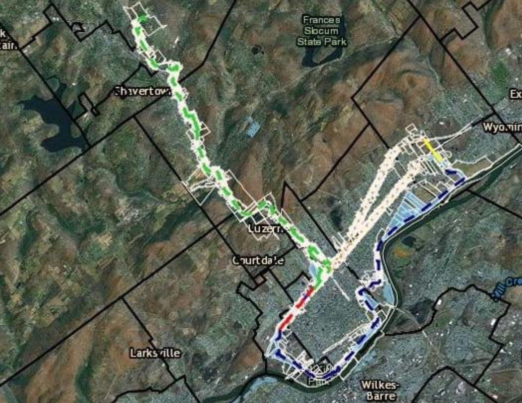
rch 2012, the Back Mountain Trail approached the Luzerne Countch 2012, the Back Mountain Trail approached the Luzerne County 911 Center in reference to adding y 911 Center in reference to adding
k Mountain Trail to the 911 database in order to improve publk Mountain Trail to the 911 database in order to improve public safety and 1st responders to the scenic safety and 1st responders to the scen

DATA PROCESSINGDATA PROCESSING
ield data collection via Trimble ield data collection via Trimble
eoExplorer XH 3000eoExplorer XH 3000
rcPad 10.0 rcPad 10.0
Windows MobileWindows Mobile
rcGIS Desktop > ArcEditor > rcGIS Desktop > ArcEditor >
rc SDE > ArcGIS Enterpriserc SDE > ArcGIS Enterprise
inal destination > Luzerne inal destination > Luzerne
ounty 911 Computer Aided ounty 911 Computer Aided
ispatch Systemispatch System

DataDataProcessinProcessin
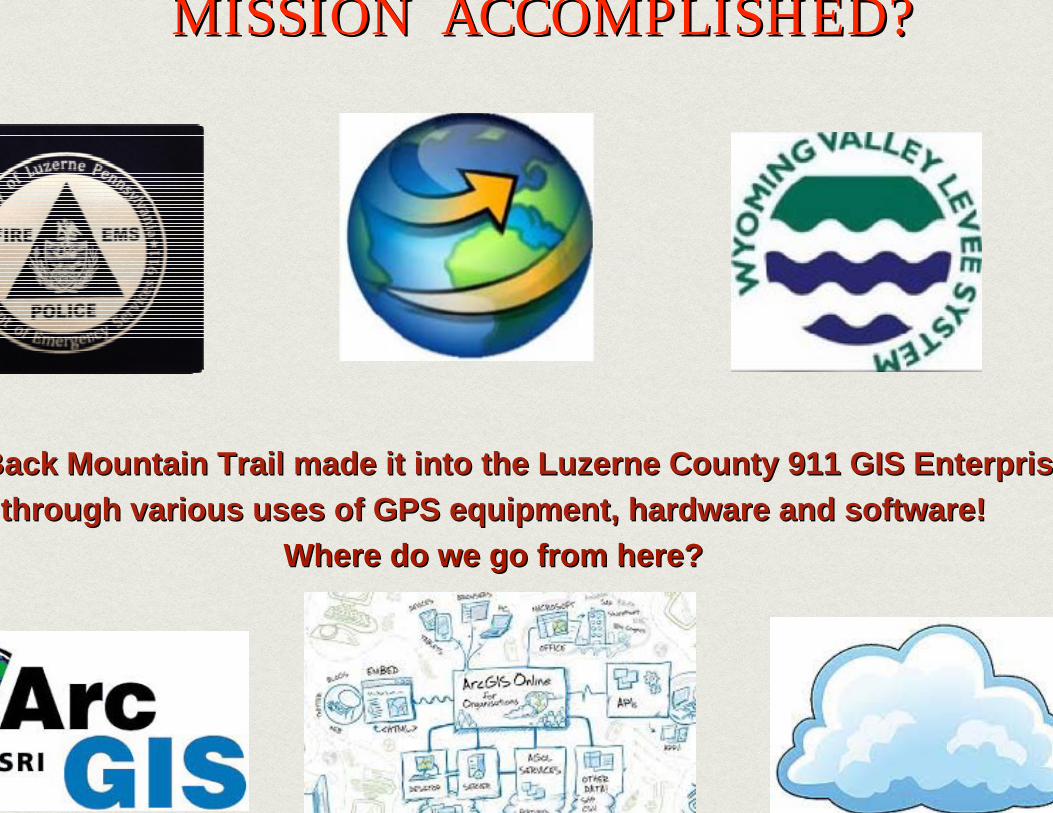
MISSION ACCOMPLISHED?MISSION ACCOMPLISHED?MISSION ACCOMPLISHED?
Back Mountain Trail made it into the Luzerne County 911 GIS Back Mountain Trail made it into the Luzerne County 911 GIS EnterprisEnterpristhrough various uses of GPS equipment, hardware and software!through various uses of GPS equipment, hardware and software!
Where do we go from here?Where do we go from here?
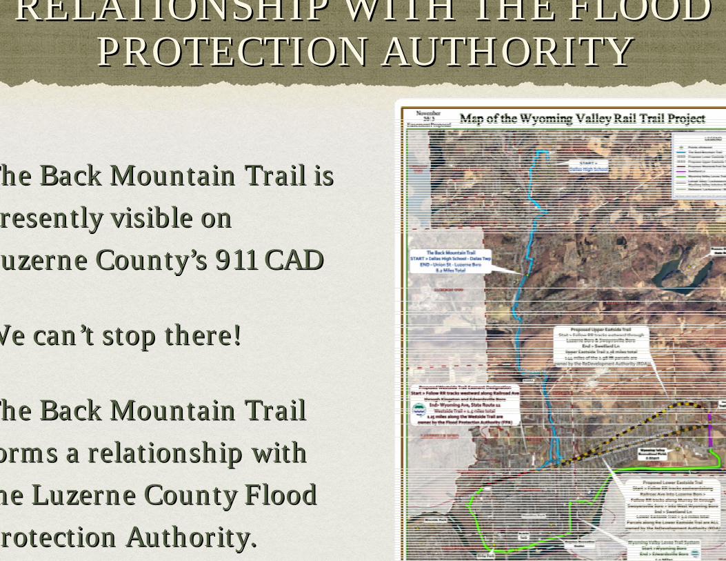
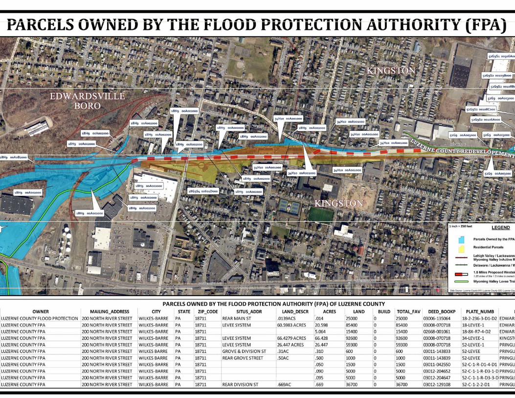
RELATIONSHIP WITH THE FLOOD RELATIONSHIP WITH THE FLOOD PROTECTION AUTHORITY PROTECTION AUTHORITY
The Back Mountain Trail is The Back Mountain Trail is
resently visible on resently visible on
Luzerne CountyLuzerne County’’s 911 CADs 911 CAD
We canWe can’’t stop there!t stop there!
The Back Mountain Trail The Back Mountain Trail
orms a relationship with orms a relationship with
he Luzerne County Flood he Luzerne County Flood
Protection Authority. rotection Authority.


WITHOUT ARC GIS ONLINE TODAY?WITHOUT ARC GIS ONLINE TODAY?THANK YOU ESRITHANK YOU ESRI
cGIS Online is a new cloudcGIS Online is a new cloud--based based
pping system for organizations pping system for organizations
at is essentially changing how GIS t is essentially changing how GIS
nagers, as well as IT managers, nagers, as well as IT managers,
nk about mapping and GIS," said nk about mapping and GIS," said
ck Dangermond, president, Esri. ck Dangermond, president, Esri.
rcGIS Online works with all types rcGIS Online works with all types
data and is built on a powerful data and is built on a powerful
erprise mapping platform that lets erprise mapping platform that lets
ers simply manage their geospatial ers simply manage their geospatial
ntent, such as data, maps, images, ntent, such as data, maps, images,
plications, and other geographic plications, and other geographic
ormation." ormation."

search of conduit pipe via ArcGIS search of conduit pipe via ArcGIS
nline Mobile Application I created to nline Mobile Application I created to
sist in our field findings.sist in our field findings.
ote to self: Stay within blue parcels ote to self: Stay within blue parcels
hile using the applicationhile using the application
ick here for a view of our Flood ck here for a view of our Flood
otection Authority footage otection Authority footage
apping out the FPA owned parcels via apping out the FPA owned parcels via
cGIS Online Web Map App (WMA) cGIS Online Web Map App (WMA)
e parcel at a timee parcel at a time
allery allery
i / lb / hi / lb / h
MEET WITH BACK MOUNTAIN TRAIL FOUNDER, JUDY RIMPLE AND FLOOD MEET WITH BACK MOUNTAIN TRAIL FOUNDER, JUDY RIMPLE AND FLOOD PROTECTION AUTHORITY DIRECTOR CHRISTOPHER BELLEMANPROTECTION AUTHORITY DIRECTOR CHRISTOPHER BELLEMAN

Examples of ArcGIS Online Distance Measuring ToolExamples of ArcGIS Online Distance Measuring Tool

p p pp (p p pp (
Smartphone Smartphone
Focus: Using the Distance Measuring ToolFocus: Using the Distance Measuring Tool

Busted by @Esrigram via BuzzFeed! BuzBusted by @Esrigram via BuzzFeed! Buz
leaked proposed location of the Flooleaked proposed location of the Floo
Protection Authority proposed location iProtection Authority proposed location i
first edition of @EsriGrams story mafirst edition of @EsriGrams story ma
gg
erdiesel is representing the Back erdiesel is representing the Back
Mountain Trail is #17Mountain Trail is #17
here for the @Esrigram story map here for the @Esrigram story map
http://bit.ly/1nM85pDhttp://bit.ly/1nM85pD

THANK YOUTHANK YOUs concludes my presentation. I would like to extend a sincer concludes my presentation. I would like to extend a sincere Thank You, to each of youe Thank You, to each of you
ur time and attention. I look forward to the possibility of wur time and attention. I look forward to the possibility of working with you in the futuorking with you in the futur


