Embed Size (px)
Citation preview

THOMAS ROBERTS’S 1741 (1714)MAP OF LEICESTER
Robert HillThe ‘True Plan or Ground-Plot of the Ancient Corporation of Leicester…’,produced by Thomas Roberts and bearing the date 1741, is widely regarded asbeing the most accurate of the eighteenth-century maps of Leicester. There ismuch in its detail to interest archaeologists and historians; for example, it is theonly map of Leicester to show a wall defining the west side of the Newarkeprecinct, the existence of which has now been demonstrated by excavation.1There are, however, uncertainties over the provenance of the map and inparticular the date of 1741 inscribed upon it. G. A. Chinnery pointed out anentry in the Chamberlain’s Accounts for 15 January 1711/12 recording apayment of £12 to Thomas Roberts ‘for his paines in making a Survey of theCorporation…’.2 This raised the possibility that the 1741 map was based on asurvey made some 30 years earlier. Particular details of the map, includingbuildings known to have been demolished long before 1741, tend to supportthis interpretation.Two separate authors have submitted papers to the Editor presenting the
results of new research into the life and work of Thomas Roberts. As they offerdifferent interpretations of the date and intended purpose of the map, it hasbeen decided to publish both papers. The second paper will appear inTransactions 2012. Editor
Thomas Roberts’s printed map of Leicester bears the year 1741, but was drawn in1713–14, and was probably engraved in 1714 with the last two digits transposedaccidentally. The error was probably a slip brought about because a printing plateis engraved as a mirror image. This is a rare map, so it is possible that printingceased when the error was noticed. We know the map could not have been drawnbefore 1708 because it shows the ‘Meeting’ in Bond Street which was built in1708.3 The primary dating evidence is that the rows of Saturday market stallsshown on the map were demolished in 1715 and replaced with a completelydifferent arrangement, and the scroll on the map stating that Leicester had ‘Beengoverned by a Mayor 480 years’ can be shown to start from the year 1233. Thisevidence is presented in detail below, after a description of the map. Otherevidence confirming that the map was drawn long before 1741 is the death of theengraver Michael Van der Gucht in 1725, Thomas Roberts in 1727, and thedemolition of the Saturday shambles (market hall) in 1726.4 Regardless of the dateprinted on the map, it is the one drawn by Thomas Roberts in 1713–14.
1 Unpublished excavations by Northamptonshire Archaeology in 2001–02.2 RoB, vol. 5, #225.3 TLAHS, vol. 71, p. 53. The building and word ‘Meeting’ are by ‘Goldsmiths Grave’ on the map.4 Thomas Roberts’s will, written and proved in 1727. See also note 11.
Trans. Leicestershire Archaeol. and Hist. Soc., 85 (2011)
07_Hill_123-138 22/9/11 11:31 Page 123

07_Hill_123-138 20/10/11 11:54 Page 124

07_Hill_123-138 20/10/11 11:54 Page 125

A DESCRIPTION OF THE MAP5
The map is drawn with east pointing upwards: north is shown at 289°; that is, 71°anticlockwise of the usual ‘north upwards’ convention. This orientation may havebeen dictated by the desire to fit everything onto a copper plate and create anattractive printed map in landscape format, using the river as a baseline for thetown. Thomas Roberts’s original work (now lost) may have been drawn withnorth upwards. Comparison with the Ordnance Survey shows it to be a fairlyaccurate plan of the town. It measures 0.52m × 0.64m and has a scale of 264 feetper inch (1:3168). The scroll in the upper left corner describes it as a ‘True plan orground-plot’ and has the statement ‘Been governed by a Mayor 480 years’ abovethe engraved signature of Thomas Roberts and the year 1741. A view of the‘S. Prospect’ of Leicester, an attractive feature at the top of the map, appears tohave been squeezed in at a late stage in the engraving process. Such alterationsare not unusual. There is no evidence that the ‘S. Prospect’ was added after 1714.Even if it was added later, the map and scroll are valid for 1714 but not fora later date. There is just one known copy of a later, undated, version of themap, printed c. 1750, which is altered to show the Exchange built in the Saturdaymarket in 1748.6 Thomas Roberts’s name and the year 1741 were removedfrom the plate for this alteration, but the engraver’s name ‘M. Vdr Gucht sculp:’was left.
THOMAS ROBERTS
Thomas Roberts was primarily a victualler and innkeeper of Leicester from 1699until his death.7 A letter written by him in 1725 gives evidence of his identitythrough its content and signature. In it he refers to his son, aged 16, beingapprenticed to a noted carpenter and joiner John Westley,8 who prepared the planfor the new Saturday shambles which was built in 1726:9
Thomas Roberts, 4th son of John & Elizabeth was baptised 5 Nov. 1665 at St.Margaret’s church, Leicester. He became a freeman in 1696 when his probablefather was Mayor for the second time.10 He married Mary Shuttleworth at St.Margaret’s in 1697 and they had children Elizabeth, Ruth & John all baptised atSt. Martin’s (1698, 1703, & 1708). Thomas was described as a victualler in 1699and as an innholder in 1716 & 1724. Thomas Roberts was therefore about 46years old when he made the Corporation survey in 1711. He copied a map and didother simple survey work in Lincolnshire in 1714–16. Shortly before his death in
5 There is a copy at ROLLR, ref. 4D65.6 This map (.52m × .64m. folded) is bound, with other items, into the front of the original copy of
Nichols, vol. 1, part 3, stored upstairs at ROLLR under the general ref. L914.2. This map wasincorrectly attributed to J. Van der Gucht by Derek Charman in 1951 (see TLAS, vol. 27, p. 25).
7 RoB, vol. 7, p. 41 (37.3): victualler in 1699; p. 87 (69.3), innholder in 1716. RoF, p. 401, innholderin 1724; p. 261, victualler deceased in 1734.
8 The letter (385mm × 300mm) is bound between pages 4 and 5 in the original copy of Nichols, vol.1, part 2, stored upstairs at ROLLR under general ref. L914.2; RoF, p. 401.
9 RoB, vol. 5 #424.10 RoF, p. 179; RoM, pp. 112–13.
126 ROBERT HILL
07_Hill_123-138 22/9/11 11:31 Page 126

1727, he made a will which mentions his daughter Ruth, his son John and his wifeMary.11
Thomas Roberts made a ‘Survey of the Corporation’ in 1711, for which he waspaid £12 in January 1712.12 This survey of the Corporation is lost, as are theinstructions given to Thomas Roberts. The 1711 survey probably reported on thestate of repair and value of the Corporation buildings, and may well have notcontained a plan. Any plan relating to a survey of Corporation property wouldprimarily show lots of numbered buildings which belonged to the Corporation,and probably little else other than the street plan and the churches. It is unlikelythat the 1714 map has a direct link with the 1711 survey, but must have beeninformed by it. Ten named aldermen of the Corporation were instructed to meet atthe Saturday market in Nov. 1712 to decide whether to repair or replace the stallsand shops.13 They may have discussed the survey of 1711.
THE REBUILDING OF THE MARKET STALLS IN 1714–15
In 1714–15, several rows of stalls and shops were demolished and replaced by twonew rows of stalls and a ‘new row’ of 33 shops which, having corner shops,suggests a rectangular building housing 33 stalls.14 To demonstrate that the mapwas drawn before 1715, it is necessary to prove that the rows of market stalls asshown on the map correspond with Corporation market leases and records priorto 1715, and that the layout of the stalls was radically different after 1715 andcould not possibly correspond to the detail on the map.
Fig. 1, redrawn from the map, identifies the various Saturday marketbuildings. It has identifying letters and numbers for the rows of shops and stallsfor the purposes of this paper. For comparison, an extract from the actual 1741(1714) map is shown in Fig. 2. The engraving of Thomas Roberts’s map is ofsufficient accuracy to show the two rows of stalls along the east side of the oldSaturday shambles. The separate structures that lie on either side of the entranceare not part of the shambles building.
The Corporation had direct control over seven rows of shops and stalls, butleased the major part of the Saturday market to Twiggs Pilgrim in 1705 for 21years. The 41 tenants of the seven rows of shops and stalls (letters B to H in Fig. 1)paid rent direct to the Corporation under their individual 21-year leases. Theseven rows B to H amounted to some 450 linear feet. The names of the 41individual traders and their rents are recorded in the Corporation’s accounts.15
Their 21-year leases, which commenced in 1691, had imposed stability in thelayout of the market until 1712.16 From an examination of adjoining tenantsnamed in the 27 surviving leases, it has been possible to determine where many of
11 ROLLR, Wills & Probate, 1727 fiche 9, item 11, 12.12 RoB, vol. 5, #225.13 RoB, vol. 5, #233.14 RoB, vol. 5, #257, #270, #272, #275, #276 (note the four corner shops Nos. 1, 11, 20 and 23).15 ROLLR, BR III/2/92, p. 77.16 ROLLR, BR II/8a/1277–94, 1302, 1307–10, 1315, 1333.
THOMAS ROBERTS’S 1741 (1714) MAP OF LEICESTER 127
07_Hill_123-138 22/9/11 11:31 Page 127

128 ROBERT HILL
Fig. 1. The Saturday market redrawn from the map.
Fig. 2. The Saturday market place as shown on Thomas Roberts’s 1741 (1714) map.
07_Hill_123-138 22/9/11 11:31 Page 128

the individual shops/stalls were located within the individual rows. The locationsthus derived for 1691 apply throughout the period 1691–1712. The locationsalmost certainly applied until the stalls were rebuilt in 1714–15. The 1691–92Corporation accounts provide a list of the 45 tenants of the rows of Corporationshops and stalls in the market place, of which four were at the Gainsborough.17
The rows B to H included 12 shoemakers stalls, seven mercers stalls, 13chandlers shops and nine glovers shops, as shown in Table 1. The location ofindividual traders within these rows is given below in Tables 2 and 3.
Shoemakers’ stalls Mercers’ shops and other shops
William Springthorp for a double stall Thomas Ludlam, a double shop.Ralph Ward, a stall Symon Thorp, a double shop.John Stretton, a stall Thomas Lawrence, a shop.Robert Warburton, a stall Jonas Davy, a shop.Thomas Huffin, a stall Extors G. Steeres, a shop occ. by Rob Awmry.John Berridge, a stall William Davenport, a shop.John Reynor, a stall Richard Orton, a shop.Thomas Adcock, a stall (7 shops, 2 double)Richard Foxton, a stallRichard Foxton for Jos. Kilby’s stallHenry Weston, a stallWilliam Birstall, a stall(12 stalls, 1 double)
Chandlers’ shops Glovers’ shops
William Harris, a shop William Browne senr., a shopJane Biggs, a shop Samuel Sherfield, a shopJohn Worthington, a shop Samuel Holden, a shopGilbert Fawsitt, a shop William Browne Jr, a shopThomas Beaumont, a shop Ralph Holden, a shopJohn Pollard, a shop John Bennett, a shopJ. Denshire, a shop George Sherfield, a shopElias Hartill, a shop Mary Browne, a shopThomas Chapman, a shop Mary Raphin, a shopJohn Mitchell, a shop (9 shops)Extors of George Beckett, a shopWilliam Geoffrey for a shop, 4s. p.a.Extors of Mr Boardman, a mill shopGiles Coker, a kitchen and barn(13 shops, a kitchen, a barn) (Total: 41 shops/stalls in rows B to H)
Table 1. Tenants of the rows B to H in 1691–92.18
17 ROLLR, BR III/2/92, p. 77.18 ROLLR, BR III/2/92, pp. 77–8.
THOMAS ROBERTS’S 1741 (1714) MAP OF LEICESTER 129
07_Hill_123-138 22/9/11 11:31 Page 129

Using the ‘adjoining tenant’ and other information in the leases (see Tables 2and 3, column 3), the names of the tenants can be sequenced. Despite gaps, it ispossible to work out where most of the above 41 tenants of the shops/stalls werelocated, within the seven rows B to H, in 1691.
Tables 2 and 3 summarise the information in the surviving leases for shops andstalls in the seven rows B to H.19 The first column in Tables 2 and 3 gives theindividual lease reference within ROLLR document class BR/II/8a/–, and the lastcolumn shows the evident location of that particular shop/stall on the market plan(Fig. 1) by reference to the numbers shown within the rows B to H. The numbers
19 ROLLR, BR II/8a/1216, 1277, 1279–82, 1284–95, 1298, 1300–02, 1304, 1307–08, 1310, 1315,1333.
20 ROLLR, BR II/8a/the number in column 1.21 ROLLR, BR III/2/109, p. 24; BR III/2/92, p. 20.
130 ROBERT HILL
Lease Tenant Adjacent tenants etc. noted Other Row andref. in lease information location
in lease
1285 Jos Kilby Cornwall on E, Ric Foxton on W Row next to H4Cornwall
1279 Rich Foxton Jos Kilby on E, Thos Adcock on W Row next toCornwall H3
1308 Thos Adcock Ric Foxton on E, Warburton on W Row next toCornwall H2
1280 Rob Warburton Thos Adcock on E H1Wm Springthorp on W
1292 Wm Double stall uppermost in row, Row next to G1–2Springthorp John Berridge on S, Backside of Thos Cornwall
Ludlam, mercer, on N1281 Jn Berridge Thos Ward on S, Springthorp on N Row next to G3
Cornwall1287 Ralph Ward Jn Berridge on N, Thos Huffin on S Row next to G4
Cornwall1310 Thos Huffin Jn Reyner* on S, Ralph Ward on N Row next to G5
CornwallJn Reyner G6
1291 Geo Steers, At north end of row Row next to F1maltster Jn Reyner* on S Women’s mkt
1307 Jn Reyner Geo Steers on N, Jn Stretton on S Towards N F2side of mkt
1286 Jn Stretton Jn Reyner on N, Hen Weston on S Row next to F3Women’s mkt
1284 Hen Weston Wm Birstall on S, Jn Stretton on N Ditto F41294 Wm Birstall Hen Weston on N, Giles Coker’s Row next to F5
barn or stable on S Women’s mktCokers stable F6–8
* John Reyner had two different stalls in 1688–89, 1689–90 and 1690–91 at 3s. and 2s. rent, but onlyone stall from 1691–92, so the information in the leases is based on history.21
Table 2. 1691 leases for shoemakers’ stalls.20
07_Hill_123-138 22/9/11 11:31 Page 130

of shops/stalls in each row is based on 3m per stall. The stall locations given in thelast column are based on a compilation of all relevant available evidence. As someleases are missing and some row descriptions are ambiguous, the individual stalllocations should not be taken as proven fact, but combined to show fairlyconvincingly that the rows of shops and stalls on the map match the survivingmarket documents for the period 1691–1714.
22 ROLLR, BR II/8a/the number in column 1.
THOMAS ROBERTS’S 1741 (1714) MAP OF LEICESTER 131
Lease Tenant Adjacent tenants etc. noted Other Row andref. in lease information location
in lease
1315 Elias Hartell, Uppermost shop towards Mercers’ and C1chandler etc. Women’s mkt, Josh Denshire glovers’ row next
on E to Shambles1282 Josh Denshire, Chandler’s shop used as glover’s Chandlers’ row C2
glover shop, Elias Hartell on W next to Women’sJn Mitchell on E mkt
1290 Jn Mitchell, Thos Chapman on E, Josh Chandlers’ row C3chandler Denshire on W by to Women’s mkt
1216* Thos Chapman, Part of a mercer’s shop, Jn C4chandler etc. Mitchell on W, Jonas Davy on E*Jonas Davy E4
1289 Thos Ludlam, Double shop, Jonas Davy on E Mercers’ row by E2–3mercer Women’s mkt towards W Women’s mkt
1302 Thos Lawrence, Another shop on W Mercers’ next to E8mercer Cornwall on E shoemakers
1293 Jane Biggs On backside of Mercers’ row Mercers’ row next D7(wid.), chandler next to Shambles, Jn to Shambles
Worthington on E1288 Jn Worthington, Top shop on backside of Mercers’ Uppermost shop D6
chandler row, Wm Jeoffrey on S next to CornwallJane Biggs, wid., on W
1333 Arthur Noone, Baker’s shop, was Wm Jeffries Near N end of D5baker glover’s shop Cornwall and near
Sarah Thorp, wid., on W the Gainsborough1277 Simon Thorp, Double shop, Ric Orton on W Mercers’ row D3–4
mercer Wm Geoffrey, glover, on E next to ShamblesOrton D2Adcock B2
1295 Jn Pollard, Gilbert Fawsitt on E Chandlers’ row B3chandler Jn Adcock on W next to Shambles
1298 Gilbert Fawsitt, Thos Beaumont on E Chandlers’ row B4chandler Jn Pollard on W next to Shambles
1301 Thos Beaumont, Wm Harris on E Chandlers’ row B5chandler Gilbert Fawsitt on W next to Shambles
1304 Wm Harris, Uppermost shop eastwards Chandlers’ row B6chandler Thos Beaumont on W next to Shambles
*This lease is dated 1676.
Table 3. 1691 leases for mercers’ and chandlers’ shops.22
07_Hill_123-138 22/9/11 11:31 Page 131

The shoemakers’ rows were rows F, G and H. The four stalls in row H workout to about 3m per stall in width. On that basis, rows F and G each had 10 stalls.Coker’s barn occupied two or three stalls, F6–8. As all the shoemakers in the1691–92 list of tenants (Table 2) are accounted for, six or seven stalls in these twoshoemakers’ rows must have been occupied by other trades.
The 13 shoemakers’ leases (Table 2) cover all the names in the list of tenantsand give a complete sequence. George Steers, maltster, appears at the north (NW)end of row F (location F1), which was a ‘shoemakers’ row’, but in the list oftenants he appears under mercers and other shops. This is no surprise as there wasa mixture of traders in several of the rows, and the row names stated in the recordswere probably historic or convenient names. Note that the leases state thatCornwall runs north, when in fact it runs NW. Therefore, in Tables 2 and 3, northmeans NW, east means NE, south means SE, and west means SW.
The other 14 leases of 1691 (Table 3), for mercers and chandlers and others,do not fully account for all the other names in the 1691–92 list of tenants (Table1). The lease for Josuah Denshire, glover, has survived but he is included in the listof chandlers. Geo. Steeres, maltster, was at location F1 (Table 2), which also putsCoker’s barn in location F6–8. In placing the mercers, note that Ludlam’s doublestall was to the north of row G according to the lease of shoemaker WmSpringthorp (see Table 2, lease ref. 1292).
The names of adjoining tenants leave no doubt where the shops within eachchain stood in relation to one another, but, with the exception of row B, thedescriptions as to row are conflicting. All the names under ‘Mercers’ in the list oftenants (Table 1) are accounted for, except Davenport. All the names under‘Chandlers’ in the list of tenants (Table 1) are accounted for, except Beckett andBoardman. None of the nine names under ‘Glovers’ in the list of tenants (Table 1)are accounted for. There are thus 12 tenants that cannot be placed, and there are15 unallocated shops/stalls within rows B to H if all the shops/stalls were 3m wide.This is a good match, as some stalls may have been wider or double stalls.
The 1741 (1714) map only shows the permanent Saturday market buildings.The Saturday market was a very busy place on Saturdays, with about 185 traders,being the 41 above in rows B to H who paid rent direct to the Corporation, plus afew others who paid rent direct to the Corporation, plus 140 traders under TwiggsPilgrims’ lease, which included 60 ‘country traders’ from Leicestershire villages.There were therefore many temporary stalls or standings (selling pitches).
In 1714–15, most of the existing rows of shops and stalls were demolished andrebuilt.23 At least three rows of shops were replaced by a ‘new row’ of 33 newshops built by the Corporation in 1715, which included front shops on both sides,back shops and four corner shops, with the tenants having to agree not to ‘setanything out in the street except what is upon the shop windows’.24 The sixsurviving leases for the ‘new row of shops’ say that they each had the number
23 RoB, vol. 5, #257, #270, #272, #275.24 RoB, vol. 5, #257, #270, #276.
132 ROBERT HILL
07_Hill_123-138 22/9/11 11:31 Page 132

above the door.25 Josiah Nutt’s corner shop was no. 1 and John Pares’s cornershop was no. 20.26 Shops with windows and doors may have been in daily ratherthan weekly use.
The individual rows of shops/stalls shown on the 1741 (1714) map (Figs 1 and2) have been shown (see above), to match closely the actual market situation from1691 to 1714, but the ‘new row’ built in 1715 was a very different arrangementwhich does not match what is shown on the map.
Evidence that the ‘480 years’ starts from 1233
Thomas Roberts’s statement (in the map scroll) that Leicester had ‘Been governedby a Mayor 480 years’ is good dating evidence if we can be sure of the start yearthat he used. This has to fall within certain logical limits. The map was engravedby M. Van der Gucht, who died in 1725. The latest reference year which ThomasRoberts’s could have used is therefore 1725 minus 480 (=1245). The alderman,known as the mayor from c. 1251, was elected locally by the brethren of the gild,so Leicester Merchant Gild Roll no. 2 is the only reliable source.27 This gild rollstarts in 1234 with the election of Willian St Lo as alderman, with SimonCurlevache, in the 18th year of Hen. III, which was translated by eighteenthcentury historians as 1233.28 This first record in the gild roll is followed byfurther references to aldermen in 1239, 1242 and 1251, the first mention of amayor.29 Only the years 1233, 1239 and 1242 fall within the range already set,but anyone looking at the gild roll for the earliest alderman/mayor would findhim in the very first record (1233) and look no further. Adding the 480 years to1233 gives 1713 as the date when Thomas Roberts drew the map, and the 1713date matches the market dating evidence already presented above. It seems thatthe map was engraved in 1714, but the engraver reversed the last two digits andput 1741. This is plausible because the plate has to be engraved as a mirrorimage. Any proofreader will know how easy it is for such glaring errors to gounnoticed.
Thomas Roberts would have known where to obtain information from theCorporation about the earliest mayor because his probable father, John Roberts(d.1705), served twice as the Mayor of Leicester (in 1679–80 and 1696–97), andhis survey for the Corporation in 1711 would have brought him into contact withthe right people.30 There are five manuscript lists of mayors, but it is fairly certain
25 ROLLR, BR II/8a/1368–72, 1374.26 ROLLR, BR II/8a/1368–72, 1374.27 Gild Roll no. 1 was not studied until after 1800, a fact which is confirmed by two mayors lists
1233–1797 and 1233–1888, and by Nichols and Thompson. ROLLR, DE1941/3. The manuscriptcopy of Staveley’s history of Leicester, ROLLR, L914.2. Nichols, vol. 1, pt. 2, pp. 360–1 (publ.1815). History of Leicester, James Thompson (1849), p. 67, last para.
28 RoB, vol. 1, p. 60.29 RoB, vol. 1, pp. 60–4.30 RoM, p. 113; RoF, pp. 163, 178.
THOMAS ROBERTS’S 1741 (1714) MAP OF LEICESTER 133
07_Hill_123-138 22/9/11 11:31 Page 133
that none of these were the source for Thomas Roberts’s datum year of 1233.31
The lists of mayors which start in 1233 were written after 1720 and another whichstarts in 1203 would have required the ‘480 years’ to be at least 500 years.32
The Saturday shambles
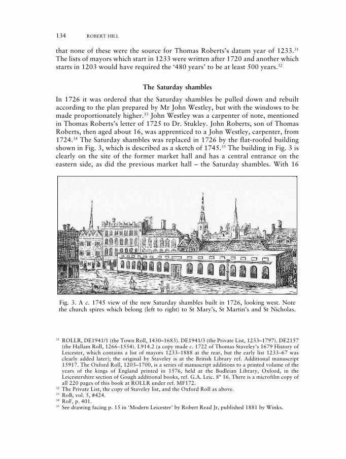
In 1726 it was ordered that the Saturday shambles be pulled down and rebuiltaccording to the plan prepared by Mr John Westley, but with the windows to bemade proportionately higher.33 John Westley was a carpenter of note, mentionedin Thomas Roberts’s letter of 1725 to Dr. Stukley. John Roberts, son of ThomasRoberts, then aged about 16, was apprenticed to a John Westley, carpenter, from1724.34 The Saturday shambles was replaced in 1726 by the flat-roofed buildingshown in Fig. 3, which is described as a sketch of 1745.35 The building in Fig. 3 isclearly on the site of the former market hall and has a central entrance on theeastern side, as did the previous market hall – the Saturday shambles. With 16
134 ROBERT HILL
Fig. 3. A c. 1745 view of the new Saturday shambles built in 1726, looking west. Notethe church spires which belong (left to right) to St Mary’s, St Martin’s and St Nicholas.
31 ROLLR, DE1941/1 (the Town Roll, 1430–1683). DE1941/3 (the Private List, 1233–1797). DE2157(the Hallam Roll, 1266–1554). L914.2 (a copy made c. 1722 of Thomas Staveley’s 1679 History ofLeicester, which contains a list of mayors 1233–1888 at the rear, but the early list 1233–67 wasclearly added later); the original by Staveley is at the British Library ref. Additional manuscript15917. The Oxford Roll, 1203–1700, is a series of manuscript additions to a printed volume of theyears of the kings of England printed in 1576, held at the Bodleian Library, Oxford, in theLeicestershire section of Gough additional books, ref. G.A. Leic. 8° 16. There is a microfilm copy ofall 220 pages of this book at ROLLR under ref. MF172.
32 The Private List, the copy of Staveley list, and the Oxford Roll as above.33 RoB, vol. 5, #424.34 RoF, p. 401.35 See drawing facing p. 15 in ‘Modern Leicester’ by Robert Read Jr, published 1881 by Winks.
07_Hill_123-138 22/9/11 11:31 Page 134

windows on the east side and (presumably) 17 windows on the west side, thiswould accommodate 33 stalls for the butchers. The new Saturday shambles, builtin 1726 to house 33 butchers, should not be confused with the ‘new row’ of 33shops built in 1715 (already described). The surviving leases for the ‘new row ofshops’ state that they each had the number above the door.36 The fact that theyeach had a door as well as a window rules out the building shown in Fig. 3. Thebuilding shown in Fig. 3 is clearly on the site of the old Saturday shambles (markethall), but we would expect to see some evidence of the shops built in 1715. Eitherthe artist omitted them for artistic reasons, or the c. 1745 view was made in 1748when the shops and stalls had been demolished again.37
Mr Watts’s House and The Bath
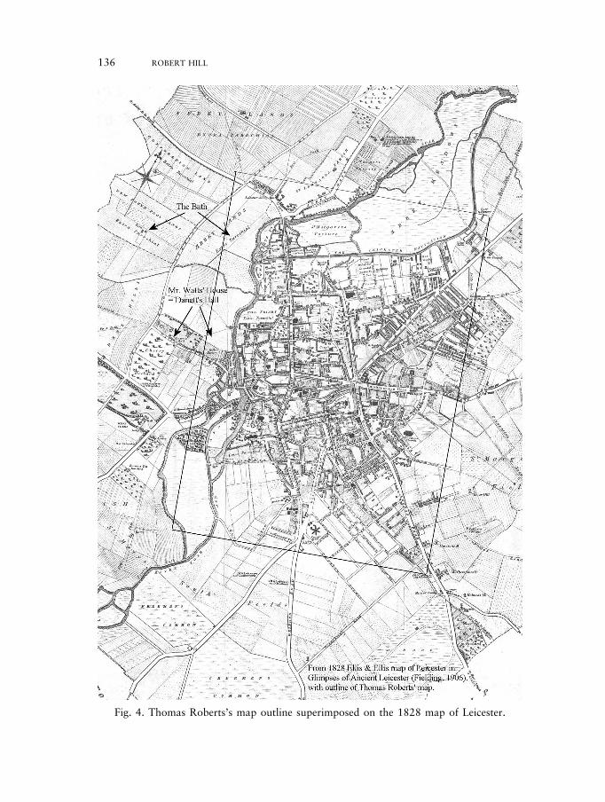
These are drawn on the extreme edge of the printed map, indicating that theyrepresent properties ‘off plan’ and outside the Borough. They may have been onThomas Roberts’s original drawing of the map (1713–14) and considered tooimportant to omit from the engraving. Fig. 4 shows the outline of ThomasRoberts’s map superimposed on the 1828 map, revealing how closely thebuildings on the edge of Thomas Roberts’s map relate to the buildings theyrepresent.38
‘Mr. Watts’ House’ on Thomas Roberts’s map is Danett’s Hall, which Mr JohnWatts of Northampton bought c. 1700. He was a leading citizen of the town whodied in 1742 aged 80: the house was owned by the Watts family until 1769.39
Danett’s Hall lay on Watts Lane, as named on the 1828 map, which ran from BowBridge and then became King Richard’s Road.40
‘The Bath’ on Thomas Roberts’s map almost certainly shows buildings at NewFound Pool. From his will dated 5 March 1712–13, Matthew Judd, apothecary ofLeicester, owned a ‘Cow close or ground inclosed commonly called or known bythe name new found pool close’. He willed that, even if it was leased to a tenant,all poor people should be allowed to take away water during the daytime forthemselves and their families, and ‘have liberty to bathe in ye place in ye said closecalled ye poor bath’.41 The inventory taken after his death, which would normallylist only personal or moveable goods, values the ‘close & buildings’ at £600.Matthew Judd evidently gave the poor people free access to a very importantsource of fresh water and bathing at a time when the nearby river, which flowsnorth, was polluted by the tanning industry which lay in the North Gate, aroundNorthgate Street and Soar Lane. Matthew Judd’s will takes the known history ofNew Found Pool back more than a century towards the origin of the name. In
36 ROLLR, BR II/8a/1368–72, 1374.37 RoB, vol. 5, #714.38 Copies of both maps are included at the back of the printed Records of RoB, v6.39 VCH, vol. 4, pp. 381–2. Leicester Memoirs, C. J. Billson p. 2–3, publ. 1924, Leicester.40 VCH, vol. 4, pp. 381, note 3. A Walk Through Leicester, p. 63; Susanna Watts, 1967 facsimile
reprint by Leicester Universtity Press of the 1804 original.41 ROLR, Wills & Probate, 1714 fiche 10, frames 37–42 (includes an inventory). Probate was granted
26 May 1714.
THOMAS ROBERTS’S 1741 (1714) MAP OF LEICESTER 135
07_Hill_123-138 22/9/11 11:31 Page 135
136 ROBERT HILL
Fig. 4. Thomas Roberts’s map outline superimposed on the 1828 map of Leicester.
07_Hill_123-138 22/9/11 11:31 Page 136

1727, his widow, Susannah Judd (d.1732), of the Borough of Leicester, made awill whereby she left six cottages and an orchard near St Nicholas church; threecottages standing at the bottom of the High Street; several other dwellings near thewest bridge; and two closes and a meadow near the Borough of Leicester called theBath Closes, then in the occupation of Mr Pare and Mr Bonnar (probably JohnPares and Robert Bonner, aldermen of Leicester).42 Susannah Judd, née Deane,was the daughter of Susannah Deane (d.1706) of the Borough of Leicester. Themother was the daughter of Sir John Harpur (d.1669), a son of Sir Henry Harpur(d.1639), who bought Calke Abbey in 1622.43 Two buildings are shown at NewFound Pool in 1828, one marked as a barn.44 By 1830, New Found Pool belongedto Isaac Harrison, a member of a Leicester firm of market gardeners who is saidto have discovered and exploited the medicinal properties of a spring of water onthe land.45 Mr Harrison built a large house as a hydropathic institution, withaccommodation for the doctor and his attendants.46 The house had 17 windowson the front elevation.47
Other observations on the map
St James’s Chapel survived as a place name long after the building disappeared. Itis marked on Thomas Roberts’s map as a place without a building and ismentioned in Thomas Roberts’s letter of 1725, again as a place. The name wasstill in use in 1708.48 The Brick Kills (kilns) shown in the South Fields wereprobably built on land leased by the Commissioners for brick-making in 1710, aparcel of land lying by Swanns windmill and five adjoining lands by Mr Carter’swindmill.49 This notes ‘the said four acre ground whereon Thomas Walls windmillstands with one acre of ground to the same with a Free road or passage to the saidwindmill’. The South Prospect at the top of the map shows the three windmillsmentioned above in 1710. Three water mills are shown on the river as North mill,Castle mill and Swann’s mill. There were thus two Swann’s mills (a windmill anda water mill), and castle mill is shown as though it could be a water mill and awindmill at the same location. The South Prospect seems to have been sketchedlooking across the South Field from the upper right corner of the map.
The churches shown on the South Prospect are left to right: St Mary’s, StNicholas’s, St Martin’s, All Saints, and St Margaret’s. They are each shown with aspire or tower as appropriate. The spire of St Nicholas’s church was taken down in
42 ROLLR, Wills & Probate, 1732, fiche 13, frames 18–19.43 ROLLR, Wills & Probate, 1706, no. 72 on 1706 fiche 4, frame 26. Harpur family tree and history
in the Calke Abbey guide book 2000 (National Trust).44 A plan of Leicester in 1828 by Ellis and Ellis is bound into Glimpses of Ancient Leicester (1906) by
Mrs T. Fielding Johnson, after p. 323, and a reduced version of it is bound inside the rear cover ofRoB 6. Another survey of Leicester by Unicume in 1828 is at ROLLR, ref. 1D65/4.
45 VCH, vol. 4, p. 455.46 VCH, vol. 4, p. 455.47 ROLLR, Cable Collection, ix 25 and ix 27.48 RoB, vol. 6, p. 80, item 5; p. 93, items 1 and 3.49 RoB, vol. 5, #216.
THOMAS ROBERTS’S 1741 (1714) MAP OF LEICESTER 137
07_Hill_123-138 22/9/11 11:31 Page 137
1802. St. Margaret’s church can still be viewed from accoss the road almostexactly as drawn.
Two Soar Lanes are shown on the map and as expected they both lead to theriver. One is listed as 14, but this number is almost impossible to spot in thenarrow lane which runs from Redcross Street to the West Bridge. The other isclearly marked as Soar Lane and runs from ‘Senvey Gate’ to the river. Both SoarLanes are mentioned in 1708 in the Records of the Borough.50 Gun Dyke seems tohave survived as the paved public open space at the corner of Castle View andCastle Street.
ABBREVIATIONS USED IN THE REFERENCES
Nichols, vol. 1, pt 1, Nichols J. 1795 History & Antiquities of the county ofLeicester, vol. I, part I.
Nichols, vol. 1, pt 2, Nichols J. 1815 History & Antiquities of the county ofLeicester, vol. I, part II.
RoB, vol. 1, Bateson M. 1899 Records of the Borough of Leicester, vol. I:1103–1327.
RoB, vol. 4, Stocks H. 1923 Records of the Borough of Leicester, vol. IV:1603–88.
RoB, vol. 5, Chinnery G. A. 1965 Records of the Borough of Leicester, vol. V:Hall Books and Papers 1689–1835. # itemnumber, not page number.
RoB, vol. 6, Chinnery G. A. 1967 Records of the Borough of Leicester, vol. VI:1689–1835.
RoB, vol. 7, Chinnery G. A. 1974 Records of the Borough of Leicester, vol. VII:Judicial and Allied Records 1689–1835.
RoF, Hartopp, Henry 1927 Register of the Freemen of Leicester1196–1770. Publ. by Edgar Backus ofLeicester.
RoM, Hartopp, Henry 1935 Roll of the Mayors of the Borough and LordMayors of the City of Leicester 1209–1935.Publ. by Edgar Backus, Leicester.
ROLLR Record Office for Leicester, Leicestershireand Rutland.
TLAAS Transactions of the Leicester Architectural &Archaeological Society.
TLAHS Transactions of the Leicester Archaoelogical& Historical Society.
VCH Victoria County History of Leicestershire.
50 RoB, vol. 6, pp. 77–9, 89.
138 ROBERT HILL
07_Hill_123-138 22/9/11 11:31 Page 138


![2903 57 27: O 69* / 113 z 247 R LIJ 123 15B 209* 191 138 ... · 2903 57 27: O 69*" / 113 z 247 R LIJ 123 15B 209* 191 138 '196 1åW 224 24 202tE i 214 C 139 EI_IJ. 1S4cl 172L 1734]](https://img.pdfslide.net/doc/110x75/5be9e35309d3f24f1b8cecc2/2903-57-27-o-69-113-z-247-r-lij-123-15b-209-191-138-2903-57-27-o-69.jpg)