Embed Size (px)
Citation preview
CONTRIBUTIONS FROM THE MUSEUM OF PALEONTOLOGY
THE UNIVERSITY OF MICHIGAN
VOL. XIX, NO. 14, pp. 167-255 (6 pls., 10 figs.) JULY 2, 1965
ILLINOIAN AND SANGAMON VEGETATION
IN SOUTHWESTERN KANSAS AND
ADJACENT OKLAHOMA
BY
RONALD 0. KAPP
MUSEUM OF PALEONTOLOGY
THE UNIVERSITY OF MICHIGAN
ANN ARBOR
CONTRIBUTIONS FROM THE MUSEUM OF PALEONTOLOGY
Director: LEWIS B. KELLUM
The series of contributions from the Museum of Paleontology is a medium for the publication of papers based chiefly upon the collections in the Museum. When the number of pages issued is sufficient to make a volume, a title page and a table of contents will be sent to libraries on the mailing list, and to individuals upon request. A list of the separate papers may also be obtained. Correspondence should be directed to the Museum of Paleontology, The University of Michigan, Ann Arbor, Michigan.
VOLUME XIX
1. Silicified Trilobites from the Devonian Jeffersonville Limestone at the Falls of the Ohio, by Erwin C. Stumm. Pages 1-14, with 3 plates.
2. Two Gastropods from the Lower Cretaceous (Albian) of Coahuila, Mexico, by Lewis B. Kellum and Kenneth E. Appelt. Pages 15-22, with 2 figures.
3. Corals of the Traverse Group of Michigan, Part XII, The Small-celled Species of Favosites and Emmonsia, by Erwin C. Stumm and John H. Tyler. Pages 23-36, with 7 plates.
4. Redescription of Syntypes of the Bryozoan Species Rhombotrypa quadrata (Rominger), by Roger J. Cuffey and T. G. Perry. Pages 37-45, with 2 plates.
5. Rare Crustaceans from the Upper Devonian Chagrin Shale in Northern Ohio, by Myron T. Sturgeon, William J. Hlavin, and Robert V. Kesling. Pages 47-64, with 5 plates.
6. A Fossil Dennstaedtioid Fern from the Eocene Clarno Formation of Oregon, by Chester A. Arnold and Lyman H. Daugherty. Pages 65-88, with 7 plates.
7. A New Species of Melocrinites from the Middle Devonian Bell Shale of Michigan, by Robert V. Kesling. Pages 89-103, with 2 plates.
8. A New Spiraculate Blastoid, Pyramiblastus, from the Mississippian Hampton Formation of Iowa, by Donald B. Macurda, Jr. Pages 105-114, with 1 plate.
9. A Drastic Reappraisal of "Lepidasterella babcocki Schuchert"--as Helianthas- ter gyalinus Clarke, a Streptophiuran Auluroid, by Robert V. Kesling. Pages 115-133, with 4 plates.
10. Decadocrinus hughwingi, a New Middle Devonian Crinoid from the Silica Formation in Northwestern Ohio, by Robert V. Kesling. Pages 135-142, with 1 plate.
11. Two New Crinoids of the Family Periechocrinitidae from the Middle Devonian Thunder Bay Limestone of Michigan, by Robert V. Kesling. Pages 143-155, with 2 plates.
12. Two Unusually Well-preserved Simple Rugose Corals from the Jeffersonville Limestone (Devonian) of the Falls of Ohio, by Erwin C. Stumm. Pages 157- 161, with 2 plates.
13. Two New Species of Trilobites from the Middle Devonian Silica Shale of Northwestern Ohio, by Erwin C. Stumm. Pages 163-166, with 1 plate.
14. Illinoian and Sangamon Vegetation in Southwestern Kansas and Adjacent Oklahoma, by Ronald 0 . Kapp. Pages 167-255, with 6 plates.
VOL. XIX, NO. 14, pp. 167-255 (6 pls., 10 figs.) JULY 2, 1965
ILLINOIAN AND SANGAMON VEGETATION
I N SOUTHWESTERN KANSAS AND ADJACENT OKLAHOMA
BY
RONALD 0. KAPP
Department of Biology Alma College
Alma, Michigan
ABSTRACT
The vegetation that was associated with certain Illinoian glacial and Sangamon interglacial fossil faunas from the southern High Plains is reported in this paper. Knowledge of the Pleistocene vegetation of south- western Kansas contributes to reconstruction of biotic communities, establishment of the climatic sequence for the area, and evaluation of the climatic conditions of glacial and interglacial ages in this nonglaciated region.
Treatment with hydrochloric and hydrofluoric acids, as well as zinc chloride flotation techniques, were necessary to extract and concentrate pollen from the sediments. Studies were made of the modern pollen rain near the fossil sites and in several prairie states; this comparative informa- tion aided in the interpretation of these fossil pollen records.
Conifers (Picea, Pinus, and Pseudotsuga) grew in association with three faunas from the Kingsdown Formation and the vegetation confirms the interpretations of Hibbard and his coworkers that the faunal assem- blages lived during a glacial maximum. Stratigraphy and the degree of extinction in the fauna indicate that these sediments date from the third
R O N A L D 0. KAPP
(Illinoian) glacial age. I t is believed that the Illinoian flora of this region was dominated by elements of the Rocky Mountain floristic province. The climate of Illinoian maximum time was probably similar to that of the eastern Dakotas or moderate altitudes in the southern Rocky Mountains today. I t is believed that summer temperatures were much cooler (average July temperature a t least 10 degrees F lower) than a t present, resulting in a drought-free moisture regime.
During later Illinoian time, pine diminished in the region; spruce was either absent or found in scattered relict stands. Juniper was locally abun- dant; Artemisia and chenopod-amaranths attained prominence in the upland vegetation of this interval. These vegetational changes suggest that the climate was warmer and drier than during the Illinoian maximum.
Sediments associated with Sangamon interglacial faunas have so far yielded only an incomplete pollen record of the vegetation; trees were mostly restricted to moist environments near perennial bodies of water. The uplands seem to have become progressively drier and more dissected as the interglacial climate became warmer. Chenopod-amaranths, Ambrosia, Artemisia, and members of the Malvaceae and Onagraceae were common members of the upland flora. Pollen was poorly preserved in middle Sangamon sediments, apparently because of deep weathering and increased aridity; caliche formed during this interval.
The closing phases of the Sangamon interglacial age appear to have had a much moister climate than did the semiarid intervals of earlier Sangamon time. The vegetational and faunal assemblages from one deposit (Jinglebob) are best explained in terms of the present biota of the south- eastern coastal plain or the southern Ozark region. Pines, possibly south- eastern species, were prominent in the vegetation.
This study, as well as comparisons with pollen analytical work in non- glaciated regions of the plains and in the southwestern United States, permits the following conclusions: (1) The climate and vegetation of nonglaciated regions south and west of the glacial border changed markedly during the Late Pleistocene; ( 2 ) Although correlation is not now possible, it is believed that these major climatic changes were approximately synchronous with the glacial and interglacial episodes of northeastern North America; (3) I t is likely that the climatic cooling during the Late Pleistocene glacial maxima in the southern High Plains was of comparable magnitude to that believed necessary to support ice accumulation within the region of continental glaciation; (4) The Late Pleistocene vegetation and associated molluscan and vertebrate faunas in the Meade County, Kansas, area form compatible biotic assemblages which may be used as a basis for biogeographic and paleoclimatic interpretations.
ILLINOIAN A N D SANGAMON VEGETATION 169
CONTENTS
. . . . . . . . . . . . . . . . . . . . . . . . . . . . . . . . . . . . . . . . . . . . . . . . . . . . . . . . . . . . . . Introduction 169 . . . . . . . . . . . . . . . . . . . . . . . . . . . . . . Assumptions and methods of paleoecology 172
. . . . . . . . . . . . . . . . . . . . . . . . . . . . . . . . . . . . . . . . . . . . . . . . . . . . . Acknowledgments 173 . . . . . . . . . . . . . . . . . . . . . . . . . . . . . . . . . . . . . . . . . . . . . . Field and laboratory methods 174
. . . . . . . . . . . . . . . . . . . . . . . . . . . . . . . . . . . . . . . . . . . . . . . Description of the region 174 . . . . . . . . . . . . . . . . . . . . . . . . . . . . . . . . . . . . . . Field investigations and collections 182
. . . . . . . . . . . . . . . . . . . . . . . . . . . . . . . . . . . . . . . . . . . . . . . . . Laboratory methods 183 . . . . . . . . . . . . . . . . . . . . . . . . . . . . . . . . . Investigations of modern pollen rain 186
. . . . . . . . . . . . . . . . . . . . . . . . . . . . . . . Pollen analysis of Late Pleistocene sediments 189 . . . . . . . . . . . . . . . . . . . . . . . . Pollen associated with Illinoian glacial age faunas 189
. . . . . . . . . . . . . . . . . . Pollen associated with Sangamon interglacial age faunas 215 . . . . . . . . . . . . . . . . . . . . . . . . . . . . . Suggested correlation of the fossil assemblages 226
. . . . . . . . . . . . . . . . . . . . . . . . . . . . . . . . . . . . . . . . . . . . . . . . . . . Bases for correlation 226 . . . . . . . . . . . . . . . . . . . . . . . . . . . . . . . . . . . . . . . . . . . Illinoian glacial age sites 228
. . . . . . . . . . . . . . . . . . . . . . . . . . . . . . . . . . . . . . . Sangamon interglacial age sites 230 . . . . . . . . . . . . . . . . . . . Regional vegetation and paleoecology of the late Pleistocene 232
. . . . . . . . . . . . . . . . . . . . . . . . . . . . . . . . . . . . . . . . . . . . . . . . . . . Maximum Illinoian 233 . . . . . . . . . . . . . . . . . . . . . . . . . . . . . . . . . . . . . . . . . . . . . . . . . . . . . . . . Late Illinoian 235
. . . . . . . . . . . . . . . . . . . . . . . . . . . . . . . . . . . . . . . . . . . . . . . . . . . . . . Early Sangamon 236 . . . . . . . . . . . . . . . . . . . . . . . . . . . . . . . . . . . . . . . . . . . . . . . . . . . Middle Sangamon 237
. . . . . . . . . . . . . . . . . . . . . . . . . . . . . . . . . . . . . . . . . . . . . . . . . . . . Late Sangamon 238 Compatibility of vegetational and faunal elements of the fossil biotas . . . . . . . . . . . 239
. . . . . . . . . . . . . . . . . Relation of Illinoian-Sangamon climate to Pleistocene events 240 . . . . . . . . . . . . . . . . . . . . . . . . . . . . . . . . . . . . . . . . . . . . . . . . . . . . . . . . . . . . . . . . . Summary 242
. . . . . . . . . . . . . . . . . . . . . . . . . . . . . . . . . . . . . . . . . . . . . . . . . . . . . . . . . . . Literature cited 245 . . . . . . . . . . . . . . . . . . . . . . . . . . . . . . . . . . . . . . . . . . . . . . . . . . . . . . . . . . . . . . Plates (a f t e r ) 249
INTRODUCTION
T HE VEGETATIONAL HISTORY of the postglacial is much better known than that of glacial and interglacial times . Increasing investigation
of deposits beyond the glacial border is supplementing our knowledge of the Late Cenozoic biota in significant ways . Palynological data from glacial and interglacial deposits from central North America are presented in this paper and interpreted paleoecologically in light of the associated fossil faunas .
Pollen analysts have not investigated the vegetational history of pre- Wisconsin times more actively, because: (1) the identity of older glacial and interglacial deposits must await detailed stratigraphic studies by Pleistocene geologists; ( 2 ) these older deposits are not usually as abun- dant and as easily sampled as surface bogs; and ( 3 ) very often such sediments are predominantly inorganic and do not contain enough well- preserved pollen to allow interpretation of the vegetation . Furthermore.
170 RONALD 0. KAPP
in glaciated areas, the action of the latest glacier usually obliterated or buried the deposits from earlier Pleistocene ages.
In a few situations, where the glacial drift is thin or where a locality is near the glacial border, early deposits of glacial or interglacial age may be recognized. Such is the case in the Don Valley brickyard near Toronto, Ontario, where the Don Beds (Sangamon interglacial) and the Scarborough Beds (Wisconsin glacial age, St. Pierre interval) have yielded pollen diagrams (Terasmae, 1960). Another Sangamon pollen record is available from southeastern Indiana near the glacial border (Kapp and Gooding, 1964). Beyond the glacial border, there have been palynological studies of Late Pleistocene sediments from the Carolina bays region and in South Carolina (Cain, 1944; Frey, 1951, 1955; Whitehead and Barghoorn, 1962), Louisiana (Brown, C. A., 1938), Florida (Davis, 1946), Texas (Potzger and Tharp, 1952; Graham and Heimsch, 1960), and in the Valley of Mexico (Sears and Clisby, 1955).
There is clear evidence that altitudinal shifts in vegetational zones occurred in the Southwest during the Wisconsin (pluvial) age (Hafsten, 1961; Martin and others, 1961). Martin and Gray (1962) conclude that these changes were comparable in magnitude to those near the glacial boundary. A long core from the San Augustin Plains in New Mexico reflects the climatic changes of the Wisconsin pluvial period (Clisby and Sears, 1956), but deeper parts of this core (Clisby, 1962) have failed to reveal other vegetational changes of equal magnitude from the pre-wiscon- sin pluvials. Sears (1961a) has summarized the palynological investigations and the climatic record from the Southwest. Some differences of opinion persist concerning the magnitude of Pleistocene climatic changes and their effects in lower latitudes. Additional investigations of sediments from throughout the Pleistocene, both in the arid Southwest and in regions of more equable climate, will be necessary to elucidate the intensity and areal extent of the climatic changes of the ice age in North America.
A small area, comprising parts of Clark, Meade, and Seward counties in Kansas, and adjacent Beaver and Harper counties in Oklahoma, is beginning to yield important palynological data for interpreting Pleistocene paleoecology. This area has already been recognized as an abundant source of Late Cenozoic geologic and paleontologic information. A long history of gully cutting and filling, as well as collapse basins of various ages, characterize the geologic situation. Deposits, ranging in age from Early Pliocene through most stages of the Pleistocene, have been identified here; frequently these sediments are exposed in gully cuts and many of them have yielded vertebrate and molluscan faunas. Faunas spanning this entire Late Cenozoic time period have been studied. Four Pleistocene glacial
ILLINOIAN A N D SANGAMON VEGETATION 171
periods and three interglacials have been identified during twenty-five years of intensive geologic and paleoecologic investigations (Hibbard and Taylor, 1960; Taylor, 1960).
Because a long Pleistocene stratigraphic sequence has been identified in this area it is very promising for pollen analytical studies. The investigations reported here are based primarily upon pollen analysis of Late Pleistocene sediments associated with local faunas of Illinoian glacial and Sangamon interglacial ages. Palynological work is yet to be undertaken on the sedi- ments of earlier Pleistocene age and of Pliocene age.
Fossils from the Meade County, Kansas, area were first reported by St. John in 1887, probably from the Cragin Quarry site. Around 1890, F. W. Cragin collected fossil vertebrates from the Early Pleistocene Laverne Formation in this area, and he later outlined the Pleistocene stratigraphy of Clark County, Kansas. Subsequently, Case (1894) and Berry (1918) described late Tertiary plant and animal fossils from this region. In 1924, Hay summarized the investigations of Cragin a t the Sangamon Cragin Quarry locality. Beginning in 1938 with several papers on the vertebrates (Hibbard, 1938a; 1938b), mollusks (Baker, 1938), and stratigraphy (Smith, 1938), continuous and intensive investigations have resulted in more than one hundred publications on the geology and paleontology of the area. The recovery of abundant shells and bones is chiefly the result of Hibbard's technique of washing large volumes of the fossiliferous sediments through screens (Hibbard, 1 9 4 9 ~ ) .
A large body of data on Late Pleistocene faunas and their ecologic relations is available as a result of studies on collections from six major localities in Meade County, Kansas, and Beaver and Harper counties, Oklahoma. The localities, all in the Kingsdown Formation, include Berends, Doby Springs, Butler Spring, and Mt. Scott localities of Illinoian age, and the Cragin Quarry and Jinglebob of Sangamon age. Sediments from each of these localities have been subjected to pollen analysis. The results of these palynological investigations constitute the main topic of this report. In 1953, Mrs. Kathryn Clisby, of Oberlin College, visited the localities and recovered some samples for pollen analysis. She gave a brief report of the pollen found in sediments from the Jinglebob and Berends localities. Celtis seeds are occasionally recovered during the washing of bones and shells from the fossiliferous matrix. There have been no other studies of plant remains from these Late Pleistocene deposits.
The stratigraphic successions and ecologic interpretations of these Late Pleistocene faunas have permitted their assignment to glacial and inter- glacial ages as identified in northeastern North America. However, the exact relation of the faunas to Pleistocene climatic events is unknown.
172 R O N A L D 0. KAPP
Taylor (1960) asserts that it is highly speculative to assign a fossil assem- blage to an early interglacial, or late glacial age, for example. There seems to be paleoecologic support, however, for the general hypothesis that Pleistocene climatic events were cyclic, an idea supported by the theories of Stokes (1955).
Assumptions and Methods of Paleoecology
The uniformitarian approach to paleoecology has been examined in detail by Cain (1944) and Ager (1963). Cain (1944, p. 31) summarizes the bases for interpretation of past vegetation in the following way:
1. The operation of climatic and topographic forces in molding plant life has been essentially the same throughout the various geological periods.
2. The operation of succession as the developmental process in vegetation has been essentially uniform throughout the whole course of the geosphere.
3. The types of responses of animals to climate and to vegetation, both as individ- uals and in groups, have remained more or less similar throughout geological time. The generalization of Clements ( 19 16) that physiography and climate directly influence the development of vegetation, and that vegetation, in turn, is a powerful determinant of the faunal composition, still seems valid.
In invertebrate and vertebrate paleontological investigations in the study area, Taylor and Hibbard (1959, p. 8) state that "consistent and harmonious results in environmental interpretation of diverse faunal elements more than justify the uniformitarian approach." The same assumption undergirds the analysis of fossil pollen.
The methods which have been used in interpreting fossil faunas include: (1) comparison with the recent fauna near the fossil locality; and ( 2 ) com- parison with recent faunas in adjacent regions.
If the fossil assemblage is different from the Recent local biota, but is similar to a living assemblage elsewhere, then the inference is made that the environment of the fossil site was like that now found where the assemblage is living. Thus in faunal analysis, the paleontologist commonly plots the modern distribution of each of the extant species in a fossil assemblage. Then the area of overlap of these distributions is identified and it is inferred that the paleoecologic conditions were similar to those in the region of overlap.
One important objective of these paleoecologic investigations is the determination of regional climate for various stages of the Pleistocene. I t should be apparent that the effects of local h2bitat conditions and of regional climate must be distinguished if valid conclusions about general climatic conditions are to be forthcoming. The interpretation of a fossil assemblage therefore requires a reconstruction of the local habitat a t each fossil locality.
ILLINOIAN A N D SANGAMON VEGETATION 173
The appropriateness of pollen analysis to paleoecology has been ade- quately demonstrated in the past forty years, but palynologists still face certain serious problems in accurately interpreting past vegetation by means of pollen statistics.
The paleoecologic interpretation of individual plant or animal species is based upon the present distribution of the species and its known (or presumed) climatic and habitat requirements. Unfortunately, plant species can seldom be identified by means of pollen alone, and the ecological implication of a given genus or family is very often uncertain. There is no direct correlation between the frequency or dominance of plants in a flora and the mixture of pollen produced by that flora. Several phenomena, none of which is well understood, contribute to this lack of correlation. Some of the factors involved include production of disproportionate quantities of pollen, differences in the distance of dissemination of various pollen types, and differential preservation of pollen. Potter and Rowley (1960) have recently summarized many of these problems and emphasize the import- ance of relating atmospheric pollen studies to modern vegetation. Despite these problems inherent in pollen analysis, a more complete understanding of the Late Pleistocene vegetation emerges as a result of pollen analysis than could be derived from identification of the few plant macrofossils which have been discovered in the area.
Acknowledgments
Financial support for supplies, a microscope, travel expenses, and a stipend for the investigator were provided by research grants from the National Science Foundation (G-10689 and GB-1023). The H. H. Bartlett Plant Exploration Fund granted support for travel expenses in 1961; the Graduate Student Research Fund of the Horace H. Rackham School of Graduate Studies made funds available for purchasing supplies in 1960. Mr. V. C. Fishel, District Engineer of the United States Geological Survey and Dr. Frank C. Foley, Director, Kansas Geological Survey, made equip- ment and men available for augering samples in August, 1961. Without this generous financial aid and co-operation, the investigation could not have been undertaken.
I am grateful for the use of the facilities and supplies of the Depart- ment of Botany, The University of Michigan, and acknowledge the great value of the Reference Collection of Pollen and Spores maintained in the plant ecology laboratory. Alma College permitted a leave of absence from teaching duties and provided space and resources for completion of research. I appreciate the generous co-operation of the ranchers on whose property the collection sites are located.
174 RONALD 0. KAPP
Professor C. W. Hibbard collected samples and provided invaluable field guidance; he and Professor W. S. Benninghoff were ready sources of advice and a constant inspiration. The aid and encouragement of the other members of my doctoral committee is gratefully acknowledged. My wife, Phyllis, served as field assistant, critic, and typist; without her indulgence and aid, the investigation would not have come to fruition.
FIELD AND LABORATORY METHODS
Description of the Region
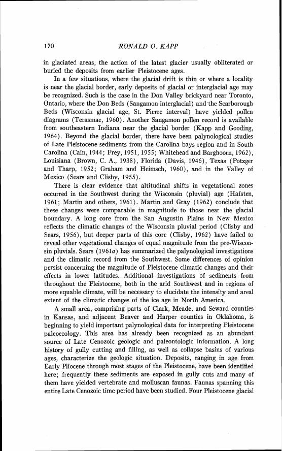
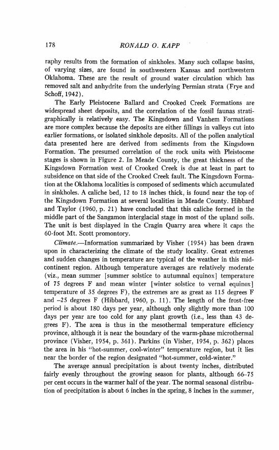
Location.-The deposits of Illinoian and Sangamon age described in this report are located in Meade County, Kansas, and in Beaver and Harper counties, Oklahoma. The collection sites (Fig. 1) lie between 99" and 101" west longitude and between 36" 30' and 37" 30' north latitude a t an elevation of about 2500 feet. The midcontinent setting of the fossil localities, well within the "rain shadow" of the Rocky Mountains and the more distant Pacific Coastal Ranges, contributes to the continentality of the climate and has doubtless been an important influence on the climate and biota throughout the Pleistocene. The area, situated between the arid Southwest and the glaciated Northeast, probably was the scene of strongly contrasting biogeographic and climatic changes during the Pleistocene.
Geology.-In his analysis of the physiography of the western United States, Fenneman (1931) includes the study area of this report within the Great Plains Province. The Meade County sites lie a t the eastern edge of the High Plains section of the Great Plains Province, while the localities in Oklahoma are east of the High Plains, in the strongly dissected Plains border section. The area lies entirely within the drainage of the Cimarron River, which flows southeasterly into Oklahoma. Topographically, in the western third of Kansas, especially in the High Plains, the land surface gradually rises toward the front ranges of the Rocky Mountains. In the northern part of the High Plains and throughout the Plains border section, the landscape is strongly dissected.
The High Plains area of western Kansas, Oklahoma, and Texas was built up during Tertiary time by deposition of gravel, sand, silt, and clay by streams flowing from the Rocky Mountains. I t is essentially a surface developed on the resistant Ogallala (Pliocene) Formation (Fenneman, 193 1, p. 11). The Pleistocene deposits which have yielded faunal remains and pollen are mostly alluvium deposited by streams that have since dis- appeared (as a t Jinglebob and UM-K4-53 localities), fill materials in sinks (Berends and Doby Springs), or, locally, sediments associated with artesian springs (Cragin Quarry).
FIG. 1. Location maps showing physical provinces according to Fenneman (map, 1946) and indicating the collecting localities. (Lower map redrawn from U. S. Geologi- cal Survey base maps, 1 :500,000.)
Key to physical provinces according to Fenneman: 12-central lowland; 13d-High Plains; 13e-Plains Border ; 13f--Colorado piedmont ; 13g-Raton section ; 16-South- ern Rocky Mountains.
Key to counties in which collections were made: A-Meade County, Kansas; B-Beaver County, Oklahoma; C-Harper County, Oklahoma.
Key to fossil localities: I-Big Springs Ranch, along Spring Creek. Localities: UM-K4-53, UM-K1-60, UM-K2-59, Mt. Scott and Cragin Quarry. 2-Meade County State Park. 3-Jinglebob pasture of XI Ranch. Locality: Jinglebob fauna quarry along Shorts Creek. 4--Butler Spring locality on XI Ranch. Localities: Butler Spring locality 2, Butler Spring local fauna site, Butler Spring Gopherus site, and Butler Spring Dire Wolf site. 5-Berends Draw. Locality: Berends local fauna site. &Doby Springs local fauna sites 2, 4, and 5.
176 RONALD 0. KAPP
A characteristic feature of the regional physiography is the paucity of bodies of standing water or persistent streams. The only permanent streams are a few rivers that head in the Rocky Mountains and very local creeks fed by artesian springs. Such artesian springs are not uncommon in the vicinity of the fossil sites and as the vents change position vertical tubes of fine sand often remain.
The soils of the region have been characterized as '[dark reddish-brown soils of subhumid warm-temperate grasslands with some hilly soils" (Visher, 1954, p. 379). The sandiness and instability of the soils were demonstrated during the dry years of the 19307s, when most of the area was considered a part of the dust bowl. At that time wind shelter belts of tamarisk ( Tanzarix gallica) , pines (mostly Pinus sylvestris and P. banksiana) , and other species were planted to aid in soil stabilization. The average annual soil moisture is about 10 per cent of saturation; the coarse substrate texture preventing water retention during dry periods. In winter, the soil normally freezes to depths of 6 to 18 inches.
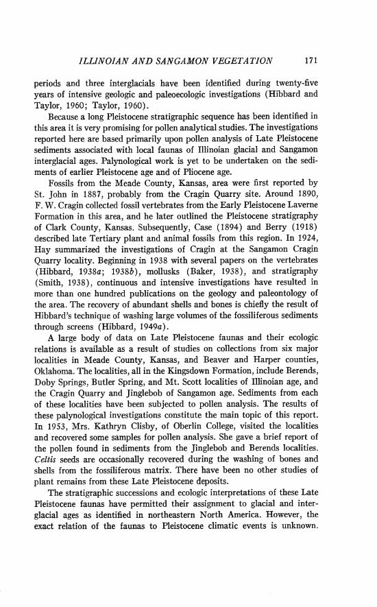
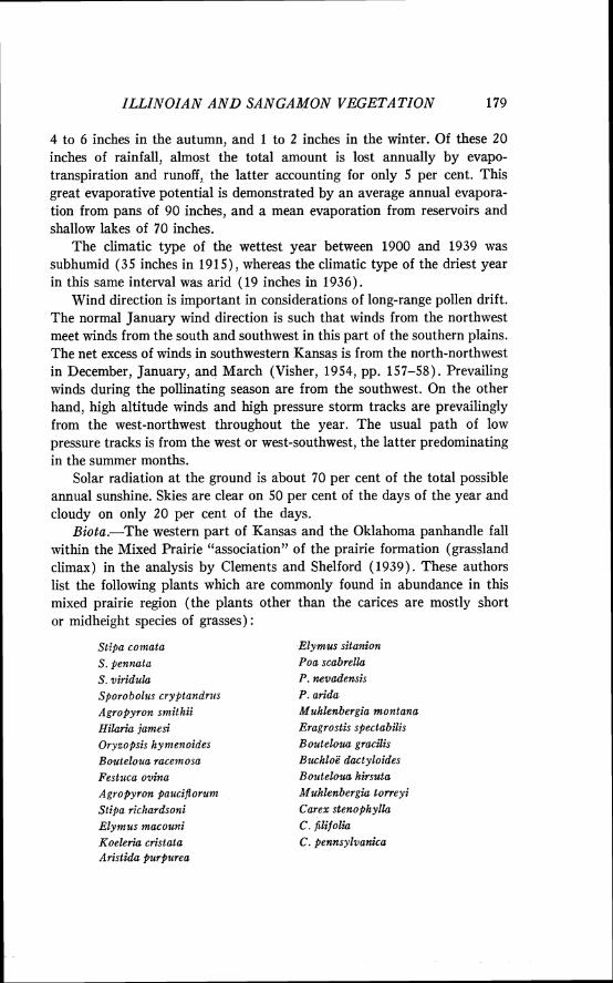
Study of the stratigraphy and paleontology of the area has been impeded by the lack of standard topographic maps. Some local areas, how- ever, have been mapped from aerial photographs in connection with paleon- tologic investigations. I t may be stated, as a generalization, that the Late Cenozoic alluvial sediments in the area show a cyclic pattern of sedimen- tation (Taylor and Hibbard, 1959, p. 16). Each of the major formations has a basal gravel or conglomerate unit which grades upward into fine sands and silt with local clay lenses. At the top of the formation is an erosional unconformity. The seven major formations date from the last two epochs of Cenozoic time; they are: ( 1 ) the Early Pliocene (Laverne Formation), ( 2 ) Middle Pliocene (Ogallala Formation), (3) Late Pliocene (Rexroad Formation), (4) Early Pleistocene (Meade Group; Ballard and Crooked Creek Formations), (5) Late Pleistocene (Sanborn Group; Kings- down and Vanhem Formations). The stratigraphy of the area is summarized in Figure 2 ; the stratigraphic positions of the several faunas mentioned in this paper are indicated in the same figure.
The erosional and depositional pattern which is responsible for the observed stratigraphy is not well understood and appears to be extremely complex. Faulting and uplift has influenced the local stream pattern (e.g., the course of Crooked Creek) and the pattern of erosion. Entrenchment of the Cimarron River has not been continuous but the ages of the terrace gravels are not older than the Illinoian. Progressive uplift of the Rocky Mountains coupled with climatic changes of the Late Cenozoic has undoubt- edly influenced local stratigraphy by significantly altering the regimen of the local streams. A distinctive feature of the local topography and stratig-
(12) Jinglebob 1.f.
(6) Borchers 1.f.
(31 Sanders 1.f.
Missler silt (CALICHEI
(2) Deer Park 1.f.
NEBRASKAN
FIG. 2 . Stratigraphic sequence of rock units and local faunas.
RONALD 0. KAPP
raphy results from the formation of sinkholes. Many such collapse basins, of varying sizes, are found in southwestern Kansas and northwestern Oklahoma. These are the result of ground water circulation which has removed salt and anhydrite from the underlying Permian strata (Frye and Schoff, 1942).
The Early Pleistocene Ballard and Crooked Creek Formations are widespread sheet deposits, and the correlation of the fossil faunas strati- graphically is relatively easy. The Kingsdown and Vanhem Formations are more complex because the deposits are either fillings in valleys cut into earlier formations, or isolated sinkhole deposits. All of the pollen analytical data presented here are derived from sediments from the Kingsdown Formation. The presumed correlation of the rock units with Pleistocene stages is shown in Figure 2. In Meade County, the great thickness of the Kingsdown Formation west of Crooked Creek is due a t least in part to subsidence on that side of the Crooked Creek fault. The Kingsdown Forma- tion at the Oklahoma localities is composed of sediments which accumulated in sinkholes. A caliche bed, 12 to 18 inches thick, is found near the top of the Kingsdown Formation at several localities in Meade County. Hibbard and Taylor (1960, p. 21 ) have concluded that this caliche formed in the middle part of the Sangamon interglacial stage in most of the upland soils. The unit is best displayed in the Cragin Quarry area where it caps the 60-foot Mt. Scott promontory.
Climate.-Information summarized by Visher (1954) has been drawn upon in characterizing the climate of the study locality. Great extremes and sudden changes in temperature are typical of the weather in this mid- continent region. Although temperature averages are relatively moderate (viz., mean summer [summer solstice to autumnal equinox] temperature of 75 degrees F and mean winter [winter solstice to vernal equinox] temperature of 35 degrees F ) , the extremes are as great as 115 degrees F and -25 degrees F (Hibbard, 1960, p. 11). The length of the frost-free period is about 180 days per year, although only slightly more than 100 days per year are too cold for any plant growth (i.e., less than 43 de- grees F ) . The area is thus in the mesothermal temperature efficiency province, although it is near the boundary of the warm-phase microthermal province (Visher, 1954, p. 361 ) . Parkins (in Visher, 1954, p. 362) places the area in his "hot-summer, cool-winter" temperature region, but it lies near the border of the region designated "hot-summer, cold-winter."
The average annual precipitation is about twenty inches, distributed fairly evenly throughout the growing season for plants, although 66-75 per cent occurs in the warmer half of the year. The normal seasonal distribu- tion of precipitation is about 6 inches in the spring, 8 inches in the summer,
ZLLZNOIAN A N D SANGAMON VEGETATION 179
4 to 6 inches in the autumn, and 1 to 2 inches in the winter. Of these 20 inches of rainfall, almost the total amount is lost annually by evapo- transpiration and runoff, the latter accounting for only 5 per cent. This great evaporative potential is demonstrated by an average annual evapora- tion from pans of 90 inches, and a mean evaporation from reservoirs and shallow lakes of 70 inches.
The climatic type of the wettest year between 1900 and 1939 was subhumid (35 inches in 1915), whereas the climatic type of the driest year in this same interval was arid (19 inches in 1936).
Wind direction is important in considerations of long-range pollen drift. The normal January wind direction is such that winds from the northwest meet winds from the south and southwest in this part of the southern plains. The net excess of winds in southwestern Kansas is from the north-northwest in December, January, and March (Visher, 1954, pp. 157-58). Prevailing winds during the pollinating season are from the southwest. On the other hand, high altitude winds and high pressure storm tracks are prevailingly from the west-northwest throughout the year. The usual path of low pressure tracks is from the west or west-southwest, the latter predominating in the summer months.
Solar radiation at the ground is about 70 per cent of the total possible annual sunshine. Skies are clear on 50 per cent of the days of the year and cloudy on only 20 per cent of the days.
Biota.-The western part of Kansas and the Oklahoma panhandle fall within the Mixed Prairie "association" of the prairie formation (grassland climax) in the analysis by Clements and Shelford (1939). These authors list the following plants which are commonly found in abundance in this mixed prairie region (the plants other than the carices are mostly short or midheight species of grasses) :
Stipa co?nata Elymus sitanion S. pennata Poa scabrella S . viridula P. nevadertsis Sporobolus cryptandrzrs P. arida Agropyron sntitlzii Muhlenbergia montana Hilariu jam& Eragrostis spectabilis Oryzopsis hynzenoides Bouteloua gracilis Boutelozra racelnosa BzuhloL; dactyloides Festuca ovina Bouteloua hirsuta Agropyron paucifloru?n Muhlenbergiu torreyi Stipa richardsoni Carex stenophyllu Elylnzds macouni C . filifoliu Koeleria cristata C . pennsylvanica Aristida pztrpurea
180 RONALD 0. KAPP
In presettlement times great herds of bison grazed this mixed grassland. Pronghorn occurred in great numbers, as did the prairie dog, prairie wolf, black-tailed jack rabbit, and ground squirrel. Pocket mice and grasshopper mice were abundant. Coyotes, badgers, kit foxes, skunks, weasels, and black-footed ferrets had their places in the original communities.
Dice (1943) includes this portion of the semiarid Great Plains within the "Kansan" biotic province, which is characterized by abundance of the grasses Bouteloua gracilis, Buchloe dactyloides, Stipa comata, and Agropy- ron smithii. He states that trees are rare, occurring only as groves of cotton- woods and other deciduous trees in gallery forests along river courses.
Gates (1940) states that in the southwestern part of Kansas there is a scanty representation of Sonoran Province elements, plants which typically have a more southwesterly distribution. He also states (p. 10) that "there is not evidence to indicate a tendency of the Rocky Mountain coniferous forest to proceed eastward into Kansas, unless plants of Cercocarpus montanus, which have sprung up in places in the Republican river drain- age . . . are accepted as exceedingly meager evidence."
Gates (1940, p. 11) gives an outline of the major plant communities found in Kansas. This is presented below:
Deciduous Hardwood Forest Province (eastern part of state) Xeric-mesic
Acer saccharurn association Quercus-Carya associations Sapindus association Ozarkian Quercus-Carya association Thicket associations
Hydric Ulmus-Acer saccharinurn association Populus-Salix association Margin associations Submerged-Potornogeton association
Prairie Province (western part of state) Xeric-mesic
Andropogon furcatus-Stipa association Sand prairie-Eragrostis association Panicum virgatum association Sand dune associations
Plains BuchloE-Bouteloua association Hydric
Marsh associations Paspalum floridurn glabratum association Spartina pectinata association
Salt marsh associations Distichlis association
Alkali flat associations River bank associations
ZLLZNOIAN AND SANCAMON VEGETATION
The plant associations of Gates' Deciduous Hardwood Forest Province are not found in the study area in southwestern Kansas, nor are all of the asso- ciations of the Prairie Province found there. A few species from the hard- wood associations are native in Meade County, however, and a few native individual trees are still occasionally found.
A list of the native plants of Meade County, Kansas, has been prepared by Dr. W. A. Horr of the University of Kansas. I t includes only seven native trees (Celtis occidentalis, C. reticulata, Populus sargentii, Prunus ameri- cana, P. angustijolia, P. virginiana, and Sapindus drummondii). Juniperus virginiana seems to have been introduced although i t now grows in the county and was abundant in Barber County, sixty miles to the east, a t the time of settlement. Three species of Salix are listed among the native species. No conifers are in the native flora (Gates, 1926), but several species of pine are now found planted in dooryards, cemeteries, and windbreaks.
Gates' Flora of Kansas lists 443 species which are known from Meade and/or one of the adjacent counties. Of these, 77 are grasses and 92 are species of composites.
The contemporary forest vegetation in the surrounding territory is of interest because these areas may have been potential sources of wind-borne pollen in the past as they are today. West of the fossil sites, in the direc- tion of the prevailing high altitude winds, stands of junipers become prevalent on the old elevated plain east of the Rocky Mountains. On the lower montane slopes in the Front Range of the Rockies, extensive stands of ponderosa pine (Pinus ponderosa) dominate the forests, while a t the higher elevations, the lodge-pole pine (Pinus murrayana) and finally spruce (especially Picea engelmannii) and fir (Abies lasiocarpa, A . arizonica, and A . concolor) predominate.
Along the Arkansas River in southeastern Oklahoma one finds tree species typical of the southeastern United States and the lower Mississippi drainage. These include the loblolly and shortleaf pines (Pinus taeda and P. echinata). East of the fossil sites, trees of the eastern deciduous forest invade the grasslands as gallery forests along the rivers. These extend as far as central Kansas and may consist of isolated individuals or continuous stands of elm, ash, walnut, box elder, and bur oak.
The contribution which these distant forests make to the modern pollen rain in the prairie region has been studied by analyzing the mixture of pollen preserved in the sediments of cattle-watering tanks. These data are summarized in the discussions which follow.
182 RONALD 0. KAPP
Field Investigations and Collections
Localities.-Samples of sediments were collected at 19 separate expo- sures a t 6 fossiliferous localities known from the Kingsdown Formation (Fig. 1) . Collections were made at a few exposures which have not yielded animal fossils, but which can be easily correlated stratigraphically with fossiliferous sites. Because of the great number of samples collected for pollen analysis (more than 800) and the long preparation procedure required to extract and identify the pollen, not all of the samples collected have been analyzed.
Collecting localities (see Fig. 1 ) : Doby Springs locality, N% S W g sec. 10, T. 2 7 N., R. 24 W., Harper County,
Oklahoma. Three collecting sites, numbered 2, 4, 5 (Stephens, 1960).
Berends local fauna locality, sec. 5 and 6, T. 5 N., R. 28 E.C.M., Beaver County, Oklahoma. One exposure.
Butler Spring locality, local fauna site and Adams local fauna site (Butler Spring loc. 2), S E g sec. 32, T. 34 S., R. 29 W., Meade County, Kansas. Gopherus locality, N W g S W g sec. 33, T. 34 S., R. 29 W., Meade County, Kansas, on the XI Ranch.
UM-K4-53 locality, S E g sec. 14, T. 32 S., R. 29 W., Meade County, Kansas, on Big Springs Ranch (Hibbard, 1963).
Cragin Quarry locality, microfauna locality 1 (Hibbard and Taylor, 1960), and Mussel site, S W g see. 17 , T. 32 S., R. 28 W., Meade County, Kansas, on the Big Springs Ranch.
Mt. Scott locality, S E g sec. 18, T. 32 S., R. 28 W., Meade County, Kansas, on the Big Springs Ranch.
Jinglebob local fauna locality, S W g sec. 32, T. 33 S., R. 29 W., Meade County, Kansas, along Shorts Creek.
Technique of sampling.-Samples were removed from the eroded faces of gullies, usually on the banks of streams or arroyos. The sediments exposed in such gully walls are usually weathered, the depth of weathering depending on the coarseness and consolidation of the unit. In an attempt to collect sediments which had not been subjected to recent weathering, the surface material on the vertical exposure to be sampled was removed to a depth of several inches to 3 feet. A change in color of the sediment and/or relative moistness was interpreted to be an indication that the sediments had not been recently weathered. There is no assurance that many of these deposits were not leached and weathered at some time in the interval since original deposition. From 400 to 500 grams of sediments were collected from the cleaned surface of the exposure. These samples were usually taken a t 6-inch intervals, although the sampling interval was often closer in organic-rich sediments or more widely spaced in very inorganic sediments, such as coarse sands and gravels. Sediments were avoided which gave indi-
ILLINOIAN AND SANGAMON VEGETATION 183
cation of possible surface contamination, such as the proximity of modern roots, fissures or animal burrows. The samples were placed into one-quart plastic bags and sealed immediately to prevent contamination with modern pollen in the field, or elsewhere. Samples were removed from each strati- graphic unit so that no sediments which might contain pollen would be overlooked.
Most of the samples upon which this report is based were collected by the author in the summer of 1960, although a few from the same or other sites collected by C. W. Hibbard in the summer of 1959 were analyzed for comparison. In 1953 the University of Michigan Museum of Paleontology field party and Mrs. Kathryn Clisby of Oberlin College sampled a few sites. Mrs. Clisby kindly provided several samples from the Jinglebob locality for reanalysis; these results are discussed subsequently in the appropriate section.
Stratigraphic analysis.-At each collection site the columnar section was measured by means of a steel tape and hand level. The stratigraphic position of each of the sediment contacts was noted before sampling and the exact position of each sample for pollen analysis recorded. Each site was photographed when preparations for sampling were complete, and the positions of the fossiliferous horizons were recorded. I t is believed that these records are sufficiently detailed to allow close correlation of the pollen analytical results with previous collections of the fossil faunas. Each of the measured stratigraphic sections and site photographs has been described previously (Kapp, 1962).
Laboratory Methods
The sandy or coarse-silty nature of many of the sediments is usually indicative of low pollen frequencies. A large volume of raw sediments was used in order to concentrate enough pollen to allow calculation of frequency percentages. In peat bog and lake deposits 1 cc or less of sediment is ordi- narily ample for counting 500 or 1000 pollen grains; I have found it necessary to extract pollen from 100 cc or more of this material. Even using large volumes of sediment and subjecting the sampIe to elaborate concentration procedures, the quantity of pollen recovered in many of the samples has been disappointingly low. Many black organic layers, which in the field look very promising for pollen analysis, proved to be barren, containing only decayed and humified particles of unrecognizable plant tissue. Conversely, a few rather sandy samples have yielded large amounts of pollen.
There were two phases in the treatment of sediments: (1) a series of
184 RONALD 0. KAPP
steps to mechanically concentrate the pollen, and (2) a succession of chemical treatments.
Mechanical separation.-During early stages of treatment, if it appeared that sands separated readily by sedimentation in beakers and centrifuge tubes, the suspended organic material and finegrained inorganic fraction was decanted into another vessel and the sand discarded. If a large amount of clay remained after acetolysis, the sample was centrifuged for 30 to 45 seconds at moderate speeds. This 'Lshort-centrifuging" caused the pollen- sized particles to separate out, leaving the clay suspended. This was de- canted and examined for pollen before discarding.
Another type of mechanical concentration used was flotation of the low-specific-gravity fraction. Since pollen has a specific gravity of about 1.3, much lower than most inorganic portions of the sediments, it was possible to suspend the sample in a liquid of high specific gravity and centrifuge down the inorganic material. The pollen and other organic debris collected near the surface of the heavy liquid and could be recovered. The flotation technique described by Funkhouser and Evitt (1959) was found to be very satisfactory; according to this procedure, a saturated 10 per cent HCl solution of zinc chloride (specific gravity of about 2.0) is utilized as the heavy liquid. In a few samples an ultrasonic generator was used for mechanical dispersion but this was not part of the usual schedule of preparation.
Chemical processing.-Chemical processing of the sediments included an initial treatment with dilute hydrochloric acid (7 per cent) to remove the carbonates. Almost without exception, the samples were very calcareous. After decanting, the sample was treated with concentrated hydrofluoric acid to remove most of the silicates. Zinc chloride flotation followed and then the washed residue was soaked in concentrated acetic acid prior to acetolysis (Erdtman, 1943, pp. 27-29). Finally the residue containing the pollen was suspended in glycerin jelly and mounted on slides for microscopic exam- ination.
Identification and counting of pollen.-Fossil pollen must be identified by comparing it with modern pollen of the taxon to which it is assigned. The reference collection of pollen and spores a t The University of Michigan was used in addition to my reference collection which includes pollen of many species of plants found abundantly in the grasslands, the Southwest, and the Rocky Mountains. Special attention was given to increasing the collections of pollen of the Ulmaceae, Onagraceae, Compositae, Moraceae, the common prairie trees and shrubs, and the conifers of the eastern Rockies. In an attempt to improve the identifications of pollen of the Compositae, a survey was made of the pollen of about 200 species in 40
ILLINOIAN A N D SANGAMON VEGETA TION
genera in the family. I t now seems possible to assign some composite pollen to tribes, and in some cases to genera.
Identifications were materially aided by reference to certain books, especially those of Erdtman (1943, 1952, 1957), Wodehouse (1935), Faegri and Iversen (1950), and Bertsch (1942).
A standardized notation system for indicating the degree of certainty of identification of pollen has been used in this study. Although most entities can be satisfactorily assigned to some taxon, these notations are used in cases of less than certain identification to convey to the reader the relative degree of accuracy and certainty of identifications. These notations, recently described by Benninghoff and Kapp (1962), are briefly outlined below:
(1) Taxon (with no qualifying notation about identification status)-identification certain, i.e., the pollen grain or spore of no other taxon (at least in this flora) could be confused with this one.
( 2 ) Taxon id. (abbreviation for idem, eadern, identical)-identifccation certain; used in instances in which the fact of positive identification needs to be indicated.
( 3 ) Taxon comp. (abbreviation for cornparatus, -a, -urn, comparative)--compares favorably with material from living representatives of taxon to which entity is provision- ally assigned, but uncertainty exists about conclusiveness of identification.
(4) Taxon sim. (abbreviation for sirnilis, -e, resembling, similar)--strong similarity to indicated taxon, which is, or is suspected of being, representative of several indistin- guishable taxa of comparable rank with respect to pollen or spore morphology.
(5) Undetermined-definitive morphological characters present, but taxonomic relationships unknown. Within this category several recognizable groups may be dis- tinguished and named according to a purely morphologic scheme, accompanied by descriptions and illustrations.
(6) Unknown-entities for which morphological characters are insufficient for determining whether they are pollen grains, spores, or other bodies.
( 7 ) The symbol -/- (hyphen, slant, hyphen), denoting damaged specimens, may be added to any of the above expressions for status of identification.
Pollen was counted by making systematic traverses across the micro- scope slides while recording the identifications on a standardized record form. In many instances several slides were examined in an attempt to compile a statistically significant number of pollen grains. Usually all of the processed sample, suspended in glycerin jelly, was examined microscopic- ally. In a few instances, the entire count was obtained from a single slide.
Presentation of data.-The standard procedure for presentation of pol- len analytical data involves the calculation of a percentage pollen spectrum for each sediment sample; this shows the relative frequency of the various sporomorphs that were encountered. These spectra are then usually plotted in stratigraphic sequence to form a pollen diagram. In forested regions, where the regional pollen rain consists almost exclusively of tree pollen, the number of arboreal pollen grains (AP) from a sample is often used as the basis for percentage calculations. This helps to insure that certain locally
RONALD 0. KAPP
numerous herbaceous plants, which may occasionally produce abundant pollen, do not obscure the characteristics of the regional vegetation, the chief basis for paleoecologic and climatic interpretations.
In nonforested regions, like the grasslands and the Southwest, the regional pollen rain may have only low percentages of tree pollen. Since anemophilous and entomophilous herbaceous plants characterize the vege- tational formations of these areas and contribute most of the pollen found in the atmosphere, pollen spectra in this report have been calculated on the basis of total tree, shrub, and herbaceous plant pollen (excluding aquatics). Pollen from aquatic plants (Cyperaceae, Nymphaeaceae, Myriophyllum, Typha-Sparganium, etc.) has been treated as a separate category in this report. These pollen types do not contribute to our knowledge of the regional vegetation, but are invaluable for characterizing the local ecologic conditions at the depositional site.
Typically pollen analysts count 200 to 500 pollen grains per sample, recognizing that the statistical significance of the data improves as the pollen sum increases. Since many samples in this study had only small quantities of pollen, a percentage spectrum was calculated whenever the total pollen in the sample was greater than 50. These spectra are presented in the form of pollen diagrams whenever there were several spectra from a site. In cases where only a few samples at a site yielded pollen, either the percentage frequencies or the actual numbers of grains are presented in tabular form.
Investigations of Modern Pollen Rain
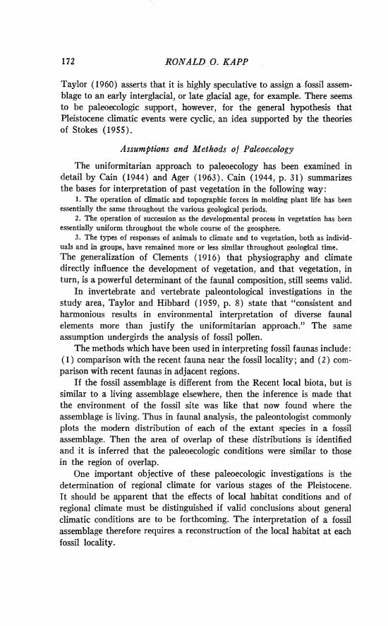
Objectives.-One basis for paleoecologic interpretations is the compari- son of a fossil assemblage with the present biota of the local area and of other geographic areas. The interpretations of pollen spectra from Late Pleistocene sediments should be more accurate when interpreted in terms of the modern pollen rain in various regions. Unlike the situation with macrofossils, presence alone is not sufficient palynological evidence to verify the occurrence of a plant in the area. Long range drift of pollen from distant forests influences the pollen rain in the grassland region. The magni- tude of this influence can be evaluated by study of the modern pollen rain in relation to contemporary distribution of the species concerned. As no characterization of the modern pollen rain of the central grassland region of the United States was available in the literature, a general study of this kind was undertaken (Kapp, 1961). A summary of these results is pre- sented below.
Cattle-watering tank analysis.-Sediments from cattle-watering tanks from a wide geographic area were collected in the summers of 1960 and
ILLII\~OZAN A N D SANGAMON VEGETATION 187
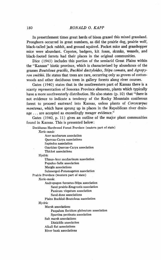
1961. Locations of the sites and a general summary of the results are shown in Figure 3 and several representative pollen types are shown in Plate V. Pollen spectra from the sample sites were grouped into three sum- mary pollen percentage spectra according to geographic location and
SCALE 'do' MILES - KEY
G R A S S E S C O M P O S I T A E CONIFEROUS TREES
C H ENOPODIACEAE - O T H E R AMARANTHACEAE DECIDUOUS T R E E S
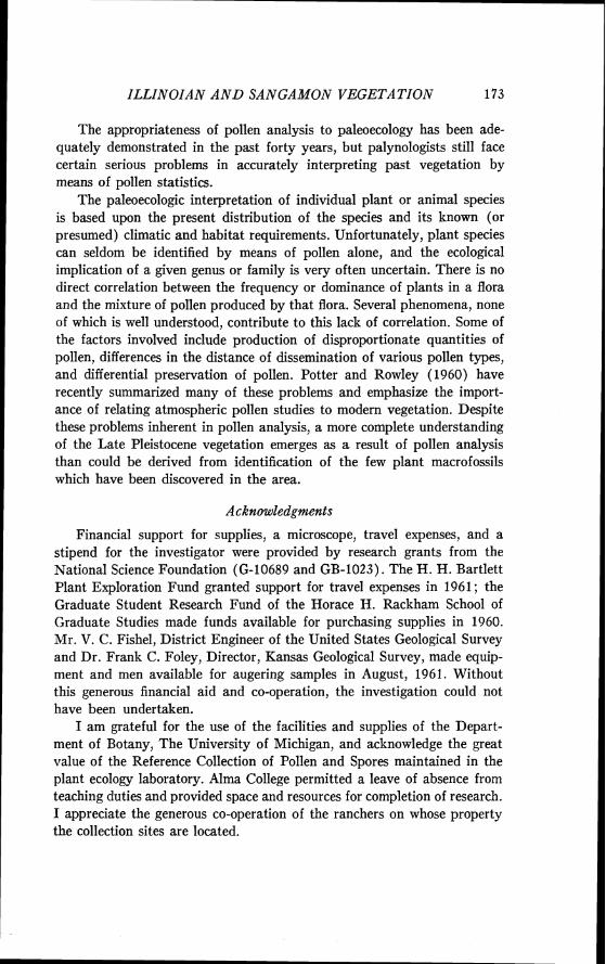
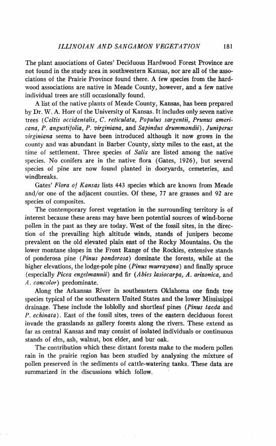
FIG. 3. Location of collecting sites and summary of modern pollen statistics.
pollen frequencies. These averaged spectra are plotted diagrammatically in Figure 4 and illustrate the major conclusions of the cattle tank analysis. Near the Front Range of the Rocky Mountains, conifer pollen predomin- ates and deciduous tree pollen is nearly absent. In the central grassland
RONALD 0. KAPP
F R O N T
R A N G E
R O C K Y
M T S .
I I
- 40
DECIDUOUS-
FOREST - - 20
M A R G I N - - 0
- 60
1 - 40
- - - 20
- 0
t r . = t r a c e not found in a v e r a g e % w rnlnlmurn % perceAtage counts
:-: local L - J ove r - r ep re sen ta t \onH maximum %
FIG. 4. Summary modern pollen rain spectra for three geographic divisions of the grassland.
60
40
20
0
CENTRAL:
PRAIRIE
region, pollen of Ambrosia, other Compositae, chenopod-amaranths, and grasses is most abundant. Surprisingly, a high frequency of grass pollen does not typify the pollen rain of the grasslands region. Grass pollen seems to be abundant only in the moister areas of the prairie. Near the deciduous forest margin, pollen of Quercus and a few other deciduous trees increases sharply, but the low stature grassland pollen entities are also very abundant.
I t seems certain that conifer pollen is widely distributed over the prairie
-
-
-
- L -
ILLINOZAN AND SANGAMON VEGETATION
from sources in the mountains to the west; the presence of low quantities of spruce and fir pollen across the grasslands attests to this fact. Increasing quantities of deciduous tree pollen occur eastward. Grassland, of the type encountered in the central plains today, is best characterized by pollen rain dominated by Ambrosia, other composites, and chenopod-amaranths.
The stock tank samples of pollen from the area of the fossil sites (Fig. 3, sites 2 and 5) compare favorably with the average ones for the central prairie area (Fig. 4). However, one collection made in Beaver County, Oklahoma, near the Berends local fauna site (Fig. 3, site 3 ) , is distinctly different. I t contained little pollen of the usually abundant com- posites and chenopod-amaranths, but had an unusually high percentage of grass pollen (43.2 per cent). Furthermore, 18 per cent of the pollen counted was of soapberry (Sapindus), a small tree which is now fairly common in the vicinity. Presence of other kinds of pollen, not encountered elsewhere, suggests that the flora of this locality near the Cimarron River has a greater variety of species than other central prairie areas.
This modern pollen rain analysis provides only an approximation of the presettlement pollen rain. Undoubtedly, introduced species and changes in the composition of plant communities as a result of grazing and cultiva- tion influence the modern pollen rain significantly.
Data of these kinds seem to have applications to the analysis of Pleistocene vegetation of the southern High Plains. A lowering of the altitudinal zones of vegetation in the mountains and spread of these mon- tane elements into the prairie could result in spectra of fossil pollen more nearly like those now encountered near the Rocky Mountains. Likewise, if major glacial advances caused a southwestward migration of the eastern deciduous forest, Pleistocene pollen spectra might be expected to resemble those of recent times from the eastern prairie.
Direct comparisons have not always been made between the fossil pollen spectra and the modern pollen rain in the following discussion. Nevertheless, many interpretations of the Late Pleistocene vegetation assume the validity of the judicious comparison of fossil pollen assemblages with the modern pollen rain.
POLLEN ANALYSIS O F LATE PLEISTOCENE SEDIMENTS
Pollen Associated with Illinoian Glacial Age Faunas
Doby Springs locality.-The Doby Springs local fauna was recovered from five separate exposures (Fig. I ) . All of the sediments, however: are included within 10 feet of a single composite stratigraphic section. The detailed geologic history of the collapse basin in which the beds were
190 RONALD 0. KAPP
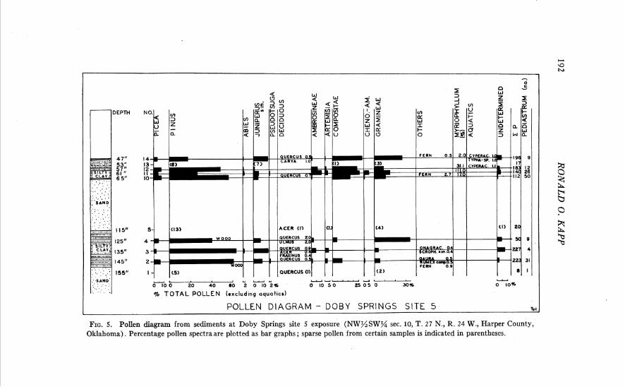
deposited and a description of the Doby Springs local fauna has been reported by Stephens (1960). Samples for pollen analysis were collected a t four sites a t the Doby Springs locality and the results from three of these are available for this report (sites 2, 4, 5). Pollen was sparse in most of the sediments, although satisfactory pollen spectra were derived from two sedimentary units a t site 5.
According to Stephens (1960), the collapse basin formed in Illinoian time and lake sediments containing the Doby Springs local fauna began accumulating a t that time. Settling and collapse along the southern edge of the basin account for the present dip of the beds. As caliche occurs in the uppermost lake sediments, the area was probably drained in Sangamon time. The fossiliferous sediments consist of sand, fine- to coarse-grained silts, and silty clays.
Smith (1958) recognized seven species of fishes from the deposits; this fish assemblage was interpreted to indicate a cool, pond environment fed by small streams. The freshwater ostracods have been studied by Gutentag and Benson (1962) ; the mollusks have been described by Barry Miller (1965). The gastropod Probythinella lacustris (Baker) is very abundant in the dark organic rich layer at site 4. This snail is found today in cool northern lakes and streams in a wide geographic area in eastern North America. Etheridge (1961, p. 181) has reported the presence of the glass lizard (Ophisaurus ) in this fauna. Twenty-four species of mammals have been described by Stephens (1960). Certain extant small mammals from the fauna (arctic shrew, masked shrew, northern water shrew, shorttail shrew, muskrat, meadow vole, and jumping mouse) indicate a marsh environment with surrounding meadows and some trees. The larger mam- mals include grazers such as the mammoth, camel, pronghorn, giant bison, and horse. The area of geographic overlap in distribution of the living forms of vertebrates in the fauna is in southeastern North Dakota and northeast- ern South Dakota. Stephens (1960, p. 1675) states that "the climate in Oklahoma during Illinoian time was probably similar to that in the area of overlap today. Lower summer temperatures and more effective moisture are indicated."
Stephens (1960, pp. 1698-99) has recognized four distinct communities in the area, and, on the basis of the fauna, makes certain inferences about the vegetation and local habitat. These communities include: a lake and marsh border community, a lowland meadow community (cool, moist, a low meadow with continuous grass cover), a shrub and tree community (farther from the lake, where leaf litter accumulated on the soil surface), and an upland prairie community (which includes both areas of heavy vegetation cover and dry sandy soils with sparse vegetational cover).
ILLINOIAN AND SANGAMON VEGETA TION 191
A seed, as yet unidentified (University of Michigan Museum of Pale- ontology [U.M.M.P.] 44334) was recovered during the process of washing the fossiliferous matrix in search of animal fossils (PI. I, Fig. 10).
Results of pollen analysis a t Doby Springs sites are discussed below in stratigraphic sequence from older to younger sediments, i.e., sites 5, 2, 4 respectively.
Site 5. The geologic section is located in N s S W g sec. 10, T. 27 N., R. 24 W., Harper County, Oklahoma. The results of pollen analysis are presented in a pollen diagram (Fig. 5 ) . Calculation of percentage frequen- cies was possible on material from seven samples (bar graphs in Fig. 5) , whereas the actual number of grains of the sparse pollen from other samples is indicated. If the pollen frequencies from all of the samples from this stratigraphic section are averaged, a generalized conception of the regional vegetation during the early period of preservation of the Doby Springs local fauna may be derived. This average pollen spectrum has the following pollen frequencies: Picea 5.0 per cent, Pinus 44.8 per cent, Abies 0.5 per cent, Juniperus sim. 7.6 per cent, Pseudotsuga 0.3 per cent, Quercus 0.7 per cent, other deciduous tree pollen 0.6 per cent, Ambrosia 2.9 per cent, Artemisia 1.5 per cent, other Compositae 15.0 per cent, Chenopodiaceae- Amaranthaceae 0.9 per cent, Gramineae 14.9 per cent, undetermined types 3.5 per cent. Myriophyllum pollen is very abundant, up to 11 1 per cent of total pollen, in certain samples.
An averaged pollen spectrum, such as the one presented above, does not convey all of the information which may be derived from the pollen diagram. There seem to be some significant differences between the pollen spectra from the lower silty clay (samples 2, 3, and 4) and those from the upper fossiliferous silt and clay (samples 10, 11, 12, and 13; Unit 17, in part, of Stephens, 1960, p. 1683). The lower sediments contain much less grass and composite pollen than those above, whereas the pollen of pine and juniper is more frequent near the base. I t seems probable that the uplands around the depositional basin, in this early part of the record, supported numerous pines and junipers, along with occasional Douglas fir trees (Pseudotsuga), oaks, and maples. In structure, the vegetation was probably a savanna, for there are significant quantities of grass, Artemisia, and other composite pollen. Some elements of this savanna vegetation are reminiscent of the plant communities in the foothills of certain parts of the Rocky Mountains today. For example, in the Ruby Mountains of south- western Montana, Pinus jlexilis, P. ponderosa, Pseudotsuga taxifolia, and two species of Juniperus commonly grow in gullies and on protected hillsides in the lower reaches of the mountains. The herbaceous understory in this
0
9Y 0
2 G P E 2
- - - --....dl . . . - 0 7 0 ; 20 i 0 <O 2 0 102% 0 10 5 0 2 5 0 5 0 30% 0 IOV.
% TOTAL POLLEN (excluding aquattcs)
POLLEN DIAGRAM - DOBY SPRINGS SITE 5 GK ,
FIG. 5. Pollen diagram from sediments at Doby Springs site 5 exposure (NW%SWg sec. 10, T. 2 7 N., R. 24 W., Harper County, Oklahoma). Percentage pollen spectra are plotted as bar graphs ; sparse pollen from certain samples is indicated in parentheses.
ILLIIVOIAN -4 hrD SAII'GAMOS VEGETL4 TIOS 193
area of Montana includes Artemisia, many composites and some grasses. The presence of Quercus and Acer pollen does not disturb the harmony of the suggested type of vegetation, as Acer glabrum, A. grandidentatum, and several species of oak are found today in Upper Sonoran and Submontane areas in the southern Rocky Mountains. Picea must have occupied habitats nearby, as a 5 per cent frequency of this pollen almost certainly indicated proximity of the trees. Picea pollen is notably under-represented in pollen spectra in comparison to the frequency of trees in the forest. In the study of modern pollen rain in the prairie, no Picea percentages approached 5 per cent, even on the slopes of the eastern ranges of the Rocky Mountains in ponderosa pine savannas.
The very small quantities of Abies pollen, such as those in the spectra from Doby Springs site 5, may have been the result of long-range drift of windborne pollen from the mountains to the west. Similar low frequencies of Abies pollen are encountered today in the grassland province.
Although Pinus is known to produce large quantities of easily dissem- inated pollen, and is therefore normally over-represented in pollen spectra, it is probable that pine grew in this region a t the time of Doby Springs deposition. In the Southwest, percentages of about 50 per cent for pine are accepted as evidence that a forest existed a t the site (Martin and Gray, 1962). Whether this criterion is applicable here is unknown. Scraps of epi- dermis which resemble that of Pinus leaves, and the presence of fragments of conifer tracheids in the sediments, seem to make it certain that conifers were then growing near the site.
Later in the record at site 5, the pollen frequencies of grass, Ambrosia, and composites increase markedly, while pine declines. The frequency of Pinus in the Illinoian plant communities may have been decreasing during this phase, while herbaceous elements were becoming more prominent. Such a vegetational change could be a reflection of increased dryness in the uplands, making some sites less suitable for trees. Pollen of the Onagraceae, including that of Gaura, was found occasionally. Most plants in this family indicate upland habitats.
The only clear evidence for characterizing the pond margin vegetation is the presence of small quantities of Salix, sedge, and Typha or Sparganium pollen. If the very low frequencies of Fraxinus and Ulmus pollen actually indicate presence of the trees in the local area, a few of these trees may also have grown near the lake.
Pollen of aquatic plants growing in the basin is represented almost exclusively by that of the submerged plant Myriophyllum, although occa- sional grains of sedges and Typha or Sparganium were identified. Myrio-
194 RONALD 0. KAPP
phyllum must have been extremely abundant in the lake at site 5, for in the upper sediments high percentages were encountered. Another member of the aquatic flora was the colonial green alga Pediastrum; the chitin- ous (?) cells of these colonies were very abundant in some of the samples.
Spores of nonvascular plants were frequent in many of the samples. Most distinctive were some unidentified "spiny" or "warty" spherical spores which were abundant in the upper sediments associated with the fossil fauna. Even more numerous than the "spiny" spores were psilate, spherical spores of various sizes which are essentially devoid of distin- guishing characteristics. In sample 2, it was calculated that there were eight thousand such spores per microscope slide. Occasional conidiospores of the imperfect fungus Alternaria were identified, and a few dyads of the type produced by fungal rusts were recorded.
Site 2. The geologic section is located in the N y SW% sec. 10, T. 27 N., R. 24 W., Harper County, Oklahoma. The results of pollen analysis are presented in Table I. Since pollen is relatively sparse in all samples from site 2, pollen frequency is noted only in terms of the actual number of grains present.
In order to compare the pollen content of the sediments of site 2 with those of stratigraphically-lower site 5, a pollen spectrum was computed by summing the pollen from the ten samples which were analyzed. This massed spectrum has the following composition: Picea 8.5 per cent, Pinus 29.1 per cent, Juniperus sim. 42.3 per cent, Ambrosia 1.1 per cent, other Compositae 1.7 per cent, Gramineae 4.6 per cent, fern 0.5 per cent, Sagittaria sim. 2.3 per cent, Nuphar sim. 0.5 per cent, Typha-Sparganium 2.3 per cent, undetermined 6.9 per cent.
When compared with the pollen spectra from the top sediments from stratigraphically lower site 5, the spectrum from site 2 provides some inter- esting information about the changes in the local vegetation at Doby Springs. The comparatively low percentage of pine pollen follows the trend toward decreasing pine which was established in the profile from site 5 (Fig. 5). Assuming that the pollen which resembles Juniperus is correctly identified, cedar must have been abundant near site 2 a t the time these deposits accumulated. This increase in Juniperus sim. pollen may reflect a continued increase in red cedar in the vegetation of the region, for the uppermost sample from site 5 also records a great increase in this pollen type. Picea pollen is more abundant in the averaged spectrum from site 2 than in any portion of the site 5 profile. This high percentage is due to a very high frequency of spruce pollen in one sample (No. 5 ) from site 2.
ZLLINOIAN A N D SANGAMON VEGETATJOX 195
TABLE I
POLLEN RECORD FROM DOBY SPRINGS SITE 2
Whether or not this reflects an actual vegetational change is unknown. The low percentages of grass and composite pollen from site 2 may be
the result of local overabundance of Juniperus rather than an actual decline of these types in the vegetation. This type of inference is very difficult to substantiate when pollen is sparse in the sediments. Myriophyllum was not found, although there are various aquatic pollen types present which reflect the nature of the emergent and shore vegetation.
Site 4. The geologic section is located in the N s S W g sec. 10, T. 2 7 N., R. 24 W., Harper County, Oklahoma. The dark brown or black silty zone near the base of this section (75-81 inches) contains abundant fossils of the aquatic snail Probythinella lacustris (Baker) ; these snails have been used as a basis for some ecological interpretations about the lake at Doby Springs.
Values are actual numbers of pollen grains counted; X indicates presence; -1- indi- cates degraded pollen. Depth is in inches below top of section.
Pollen Types
.-
Trees Picea . . . . . . . . . . . . . . . Pinus . . . . . . . . . . . . . . . . Juniperus sim. . . . . . . . .
Herbs Total Compositae Gramineae
Aquatics Nuphar Sagittaria sim. Typha-Sparganium
Others Ferns . . . . . . . . . . . . . . . . . . . . Pediastrum Undetermined
Numberslidescounted . . . Total pollen counted
(excluding aquatics) ...
Sediment
Clay-Sand
Type, Sample Numbers, and Depth
1 3 60"
1
. . . . . . . . . . . . . . . . . . . . . . . . .
. . . . . . . . . . . . .
. . . . . . . . . . . . . . . . . . . . . . . . . . . .
2
1
52"
1 2
20
2
23
Gray Sand Gray Silty Clay
4 5 48"
. . 1 4
. . . . . . . . . . . . . . . . . . . . . . . . . . . .
1
2
6
43"
11 30 14
1 3
2 . . . . . . . . . . . . . . . . . .
1
3
3
63
6 37" --
. . . . 2 4
. . . .
. . . .
X . . 1
6
21"
. .
.. 1
1 ..
. . . . . . . . . . . . 4
2
7 33"
1 16
. . . . . . . .
2
4
19
27"
-1-3 4 7
2 2
. . . . . . . . . . . .
3
8
17
9 1 1 1 3 1 5 15"
-/-I 1
11
. . 3
1 2 1
2
8
1 7
8"
2 10 ..
1 . .
. .
.. 3
1
7
14
196 RONALD 0. KAPP
Of all of the sites a t Doby Springs locality, pollen is most sparse a t site 4. Only five pollen entities have been identified from the dark sandy silt from which Probythinella has been recovered (Table 11). More than one-third of the pollen grains identified from these sediments are pine and
TABLE I1
nearly one-third are Juniperus sim. Some grass pollen and two grains of Compositae were also found along with one of Sagittaria sim. This pollen assemblage, although very meager, is similar to the pollen flora from the sediments at site 2. This similarity might be expected since the sample sites are very close geographically and the sediments are from the same strati- graphic unit (Unit 20, Stephens, 1960, p. 1683).
Values are actual numbers of pollen grains counted ; -1- indicates degraded pollen ; * indicates probable contaminant; ** indicates contaminant in sandy sediments from modern flora ; X indicates presence. Depth is in inches below top of section.
Pollen Types
Trees
Pinus . . . . . . . . . . . . . . . . . Juniperus sim. . . . . . . . . .
. . . . . . . . . . . . . . . . . QU~YCUS Ulmus . . . . . . . . . . . . . . . . . .
Herbs Total Compositae . . . . . .
. . . . . . . . . . . . Gramineae
Aquatics . . . . . . . . . Sagittaria sim.
Others Moss . . . . . . . . . . . . . . . . . . . Fungal spores . . . . . . . . . Fungal sporangia . . . . . . Undetermined . . . . . . . . . . .
Number of slides counted . . . Total pollen counted
(excluding aquatics) . . . . . . --
Sediment Type, Sample Numbers, and Depth
Sand
1 84"
3 2
1
3
1
X X
2
10
Sandy Silt Gray Sand
3 4 5 6 8 79" 76" 73" 69" 58"
3 4 3 1 . . 1 . . 6 3 . .
. . . . . . . . . .
. . . . . . . . . .
. . -/-I . . . .
. .
. .
X X . . . . 2
4
. .
. .
. . X
. . 3
5
5
. .
X X
. . 3
14
2
. .
. .
.. X X X X X
. . 4
6
(abundant Helianthus) . .
. .
X . .
. . 2
. .
. .
X X
2
2
contamination
ILLZNOIAN AND SANGAMON VEGETATION
Numerous pollen grains of Helianthus were identified in the sand in the upper two-thirds of the exposure. I t is apparent from the preservation of these pollen grains, and the absence of the usual flora, that the upper sedi- ments are contaminated by the recent pollen rain. Helianthus grows abun- dantly near the Doby Springs site in most years. This is the only known instance of sample contamination by recent pollen. Contamination to con- siderable depths might be expected as the sand is coarse and porous.
Synopsis.-The vegetation in the vicinity of Doby Springs during the early part of this Illinoian glacial age record seems to have included a pine- juniper community. Some Douglas fir, oak, and maple were present, but not abundant. Spruce occurred locally, probably occupying sites which were not subject to severe drying, possibly near the lake margin itself. During the early part of the sedimentary record, prior to deposition of the fossil fauna, the vegetation was somewhat different from that which developed later. Apparently there were significantly more trees, especially pine, in the drainage basin in this early period, for the pollen of grasses, composites, and other herbs is not prominent. Later, a t the time when the fossil fauna was being deposited, grass and composite pollen becomes abundant, suggesting that unforested openings were more frequent in the surrounding uplands. Late in the time interval, red cedar (Juniperus) must have been very com- mon in the region. The lake margin association included a few ash trees, some willow, and possibly spruce, along with grass, occasional sedges, some cattail or bur reed and a ground cover of moss. The flowering plants in the lake itself included arrowleaf (Sagittaria), water lily, and abundant water milfoil (Myriophyllum). The colonial green alga, Pediastrum, must have abounded in the lake a t certain times, and possibly also flourished in the freshwater streams which drained the surrounding landscape.
Berends local fauna locality.-The major collections of fossils which comprise the Berends local fauna were recovered from a 3- or 4-foot-thick stratum near the top of a 30-foot exposure (Pl. VI, Fig. 1) located about i mile south of the Cimarron River in secs. 5 and 6, T. 5 N., R. 28 E. C. M., Beaver County, Oklahoma (Fig. 1 ) . The sediments were deposited in a Late Pleistocene basin or sinkhole which formed as a result of collapse of underlying deposits. A relatively high percentage of extinct species in the fauna, together with stratigraphic evidence, suggests an Illinoian age for the fauna. Taylor and Hibbard (1959, p. 85) have summarized the paleontol- ogical data and the climatological inferences as follows:
198 RONALD 0. KAPP
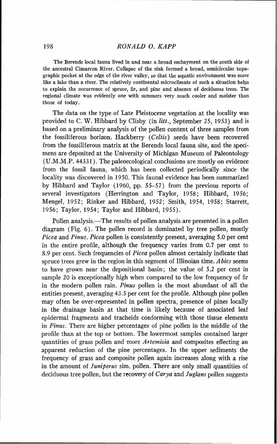
The Berends local fauna lived in and near a broad embayment on the south side of the ancestral Cimarron River. Collapse of the sink formed a broad, semicircular topo- graphic pocket at the edge of the river valley, so that the aquatic environment was more like a lake than a river. The relatively continental microclimate of such a situation helps to explain the occurrence of spruce, fir, and pine and absence of deciduous trees. The regional climate was evidently one with summers very much cooler and moister than those of today.
The data on the type of Late Pleistocene vegetation a t the locality was provided to C. W. Hibbard by Clisby (in litt., September 25, 1953) and is based on a preliminary analysis of the pollen content of three samples from the fossiliferous horizon. Hackberry (Celtis) seeds have been recovered from the fossiliferous matrix at the Berends local fauna site, and the speci- mens are deposited at the University of Michigan Museum of Paleontology (U.M.M.P. 44331). The paleoecological conclusions are mostly on evidence from the fossil fauna, which has been collected periodically since the locality was discovered in 1950. This faunal evidence has been summarized by Hibbard and Taylor (1960, pp. 55-57) from the previous reports of several investigators (Herrington and Taylor, 1958 ; Hibbard, 1956 ; Mengel, 1952; Rinker and Hibbard, 1952; Smith, 1954, 1958; Starrett, 1956; Taylor, 1954; Taylor and Hibbard, 1955).
Pollen analysis.-The results of pollen analysis are presented in a pollen diagram (Fig. 6) . The pollen record is dominated by tree pollen, mostly Picea and Pinus. Picea pollen is consistently present, averaging 5.0 per cent in the entire profile, although the frequency varies from 0.7 per cent to 8.9 per cent. Such frequencies of Picea pollen almost certainly indicate that spruce trees grew in the region in this segment of Illinoian time. Abies seems to have grown near the depositional basin; the value of 5.2 per cent in sample 20 is exceptionally high when compared to the low frequency of fir in the modern pollen rain. Pinus pollen is the most abundant of all the entities present, averaging 43.5 per cent for the profile. Although pine pollen may often be over-represented in pollen spectra, presence of pines locally in the drainage basin at that time is likely because of associated leaf epidermal fragments and tracheids conforming with those tissue elements in Pinus. There are higher percentages of pine pollen in the middle of the profile than at the top or bottom. The lowermost samples contained larger quantities of grass pollen and more Artemisia and composites effecting an apparent reduction of the pine percentages. In the upper sediments the frequency of grass and composite pollen again increases along with a rise in the amount of Juniperus sim. pollen. There are only small quantities of deciduous tree pollen, but the recovery of Carya and Juglans pollen suggests
661 NOIJ V L Y ~ X A hTom v3 N vs a N v N VIO NITTI
200 RONALD 0. KAPP
that the environment was different from the present. Pollen of aquatic plants (Myriophyllum, Typha-Sparganium, and Cyperaceae) is more abun- dant in the samples near the base of the exposure.
There was a great difference in the quantity of pollen recovered from the sand and from the clay layers interbedded in the sandy unit at this exposure. Only the clay sediments yielded sufficient pollen for calculation of percentage spectra (Fig. 6) . A decline in herbaceous plant pollen and an increase in pine percentages coincides with the incidence of sandy sediments. I t is possible, but not substantiated, that some differences in the pollen spectra from the middle of the record may be related to the manner and season of deposition. If the sand had been deposited very quickly and the clay slowly, in different seasons, the pollen frequencies might not be repre- sentative of the entire annual pollen rain. Because of questions of this kind, it seems unlilrely that there is climatic significance in the changes in pollen percentages near the middle of the diagram.
An averaged pollen spectrum has been calculated for comparison with the data from other localities and in particular with the Doby Springs sites. As there is some question about the representativeness of the pollen spectra from the sandy horizons of the exposure, only the individual spectra from the basal clay and from the silt near the top have been used to calculate the averaged pollen spectrum. The percentages of the various pollen types in the averaged spectrum are as follows: Picea 5.0 per cent, Pinus 43.5 per cent, AMes 0.9 per cent, Juniperus sim. 2.3 per cent, deciduous tree pollen 0.4 per cent, Ambrosineae 0.8 per cent, Artemisia 4.7 per cent, other Compositae 8.8 per cent, Chenopodiaceae-Amaranthaceae 1.1 per cent, Gramineae 3 1.8 per cent, aquatic plant pollen 1.8 per cent, others 0.5 per cent, undetermined 0.7 per cent.
Analysis of samples retrieved by C. W. Hibbard in 1959 has added ATymphaea, Ulmus, and Alnus to the flora of the lower clay unit near the base of the exposure (sample 4 of Hibbard). The elm and alder probably grew in moist soils near the lake margin or in stream bottoms.
Clisby reported pine of several pollen sizes, a few spruce pollen grains, very few fir grains, and a few grains of both grass and composites in the Berends flora. Her conclusion was that "the spruce in the pollen profile must indicate a markedly cooler and more moist climate than the present" (in litt., September 25, 1953). Such a conclusion is compatible with the results of the more extended analysis.
Numerous colonies of Pediastrum were recorded from samples 1, 3, 4, 10, and 17. This alga was apparently very abundant in the lake or tributary streams. A few colonial bodies resembling Botryococcus were found in the
ILLINOIAN AND SANGAIIION VEGETd TIOW 201
upper sediments. Fungal sporangia, hyphae, and spores were present in all samples, and extremely abundant in some.
The vegetation of the area during the period in which the sediments were deposited must have included substantial numbers of coniferous trees. The upland vegetation near the lake probably included numerous pines and junipers; the trees may have had a riparian habitat or the vegetational structure may have been a savanna. Although pollen of Celtis was not identified, the recovery of seeds from the fossiliferous matrix is evidence that hackberry trees were present in these upland plant communities. Spruce trees were most likely found in depressions and valleys, where wind and edaphic dryness were less severe. The drier upland plant communities must have been open and rich in grasses, composites, and unidentified members of the Onagraceae. Arternisia was a prominent member of the flora of these open areas. The vegetation cover was probably much more complete than at present, resulting in a more stable, less easily eroded soil surface. Greater representations of Chenopodiaceae and Amaranthaceae would be expected under conditions of aridity or edaphic disturbance.
Near the lake the vegetation was probably dominated by grasses. There were some willow, birch, and probably alder and elm trees in the immediate vicinity of the lake, with sedges, ferns, and Typha or Sparganium on the wettest substrates. The submerged aquatic flora included Myriophyllunz and an abundance of Pediastrum.
During the period of deposition at the Berends sink, the pollen record suggests relatively little change in the vegetation. Grasses may have been somewhat more abundant early in the period and composites somewhat more common later. The increased frequency of pine pollen in the middle of the section may not actually record a change in vegetation, but rather be the result of intermittant deposition a t certain seasons. The seasonal distri- bution of rainfall was probably more uniform than a t present.
Butler Spring area.-Vertebrate fossils have been collected and de- scribed from the Butler Spring area for about twenty years (Fig. 1) . Among these vertebrates are a turtle in the genus Emydoidea (Taylor, 1943), a neotenic salamander (Tihen, 1955), fishes (Smith, 1958), and several mammals (Hibbard, 1943, 1949b). Early geologic studies of the deposits a t the Butler Spring area were made by Smith (1940). Recently Hibbard and Taylor ( 1960) have described the stratigraphy in more detail and have reported a larger mollusk and vertebrate fauna.
Nearly all of the deposits a t the Butler Spring area were laid down in a series of sinkholes, and all of the sediments have been referred to the undifferentiated Sanborn Group. The deposits containing the Butler Spring local fauna are considered to be of late Illinoian age, so the sediments
202 RONALD 0. KAPP
which lie stratigraphically above the fauna are believed to be of the Sanga- mon interglacial age. Hibbard and Taylor (1960, p. 47) state that the Berends and Doby Springs local faunas are equivalent in age to the Butler Spring local fauna. This opinion has been modified (Hibbard, 1963), and exact correlation of the Butler Spring local fauna now seems doubtful.
The Butler Spring faunal assemblage lived near and in a medium-sized perennial stream which was considerably larger than the present Cimarron River. Such a stream environment is required by the gar (Lepisosteus), the channel catfish (Ictalurus punctatus), and the freshwater mussel (Quad- rula). Detailed information about the local habitat is provided by the quantitative study of the mollusks which have been recovered in great numbers. Inferences have been made about the terrestrial environment on the basis of the mammals and land snails. The fossiliferous beds were de- posited in quiet shallow water with "dense beds of submergent aquatic plants, such as Potornogeton, Myriophyllum, and Ceratophyllum" (Hib- bard and Taylor, 1960, p. 49). There were apparently small clumps of trees along the river, with abundant grasses and shrubs in the drier uplands.
Although there is a large northern element in the fossil fauna, it does not completely resemble any modern fauna from higher latitudes. The mollusk fauna has distinct affinities with the modern Great Plains faunas, and the largest share of the species now live in the central lowland of the eastern Dakotas. The fauna suggests that the climate in late Illinoian time had cooler summers than Meade County today. Winters were not as severe as those of North Dakota a t present and may not have differed greatly from those of today in the Meade County area. The precipitation probably was not much different than a t present, but because of cooler summers there would have been less evapo-transpiration and consequently more effective precipitation.
Butler Spring locality 2 (Adams local fauna site).-Locality 2 of Hibbard and Taylor (1960, p. 46; U.S.G.S. Cenozoic locality 21043) is in the S E g sec. 32, T . 34 S., R. 29 W., Meade County, Kansas (Fig. 1) . Fossils which have been assigned to the Butler Spring local fauna have been collected mostly from the interbedded silts, sands, and clay near the top of this exposure. Recently, mollusk and vertebrate fossils from these beds have been shown to compose a separate assemblage (Adams local fauna), and are no longer considered part of the Butler Spring local fauna (Hibbard, in litt., October 26, 1962).
The results of pollen analysis are presented in a pollen diagram (Fig. 7 ) . The samples which were examined from the upper sandy part of the expo- sure (above 212 inches) were nearly devoid of pollen. In the middle and
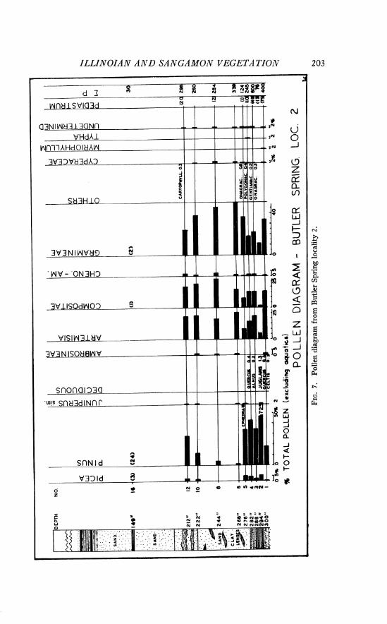
ILLINOIAN AND SAhTGAMO;17 VEGETrlTIOiV 2 03
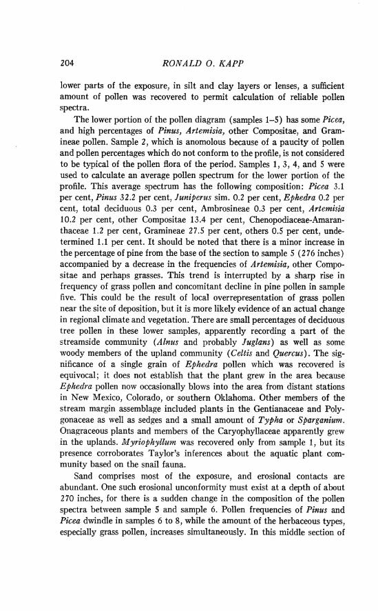
RONALD 0. KAPP
lower parts of the exposure, in silt and clay layers or lenses, a sufficient amount of pollen was recovered to permit calculation of reliable pollen spectra.
The lower portion of the pollen diagram (samples 1-5) has some Picea, and high percentages of Pinus, Artemisia, other Compositae, and Gram- ineae pollen. Sample 2, which is anomolous because of a paucity of pollen and pollen percentages which do not conform to the profile, is not considered to be typical of the pollen flora of the period. Samples 1, 3, 4, and 5 were used to calculate an average pollen spectrum for the lower portion of the profile. This average spectrum has the following composition : Picea 3.1 per cent, Pinus 32.2 per cent, Juniperus sim. 0.2 per cent, Ephedra 0.2 per cent, total deciduous 0.3 per cent, Ambrosineae 0.3 per cent, Artemisia 10.2 per cent, other Compositae 13.4 per cent, Chenopodiaceae-Amaran- thaceae 1.2 per cent, Gramineae 27.5 per cent, others 0.5 per cent, unde- termined 1.1 per cent. I t should be noted that there is a minor increase in the percentage of pine from the base of the section to sample 5 (276 inches) accompanied by a decrease in the frequencies of Artemisia, other Compo- sitae and perhaps grasses. This trend is interrupted by a sharp rise in frequency of grass pollen and concomitant decline in pine pollen in sample five. This could be the result of local overrepresentation of grass pollen near the site of deposition, but it is more likely evidence of an actual change in regional climate and vegetation. There are small percentages of deciduous tree pollen in these lower samples, apparently recording a part of the streamside community (Alnus and probably Juglans) as well as some woody members of the upland community (Celtis and Quercus). The sig- nificance of a single grain of Ephedra pollen which was recovered is equivocal; it does not ektablish that the plant grew in the area because Ephedra pollen now occasionally blows into the area from distant stations in New Mexico, Colorado, or southern Oklahoma. Other members of the stream margin assemblage included plants in the Gentianaceae and Poly- gonaceae as well as sedges and a small amount of Typha or Sparganium. Onagraceous plants and members of the Caryophyllaceae apparently grew in the uplands. Myriophyllum was recovered only from sample 1, but its presence corroborates Taylor's inferences about the aquatic plant com- munity based on the snail fauna.
Sand comprises most of the exposure, and erosional contacts are abundant. One such erosional unconformity must exist a t a depth of about 270 inches, for there is a sudden change in the composition of the pollen spectra between sample 5 and sample 6. Pollen frequencies of Pinus and Picea dwindle in samples 6 to 8, while the amount of the herbaceous types, especially grass pollen, increases simultaneously. In this middle section of
ILLZNOIAN AND SANGAMON VEGETATION 205
the pollen diagram, deciduous tree pollen is lost and the variety of herba- ceous types has decreased. This portion of the pollen diagram seems to represent a very different time interval from that recorded near the base. Higher in the section, in samples ten and twelve, the frequency of Pinus again begins to rise, accompanied by a decline in grass pollen. I t seems apparent that the vegetation recorded by the pollen spectra in the middle of the profile is quite different from that suggested by the spectra near the base. I t is impossible to suggest the length of the time period involved, but a striking change in the vegetational composition must have occurred during late Illinoian time. The middle part of the diagram suggests a drier and/or warmer condition with a resultant decrease in the abundance of arboreal species.
The deposits a t the Adams local fauna site were relatively coarse, stream-laid sands which contained almost no pollen. Usually when pollen was recovered from the middle or top parts of this section, it was from clay or silty layers and lenses. There is always a possibility that finegrained lenticular deposits have their origin in older reworked deposits, and under such conditions one might expect that many of the pollen grains would be eroded and broken. However, the majority of the pollen grains from the finegrained sediments within the sand unit were not damaged.
Butler Spring local fauna site.-Locality 1 of Hibbard and Taylor (1960, p. 46; U.S.G.S. Cenozoic locality 21042) is in the S E g sec. 32, T. 34 S., R. 29 W., Meade County, Kansas (Fig. 1) . This is the main exposure from which the Butler Spring molluscan local fauna was collected. This Illinoian fossil fauna assemblage is from the gray clay unit and in- cludes mollusks, fishes, a turtle, and Microtus. Camel, horse, and mammoth remains were recovered from the underlying sands.
The results of pollen analysis are presented in Table 111. Since pollen was so sparse, the table indicates the actual numbers of pollen grains which were recovered; percentage calculations were not attempted. Samples 1-8 were collected by Kapp in 1960; samples 10H and 12H were obtained by Hibbard in 1959; all samples were from the Illinoian molluscan local fauna horizon.
The absence of Picea pollen suggests that there may be a significant difference between the vegetation a t this site and that of the localities previously discussed. There is less Pinus pollen in these samples than in the other Illinoian sediments studied, and much more Juniperus sim. and decid- uous tree pollen. Pollen of composites is surprisingly scarce, while grass is well represented. One sample (10H) contained an exceptionally large amount of Typha (or Sparganium) pollen. Clusters of coniferous tracheids, with round full-bordered pits which resemble those of pine, were found in
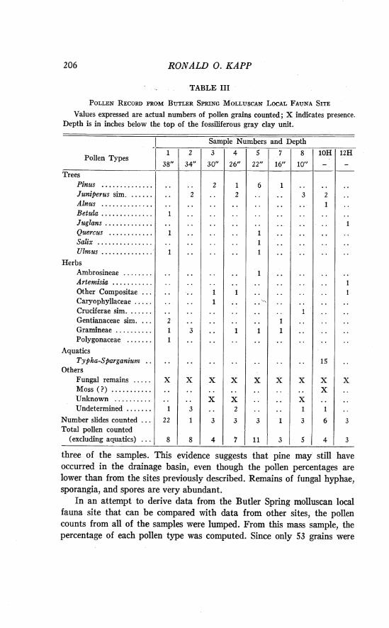
206 RONALD 0. KAPP
TABLE I11
Values expressed are actual numbers of pollen grains counted; X indicates presence. Depth is in inches below the top of the fossiliferous gray clay unit.
I Sample Numbers and Depth
Pollen Types
Trees Pinus .............. Juniperz~s sim. ...... Alnus . . . . . . . . . . . . . . Betula . . . . . . . . . . . . . . Juglans . . . . . . . . . . . . . Quercus . . . . . . . . . . . . Salix ............... Ulnzus . . . . . . . . . . . . . .
Herbs Ambrosineae . . . . . . . . Artemisia ........... Other Compositae . . . Caryophyllaceae . . . . . Cruciferae sim. . . . . . . Gentianaceae sim. . . . Gramineae . . . . . . . . . . Polygonaceae . . . . . . .
Aquatics Typha-Sparganiunz . .
Others Fungal remains . . . . . Moss ( ?) . . . . . . . . . . . Unknown . . . . . . . . . . Undetermined .......
... Number slides counted Total pollen counted
(excluding aquatics) . . . three of the samples. This evidence suggests that pine may still have occurred in the drainage basin, even though the pollen percentages are lower than from the sites previously described. Remains of fungal hyphae, sporangia, and spores are very abundant.
In an attempt to derive data from the Butler Spring molluscan local fauna site that can be compared with data from other sites, the pollen counts from all of the samples were lumped. From this mass sample, the percentage of each pollen type was computed. Since only 53 grains were
ILLINOIAN AND Sl i NGAMON VEGETATION 207
counted (excluding aquatics), these percentages must be regarded as sta- tistically unreliable. Nevertheless, they may be suggestive, to some extent, of the nature of the vegetation. The percentages are: Pinus 12.5 per cent, Juniperus sim. 18.8 per cent, total deciduous 16.8 per cent, total compositae 10.5 per cent, Gramineae 14.6 per cent, other herbaceous types 12.5 per cent, Typha-Sparganium 32.0 per cent, undetermined 14.6 per cent. The percent- age for Juniperus sim. is much higher than from samples a t the Doby Springs, Berends, or the Adams local fauna sites. The same is true of deciduous tree pollen which comprises 16.8 per cent of the pollen in this mass sample. In other Illinoian age samples the average percentage for deciduous tree pollen is 1 per cent or less. The predominent vegetation of the region seems to have been grassland. Along the stream a t the Butler Spring molluscan local fauna site, in Illinoian time, there were several hardwood trees including alder, birch, willow, elm, and possibly walnut, as well as pine and juniper.
Gopherus locality.-In 1959 C. W. Hibbard collected samples from deposits in the Butler Spring local fauna locality which are considered to be of Sangamon interglacial age. One such Sangamon site is designated the Gopherus locality (UM-K3-59) because of turtle remains found in a burrow in NW% SW% sec. 33, T. 34 S., R. 29 W., Meade County, Kansas. A sample from the "black soil zone" (upon which the base of the Gopherus burrow rested), and another taken 18 inches below the top of the soil horizon a t a nearby exposure, were examined for pollen. None was found in either. The nature of the organic debris in the "soil zone," however, may be of significance. The black color of the soil horizon is due to the presence of large quantities of degraded wood and other plant material. The wood cells are so completely humified that they are unrecognizable, but some of the fragments have the appearance of coniferous tracheids (viz., uniform diameter in cross section). Although this may represent the remains of a true humus layer of a soil horizon, there is a possibility that it is the remnant of a mass of burned plant debris. The striking similarity between the organic material from below the Gopherus horizon, and comparable material from a dark zone at the UM-K4-53 locality, will be discussed subsequently. Celtis seeds have been recovered from the reddish sandy silt just above the "black soil zone." These specimens are deposited in the University of Michi- gan 14useum of Paleontology (U.M.M.P. 41 577).
Synopsis.-Deposits in the Butler Spring area range in age from maxi- mum Illinoian to Sangamon. The sediments a t the base of the Adams local fauna site (Locality 2) have yielded a pollen assemblage which is similar to those from Berends and Doby Springs. Later Illinoian sediments do not contain as much pollen, and spruce is lacking. This seems to represent a
208 R O N A L D 0. KAPP
period of warmer climate near the end of the Illinoian glacial age. Sangamon sediments have not yielded pollen from the Butler Spring area. A late Illinoian or early Sangamon "black soil zone" contains plant remains very similar to a black organic zone a t the UM-K4-53 site.
Mt. Scott local fauna sites.-Miller (1961) has described a new mollus- can faunule from the UM-K4-53 site on the Big Springs Ranch ( S E g sec. 14, T . 32 S., R. 29 W.) in Meade County, Kansas (Fig. 1). The mollusks indicate that the local environment a t the time of deposition was that of a perennial stream with temporary pools adjacent to it. Some wooded areas near the stream must have existed to explain the presence of certain species of mollusks. Miller (1961, p. 115) has found that the central and eastern part of the Nebraska-South Dakota border is the area of geographical overlap of the ranges of the extant species in the molluscan fauna. He has postulated that, during this phase of Illinoian time, the summers were moister and cooler than in the area at present.
More recently, quantities of fossiliferous matrix have been washed at two sites (UM-K1-60, S W g SW% sec. 13, T. 32 S., R. 29 W., and UM- K2-59, S E g sec. 18, T. 32 S., R. 28 W.) near the UM-K4-53 locality. Possibly all of these exposures were once part of the same deposit of great linear extent along Spring Creek. The vertebrate fauna from the two new sites, as well as from UM-K4-53, has been described by Hibbard (1963). Etheridge (1961) has named this assemblage the Mt. Scott local fauna. Hibbard (1963, p. 187) states that "the mammals recovered from these three localities are . . . considered, on the basis of stratigraphic and taxo- nomic evidence, to belong to one fauna, the Mt. Scott local fauna." The presence of gar, muskellunge, and yellow perch is evidence of a pool of clear cool water at the site (Smith, 1963). According to Hibbard (1963), such a pool may have been formed by beaver dams. Hibbard considers the climate to have been moist, subhumid; winter temperatures were like those in southern New Jersey and summer temperatures like northern New Jersey or southeastern Wisconsin today. The rainfall was 20 to 25 inches a year, mostly falling during the warmer part of the year.
The sediments which contain the fauna are finegrained sands, silts, and clays. The deposit is interpreted as one of fluvial origin, formed by the meandering ancestral Spring Creek. All of the deposits are exposed along the north side of Spring Creek. Ostracods have also been found abundantly, and hackberry (Celtis) seeds were recovered during the washing of the matrix (U.M.M.P. 34797).
UM-K4-53 site. The contact between the black silty clay and the overlying gray clay in the stratigraphically lower section was followed up- stream (northwest) to another exposure where the upper sediments were
ILLIlVOIAN A N D SANGAMON VEGETA TION 2 09
sampled. This stratigraphically higher part of the section is shown in Plate VI, Fig. 2. Samples 4H, 11H, and 12 were collected at the southeast- erly exposure and samples 16 through 24 were taken a t the stratigraphically higher exposure. The results of pollen analysis are presented in Table IV.
Virtually no pollen was recovered in the interval from 109 to 136 inches in the section. The sediments are dark colored and appear to be very organic because they contain abundant fragments of decayed woody tissue which strongly resemble the material recovered from the "black soil zone7' a t the Butler Spring Gopherus site. As a t the Gopherus site, the tissue appears to be charred and some of the woody tissue seems to be from conifers. In these black sediments a t UM-K4-53, there are numerous echinate, spherical sporomorphs which may be moss spores. Although almost no pollen was recovered from the lower samples collected in 1960, two samples (4H and 11H) taken by Hibbard in 1959 from the fossiliferous horizon did contain pollen. The pollen spectrum for sample 4H (Table IV) is characterized by high percentages of pine pollen, low spruce percentages, and rather strong representation of deciduous tree pollen. There are significant quantities of composite and grass pollen. This assemblage, contemporaneous with the fossil fauna, differs from the other pollen spectra from this site in the absence of the chenopod-amaranth category.
Adequate quantities of pollen were recovered from three other samples collected a t this site. Sample 12 was taken a t 106 inches, at the base of a gray clay horizon. This pollen spectrum has a surprisingly low pine frequency, high percentages of Ambrosia, Artemisia and other composites, and large percentages of chenopod-amaranth pollen. Remains of many colonies of the green alga Pediastrum were found in this sample, probably indicating the formation of a streamside pool or shallow oxbow lake a t the depositional site. Two additional samples (21 and 22) yielded sufficient pollen for calculating pollen spectra; these were taken from the dark sedi- inents in a banded matrix which resembles varved clay. Like sample 12 in the underlying gray clay, there are relatively high percentages of Cheno- podiaceae-Amaranthaceae pollen in these two samples. Pollen of Picea and A hies is infrequent and its occasional presence may be due to long-range aerial dissemination from sources in the Rocky Mountains. A variety of deciduous tree pollen types is present (e.g., Salix, Quercus, Celtis, Ulmus) in these upper sediments, but they are not as abundant as in sample 4H.
Even though samples 21 and 22 were taken just 3 inches apart in the varved clay, there are striking differences between the percentages of pine and grass pollen in them. I t seems possible that the varves represent less than an annual accumulation of sediment. Some of the bands are much thicker than others, and in some the dark portion is broad and dark gray
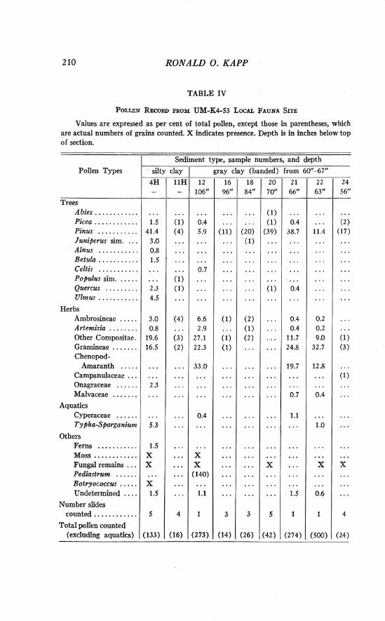
RONALD 0 . KAPP
TABLE IV
Values are expressed as per cent of total pollen, except those in parentheses, which are actual numbers of grains counted. X indicates presence. Depth is in inches below top of section.
Pollen Types
Sediment type, sample numbers, and depth
silty clay I gray clay (banded) from 60"-67"
106" l2
0.4 5.9
. . . . . .
. . . . . .
0.7 . . . ...
. . . . . .
6.6 2.9
27.1 22.3
33.0
. . . . . .
0.4 . . . . . .
. . . . . . X X
(140) . . . . . .
1.1
1
(273)
Trees L
A bies . . . . . . . . . . . . . . . . . . . . . Picea . . . . . . . . . . . . 1.5 Pinus . . . . . . . . . . . 41.4 Juniperus sim. . . . 3.0 Alnus . . . . . . . . . . . 0.8 Betula . . . . . . . . . . . 1.5 C e l t i ~ . . . . . . . . . . . . . . . . . Populus sim. . . . . . . . . Quercus . . . . . . . . . 2.3 Ulmus . . . . . . . . . . . 4.5
Herbs Ambrosineae . . . . . 3.0 Artemisia . . . . . . . . 0.8 Other Compositae. 19.6 Gramineae . . . . . . . 16.5 Chenopod-
Amaranth . . . . . . . . . . . Campanulaceae Onagraceae . . . . . . 2.3 Malvaceae . . . . . . . . . . . . . . . .
Aquatics Cyperaceae . . . . . . . . . . . . Typha-Sparganium 5.3
Others Ferns ........... 1.5 Moss ............ X Fungal remains . . . X Pediastrum . . . . . . . . . . . . Botryococcus . . . . . X Undetermined . . . . 1.5
Number slides counted ............ 5
Total pollen counted (excluding aquatics) (133)
- 11"
(1) (4)
- . . . . . .
(1) (1)
(4) . . . (3) ( 2 )
. . . . . . . . . . . .
...
...
. . .
4
(16)
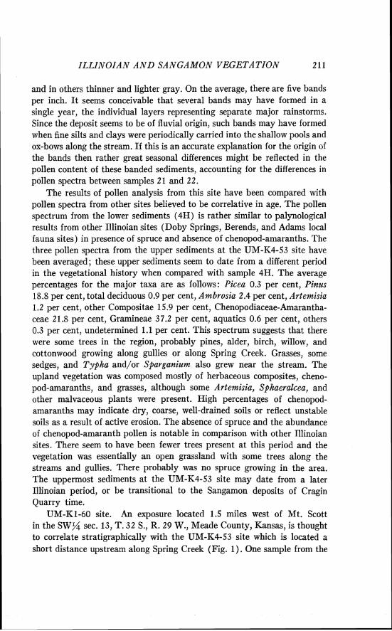
ILLINOIAN A N D SANGAMON VEGETATION
and in others thinner and lighter gray. On the average, there are five bands per inch. I t seems conceivable that several bands may have formed in a single year, the individual layers representing separate major rainstorms. Since the deposit seems to be of fluvial origin, such bands may have formed when fine silts and clays were periodically carried into the shallow pools and ox-bows along the stream. If this is an accurate explanation for the origin of the bands then rather great seasonal differences might be reflected in the pollen content of these banded sediments, accounting for the differences in pollen spectra between samples 2 1 and 22.
The results of pollen analysis from this site have been compared with pollen spectra from other sites believed to be correlative in age. The pollen spectrum from the lower sediments (4H) is rather similar to palynological results from other Illinoian sites (Doby Springs, Berends, and Adams local fauna sites) in presence of spruce and absence of chenopod-amaranths. The three pollen spectra from the upper sediments a t the UM-K4-53 site have been averaged; these upper sediments seem to date from a different period in the vegetational history when compared with sample 4H. The average percentages for the major taxa are as follows: Picea 0.3 per cent, Pinus 18.8 per cent, total deciduous 0.9 per cent, Ambrosia 2.4 per cent, Artemisia 1.2 per cent, other Compositae 15.9 per cent, Chenopodiaceae-Amarantha- ceae 21.8 per cent, Gramineae 37.2 per cent, aquatics 0.6 per cent, others 0.3 per cent, undetermined 1.1 per cent. This spectrum suggests that there were some trees in the region, probably pines, alder, birch, willow, and cottonwood growing along gullies or along Spring Creek. Grasses, some sedges, and Typha and/or Sparganium also grew near the stream. The upland vegetation was composed mostly of herbaceous composites, cheno- pod-amaranths, and grasses, although some Artemisia, Sphaeralcea, and other malvaceous plants were present. High percentages of chenopod- amaranths may indicate dry, coarse, well-drained soils or reflect unstable soils as a result of active erosion. The absence of spruce and the abundance of chenopod-amaranth pollen is notable in comparison with other Illinoian sites. There seem to have been fewer trees present a t this period and the vegetation was essentially an open grassland with some trees along the streams and gullies. There probably was no spruce growing in the area. The uppermost sediments a t the UM-K4-53 site may date from a later Illinoian period, or be transitional to the Sangamon deposits of Cragin Quarry time.
UM-K1-60 site. An exposure located 1.5 miles west of Mt. Scott in the S W g sec. 13, T. 32 S., R. 29 W., Meade County, Kansas, is thought to correlate stratigraphically with the UM-K4-53 site which is located a short distance upstream along Spring Creek (Fig. 1 ) . One sample from the
212 RONALD 0. KAPP
UM-K1-60 horizon was collected by Hibbard in 1959 and has been analyzed for comparison with the UM-K4-53 site. Pollen was not abundant in these sediments. Though a percentage calculation based on only a total pollen count of 52 grains may not be a statistically reliable body of evidence from which to reconstruct the vegetation, such a calculation suggests the compo- sition of the plant community a t that time. A comparison of the percentages in the UM-K1-60 pollen spectrum (Table V) with the averaged spectrum from the upper sediments from the UM-K4-53 site reveals a close resem- blance between the two, lending support to the hypothesis that the sites are stratigraphically correlative.
TABLE V RECORD OF POLLEN RECOVERED FROM UM-KI-60 S E D I M ~ T S
One sample was analyzed; both actual numbers of pollen grains and percentages are given.
- Number grains
Pollen Types 1 Counted Percentage
Trees Pinzrs . . . . . . . . . . . . . . . . . . . . . . . . . . . . . . . . . . . .
Herbs Ambrosia . . . . . . . . . . . . . . . . . . . . . . . . . . . . . . . . Artemisia . . . . . . . . . . . . . . . . . . . . . . . . . . . . . . . . . Other Compositae . . . . . . . . . . . . . . . . . . . . . . . . . Chenopod-amaranth . . . . . . . . . . . . . . . . . . . . . . . Gramineae . . . . . . . . . . . . . . . . . . . . . . . . . . . . . . . . Onagraceae . . . . . . . . . . . . . . . . . . . . . . . . . . . . . . . Unknown . . . . . . . . . . . . . . . . . . . . . . . . . . .. .. .
Number slides counted . . . . . . . . . . . . . . . . . . . . . . . . . Total pollen counted . . . . . . . . . . . . . . . . . . . . . . . . . . .
Base of Mt. Scott (UM-K2-59). Sediments a t the base of a 60-foot exposure along the north side of Spring Creek ( S E g sec. 18, T . 32 S., R. 28 W.) have been correlated with the sediments at the UM-K4-53 and UM-K1-60 sites (Hibbard, 1963). Mt. Scott ("The Lookout") is capped by a well-indurated caliche believed to date from middle Sangamon inter- glacial times; most of the exposure is composed of deposits which are correlated, on the basis of the Cragin Quarry local fauna, with other early Sangamon deposits. Pollen analysis of these sediments of Sangamon-age will be discussed subsequently.
Pollen was sparse in the sediments from the base of Mt. Scott; the record is presented in Table VI. Eight samples were analyzed from a core augered below the quarry floor in the summer of 1961. In addition, eight samples were collected in 1960 from the face of the 4-foot vertical exposure
(9)
(4) (1) (8) ( 5 )
( 2 2 ) (1) ( 2 )
4
( 5 2 )
17.6
7.7 1.9
15.4 9.6
42.3 1.9 3.8
. . .
. . .
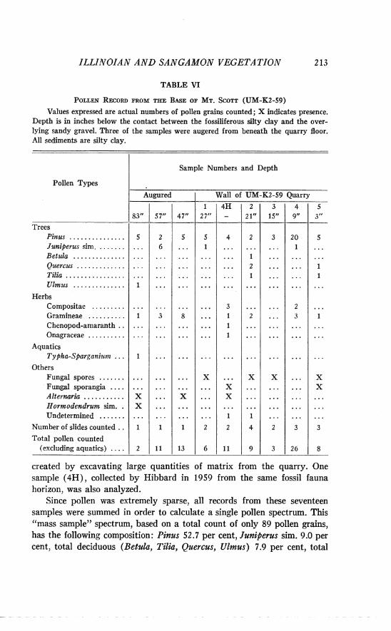
ILLINOIAN A N D SANGAMON VEGETATION 2 13
TABLE VI
Values expressed are actual numbers of pollen grains counted; X indicates presence. Depth is in inches below the contact between the fossiliferous silty clay and the over- lying sandy gravel. Three of the samples were augered from beneath the quarry floor. All sediments are silty clay.
I Sample Numbers and Depth
Pollen Types
Augured 1 Wall of UM-K2-59 Quarry I
created by excavating large quantities of matrix from the quarry. One sample (4H), collected by Hibbard in 1959 from the same fossil fauna horizon, was also analyzed.
Since pollen was extremely sparse, all records from these seventeen samples were summed in order to calculate a single pollen spectrum. This "mass sample" spectrum, based on a total count of only 89 pollen grains, has the following composition: Pinus 52.7 per cent, Juniperus sim. 9.0 per cent, total deciduous (Betula, Tilia, Quercus, Ulmus) 7.9 per cent, total
47"
5 ...
8 . . . . . . . . . . . .
X
1
13
1 4 . 5 7 "
5 3~~
5 . . .
1 1
. . . 1
X X
3
8
27"
5 1
...
X
...
2
6
Trees Pinus . . . . . . . . . . . . . . . Juniperus sim. . . . . . . . . . . Betula Quercus Tilia Ulmzls . . . . . . . . . . . . . .
Herbs Compositae Gramineae . . . . . . . . . . Chenopod-amaranth.. Onagraceae
Aquatics Typha-Sparganiunz ...
Others Fungal spores Fungal sporangia Alternaria . . . . . . . . . . . Hormodendrum sim. . Undetermined
Numberofslidescounted..
Total pollen counted (excluding aquatics) . . . .
5
1
1
1
. . . . . . . . . . . . . . . .
X X
1
2
1 4 H 2 -
4
. . . . . . . . . . . . . . . . . . . . . . . .
3 1 1 1
. . . . . . . . . . . . . . . . . . . . . . . .
. . . X X
. . . . . . . . . . . . . . . . . . . . . . . . 1
2
11
2 6
. . . . . . . . . . . . . . . . . . . . . . . . . . . . . . . . . . . . . . . . . . . . . . . . . . . . . . . . .
. . . . . . . . . . . . . . . . . . . . . . . . . . . . . . .
. . . . . . . . . . . . . . . . . . . . . 3
. . . . . . . . . . . . . . . . . . . . . .
. . . . . . . . . . . . . . . . ...
. . . . . . . . . . . . . . . . . . . 1
11
3 I t
3
. . . . . . . . .
X . . . . . . . . .
2
3
21tt
2 . . . . . . . . .
1 2 1
2
X
1
4
9
4 9u ---
20 1
. . . . . . . . .
. . . . . .
. . . . . .
2 3
. . . . . . . . . . . .
. . . . . . . . . . . .
. . .
. . . . . . . . . . . .
. . . . . . . . . 3
26
2 14 RONALD 0. KAPP
Compositae 5.6 per cent, Chenopodiaceae-Amaranthaceae 1.1 per cent, Gramineae 2 1.4 per cent, Onagraceae 1.1 per cent, Typha-Sparganium 1.1 per cent, undetermined 2.2 per cent. Except for the absence of Picea, this spectrum is more similar to lower sample (4H) from the UM-K4-53 site (Table IV) than to spectra from UM-K1-60 or the stratigraphically higher samples at UM-K4-53. Like the pollen spectrum from the lowest sample from UM-K4-53, it has high percentages of Pinus, a relatively high fre- quency of deciduous tree pollen, and very little chenopod-amaranth pollen. As a t UM-K4-53, Celtis seeds (U.M.M.P. 36290, P1. I, Fig. 9) have been washed from the fossiliferous matrix from the quarry a t the base of Mt. Scott.
Synopsis.-Pollen analysis of sediments a t the Mt. Scott local fauna site and the stratigraphically equivalent sites (UM-K4-53 and UM-K1-60) provides some concept of the vegetation associated with the Mt. Scott local fauna. Hackberry (Celtis) trees, a mixture of composites, grasses, and members of the Onagraceae probably occupied the uplands. Early in the period there was abundant pine and a variety of deciduous trees in the area, possibly in the moister habitats along the stream. Later in the depositional interval there apparently was a decline in the amount of pine in the vegetation; concurrently members of the Chenopodiaceae and/or Amaranthaceae became prominent in the area. The later period seems to have been a time of warmer and drier climate, probably with increased dissection of the uplands providing suitable habitats for the chenopods and amaranths.
The sediments at the UM-K1-60 exposure seem to be stratigraphically equivalent to the upper sediments a t the UM-K4-53 site and the pollen spectra from these two sites are rather similar. Although pollen is extremely sparse in samples from the base of Mt. Scott, these deposits seem to corre- late best with the lowermost sediments at the UM-K4-53 site.
The problem of correlating the Mt. Scott local fauna with other Late Pleistocene assemblages from the Meade County area has been discussed recently by Miller (1961) and Hibbard (1963). Only the pollen spectrum from one of the lower samples a t the UM-K4-53 site is a t all similar to pollen spectra from the Illinoian age deposits a t Doby Springs, Berends, or the lowermost sediments a t the Adams local fauna site. The low percentage of Picea in sample 4H, however, is of equivocal significance, for in the modern pollen rain spruce may attain this frequency in some prairie areas. Furthermore, low spruce percentages occur in pollen spectra from sediments associated with faunas which are clearly of interglacial age. None of the UM-K4-53 pollen spectra are sufficiently different from (or similar to) those from the sediments a t the Butler Spring local fauna site to deny or corroborate the previous hypothesis of Miller (1961) that the fauna a t
ILLINOIAN A N D SANGAMOI\: VEGETATION
UM-K4-53 is equivalent to the Butler Spring local fauna. The pollen data suggest that the UM-K4-53 deposit was formed during
a transitional period in very late Illinoian time when the biota was changing in response to the shifting climatic conditions. If the period of deposition a t the Mt. Scott local fauna locality was actually a period of climatic change and active biogeographic change, this might account for the difficulty encountered by Miller (1961, pp. 118-23) in correlating the UM-K4-53 site molluscan fauna with others from the Late Pleistocene of the area.
Pollen Associated with Sangamon Interglacial Age Faunas
Cragin Quarry local fauna sites.-The earliest collections of fossils in the Meade County area were made a t the Cragin Quarry locality in 1887 by St. John, and later by Cragin and Hay (Hibbard and Taylor, 1960). Additional fossils were collected in 1934, 1937, and 1938 and in subsequent years and have been described by Hibbard (1938a, 1939) and H. T. U. Smith (1940). Since 1953, there have been several periods of intensive collecting a t the original Cragin Quarry site and a t other stratigraphically equivalent sites on the Big Springs Ranch. A large number of the fossil mollusks and vertebrates have been identified and constitute the Cragin Quarry local fauna that was recently restudied in detail by Hibbard and Taylor (1960). An index map of the several Cragin Quarry fossil sites as well as the description of a measured stratigraphic section (Measured Section 1 in NWH SW% sec. 17, T . 32 S., R. 28 W., Meade County, Kansas) has also been published (Hibbard and Taylor, 1960, pp. 28-30). All fossiliferous deposits are within the Kingsdown Formation. This forma- tion unconformably overlies the Crooked Creek Formation, which in turn is separated by an erosional unconformity from the older Ballard Forma- tion. In this area the Kingsdown Formation is an alluvial deposit filling a valley that cut into the Crooked Creek Formation. The Kingsdown Forma- tion is capped by a moderately well-indurated caliche; most of the sedi- ments are fine sand, silt and clay, commonly containing lime nodules. Some large bones have been recovered from a sand tube interpreted to have been constructed by a former artesian spring. In Sangamon time this spring modified the local habitat with respect to water supply and microclimate and allowed an interesting assemblage of animals to live near the Cragin Quarry site.
On the basis of stratigraphic evidence and inferences from the fauna, Hibbard and Taylor (1960, p. 32) conclude that the Cragin Quarry local fauna is of Early Sangamon age, somewhat more recent than the Butler Spring local fauna. Furthermore, the position of the mid-Sangamon caliche
RONALD 0. KAPP
indicates that the Jinglebob local fauna is more recent than the Cragin Quarry assemblage, apparently dating from Late Sangamon time.
The local ecological conditions of early Sangamon time have been inferred from the faunal assemblage. A restricted oasis existed near Cragin Quarry locality 1 but the regional climate was semiarid. Two ecologically distinct groups of animals have been recovered. One group, including mol- lusks, fishes, salamanders, frogs, toads, and snakes, lived in the small oasis. Remains of certain land snails, two types of large tree bats (Dasypterus and Lasiurus) , the harvest mouse (Reithrodontomys) , and a deermouse indi- cate that there were trees and shrubs growing around the outlet of the spring. The absence of certain mammals suggests that the riparian belt of vegetation was of limited extent. The other ecological group includes the lizards and most of the small mammals which lived in a dry upland habitat. Etheridge (1958, p. 99) postulated that the ecological implications of the fossil lizards suggested "that the Cragin Quarry local habitat was one of extensive areas of bare, rocky ground with occasional rocky outcrops, per- haps small, scattered patches of sand, and vegetation consisting of scattered clumps of short grass and low xerophilous shrubs." Some herbivores (e.g., the large ground sloth, mammoth, and Equus scotti) browsed the wooded stream valleys while others (e.g., Camelops) lived primarily in the uplands.
Inferences about the climate of this part of the Sangamon period are based on the present distribution of extant members of the fossil fauna. Certain of the tortoises, lizards, bats, and rodents a t the present time have southern distributions, suggesting that the winters were much milder in Sangamon time, temperatures probably seldom dropping to freezing (Hibbard, 1960, p. 22; Hibbard and Taylor, 1960, p. 37). Several of the fossil mollusks now have northern or eastern distributions, their present ranges not extending as far as Meade County. Their occurrence at the Cragin Quarry site in Sangamon time has been explained by the ameliorating microclimatic effects of the artesian spring and by postulating a slight reduction in the summer extremes of temperature. The rainfall may not have been very different from present, but i t may have been more evenly distributed throughout the year eliminating summer drought (Hibbard and Taylor, 1960, p. 38).
Mt. Scott locality.-The Mt. Scott exposure which yielded the Cragin Quarry fauna (U.S.G.S. Cenozoic localities 21276, and 2 1277) is located in the SE% sec. 18, T. 32 S., R. 28 W., Meade County, Kansas. The results of pollen analysis of the Sangamon age sediments from Mt. Scott are presented in Table VII. Several samples from the middle of the exposure yielded sufficient pollen for the calculation of pollen spectra. Because of the great vertical extent of this exposure, only samples from sedimentary units which
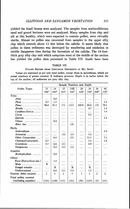
ILLZNOZAN A N D SANGAMON VEGETATION 217
yielded the fossil faunas were analyzed. The samples from nonfossiliferous sand and gravel horizons were not analyzed. Many samples from clay and silt a t this locality, which were expected to contain pollen, were virtually sterile. Almost no pollen was recovered from samples in the upper silty clay which extends about 13 feet below the caliche. I t seems likely that pollen in these sediments was destroyed by weathering and oxidation in middle Sangamon time during the formation of the caliche. The 24-foot- thick gray silty clay unit which comprises most of the middle of the section has yielded the pollen data presented in Table VII. Snails have been
TABLE VII
Values are expressed as per cent total pollen, except those in parentheses, which are actual numbers of grains counted. X indicates presence. Depth is in inches below the top of the section; all sediments are gray silty clay.
I Sample Numbers and Depth Pollen Types
Trees A bies . . . . . . . . . . . . . .
. . . . . . . . . . . . . . . Picea Pinus . . . . . . . . . . . . . . . Betula . . . . . . . . . . . . . . Carpinzrs-Ostrya . . . . . Carya .............. Quercus . . . . . . . . . . . . Ulmus . . . . . . . . . . . . .
. . . . . . . . . . Rhtrs sim.
Herbs Ambrosineae . . . . . . . . Artemisia . . . . . . . . . . . Other Compositae ... Chenopod-amaranth . . Gramineae . . . . . . . . . . Onagraceae . . . . . . . . .
Aquatics Myriophyll~r?i~ ......
Others Fern (Botrycltilrm sim.) Moss . . . . . . . . . . . . . . . Fungal remains . . . . . . Undetermined . . . . . . .
Number slides counted . . . Total pollen counted
... (excluding aquatics)
218 RONALD. 0. KAPP
collected near the base and top of this silty clay unit, but no pollen was recovered from the basal 7 feet of the unit.
The pollen spectra are overwhelmingly dominated by Pinus pollen. An average pollen spectrum was computed for the spectra from five samples (23, 24, 26, 34, 40). The frequencies of the various pollen entities in this average spectrum are as follows: Picea 1.0 per cent, Pinus 87.6 per cent, Abies 0.2 per cent, total deciduous (Betula, Carpinus, Carya, Quercus) 1.8 per cent, total Compositae (Ambrosia, Artemisia, others) 5.3 per cent, chenopod-amaranth 1.1 per cent, Gramineae 2.0 per cent, Myriophyllum 0.1 per cent, others 0.6 per cent, undetermined 0.5 per cent. The high frequency of pine pollen and the recovery of two wood fragments which appear to be pine, suggest that Pinus grew close to the site during deposition of the sediments in the middle horizons of the exposure.
Pine may have persisted into the interglacial age along the ancestral Spring Creek along with a few hardwoods such as Betula, Carpinus, Ca~ya , Ulmus, and possibly Quercus. Because of the close proximity of the pine trees, pollen of the upland herbaceous element is not proportionately repre- sented. Low pollen frequencies for Ambrosia, Artemisia, other composites, chenopod-amaranths, grasses, and members of the Onagraceae are charac- teristic of these pollen spectra. These pollen types probably provide only a fragmentary record of the vegetation of the upland areas. The low percent- ages of spruce and fir pollen may be the result of long-range wind transport from western montane forests.
The occurrence of Tilia pollen in two samples from UM-K2-59 (samples 2 and 5) and in one sample from this site (48, omitted from Table VII ) is of interest as the botanical range of Tilia americana now extends only to northeastern Kansas and eastern Nebraska, more than 200 miles from the fossil locality. There are some isolated occurrences of Tilia heterophylla as far west as western Missouri and northwestern Arkansas, but this species is less likely to have extended its range into the prairie region.
The presence of fern spores which closely resemble Botrychium suggests that rattlesnake ferns grew in the moister areas along the stream. The recovery of a single pollen grain of Myriophyllum gives evidence of the presence of one species of submerged aquatic flowering plant which grew in the streamside pools.
Hart Draw mussel site.-This exposure is located in a tributary gully on the south side of Hart Draw in the S W g sec. 17, T. 32 S., R. 28 W., Meade County, Kansas. I t is several hundred feet east of the exposure at Cragin Quarry locality 1 and stratigraphically lower than the main Cragin Quarry exposure. Snails, bone fragments, and fresh water unionid clams are exposed on the eroding surfaces of the fossiliferous deposit. The matrix is a
ILLINOIAN AND SANGAMON VEGETATION 2 19
relatively uniform gray clay. Samples collected in 1959 by Hibbard were analyzed for pollen content. The pollen spectra from these sediments are plotted a t the bottom of the pollen diagram in Figure 8.
The four pollen spectra from this site are rather uniform and are characterized by low percentages of Pinus pollen (average 13.7 per cent) and high percentages of composites (total composites average 26.3 per cent) and grasses (average 46.6 per cent). Quercus and Ulmus pollen was recov- ered in low, but significant, percentages. The strong representation of pollen of the herbaceous plants of the upland plant community suggests that the vegetation was mostly open grassland composed of grasses, Ambrosia, Artemisia, other composites, some chenopod-amaranths, and members of the Malvaceae, Onagraceae, and Campanulaceae. The trees were probably restricted to stream margins.
The streamside vegetation included sedges, Typha and/or Sparganium, ferns, and an occasional Lycopodium (in sample 3H) . There was sufficient standing water in some part of the drainage system to allow growth of Nuphar, the water lily.
Cragin Quarry locality 1 .-This site (Microfauna locality, 2 12 74) located in SW% sec. 17, T . 32 S., R. 28 W., Meade County, Kansas, includes the original exposures where the first fossils in the area were collected (Fig. 1) . Part of the exposure has been bulldozed to reveal the nature of the stratigraphy. At one quarry, about 15 tons of matrix were washed during the recovery of the Cragin Quarry local fauna.
The Cragin Quarry local fauna has been collected from the gray clay near the base of the stratigraphic section. Some samples were collected a t this site in 1959 by Hibbard, the remainder by myself in 1960. Many large bones were recovered during the excavation of the exposure in prepara- tion for sampling. The results of pollen analysis are shown in Figure 8.
The lowermost sample (lOH), collected a t the base of the draw, is very similar in pollen content to the samples from the Hart Draw mussel locality. I t has low percentages of Pinus and high representation of the herbaceous plants of the grassland. This spectrum is very different in its composition from the spectra derived from samples in the overlying sediments. The abrupt shift in the pollen composition implies the presence of an erosional unconformity.
Most of the stratigraphically higher samples collected a t this locality, especially in the top 10 feet of the section, were found to be nearly devoid of pollen. Samples 3 and 6, however, yielded pollen spectra which are strongly dominated by pine pollen (average 84 per cent) and contain more spruce (average 4.0 per cent) than the others from this site. Juniperus sim.

DEPTH NO
~ ~ b ' " " ' 30 60 do -5 o l o 0-0 W s i ' ' 30 ' ' sbY5, 0 7 0 %
% TOTAL POLLEN ( e x c l u d ~ n ~ aquot~cr) "clump
POLLEN DIAGRAMS - CRAGlN QUARRY SITES WJ
FIG. 8. Pollen diagrams from Hart Draw mussel site (lower) and Cragin Quarry microfauna locality (upper).
ZLLINOZAN AND SANGAMON VEGETATION 221
is present in low frequency and composites, grasses, and chenopod-amar- anths are also present in small quantities.
The predominance of pine pollen in these samples is similar to the results from samples of Sangamon sediments from Mt. Scott (Table VII). In light of the paleoecological interpretations from the fossil fauna (viz., dry uplands, very fragmentary tree cover along streams), it is probable that pine pollen is strongly over-represented in these samples due to the presence of an isolated stand of these trees near the oasis at the site of deposition. I t seems likely that the upland elements (composites, chenopod-amaranths, grasses) are under-represented in these pollen spectra because of the proximity of pines to the artesian spring where deposition occurred. I t is possible that this oasis also served as a refugium for a few spruce trees, as an average frequency of 4 per cent (from samples 3 and 6) could indicate that Picea actually grew near the site.
Samples from the upper sediments a t Cragin Quarry locality 1 contained little or no pollen. This situation again is parallel to the results of pollen analysis at Mt. Scott. The sediments below the caliche apparently were subjected to oxidation and weathering during or after the time of deposition, conditions which are believed to be very destructive to pollen. The compo- sition of the pollen spectra, the stratigraphic position of the sterile sediments in relation to the caliche, and faunal similarity, supports the correlation of the top of the Mt. Scott exposure with the sediments a t the Cragin Quarry sites.
Augered samples.-The extreme sparseness of pollen in many of the samples collected along gully exposures raised questions about the severity of recent weathering of sediments in such outcrops. I t seemed possible that the lack of pollen might be due to deep weathering in recent times near such gully exposures. Samples were retrieved by means of a power augering machine during the summer of 1961 in an attempt to obtain sediments which might yield pollen more abundantly. Such samples were collected a t four drill holes near the Cragin Quarry localities and a t Mt. Scott. One of the drill holes extended to a depth of 59 feet, probably completely through the Kingsdown Formation at the Cragin Quarry site. Several samples were processed from these borings to evaluate their usefulness in pollen analysis. The results of this analysis from the longest boring are presented in Table VIII. The absence of pollen in the shallow sediments and the kinds of pollen identified are both in harmony with the results of pollen analysis of samples taken in hand-dug sections a t the Cragin Quarry and Mt. Scott exposures. Sangamon-age samples retrieved by augering were no more productive than sediments recovered from freshly exposed gully banks.
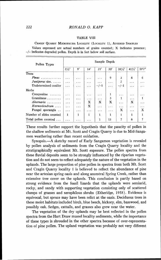
222 RONALD 0. KAPP
TABLE VIII
CRAGIN QUARRY MICRO.FAUNA LOCALITY (LOCALITY I), AUGERED SAMPLES
Values expressed are actual numbers of grains counted; X indicates presence; -/- indicates degraded pollen. Depth is in feet below soil surface.
I
Pollen Types
Trees Pinus . . . . . . . . . . . . . Juniperus sim. . . . . . Undetermined conifer
Herbs Compositae . . . . . . . Gramineae . . . . . . . . . Alternaria . . . . . . . . . Hormodendrum . . . . Fungal sporangia . .
Number of slides counted
Total pollen counted . . .
Sample
14'
...
...
. . . X X
1
...
Depth
These results further support the hypothesis that the paucity of pollen in the shallow sediments at Mt. Scott and Cragin Quarry is due to Mid-Sanga- mon weathering rather than recent oxidation.
Synopsis.-A sketchy record of Early Sangamon vegetation is revealed by pollen analysis of sediments from the Cragin Quarry locality and the stratigraphically equivalent Mt. Scott exposure. The pollen spectra from these fluvial deposits seem to be strongly influenced by the riparian vegeta- tion and do not seem to reflect adequately the nature of the vegetation in the uplands. The large proportion of pine pollen in spectra from both Mt. Scott and Cragin Quarry locality 1 is believed to reflect the abundance of pine near the artesian spring oasis and along ancestral Spring Creek, rather than extensive tree cover on the uplands. This conclusion is partly based on strong evidence from the fossil lizards that the uplands were semiarid, rocky, and sandy with supporting vegetation consisting only of scattered clumps of grasses and xerophilous shrubs (Etheridge, 1958). Evidence is equivocal, but spruce may have been relict a t the oasis. Deciduous trees in these moist habitats included birch, blue beech, hickory, elm, basswood, and possibly oak. Sedges, cattails, and grasses also grew near the water.
The vegetation of the dry uplands may be best reflected in the pollen spectra from the Hart Draw mussel locality sediments, while the importance of these types is shrouded in the other spectra because of over-representa- tion of pine pollen. The upland vegetation was probably not very different
ILLINOIAIV AND SANGAMON VEGETATION 223
from that of today. Ambrosia, Artemisia, and other composites, as well as grasses, and to a lesser extent chenopods and amaranths, were all important members of this upland plant assemblage. Plants in the insect pollinated families, Onagraceae (including Gaura) , and in the Malvaceae (including Sphaeralcea) must have been abundant, for their pollen is frequently recov- ered from these Sangamon sediments. Pollen of a member of the Campanu- laceae, either Campanula or Specularia, was identified several times, reflect- ing the presence of this plant in the flora.
Certain members of the aquatic snail fauna, which have distinctly northern affinities, persisted in the ameliorated climate around the oasis during the Sangamon interval (Hibbard and Taylor, 1960, pp. 37-38). These snails seem to have had disjunct distributions in Meade County during Sangamon time when the regional climate was warm enough to allow certain southern and southwestern vertebrates to spread into the area. In a similar fashion, it is quite possible that disjunct stands of certain trees such as pine, possibly spruce, and certain hardwoods persisted in the equable microhabitats near the artesian springs and perennial streams. Pine may have survived in Meade County throughout the interglacial time, for high pine pollen frequencies also occur in the samples analyzed from the late Sangamon Jinglebob quarry. These data will be discussed below.
Jinglebob local fauna locality.-A fossil-bearing terrace deposit of the Kingsdown Formation was discovered in 1947 along Shorts Creek in the Jinglebob pasture of the X I Ranch (SW% sec. 32, T. 33 S., R. 29 W., hleade County, Kansas, Fig. 1) . The fossil-bearing sediments are gray sandy silts exposed in the wall and bed of intermittent Shorts Creek only two or three miles from its head. The ancestral Pleistocene stream formed the terrace within a broad valley which had been incised through the Early Pleistocene Crooked Creek and Ballard formations into the underlying Rexroad Formation of late Pliocene age. The present Crooked Creek does not follow the meanders of the old stream and therefore the fossiliferous terrace deposits outcrop in only one or two places.
Skeletal remains of large vertebrates (mammoth and short-faced bear) were initially recovered at the site. In 1950 and 1951 large quantities of the fossiliferous matrix were washed to recover mollusks and smaller verte- brates. A long list of small rodents is now available from this site and certain of these animals are of paleoecologic and zoogeographical interest. The Jinglebob fauna consists of elements which are distinctly of southern affinities (Terrapene, Reithrodontomys, Neotonta, Dipodomys, Oryzomys, Spilogale, Mammuthus columbi, and others) and others which are consid- ered to be part of a northern assemblage (Sorex, Synaptomys, Microtus, Ondatra, and Zapus) (Hibbard, 1955). From the occurrence of several
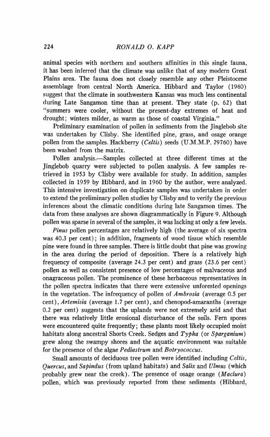
RONALD 0. KAPP
animal species with northern and southern affinities in this single fauna, i t has been inferred that the climate was unlike that of any modern Great Plains area. The fauna does not closely resemble any other Pleistocene assemblage from central North America. Hibbard and Taylor (1960) suggest that the climate in southwestern Kansas was much less continental during Late Sangamon time than at present. They state (p. 62) that "summers were cooler, without the present-day extremes of heat and drought; winters milder, as warm as those of coastal Virginia."
Preliminary examination of pollen in sediments from the Jinglebob site was undertaken by Clisby. She identified pine, grass, and osage orange pollen from the samples. Hackberry (Celtis) seeds (U.M.M.P. 29760) have been washed from the matrix.
Pollen analysis.-Samples collected at three different times at the Jinglebob quarry were subjected to pollen analysis. A few samples re- trieved in 1953 by Clisby were available for study. In addition, samples collected in 1959 by Hibbard, and in 1960 by the author, were analyzed. This intensive investigation on duplicate samples was undertaken in order to extend the preliminary pollen studies by Clisby and to verify the previous inferences about the climatic conditions during late Sangamon times. The data from these analyses are shown diagrammatically in Figure 9. Although pollen was sparse in several of the samples, it was lacking at only a few levels.
Pinus pollen percentages are relatively high (the average of six spectra was 40.3 per cent) ; in addition, fragments of wood tissue which resemble pine were found in three samples. There is little doubt that pine was growing in the area during the period of deposition. There is a relatively high frequency of composite (average 24.3 per cent) and grass (23.6 per cent) pollen as well as consistent presence of low percentages of malvaceous and onagraceous pollen. The prominence of these herbaceous representatives in the pollen spectra indicates that there were extensive unforested openings in the vegetation. The infrequency of pollen of Ambrosia (average 0.5 per cent), Artemisia (average 1.7 per cent), and chenopod-amaranths (average 0.2 per cent) suggests that the uplands were not extremely arid and that there was relatively little erosional disturbance of the soils. Fern spores were encountered quite frequently; these plants most likely occupied moist habitats along ancestral Shorts Creek. Sedges and Typha (or Sparganium) grew along the swampy shores and the aquatic environment was suitable for the presence of the algae Pediastrum and Botryococcus.
Small amounts of deciduous tree pollen were identified including Celtis, Quercus, and Sapindus (from upland habitats) and Salix and Ulmus (which probably grew near the creek). The presence of osage orange (Maclura) pollen, which was previously reported from these sediments (Hibbard,
ILLINOIAN AND SANGAMON VEGETA TZON 225 t
:: ~ ~ 3 2 rn d 3 - e l ,
0 03NIWt17 I WNn
SNti3J
s311vn~v --
226 RONALD 0 . KAPP
1955, p. 200), has not been verified. Celtis pollen is very similar to Maclura, although the pollen grains seem to be distinguishable on the basis of size and the details of wall and pore structure. Celtis pollen was found once during my analysis and hackberry seeds have been recovered during wash- ing of the fossiliferous matrix. I t is believed that the previous report of Maclura may actually have been based upon the presence of Celtis.
A single pollen grain which is unquestionably that of a member of the Myricaceae was recovered and is of phytogeographic interest. I t is difficult to separate Comptonia and Myrica on the basis of pollen characteristics. Myrica is known from the Tertiary fossil record of the western United States, but no representatives of this family are now found in the southern Rocky Mountain states. The presence of Myrica pollen might be explained by suggesting a more southerly Sangamon range for Myrica gale L., which now is found only as far south as Oregon and Wisconsin (Fernald, 1950), or Comptonia perigrina (L.) Coulter, which extends south to Saskatchewan, Indiana, and North Carolina. I t is also conceivable that Tertiary species of Myrica could have persisted into Late Pleistocene times in this region.
Another explanation for the presence of Myrica is to postulate that it came into the southern High Plains from the southeast. Three species of Myrica (M. heterophylla Raf., M. cerifera L., and M. pusilla Raf.) are now found in the Gulf Coast states, as far west as Texas and Arkansas (Fernald, 1950, p. 524; Oosting, 1956, p. 292). These species are usually found in dry or moist thickets, woodlands, or swamps; furthermore, Myrica pusilla Raf. sometimes occurs in pine barrens. If the climate was sufficiently ameliorated during this phase of Sangamon time to allow the rice rat (Oryzomys) and several other southern animals to move north- westward into the area, then ecological conditions might well have allowed members of the southeastern flora to invade also. If this hypothesis has merit, then the pine pollen in the Jinglebob spectra might also represent such southeastern species as Pinus echinata and P. taeda, and the composi- tion of the vegetation might have borne some resemblance to the pine savannas which now extend into eastern Texas and Arkansas.
The results of pollen analysis are in accord with the earlier paleoeco- logical conclusions of Hibbard (1955) that the late Sangamon climate was more moist and less continental than the present.
SUGGESTED CORRELATION OF THE FOSSIL ASSEMBLAGES
Bases for Cmrelation
An attempt has been made to correlate the Kingsdown Formation exposures which have been studied in this investigation. I t must be empha- sized that such a correlation is only approximate a t several points, and will
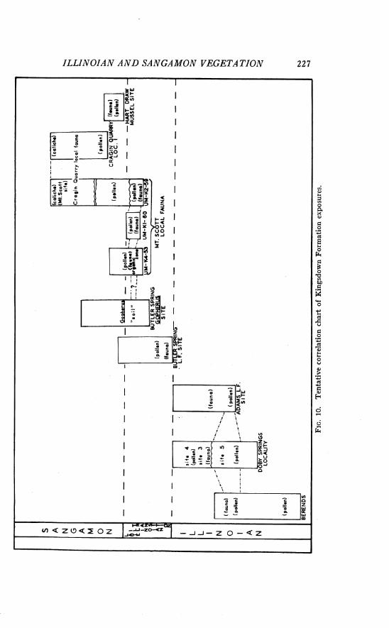
ILLINOIAN AND SANGAMON VEGETATION 2 2 7
228 RONALD 0. KAPP
undoubtedly be modified as additional geologic and paleontologic work is completed. The tentative correlation (Fig. 10) is based on the kinds of evidence outlined below.
1. In a few instances there is good stratigraphic control which permits confident correlation. Such direct correlation exists between the UM-K4-53, UM-K1-60 and UM-K2-59 sites, and also between the caliche which caps Mt. Scott and that a t the Cragin Quarry.
2. Correlation may be based on the similarity of the fossil assemblages in the sediments. Correlation of this type is satisfactory between the Doby Springs local fauna and the Berends local fauna. The correlation of these two faunas with the Butler Spring local fauna is suggestive, but less firm (Stephens, 1960). In another instance, the fossils recovered from the upper sediments at Mt. Scott are clearly part of the same assemblage as those from Cragin Quarry, but the relationships of the Cragin Quarry fauna with the interglacial fossils which lie stratigraphically above the Butler Spring local fauna have not been studied (Hibbard and Taylor, 1960, p. 32) . In several other instances correlation with a glacial or interglacial stage has been inferred from the climatic requirements of the faunal assemblage and from percentage of extinct species in the fauna.
3. Similarity of the pollen spectra provides strong support for correla- tion of certain deposits. Thus, the previous evidence of time-stratigraphic equivalence for correlation of Berends and Doby Springs is greatly en- hanced by pollen data. The presence of pollen in stratigraphic units which do not contain faunal remains sometimes permits differentiation of deposits which were previously indistinguishable. For example, this type of evidence indicates that the Butler Spring local fauna existed later in the Illinoian age than Berends and Doby Springs. In other cases, paleoecologic inferences based on the vegetation are used as evidence for contemporaneity.
Illinoian Glacial Age Sites
Berends, Doby Springs, and Adams local fauna localities.-Stephens (1960, p. 1700) has discussed the faunal evidence for correlation of these three faunas. He states:
The Berends local fauna offers the best comparison with the Doby Springs local fauna. The faunas have five species of mammals in common. Smith (1958) has com- pared the fishes from the Berends local fauna, the Butler Spring local fauna, and the Doby Springs local fauna. He considered them as Illinoian in age and found that the Doby Springs local fauna had five species in common with the Berends local fauna and three in common with the Butler Spring local fauna. The mammals common to all three local faunas are abundant forms in glacial faunas. Sufficient vertebrate material was not recovered from the Butler Spring local fauna to allow comprison with the exception of the fishes.
ILLIh701AN AND SANGAMON VEGETAT10117
Palynological evidence supports and extends the evidence for correla- tion of these three local faunas. The vegetation associated with the Berends local fauna was very similar to that a t Doby Springs. I t seems clear, on the basis of pollen analysis, that the Butler Spring molluscan local fauna lived later and in a period of somewhat warmer climate than the Berends and Doby Springs local faunas.
During Doby Springs and Berends times the vegetation (Figs. 5 and 6) included pine trees (either along streams and ravines or in savanna-type communities). Spruce was growing in the area; Douglas fir (Pseudotsuga) evidently was present, presumably on moist sites. Drier upland sites were populated by a variety of composites and grasses and in some places sage- brush was abundant; chenopods and amaranths, however, were not promi- nent in the flora. Some deciduous trees, as well as common marsh plants, grew near the lakes where deposition occurred.
The similarity of the local depositional environments at Doby Springs, Berends, and the Adams local fauna sites may be deduced from the simi- larity of the aquatic vegetation, especially the prominence of Myriophyllum pollen and Pediastrum remains in the sediments from both sites. The strongest botanical evidence for correlation of these three sites is the prominence of spruce pollen ( 5 per cent) in the spectra. The only unequivo- cal evidence for the presence of spruce trees in the Meade County area is from these three sites.
The composition of the upland vegetation may have changed somewhat by the time the sediments at Doby Springs sites 2 and 4 were deposited. Although the pollen evidence is inadequate, spruce seems to be absent or infrequent near the sites and the upland arboreal vegetation consisted mostly of juniper and pine. Thus, the upper sediments a t Doby Springs are believed to represent a later Illinoian interval.
Butler Spring local fauna and Mt. Scott local fauna sites.-Hibbard and Taylor (1960, p. 47) have summarized the information available about the correlation of the Butler Spring local fauna as follows: "Probably many of the Illinoian faunas of the Great Plains are equivalent to the Butler Spring local fauna. Only in the Meade County area, however, can correla- tive faunas be recognized with reasonable certainty. They are the Berends and Doby Springs local faunas . . . ."
I t has been pointed out by Stephens (1960) that the fishes alone form the basis for correlating the Butler Spring local fauna with the other Illinoian assemblages (Berends and Doby Springs).
hIiller ( 196 1, pp. 122-23) has attempted to correlate the UM-K4-53 local faunule with other Late Pleistocene assemblages on the basis of the mollusks. Although he found that "our present knowledge concerning the
230 RONALD 0. KAPP
factors determining the composition of fossil molluscan faunas is still too limited to permit correlation on the basis of these assemblages alone," he stated that "if future work can definitely establish the age of the fossils as Illinoian, the term 'Butler Spring local fauna' should be used for this local faunule." Hibbard (1963, p. 192) discussed the correlation of the Mt. Scott local fauna (including UM-K4-53). He stated that "Hibbard and Taylor (1960, p. 47) considered the Butler Spring local fauna as late Illinoian. The microvertebrates needed to correlate this fauna with either the colder Doby Springs and Berends local faunas or the slightly warmer (late Illinoian) Mt. Scott fauna are lacking."
The pollen analytical data do not contribute conclusive evidence for resolving the difficulties of correlating these sites. The vegetation associated with the Butler Spring molluscan local fauna bears more resemblance to the vegetation at the Mt. Scott local fauna sites than to the Berends-Doby Springs assemblage. Both the Butler Spring local fauna pollen spectra and those associated with the Mt. Scott local fauna lack significant percentages of spruce pollen and have variable low percentages of pine. The Butler Spring record is distinguished by high percentages of deciduous tree pollen (16.8 per cent average) and no chenopod-amaranth pollen, while in the Mt. Scott local fauna sediments deciduous pollen is sparse and chenopod- amaranth pollen is frequent. The pollen data are not satisfactory for the confident correlation of these two deposits.
Examination of sediments deposited stratigraphically above the Butler Spring local fauna reveals a stratum (black soil zone) which contains numerous fragments of decayed plant parts. Immediately above this black soil zone, a fossil turtle (Gopherus) was found in a tunnel in reddish Sangamon silt. Whether this black soil zone represents the humus of a buried soil profile or represents burned vegetable remains is unknown. Similar degraded remains of plant tissue also occur in the lowest sediments a t the UM-K4-53 site. I t is tentatively suggested that the similarity between these two black humic deposits may have stratigraphic significance. On the basis of faunal evidence and perhaps the decayed humic remains, it is probable that the Mt. Scott local fauna deposit postdates the Butler Spring local fauna deposit.
There is a close stratigraphic relationship and good faunal and palyno- logical correlation between the three sites which yielded the Mt. Scott local fauna. Pollen data suggest that the upper sediments at UM-K4-53 may correlate with UM-K1-60, and that they may represent a later period than the base of Mt. Scott and the lower levels a t UM-K4-53.
Sangamon Interglacial Age Sites The Cragin Quarry and Mt. Scott exposures are readily correlated on
ILLINOIAN A N D SANGAMON VEGETATION
the basis of the nearly continuous caliche which occurs a t the top of each of the sections and near the soil surface between the sites. Furthermore, the fossil faunas are so similar that they have been placed into a single local fauna (Cragin Quarry local fauna). Pollen analysis a t these two localities provides certain additional information about the correlation of the sedi- ments. The samples from the middle of the Mt. Scott exposure have yielded pollen spectra with surprisingly high pine frequencies and low representa- tion of herbaceous plant pollen. Very similar pollen spectra were derived from samples from Cragin Quarry locality 1. I t is surmised that the sedi- ments are approximately equivalent in age and record a vegetational stage in which pine was restricted to the margins of Spring Creek and an artesian oasis. The exceptionally high pine frequencies are probably due to local over-representation of pine pollen near the depositional sites. The lower- most sample from the microfauna locality and all samples from the nearby Hart Draw mussel site have yielded pollen spectra which are very different from Mt. Scott and the Cragin Quarry locality 1. There must be an erosional unconformity near the base of Cragin Quarry locality 1. The lowermost sediments (Hart Draw mussel site and base of Cragin Quarry locality 1) represent a different, and possibly considerably earlier portion of Sangamon time than that of the Cragin Quarry local fauna.
There is growing faunal evidence that the deposits a t the Cragin Quarry sites may be equivalent to the Sangamon deposits in the Butler Spring area (Hibbard, personal communication). Palynological evidence is still inade- quate to evaluate this suggested correlation. A preliminary analysis of Sangamon sediments from the Butler Spring Gopherus site and a nearby exposure ( N W g SW% sec. 33, T. 34 S., R. 29 W., Meade County, Kansas) indicates that the Butler Spring deposits which lie below the Sangamon caliche are barren of pollen. This same observation has been made about the uppermost Sangamon sediments a t Cragin Quarry. Perhaps pollen analysis of samples from the Sangamon Dire Wolf site (KU-7) a t the Butler Spring locality will contribute evidence of value for correlation of these deposits.
Direct correlation of the Sangamon Jinglebob local fauna with other Late Pleistocene faunas is impossible a t present. Stratigraphic evidence indicates that the sediments were deposited after caliche formation during the middle ( ? ) of the Sangamon interglacial. Palynological data from the Sangamon deposits is too incomplete to permit conclusive correlations of the Jinglebob sediments with others of about the same age.
The vegetation associated with the Jinglebob local fauna is ecologically compatible with the animal assemblage. Indeed, the pines and possibly Myrica may indicate that some elements of the flora, like some members of the fauna, have affinities with the coastal plain of the Gulf of Mexico. Thus,
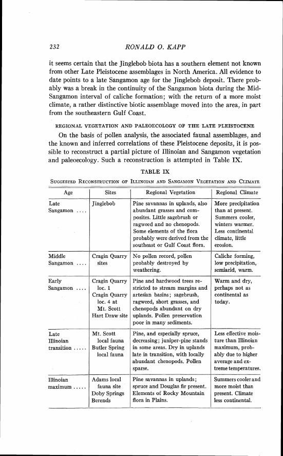
232 RONALD 0. KAPP
it seems certain that the Jinglebob biota has a southern element not known from other Late Pleistocene assemblages in North America. All evidence to date points to a late Sangamon age for the Jinglebob deposit. There prob- ably was a break in the continuity of the Sangamon biota during the Mid- Sangamon interval of caliche formation; with the return of a more moist climate, a rather distinctive biotic assemblage moved into the area, in part from the southeastern Gulf Coast.
REGIONAL VEGETATION AND PALEOECOLOGY OF THE LATE PLEISTOCENE
On the basis of pollen analysis, the associated faunal assemblages, and the known and inferred correlations of these Pleistocene deposits, it is pos- sible to reconstruct a partial picture of Illinoian and Sangamon vegetation and paleoecology. Such a reconstruction is attempted in Table IX.
TABLE IX
Age
Late Sangamon . . . .
Middle Sangamon . . . .
Early Sangamon . . . .
Late Illinoian transition . . . . .
Illinoian maximum . . . . .
Sites
Jinglebob
Cragin Quarry sites
Cragin Quarry loc. 1
Cragin Quarry loc. 4 a t Mt. Scott
Hart Draw site
Mt. Scott local fauna
Butler Spring local fauna
p-
Adams local fauna site
Doby Springs Berends
Regional Vegetation
Pine savannas in uplands, also abundant grasses and com- posites. Little sagebrush or ragweed and no chenopods. Some elements of the flora probably were derived from the southeast or Gulf Coast flora.
No pollen record, pollen probably destroyed by weathering.
Pine and hardwood trees re- stricted to stream margins and artesian basins; sagebrush, ragweed, short grasses, and chenopods abundant on dry uplands. Pollen preservation poor in many sediments.
-- Pine, and especially spruce, decreasing; juniper-pine stands in some areas. Dry in uplands late in transition, with locally abundant chenopods. Pollen sparse.
Pine savannas in uplands ; spruce and Douglas fir present. Elements of Rocky Mountain flora in Plains.
/ Regional Climate
More precipitation than at present. Summers cooler, winters warmer. Less continental climate, little erosion.
Caliche forming, low precipitation, semiarid, warm.
Warm and dry, perhaps not as continental as today.
Less effective mois- ture than Illinoian maximum, prob- ably due to higher average and ex- treme temperatures.
Summers cooler and more moist than present. Climate less continental.
ILLINOIAN AND SANGAMON VEGETATION 233
Maximum Illinoian
Vegetation.-During an Illinoian glacial period of maximum coolness and moistness, the dominant arboreal vegetational type of the Meade County area included numerous pines. There were spruce trees growing in the area, for consistent occurrence of an appreciable amount of spruce pollen (about 5 per cent) in sediments is considered good evidence for the close proximity of the trees (Potter and Rowley, 1960, p. 20). Some Douglas fir (Pseudotsuga) also must have grown near the Doby Springs locality in Harper County, Oklahoma. The Douglas fir trees that con- tributed 0.7 to 1.3 per cent in the pollen spectra most likely occupied protected upland gullies or valleys-which is a common habitat for this species at present in certain places in the dry foothills of the Rocky Mountains of the northern United States. Grasses and composites were generally abundant in savanna openings and wooded uplands, whereas sage- brush (A~temisia) was frequent only near certain depositional localities. Deciduous trees were not prominent in the vegetation, but some alder, birch, willow, ash, maple, hickory, walnut, and oak is represented in the pollen record. These deciduous trees, with the possible exception of oak, probably occupied moist sites near the depositional basins.
Water milfoil was a prominent member of the aquatic plant communi- ties, for Myriophyllum pollen is commonly preserved in these sediments, sometimes in great abundance. The colonial aquatic alga, Pediastrum, was consistently found in the sediments of Illinoian glacial maximum age, sometimes abundantly. Although not entirely absent from Sangamon deposits, both Myriophyllum and Pediastrum are of only scattered and infrequent occurrence, suggesting that there was a greater availability of water in the study area during the Illinoian glacial age.
Several members of the Illinoian flora (notably Pinus, Picea, and Pseudotsuga) indicate that the vegetation of the study area had strong phytogeographic relationships with the Rocky Mountain flora. All of the elements in the Illinoian flora seem compatible with the hypothesis that the Illinoian glacio-pluvial climate allowed an invasion of the High Plains by plants which are now found in the uplands to the west. The vegetation may have resembled the modern pine savannas of many of the lower Rocky Mountain slopes, ravines and depressions. Such genera as Acer, Fraxinus, Salix, Betula, Quercus, Pseudotsuga, Juniperus, Alnus, and Celtis, which are present in the pollen record, would be expected in such a situation. The presence of Juglans and Carya indicates that an eastern deciduous element mingled with the western assemblage in this area.
During the climatic amelioration after the Illinoian maximum period, pine abundance decreased and spruce disappeared in the area. Juniper
234 RONALD 0. KAPP
became a prominent element in the vegetation a t some localities (e.g., Doby Springs sites 2 and 4) .
Paleoeco1ogy.-The similarities of the maximum Illinoian vegetation to the modern vegetation of the Rocky Mountains, and the modern distribu- tion of the extant vertebrates from the associated faunas (Smith, 1954; Stephens, 1960) allows the reconstruction of maximum Illinoian climate. I t is presumed that the climate of the southern High Plains during this glacial age was similar to the present climate of southeastern North Dakota (Stephens, 1960, p. 1700) and montane areas of central Colorado. These two areas, though separated geographically, are similar climatically.
The mean annual temperature of southwestern Kansas and adjacent Oklahoma during the Illinoian glacial maximum was probably between 40 and 45 degrees F, while a t present it is about 55 degrees F (Visher, 1954, map 3) . This conclusion is based on the temperature data from the areas where the extant members of the fossil biota are found. Apparently the major decrease in temperature occurred in the winter as the average winter (winter solstice to vernal equinox) temperature of the eastern Dakotas and central Colorado is about 15 degrees F, in contrast to about 35 degrees F in southwestern Kansas (Visher, 1954, map 4) . Similar data about the summer (summer solstice to autumnal equinox) temperatures (Visher, 1954, map 5) indicates that a mean temperature of 65 to 70 degrees F occurs in Colorado and the eastern Dakotas, while the mean summer tem- perature in southwestern Kansas is 75 to 80 degrees F. I t would appear that average winter temperatures were approximately 20 degrees F cooler during the Illinoian maximum, and summer temperatures were about 10 degrees F cooler, than at present in southwestern Kansas.
Annual precipitation may not have been very different during Illinoian time from the present annual average of 20 to 25 inches (Visher, 1954, map 492). However, the precipitation was certainly much more effective. This increased effectiveness is illustrated by modern data on annual evap- oration from pans. At the present there is 40 inches excess of evaporation over annual precipitation (Visher, 1954, map 489). Based on precipitation- evaporation data for the geographic areas where extant members of the Illinoian faunas are found, the excess of evaporation must have been less than 20 inches during Illinoian times.
The inferences about Illinoian maximum climate are especially inter- esting in relation to published accounts of the temperature requirements and the Late Pleistocene distribution of Picea. Leopold (1957) has demonstrated that the southern limit of Picea mariana and P. glauca in northeastern North America coincides with the 21 degrees C (70 degrees F) average July isotherm. Hafsten (1961, p. 86) reports that spruce seldom
ILLIiVOIAN AND SANGAMON VEGETATION 23 5
occurs where the average July temperature exceeds 19 degrees C (66 de- grees F ) in the mountains of New illexico. I t appears to be accurate that Picea does not extend into areas where the average July temperature is warmer than 19 to 21 degrees C. The 21 degrees C (70 degrees F) average July isotherm now passes through southeastern North Dakota and along the Front Range of the Rocky Mountains as far south as Colorado and New Mexico (Visher, 1954, map 23). Since both the fossil fauna and the Illinoian vegetation require summers with this degree of coolness, it is concluded that the 21 degree C average July isotherm passed through or south of the fossil localities in the southern High Plains during the Illinoian glacial maximum.
There is a striking similarity between these climatic interpretations of Illinoian maximum climate and the conclusions of Hafsten ( 1961 ) about the Wisconsin glacial (pluvial) period in the Llano Estacado (Staked Plains section of the southern High Plains, in western Texas and adjacent New Illexico). Also basing his interpretations on the ecologically important genus Picea, Hafsten has concluded that the July temperature of the Tahoka pluvial (Wisconsin maximum glaciation [ ? I , 15,000-22,500 years B. P.) of the Llano Estacado was a t least 6 degrees C (10 degrees F ) cooler than the present.
I t is believed that the Tahoka pluvial is equivalent in age to the Wisconsin Cary maximum of northeastern North America. Assuming this to be true, the climatic events which caused glacial advance also resulted in marked lowering of the altitudinal zones of vegetation in the southern High Plains. The Wisconsin glacial pollen record from the Llano Estacado and the Illinoian glacial record from southwestern Kansas and Oklahoma have similar spruce percentages; high percentages of tree pollen (80 to 90 per cent) characterize the glacial age pollen spectra from both regions.
During the Rich Lake interpluvial (22,500-32,000 years B. P.) in the Llano Estacado, spruce declined to negligible percentages, while pine decreased to a frequency of about 15 per cent in the pollen spectra. Accompanying this decrease in tree pollen, grass, composite, and sagebrush pollen increased markedly. There is evidence from the postpluvial (post- glacial) portion of the Llano Estacado profiles, and from investigations in eastern Texas (Graham and Heimsch, 1960), that the minor climatic changes of Wisconsin postglacial time did not affect the vegetation of distant areas south and southwest of the glacial border.
Late Illinoian
Vegetation.-The vegetation of the late Illinoian glacial age exhibited considerable geographic variation and was probably undergoing floristic
RONALD 0. KAPP
change. Pine was less abundant than during the Illinoian maximum period which preceded this interval. Spruce either no longer grew in the region or was reduced to infrequent relict stands. I n some areas, perhaps along gullies and ravines, the vegetation included a prominent juniper-pine element. Chenopods and amaranths were locally abundant, probably in response to increased dryness and greater erosion on the upland surfaces. At one site (Butler Spring local fauna site), deciduous trees must have been rather abundant (16.8 per cent of pollen spectrum). This, however, is considered to be a reflection of the proximity of the trees to the basin, rather than a general increase in prominence of the deciduous element in the arboreal vegetation. Pollen is generally much sparser in the sediments of this period than in those of the maximum Illinoian. This may be the result of partial destruction of the pollen in the sediments through weather- ing, as well as initially low absolute pollen frequency because of rapid sedimentation (that is, increased erosion).
Paleoeco1ogy.-The decline of spruce in the pollen record of late Illinoian time is strong evidence for a warming of the climate. Increased summer temperatures would promote increased evaporation and a drier climate. The beginnings of this trend toward a warmer, drier climate may be reflected by the pollen record from Doby Springs sites 2 and 4.
A less favorable precipitation-evaporation ratio would result in a de- crease in the amount of standing water in the region, and a decline in the number of perennial streams. This change probably explains why pollen of aquatic plants is less frequent in sediments of this interval.
The Butler Spring and Mt. Scott localities are believed to date from the late Illinoian on the basis of pollen analysis and faunal evidence. Summer temperature maxima were apparently not high enough to eliminate some northern species of animals from the faunas. Smith (1963), citing zoogeographical data of Radforth, states that the fish assemblage at the Mt. Scott local fauna is not now found south of the 70 degrees F ( 2 1 de- grees C) average July isotherm. This faunal evidence suggests that the climate of late Illinoian time may have also been suitable for the persistence of relict stands of spruce. This may explain the sporadic occurrence of Picea pollen in sediments of this age.
Early Sangamon Vegetation.-In response to increasing dryness of the upland surfaces,
the trees seem to have been restricted to the margins of streams, springs, and ponded waters during the Early Sangamon interval. This has resulted in over-representation of pine pollen in many of the pollen spectra from sediments deposited in the basins adjacent to the trees. There is some evidence that pine was actually much less prominent in the vegetation
ILLINOIAN AND SANGAMON VEGETA TIOW 237
during this period than before. For example, the pollen spectra from the Hart Draw mussel site have low percentages of pine and high frequencies of ragweed, sagebrush, composite, and grass pollen. This suggests that the uplands had a rather open grasslands-type vegetation. The lizard fauna at Cragin Quarry suggests strongly that the climate was more arid than today, with winters somewhat warmer than now. I t has been suggested (Hibbard and Taylor, 1960) that several members of the fossil fauna were relict at the Cragin Quarry oasis, and persisted there only because the artesian spring made the local habitat more equable. I t is entirely possible that several elements in the flora also survived as relicts in the Meade County area during early Sangamon times. I t seems likely that this is the explana- tion for the presence of some of the trees, including the pines. Due to leaching of carbonates, higher soil acidity near the artesian springs may have provided a suitable habitat for the persistence of pines. I t is possible that occasional spruce trees still existed in the region. Although marsh and aquatic plants grew near the depositional sites, the conditions seem to have been unsuitable for luxuriant growth of aquatics such as Myriophyllum. Pediastrz~m is virtually absent from sediments of this period.
Paleoeco1ogy.-The climate seems to have been semiarid, although it was not as continental as at present in the area. Winter temperatures were warmer than today, and may never have dropped to freezing. The occur- rence of certain northern and northeastern forms in the fauna suggests that summers were not as hot as today. This northern element of the fauna may represent a relict assemblage whose disjunct distribution during the Sanga- mon may be explained by the ameliorating effects of artesian springs. Faunal evidence suggests that the mean annual rainfall may have been the same as today (Hibbard and Taylor, 1960, p. 39).
Middle Sanganzon
Middle Sangamon time is believed to have been a period of caliche formation. There is considerable discussion in the literature about the climatic conditions under which caliche forms, and one recent paper suggests that caliche is deposited most rapidly in wet summers (Martin, and others, 1961, p. 87). Brown's (1956) hypothesis that caliche will not form under completely arid conditions is antithetical to the views of Bretz and Horberg (1949), who feel that caliche beds are a record of relatively arid conditions. The pollen record, or lack of it, from the sediments beneath the middle Sangamon caliche in Meade County, suggests that there was severe weather- ing during or immediately after the depositional interval. Such severe weathering might be expected to occur under semiarid conditions when the substrate was alternately dried to considerable depths and then briefly
238 RONALD 0. KAPP
wetted. Rainfall may have been sporadic and scanty. The climate was probably as continental as today; caliche is forming in some areas in the High Plains and Southwest a t the present time.
There virtually is no pollen record from this interval, although many samples have been examined from the extensive deposits of this period.
Late Sangamon
Vegetation.-A unique biota seems to have occupied the Meade County area during Late Sangamon times, according to the record from Jinglebob local fauna sediments. Some members of both the fauna, and probably the flora, came into the southern High Plains from the south and southeast. The vegetation of the period may have included a pine savanna association. The paucity of Ambrosia, Artemisia, and Chenopodiaceae-Amaranthaceae pollen suggests that the upland surfaces were neither very dry nor eroded. Some elements of the deciduous tree flora, such as Celtis and Sapindus, are present now in the region while others, like oak and elm, may have come into the area from the east.
If it is correct that there was a Gulf coastal plain element in the flora, then it is likely that the pines found in the area in late Sangamon time were southeastern species (e.g., Pinus echinata or P. taeda) which now extend into eastern Oklahoma and east Texas.
Pa1eoecology.-The presence of some northern rodents suggests that the summer climate was "more moist and equable" (Hibbard, 1955, p. 202) than a t present. A distinctive southern and coastal plain element in the fauna implies that the winters were much milder than at present, without extremely low temperatures. On the basis of preliminary examination of the pollen from the Jinglebob sediments, Hibbard (1955, p. 204) concluded that "a rainfall of 40 to 45 inches, comparable to that of the Ozark area of eastern Kansas, would have al!owed pine to grow."
The vegetation deduced from the pollen record supports the previous climatic interpretations of Hibbard. Faunal evidence suggests that the high frequencies of pine pollen may have resulted from the invasion of pine species from the southeast. For pines, and possibly either Myrica or Comptonia, to spread into the southern High Plains from the southeast and Gulf Coast, a moister climate is postulated. If conditions were like south- eastern Kansas and eastern Oklahoma today, the normal average tempera- ture was probably a t least 5 degrees F warmer than today (Visher, 1954, map 3). I t is likely that the mean minimum winter temperatures were about 20 degrees F warmer than at present (Visher, map 4 ) . As Hibbard (1955) suggested, a rainfall of 40 inches, in contrast to the present precipi- tation of 20 inches per year, would have been required to explain the
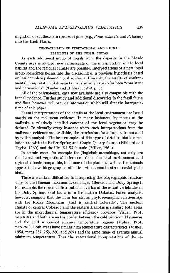
ILLIiiTOIAN A N D SANGAMON VEGETATZOX
migration of southeastern species of pine (e.g., Pinus echinata and P. taeda) into the High Plains.
COMPATIBILITY OF VEGETATIONAL AND FAUNAL
ELEMENTS O F THE FOSSIL BIOTAS
As each additional group of fossils from the deposits in the Meade County area is studied, new refinements of the interpretation of the local habitat and the regional climate are possible. Interpretations of a new fossil group sometimes necessitate the discarding of a previous hypothesis based on less complete paleontological evidence. However, the results of environ- mental interpretation of diverse faunal elements have so far been "consistent and harmonious" (Taylor and Hibbard, 1959, p. 8) .
All of the palynological data now available are also compatible with the faunal evidence. Further study and additional discoveries in the fossil fauna and flora, however, will provide information which will alter the interpreta- tions of this paper.
Faunal interpretations of the details of the local environment are based mostly on the molluscan evidence. In many instances, by means of the mollusks a relatively detailed concept of the local vegetation may be deduced. In virtually every instance where such interpretations from the molluscan evidence are available, the conclusions have been substantiated by pollen analysis. The best examples of this type of detailed biotic corre- lation are with the Butler Spring and Cragin Quarry faunas (Hibbard and Taylor, 1960) and the UM-K4-53 faunule (Miller, 1961).
In certain cases, for example the Jinglebob assemblage, not only are the faunal and vegetational inferences about the local environment and regional climate compatible, but some of the plants as well as the animals appear to have biogeographic affinities with a southeastern coastal plain biota.
There are certain difficulties in interpreting the biogeographic relation- ships of the IIlinoian maximum assemblages (Berends and Doby Springs). For example, the region of distributional overlap of the extant vertebrates in the Doby Springs local fauna is in the eastern Dakotas. Pollen analysis, however, suggests that the flora has strong phytogeographic relationships with the Rocky Mountains (that is, central Colorado). The modern climate of central Colorado and the eastern Dakotas is similar; both areas are in the microthermal temperature efficiency province (Visher, 1954, map 958) and both are on the border between the cold winter-mild summer and the cold winter-hot summer temperature regions (Visher, 1954, map 961). Both areas have similar high temperature characteristics (Visher, 1954, maps 257, 258, 260, and 269) and the same range of average annual minimum temperatures. Thus the vegetational interpretations of the re-
240 RONALD 0. KAPP
gional climate of Illinoian maximum time are compatible with the climatic inferences based on the vertebrate fauna (see detailed discussion in previous sections).
The geographic source areas for the Illinoian fauna (eastern Dakotas) and the flora (southern Rocky Mountains) are rather far apart. I t seems probable that certain northern faunal elements, which require a woodland habitat, either migrated westward and then south along the western prairie or followed gallery forests of deciduous trees from the east along major rivers which cross the grasslands. There is no convincing palynological evidence that the eastern deciduous forest extended across the grasslands as far as western Kansas during the Illinoian glacial age.
RELATION O F ILLINOIAN-SANGAMON CLIMATE TO PLEISTOCENE EVENTS
Lacking satisfactory correlation of the late Cenozoic deposits of the southern High Plains with either Cordilleran or Northeastern United States sequences, questions about the synchroneity of Pleistocene events remain unresolved (Miller, 1958). In the southwestern Kansas study area, however, one can scarcely escape the conclusion that the series of four "cool climate" faunal assemblages correlates approximately with the four glacial ages. Although there is an exceptionally long sequence of Late Cenozoic sediments in this region, the details of minor climatic fluctuations will never be complete because of the numerous erosional unconformities.
In discussing correlation of Pleistocene climatic events, it is useful to compare the glacial-interglacial sequence derived from paleontological in- vestigations in the southern High Plains with a climatic model for the ice ages proposed by Stokes (1955). Stokes proposed that ocean temperature oscillations are the basic cause of the climatic cycles. Inherent in the hypothesis is the assumption that increased precipitation, rather than decreased temperature, is responsible for initiating development of con- tinental glaciers. Decreased temperature results from the increased precipi- tation, but is not the prime cause of glaciation. Furthermore, because increased precipitation in some regions would require increased evaporation in others, Stokes (1955, p. 816 quoting Fenner, 1948) states that "intervals of ameliorated conditions in some regions coincided with increased sever- ity in others. The Pleistocene, then, may have been a period of sharper contrasts of climate and of shifting climates rather than a period of greater cold."
The climate of Illinoian maximum time in southwestern Kansas was decidedly cooler than a t present, but there is little evidence that precipita- tion was any greater than now. If we are to accept the hypothesis that continental glaciation coincided with general increases in precipitation,
ILLINOIAN A N D SANGAMON VEGETATION 241
then why is there not evidence of greater rainfall during the supposed Illinoian maximum in the southern High Plains? In accordance with Stokes' views, we may accept the theory that climatic changes in the Pleistocene were not everywhere synchronous and in the same direction. Then the southern plains may have been an area of low evaporation rather than greater precipitation during glacial maxima. Furthermore, the period designated as maximum Illinoian on the basis of the southwestern Kansas fossil record may not have been synchronous with maximum continental glaciation. The maximum climatic cooling may have occurred slightly after the period of high precipitation and glacial advance. A period of cold a t the end of a glacial stage was postulated by Stokes (1955, p. 820), who said "the time of most severe continental cold should be during the waning stages of the glaciers, and the cold periods should overlap into the early part of the succeeding interglacial period." The foregoing discussion should make it clear that the assignment of the biotic assemblages described in this paper to a certain phase of the glacial-interglacial sequence is speculative and based on debatable assumptions.
Correlation of the vegetational and climatic history of the southern High Plains with similar records from the Southwest is not yet possible. Several relevant studies from the Southwest are summarized below for purposes of comparison.
A long sedimentary core from the San Augustin Plains in western New Mexico is being studied by Clisby. A radiocarbon-dated spruce maximum (27,000 + 5,000 - 3,200 years B. P.) occurs in the pollen diagram in the upper fifty feet of core (Clisby and Sears, 1956). The fluctuations in this spruce curve probably reflect climatic changes of the Wisconsin glacial age and in part correlate with the pluvial periods described from the Llano Estacado.
In the deeper parts of CIisby's long (2,000 ft.) core from the San Augustin Plains, there is evidence of repeated oscillations in the climate which result in minor increases in spruce pollen. None of the earlier spruce peaks is as pronounced as the latest one of Wisconsin glacial age. No perceptible Pliocene-Pleistocene boundary has been identified (Clisby, 1962). I t is extremely difficult to interpret this long Pleistocene pollen record. The hypothesis that the pre-Wisconsin glacial ages had no effect on the climate, or altitudinal zones of vegetation in the San Augustin Plains seems unlikely, because a vegetational response to the pronounced climatic cooling of the Illinoian glacial stage is evident in southwestern Kansas.
An Early Pleistocene record has recently been reported from the Sonoran desert of Arizona by Gray (1961). This record, based on three well core samples, is believed to be of Nebraskan glacial age. I t lies below a
242 RONALD 0. KAPP
mid-Kansan fauna. The pollen record suggests that during one phase of the Nebraskan glacial stages, altitudinal zones of vegetation were lowered at least 1500 feet. I t is believed that the climate of southeast Arizona was cooler and probably wetter than present during the Nebraskan glacial age. A southward shift of Pacific winter cyclonic storm tracks is postulated to explain lake expansion and the deposition of the pollen-bearing sediments.
Roosma (1958) has detected evidence of Wisconsin-age climatic changes in the Mojave desert of California. In a pollen diagram prepared from 104 feet of sediments from Searles Lake, vegetational changes were detected which appear to correlate with the Wisconsin maximum, the Two Creeks interstadial, and the Valders glacial readvance.
Martin and Gray (1962, p. 111) state that "the drastic changes found in the fossil pollen record show that the arid Southwest did not escape profound climatic and vegetational change during glacial times." However, the postpluvial pollen profiles from the Llano Estacado and the pre-Wis- consin record from the San Augustin Plain core do not clearly record these "drastic changes." In other cores from the Willcox Playa, Martin (1962) has encountered the difficulty of correlating major fluctuations with known climatic sequences. He concludes that "The absence of similar short-term fluctuations in glacial age cores elsewhere suggests that in arid regions Pleistocene climatic conditions were much more variable. If the fluctuations are synchronous they may prove of great value in correlating pluvial playa lake profiles from western North America."
A recent analysis by Sears (1961b) on lake sediments from the Nebraska Sandhills also poses questions about the nature of postglacial climatic changes in the grassland province. Not only is there conflicting evidence about the climatic effects associated with glaciation in the Southwest, and about the correlation of such climatic events with glacial stages, but more investigation will be required to elucidate the regional sequences in the southern High Plains and Southwest.
SUMMARY
The purpose of this investigation was to determine, by means of pollen analysis, the nature of the vegetation associated with selected Late Pleisto- cene fossil faunas from the southern High Plains in southwestern Kansas and adjacent Oklahoma. The study permits evaluation and extension of the previous paleoecologic and climatic interpretations of the Illinoian and Sangamon ages.
Sediment samples for pollen analysis were collected by C. LV. Hibbard in 1959 and by myself in 1960 from six major fossil localities in Meade County, Kansas, and Beaver and Harper counties, Oklahoma. In the
ILLISOIAN AND SAA'GAMON VEGETA TZOA' 243
summer of 1960, the stratigraphy of each of the exposures was studied in detail to ensure exact stratigraphic positioning of the pollen samples with relation to the fossil faunas. Some deep augering for recovery of sediments a t one site was undertaken in 1961; the sediments to a depth of 50 feet were found to be as poor in pollen as the stratigraphically equivalent beds sampled from the natural exposures.
Special techniques were used for removing and concentrating the pollen from the refractory sediments. Most important was the use of HCI and HF to remove carbonates and silicates, and the flotation separation of the organic matter by means of a saturated, acidified, zinc chloride solution. Even with the use of such techniques for concentrating the pollen, many samples yielded little or no pollen.
The modern pollen rain of several central prairie states was sampled to gain some understanding of the pollen contribution of the present vegeta- tion. The results of that study furnished useful criteria for interpretation of fossil pollen assemblages.
The results of pollen analysis of the Illinoian (glacial) and Sangamon (interglacial) ages are presented in tabular form and in pollen diagrams.
Three deposits are essentially contemporaneous and are believed to date from the period of maximum Illinoian glaciation. They are the Doby Springs, Berends, and part of the Butler Spring sedimentary sequence. During this Illinoian interval the vegetation had a predominent pine (Pinus) element; numerous spruce (Picea) trees grew in the region. Douglas fir (Pseudotsuga) also grew near the Doby Springs sites in low frequency. Grasses and composites were abundant in nonwooded sites and on well-drained upland habitats. The sparseness of Ambrosia and chenopod- amaranths probably is significant because it reflects a more effective moisture balance and lack of widespread erosion of upland surfaces. The presence of spruce trees in the southern High Plains during Illinoian lllaximum time, in combination with a faunal assemblage which has affinities with the present fauna of the eastern Dakotas, suggests that the mean summer temperature was lowered a t least 10 degrees F during the period. Rainfall may not have been much different than a t present. The vegetation of Illinoian glacial times had a floristic element with distinct Rocky i\lountain affinities.
During late Illinoian time, Picea pollen was less frequent in the sedi- ments; spruce trees appear to have been absent or restricted to scattered relict stands. The decline in abundance was apparently due to higher summer temperatures. The abundance of pine in the flora diminished and the pollen record indicates that pines were replaced in some places by juniper (Juniperus) or sagebrush (Artemisia) . Pollen preservation was less
244 RONALD 0. KAPP
satisfactory in deposits of this period than in the Illinoian maximum interval. A less favorable precipitation-evaporation ratio is suggested by a decline in frequency of certain aquatic plants.
The vegetational record of early and Middle Sangamon times is less satisfactory than that of the Illinoian age. This is in part due to lack of pollen preservation in the middle Sangamon sediments associated with caliche beds, and in part due to inferred over-representation of pine pollen from trees growing a t the depositional sites.
During the Early Sangamon period, pine and deciduous trees seem to have been restricted to the moist habitats fringing the perennial streams and artesian springs. The pollen spectra from Mt. Scott and Cragin Quarry locality 1 exhibit strong representation of pine pollen, and relatively little pollen of the herbaceous plants of the uplands. The lizard fauna of the Cragin Quarry local fauna gives convincing evidence that the uplands were very dry, eroded, and populated with scattered clumps of grasses and xerophilous shrubs. I t is most likely that pine and several hardwood trees, like some members of the fauna, persisted as relicts in the restricted mesic habitats near perennial streams and springs.
There is no vegetational record of Middle Sangamon time, probably because of severe, deep weathering of the sediments which destroyed the pollen. The formation of a caliche layer during this interval is believed to indicate arid conditions.
The only record of Late Sangamon biota is from the Jinglebob deposit. Several elements of the vegetation and fauna indicate biogeographic rela- tionships with eastern Oklahoma and Texas, and perhaps the coastal plain. The predominant vegetation was perhaps a pine savanna. The absence of chenopod-amaranths and sparseness of ragweed and sagebrush pollen sug- gests that the uplands were moist and the plant cover complete. Winters were apparently considerably warmer than at present; there was probably about double the rainfall, and the climate was much less continental.
Certain major inferences may be drawn from these data. The vegetation of the Illinoian glacial age in southwestern Kansas had affinities with the Rocky Mountain flora. Presence of certain genera indicates that the climate was much less continental than a t present. Mean annual temperatures and mean summer temperatures must have been lower; this resulted in more effective precipitation. Gradual changes in the vegetation occurred in response to the climatic changes which accompanied the advent of the Sangamon interglacial age. The vegetation became predominantly open grassland. Some deciduous and coniferous trees persisted on moist sites. No pollen record of the most arid Mid-Sangamon stage is available, but precipitation increased near the end of this interglacial stage. In response
ILLINOIAN AND SAA'GAMON VEGETATIOAT
to this climatic change, pine savannas developed and most xerophilous plants disappeared from the pollen record.
A tentative correlation of the deposits of the Kingsdown Formation (Illinoian and Sangamon ages) has been proposed. This correlation is based on stratigraphic, faunal, and pollen analytical evidence.
The Illinoian glacial vegetation of southwestern Kansas has been com- pared with the vegetation of Wisconsin pluvial times in the Llano Estacado of the southern High Plains. Spruce spread into the High Plains during both of these glacial ages. The presence of spruce has been interpreted to indicate a 10 degrees F drop in the mean July temperature in both regions during glacial ages. In both areas, pine was prominent in the vegetation. The climatic changes accompanying the third and fourth glaciations (Illi- noian and Wisconsin) are therefore believed to have resulted in a pro- nounced lowering of the altitudinal zones of vegetation in the southern Rocky Mountains. Spruce and pine populated High Plains regions nearly 300 miles from their present montane ranges during these glacial ages.
A brief discussion of the results of pollen analysis a t other localities in the Southwest is included. I t seems clear that there were major climatic changes in these nonglaciated areas during the Pleistocene. Valid correlation of climatic changes and vegetational shifts among the various sites will require much more information than is now available. Such knowledge will also permit evaluation of the synchroneity of the Pleistocene climatic events of the southern High Plains and the glacial events of northeastern North America.
LITERATURE CITED
AGER, DEREK V. 1963. Principles of Paleoecology. New York: McGraw-Hill Book Co., Inc. Pp. X I + 371.
BAKER, F. C. 1938. New Land and Freshwater Mollusca from the Upper Pliocene of Kansas and a New Species of Gyr.auh~s from the Early Pleistocene Strata. Nautilus, Vol. 51, pp. 126-31.
BENNINGHOFF, W. S., and KAPP, R. 0 . 1962. Suggested Notations to Indicate Iden- tification Status of Fossil Pollen. Pollen et Spores, Vol. IV, No. 2 , p. 332. International Conference on Palynology. rAbstracts.1
BERRY, E. W. 1918. Fossil Plants from the Late Tertiary of Oklahoma. U. S. Nat. Mus. Proc., Vol. 51, pp. 627-36.
BERTSCH, KARL. 1942. Lehrbuch der Pollenanalyse. Stuttgart: Verlag Ferdinand Enke. BRETZ, J. H., and HORBERG, L. 1949. Caliche in Southeastern New Mexico. Journ.
Geol., Vol. 57, pp. 491-511. BROWN, C. A. 1938. The Flora of Pleistocene Deposits in the Western Florida Parishes,
West Feliciana Parish, and East Baton Rouge Parish, Louisiana. In Contribu- tions to the Pleistocene History of the Florida Parishes of Louisiana. Geol. Bull. No. 12, Dept. of Conservation, Louisiana Geol. Surv., pp. 59-96.
246 RONALD 0 . KAPP
BROWN, C. N. 1956. The Origin of Caliche on the Northeastern Llano Estacado, Texas. Journ. Geol., Vol. 64, pp. 1-15.
CAIN, S. A. 1944. Foundations of Plant Geography. New York: Harper & Brothers. Pp. XIV + 556.
CASE, E. C. 1894. A Geological Reconnaissance in Southwest Kansas and No Man's Land. Kans. Univ. Quart., Vol. 2, pp. 143-47.
CLEMENTS, F .E. 1916. Plant Succession. Carnegie Instit. Washington Publ., No. 242, 512 pp. and SHELFORD, V. E. 1939. Bio-ecology. New York: John Wiley & Sons. 425 pp.
CLISBY, KATHRYN, H. 1962. An Imperceptible Plio-Pleistocene Boundary. Pollen et Spores, Vol. IV, No. 2, p. 339 International Conference on Palynology. [Abstracts.] and SEARS, P . B. 1956. San Augustin Plains-Pleistocene Climatic Changes. Science, Vol. 124, pp. 537-39.
DAVIS, J. H. 1946. The Peat Deposits of Florida. Florida Geol. Surv., Geol. Bull., V O ~ . 30, pp. 1-247.
DICE, L. R. 1943. The Biotic Provinces of North America. Ann Arbor: Univ. Mich. Press. 78 pp.
ERDTMAN, G. 1943. An Introduction to Pollen Analysis. Waltham, Mass.: Chronica Botanica Co. Plant Science Books, N. S., Vol. 12. 230 pp.
- 1952. Pollen Morphology and Plant Taxonomy, Angiosperms. Ibid., 539 pp. 1957. Pollen and Spore Morphology/Plant Taxonomy, Gymnospermae, Pteri- dophyta, Bryophyta. New York: The Ronald Press Company. 151 pp.
E T H E R ~ G E , RICHARD. 1958. Pleistocene Lizards of the Cragin Quarry Fauna of Meade County, Kansas. Copeia, No. 2, pp. 94-101. 1961. Late Cenozoic Glass Lizards (Ophisaurus) from the Southern Great Plains. Herpetologica, Vol. 17, pp. 179-86.
FAEGRI, KNUT, and IVERSEN, JOHS. 1950. Textbook of Modern Pollen Analysis. Cop- enhagen: Ejnar Munksgaard. 168 pp.
FENNEMAN, N. M. 1931. Physiography of Western United States. New York: Mc- Graw-Hill Book Co., Inc. 534 pp.
- 1946. Physical Divisions of the United States (map). In N. M. Fenneman, Physiography of Western United States; 1st ed., Ninth Impression; New York: McGraw-Hill Book Co., Inc. (Folded map insert.)
FENNER, C. N. 1948. Pleistocene Climate and Topography of the Arequipa Region, Peru. Geol. Soc. Amer., Bull., Vol. 59, pp. 895-917.
FERNALD, M. L. 1950. Gray's Manual of Botany, 8th ed.; New York: American Book Company. 1632 pp.
FREY, DAVID G. 1951. Pollen Succession in the Sediments of Singletary Lake, North Carolina. Ecology, Vol. 32, pp. 518-33.
- 1955. A Time Revision of the Pleistocene Pollen Chronology of Southeastern North Carolina. Ibid., Vol. 36, pp. 762-63.
FRYE, J. C., and SCHOFF, S. L. 1942. Deep Seated Solution in the Meade Basin and Vicinity, Kansas and Oklahoma. Amer. Geophys. Union, Trans., pp. 35-59.
FUNKHOUSER, J. W., and EVITT, W. R. 1959. Preparation Techniques for Acid-insol- uble Microfossils. Micropaleontology, Vol. 5 , pp. 369-75.
GATES, F. C. 1926. Pines in the Prairie. Ecology, Vol. 7, pp. 96-98. - 1940. Flora of Kansas. Topeka: Kansas State Printing Plant. 266 pp.
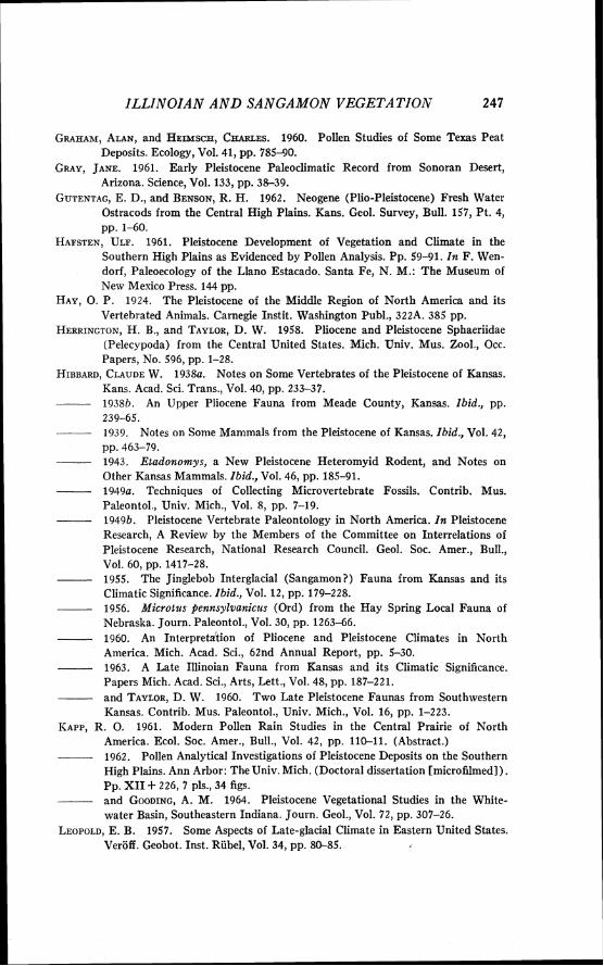
ZLLZNOZAN AND SANGAMON VEGETATION 247
GRAHAM, ALAN, and HEIMSCH, CHARLES. 1960. Pollen Studies of Some Texas Peat Deposits. Ecology, Vol. 41, pp. 785-90.
GRAY, JANE. 1961. Early Pleistocene Paleoclimatic Record from Sonoran Desert, Arizona. Science, Vol. 133, pp. 38-39.
GUTENTAG, E. D., and BENSON, R. H. 1962. Neogene (Plio-Pleistocene) Fresh Water Ostracods from the Central High Plains. Kans. Geol. Survey, Bull. 157, Pt. 4, pp. 1-60.
HAFSTEN, ULF. 1961. Pleistocene Development of Vegetation and Climate in the Southern High Plains as Evidenced by Pollen Analysis. Pp. 59-91. I n F. Wen- dorf, Paleoecology of the Llano Estacado. Santa Fe, N. M.: The Museum of New Mexico Press. 144 pp.
HAY, 0 . P . 1924. The Pleistocene of the Middle Region of North America and its Vertebrated Animals. Carnegie Instit. Washington Publ., 322.4. 385 pp.
HERRINGTON, H. B., and TAYLOR, D. W. 1958. Pliocene and Pleistocene Sphaeriidae (Pelecppoda) from the Central United States. Mich. Univ. Mus. Zool., Occ. Papers, No. 596, pp. 1-28.
HIBBARD, CLAUDE W. 1938a. Notes on Some Vertebrates of the Pleistocene of Kansas. Kans. Acad. Sci. Trans., Vol. 4 0 , pp. 233-37.
----- 193Sb. An Upper Pliocene Fauna from Meade County, Kansas. Ibid. , pp. 239-65. 1939. Notes on Some Mammals from the Pleistocene of Kansas. Ibid. , Vol. 42, pp. 463-79. 1943. E t a d o n o m y s , a New Pleistocene Heteromyid Rodent, and Notes on Other Kansas Mammals. Ibid. , Vol. 4 6 , pp. 185-91. 1949a. Techniques of Collecting Microvertebrate Fossils. Contrib. Mus. Paleontol., Univ. Mich., Vol. 8 , pp. 7-19.
- 1949b. Pleistocene Vertebrate Paleontology in North America. I n Pleistocene Research, A Review by the Members of the Committee on Interrelations of Pleistocene Research, National Research Council. Geol. Soc. Amer., Bull., Vol. 6 0 , pp. 1417-28.
- 1955. The Jinglebob Interglacial (Sangamon?) Fauna from Kansas and its Climatic Significance. Ibid., Vol. 12, pp. 179-228. 1956. M i c r o t z ~ s pennsy lvanicz~s (Ord) from the Hay Spring Local Fauna of Nebraska. Journ. Paleontol., Vol. 30, pp. 1 2 6 3 4 6 .
- 1960. An Interpretition of Pliocene and Pleistocene Climates in North America. Mich. Acad. Sci., 62nd Annual Report, pp. 5-30.
- 1963. A Late Illinoian Fauna from Kansas and its Climatic Significance. Papers Mich. Acad. Sci., Arts, Lett., Vol. 4 8 , pp. 187-221.
- and TAYLOR, D. W. 1960. Two Late Pleistocene Faunas from Southwestern Kansas. Contrib. Mus. Paleontol., Univ. Mich., Vol. 16, pp. 1-223.
KAPP. R. 0. 1961. Modern Pollen Rain Studies in the Central Prairie of North America. Ecol. Soc. Amer., Bull., Vol. 4 2 , pp. 1 1 G 1 1 . (Abstract.)
- 1962. Pollen Analytical Investigations of Pleistocene Deposits on the Southern High Plains. Ann Arbor: The Univ. Mich. (Doctoral dissertation [microfilmed]). Pp. XI1 + 226, 7 pls., 34 figs.
- and GOODING, A. M. 1964. Pleistocene Vegetational Studies in the White- water Basin, Southeastern Indiana. Journ. Geol., Vol. 7 2 , pp. 307-26.
LEOPOLD, E. B. 1957. Some Aspects of Late-glacial Climate in Eastern United States. Veroff. Geobot. Inst. Riibel, Vol. 3 4 , pp. 80-85.
248 RONALD 0. KAPP
MARTIN, P. S. 1962. Trend and Fluctuation in the Willcox Playa. Pollen et Spores, Vol. IV, pp. 263-64. International Conference on Palynology. [Abstracts.] and GRAY, JANE. 1962. Pollen Analysis and the Cenozoic. Science, Vol. 137, pp. 103-11.
- , SCHOENWETTER, JAMES, and ARMS, B. C. 1961. Southwestern Palynol- ogy and Prehistory, the Last 10,000 Years. Tucson: The University of Arizona Geochronology Laboratories. 119 pp.
MENGEL, R. M. 1952. White Pelican from the Pleistocene of Oklahoma. Auk, Vol. 69, pp. 81-82.
MILLER, BARRY B. 1961. A Late Pleistocene Molluscan Faunule from Meade County, Kansas. Papers Mich. Acad. Sci., Arts, Lett., Vol. 4 6 , pp. 103-25. 1965. Five Illinoian Molluscan Faunas from the Southern Great Plains. Mala- cologia, Vol. 3.
MILLER, JOHN P. 1958. Problems of the Pleistocene in Cordilleran North America, as Related to Reconstruction of Environmental Changes that Affected Early Man. I n T. L. Smiley, editor. Climate and Man in the Southwest. Tucson: Univ. of Arizona Press. Pp. 1 9 4 9 .
OOSTING, H. J. 1956. The Study of Plant Communities. 2d ed.; San Francisco: W. H. Freeman and Company. 440 pp.
POTTER, L. D., and ROWLEY, J. 1960. Pollen Rain and Vegetation, San Augustin Plains, New Mexico. Bot. Gaz., Vol. 122, pp. 1-25.
POTZGER, J. E., and THARP, B. C. 1952. Pollen Study of Two Bogs in Texas. Ecology, Vo1. 3 5 , pp. 462-66.
RINKER, G. C., and HIBB~RD, C. W. 1952. A New Beaver, and Associated Vertebrates, from the Pleistocene of Oklahoma. Journ. Mammal., Vol. 33, pp. 98-101.
ROOSMA, AINO. 1958. A Climatic Record from Searles Lake, California. Science, Vol. 128, p. 716.
ST. JOHN, ORESTES. 1887. Notes on the Geology of Southwestern Kansas. Kans. State Board Agric. Rept., Vol. 10, pp. 132-52.
SEARS, P. B. 1961a. Palynology and the Climatic Record of the Southwest. In R. W. Fairbridge, editor. Solar Variations, Climatic Change, and Related Geophysical Problems. Ann. New York Acad. Sci., Vol. 9 5 , pp. 632-41.
- 1961b. A Pollen Profile from the Grassland Province. Science, Vol. 134, pp. 2038-40.
---- and CLISBY, K. H . 1955. Palynology in Southern North America, Pt. IV: Pleistocene Climate in Mexico. Geol. Soc. Amer., Bull., Vol. 6 6 , pp. 521-30.
SMITH, C. L. 1954. Pleistocene Fishes of the Berends Fauna of Beaver County, Oklahoma. Copeia, No. 4 , pp. 282-89.
---- 1958. Additional Pleistocene Fishes from Kansas and Oklahoma. Ibid., No. 3, pp. 176-80.
SMITH, GERALD R. 1963. A Late Illinoian Fish Fauna from Southwestern Kansas: Copeia, No. 2, pp. 278-85.
SMITH, H. T. U. 1938. Preliminary Notes on Pleistocene Gravels in Southwestern Kansas. Kans. Acad. Sci. Trans., Vol. 4 0 , pp. 283-91.
- 1940. Geologic Studies in Southwestern Kansas. Kans. Geol. Surv. Bull., Vol. 3 4 , pp. 1-212.
STARRETT, ANDREW. 1956. Pleistocene Mammals of the Berends Fauna of Oklahoma Journ. Paleontol., Vol. 3 0 , pp. 1187-92.
STEPHENS, J . J . 1960 Stratigraphy and Paleontology of a Late Pleistocene Basin,
ILLINOIAN A N D SANGAMON VEGETATION 249
Harper County, Oklahoma. Geol. Soc. Amer., Bull., Vol. 71, pp. 1675-1702. STOKES, W. L. 1955. Another Look a t the Ice Age. Science, Vol. 122, pp. 815-21. TAYLOR, D. W. 1954. A New Pleistocene Fauna and New Species of Fossil Snails from
the High Plains. Univ. Mich. Mus. Zool., Occ. Papers, No. 557, pp. 1-16. - 1960. Late Cenozoic Molluscan Faunas from the High Plains. Geol. Surv.
Prof. Pap., No. 337, pp. 1-94. - and HIBBARD, C. W. 1955. A New Pleistocene Fauna from Harper County,
Oklahoma. Oklahoma Geol. Surv. Circular No. 37, pp. 1-23. - 1959. Summary of Cenozoic Geology and Paleontology of Meade County
Area, Southwestern Kansas and Northwestern Oklahoma. (Unpublished manu- script.) U.S. Geol. Surv. Field Conference Guide. 157 pp.
TAYLOR, E. H. 1943. An Extinct Turtle of the Genus Emys from the Pleistocene of Kansas. Kans. Univ. Sci. Bull., Vol. 29, pp. 249-54.
TERASMAE, J. 1960. A Palynological Study of the Pleistocene Interglacial Beds a t Toronto, Ontario. Geol. Surv. Canada, Bull., Vol. 56, pp. 23-41.
TIHEN, J. J. 1955. A New Pliocene Species of Ambystoma, with Remarks on Other Fossil Ambystomids. Contrib. Mus. Paleontol., Univ. Mich., Vol. 12, pp. 229-44.
VISHER, S. S. 1954. Climatic Atlas of the United States. Cambridge: Harvard Univ. Press. 403 pp.
WHITEHEAD, D. R., and BARGHOORN, E. S. 1962. Pollen Analytical Investigations from Western North Carolina and South Carolina. Ecol. Monogr. Vol. 32, pp. 347-69.
WODEHOUSE, R. P. 1935. Pollen Grains. New York: McGraw-Hill Book Co., Inc. 574 pp.
Submitted for gublication Novenzber 16,1964
PLATES
RONALD 0 . KAPP
PLATE I
FIG. 1. Abies, well core, 35.5 feet depth
FIG. 2. Abies, body 100 p long; well core, 35.5 feet depth
FIG. 3. Picea, body about 80 y long; well core, 35.5 feet depth
FIG. 4. Juniperus sim., 28 p ; Doby Springs 5, sample no. 3
FIG. 5. Pseudotsuga, about 80 p ; Doby Springs 5, sample no. 2
FIG. 6. Picea, total length 1 4 0 ~ ; Berends, sample no. 1
FIG. 7. Ephedra, 28 X 50 p ; Butler Spring loc. 2 , sample no. 5
FIG. 8. Pinus, body 56 long; Mt. Scott, sample no. 40
FIG. 9. Celtis seeds ; U.M.M.P. 36290 ; scale is in millimeters ; UM-K2-59 site
FIG. 10. Undetermined seed; U.M.M.P. 44334; about 2 mm long; Doby Springs locality
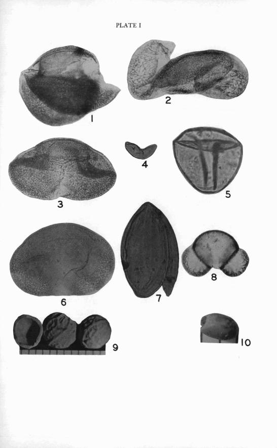
PLATE I
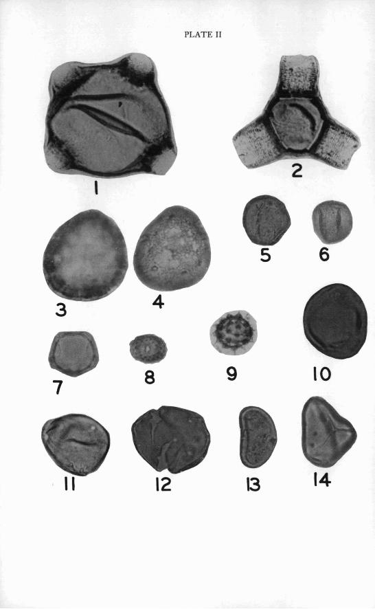
PLATE I1
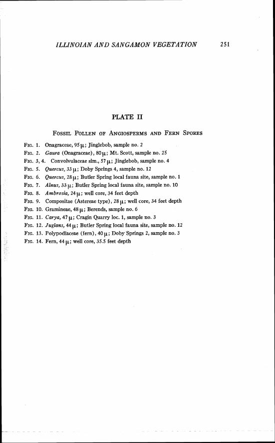
ILLINOIAN A N D SANGAMON VEGETATION 2 5 1
PLATE I1
FIG. 1. Onagraceae, 9 5 ~ ; Jinglebob, sample no. 2
FIG. 2. Gaura (Onagraceae) , 80 p; Mt. Scott, sample no. 25
FIG. 3,4. Convolvulaceae sim., 57 p; Jinglebob, sample no. 4
FIG. 5. Quercus, 33 p; Doby Springs 4, sample no. 12
FIG. 6. Quercus, 28 p; Butler Spring local fauna site, sample no. 1
FIG. 7. Alnus, 33 p; Butler Spring local fauna site, sample no. 10
FIG. 8. Ambrosia, 24 p; well core, 34 feet depth
FIG. 9. Compositae (Astereae type), 28 p; well core, 34 feet depth
FIG. 10. Gramineae, 48 p; Berends, sample no. 6
FIG. 11. Carya, 47 p; Cragin Quarry loc. 1, sample no. 3
FIG. 12. Juglans, 44 p; Butler Spring local fauna site, sample no. 12
FIG. 13. Polypodiaceae (fern), 40 p; Doby Springs 2, sample no. 3
FIG. 14. Fern, 44 p; well core, 35.5 feet depth
RONALD 0. KAPP
PLATE I11
FIG. 1, 2. Scrophulariaceae sim., 28 p; Doby Springs 5, sample no. 3
FIG. 3. Tilia, 39.5 p; Mt. Scott, sample no. 48
FIG. 4, 5. Myriophyllum, 25 p; Doby Springs 5, sample no. 11
FIG. 6. Artemisia, 19 p; well core, 35.5 feet depth
FIG. 7. Polygonaceae, 25 p; Butler Spring local fauna site, sample no. 1
FIG. 8. Gentianaceae sim., 25 p; Butler Spring local fauna site, sample no. 1
FIG. 9. Saxifraga sim., 28 p; well core, 34 feet depth
FIG. 10. Betula, 2611; Mt. Scott, sample no. 24
FIG. 11. Typha-Sparganium, 30 p; Berends, sample no. 6
FIG. 12, 13. Myrica, 23 p; Jinglebob, sample no. 2
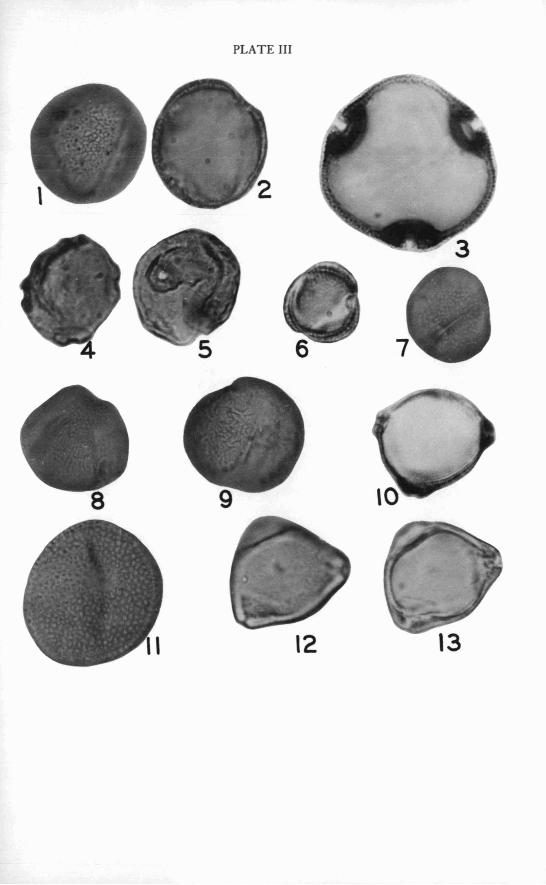
PLATE I11
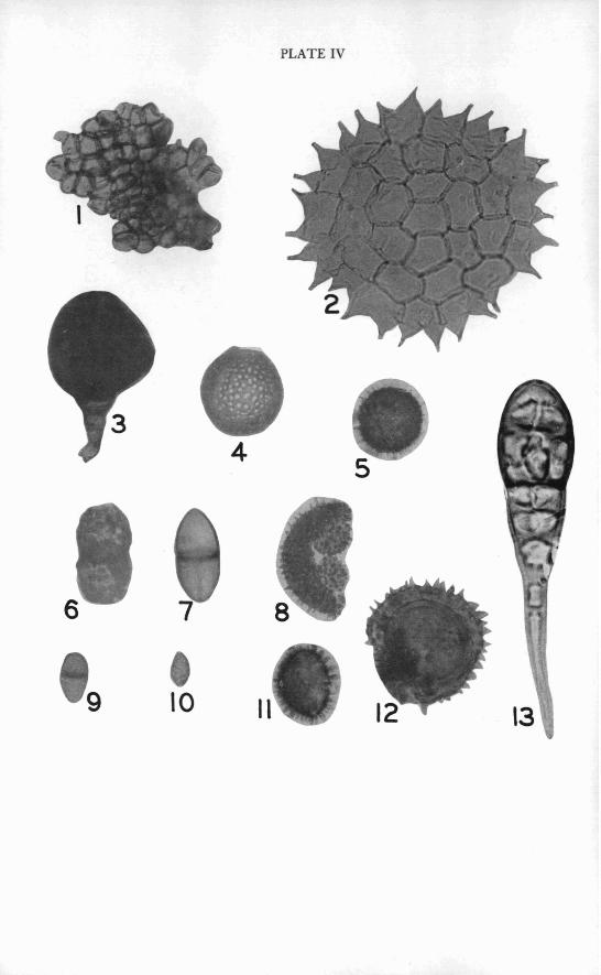
PLATE IV
ILLINOIAN A N D SANGAMON VEGETATION 2 53
PLATE IV
FIG. 1. B O ~ Y ~ O C O C C U S sim., 9 p X 13 p ; Doby Springs 2, sample no. 15
FIG. 2. Pediastrum, 133 p diameter of colony; Berends, sample no. 6
FIG. 3. Unknown, 52 p X 80 p ; Doby Springs 2, sample no. 15
FIG. 4. Test of Sarcodinean protozoan; well core, 35.5 feet depth
FIG. 5. Moss(?) spore, 33 p ; Doby Springs 2, sample no. 13.
FIG. 6. Fungal dyad, 33 p ; Doby Springs 2, sample no. 13
FIG. 7. Fungal dyad, 46 p X 21 p ; well core, 35.5 feet depth
FIG. 8. Unknown, diameter of larger body is 53 p ; Doby Springs 2, sample no. 5
FIG. 9. Fungal dyad, 2 4 ~ ; Butler Spring local fauna site, sample no. 10
FIG. 10. Fungal spore, 17 p ; well core, 34 feet depth
FIG. 11. Moss ( ?), 37 p ; Doby Springs 2, sample no. 13
FIG. 12. Moss ( ?) , 56 p ; Doby Springs 4, sample no. 5
FIG. 13. Alternaria, 9 0 p ; Mt. Scott, sample no. 24
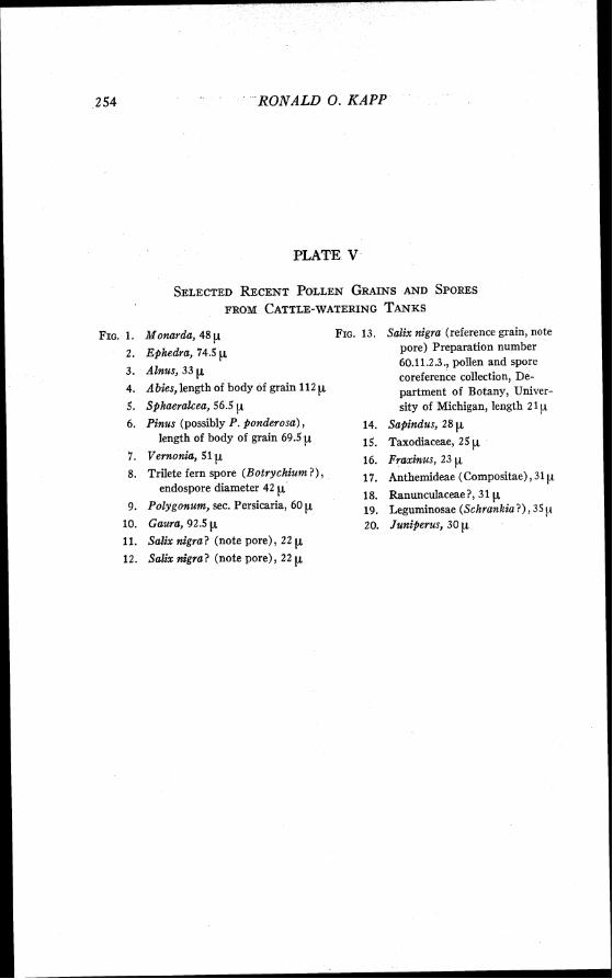
RONALD 0. KAPP
PLATE V
SELECTED RECENT POLLEN GRAINS AND SPORES FROM CATTLE-WATERING TANKS
FIG. 1. Monarda, 48 p 2. Ephedra, 74.5 p 3. Alnus, 3 3 p
4. Abies, length of body of grain 112 y 5. Sphaeralcea, 56.5 p 6. Pinus (possibly P. ponderosa) ,
length of body of grain 69.5
7. Venzonia, 51 p 8. Trilete fern spore (Botrychium?) ,
endospore diameter 42 p 9. Polygonum, sec. Persicaria, 60
10. Gaura, 92.5 p 11. Salix nigra? (note pore), 22 EL 12. Salix nigra? (note pore), 22 p
Salix nigra (reference grain, note pore) Preparation number 60.11.2.3., pollen and spore coreference collection, De- partment of Botany, Univer- sity of Michigan, length 21
Sapindus, 28 p Taxodiaceae, 25 p Fraxinus, 23 p Anthemideae (Compositae) ,31 p Ranunculaceae ?, 3 1 p. Leguminosae (Schrankia?) , 3 5 { I
Juniperus, 30 p
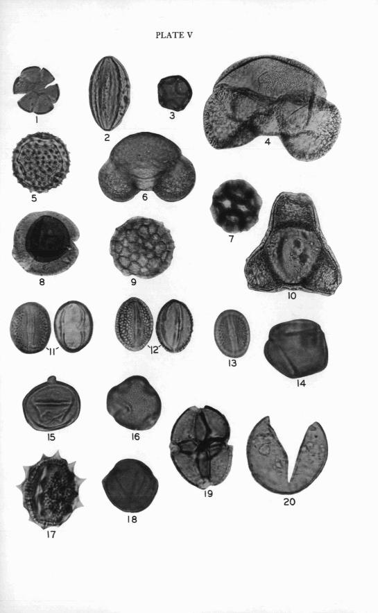
PLATE V
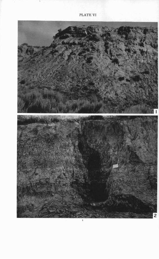
PLATE VI

ZLLINOIAN A N D SANGAMON VEGETATION 2 5 5
PLATE VI
FIG. 1. Berends local fauna locality a t time of collection.
FIG. 2. UM-K4-53 exposure, upper part of section, a t time of collection. Note varved sediments in middle of exposure.