Embed Size (px)
DESCRIPTION
site plan
Citation preview
8/26/2015 09REZ03 Cooke and Futrell Property
https://www.townofcary.org/Departments/Planning_Department/Public_Hearing_Cases/Rezoning_Cases/2009_Rezoning_Cases/09REZ03_Cooke… 1/14
09REZ03 Cooke and Futrell Property
Town of Cary , North Carolina Rezoning Staff Report
09REZ03 Cooke Futrell PropertyTown Council Meeting
August 11, 2010
REQUEST
To amend the Town of Cary Official Zoning Map by rezoning approximately 8.16 acres located at 6737 CarpenterFire Station Road, 4004 & 3890 NC 55 Hwy. and 1950 & 1958 Morrisville Carpenter Road from Residential 40(R40) and Office/Research and Development (ORD) to General Commercial Conditional Use (GCCU). Theconditions, proposed by the applicant, are listed in the background information portion of this report.
NOTE: The purpose of the rezoning is to determine whether on not the land uses and densities allowed in theproposed zoning district are appropriate for the site. Technical design standards of the Land DevelopmentOrdinance are addressed during review of the site or subdivision plan and can be found athttp://www.amlegal.com/library/nc/cary.shtml.
SUBJECT PARCELS
Property Owner(s) County Parcel Number(s)(10digit) Real Estate ID(s) Deeded Acreage
Glen Futrell150 Towerview Ct.Cary, NC 27513
0735745188 0340048 2.81 ±
Glen and Joy C. Futrell150 Towerview Ct.Cary, NC 27513
0735736844 0101297 1.19 ±
Glen and Joy Cooke Futrell150 Towerview Ct.Cary, NC 27513
0735735770 0248335 .51 ±
Carpenter Ruritan Clubc/o Mr. Warren Hill4137 NC Highway 55Cary, NC 275198316
0735737605 0168194 .45 ±
Dorothy W. Cooke121 Franklin Hills Pt.Cary, NC 275198402
0735726346 portion 0014628 portion 3.2 ±
8/26/2015 09REZ03 Cooke and Futrell Property
https://www.townofcary.org/Departments/Planning_Department/Public_Hearing_Cases/Rezoning_Cases/2009_Rezoning_Cases/09REZ03_Cooke… 2/14
Total Area 8.16±
BACKGROUND INFORMATION
General Location 6737 Carpenter Fire Station Road, 4004 & 3890 NC 55 Hwy. and 1950 & 1958Morrisville Carpenter Road
Land Use PlanDesignation
Located within the Carpenter Community Plan. Designation of Mixed andOffice/Institutional or Office/Industrial with Carpenter Community Plan Note 9
Existing Zoning District(s) Residential 40 (R40) and Office/Research and Development (ORD)
Proposed Zoning District General Commercial Conditional Use (GCCU)
Town Limits The property with the address of 1950 Morrisville Carpenter Road is locatedinside Cary’s town limits. All other properties are located outside Cary’scorporate limits but inside the ETJ. In accordance with the LDO, annexation ofthese properties is required at the time of development plan review.
Valid Protest Petition No protest petition was submitted.
PROPOSED ZONING CONDITIONS
Proposed at TownCouncil PublicHearing
Proposed at June 21, 2010Planning and Zoning BoardMeeting
Current Proposed Conditions
1. No individualbuilding shall be largerthan 30,000 squarefeet.
1. No individual building will begreater than 25,000 square feet.
1. Within 200 feet north and south of thecurrent alignment of the Morrisville CarpenterRoad rightofway, the gross building squarefootage will not exceed 10,000 square feet iftwo stories or 7,000 square feet if onestory.Outside of this area, the maximum squarefootage will be 19,000 gross square feet. Building size limits will be noted on each siteplan and indicated on a recorded plat prior toissuance of a Certificate of Occupancy.
2. Buildings shall belimited to two storiesand a maximum heightof 45 feet.
2. Buildings will be limited to twostories and a maximum height of 45feet.
2. Within 200 feet north and south of thecurrent alignment of Morrisville CarpenterRoad rightofway, the building height will be amaximum of 35 feet. Outside of this area,buildings will be limited to two stories with amaximum height of 45 feet. Building heightlimits will be noted on each site plan andindicated on a recorded plat prior to issuanceof a Certificate of Occupancy.
8/26/2015 09REZ03 Cooke and Futrell Property
https://www.townofcary.org/Departments/Planning_Department/Public_Hearing_Cases/Rezoning_Cases/2009_Rezoning_Cases/09REZ03_Cooke… 3/14
3. The mix of uses onthe subject propertieswill be 80%Commercial and 20%Office
3. The mix of uses will be 67%commercial and 33% office.
3. The mix of uses will be commercial(minimum 33%, maximum 67%) and office(minimum 33%, maximum 67%). A conceptualplan showing the percentage of both proposedand existing uses on all properties within thesubject rezoning will be included with each siteplan submittal. Calculations will be based onbuilding square footage.
4. The buffer width adjacent to therailroad in the MixedUse area willbe a 25foot opaque buffer. Thebuffer will be supplemented to meetnative forest stand, includingevergreen shrubs.
4. The buffer width adjacent to the railroad willbe a semiopaque buffer with an averagewidth of 30 feet and a minimum width of 25feet. Evergreen material found in the buffer willbe native plant material.
5. Architecture: Masonry materialon buildings will consist of stone ornatural colored brick. Pouredconcrete walls or materials with asmooth finish may not be used tomeet the Community AppearanceManual requirement of 75%masonry. When metal roofs are avisible part of the façade, the roofwill be in natural colors. Buildingswill incorporate at least twoadditional architectural designelements from the following list thatcompliment late 19th and early 20thcentury vernacular commercial andrural buildings:
Stepped parapet roofModillioned or corbelled corniceworkOverhanging eavesSegmentalarch windowsLarge, plateglass storefrontsDouble hung windowsWindow sash design with a 9over 6, 6 over 6 or 4 over 4patternDouble front doorsNontinted windowsDecorative, patterned brickworkAsphalt shingles on roofs orstanding seam metal roofs innatural metal colorsLowpitched gabled roof
5. Masonry material on buildings will consist ofstone or unpainted brick. Poured concretewalls or materials with a smooth finish may notbe used to meet the Community AppearanceManual requirement of 75% masonry.
When metal roofs are a visible part of thefaçade, the roof will be in naturally occurringmetal colors or earth tone colors from a paletteof browns, tans or grays. If asphalt shinglesare used they will be in earth tone colors froma palette of browns, tans or grays.
One item out of each of the following twocategories will be used in the building design.
Roof Style
Stepped parapet roof orGabled roof with overhanging eaves orFlat roof with Modillioned or corbelledcornice work on the building façade
Window Style
Doublehung windows with a sash designwith 9 over 6, 6 over 6 or 4 over 4 patternorLarge Plateglass window storefronts withnontinted windows orSegmental Arch windows
6. Signage: There will be nointernally illuminated ground signs.Wall signs will be limited to externalillumination or reverse (haloillumination).
6. There will be no internally illuminatedground signs. Wall signs will be limited toexternal illumination or reverse haloillumination.
7. The following uses will not be allowed: Auto
8/26/2015 09REZ03 Cooke and Futrell Property
https://www.townofcary.org/Departments/Planning_Department/Public_Hearing_Cases/Rezoning_Cases/2009_Rezoning_Cases/09REZ03_Cooke… 4/14
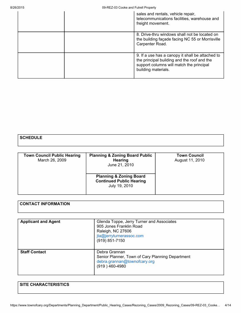
sales and rentals, vehicle repair,telecommunications facilities, warehouse andfreight movement.
8. Drivethru windows shall not be located onthe building façade facing NC 55 or MorrisvilleCarpenter Road.
9. If a use has a canopy it shall be attached tothe principal building and the roof and thesupport columns will match the principalbuilding materials.
SCHEDULE
Town Council Public HearingMarch 26, 2009
Planning & Zoning Board PublicHearing
June 21, 2010
Town CouncilAugust 11, 2010
Planning & Zoning BoardContinued Public Hearing
July 19, 2010
CONTACT INFORMATION
Applicant and Agent Glenda Toppe, Jerry Turner and Associates905 Jones Franklin RoadRaleigh, NC [email protected](919) 8517150
Staff Contact Debra GrannanSenior Planner, Town of Cary Planning [email protected](919 ) 4604980
SITE CHARACTERISTICS
8/26/2015 09REZ03 Cooke and Futrell Property
https://www.townofcary.org/Departments/Planning_Department/Public_Hearing_Cases/Rezoning_Cases/2009_Rezoning_Cases/09REZ03_Cooke… 5/14
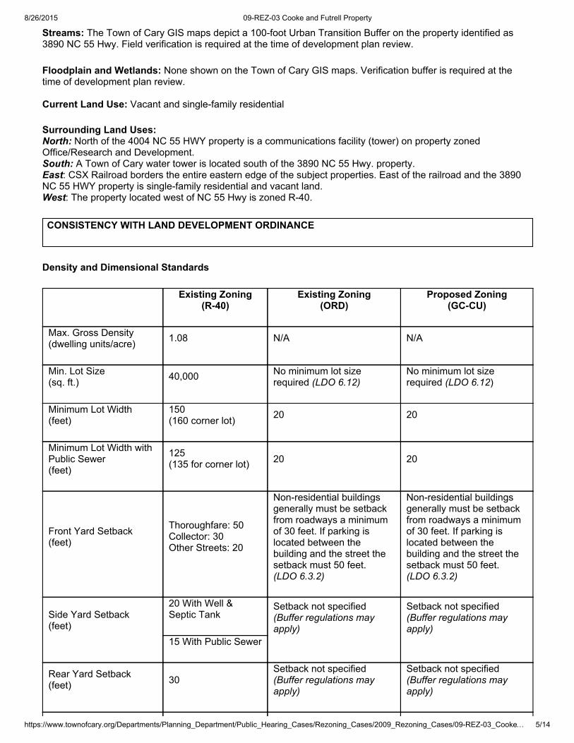
Streams: The Town of Cary GIS maps depict a 100foot Urban Transition Buffer on the property identified as3890 NC 55 Hwy. Field verification is required at the time of development plan review.
Floodplain and Wetlands: None shown on the Town of Cary GIS maps. Verification buffer is required at thetime of development plan review.
Current Land Use: Vacant and singlefamily residential
Surrounding Land Uses: North: North of the 4004 NC 55 HWY property is a communications facility (tower) on property zonedOffice/Research and Development.South: A Town of Cary water tower is located south of the 3890 NC 55 Hwy. property.East: CSX Railroad borders the entire eastern edge of the subject properties. East of the railroad and the 3890NC 55 HWY property is singlefamily residential and vacant land.West: The property located west of NC 55 Hwy is zoned R40.
CONSISTENCY WITH LAND DEVELOPMENT ORDINANCE
Density and Dimensional Standards
Existing Zoning(R40)
Existing Zoning(ORD)
Proposed Zoning(GCCU)
Max. Gross Density(dwelling units/acre) 1.08 N/A N/A
Min. Lot Size(sq. ft.) 40,000 No minimum lot size
required (LDO 6.12)No minimum lot sizerequired (LDO 6.12)
Minimum Lot Width(feet)
150(160 corner lot) 20 20
Minimum Lot Width withPublic Sewer(feet)
125(135 for corner lot) 20 20
Front Yard Setback(feet)
Thoroughfare: 50Collector: 30Other Streets: 20
Nonresidential buildingsgenerally must be setbackfrom roadways a minimumof 30 feet. If parking islocated between thebuilding and the street thesetback must 50 feet.(LDO 6.3.2)
Nonresidential buildingsgenerally must be setbackfrom roadways a minimumof 30 feet. If parking islocated between thebuilding and the street thesetback must 50 feet.(LDO 6.3.2)
Side Yard Setback(feet)
20 With Well &Septic Tank
Setback not specified(Buffer regulations mayapply)
Setback not specified(Buffer regulations mayapply)
15 With Public Sewer
Rear Yard Setback(feet) 30
Setback not specified(Buffer regulations mayapply)
Setback not specified(Buffer regulations mayapply)
8/26/2015 09REZ03 Cooke and Futrell Property
https://www.townofcary.org/Departments/Planning_Department/Public_Hearing_Cases/Rezoning_Cases/2009_Rezoning_Cases/09REZ03_Cooke… 6/14
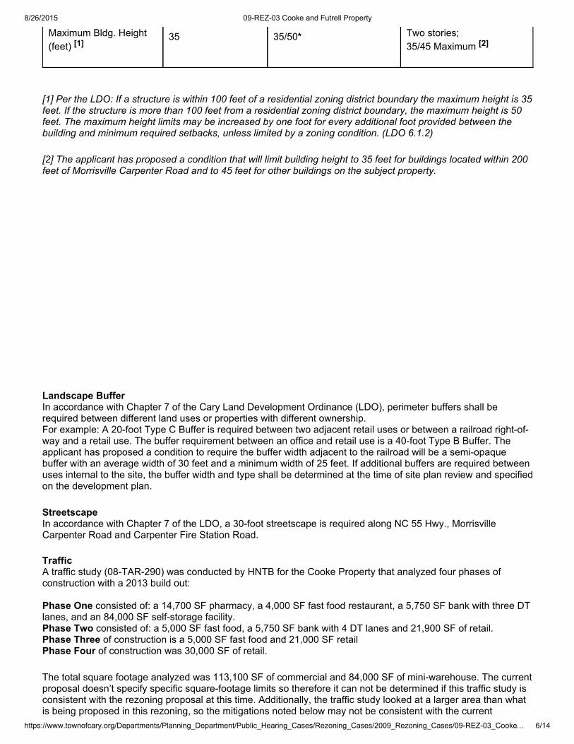
Maximum Bldg. Height(feet) [1]
35 35/50* Two stories;35/45 Maximum [2]
[1] Per the LDO: If a structure is within 100 feet of a residential zoning district boundary the maximum height is 35feet. If the structure is more than 100 feet from a residential zoning district boundary, the maximum height is 50feet. The maximum height limits may be increased by one foot for every additional foot provided between thebuilding and minimum required setbacks, unless limited by a zoning condition. (LDO 6.1.2)
[2] The applicant has proposed a condition that will limit building height to 35 feet for buildings located within 200feet of Morrisville Carpenter Road and to 45 feet for other buildings on the subject property.
Landscape BufferIn accordance with Chapter 7 of the Cary Land Development Ordinance (LDO), perimeter buffers shall berequired between different land uses or properties with different ownership.For example: A 20foot Type C Buffer is required between two adjacent retail uses or between a railroad rightofway and a retail use. The buffer requirement between an office and retail use is a 40foot Type B Buffer. Theapplicant has proposed a condition to require the buffer width adjacent to the railroad will be a semiopaquebuffer with an average width of 30 feet and a minimum width of 25 feet. If additional buffers are required betweenuses internal to the site, the buffer width and type shall be determined at the time of site plan review and specifiedon the development plan.
StreetscapeIn accordance with Chapter 7 of the LDO, a 30foot streetscape is required along NC 55 Hwy., MorrisvilleCarpenter Road and Carpenter Fire Station Road.
TrafficA traffic study (08TAR290) was conducted by HNTB for the Cooke Property that analyzed four phases ofconstruction with a 2013 build out:
Phase One consisted of: a 14,700 SF pharmacy, a 4,000 SF fast food restaurant, a 5,750 SF bank with three DTlanes, and an 84,000 SF selfstorage facility. Phase Two consisted of: a 5,000 SF fast food, a 5,750 SF bank with 4 DT lanes and 21,900 SF of retail.Phase Three of construction is a 5,000 SF fast food and 21,000 SF retailPhase Four of construction was 30,000 SF of retail.
The total square footage analyzed was 113,100 SF of commercial and 84,000 SF of miniwarehouse. The currentproposal doesn’t specify specific squarefootage limits so therefore it can not be determined if this traffic study isconsistent with the rezoning proposal at this time. Additionally, the traffic study looked at a larger area than whatis being proposed in this rezoning, so the mitigations noted below may not be consistent with the current
8/26/2015 09REZ03 Cooke and Futrell Property
https://www.townofcary.org/Departments/Planning_Department/Public_Hearing_Cases/Rezoning_Cases/2009_Rezoning_Cases/09REZ03_Cooke… 7/14
proposal.
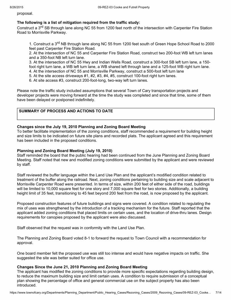
The following is a list of mitigation required from the traffic study:Construct a 3rd SB through lane along NC 55 from 1200 feet north of the intersection with Carpenter Fire StationRoad to Morrisville Parkway.
1. Construct a 3rd NB through lane along NC 55 from 1200 feet south of Green Hope School Road to 2000feet past Carpenter Fire Station Road.2. At the intersection of NC 55 and Carpenter Fire Station Road, construct two 200foot WB left turn lanesand a 350foot NB left turn lane.3. At the intersection of NC 55 Hwy and Indian Wells Road, construct a 300foot SB left turn lane, a 150foot right turn lane, a WB left turn lane, a WB shared left through lane and a 125foot WB right turn lane.4. At the intersection of NC 55 and Morrisville Parkway, construct a 500foot left turn lane5. At the site access driveways #1, #2, #3, #4, #5, construct 100foot right turn lanes.6. At site access #3, construct 200footlong, twoway left turn lanes.
Please note the traffic study included assumptions that several Town of Cary transportation projects anddeveloper projects were moving forward at the time the study was completed and since that time, some of themhave been delayed or postponed indefinitely.
SUMMARY OF PROCESS AND ACTIONS TO DATE
Changes since the July 19, 2010 Planning and Zoning Board MeetingTo better facilitate implementation of the zoning conditions, staff recommended a requirement for building heightand size limits to be indicated on future site plans and recorded plats. The applicant agreed and this requirementhas been included in the proposed conditions.
Planning and Zoning Board Meeting (July 19, 2010)Staff reminded the board that the public hearing had been continued from the June Planning and Zoning BoardMeeting. Staff noted that new and modified zoning conditions were submitted by the applicant and were reviewedby staff.
Staff reviewed the buffer language within the Land Use Plan and the applicant’s modified condition related totreatment of the buffer along the railroad. Next, zoning conditions pertaining to building size and scale adjacent toMorrisville Carpenter Road were presented. In terms of size, within 200 feet of either side of the road, buildingswill be limited to 10,000 square feet for one story and 7,000 square feet for two stories. Additionally, a buildingheight limit of 35 feet, transitioning to 45 feet beyond 200 feet from the road, is now proposed by the applicant.
Proposed construction features of future buildings and signs were covered. A condition related to regulating themix of uses was strengthened by the introduction of a tracking mechanism for the future. Staff reported that theapplicant added zoning conditions that placed limits on certain uses, and the location of drivethru lanes. Designrequirements for canopies proposed by the applicant were also discussed.
Staff observed that the request was in conformity with the Land Use Plan.
The Planning and Zoning Board voted 81 to forward the request to Town Council with a recommendation forapproval.
One board member felt the proposed use was still too intense and would have negative impacts on traffic. Shesuggested the site was better suited for office use.
Changes Since the June 21, 2010 Planning and Zoning Board MeetingThe applicant has modified the zoning conditions to provide more specific expectations regarding building design,to reduce the maximum building size and limit certain uses. A condition to require submission of a conceptualplan showing the percentage of office and general commercial use on the subject property has also beenintroduced.
8/26/2015 09REZ03 Cooke and Futrell Property
https://www.townofcary.org/Departments/Planning_Department/Public_Hearing_Cases/Rezoning_Cases/2009_Rezoning_Cases/09REZ03_Cooke… 8/14
Planning and Zoning Board Meeting (June 21, 2010)Staff presented the request and noted that several of the conditions proposed by the applicant had been modifiedsince the first public hearing. Staff's observation was that the conditions did not provide enough assurance thatthe request would comply with the Comprehensive Plan. The applicant spoke during the public hearing andstated that additional conditions had been submitted for review but not in time to be included in the staff report.The applicant asked that the case be tabled until the next meeting.
During discussion of the case, one board member commented that the proposed conditions put too muchemphasis on the architectural elements and that more pertinent issues, such as use categories and the amountof commercial square footage, should be addressed. The board asked for clarification on some of the LDOrequirements and asked to see the boundaries of the Rural Village District. The board suggested a corridor studybe completed for NC 55 Hwy. The board voted unanimously 90 to continue the public hearing
Changes Since the Town Council Public HearingAs indicated in the Applicable Comprehensive or Area Plan Requirements portion of this report, Note 9 wasrecently amended as per Comprehensive Plan Amendment case 09CPA03:
The portion of the Dorothy W. Cooke lot being considered for rezoning was reduced from 11.61 acres to 3.2acres.
The applicant revised the proposed mix of uses on the subject property from 80% Commercial and 20% Office topropose 67% Commercial and 33% Office. In addition, the original zoning condition that proposed a maximumbuilding size of 30,000 square feet has been reduced to 25,000 square feet. The applicant has also submittedseveral new zoning conditions that pertain to landscaping, building design and signage.
Town Council Public HearingAt the March 26, 2009 Town Council Meeting, staff presented the request and noted that there was no protestpetition. The applicant, Mr. Futrell, suggested to the Town Council that citizens in the vicinity of the subjectproperty were in need of commercial services. He further expressed his desire to apply zoning conditions anddevelopment regulations that would make future development compatible with the historic Carpenter Community.He stated that he faced challenges with the property because of its location between the railroad and NC 55 Hwy.No one else spoke at the public hearing. Council emphasized the importance of ensuring that rezoning conditionsassociated with this case ensured development that would compliment the Carpenter Community.
Neighborhood MeetingOn Tuesday, December 16, 2008 the applicant conducted a neighborhood meeting at Good Hope BaptistChurch, to which property owners within 400 feet of the subject property were invited. In the rezoning application,the applicant listed the following resident concerns: height of buildings, visual impact, road improvements andlocation of public sewer.
NotificationOn March 10, 2008 notification of a public hearing on this request was mailed to property owners within 400 feetof the subject property.
The property was posted with a notice of the public hearing on March 11, 2009.
Notification consistent with General Statutes was published in the Cary News on March 11 and 18, 2009.
CRITERIA FOR CONSIDERATION IN REVIEWING REZONINGS
Section 3.4.1(E) of the Land Development Ordinance sets forth the following criteria that should be considered inreviewing rezonings:1. The proposed rezoning corrects an error or meets the challenge of some changing condition, trend or fact;2. The proposed rezoning is consistent with the Comprehensive Plan set forth in Section 1.3 (LDO);3. The Town and other service providers will be able to provide sufficient public safety, educational, recreational,transportation and utility facilities and services to the subject property while maintaining sufficient levels of service
8/26/2015 09REZ03 Cooke and Futrell Property
https://www.townofcary.org/Departments/Planning_Department/Public_Hearing_Cases/Rezoning_Cases/2009_Rezoning_Cases/09REZ03_Cooke… 9/14
to existing development;4. The proposed rezoning is unlikely to have significant adverse impacts on the natural environment, including air,water, noise, stormwater management, wildlife and vegetation;5. The proposed rezoning will not have significant adverse impacts on property in the vicinity of the subject tract;6. The proposed zoning classification is suitable for the subject property
APPLICABLE COMPREHENSIVE OR AREA PLAN REQUIREMENTS
Comprehensive Plan Element Consistent Not Consistent Not Applicable
Land Use Plan or Area Plan P
Parks, Recreation, and Cultural ResourcesFacility Master Plan P
Growth Management Plan P
Affordable Housing Plan P
Comprehensive Transportation Plan P
Open Space and Historic Resources Plan P
A. Land Use Plan or Area PlanThe governing land use element of Cary’s Comprehensive Plan for the subject parcels is the CarpenterCommunity Plan, originally adopted in September 2005. The Carpenter Community Plan currently recommendsthe following future land uses for the subject parcels:
The entire subject area is recommended for Mixed Use (MXD) development. Areas designated as Mixed Use arerecommended to include at least two major land use types from among commercial, office, and mediumtohighdensity residential. The plan further specifies that a single use type “should not substantially dominate an entirearea designated as Mixed Use.” However, for the MXD area in question, the plan also states that residential usesare not required within the usage mix. That is, the usage mix could consist of commercial and office uses only.Additional land use recommendations are described in Note 9 on the plan map, which applies to the entire areadesignated as MXD between NC Highway 55 and the CSX Railroad rightofway. Note 9 was recently amendedas per Comprehensive Plan Amendment case 09CPA03:
“In the MixedUse area, vegetated buffers along the railroad are recommended to exceed LDO performancestandards by having a minimum width of 25’ and including semiopaque plantings. Along the approaches to andfrom the Rural Village, and where views exist to and from the Rural Village, new development within the MixedUse area should be compatible with the character of the adjacent Rural Village portion of the National RegisterHistoric District, in terms of historic landscape, streetscape, and building architecture, including materials, height,and mass. Inclusion of historic materials such as wood siding, doublehung windows, tin roofs, and brickfoundations, is preferred. Residential uses in area 9 are permissible but not required.”
B. Parks and Greenways Master PlanAccording to the Parks, Recreation and Cultural Resources Master Plan an eastwest greenway trail is proposedto cross the subject parcels near the northern portion of the subject area, near the existing segment of CarpenterFire Station Road. According to the Carpenter Community Plan, this greenway is proposed to cross Highway 55via a gradeseparated crossing.
C. Growth Management PlanThe Growth Management Plan includes the following Guiding Principles which are relevant to this case:
8/26/2015 09REZ03 Cooke and Futrell Property
https://www.townofcary.org/Departments/Planning_Department/Public_Hearing_Cases/Rezoning_Cases/2009_Rezoning_Cases/09REZ03_Cook… 10/14
1. Guiding Principle R1: Ensure that adequate infrastructure and services are available concurrently with newdevelopment.Analysis: Public infrastructure is located reasonably proximate to the site.
2. Guiding Principle L1: Concentrate growth near existing and planned employment centers and available andplanned infrastructure to minimize costly servicearea extensions.Analysis: Residential growth is not envisioned for the subject site. The recommendations of the CarpenterCommunity Plan envision nonresidential growth at a scale that complements the site’s context. The proposedamendment does not affect these recommendations.
3. Guiding Principle L2: Ensure that future growth protects sensitive natural resources and protects open space.Analysis: One of the parcels does contain some significant natural resources and several of the sites includenotable and mature hardwoods. The degree to which future development may or may not preserve some or all ofthose resources cannot be determined with this Comprehensive Plan Amendment case, but may be addressedby a rezoning or site plan.
4. Guiding Principle A1: Increase permitted densities in preferred growth areas to encourage desired forms ofdevelopment.Analysis: The Carpenter Community Plan identifies the type and intensity of development that is most desired bythe Town in this particular area. The proposed amendment does not affect these recommendations.
D. Affordable Housing PlanSince it is highly unlikely that residential uses would be sited within the subject area, in general the AffordableHousing Plan is not applicable to this case. In fact, the following goal from the Affordable Housing Plandiscourages housing at this location:
1. Goal: Encourage the location of highdensity housing within walking and convenient commuting distance ofemployment, shopping, and other activities, or within a short walk of a bus or transit stop, through "mixed use"developments, residences created on the upper floors of nonresidential downtown buildings, and other creativestrategies.
Analysis: The subject area is isolated between NC Highway 55 and the CSX Railroad line. In the future, with theplanned closings of the railroad crossings of Carpenter Fire Station and MorrisvilleCarpenter Roads, the site willbecome completely isolated, lacking both street and pedestrian connections to nearby areas. The site is notwithin walking distance of employment, shopping, or other daily activities.
E. Comprehensive Transportation PlanThe Comprehensive Transportation Plan includes the following recommendations for the thoroughfares adjacentto the subject parcels:
NC Highway 55 is designated as a Major Thoroughfare Existing Section: 4lane divided with landscaped median and paved shoulders; approximately 150 feet of ROWFuture Section: 4lane divided with landscaped median and curb & gutter; approximately 150 feet of ROW (sixlanes required north of Indian WellsSidewalks: Required on both sides Bicycle Lanes: 14footwide outside lanesTransit: None required at this timeStatus of Planned Improvements: None scheduled by the Town
Carpenter Fire Station Road & MorrisvilleCarpenter Road are designated as Major Thoroughfares
Existing Section: 2lane thoroughfare; approximately 60 feet of ROWFuture Section: 4lane divided with landscaped median; approximately 100 feet of ROWSidewalks: Sidewalks required on both sidesBicycle Lanes: 14footwide outside lanesTransit: None required at this timeStatus of Planned Improvements: None scheduled by the Town. In December 2009, ST1166 (Carpenter Fire
8/26/2015 09REZ03 Cooke and Futrell Property
https://www.townofcary.org/Departments/Planning_Department/Public_Hearing_Cases/Rezoning_Cases/2009_Rezoning_Cases/09REZ03_Cook… 11/14
Station Road Extension and Railroad Bridge) was postponed indefinitely.
F. Open Space and Historic Resources PlanThe Open Space Plan and its priority open space inventory identify portions of the case area as having somesignificant natural resources. These natural resource areas are located on the Dorothy Cooke propertyimmediately south of MorrisvilleCarpenter Road, and consist of mixed upland hardwoods near the existinghomestead and farm pond.
Staff’s Observation
The proposed conditions related to architecture are intended to compliment the surrounding community andcontain design elements that are reminiscent of the late 19th and early 20th century vernacular style of buildingdesign. They are not, however, intended to replicate the buildings in the Rural Village portion of the CarpenterCommunity. When these conditions are combined with the requirements of Cary’s Community AppearanceManual, this promotes a high quality building design with an historic nature. The zoning conditions, introduced bythe applicant to limit the building size and height on approaches to Carpenter Rural Village, help to prevent futuredevelopment from detracting from the character of the existing community.
The proposed rezoning is consistent with the Comprehensive Plan and other applicable, adopted plans, policiesand documents.
APPLICANT’S JUSTIFICATION STATEMENT
The following statements are provided by the applicant (shown below in italics) in response to the criteriaestablished in the application (shown below in bold) and do not necessarily represent the views or opinions of theTown of Cary. Any statements as to the type, the quality, or the physical features are at the direction of theapplicant and may be formulated into a condition:
1. Any issues with the size of the tract?Response: The tract is of ample size to accommodate the requested commercial development. Furthermore, if allof the parcels are zoned commercial, there will be the opportunity for a wellplanned, coordinated developmentversus a piecemeal development.
2. How is the request compatible with the Comprehensive Plan (i.e. Land Use, Transportation, OpenSpace and Historic Resources)?Response: The rezoning is part of the adopted Carpenter Community Plan. The current land use plan identifiesthe parcels for mixed use, office/industrial and office/institutional. The proposed land use is commercial. Part ofthe proposed rezoning is compatible with the Comprehensive Plan/Carpenter Community Plan. The parcels withthe mixed use designation are compatible with the comprehensive plan. Mixed use allows commercial and retailuses. The parcels with the office/industrial and office/institutional designation are not compatible with thecomprehensive plan. As mentioned previously, commercial and retail uses are allowed within the mixed useportion of the Carpenter Community Plan. Given the type of development that has occurred in the area and thefact that commercial and retail uses are allowed in the mixed use portion of the Carpenter Community Plan, it isour opinion that the proposed land use of commercial is appropriate for all the parcels being rezoned.Furthermore, the uses permitted in the commercial zoning district will provide the necessary support services inclose proximity to existing and future residential development in the area.
3. What are the benefits and detriments to the owner, neighbors and the community?Response: As stated above, the proposed rezoning will provide the necessary support services for the area.Given the proximity of the support services, the length of automobile trips will be reduced and the potential existsfor alternative means of transportation such as walking and biking. The parcels are bounded by roads, therailroad and the Town of Cary water tower on all sides, thus minimizing any impact to surrounding properties.Given the constraints of the site, the uses permitted in the proposed rezoning are a better fit for the property.Furthermore, the Town’s Land Development Ordinance (LDO) will adequately protect the adjacent propertyowners.
8/26/2015 09REZ03 Cooke and Futrell Property
https://www.townofcary.org/Departments/Planning_Department/Public_Hearing_Cases/Rezoning_Cases/2009_Rezoning_Cases/09REZ03_Cook… 12/14
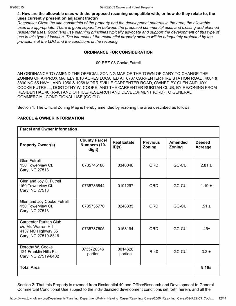
4. How are the allowable uses with the proposed rezoning compatible with, or how do they relate to, theuses currently present on adjacent tracts?Response: Given the site constraints of the property and the development patterns in the area, the allowableuses are appropriate. There is good separation between the proposed commercial uses and existing and plannedresidential uses. Good land use planning principles typically advocate and support the development of this type ofuse in this type of location. The interests of the residential property owners will be adequately protected by theprovisions of the LDO and the conditions of the rezoning.
ORDINANCE FOR CONSIDERATION
09REZ03 Cooke Futrell
AN ORDINANCE TO AMEND THE OFFICIAL ZONING MAP OF THE TOWN OF CARY TO CHANGE THEZONING OF APPROXIMATELY 8.16 ACRES LOCATED AT 6737 CARPENTER FIRE STATION ROAD, 4004 &3890 NC 55 HWY., AND 1950 & 1958 MORRISVILLE CARPENTER ROAD, OWNED BY GLEN AND JOYCOOKE FUTRELL, DORTOTHY W. COOKE, AND THE CARPENTER RURITAN CLUB, BY REZONING FROMRESIDENTIAL 40 (R40) AND OFFICE/RESEARCH AND DEVELOPMENT (ORD) TO GENERALCOMMERCIAL CONDITIONAL USE (GCCU)
Section 1: The Official Zoning Map is hereby amended by rezoning the area described as follows:
PARCEL & OWNER INFORMATION
Parcel and Owner Information
Property Owner(s)County ParcelNumbers (10
digit)Real EstateID(s)
PreviousZoning
AmendedZoning
DeededAcreage
Glen Futrell150 Towerview Ct.Cary, NC 27513
0735745188 0340048 ORD GCCU 2.81 ±
Glen and Joy C. Futrell150 Towerview Ct.Cary, NC 27513
0735736844 0101297 ORD GCCU 1.19 ±
Glen and Joy Cooke Futrell150 Towerview Ct.Cary, NC 27513
0735735770 0248335 ORD GCCU .51 ±
Carpenter Ruritan Clubc/o Mr. Warren Hill4137 NC Highway 55Cary, NC 275198316
0735737605 0168194 ORD GCCU .45±
Dorothy W. Cooke121 Franklin Hills Pt.Cary, NC 275198402
0735726346 portion
0014628portion R40 GCCU 3.2 ±
Total Area 8.16±
Section 2: That this Property is rezoned from Residential 40 and Office/Research and Development to GeneralCommercial Conditional Use subject to the individualized development conditions set forth herein, and all the
8/26/2015 09REZ03 Cooke and Futrell Property
https://www.townofcary.org/Departments/Planning_Department/Public_Hearing_Cases/Rezoning_Cases/2009_Rezoning_Cases/09REZ03_Cook… 13/14
requirements of the Cary Land Development Ordinance (LDO) and other applicable laws, standards, policies andguidelines
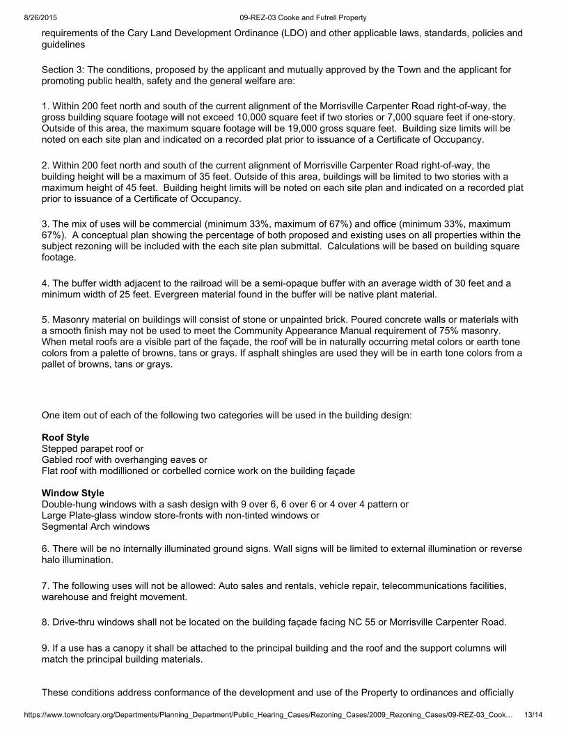
Section 3: The conditions, proposed by the applicant and mutually approved by the Town and the applicant forpromoting public health, safety and the general welfare are:
1. Within 200 feet north and south of the current alignment of the Morrisville Carpenter Road rightofway, thegross building square footage will not exceed 10,000 square feet if two stories or 7,000 square feet if onestory.Outside of this area, the maximum square footage will be 19,000 gross square feet. Building size limits will benoted on each site plan and indicated on a recorded plat prior to issuance of a Certificate of Occupancy.
2. Within 200 feet north and south of the current alignment of Morrisville Carpenter Road rightofway, thebuilding height will be a maximum of 35 feet. Outside of this area, buildings will be limited to two stories with amaximum height of 45 feet. Building height limits will be noted on each site plan and indicated on a recorded platprior to issuance of a Certificate of Occupancy.
3. The mix of uses will be commercial (minimum 33%, maximum of 67%) and office (minimum 33%, maximum67%). A conceptual plan showing the percentage of both proposed and existing uses on all properties within thesubject rezoning will be included with the each site plan submittal. Calculations will be based on building squarefootage.
4. The buffer width adjacent to the railroad will be a semiopaque buffer with an average width of 30 feet and aminimum width of 25 feet. Evergreen material found in the buffer will be native plant material.
5. Masonry material on buildings will consist of stone or unpainted brick. Poured concrete walls or materials witha smooth finish may not be used to meet the Community Appearance Manual requirement of 75% masonry.When metal roofs are a visible part of the façade, the roof will be in naturally occurring metal colors or earth tonecolors from a palette of browns, tans or grays. If asphalt shingles are used they will be in earth tone colors from apallet of browns, tans or grays.
One item out of each of the following two categories will be used in the building design:
Roof StyleStepped parapet roof orGabled roof with overhanging eaves orFlat roof with modillioned or corbelled cornice work on the building façade
Window StyleDoublehung windows with a sash design with 9 over 6, 6 over 6 or 4 over 4 pattern orLarge Plateglass window storefronts with nontinted windows orSegmental Arch windows
6. There will be no internally illuminated ground signs. Wall signs will be limited to external illumination or reversehalo illumination.
7. The following uses will not be allowed: Auto sales and rentals, vehicle repair, telecommunications facilities,warehouse and freight movement.
8. Drivethru windows shall not be located on the building façade facing NC 55 or Morrisville Carpenter Road.
9. If a use has a canopy it shall be attached to the principal building and the roof and the support columns willmatch the principal building materials.
These conditions address conformance of the development and use of the Property to ordinances and officially
8/26/2015 09REZ03 Cooke and Futrell Property
https://www.townofcary.org/Departments/Planning_Department/Public_Hearing_Cases/Rezoning_Cases/2009_Rezoning_Cases/09REZ03_Cook… 14/14
adopted plans and address impacts reasonably expected to be generated by the development and use of theProperty.
Section 4: This ordinance shall be effective on the date of adoption.Adopted and effective: August 11, 2010
________________________________________Harold Weinbrecht, Jr.Mayor
______________________________Date