Embed Size (px)
Citation preview
El Dorado
HEAD
The gold fever that gripped Victoria from the 1850s until the early decades of the 20th century left an indelible mark on the historic towns and places linked by the Indigo Gold Trail.
Gold worth billions of dollars in today’s currency was extracted from the area once known as the Ovens and Indigo Goldfields. Initially lone diggers searching for alluvial gold used primitive tools such as pans, picks and cradles. As the years progressed more sophisticated technologies were developed including high pressure hydraulic sluicing, powerful explosives for hard rock mining, and much later the large barge and bucket dredges. The evolution of these gold mining technologies as well as their devastating environmental impact are integral to the Indigo Gold Trail story.
Today, in and around Beechworth, Chiltern, Rutherglen and Yackandandah, and the villages and countryside in between, the legacy of the rush for gold remains - from the perfectly preserved streetscapes of the towns to the countless mine shafts and mullock heaps to astonishing water races carved through solid granite; from Chinese Burning Towers and pioneer graves to historic government buildings, schools and museums all dating from those early, heady days of the gold rush.
The Indigo Gold Trail takes in some of the most picturesque countryside in Australia and includes scores of easily accessible sites.
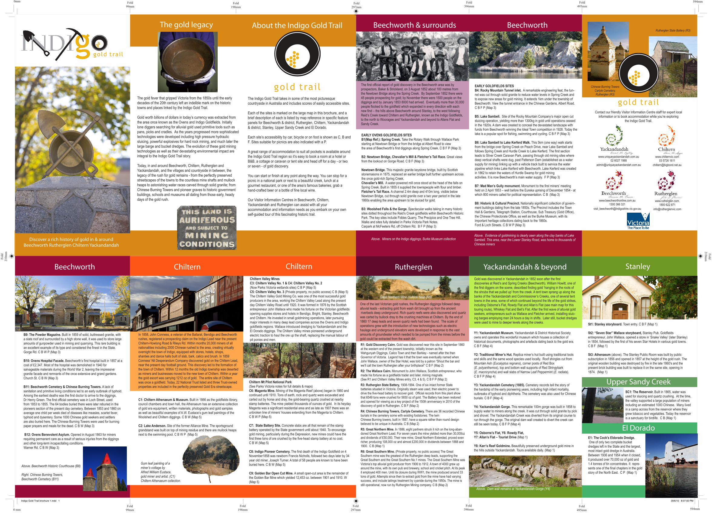
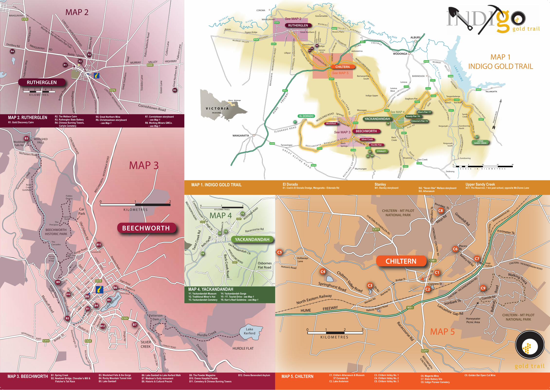
Each of the sites is marked on the large map in this brochure, and a brief description of each is listed by map reference in specific feature panels for Beechworth & district, Rutherglen, Chiltern, Yackandandah & district, Stanley, Upper Sandy Creek and El Dorado.
Each site’s accessibility by car, bicycle or on foot is shown as C, B and F. Sites suitable for picnics are also indicated with a P.
A great range of accommodation to suit all pockets is available around the Indigo Gold Trail region so it’s easy to book a room at a hotel or B&B, a cottage or caravan or tent site and head off for a day - or two or seven - of gold discovery.
You can start or finish at any point along the way. You can stop for a picnic in a national park or next to a beautiful creek, lunch at a gourmet restaurant, or one of the area’s famous bakeries, grab a hand-crafted beer or a bottle of fine local wine.
Our Visitor Information Centres in Beechworth, Chiltern, Yackandandah and Rutherglen can assist with all your accommodation and information needs as you embark on your own self-guided tour of this fascinating historic trail.
The first official report of gold discovery in the Beechworth area was by prospectors, Baker & Strickland, on 3 August 1852 about 100 metres from the Newtown Bridge along the Spring Creek. By September 1852 there were 45 people prospecting for gold; by November there were 1500 people on the diggings and by January 1853 8000 had arrived. Eventually more than 30,000 people flocked to the goldfield which expanded in every direction with each new find – the hills above Beechworth around Stanley, to the west following Reid’s Creek toward Chiltern and Rutherglen, known as the Indigo Goldfields, to the north to Wooragee and Yackandandah and beyond to Allans Flat and Sandy Creek.
EARLY GOLDFIELDS SITESB4: Rocky Mountain Tunnel inlet. A remarkable engineering feat, the tun-nel was cut through solid granite to reduce water levels in Spring Creek and to expose new areas for gold mining. It extends 1km under the township of Beechworth. View the tunnel entrance in the Chinese Gardens, Albert Road. C B F P (Map 3)
B5: Lake Sambell. Site of the Rocky Mountain Company’s major open cut sluicing operation, yielding more than 1300kg in gold until operations ceased in the 1920s. A dam was created to conceal the devastated landscape with funds from Beechworth winning the Ideal Town competition in 1928. Today the lake is a popular spot for fishing, swimming and cycling. C B F P (Map 3)
B6: Lake Sambell to Lake Kerferd Walk. This 5km (one way) walk starts from the bridge over Spring Creek on Peach Drive, near Lake Sambell and follows Spring Creek and Hurdle Creek to Lake Kerferd. The first section leads to Silver Creek Caravan Park, passing through old mining sites where deep vertical shafts were dug, past Patterson Dam (established as a water supply for mining) linking up with a vehicle track built to service the water pipeline which links Lake Kerferd with Beechworth. Lake Kerferd was created in 1862 to retain the waters of Hurdle Swamp for gold mining activities. It is now Beechworth’s main water supply. F P (Map 3)
B7: Mad Man’s Gully monument. Monument to the first miners’ meeting held on 2 April 1853 – well before the Eureka uprising of December 1854 - at which 800 miners called for political representation. C B (Map 3)
B8: Historic & Cultural Precinct. Nationally significant collection of govern-ment buildings dating from the late 1850s. The Precinct includes the Town Hall & Gardens, Telegraph Station, Courthouse, Sub Treasury (Gold Office), the Chinese Protectorate Office, as well as the Burke Museum, with its important heritage collections dating back to the 1860s. Ford & Loch Streets. C B W P (Map 3)
EARLY OVENS GOLDFIELDS SITES B1(Map Ref.): Spring Creek. Take the Rotary Walk through Wallace Park starting at Newtown Bridge or from the bridge at Albert Road to view the area of Beechworth’s first diggings along Spring Creek. C B F P (Map 3)
B2: Newtown Bridge, Chevalier’s Mill & Fletcher’s Tail Race. Great views from the lookout on Gorge Road. C B F (Map 3)
Newtown Bridge. This majestic granite keystone bridge, built by Scottish stonemasons in 1875, replaced an earlier bridge built further upstream across the once gold-rich Spring Creek.Chevalier’s Mill. A water-powered mill once stood at the head of the falls on Spring Creek. Built in 1855 it supplied the townspeople with flour and timber. Fletcher’s Tail Race. A channel 2.4m deep and 410m long, visible below Newtown Bridge, cut through solid granite over a two year period in the late 1860s enabling the area upstream to be sluiced for gold.
B3: Woolshed Falls & the Gorge. Spectacular walks taking in many historic sites dotted throughout the Reid’s Creek goldfields within Beechworth Historic Park. The key sites include Fiddes Quarry, The Precipice and One Tree Hill. Walks and sites fully detailed in Parks Victoria Park Notes. Carpark at McFeeters Rd, off Chiltern Rd. B F P (Map 3)
B9: The Powder Magazine. Built in 1859 of solid, buttressed granite, with a slate roof and surrounded by a high stone wall, it was used to store large amounts of gunpowder used in mining and quarrying. This rare building is an excellent example of its type and considered the finest in the State. Gorge Rd. C B W P (Map 3)
B10: Ovens Hospital Facade. Beechworth’s first hospital built in 1857 at a cost of £2,347. Most of the hospital was demolished in 1940 for salvageable materials during the World War 2, leaving the impressive granite facade and remnants of the once extensive and grand gardens. Church St. C B W (Map 3)
B11: Beechworth Cemetery & Chinese Burning Towers. A lack of sanitation and primitive living conditions led to an early outbreak of typhoid. Among the earliest deaths was the first doctor to arrive to the diggings, Dr Henry Green. The first official cemetery was in Loch Street, used from 1853 to 1855. The 64 bodies buried there were later reburied in the pioneers section of the present day cemetery. Between 1853 and 1860 on average one child per week died of diseases like measles, scarlet fever, typhoid and dysentery. Some 1000 Chinese gold seekers and settlers are also buried here. The Chinese Burning Towers were used for burning paper prayers and meals for the dead. C B W (Map 3)
B12: Ovens Benevolent Asylum. Opened in August 1863 for miners requiring permanent care as a result of serious injuries from the diggings and other long-term incapacitating conditions. Warner Rd. C B W (Map 3)
In 1858, John Conness, a veteran of the Ballarat, Bendigo and Beechworth rushes, registered a prospecting claim on the Indigo Lead near the present Chiltern-Howlong Road & Rileys Rd. Within months 20,000 miners of all nationalities including 2000 Chinese rushed to the area, creating virtually overnight the town of Indigo, equipped with stores, hotels, shops, shanties and dance halls built of slab, bark, calico and brush. In 1859 Conness’ Nil Desperandum Company discovered gold on the Chiltern Lead, near the present day football ground. This discovery led to the formation of the town of Chiltern. Within 12 months the old Indigo township was deserted as miners and businesses moved to the new town of Chiltern. Within a year the gold escort was carrying 1212 oz of gold. The entire site of Chiltern was once a goldfield. Today, 22 National Trust listed and three Trust-owned properties are included in the perfectly preserved Gold Era streetscape.
C1: Chiltern Athenaeum & Museum. Built in 1866 as the goldfields library, council chambers and town hall, the Athenaeum has an extensive collection of gold era equipment, written materials, photographs and gold samples as well as beautiful examples of A.W. Eustace’s gum leaf paintings of the Woolshed and Chiltern diggings. C B W (Map 5) C2: Lake Anderson. Site of the former Alliance Mine. The sportsground grandstand was built on top of mining residue and there are mullock heaps next to the swimming pool. C B W P (Map 5)
Chiltern Valley MinesC3: Chiltern Valley No. 1 & C4: Chiltern Valley No. 2 (Now Parks Victoria wetlands sites) C B P (Map 5)C5: Chiltern Valley No. 3 (Private property, no public access) C B (Map 5)The Chiltern Valley Gold Mining Co. was one of the most successful gold producers in the area, working the Chiltern Valley Lead along the present day Chiltern Valley Road until 1920. It was formed in 1876 by the Scottish entrepreneur John Wallace who made his fortune on the Victorian goldfields opening supplies stores and hotels in Bendigo, Bright, Stanley, Beechworth and Chiltern. He invested in small goldmining operations, later pursuing major interests in many deep lead companies across the Ovens and Indigo goldfields regions. Wallace introduced dredging to Yackandandah and the El Dorado diggings. The Chiltern Valley mines pioneered underground electric traction to haul the ore up the shaft, replacing the manual labour of pit ponies and men.
One of the last Victorian gold rushes, the Rutherglen diggings followed deep alluvial leads - extracting gold from wash dirt brought up from the ancient riverbeds deep underground. Rich quartz reefs were also discovered and quartz was carted by bullock dray to the crushing machines at Chiltern. By the end of 1860 17 deep leads and seven quartz reefs had been found. The scale of operations grew with the introduction of new technologies such as electric haulage and underground elevators were developed in response to the vast amounts of groundwater which needed to be pumped from the mines before the gold could be extracted from the wash dirt.
R1: Gold Discovery Cairn. Gold was discovered near this site in September 1860 at the western end of the present township, initiallly known as the Wahgunyah Diggings, Calico Town and then Barkley - named after the then Governor of Victoria. Legend has it that the town was eventually named when John Wallace, owner of the Star Hotel, was told by a patron “Shout the bar and we’ll call the town Rutherglen after your birthplace!” C B F (Map 2)
R2: The Wallace Cairn. Monument to John Wallace, Scottish entrepreneur, who made his fortune as a goldfields trader and later, mining magnate. (See R1 and Chiltern Valley Mines entry, C3, 4 & 5). C B F P (Map 2)
R3: Rutherglen State Battery, 1908-1994. One of six intact former State batteries situated in Victoria. Originally steam was used, then electric power to drive the five-head battery to recover gold. Official records from this plant show that 6549 tons were crushed for 5650 oz of gold. The Battery has been restored and opened for viewing as a key project of the 150th anniversary in 2010 of the discovery of gold in Rutherglen. C B F (Map 2)
R4: Chinese Burning Towers, Carlyle Cemetery. There are 36 recorded Chinese burials in the cemetery some with existing footstones. The twin Chinese Burning towers, built in 1887, have a square rather than round design believed to be unique in Australia. C B (Map 2)
R5: Great Northern Mine. In 1886, eight partners struck it rich on the long-aban-doned Great Northern Lead. For seven years the mine yielded more than 30,000oz and dividends of £50,000. Their new mine, Great Northern Extended, proved even richer, producing 108,000 oz and almost £200,000 in dividends between 1888 and 1900. C B (Map 1)
R6: Great Southern Mine. (Private property, no public access) The Great Southern mine was the greatest of the Rutherglen deep leads, supporting the Great Southern and the Great Southern No.1 mines. The Great Southern Mine was Victoria’s top alluvial gold producer from 1906 to 1912. A town of 4000 grew up around the mine, with its own pub and brewery, school and cricket pitch. At its peak it employed 400 men. Until its closure during WW1, the mine produced around 33 tons of gold. Attempts since then to extract gold from the mine have had varying success, and include tailings treatment by cyanide during the 1950s. The mine is still operational, now run by Rutherglen Mining company. C B (Map 2)
Gold was discovered in Yackandandah in 1852 soon after the first discoveries at Reid’s and Spring Creeks (Beechworth). William Howitt, one of the first diggers on the scene, described finding gold ‘hanging in the roots of the shrubs that we pulled up’ from the creek. A tent town sprang up along the banks of the Yackandandah and Commissioner’s Creeks, one of several tent towns in the area, some of which continued beyond the life of the gold strikes, including Osborne’s Flat, Rowdy Flat and Allan’s Flat (see main map for this touring route), Whiskey Flat and Bell’s Flat. After the first wave of alluvial gold seekers, entrepreneurs such as Wallace and Fletcher arrived, installing sluic-ing barges employing men 24 hours a day in shifts. Later still, bucket dredges were used to mine to deeper levels along the creeks.
Y1: Yackandandah Museum. Yackandandah & District Historical Society owns and operates this wonderful museum which houses a collection of historical documents, photographs and artefacts dating back to the gold era. C B F (Map 4)
Y2: Traditional Miner’s Hut. Replica miner’s hut built using traditional tools and skills and the same wood species used locally. Roof shingles cut from Mountain Ash (Eucalyptus regnans), corner posts of Red Box (E. polyanthemos), top and bottom wall supports of Red Stringybark (E. macroryncha) and wall slabs of Narrow Leaf Peppermint (E. radiata).C B F P (Map 4)
Y3: Yackandandah Cemetery (1885). Cemetery records tell the story of the hardship of the early pioneering years, including high infant mortality, outbreaks of typhoid and diphtheria. The cemetery was also used for Chinese burials. C B F (Map 4)
Y4: Yackandandah Gorge. This remarkable 100m gorge was built in 1858 to supply water to miners along the creek. It was cut through solid granite by pick and shovel. The Yackandandah Creek was diverted from its original course to run through the gorge. The original dam wall created to divert the creek can still be seen today. C B F P (Map 4)
Y5: Osborne’s Flat, Y6: Rowdy Flat, Y7: Allan’s Flat – Tourist Drive (Map 1)
Y8: Karr’s Reef Goldmine. Beautifully preserved underground gold mine in the hills outside Yackandandah. Tours available daily. (Map 1)
St1: Stanley storyboard. Town entry. C B F (Map 1)
St2: “Seven Star” Wallace storyboard, Stanley Pub. Goldfields entrepreneur, John Wallace, opened a store in ‘Snake Valley’ (later Stanley) in 1854, followed by the first of his seven Star Hotels in various gold towns. C B F (Map 1)
St3: Athenaeum (above). The Stanley Public Room was built by public subscription in 1856 and opened in 1857 at the height of the gold rush. The original wooden building was destroyed by fire in the late 1860's and the present brick building was built to replace it on the same site, opening in 1874. (Map 1)
Contact our friendly Visitor Information Centre staff for expert local information or to book accommodation while you’re exploring
the Indigo Gold Trail.
SC1: The Reservoir. Built in 1865, water was used for sluicing and quartz crushing. At the time, the valley supported a large population of miners including an estimated 1000 Chinese. Many lived in a camp across from the reservoir where they grew tobacco and vegetables. Today the reservoir is a sanctuary for birdlife. C B (Map 1)
E1: The Cock’s Eldorado Dredge. One of only two complete bucket dredges left in the State and the largest, most intact gold dredge in Australia. Between 1936 and 1954 when it closed, it produced over 70,000 oz of gold and 1.4 tonnes of tin concentrates. It repre-sents one of the final chapters in the gold story of the North East. C P (Map 1)
Chiltern Mt Pilot National Park (See Parks Victoria notes for full details & maps)C6: Magenta Mine. Mining of the Magenta Reef (above) began in 1860 and continued until 1910. Tons of earth, rock and quartz were excavated and carted out by horse and dray, the gold-bearing quartz crushed at nearby stamp batteries. The mine yielded thousands of ounces of gold. In its heyday Magenta was a significant residential area and as late as 1907 there was an unbroken line of miners’ houses extending from the Magenta to Chiltern. C B W P (Map 5)
C7: State Battery Site. Concrete slabs are all that remain of the stampbattery operated by the State government until about 1940. To encourage gold mining, particularly during the Depression, new mines could have the first three tons of ore crushed by the five-head stamp battery at no cost.C B W (Map 5)
C8: Indigo Pioneer Cemetery. The first death of the Indigo Goldfield on 4 November1858 was newborn Francis Nicholls, followed two days later by 34 year old miner, Joseph Turner. A total of 58 people are known to have been buried here. C B W (Map 5)
C9: Golden Bar Open Cut Mine. A small open-cut area is the remainder of the Golden Bar Mine which yielded 12,453 oz. between 1901 and 1910. W (Map 5)
Above. Evidence of goldmining is clearly seen along the clay banks of Lake Sambell. This area, near the Lower Stanley Road, was home to thousands of Chinese miners.
Gum leaf painting of a miner’s cottage byAlfred William Eustace, gold miner and artist. (C1) Chiltern Athenaeum collection.
Above. Miners on the Indigo diggings, Burke Museum collection
Chinese Burning Towers Carlyle Cemetery, Rutherglen (R3)
Rutherglen State Battery (R3)
Above. Beechworth Historic Courthouse (B8)
Right. Chinese Burning Towers, Beechworth Cemetery (B11)
www.beechworthonline.com.au1300 366 321
www.chilternvic.com03 5726 1611
www.uniqueyackandandah.com.au02 6027 1988
www.rutherglen.com.1800 622 871
Above. Dam wall remains at Yackandandah Gorge (Y4)
Great Northern Mine mullock heap (R5)
Discover a rich history of gold in & aroundBeechworth Rutherglen Chiltern Yackandandah
Beechworth & surroundsAbout the Indigo Gold TrailThe gold legacy Beechworth
Chiltern Rutherglen Yackandandah & beyondChiltern Stanley
Upper Sandy Creek
Beechworth
0mm 594mmFold99mm
Fold99mm
Fold198mm
Fold198mm
Fold396mm
Fold297mm
Fold495mm 594mm
Fold297mm
Fold396mm
Fold495mm
Fold210m
mFold
210m
m
0 mm
Indigo Gold Trail brochure 1.indd 1 29/6/10 8:07:50 PM
BEECHWORTH HISTORIC PARK
WOOLSHED FALLS
SILVERCREEK HURDLE FLAT
BEECHWORTH
BEECHWORTH - STANLEY ROAD
BEEC
HWO
RTH
- W
OD
ON
GA
ROAD
CHILTERN ROAD
Malako
Road
WANGARATTA ROAD
High St
Finch St
Kars St
Bridge S
t
BUCKLA
ND GAP RO
AD
Kerfo
rd R
d
Junction Rd
McFeeters Road
Woolshed Falls Rd
Gorge Road
Silver C
reek
Lake Sambell
Patterson Dam
Lake KerferdHurdle Creek
Elgin Road
Balaclava Road
Gra
veya
rd C
reek
Dingle Rd
Silver Ck Rd
Mellish St.
Harper A
Loch St
FORD STREET
CAMP ST
Church St
SYDNEY ROAD
Cemetery Rd
War
ner R
d
Payn
e Rd
Wallace St
Gorge Road
One Way
Road
One Way Road
Peach Drive
Albert Road
Old Chiltern Rd
CarPark
Skidmore Rd
Deep Creek
Spring (Muddy) C
reekPennyw
eight Ck
TheCascades
One Tree Hill
Spring Creek
Bridge
ThePrecipice
FiddesQuarry
Ingram’s Rock
Reids Creek
Gold eld
B1
B8
B9
B12
B2
B3
B6
B7
B5
B4
B10
B11
C315
C525
C524C315
0 1 2
K I L O M E T R E S
See MAP 2
See MAP 5
See MAP 3
See MAP 4
C527
B400
C375
C375
C315C524
C315
C377
M31
B400
M31
C532
C525
C527
C527
C315
B400
C531
C527
C533
C528
C531
C533
B400
B400
C537
B500
B500
M U R R A Y
R I V E R MURRAY
RIVER
L AK
E H
UM
E
K I E W
A R
I VE
R
MURRAY
VALLEYH
IGHWAY
MURRAY VALLEY
HIGHWAY
BARNAWARTHA - HOWLONG RD
RUTH
ERG
LEN
- S
PRI N
GH
URS
T RO
AD
WA
HG
UN
YA -
WA
NG
AR
AT
TA R
OA
D
AL L
AN
S FL AT
BEECHW
O
RTH - WODONGA ROAD
INDIGO CREEK ROAD
BE
EC
HW
OT
H - C
HI LT
ER
N R
D
Stanley Rd
F L AT R D
WOOLSHED ROAD (gravel)
McFeeters Rd
CHILTERN VALLEY ROAD
M U R R A Y V A L L E Y H I G H W A Y
H U M E F R E E W AY
HU
ME
F
R E E WA
Y
B E E C H W O R T H - W A N G A R A T T A R O A D
B UC
K L AN
D G
AP
RO
AD
G R E A T A L P I NE R O
A D
E L D O R A D O R O A D
HO
WLO
NG
- CH
ILTER
N R
D
SOLDIERS RD
KIEWA VALLEY H
IGH
WA
Y
BA
CK CREEK RD
DE
DE
RA
NG
RO
A D
SAN
DY
CR
EEK R
D
LOCHARTS GAP ROAD
GU
ND
OW
RING
ROA
D
OSBORNE’S
ROAD
CHILTERN- RUTHERGLEN RD
WAHGUNYAH
ALBURY
WODONGABARNAWATHA
TALLANGATTA
BARANDUDA
COROWA
CHILTERN
RUTHERGLEN
BEECHWORTH
EL DORADOYACKANDANDAH
WANGARATTA
IndigoCornishtown
BarnawarthaSouth
Leneva
Staghorn Flat
Wooragee
Bruarong
Back Creek
Glen Creek
KergunyahSouth
Gundowring
Dederang
SandyCreek
Kergunyah Gundowring North
Red Blu
Tangambalanga
Browns PlainsGreat Northern
Lilliput
Tarrawingee
Murmungee
Gooramadda
BriminDugays Bridge
Indigo Upper
Kiewa
LenevaWest
Black Springs
Osborne’s Flat Y5
Allan’s Flat Y7
UPPERSANDY CREEK
Silver Creek
Hurdle Flat
STANLEY
Rowdy Flat Y6
Woolshed
MYR
TLEF
ORD
- YA
CKAN
DAN
DAH
RD
CORN
ISH
TOW
NRO
AD
CHRI
STM
AST
OW
NRO
AD
Mag
netic
Nor
th
S C A L E I N K I L O M E T R E S
0 5 10 15 20
Y8
St3
St1
St2
E1
Sc1
R6R7
R8
VINEVIEW ROAD
Gre
at S
outh
ern
R
oad
WAHGUNYAH
MURRAY VALLEY HIGHWAY
Cornishtown Road
CHILTERN - RUTHERGLEN RD
RUTH
ERGLEN
- WAHGUNYAH RD
Murray to the Montains Rail Trail
Barkly Street
CARLYLE - HOPETOUN ROAD
RUTHERGLEN - SPRIN
GH
URST RD
Slaugterhouse Road
Brid
ge R
oad
RUTHERGLEN
Distillery Rd
Batt
ery
Rd
Polic
e Pa
ddoc
ks R
oad
Culle
ns L
ane
Trim
bles
Lan
e
Gre
en L
ane
Falk
ners
Lan
e
Gre
at N
orth
ern
Rd
Fede
ratio
n W
ay
R5
R2R1
R3R4
C376
B400
C3760 1 2 3 4 5
K I L O M E T R E S
C9
C4
C6
C1
C2C3
C5
C7
C8
C381
C377
M31
C377
CHILTERN
BEECHWORTH
CHILTERN RD
Racecourse Rd
HUME FREEWAYNorth Eastern Railway
Springhurst Road
Lancashire Gap Rd
Balla
rat
Ro
ad
Walking Track
CHILTERN - YACKANDANDAH ROAD
Perimeter Tk
Cyanide Rd
Honeyeater Picnic Area
CHILTERN - MT PILOTNATIONAL PARK
Chiltern Valley Road
Pit Rd
Mackay St
Wenkes Rd
Bridge St
Railway Access Road
Hollaways Lane
Hotson’s Road
C
HIL
TERN
- BARNAWARATHA RD
Frogs Hollow
Battery Hill Rd
PlacersTk
HO
WLO
NG
- CHILTERN
RD
Rileys Rd
Boundary Tk
CHILTERN - Y
ACKANDANDAH RD
CHILTERN RUTHERGLEN RD
CHILTERN - MT PILOTNATIONAL PARK
Mai
n S
t
Conness St
Ironbark Tk
Greenhill Rd
Chan
dler
s Tk
0 1 2 3
K I L O M E T R E S
MAP 2
B1. Spring CreekB2. Newtown Bridge, Chevalier’s Mill & Fletcher’s Tail Race
B3. Woolshed Falls & the GorgeB4. Rocky Mountain Tunnel InletB5. Lake Sambell
B6. Lake Sambell to Lake Kerferd WalkB7. Madman’s Gully monumentB8. Historic & Cultural Precint
B9. The Powder MagazineB10. Ovens Hospital FacadeB11. Cemetery & Chinese Burning Towers
B12. Ovens Benevolent Asylum C1. Chiltern Athenaeum & Museum 57 Conness StC2. Lake Anderson
C3. Chiltern Valley No. 1 C4. Chiltern Valley No. 2C5. Chiltern Valley No. 3
C6. Magenta MineC7. State Battery SiteC8. Indigo Pioneer Cemetery
C9. Golden Bar Open Cut Mine
R2. The Wallace CairnR3. Rutherglen State BatteryR4. Chinese Burning Towers, Carlyle Cemetery
R5. Great Northern MineR6. Christmastown storyboard - see Map 1
Y1. Yackandandah MuseumY2. Traditional Miner’s HutY3. Yackandandah Cemetery
Y4. Yackandandah GorgeY5 - Y7. Tourist Drive - see Map 1Y8. Karr’s Reef Goldmine - see Map 1
El DoradoE1. Cock’s El Dorado Dredge, Wangaratta - Eldorado Rd
Upper Sandy CreekSC1. The Reservior, 1 km past school, opposite McClures Lane
StanleySt1. Stanley storyboard St2. “Seven Star” Wallace storyboard
St3. Athenaeum
MAP 2. RUTHERGLEN
MAP 3. BEECHWORTH
MAP 4. YACKANDANDAH
MAP 1. INDIGO GOLD TRAIL
MAP 5. CHILTERN
MAP 3
MAP 5
MAP 1INDIGO GOLD TRAIL
R7. Cornishtown storyboard - see Map 1 R8. Working Miners GMCo. - see Map 1
R1. Gold Discovery Cairn
YACKANDANDAH
Racecourse Rd
MYRTLEFORD ROAD
Back Creek Road
BEECHWO
RTH ROAD WODONGA ROAD
Twist
Cre
ek R
d
Osbornes Flat Road
Comm
issioner’s Ck
Yackandandah Ck
Bells Flat R
d
High St
Will
iam
s St
Y1Y2
Y4
Y3
C527
C532
C527
0 1 2
K I L O M E T R E S
MAP 4
MELBOURNE
V I C T O R I A
Albury - Wodonga