Embed Size (px)
Citation preview
1
1 13-1 STORMWATER UTILITY SERVICE CHARGE. 2 3 13-1.1 Short Title. 4 5 This section may be cited as the Stormwater Utility Service Charge Ordinance. (Ord. 6 #2003-22, §2) 7 8 13-1.2 Legislative Findings. 9 10 The governing body of the city has determined that: 11 12 A. The federal Clean Water Act, 33 U.S.C. 1251 et seq., requires certain political 13 entities, such as the city of Santa Fe, to implement stormwater management programs within 14 prescribed time frames, and the environmental protection agency, pursuant to the federal Clean 15 Water Act, has published rules for stormwater outfall permits. 16 17 B. Section 3-49-5 NMSA 1978 authorizes cities to "open, construct, repair, keep in 18 order and maintain water mains, laterals, reservoirs, standpipes, sewers and drains," and section 3-19 27-4 authorizes cities to "levy by general ordinance a just and reasonable service charge" for 20 "maintaining, enlarging, extending, constructing, and repairing water facilities." 21 22 C. The Santa Fe region will benefit from the city's efforts to maintain and improve the 23 system of stormwater facilities and other efforts to improve and safeguard the water quality of the 24 Santa Fe River and its tributary arroyos, due to their reliance on the Santa Fe River and 25 groundwater for their long-term supply. 26 27 D. The stormwater system that provides for the collection, treatment, storage and 28 disposal of stormwater provides benefits and services to the Santa Fe region. Such benefits 29 include, but are not limited to: the provision of adequate systems of collection, conveyance, 30 detention, treatment and release of stormwater; and improvements to the water quality in 31 the stormwater and surface water system and its receiving waters. 32 (Ord. #2003-22, §3) 33 34 13-1.3 Purpose. 35 36 The city shall impose a stormwater utility service charge on the monthly utility bills of its 37 utility customers for the purpose of funding the operation, construction and maintenance 38 of stormwater facilities, for stormwater system planning, and for review 39 of stormwater development plans for compliance with stormwater management codes. (Ord. 40 #2003-22, §4) 41 42 [This may need to be updated to match new level of service goals if developed.] 43 44 13-1.4 Definitions. 45 46
2
For the purpose of this section, the following definitions shall apply: 1 2
Construction means the erection, building, acquisition, alteration, reconstruction, 3 improvement or extension of stormwater facilities; preliminary planning to determine the 4 economic and engineering feasibility of stormwater facilities; the engineering, architectural, legal, 5 fiscal and economic investigations and studies, surveys, designs, plans, working drawings, 6 specifications, procedures, and other action necessary in the construction of stormwater facilities; 7 and the inspection and supervision of the construction of stormwater facilities. 8 9 Stormwater means stormwater surface runoff, snow melt runoff, surface runoff, street 10 wash waters related to street cleaning or maintenance, infiltration, and drainage. 11 12
Stormwater management means the planning, design, construction, regulation, 13 improvement, repair, maintenance, and operation of facilities and programs relating to water, flood 14 plains, flood control, grading, erosion, tree conservation, and sediment control. 15 16 Stormwater utility service charge means the charge established under this section and 17 levied on utility customers to fund the costs of stormwater management and of operating, 18 maintaining, and improving the stormwater system in the city. 19 (Ord. #2003-22, §5) 20 21 13-1.5 Stormwater Utility Service Charge Established. 22 23 Each city utility customer account, except those set forth in subsection 13-1.6, shall be 24 billed a monthly stormwater utility service charge as shown on the attached Exhibit A. The 25 governing body shall, by ordinance, periodically amend Exhibit A based upon increased costs to 26 the city for stormwater management. The stormwater utility service charge is in addition to any 27 other charge that the city has the right to charge under any other rule or regulation of the city. (Ord. 28 #2003-22, §6; Ord. #2010-17, §1) 29 30 Editor's Note: Exhibit A, referred to herein, may be found at the end of this chapter. 31 32 13-1.6 Exemptions from Charges. 33 34 Customers may be exempt from monthly stormwater utility service charge if they meet the 35 following: 36 37 A. Any customer filing an affidavit setting out the following facts: 38 39
(1) The customer is the head of the household residing in the residence being 40 assessed; 41 42 (2) The household's gross annual income does not exceed one hundred twenty 43 percent (120%) of the most recent federal poverty guidelines issued by the U.S. Department 44 of Health and Human Services; and 45 46
3
(3) The customer shall submit documents as required by city policy in order to 1 verify income. 2 3
B. Any person filing an affidavit requesting exemption of the charge consents to any 4 reasonable investigation and substantiation by the city of the facts stated in the affidavit. 5 6 C. The filing of a false statement or otherwise fraudulently obtaining the benefits of 7 this subsection is a violation of the Santa Fe Code and is punishable pursuant to Section 1-3 of this 8 Code and shall entitle the city to recover any fraudulently exempted amount and applicable interest 9 penalties. 10 (Ord. #2003-22, §7) 11 12 13-1.7 Use of Revenues. 13 14 Stormwater utility service charge revenues shall be accounted for separately from other 15 funds of the city. The charges and any interest earned on the fund shall be spent only for the 16 following: 17 18 A. The acquisition, design, construction, maintenance and operation of 19 the stormwater system, including capital improvements designated in the capital improvement 20 program; 21 22 B. Administration and enforcement of this section and all regulations and procedures 23 adopted relating to the design, construction, maintenance, operation and alteration of 24 the stormwater system, including, but not limited to, the quantity and/or velocity of 25 the stormwater conveyed thereby; 26 27 C. Preparation and revision of comprehensive drainage infrastructure and monitoring 28 plans; 29 30 D. Review of development plans for conformity with stormwater regulation and 31 inspection and acceptance of extensions and connections to the stormwater system; 32 33 E. Enforcement of regulations to protect and maintain water quality and quantity 34 within the system in compliance with water quality standards established by state, regional and/or 35 federal agencies as now adopted or hereafter amended; 36 37 F. Other activities related to the improvement, maintenance and operation of 38 the stormwater system. 39 (Ord. #2003-22, §7) 40 41 42 13-2 STORMWATER ILLICIT DISCHARGE CONTROL. 43 44 13-2.1 Title. 45 46
4
Section 13-2 may be cited as the Stormwater Illicit Discharge Control Ordinance. 1 (Ord. #2005-3, §2) 2 3 13-2.2 Legislative Findings. 4 5 The governing body of the city has determined that the federal Clean Water Act, 33 U.S.C. 6 1251 et seq., requires the city of Santa Fe, to implement a stormwater management plan to comply 7 with stormwater discharge permits issued under the national pollutant discharge elimination 8 system (NPDES), which includes the requirement to detect and eliminate illicit discharges of 9 pollutants into and illegal connections to the municipal storm drain (storm sewer) system. (Ord. 10 #2005-3, §3) 11 12 13-2.3 Purpose. 13 14 The purpose and intent of the Stormwater Illicit Discharge Ordinance is to protect and 15 enhance the water quality of watercourses and groundwater by prohibiting non-16 stormwater discharges to the city's storm drain system. (Ord. #2005-3, §4) 17 18 13-2.4 Definitions. 19 20 For the purpose of this section, the following definitions shall apply: 21 22 Abate means to bring to a halt, eliminate or, where that is not possible or feasible, to 23 suppress, reduce, or minimize. 24 25 City means the city of Santa Fe. 26 27 Clean Water Act means the federal Water Pollution Control Act (33 U.S.C. 1251 et seq.), 28 and any subsequent amendments thereto. 29 30 Hazardous material means any material, including any substance, waste, or combination 31 thereof, which because of its quantity, concentration, or physical, chemical, or infectious 32 characteristics may cause, or significantly contribute to, a substantial present or potential hazard 33 to human health, safety, property, or the environment when improperly treated, stored, transported, 34 disposed of, or otherwise managed. 35 36 Illicit discharge means any direct or indirect non-stormwater discharge to the storm drain 37 system that contains any pollutant(s). 38 39 Illicit Illegal connection means either of the following: 40 41 A. Any drain or conveyance, whether on the surface or subsurface, which allows an 42 illicit discharge to enter the storm drain system including but not limited to any conveyances which 43 allow any non-stormwater discharge including sewage, process wastewater, and wash water to 44 enter the storm drain system and any connections to the storm drain system from indoor drains and 45
5
sinks, regardless of whether said drain or connection had been previously allowed, permitted, or 1 approved by a government agency; or 2 3 B. Any drain or conveyance connected from a commercial or industrial establishment 4 to the storm drain system which has not been documented in plans, maps, or equivalent records 5 and approved by the city. 6 7 NPDES stormwater discharge permits means general, group, and 8 individual stormwater discharge permits which regulate facilities defined in federal NPDES 9 regulations pursuant to the Clean Water Act. 10 11 Pollutant means anything which causes or contributes to pollution. Pollutants may include, 12 but are not limited to: paints, varnishes, and solvents; oil, anti-freeze, and other automotive fluids; 13 nonhazardous liquid and solid wastes and yard wastes; branches, trimmings, refuse, rubbish, 14 garbage, litter, or other discarded or abandoned objects, articles, and accumulations, so that same 15 may cause or contribute to pollution; floatables; pesticides, herbicides, and fertilizers; hazardous 16 substances and wastes; sewage, fecal coliform and pathogens, dissolved and particulate metals; 17 animal wastes; wastes and residues that result from constructing or remodeling a building or 18 structure (including but not limited to sediments, slurries, mud, plasters, and concrete rinsates); 19 and noxious or offensive matter of any kind. 20 21 Pollution means the human-made or human-induced alteration of the quality of waters by 22 waste to a degree which unreasonably affects, or has the potential to unreasonably affect, either 23 the waters for beneficial uses or the facilities which serve these beneficial uses. 24 25 Premises means any lot or combination of contiguous lots held in single ownership and the 26 buildings, structures or other appurtenances thereon. 27 28 Storm drain system means publicly-owned facilities and appurtenances operated by the city 29 by which stormwater is collected and/or conveyed, including but not limited to any roads with 30 drainage systems, municipal streets, curbs, gutters, drop inlets, piped storm drains (culverts), 31 pumping facilities, retention and detention basins, natural and human-made or altered drainage 32 channels and arroyos, reservoirs, and other drainage structures which are within the city and are 33 not part of a publicly owned treatment works as defined at 40 CFR 122.2. 34 35 Stormwater means any surface flow, runoff, snow melt, and drainage consisting entirely of 36 water from rain and snow storm events. 37 38 Waters of the United States means surface watercourses and water bodies as defined at 40 39 CFR 122.2, including all natural waterways, channels, and depressions in the earth that may carry 40 water, even though such waterways may only carry water during rain and snow storms and may 41 not carry stormwater at and during all times and seasons. 42 (Ord. #2005-3, §5) 43 44 13-2.5 Responsibility for Administration. 45 46
6
The city shall administer, implement, and enforce the provisions of this section. Any 1 powers granted or duties imposed upon the city may be delegated in writing by the city to persons 2 or entities acting in the beneficial interest of or in the employ of the city. (Ord. #2005-3, §6) 3 4 13-2.6 Prohibition of Illicit Discharges. 5 6 A. No person shall discharge or cause to be discharged any direct or indirect non-7 stormwater discharge to the storm drain system that contains any pollutants that cause or contribute 8 to a violation of local, state or federal water quality standards. 9 10 B. Discharges from the following activities will not be considered a source of 11 pollutants to the storm drain system and to waters of the U.S. when properly managed to ensure 12 that no potential pollutants are present, and therefore they shall not be considered illicit discharges 13 unless determined to cause a violation of the provisions of the Clean Water Act, state law or this 14 section: 15 16
(1) Water line flushing; 17 18 (2) Uncontaminated pumped groundwater and other discharges from potable 19 water sources; 20 21 (3) Landscape irrigation and lawn watering; 22 23 (4) Rising groundwater; 24 25 (5) Uncontaminated groundwater infiltration to the storm drain system; 26 27 (6) Uncontaminated foundation drains; 28 29 (7) Uncontaminated water from crawl space pumps; 30 31 (8) Air conditioning condensation; 32 33 (9) Uncontaminated nonindustrial roof drains; 34 35 (10) Springs; 36 37 (11) Individual residential car washing; 38 39 (12) Flows from riparian habitats and wetlands; or 40 41 (13) Dechlorinated swimming pool discharges; street wash waters; and flows 42 from fire fighting. 43
44 C. The prohibition shall not apply to any non-stormwater discharge permitted under 45 an NPDES permit, waiver, or waste discharge order issued to the discharger and administered by 46
7
the federal environmental protection agency, provided that the discharger is in full compliance 1 with all requirements of the permit, waiver, or order and other applicable laws and regulations. If 2 requested, a copy of said NPDES permit, waiver, or waste discharge order shall be provided to the 3 city within ten (10) days of request. 4 (Ord. #2005-3, §7) 5 6 13-2.7 Prohibition of Illicit Illegal Connections. 7 8 The construction, use, maintenance or continued existence of illicit connections to the 9 storm drain system is prohibited. This prohibition expressly includes, without limitation, illicit 10 connections made in the past, regardless of whether the connection was permissible under law or 11 practices applicable or prevailing at the time of connection. (Ord. #2005-3, §8) 12 13 13-2.8 Waste Disposal Prohibitions. 14 15 No person shall throw, deposit, leave, maintain, keep, or permit to be thrown, deposited, 16 left, or maintained, in or upon any component of the storm drain system, or water of the U.S., any 17 pollutant. (Ord. #2005-3, §9) 18 19 13-2.9 Watercourse Protection. 20 21 Every person owning property through which a watercourse passes, or such person's lessee, 22 shall keep and maintain that part of the watercourse within the property reasonably free of trash, 23 debris, excessive vegetation, and other substances that would pollute, contaminate, obstruct, or 24 significantly retard the flow of water through the watercourse. In addition, the owner or lessee 25 shall maintain existing privately owned structures within or adjacent to a watercourse, so that such 26 structures will not become a hazard to the use, function, or physical integrity of the watercourse. 27 The owner or lessee shall not remove healthy bank vegetation beyond that actually necessary for 28 maintenance, nor remove said vegetation in such a manner as to increase the vulnerability of the 29 watercourse to erosion. The property owner shall be responsible for maintaining and stabilizing 30 that portion of the watercourse that is within their property lines in order to protect against erosion 31 and degradation of the watercourse originating or contributed from their property. (Ord. #2005-3, 32 §10) 33 34 13-2.10 Requirement to Notify the City of Spills. 35 36 Notwithstanding other requirements of law, as soon as any person responsible for a facility 37 or operation, or responsible for emergency response for a facility or operation has information of 38 any known or suspected release of materials which are resulting or may result in illicit discharges 39 or pollutants discharging into stormwater, the storm drain system, or water of the U.S. from said 40 facility, said person shall take all necessary steps to ensure the discovery, containment, and cleanup 41 of such release. In the event of such a release of a hazardous material said person shall immediately 42 notify emergency response officials of the occurrence. In the event of a release of nonhazardous 43 materials, said person shall notify the city's public works department in person or by phone or 44 facsimile no later than 5:00 p.m. of the next business day. Notifications in person or by phone shall 45 be confirmed by written notice addressed and mailed to the city's public works department within 46
8
three business days of the phone notice. If the discharge of prohibited materials emanates from a 1 commercial or industrial establishment, the owner or operator of such establishment shall also 2 retain an on-site written record of the discharge and the actions taken to prevent its recurrence. 3 Such records shall be retained for at least three (3) years. (Ord. #2005-3, §11) 4 5 13-2.11 Authority to Inspect. 6 7 Whenever necessary to make an inspection to enforce any provision of this section, or 8 whenever the city has probable cause to believe that there exists any condition which constitutes a 9 violation of this section, the city may enter such premises at all reasonable times to inspect the 10 same and to inspect and copy records related to stormwater discharge compliance. In the event the 11 owner or occupant refuses entry after a request to enter and inspect has been made, the city is 12 hereby empowered to seek assistance from any court of competent jurisdiction in obtaining such 13 entry. (Ord. #2005-3, §12) 14 15 13-2.12 Authority to Sample, Establish Sampling Devices and Test. 16 17 During any inspection as provided herein, the city may take any samples and perform any 18 testing deemed necessary to aid in the pursuit of the inquiry or to record site activities. In the event 19 the owner or occupant denies permission to sample, establish sampling devices, and test, the city 20 is hereby empowered to seek assistance from any court of competent jurisdiction in obtaining such 21 samples, sampling devices, or tests. (Ord. #2005-3, §13) 22 23 13-2.13 Requirements to Eliminate Illicit Discharges. 24 25 The city may require by written notice that a person responsible for an illicit discharge 26 immediately, or by a specified date, discontinue the discharge and, if necessary, take measures to 27 eliminate the source of the discharge to prevent the occurrence of future illicit discharges. (Ord. 28 #2005-3, §14) 29 30 13-2.14 Requirement to Eliminate Illicit Illegal Connections. 31 32 The city may require by written notice that a person responsible for an illicit illegal 33 connection to the storm drain system comply with the requirements of this section to eliminate the 34 connection by a specified date. (Ord. #2005-3, §15) 35 36 13-2.15 Violations; Penalties, and Enforcements. 37 38 A. It shall be unlawful for any person to violate any provision or fail to comply with 39 any of the requirements of the Illicit Discharge Control Ordinance. Each day the violation 40 continues shall be considered a separate offense. 41 42 B. Whenever the city finds that a person has violated or is violating a requirement of 43 the section the city may: 44 45
(1) Issue a written notice of violation; 46
9
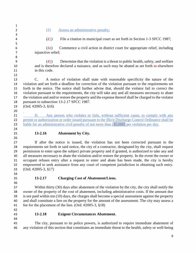
1 (2) Assess an administrative penalty; 2
3 (23) File a citation in municipal court as set forth in Section 1-3 SFCC 1987; 4 5 (34) Commence a civil action in district court for appropriate relief, including 6 injunctive relief; 7
8 (45) Determine that the violation is a threat to public health, safety, and welfare 9 and is therefore declared a nuisance, and as such may be abated as set forth in elsewhere 10 in this code. 11
12 C. A notice of violation shall state with reasonable specificity the nature of the 13 violation and set forth a deadline for correction of the violation pursuant to the requirements set 14 forth in the notice. The notice shall further advise that, should the violator fail to correct the 15 violation pursuant to the requirements, the city will take any and all measures necessary to abate 16 the violation and and/or restore the property and the expense thereof shall be charged to the violator 17 pursuant to subsection 13-2.17 SFCC 1987. 18 (Ord. #2005-3, §16) 19 20 D. Any person who violates or fails, without sufficient cause, to comply with any 21 permit or authorization or order issued pursuant to the Illicit Discharge Control Ordinance shall be 22 liable for an administrative civil penalty of not more than [$5,000] per violation per day. 23 24 13-2.16 Abatement by City. 25 26 If after the notice is issued, the violation has not been corrected pursuant to the 27 requirements set forth in said notice, the city of a contractor, designated by the city, shall request 28 permission to enter upon the subject private property and if granted, is authorized to take any and 29 all measures necessary to abate the violation and/or restore the property. In the event the owner or 30 occupant refuses entry after a request to enter and abate has been made, the city is hereby 31 empowered to seek assistance from any court of competent jurisdiction in obtaining such entry. 32 (Ord. #2005-3, §17) 33 34 13-2.17 Charging Cost of Abatement/Liens. 35 36 Within thirty (30) days after abatement of the violation by the city, the city shall notify the 37 owner of the property of the cost of abatement, including administrative costs. If the amount due 38 is not paid within ten (10) days, the charges shall become a special assessment against the property 39 and shall constitute a lien on the property for the amount of the assessment. The city may assess a 40 fee for the placement of the lien. (Ord. #2005-3, §18) 41 42 13-2.18 Exigent Circumstances Abatement. 43 44 The city, pursuant to its police powers, is authorized to require immediate abatement of 45 any violation of this section that constitutes an immediate threat to the health, safety or well-being 46
10
of the public. If any such violation is not abated immediately as directed by the city, the city and/or 1 its agents are authorized to enter onto private property and to take any and all measures required 2 to remediate the violation for the protection of the community. Any expense related to such 3 remediation undertaken by the city shall be fully reimbursed by the property owner and/or 4 responsible party. Any relief obtained under this section shall not prevent the city from seeking 5 other and further relief authorized under this section. (Ord. #2005-3, §19) 6 7 13-2.19 Severability. 8 9 The requirements and provisions of this section and their parts, subparts and clauses are 10 severable. In the event that any requirement, provision, part, subpart or clause of this section, or 11 the application thereof to any person or circumstance, is held by a court of competent jurisdiction 12 to be invalid or unenforceable, it is the intent of the governing body that the remainder of the 13 section be enforced to the maximum extent possible consistent with the governing body's purpose 14 of detecting and eliminating illicit discharges. (Ord. #2005-3, §20) 15 16
… 17
18 14-8.2 TERRAIN EROSION CONTROL AND POST CONSTRUCTION STORMWATER 19 MANAGEMENT 20
(Ord. No. 2011-37 § 10) 21
(A) Purpose 22
The purpose of this Section 14-8.2 is to protect, maintain and enhance the health, safety and 23 general welfare of the citizens and natural environment of Santa Fe. The following 24 considerations shall be used during the design and planning process for all 25 proposed developments subject to this Section 14-8.2: 26
(1) ensure sound and orderly development of the natural terrain; 27
(2) protect life and property from the dangers of flooding and the hazard of 28 improper cuts and fills; 29
(3) minimize erosion and sedimentation; 30
(4) minimize destruction of the natural landscape; 31
(5) protect the scenic character of Santa Fe from the visual blight of 32 indiscriminate cuts and fills and vegetation removal resulting from extensive grading and utility 33 scars; 34
(6) treat stormwater runoff as a valuable natural resource in Santa Fe, a community that is 35 prone to drought, by encouraging water collection and infiltration on site; 36
11
(7) control the adverse impacts associated with accelerated stormwater runoff on natural 1 drainage ways and all structures due to increased development and impervious surfaces; 2
(8) minimize erosion and degradation of arroyo channels and improve the condition of the 3 channels where possible; 4
(9) respect, protect, maintain and restore natural drainageways, 5 wetlands, bosques, floodplains, steep slopes, riparian vegetation and wildlife habitat areas; 6
(10) prevent stormwater runoff from entering or damaging acequias or other irrigation 7 facilities; 8
(11) integrate stormwater management measures into the landscape and site planning process 9 as set forth in Section 14-8.4 (Landscape and Site Design); 10
(12) provide aesthetically pleasing solutions to post construction stormwater management 11 and erosion control measures by integrating measures into the overall landscape and site design; 12 and 13
(13) promote improved water quality through compliance with the EPA NPDES 14 MS4 permit and Construction General Permit (CGP). 15
(B) Applicability 16
(1) Minimum Standards and Submittal Requirements 17
(a) Minimum standards and submittal requirements for terrain erosion control and post-18 construction stormwater management are based on the type of project and all projects shall meet 19 the minimum standards in Subsection 14-8.2(D) (Standards for All Grading). 20
(b) Projects for which a construction permit for grading is required by Section 14-3.10(E) 21 (Development in Special Flood Hazard Areas) shall also meet the applicable minimum standards 22 and submittal requirements in Subsection 14-8.2(E) for minor development or Subsection 14-23 8.2(F) for all other development. 24
(c) Master plan, preliminary development plan and preliminary 25 subdivision plat applications shall also meet the minimum standards and submittal requirements 26 in Subsection 14-8.2(G). 27
(d) Final development plan and subdivision plat applications shall also meet the requirements 28 in Subsection 14-8.2(H). 29
(e) All city departments that implement construction projects shall comply with the 30 objectives, intent and minimum standards of this Section 14-8.2. 31
(2) Exemptions 32

12
A development is exempt from the requirements of this Section 14-8.2 if it meets the 1 following conditions: 2
(a) less than two hundred fifty (250) square feet of total land area is disturbed; 3
(b) no slopes greater than ten percent are disturbed; 4
(c) existing drainage patterns on the property are not changed in a way that would increase 5 the amount of stormwater runoff leaving the property or cause significant change to on-site 6 drainage patterns as determined by the city engineer, and 7
(d) adequate erosion control best management practices is provided are utilized. 8
(3) Alternative Means of Compliance 9
Applicants may propose alternatives to standard post-construction stormwater 10 management techniques, so long as these alternatives allow the project to meet the minimum 11 standards and general requirements of this Section 14-8.2. Alternative techniques may be 12 proposed that achieve improved environmental performance, including reduced stormwater 13 runoff, increased infiltration, reduced sedimentation and erosion, and for aesthetic purposes. 14
(a) On-site retention of the regulatory volume described in Subsection 14-8.2(D)(b)(ii) can 15 be waived if the following site constraints exist on the development: [insert appropriate site 16 constraints1] and alternative compliance measures are implemented. The applicant shall 17 demonstrate, to the satisfaction of the [insert appropriate official], that the site constraints cannot 18 be overcome or mitigated through reasonable re-design of the site. Infeasibly must be 19 demonstrated with site-specific hydrologic and design analyses conducted and endorsed by a 20 professional engineer or landscape architect properly licensed in the State of New Mexico. 21
(b) In the event that the [land use director] determines retention infeasibility has been 22 adequately demonstrated, the applicant shall comply with all other post-construction 23 performance standards and [insert alternative compliance option(s)].2 24
1 Draft MS4 permit allows for the following site constraints to trigger alternative compliance: A. too small a lot outside of the building footprint to create the necessary infiltrative capacity even with amended soils; B. soil instability as documented by a thorough geotechnical analysis; C. a site use that is inconsistent with capture and reuse of storm water; D. other physical conditions; or, E. to comply with applicable requirements for on-site flood control structures leaves insufficient area to meet the standard 2 Draft MS4 permit allows for the following alternative compliance options: A. Off-site mitigation. The off-site mitigation option only applies to redevelopment sites and cannot be applied to new development. Management of the standard volume, or a portion of the volume, may be implemented at another location within the MS4 area, approved by the permittee. The permittee shall identify priority areas within the MS4 in which mitigation projects can be completed. The permittee shall determine who will be responsible for long-term maintenance on off-site mitigation projects. B. Ground Water Replenishment Project: Implementation of a project that has been determined to provide an opportunity to replenish regional ground water supplies at an offsite location. C. Payment in lieu. Payment in lieu may be made to the permittee, who will apply the funds to a public stormwater project. MS4s shall maintain a publicly accessible database of approved projects for which these payments may be
13
(c) Proposals for alternative compliance to standard post-construction stormwater 1 management techniques retention volume alternative compliance options are subject to review 2 and approval of the city engineer in writing, stating the basis for proposing such a waiver 3 options.3 4
(C) Procedures and General Requirements 5
(1) The city engineer may determine the following: 6
(a) the completeness of all required erosion control terrain and post-construction stormwater 7 management submittals; 8
(b) compliance with all minimum standards; 9
(c) the acceptability of all proposed erosion control best management practices and post-10 construction stormwater management methods; and 11
(d) the need for additional information or written approval in order to determine compliance 12 with the purposes, intent and minimum standards of this Section 14-8.2. 13
(2) The preparation of submittals shall be as provided in this Subsection 14-8.2(C)(2) and in 14 accordance with the provisions of Chapter 61 NMSA 1978 (Professional and Occupational 15 Licensing) regulating the practice of architecture, landscape architecture, engineering and land 16 surveying. (Ord. No. 2013-16 § 44) 17
(a) Grading Erosion and sediment control plan submittals for minor development or 18 for grading incidental to the construction or modification of a structure may be prepared by any 19 person, including the homeowner, who has the legal authority to design the structure; however, 20 the city engineer may require that submittals be prepared and signed by a professional 21 engineer, architect, professional land surveyor or landscape architect licensed in New Mexico if 22 necessary to fulfill the requirements of this Section 14-8.2, Chapter 61 NMSA 1978 or applicable 23 regulations; 24
(b) Submittals for development other than minor development or incidental to the 25 construction or modification of a structure shall be prepared as follows: 26
(i) topographic plans shall be prepared and certified by a professional 27 engineer or professional land surveyor; 28
(ii) post-construction stormwater management submittals for master plans, subdivisions 29 and development plans shall be prepared and certified by a professional engineer. Stormwater 30
used. D. Other. In a situation where alternative options A through C above are not feasible and the permittee wants to establish another alternative option for projects, the permittee may submit to the EPA for approval, the alternative option that meets the standard. 3 The draft MS4 permit does not allow for any waiver of the post-construction performance standard, therefore the City would not be allowed to waive these requirements for any project of one acre or more.
14
management submittals for all other types of development shall be prepared by a professional 1 engineer or an architect or landscape architect registered in New Mexico; and 2
(iii) site restoration submittals shall be prepared and certified by a professional 3 engineer, architect or landscape architect licensed in New Mexico. 4
(3) No certificate of occupancy or any type of final construction approval shall be issued by 5 the city unless a parcel is in full compliance with the requirements of this Section 14-8.2 and all 6 inspections have been conducted as described in this Section 14-8.2. 7
(4) Activities permitted pursuant to this Section 14-8.2 may also require notification or 8 permitting by other agencies, including written approval from the Acequia Madre de Santa Fe 9 community acequia association or other official watercourse-related entity, the EPA, the United 10 States army corps of engineers, the federal emergency management agency (FEMA) and the 11 New Mexico Department of Environment. It is the responsibility of each applicant to determine 12 whether additional notification or permitting is required. 13
(5) All inspections shall be documented in written form, shall be made available to the city 14 engineer or code enforcement officer upon request. 15
(D) Standards for All Grading 16
When a construction permit for grading is required by this Section 14-8.2, applications for 17 the permit shall show compliance with the following erosion and sediment control minimum 18 standards: 19
(1) Cut and Fill Slopes 20
(a) exposed cut slopes on a site shall not exceed ten (10) feet in height, except as otherwise 21 permitted by this Section 14-8.2. In no case shall the height of a cut exceed the height of 22 any building constructed in the excavated area; (Ord. No. 2013-16 § 45) 23
(b) fill slopes on a site shall not exceed fifteen (15) feet in height. Retaining walls for fill 24 slopes shall be no greater than six (6) feet in height as provided in Section 14-8.5(B)(1), except 25 as otherwise provided in Section 14-5.6(G) (Escarpment Overlay District Landscaping). Fill 26 slopes shall be no steeper than 3:1, unless a structural alternative such as a retaining wall or some 27 other measure acceptable to the city engineer is provided; 28
(c) cut or fill slopes for roads shall not exceed fifteen (15) feet in height; and 29
(d) all cut slopes that are not stabilized by a retaining wall or some other measure acceptable 30 to the city engineer, shall be no steeper than 2:1, unless a structural alternative is provided or 31 unless it can be demonstrated by a geotechnical study that existing soils will naturally 32 accommodate a steeper slope and acceptable revegetation or other erosion control can be 33 achieved. 34
15
(2) Grading 1
(a) Grading for buildings is limited to fifteen (15) feet beyond the outer edge of 2 the building foundation, patio, wall, driveway, road, parking area or other constructed facility 3 except as necessary: 4
(i) for the construction of stormwater runoff management control measures in compliance 5 with this Section 14-8.2; or 6
(ii) to accommodate required horizontal to vertical measurements for cut and fill slopes. 7
(b) Natural slopes thirty percent or greater shall remain undisturbed, except for arroyo 8 crossings and for no more than three isolated occurrences of sloped areas where each individual 9 disturbance shall not exceed one thousand (1,000) square feet, as approved by the city 10 engineer. The city engineer may waive this provision, in writing, stating the reasons and basis 11 for such approval, if evidence is provided by the applicant showing that strict enforcement of 12 this provision would prohibit access to the lot or placement of utilities. This provision applies 13 solely to the construction of roads, driveways and utility placement and is not intended to 14 allow development on natural slopes exceeding thirty percent. The other provisions of the 15 escarpment overlay district ordinance and the terrain and stormwater management regulations 16 shall remain in effect. 17
(c) Phasing for grading and clearing shall may be required for all sites greater than [five 18 acres], with the size of each phase to be established at plan reviews and approved by the city 19 engineer on all sites where construction will not begin immediately after clearing and grading. 20
(d) A construction permit for grading for driveway construction shall not be issued unless 21 the city engineer has first determined that the driveway provides access to a buildable area as 22 defined in Subsection 14-8.2(D)(3) and that the permit complies with the requirements of Section 23 14-5.6 (Escarpment Overlay District); and 24
(e) All grading completed on the site shall conform to the approved grading plan. 25
(3) Topography 26
(Ord. No. 2014-31 § 28) 27
(a) Each residential lot shall have a buildable site designated as suitable for a building with a 28 footprint of not less than forty percent of the minimum required net lot area or two thousand 29 (2,000) square feet, whichever is less, which can be developed in accordance with the terrain and 30 stormwater management standards and with other applicable development standards, including 31 required setbacks and access requirements. The planning commission or summary committee 32 may approve residential lots with a smaller buildable site to accommodate lot size averaging or 33 within multi-family developments. 34
16
(b) At least one-half of the area designated as suitable for building and at least one-half of 1 any building footprint shall have a natural slope of less than twenty percent; the remainder of the 2 area or building footprint may have a natural slope of twenty percent or greater, but less than 3 thirty percent. 4
(c) The first floor finished floor elevation at any point of any portion of a building built on a 5 natural slope of twenty percent or greater shall not exceed five (5) vertical feet above the 6 natural slope at that point. 7
(d) A structure shall not be built on a natural slope of thirty percent or greater. 8
(4) Post Construction Stormwater Management 9
(a) General Standards: 10
(i) stormwater management control measures shall be selected to best accommodate the 11 specific geologic, hydrologic and topographic features of the land to be developed; 12
(ii) stormwater management control measures shall be designed as both a comprehensive 13 and integral part of the development; 14
(iii) stormwater management control measures shall be designed to directly address 15 additional flows from the proposed development. Compliance with these standards shall not be 16 achieved solely by alterations to flows upstream of a proposed development; and 17
(iv) stormwater management plans may be designed to incorporate measures that are shared 18 by two or more developments; provided that the measures comply with the minimum standards 19 of this Section 14-8.2, including provision of an enforceable legal agreement for construction 20 and maintenance. 21
(b) Discharge Post Construction Stormwater Management Performance Standards4: 22
(i) except as otherwise required by this Section 14-8.2, the stormwater runoff peak flow rate 23 discharged from a site post-development shall not exceed pre-development conditions for any 24 frequency storm event up to the one percent chance, twenty-four-hour storm event at each 25 discharge point; 26
(ji) The runoff volume of stormwater runoff leaving the site post-construction associated 27 with the 90th percentile annual storm event, known as the regulatory volume, shall not exceed the 28
4 The draft MS4 permit allows for the management of the 80th percentile storm event for redevelopment, however, since Santa Fe has not previously differentiated between new and redevelopment that distinction not included.

17
runoff volume5 leaving the site under natural conditions6. If retention is determined to be 1 infeasible due to site constraints, the land use director can approve alternative compliance 2 options for up to one-hundred percent of the retention volume. See Subsection 14-8.2 (B) for 3 alternative compliance requirements. 4
(iii) The regulatory volume must be treated to achieve a minimum of 85 percent removal of total 5 suspended solids, as compared with uncontrolled runoff. 6
(iiv) runoff control measures may include the use of detention or retention basins and active 7 water harvesting and passive water harvesting techniques, swales, berms, check dams, 8 vegetative ground cover, permeable pavements, tree wells, dry wells, cisterns and other 9 techniques appropriate for retaining and infiltrating water on site; 10
(iii) stormwater shall not be discharged into any watercourse or drainage channel without 11 adequate reduction of flow velocity, which shall be accomplished by erosion control techniques 12 that may include the routing or energy dissipation of stormwater runoff to a vegetated swale, 13 vegetated basin or stone-protected area. The techniques used shall be sufficient to diminish 14 runoff velocity and spread runoff flow adequately to avoid erosion upon entering the 15 watercourse; 16
(iv) stormwater runoff shall not be routed into irrigation ditches, canals, acequias or 17 watercourses related to an acequia system unless specific plans have been approved in writing by 18 the person legally responsible for the operation and maintenance of the facility and the city 19 engineer. The developer is responsible for obtaining all such approvals before submittal of 20 an application; and 21
(vi) an active, historic acequia, whether on site or off site, shall not be disturbed in any way 22 by building development or construction activity unless specific plans have been approved in 23 writing by the person or entity legally responsible for the operation and maintenance of 24 the acequia. The developer is responsible for obtaining all such approvals before submittal of 25 an application. 26
(c) Detention Basin Standards: 27
(i) stormwater detention basins and overflow structures shall be sized and designed to 28 adequately accommodate flows from one percent chance, twenty-four-hour storm events; 29 provided, however, that such basins shall also be equipped with outflow structures that limit 30
5 With no design manual in Santa Fe at this time, recommend including a reference for determining this volume in the Municipal Code as specified in the draft MS4 permit. Permit states: Estimation of the 90th or 80th percentile storm event discharge volume is included in EPA Technical Report entitled “Estimating Predevelopment Hydrology in the Urbanized Areas in New Mexico. Permittees can also estimate: Option A: a site specific 90th or 80th percentile storm event discharge volume using methodology specified in the referenced EPA Technical Report. Option B: a site specific pre-development hydrology and associated storm event discharge volume using methodology specified in the referenced EPA technical Report. 6 The draft MS4 permit does not indicate the comparative condition as pre-development. Specifying ‘natural condition’ as comparative condition will allow for some retrofit in redeveloping areas.

18
flow-through from lesser magnitude storms to runoff rates equal to or less than pre-1 development runoff rates; 2
(ii) infiltration, detention and retention basins shall provide a means of controlling and 3 removing sediment. Methods may include sedimentation settling ponds, sediment traps, filters 4 on drop inlets or other methods. All basins shall be designed to empty within no more than 5 twenty-four hours; 6
(iii) landscape treatment of detention and retention basins may be required in accordance 7 with Section 14-8.4 (Landscape and Site Design); and 8
(iv) discharge standards for minor development are provided in Subsection 14-8.2(E)(2). 9
(d) Detention in Cisterns 10
(i) Cisterns may be used if they are connected to an irrigation system or other water use. 11
(ii) A maximum of fifty percent of required stormwater detention volume and one hundred 12 percent of retention volume may be storedretained in cisterns., except that oOne hundred percent 13 of required stormwater detention volume may be stored retained in cisterns for 14 minor development. 15
(iii) Cisterns shall be installed and operated in compliance with applicable provisions of 16 other regulations, including Section 14-8.4 (Landscape and Site Design) and Chapter 7 SFCC 17 1987 (Building and Housing). 18
(e) Arroyo, Stream and Watercourse Standards: 19
(i) for arroyos, streams or watercourses that carry one hundred (100) cubic feet per second 20 or more of stormwater flow in a one percent chance event, all structures, paved roads, driveways 21 and parking lots shall be set back a minimum of twenty-five (25) feet from the top shoulder of an 22 arroyo plus the depth of the arroyo channel. This setback provision does not apply to stormwater 23 management structures or public access trails. The city engineer may waive this provision, in 24 writing, stating the reasons and basis for such approval, if evidence is provided by a professional 25 engineer demonstrating arroyo bank stability; 26
(ii) for arroyos, streams or watercourses that carry less than one hundred (100) cubic feet per 27 second in a one percent chance event, the city engineer may require a setback based on soils and 28 hydrologic information supplied by the applicant. 29
(iii) except for erosion control measures practices, stormwater management control 30 measures, public access trails or the placement of underground utilities required for development, 31 no grading shall occur within the setback area; 32
(iv) where practical, erosion control and channel stability in arroyos, streams or watercourses 33 shall be achieved using techniques that reduce stormwater velocity and pollution, preserve 34
19
active floodplains, provide adequate room for flood waters to spread safely and use native 1 vegetation. Arroyo and watercourse banks shall not be armored with concrete, gabion baskets, 2 sheet piling, rip-rap or similar hardened material unless no reasonable alternative exists to protect 3 public infrastructure or pre-existing structures; and 4
(v) fences, walls and similar structures may not be constructed in or across an arroyo, stream 5 or watercourse. 6
(5) Site Restoration and Permanent Stabilization: 7
(a) soil stabilization and erosion control measures practices for all land disturbed by 8 construction shall be completed within twenty-one days after completion of construction or other 9 activities on site that interfere with soil stabilization measures. If the time of year is not 10 conducive to planting, it may be delayed until the next appropriate planting season if all other 11 appropriate temporary erosion control measures practices are maintained until 12 permanent erosion control measures are implemented; (b) one or more of the following 13 permanent stabilization and erosion control measures practices shall be used: 14
(i) revegetation with appropriate drought-tolerant plant materials, including grasses or other 15 ground cover; 16
(ii) restoration with bioengineering techniques such as live staking, brush layering, brush 17 mattress and live crib walls; and 18
(iii) stabilization with stones, terracing or similar techniques; and 19
(c) all trees and shrubs shall be mulched and irrigated until established. Grass seed should 20 either be hydroseeded or covered with biodegradable material or synthetic soil erosion control 21 blankets or matting and irrigated until established. Irrigation shall be pursuant to the irrigation 22 requirements in Section 14-8.4 (Landscape and Site Design). 23
(6) Increase in Minimum Standards 24
The city engineer may require implementation of more than the minimum stormwater 25 standards if arroyos on site or immediately downstream of a site show evidence of 26 increased flooding, channel erosion or sedimentation as a direct result of conditions on the 27 site. Increased requirements shall be limited to the following on-site measures: 28
(a) erosion and sediment control measures extended to a broader area of the site than 29 the development area; 30
(b) revegetation or stabilization of highly eroded areas; 31
(c) arroyo restoration or other erosion control measures practices within highly eroded 32 channels; or 33
20
(d) a combination of the measures specified in Subsections 14-8.2(D)(6)(a) through (c). 1
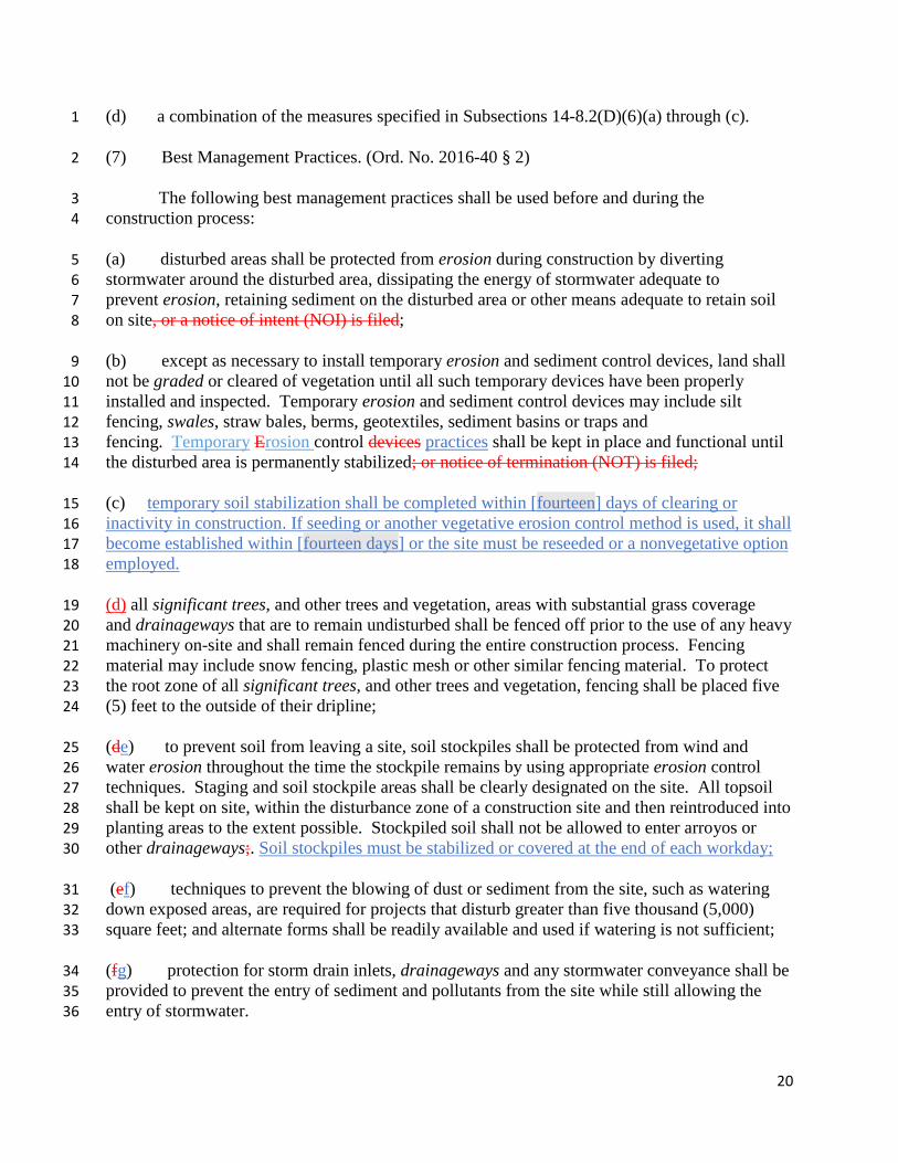
(7) Best Management Practices. (Ord. No. 2016-40 § 2) 2
The following best management practices shall be used before and during the 3 construction process: 4
(a) disturbed areas shall be protected from erosion during construction by diverting 5 stormwater around the disturbed area, dissipating the energy of stormwater adequate to 6 prevent erosion, retaining sediment on the disturbed area or other means adequate to retain soil 7 on site, or a notice of intent (NOI) is filed; 8
(b) except as necessary to install temporary erosion and sediment control devices, land shall 9 not be graded or cleared of vegetation until all such temporary devices have been properly 10 installed and inspected. Temporary erosion and sediment control devices may include silt 11 fencing, swales, straw bales, berms, geotextiles, sediment basins or traps and 12 fencing. Temporary Erosion control devices practices shall be kept in place and functional until 13 the disturbed area is permanently stabilized; or notice of termination (NOT) is filed; 14
(c) temporary soil stabilization shall be completed within [fourteen] days of clearing or 15 inactivity in construction. If seeding or another vegetative erosion control method is used, it shall 16 become established within [fourteen days] or the site must be reseeded or a nonvegetative option 17 employed. 18
(d) all significant trees, and other trees and vegetation, areas with substantial grass coverage 19 and drainageways that are to remain undisturbed shall be fenced off prior to the use of any heavy 20 machinery on-site and shall remain fenced during the entire construction process. Fencing 21 material may include snow fencing, plastic mesh or other similar fencing material. To protect 22 the root zone of all significant trees, and other trees and vegetation, fencing shall be placed five 23 (5) feet to the outside of their dripline; 24
(de) to prevent soil from leaving a site, soil stockpiles shall be protected from wind and 25 water erosion throughout the time the stockpile remains by using appropriate erosion control 26 techniques. Staging and soil stockpile areas shall be clearly designated on the site. All topsoil 27 shall be kept on site, within the disturbance zone of a construction site and then reintroduced into 28 planting areas to the extent possible. Stockpiled soil shall not be allowed to enter arroyos or 29 other drainageways;. Soil stockpiles must be stabilized or covered at the end of each workday; 30
(ef) techniques to prevent the blowing of dust or sediment from the site, such as watering 31 down exposed areas, are required for projects that disturb greater than five thousand (5,000) 32 square feet; and alternate forms shall be readily available and used if watering is not sufficient; 33
(fg) protection for storm drain inlets, drainageways and any stormwater conveyance shall be 34 provided to prevent the entry of sediment and pollutants from the site while still allowing the 35 entry of stormwater. 36
21
(E) Standards for Minor Development; Submittal Requirements 1
(1) Minor Development 2
A minor development includes the construction of any structure, including 3 single family residences, additions, sheds, garages, fences, driveways or pavement, that meets all 4 of the following criteria: 5
(a) it takes place on a single lot or a subdivision of fewer than three lots; 6
(b) it results in cumulative total disturbance of less than five thousand (5,000) square feet of 7 land on a lot; 8
(c) it disturbs no slope equal to or greater than twenty percent; and 9
(d) no more than three thousand five hundred (3,500) square feet of new impervious surface 10 is created per lot. 11
(2) Minimum Standards; Discharge Standards 12
Minor development must comply with the standards in Subsection 14-8.2(D), except that 13 the minimum volume of water to be contained or infiltrated on site shall be determined by 14 multiplying the total area of new impervious surface, in square feet, by 0.16 feet to arrive at a 15 value expressed in cubic feet, i.e. one hundred sixty (160) cubic feet of water containment is 16 required per one thousand (1,000) square feet of impervious surface.7 17
(3) Submittals 18
Construction permit applications for grading for minor development must provide 19 sufficient information to demonstrate compliance with the standards in Subsection 14-8.2(D) and 20 Subsection 14-8.2(E)(1) and (2), including the following, unless the requirement is waived by 21 the land use director: 22
(a) a brief narrative description of the proposed project; 23
(b) a topographic map of the property to scale, including United States Geological Survey 24 quadrangle maps or maps generated by the city, adequate to show elevation contours, 25 natural drainageways and existing and proposed improvements; 26
(c) a brief written description or representative photographs of the type of existing 27 vegetation, such as piñon and juniper trees, annual weeds, grass cover, bare ground and so on, 28 and approximate coverage of existing vegetation at the site, and a plan for vegetation removal at 29 the site; 30
7 Need to confirm that this is less stringent than EPA required standard. If not less stringent, then would not be appropriate as a minor development allowance.
22
(d) a description site map showing boundaries of all proposed grading or ground disturbance; 1
(e) calculations and a plan drawing showing: 2
(i) the size, volume, dimensions design specifications and calculations establishing 3 compliance with the performance standards set forth in [Subsection 14-8.2(D)], construction 4 details, and location of all proposed runoff containment structures stormwater control measures 5 or methods and how water will be directed to the structures measures or methods; and 6
(ii) percolation test results or other means of demonstrating that containment structures will 7 empty within twenty-four hours; 8
(f) a roof run-off drainage plan; and 9
(g) a planting plan for revegetation showing proposed plant materials and a description of 10 the proposed irrigation method or other methods used to establish vegetation and 11 prevent erosion until vegetation becomes established. 12
(F) Submittal Requirements For All Other Development 13
(Ord. No. 2014-31 § 29) 14
All other development that requires a construction permit for grading, and that is not classified as 15 minor development under the provisions of Subsection 14-8.2(E), shall meet the following 16 minimum submittal requirements: 17
(1) Submittals for construction permit applications for grading must provide sufficient 18 information to show compliance with Subsection 14-8.2(D) and (E). Unless waived by the land 19 use director, submittals must include: 20
(a) a topographic survey and grading plan with elevation contours shown at not more than 21 two (2) foot intervals on slopes less than thirty percent and five (5) foot intervals on slopes of 22 thirty percent or greater that shows: 23
(i) all sloped areas of zero to twenty percent, twenty-one to thirty percent and greater than 24 thirty percent shall be clearly marked and differentiated by shade, tone or color at a scale 25 sufficient to allow verification of the calculations; 26
(ii) ground elevations that conform to either the United States Geological Survey sea level 27 datum, as modified, or to the city's monument system; 28
(iii) the designated buildable sites or buildable areas; 29
(iv) all areas to be graded on the site and the final contours to be achieved by the grading; 30
(v) all finished floor or grade elevations; 31
23
(vi) spot elevations, as needed; 1
(vii) areas of soils with severe limitations for the intended use; 2
(viii) the location of temporary erosion control structures and methods used, including staging 3 and stockpile areas; 4
(ix) all significant trees and areas with substantial grass coverage to be removed; 5
(x) a construction schedule when the project will be developed in phases; sequence of 6 construction of the development site, including stripping and clearing; rough grading; 7 construction of utilities, infrastructure, and buildings; and final grading and landscaping. 8 Sequencing shall identify the expected date on which clearing will begin, the estimated duration 9 of exposure of cleared areas, areas of clearing, installation of temporary erosion and sediment 10 control measures, and establishment of permanent vegetation. 11
(xi) the location of fencing around the areas to be protected; 12
(xii) the ratio of horizontal to vertical measurement for cut and fill slopes; 13
(xiii) the total volume, in cubic yards, of earth to be moved; 14
(xiv) all existing disturbed areas; 15
(xv) special flood hazard areas designated by FEMA on the Flood Insurance Rate Map 16 (FIRM); and 17
(xvi) date, method of survey and certification from a New Mexico professional 18 engineer or professional land surveyor that the plan is in compliance with national map accuracy 19 standards; 20
(G) Standards for Master Plans, Preliminary Development Plans and 21 Preliminary Subdivision Plats; Submittal Requirements 22
(1) Minimum Standards: 23
(a) projects shall meet the minimum standards of Subsection 14-8.2(D); 24
(b) all land below the base flood elevation for a one percent chance event shall be dedicated 25 as a drainage easement and as public or private open space or public right of way; and 26
(c) for all development where one-half or more of the land within the project site exceeds 27 twenty percent slope, the quantity and peak flow rate of post-development stormwater runoff on 28 all developed or disturbed land shall not exceed seventy-five percent of the quantity and peak 29 flow rate of the pre-development runoff. 30
24
(2) Submittals 1
Submittals for master plans, preliminary development plans and subdivision plats shall 2 include: 3
(a) a conceptual plan and report that shows the general approach proposed for terrain and 4 stormwater management, and how the proposed development meets all of the minimum 5 standards described in Subsection 14-8.2(D); 6
(b) a topographic survey and grading plan as outlined in Subsection 14-8.2(F)(5); and 7
(c) a brief description of the watershed directly upstream and downstream of the parcel, 8 including the size, terrain, type and extent of vegetation cover and degree of development for all 9 areas draining to the project site. 10
(H) Final Development Plans and Subdivision Plats 11
(1) Minimum standards 12
Final development plans and subdivision plats shall meet the minimum standards 13 described in Subsection 14-8.2(D) and (G). 14
(2) Submittals 15
Submittals for final development plans and subdivision plats shall include: 16
(a) all submittals required pursuant to Subsection 14-8.2(F); 17
(b) a long-term operation and maintenance plan and certification statement. This plan shall 18 include a schedule for the life of the stormwater management measures, including the time frame 19 for completion and the responsible party who shall perform the maintenance The operation and 20 maintenance plan shall be binding on the record owner of the property or properties subject to 21 this ordinance and their owners, heirs and assigns. The operation and maintenance plan shall be 22 developed by a professional engineer or landscape architect properly licensed to practice in the 23 State of New Mexico and shall include maintenance requirements and protocols for each 24 stormwater control measure, including an associated schedule of inspection and maintenance 25 activities, and procedures and checklists for each stormwater control measure and a signed 26 certification statement accepting responsibility for the operation, maintenance and inspection of 27 the stormwater control measures.; and 28
(c) an as-built certification signature block to be executed by a professional engineer after 29 the within 90 days of project completion to ensure that the constructed stormwater management 30 systems comply with the approved stormwater plans. 31
(I) Inspections and Violations During Construction Process 32
25
(1) For all nonresidential projects and all residential projects that do not qualify as 1 minor development, an applicant shall notify the land use director to set up an inspection at the 2 following times: 3
(a) when the construction erosion and sediment control devices and measures are in place; 4
(b) when final stormwater management measures are completed; 5
(c) when the final site restoration measures are completed; provided, however, that if final 6 site restoration measures are being delayed due to the season, the applicant shall notify the land 7 use director when temporary erosion control measures practices, for use until site restoration is 8 complete, in place and ready for inspection; and 9
(d2) further construction or issuance of any permits shall not occur until written approval has 10 been granted by the inspector after each inspection that the best management practices and 11 stormwater management control methods measures have been completed in accordance with 12 approved plans; 13
(23) the land use director may enter upon any property subject to this Subsection 14-8.2 at 14 reasonable times to conduct inspections of grading, erosion and stormwater management 15 measures to determine compliance with city policies and procedures and to carry out duties in the 16 enforcement of this Subsection 14-8.2; and 17
(34) the land use director may waive or consolidate any inspections required under this 18 Section 14-8.2. 19
(J) Dedications, Easements and Rights of Way 20
(1) All land below the base flood elevation for a one percent, twenty-four-hour storm event 21 shall be dedicated as a drainage easement and as public or private open space or public right of 22 way. 23
(2) Dedications to the city may be required by the city engineer for the components of the 24 stormwater drainage system, including access for maintenance. The types of all easements 25 and open space dedications shall be determined by the city engineer. If a dedication is required, 26 it shall be designated on the plan or plat and in effect prior to construction permit approval. 27
(3) An applicant may make requests for acceptance of dedications of a stormwater drainage 28 system to the city; however, the city is not obligated to accept a dedication offer. Only 29 the governing body may accept dedications to the city. If a dedication is offered to and accepted 30 by the city, it shall be designated on the plan or plat and shall be in effect prior to 31 construction permit approval. 32
(K) Long-Term Maintenance Responsibilities and Inspections 33
(1) Responsibilities 34
26
All stormwater management measures and facilities shall be maintained by the fee 1 simple owner of the property or a property owners association, unless a dedication of the 2 stormwater management system was required and accepted by the city, in which case, the city is 3 responsible for maintenance. The stormwater management system shall be maintained in good 4 condition and promptly repaired. Maintenance shall include the repair and restoration of all 5 grade surfaces, walls, swales, drains, dams, ponds, basins, site restoration measures, associated 6 vegetation and any other stormwater measure constructed on site. The maintenance shall be in 7 accordance with approved stormwater management plans. 8
(2) Self-Inspections 9
Periodic inspections shall be conducted by the applicant or the applicant’s successors of 10 the stormwater control measure(s) as set forth in the applicable Operations and Maintenance 11 Plan. Inspection and reporting procedures shall be conducted according to the Operation and 12 Maintenance Plan. An inspection report shall be provided to the land use director according to 13 the schedule in the Operation and Maintenance Plan, commencing no more than twelve months 14 after the date of issuance of a certificate of occupancy for the development project, and occurring 15 [annually] or stipulated period thereafter. A professional engineer or landscape architect properly 16 licensed to practice in the State of New Mexico shall certify the periodic inspection reports. 17
(23) City Compliance Inspections 18
The city or its authorized agent may enter upon a property that is subject to this Section 19 14-8.2 at reasonable times to access the stormwater management system to ensure that the 20 system is maintained in proper working condition that meets the approved stormwater 21 management plans and the objectives and minimum standards of this section. 22
(34) Maintenance Violations Abatement by City 23
If, after notice by the city to correct a violation requiring maintenance work, satisfactory 24 corrections are not made by the owner or responsible party within a reasonable period of time, 25 the city may perform all necessary work to place the facility in proper working 26 condition. The owner or responsible party of the facility shall be assessed the associated costs of 27 the work. 28
(L) Violations; Penalties, and Enforcements. 29 30 A. It shall be unlawful for any person to violate any provision or fail to comply with 31 any of the requirements of the Erosion Control and Post Construction Stormwater Management 32 Ordinance. Each day the violation continues shall be considered a separate offense. 33 34 B. In addition to the enforcement actions authorized in Santa Fe Municipal Code 35 Sections 13-2.216 through 13-2.219, whenever the city finds that a person has violated or is 36 violating a requirement of the section the city may: 37 38
(1) Issue a written notice of violation; 39
27
1 (2) Assess an administrative penalty of up to [$1000] per day per offense; 2
3 (23) Suspend or revoke the grading permit. 4 5
(43) File a citation in municipal court as set forth in Section 1-3 SFCC 1987; 6 7 (54) Commence a civil action in district court for appropriate relief, including 8 injunctive relief; 9
10 (65) Determine that the violation is a threat to public health, safety, and welfare 11 and is therefore declared a nuisance, and as such may be abated as set forth in elsewhere 12 in this code. 13
14 C. A notice of violation shall state with reasonable specificity the nature of the 15 violation and set forth a deadline for correction of the violation pursuant to the requirements set 16 forth in the notice. The notice shall further advise that, should the violator fail to correct the 17 violation pursuant to the requirements, the city will take any and all measures necessary to abate 18 the violation and and/or restore the property and the expense thereof shall be charged to the violator 19 pursuant to subsection 13-2.17 SFCC 1987. 20 (Ord. #2005-3, §16) 21 22
23
14-8.3 FLOOD REGULATIONS 24 (Ord. No. 2011-37 § 10; Ord. No. 2012-19 § 3) 25
(A) Adoption of Special Flood Hazard Areas 26
(1) The city adopts the special flood hazard areas identified by FEMA in the current 27 scientific and engineering report entitled, "The Flood Insurance Study (FIS) for Santa Fe County, 28 New Mexico and Incorporated Areas," with accompanying FIRM, effective June 17, 2008 and 29 December 4, 2012. (Ord. No. 2013-16 § 46) 30
(2) The city may adopt and establish other flood hazard zones or elevations as identified in: 31
(a) subsequent drainage studies prepared for and accepted by the city; 32
(b) subsequent letters of map amendment and letters of map revision, as prepared for and 33 accepted by FEMA; and 34
(c) other known flood hazard zones identified by the floodplain administrator and adopted 35 by the governing body. 36
(B) Applicability; Permit Required 37

28
(1) The requirements of this Section 14-8.3 are in addition to and not in lieu of other 1 provisions of Chapter 14. 2
(2) New development, including substantial improvements to existing structures shall comply 3 with the standards of this Section 14-8.3. However, this Section 14-8.3 does not apply to 4 an application meeting either of the following criteria: 5
(a) the project is limited to work that does not change the footprint, size or enclosed area of 6 an existing structure, such as re-roofing, re-stuccoing or interior remodeling; or 7
(b) the project will not result in an increased flood risk to persons or structures or their 8 contents as determined by the floodplain administrator, who may require certification by 9 a professional engineer. 10
(3) Regardless of applicability of this Section 14-8.3, all development in a special flood 11 hazard area, including excavation and fill operations, requires approval of the floodplain 12 administrator and a permit. 13
(C) General Provisions for Development in Special Flood Hazard Areas 14
(1) All newly created lots shall contain a buildable area that is entirely outside of any special 15 flood hazard area. 16
(2) If an existing lot contains land both within and outside of the special flood hazard 17 area, any new construction, including roads and driveways, shall only be outside of the special 18 flood hazard area, except as allowed by Subsections 14-8.3(E), (F) and (G). 19
(3) If an existing lot contains no land outside the special flood hazard 20 area, any new construction shall only occur in the flood fringe and only pursuant to Subsections 21 14-8.3(E), (F) and (G). 22
(4) On an application for subdivision plat or development plan approval, where the tract or 23 portions of the tract are located within a special flood hazard area, the applicant shall submit 24 detailed hydrologic data indicating the water surface elevations for a one percent 25 chance event, to be shown for sections of the drainage channel at intervals of no greater than 26 one hundred feet. The special flood hazard area shall be further 27 defined as floodway and flood fringe, if applicable. The floodplain administrator may waive the 28 requirement for the submission of detailed hydrologic data based on a site investigation. 29 The special flood hazard area, FIRM panel number and date shall be accurately depicted by 30 an architect, professional land surveyor or professional engineer on the development plan, 31 subdivision plat, and construction permit where applicable. 32
(5) For purposes of this Section 14-8.3, the special flood hazard area is that shown on the 33 appropriate FIRM. Flood fringe, floodway and base flood elevation shall be shown as required by 34 the floodplain administrator. 35
29
(6) New and replacement water supply and sanitary sewage systems located in special flood 1 hazard areas shall be designed to minimize or eliminate infiltration. 2
(7) Onsite liquid waste disposal systems located in special flood hazard areas shall be designed 3 to avoid impairment or contamination. 4
(8) For subdivisions or other developments greater than fifty lots or five acres that are located 5 entirely or partially within a special flood hazard area, base flood elevations are required to be 6 shown on the development plan or subdivision plat for all lots that are entirely or partially within 7 the special flood hazard area. 8
(9) In A and AE zones, recreational vehicles shall be: 9
(a) elevated and anchored; or 10
(b) on the site for fewer than one hundred eighty consecutive days; or 11
(c) fully licensed and highway ready. 12
(D) Engineering Criteria 13
The analysis, determination and designation of base flood elevation, special flood hazard areas, 14 floodway or flood fringe shall adhere to professional hydrologic and hydraulic engineering 15 techniques supplemented with data obtained by field examination and surveys as necessary. 16 Engineering practice manuals of the American Society of Civil Engineers and similar competent 17 manuals of professional hydrologic and hydraulic engineering techniques may be used in 18 accordance with FEMA requirements. 19
(E) Land Use and Development in Floodway 20
No uses shall be permitted within the floodway, except those set out in this Subsection 14-8.3(E); 21 provided that such uses comply with the provisions of Article 14-6 (Permitted Uses and Use 22 Regulations) and any other applicable federal or state law; and further provided that such uses do 23 not constrict flow or create a rise in the base flood elevation during the one percent chance event: 24
(1) Cultivating and harvesting of crops according to recognized soil conservation practices; 25
(2) Pasture, grazing land; 26
(3) Wildlife sanctuary, woodland preserve; 27
(4) Outlet installations for sewage treatment plants and sealed public water supply wells; 28
(5) Passive recreational uses such as parks or trails; 29
(6) Open area residential uses, such as lawns, gardens and play areas; 30
30
(7) Stormwater management and arroyo or watercourse stabilization facilities, such as check 1 dams and gabions, provided that any such facilities that constrict flow or create a rise in the base 2 flood elevation during the one percent chance event comply with all applicable FEMA 3 requirements and all provisions of this Section 14-8.3 that are more stringent than the FEMA 4 requirements; 5
(8) Legal nonconforming uses occupying structures in existence on June 17, 2008; provided 6 that such uses may not be intensified and that the structures that such uses occupy comply with 7 all applicable FEMA requirements and all provisions of this Section 14-8.3 that are more 8 stringent than the FEMA requirements; 9
(9) Active recreational uses that do not include permanent structures and so long as 10 any temporary structures or equipment are removed when not in active use; and 11
(10) Railroads, streets, driveways, bridges, private and public utility lines that 12 cross the floodway with minimal disturbance as determined by the floodplain administrator, and 13 structural works for the control and handling of flood flows, such as dams, embankments, 14 flood walls, velocity control structures or storm drainage control and handling works (with the 15 exception of required stormwater detention facilities) provided that any such facilities that 16 constrict flow or create a rise in the base flood elevation during the one percent chance 17 event comply with all applicable FEMA requirements and all provisions of this Section 14-8.3 18 that are more stringent than the FEMA requirements. 19
(F) Land Use and Development in Flood Fringe 20
(1) No uses shall be permitted within the flood fringe except those set out in this Subsection 21 14-8.3(F); provided that such uses comply with the provisions of Chapter 14, Article 6 22 (Permitted Uses and Use Regulations) and any other applicable federal or state law. 23
(2) All uses permitted in the floodway pursuant to Subsection 14-8.3(E) are also allowed 24 in the flood fringe. 25
(3) Storage, processing or disposal of materials that in time of flooding are buoyant, 26 flammable, explosive, toxic or could be injurious to human, animal or plant life, are prohibited 27 within the flood fringe. 28
(4) No fence, wall or similar structure shall be erected in or across any arroyo, stream or 29 watercourse unless it is designed to break away and not to cause a flow obstruction. 30
(5) At-grade parking facilities are allowed so long as such facilities cannot be reasonably 31 accommodated outside the flood fringe, as determined by the floodplain administrator. 32
(6) Structures or uses within the flood fringe portion of the special flood hazard 33 area meeting the following requirements are allowed upon review by the floodplain 34 administrator and issuance of a permit, to the extent that they are not prohibited by any other 35 ordinance, plan or policy: 36
31
(a) residential or nonresidential structures, to be constructed or substantially improved in 1 the flood fringe, shall have the elevation of the lowest floor at least one foot above the base flood 2 elevation. The floodplain administrator may authorize dry flood proofing for protection of 3 nonresidential structures where the elevation of existing streets or utilities make compliance with 4 this provision infeasible, or in other special circumstances. The design and construction methods 5 of dry flood proofing shall comply with 44 CFR Section 60.3 of the National Flood Insurance 6 Program regulations as certified by a professional engineer or architect; 7
(b) structures shall be designed and constructed to withstand flood conditions at the 8 proposed construction site; 9
(c) new construction and substantial improvements with fully enclosed areas below 10 the lowest floor that are subject to flooding shall be designed to automatically equalize 11 hydrostatic flood forces on exterior walls by allowing for the entry and exit of flood waters. 12 Designs for meeting this requirement shall either be certified by a professional engineer or 13 an architect or meet or exceed the following minimum criteria: 14
(i) a minimum of two openings on different walls having a total net area of not less than 15 one square inch for every square foot of enclosed area subject to flooding shall be provided; 16
(ii) the bottom of all openings shall be no higher than one foot above finished grade; and 17
(iii) openings may be equipped with screens, louvers, valves or other coverings or devices 18 provided that they allow the automatic entry and exit of flood waters; 19
(d) all new construction or substantial improvements shall be constructed with electrical, 20 heating, ventilation, plumbing and air conditioning equipment and other service facilities that are 21 designed or located so as to prevent water from entering or accumulating within the components 22 during conditions of flooding; 23
(e) sanitary and storm sewer drains shall be equipped with valves capable of being closed, 24 manually or automatically, to prevent backup of sewage and stormwaters into 25 the building or structure; 26
(f) the base flood elevation shall be certified and superimposed on the site plan, and 27 accurately depicted on the elevation drawings for all sides of a building by a professional 28 surveyor, professional engineer or architect. The elevation drawings shall also indicate the 29 lowest floor elevation and location of all windows, doors or other openings. The floodplain 30 administrator may request additional data for the construction permit if deemed necessary; 31
(g) before issuance of a construction permit for the construction of a structure in the flood 32 fringe, a professional engineer shall certify that the structure has been designed to conform with 33 the provisions of this Subsection 14-8.3(F), and that the bottom of all openings in the enclosure 34 are no more than one foot above the base flood elevation. The same professional engineer shall 35 also certify, upon completion of the structure, that construction complies with the submitted 36 plans; 37
32
(h) a manufactured home or mobile home shall be elevated on compacted fill or pilings. The 1 lowest floor of the manufactured home or mobile home shall be at least one foot above the base 2 flood elevation; 3
(i) manufactured homes or mobile homes shall be anchored to resist flotation, collapse or 4 lateral movement by providing: 5
(i) over-the-top ties at each of the four corners, with two additional ties per side at 6 intermediate locations, and for manufactured homes or mobile homes less than fifty feet long, 7 one over the-top tie at each of the four corners is required; 8
(ii) frame ties at each corner with five additional ties per side at intermediate points and 9 for manufactured or mobile homes less than fifty feet long, four ties are required per side; 10
(iii) all components of the anchor system shall be capable of carrying a force of four 11 thousand eight hundred pounds; and 12
(iv) additions to the manufactured home or mobile home shall be similarly anchored; 13
(j) for existing manufactured home or mobile home parks located in the special flood hazard 14 area, a vehicular circulation plan indicating alternative vehicular access and escape routes during 15 the one percent chance event shall be submitted as part of any improvement, construction 16 or development project; and 17
(k) no new manufactured homes, mobile homes or foundations for either type 18 of structure shall be permitted in the special flood hazard area. 19
(G) Repair or Replacement of Legal Nonconforming Structures in the 20 Special Flood Hazard Area 21
A structure that on June 17, 2008 was legally nonconforming because of its location 22 within a special flood hazard area, and that is substantially damaged by flood, fire or other 23 casualty may be replaced or repaired within the special flood hazard area subject to the 24 following: 25
(1) If there is a site on the property outside the special flood hazard area that will 26 accommodate a structure of the same gross floor area as the legal nonconforming 27 structure, the structure shall not be repaired or replaced within the special flood hazard area. 28
(2) If the legal nonconforming structure was located within the flood fringe and there is no 29 other site on the property that will accommodate a structure of the same gross floor 30 area, the structure may be repaired or replaced in the flood fringe. The repaired or 31 replacement structure must not exceed the gross floor area or the footprint of the legal 32 nonconforming structure and the footprint must be sized to minimize flood hazard. 33
33
(3) If the legal nonconforming structure was located in the floodway but there is a site 1 on the property outside the floodway that will accommodate a structure of the same gross 2 floor area as the legal nonconforming structure, the structure must not be repaired or replaced within 3 the floodway. The footprint of the replacement structure must be sized to minimize flood hazard 4 and must not exceed the gross floor area or the footprint of the legal nonconforming structure; 5
(4) If the legal nonconforming structure was located within the floodway, and there is no 6 other site on the property that will accommodate a structure of the same gross 7 floor area, the structure may be repaired or replaced in the floodway. The repaired or 8 replacement structure must not exceed the gross floor area or the footprint of the legal 9 nonconforming structure and the footprint must be sized to minimize flood hazard; 10
(5) A structure that is repaired or replaced within the special flood hazard area shall comply 11 with all applicable FEMA requirements and all provisions of this Section 14-8.3 that are more 12 stringent than FEMA requirements; 13
(6) A structure that is repaired or replaced in accordance with this Subsection 14-8.3(G) shall 14 not require a waiver to be constructed in a special flood hazard area; provided that any necessary 15 variance to other requirements of Chapter 14, including setbacks and terrain management, is 16 granted; and 17
(7) As a condition of construction permit issuance for a replacement structure, any remaining 18 portion of the legal nonconforming structure in the special flood hazard area shall be demolished 19 or removed. 20
(H) Amendment to FIRM 21
(1) Amendments to the established base flood elevations and special flood hazard 22 areas may be initiated either by the floodplain administrator or by any other person 23 through application to FEMA. The application shall be accompanied by sufficient copies of 24 supporting plans and reports as required by FEMA to meet the minimum requirements of the 25 National Flood Insurance Program (NFIP). If the application is not made by the floodplain 26 administrator, a copy of the submission to FEMA shall be forwarded to the floodplain 27 administrator. Submission of inaccurate information with an application is grounds for denial 28 from FEMA. The floodplain administrator may provide comments to FEMA on any submission 29 for a map change. 30
(2) In addition to the change described in Subsection 14-8.3(H) and on the basis of 31 hydrologic data, the governing body may establish additional flood hazard zones and modify 32 these additional flood hazard zones by ordinance. The amendment may be for non-FEMA-33 approved changes but shall not be less restrictive than FEMA requirements. Where the change 34 affects land owned by persons other than the applicant, all affected property owners shall be 35 notified of the change by certified mail, return receipt requested. The signed receipts shall be 36 submitted to the floodplain administrator. 37
34
(3) The governing body's decision to add or amend a special flood hazard area shall be based 1 on appropriate information, including detailed engineering analysis and recommendations in 2 reports and plans done by or for the city or other governing agencies, including those prepared for 3 construction permits and subdivisions. 4
(4) If the governing body denies a change to the flood hazard zone, the reasons for denial shall 5 be stated in a written report. 6
(5) Prior to approval by the governing body, the floodplain administrator shall notify the state 7 coordinator for the NFIP at the New Mexico homeland security and emergency management 8 department. 9
(6) If major alterations to a watercourse are proposed adjacent to the corporate limits of 10 Santa Fe, the floodplain administrator shall notify the Santa Fe county manager and Santa 11 Fe county floodplain administrator of such proposal. 12
(I) Warning and Disclaimer of Liability 13
The degree of flood protection intended to be provided by this Section 14-8.3 is considered 14 reasonable for regulatory purposes and is based on engineering and scientific methods of study. 15 Larger floods may occur on occasions or the flood height may be increased by natural or 16 manmade causes. This Section 14-8.3 does not imply that areas outside the special flood hazard 17 area or land uses allowed within such area will always be totally free 18 from flooding or flood damages. This Section 14-8.3 does not create liability on the part of 19 the governing body or any official, employee or agent of the governing 20 body for any flood damages that result from reliance on this Section 14-8.3 or any administrative 21 decision lawfully made pursuant to this Section 14-8.3. 22
23
14-8.4 LANDSCAPE AND SITE DESIGN 24 (Ord. No. 2011-37 § 10) 25
(A) Purpose and Intent 26
(1) It is the purpose and intent of this Section 14-8.4 to foster the creation of regionally 27 appropriate, sustainable landscapes. This Section 14-8.4 requires water harvesting and 28 encourages the development of alternate sources of landscape irrigation water, because potable 29 water is an increasingly scarce resource. Water conservation, water harvesting and irrigation 30 efficiency shall guide landscape design, installation and maintenance to foster a responsible and 31 judicious use of our water and other natural resources. 32
(2) It is also the purpose of this Section 14-8.4 to protect and promote the health and beauty 33 of natural settings and urban landscapes, to recognize and provide for appropriate changes in the 34 urban context and to protect and preserve public and private landscape resources. This Section 35 14-8.4 is part of the purpose and intent of Chapter 14, which is to enhance the appearance 36
35
of Santa Fe's streets and public places in order to promote their role as community amenities and 1 social spaces that contribute to civic pride and vitality. 2
(3) It is also the purpose and intent of this Section 14-8.4 to preserve existing healthy 3 vegetation to the greatest extent possible as an important cultural, environmental and economic 4 resource. 5
(B) Applicability 6
(1) This Section 14-8.4 applies to, and a landscape plan that demonstrates compliance of the 7 entire property with this Section 14-8.4 is required with, the following: (Ord. No. 2013-16 § 47) 8
(a) applications for subdivision plat approval, except lot split and resubdivision plats; 9
(b) applications for development plan approval; 10
(c) applications for master plan approval; 11
(d) applications for construction permits and special use permits as follows: 12
(i) all new nonresidential and multiple-family construction resulting in an 13 enclosed structure with a gross floor area greater than one thousand (1,000) square feet; and 14
(ii) for additions or remodeling of existing nonresidential and multiple-15 family structures with a construction valuation over one hundred thousand dollars 16 ($100,000), landscape improvements to comply with this Section 14-8.4, as prioritized by 17 the land use director, shall be required up to a total cost of twenty percent of the construction 18 valuation; and 19
(e) development on city-owned land. 20
(2) The following requirements of this section apply to 21 all development, including applications for construction of and exterior alterations to single 22 family dwellings and apply to landscaping activities not directly associated with development 23 applications: 24
(a) Subsections 14-8.4(E)(1)(b) (Passive Water Harvesting), (E)(3) (Water Features), and 25 (E)(4) (Irrigation Standards); and 26
(b) Subsections 14-8.4(F)(3) (Controlled or Prohibited Plant Materials), (F)(4) (Turf 27 Limitations), and (F)(5) (Preservation of Existing Vegetation). 28
(3) The requirements of this Section 14-8.4 other than those cited in Subsection 14-8.4(B)(2) 29 do not apply to the following: 30
36
(a) applications for new or modified single-family dwelling units, except that they shall 1 comply with applicable provisions of Subsections 14-8.4(E) (Water Harvesting and Irrigation 2 Standards) and (F) (Plant Material Standards); 3
(b) interior residential remodeling. 4
(c) where standards of Section 14-7.4 (BCD) conflict with the provisions of this section, the 5 BCD standards shall apply. In any other case in which more than one set 6 of landscape requirements are applicable, the more stringent shall apply as provided in Section 7 14-1.7 (Conflicting Provisions). 8
(4) Additional landscape requirements may apply to properties subject to terrain 9 management regulations as set forth in Section 14-8.2 (Terrain Erosion Control and Post 10 Construction Stormwater Management) and to those located in the escarpment overlay district as 11 set forth in Section 14-5.6. Additional landscaping requirements applicable to outdoor and 12 emergency water use are set forth in Chapter 25 SFCC 1987 (Water). 13
(5) Guidelines for design of medians and planting strips may be found in Resolution 2010-14 66. Landscape irrigation standards may be found in Resolution 2010-17. 15
(C) Compliance and Enforcement 16
(1) Construction permits, development plans, master plans and subdivision plats shall 17 comply with this Section 14-8.4. 18
(2) If the requirements of this section cannot be met prior to the request for a certificate of 19 occupancy, the applicant may provide a financial guarantee in accordance with Section 14-20 3.12(B) (Temporary Certificate of Occupancy) and with policies issued by the land use director. 21
(3) In the escarpment overlay district, compliance with both this Section 14-8.4 and Section 22 14-5.6 (Escarpment Overlay District) are required. 23
(4) The land use director shall have discretion to allow alternate means of compliance with 24 the requirements of this section when the proposed alternate means satisfy the intent, and are 25 equivalent to or exceed the requirements of, this Section 14-8.4 and when: 26
(a) site conditions, including the configuration of the lot, topography or existing vegetation, 27 make full compliance impossible or impractical; 28
(b) the proposed alternate means of compliance are appropriate to the design intent, 29 especially in response to landscape or site design consistent with the surrounding area or with 30 the historic character of Santa Fe; and 31
(c) the proposed alternate means of compliance promote good comply with the stormwater 32 management requirements of Subsection 14-8.2, and provide water conservation and water 33 harvesting benefits equal to or greater than the original requirement. 34
37
(5) Existing landscaping or other improvements may meet the requirements of this Section 1 14-8.4. 2
(D) Landscaping Plan Submittal Requirements 3
When the requirements of this Section 14-8.4 apply, information shall be provided as required by 4 the land use director. Landscaping plans shall be consistent with other required plans including 5 terrain management, utilities and siting of structures. 6
(E) Water Harvesting and Irrigation Standards 7
Water conservation and stormwater management shall guide landscape and site planning, design, 8 installation and management. Landscape planning shall begin early in the development process 9 in conjunction with the requirements of Section 14-8.2 (Terrain Erosion Control and Post 10 Construction Stormwater Management). Landscape design shall apply the principles 11 of xeriscaping and achieve the highest industry standards for irrigation efficiency. Alternative 12 sources of irrigation water shall be developed, including harvested water from roof and site 13 runoff. Gray water use is recommended where appropriate. Potable water shall be used only as 14 a back-up or temporary irrigation water source to the greatest extent possible. The purpose of 15 these strategies is to develop drought tolerant landscapes and to reduce the demand on the 16 potable water system. 17
(1) Water Harvesting 18
(a) The landscaping plan shall include passive water harvesting for landscape irrigation 19 purposes as a minimum requirement. Active Wwater harvesting that is a primary component of 20 stormwater management may qualify for open space reduction as provided in Section 14-21 7.5(D)(6). 22
23
(6) To encourage an increase in permeable surface area, to reduce stormwater 24 runoff and erosion, to increase infiltration, and to encourage water conservation 25 and water harvesting, the required open space may be reduced as follows: 26
(a) 8The open space requirement for development that incorporates a passive 27 water harvesting concept that is a primary component of stormwater management 28 is twenty (20) percent of the total lot area. The open space requirement for 29 development that incorporates an active water harvesting and distribution system 30 that is a primary component of stormwater management and that is a component 31 of outdoor irrigation or suitably treated for indoor use is fifteen (15) percent of the 32 total lot area. The credits shall be earned through the application of engineering 33 calculations that are submitted as a part of the landscape plan and the terrain post-34
8 Now that a retention requirement is included as performance standard and IF THE RETENTION STANDARD THRESHOLD IS THE SAME AS FOR EXISING DRAINAGE REQUIREMENTS, incentive for passive harvesting may not be appropriate, however incentivizing ACTIVE harvesting could still be
38
construction stormwater management regulations provided in Section 14-8.2 1 Terrain Erosion Control and Post Construction Stormwater Management). The 2 calculations shall show the percentage of water harvested and the estimated water 3 conserved based on the required water budget provided in Section 14-8.4(E) 4 Water Harvesting and Irrigation Standards; and 5
(b) the open space reduction shall not result in an increase in parking area. 6
7
(b) Passive water harvesting techniques include: 8
(i) surface collection, such as swales, parking lot islands, bar 9 ditches, detention or retention ponds and constructed wetlands. Detention and retention ponds 10 should be integrated landscape features, rather than single-purpose flood control ponds; 11
(ii) in-ground storage, such as soil amendments, constructed rain gardens, French drains, 12 pumice wicks, permeable paving and collection structures with infiltration fields or galleries. In-13 ground structures shall use techniques and materials that have been proven effective, safe and 14 structurally sound; and 15
(iii) low impact development and green infrastructure guidelines and techniques 16 recommended by the Federal Environmental Protection Agency. 17
(cb) Active water harvesting systems include storage and distribution systems such as above-18 ground rain barrels and storage tanks and below-grade cisterns that use gravity or pumps to 19 distribute water to an irrigation system; 20
(dc) Active water harvesting systems shall be maintained and the water used 21 for landscape irrigation purposes. The land use director may inspect, test and monitor the 22 components of active water harvesting systems, including tanks, pumps and controllers, as 23 needed. 24
(2) Gray Water 25
Gray water irrigation is appropriate for some landscape installations. Gray water use is 26 regulated by New Mexico department of environment liquid waste disposal regulations, which 27 define minimum lot size and imposes other standards. 28
(3) Water Features 29
(a) Water features, are classified as high water use. 30
(b) The water surface area of the water feature shall not exceed twenty percent of the total 31 allowable cool season turf area and shall be included in the total area of cool season turf allowed 32 as specified in Subsection 14-8.4(F)(4). 33
39
(c) Water used in water features shall be re-circulated. 1
(d) The water feature shall be designed to prevent seepage and leaks. 2
(4) Irrigation Standards 3
Irrigation systems shall be provided for all landscaped areas. Landscape irrigation plans 4 shall integrate water harvesting and stormwater management with the highest industry standards 5 for efficient irrigation use. The development of alternative sources of irrigation water is 6 recommended, including harvested water from cistern collection and gray water. Potable water 7 irrigation may be used as a supplemental or temporary system. Irrigation designers and installers 8 are encouraged to use the City Landscape Irrigation Systems Standards as a guide to minimum 9 specifications for irrigation systems. All new irrigation systems and major renovation of 10 existing systems shall comply with the following standards: 11
(a) a code-approved backflow prevention device is required for all irrigation systems 12 connected to the city water system, including existing irrigation systems. Atmospheric vacuum 13 breakers are the minimum required standard for above grade systems such as those connected to 14 hose bibs and frost-free hydrants; 15
(b) an automatic, digital multi-programmable controller is required for all irrigation systems 16 with an irrigated landscaped area larger than one thousand (1,000) square feet installed in 17 commercial, industrial and multiple-family residential development. 18
(c) hand watering for commercial, industrial and multiple-family installations of less than 19 one thousand (1,000) square feet of landscaped area is allowed. Shut-off nozzles are required on 20 hoses used for hand watering; 21
(d) irrigation system operation information, including recommended monthly and seasonal 22 irrigation schedules, and water budgets based on gallons used for landscape plantings for years 23 one and three, shall be included on the irrigation plan or with attached documentation; 24
(e) irrigation systems shall be designed for the site-specific topography, site orientation, 25 microclimate, prevailing winds and soil type so as to prevent runoff, minimize evaporation and 26 promote infiltration; 27
(f) irrigation systems shall be designed to prevent water waste, over-watering and overspray 28 or drainage of water onto any paved or unplanted surface; 29
(g) planting beds shall be swaled, sloped or recessed below grade to prevent fugitive water; 30
(h) irrigation systems shall be zoned by levels of water use. For the most efficient water use, 31 plants with similar water use requirements shall be grouped together. Separate zones are 32 required for permanent and temporary irrigation lines; 33
40
(i) overhead spray irrigation is prohibited for watering trees and shrubs, but is allowed for 1 turf and ground cover plants and for temporary irrigation systems for revegetation with drought 2 tolerant plant species. Spray irrigation is prohibited in areas where any dimension is less than 3 ten (10) feet; 4
(j) temporary irrigation systems are allowed and encouraged in conjunction with the use 5 of revegetation with drought tolerant plant material. Temporary irrigation systems shall be 6 reviewed on a case-by-case basis and removed after the vegetation is established; 7
(k) turf, sod or grass seeding of cool season turf species shall not be planted 8 on slopes greater than twenty-five percent or in areas where any dimension is less than ten (10) 9 feet. Revegetation using temporary irrigation, with annual plant species used for erosion control 10 to meet the requirements set forth in Section 14-8.2 (Terrain and Stormwater Management) is 11 exempt from this restriction. 12
(F) Plant Material Standards 13
(1) Plant Material Selection 14
Plant material selection shall emphasize drought tolerant plant species and shall limit the 15 use of high water use plant species. All required plant material shall be cold hardy to USDA 16 Classification Zone 5 , which is minus fifteen degrees Fahrenheit, or colder. 17
(2) Installation 18
Required plant material shall be installed as follows: 19
(a) all required deciduous trees shall be two (2) inch caliper minimum; 20
(b) all required shrubs shall be five gallon minimum except as noted on the City of Santa Fe 21 Recommended Plant List; 22
(c) all required evergreen trees shall be a minimum of six (6) feet in height. 23
(d) when more than ten trees are required by this Section 14-8.4, more than one species shall 24 be provided unless otherwise approved by the land use director; 25
(e) stormwater detention ponds and retention ponds shall be planted with appropriate trees, 26 shrubs and grasses ,with a minimum of one tree and three shrubs per five hundred (500) square 27 feet of required ponding area. Plants located in the bottom third of the detention 28 pond or retention pond must be adaptable to periods of submersion and may require replacement 29 during periodic maintenance to remove silt; 30
(f) any plant material required by this Section 14-8.4 that fails to show healthy growth due to 31 damage, pest, disease or neglect shall be promptly replaced with a similar plant; 32
41
(g) required new plant material shall be protected from damage by vehicles; 1
(h) new plant material shall be mulched to a minimum depth of two (2) inches and 2 the mulch renewed yearly or as needed. Mulch may be of organic or inorganic material. 3
(i) plastic sheeting is not permitted as weed barrier; and 4
(j) the owner shall properly maintain all materials and installation required by this Section 5 14-8.4, including proper pruning, soil testing, fertilizing and weeding. 6
(3) Controlled or Prohibited Plant Materials 7
(a) Turf grass sod or turf grass seed mixes installed within the city limits shall contain no 8 more than twenty-five percent Kentucky Bluegrass. 9
(b) Russian Olive (Elaeagnus angustifolia) and Salt Cedar (Tamarix spp) shall not be sold or 10 installed within the city limits. 11
(4) Turf Limitations 12
Warm season grasses are recommended for most turf applications. The installation 13 of cool season turf grasses is discouraged, as they require greater quantities of irrigation 14 water. Refer to the City of Santa Fe Recommended Plant List for specific information on grass 15 species. Cool season turf shall be limited to areas with relatively low evaporation from wind and 16 heat or in locations used for active or passive recreational use. The total area of cool season 17 turf shall be limited as follows: 18
(a) single-family dwelling units shall not have cool season turf in excess of one thousand 19 (1,000) square feet or ten percent of the total lot area, whichever is less; 20
(b) multiple-family residential developments shall not have cool season turf in excess of 21 twenty per cent of the required common open space; 22
(c) industrial and commercial developments shall not have cool season turf in excess of one 23 thousand (1,000) square feet or three percent of the required open space, whichever is greater; 24 and 25
(d) public parks and commercial recreational uses are exempt from this restriction, but shall 26 install only the minimum cool season turf required for the active recreational use. 27
(5) Preservation of Existing Vegetation 28
(Ord. No. 2014-31 § 30) 29
(a) The land use director may require the preservation, relocation or replacement of 30 existing significant trees as provided in Subsection 14-8.4(B), except that the public works 31
42
director may determine the requirements for significant trees located within public right-of-way, 1 within city parks or on other land owned by the city. Determinations shall be made in 2 accordance with the following criteria: 3
(i) priority is given to preserving significant trees that provide screening, buffering, wildlife 4 habitat or linkages to wildlife habitat; 5
(ii) significant trees that are to be preserved or relocated shall be healthy and free from 6 serious insect or parasite infestation; 7
(iii) significant trees to be relocated shall be selected from areas with adequate soil 8 conditions for successful relocation; 9
(iv) the recommended season for relocation of piñon (Pinus edulis) trees is September 15 to 10 May 15; 11
(v) if relocation of existing significant trees is not possible within these guidelines, then 12 equivalent plant material shall be provided. Replacement evergreen trees shall be six (6) feet tall 13 or taller, replacement deciduous trees shall be two (2) inches caliper or greater; and 14
(vi) relocated or replacement trees shall be irrigated until they are established. 15
(b) A minimum of forty percent of piñon significant trees shall be preserved, relocated on 16 site or replaced as specified in this Section 14-8.4. Piñon trees that are preserved or relocated on 17 site and are a minimum of eight (8) feet tall shall substitute for two trees required elsewhere in 18 this Section 14-8.4. 19
(c) No existing deciduous tree with a six (6) inch caliper or greater or evergreen tree over 20 eight (8) feet tall shall be removed without the approval of the land use director or public works 21 director as provided in Subsection (F)(5)(a) above. Trees classified by the New Mexico 22 department of agriculture as noxious weeds that are smaller than a twelve (12) inch caliper are 23 exempt from this review, including Russian olive (Elaeagnus angustifolia), Siberian elm 24 (Ulmus pumila), tree of heaven (Ailanthus altissisima) and salt cedar (Tamarix species). 25
(d) During construction, existing plant material to be preserved shall be enclosed by a 26 temporary fence at least five (5) feet outside the dripline. In no case shall vehicles be parked or 27 materials or equipment be stored or stockpiled within the enclosed area. 28
(e) All areas with exposed soil surfaces disturbed by construction shall be revegetated to 29 minimize erosion and stormwater runoff and to improve the infiltration of precipitation. 30
(f) Destroyed vegetation shall be removed promptly to prevent insect infestation of healthy 31 vegetation. 32
(g) The preservation of plant species classified as noxious weeds is discouraged. 33
43
(h) Topsoil removed during construction shall be stockpiled on site and reused on site 1 in landscaped areas or areas to be revegetated. Stockpile protection shall be used consistent with 2 the requirements found in Subsection 14-8.2(D. 3
(G) Street Tree Standards 4
(1) Street trees are required to reduce heat, dust, glare and the need for cooling or heating; to 5 help clean and oxygenate the air; to reduce road noise; to promote continuity 6 between developments; and to enhance the appearance of Santa Fe's streets. Consideration 7 should be given to urban density, historic or vernacular character of the location; continuity with 8 native vegetation and the natural landscape; and the ability to provide water for irrigation. 9
(2) Required street trees do not substitute for required landscape material in parking lots, 10 except as provided in Subsection 14-8.4(I)(2) (Parking Lots – Perimeter Screening). Street 11 trees shall be located as follows: 12
(a) on major and secondary arterials, one tree an average of every thirty (30) to forty (40) 13 feet; 14
(b) on all other streets, one tree an average of every twenty-five (25) to thirty-five (35) feet; 15 and 16
(c) where street trees or planting strips are required but not practical, the equivalent area in 17 square feet and amount of plant material may be provided elsewhere on the site, with approval of 18 the land use director and based on existing conditions or design intent. 19
(3) Location of Street Trees: 20
(Ord. No. 2013-16 § 48; Ord. No. 2014-31 § 31) 21
(a) on streets, other than major and secondary arterials, street trees shall be located on the 22 subject property adjacent to the property line or within the right of way as approved by the 23 planning commission or the public works director. Street trees located within the right of 24 way shall be planted in compliance with Chapter 23 SFCC 1987 Streets, Sidewalks and Public 25 Places and in compliance with adopted median and parkway standards; 26
(b) on major and secondary arterials, trees shall be planted in a minimum ten (10) foot 27 wide parkway that includes the width of the sidewalk or other pedestrian way. If 28 existing development precludes provision of the ten (10) foot wide parkway, trees shall be 29 planted in a space no smaller than five (5) feet by thirteen (13) feet and preferably multiple trees 30 in longer planting strips; 31
(c) street trees should be planted to the greatest extent possible in swales or basins that 32 collect run-off and precipitation; 33
44
(d) street trees shall be located at least fifteen (15) feet from light standards, so as not to 1 impede outdoor illumination; 2
(e) street trees shall be located at least fifteen (15) feet from fire hydrants so as not to 3 interfere with hydrant operation; 4
(f) street trees located under utility lines shall be a species that maintains a minimum of five 5 (5) feet of clearance from overhead utility lines at maturity; and 6
(g) street trees shall not be required on single-family residential lots. 7
(H) Open Space Planting Requirements 8
(Ord. No. 2014-31 § 32) 9
(1) Required open space shall be planted with a minimum of one tree and two shrubs every 10 five hundred (500) square feet, exclusive of areas developed with patios, game courts, swimming 11 pools or similar hardscape recreational features. 12
(2) In addition to required trees and shrubs, open space areas shall be landscaped with 13 groundcover plants or decorative mulch or naturally occurring groundcover plants shall be 14 maintained. 15
(3) Street trees and landscaping required for parking lots may be counted toward meeting 16 the minimum planting requirements for open space. 17
(4) At least twenty-five percent of required trees and shrubs shall be evergreen. Existing 18 trees and shrubs shall be accepted for required landscaping if they otherwise meet the 19 requirements of this Section 14-8.4. 20
(5) Areas used to comply with the stormwater management requirements found in 21 Subsection 14-8.2(D)(4) may be counted toward meeting the minimum planting requirements 22 for open space. 23
(I) Parking Lots 24
(1) Purpose and General Requirements 25
Parking lots are transitional spaces where users change modes of travel from car, bus or 26 bicycle to pedestrian or assisted movement in wheel chairs or by other means. Parking lots shall 27 safely and attractively serve all transportation modes, especially pedestrian. Parking lots shall 28 complement and define the buildings they serve by the use of roadways, pedestrian ways and 29 interior landscaping to emphasize open space, building entrances and other site or architectural 30 elements. Parking lots shall use stormwater harvesting in parking lot islands and 31 perimeter screening strips to reduce the use of potable water irrigation. 32
45
(2) Perimeter Screening 1
(Ord. No. 2014-31 § 33) 2
(a) When three or more off-street parking spaces are required, perimeter screening shall be 3 provided. The purpose of perimeter screening of parking lots is to define parking areas, mitigate 4 the view of cars and pavement, help direct traffic flow, provide continuity to streetscapes, and 5 obtain the environmental benefits of increased planting and reduce and control stormwater 6 runoff. 7
(b) in commercial districts, wherever there is a parking lot for more than three motor 8 vehicles and any part of the parking lot is within twenty-five (25) feet of a residential area and 9 not separated by a public right of way, a solid masonry wall not less than four (4) feet in height 10 shall be erected between the parking lot and the residential district boundaries. 11
(c) The parking lot shall be screened from all public streets and adjacent properties by a 12 continuous wall or berm four (4) feet or more in height, a hedge a minimum four (4) feet high at 13 maturity, other vegetative screening appropriate to the landscape design intent or any 14 combination of these so long as the screening objective is achieved. Topography and adjacent 15 uses shall be taken into account to determine the most effective means of screening. Screening 16 areas may be used to meet the stormwater management requirements found in Subsection 14-17 8.2(D)(4). 18
(d) A continuous planting strip must be provided where a parking lot abuts or occupies 19 a street yard. The planting strip must be at least five (5) feet wide. Trees shall be planted an 20 average of twenty-five (25) feet on center, in an area with a minimum dimension of five (5) feet 21 and containing a minimum of seventy-five (75) square feet of permeable surface exclusive of 22 curbing. Street trees may be counted toward the tree planting requirement of this Subsection 23 (I)(2)(d). Planting strips may be used to meet the stormwater management requirements found in 24 Subsection 14-8.2(D)(4). 25
(3) Interior Parking Lot Landscape Requirements 26
(Ord. No. 2014-31 § 34) 27
(a) The purpose of interior planting requirements in parking lots is to provide visual relief 28 from large expanses of cars and pavement, provide shade to reduce heat and glare, help direct 29 traffic flow and reduce and control stormwater runoff. 30
(b) When forty twenty-five9 or more off-street parking spaces are provided, 31 interior lot landscaping shall be provided. 32
9 Lowering threshold for interior islands will provide more opportunities for passive harvesting to meet retention performance standard while getting other benefits of islands, i.e. shade, pedestrian safety, etc. ALB requires tree for every 10 spaces regardless of parking lot size.
46
(c) No single parking area shall exceed one hundred twenty spaces unless divided into two 1 or more subareas by an internal landscaped street or landscaped pedestrian way that is a 2 minimum ten (10) feet wide. 3
(d) A minimum of ten (10) square feet of permeable landscaped area shall be provided per 4 parking space. A minimum of one deciduous tree shall be planted per ninety (90) square feet 5 of landscaped area. 6
(e) Traffic islands shall have a minimum dimension of six (6) feet and contain a minimum of 7 ninety (90) square feet of permeable surface, exclusive of curbing, and shall be distributed 8 throughout the lot. As a component of a stormwater management plan, traffic islands may be 9 combined to facilitate water harvesting and these combined islands shall be distributed within 10 each subarea. 11
(f) No more than twenty cars shall be parked in a row without a planting island adjacent to 12 the length of the parking space having a minimum area of ninety (90) square feet, and including 13 at least one tree. 14
(4) Stormwater Management 15
(a) Stormwater runoff shall be used to provide irrigation for the perimeter and interior 16 plantings to the greatest extent possible. 17
(b) Stormwater runoff water shall be harvested and infiltrated as close to where it falls as 18 possible. 19
(c) The consolidation of planting islands is allowed to facilitate stormwater harvesting and 20 promote plant growth. The consolidated planting islands shall be distributed in each subarea. 21
(d) The use of biofiltration techniques such as constructed rain gardens to filter pollutants 22 carried by runoff and infiltrate stormwater for irrigation is recommended. 23
(5) Pedestrian Circulation 24
(Ord. No. 2014-31 § 35) 25
When forty off-street parking spaces are provided, sidewalks for primary pedestrian 26 routes shall be provided. At a minimum this includes pedestrian ways from the primary off-site 27 entrance or entrances to the primary building entrance or entrances. 28
(a) All pedestrian ways shall be landscaped with a minimum six (6) foot wide planting 29 strip on at least one side, exclusive of curbs, and trees an average of twenty-five (25) feet on 30 center, parallel to and adjacent to the walkway. 31
(b) If the planting strip abuts a row of parking, the tree planting areas may be included in the 32 interior lot landscape requirements. 33
47
(6) Vehicle Overhangs 1
Vehicles may not overhang the minimum required landscaped area unless the following 2 conditions are met, in which case adjacent parking spaces may also be reduced by the amount of 3 the overhang: 4
(a) the planting islands have a minimum depth of five (5) feet plus the amount of the 5 overhang for each side of parking, exclusive of curbing, as defined in Section 14-8.6 (Off-Street 6 Parking and Loading); 7
(b) either curbing or wheel stops are provided; and 8
(c) plant material is located outside the overhang area or is no greater than twelve (12) 9 inches in height at maturity; 10
(7) Compliance 11
Projects that do not require an increase in existing parking are not required to eliminate 12 parking spaces to comply with the requirements of this Section 14-8.4. Projects that require an 13 increase in existing parking are required to comply with the requirements of this Section 14-8.4. 14
(8) Display Lots and Flea Markets 15
Display lots and flea markets are exempt from interior pedestrian circulation 16 requirements, but are required to include interior landscape islands or swales for stormwater 17 management. Such islands shall be planted with one deciduous tree per one thousand (1,000) 18 square feet of impervious surface area. 19
(J) Screening and Buffering 20
(1) Wall and Fences 21
For any project to which this Subsection 14-8.4(J) applies, publicly visible walls and 22 fences shall be wrought iron or simulated wrought iron, wood or simulated wood, cedar 23 pole, adobe, split-faced concrete block, stone, stuccoed or rectangular mesh wire on wooden 24 posts in combination with vines or other climbing plant material. 25
(2) Residential Developments 26
(a) (Ord. No. 2014-31 § 36) Residential development on residentially zoned property that 27 abuts major or secondary arterials shall be screened from those streets to mitigate noise and to 28 promote residential privacy as follows: 29
(i) Screening shall be by walls, fences, the planting of trees and shrubs or a combination of 30 these. 31
48
(ii) The provision of plant material shall, at a minimum, conform to the same requirements 1 as for open space in Subsection 14-8.4(H) (Open Space Planting Requirements). Screening areas 2 may be used to meet the stormwater management requirements found in Subsection 14-3 8.2(D)(4). 4
(iii) An alternative to screening shall be a twenty-five (25) foot setback of undisturbed trees, 5 shrubs, grasses or landscape treatment consisting of appropriate vegetative cover. 6
(b) Walls and fences that are provided as subdivision improvements for 7 a residential subdivision or at the time of initial development of a multi-8 family residential development comprising four or more lots or units, shall comply with the 9 following: 10
(i) Any wall or fence that is more than three (3) feet in height above finished grade on the 11 side facing the street, shall be set back from the street right of way line a distance equal to or 12 greater than that height. 13
(ii) The setback area required by Subsection (b)(i) shall be landscaped with plant material 14 that consists of predominantly thorny or other barrier plantings that will cover a minimum of 15 seventy-five percent of the ground area of the planter and that will screen a minimum of seventy-16 five percent of the face of the fence or wall at maturity. 17
(iii) This Subsection (2)(b) does not apply within historic districts or 18 to residential developments approved prior to March 1, 2012. 19
(iv) This Subsection (2)(b) does not apply to construction of walls or fences on 20 individual lots with single-family dwellings subsequent to the initial construction of walls or 21 fences as subdivision improvements. 22
(3) Buffer for Nonresidential Development Abutting Residential 23
(Ord. No. 2014-31 § 37) 24
(a) Nonresidential development that abuts a residential development on a residentially zoned 25 property or an undeveloped parcel in a residential zoning district shall provide a 26 continuous landscaped buffer strip not less than fifteen (15) feet wide. 27
(b) Plant material in the landscaped buffer shall, at a minimum, conform to the requirements 28 for open space provided in Subsection 14-8.4(H). 29
(c) The landscaped buffer may be considered part of any required open space so long as all 30 other conditions of the open space requirement are satisfied. Screening areas may be used to 31 meet the stormwater management requirements found in Subsection 14-8.2(D)(4). 32
(4) Storage, Trash and Equipment 33
49
(a) All trash areas, dumpsters, outdoor storage, service areas, ground and wall-mounted 1 mechanical and electrical equipment, excluding transformers, and pedestals shall be screened so 2 that they are not substantially visible from any public street, way or place or any 3 adjacent residential property. 4
(b) Screening shall be by walls, fences or planting of trees or shrubs sufficient to meet 5 the screening objective within two years of installation, or any combination of these so long as 6 the screening objective is achieved. Topography and adjacent uses shall be taken into account to 7 determine the most effective means of screening. Screening areas may be used to meet the 8 stormwater management requirements found in Subsection 14-8.2(D)(4). 9
(c) All trash areas, dumpsters, grease collection areas, outdoor storage, service areas and 10 other uses that may contribute to stormwater pollution shall be constructed so as not to allow 11 pollutants to be collected in runoff and discharged to the public stormwater system. Topography, 12 adjacent uses and constructed barriers and stormwater treatment controls shall be taken into 13 account and incorporated into the site design to provide the most effective means of preventing 14 stormwater pollution. 15
16
14-8.5 WALLS AND FENCES 17 (Ord. No. 2011-37 § 10) 18
(A) Applicability 19
(1) The retaining wall height standards in this Section 14.8.5 apply to the portion of a wall, 20 fence or similar structure that supports a higher finished grade on one side than on the 21 other. The height of the retaining wall is measured from the finished grade at the base of 22 the wall to the finished grade at the top of the wall. (Ord. No. 2012-11 § 22) 23
(2) The fence height standards in this Section 14-8.5 apply to fences, screen walls and 24 similar structures, and hedges. Railings or similar barriers required by building or other codes to 25 protect against falling hazards are exempt when built to the minimum height required by those 26 codes and when constructed to maximize transparency. Fence height is measured from the 27 finished grade at the base of the fence, excluding the height of any retaining wall upon which it 28 is built. 29
(3) Additional regulations may apply to walls and fences, including Section 14-5.2 (Historic 30 Districts), Section 14-5.4(A)(4) (South Central Highway Corridor Overlay District Standards) 31 and Section 14-7.1(F) (Visibility at Driveways and Yards). If those or other provisions of 32 Chapter 14 conflict with the requirements of this Section 14-8.5, conflicts shall be resolved 33 pursuant to Section 14-1.7 (Conflicting Provisions). 34
(B) Maximum Height of Retaining Walls and Fences 35
(1) Maximum Height of Retaining Walls 36
50
(a) No retaining wall shall exceed six (6) feet in height. 1
(b) Retaining walls shall be stepped or terraced so that they are separated by a distance equal 2 to the height of the higher wall. 3
(2) Maximum Height of Fences 4
(Ord. No. 2013-16 § 49) 5
(a) On a property developed for residential use or on undeveloped property zoned 6 for residential use, no fence shall exceed six (6) feet in height except that: 7
(i) along the common property line with a property developed for or zoned 8 for nonresidential use, the maximum height of fences is eight (8) feet; and 9
(ii) within a residential compound, the maximum height of fences is eight (8) feet. 10
(b) On a property developed for nonresidential use or on undeveloped property zoned 11 for nonresidential use, no fence shall exceed eight (8) feet in height. 12
(c) Walls and fences may exceed the height limit over pedestrian or vehicular gates. 13
(3) Maximum Height of Fences Built on Retaining Walls 14
In addition to the height limits in Subsections 14-8.5(B)(1) and (2), the combined height 15 of a fence built on a retaining wall shall not exceed the maximum fence height plus four (4) feet 16 as measured above the finished grade on the downslopeside. 17
(C) Additional Fence Regulations for Specified Nonresidential Uses 18
(1) For neighborhood grocery stores or laundromats catering to local pedestrian trade in 19 a residential district, there must be a solid masonry wall not less than six (6) feet in height 20 erected along side and rear lot lines with adjoining residential lots. 21
(2) For a parking lot contiguous to a residential district or one or more of the RAC, AC, SC 22 or I districts, a six (6) foot solid masonry wall shall be erected along edges of portions of the 23 parking lot adjoining property in the residential district; provided, however, that in the front 24 required yard, the maximum height of a wall or fence shall be three (3) feet. 25
(3) In outdoor storage yards or salvage yards, a solid wall or fence at least six (6) feet in 26 height, with access only through solid gates that are kept closed when not in use, shall be erected 27 around the entire yard. No object shall be stacked or stored higher than the minimum height of 28 the enclosing wall or fence. 29
30
14-8.6 OFF-STREET PARKING AND LOADING 31
51
(Ord. No. 2011-37 § 10; Ord. No. 2012-11 §23) 1
(A) Specific Parking Requirements 2
The minimum number of off-street parking spaces shall be provided in accordance with Table 3 14-8.6-1 Parking and Loading Requirements. [Editor’s Note: Table is Exhibit A located in the 4 Appendix following Section 14-12.] 5
(B) Standards for Off-Street Parking Spaces and Parking Lots 6
(1) General Standards 7
(Ord. No. 2014-4; Ord. No. 2014-31 § 38) 8
All off-street parking spaces and lots shall meet the standards set forth in this Subsection 9 14-8.6(B) and any additional standards shown on an approved site plan: 10
(a) they shall be designed, maintained and regulated so that no parking or maneuvering 11 incidental to parking shall be on any street, walk or alley; provided that the public works director 12 may approve parking lots serving one or two dwelling units and comprising four or fewer 13 parking spaces designed to allow vehicles to back onto a street classified as a subcollector or 14 lane, onto a walk or alley, or in exceptional circumstances onto a street classified as an arterial or 15 collector; 16
(b) they shall be designed so that vehicles may be removed without moving another vehicle 17 except in attended lots, or single-family dwellings where not more than two spaces assigned for 18 use to the same dwelling unit may be arranged in tandem; 19
(c) they shall have barriers that prevent vehicles from extending over the public sidewalks, 20 abutting lots or the minimum required landscaped area, and that prevent vehicles from 21 obstructing building entries and ADA accessible routes; 22
(d) they shall be designed to discourage parking lot traffic from accessing directly onto major 23 arterial streets, unless no reasonable alternative is available; 24
(e) they shall be appropriately marked to indicate the location of the spaces; 25
(f) they shall be surfaced with concrete, asphalt, paving blocks, brick, other similar 26 impervious materials or pervious surfacing systems which are intended for outdoor motor vehicle 27 use. The use of gravel, slag, or cinder shall be prohibited. The permeable surfacing system shall 28 be designed to meet the requirements of the city engineer and shall be installed and maintained 29 according to manufacturer's specifications. 30
(fg) if they are required parking spaces, they shall be available at all times for parking the 31 personal vehicles of employees and customers or residents and guests for which the spaces are 32 required. Required parking spaces shall be unobstructed and shall not be used for storage, 33 display, sales or parking of commercial or other vehicles used by employees in the conduct of the 34
52
use for which the spaces are required, unless an itinerant vending permit or special 1 use permit has been issued. Required off-street loading spaces shall not be included as off-street 2 parking spaces in the computation of required off-street parking. 3
(gh) To the extent feasible, driveway or parking lot aisles shall not direct vehicle traffic 4 toward a primary pedestrian entryway to a nonresidential or multiple family residential building. 5
(i) A driveway or parking lot aisle that is oriented toward a primary pedestrian entryway to 6 a nonresidential or multiple family residential building shall have bollards or other safety 7 barriers that prevent accidental vehicle collisions with the entryway and pedestrians in front of 8 the entryway. 9
(ii) Compliance with the provisions of this Subsection 14-8.6(B)(1)(g) is required for the 10 types of projects identified in Subsection 14-8.4(B)(1) Landscape and Site Design Applicability. 11 For additions or remodeling projects as described in Subsection 14-8.4(B)(1)(d)(ii), the total cost 12 for required safety barriers shall not exceed twenty percent of the project's construction 13 valuation, in addition to the cost of landscape improvements. 14
(2) Parking Space Requirements 15
(a) Required parking spaces shall be arranged and constructed in accordance with parking 16 and driveway standards contained in Illustrations 14-8.6-1, 2 and 3. [Editor’s Note: Illustrations 17 are Exhibit B Illustrations of Parking Space Layout and Dimensional Standards located in the 18 Appendix following Section 14-12.]. 19
(b) No required off-street parking space shall be located within the right-of-way of 20 any street, roadway or public alley. 21
(c) Calculations of the number of spaces required shall be rounded up to the next whole 22 number. 23
(3) Changes in Use 24
(a) When the type or intensity of use of any building, structure or premises is increased by 25 any means, including through addition of dwelling units, gross floor area or seating capacity, off-26 street parking shall be supplemented to accommodate the intensified use. Likewise, if the type or 27 intensity is decreased by any means, off-street parking may be reduced by approval of the land 28 use director. 10 29
(b) For a use that is legally nonconforming with regard to the number of parking spaces 30 provided, the number of spaces that are lacking may be subtracted from the number of 31 required off-street parking spaces for a new use at the same location so that the degree of 32 nonconformity is maintained but is not increased. 33
10 This will be necessary if fee structure is changed to impervious cover-based.
53
(4) Combined Uses; Shared Parking (Ord. No. 2016-39 § 5) 1
(a) Combined uses on the same premises shall provide the combined total number of spaces 2 required for each use separately, unless a shared parking plan is approved. 3
(b) Uses on premises comprising more than one legal lot of record may provide shared 4 parking in accordance with an approved shared parking plan. 5
(c) Parking required for uses located on adjoining lots in RAC, C, BCD, BIP, MU, SC or I 6 districts, for institutional uses located on adjoining lots in residential districts, or for a qualifying 7 project within the Midtown LINC Overlay District, may be provided on a joint basis. Within the 8 joint parking areas, the spaces required for each of the participating uses shall be marked on the 9 parking plan and maintained as allocated to the individual use, unless a shared parking plan is 10 approved. (Ord. No. 2013-16 § 50) 11
(d) Cumulative parking space requirements for mixed-use occupancies or adjoining mixed 12 uses may be reduced if the applicant demonstrates that the peak requirements of the several 13 occupancies occur at different times, such as mid-day for office uses and evening 14 for residential uses, as supported by a parking demand study. 15
(e) Reduction in the total number of spaces required by the addition of all uses in the BCD 16 or as specified in Subsection 14-8.6(A) may be approved by a land use board pursuant to a 17 special use permit or development plan if the reduction is supported by a parking demand study. 18
(f) Reduction in the total number of spaces required by this Section 14-8.6 for qualifying 19 projects within the Midtown LINC Overlay District shall be approved by the land use 20 director pursuant to Subsection 14-3.8(B)(9) if the reduction is supported by a parking demand 21 study prepared by the qualifying project applicant. In addition to the shared parking provisions 22 of this Subsection, the total number of spaces required as determined by a shared parking plan or 23 parking demand study may be reduced by the number of on-street parking spaces present in the 24 Midtown LINC Overlay District adjacent to a qualifying project. 25
(5) Parking Spaces Designated for Persons with Disabilities 26
Parking lots shall comply with applicable standards for provision of parking spaces designated 27 for persons with disabilities contained in construction codes adopted pursuant to Chapter 7 SFCC 28 1987 (Building and Housing) and pursuant to New Mexico laws and regulations, including 29 standards for compliance with the federal Americans with Disabilities Act. 30
(6) Parking Structures 31
(a) Parking structures shall have architecturally compatible, articulated façades designed to 32 screen the view of parked vehicles from all floors above the ground floor except 33 on façades abutting an alley. 34
54
(b) In a MU district, if eighty percent of the ground floor of any side of an above-grade 1 parking structure is adjacent to a public street, except an alley, or adjacent to a public open 2 space or plaza, it shall be constructed to an adequate depth to allow future occupancy by 3 a commercial or other non-parking permitted use allowed in the MU district. 4
(7) Reduction of Parking Requirements for Transit Facility 5
The off-street parking requirements set forth in Subsection 14-8.6(B) may be reduced up 6 to five percent if the property owner enters into an agreement with the City wherein the property 7 owner grants the City the right to use a portion of the property for a City transit facility. 8
(a) Whether or not the site is a suitable location for a transit facility is at the sole discretion 9 of the City. 10
(b) The amount of reduction and the terms of the agreement shall be subject to review and 11 recommendation by the Land Use Department, the Transit Division and the City Attorney's 12 Office and shall be based upon the City's specific transit needs at the site, the anticipated 13 reduction in parking demand due to the facility and specific characteristics and considerations of 14 the site. 15
(c) The agreement may be in the form of an easement, dedication or long term lease 16 approved by the Governing Body. 17
… 18
(F) Procedures for Securing Approval 19
(1) Applications; Parking Plan 20
Applications for construction permits, special use permits, development plans or 21 other development approvals shall include parking plans that show compliance with applicable 22 requirements of this Section 14-8.6, adopted parking and driveway standards and other 23 applicable provisions of Chapter 14 as required by the land use director. The applicant shall 24 also obtain any access permits required by Chapter 23 SFCC 1987 (Streets, Highways and Public 25 Places) or required by state or federal law or regulation. 26
(2) Review of Plans 27
Parking plans, including shared parking plans, shall be reviewed by the land use 28 director for compliance with this Section 14-8.6. 29
(3) Special Provisions for Shared Parking Plans 30
(a) An application for a shared parking plan shall contain a parking demand study or other 31 information required by the land use director and shall include plans showing the proposed 32 shared parking facilities in relation to the uses for which they are to be provided. 33
55
(b) Pursuant to the same procedure and subject to the same limitations and requirements by 1 which the shared parking plan is approved, a shared parking plan may be amended or withdrawn, 2 either partially or completely, if all land and structures remaining under the special plan and if 3 all land and structures withdrawn from the shared parking plan comply with the provisions of 4 this article. 5
(c) Upon approval of a shared parking plan, a copy of the plan shall be recorded in the office 6 of the county clerk and its contents shall: 7
(i) be binding upon the applicants, their heirs, successors and assigns; 8
(ii) limit and control the issuance and validity of all construction permits and certificates; 9 and 10
(iii) restrict and limit the use and operation of all land and structures included within the 11 shared-use plan to conditions and limitations specified in the plan. 12
13
14
25-2.7 OUTDOOR CONSERVATION. 15 A. Outdoor Irrigating Periods. Outdoor irrigation is prohibited between 10:00 a.m. 16 and 6:00 p.m. from May 1 through October 31. It is recommended that outdoor irrigation be 17 limited to no more than three (3) days per week, recognizing that low-water use plants and native 18 vegetation require less irrigation. The use of grey water meeting applicable standards or water 19 harvested from precipitation is encouraged. 20
B. Exemptions: 21
(1) Nursery stock. Plants being irrigated for retail or wholesale sale are exempt from 22 paragraph A, above. 23
(2) Licensed landscape maintenance and contracting companies. All manual watering 24 by landscape maintenance and contracting companies licensed with the state of New Mexico 25 construction industries division and registered with the city of Santa Fe business registration unit 26 are exempt from paragraph A, above. Landscape companies setting timed irrigation systems shall 27 ensure that the systems comply with paragraph A. 28
(3) Acequias. Irrigation from acequias is exempt from paragraph A, above. 29
C. Potable Water Use for Certain Construction and Landscaping Purposes. For those 30 construction and landscaping purposes permitted by the New Mexico environment department to 31 use treated wastewater, potable water use from a fire hydrant is prohibited. Treated wastewater 32 from the city's effluent fill station or other facility shall be used for such purposes. 33
56
D. Swimming Pools. Swimming pools located outside shall be covered when not in 1 use. Kiddy pools less than twelve (12") inches in depth and less than five (5') feet in diameter are 2 exempt from this provision. 3
E. Vehicle Washing: All manual car washing shall use a hose equipped with a 4 positive shut-off nozzle. 5
(1) All vehicle washing at residences is limited to once-per month per vehicle; and 6
(2) Commercial car sale lots and other commercial and governmental entities with 7 on-site vehicle washing facilities are limited to washing each vehicle one (1) time per month 8 unless there is a demonstrated public health or safety reason for more frequent washings. 9 Commercial car sale lots shall be allowed to wash cars at time of sale and prior to placing in a 10 showroom. 11
F. Hard Surface Cleaning. Using water to clean hard surfaces with a hose or power 12 washer, including but not limited to, the cleaning of tennis courts, sidewalks, driveways, walls, 13 parking areas and outdoor eating areas is prohibited except to prevent or abate public health, 14 safety or accident hazards when alternative methods are not available. 15
G. Turf. The planting of cool season grass is strongly discouraged. For further 16 restrictions see subsection 14-8.4(F)(4) SFCC 1987. 17
H. Authority to Permit Exceptions. The city water division director has the authority 18 to permit exceptions to this subsection provided the water conservation objective is not 19 compromised. 20
21
(Ord. #1997-17, §8; Ord. #2001-34, §4; Ord. #2003-12, §1; Ord. #2006-53, §7) 22
23
25-2.11 OTHER WATER CONSERVATION PROGRAMS. 24 The governing body may adopt other water conservation programs, including but not 25 limited to, rebates or vouchers for water saving devices. Such programs shall be adopted by 26 resolution and shall not exceed funds allocated by the governing body each fiscal year. No water 27 user shall be eligible for both a rebate or voucher and a retrofit credit for any specific water 28 saving device. (Ord. #2003-29, §2) 29
30
ARTICLE 14-9: INFRASTRUCTURE DESIGN, IMPROVEMENT, AND DEDICATION 31 STANDARDS 32 (Ord. No. 2011-37 § 12) 33
34
14-9.1 GENERAL PURPOSE AND APPLICABILITY 35 36
57
(A) Purpose 1
The provisions of this article are intended to: 2
(1) ensure that improvements to city infrastructure that are necessary to directly serve 3 specific new development projects are coordinated with the occurrence of that development; 4
(2) ensure that infrastructure is constructed in accordance with applicable provisions of 5 Chapter 14; 6
(3) ensure that infrastructure is constructed in a manner that is consistent with applicable 7 provisions of adopted policies, including the general plan; and 8
(4) coordinate the provision of infrastructure that directly serves specific new development 9 projects with the provision of facilities needed to remedy existing deficiencies and with the 10 provision of facilities that are subject to impact fees as provided in Section 14-8.14. 11
(B) Applicability 12
All developments approved pursuant to the provisions of Chapter 14 must dedicate land 13 and easements and must construct, or provide funding for the city to construct, the public and 14 quasi-public infrastructure improvements required by Chapter 14 to address effects on existing 15 and new infrastructure that serves the new development, including: 16
(1) fire hydrants, fire lanes, emergency access roads and access gates as required by Chapter 17 12 SFCC 1987 (Fire Prevention and Protection); 18
(2) streets, curbs, gutters, sidewalks, signing, striping, traffic control devices and street 19 lighting consistent with the standards in this article and Chapter 23 SFCC 1987 (Streets, 20 Sidewalks and Public Places); 21
(3) grading and retaining walls within the right-of-way and adjacent to the right of way; 22
(4) fences, walls and landscaping required for screening facilities from public view as 23 required by Articles 14-7 (Building Envelope and Open Space Standards and Measurements) and 24 14-8 (Development and Design Standards); 25
(5) solid waste enclosures required by Section 21-4 SFCC 1987 (Refuse Collection); 26
(6) landscaping, irrigation, stormwater control measures and other improvements to common 27 open space required by Articles 14-7 and 14-8; 28
(7) drainage or other stormwater management facilities necessary to comply with Sections 29 14-8.2 (Terrain Erosion Control and Post Construction Stormwater Management) and 14-8.3 30 (Flood Regulations) and Chapter 13 SFCC 1987 (Stormwater Utility); 31
(8) connections to and extensions of sewer mains as provided in Chapter 22 SFCC 1987 32 (Sewers); 33
58
(9) connections to and extensions of water mains as provided in Chapter 25 SFCC 1987 1 (Water); 2
(10) parks, trails and other facilities required by Section 14-8.15 (Dedication and 3 Development of Land for Parks, Open Space, Trails and Recreational Facilities); 4
(11) other required utilities, including natural gas and electricity; and 5
(12) other improvements determined to be necessary in accordance with written policies of 6 the land use director. 7
… 8
14-9.2 STREET IMPROVEMENT AND DESIGN STANDARDS 9 … 10
(C) Street Design Engineering Standards 11
(1) Public and private streets and lot access driveways shall be designed and constructed in 12 accordance with the provisions of this chapter; Chapter 12 SFCC (Fire Prevention and 13 Protection) and any engineering standards adopted pursuant to this chapter. 14
(2) Where no specific standard has been adopted, streets shall be designed in accordance 15 with applicable standards adopted by national engineering organizations such as the American 16 Association of State Highway and Transportation Officials and the Institute of Transportation 17 Engineers. 18
(3) Where no specific standard has been adopted, construction must comply with the current 19 edition of the "New Mexico Department of Transportation Standard Specifications for Road and 20 Bridge Construction." 21
(4) A private street built and subsequently proposed to be dedicated to the city must meet all 22 applicable public street standards set forth in this Section 14-9.2. 23
(5) The city shall not maintain private streets. 24
(6) Following are specific construction and engineering standards: 25
(a) each street shall terminate in a cul-de-sac or other approved turnaround, except where the 26 planning commission or summary committee requires a street to be stubbed out at a property 27 boundary in anticipation of future extension; 28
(b) property lines at street intersections shall be rounded with a radius of ten feet, or a 29 greater radius when necessary to allow the construction of a curb having a desirable radius. 30 Sidewalks may not be curtailed at street corners to less than normal width. The planning 31 commission may allow comparable cutoffs or chords in place of rounded corners; 32
(c) new streets shall be dedicated and improved to the full width for which they are planned, 33 except where a land use board or the governing body determines that an interim width or level of 34
59
improvements provides safe and adequate service as part of an enforceable plan for the phased 1 completion of the improvements; 2
(d) when a tract to be developed borders an existing street having a right-of-way width 3 insufficient to conform to the minimum width standards required by these regulations, the 4 necessary additional right-of-way shall be platted and dedicated in such a way to make the 5 resulting street conform; 6
(e) street names shall not duplicate or be so similar as to be confusing with existing street 7 names. Where a proposed street is to be a continuation of an existing named street, the proposed 8 street shall have the name of the existing street. Street names must be approved by the planning 9 commission; 10
(f) curbs at intersections shall be designed with a minimum radius of twenty-five (25) feet. 11 The planning commission may approve a smaller radius; 12
(g) in areas zoned for residential development, planting strips are required between the edge 13 of pavement and the edge of the required sidewalks. Planting strips must have a width of not 14 less than five (5) feet; 15
(h) the planning commission may approve street access to adjoining property, requiring 16 proposed streets to be extended by dedication to the boundary of that property. Such streets shall 17 be improved in the same manner as prescribed for other streets in the development; and 18
(i) street grades shall not exceed the following, with allowances for vertical curves: 19
(i) major and secondary arterial streets or highways, six percent; 20
(ii) collector and subcollector streets, ten percent; 21
(iii) lanes, fifteen percent except when a lesser grade is required by the fire marshal pursuant 22 to fire apparatus access road standards; and 23
(iv) no street grade shall be less than one half of one percent. 24
(7) All new streets must be paved either with asphalt or an approved permeable surfacing 25 system; provided, however, that the planning commission may approve gravel surfaces for 26 roadways classified as private lanes or shared private driveways if it finds, based on substantial 27 evidence, that: 28
(a) vegetation or topographical maps or other evidence shows that dust from the roadways 29 will not be a problem for residents living next to the roadway; 30
(b) the gravel lane is an important consideration in the area's streetscape or in the overall 31 project design; and 32
(c) the gravel lane will not cause erosion or sediment problems or those problems will be 33 eliminated by the use of accepted engineering methods. 34
60
(8) Specific construction and engineering standards, lot access driveways and streets 1 classified as lanes and certain subcollectors: (Ord. No. 2013-16 § 56) 2
(a) streets classified as "lanes" shall be laid out so that use by through traffic is minimized; 3
(b) lot access driveways shall be private. Streets classified as "lanes" or "subcollectors" may 4 be constructed as private streets; 5
(c) lot access driveways and private streets classified as "lanes" or "subcollectors" may be 6 approved for access to newly created lots where the planning commission or summary 7 committee determines that no public street is needed to provide access to the property being 8 subdivided or to surrounding properties, based on existing and planned future uses of the 9 properties. 10
(d) a roadway classified as a lane must meet the following standards: 11
(i) paved lanes; and 12
(ii) unpaved lanes that are approved for construction with gravel surfacing as provided in 13 Subsection (B)(7) above 14
A. twenty-two (22) feet driving surface width; 15
B. eight (8) feet shoulder and drainage on each side; 16
C. six (6) inch crushed gravel base course surfacing material; and 17
D. thirty-eight (38) feet total right of way or access easement. 18
(e) A lot access driveway that is required to provide emergency vehicle access pursuant to 19 Chapter XII SFCC (Fire Prevention and Protection) must meet the standards of that chapter. 20 Otherwise, a lot access driveway must have an all-weather driving surface at least ten (10) feet in 21 width, must be no steeper than fifteen percent grade, or as required by the fire marshal and must 22 accommodate drainage and utility facilities and easements. 23
(D) Access and Traffic Calming 24
(1) Where a development abuts or contains an existing or proposed arterial street, a land use 25 board may require marginal access for collector or local streets, reverse frontage with screen 26 planting or walls contained in a non-access reservation along the rear property line, lots with rear 27 service alleys or such other treatment as may be necessary for adequate protection of residential 28 properties and to afford separation of through and local traffic. 29
(2) Where a development borders on or contains a railroad right-of-way or limited access 30 highway right-of-way, a land use board may require a street approximately parallel to and on 31 each side or on either side of such right-of-way, at a distance suitable for the appropriate use of 32 the intervening land for park or recreational purposes when such purposes are appropriate in the 33 relevant area. Such distances also shall be determined with due regard for the requirements of 34 approach grades and future grade separations. 35
61
(3) At least one through street that traverses the entire developed area shall be provided for 1 each one thousand (1,000) feet of developed area. (Ord. No. 2012-11 § 26) 2
(4) At least two connections to the existing road network points shall be provided for every 3 ten acres of development. (Ord. No. 2012-11 § 26) 4
(5) Where a trail network exists or is planned, access to the trail network must be provided 5 every five hundred (500) feet, where feasible. (Ord. No. 2012-11 § 26) 6
(6) Reserve strips controlling access to streets are prohibited unless the city controls the 7 reserve strip under conditions approved by the planning commission. 8
(7) Traffic calming measures are allowed in new developments and specific measures may 9 be required by the planning commission to ensure traffic safety in new neighborhoods. 10
(8) Cul-de-sacs and other dead-end streets, both public and private, may be constructed only 11 if topography, lot configuration, previous development patterns or other natural or built features 12 prevent continuation of the street. 13
(E) Sidewalks 14
(Ord. No. 2013-16 § 57) 15
(1) If a subdivision plat or development plan approval is required, curb, gutter and sidewalk 16 locations shall be dedicated when the subdivision plat or development plan is recorded and 17 constructed in accordance with applicable standards as part of the subdivision or development 18 plan infrastructure. 19
(2) If a subdivision plat or development plan is not required, curbs, gutter and sidewalks 20 shall be constructed in accordance with applicable standards and dedicated to the city prior to 21 issuance of a certificate of occupancy for: 22
(a) construction of a new principal building; 23
(b) all additions over five hundred (500) square feet gross floor area; 24
(c) remodeling or renovations over five (500) hundred square feet gross floor area for 25 multiple-family residential and nonresidential permits; and 26
(3) sidewalk construction is not required to exceed twenty percent of the value of the other 27 construction covered by the permit for additions and remodeling. 28
(4) Sidewalks shall be located in a city right-of-way or, if adequate right-of-way is not 29 available, sidewalks shall be located in a public access easement dedicated to the city on an 30 approved plat. The sidewalk shall be consistent with the street standards of Subsection 14-9.2(C) 31 and located along each street frontage immediately adjacent to the development. 32
(5) New sidewalks, drive pads and curb ramps required pursuant to Subsection 14-9.2(E)(1) 33 or (2) must comply with the Americans with Disabilities Act Accessibility Guidelines (ADAAG) 34
62
and with New Mexico department of transportation pedestrian access details (NMDOTPAD) and 1 must be constructed of concrete, meeting standards approved by the city or alternative materials 2 approved by the land use director. New sidewalks constructed pursuant to Subsection 14-3 9.2(E)(1) must be free of any structures, signs, landscaping, above ground utility elements or 4 other items that prevent free passage along the sidewalk. New sidewalks constructed pursuant to 5 Subsection 14-9.2(E)(2) must be free of any structures, signs, landscaping, above ground utility 6 elements or other items that result from the new construction and that prevent free passage along 7 the sidewalk. 8
(6) Replacement of existing sidewalks is not required if they are in good condition and 9 substantially in compliance with ADAAG. Existing sidewalks shall be free of any structures, 10 signs, landscaping, above ground utility elements or other items that prevent free passage along 11 the sidewalk. However, in the situations described in Subsection 14-9.2 (E)(1) and (E)(2), the 12 land use director may allow the sidewalk barrier to remain or approve an alternate sidewalk 13 alignment creating free passage if the removal of the sidewalk barrier is deemed not feasible. 14
(7) A new sidewalk that connects to an existing sidewalk shall be the wider of: 15
(a) the width of the existing sidewalk; 16
(b) the required minimum width set forth in Table 14-9.2-1; 17
(c) the NMDOTPAD as may be amended by the city; or 18
(d) the minimum width required by ADAAG. 19
(8) A curb/access ramp meeting NMDOTPAD and city standards shall be constructed where 20 two paved streets with curb, gutter and sidewalk intersect. 21
(9) Drive pads shall comply with NMDOTPAD and any city street standard details. 22
(10) If there is no curb or gutter, an alternative pedestrian route may be approved as part of a 23 subdivision plat or development plan. The alternative pedestrian route shall comply with 24 ADAAG. Consideration shall be given to future maintenance, the surrounding uses, density and 25 the location and type of the street. 26
(11) Colored concrete shall be required in the city's historic districts according to the color 27 palette approved by the historic districts review board available from the city historic 28 preservation division. Alternative materials may also be required by the historic districts review 29 board. In addition, the city reserves the right to specify sidewalk color or alternative materials in 30 other sections of the city as may be appropriate. 31
(12) Construction of sidewalks shall comply with Section 23-3 SFCC 1987 (Construction and 32 Maintenance of Curbs, Gutters and Sidewalks) unless alternative permeable materials are 33 approved by the land use director. 34
(F) Pedestrian Crosswalks 35
63
Pedestrian crosswalks shall be included in the design of each signalized intersection and 1 at any other street crossing locations required by the land use director and they must meet 2 engineering standards adopted by the city. Crosswalks must connect sidewalks and must have 3 sidewalk wheelchair ramps on each side of the street. Crosswalks shall be installed at the time of 4 intersection construction. 5
(G) Curbs and Gutters 6
(1) All new streets must have curbs and gutters that meet city standards, except for roadways 7 classified as lanes or shared private driveways if the planning commission finds, based on 8 substantial evidence, that the following conditions are met:11 9
(a) absence of curbs and gutters will not contribute to the deterioration of the pavement 10 edge, particularly on streets where on-street parking is allowed; 11
(b) curbs and gutters are not necessary to channel stormwater, as shown by a site-specific 12 drainage and stormwater control plan analysis or other means; and 13
(c) curbs and gutters are not necessary to confine driveway access to specific locations and 14 to maintain the appearance of the streetscape. 15
(2) Colored concrete is required in the historic districts according to the color palette 16 approved by the historic districts review board available from the city historic preservation 17 division. 18
(H) Maintenance of Public Parkways 19
Maintenance of the public parkway, generally comprised of the sidewalk setback and the 20 sidewalk itself, is the responsibility of the person owning or in charge or control of the lot or 21 property contiguous to the parkway, exclusive of controlled access arterials. Maintenance shall 22 be to eliminate public nuisances and ensure pedestrian and vehicular safety and visibility, and 23 shall include the eradication of weeds and the trimming of trees and shrubs. Maintenance shall 24 comply with Sections 10.3 SFCC 1987 (Weeds) and 23-3 SFCC 1987 (Construction and 25 Maintenance of Curbs, Gutters and Sidewalks). 26
(I) Alleys 27
Alleys shall comply with the following provisions: 28
(1) the right-of-way width of an alley shall not be less than twenty (20) feet; 29
(2) alley intersections and sharp changes in alignment are not allowed and, where necessary, 30 corners shall be cut off sufficiently to allow safe vehicular movement; and 31
(3) dead-end alleys are not allowed; and. 32
11 Would allow use of swales for any road which these conditions are met.
64
(4) all new alleys must be paved either with asphalt or an approved permeable surfacing 1 system. 2
(J) Easements 3
(1) Easements across lots or centered on rear or side lot lines shall be provided for utilities if 4 the planning commission or the city engineer finds that they are necessary for adequate and 5 necessary utility service to the subdivision or surrounding areas. Such easements shall be at least 6 ten (10) feet wide and may be located over a lot line so that there is a five (5) foot easement on 7 each lot; and 8
(2) Where a subdivision is traversed by a watercourse, drainageway, channel or stream, the 9 owner shall provide a stormwater drainage easement or right-of-way conforming substantially 10 with the lines of the watercourse, drainageway, channel or stream and of such width and 11 construction the planning commission finds is adequate for the purpose. Parallel streets or 12 parkways may be required by the planning commission in connection with the drainage easement 13 or right-of-way. 14
(3) Easements required by this Section 14-9.2 shall not interfere with other easements or 15 uses of the property on which the easement exists. 16
(K) Utilities, Storm Drainage and Street Improvements 17
(Ord. No. 2013-16 § 58) 18
Utilities, storm drainage facilities and street improvements shall be provided as follows. 19
(1) Standards and Specifications: 20
(a) connection to city water service except as provided in Section 25-1.10 SFCC 1987 21 (Regulations for the Drilling of New Domestic Water Wells); 22
(b) connection to city sewer services except as provided in Section 22- 3.1 SFCC 1987 23 (Sewers — Connection to the Public System); 24
(c) approval of storm sewer system and other drainage improvement plans stormwater 25 management controls required by Section 14-8.2 by the city engineer; 26
(d) approval of grading and centerline gradients by the city engineer; 27
(e) approval of major and secondary arterial street cross-section by the city engineer; 28 provided, however, that the cost of improvement to the developer shall not exceed that which is 29 required for improving a collector street. 30
(f) installation of street name signs of a material and design approved by the governing body 31 at all street intersections; 32
(g) approval of complete street lighting facilities by the city engineer; and 33
65
(h) landscaping as required by Section 14-8.4 (Landscape and Site Design). 1
(2) Design Details, Construction Standards and Specifications 2
Design details, construction standards and specifications for utilities and storm drainage 3 shall conform to standard details and specifications adopted by the governing body. 4
(L) Landscaping 5
Landscaping plans shall be submitted for all roadway medians and all parkway strips. 6 Landscaping plans shall include proposed location, size and type of vegetation or xeriscaping, 7 including street trees, shrubs, ground cover or other proposed ground treatment in conformance 8 with the city's landscaping regulations. Location of proposed landscaping shall meet sight 9 distance and other safety criteria as determined by the land use director. Landscaping plans shall 10 show any irrigation system necessary to maintain the roadway landscaping and shall describe all 11 maintenance requirements for medians and parkway strips. The final approved landscaping 12 plans shall be implemented at the developer's cost as part of road construction and all materials 13 shall be maintained and guaranteed by the developer for a minimum of one year or until 14 established. Landscaping plans should comply with Resolution 2010-66, Landscape Design 15 Guidelines for Medians and Planting Strips, as amended. 16
… 17
14-9.4 UTILITY AND STORM DRAINAGE IMPROVEMENT AND DESIGN 18 STANDARDS [RESERVED] 19 20
14-9.5 INFRASTRUCTURE DEDICATION, COMPLETION AND GUARANTEES 21 22
(A) Dedication of Rights of Way and Easements 23
(Ord. No. 2013-16 § 60) 24
(1) On-site and off-site rights of way and easements required for public and quasi-public 25 infrastructure shall be dedicated before or concurrently with recording a subdivision plat or filing 26 a development plan or issuance of a construction permit for any development for which no 27 development plan or subdivision plat is required. 28
(2) All quasi-public infrastructure and land designated for ownership in undivided interest, 29 such as private roads and drainage facilities stormwater control measures and common open 30 space, must be dedicated to and perpetually maintained by an owners' association or similar legal 31 entity. An article of incorporation and bylaws for the owners' association along with a 32 declaration of restrictions and covenants must be submitted for review and approval by the city 33 attorney. 34
(B) Infrastructure Completion or Agreement to Construct Improvements Required 35
66
The public or quasi-public infrastructure required for any development shall be 1 completed by the developer in accordance with plans approved by the city prior to commencing 2 other aspects of the development, or the developer must enter into an agreement with the city to 3 construct improvements as described in Subsection 14-9.5(C). The infrastructure must be 4 completed or the agreement to construct improvements must be executed prior to the earliest of 5 the following: 6
(1) recording the plat for development that requires a subdivision plat other than a plat for a 7 family transfer subdivision, a summary procedure lot split or a resubdivision; 8
(2) recording or filing in city archives an approved development plan; 9
(3) issuance of a construction permit for any construction other than the infrastructure, for 10 development for which a plat for an inheritance or family transfer subdivision, a summary 11 procedure lot split or a resubdivision is required; and 12
(4) issuance of a construction permit for any construction other than the infrastructure, for 13 development for which no subdivision plat or development plan is required. 14
(C) Agreement to Construct Improvements, Financial Guarantee 15
(1) The agreement to construct improvements must be executed by the developer according 16 to infrastructure completion policies approved by the land use director. 17
(2) The agreement to construct improvements establishes the sequence of permitting, 18 construction, completion and acceptance of infrastructure relative to the permitting, construction, 19 completion and occupancy of buildings and other development activities, consistent with the 20 requirements of Chapter 14 and applicable provisions of other chapters of the Santa Fe City 21 Code and consistent with city infrastructure completion policies, including requirements for: 22
(a) partial completion of infrastructure prior to issuance of a construction permit for a 23 building; and 24
(b) substantial completion of the infrastructure prior to issuance of a certificate of 25 occupancy. 26
(3) The agreement to construct improvements shall include a financial guarantee in a form 27 acceptable to the land use director for the construction cost of the infrastructure as estimated 28 according to Subsection 14-9.5(G). If the financial guarantee uses an out-of-state financial 29 institution, an additional contingency fee is required to reflect potential costs of possible out-of-30 state legal action. 31
(4) All required improvements shall be completed within two years after construction 32 begins, unless a longer time period is approved by a land use board or by the land use director for 33 a project that is to be constructed in phases. 34
(5) The developer may request a reduction in the amount of the financial guarantee when 35 specific improvements are completed. To qualify for a financial guarantee reduction: 36
67
(a) the improvements must be completed according to approved plans and inspected by the 1 land use director; and 2
(b) a written request for the reduction must be made using Form AIA G702 or approved 3 equivalent format and certified by the architect or professional engineer of record. 4
(D) Completion and Warranty Period Financial Guarantee 5
(Ord. No. 2013-16 § 61) 6
(1) All infrastructure improvements shall be completed in accordance with the requirements 7 of city regulations and approvals, and the land use director must inspect and accept all work. 8
(2) The developer shall warranty the infrastructure improvements for a period of at least one 9 year after acceptance and must repair or replace defects at no cost to the city during the warranty 10 period. The land use director may extend the warranty period when necessary to insure that 11 actual or potential defects are corrected. 12
(3) During the warranty period, the developer shall maintain on file with the city a 13 construction financial guarantee in an amount equal to ten percent of the cost estimate in 14 Subsection 14-9.5(G) and it shall remain in effect until the required infrastructure has passed a 15 final warranty inspection by the land use director. If there is no agreement to construct 16 improvements, a separate financial guarantee for the warranty period consistent with city 17 infrastructure completion policies shall be provided. 18
(E) Use of Funds by City 19
If the required improvements are not completed in accordance with the agreement to 20 construct improvements or the required repairs are not completed satisfactorily within the 21 warranty period, the city may use the financial guarantee funds in any manner and in any 22 combination it deems necessary to complete or repair the required improvements. This provision 23 does not relieve the applicant of the obligation to complete the improvements or repairs 24 according to the schedule in the agreement, using other funds. 25
(F) Refund 26
If all conditions of this Section 14-9.5 have been met, including acceptance of 27 improvements, and the warranty period has passed, the city shall refund all money not called for 28 within thirty days of a written request from the applicant. 29
(G) Construction Cost Estimate 30
A construction cost estimate, prepared by a professional engineer or other qualified 31 person approved by the land use director shall be provided for all public or quasi-public 32 improvements that are required as a condition of approval or that will be maintained by the city, 33 unless such improvements are built out prior to plat recordation. Required improvements include 34

68
those described in Section 14-9.2 (Street Improvement and Design Standards) and as listed in the 1 city infrastructure completion policies. The construction cost estimate is the basis for the 2 financial guarantees required by Subsections 14-9.5(C) and (D). The estimate and guarantees 3 must include a ten percent contingency; provided that a five percent contingency is acceptable 4 for nonprofit housing and economic development organizations approved by the community 5 services department. 6

H. REGULATORY CONSIDERATIONS CHECKLIST
MEMO
Tetra Tech 700 N. Saint Mary’s Suite 300, San Antonio, Texas 78205
Tel 210.299.7900 tetratech.com
To: Leroy Pacheco, City of Santa Fe
Melissa McDonald, City of Santa Fe
Cc: Troy Dorman, Tetra Tech
From: Christy Williams, Tetra Tech
Date: August 8, 2018
Subject: Regulatory Considerations for Design of Green Infrastructure Practices
The City of Santa Fe supports the use of green infrastructure practices to manage stormwater on private and public projects. There are a variety of regulatory conditions when selecting and designing green infrastructure practices. Tetra Tech was tasked with developing a checklist for designers and plan reviewers to identify these considerations.
The Tetra Tech team compiled potential requirements from federal and state regulations as well as the draft City of Santa Fe Municipal Code1. The resulting checklist is intended as general guidance. Specific requirements will vary based on type of green infrastructure practice, location, etc.
“No” responses could indicate a need for further evaluation of the practice.
1.0 FEDERAL REGULATIONS
Clean Water Act Section 404 ☐ Yes ☐ No ☐ N/A Has the need for a Section 404/401 Permits from the U.S. Army Corps of
Engineers been evaluated if the construction of the practice will impact a wetland?
Endangered Species Act ☐ Yes ☐ No ☐ N/A Has the need for an ESA determination been evaluated?
National Historic Preservation Act ☐ Yes ☐ No ☐ N/A Has the need for a NHPA/SHPA evaluation been considered?
Americans with Disabilities Act ☐ Yes ☐ No ☐ N/A If proposing alternative sidewalk or trail treatments, have all ADA requirements
been met?
1 Redline version prepared by Tetra Tech and submitted on March 2, 2018.

TETRA TECH 2
2.0 STATE REGULATIONS
NPDES Construction General Permit ☐ Yes ☐ No ☐ N/A If part of a project which is one acre or more, has the project submitted a notice of
intent (NOI) for coverage under the New Mexico Construction General Permit (NMR100000)?
☐ Yes ☐ No ☐ N/A If part of a project which is one acre or more, is the practice a part of an approved Storm Water Pollution Prevention Plan (SWPPP)?
Office of State Engineer (OSE) Requirements ☐ Yes ☐ No ☐ N/A If harvesting rainwater from roof surfaces, will the practice allow the same runoff
from the site to occur that would in its natural, predevelopment state?
☐ Yes ☐ No ☐ N/A If the practice captures and infiltrates stormwater (especially if it is a large project whose purpose is to infiltrate stormwater for aquifer storage and recovery), has OSE been consulted to determine if groundwater permitting applies?
New Mexico Environment Department (NMED) ☐ Yes ☐ No ☐ N/A Has NMED been contacted to determine if a groundwater discharge permit is
required for infiltration practices which capture parking lot or other potentially polluted runoff?
3.0 LOCAL REGULATIONS
Post Construction Stormwater Management ☐ Yes ☐ No ☐ N/A Does the practice(s) proposed comply with retention performance standards?
☐ Yes ☐ No ☐ N/A Do cisterns comply with grading requirements, landscape and site design requirements and building and housing Municipal Code requirements?
☐ Yes ☐ No ☐ N/A Are easements included on site plan for all green infrastructure practices?
☐ Yes ☐ No ☐ N/A Have operation and maintenance considerations been included for all green infrastructure practices and responsible parties been identified?
Landscape and Site Design
☐ Yes ☐ No ☐ N/A As determined by the applicability described on 14-8.4, have open space reductions been considered when utilizing water harvesting?
☐ Yes ☐ No ☐ N/A Has the project been designed such that no increase in parking will occur as a result of open space reductions?
Parking, Sidewalks, and Streets ☐ Yes ☐ No ☐ N/A Do off-street parking/loading permeable surface designs meet the requirements of
the City Engineer?
☐ Yes ☐ No ☐ N/A Is rainwater harvesting being used in parking lot islands and perimeter screening strips to reduce the use of potable water irrigation.
☐ Yes ☐ No ☐ N/A Where a parking lot abuts or occupies a street yard, is perimeter screening included in parking lot design?

TETRA TECH 3
☐ Yes ☐ No ☐ N/A Is the minimum square feet of permeable landscaped area per parking space provided?
☐ Yes ☐ No ☐ N/A Are traffic islands the correct size, do they contain the correct amount of permeable surface, are distributed throughout the lot, and are combined (where needed) to facilitate water harvesting?
☒ Yes ☐ No ☐ N/A As applicable, are alternative permeable surfaces proposed in place of sidewalks approved by the land use director?
☒ Yes ☐ No ☐ N/A As applicable, has a street cut permit been obtained?
☒ Yes ☐ No ☐ N/A As applicable, do site-specific drainage and stormwater control plan analysis supports plan to not include curb and gutter?
☐ Yes ☐ No ☐ N/A As applicable, are alternative permeable surfaces used in alleys approved?
Wildlife ☐ Yes ☐ No ☐ N/A Are there prairie dogs on-site that will need to be relocated?
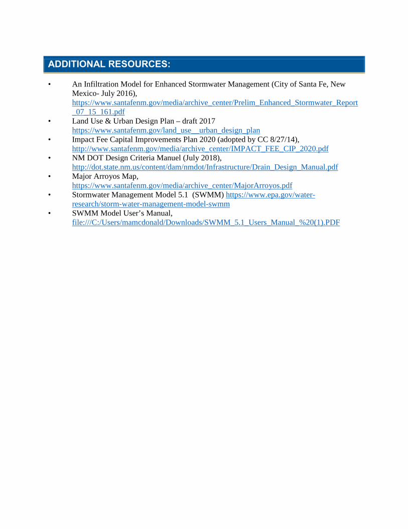
ADDITIONAL RESOURCES:
• An Infiltration Model for Enhanced Stormwater Management (City of Santa Fe, New Mexico- July 2016), https://www.santafenm.gov/media/archive_center/Prelim_Enhanced_Stormwater_Report_07_15_161.pdf
• Land Use & Urban Design Plan – draft 2017 https://www.santafenm.gov/land_use__urban_design_plan
• Impact Fee Capital Improvements Plan 2020 (adopted by CC 8/27/14), http://www.santafenm.gov/media/archive_center/IMPACT_FEE_CIP_2020.pdf
• NM DOT Design Criteria Manuel (July 2018), http://dot.state.nm.us/content/dam/nmdot/Infrastructure/Drain_Design_Manual.pdf
• Major Arroyos Map, https://www.santafenm.gov/media/archive_center/MajorArroyos.pdf
• Stormwater Management Model 5.1 (SWMM) https://www.epa.gov/water-research/storm-water-management-model-swmm
• SWMM Model User’s Manual, file:///C:/Users/mamcdonald/Downloads/SWMM_5.1_Users_Manual_%20(1).PDF
Troy M. Dorman, PhD, PE, CFM
Principal in Charge
EXPERIENCE SUMMARY
Dr. Dorman has 18 years of civil/environmental engineering experience in water resources engineering, stormwater management, low impact development techniques, water quality BMPs, watershed master planning, land use planning, utility coordination, surface and groundwater hydrologic modeling, hydraulic design and erosion control. Dr. Dorman’s roles have included client development, project management, engineering design/review and team leadership for clients ranging from the U.S. Army Corps of Engineers to state, county and local agencies.
RELEVANT EXPERIENCE
Sustainable Stormwater Engineering IDIQ, San Antonio River Authority (SARA). Program Manager for this on-call contract and also serves as Project Manager for several individual projects. Project manager, lead designer, field investigator and BMP optimization modeling task leader for an LID retrofit at SARA headquarters. Led a series of workshops and tours focused on LID BMP O&M for SARA, including participants from SARA, City of San Antonio DSD, City of San Antonio TCI, SAWS, CPS, and Bexar County. Principal author of the San Antonio River Basin LID Manual, a tailored local LID design manual for the four counties in SARA’s jurisdiction. Project Manager for this on-call contract. Project manager, lead designer, field investigator and BMP optimization modeling task leader for an LID retrofit at SARA headquarters. Led a series of workshops and tours focused on LID BMP O&M for SARA, including participants from SARA, City of San Antonio DSD, City of San Antonio TCI, SAWS, CPS, and Bexar County. Principal author of the San Antonio River Basin LID Manual, a tailored local LID design manual for the four counties in SARA’s jurisdiction. Project Manager to support the City of San Antonio and SARA in their joint effort to prepare a voluntary LID and Natural Channel Design Ordinance. Managing analysis, preliminary design and estimating for a series of proposed CIP projects for future bond funding for local watershed drainage master plans.
Bleiders/German Creek Stormwater Capital Improvement Project, New Braunfels, TX. Project manager to develop a preliminary engineering report to evaluate the feasibility of diverting water from Bleiders Creek through a natural overflow route that has been blocked by an active railroad line for more than 150 years. Managed Tetra Tech’s efforts, working as a sub to a local engineer, to lead hydrology and hydraulic modeling, preliminary design, environmental permitting, and options analysis. Modeling included a combination of HEC-HMS and HEC-RAS models to show the benefit of proposed upstream dam by itself or with the diversion project. A 2-D unsteady XP-SWMM model was used to produce a corrected effective FEMA floodplain and evaluate downstream impacts on the Guadalupe River, including the timing of the diverted hydrograph. Project also includes establishing cross section survey locations, survey QC, and multiple public outreach efforts to evaluate options proposed by community groups and address significant landowner resistance.
SARA Drainage Local Watershed Master Plan Support. Managing analysis, preliminary design and estimating of a series of proposed CIP projects for future bond funding. Led development of a checklist that was used by team members from other design firms to evaluate LID and GI opportunities for the projects in Council Districts 4, 7 and 8. Led additional analysis of the LID/GI potential for up to 4 projects each from Council Districts 4, 7, and 8
EDUCATION
Ph.D., Water Resources and Environmental Engineering, Texas Tech University, 2003
M.S., Civil Engineering, Texas Tech University, 1996
B.S., Hydrology, Tarleton State University, 1993
REGISTRATIONS/LICENSES
Professional Engineer, Texas No. 92722, 2003
Certified Flood Plain Manager
ENV-SP
AREA OF EXPERTISE
Water resources engineering
Stormwater management
Low impact development
Water quality BMPs
Watershed master planning
Land use planning
Utility coordination
Surface and groundwater hydrologic modeling
Hydraulic design
Erosion control
YEARS OF EXPERIENCE
18
YEARS WITH FIRM
3
Résumé 1
Résumé Troy M. Dorman, PhD, PE, CFM
to prepare cost estimates and feasibility assessments. Developed proposed infrastructure improvements including storm drain systems, street improvements, upgraded culvert crossings and stream restoration design.
Drainage, Detention and Edwards Aquifer Water Quality Design, Buda, TX. Led design and preparation of an Edwards Aquifer Protection Plan for a site near Buda, TX, on behalf of a private client. Prepared analysis and design of temporary and permanent stormwater BMPs for an Aboveground Storage Tank site over the Edwards Aquifer, designed to meet both NPDES and dam safety needs. Prepared a drainage report for submittal to the City that analyzed 2-yr to 100-yr storm events to assess whether the site development would increase flows downstream of the site or negatively impact any existing public infrastructure.
New York Rising Community Reconstruction Program, New York State DEP. Supporting project for assisting local communities in developing flood hazard mitigation projects in response to Superstorm Sandy, Tropical Storm Irene, and Tropical Storm Lee. Serving as technical lead for hydrologic and hydraulic modeling in Margaretville, Shandaken, and Hardenburgh, NY. Providing program guidance to the communities while directing and reviewing work of staff engineers. Performing QC of HEC-RAS models and screening projects based on feasibility and hydraulic efficacy. The project will ultimately develop a list of projects for funding through various state and federal programs.
Wilson County Watershed Master Plan, SARA. Project manager for development of comprehensive watershed master plans to assess potential flood damage to buildings, roads and infrastructure within Wilson County. Managed review of each community’s development regulations and made recommendations to update and strengthen drainage design criteria and overall floodplain management codes. The master plan identifies major flooding reaches, identifies target areas for flood mitigation and evaluates appropriate structural and nonstructural solutions for each target area. Along with flood solution strategies, areas were identified as suitable or not suitable for combining recommended improvements with multi-use facilities including environmental habitat restoration, community recreation and open space enhancement. A comprehensive report for each community will support efforts by the communities to acquire funding through federal hazard mitigation programming. Grant monies supplement each community budget to improve drainage infrastructure to protect citizens from property damage and physical injury or loss of life due to flooding.
Word Borchers Development, New Braunfels, TX. Served as Water Resources technical lead for a mixed-use, master planned community located on the 2,421-acre Word Borchers Ranch on Loop 337 north of the City of New Braunfels, TX. As part of the master planning process for a development agreement between the City of New Braunfels and the client, developed standards that will protect water quality, decrease flow, and mitigate downstream flooding problems. The development regulations far exceed current City of New Braunfels development code but will be used to govern development of the equivalent of a small city on 2400 acres during the next 20 to 25 years. Developed new approaches to assess sediment loading, erosion potential, stream protection, and water quality BMPs that integrate with overall land plan. Also incorporated modeling of LID features throughout the 20-year build-out, as well as sized wet ponds, extended detention and water quality measures to provide nondegradation from sediment.
San Antonio River Watershed Master Plan, San Antonio, TX. Over a 3 year period, led development of the Master Plan, which covered approximately 130 mi2 of San Antonio including downtown, the River Walk and many neighborhoods that were built in the 1940s, 50s and 60s prior to establishment of FEMA regulations. The master plan addressed flooding, infrastructure conflicts, stream preservation/restoration potential and transportation impacts from impassable roads. Proposed solutions included detention, channel widening, buyouts, underground storm drain systems and bridge widening or removal. Over 50 different regional and localized drainage issues were investigated to develop conceptual solutions. Led the effort to present the technical basis, financial benefits and community improvements that could be realized by each project. Projects included unsteady 1D and 2D modeling, infrastructure sizing, environmental permitting assessment, cost estimating and utility conflict review.
Private Landowner Dispute, Boerne, TX. Principal-in-charge and QA/QC review for this project. His team was hired by a public homebuilder to review drainage plans designed by another engineering firm for a recently constructed subdivision. A commercial property owner downstream from the subdivision was damaged during an intense rainfall event. The City of Boerne was initially involved for their role in reviewing and approving construction. Reviewed street drainage, inlet capacity, channel capacity and detention sizing to verify compliance with Boerne’s development regulations. The team determined that the detention basins were incorrectly sized and did not follow Boerne’s regulations. The City of Boerne and our client were both exonerated.
2
Christy Williams
Senior Environmental Planner
EXPERIENCE SUMMARY
Ms. Williams has worked in the water resources and land use planning and policy field for 22 years, having worked as an environmental specialist for a state department of transportation, a local county planner and storm water program manager, an outreach and environmental program coordinator for a national conservation non-profit, and as a storm water and erosion control construction inspector and plan reviewer for local governments. She has more than a decade of experience helping municipalities implement their stormwater programs, including conducting audits of more than 70 MS4 permitees around the country, writing numerous MS4 permits, and co-authoring national MS4 permit writer and audit guidance for USEPA. With a recent focus on green infrastructure, Ms. Williams has assisted numerous localities incorporate green infrastructure principles and practices into private property and public spaces. She has conducted code and ordinance reviews as well as assisted numerous localities with the revision and/or development of new local regulations to allow, support, incentivize and allow green infrastructure practices. In addition, Ms. Williams has helped municipalities assess green infrastructure financing options and develop private property green infrastructure incentive programs. Ms. Williams has provided a wide array of public education and outreach and training support related to stormwater management, water quality trading, and green infrastructure design throughout the country.
RELEVANT EXPERIENCE
Stormwater Management Program Development and Implementation, San Francisco Public Utilities Commission. Developed multiple stormwater management documents for City and County of San Francisco to comply with Phase II MS4 General Permit requirements. Wrote an illicit discharge enforcement response plan, a spill response plan and a construction activity enforcement response plan. Developed a source investigations and corrective actions plan for the City and County.
Green Infrastructure Plan Development, City of Detroit, MI. Reviewed the City’s codes, ordinances and planning documents and developed a list of recommendations to remove barriers to green infrastructure implementation. Assisting in writing a new post-construction stormwater ordinance – the city’s first – and updating the codes to provide additional support, incentives and requirements to implement multi-functioning landscapes. The development of these codes is being implemented as part of the City’s CSO Long Term Control Program.
Green Infrastructure Incentive Program and Code Update for Burlington, NC. Supported the town of Burlington in the development of a green infrastructure incentive program that included a new grant program, a green infrastructure audit and public-private partnership model, public demonstration projects, and a variety of land use incentives that required updates to city codes and ordinances.
Building Blocks Workshops – Linking Land Use and Water Quality, USEPA OWM. Conducted numerous workshops for local governments interested in learning more about how to better link land use planning techniques and concepts with water quality impacts. Each workshop was 2-3 days and targeted government staff, elected officials and the general public. Performed cursory review of the municipality’s local codes and ordinances to provide them some real-world examples about how their land use planning decisions impact water quality now and how they could be altered to protect water resources in the future while encouraging and support economic development in the community.
Update and Revision of Conservation Subdivision Land Use Pattern, San Antonio River Authority. Assisted SARA in update and revision of the City of San Antonio’s existing conservation subdivision use pattern in
EDUCATION
M.A., Urban and Environmental Planning, University of Virginia
B.A., Biology, Randolph-Macon College
AREAS OF EXPERTISE
Green infrastructure
Permitting
Regulation development
Integrated planning
Stakeholder involvement
Facilitation
Guidance development
Facility inspections/audits
YEARS OF EXPERIENCE
19
YEARS WITH FIRM
14
Résumé 1
Résumé Christy Williams
the San Antonio Unified Development Code. Worked with SARA, City and outside stakeholders to update the language to include more incentives, specific conservation area management requirements and revised development to encourage the conservation of valuable open space in the City and the Extraterritorial Jurisdiction outside the City. Wrote multiple drafts of the code language for use during informal stakeholder meetings and the City’s subsequent formal public involvement process. This effort was done in conjunction with Tetra Tech’s assistance to SARA to develop a new LID/voluntary sustainable land-use and stormwater management alternative ordinance the combines the principles of LID and Natural Channel Design Protocols (NCDP).
Water Infrastructure and Resiliency Finance Center Database Development. Assisted EPA in conducting an inventory of existing financing resources available to communities with stormwater and green infrastructure needs. Helped to categorize the resources by geography, topic, target audience, and applicability. The database will be used as a user-friendly online clearinghouse of existing stormwater financing resources based on the research completed.
Integrated Planning Technical Assistance. Supported USEPA technical assistance project in support of the Integrated Municipal Stormwater and Wastewater Planning Approach Framework. Oversaw assistance to the City of Burlington, VT, City of Santa Maria, CA, and Onondaga County, NY, to support several of the key elements of the planning process described in the USEPA 2012 memorandum. Support included convening a stakeholder group; conducting an online poll to develop community criteria for evaluating alternatives; reviewing various stormwater, flow restoration, and CSO reduction projects; investigating options for phosphorus reduction at WWTPs; developing methods and an interactive spreadsheet tool to identify, evaluate, and select options for integrated water resource management; developing processes for engaging stakeholders; and developing a user-friendly spreadsheet for scoring individual stormwater and wastewater projects.
Phase II Stormwater Management Program Audits, Plan Development and Implementation, Puerto Rico. Conducted audits of and developed stormwater management program (SWMP) plans for five municipalities in Puerto Rico. Each plan was used as the notice of intent submittal for initial coverage under the Puerto Rico MS4 Phase II General Permit. Further assisting municipalities in implementation of their stormwater management programs. For example, has conducted municipal facilities inspections at four localities for the last two years.
NPDES MS4 Program Evaluation Guidance. Principal co-author of a USEPA guidance document drafted to assist permitting authorities in the evaluation of Phase I and Phase II MS4 stormwater management programs. The guidance includes checklists, worksheets, and numerous other resources and tools to prepare for and perform consistent program evaluations as well as conduct follow up activities.
Integrated Watershed-Based Storm Water Permitting for Minnesota Board of Water and Soil Resources (BWSR) and the Ramsey Washington Metro Watershed District. Participated in Phase One of this project and was a primary co-author of the framework analysis document. Support included identifying opportunities to streamline current Phase II municipal separate storm sewer system (MS4) requirements under the federal NPDES Storm Water Program with Minnesota requirements under the Metropolitan Water Management Program (Minnesota Statutes, Section 103B.201), Watershed District Law (M.S. Chapter 103D) and Minnesota Rules (Chapters 7050, 7090 and 8410). Project outputs are recommended measures for the integration of watershed-based storm water and watershed management planning requirements followed by agency and local government efficiencies in permit issuance and compliance concurrent with measurable environmental results.
NPDES Storm Water Public Education Program, TNRCC. Assisted with development of TNRCC stormwater outreach program by editing training and presentation materials. For a related contract, researched 20 different state Multi-sector General Permit (industrial storm water) programs and summarized the existing information for use by TNRCC in developing the TPDES industrial storm water program. Researched and summarized existing information regarding alternative industrial storm water monitoring techniques and programs around the country.
NPDES MS4 Storm Water Program, Arlington County, VA. Served as County stormwater program manager. Wrote Annual Reports. Wrote a grant application and acquired a grant from Chesapeake Bay Local Assistance Department to develop the first comprehensive watershed management plan for Arlington County. Developed a restoration, mitigation and storm water management plan that could be used to develop projects for the County’s CIP. Reviewed site plans and water quality impact assessments for compliance with County Chesapeake Bay Preservation Ordinance, Virginia Erosion and Sediment Control Law, and Virginia Storm Water Regulations.
2
Rosemary Romero Consulting
building better communities through public involvement & decision-making, strategic planning, and conflict resolution
1350 San Juan Drive, Santa Fe NM 87505 505.982.9805 office 505.690.3016 cell [email protected]
For the past three decades, Ms. Romero has designed and facilitated numerous public involvement projects, assessed the potential for neutral conflict resolution services in diverse cases, consulted with public and private organizations on the use of alternative dispute resolution techniques, trained hundreds of persons in negotiation and mediation and public involvement skills and promoted the use of mediation and facilitation in the environmental field and other public policy arenas that affect communities. She has facilitated controversial issues with various federal, state, local governments and nonprofit organizations and lead strategic planning efforts for numerous entities. As a native New Mexican, she brings a heightened awareness of cross-cultural issues in the resolution of disputes. She is the former President of Western Network a non-profit organization that developed an extensive practice centered on conflict resolution specific to natural resource issues such as water planning and land use planning. Ms. Romero completed four years as an elected City of Santa Fe Councilor and in that capacity served on several regional boards including the Chairmanship of the North Central Regional Transit District, Santa Fe Solid Waste Management Agency, and Santa Fe Regional Planning Authority while also serving on key City of Santa Fe committees. Ms. Romero has also served in other national leadership roles including Past President and current member of the Association for Conflict Resolution (ACR) the largest ADR membership organization in the United States. Select Project Work: 2004 - 2016: Interstate Stream Commission: As a consultant to the Office of the State Engineer and Interstate Stream Commission, organized and developed regional water planning efforts throughout the state. The final regional water plan was developed by Taos County and accepted by the ISC was, the recipient of a statewide award by the Regional Water Planning Dialogue for stellar public involvement. 1998 – 2016: Collaborative Forest Restoration Program. In 1998 Ms. Romero worked with two other conservation organizations to design and facilitate day-long workshops with representatives from the logging industry, livestock associations, community organizations and other interested parties to develop a vision for forest health and restoration. The process allowed the diverse interest groups to share their individual perspectives in a constructive, non-threatening environment that helped build trust and working relationships. The process was the first of this type used by congressional staff to develop legislation in 2000. Romero continues her involvement through facilitation of the annual CFRP workshop for grantees and facilitation of the annual FACA (Federal Advisory Committee Act) Technical Advisory Committee reviewing proposals focused on forest health. 2012-2016: American Friends Service Committee-New Mexico. Evaluation of a 4 year long
1
evaluation of a Kellogg Foundation project “Thriving Community Farmers, Healthy New Mexico Children” grant. The grant seeks to help the AFSC farmers training program improve community food environments affecting poor children of color and low-income families in three project areas in New Mexico. 2014 - 2016: Cibola/Carson/Lincoln National Forests. Travel Management Public Involvement; Forest Plan Revisions; endangered species; livestock; fire management. 2007-2008: Environmental Justice Taskforce - Facilitation of the Bernalillo County/City of Albuquerque Environmental Justice Taskforce. The Scope of the EJ Task Force was to develop recommendations to implement the EJ objectives of the Taskforce, i.e., immediate, short-term, and long-term recommendations; identify any barriers to implement recommendations; identify/develop check list or other qualitative analysis for EJ regarding air quality; identify existing models for analyzing cumulative effects. This has been a seven month long project and the final report was submitted March 2008.
2008: MolyCorp/Chevron Public Involvement. Co-Facilitator for an EPA funded project to facilitate public meetings in Questa, NM for development of a Remediation Plan for the Questa mine. In addition, Ms. Romero worked closely with MolyCorp staff and the Taos Community Foundation to develop a long-term community based fund for post-mine closure projects. 2005 – 2006: Upper Rio Grande Watershed: Development of a watershed restoration action strategy (WRAS) for the Upper Rio Grande Watershed. The project has included meeting with community members throughout Taos County, facilitation of agency meetings, interviews, and focused meetings in order to gather information on future projects that can be funded through NMED 319 grant monies to address water quality issues. The WRAS includes six sub-wrases (Rio Fernando, Rio Hondo, Pilar, Greater World, Rio Pueblo, Ranchos de Taos) that have been implemented at various degrees. Educational Background: Associate of Arts Degree from Santa Fe Community College, attended the College of Santa Fe, Environmental Management Program and Antioch University, Yellow Springs, Ohio, Masters in Art Program for Environment & Community. Ms. Romero has received over 200 hours of mediation/facilitation/strategic planning training including Environmental Public Policy Mediation from CDR Associates; Collaborative Leadership for Community Problem-Solving and Visioning at SFCC; ICR Associates Strategic Planning.
2
Jesse Dillon Roach, PhD, PE
Hydrologist
EXPERIENCE SUMMARY
Jesse Roach is a Hydrologist with a background in water resources and operations modeling, and high level analysis of integrated hydrologic systems. At Tetra Tech, Jesse has supported development of the Upper Rio Grande Water Operations Model, a RiverWare based accounting and operations model for the Rio Grande from headwaters to El Paso, Texas which includes water rights based operations. Jesse was also the lead and primary developer of a Powersim based monthly timestep systems model for the upper Rio Grande basin known as the Upper Rio Grande Simulation Model (URGSiM), and a state level mass balance model for New Mexico. Prior to joining Tetra Tech, Jesse worked at Sandia National Laboratories on quantitative analysis of the relationship between water resources and the human and natural demands they serve. Jesse has worked as a lead modeler on integrated systems level models that incorporate climate, surface water, groundwater, reservoir, human demand, and environmental demand dynamics for a variety of hydrologic systems. Such models can be built in a collaborative manner in order to involve and educate parties with an interest in the resource management outcome. Recent and notable projects include analysis of post-wildfire hydrologic response in Whitewater Creek and the Pecos River, hydrologic and hydraulic analysis of watershed areas in and around the Pueblos of Santa Ana and San Felipe, analysis of potential climate change impacts in the Upper Rio Grande using URGSiM, and collaborative development of system dynamics models of water systems in the Tigris-Euphrates basin in Turkey, Syria and Iraq. Jesse is skilled in use of Matlab, Excel, ARC-GIS, HEC-HMS, HEC-RAS, Powersim, and RiverWare softwares for application to resource management analysis. Jesse is an adjunct professor at the University of New Mexico, and teaches a graduate level course there on hydrologic modeling.
RELEVANT EXPERIENCE
Post Wildfire Hydrology Whitewater Creek and Pecos River, New Mexico (2016). Development of HEC-HMS rainfall runoff models for pre- and post-wildfire conditions in two burn scarred watersheds.
Reconstruction of 1850-1920 Sacramento and San Juaquin Rim Inflows & Valley Precipitation (2016). Provided technical oversight for data gathering and analysis to reconstruct precipitation in California’s Sacramento and San Juaquin basins from correlations between tree ring records, PRISM synthetic data, and observed records.
URGWOM Model Development; USACE, Albuquerque District; Albuquerque, NM (2014-Present). Senior Water Resources Engineer. Provided RiverWare model development of the Upper Rio Grande Water Operations Model (URGWOM), including rule writing, accounting, and suggestions for physical model improvements.
New Mexico Dynamic Statewide Water Budget (2014-Present). Synthesis of water supply and demand data and modeled values from across New Mexico into a single, easily accessible platform that provides hydrologic mass balance information at a variety of spatial scales including County, Water Planning Region, river basin, or the entire state.
Upper Rio Grande Simulation Model (URGSiM) Development; USACE; Albuquerque, NM (2014-2016). Lead Model Developer. Development and maintenance of a monthly timestep system level mass balance and operations model known as the Upper Rio Grande Simulation Model (URGSiM).
EDUCATION
Ph.D., Hydrology and Water Resources; University of Arizona, 2007
M.S., Civil and Environmental Engineering, Stanford University, 1997
B.S., Civil Engineering, Stanford University, 1995
B.S., Biological Sciences, Stanford University, 1995
AREAS OF EXPERTISE
Hydrologic and hydraulic analysis
Water resources modeling
LICENSES/REGISTRATIONS
Professional Engineer, New Mexico, License No. 23277 (2015)
Adjunct Lecturer, University of New Mexico, Water Resources Program
YEARS OF EXPERIENCE
10
YEARS WITH FIRM
2
Résumé 1
Résumé Jesse Dillon Roach, PhD, PE
San Felipe Section 203 Watershed Management Plan; USACE, Albuquerque District; Albuquerque, NM (2014-2015). Developed HEC-HMS models and resulting flood magnitude and frequency estimates for seven tributaries to the Rio Grande between Cochiti and Bernalillo representing over 350 square miles of drainage area.
Upper Rio Grande Impacts Assessment; Bureau of Reclamation; Albuquerque, NM (2012-2013). Technical Lead. Investigation of potential climate change impacts on water supply and demand in the Upper Rio Grande system. Contractor to Bureau of Reclamation. Technical lead.
Water, Energy, & Carbon Sequestration Simulation Model (WECSsim); U.S. DoE; Albuquerque, NM (2011-2014). Technical Lead. Development of a simulation model to evaluate water demand and supply impacts from national scale implementation of carbon dioxide capture and storage. Technical lead.
Expected Hydrologic Impacts Associated with Increased Conservation Storage at El Vado Reservoir; Bureau of Reclamation; Albuquerque, NM (2011). Initial assessment of potential hydrologic impacts of raising the spillway at El Vado to allow for additional conservation storage. Sole provider for contracting, technical analysis, and reporting.
Evaluating Water Supply and Consumption by Sector in a National Water Resources Framework; U.S. Department of State; Iraq, Jordan, Turkey (2008-2011). Interacted with engineers from the Iraq Ministry of Water Resources to collaboratively build a systems level model of the Tigris-Euphrates system so that users could visualize likely impacts to Iraq of upstream water development and climate change, and experiment with potential strategies for coping with those impacts. Technical lead.
Stochastic Hydrologic Analysis of the Upper Rio Grande Surface Water System; Project Owner; Albuquerque, NM (2009). Ran a monthly timestep mass balance model of the Rio Grande built by Dr. Roach with thousands of tree ring based hydro-climatological scenarios. Sole provider of all aspects of study.
PAPERS AND PRESENTATIONS
First Author:
• Expected Hydrologic Impacts Associated with Increased Conservation Storage at El Vado Reservoir, New Mexico. 2011 Report to U.S. Bureau of Reclamation.
• A Compartmental–Spatial System Dynamics Approach to Ground Water Modeling. 2009. Coauthor: V. Tidwell. Ground Water Vol. 47 (Sept-Oct), No. 5 pp 686–698
• Stochastic Hydrologic Analysis of the Upper Rio Grande Surface Water System in New Mexico. Report to URGWOM Technical Team. 79pp. SAND2009-6529P July 1, 2009.
• Strategy for Water and Land Resources in Iraq (SWLRI) Water Systems Planning Model (WSPM) Final Report. With: H. Passell, M. Reno, G. Klise, & V. Tidwell. Sandia National Laboratories SAND2009-3063P. May 2009.
• Integrated Surface Water Groundwater Modeling in the Upper Rio Grande in Support of Scenario Analysis. Department of Hydrology and Water Resources, University of Arizona. 341 p. (PhD dissertation).
2

Richard L. Schaefer, PE, LEED AP
Civil Engineer
EXPERIENCE SUMMARY
Mr. Schaefer is an experienced manager of planning, design and construction of infrastructure projects and program development for municipalities. His technical experience emphasizes storm and surface water management, wastewater and CSO infrastructure. Rick assists cities in developing stormwater programs that both address locally-driven initiatives and achieve regulatory compliance. Mr. Schaefer prepares comprehensive stormwater plans and basin plans providing municipalities with capital improvement programming, maintenance and operational planning, regulatory guidance, and funding strategies to retrofit watersheds, upgrade and expand drainage and wastewater infrastructure, and to manage/protect local water resources. He develops funding strategies and assists with establishing stormwater utilities and related revenue structures to implement water programs.
RELEVANT EXPERIENCE
Stormwater Master Plan Update, Bothell, Washington, City of Bothell. Updated the comprehensive stormwater plan to address current physical, policy, regulatory and fiscal conditions affecting the city's stormwater program. The project used a phased, interactive approach to evaluate intermediate findings and adaptively reallocated analytical resources to assure the city greatest return on its planning investment. The update focused on optimizing levels of service (capital, operations, and maintenance) and achieving regulatory compliance within the city's available personnel and fiscal resources.
Stormwater Program Implementation, Blaine, Washington, City of Blaine. Managed a grant-supported project to implement a stormwater management program in Blaine directed at addressing local drainage problems, improving water quality in sensitive receiving waters, and achieving regulatory compliance. Keys to the success of the program were regional cooperation and funding. Employed RNA type-matching technology identifying the range of fecal coliform sources to Drayton Harbor as an aid in prioritizing control strategies both in the city and in surrounding Whatcom County. The project also formed a stormwater utility and system development charge to fund efforts addressing surface water needs. Formed and coordinated with a citizen advisory committee to develop policies and recommendations presented to the City Council for adoption.
Stormwater Program Implementation, Snohomish, Washington, City of Snohomish. Project Manager for reassessment of the city's stormwater program and related CSO control needs, and plan to implement a funding mechanism moving the program forward. Worked extensively with a citizen advisory committee to fund a program that addresses local flooding, water quality and habitat needs and complies with state and federal regulations.
Comprehensive Storm Drainage Plan, University Place, Washington, City of University Place. Project manager responsible for preparing the first comprehensive stormwater plan for the newly incorporated city of University Place. The plan prepared an inventory of existing infrastructure, completed hydrologic and hydraulic assessment of drainage systems throughout the city, assessed local needs and regulatory mandates, developed capital and maintenance programs, and produced a revenue requirements model. Development of the plan was fast-tracked, completing the draft plan along with recommendations for implementing a stormwater utility within three months. Utility rate structure and fee schedule were promptly adopted one month later.
EDUCATION
M.S., Civil Engineering, North Carolina State University, 1982
B.S., Civil Engineering, University of Michigan, 1977
AREAS OF EXPERTISE
Stormwater program development
Utility development
Stormater management
LICENSES/REGISTRATIONS
Professional Engineer (Washington #19988, 1981; California #41430, 1987)
LEED Accredited Professional (2009)
PROFESSIONAL AFFILIATIONS
American Society of Civil Engineers (ASCE)
American Public Works Association (APWA)
American Council of Engineering Companies (ACEC)
YEARS OF EXPERIENCE
39
YEARS WITH FIRM
5
Résumé 1
Résumé Richard L. Schaefer, PE, LEED AP
Stormwater Quality Management Plan, Anacortes, Washington, City of Anacortes. Managed preparation of grant-funded comprehensive stormwater plan for the city and adjoining areas of Skagit County. Plan established a prioritized capital improvement program, O&M plan, water quality assessment, regulatory analysis, financing strategy, and proposed development standards and ordinances. This plan specifically addressed allocation of funding and improvement responsibilities between the city and new development.
Waterways Asset Management Planning, San Jose, CA, Santa Clara Valley Water District. Technical Lead developing an approach to prepare asset management plans and long-term funding strategies for the waterways in nine watersheds. Conducted multiple workshops with staff across the District’s stakeholder divisions: Maintenance, Engineering, Vegetation Management, Environmental Stewardship, Water Supply Operations, and Fisheries). Developed a framework for defining Level of Service (LOS) that connects Strategic Drivers (Board Ends Policies and Objectives), through LOS Standards, to Performance Measures. Also designed and led a multi-workshop process to generate and evaluate alternative management strategies for waterway assets along reaches of the Guadalupe River posing certain risk if not maintained and entailing significant costs.
Funding Development for Watershed Implementation Plan, Prince George’s County, MD. Senior Technical Consultant guiding the County in developing new funding to implement a $1.2 billion program retrofitting drainage across the county to reduce phosphorous and nitrogen loading to the Chesapeake estuary. Developed an efficient means utilizing available tax account data with analyses prepared from the County’s GIS to define the ratepayer base; defined criteria and evaluated alternative fee structures compliant with provisions of Maryland’s House Bill 987; provided for on-site BMP credits and fee adjustments; and leveraged debt-financing approaches. Developed a recommended fee structure through workshops with multiple county departments over 4 months, and implemented the fees for distribution in July 2013. Project completed on an accelerated 11-month schedule.
Stormwater Utility Feasibility Study. Dover, New Hampshire, City of Dover. Technical Director for study assessing feasibility and implementation requirements for an enterprise stormwater utility to operate, maintain and improve stormwater infrastructure and programs needed to safeguard the city from flooding and meet new regulatory obligations. Using the City’s GIS database, directed development of rate base model and alternative fee structures. Initiated advisory committee process engaging city council representatives and stakeholders to evaluate alternative policies and forward recommendations to the full Council.
Stormwater Utilities Comparison, Tacoma, Washington, Pierce County. Managed evaluation of County’s water programs and performed comparisons with other Washington state jurisdictions subject to Phase I NPDES stormwater regulations. Assessed the various components of Pierce County’s projects and activities and made side-by-side comparisons with other counties, major municipalities and the state Department of Transportation.
Surface Water Design Manual, Seattle, Washington, King County. As Project Manager, completed 1990 King County Surface Water Design Manual drafts and conducted public review and workshops. Later retained to manage consultant support to the county in preparing the 1992 interim updates, and key issue papers. Supervised the development of complementary software, (KCRTS), the county's BMP manual, and associated training program. The project work culminated in publication of the 1998 Surface Water Design Manual.
Stormwater Funding Implementation, Arlington, Washington, City of Arlington. Managed the evaluation of a stormwater utility and fee structure to fund the city's stormwater management activities to control flooding, protect water quality, construct and maintain the drainage infrastructure. Updated Arlington's prior Stormwater Management Plan by expanding program activities to include recent annexations and to comply with evolving state and federal NPDES and ESA regulations. Worked with a representative advisory committee to develop an equitable and acceptable fee structure that included both an impervious area-based fee structure and a system development charge.
Stormwater Utility Formation, Kirkland, Washington, City of Kirkland. Project Manager responsible for both developing Kirkland’s Surface Water Master Plan and the subsequent enterprise utility formation process to fund the recommended program of capital improvements, maintenance, operations, policy enforcement, and regulatory compliance. Assisted the City in securing and administering state grant to support the utility formation process.
2
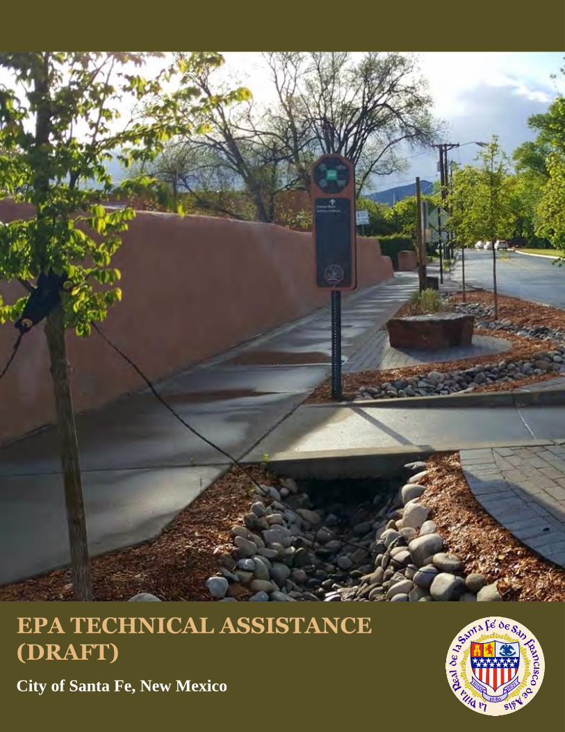
EPA TECHNICAL ASSISTANCE (DRAFT)City of Santa Fe, New Mexico
DRAFT Santa Fe Roadway GI Guide Page 1 September 14, 2018
[DRAFT]AGuidetoIncorporatingGreenInfrastructureintoRoadwayProjectsinSantaFeWhy should you read this document? This document provides Santa Fe with information that can be shared among city departments/staff to encourage them to consider incorporating green infrastructure practices into roadway improvement projects. It is a basic primer. It will be available for the public to view, and may be shared with private developers and their engineers as part of a standard informational packet. Who should read this document? City departments/staff and private developers/engineers involved in road redesign and reconstruction projects, redevelopment and urban renewal/revitalization, streetscape design, and maintenance of roadways and landscaping.
TableofContents1. Introduction
2. Considering Green Infrastructure within the Broader Project Development Process
3. Green Stormwater Infrastructure Practices
4. General Design Considerations
5. Maintenance of Green Infrastructure practices
6. Permitting/regulatory considerations
7. Example Design Concepts for Santa Fe Sites
8. References
DRAFT Santa Fe Roadway GI Guide Page 2 September 14, 2018
Tree Trench
A tree trench is a type of infiltration trench containing one or multiple trees, which is located within street right‐of‐way (ROW) between the street and the sidewalk (2, 7). It combines the benefits of a street tree with the efficiency of a stormwater infrastructure element, providing multiple benefits to the surrounding human and natural environment using only minimal surface space. Most importantly, it provides an opportunity to infiltrate and evapotranspire stormwater and recharge the aquifer, reduce pollutants delivered to receiving waters, and reduce the burden that landscaping can have on potable water sources for irrigation. Tree trenches are typically designed for water quality treatment and to promote healthier tree growth (2, 7). With adequate space, the practice can provide modest flood reduction benefit (9). In a ROW, stormwater runoff enters the practice through the catch basins, passes through crushed stone, is conveyed through an underdrain to one or more tree plantings, fills void space, and exits back through the catch basin (7).
Benefits
Recharges groundwater. Reduces pollutants/ improves water quality. Improves aesthetics. Increases habitat value. Provides shade / reduces urban heat island effects. Provides carbon sequestration. Improves air quality. Reduces long term irrigation needs/ potable water dependency. Uses minimal surface space.
Roadway/Transportation Application
Roadway medians Roundabouts Rights‐of‐way/ vegetated roadway edge Curb and gutter roadways Pedestrian/ bike/multi‐use paths ‘Complete’ streets for multi‐modal transportation Parking lot islands/edges Cul‐de‐sacs Courtyards/patios
DRAFT Santa Fe Roadway GI Guide Page 3 September 14, 2018
Design Considerations
Physical Site Characteristics
Challenging on steep slopes. If slopes are greater 4‐5%, then consider using a terraced approach.
Consider if the site has shallow bedrock or high groundwater. A separation distance of 3 feet is recommended between the bottom of the practice and the seasonally high ground water table.
Design Elements
Center the tree trench approximately 4‐6 feet behind the back of curb to preserve the step‐out zone on the curb side of the trees and the sidewalk on the other.
Typical size of the soil media is 3 to 4 feet in width by 6‐8 feet in length and up to 4 feet in depth, and when combined with a stone storage reservoir, cobbles, or porous rubber, it typically provides adequate space for tree roots to grow and expand. Proper sizing will help prevent sidewalk upheaval from root growth.
Permeable pavement is an option above the tree trench to intercept additional stormwater and help to provide oxygen to the roots of the tree.
Tree trench sections can be constructed back to back for any length desired. However, an inlet and water control structure is recommended for every three trees.
Soils
Suitable soil infiltration rates required to prevent tree roots from drowning, or overflow mechanism needed for larger rain events.
Vegetation
Aboveground or subsurface utilities can provide challenges. Select trees with maximum growth potential less than the height of the utility (usually about 30 ft). Factor in enough space so underground utilities are protected from roots and water.
Tree selection should be well suited to tree trench size and distance to adjacent structures, to avoid conflicts or restrictions on root growth.
Use xeriscaping. Xeriscaping uses vegetation compatible with the New Mexico environment and offers cooling and habitat, while using less water than other vegetation types.
Water for trees should be applied as efficiently as possible and only when necessary. Drip, bubbler, and micro‐spray systems or soaker hoses are appropriate for trees.
(1, 2, 4, 5, 6)
DRAFT Santa Fe Roadway GI Guide Page 4 September 14, 2018
Pretreatment
Pretreatment filter designed with media (e.g., pea gravel). (7)
Construction considerations
Do not over‐compact soil during the delivery of plants to the planting locations, digging of planting holes and installing plants. Compaction can reduce infiltration rates by increasing bulk density of the soil.
Examine the surface grades and soil conditions; only plant when weather and soil conditions are suitable for planting the specified materials in accordance with locally accepted practices.
When applicable, plant trees before other plants are installed. (13)
Maintenance
Remove sediment and trash from the catch basin, and remove trash and dead vegetation from tree trench regularly.
Upkeep of vegetation includes occasional weeding, pruning, removal of invasive species/pests. If mulch is used, check to see if it needs to be replaced. Turn or till soil if compaction occurs. Check for signs of erosion and improper root growth. Check that the irrigation system is functioning properly, and adjusting automatic irrigation
systems as the seasons change. (4, 5, 7) Inspect underdrain for obstructions.
Planning level costs
Moderate cost/acre ($$). (17)
DRAFT Santa Fe Roadway GI Guide Page 5 September 14, 2018
Graphics showing examples (to be inserted during page layout)
Tree trench design (6)
Tree trench design (6)
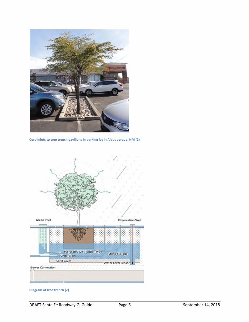
DRAFT Santa Fe Roadway GI Guide Page 6 September 14, 2018
Curb inlets to tree trench pavilions in parking lot in Albuquerque, NM (2)
Diagram of tree trench (2)
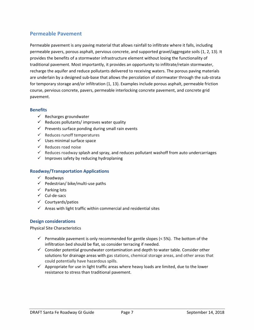
DRAFT Santa Fe Roadway GI Guide Page 7 September 14, 2018
Permeable Pavement
Permeable pavement is any paving material that allows rainfall to infiltrate where it falls, including permeable pavers, porous asphalt, pervious concrete, and supported gravel/aggregate soils (1, 2, 13). It provides the benefits of a stormwater infrastructure element without losing the functionality of traditional pavement. Most importantly, it provides an opportunity to infiltrate/retain stormwater, recharge the aquifer and reduce pollutants delivered to receiving waters. The porous paving materials are underlain by a designed sub‐base that allows the percolation of stormwater through the sub‐strata for temporary storage and/or infiltration (1, 13). Examples include porous asphalt, permeable friction course, pervious concrete, pavers, permeable interlocking concrete pavement, and concrete grid pavement. Benefits Recharges groundwater Reduces pollutants/ improves water quality Prevents surface ponding during small rain events Reduces runoff temperatures Uses minimal surface space Reduces road noise Reduces roadway splash and spray, and reduces pollutant washoff from auto undercarriages Improves safety by reducing hydroplaning
Roadway/Transportation Applications Roadways Pedestrian/ bike/multi‐use paths Parking lots Cul‐de‐sacs Courtyards/patios Areas with light traffic within commercial and residential sites
Design considerations Physical Site Characteristics
Permeable pavement is only recommended for gentle slopes (< 5%). The bottom of the infiltration bed should be flat, so consider terracing if needed.
Consider potential groundwater contamination and depth to water table. Consider other solutions for drainage areas with gas stations, chemical storage areas, and other areas that could potentially have hazardous spills.
Appropriate for use in light traffic areas where heavy loads are limited, due to the lower resistance to stress than traditional pavement.
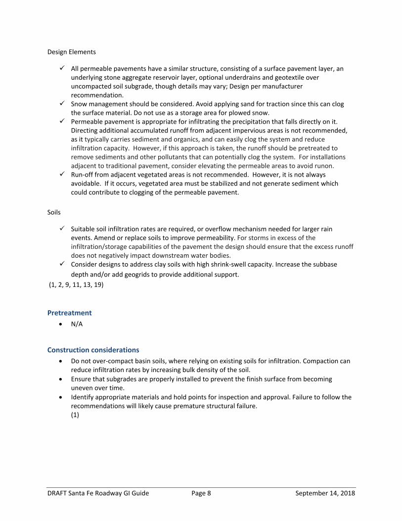
DRAFT Santa Fe Roadway GI Guide Page 8 September 14, 2018
Design Elements
All permeable pavements have a similar structure, consisting of a surface pavement layer, an underlying stone aggregate reservoir layer, optional underdrains and geotextile over uncompacted soil subgrade, though details may vary; Design per manufacturer recommendation.
Snow management should be considered. Avoid applying sand for traction since this can clog the surface material. Do not use as a storage area for plowed snow.
Permeable pavement is appropriate for infiltrating the precipitation that falls directly on it. Directing additional accumulated runoff from adjacent impervious areas is not recommended, as it typically carries sediment and organics, and can easily clog the system and reduce infiltration capacity. However, if this approach is taken, the runoff should be pretreated to remove sediments and other pollutants that can potentially clog the system. For installations adjacent to traditional pavement, consider elevating the permeable areas to avoid runon.
Run‐off from adjacent vegetated areas is not recommended. However, it is not always avoidable. If it occurs, vegetated area must be stabilized and not generate sediment which could contribute to clogging of the permeable pavement.
Soils
Suitable soil infiltration rates are required, or overflow mechanism needed for larger rain events. Amend or replace soils to improve permeability. For storms in excess of the infiltration/storage capabilities of the pavement the design should ensure that the excess runoff does not negatively impact downstream water bodies.
Consider designs to address clay soils with high shrink‐swell capacity. Increase the subbase depth and/or add geogrids to provide additional support.
(1, 2, 9, 11, 13, 19)
Pretreatment
N/A
Construction considerations Do not over‐compact basin soils, where relying on existing soils for infiltration. Compaction can
reduce infiltration rates by increasing bulk density of the soil. Ensure that subgrades are properly installed to prevent the finish surface from becoming
uneven over time. Identify appropriate materials and hold points for inspection and approval. Failure to follow the
recommendations will likely cause premature structural failure. (1)

DRAFT Santa Fe Roadway GI Guide Page 9 September 14, 2018
Maintenance
Regular sweeping or vacuuming with a vacuum sweeper is required to ensure that clogging does not occur.
Inspect for proper drainage and to identify any deterioration, cracks and settling. Inspect adjacent areas for sources of sediment like erosion of uphill areas and surrounding
vegetation management activities that could impact performance like grass clippings, etc. Pervious pavements can reduce winter maintenance needs. Sand should not be used for winter
maintenance, and environmentally friendly deicers should be used, and only as needed. Icing rarely occurs because water infiltrates instead of ponding and freezing.
Snow plowing should be done with care to prevent chipping of pavement. Snow piles should not be stored on the surface because the generally contain sediment and debris which will clog the system as the snow melts.
(2, 13)
Cost considerations Moderate to high cost/acre ($$$) (1)
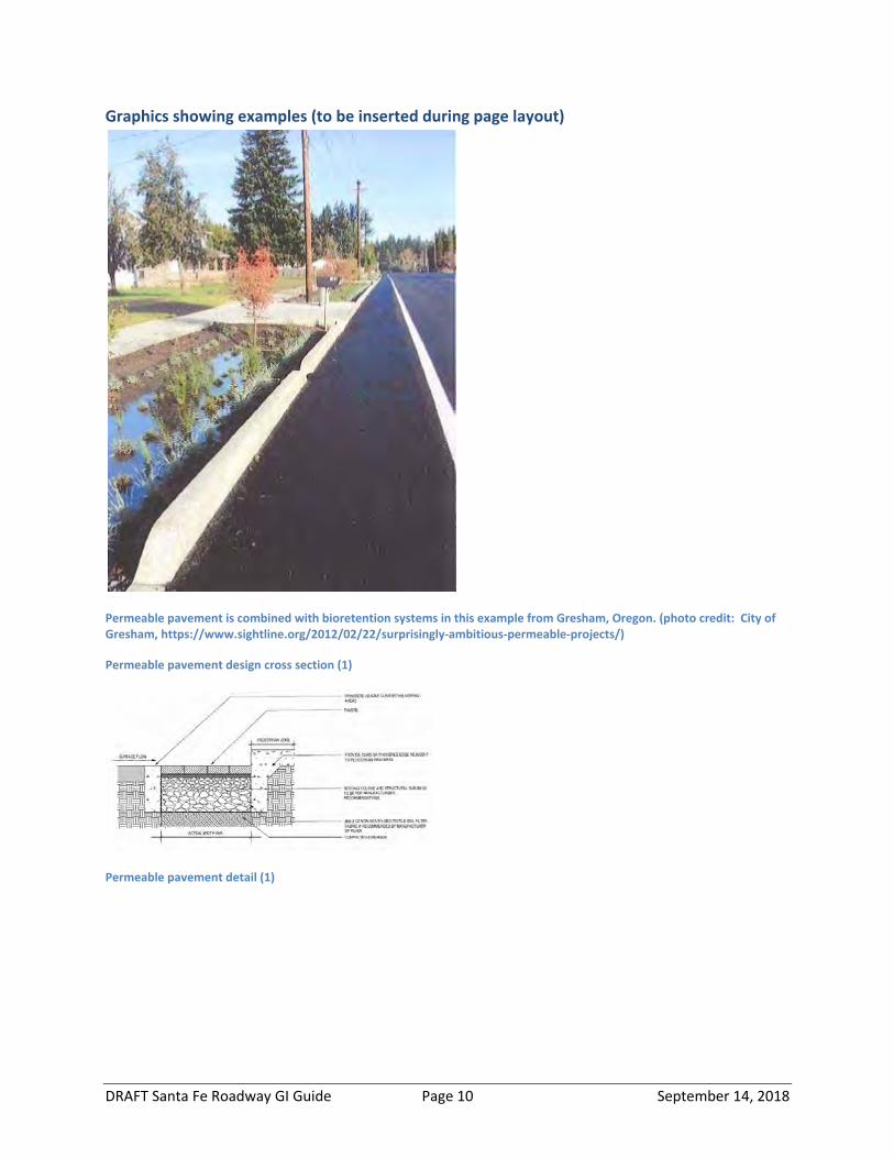
DRAFT Santa Fe Roadway GI Guide Page 10 September 14, 2018
Graphics showing examples (to be inserted during page layout)
Permeable pavement is combined with bioretention systems in this example from Gresham, Oregon. (photo credit: City of Gresham, https://www.sightline.org/2012/02/22/surprisingly‐ambitious‐permeable‐projects/)
Permeable pavement design cross section (1)
Permeable pavement detail (1)
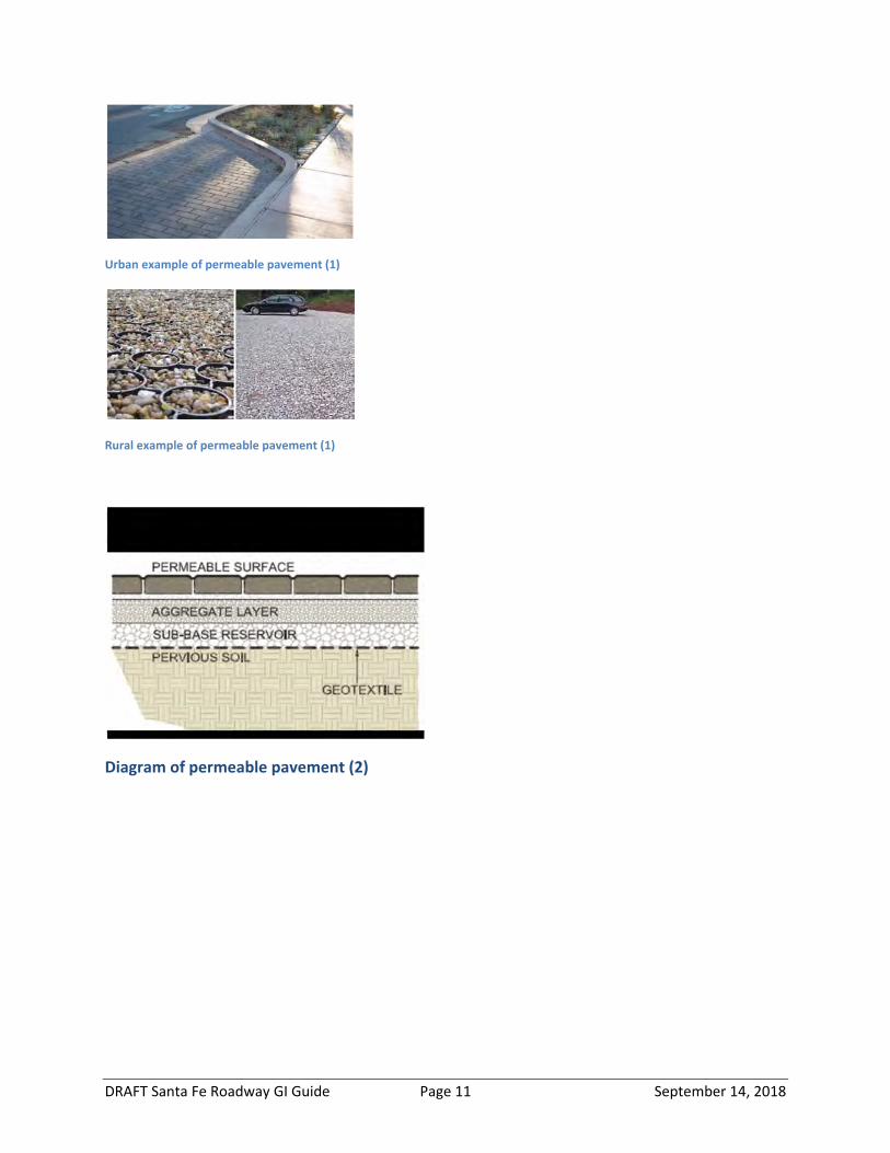
DRAFT Santa Fe Roadway GI Guide Page 11 September 14, 2018
Urban example of permeable pavement (1)
Rural example of permeable pavement (1)
Diagram of permeable pavement (2)
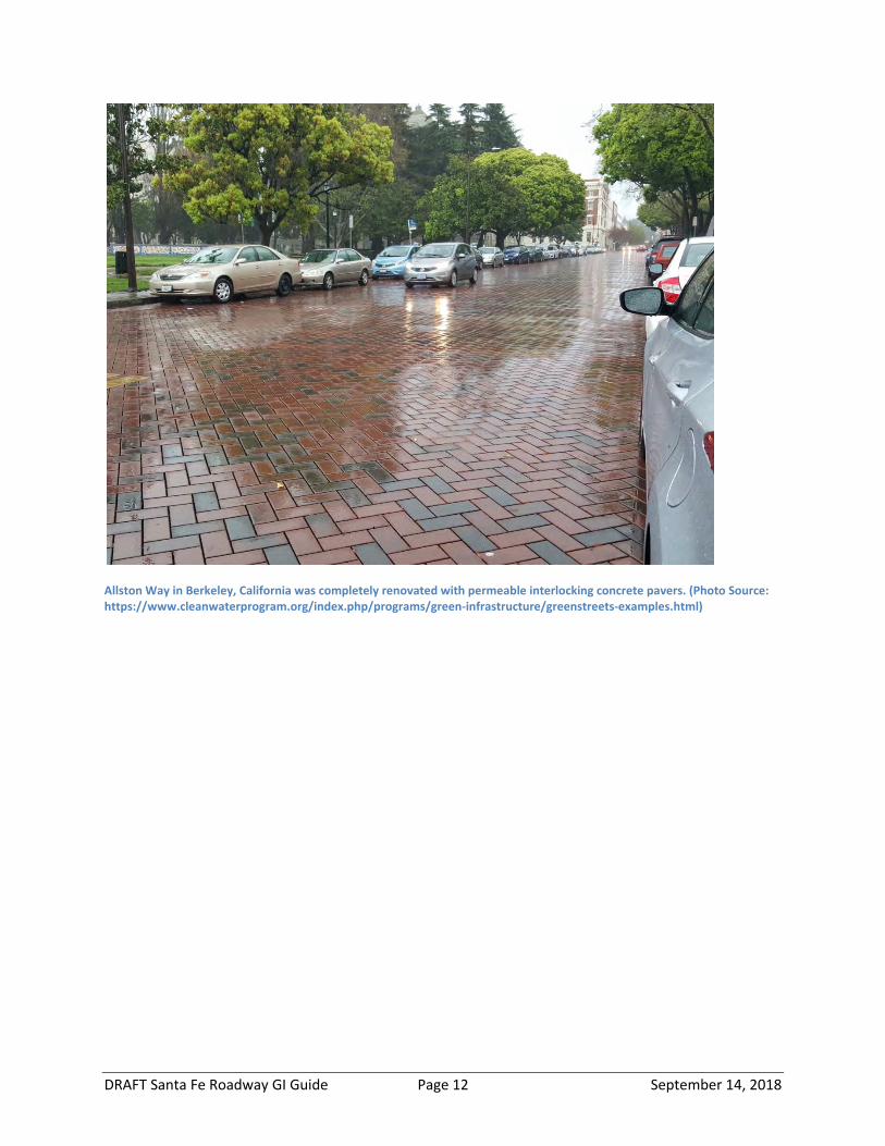
DRAFT Santa Fe Roadway GI Guide Page 12 September 14, 2018
Allston Way in Berkeley, California was completely renovated with permeable interlocking concrete pavers. (Photo Source: https://www.cleanwaterprogram.org/index.php/programs/green‐infrastructure/greenstreets‐examples.html)
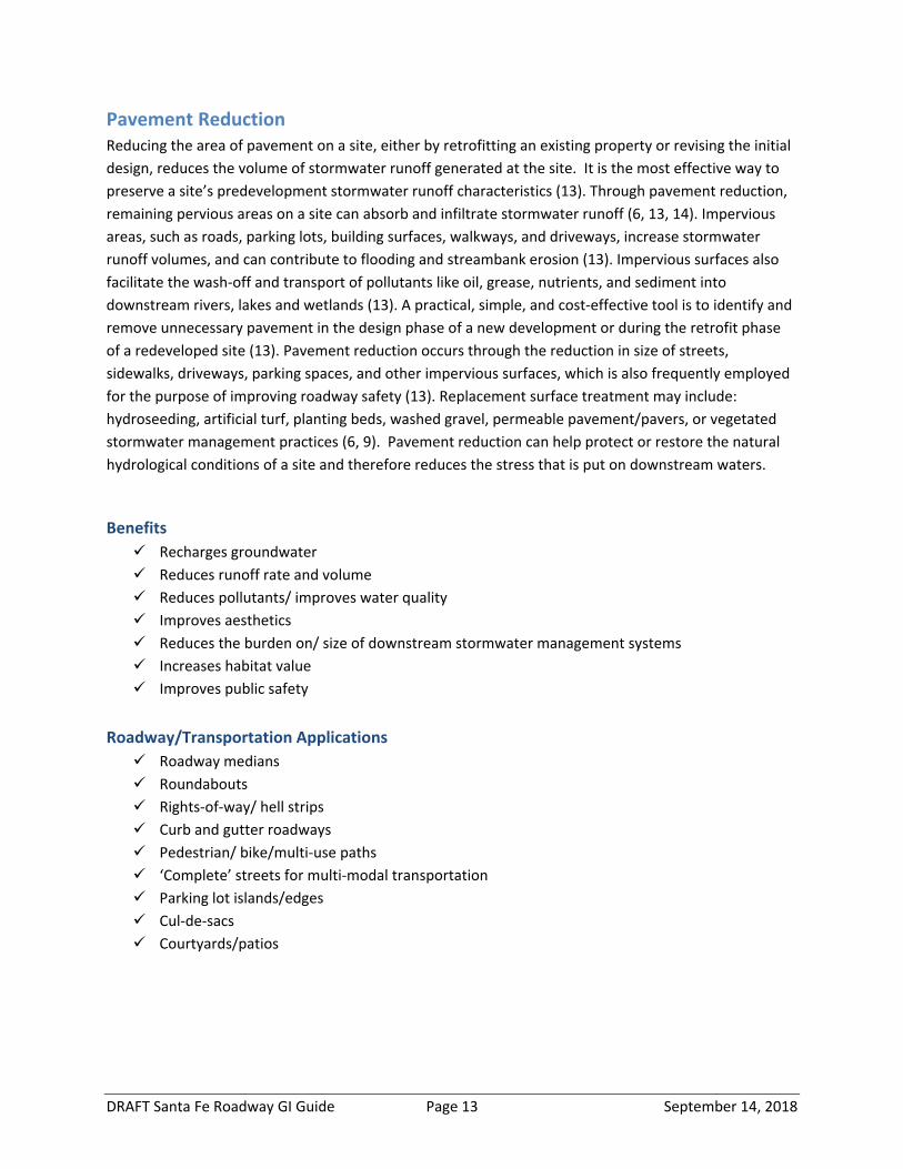
DRAFT Santa Fe Roadway GI Guide Page 13 September 14, 2018
Pavement Reduction Reducing the area of pavement on a site, either by retrofitting an existing property or revising the initial design, reduces the volume of stormwater runoff generated at the site. It is the most effective way to preserve a site’s predevelopment stormwater runoff characteristics (13). Through pavement reduction, remaining pervious areas on a site can absorb and infiltrate stormwater runoff (6, 13, 14). Impervious areas, such as roads, parking lots, building surfaces, walkways, and driveways, increase stormwater runoff volumes, and can contribute to flooding and streambank erosion (13). Impervious surfaces also facilitate the wash‐off and transport of pollutants like oil, grease, nutrients, and sediment into downstream rivers, lakes and wetlands (13). A practical, simple, and cost‐effective tool is to identify and remove unnecessary pavement in the design phase of a new development or during the retrofit phase of a redeveloped site (13). Pavement reduction occurs through the reduction in size of streets, sidewalks, driveways, parking spaces, and other impervious surfaces, which is also frequently employed for the purpose of improving roadway safety (13). Replacement surface treatment may include: hydroseeding, artificial turf, planting beds, washed gravel, permeable pavement/pavers, or vegetated stormwater management practices (6, 9). Pavement reduction can help protect or restore the natural hydrological conditions of a site and therefore reduces the stress that is put on downstream waters.
Benefits Recharges groundwater Reduces runoff rate and volume Reduces pollutants/ improves water quality Improves aesthetics Reduces the burden on/ size of downstream stormwater management systems Increases habitat value Improves public safety
Roadway/Transportation Applications Roadway medians Roundabouts Rights‐of‐way/ hell strips Curb and gutter roadways Pedestrian/ bike/multi‐use paths ‘Complete’ streets for multi‐modal transportation Parking lot islands/edges Cul‐de‐sacs Courtyards/patios

DRAFT Santa Fe Roadway GI Guide Page 14 September 14, 2018
Design considerations Relies on small, distributed onsite practices Reduces area available for parking, travel lanes
(14)
Narrow Streets
Reduce street widths and improve traffic safety where feasible by eliminating underutilized on‐street parking or reducing lane width
Largely applicable in residential neighborhood roads. Local public works, police and fire departments, and residents who fear losing parking spaces
and accessibility may object to narrower streets. (6, 13)
Slimmer Sidewalks
Install sidewalks on one side of roads or combine them with multi‐use paths located in backyard easements or natural areas where suitable to meet pedestrian needs. Whenever possible, these paths should be made of pervious materials.
Use alternative development designs, such as cluster development, to reduce the length of roads, sidewalks, and other impervious areas. (6)
Right Sized Cul‐de‐sacs
Minimize the diameter of residential street cul‐de‐sacs, consider hammerhead turnarounds or loop roads and/or incorporate landscaped islands. (13)
Right Sized Parking Lots
Evaluate parking requirements considering average demand as well as peak demand. Consider the application of smaller parking stalls and/or compact parking spaces. Analyze parking lot layout to evaluate the applicability of narrowed traffic lanes and slanted
parking stalls. Where appropriate, minimize impervious parking area by utilizing overflow parking areas
constructed of pervious paving materials. Encourage shared parking arrangements with adjacent land uses. Enable owners/developers to provide proof of parking for required number of parking spaces
while constructing only those that the owner/developer demonstrates are necessary. (10, 13)
Pretreatment Not applicable
Construction considerations Not applicable
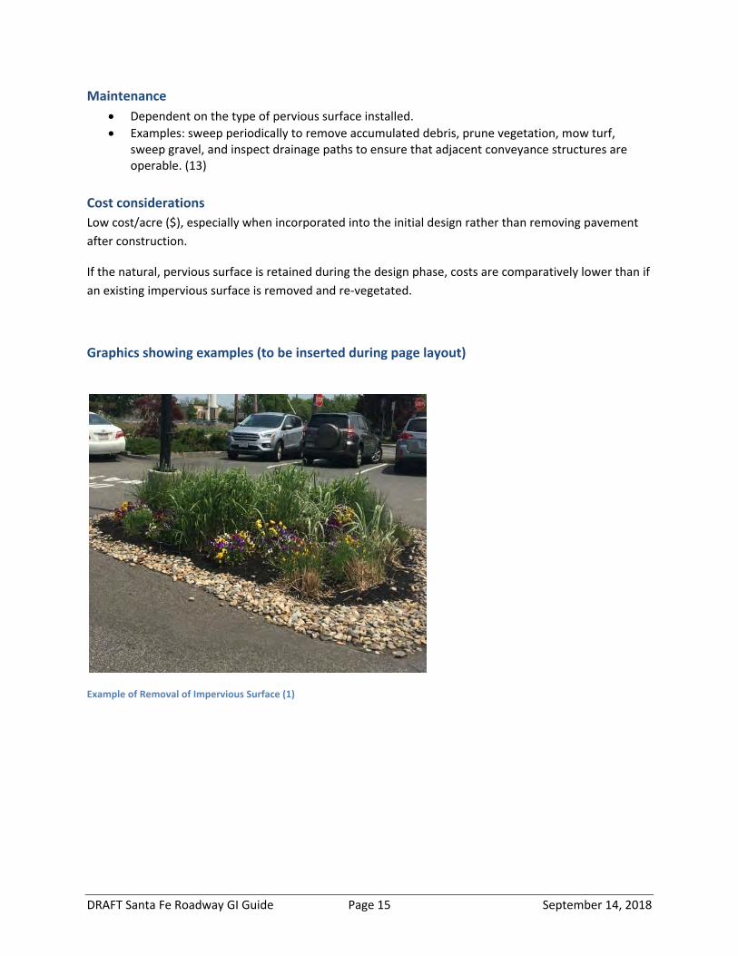
DRAFT Santa Fe Roadway GI Guide Page 15 September 14, 2018
Maintenance Dependent on the type of pervious surface installed. Examples: sweep periodically to remove accumulated debris, prune vegetation, mow turf,
sweep gravel, and inspect drainage paths to ensure that adjacent conveyance structures are operable. (13)
Cost considerations Low cost/acre ($), especially when incorporated into the initial design rather than removing pavement after construction.
If the natural, pervious surface is retained during the design phase, costs are comparatively lower than if an existing impervious surface is removed and re‐vegetated.
Graphics showing examples (to be inserted during page layout)
Example of Removal of Impervious Surface (1)
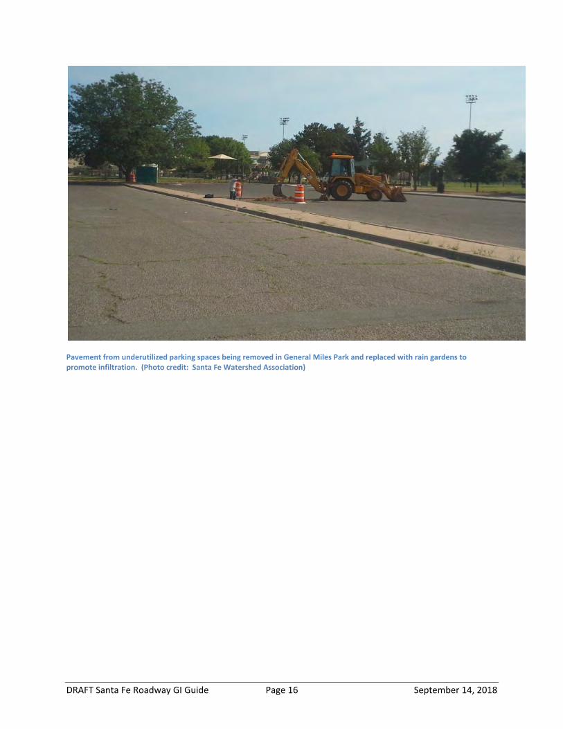
DRAFT Santa Fe Roadway GI Guide Page 16 September 14, 2018
Pavement from underutilized parking spaces being removed in General Miles Park and replaced with rain gardens to promote infiltration. (Photo credit: Santa Fe Watershed Association)
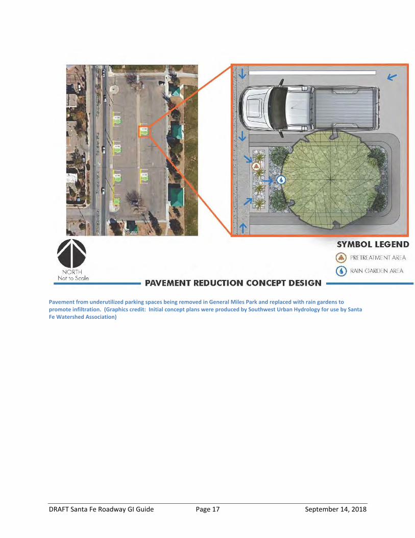
DRAFT Santa Fe Roadway GI Guide Page 17 September 14, 2018
Pavement from underutilized parking spaces being removed in General Miles Park and replaced with rain gardens to promote infiltration. (Graphics credit: Initial concept plans were produced by Southwest Urban Hydrology for use by Santa Fe Watershed Association)
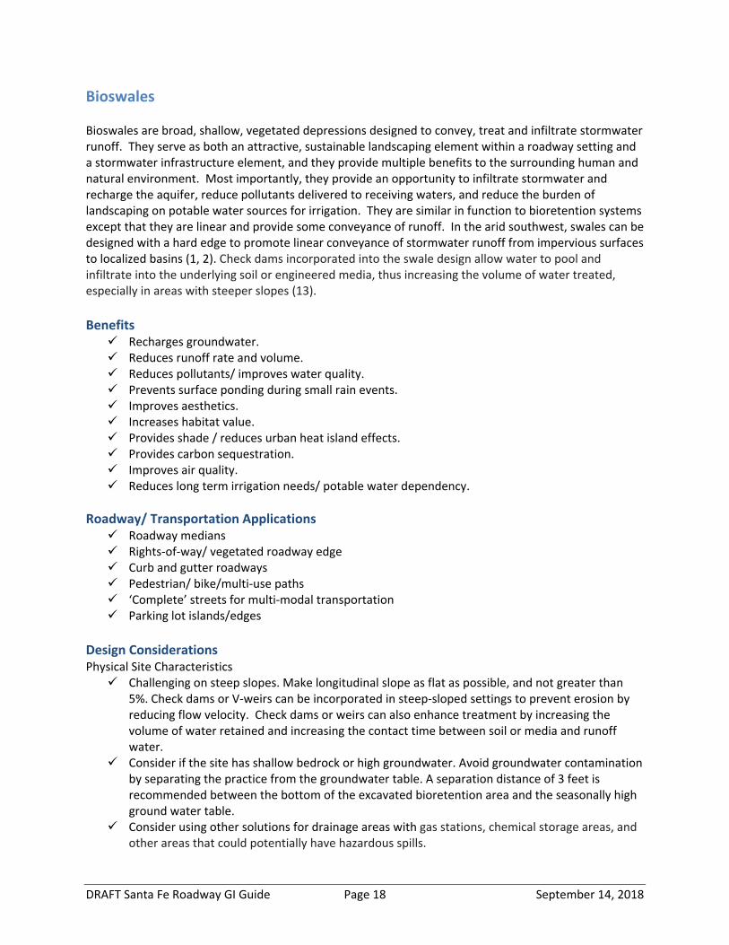
DRAFT Santa Fe Roadway GI Guide Page 18 September 14, 2018
Bioswales Bioswales are broad, shallow, vegetated depressions designed to convey, treat and infiltrate stormwater runoff. They serve as both an attractive, sustainable landscaping element within a roadway setting and a stormwater infrastructure element, and they provide multiple benefits to the surrounding human and natural environment. Most importantly, they provide an opportunity to infiltrate stormwater and recharge the aquifer, reduce pollutants delivered to receiving waters, and reduce the burden of landscaping on potable water sources for irrigation. They are similar in function to bioretention systems except that they are linear and provide some conveyance of runoff. In the arid southwest, swales can be designed with a hard edge to promote linear conveyance of stormwater runoff from impervious surfaces to localized basins (1, 2). Check dams incorporated into the swale design allow water to pool and infiltrate into the underlying soil or engineered media, thus increasing the volume of water treated, especially in areas with steeper slopes (13). Benefits Recharges groundwater. Reduces runoff rate and volume. Reduces pollutants/ improves water quality. Prevents surface ponding during small rain events. Improves aesthetics. Increases habitat value. Provides shade / reduces urban heat island effects. Provides carbon sequestration. Improves air quality. Reduces long term irrigation needs/ potable water dependency.
Roadway/ Transportation Applications Roadway medians Rights‐of‐way/ vegetated roadway edge Curb and gutter roadways Pedestrian/ bike/multi‐use paths ‘Complete’ streets for multi‐modal transportation Parking lot islands/edges
Design Considerations Physical Site Characteristics Challenging on steep slopes. Make longitudinal slope as flat as possible, and not greater than
5%. Check dams or V‐weirs can be incorporated in steep‐sloped settings to prevent erosion by reducing flow velocity. Check dams or weirs can also enhance treatment by increasing the volume of water retained and increasing the contact time between soil or media and runoff water.
Consider if the site has shallow bedrock or high groundwater. Avoid groundwater contamination by separating the practice from the groundwater table. A separation distance of 3 feet is recommended between the bottom of the excavated bioretention area and the seasonally high ground water table.
Consider using other solutions for drainage areas with gas stations, chemical storage areas, and other areas that could potentially have hazardous spills.
DRAFT Santa Fe Roadway GI Guide Page 19 September 14, 2018
Design Elements Consider amount of nearby pedestrian activity and provide walkways or bridges across the
practice if needed to allow for unimpeded movement. Design to avoid conflicts to subsurface utilities. Install appropriate erosion and flow dissipaters at the entry and exit points of the swale.
Soils Soils must have a suitable infiltration rate (>0.5 inches/hour). If the infiltration rate is low (<0.5
inches/hour) consider including a perforated underdrain connected to the drainage network to reduce overflows and increase safety. Other alternatives include amending soils, installing a minimum 12” sand layer under the basin, or using a dry swale with engineering media instead.
Not suitable for highly erodible soils. Soils must be native or amended soils suitable to sustain the selected vegetation.
Vegetation Vegetation should be native, drought tolerant, salt tolerant, and able to withstand periodic
inundation. (1, 2, 8, 12, 13) Pretreatment
Sediment forebay, vegetated filter strips/side slopes, water quality inlets. Bioswales can also serve as pretreatment to a bioretention or bioinfiltration system (12, 13).
Construction considerations
Do not over‐compact basin soils, where relying on existing soils for infiltration. Compaction can reduce infiltration rates by increasing bulk density of the soil. Avoid using heavy equipment directly on bioswale soils during site preparation and construction.
Identify appropriate materials and specify times for inspection and approval. During construction, avoid use sediment and erosion control measures to prevent
sedimentation from upgradient construction activities to avoid clogging of the swale. When practical, complete upgradient work prior to swale installation. (1, 13)
Maintenance
Inspect at least annually for adequate perennial vegetation coverage, erosion and degradation of side slopes.
Remove sediment, trash and dead vegetation at inlets and outlets to avoid clogging. Manage vegetation by regular weeding, pruning, removing invasive species, and revegetating as
needed. (1, 12, 13, 14)
Cost considerations
Low to moderate cost/acre ($$) (1). Potentially less expensive installation costs than expensive curb and gutter systems (13).
Graphics showing examples (to be inserted during page layout)
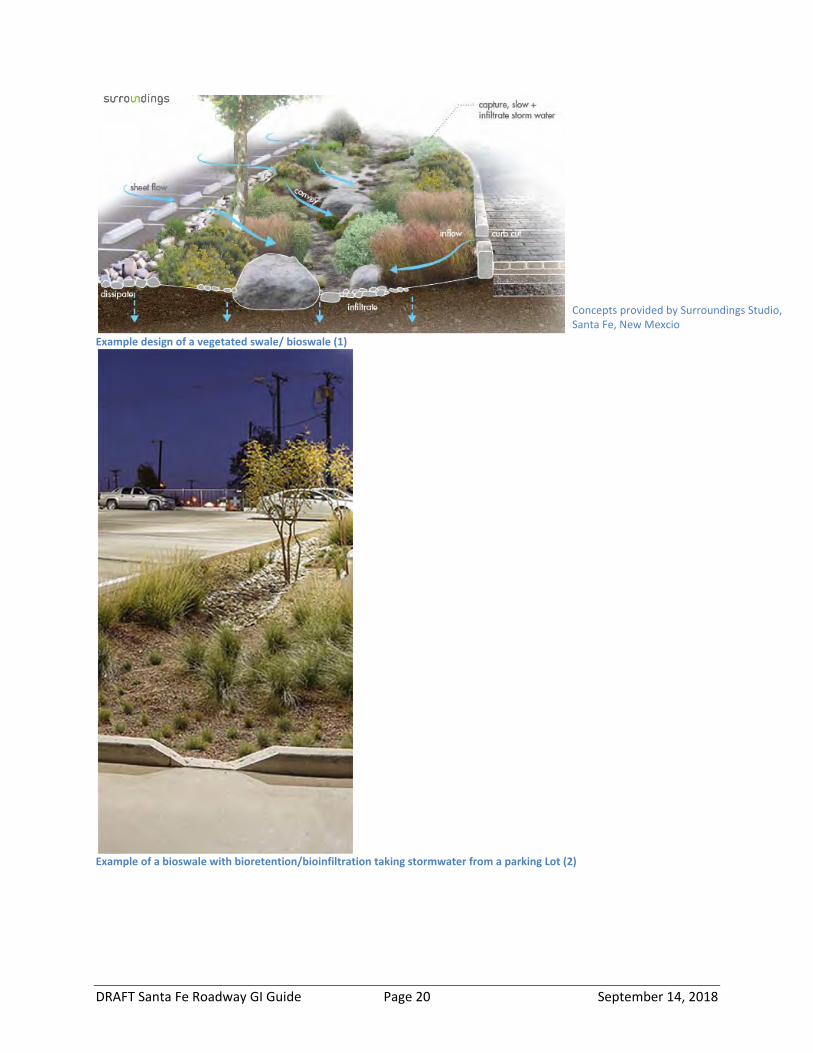
DRAFT Santa Fe Roadway GI Guide Page 20 September 14, 2018
Example design of a vegetated swale/ bioswale (1)
Example of a bioswale with bioretention/bioinfiltration taking stormwater from a parking Lot (2)
Concepts provided by Surroundings Studio, Santa Fe, New Mexcio

DRAFT Santa Fe Roadway GI Guide Page 21 September 14, 2018
Bioretention System
A bioretention system is a shallow landscape depression sited at a low point and designed to collect and treat (and sometimes infiltrate) stormwater runoff (1, 2). It serves as both an aesthetically pleasing, sustainable landscaping element within a roadway setting and a stormwater infrastructure element, and it provides multiple benefits to the surrounding human and natural environment. Most importantly, bioretention systems provide an opportunity to retain or infiltrate stormwater and recharge the aquifer, reduce pollutants delivered to receiving waters, and reduce the burden of landscaping on potable water sources for irrigation. Bioretention practices are typically designed for water quality treatment through filtration, biological uptake and microbial activity (1, 2, 9). With adequate space, they can provide some flood storage (9). They can also be designed for double duty as roadway bump‐outs that provide traffic calming and improve pedestrian safety by reducing the length of cross‐walks.
Benefits Recharges groundwater. Prevents surface ponding during small rain events, but must include an overflow mechanism to
accommodate heavy rainfall events. Reduces pollutants/ improves water quality. Improves aesthetics. Increases habitat value. Provides shade / reduces urban heat island effects. Provides carbon sequestration. Improves air quality. Reduces long term irrigation needs/ potable water dependency.
Roadway/Transportation Applications Roadway medians Roundabouts Rights‐of‐way/ vegetated roadway edge Curb and gutter roadways Pedestrian sidewalks/ bike/multi‐use paths ‘Complete’ streets for multi‐modal transportation Parking lot islands/edges Cul‐de‐sacs Courtyards/patios
Design considerations Physical Site Characteristics Challenging on steep slopes. Incorporate diversion berms, check dams, or terraces so bottom is
relatively flat sloped (1‐5%). Consider if the site has shallow bedrock or high groundwater. Use in areas where porous
underground material (i.e. tuff) is at least 18” below the bottom of the practice (1). Avoidgroundwater contamination by separating the practice from the groundwater table. Aseparation distance of 2 feet is recommended between the bottom of the excavatedbioretention area and the seasonally high ground water table.
Consider potential groundwater contamination. Consider using other solutions for drainageareas with gas stations, chemical storage areas, and other areas that could potentially have

DRAFT Santa Fe Roadway GI Guide Page 22 September 14, 2018
hazardous spills. Consider the drainage area. The practice typically serves a highly impervious area less than 2
acres in size, and the surface area of the practice should be approximately 3‐6% of thecontributing drainage area. Sediment trap or forebay should be sized to contain 5 percent ofthe total detention volume.
Design Elements Top elevation of sediment trap interior wall should be a minimum of 4” below gutter inlet
elevation. Interior wall at planting area should be a maximum 4” below gutter inlet elevation. Consider amount of nearby pedestrian activity and provide walkways or bridges across the
practice if needed to allow for unimpeded movement. Design to avoid conflicts to subsurface utilities.
Soils Soils must have a suitable infiltration rate (>0.5 inches/hour). If the infiltration rate is low (<0.5
inches/hour) consider amending soils, including an underdrain to allow overflow, or installing aminimum 12” sand layer under the basin.
Reduce soil compaction by either mixing with soil amendments or replacing with structural soilsor other suitable soil media.
Soils must be suitable to sustain the selected plantings. In general, tree soils require moremoisture holding capacity than soils that support herbaceous plants or xeriscape.
Vegetation Vegetation should be drought tolerant, able to withstand periodic inundation, and salt tolerant. Planting zone should be stabilized with 3” depth of shredded wood or rock mulch (crushed rock,
pea gravel, or small stones).(1, 3, 4, 6, 9, 13, 18)
Pretreatment Sediment forebay/sediment trap, bioswale, gravel or stone diaphragm.
Construction considerations Where relying on existing soils for infiltration, do not over‐compact basin soils. Compaction can
reduce infiltration rates by increasing bulk density of the soil. Identify appropriate materials and hold points for inspection and approval.
Ensure maintenance access is included in the design and construction of the practice.(1, 13)
Maintenance Inspect for the following at least annually, and repair as needed:
o adequate perennial vegetation coverage; erosion; degradation of check dams andothers structures; debris, trash and sediment accumulations; and to ensure runoff flowsthrough the full length of the practice
Prune trees and shrubs, remove dead vegetation, and remove plantings as needed to avoidovercrowding.
Check for and remove invasive species. Do not mow vegetation.

DRAFT Santa Fe Roadway GI Guide Page 23 September 14, 2018
Remove sediment from the forebay regularly. Remove trash and dead vegetation regularly. Stabilize any areas to prevent erosion. If soils become compacted, turn or till soils.(1)
Cost Considerations Low cost/acre for rural applications ($‐$$). Can be moderate to high for urban locations ($$$).
(1)
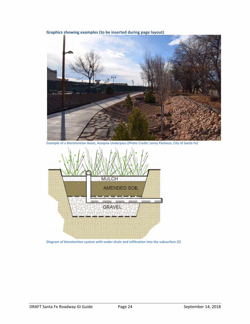
DRAFT Santa Fe Roadway GI Guide Page 24 September 14, 2018
Graphics showing examples (to be inserted during page layout)
Example of a Bioretention Basin, Acequia Underpass (Photo Credit: Leroy Pacheco, City of Santa Fe)
Diagram of bioretention system with under‐drain and infiltration into the subsurface (2)
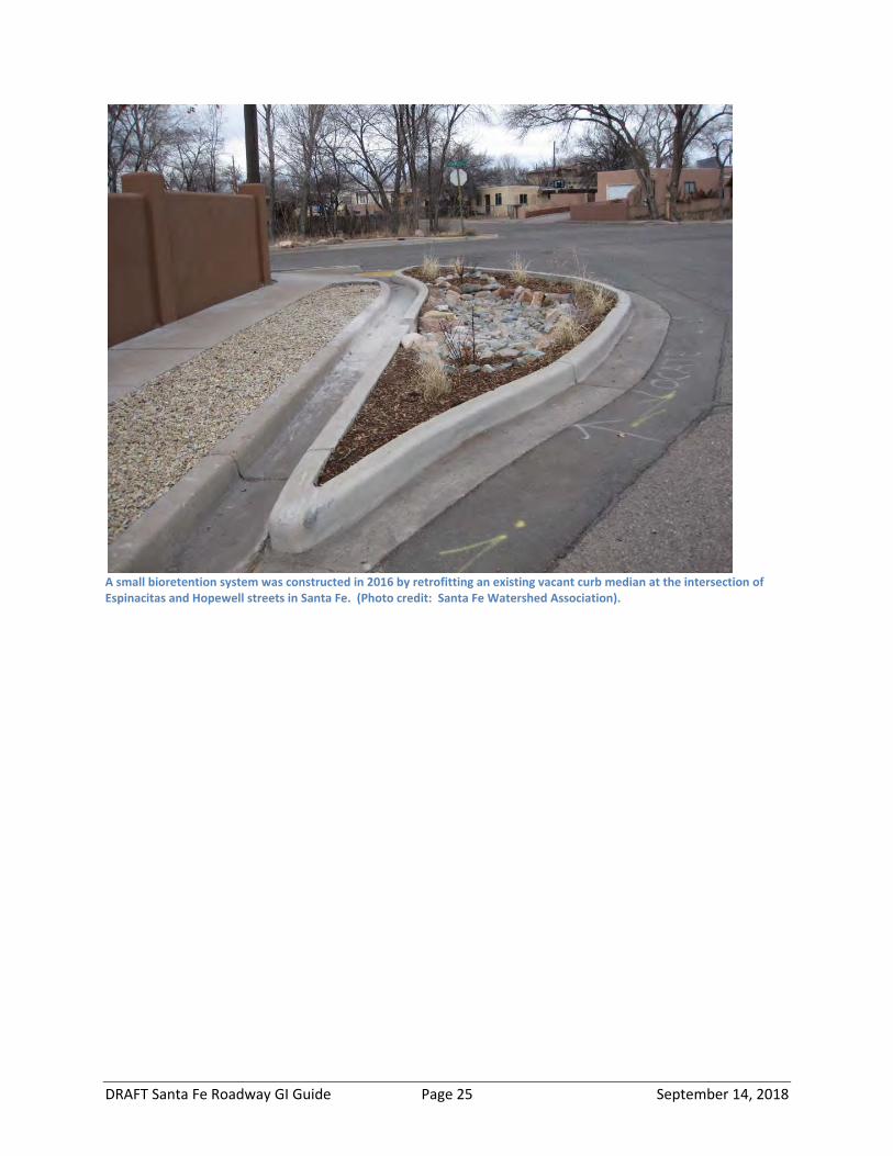
DRAFT Santa Fe Roadway GI Guide Page 25 September 14, 2018
A small bioretention system was constructed in 2016 by retrofitting an existing vacant curb median at the intersection of Espinacitas and Hopewell streets in Santa Fe. (Photo credit: Santa Fe Watershed Association).
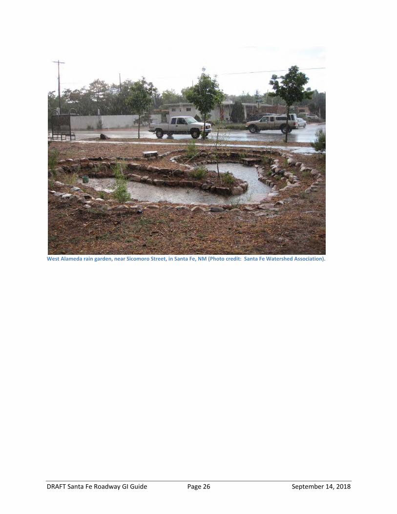
DRAFT Santa Fe Roadway GI Guide Page 26 September 14, 2018
West Alameda rain garden, near Sicomoro Street, in Santa Fe, NM (Photo credit: Santa Fe Watershed Association).
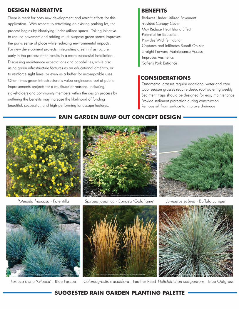
DESIGN NARRATIVEThere is merit for both new development and retrofit efforts for this
application. With respect to retrofitting an existing parking lot, the
the parks sense of place while reducing environmental impacts.
For new development projects, integrating green infrastructure
process begins by identifying under utilized space. Taking initiative
to reduce pavement and adding multi-purpose green space improves
Discussing maintenace expectations and capabilities, while also
using green infrastructure features as an educational amentity, or
to reinforce sight lines, or even as a buffer for incompatible uses.
Often times green infrastructure is value-engineered out of public
improvements projects for a multitude of reasons. Including
stakeholders and community members within the design process by
outlining the benefits may increase the likelihood of funding
beautiful, successful, and high-performing landscape features.
early in the process often results in a more successful installation.
Reduces Under Utilized PavementProvides Canopy CoverMay Reduce Heat Island EffectPotential for EducationProvides Wildlife HabitatCaptures and Infiltrates Runoff On-site
Straight Forward Maintenance Access
Improves AestheticsSoftens Park Entrance
BENEFITS
Ornamental grasses require additional water and careCool season grasses require deep, root watering weeklySediment traps should be designed for easy maintenanceProvide sediment protection during constructionRemove silt from surface to improve drainage
CONSIDERATIONS
Potentilla fruticosa - Potentilla Spiraea japonica - Spiraea ‘Goldflame’
Calamagrostis x acutiflora - Feather ReedFestuca ovina ‘Glauca’ - Blue Fescue
Juniperus sabina - Buffalo Juniper
Helictotrichon semperirens - Blue Oatgrass
SUGGESTED RAIN GARDEN PLANTING PALETTE
RAIN GARDEN BUMP OUT CONCEPT DESIGN
https://vancouverislandgrows.wordpress.com/2016/06/21/potentilla-fruticosa/ http://mikesbackyardnursery.com/2015/12/gold-flame-spirea-growing-selling-and-propagating-this-awesome-plant/ https://simgreen.ro/categorii/amenajari-spatii-verzi/plante/juniperus-sabina-tamariscifolia.html
https://www.seedsforafrica.co.za/products/blue-fescue-grass-festuca-ovina-glauca-exotic-ornamental-grass-20-seeds https://plantright.org/better-plants/calamagrostis-x-acutiflora-karl-foerster/ https://www.planta.nl/webshop/planten/grassen/helictotrichon-sempervirens
NORTHNot to Scale
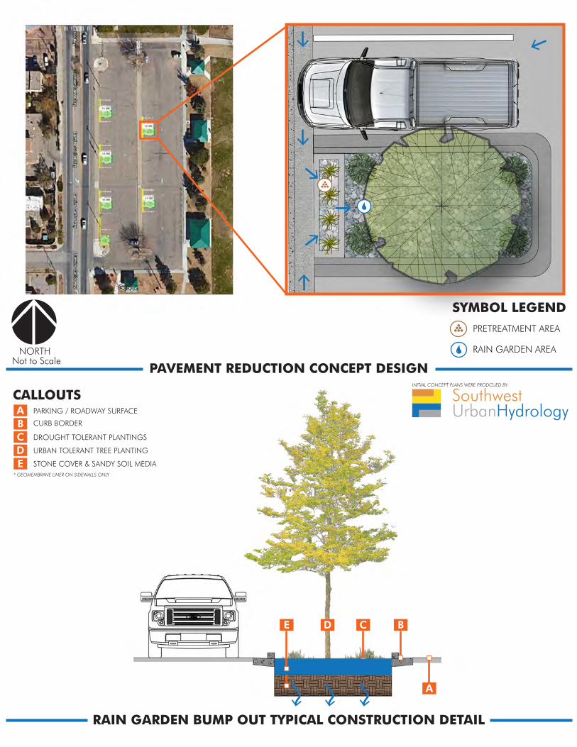
LP
HP
POROUS PAVEMENT
SYMBOL LEGEND
PRETREATMENT AREA
BIORETENTION AREA
LOW POINT
HIGH POINT
CONCEPTUAL CONTOURS
BIORETENTION CONCEPT DESIGN
RAIN GARDEN BUMP OUT TYPICAL CONSTRUCTION DETAIL
ABCDE
A
BCE D
PARKING / ROADWAY SURFACE
CURB BORDER
DROUGHT TOLERANT PLANTINGS
URBAN TOLERANT TREE PLANTING
STONE COVER & SANDY SOIL MEDIA* GEOMEMBRANE LINER ON SIDEWALLS ONLY
INITIAL CONCEPT PLANS WERE PRODCUED BY:
PAVEMENT REDUCTION CONCEPT DESIGN
CALLOUTS
NORTHNot to Scale
SYMBOL LEGENDPRETREATMENT AREA
RAIN GARDEN AREA
SouthwestUrbanHydrology
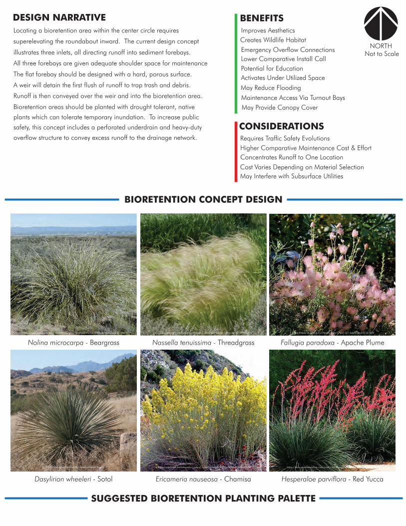
DESIGN NARRATIVELocating a bioretention area within the center circle requires
superelevating the roundabout inward. The current design concept
The flat forebay should be designed with a hard, porous surface.
A weir will detain the first flush of runoff to trap trash and debris.
illustrates three inlets, all directing runoff into sediment forebays.
All three forebays are given adequate shoulder space for maintenance
Bioretention areas should be planted with drought tolerant, native
plants which can tolerate temporary inundation. To increase public
safety, this concept includes a perforated underdrain and heavy-duty
overflow structure to convey excess runoff to the drainage network.
Runoff is then conveyed over the weir and into the bioretention area.
Improves AestheticsCreates Wildlife HabitatEmergency Overflow ConnectionsLower Comparative Install CallPotential for EducationActivates Under Utilized Space
May Reduce Flooding
Maintenance Access Via Turnout BaysMay Provide Canopy Cover
BENEFITS
Higher Comparative Maintenance Cost & EffortConcentrates Runoff to One Location
Requires Traffic Safety Evolutions
Cost Varies Depending on Material SelectionMay Interfere with Subsurface Utilities
CONSIDERATIONS
Nolina microcarpa - Beargrass Nassella tenuissima - Threadgrass
Ericameria nauseosa - ChamisaDasylirion wheeleri - Sotol
Fallugia paradoxa - Apache Plume
Hesperaloe parviflora - Red Yucca
SUGGESTED BIORETENTION PLANTING PALETTE
BIORETENTION CONCEPT DESIGN
http://www.public.asu.edu/~camartin/plants/Plant%20html%20files/nolinamicrocarpa.html https://www.amazon.com/Nassella-tenuissima-Mexican-Feather-Grass/dp/B01MTN9UHJ https://www.studyblue.com/notes/note/n/hort-321-lab-8/deck/3181976
https://www.yuccado.com/dasylirion-wheeleri.html https://calphotos.berkeley.edu/cgi/img_query?enlarge=0000+0000+0403+0684 https://www.smartseedstore.com/products/hesperaloe-parviflora-texas-red-yucca
NORTHNot to Scale
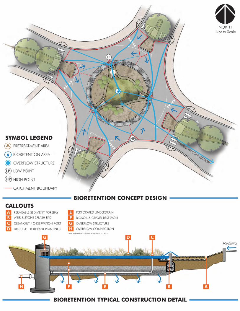
LP
HP
LP
HP
SYMBOL LEGENDPRETREATMENT AREA
BIORETENTION AREA
OVERFLOW CONNECTIONOVERFLOW STRUCTURE
LOW POINT
HIGH POINT
CATCHMENT BOUNDARY
BIORETENTION CONCEPT DESIGN
BIORETENTION TYPICAL CONSTRUCTION DETAIL
ABCD
E
GH
ABEF
CDG
H
PERMEABLE SEDIMENT FOREBAY
WEIR & STONE SPLASH PAD
CLEANOUT / OBSERVATION PORT
DROUGHT TOLERANT PLANTINGS
PERFORATED UNDERDRAIN
ROADWAY
F BIOSOIL & GRAVEL RESERVOIR
OVERFLOW STRUCTURE
OVERFLOW CONNECTION* GEOMEMBRANE LINER ON SIDEWALLS ONLY
CALLOUTS
NORTHNot to Scale
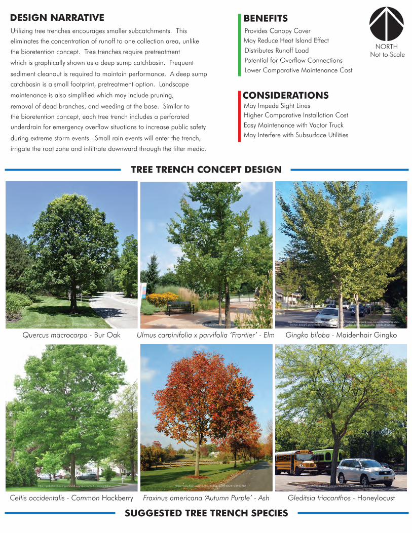
Provides Canopy CoverMay Reduce Heat Island EffectDistributes Runoff LoadPotential for Overflow ConnectionsLower Comparative Maintenance Cost
BENEFITS
May Impede Sight LinesHigher Comparative Installation CostEasy Maintenance with Vactor TruckMay Interfere with Subsurface Utilities
CONSIDERATIONS
DESIGN NARRATIVEUtilizing tree trenches encourages smaller subcatchments. This
eliminates the concentration of runoff to one collection area, unlike
sediment cleanout is required to maintain performance. A deep sump
catchbasin is a small footprint, pretreatment option. Landscape
the bioretention concept. Tree trenches require pretreatment
which is graphically shown as a deep sump catchbasin. Frequent
removal of dead branches, and weeding at the base. Similar to
the bioretention concept, each tree trench includes a perforated
underdrain for emergency overflow situations to increase public safety
during extreme storm events. Small rain events will enter the trench,
irrigate the root zone and infiltrate downward through the filter media.
maintenance is also simplified which may include pruning,
SUGGESTED TREE TRENCH SPECIES
TREE TRENCH CONCEPT DESIGN
Gleditsia triacanthos - HoneylocustFraxinus americana ‘Autumn Purple’ - AshCeltis occidentalis - Common Hackberry
Gingko biloba - Maidenhair GingkoUlmus carpinifolia x parvifolia ‘Frontier’ - ElmQuercus macrocarpa - Bur Oak
https://gobotany.newenglandwild.org/species/celtis/occidentalis/ https://www.flickr.com/photos/47344322@N06/5104967686 https://www.chicagobotanic.org/plantinfo/tree_alternatives/skyline_honeylocust
http://niavisdesign.com/popular-landscaping-trees/popular-front-yard-trees-home-decorating-ideas-kitchen-designs-pictures-landscaping-2017-most-ginkgo-biloba-tree-on-the-beside-street-and/http://plants.echters.com/12130005/Plant/378/Bur_Oak/ http://www.hesslandscapenursery.com/plant_library/plant/2932/ulmus-carp-x-parvifolia-frontier/
NORTHNot to Scale
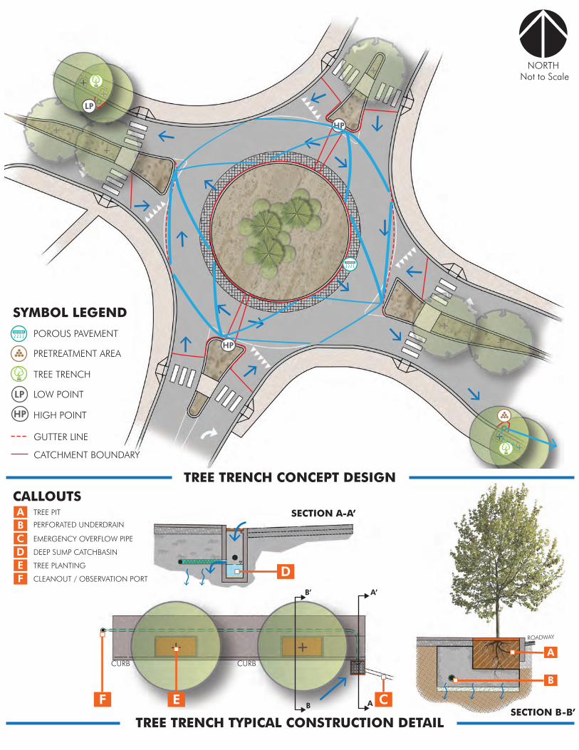
TREE TRENCH CONCEPT DESIGN
LP
LP
HP
POROUS PAVEMENT
SYMBOL LEGEND
PRETREATMENT AREA
TREE TRENCH
LOW POINT
HIGH POINT
CATCHMENT BOUNDARY
GUTTER LINE
HP
HP
ROADWAY
A
B
TREE TRENCH TYPICAL CONSTRUCTION DETAIL
SECTION A-A’
SECTION B-B’
ABCD
TREE PIT
PERFORATED UNDERDRAIN
EMERGENCY OVERFLOW PIPE
DEEP SUMP CATCHBASIN
E TREE PLANTING
F CLEANOUT / OBSERVATION PORT
CALLOUTS
CURBCURB
C
A’
A
B’
BEF
D
NORTHNot to Scale
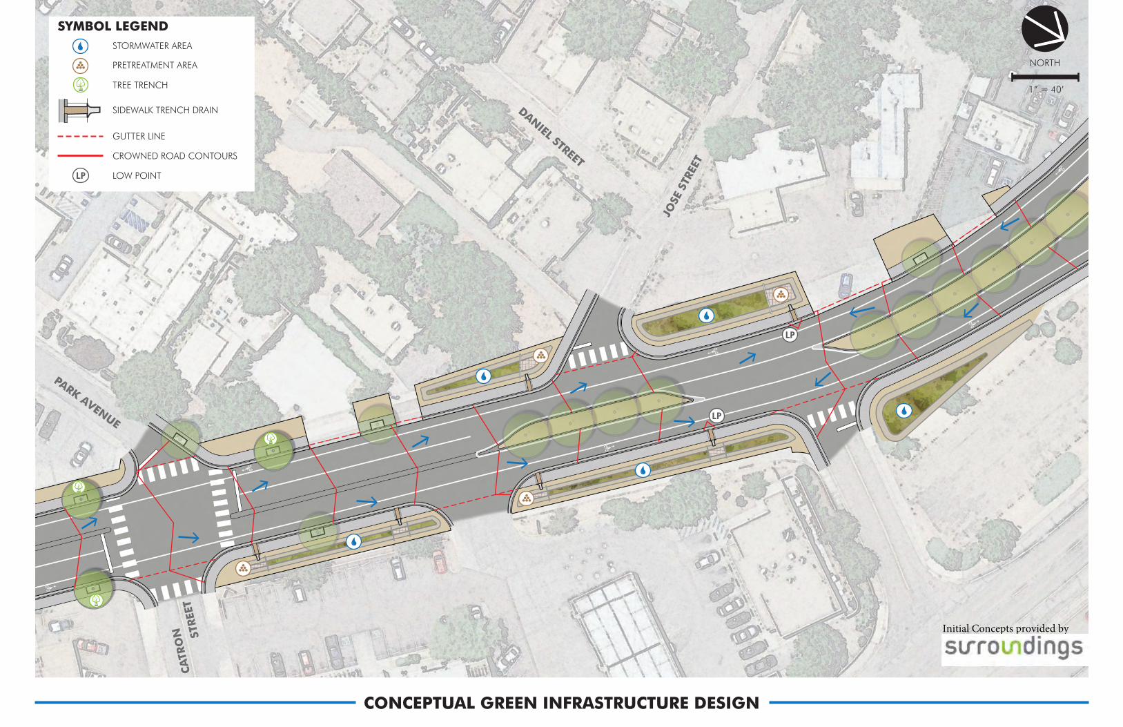
CONCEPTUAL GREEN INFRASTRUCTURE DESIGN
SYMBOL LEGENDSTORMWATER AREA
PRETREATMENT AREA
TREE TRENCH
SIDEWALK TRENCH DRAIN
GUTTER LINE
CROWNED ROAD CONTOURS
LOW POINT
LP
LP
LP
NORTH
1” = 40’
CONCEPTUAL DRAINAGE NETWORK
JOSE
STR
EET
STREE
TCA
TRO
N
DANIEL STREET
PARK AVENUE
SYMBOL LEGENDDEEP SUMP CATCHBASIN
‘BUBBLER’ STRUCTURE
OVERFLOW STRUCTURE
DIVERSION DRAIN MANHOLE
PERFORATED RECHARGE BASIN
EMERGENCY OVERFLOW PIPE
HIGH DENSITY DISTRIBUTION PIPE
PERFORATED UNDERDRAIN PIPE
Initial Concepts provided by
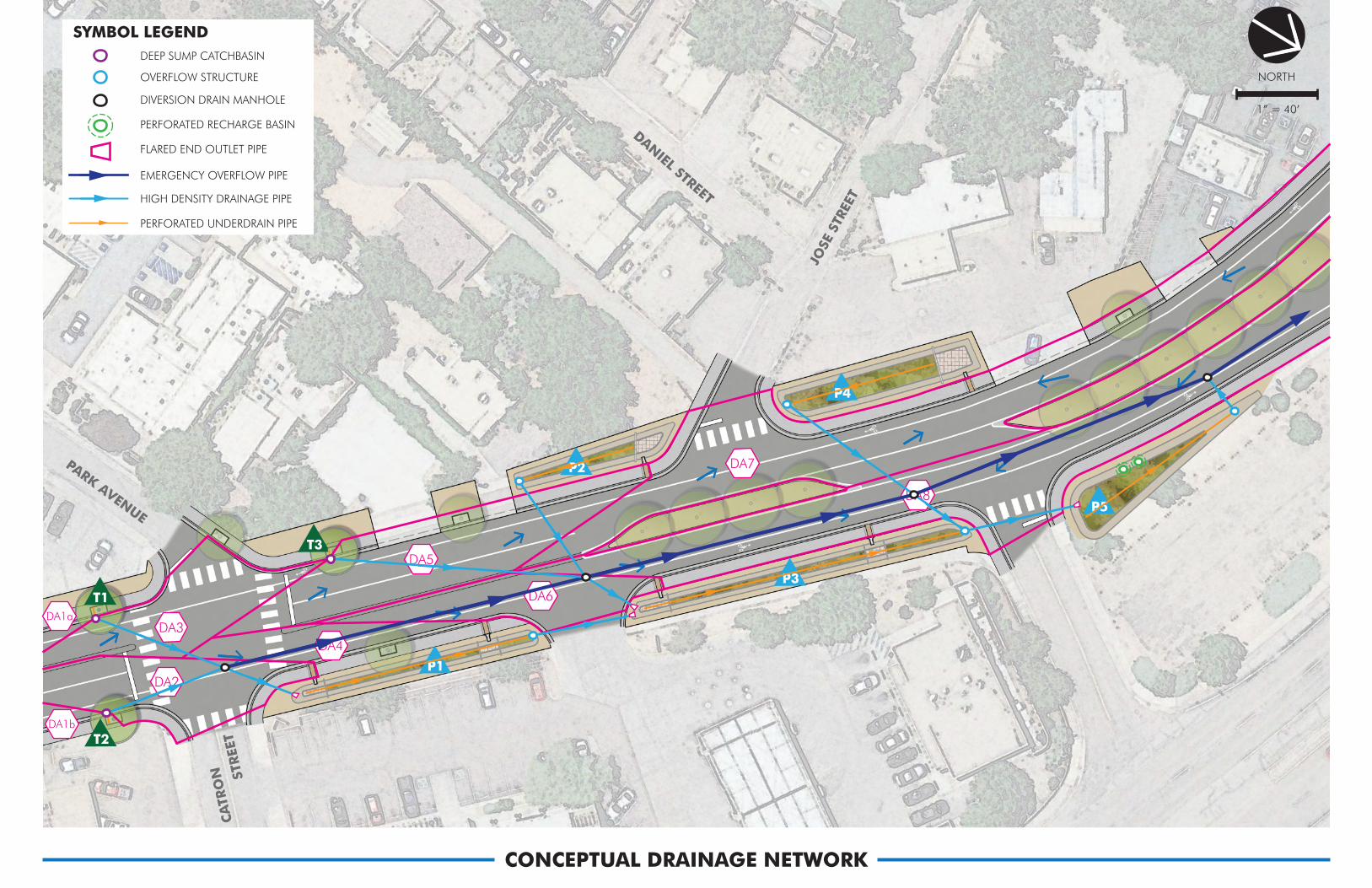
CONCEPTUAL GREEN INFRASTRUCTURE DESIGN
SYMBOL LEGENDSTORMWATER AREA
PRETREATMENT AREA
TREE TRENCH
SIDEWALK TRENCH DRAIN
GUTTER LINE
CROWNED ROAD CONTOURS
LOW POINT
LP
LP
LP
P4
T1
T2
T3
P1
P2
P3
P5
DA5
DA6
DA7
DA8
DA1b
DA1a
DA2
DA4DA3
NORTH
1” = 40’
CONCEPTUAL DRAINAGE NETWORK
JOSE
STR
EET
STREE
TCA
TRO
N
DANIEL STREET
PARK AVENUE
CONCEPTUAL DRAINAGE AREAS
SYMBOL LEGENDDEEP SUMP CATCHBASIN
OVERFLOW STRUCTURE
DIVERSION DRAIN MANHOLE
PERFORATED RECHARGE BASIN
FLARED END OUTLET PIPE
EMERGENCY OVERFLOW PIPE
HIGH DENSITY DRAINAGE PIPE
PERFORATED UNDERDRAIN PIPE
SYMBOL LEGEND
SYSTEM HYDROLOGY
TREE TRENCH COLLECTION AREA
BIORETENTION COLLECTION AREA
DRAINAGE SUBCATCHMENT AREA
SUBCATCHMENT BOUNDARY
T1
P1
DA1
T1 T2 T3
P1
P2
DA3DA1a DA1b
DA2 DA4
P3
DA6 DA8
DA5
P4
P5
DA7
PRIMARY FLOW PATH
PRIMARY OVERFLOW
DIVERTED RUNOFF

CONCEPTUAL GREEN INFRASTRUCTURE DESIGN
SYMBOL LEGENDSTORMWATER AREA
PRETREATMENT AREA
TREE TRENCH
SIDEWALK TRENCH DRAIN
GUTTER LINE
CROWNED ROAD CONTOURS
LOW POINT
LP
LP
LP
P4
T1
T2
T3
P1
P2
P3
P5
DA5
DA6
DA7
DA8
DA1b
DA1a
DA2
DA4DA3
NORTH
1” = 40’
CONCEPTUAL DRAINAGE NETWORK
JOSE
STR
EET
STREE
TCA
TRO
N
DANIEL STREET
PARK AVENUE
CONCEPTUAL DRAINAGE AREAS
SYMBOL LEGENDDEEP SUMP CATCHBASIN
‘BUBBLER’ STRUCTURE
OVERFLOW STRUCTURE
DIVERSION DRAIN MANHOLE
PERFORATED RECHARGE BASIN
EMERGENCY OVERFLOW PIPE
HIGH DENSITY DISTRIBUTION PIPE
PERFORATED UNDERDRAIN PIPE
SYMBOL LEGEND
SYSTEM HYDROLOGY
TREE TRENCH COLLECTION AREA
BIORETENTION COLLECTION AREA
DRAINAGE SUBCATCHMENT AREA
SUBCATCHMENT BOUNDARY
T1
P1
DA1
T1 T2 T3
P1
P2
DA3DA1a DA1b
DA2 DA4
P3
DA6 DA8
DA5
P4
P5
DA7
PRIMARY FLOW PATH
PRIMARY OVERFLOW
DIVERTED RUNOFF
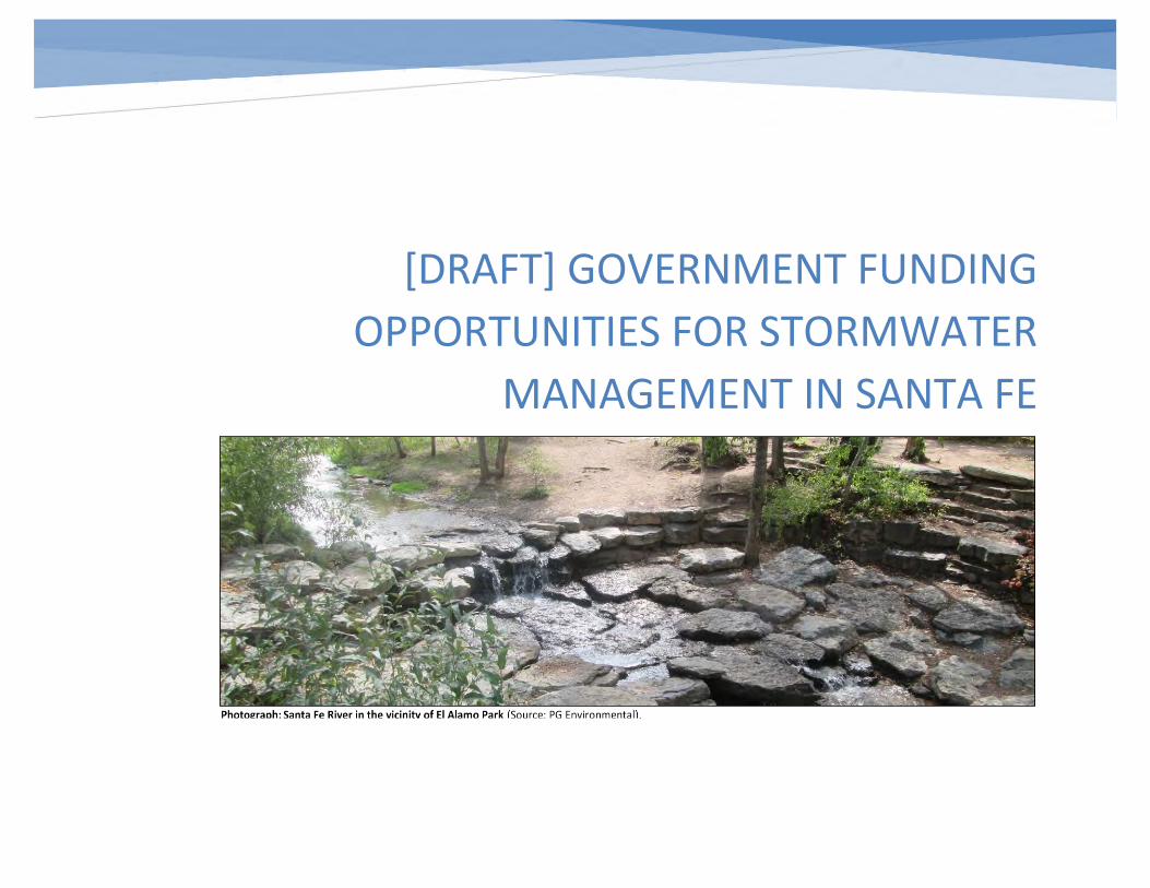
[DRAFT] GOVERNMENT FUNDING
OPPORTUNITIES FOR STORMWATER
MANAGEMENT IN SANTA FE
[DRAFT] Government Funding Opportunities for Stormwater Management in Santa Fe
i
PREFACE
Long-term stormwater planning promotes effective stormwater management while also supporting a community’s broader vision and goals, such as flooding reduction, increased neighborhood aesthetics, improved recreational opportunities through water quality improvement and public health protection. Long-term stormwater planning can also support a community’s resilience, economic growth, infrastructure improvement, environmental compliance and overall quality of life. Establishing a vision and well-constructed plan for accomplishing stormwater program goals can also help open the door to potential new sources of funding by strategically identifying long-term community goals and better aligning activities with a comprehensive water resource management focus. Communities may be able to save money and find multiple benefits by looking comprehensively at multiple long-term planning efforts to incorporate stormwater early into planned projects.
Santa Fe, New Mexico is one of four communities that participated in a U.S. Environmental Protection Agency (EPA) voluntary technical assistance effort to improve long-term stormwater planning. These communities worked with EPA to explore ways to sync planned and future activities with long-term stormwater planning, utilizing the general process outlined in EPA’s draft Community Solutions for Stormwater Management: A Guide for Voluntary Long-Term Planning.
Often, stormwater is dealt with in a reactive way. Problems are fixed when they arise until the next time it happens again with little thought being put into long-term solutions. This cycle prevents for a more proactive solution to be identified and implemented. Santa Fe decided to work on this long-term stormwater planning effort to break this cycle and be more proactive to look for ways to save their community money and make improvements to the community and its waters. With this new approach, Santa Fe is committing to looking for long-term solutions to make real improvements for Santa Feans that are based on the community’s identified needs, wants, and vision.
Through the technical assistance effort, the city and EPA have worked together to identify and address several of the city’s long-term stormwater goals, including developing a guidebook for design and implementing green infrastructure on roadway projects as well as information on pursuing government funding opportunities.
[DRAFT] Government Funding Opportunities for Stormwater Management in Santa Fe
ii
TABLE OF CONTENTS
INTRODUCTION ........................................................................................................................................................................................................................................ 1
1. INTEGRATE STORMWATER MANAGEMENT INTO EXISTING CITY PLANNING EFFORTS ................................................................................................................... 3
2. LEVERAGE STRATEGIC PARTNERSHIPS ............................................................................................................................................................................................. 5
State Partners and Opportunities ........................................................................................................................................................................................................ 5
Regional and Local Partners and Resources ......................................................................................................................................................................................... 7
3. IDENTIFY FUNDING OPPORTUNITIES ............................................................................................................................................................................................... 9
Know the Value of Stormwater ............................................................................................................................................................................................................ 9
Pick the Right Project ......................................................................................................................................................................................................................... 10
4. LEARN FROM PAST EXPERIENCE .................................................................................................................................................................................................... 12
Past Attempts ..................................................................................................................................................................................................................................... 12
Lessons Learned ................................................................................................................................................................................................................................. 12
Making Improvements ....................................................................................................................................................................................................................... 12
Success Story: The Acequia Trail Underpass ...................................................................................................................................................................................... 13
5. POTENTIAL OPPORTUNITIES FOR SANTA FE .................................................................................................................................................................................. 15
EPA Clean Water State Revolving Fund (CWSRF) ............................................................................................................................................................................... 15
USDOT Better Utilizing Investments to Leverage Development (BUILD) Grant Program .................................................................................................................. 19
U.S. Department of Housing and Urban Development (HUD) Community Development Block Grant (CDBG) Program .................................................................. 22
EPA Section 319 Grant Program ......................................................................................................................................................................................................... 24
REFERENCES ........................................................................................................................................................................................................................................... 26
[DRAFT] Government Funding Opportunities for Stormwater Management in Santa Fe
iii
Appendix A: Case Study – Santa Fe Metropolitan Planning Organization ............................................................................................................................................. 28
Project Planning and Funding ............................................................................................................................................................................................................. 28
Integrating Stormwater into MPO Projects........................................................................................................................................................................................ 29
MPO Projects in Santa Fe ................................................................................................................................................................................................................... 30
Appendix B: Case Study – Southern Sandoval County Arroyo Flood Control Authority ........................................................................................................................ 31
Long-term Planning Approach ............................................................................................................................................................................................................ 31
Federal Funding Portfolio ................................................................................................................................................................................................................... 32
Project Example: Lower Montoyas Water Quality Feature................................................................................................................................................................ 33
Appendix C: Summary of Potential Federal Funding Opportunities ...................................................................................................................................................... 34
[DRAFT] Government Funding Opportunities for Stormwater Management in Santa Fe
iv
ABBREVIATIONS, ACRONYMS, AND SYMBOLS
BMP Best management practice BUILD Better Utilizing Investments to Leverage Development CDBG Community Development Block Grant CMAQ Congestion Mitigation and Air Quality Improvement Program CPB Construction Programs Bureau CWSRF Clean Water State Revolving Fund DOT U.S. Department of Transportation EPA U.S. Environmental Protection Agency FEMA Federal Emergency Management Agency FHWA Federal Highway Administration FTA Federal Transit Administration GI Green infrastructure HSIP Highway Safety Improvement Program HUD U.S. Department of Housing and Urban Development MPO Metropolitan Planning Organization MS4 Municipal separate storm sewer system MTP Metropolitan Transportation Plan NMDOT New Mexico Department of Transportation NMED New Mexico Environment Department NMFA New Mexico Finance Authority NPDES National Pollutant Discharge Elimination System RFP Request for proposal SAP Special Appropriations Program SSCAFCA Southern Sandoval County Arroyo Flood Control Authority SSFC Sustainable Santa Fe Commission SWQB Surface Water Quality Bureau TAP Transportation Alternatives Program TIGER Transportation Investment Generating Economic Recovery TIP Transportation Improvement Program TMDL Total maximum daily load WBP Watershed-based plan WIFIA Water Infrastructure Finance and Innovation Act WPF Water Project Fund WTB Water Trust Board
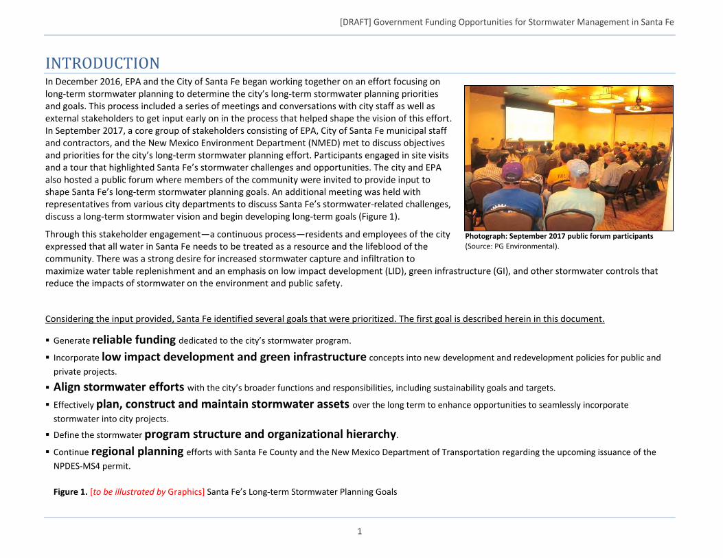
[DRAFT] Government Funding Opportunities for Stormwater Management in Santa Fe
1
INTRODUCTION In December 2016, EPA and the City of Santa Fe began working together on an effort focusing on long-term stormwater planning to determine the city’s long-term stormwater planning priorities and goals. This process included a series of meetings and conversations with city staff as well as external stakeholders to get input early on in the process that helped shape the vision of this effort. In September 2017, a core group of stakeholders consisting of EPA, City of Santa Fe municipal staff and contractors, and the New Mexico Environment Department (NMED) met to discuss objectives and priorities for the city’s long-term stormwater planning effort. Participants engaged in site visits and a tour that highlighted Santa Fe’s stormwater challenges and opportunities. The city and EPA also hosted a public forum where members of the community were invited to provide input to shape Santa Fe’s long-term stormwater planning goals. An additional meeting was held with representatives from various city departments to discuss Santa Fe’s stormwater-related challenges, discuss a long-term stormwater vision and begin developing long-term goals (Figure 1).
Through this stakeholder engagement—a continuous process—residents and employees of the city expressed that all water in Santa Fe needs to be treated as a resource and the lifeblood of the community. There was a strong desire for increased stormwater capture and infiltration to maximize water table replenishment and an emphasis on low impact development (LID), green infrastructure (GI), and other stormwater controls that reduce the impacts of stormwater on the environment and public safety.
Considering the input provided, Santa Fe identified several goals that were prioritized. The first goal is described herein in this document.
Generate reliable funding dedicated to the city’s stormwater program.
Incorporate low impact development and green infrastructure concepts into new development and redevelopment policies for public and
private projects.
Align stormwater efforts with the city’s broader functions and responsibilities, including sustainability goals and targets.
Effectively plan, construct and maintain stormwater assets over the long term to enhance opportunities to seamlessly incorporate
stormwater into city projects.
Define the stormwater program structure and organizational hierarchy.
Continue regional planning efforts with Santa Fe County and the New Mexico Department of Transportation regarding the upcoming issuance of the
NPDES-MS4 permit.
Figure 1. [to be illustrated by Graphics] Santa Fe’s Long-term Stormwater Planning Goals
Photograph: September 2017 public forum participants (Source: PG Environmental).

[DRAFT] Government Funding Opportunities for Stormwater Management in Santa Fe
2
A sustainable stormwater program requires staff, financial resources, and an in-depth understanding of the true costs of providing services. Additionally, communities including Santa Fe need to plan for and finance capital improvements and other priority projects to benefit the community and provide essential services. Common funding options include dedicated revenue sources (e.g., stormwater fee) and outside financing (e.g., grants, loans). One of Santa Fe’s long-term stormwater planning goals is to establish sustainable financing for its stormwater program and long-term priorities.
Santa Fe began pursuing this goal in the fall of 2017 with the help of its in-house consultant, Tetra Tech. The city conducted an in-depth evaluation of the city’s stormwater program organization and resources, including an assessment of Santa Fe’s stormwater fee implementation. The results are incorporated into Santa Fe’s Stormwater Management Strategic Plan.
EPA has worked with the city to develop this complementary document to help identify potentially relevant government funding in the form of grants or loans for stormwater projects and priorities in Santa Fe.
What’s in This Document?
This document primarily focuses on federal funding opportunities for projects and improvements that incorporate stormwater management strategies, such as GI and LID. It is also designed as a resource for the city to identify existing programs, plans, and projects that would align well with stormwater management priorities. This holistic approach can make Santa Fe eligible for more funding opportunities by using stormwater management to fulfill key funding program criteria as part of larger projects (e.g., transportation or other broad-scope community improvements). The document provides guidance on how to:
Integrate stormwater management into existing city planning efforts (Section 1)
Leverage strategic partnerships (Section 2)
Identify funding opportunities (Section 3)
Learn from past experience (Section 4)
Case Study – Santa Fe MPO (Appendix A: Case Study – S)
Case Study – Southern Sandoval County Arroyo Flood Control Authority (Appendix B: Case Study – Southern Sandoval County Arroyo Flood Control Authority )
Summary of Potential Federal Funding Opportunities (Appendix C: Summary of Potential Federal Funding Opportunities) This document can be shared with city department supervisors and decision-makers, as well as key external stakeholders, to demonstrate the advantage of pursuing stormwater management projects to improve public infrastructure, the environment, and the overall quality of life for the residents of Santa Fe.

[DRAFT] Government Funding Opportunities for Stormwater Management in Santa Fe
3
1. INTEGRATE STORMWATER MANAGEMENT INTO EXISTING CITY PLANNING EFFORTS To set up for success in obtaining project funding from outside sources, the city should integrate stormwater management into its current community
and infrastructure planning efforts. Stormwater management by itself may not be the central focus of, nor meet all the qualifying criteria for, certain
grant and loan programs. However, applicants can often still qualify for funding by
strategically incorporating stormwater components into the scope of broader projects
such as transportation and safety improvements, hazard mitigation, or community and
quality of life enhancements. Projects that contribute to master planning efforts and
larger-scale community improvements often receive higher consideration and ranking
when applying for government grants and loans. Also, having challenges and potential
solutions identified and documented in other existing documents can help show that the
community is engaged and dedicated to fixing problems that arise.
A community can and should take several key actions to encourage local planners and
developers to incorporate stormwater management practices into projects, thus
increasing the likelihood of receiving outside funding:
Ensure that local ordinances and design standards support stormwater
management practices, including GI/LID.
Increase interdepartmental communication related to project planning; identify
opportunities to collaborate.
Include stormwater management priorities in capital improvement planning.
Educate local decision-makers and the local design community about the city’s
stormwater management priorities and the benefits of implementing these
types of projects.
In Santa Fe, stakeholders specifically highlighted interdepartmental coordination and
cooperation as an area for improvement. Decision-makers who do not typically work
with stormwater management planning can benefit from education on the benefits and
applicability of stormwater management in project design. Realizing that incorporating
stormwater management into projects as a component – instead of a stand-alone piece
– can often save limited public funding. Stormwater practices can also add value to projects and contribute to securing funding from outside sources.
Planners and engineers who do not specialize in stormwater design may overlook or not be as-aware of the social and economic benefits that various
stormwater management approaches can bring to a project and ultimately the community. A coordinated engagement and outreach effort, both internal
Stormwater projects work best when communities think about stormwater early in the design phase rather than later after homes and businesses are built. And the most successful plans start with a vision for the community forged by a collaborative process.
- Long-term Stormwater Plans: Community Solutions
for Clean Water and A Greener Future (EPA)
Photograph: The Santa Fe Railyard was a collaborative city project that included several stormwater management features (Source: PG Environmental).
[DRAFT] Government Funding Opportunities for Stormwater Management in Santa Fe
4
to the city and its external partners, will increase the extent to which stormwater management practices are incorporated into project design, which will
in turn create a larger pool of projects to choose from when pursuing funding.
The City of Santa Fe is currently engaged in numerous long-term and master planning efforts across several departments. Some of these efforts could be
leveraged to promote the use of stormwater management practices in the city and to obtain external funding to do so. City departments such as Land
Use1 and Parks & Recreation2 are adept at long-term planning and have already recognized the importance of responsible stormwater management.
Other departments, such as Public Works and Transportation, have a long history of working with federal and state programs to fund infrastructure
projects. The people in each of these entities provide unique perspectives and knowledge in their respective fields and offer an opportunity to partner
and coordinate and could represent new potential avenues for project funding.
Transportation projects are an especially promising mechanism for pursuing government grants and loans, as managing runoff from impervious roadways
is necessary for flood control and safety, and new facility projects typically include some consideration for drainage improvements (quantity or quality).
Further, GI and LID designs that incorporate natural and native vegetation can improve the aesthetics of new streetscapes, attracting pedestrians and
businesses. By communicating and aligning stormwater management priorities with bigger-picture city planning, Santa Fe can improve its odds of
securing external funding.
1City of Santa Fe Land Use & Urban Design Plan (draft 2017): https://www.santafenm.gov/land_use__urban_design_plan 2 Santa Fe Parks, Open Space, Trails and Recreation Master Plan (2017): https://www.santafenm.gov/document_center/document/7643
“Over 20,000 acre-feet of rain water falls within Santa Fe city limits during a typical year. That is more than the average annual usage for all
urban use in the city. This runoff can be used to support plants and trees, reduce potable water demand and recharge the overtaxed ground
water supplies. Uncontrolled runoff causes erosion and causes maintenance problems in the millions of dollars.”
-City of Santa Fe Land Use & Urban Design Plan (draft 2017)
“The City’s efforts to improve stormwater management provides an opportunity to capture water for park landscapes and to incorporate
Low-Impact-Development (LID), measure water use and look for efficiencies.”
-Santa Fe Parks, Open Space, Trails and Recreation Master Plan (2017)

[DRAFT] Government Funding Opportunities for Stormwater Management in Santa Fe
5
2. LEVERAGE STRATEGIC PARTNERSHIPS
Obtaining funding through state or federal programs often requires the coordination and cooperation of multiple entities (either within a municipal
organization or with regional, state, or federal partners). The city should give careful thought as to which entity will take the lead for a particular
opportunity and which others can provide added value, support, and input to increase the odds of success.
In many cases, the city will be pursuing funding for its own local projects and working between multiple city departments. However, certain funding
programs may target specific types of groups, such as watershed and regional planning organizations or state agencies. In these cases, the city could
become a partner on a team of applicants or work to integrate city projects, goals, and priorities into regional- or state-level planning. Routine
communication between all parties can help leverage opportunities as they become available.
State Partners and Opportunities
The City of Santa Fe and State of New Mexico have built relationships on several levels. For projects that are regionally significant and have broad
watershed impacts, the state can be a direct partner in planning and execution. The state can also act as an advocate to help the city launch and fund
significant local projects. In other cases, the state can be the source of grants or loans or responsible for distributing and overseeing funding from federal
programs.
As it relates to stormwater management projects and funding, the city will likely find itself frequently engaging NMED. Funding, resources, and
partnerships can also come from other entities, such as the State Water Trust Board and the New Mexico Department of Transportation (NMDOT). In
many cases state and federal funding for transportation projects can be accessed through the Santa Fe
Metropolitan Planning Organization (see Regional and Local Partners, below).
NMED Construction Programs Bureau (CPB)3
NMED is responsible for overseeing the state’s water resources and management activities, including
drinking water, wastewater, ground water, and surface water and related infrastructure assets.
Stormwater management falls under NMED’s Surface Water Quality Bureau (SWQB), Point Source
Regulation Section. CPB provides water and wastewater project funding assistance in the form of grants
and loans, most notably the Clean Water State Revolving Fund (CWSRF) and Capital Outlay Special
Appropriations Program (SAP). Further, CPB provides in-person technical support and guidance related to the
funding programs they sponsor, as well as during the construction and implementation process. The CPB
website includes templates and guidance to help local communities pursue funding programs.
3NMED CPB website: https://www.env.nm.gov/construction-programs/
Figure 2. CWRSF logo.
[DRAFT] Government Funding Opportunities for Stormwater Management in Santa Fe
6
New Mexico State Water Trust Board (Water Project Fund)4
The New Mexico Finance Authority (NMFA) was established to provide a low-cost financing mechanism for city, county, and select state infrastructure
projects. New Mexico’s 2001 Water Project Finance Act specifically charged NMFA with administering a Water Project Fund (WPF) and corresponding
Water Trust Board (WTB) to oversee it. WPF assistance was established to support five types of projects:
Water conservation or recycling, treatment, or water use
Flood prevention
Endangered Species Act collaborative projects
Water storage, conveyance, or delivery
Watershed restoration and management
Funding selections are made annually; interested parties must submit a Notice of Intent and then complete a formal application. Submissions are
screened for completeness and eligibility and evaluated against WTB’s criteria (e.g., local contribution, regional nature of projects, leveraging of funds,
contribution to water quality/watershed improvement, attention to human health and safety). The 16-member board is responsible for making funding
recommendations to the State Legislature.
4New Mexico State WTB WPF website: https://www.nmfa.net/financing/water-programs/water-project-fund/
NMED’s Capital Outlay Special Appropriations Program (SAP) has been supporting environmental infrastructure projects (including stormwater
improvements) since 1973 through the sale of severance tax bonds. As of the end of 2017, the state was actively overseeing 154 SAP projects with a
total outstanding balance of more than $25 million. Eligible communities (e.g., municipalities, counties, special districts, Indian Tribes, Mutual Domestic
Water Consumers Associations) can apply for funding through their legislative representative.
“Watershed health is a public health and safety issue and watershed restoration encompasses a suite of activities from forest thinning
to riparian restoration projects to consideration of soil and substrate conditions. Projects that address long-term maintenance and
overarching watershed restoration will be considered. Projects solely intended to monitor the efficacy of watershed restoration and
maintenance are considered eligible for funding as long as it is part of a written long-term maintenance plan.”
– Section V.A.1 of the Water Trust Board Water Project Fund Project Management Policies
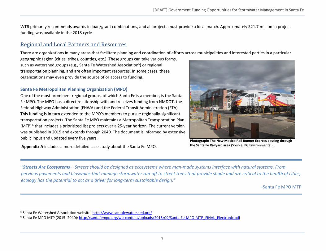
[DRAFT] Government Funding Opportunities for Stormwater Management in Santa Fe
7
WTB primarily recommends awards in loan/grant combinations, and all projects must provide a local match. Approximately $21.7 million in project
funding was available in the 2018 cycle.
Regional and Local Partners and Resources
There are organizations in many areas that facilitate planning and coordination of efforts across municipalities and interested parties in a particular
geographic region (cities, tribes, counties, etc.). These groups can take various forms,
such as watershed groups (e.g., Santa Fe Watershed Association5) or regional
transportation planning, and are often important resources. In some cases, these
organizations may even provide the source of or access to funding.
Santa Fe Metropolitan Planning Organization (MPO)
One of the most prominent regional groups, of which Santa Fe is a member, is the Santa
Fe MPO. The MPO has a direct relationship with and receives funding from NMDOT, the
Federal Highway Administration (FHWA) and the Federal Transit Administration (FTA).
This funding is in turn extended to the MPO’s members to pursue regionally-significant
transportation projects. The Santa Fe MPO maintains a Metropolitan Transportation Plan
(MTP) 6 that includes a prioritized list projects over a 25-year horizon. The current version
was published in 2015 and extends through 2040. The document is informed by extensive
public input and updated every five years.
Appendix A includes a more detailed case study about the Santa Fe MPO.
5 Santa Fe Watershed Association website: http://www.santafewatershed.org/ 6 Santa Fe MPO MTP (2015–2040): http://santafempo.org/wp-content/uploads/2015/09/Santa-Fe-MPO-MTP_FINAL_Electronic.pdf
Photograph: The New Mexico Rail Runner Express passing through the Santa Fe Railyard area (Source: PG Environmental).
“Streets Are Ecosystems – Streets should be designed as ecosystems where man‐made systems interface with natural systems. From
pervious pavements and bioswales that manage stormwater run‐off to street trees that provide shade and are critical to the health of cities,
ecology has the potential to act as a driver for long‐term sustainable design.”
-Santa Fe MPO MTP
[DRAFT] Government Funding Opportunities for Stormwater Management in Santa Fe
8
Sustainable Santa Fe Commission
The Sustainable Santa Fe Commission (SSFC)7 is a 9-member citizen group that advises the Santa Fe city government on environmental policies, programs,
and projects. Pursuant to City of Santa Fe Resolution No. 2015-57, the commission has overseen the development of a 25-Year Sustainability Plan for the
city that provides recommendations on environmental initiatives in Santa Fe, with the goal of becoming carbon neutral by 2040. Promotion of healthy
aquifers is listed as a top water-related priority in the plan, with a corresponding action item listed as, “shift the emphasis of stormwater infrastructure
towards capture, infiltration, and utilization.” While SSFC may not have a direct line to government funding, engaging with the group and promoting the
city’s stormwater priorities is just another way to ensure they get considered in larger planning efforts. Environmental sustainability is more and more
becoming part of the key criteria and goals for a variety of funding programs.
Southern Sandoval County Arroyo Flood Control Authority
Southern Sandoval County Arroyo Flood Control Authority (SSCAFCA) is another government agency located near Santa Fe that routinely applies for and is
awarded funding through government programs. SSCAFCA is well-versed in the planning and application process involved in pursuing government
funding (particularly for funding arroyo-related projects through the Federal Emergency Management Agency [FEMA]) and could serve as a valuable
resource to the city for guidance on navigating the process. Appendix B includes a case study providing additional details on the SSCAFCA organization.
7 Sustainable Santa Fe website: https://www.santafenm.gov/sustainable_santa_fe
[DRAFT] Government Funding Opportunities for Stormwater Management in Santa Fe
9
3. IDENTIFY FUNDING OPPORTUNITIES
Once projects are identified and incorporated into planning, the city can focus on identifying funding and financing options. In addition to locally available
funds, the State of New Mexico and the federal government offer a wide variety of funding opportunities that can help communities to achieve their
stormwater goals. Some opportunities present a clear path for incorporating stormwater management (e.g., the CWSRF), whereas others may require
more coordination.
Resources available to help communities and planners navigate the various funding options include EPA’s website for Green Infrastructure Funding
Opportunities8 and the Water Finance Clearinghouse9. Being aware of available funding and funding cycles and engaging in long-term planning to identify
specific projects that contribute to a cohesive community vision for the future will increase the chances of having projects in waiting.
It should be emphasized that government grant and loan programs are supplements to a well-structured and sustainable financing approach. Many
government funding programs also include a local match or other financial contingencies, so a community should already be in a position to
accommodate these requirements as opportunities become available. As mentioned previously, Santa Fe is already taking action to evaluate and improve
the sustainability of its stormwater program financing.
Know the Value of Stormwater
As discussed in Section 1, stormwater projects may need to be incorporated into larger scopes of work, such as transportation and other capital
improvement projects, to be eligible for external funding. A number of programs clearly outline the acceptance of stormwater and GI/LID practices. For
example, the CWRSF has a long list of acceptable items related to stormwater that can be funded10. Even the U.S. Department of Transportation (DOT)
Better Utilizing Investments to Leverage Development (BUILD) Grant Program has specific ranking criteria related to environmental protection, including
reducing water pollution as well as stormwater mitigation. However, stormwater can also be incorporated into other programs that are less explicit about
stormwater management.
Educating planners and decision-makers on the additional benefits of stormwater management (e.g., beyond water quality and quantity control) can be
essential for achieving long-term stormwater goals in a community. Further, being able to identify and articulate the value stormwater management
brings to a particular project and the community can help potential applicants target funding opportunities based on specific ranking criteria and metrics.
For example, implementing stormwater management can offer social and economic benefits in areas such as:
8EPA Green Infrastructure Funding Opportunities website: https://www.epa.gov/green-infrastructure/green-infrastructure-funding-opportunities 9EPA Water Infrastructure and Resiliency Finance Center (WIRFC). The WIRFC Water Finance Clearinghouse is a searchable database for sanitary sewer, stormwater, drinking water, and other relevant funding sources from federal, state, local, and other programs. Resources and information on available funding sources, including state-specific contact information, are updated regularly. 10CWSRF Stormwater website: https://www.epa.gov/cwsrf/clean-water-state-revolving-fund-cwsrf-stormwater
[DRAFT] Government Funding Opportunities for Stormwater Management in Santa Fe
10
Safety – Implementing stormwater management can reduce runoff volume and velocity from roadways, prevent flooding in busy pedestrian
areas, and reduce dangerous erosion that could undermine bridge footings or culverts.
Public Health and Quality of Life – Beyond improving water quality, plants used to manage stormwater can contribute to improved air quality as
well. Further, GI/LID practices implemented in places like parks, open spaces, and along roads and trails can beautify the area and enhance
recreational experiences.
Local Economy – GI and LID practices often incorporate natural landscapes and native plantings, both of which can be aesthetically pleasing in a
streetscape setting. Incorporating these elements into areas that are home to local businesses can help attract patrons by providing a more
beautiful setting.
More detailed information related to the value of stormwater management can be found in two documents sponsored by EPA, The Value of Green
Infrastructure: A Guide to Recognizing Its Economic, Environmental and Social Benefits11 and The Economic Benefits of Green Infrastructure: A Case Study
of Lancaster, PA.12 Both highlight some of the quantitative and qualitative benefits of implementing stormwater management in a community.
Appendix C of this document includes a summary of various federal funding opportunities the city could pursue. Section 5 of this document includes
deeper discussion of four federal funding programs that may be particularly relevant to the City of Santa Fe:
EPA/State of New Mexico CWSRF Program
USDOT BUILD Grant Program
U.S. Department of Housing and Urban Development (HUD) Community Development Block Grant (CDBG) Program
EPA Section 319 Grant Program
Pick the Right Project
Not all projects will match well with government funding opportunities; however, communities that have proactively planned projects in advance of
funding needs will be well-positioned to pursue outside funding as soon as an opportunity arises. Maintaining a pool of potential projects enables
decision-makers to select the best for a particular funding program. Several considerations need to be made before applying for a government loan or
grant program:
Has enough planning been completed, and is there enough data available to support a successful application?
How does the project fit the criteria for funding?
Does the project timeline align with the funding cycle?
11The Value of Green Infrastructure: A Guide to Recognizing Its Economic, Environmental and Social Benefits: https://www.cnt.org/sites/default/files/publications/CNT_Value-of-Green-Infrastructure.pdf 12The Economic Benefits of Green Infrastructure: A Case Study of Lancaster, PA: https://www.epa.gov/sites/production/files/2015-10/documents/cnt-lancaster-report-508_1.pdf

[DRAFT] Government Funding Opportunities for Stormwater Management in Santa Fe
11
Are the terms of the program appropriate for the project (e.g., loan payoff timeline, design requirements)?
Is the community able to provide enough matching funds (if required)?
Are there any partners (e.g., state or regionally) that can contribute to or help advocate for the project?
These are just some of the basic questions to consider when determining whether a project is a good fit for a certain program. Communities and agencies
that are routinely successful at obtaining outside funding are well-versed in the application process (including how to meet key criteria) and communicate
regularly with funding program administrators and application reviewers.

[DRAFT] Government Funding Opportunities for Stormwater Management in Santa Fe
12
4. LEARN FROM PAST EXPERIENCE
Santa Fe has successfully pursued federal and state funding opportunities for various projects and programs across several city departments; however,
incorporating stormwater management priorities has yielded mixed results.
Past Attempts
The city has pursued funding for several projects in the past highlighting green infrastructure, but been unsuccessful for various, and many times,
unknown reasons. For example, in 2016, the city applied for $854,400 of Transportation Alternative Program (TAP) funding, to go with $145,600 of
matching local funds, to construct a one-mile bike/pedestrian trail to extend the Acequia Trail and connect to the El Camino Real Trail. The project would
improve the city’s trail system connectivity and included measures to mitigate flooding by replacing the existing culvert and eliminating choke points
where the roadway crosses the Santa Fe River. The project was ultimately not awarded TAP funding and it was not exactly clear why at the time. The city
was similarly unsuccessful in pursuing TAP funds for the Arroyo de Los Chamisos Extension project in 2015 and the Canada Rincon Trail in 2016.
The city has also pursued various other funding opportunities with similar results for projects incorporating stormwater management, such as projects
through FHWA’s Recreational Trails Program (RTP), EPA’s Urban Waters and Section 319 grants, as well as assistance form EPA’s Greening America’s
Communities initiative.
Lessons Learned
In many cases, the city was not notified with clear reasons for unsuccessful applications. This underscores the need for Santa Fe to be proactive in
following up with funding administrators after successful and unsuccessful applications. The city is often dedicating considerable resources to planning for
and pursuing these opportunities, and it is important to ask for feedback and learn how the process can be improved to maximize results.
In a handful of cases, it was clear why funding was not awarded. For example, the city has historically lacked of a watershed-based plan, which is pre-
requisite under EPA’s Section 319 grant program. Further, Santa Fe’s waterbodies have not always been formally classified with impairments (e.g., 303(d)
and TMDLs), which is often given priority ranking for water quality-driven funding programs.
Making Improvements
The city has taken steps to improve stormwater planning and better position itself for success. Since 2017, Santa Fe has been engaging in an effort to
internally evaluate its stormwater program as a whole and develop a Stormwater Management Strategic Plan. One of the many outcomes of this effort
will provide, is to identify areas to improve the sustainability of the city’s stormwater program funding. The city has also been working to generate
hydraulic modeling reports in support of watershed-based planning. Further, the city has been working with EPA to develop A Guide to Incorporating
Green Infrastructure into Roadway Projects in Santa Fe. These documents will help emphasize the value of managing stormwater and facilitate the
integration of stormwater management into project planning.

[DRAFT] Government Funding Opportunities for Stormwater Management in Santa Fe
13
Additionally, in 2017, EPA approved E. coli total maximum daily load (TMDL) requirements for the Santa Fe River from Cienega Creek to Nichols Reservoir. This
new requirement to address a recognized impairment should give the city better leverage when pursuing funding options geared towards improving water
quality.
Success Story: The Acequia Trail Underpass
Acequia Trail Underpass (completed 2017)13
FHWA – Congestion Mitigation and Air Quality (CMAQ) Improvement Program; Total Funding – $4,290,463 (including over $600,000 of local matching funds)
Santa Fe’s Acequia Trail Underpass project involved constructing a path under St. Francis Drive, one of the busiest intersections in the city, providing cyclists and
pedestrians a safer connection between southwest Santa Fe and the popular Santa Fe Railyard area. The Acequia Trail is one of four major trail corridors in the
city of Santa Fe and has an average of 358 users a day. Prior to construction, trail users crossed the intersection at St. Francis Drive via a signalized crosswalk.
However, the public often used unsafe and out of direction paths to reach the crosswalk, such as crossing at unmarked mid-block locations rather than the
crosswalk, jumping the road median, and not observing crosswalk countdown signals. Vehicles also failed to yield to cyclists and pedestrians at the intersection,
and vehicles stopped in the crosswalk prevented safe passage.
The City initially applied for Highway Safety
Improvement Program (HSIP) funding
through FHWA, but was unsuccessful. This
was likely due to the city’s lack of robust
crash data necessary to satisfy HSIP’s data
driven selection process. The city was
eventually able to obtain project funding, in
the form of a CMAQ Improvement Program
funds (also FHWA)—a program focused on
traffic-calming and air quality
improvements.
While the funding mechanism for the
underpass project did not specifically
highlight stormwater components, the city
integrated these elements in the
construction plan. For example, a detailed
hydrologic study and hydraulic analysis were
13 The data and information referenced in this section were provided during communications with City of Santa Fe staff and from internal documents provided by the city related to the grant application and project development process.
Photograph: Stormwater swale installed as a component of the Acequia Trail Underpass project (Source: City of Santa Fe)
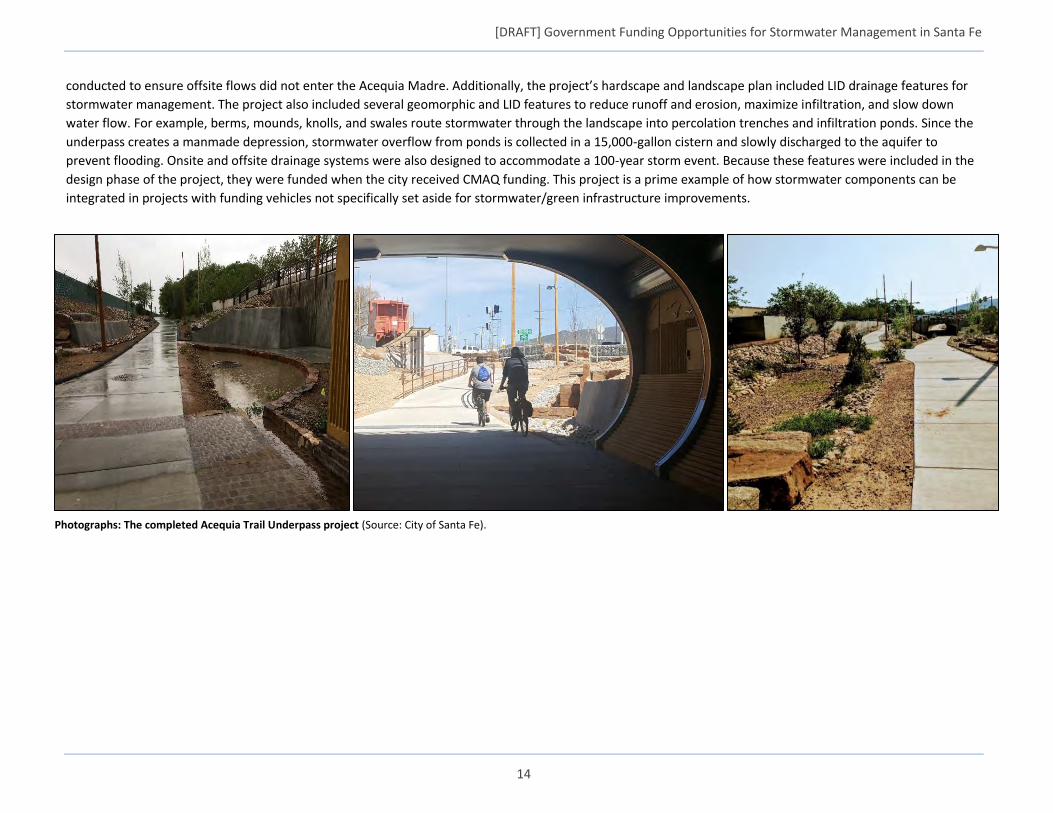
[DRAFT] Government Funding Opportunities for Stormwater Management in Santa Fe
14
conducted to ensure offsite flows did not enter the Acequia Madre. Additionally, the project’s hardscape and landscape plan included LID drainage features for
stormwater management. The project also included several geomorphic and LID features to reduce runoff and erosion, maximize infiltration, and slow down
water flow. For example, berms, mounds, knolls, and swales route stormwater through the landscape into percolation trenches and infiltration ponds. Since the
underpass creates a manmade depression, stormwater overflow from ponds is collected in a 15,000-gallon cistern and slowly discharged to the aquifer to
prevent flooding. Onsite and offsite drainage systems were also designed to accommodate a 100-year storm event. Because these features were included in the
design phase of the project, they were funded when the city received CMAQ funding. This project is a prime example of how stormwater components can be
integrated in projects with funding vehicles not specifically set aside for stormwater/green infrastructure improvements.
Photographs: The completed Acequia Trail Underpass project (Source: City of Santa Fe).
[DRAFT] Government Funding Opportunities for Stormwater Management in Santa Fe
15
5. POTENTIAL OPPORTUNITIES FOR SANTA FE This section provides a more in-depth view of four federal funding programs that the City of Santa Fe may consider pursuing in the future
EPA Clean Water State Revolving Fund (CWSRF)
EPA’s CWSRF program was established in 1987 to provide at or below-market interest rate loans,14 refinancing assistance, and loan guarantees for water
infrastructure projects. EPA provides capitalization grants to the 51 CWSRF programs across the country each year;15 states are required to contribute a
20 percent match. Loan repayments “revolve” back into state funds to finance future projects. The CWSRF is “ideally suited to serve as sources of low or
no cost financial assistance to a broad and diverse range of publicly and privately-owned green infrastructure projects” (Sawyers, 2016). The CWSRF
Green Project Reserve (GPR), established in 2009, is specifically designed to support green infrastructure, water and energy efficiency improvements, and
other innovative activities. (EPA, 2017). Since 2009, $1.1 billion was reported as going towards green infrastructure projects nationally through the
CWSRF program
EPA encourages state CWSRF programs to offer financial incentives and priority ranking criteria/bonus points for green infrastructure projects (Sawyers,
2016). In New Mexico, CWSRF applications can receive a maximum of 475 points; up to 25 points are awarded to projects that incorporate stormwater
BMPs, and 25 bonus points are awarded to projects that can be classified under the GPR (EPA, 2015). However, none of the 21 active CWSRF loans were
for stormwater-focused projects as of the end of FY 2017 (NMED Construction Programs Bureau, 2017).
14 CWSRF loans offer terms up to 30 years, though no longer than the useful life of the project. 15 EPA provides CWSRF grants to all 50 states and Puerto Rico.
States have the flexibility to provide additional subsidies to municipal or intermunicipal funding recipients in the form of negative interest loans or
principal forgiveness. The maximum percentage of a state’s capitalization grant used for additional subsidization ranges from 0 to 30 percent,
depending on the amount of the total appropriation.
NMED aims to provide the maximum allowable additional subsidy each year (NMED, 2018). Additional subsidization can be provided to address
affordability issues (for municipalities that meet New Mexico’s affordability criteria; New Mexico CWSRF Program, 2018), to benefit individual
residential rate payers, or for projects/activities that address water or energy efficiency goals, mitigate stormwater runoff, or encourage sustainable
project planning, design, and construction (Sawyers, 2015).
[DRAFT] Government Funding Opportunities for Stormwater Management in Santa Fe
16
Eligibility New Mexico’s CWSRF program is managed by NMED’s Construction Programs Bureau (CPB).16 The application period opens once per year, typically in the
spring.17 There are several broad categories of projects eligible for the program.
Most municipalities are eligible to pursue funding for publicly-owned stormwater projects18, including:
Stormwater BMP projects that utilize cost-effective controls and use innovative technologies.
Development and implementation of a municipality-wide stormwater management plan.
Projects designed to manage, reduce, treat, reuse, or recapture stormwater or subsurface drainage water.
Development or implementation of watershed partnerships between municipalities and property owners to address nonpoint sources of pollution.
Management of municipal wet weather discharges on an integrated watershed or subwatershed basis, demonstrating the effectiveness of a unified
wet weather approach.
Further, projects that contribute to the implementation of a Section 319 Nonpoint Source Management Program or a Section 320 Comprehensive
Conservation and Management Plan (CCMP) are also typically eligible for funding. Eligibility requirements vary to some extent for planning, energy and
water conservation, and surface water protection and restoration projects. As of 2014, projects pursued to meet the requirements of a MS4 permit are
eligible for CWSRF funding, regardless of ownership (public or private).
16 Contact: [email protected] or (505) 827-2806 17 Application forms and supplemental materials are available at: https://www.env.nm.gov/construction-programs/cpb-forms-and-documents/#CWSRF-ApplicationandInformationtoApply 18 NMED has petitioned the state’s Water Quality Control Commission to expand the list of eligible CWSRF assistance recipient to include state agencies.
Eligible Types of Projects • Constructing publicly owned treatment works (POTWs) • Watershed pilot projects
• Nonpoint source • Energy efficiency, water efficiency, or reuse
• Reducing the demand for POTW capacity through water conservation,
efficiency, and reuse
• Reusing or recycling wastewater, stormwater, or subsurface drainage water
• Stormwater • Security measures at POTWs
• Decentralized systems • National Estuary Program projects
• Technical assistance/planning
[DRAFT] Government Funding Opportunities for Stormwater Management in Santa Fe
17
Throughout the long-term stormwater planning process, stakeholders in Santa Fe have communicated the importance of stormwater capture and
infiltration, as well as prioritizing stormwater management starting in upland areas to mitigate erosion and prevent sediment and trash from flowing into
lower areas. The following types of projects are eligible for CWSRF funding and may be particularly applicable to the city.
Specific Types of Stormwater Projects Applicable to Santa Fe
• Traditional pipe, storage, and treatment systems
• Real-time control systems for CSO management
• Stormwater BMPs
• Watershed management of wet weather discharges
• Sediment controls including:
o Filter fences
o Storm drain inlet protection
o Street sweepers
o Vacuum trucks
• Green roofs, green streets, and green walls
• Rainwater harvesting, storage, management, and distribution systems
• Real-time control systems for harvested rainwater
• Infiltration basins
• Constructed wetlands, including surface flow and subsurface flow (e.g.,
gravel) wetlands
• Bioretention/bioswales (e.g., rain gardens, tree boxes)
• Permeable pavement
• Wetland/riparian/shoreline creation, protection, and restoration
• Establishment/restoration of urban tree canopy
• Integrating green infrastructure into existing gray infrastructure
including purchase and demolition costs
• Municipality-wide stormwater planning
• Water conservation education and incentive programs (e.g., installation
of permeable surfaces or rain barrels)
• Distribution lines to support water reuse and use of harvested
precipitation
• Energy efficient equipment and components (e.g., lighting, HVAC,
electronic systems)
• On-site and off-site renewable energy
• Land acquisition*
• Asset management/fiscal sustainability planning**
• Integrated planning**
• Cost and effectiveness analyses
• Capital improvement plans**
* Eligible if part of a broader eligible project
** Eligible if these activities are reasonably expected to result in a capital project
Additional Program Requirements
As of 2014, municipal or intermunicipal CWSRF assistance recipients are required to conduct a cost and effectiveness analysis. Specifically, the
analysis must include study and evaluation of the cost and effectiveness of the processes, materials, techniques, and technologies for carrying
out the proposed project or activity for which assistance is sought. Projects and activities must show they increase the potential for efficient
water use, capture, reuse, and conservation, and energy conservation to the maximum extent practicable (taking into account construction costs,
operations and maintenance costs over the lifetime of the project/activity, and replacement costs) (Sawyers, 2015).
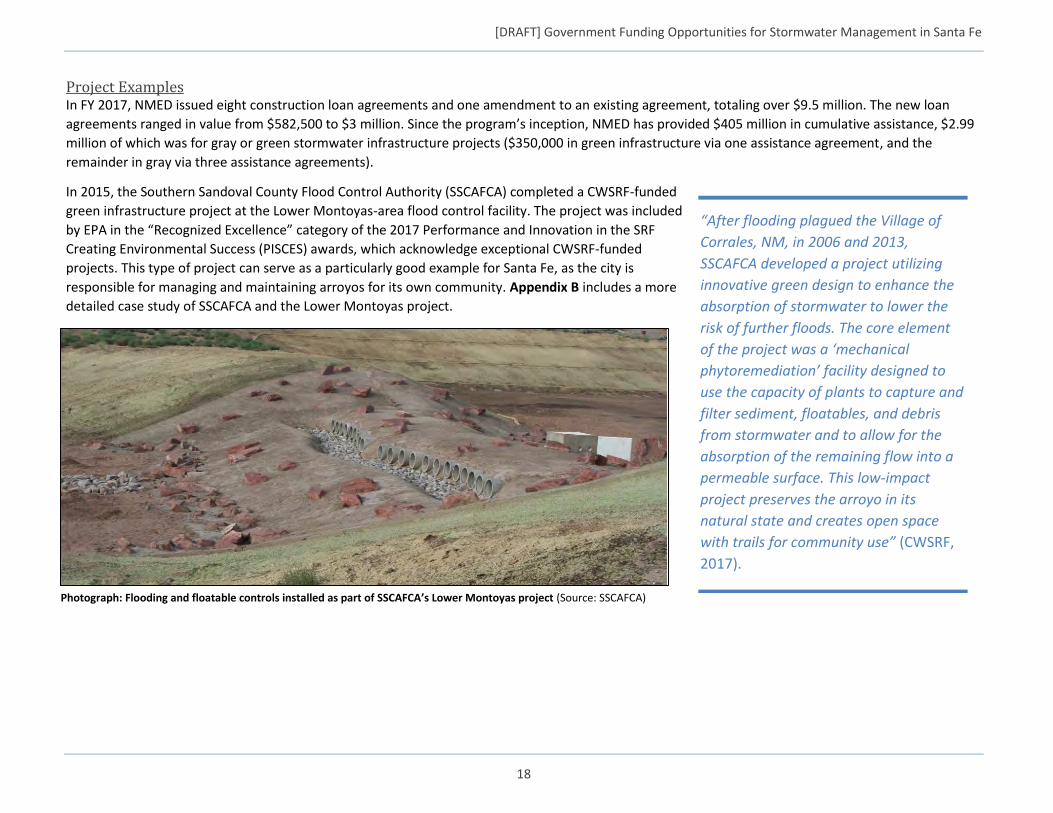
[DRAFT] Government Funding Opportunities for Stormwater Management in Santa Fe
18
Project Examples In FY 2017, NMED issued eight construction loan agreements and one amendment to an existing agreement, totaling over $9.5 million. The new loan
agreements ranged in value from $582,500 to $3 million. Since the program’s inception, NMED has provided $405 million in cumulative assistance, $2.99
million of which was for gray or green stormwater infrastructure projects ($350,000 in green infrastructure via one assistance agreement, and the
remainder in gray via three assistance agreements).
In 2015, the Southern Sandoval County Flood Control Authority (SSCAFCA) completed a CWSRF-funded
green infrastructure project at the Lower Montoyas-area flood control facility. The project was included
by EPA in the “Recognized Excellence” category of the 2017 Performance and Innovation in the SRF
Creating Environmental Success (PISCES) awards, which acknowledge exceptional CWSRF-funded
projects. This type of project can serve as a particularly good example for Santa Fe, as the city is
responsible for managing and maintaining arroyos for its own community. Appendix B includes a more
detailed case study of SSCAFCA and the Lower Montoyas project.
“After flooding plagued the Village of
Corrales, NM, in 2006 and 2013,
SSCAFCA developed a project utilizing
innovative green design to enhance the
absorption of stormwater to lower the
risk of further floods. The core element
of the project was a ‘mechanical
phytoremediation’ facility designed to
use the capacity of plants to capture and
filter sediment, floatables, and debris
from stormwater and to allow for the
absorption of the remaining flow into a
permeable surface. This low-impact
project preserves the arroyo in its
natural state and creates open space
with trails for community use” (CWSRF,
2017).
Photograph: Flooding and floatable controls installed as part of SSCAFCA’s Lower Montoyas project (Source: SSCAFCA)
[DRAFT] Government Funding Opportunities for Stormwater Management in Santa Fe
19
USDOT Better Utilizing Investments to Leverage Development (BUILD) Grant Program
USDOT’s BUILD Grant Program, which replaced the Transportation Investment Generating Economic Recovery (TIGER) program in 2018, provides funding
to surface transportation projects that have a significant regional or local impact. The program also considers the extent to which the applicant has
implemented “local activities to generate additional non-Federal revenue for transportation infrastructure” (DOT, 2018). In 2017, TIGER grants were
awarded to 41 projects across the country ranging in value from $2 to the $25 million maximum.19
BUILD grants have been successfully applied to green and gray stormwater infrastructure and other
stormwater management components, and are often used to fund Complete Streets and Green Streets-
type projects. Environmental protection, quality of life, and innovation are three of the merit criteria
considered for awarding BUILD grants that could be leveraged for implementing stormwater
management into project designs.20 USDOT specifically encourages applicants to provide data on a
project’s anticipated environmental benefits, including reduced energy consumption and stormwater
runoff.21
Eligibility Eligible grant recipients include state, local, and tribal governments, including transit agencies, port
authorities, MPOs, and other political subdivisions of state or local governments. States and jurisdictions
can also coordinate to submit a joint application (as long as all participants are eligible) (BUILD, 2016).
The following are general examples of projects eligible for BUILD grants (DOT, 2018):
Highway, bridge, or other road projects eligible under Title 23 of the U.S. Code
Public transportation projects eligible under Chapter 53 of Title 49 of the U.S. Code
Passenger and freight rail transportation projects
Intermodal projects
In 2018, Congress also authorized up to $15 million for planning grants (e.g., preliminary engineering and design, environmental and final design,
feasibility studies). Projects are ultimately evaluated against their alignment with one or more of the program’s merit criteria,22 which includes, among
others, environmental protection. Considerations that may be especially relevant to Santa Fe’s long-term stormwater planning efforts are outlined in the
following table. Santa Fe is able to pursue these opportunities on their own, or in conjunction with a local planning group, like the Santa Fe MPO (see
Appendix A) or the New Mexico DOT.
19 https://www.transportation.gov/sites/dot.gov/files/docs/policy-initiatives/tiger/306331/t9-fact-sheets_0.pdf 20 https://www.transportation.gov/sites/dot.gov/files/docs/policy-initiatives/tiger/308656/build-vs-tiger-fact-sheet-042018-1049am.pdf 21 https://www.transportation.gov/sites/dot.gov/files/docs/policy-initiatives/build/114796/fed-reg-build-nofo-2018_0.pdf 22 Contact: [email protected], or 202-366-0301; application forms and supplemental materials are available at: https://www.transportation.gov/BUILDgrants
Complete Streets
More than 1,400 cities and towns across the
country (including the Santa Fe MPO) have
pursued Complete Streets policies to make
their roadways more accessible for all forms
of transportation, minimize the
environmental impacts of impervious
surfaces, and improve safety. Complete
Streets designs often incorporate green
infrastructure elements (e.g., bioswales,
planters) for sustainable stormwater
management. These natural and engineered
solutions reduce the risk of flooding while
offering valuable co-benefits like and
improvements in air quality and enhanced
recreational spaces.
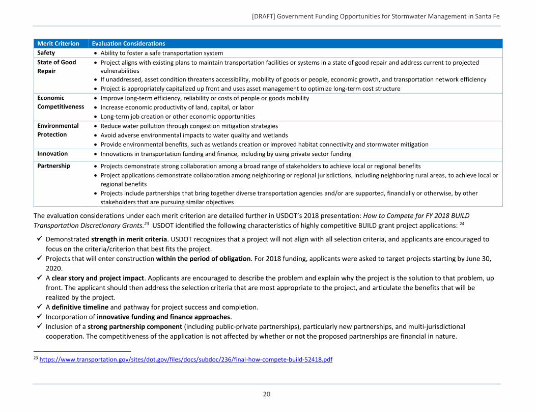
[DRAFT] Government Funding Opportunities for Stormwater Management in Santa Fe
20
The evaluation considerations under each merit criterion are detailed further in USDOT’s 2018 presentation: How to Compete for FY 2018 BUILD
Transportation Discretionary Grants.23 USDOT identified the following characteristics of highly competitive BUILD grant project applications: 24
Demonstrated strength in merit criteria. USDOT recognizes that a project will not align with all selection criteria, and applicants are encouraged to
focus on the criteria/criterion that best fits the project.
Projects that will enter construction within the period of obligation. For 2018 funding, applicants were asked to target projects starting by June 30,
2020.
A clear story and project impact. Applicants are encouraged to describe the problem and explain why the project is the solution to that problem, up
front. The applicant should then address the selection criteria that are most appropriate to the project, and articulate the benefits that will be
realized by the project.
A definitive timeline and pathway for project success and completion.
Incorporation of innovative funding and finance approaches.
Inclusion of a strong partnership component (including public-private partnerships), particularly new partnerships, and multi-jurisdictional
cooperation. The competitiveness of the application is not affected by whether or not the proposed partnerships are financial in nature.
23 https://www.transportation.gov/sites/dot.gov/files/docs/subdoc/236/final-how-compete-build-52418.pdf
Merit Criterion Evaluation Considerations
Safety Ability to foster a safe transportation system
State of Good
Repair
Project aligns with existing plans to maintain transportation facilities or systems in a state of good repair and address current to projected vulnerabilities
If unaddressed, asset condition threatens accessibility, mobility of goods or people, economic growth, and transportation network efficiency
Project is appropriately capitalized up front and uses asset management to optimize long-term cost structure
Economic
Competitiveness
Improve long-term efficiency, reliability or costs of people or goods mobility
Increase economic productivity of land, capital, or labor
Long-term job creation or other economic opportunities
Environmental
Protection
Reduce water pollution through congestion mitigation strategies
Avoid adverse environmental impacts to water quality and wetlands
Provide environmental benefits, such as wetlands creation or improved habitat connectivity and stormwater mitigation
Innovation Innovations in transportation funding and finance, including by using private sector funding
Partnership Projects demonstrate strong collaboration among a broad range of stakeholders to achieve local or regional benefits
Project applications demonstrate collaboration among neighboring or regional jurisdictions, including neighboring rural areas, to achieve local or
regional benefits
Projects include partnerships that bring together diverse transportation agencies and/or are supported, financially or otherwise, by other
stakeholders that are pursuing similar objectives
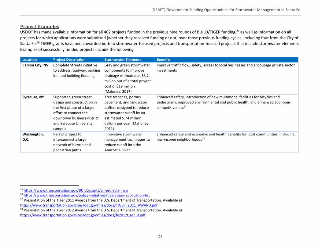
[DRAFT] Government Funding Opportunities for Stormwater Management in Santa Fe
21
Project Examples USDOT has made available information for all 462 projects funded in the previous nine rounds of BUILD/TIGER funding,25 as well as information on all
projects for which applications were submitted (whether they received funding or not) over those previous funding cycles, including four from the City of
Santa Fe.26 TIGER grants have been awarded both to stormwater-focused projects and transportation-focused projects that include stormwater elements.
Examples of successfully funded projects include the following.
25 https://www.transportation.gov/BUILDgrants/all-projects-map 26 https://www.transportation.gov/policy-initiatives/tiger/tiger-application-list 27 Presentation of the Tiger 2011 Awards from the U.S. Department of Transportation. Available at https://www.transportation.gov/sites/dot.gov/files/docs/TIGER_2011_AWARD.pdf 28 Presentation of the Tiger 2012 Awards from the U.S. Department of Transportation. Available at https://www.transportation.gov/sites/dot.gov/files/docs/fy2012tiger_0.pdf
Location Project Description Stormwater Elements Benefits
Carson City, NV Complete Streets initiative
to address roadway, parking
lot, and building flooding
Gray and green stormwater
components to improve
drainage estimated at $3.2
million out of a total project
cost of $19 million
(Maloney, 2017)
Improve traffic flow, safety, access to local businesses and encourage private sector
investments
Syracuse, NY Supported green street
design and construction in
the first phase of a larger
effort to connect the
downtown business district
and Syracuse University
campus
Tree trenches, porous
pavement, and landscape
buffers designed to reduce
stormwater runoff by an
estimated 5.74 million
gallons per year (Mahoney,
2011)
Enhanced safety, introduction of new multimodal facilities for bicycles and
pedestrians, improved environmental and public health, and enhanced economic
competitiveness27
Washington,
D.C.
Part of project to
interconnect a large
network of bicycle and
pedestrian paths
Innovative stormwater
management techniques to
reduce runoff into the
Anacostia River
Enhanced safety and economic and health benefits for local communities, including
low-income neighborhoods28
[DRAFT] Government Funding Opportunities for Stormwater Management in Santa Fe
22
U.S. Department of Housing and Urban Development (HUD) Community Development Block Grant (CDBG) Program
As a HUD-designated entitlement community, the City of Santa Fe already receives annual CDBG funding of approximately $500,000. The City’s
Community Development Commission is responsible for allocating the funds to local agencies and non-profits to carry out the goals and strategies related
to housing and community needs as outlined in Santa Fe’s Draft Consolidated Plan 2018 – 2022.29 The draft plan articulates the following high-level
program goals (Fitzpatrick, 2018):
Increased opportunities for at-risk populations through reduction in the rate of households with cost burden.
Increased affordable housing opportunity through increased inventory of very low-income rental units and vouchers.
Increased opportunity for homeownership and increased support for current homeowners.
Improving housing opportunities to reflect urban needs, and aligning redevelopment projects, economic development objectives, and sustainability
goals to reflect changing demographics.
CDBG-funded programs, projects and activities are able to include sustainable building practices and initiatives, such as effective stormwater
management and water quality improvements. As part of the final goal listed above, the city recognizes the need for housing that achieves “high
standards of sustainability through green building, design, and alternative energy sources.” The draft plan also highlights the importance of water
resources and infrastructure for Santa Fe’s business community. A 2013 update to the City’s Housing Needs Assessment acknowledged progress in
incorporating green/sustainable components into building upgrades and new housing developments, including water catchment, drip irrigation, and
rainwater harvesting (BBC, 2013), as well as conversion from septic (using CDBG funding).
All CDBG projects must address needs of low- to moderate-income City residents. Eligible projects may include (CDC, 2017):
Acquisition of real property
Relocation and demolition
Rehabilitation of residential and non-residential structures
Provision of public facilities and improvements (water and sewer services, flood and drainage improvements, aesthetic amenities including
trees, parks, sidewalks, curbs and gutters, etc.)30
Down payment assistance toward the purchase of a home
Payment for public services within certain limits
Since 2007, about 10 percent of Santa Fe’s available CDBG funding has been provided for public facility improvements.31
29 PDF of Draft Consolidated Plan 2018 – 2022: https://www.santafenm.gov/document_center/document/8434 30 PDF Categorizing Eligible Activities through Community Development Block Grant Program. Available at https://www.hud.gov/sites/documents/DOC_17133.PDF 31 Excel Sheet describing the Consolidated Plan Funding 2013-2018 Percentages (by category, to date.) Available at https://www.santafenm.gov/document_center/document/7635

[DRAFT] Government Funding Opportunities for Stormwater Management in Santa Fe
23
Project Examples Below are examples of successfully funded CDBG projects from other communities that have been able to incorporate stormwater elements.
While not specifically stormwater-focused, cities including Bangor, ME and Ashland, KY, have used CDBG funding to revitalize neighborhoods in part
through the development and installation of green space (which could have added stormwater management benefits, if desired). Cities including Austin,
TX, Bellevue, NE, and Attleboro, MA invested CDBG funding in substantial infrastructure upgrades (including water services, surface transportation and
sidewalks) to redevelop neighborhoods for low-income residential housing and retail and commercial space (Cornett, 2017).
CDBG – Disaster Recovery Assistance32 As an extension of CDBG program, HUD’s Disaster Recovery Assistance program also has funding available for recovery after major disasters, as well as for implementing measures for resiliency against future disasters. In April 2018, HUD announced the award of approximately $28 billion to help disaster recovery in several states, as well as Puerto Rico and the U.S. Virgin Islands. These funds were targeted at helping areas that have experienced Presidentially-declared disasters occurring since 2015, and will help communities repair and restore residences, businesses and infrastructure, as well as protect against future events. Funding can be requested in response to events like extreme weather and wild fires. Santa Fe can keep this funding source in mind in case the need arises.
32 HUD CDBG Disaster Recovery Assistance website: https://www.hud.gov/hudprograms/disaster-recovery
Location Project Description Stormwater Elements Benefits
Adams, MA Address drainage, accessibility,
and other issues
Stormwater retrofits and
installation of rain gardens
Improve the town’s visitor center parking lot (Erie Street CDBG, 2016)
Storm Lake, IA Improve stormwater drainage in
the town’s Erie Street area
Design and construction of a
stormwater conveyance
system that includes
permeable pavers, rain
gardens, bio swales, and tree
wells
Anticipate significant reduction in stormwater runoff and pollutant loading
(Erie Street CDBG, 2016)
Pittsburgh, PA Transform a blighted, vacant
hotel it into part of a larger
streetscape (also used Allegheny
County funding and EPA Section
319 funds)
Incorporates trees,
underground storage to
promote infiltration, pervious
pavers, bio-filtration systems,
a rain park, and other green
infrastructure components
Manage an estimated 500,000 gallons of stormwater runoff per year (Ramage,
2017)
Chicago, IL Innovative green retrofit on a
historic (1897) building, the
Chicago Cultural Center
Green roof supplemented by
solar panels
Reduces rooftop runoff and incorporates an irrigation system fed by recycled
rainwater (Bartsch, 2015)

[DRAFT] Government Funding Opportunities for Stormwater Management in Santa Fe
24
EPA Section 319 Grant Program
EPA’s Clean Water Act Section 319 program allocates funding to states33
to support nonpoint source pollution reduction efforts. EPA’s Section
319 program guidance specifically recognizes the “importance of green
infrastructure…in managing stormwater” and supports awarding
funding to green infrastructure projects (Yoshikawa, 2013). Urban
stormwater runoff activities are eligible for Section 319 funding if those
activities are not required by or do not directly implement a draft or
final NPDES permit. Eligible activities may include:
Technical assistance
Monitoring activities related to designing and evaluating urban
runoff management strategies
Outreach and education
Regulatory, policy, or local ordinance development
Best management practices
Technology transfer and training
New Mexico’s 319 funds are administered by the NMED’s SWQB.
Eligible projects “must be in watersheds of specified priority stream reaches,” (i.e., stream reaches listed as impaired in New Mexico’s current Section
303(d)/305(b) Integrated Report) (Martinez, 2018). Eligible funding recipients include citizen watershed groups; non-profit and for-profit organizations;
citizens; and federal, state, and local agencies.
New Mexico had a total of $200,000 available in 319 grants in Federal Fiscal Year 2018; grantees were required to provide at least 40 percent of the
project in cash or in-kind match (Martinez, 2018). SWQB first reviews grant applications to confirm application completeness and project and applicant
eligibility, then evaluates and scores qualifying applications.
33 Allocations based on an established formula.
An important component of [the Section 319 Grant Program] process is the
watershed-based plan (WBP) approach as outlined in the guidance provided in
EPA’s Nonpoint Source Program and Grants Guidelines for States and Territories ...
As WBP expands on the information provided in a TMDL by identifying causes and
sources of impairment, recommending management measures, estimating
expected load reductions from management measures, providing methods to
measure implementation success, estimating funding needs, and outlining
potential education and outreach efforts. NMED intends to support watershed-
based planning through a competitive statewide request for grant applications
(RFGA), conducted approximately annually, and through technical support
provided to partner agencies and stakeholder groups interested in water quality.
The first such RFGA was released in November 2017 and is similar to past requests
for proposals (RFPs) for watershed-based planning projects. More information on
watershed-based planning is available at www.env.nm.gov/surface-water-
quality/wbp.
– NMED Nonpoint Source Management Program 2017 Annual Report
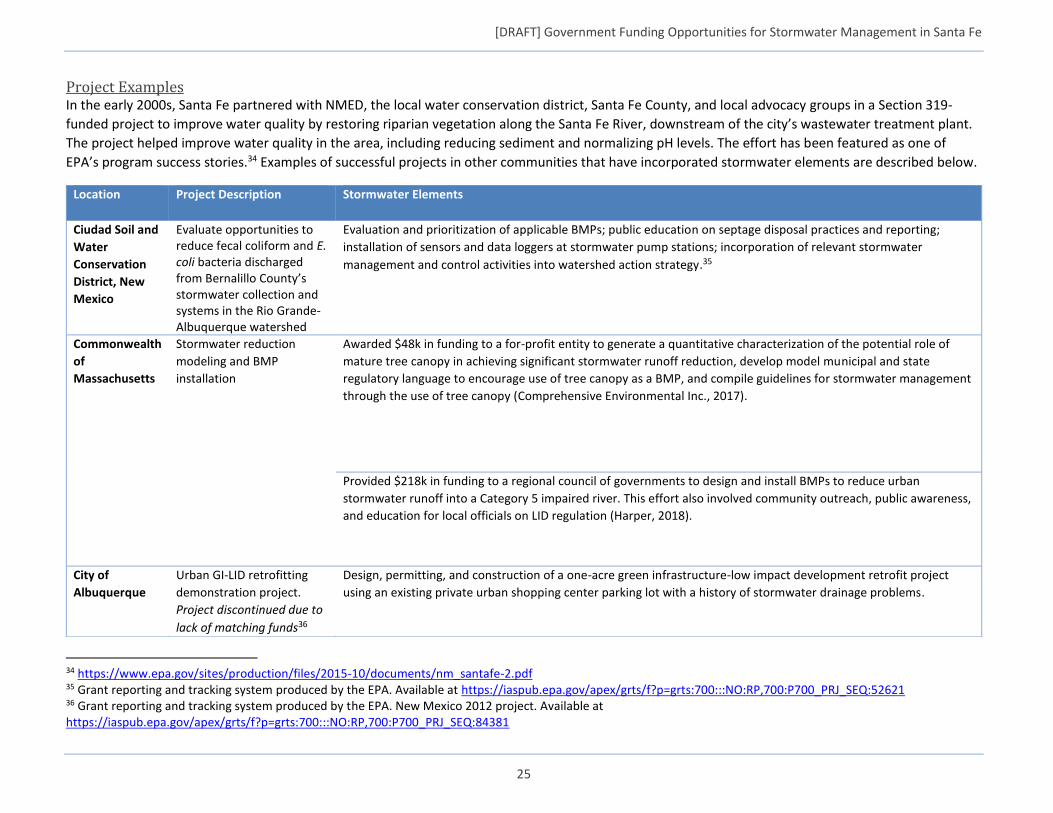
[DRAFT] Government Funding Opportunities for Stormwater Management in Santa Fe
25
Project Examples In the early 2000s, Santa Fe partnered with NMED, the local water conservation district, Santa Fe County, and local advocacy groups in a Section 319-
funded project to improve water quality by restoring riparian vegetation along the Santa Fe River, downstream of the city’s wastewater treatment plant.
The project helped improve water quality in the area, including reducing sediment and normalizing pH levels. The effort has been featured as one of
EPA’s program success stories.34 Examples of successful projects in other communities that have incorporated stormwater elements are described below.
34 https://www.epa.gov/sites/production/files/2015-10/documents/nm_santafe-2.pdf 35 Grant reporting and tracking system produced by the EPA. Available at https://iaspub.epa.gov/apex/grts/f?p=grts:700:::NO:RP,700:P700_PRJ_SEQ:52621 36 Grant reporting and tracking system produced by the EPA. New Mexico 2012 project. Available at https://iaspub.epa.gov/apex/grts/f?p=grts:700:::NO:RP,700:P700_PRJ_SEQ:84381
Location Project Description Stormwater Elements
Ciudad Soil and
Water
Conservation
District, New
Mexico
Evaluate opportunities to reduce fecal coliform and E. coli bacteria discharged from Bernalillo County’s stormwater collection and systems in the Rio Grande-Albuquerque watershed
Evaluation and prioritization of applicable BMPs; public education on septage disposal practices and reporting;
installation of sensors and data loggers at stormwater pump stations; incorporation of relevant stormwater
management and control activities into watershed action strategy.35
Commonwealth
of
Massachusetts
Stormwater reduction
modeling and BMP
installation
Awarded $48k in funding to a for-profit entity to generate a quantitative characterization of the potential role of
mature tree canopy in achieving significant stormwater runoff reduction, develop model municipal and state
regulatory language to encourage use of tree canopy as a BMP, and compile guidelines for stormwater management
through the use of tree canopy (Comprehensive Environmental Inc., 2017).
Provided $218k in funding to a regional council of governments to design and install BMPs to reduce urban
stormwater runoff into a Category 5 impaired river. This effort also involved community outreach, public awareness,
and education for local officials on LID regulation (Harper, 2018).
City of
Albuquerque
Urban GI-LID retrofitting
demonstration project.
Project discontinued due to
lack of matching funds36
Design, permitting, and construction of a one-acre green infrastructure-low impact development retrofit project
using an existing private urban shopping center parking lot with a history of stormwater drainage problems.
[DRAFT] Government Funding Opportunities for Stormwater Management in Santa Fe
26
REFERENCES Bartsch, Charlie. “Recycling History: The Value of ‘Old’ in Brownfield Reuse.” Recycling History: The Value of “Old” in Brownfield Reuse, 4 Sept. 2015, pp.
1–33. US Environmental Protection Agency, Economic Development, doi:8/1/2018.
BBC, Research & Consulting. “Housing Needs Assessment Update.” EXECUTIVE SUMMARY Santa Fe 2012 Housing Needs Assessment, City of Santa Fe, New Mexico, 19 Mar. 2013, www.santafenm.gov/document_center/document/5446.
BUILD, DOT. “2018 BUILD Applications FAQs.” US Department of Transportation, United States Department of Transportation, 23 Feb. 2016, www.transportation.gov/BUILDgrants/2018-build-application-faqs.
Community Development Commission (CDC). “Eligible Activities.” Water Quality and Compliance | City of Santa Fe, New Mexico, City of Santa Fe, 1 Jan. 2017, www.santafenm.gov/eligible_activities.
Comprehensive Environmental Inc., et al. Tree Canopy Stormwater Implementation & Outreach Program: 14-07/319: 2014-2017. Massachusetts Executive Office of Energy and Environmental Affairs, Department of Environmental Protection, Bureau of Water Resources, Division of Municipal Services, 2017.
Cornett, Mick, et al. “CDBG Works: How Mayors Put CDBG to Work.” CDBG WORKS: How Mayors Put CDBG to Work, 1 June 2017, pp. 1–116. The United States Conference of Mayors, doi:8/1/2018.
CWSRF. “PISCES Recognition Program 2017 Compendium.” Epa.gov, 2017, www.epa.gov/sites/production/files/2017-11/documents/pisces_compendium_final2.pdf.
DOT. “Federal Register.” DEPARTMENT OF TRANSPORTATION Office of the Secretary of Transportation Notice of Funding Opportunity for the Department of Transportation’s National Infrastructure Investments Under the Consolidated Appropriations Act, 2018, vol. 83, no. 82, 27 Apr. 2018, pp. 1–11. Office of the Secretary of Transportation, DOT, doi:8/2/2018.
EPA. “Financing Green Infrastructure: A Best Practices Guide for the Clean Water State Revolving Fund.” Epa.gov, 2015, www.epa.gov/sites/production/files/2016-01/documents/final_gi_best_practices_guide_12-9-15.pdf.
EPA. “2017 Annual Report: CWSRF Programs.” Epa.gov, 2017, www.epa.gov/sites/production/files/2018-03/documents/final_2017_cwsrf_annual_report_for_web2.pdf.
“Erie Street CDBG Storm Water Improvements | Storm Lake, IA - Official Website.” Solar Energy | Storm Lake, IA - Official Website, Government Websites by CivicPlus, 6 June 2016, www.stormlake.org/631/Erie-Street-CDBG-Storm-Water-Improvement.
Fitzpatrick, Mollie. “City of Santa Fe CONSOLIDATED PLAN.” Santa Fe Community Development Commission and Open House, 18 Apr. 2018, pp. 1–20. BBC, Consulting, doi:8/2/2018.
Harper, Malcolm M. “PROJECT SUMMARIES.” SECTION 319 NONPOINT SOURCE COMPETITIVE GRANTS PROGRAM, pp. 1–64. MASSACHUSETTS DEPARTMENT OF ENVIRONMENTAL PROTECTION, doi:8/2/2018.
Martinez, Susana, et al. “Federal Clean Water Act Section 319 Grant Federal Fiscal Year 2018: Watershed-Based Planning.” Request for Grant Application (RFGA), 1 Jan. 2018, pp. 1–4. New Mexico Environment Department, Surface Water Quality Bureau, doi:8/2/2018.
[DRAFT] Government Funding Opportunities for Stormwater Management in Santa Fe
27
Mahoney, Joanne M. “Save The Rain Clean The Lake.” FACT SHEET: Connective Corridor Phase 1, Contract 1, 22 Dec. 2011, pp. 1–1., doi:8/2/2018.
Maloney, Lucia. “Carson City Gateway.” TIGER 2017 Discretionary Grant Application, 16 Oct. 2017, pp. 1–35. TIGER 2017, doi:8/2/2018. Grant Application
New Mexico CWSRF Program, and Northbridge Environmental. “CWSRF Affordability Criteria System.” Www.env.nm.gov, Feb. 2018, www.env.nm.gov/wp-content/uploads/2017/04/CWSRF-Affordability-Criteria-System_FEB2018.pdf.
New Mexico Environment Department. “New Mexico Clean Water State Revolving Fund Intended Use Plan State Fiscal Year 2019.” www.env.nm.gov, 30 June 2018, www.env.nm.gov/wp-content/uploads/2017/04/CWSRF-2019-Draft-Intended-Use-Plan.pdf.
New Mexico Environment Department Construction Programs Bureau. “Infrastructure Development Report.” www.nmlegis.gov, July 2017, www.nmlegis.gov/handouts/NMFA 110117 Item 3 b - NMED Presentation.pdf.
Ramage, Mary Ellen. “Funding & Sustainability Initiatives in The Borough of Etna.” Funding & Sustainability Initiatives in The Borough of Etna, 1 May 2017, pp. 1–27. Bayer Center, Non-Profit Management, doi:8/1/2018. Power Point slides
Sawyers, Andrew D. “Memorandum: Green Infrastructure Policy for the Clean Water State Revolving Fund Program.” Epa.gov, 6 Jan. 2016, www.epa.gov/sites/production/files/2016-01/documents/cwsrf_green_infrastructure_policy_final.pdf.
Sawyers, Andrew D. “Memorandum: Interpretive Guidance for Certain Amendments in the Water Resources Reform and Development Act to Titles I, II, V, and VI of the Federal Water Pollution Control Act.” Epa.gov, June 2015, www.epa.gov/sites/production/files/2015-04/documents/water_resources_reform_and_development_act_guidance.pdf
U.S. DOT. “BUILD vs. TIGER Fact Sheet.” Www.transportation.gov, 2018, www.transportation.gov/sites/dot.gov/files/docs/policy-initiatives/tiger/308656/build-vs-tiger-fact-sheet-042018-1049am.pdf.
Yoshikawa, Nancy. “Nonpoint Source Program and Grants Guidelines for States and Territories.” pp. 1–78.EPA's Nonpoint Source Website, EPA, 12 Apr. 2013, doi:8/2/2018.
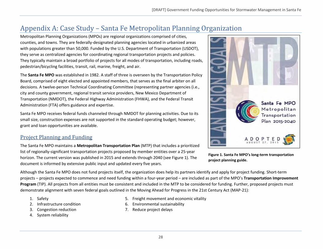
[DRAFT] Government Funding Opportunities for Stormwater Management in Santa Fe
28
Appendix A: Case Study – Santa Fe Metropolitan Planning Organization Metropolitan Planning Organizations (MPOs) are regional organizations comprised of cities,
counties, and towns. They are federally-designated planning agencies located in urbanized areas
with populations greater than 50,000. Funded by the U.S. Department of Transportation (USDOT),
they serve as centralized agencies for coordinating regional transportation projects and policies.
They typically maintain a broad portfolio of projects for all modes of transportation, including roads,
pedestrian/bicycling facilities, transit, rail, marine, freight, and air.
The Santa Fe MPO was established in 1982. A staff of three is overseen by the Transportation Policy
Board, comprised of eight elected and appointed members, that serves as the final arbiter on all
decisions. A twelve-person Technical Coordinating Committee (representing partner agencies (i.e.,
city and county government, regional transit service providers, New Mexico Department of
Transportation (NMDOT), the Federal Highway Administration (FHWA), and the Federal Transit
Administration (FTA) offers guidance and expertise.
Santa Fe MPO receives federal funds channeled through NMDOT for planning activities. Due to its
small size, construction expenses are not supported in the standard operating budget; however,
grant and loan opportunities are available.
Project Planning and Funding
The Santa Fe MPO maintains a Metropolitan Transportation Plan (MTP) that includes a prioritized
list of regionally-significant transportation projects proposed by member entities over a 25-year
horizon. The current version was published in 2015 and extends through 2040 (see Figure 1). The
document is informed by extensive public input and updated every five years.
Although the Santa Fe MPO does not fund projects itself, the organization does help its partners identify and apply for project funding. Short-term
projects – projects expected to commence and need funding within a four-year period – are included as part of the MPO’s Transportation Improvement
Program (TIP). All projects from all entities must be consistent and included in the MTP to be considered for funding. Further, proposed projects must
demonstrate alignment with seven federal goals outlined in the Moving Ahead for Progress in the 21st Century Act (MAP-21):
1. Safety 2. Infrastructure condition 3. Congestion reduction 4. System reliability
5. Freight movement and economic vitality 6. Environmental sustainability 7. Reduce project delays
Figure 1. Santa Fe MPO’s long-term transportation
project planning guide.
[DRAFT] Government Funding Opportunities for Stormwater Management in Santa Fe
29
Funding programs available for TIP projects include:
Metropolitan Planning (PL)
National Highway Performance Program (NHPP)
Surface Transportation Block Grant Program (STBG)
Highway Safety Improvement Program (HSIP)
Congestion Mitigation and Air Quality Improvement Program (CMAQ)
Transportation Alternatives Program (TAP)
These programs typically favor state-level projects and local projects determined to be regionally significant. Santa Fe MPO representatives indicated
bridge rehabilitation and paving projects tend to be given higher-priority at the local level. The TIP is updated every two years in coordination with
NMDOT.
Integrating Stormwater into MPO Projects
Santa Fe MPO representatives acknowledge that infrastructure improvements have traditionally skewed towards “hard” elements like sidewalks and bike
lanes, but, as an organization, they are willing and already active in promoting the use of more environmentally sustainable building practices. The MPO
recognizes the value that stormwater management concepts can bring to transportation projects, and the MTP actively promotes the use of GI/LID
practices. Santa Fe MPO promotes green streets design practices and has adopted A Resolution Advancing Complete Streets for the Santa Fe Metropolitan
Planning Area,37 which states “the Santa Fe Metropolitan Planning Organization promotes a multi-modal, regional transportation system that is safe,
energy and fiscally efficient, maximizes community connectivity, serves the mobility needs of all citizens, and exists in harmony with the environment.”
Design concepts like narrower street widths, bioretention curb extensions and sidewalk planters, permeable pavement, and sidewalk trees and tree boxes are
just some of the LID techniques recommended specifically in Santa Fe’s MTP.
37 Santa Fe MPO Complete Streets resolution (Resolution No. 2007-1): http://santafempo.org/wp-content/uploads/2009/07/Complete-Streets-Resolution.pdf
Santa Fe MPO indicated that NMDOT is often only able to disburse a portion of its available project funding each year (sometimes as little as 50 percent
or less) due in part to procedural challenges, constraints of recipients and project timelines, and lack of available local matching funds. This shows there is
likely room for improvement in the process and an opportunity for well-prepared entities to capitalize.
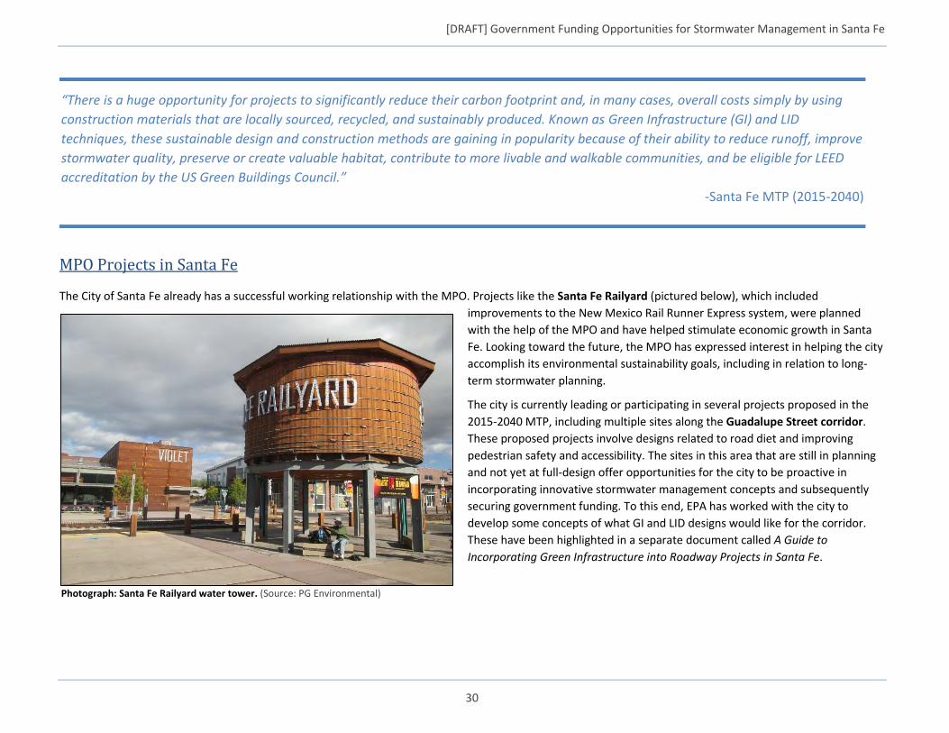
[DRAFT] Government Funding Opportunities for Stormwater Management in Santa Fe
30
MPO Projects in Santa Fe
The City of Santa Fe already has a successful working relationship with the MPO. Projects like the Santa Fe Railyard (pictured below), which included
improvements to the New Mexico Rail Runner Express system, were planned
with the help of the MPO and have helped stimulate economic growth in Santa
Fe. Looking toward the future, the MPO has expressed interest in helping the city
accomplish its environmental sustainability goals, including in relation to long-
term stormwater planning.
The city is currently leading or participating in several projects proposed in the
2015-2040 MTP, including multiple sites along the Guadalupe Street corridor.
These proposed projects involve designs related to road diet and improving
pedestrian safety and accessibility. The sites in this area that are still in planning
and not yet at full-design offer opportunities for the city to be proactive in
incorporating innovative stormwater management concepts and subsequently
securing government funding. To this end, EPA has worked with the city to
develop some concepts of what GI and LID designs would like for the corridor.
These have been highlighted in a separate document called A Guide to
Incorporating Green Infrastructure into Roadway Projects in Santa Fe.
“There is a huge opportunity for projects to significantly reduce their carbon footprint and, in many cases, overall costs simply by using
construction materials that are locally sourced, recycled, and sustainably produced. Known as Green Infrastructure (GI) and LID
techniques, these sustainable design and construction methods are gaining in popularity because of their ability to reduce runoff, improve
stormwater quality, preserve or create valuable habitat, contribute to more livable and walkable communities, and be eligible for LEED
accreditation by the US Green Buildings Council.”
-Santa Fe MTP (2015-2040)
Photograph: Santa Fe Railyard water tower. (Source: PG Environmental)
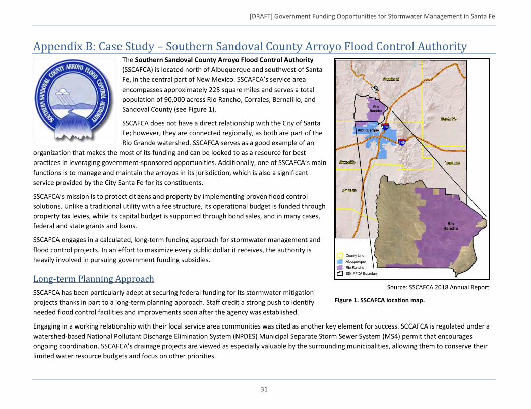
[DRAFT] Government Funding Opportunities for Stormwater Management in Santa Fe
31
Appendix B: Case Study – Southern Sandoval County Arroyo Flood Control Authority The Southern Sandoval County Arroyo Flood Control Authority
(SSCAFCA) is located north of Albuquerque and southwest of Santa
Fe, in the central part of New Mexico. SSCAFCA’s service area
encompasses approximately 225 square miles and serves a total
population of 90,000 across Rio Rancho, Corrales, Bernalillo, and
Sandoval County (see Figure 1).
SSCAFCA does not have a direct relationship with the City of Santa
Fe; however, they are connected regionally, as both are part of the
Rio Grande watershed. SSCAFCA serves as a good example of an
organization that makes the most of its funding and can be looked to as a resource for best
practices in leveraging government-sponsored opportunities. Additionally, one of SSCAFCA’s main
functions is to manage and maintain the arroyos in its jurisdiction, which is also a significant
service provided by the City Santa Fe for its constituents.
SSCAFCA’s mission is to protect citizens and property by implementing proven flood control
solutions. Unlike a traditional utility with a fee structure, its operational budget is funded through
property tax levies, while its capital budget is supported through bond sales, and in many cases,
federal and state grants and loans.
SSCAFCA engages in a calculated, long-term funding approach for stormwater management and
flood control projects. In an effort to maximize every public dollar it receives, the authority is
heavily involved in pursuing government funding subsidies.
Long-term Planning Approach
SSCAFCA has been particularly adept at securing federal funding for its stormwater mitigation
projects thanks in part to a long-term planning approach. Staff credit a strong push to identify
needed flood control facilities and improvements soon after the agency was established.
Engaging in a working relationship with their local service area communities was cited as another key element for success. SCCAFCA is regulated under a
watershed-based National Pollutant Discharge Elimination System (NPDES) Municipal Separate Storm Sewer System (MS4) permit that encourages
ongoing coordination. SSCAFCA’s drainage projects are viewed as especially valuable by the surrounding municipalities, allowing them to conserve their
limited water resource budgets and focus on other priorities.
Source: SSCAFCA 2018 Annual Report
Figure 1. SSCAFCA location map.
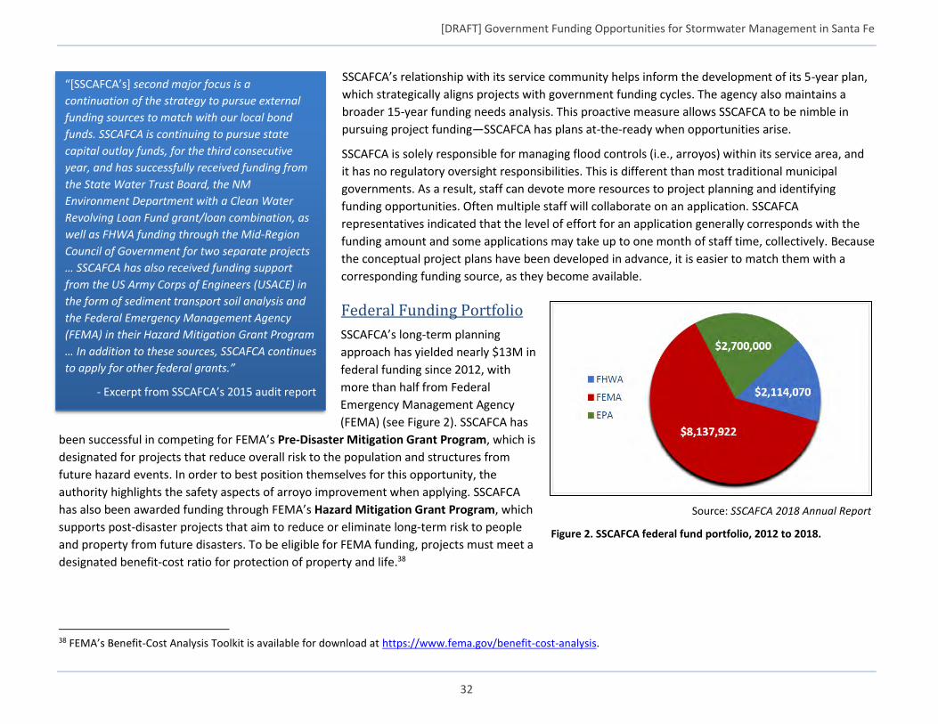
[DRAFT] Government Funding Opportunities for Stormwater Management in Santa Fe
32
SSCAFCA’s relationship with its service community helps inform the development of its 5-year plan,
which strategically aligns projects with government funding cycles. The agency also maintains a
broader 15-year funding needs analysis. This proactive measure allows SSCAFCA to be nimble in
pursuing project funding—SSCAFCA has plans at-the-ready when opportunities arise.
SSCAFCA is solely responsible for managing flood controls (i.e., arroyos) within its service area, and
it has no regulatory oversight responsibilities. This is different than most traditional municipal
governments. As a result, staff can devote more resources to project planning and identifying
funding opportunities. Often multiple staff will collaborate on an application. SSCAFCA
representatives indicated that the level of effort for an application generally corresponds with the
funding amount and some applications may take up to one month of staff time, collectively. Because
the conceptual project plans have been developed in advance, it is easier to match them with a
corresponding funding source, as they become available.
Federal Funding Portfolio
SSCAFCA’s long-term planning
approach has yielded nearly $13M in
federal funding since 2012, with
more than half from Federal
Emergency Management Agency
(FEMA) (see Figure 2). SSCAFCA has
been successful in competing for FEMA’s Pre-Disaster Mitigation Grant Program, which is
designated for projects that reduce overall risk to the population and structures from
future hazard events. In order to best position themselves for this opportunity, the
authority highlights the safety aspects of arroyo improvement when applying. SSCAFCA
has also been awarded funding through FEMA’s Hazard Mitigation Grant Program, which
supports post-disaster projects that aim to reduce or eliminate long-term risk to people
and property from future disasters. To be eligible for FEMA funding, projects must meet a
designated benefit-cost ratio for protection of property and life.38
38 FEMA’s Benefit-Cost Analysis Toolkit is available for download at https://www.fema.gov/benefit-cost-analysis.
“[SSCAFCA’s] second major focus is a
continuation of the strategy to pursue external
funding sources to match with our local bond
funds. SSCAFCA is continuing to pursue state
capital outlay funds, for the third consecutive
year, and has successfully received funding from
the State Water Trust Board, the NM
Environment Department with a Clean Water
Revolving Loan Fund grant/loan combination, as
well as FHWA funding through the Mid-Region
Council of Government for two separate projects
… SSCAFCA has also received funding support
from the US Army Corps of Engineers (USACE) in
the form of sediment transport soil analysis and
the Federal Emergency Management Agency
(FEMA) in their Hazard Mitigation Grant Program
… In addition to these sources, SSCAFCA continues
to apply for other federal grants.”
- Excerpt from SSCAFCA’s 2015 audit report
Source: SSCAFCA 2018 Annual Report
Figure 2. SSCAFCA federal fund portfolio, 2012 to 2018.
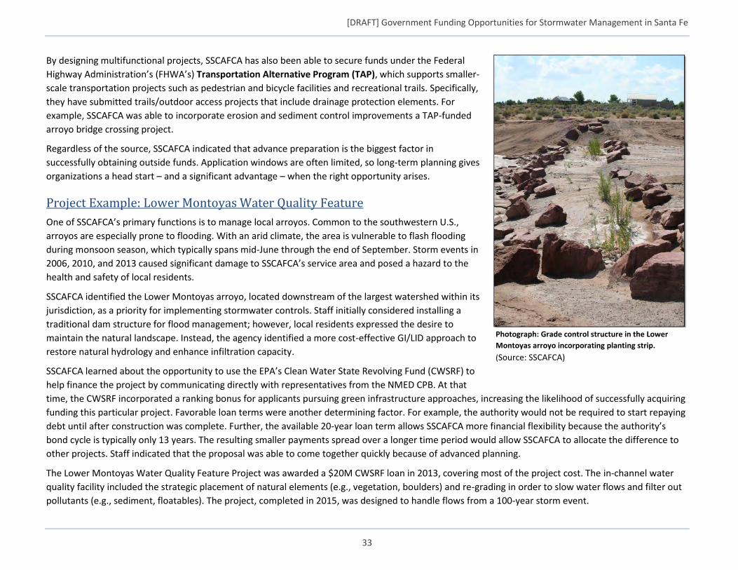
[DRAFT] Government Funding Opportunities for Stormwater Management in Santa Fe
33
By designing multifunctional projects, SSCAFCA has also been able to secure funds under the Federal
Highway Administration’s (FHWA’s) Transportation Alternative Program (TAP), which supports smaller-
scale transportation projects such as pedestrian and bicycle facilities and recreational trails. Specifically,
they have submitted trails/outdoor access projects that include drainage protection elements. For
example, SSCAFCA was able to incorporate erosion and sediment control improvements a TAP-funded
arroyo bridge crossing project.
Regardless of the source, SSCAFCA indicated that advance preparation is the biggest factor in
successfully obtaining outside funds. Application windows are often limited, so long-term planning gives
organizations a head start – and a significant advantage – when the right opportunity arises.
Project Example: Lower Montoyas Water Quality Feature
One of SSCAFCA’s primary functions is to manage local arroyos. Common to the southwestern U.S.,
arroyos are especially prone to flooding. With an arid climate, the area is vulnerable to flash flooding
during monsoon season, which typically spans mid-June through the end of September. Storm events in
2006, 2010, and 2013 caused significant damage to SSCAFCA’s service area and posed a hazard to the
health and safety of local residents.
SSCAFCA identified the Lower Montoyas arroyo, located downstream of the largest watershed within its
jurisdiction, as a priority for implementing stormwater controls. Staff initially considered installing a
traditional dam structure for flood management; however, local residents expressed the desire to
maintain the natural landscape. Instead, the agency identified a more cost-effective GI/LID approach to
restore natural hydrology and enhance infiltration capacity.
SSCAFCA learned about the opportunity to use the EPA’s Clean Water State Revolving Fund (CWSRF) to
help finance the project by communicating directly with representatives from the NMED CPB. At that
time, the CWSRF incorporated a ranking bonus for applicants pursuing green infrastructure approaches, increasing the likelihood of successfully acquiring
funding this particular project. Favorable loan terms were another determining factor. For example, the authority would not be required to start repaying
debt until after construction was complete. Further, the available 20-year loan term allows SSCAFCA more financial flexibility because the authority’s
bond cycle is typically only 13 years. The resulting smaller payments spread over a longer time period would allow SSCAFCA to allocate the difference to
other projects. Staff indicated that the proposal was able to come together quickly because of advanced planning.
The Lower Montoyas Water Quality Feature Project was awarded a $20M CWSRF loan in 2013, covering most of the project cost. The in-channel water
quality facility included the strategic placement of natural elements (e.g., vegetation, boulders) and re-grading in order to slow water flows and filter out
pollutants (e.g., sediment, floatables). The project, completed in 2015, was designed to handle flows from a 100-year storm event.
Photograph: Grade control structure in the Lower
Montoyas arroyo incorporating planting strip.
(Source: SSCAFCA)
[DRAFT] Government Funding Opportunities for Stormwater Management in Santa Fe
34
Appendix C: Summary of Potential Federal Funding Opportunities
U.S. Environmental Protection Agency (EPA)
PROGRAM PROGRAM DESCRIPTION EXAMPLE OF FUNDED PROJECTS
Clean Water State Revolving Fund
Using a combination of federal and state funds, provides loans to construct municipal wastewater facilities, control nonpoint sources of pollution, build decentralized wastewater treatment systems, create green infrastructure projects, protect estuaries, and fund other water quality projects. The Best Practices Guide (2015) highlights successful case studies and examples of ways state CWSRF programs can prioritize green infrastructure projects for funding by implementing priority point systems, program set-asides, and marketing strategies for state programs. Green Infrastructure Approaches to Managing Wet Weather with Clean Water State Revolving Funds Factsheet (2008).
The Inland Empire Utilities Agency (IEUA) – a regional wastewater service provider and distributor of wholesale water and recycled water in San Bernardino County, CA – received more than $30 million in financing from the American Recovery and Reinvestment Act (ARRA). A portion of these funds will be used for stormwater capture in local groundwater aquifers and green infrastructure projects to improve the water quality of the Chino Creek Watershed and improve wildlife habitat by restoring the degraded riparian ecosystem. In 2004, the Nature Conservancy used a $9 million CWSRF loan to fund the interim financing and holding a critical portion of land, known as the Palo Corona Ranch, in Monterey County, CA. This project protected 9,898 acres of pristine Redwood and Monterey Pine forests from imminent development. Without the Nature Conservancy’s purchase increased sedimentation and stormwater runoff would have cause severe impaired to coastal and aquatic resources. The property will be retained by the Department of Parks and the Monterey Peninsula Recreational Park District with dedicated funds over a seven-year period.
Water Infrastructure Finance and Innovation Act (WIFIA)
WIFIA is a federal credit program administered by EPA for eligible water and wastewater infrastructure projects, including stormwater and green infrastructure projects.
The WIFIA program is inviting 12 entities with projects in 9 states to apply for more than $2 billion in WIFIA loans. Several of the selected projects include stormwater:
The City of Baltimore, MD will repair, rehabilitate, replace, and upgrade its wastewater collection and treatment, water treatment and distribution, and stormwater management systems.
The City of Omaha, NE will construct a new retention treatment basin to address combined sewer overflows in the Saddle Creek Basin.
King Co., WA will construct a new wet weather treatment station, conveyance pipelines and outfall structure to treat combined sewer overflows to the Lower Duwamish Waterway.
U.S. EPA
Federal Funding Programs - Stormwater and Green Infrastructure Projects
[DRAFT] Government Funding Opportunities for Stormwater Management in Santa Fe
35
PROGRAM PROGRAM DESCRIPTION EXAMPLE OF FUNDED PROJECTS
Saint Louis, MO will construct a new pump station, replace parts of the sanitary sewer to address combined and sanitary sewer overflows to Deer Creek.
Section 319 Nonpoint Source Grant Program
Funding goes to states to reduce nonpoint source pollution (pollution caused by rainfall running over the ground and carrying pollutants including trash, oil and grease, and fertilizers into nearby waterways). EPA’s most recent program guidance recognized the “importance of green infrastructure … in managing stormwater” and supported awarding funding to green infrastructure projects.
The District of Columbia Department of Energy and Environment (DOEE) used Section 319 funding to partially fund remediation of the Watts Branch watershed in northeast D.C. Watts Branch suffered from severe erosion and sediment pollution due to frequent flooding. DDOE led a project to restore the stream bed and control flooding using tree and shrub plantings, regrading of the stream bed, and upstream low-impact development practices to manage impervious surface runoff.
Urban Waters Small Grants Program (UWSG)
Funding to communities to improve the quality of urban waters while simultaneously stimulating neighborhood revitalization. The Urban Waters Small Grants Program has a focus on underserved communities, defined as “communities with environmental justice concerns and/or susceptible populations.” The Program can be used specifically for innovative or new green infrastructure practices that improve water quality; state, local, and tribal governments, as well as universities and nonprofit organizations, are eligible to apply.
The Constitutional Rights Foundation, in partnership with Los Angeles Waterkeeper and UCLA, award to work with four high schools in Los Angeles County. College- aspiring students will be taught how to collect data related to trash and industrial stormwater pollution. Up to five seniors from UCLA’s Environmental Sciences bachelors program will serve as peer mentors and role models for participants (2015/6).
Heal the Bay will monitor bacterial water pollution at two recreational zones in the Los Angeles River. Water quality data will be made available regularly to the public. Results of the study will be used to make recommendations to agencies and watershed stakeholders for improving water quality and protecting public health (2015/6).
U.S. Housing and Urban Development (HUD)
PROGRAM PROGRAM DESCRIPTION EXAMPLE OF FUNDED PROJECTS
Community Development Block Grant (CDBG)
Eligible to fund stormwater and green infrastructure because these projects can create jobs, increase economic activity, and increase property values. For example, urban tree planting can increase economic activity in a commercial district. Additionally, green infrastructure can increase property values by mitigating flooding, improving neighborhood aesthetics, and providing other co-benefits.
Detroit, MI, used $8.9 million in CDBG funds in 2014 to create a major flood prevention and economic development program. Detroit is using the funding to demolish blighted properties, landscape and install trees on 200 vacant lots to improve stormwater management and neighborhood aesthetics, and install infrastructure that will direct stormwater into new bio-retention basins. Chicago has used CDBG funding to put a new green roof on its historic Cultural Center.
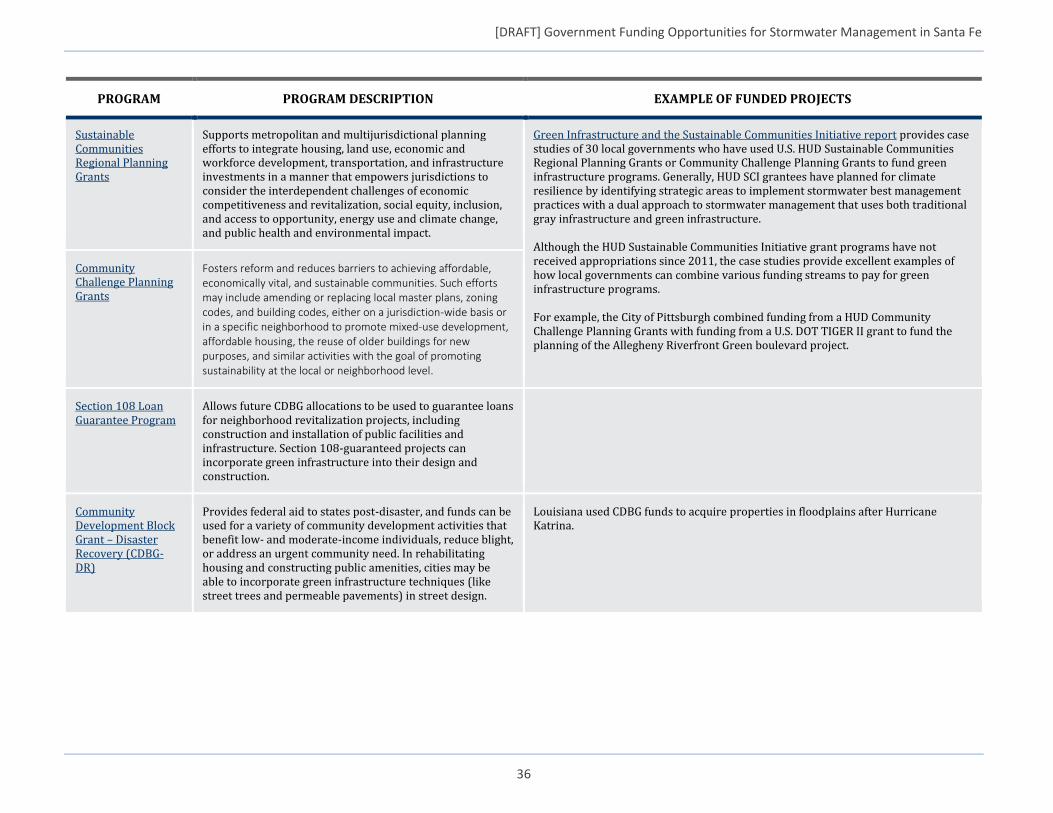
[DRAFT] Government Funding Opportunities for Stormwater Management in Santa Fe
36
PROGRAM PROGRAM DESCRIPTION EXAMPLE OF FUNDED PROJECTS
Sustainable Communities Regional Planning Grants
Supports metropolitan and multijurisdictional planning efforts to integrate housing, land use, economic and workforce development, transportation, and infrastructure investments in a manner that empowers jurisdictions to consider the interdependent challenges of economic competitiveness and revitalization, social equity, inclusion, and access to opportunity, energy use and climate change, and public health and environmental impact.
Green Infrastructure and the Sustainable Communities Initiative report provides case studies of 30 local governments who have used U.S. HUD Sustainable Communities Regional Planning Grants or Community Challenge Planning Grants to fund green infrastructure programs. Generally, HUD SCI grantees have planned for climate resilience by identifying strategic areas to implement stormwater best management practices with a dual approach to stormwater management that uses both traditional gray infrastructure and green infrastructure. Although the HUD Sustainable Communities Initiative grant programs have not received appropriations since 2011, the case studies provide excellent examples of how local governments can combine various funding streams to pay for green infrastructure programs. For example, the City of Pittsburgh combined funding from a HUD Community Challenge Planning Grants with funding from a U.S. DOT TIGER II grant to fund the planning of the Allegheny Riverfront Green boulevard project.
Community Challenge Planning Grants
Fosters reform and reduces barriers to achieving affordable, economically vital, and sustainable communities. Such efforts may include amending or replacing local master plans, zoning codes, and building codes, either on a jurisdiction-wide basis or in a specific neighborhood to promote mixed-use development, affordable housing, the reuse of older buildings for new purposes, and similar activities with the goal of promoting sustainability at the local or neighborhood level.
Section 108 Loan Guarantee Program
Allows future CDBG allocations to be used to guarantee loans for neighborhood revitalization projects, including construction and installation of public facilities and infrastructure. Section 108-guaranteed projects can incorporate green infrastructure into their design and construction.
Community Development Block Grant – Disaster Recovery (CDBG-DR)
Provides federal aid to states post-disaster, and funds can be used for a variety of community development activities that benefit low- and moderate-income individuals, reduce blight, or address an urgent community need. In rehabilitating housing and constructing public amenities, cities may be able to incorporate green infrastructure techniques (like street trees and permeable pavements) in street design.
Louisiana used CDBG funds to acquire properties in floodplains after Hurricane Katrina.
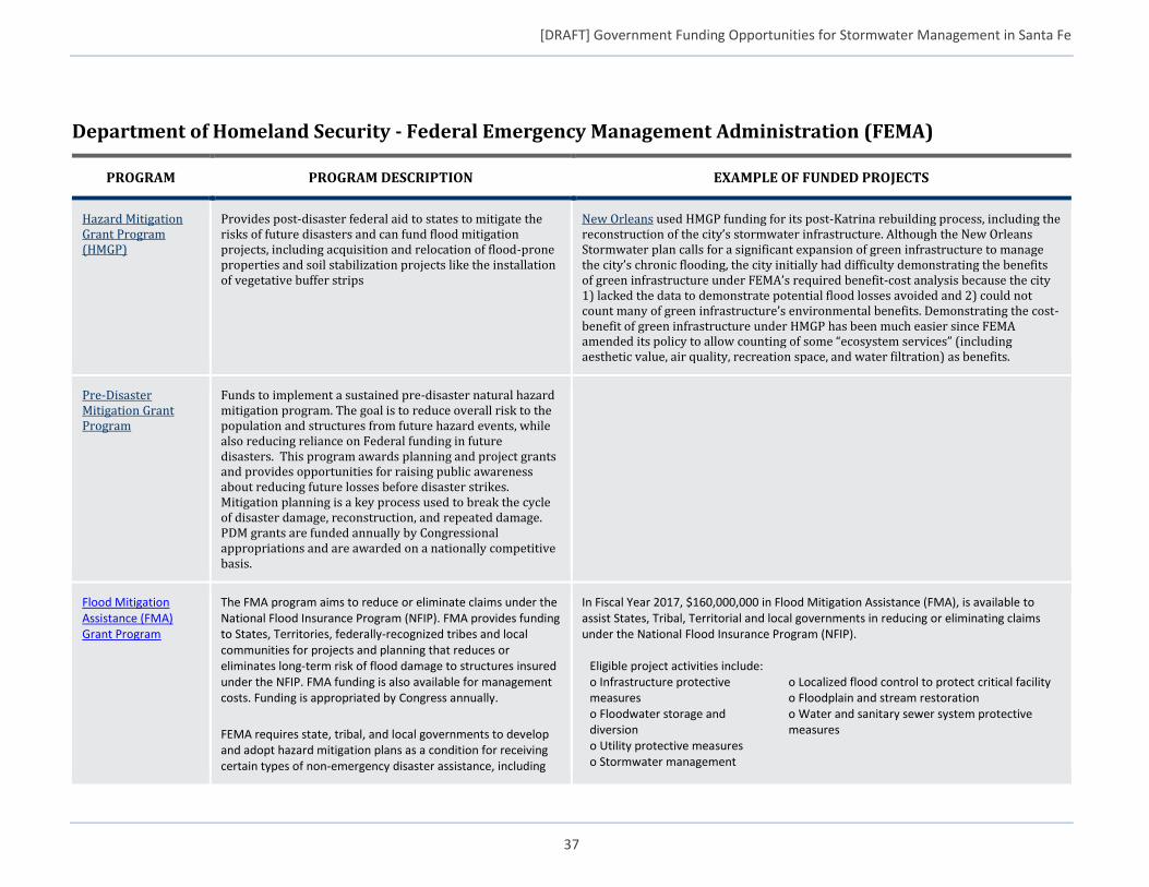
[DRAFT] Government Funding Opportunities for Stormwater Management in Santa Fe
37
Department of Homeland Security - Federal Emergency Management Administration (FEMA)
PROGRAM PROGRAM DESCRIPTION EXAMPLE OF FUNDED PROJECTS
Hazard Mitigation Grant Program (HMGP)
Provides post-disaster federal aid to states to mitigate the risks of future disasters and can fund flood mitigation projects, including acquisition and relocation of flood-prone properties and soil stabilization projects like the installation of vegetative buffer strips
New Orleans used HMGP funding for its post-Katrina rebuilding process, including the reconstruction of the city’s stormwater infrastructure. Although the New Orleans Stormwater plan calls for a significant expansion of green infrastructure to manage the city’s chronic flooding, the city initially had difficulty demonstrating the benefits of green infrastructure under FEMA’s required benefit-cost analysis because the city 1) lacked the data to demonstrate potential flood losses avoided and 2) could not count many of green infrastructure’s environmental benefits. Demonstrating the cost-benefit of green infrastructure under HMGP has been much easier since FEMA amended its policy to allow counting of some “ecosystem services” (including aesthetic value, air quality, recreation space, and water filtration) as benefits.
Pre-Disaster Mitigation Grant Program
Funds to implement a sustained pre-disaster natural hazard mitigation program. The goal is to reduce overall risk to the population and structures from future hazard events, while also reducing reliance on Federal funding in future disasters. This program awards planning and project grants and provides opportunities for raising public awareness about reducing future losses before disaster strikes. Mitigation planning is a key process used to break the cycle of disaster damage, reconstruction, and repeated damage. PDM grants are funded annually by Congressional appropriations and are awarded on a nationally competitive basis.
Flood Mitigation Assistance (FMA) Grant Program
The FMA program aims to reduce or eliminate claims under the National Flood Insurance Program (NFIP). FMA provides funding to States, Territories, federally-recognized tribes and local communities for projects and planning that reduces or eliminates long-term risk of flood damage to structures insured under the NFIP. FMA funding is also available for management costs. Funding is appropriated by Congress annually.
FEMA requires state, tribal, and local governments to develop and adopt hazard mitigation plans as a condition for receiving certain types of non-emergency disaster assistance, including
In Fiscal Year 2017, $160,000,000 in Flood Mitigation Assistance (FMA), is available to assist States, Tribal, Territorial and local governments in reducing or eliminating claims under the National Flood Insurance Program (NFIP).
Eligible project activities include: o Infrastructure protective measures o Floodwater storage and diversion o Utility protective measures o Stormwater management
o Localized flood control to protect critical facility o Floodplain and stream restoration o Water and sanitary sewer system protective measures
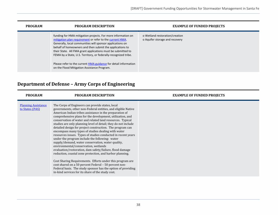
[DRAFT] Government Funding Opportunities for Stormwater Management in Santa Fe
38
PROGRAM PROGRAM DESCRIPTION EXAMPLE OF FUNDED PROJECTS
funding for HMA mitigation projects. For more information on mitigation plan requirement or refer to the current HMA. Generally, local communities will sponsor applications on behalf of homeowners and then submit the applications to their State. All FMA grant applications must be submitted to FEMA by a State, U.S. Territory, or federally-recognized tribe.
Please refer to the current HMA guidance for detail information on the Flood Mitigation Assistance Program.
o Wetland restoration/creation o Aquifer storage and recovery
Department of Defense – Army Corps of Engineering
PROGRAM PROGRAM DESCRIPTION EXAMPLE OF FUNDED PROJECTS
Planning Assistance to States (PAS)
The Corps of Engineers can provide states, local governments, other non-Federal entities, and eligible Native American Indian tribes assistance in the preparation of comprehensive plans for the development, utilization, and conservation of water and related land resources. Typical studies are only planning level of detail; they do not include detailed design for project construction. The program can encompass many types of studies dealing with water resources issues. Types of studies conducted in recent years under the program include the following: water supply/demand, water conservation, water quality, environmental/conservation, wetlands evaluation/restoration, dam safety/failure, flood damage reduction, coastal zone protection, and harbor planning. Cost Sharing Requirements. Efforts under this program are cost shared on a 50 percent Federal – 50 percent non-Federal basis. The study sponsor has the option of providing in-kind services for its share of the study cost.
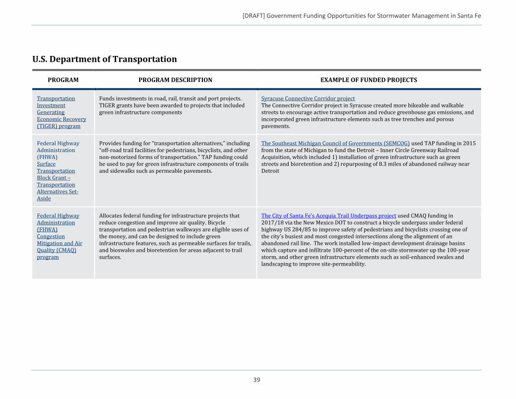
[DRAFT] Government Funding Opportunities for Stormwater Management in Santa Fe
39
U.S. Department of Transportation
PROGRAM PROGRAM DESCRIPTION EXAMPLE OF FUNDED PROJECTS
Transportation Investment Generating Economic Recovery (TIGER) program
Funds investments in road, rail, transit and port projects. TIGER grants have been awarded to projects that included green infrastructure components
Syracuse Connective Corridor project The Connective Corridor project in Syracuse created more bikeable and walkable streets to encourage active transportation and reduce greenhouse gas emissions, and incorporated green infrastructure elements such as tree trenches and porous pavements.
Federal Highway Administration (FHWA) Surface Transportation Block Grant – Transportation Alternatives Set-Aside
Provides funding for “transportation alternatives,” including “off-road trail facilities for pedestrians, bicyclists, and other non-motorized forms of transportation.” TAP funding could be used to pay for green infrastructure components of trails and sidewalks such as permeable pavements.
The Southeast Michigan Council of Governments (SEMCOG) used TAP funding in 2015 from the state of Michigan to fund the Detroit – Inner Circle Greenway Railroad Acquisition, which included 1) installation of green infrastructure such as green streets and bioretention and 2) repurposing of 8.3 miles of abandoned railway near Detroit
Federal Highway Administration (FHWA) Congestion Mitigation and Air Quality (CMAQ) program
Allocates federal funding for infrastructure projects that reduce congestion and improve air quality. Bicycle transportation and pedestrian walkways are eligible uses of the money, and can be designed to include green infrastructure features, such as permeable surfaces for trails, and bioswales and bioretention for areas adjacent to trail surfaces.
The City of Santa Fe’s Acequia Trail Underpass project used CMAQ funding in 2017/18 via the New Mexico DOT to construct a bicycle underpass under federal highway US 284/85 to improve safety of pedestrians and bicyclists crossing one of the city’s busiest and most congested intersections along the alignment of an abandoned rail line. The work installed low-impact development drainage basins which capture and infiltrate 100-percent of the on-site stormwater up the 100-year storm, and other green infrastructure elements such as soil-enhanced swales and landscaping to improve site-permeability.
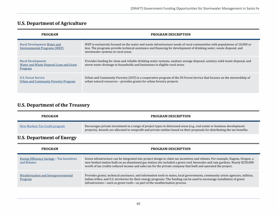
[DRAFT] Government Funding Opportunities for Stormwater Management in Santa Fe
40
U.S. Department of Agriculture
PROGRAM PROGRAM DESCRIPTION
Rural Development Water and Environmental Programs (WEP)
WEP is exclusively focused on the water and waste infrastructure needs of rural communities with populations of 10,000 or less. The programs provide technical assistance and financing for development of drinking water, waste disposal, and stormwater systems in rural areas.
Rural Development Water and Waste Disposal Loan and Grant Program
Provides funding for clean and reliable drinking water systems, sanitary sewage disposal, sanitary solid waste disposal, and storm water drainage to households and businesses in eligible rural areas.
U.S. Forest Service Urban and Community Forestry Program
Urban and Community Forestry (UCF) is a cooperative program of the US Forest Service that focuses on the stewardship of urban natural resources – provides grants for urban forestry projects
U.S. Department of the Treasury
PROGRAM PROGRAM DESCRIPTION
New Markets Tax Credit program Encourages private investment in a range of project types in distressed areas (e.g., real estate or business development projects). Awards are allocated to nonprofit and private entities based on their proposals for distributing the tax benefits.
U.S. Department of Energy
PROGRAM PROGRAM DESCRIPTION
Energy Efficiency Savings – Tax Incentives and Rebates
Green infrastructure can be integrated into project design to claim tax incentives and rebates. For example, Eugene, Oregon, a new biofuel station built on an abandoned gas station site included a green roof, bioswales and rain gardens. Nearly $250,000 worth of tax credits reduced income and sales tax for the private company that built and operated the project.
Weatherization and Intergovernmental Program
Provides grants, technical assistance, and information tools to states, local governments, community action agencies, utilities, Indian tribes, and U.S. territories for their energy programs. The funding can be used to encourage installation of green infrastructure—such as green roofs—as part of the weatherization process.
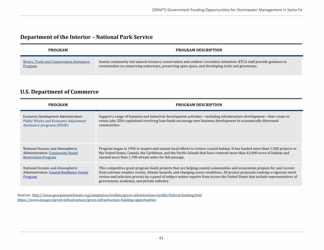
[DRAFT] Government Funding Opportunities for Stormwater Management in Santa Fe
41
Department of the Interior – National Park Service
PROGRAM PROGRAM DESCRIPTION
Rivers, Trails and Conservation Assistance Program
Assists community-led natural resource conservation and outdoor recreation initiatives. RTCA staff provide guidance to communities on conserving waterways, preserving open space, and developing trails and greenways.
U.S. Department of Commerce
PROGRAM PROGRAM DESCRIPTION
Economic Development Administration: Public Works and Economic Adjustment Assistance programs (EDAP)
Support a range of business and industrial development activities—including infrastructure development—that create or retain jobs. EDA-capitalized revolving loan funds encourage new business development in economically distressed communities.
National Oceanic and Atmospheric Administration: Community-Based Restoration Program
Program began in 1996 to inspire and sustain local efforts to restore coastal habitat. It has funded more than 1,500 projects in the United States, Canada, the Caribbean, and the Pacific Islands that have restored more than 41,000 acres of habitat and opened more than 1,700 stream miles for fish passage.
National Oceanic and Atmospheric Administration: Coastal Resilience Grants Program
This competitive grant program funds projects that are helping coastal communities and ecosystems prepare for and recover from extreme weather events, climate hazards, and changing ocean conditions. All project proposals undergo a rigorous merit review and selection process by a panel of subject matter experts from across the United States that include representatives of government, academia, and private industry.
Sources: http://www.georgetownclimate.org/adaptation/toolkits/green-infrastructure-toolkit/federal-funding.html
https://www.epa.gov/green-infrastructure/green-infrastructure-funding-opportunities