Embed Size (px)
Citation preview
1
SUBWAY-SIDEWALK INTERFACE PROJECT
GUN HILL ROAD - WHITE PLAINS
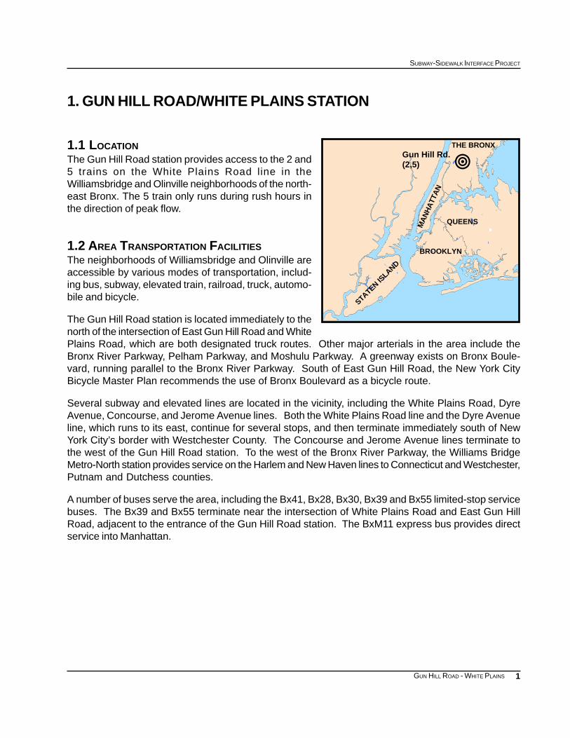
1. GUN HILL ROAD/WHITE PLAINS STATION
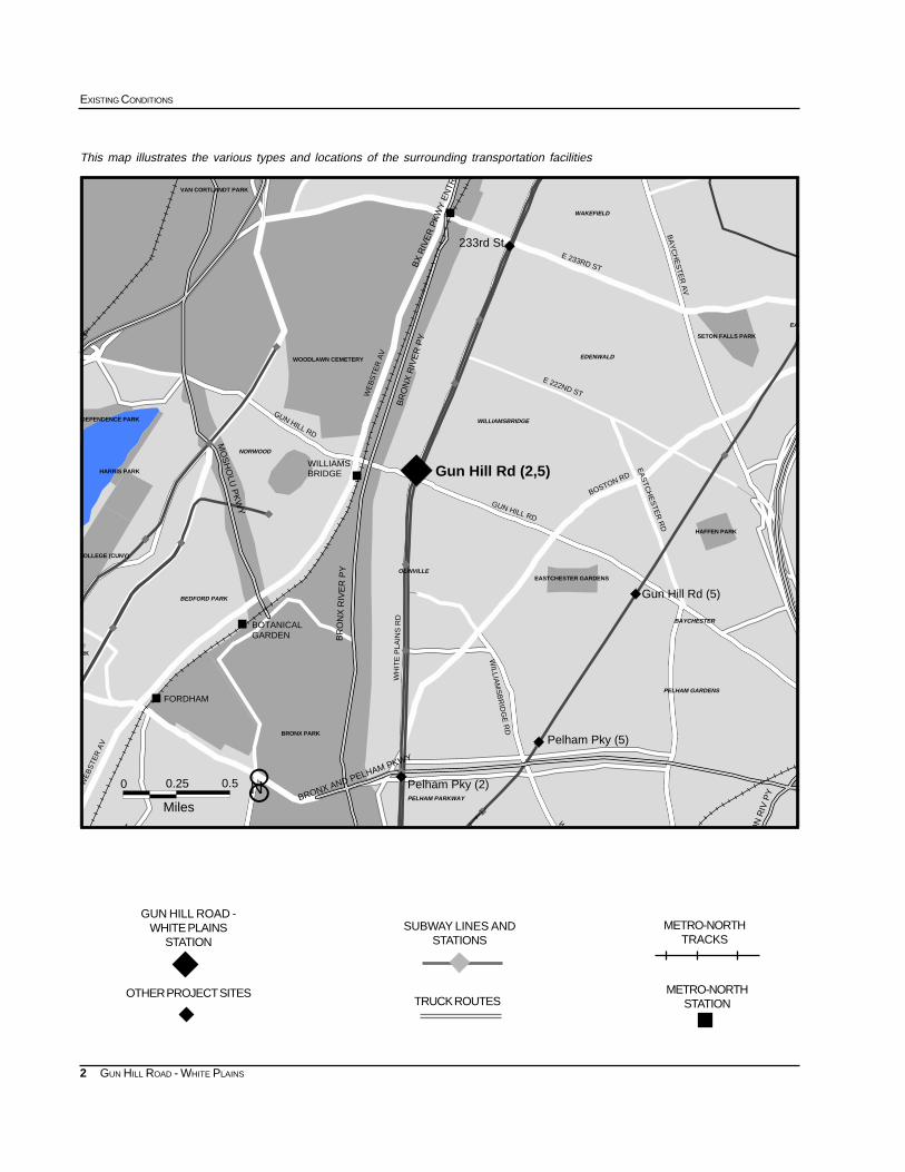
1.1 LOCATIONThe Gun Hill Road station provides access to the 2 and5 trains on the White Plains Road line in theWilliamsbridge and Olinville neighborhoods of the north-east Bronx. The 5 train only runs during rush hours inthe direction of peak flow.
1.2 AREA TRANSPORTATION FACILITIESThe neighborhoods of Williamsbridge and Olinville areaccessible by various modes of transportation, includ-ing bus, subway, elevated train, railroad, truck, automo-bile and bicycle.
The Gun Hill Road station is located immediately to thenorth of the intersection of East Gun Hill Road and WhitePlains Road, which are both designated truck routes. Other major arterials in the area include theBronx River Parkway, Pelham Parkway, and Moshulu Parkway. A greenway exists on Bronx Boule-vard, running parallel to the Bronx River Parkway. South of East Gun Hill Road, the New York CityBicycle Master Plan recommends the use of Bronx Boulevard as a bicycle route.
Several subway and elevated lines are located in the vicinity, including the White Plains Road, DyreAvenue, Concourse, and Jerome Avenue lines. Both the White Plains Road line and the Dyre Avenueline, which runs to its east, continue for several stops, and then terminate immediately south of NewYork City’s border with Westchester County. The Concourse and Jerome Avenue lines terminate tothe west of the Gun Hill Road station. To the west of the Bronx River Parkway, the Williams BridgeMetro-North station provides service on the Harlem and New Haven lines to Connecticut and Westchester,Putnam and Dutchess counties.
A number of buses serve the area, including the Bx41, Bx28, Bx30, Bx39 and Bx55 limited-stop servicebuses. The Bx39 and Bx55 terminate near the intersection of White Plains Road and East Gun HillRoad, adjacent to the entrance of the Gun Hill Road station. The BxM11 express bus provides directservice into Manhattan.
!Gun Hill Rd.(2,5)
QUEENSMA
NH
ATT
AN
BROOKLYN
STATEN ISLAND
THE BRONX
2
EXISTING CONDITIONS
GUN HILL ROAD - WHITE PLAINS
This map illustrates the various types and locations of the surrounding transportation facilities
SUBWAY LINES ANDSTATIONS
GUN HILL ROAD -WHITE PLAINS
STATIONMETRO-NORTH
TRACKS
METRO-NORTHSTATIONTRUCK ROUTES
OTHER PROJECT SITES
8N
""""
""""
""""
""""
""""
""""
""""
""""
""""
""""
""""
""""
""""
""""
""""
""""
""""
#
#
#
# WAKEFIELD
BEDFORD PARK
NORWOOD
OLINVILLE
WILLIAMSBRIDGE
EDENWALD
EAS
PELHAM GARDENS
BAYCHESTER
PELHAM PARKWAYBELMONT
0 0.25
Miles
0.5
WOODLAWN CEMETERY
BA
YC
HE
ST
ER
AV
WE
BS
TE
R A
V
GUN HILL RD
EA
STC
HE
STE
R R
D
E 222ND ST
WILLIA
MS
BR
IDG
E R
D
GUN HILL RD
WH
ITE
PLA
INS
RD
W
T
E 233RD ST
WE
BS
TER
AV
BOSTON RD
BR
ON
X R
IVE
R P
Y
BR
ON
X R
IVE
R P
Y
Gun Hill Rd (2,5)
BOTANICAL GARDEN
FORDHAM
WILLIAMS BRIDGE
233rd St
Gun Hill Rd (5)
Pelham Pky (2)
Pelham Pky (5)BRONX PARK
VAN CORTLANDT PARK
SETON FALLS PARK
HAFFEN PARK
EASTCHESTER GARDENS
HARRIS PARK
NDEPENDENCE PARK
ARK
COLLEGE (CUNY)
BRONX AND PELHAM PKWYO
N R
IV P
Y
N EP
MO
SH
OLU
PK
WY
BX
RIV
ER
PK
WY
EN
TRA
8N
3
SUBWAY-SIDEWALK INTERFACE PROJECT
GUN HILL ROAD - WHITE PLAINS
AGE DISTRIBUTION: 1990
0-21 (30.45%)
65+ (13.31%)
22-64 (56.24%)
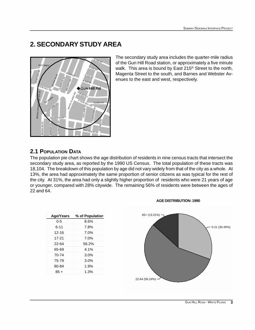
2. SECONDARY STUDY AREA
The secondary study area includes the quarter-mile radiusof the Gun Hill Road station, or approximately a five minutewalk. This area is bound by East 215th Street to the north,Magenta Street to the south, and Barnes and Webster Av-enues to the east and west, respectively.
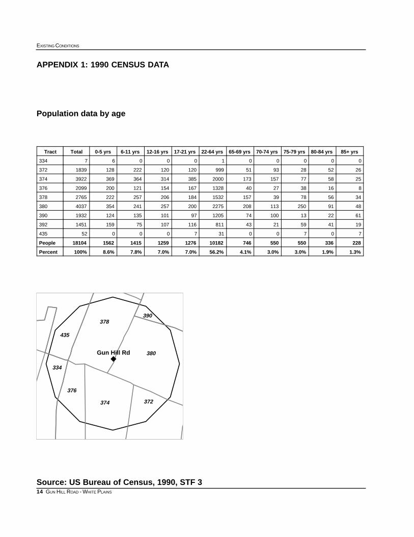
2.1 POPULATION DATAThe population pie chart shows the age distribution of residents in nine census tracts that intersect thesecondary study area, as reported by the 1990 US Census. The total population of these tracts was18,104. The breakdown of this population by age did not vary widely from that of the city as a whole. At13%, the area had approximately the same proportion of senior citizens as was typical for the rest ofthe city. At 31%, the area had only a slightly higher proportion of residents who were 21 years of ageor younger, compared with 28% citywide. The remaining 56% of residents were between the ages of22 and 64.
% of PopulationAge/Years8.6%0-5
7.8%6-11
7.0%12-16
7.0%17-21
56.2%22-64
4.1%65-69
3.0%70-74
3.0%75-79
1.9%80-84
1.3%85 +
E GUN HILL RD
DUNCOMB AV
MAGENTA ST
OLI
NV
ILLE
AV
BA
RK
ER
AV
BR
ON
X B
LVD
WH
ITE
PLA
INS
RD
BA
RN
ES
AV
BARTHOLDI ST
CA
PU
CH
IN W
Y
HO
LLA
ND
AV
E 216 ST
E 215 ST
E 214 ST
E 213 ST
E 213 ST
OLI
NV
ILLE
AV
WIL
LET
T A
V
BR
ON
X B
LVD
E 211 ST
WE
BS
TE
R A
V
E GUN HILL RDTILDEN ST
Gun Hill Rd
BX RIVER
S
BR
ON
X R
IVE
R P
KW
Y E
N S
B
DIST BNDY
4
EXISTING CONDITIONS
GUN HILL ROAD - WHITE PLAINS
0 500 1000 1500 2000 2500 3000 Daily Number of Trips
Bicycle
Taxicab
Worked at Home
Other
Railroad
Walked
Carpool
Bus or Trolleybus
Car, Truck, or Van
Subway or Elevated
Journey to Work Reverse Journey to Work
JOURNEY TO WORK: 1990 Gun Hill Road Secondary Study Area
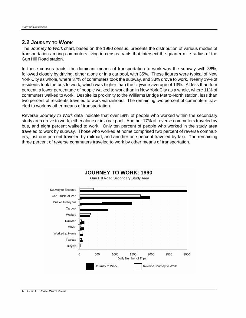
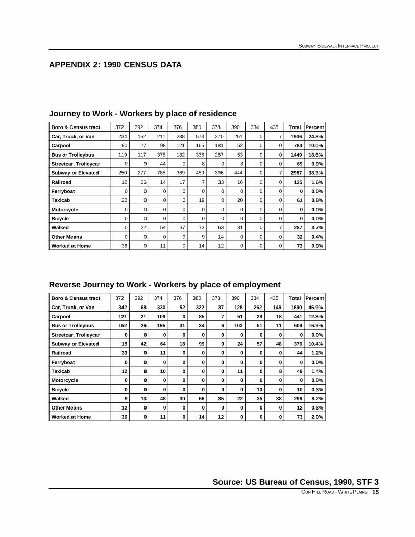
2.2 JOURNEY TO WORKThe Journey to Work chart, based on the 1990 census, presents the distribution of various modes oftransportation among commuters living in census tracts that intersect the quarter-mile radius of theGun Hill Road station.
In these census tracts, the dominant means of transportation to work was the subway with 38%,followed closely by driving, either alone or in a car pool, with 35%. These figures were typical of NewYork City as whole, where 37% of commuters took the subway, and 33% drove to work. Nearly 19% ofresidents took the bus to work, which was higher than the citywide average of 13%. At less than fourpercent, a lower percentage of people walked to work than in New York City as a whole, where 11% ofcommuters walked to work. Despite its proximity to the Williams Bridge Metro-North station, less thantwo percent of residents traveled to work via railroad. The remaining two percent of commuters trav-eled to work by other means of transportation.
Reverse Journey to Work data indicate that over 59% of people who worked within the secondarystudy area drove to work, either alone or in a car pool. Another 17% of reverse commuters traveled bybus, and eight percent walked to work. Only ten percent of people who worked in the study areatraveled to work by subway. Those who worked at home comprised two percent of reverse commut-ers, just one percent traveled by railroad, and another one percent traveled by taxi. The remainingthree percent of reverse commuters traveled to work by other means of transportation.
5
SUBWAY-SIDEWALK INTERFACE PROJECT
GUN HILL ROAD - WHITE PLAINS
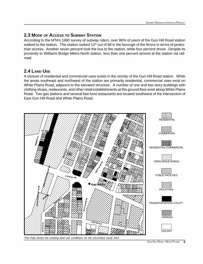
This map shows the existing land use conditions for the secondary study area
RESIDENTIAL /COMMERCIAL
RESIDENTIAL
COMMERCIAL
OPEN SPACE /PARKS
PUBLIC FACILITIES
INDUSTRIAL
PARKING
VACANT
TRANSPORTATION / UTILITY
2.3 MODE OF ACCESS TO SUBWAY STATIONAccording to the MTA’s 1990 survey of subway riders, over 86% of users of the Gun Hill Road stationwalked to the station. This station ranked 12th out of 68 in the borough of the Bronx in terms of pedes-trian access. Another seven percent took the bus to the station, while four percent drove. Despite itsproximity to Williams Bridge Metro-North station, less than one percent arrived at the station via rail-road.
2.4 LAND USEA mixture of residential and commercial uses exists in the vicinity of the Gun Hill Road station. Whilethe areas southeast and northwest of the station are primarily residential, commercial uses exist onWhite Plains Road, adjacent to the elevated structure. A number of one and two story buildings withclothing shops, restaurants, and other retail establishments at the ground floor exist along White PlainsRoad. Two gas stations and several fast food restaurants are located southwest of the intersection ofEast Gun Hill Road and White Plains Road.
6
EXISTING CONDITIONS
GUN HILL ROAD - WHITE PLAINS
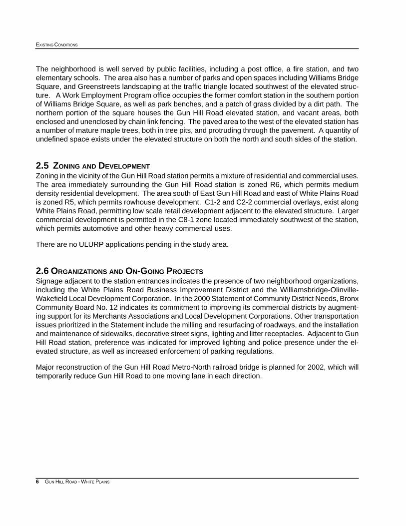
The neighborhood is well served by public facilities, including a post office, a fire station, and twoelementary schools. The area also has a number of parks and open spaces including Williams BridgeSquare, and Greenstreets landscaping at the traffic triangle located southwest of the elevated struc-ture. A Work Employment Program office occupies the former comfort station in the southern portionof Williams Bridge Square, as well as park benches, and a patch of grass divided by a dirt path. Thenorthern portion of the square houses the Gun Hill Road elevated station, and vacant areas, bothenclosed and unenclosed by chain link fencing. The paved area to the west of the elevated station hasa number of mature maple trees, both in tree pits, and protruding through the pavement. A quantity ofundefined space exists under the elevated structure on both the north and south sides of the station.
2.5 ZONING AND DEVELOPMENTZoning in the vicinity of the Gun Hill Road station permits a mixture of residential and commercial uses.The area immediately surrounding the Gun Hill Road station is zoned R6, which permits mediumdensity residential development. The area south of East Gun Hill Road and east of White Plains Roadis zoned R5, which permits rowhouse development. C1-2 and C2-2 commercial overlays, exist alongWhite Plains Road, permitting low scale retail development adjacent to the elevated structure. Largercommercial development is permitted in the C8-1 zone located immediately southwest of the station,which permits automotive and other heavy commercial uses.
There are no ULURP applications pending in the study area.
2.6 ORGANIZATIONS AND ON-GOING PROJECTSSignage adjacent to the station entrances indicates the presence of two neighborhood organizations,including the White Plains Road Business Improvement District and the Williamsbridge-Olinville-Wakefield Local Development Corporation. In the 2000 Statement of Community District Needs, BronxCommunity Board No. 12 indicates its commitment to improving its commercial districts by augment-ing support for its Merchants Associations and Local Development Corporations. Other transportationissues prioritized in the Statement include the milling and resurfacing of roadways, and the installationand maintenance of sidewalks, decorative street signs, lighting and litter receptacles. Adjacent to GunHill Road station, preference was indicated for improved lighting and police presence under the el-evated structure, as well as increased enforcement of parking regulations.
Major reconstruction of the Gun Hill Road Metro-North railroad bridge is planned for 2002, which willtemporarily reduce Gun Hill Road to one moving lane in each direction.
7
SUBWAY-SIDEWALK INTERFACE PROJECT
GUN HILL ROAD - WHITE PLAINS
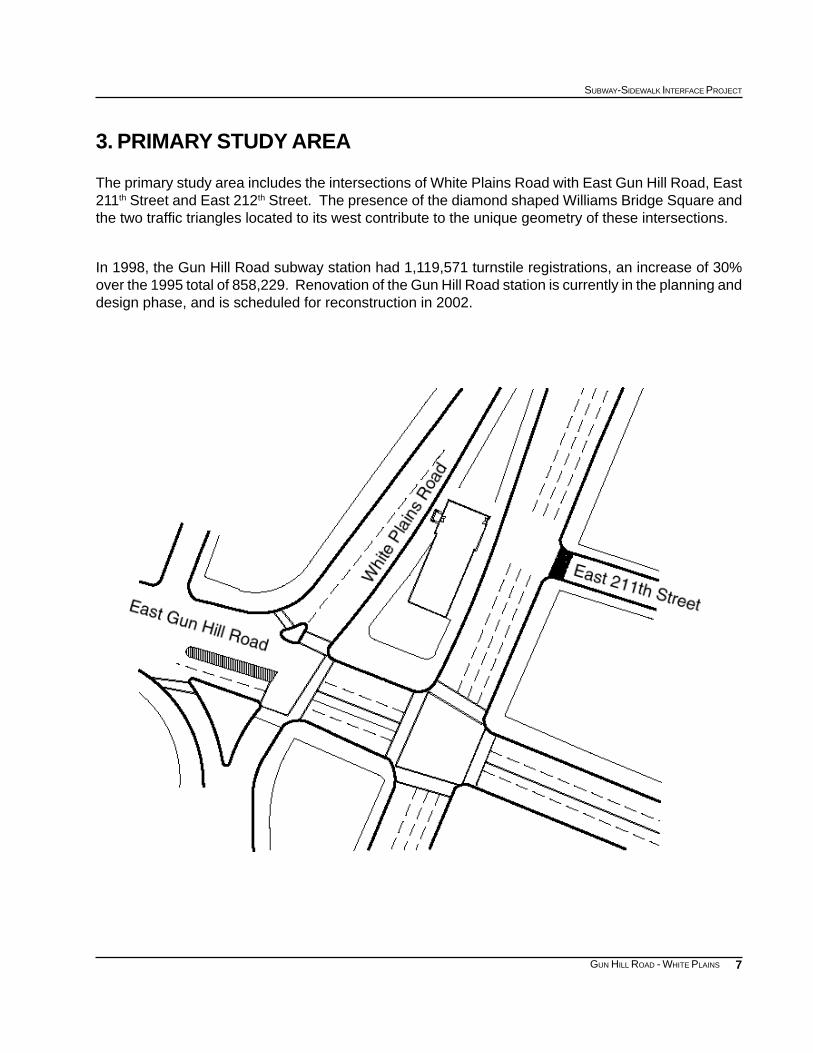
3. PRIMARY STUDY AREA
The primary study area includes the intersections of White Plains Road with East Gun Hill Road, East211th Street and East 212th Street. The presence of the diamond shaped Williams Bridge Square andthe two traffic triangles located to its west contribute to the unique geometry of these intersections.
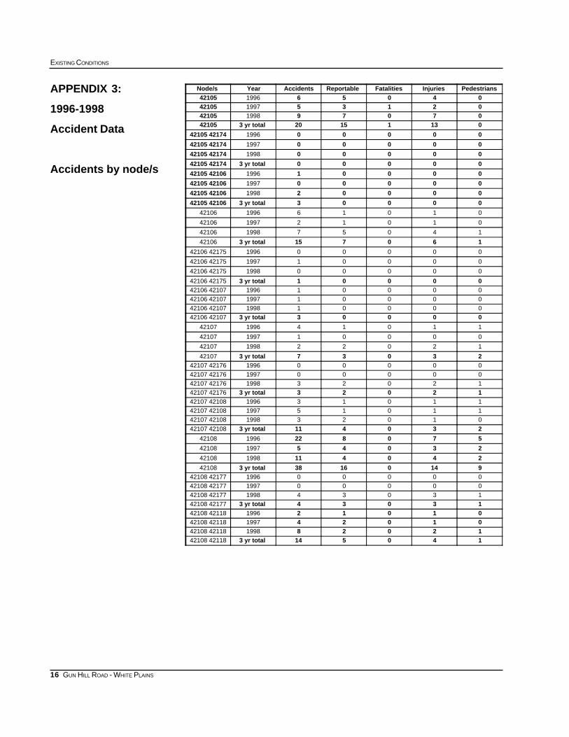
In 1998, the Gun Hill Road subway station had 1,119,571 turnstile registrations, an increase of 30%over the 1995 total of 858,229. Renovation of the Gun Hill Road station is currently in the planning anddesign phase, and is scheduled for reconstruction in 2002.
8
EXISTING CONDITIONS
GUN HILL ROAD - WHITE PLAINS
South side of Gun Hill Road Station
Western entrance to Gun Hill Road StationEastern entrance to Gun Hill Road Station
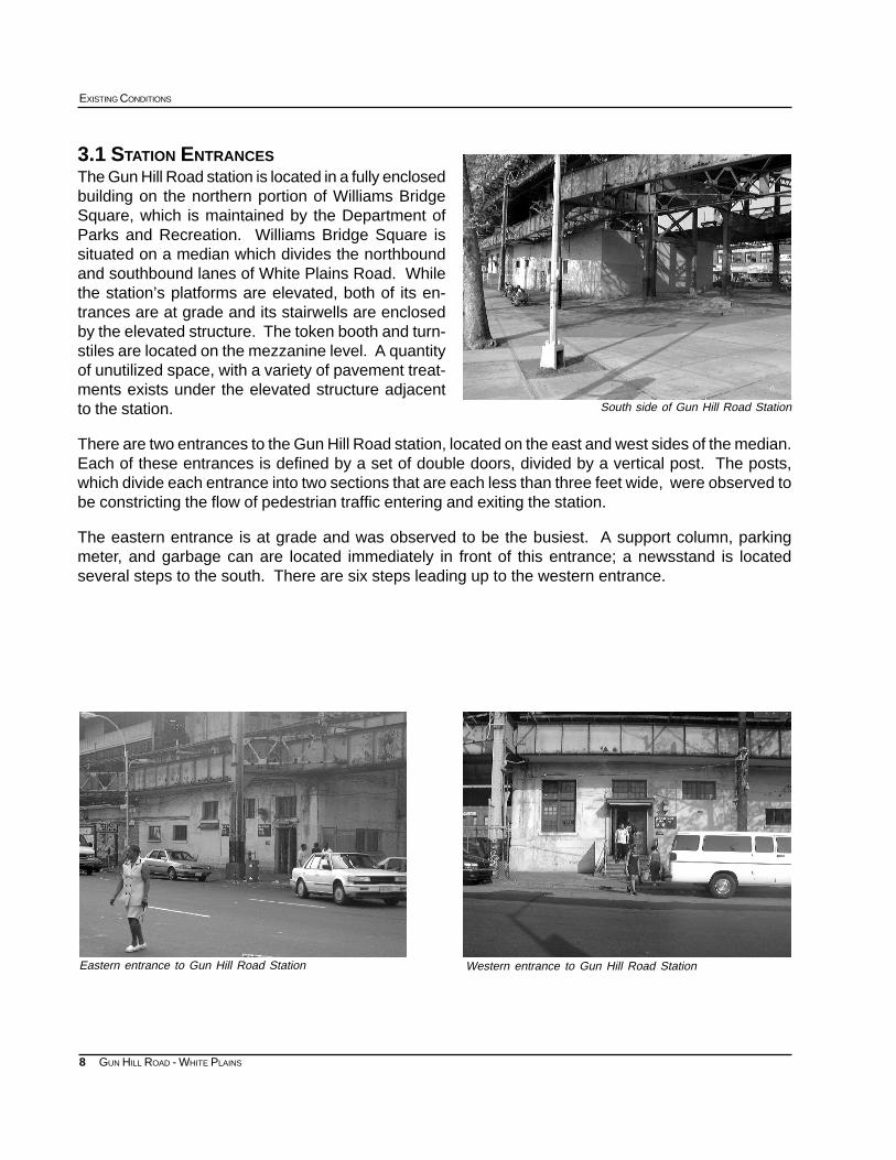
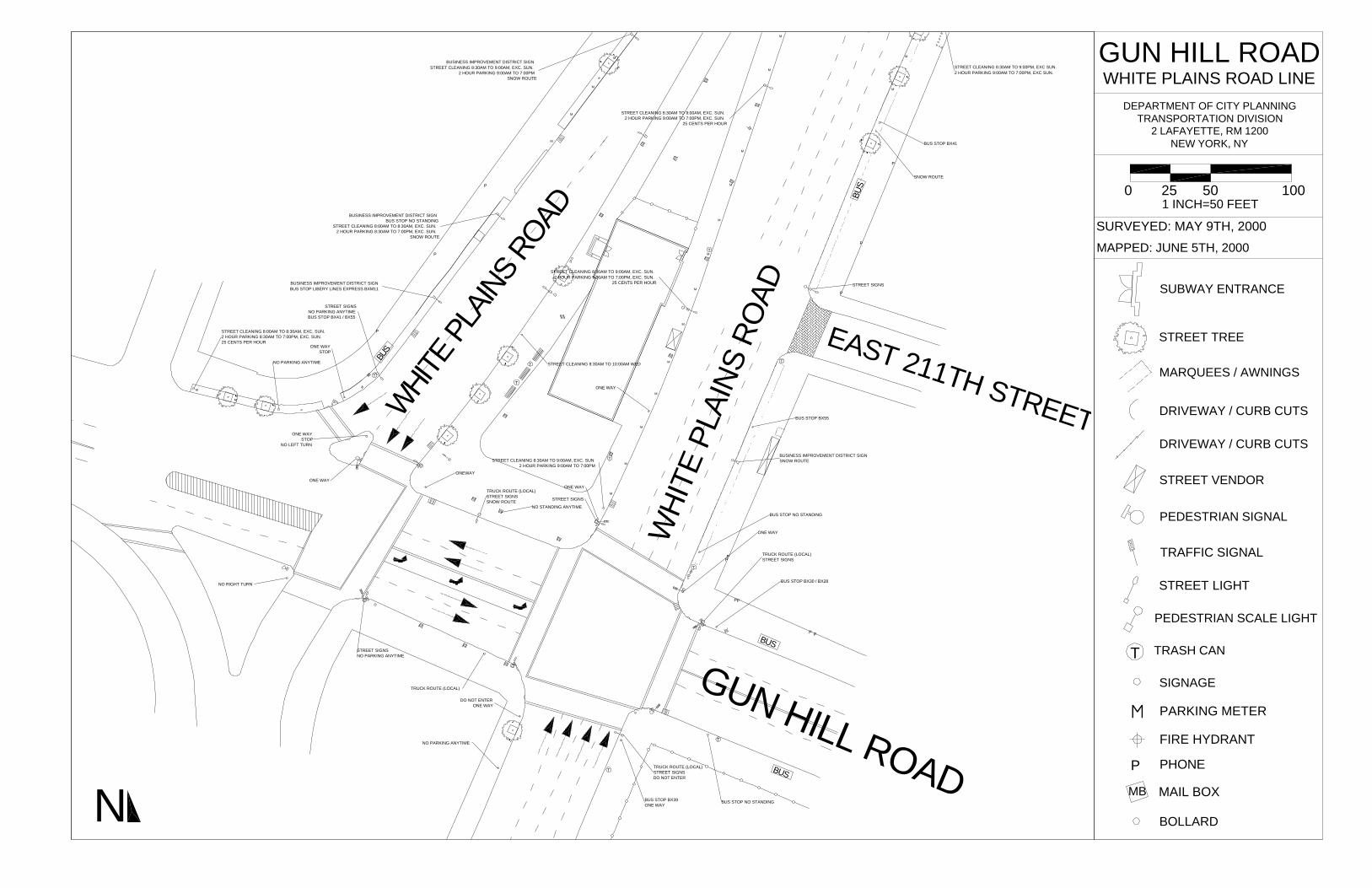
3.1 STATION ENTRANCESThe Gun Hill Road station is located in a fully enclosedbuilding on the northern portion of Williams BridgeSquare, which is maintained by the Department ofParks and Recreation. Williams Bridge Square issituated on a median which divides the northboundand southbound lanes of White Plains Road. Whilethe station’s platforms are elevated, both of its en-trances are at grade and its stairwells are enclosedby the elevated structure. The token booth and turn-stiles are located on the mezzanine level. A quantityof unutilized space, with a variety of pavement treat-ments exists under the elevated structure adjacentto the station.
There are two entrances to the Gun Hill Road station, located on the east and west sides of the median.Each of these entrances is defined by a set of double doors, divided by a vertical post. The posts,which divide each entrance into two sections that are each less than three feet wide, were observed tobe constricting the flow of pedestrian traffic entering and exiting the station.
The eastern entrance is at grade and was observed to be the busiest. A support column, parkingmeter, and garbage can are located immediately in front of this entrance; a newsstand is locatedseveral steps to the south. There are six steps leading up to the western entrance.
9
SUBWAY-SIDEWALK INTERFACE PROJECT
GUN HILL ROAD - WHITE PLAINS
White Plains Road north of the station
3.2 STREETS ADJACENT TO THE STATION ENTRANCES
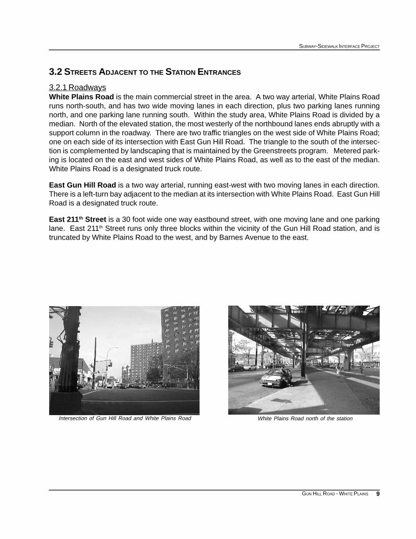
3.2.1 RoadwaysWhite Plains Road is the main commercial street in the area. A two way arterial, White Plains Roadruns north-south, and has two wide moving lanes in each direction, plus two parking lanes runningnorth, and one parking lane running south. Within the study area, White Plains Road is divided by amedian. North of the elevated station, the most westerly of the northbound lanes ends abruptly with asupport column in the roadway. There are two traffic triangles on the west side of White Plains Road;one on each side of its intersection with East Gun Hill Road. The triangle to the south of the intersec-tion is complemented by landscaping that is maintained by the Greenstreets program. Metered park-ing is located on the east and west sides of White Plains Road, as well as to the east of the median.White Plains Road is a designated truck route.
East Gun Hill Road is a two way arterial, running east-west with two moving lanes in each direction.There is a left-turn bay adjacent to the median at its intersection with White Plains Road. East Gun HillRoad is a designated truck route.
East 211th Street is a 30 foot wide one way eastbound street, with one moving lane and one parkinglane. East 211th Street runs only three blocks within the vicinity of the Gun Hill Road station, and istruncated by White Plains Road to the west, and by Barnes Avenue to the east.
Intersection of Gun Hill Road and White Plains Road
10
EXISTING CONDITIONS
GUN HILL ROAD - WHITE PLAINS
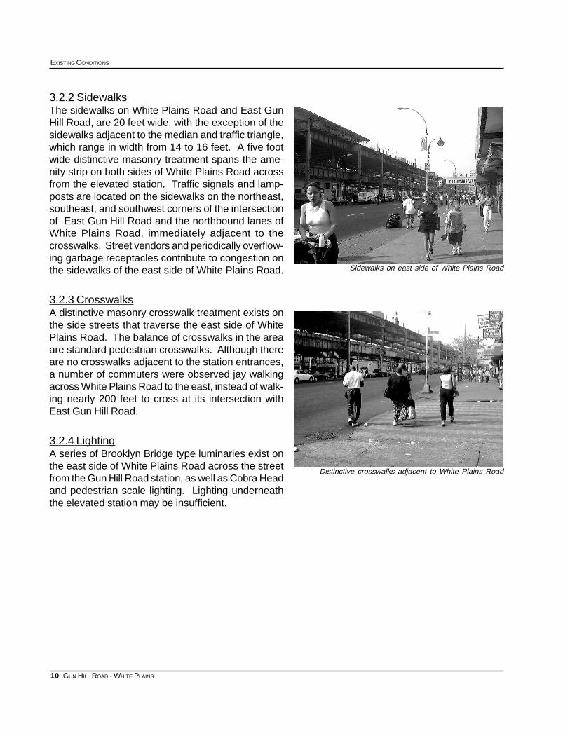
Sidewalks on east side of White Plains Road
Distinctive crosswalks adjacent to White Plains Road
3.2.2 SidewalksThe sidewalks on White Plains Road and East GunHill Road, are 20 feet wide, with the exception of thesidewalks adjacent to the median and traffic triangle,which range in width from 14 to 16 feet. A five footwide distinctive masonry treatment spans the ame-nity strip on both sides of White Plains Road acrossfrom the elevated station. Traffic signals and lamp-posts are located on the sidewalks on the northeast,southeast, and southwest corners of the intersectionof East Gun Hill Road and the northbound lanes ofWhite Plains Road, immediately adjacent to thecrosswalks. Street vendors and periodically overflow-ing garbage receptacles contribute to congestion onthe sidewalks of the east side of White Plains Road.
3.2.3 CrosswalksA distinctive masonry crosswalk treatment exists onthe side streets that traverse the east side of WhitePlains Road. The balance of crosswalks in the areaare standard pedestrian crosswalks. Although thereare no crosswalks adjacent to the station entrances,a number of commuters were observed jay walkingacross White Plains Road to the east, instead of walk-ing nearly 200 feet to cross at its intersection withEast Gun Hill Road.
3.2.4 LightingA series of Brooklyn Bridge type luminaries exist onthe east side of White Plains Road across the streetfrom the Gun Hill Road station, as well as Cobra Headand pedestrian scale lighting. Lighting underneaththe elevated station may be insufficient.
11
SUBWAY-SIDEWALK INTERFACE PROJECT
GUN HILL ROAD - WHITE PLAINS
3.3 TRAFFIC
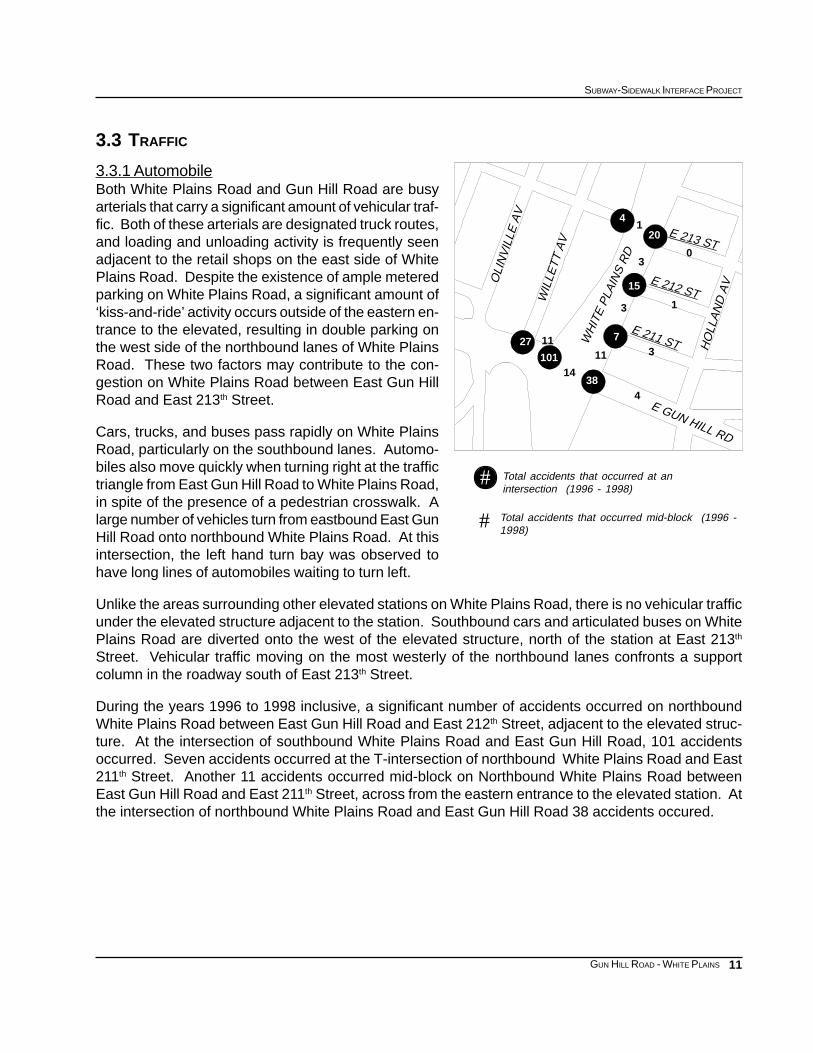
3.3.1 AutomobileBoth White Plains Road and Gun Hill Road are busyarterials that carry a significant amount of vehicular traf-fic. Both of these arterials are designated truck routes,and loading and unloading activity is frequently seenadjacent to the retail shops on the east side of WhitePlains Road. Despite the existence of ample meteredparking on White Plains Road, a significant amount of‘kiss-and-ride’ activity occurs outside of the eastern en-trance to the elevated, resulting in double parking onthe west side of the northbound lanes of White PlainsRoad. These two factors may contribute to the con-gestion on White Plains Road between East Gun HillRoad and East 213th Street.
Cars, trucks, and buses pass rapidly on White PlainsRoad, particularly on the southbound lanes. Automo-biles also move quickly when turning right at the traffictriangle from East Gun Hill Road to White Plains Road,in spite of the presence of a pedestrian crosswalk. Alarge number of vehicles turn from eastbound East GunHill Road onto northbound White Plains Road. At thisintersection, the left hand turn bay was observed tohave long lines of automobiles waiting to turn left.
Unlike the areas surrounding other elevated stations on White Plains Road, there is no vehicular trafficunder the elevated structure adjacent to the station. Southbound cars and articulated buses on WhitePlains Road are diverted onto the west of the elevated structure, north of the station at East 213th
Street. Vehicular traffic moving on the most westerly of the northbound lanes confronts a supportcolumn in the roadway south of East 213th Street.
During the years 1996 to 1998 inclusive, a significant number of accidents occurred on northboundWhite Plains Road between East Gun Hill Road and East 212th Street, adjacent to the elevated struc-ture. At the intersection of southbound White Plains Road and East Gun Hill Road, 101 accidentsoccurred. Seven accidents occurred at the T-intersection of northbound White Plains Road and East211th Street. Another 11 accidents occurred mid-block on Northbound White Plains Road betweenEast Gun Hill Road and East 211th Street, across from the eastern entrance to the elevated station. Atthe intersection of northbound White Plains Road and East Gun Hill Road 38 accidents occured.
Total accidents that occurred at anintersection (1996 - 1998)
Total accidents that occurred mid-block (1996 -1998)
#
#
3
13
4
7
15
20
4
11
38
101
1127
14
1
30
WH
ITE
PLA
INS
RD
E 212 ST
HO
LLA
ND
AV
E 213 ST
WIL
LETT
AV
E 211 ST
OLI
NV
ILLE
AV
E GUN HILL RD
12
EXISTING CONDITIONS
GUN HILL ROAD - WHITE PLAINS
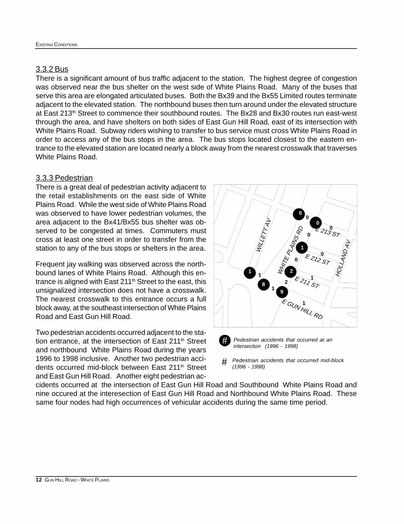
3.3.2 BusThere is a significant amount of bus traffic adjacent to the station. The highest degree of congestionwas observed near the bus shelter on the west side of White Plains Road. Many of the buses thatserve this area are elongated articulated buses. Both the Bx39 and the Bx55 Limited routes terminateadjacent to the elevated station. The northbound buses then turn around under the elevated structureat East 213th Street to commence their southbound routes. The Bx28 and Bx30 routes run east-westthrough the area, and have shelters on both sides of East Gun Hill Road, east of its intersection withWhite Plains Road. Subway riders wishing to transfer to bus service must cross White Plains Road inorder to access any of the bus stops in the area. The bus stops located closest to the eastern en-trance to the elevated station are located nearly a block away from the nearest crosswalk that traversesWhite Plains Road.
3.3.3 PedestrianThere is a great deal of pedestrian activity adjacent tothe retail establishments on the east side of WhitePlains Road. While the west side of White Plains Roadwas observed to have lower pedestrian volumes, thearea adjacent to the Bx41/Bx55 bus shelter was ob-served to be congested at times. Commuters mustcross at least one street in order to transfer from thestation to any of the bus stops or shelters in the area.
Frequent jay walking was observed across the north-bound lanes of White Plains Road. Although this en-trance is aligned with East 211th Street to the east, thisunsignalized intersection does not have a crosswalk.The nearest crosswalk to this entrance occurs a fullblock away, at the southeast intersection of White PlainsRoad and East Gun Hill Road.
Two pedestrian accidents occurred adjacent to the sta-tion entrance, at the intersection of East 211th Streetand northbound White Plains Road during the years1996 to 1998 inclusive. Another two pedestrian acci-dents occurred mid-block between East 211th Streetand East Gun Hill Road. Another eight pedestrian ac-cidents occurred at the intersection of East Gun Hill Road and Southbound White Plains Road andnine occured at the interesection of East Gun Hill Road and Northbound White Plains Road. Thesesame four nodes had high occurrences of vehicular accidents during the same time period.
Pedestrian accidents that occurred at anintersection (1996 - 1998)
Pedestrian accidents that occurred mid-block(1996 - 1998)
#
#
01
0
0
00
0
1
12
9
21
1
1
8
0
WH
ITE
PLA
INS
RD E 213 ST
E 212 ST
E 211 ST
WIL
LETT
AV
HO
LLA
ND
AV
E GUN HILL RD
13
SUBWAY-SIDEWALK INTERFACE PROJECT
GUN HILL ROAD - WHITE PLAINS
GUN HILL ROAD/WHITE PLAINS ROAD APPENDICES
APPENDIX 1: 1990 CENSUS DATA
Population Data by Age and Census Tract
APPENDIX 2: 1990 CENSUS DATA
Journey to Work - Workers by place of residence
Reverse Journey to Work - Workers by place of employment
APPENDIX 3: 1996-1998 ACCIDENT DATA
Accidents by Node/s
APPENDIX 4: SIGNAL TIMING DATA
APPENDIX 5: INVENTORY OF EXISTING CONDITIONS
14
EXISTING CONDITIONS
GUN HILL ROAD - WHITE PLAINS
Population data by age
APPENDIX 1: 1990 CENSUS DATA
Source: US Bureau of Census, 1990, STF 3
85+ yrs80-84 yrs75-79 yrs70-74 yrs65-69 yrs22-64 yrs17-21 yrs12-16 yrs6-11 yrs0-5 yrsTotalTract
00000100067334
26522893519991201202221281839372
25587715717320003853143643693922374
81638274013281671541212002099376
3456783915715321842062572222765378
489125011320822752002572413544037380
612213100741205971011351241932390
1941592143811116107751591451392
7070031700052435
22833655055074610182127612591415156218104People
1.3%1.9%3.0%3.0%4.1%56.2%7.0%7.0%7.8%8.6%100%Percent
372374
376
334
380
435
378390
Gun Hill Rd
15
SUBWAY-SIDEWALK INTERFACE PROJECT
GUN HILL ROAD - WHITE PLAINS
APPENDIX 2: 1990 CENSUS DATA
Journey to Work - Workers by place of residence
Reverse Journey to Work - Workers by place of employment
Source: US Bureau of Census, 1990, STF 3
PercentTotal435334390378380376374392372Boro & Census tract
24.8%193670251270573238211152234Car, Truck, or Van
10.0%7840052181165121987790Carpool
18.6%14490053267336182375117119Bus or Trolleybus
0.9%690080804490Streetcar, Trolleycar
38.3%298770444396459369785277250Subway or Elevated
1.6%125001633717142612Railroad
0.0%0000000000Ferryboat
0.8%61002001900022Taxicab
0.0%0000000000Motorcycle
0.0%0000000000Bicycle
3.7%287703163733754220Walked
0.4%320001499000Other Means
0.9%730001214011036Worked at Home
PercentTotal435334390378380376374392372Boro & Census tract
46.9%1690149262128373225233068342Car, Truck, or Van
12.3%441182951785010921121Carpool
16.9%60911511036343119526152Bus or Trolleybus
0.0%0000000000Streetcar, Trolleycar
10.4%37648572499918644215Subway or Elevated
1.2%4400000011033Railroad
0.0%0000000000Ferryboat
1.4%49801100010812Taxicab
0.0%0000000000Motorcycle
0.3%100100000000Bicycle
8.2%29638352235663048139Walked
0.3%120000000012Other Means
2.0%730001214011036Worked at Home
16
EXISTING CONDITIONS
GUN HILL ROAD - WHITE PLAINS
APPENDIX 3:
1996-1998
Accident Data
Accidents by node/s
PedestriansInjuriesFatalitiesReportableAccidentsYearNode/s040561996421050213519974210507079199842105013115203 yr total42105
00000199642105 42174
00000199742105 42174
00000199842105 42174
000003 yr total42105 42174
00001199642105 42106
00000199742105 42106
00002199842105 42106
000033 yr total42105 42106
01016199642106
01012199742106
14057199842106
1607153 yr total42106
00000199642106 42175
00001199742106 42175
00000199842106 42175
000013 yr total42106 42175
00001199642106 42107
00001199742106 42107
00001199842106 42107
000033 yr total42106 42107
11014199642107
00001199742107
12022199842107
230373 yr total42107
00000199642107 42176
00000199742107 42176
12023199842107 42176
120233 yr total42107 42176
11013199642107 42108
11015199742107 42108
01023199842107 42108
2304113 yr total42107 42108
570822199642108
23045199742108
240411199842108
914016383 yr total42108
00000199642108 42177
00000199742108 42177
13034199842108 42177
130343 yr total42108 42177
01012199642108 42118
01024199742108 42118
12028199842108 42118
1405143 yr total42108 42118
17
SUBWAY-SIDEWALK INTERFACE PROJECT
GUN HILL ROAD - WHITE PLAINS
Source: New York State DOT Local Accident Surveillance Project
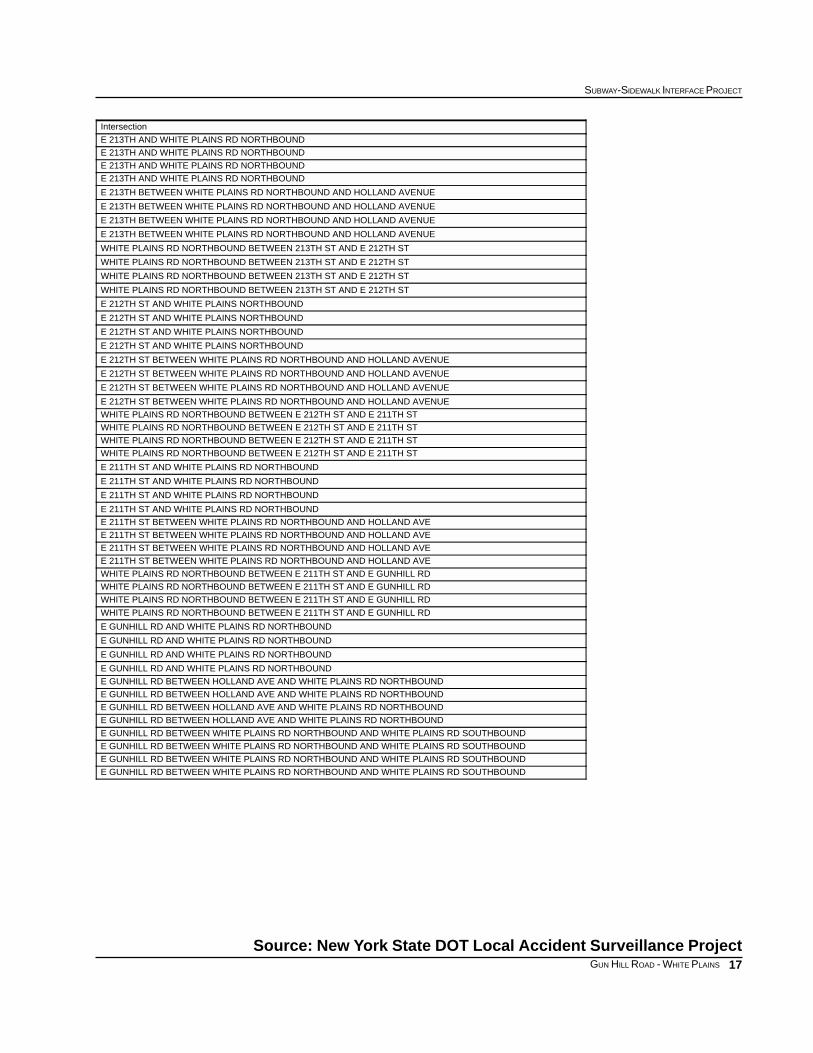
Intersection
E 213TH AND WHITE PLAINS RD NORTHBOUND
E 213TH AND WHITE PLAINS RD NORTHBOUND
E 213TH AND WHITE PLAINS RD NORTHBOUND
E 213TH AND WHITE PLAINS RD NORTHBOUND
E 213TH BETWEEN WHITE PLAINS RD NORTHBOUND AND HOLLAND AVENUE
E 213TH BETWEEN WHITE PLAINS RD NORTHBOUND AND HOLLAND AVENUE
E 213TH BETWEEN WHITE PLAINS RD NORTHBOUND AND HOLLAND AVENUE
E 213TH BETWEEN WHITE PLAINS RD NORTHBOUND AND HOLLAND AVENUE
WHITE PLAINS RD NORTHBOUND BETWEEN 213TH ST AND E 212TH ST
WHITE PLAINS RD NORTHBOUND BETWEEN 213TH ST AND E 212TH ST
WHITE PLAINS RD NORTHBOUND BETWEEN 213TH ST AND E 212TH ST
WHITE PLAINS RD NORTHBOUND BETWEEN 213TH ST AND E 212TH ST
E 212TH ST AND WHITE PLAINS NORTHBOUND
E 212TH ST AND WHITE PLAINS NORTHBOUND
E 212TH ST AND WHITE PLAINS NORTHBOUND
E 212TH ST AND WHITE PLAINS NORTHBOUND
E 212TH ST BETWEEN WHITE PLAINS RD NORTHBOUND AND HOLLAND AVENUE
E 212TH ST BETWEEN WHITE PLAINS RD NORTHBOUND AND HOLLAND AVENUE
E 212TH ST BETWEEN WHITE PLAINS RD NORTHBOUND AND HOLLAND AVENUE
E 212TH ST BETWEEN WHITE PLAINS RD NORTHBOUND AND HOLLAND AVENUE
WHITE PLAINS RD NORTHBOUND BETWEEN E 212TH ST AND E 211TH ST
WHITE PLAINS RD NORTHBOUND BETWEEN E 212TH ST AND E 211TH ST
WHITE PLAINS RD NORTHBOUND BETWEEN E 212TH ST AND E 211TH ST
WHITE PLAINS RD NORTHBOUND BETWEEN E 212TH ST AND E 211TH ST
E 211TH ST AND WHITE PLAINS RD NORTHBOUND
E 211TH ST AND WHITE PLAINS RD NORTHBOUND
E 211TH ST AND WHITE PLAINS RD NORTHBOUND
E 211TH ST AND WHITE PLAINS RD NORTHBOUND
E 211TH ST BETWEEN WHITE PLAINS RD NORTHBOUND AND HOLLAND AVE
E 211TH ST BETWEEN WHITE PLAINS RD NORTHBOUND AND HOLLAND AVE
E 211TH ST BETWEEN WHITE PLAINS RD NORTHBOUND AND HOLLAND AVE
E 211TH ST BETWEEN WHITE PLAINS RD NORTHBOUND AND HOLLAND AVE
WHITE PLAINS RD NORTHBOUND BETWEEN E 211TH ST AND E GUNHILL RD
WHITE PLAINS RD NORTHBOUND BETWEEN E 211TH ST AND E GUNHILL RD
WHITE PLAINS RD NORTHBOUND BETWEEN E 211TH ST AND E GUNHILL RD
WHITE PLAINS RD NORTHBOUND BETWEEN E 211TH ST AND E GUNHILL RD
E GUNHILL RD AND WHITE PLAINS RD NORTHBOUND
E GUNHILL RD AND WHITE PLAINS RD NORTHBOUND
E GUNHILL RD AND WHITE PLAINS RD NORTHBOUND
E GUNHILL RD AND WHITE PLAINS RD NORTHBOUND
E GUNHILL RD BETWEEN HOLLAND AVE AND WHITE PLAINS RD NORTHBOUND
E GUNHILL RD BETWEEN HOLLAND AVE AND WHITE PLAINS RD NORTHBOUND
E GUNHILL RD BETWEEN HOLLAND AVE AND WHITE PLAINS RD NORTHBOUND
E GUNHILL RD BETWEEN HOLLAND AVE AND WHITE PLAINS RD NORTHBOUND
E GUNHILL RD BETWEEN WHITE PLAINS RD NORTHBOUND AND WHITE PLAINS RD SOUTHBOUND
E GUNHILL RD BETWEEN WHITE PLAINS RD NORTHBOUND AND WHITE PLAINS RD SOUTHBOUND
E GUNHILL RD BETWEEN WHITE PLAINS RD NORTHBOUND AND WHITE PLAINS RD SOUTHBOUND
E GUNHILL RD BETWEEN WHITE PLAINS RD NORTHBOUND AND WHITE PLAINS RD SOUTHBOUND
18
EXISTING CONDITIONS
GUN HILL ROAD - WHITE PLAINS
PedestriansInjuriesFatalitiesReportableAccidentsYearNode/s41601747199642118
31501626199742118
11201428199842118
8430471013 yr total42118
01013199642117 42118
11013199742117 42118
01015199842117 42118
1303113 yr total42117 42118
030412199642117
03036199742117
13039199842117
19010273 yr total42117
02022199642104
01011199742104
00001199842104
030343 yr total42104
00000199642104 42105
00001199742104 42105
00000199842104 42105
000013 yr total42104 42105
Accident Data Cont.
19
SUBWAY-SIDEWALK INTERFACE PROJECT
GUN HILL ROAD - WHITE PLAINS
Intersection
E GUN HILL RD AND WHITE PLAINS RD SOUTHBOUND
E GUN HILL RD AND WHITE PLAINS RD SOUTHBOUND
E GUN HILL RD AND WHITE PLAINS RD SOUTHBOUND
E GUN HILL RD AND WHITE PLAINS RD SOUTHBOUND
E GUNHILL RD BETWEEN WILLET AVE AND WHITE PLAINS RD SOUTHBOUND
E GUNHILL RD BETWEEN WILLET AVE AND WHITE PLAINS RD SOUTHBOUND
E GUNHILL RD BETWEEN WILLET AVE AND WHITE PLAINS RD SOUTHBOUND
E GUNHILL RD BETWEEN WILLET AVE AND WHITE PLAINS RD SOUTHBOUND
E GUN HILL RD AND DUCOMB AVE/WILLETT AVE
E GUN HILL RD AND DUCOMB AVE/WILLETT AVE
E GUN HILL RD AND DUCOMB AVE/WILLETT AVE
E GUN HILL RD AND DUCOMB AVE/WILLETT AVE
WHITE PLAINS RD SOUTHBOUND AND E 213TH STREET
WHITE PLAINS RD SOUTHBOUND AND E 213TH STREET
WHITE PLAINS RD SOUTHBOUND AND E 213TH STREET
WHITE PLAINS RD SOUTHBOUND AND E 213TH STREET
E 213TH ST BETWEEN WHITE PLAINS RD SOUTHBOUND AND WHITE PLAINS RD NORTHBOUND
E 213TH ST BETWEEN WHITE PLAINS RD SOUTHBOUND AND WHITE PLAINS RD NORTHBOUND
E 213TH ST BETWEEN WHITE PLAINS RD SOUTHBOUND AND WHITE PLAINS RD NORTHBOUND
E 213TH ST BETWEEN WHITE PLAINS RD SOUTHBOUND AND WHITE PLAINS RD NORTHBOUND
20
EXISTING CONDITIONS
GUN HILL ROAD - WHITE PLAINS
A
B
C
D
OLI
NV
ILLE
AV
E 211 ST HO
LLA
ND
AV
E 212 ST
E GUN HILL RD
E 213 STWH
ITE
PLA
INS
RD
WIL
LET
T A
V
APPENDIX 4: SIGNAL TIMING DATA
East Gun Hill Road and White Plains Road
Intersection Map:Gun Hill Road-White Plains Road
TIMETRAFFIC FLOWCROSSWALK ORIENTATIONINDICATORINTERSECTION
Hours/Min
Mid-DayE Gun Hill RoadCrossing White Plains Rd along north side of E Gun Hill RoadA
Mid-DayE Gun Hill RoadCrossing White Plains Rd along south side of E Gun Hill RoadB
Mid-DayWhite Plains RoadCrossing E Gun Hill Road along west side of White Plains Rd C
Mid-DayWhite Plains RoadCrossing E Gun Hill Road along east side of White Plains Rd D
All Other TimesE Gun Hill RoadCrossing White Plains Rd along north side of E Gun Hill RoadA
All Other TimesE Gun Hill RoadCrossing White Plains Rd along south side of E Gun Hill RoadB
All Other TimesWhite Plains RoadCrossing E Gun Hill Road along west side of White Plains Rd C
All Other TimesWhite Plains RoadCrossing E Gun Hill Road along east side of White Plains Rd D
21
SUBWAY-SIDEWALK INTERFACE PROJECT
GUN HILL ROAD - WHITE PLAINS
East Gun Hill Road and White Plains Road
Source: NYC DOT
TimeCrossingSufficientofEstimation Preliminary
Street*to CrossRequired TimeEstimated
Only)(GreenTimeCrossingPedestrianAdjusted
Amber)(Green andTime CrossingPedestrianTotal
WidthCrosswalk
LengthCrosswalk
TIMECYCLE
L/T REDREDAMBERGREEN
secondssecondssecondsfeetfeetsecondssecondssecondssecondsseconds
Sufficient16.253134156590182331
Sufficient16.5313414.56690182331
Sufficient203134138090182331
Sufficient15.753134136390182331
Sufficient16.2549521565120182349
Sufficient16.5495214.566120182349
Sufficient2043461380120182343
Sufficient15.7543461363120182343
BUSP P
T
BUST
T
PP
PP
T
P
P
BUS
P
M
M
PP
T
T
M
TM
M
M
M
M
M
MT
M
M
M
M
M
M
M
MB TBU
S
P
P
P
M
ONEWAY
TRUCK ROUTE (LOCAL)STREET SIGNSSNOW ROUTE
STREET CLEANING 8:30AM TO 10:00AM WED
DO NOT ENTERONE WAY
NO PARKING ANYTIME
TRUCK ROUTE (LOCAL)
STREET SIGNSNO PARKING ANYTIME
NO RIGHT TURN
TRUCK ROUTE (LOCAL)STREET SIGNS
BUS STOP BX30 / BX28
BUS STOP NO STANDINGBUS STOP BX39ONE WAY
TRUCK ROUTE (LOCAL)STREET SIGNSDO NOT ENTER
ONE WAY
BUS STOP NO STANDING
BUSINESS IMPROVEMENT DISTRICT SIGNSNOW ROUTE
BUS STOP BX55
BUS STOP BX41
STREET CLEANING 8:30AM TO 9:00PM, EXC SUN.2 HOUR PARKING 9:00AM TO 7:00PM, EXC SUN.
STREET SIGNS
ONE WAY
STREET CLEANING 8:30AM TO 9:00AM, EXC. SUN2 HOUR PARKING 9:00AM TO 7:00PM
ONE WAY
STREET CLEANING 8:30AM TO 9:00AM, EXC. SUN.2 HOUR PARKING 9:00AM TO 7:00PM, EXC. SUN.
25 CENTS PER HOUR
STREET CLEANING 8:30AM TO 9:00AM, EXC. SUN.2 HOUR PARKING 9:00AM TO 7:00PM, EXC. SUN.
25 CENTS PER HOUR
STREET CLEANING 8:00AM TO 8:30AM, EXC. SUN.2 HOUR PARKING 8:30AM TO 7:00PM, EXC. SUN.25 CENTS PER HOUR
NO PARKING ANYTIME
STREET SIGNSNO PARKING ANYTIMEBUS STOP BX41 / BX55
BUSINESS IMPROVEMENT DISTRICT SIGNBUS STOP LIBERY LINES EXPRESS BXM11
BUSINESS IMPROVEMENT DISTRICT SIGNBUS STOP NO STANDING
STREET CLEANING 8:00AM TO 8:30AM, EXC. SUN.2 HOUR PARKING 8:30AM TO 7:00PM, EXC. SUN.
SNOW ROUTE
M
M
MBUSINESS IMPROVEMENT DISTRICT SIGN
STREET CLEANING 8:30AM TO 9:00AM, EXC. SUN.2 HOUR PARKING 9:00AM TO 7:00PM
SNOW ROUTE
GUN HILL ROAD
EAST 212TH STREET
WH
ITE
PLAI
NS
RO
AD
EAST 211TH STREETWHI
TE P
LAIN
S RO
AD
STREET SIGNS
SNOW ROUTE
NO STANDING ANYTIME
ONE WAYSTOP
ONE WAYSTOP
NO LEFT TURN
ONE WAY
N
STREET VENDOR
FIRE HYDRANT
BOLLARD
MAIL BOX
PHONEP
MB
PEDESTRIAN SIGNAL
PARKING METER
SIGNAGE
TRASH CAN
PEDESTRIAN SCALE LIGHT
M
T
STREET LIGHT
TRAFFIC SIGNAL
50250 100
SUBWAY ENTRANCE
1 INCH=50 FEET
DRIVEWAY / CURB CUTS
MARQUEES / AWNINGS
STREET TREE
SURVEYED: MAY 9TH, 2000
TRANSPORTATION DIVISIONDEPARTMENT OF CITY PLANNING
GUN HILL ROAD
2 LAFAYETTE, RM 1200NEW YORK, NY
WHITE PLAINS ROAD LINE
MAPPED: JUNE 5TH, 2000
DRIVEWAY / CURB CUTS