Embed Size (px)
Citation preview
1
These well known sayings, referring to both theconstitution of water and its uses for humankind,
illustrate clearly an inherent flaw in the availability ofwater all over the world. Although 75% of the earth’ssurface is covered with water, only a miniscule proportionof it is available for human needs as fresh water. Withso less water available and most of it polluted anddepleted, disputes over the use of fresh water arebecoming very common.1
Today in India, water is one of the two mostimportant sources of conflict. The other is religion. Theranking of these issues is location– specific. The politicalsystem of India is based on multi-party democracy.Every political party gives a top slot to water resourcedevelopment in its election manifesto. Every candidate,contesting the election, promises a water project to his/her constituency. The availability of water is seldomtaken into consideration when making these electoralpromises.
Non-availability can always be attributed to someone upstream who can be shown as havingappropriated all the water, a ripe case for conflict.Water is an easily exploitable issue in electoral politics.The potential for conflict had always existed historically,but the political leadership facilitated the negotiations.Over the years, this spirit has changed to rigid postures,with every State rushing to overexploit water andaccusing neighbours of “stealing” their share.
Given this political environment, it is not surprisingthat the national river interlinking plan has beenoffered as a miracle solution to water scarcity, primarilywith the following claims:
i) First, interlinking would lead to a permanentdrought proofing of the country by raising theirrigation potential to equal the current net sownarea of about 150 million hectares.
ii) Second, it would mitigate the annual floods inGanga and Brahamputra.
iii) Third, it would add 34,000 MW of hydropower tothe national pool.
The passing observation of the President A.P.J. AbdulKalam, on the eve of Independence day 2002,set the momentum for interlinking of rivers, hithertoa dormant idea. This prompted one advocate, RanjitKumar, to attach the copy of Kalam’s speech with aPublic Interest Litigation (PIL), which he had filedfor the cleaning of Yamuna. Thus in August 2002for the first time, the issue came up in the SupremeCourt. Justice B. N. Kirpal, the then Chief Justice of Indiawho was heading the bench responded soenthusiastically that he converted the PIL for cleaningof the Yamuna into an independent writ petition andissued notices to the Centre and the States forinterlinking of rivers.
When the matter came up again on 31 October 2002,only the Centre and Tamil Nadu endorsed the Court’sinitiative. The absence of response from all but oneState did not deter justice Kirpal and other Judges frompursuing the task which they took with missionaryzeal. On the contrary, the learned judges ruled that inthe absence of affidavits from other States, theassumption was clearly that they do not oppose theplan made in the Writ Petition and there is consensusamong all of them that there should be inter-linking ofrivers in India.
The order passed on 31 October 2002 formed thebasis on which the Centre set up a high powered TaskForce under Mr. Suresh Prabhu, former Union Ministerof Power. The irony is that the very order thatpresumed an all India consensus on the subject went onrecord to suggest how the Task Force would go intobringing consensus among the States.
1. INTRODUCTION“Little drops of water make a mighty ocean”
“Water, water every where, not a drop to drink”
2
Another irony about this far-reaching order is thatthere is no mention of the 10 years deadline, though thedeadline is presented as part of the project. Justice Kirpalwas cautious enough not to put the deadline in writinglest it raise delicate Constitutional questions of theCourt’s jurisdiction in the realm of executive policy.
Interlinking of Rivers as a solution for drought andflood is not a new proposal. It was Sir Arthur Cottonwho had originally proposed the networking of riversmore than a century ago, and Dr. K. L. Rao, theMinister of Power and Irrigation in the Cabinet ofSmt. Indira Gandhi, revived this proposal in 1972.Both were no doubt eminent engineers. Sir Cotton’sprime concern was for inland navigational networkand Dr. Rao’s concern was for irrigation and power.Neither could perceive that far wider issues wereinvolved.2
Mr. Rao presented his plan to link the Ganga andCauvery. In 1974, a similar proposal ‘Garland Canal’was submitted by Captain Dinshaw J. Dastur, an airpilot. The Government prepared its own plan in 1980and in 1982; the National Water Development Agency(NWDA) was set up to carry out detailed studies. Itenvisioned a 30 year plan but following the SupremeCourt directive, the Task Force has published a timetable which lists 2016 as the date for completion. Noexplanation has been provided how this is to bemanaged. Such a project should have been preceded bya study of:
i) Financial Viability
ii) Technological Capability
iii) Ecological Sustainability
iv) Detailed Environmental Impact Assessment.
The NWDA plan has divided the project into twobroad ‘components’ - the Himalayan part with 14 riverlinks estimated at Rs. 375,000 crores and the Peninsularcomponent with 17 river links estimated at Rs. 185,000crores.
Not only does the economics of the plan appear tobe extremely improbable, but serious reservations arealso raised about its claims. Let us look at two of theseclaims, that of flood control and the assumption thatthe Ganga, Brahamputra, Mahanadi and Godavari are“water surplus”.
From being a river which supported inland trade andpassenger traffic 150 years ago, the Ganga has becomea silt-choked shadow of its former self. The British usedit to ship their troops from Bengal to Kanpur and Delhiduring the 1857 war of independence. Today, the
Calcutta Port is so silted that crores of rupees have beeninvested to build another port at Haldia. It was toovercome the silting of the Calcutta Port that the Farakkabarrage was constructed to divert more water to theIndian stream. While Farakka has led to drasticallyreduced water flows to Bangladesh and resulted inconstant diplomatic tension with that country, it has notbeen able to save the Calcutta Port. One may be temptedto ask: Does the Ganga really have surplus water?
i) One, the source of the river is drying up, likealmost all the other Himalayan rivers. It is wellknown that Gangotri Glacier which feeds the riverhas receded by over 14 km in the last centuryalone.
ii) Second, increasing amounts of the river’s water arealready being used for irrigation as well as urbanneeds.
iii) Third, almost half of the Ganga’s water at Patnaoriginates in Nepal which has its own plans todevelop hydrological resources. Once these comeup, flows would be further reduced in the Ganga.
Similar facts do not justify the claims thatBrahamputra, the Mahanadi and the Godavari arewater surplus. In any case, the riparian states throughwhich these rivers pass have their own plans to use this“surplus water”. This puts another question mark onthe schemes political feasibility. Try visualizing Punjabparting with its water for Tamil Nadu to use, whenneighboring Karnataka almost refused to obey theSupreme Court on this issue.
On the ecological front, consider the fall-out ofbuilding 200 large water storage reservoirs and anextensive network of canals. Linking these rivers andstorage reservoirs would eat into the natural habitatsof wild life and re-shape the ecology of the countrywith unknown consequences. There are no estimatesregarding the number of people who would bedislocated, estimates vary from lakhs to a few crores.This would surely add to the political as well aseconomic costs of the project.
These rivers do have massive flood flows – estimatedat 30,000 to 60,000 cubic metres of water per second(cusec) during a few days in the monsoon. The planenvisions tapping these flood flows, storing these in thereservoirs and draining this water over thousands ofkms of canals to “parched” agricultural lands inSouthern, Western, and Central India. While this maysound good, the fine analysis reveals that only 1,500cusec water is to be lifted from a total flood flow of60,000 cusec. How lifting only 2.5% of water flow can

3
solve, or even mitigate floods is a mystery. The otherissue not being raised is why water rich reparians likethe Cauvery basin and Cauvery delta are today“parched” and water-scarce.
Capturing all the water of a river and stopping itsnatural flow to divert it outside the basin is tantamountto killing it. Countries with a history of playing aroundwith rivers and trying to control them, are nowinvesting billions of dollars to restore them by removing
dams and embankments. In the US alone, more than 100dams were removed between 1999 and 2002. In 2001,over 115 miles of the river Baraboo were restored inWisconsin. Attempts are now on to revive the Coloradoin the Southwestern US as its waters dry up beforereaching the ocean. An $ 8 billion plan has been passedin California to revive some of its rivers. In Spain,protests have stalled the second phase of water transferfrom the Ebro river to the country’s south.3
4
2. THE FINANCIAL COST
There are at least three different estimates3 for thefinancial implication of the project.
i) The National Water Development Agency budgetsthe entire project at Rs. 560,000 crores ($ 112 billion)at 2002 prices.
ii) However Mr. Prabhu himself accepts that it couldcost up 1,000,000 crores ($ 200 billion). Mr. Prabhuwould prefer to generate resources for the projectwithin the country. According to him, Hydro-electric and navigational projects are two obviousareas where privatization will work well. Accordingto Radha Singh, Additional Secretary in the Ministryof Water Resources, “the private sector will bepitching in.”4
iii) According to a former Secretary in the Union WaterResource Ministry, the estimated cost of just thePeninsular component is about Rs. 500,000 crores.
These links stretch from the Satluj in the North tothe Vaippar in the South and from the Brahamputrain the East to the Mahi in the West.
Even the minimum estimated cost of Rs. 560,000crores at 2002 prices equals 25 per cent of our GrossDomestic Product (GDP), or two and half times of ourannual tax collection and double of our present foreignexchange reserves. Where is the investible capital ofthis magnitude available in the domestic market.According to Economic Survey for 2001-2002, the country’sGross Domestic Savings were lower than the cost of thisproject. The cost is also higher than India’s totaloutstanding external debt by close to $ 12 billion.
The only possible financing option would be fundsfrom international sources. This would place a debt ofabout $ 112 on every Indian, whose average annualincome range is between $ 400 and $ 800. It also raisesquestions about how this loan would be returned. The
Many canals will pass through national parks and sanctuaries. How many willbe displaced? How will the flora and fauna and soil be affected.5
R K Pachauri - TERI
When there is excess water in the Brahmputra, there will be excess in Gangaand Mahanadi, causing storages to flow.6
Sunita Narain – Centre for Science and Environment
Lifting water from Northern rivers to the South will require a lot of energywhich must be produced by hydropower – this renders the scheme infructuous.7
Darryl D’ Monte – Environmentalist
The Supreme Court’s direction that the rivers of India shall be linked within 10years is not at all a defensible instance of Judicial activism. That apart, turningto the merits of the direction, one wishes that the learned Judges had undertakena more careful study of the subject before deciding to issue directions.7
Ramaswamy R. Iyer – Former Secretary, Ministry of Water ResourcesGovt. of India
Consent of Nepal, Bhutan and Bangladesh is required. States may notcooperate. 4.5 lakh people may be displaced. 79,292 hectares of forest may besubmerged.8
Shankar Aiyar – Journalist
5
guarantees and the counter-guarantees would be neededto secure it. Not only this, annual interest on thisamount would range between Rs. 20,000 crores and Rs.30,000 crores.
External borrowing of this scale would also makeany future Government in the country more vulnerableto foreign financial pressures. The real threat is thatafter starting the project with much fanfare andinvesting thousands of crores into it, a futureGovernment would have to simply abandon it as itsfinancial implications unravel. This would leavebillions of cubic metres of earth dug up and the face ofthe country scarred for centuries. The alternative leftthen would be to hand over the project, and along withit the entire water resources of the country, to MNCs tobuild and run.
It will be a matter of time before the governmentthrows up its hands and asks for private participation.Bureaucrats, politicians and other apologists wouldargue that private participation is necessary to savethe billions already sunk in the project. This is the thinedge of the wedge for wholesale privatization of waterin India.
At the World Water Forum meeting in 2001, waterMNCs successfully managed to get the UN to define
water as a ‘human need’ as distinct from “humanright.” By the WTO’s definitions, which are increasinglyrunning the market, human needs can be supplied bythe private entrepreneurs for a profit, unlike a humanright which accrues equally to every one.
The World Bank estimated in 1998 that global tradein water would generate $ 800 billion a year in the firstdecade of the 21st century. It is not surprising to findthat eventually funds for the scheme would come fromthe World Bank which ultimately control the market.
Untill recently, water like air has been very difficultto own and control privately. It is a vital commonresource. However, due to great scarcity, even thepiecemeal attempts to sell one river or one town’s watersupply has earned huge profits for the private companies.One may consider the drastic implications thatinterlinking of rivers will bring all the water under oneorganized command of global corporations.
The Promethean ambitions of engineers and thenexus between bureaucrats and contractors may seducethe larger public with dreams of water security. But inreality, this grandiose scheme may well create conditionswhere large scale privatization of water becomes theonly option. Rushing blindly towards this future is thereal danger.

6
In August 1980, the then Ministry of Irrigation (nowWater Resources) formulated a National Perspective
Plan for interlinking of rivers, which comprises of twocomponents, namely
• Peninsular Rivers Development and
• Himalayan Rivers Development
Peninsular Rivers Component
The Scheme is divided into four major parts:
i) Interlinking of Mahanadi-Godavari-Krishna-Cauvery rivers and building storages at potentialsites in these basins.
This part involves major interlinking of the riversystems where surpluses from the Mahanadi andthe Godavari are intended to be transferred to theneedy areas in the South.
ii) Interlinking of west flowing rivers, north of Bombayand south of Tapi.
The Scheme provides for taking water supply bycanal to the metropolitan areas of Mumbai; it alsoprovides irrigation to the coastal areas inMaharashtra.
iii) Interlinking of Ken-Chambal
The scheme provides for a water grid for MadhyaPradesh and Uttar Pradesh, and interlinking canalsbacked by as many storages as possible.
iv) Diversion of other west flowing rivers
The Peninsular development is expected to provideadditional irrigation of about 13 million ha. and isexpected to generate about 4,000 MW of power.
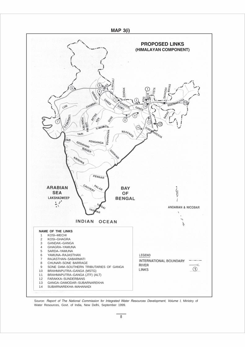
Himalayan Rivers Component
The Himalayan Rivers Component envisagesconstruction of storages on the principal tributaries ofthe Ganga and the Brahmaputra in India and Nepal.It calls for interlinking canal systems to transfersurplus flows of the eastern tributaries of the Ganga tothe West. It also proposes to link the main Brahmaputra
3. PROPOSED NATIONAL PLAN FORINTERLINKING OF RIVERS
and its tributaries with the Ganga, and the Ganga withMahanadi. This component would provide additionalirrigation of about 22 million ha. and generation ofabout 30,000 MW of hydropower, besides controllingflood in the Ganga Brahmaputra basin. It would alsoprovide the necessary discharge for augmentation offlows at Farakka required inter alia to flush CalcuttaPort and the inland navigation facilities across thecountry.
Himalayan Rivers Development Component
1. Kosi–Mechi Link
2. Kosi–Ghaghra Link
3. Gandak–Ganga Link
4. Ghaghra–Yamuna Link
5. Sarda–Yamuna Link
6. Yamuna–Rajasthan Link
7. Rajasthan–Sabarmati Link
8. Chunar–Sone Barrage Link
9. Sone Dam–Southern Tributaries of Ganga Link
10. Brahmaputra–Ganga Link (Manas-Sankosh Tista-Ganga)
11. Brahmaputra-Ganga Link (Jogighopa Tista-Farakka)
12. Farakka–Sunderbans Link
13. Ganga–Damodar–Sundernarekha Link
14. Subernarekha–Mahanadi Link
It is estimated by the government that the NationalPerspective Plan would give additional benefits ofirrigating 25 million ha. from surface waters, and 10million ha. by increased use of ground waters, raisingthe ultimate irrigation potential from 13 million ha to148–150 million ha. It also predicts the generation of340,000 MW of power, apart from the benefits of floodcontrol, navigation, water supply, fisheries, salinityand pollution control, etc.
7
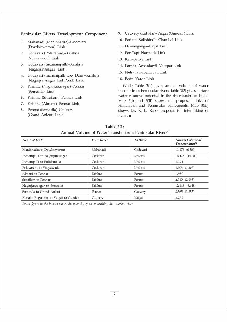
Table 3(1)Annual Volume of Water Transfer from Peninsular Rivers8
Name of Link From River To River Annual Volume ofTransfer (mm3)
Manibhadra to Dowleswaram Mahanadi Godavari 11,176 (6,500)
Inchampalli to Nagarjunasagar Godavari Krishna 16,426 (14,200)
Inchampalli to Pulichintala Godavari Krishna 4,371
Polavaram to Vijayawada Godavari Krishna 4,903 (3,305)
Almatti to Pennar Krishna Pennar 1,980
Srisailam to Pennar Krishna Pennar 2,310 (2,095)
Nagarjunasagar to Somasila Krishna Pennar 12,146 (8,648)
Somasila to Grand Anicut Pennar Cauvery 8,565 (3,855)
Kattalai Regulator to Vaigai to Gundar Cauvery Vaigai 2,252
Lower figure in the bracket shows the quantity of water reaching the recipient river
Peninsular Rivers Development Component
1. Mahanadi (Manibhadra)–Godavari(Dowlaiswaram) Link
2. Godavari (Polavaram)–Krishna(Vijayawada) Link
3. Godavari (Inchamapalli)–Krishna(Nagarjunasagar) Link
4. Godavari (Inchampalli Low Dam)–Krishna(Nagarjunasagar Tail Pond) Link
5. Krishna (Nagarjunasagar)–Pennar(Somasila) Link
6. Krishna (Srisailam)–Pennar Link
7. Krishna (Almatti)–Pennar Link
8. Pennar (Somasila)–Cauvery(Grand Anicut) Link
9. Cauvery (Kattalai)–Vaigai (Gundar ) Link
10. Parbati–Kalishindh–Chambal Link
11. Damanganga–Pinjal Link
12. Par-Tapi–Narmada Link
13. Ken–Betwa Link
14. Pamba–Achankovil–Vaippar Link
15. Netravati–Hemavati Link
16. Bedti–Varda Link
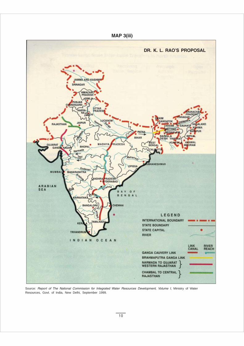
While Table 3(1) gives annual volume of watertransfer from Peninsular rivers, table 3(2) gives surfacewater resource potential in the river basins of India.Map 3(i) and 3(ii) shows the proposed links ofHimalayan and Peninsular components. Map 3(iii)shows Dr. K. L. Rao’s proposal for interlinking ofrivers.
8
NAME OF THE LINKS1 KOSI–MECHI2 KOSI–GHAGRA3 GANDAK–GANGA4 GHAGRA–YAMUNA5 SARDA–YAMUNA6 YAMUNA–RAJASTHAN7 RAJASTHAN–SABARMATI8 CHUNAR–SONE BARRAGE9 SONE DAM–SOUTHERN TRIBUTARIES OF GANGA
10 BRAHMAPUTRA–GANGA (MSTG)11 BRAHMAPUTRA–GANGA (JTF) (ALT)12 FARAKKA–SUNDERBANS13 GANGA–DAMODAR–SUBARNAREKHA14 SUBARNAREKHA–MAHANADI
Source: Report of The National Commission for Integrated Water Resources Development, Volume I, Ministry ofWater Resources, Govt. of India, New Delhi, September 1999.
PROPOSED LINKS(HIMALAYAN COMPONENT)
MAP 3(i)

9
NAME OF THE LINKS1 MAHANADI (MANIBHADRA)–GODAVARI (DOWLAISWARAM)2 GODAVARI (INCHAMPALLI)–KRISHNA (NAGARJUNASAGAR)3 GODAVARI (INCHAMPALLI LOW DAM)–KRISHNA (NAGARJUNASAGAR TAIL POND)4 GODAVARI (POLAVARAM)–KRISHNA (VIJAYAWADA)5 KRISHNA (ALMATTI)–PENNAR6 KRISHNA (SRISAILAM)–PENNAR7 KRISHNA (NAGARJUNASAGAR)–PENNAR (SOMASILA)8 PENNAR (SOMASILA)–CAUVERY (GRAND ANICUT)9 CAUVERY (KATTALAI)–VAIGAI–GUNDAR
10 KEN–BETWA11 PARBATI–KALISINDH–CHAMBAL12 PAR–TAPI–NARMADA13 DAMANGANGA–PINJAL14 BEDTI–VARDA15 NETRAVATI–HEMAVATI16 PAMBA–ACHANKOVIL–VAIPPAR
Source: Report of The National Commission for Integrated Water Resources Development, Volume I, Ministry ofWater Resources, Govt. of India, New Delhi, September 1999.
PROPOSED LINKS(PENINSULAR COMPONENT)
MAP 3(ii)
10
MAP 3(iii)
Source: Report of The National Commission for Integrated Water Resources Development, Volume I, Ministry of WaterResources, Govt. of India, New Delhi, September 1999.
DR. K. L. RAO’S PROPOSAL
11
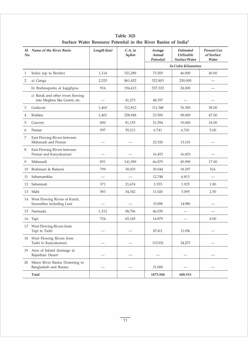
Table 3(2)Surface Water Resource Potential in the River Basins of India9
Sl. Name of the River Basin Length (km) C.A, in Average Estimated Present UseNo. Sq.Km Annual Utilisable of Surface
Potential Surface Water Water
In Cubic Kilometres
1 Indus (up to Border) 1,114 321,289 73.305 46.000 40.00
2 a) Ganga 2,525 861,452 522.803 250.000 —
b) Brahmaputra at Jogighpoa 916 194,413 537.322 24.000 —
c) Barak and other rivers flowinginto Meghna like Gomti, etc. — 41,273 48.357 — —
3 Godavari 1,465 312,812 111.348 76.300 38.00
4 Krishna 1,401 258,948 23.500 58.000 47.00
5 Cauvery 800 81,155 21.594 19.000 18.00
6 Pennar 597 55,213 6.741 6.741 5.00
7 East Flowing Rivers betweenMahanadi and Pennar — — 22.520 13.110 —
8 East Flowing Rivers betweenPennar and Kanyakumari — — 16.453 16.453 —
9 Mahanadi 851 141,589 66.879 49.990 17.00
10 Brahmani & Baitarni 799 30,033 30.044 18.297 NA
11 Subarnarekha — — 12.748 6.813 —
12 Sabarmati 371 21,674 3.355 1.925 1.80
13 Mahi 583 34,342 11.020 3.095 2.50
14 West Flowing Rivers of Kutch,Saurashtra including Luni — — 15.098 14.980 —
15 Narmada 1,312 98,796 46.039 — —
16 Tapi 724 65,145 14.879 — 8.00
17 West Flowing Rivers fromTapi to Tadri — — 87.411 11.936 —
18 West Flowing Rivers fromTadri to Kanyakumari — — 113.532 24.273 —
19 Area of Inland drainage inRajasthan Desert — — — — —
20 Minor River Basins Drainning toBangladesh and Burma — — 31.000 — —
Total 1875.948 688.913

12
The river systems of the entire country have beendivided into twenty river basins comprising
twelve major basins with a drainage area exceeding20,000 sq. km each and eight composite river basinscombining the remaining medium and small riversystems for the purpose of planning and development.
4. RIVER BASINS
4a. Major River Basins in India
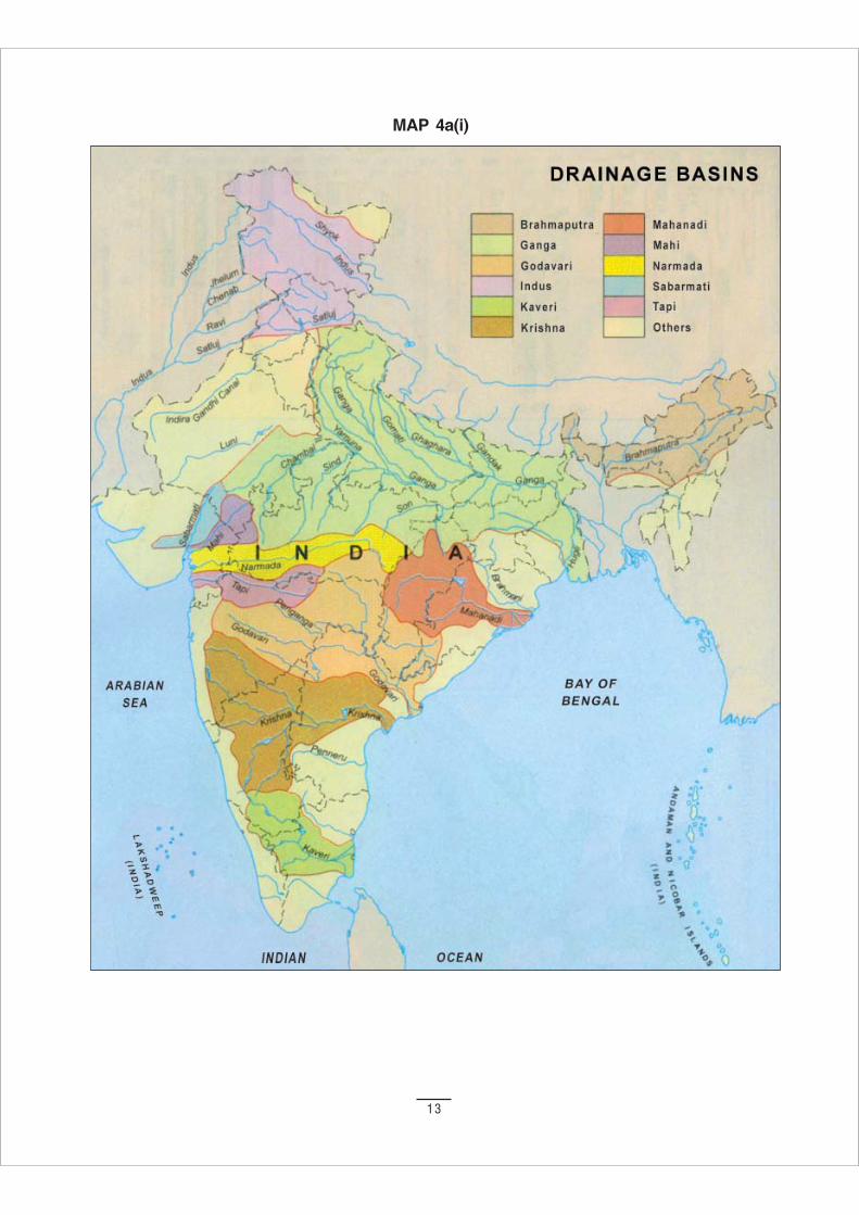
Table 4a(1) and 4a(2) give details of the Major andComposite river basins with names of important riversunder each basin, catchment area, average annualsurface water availability, and storage capacity. Map4a(i) shows the drainage basins of major rivers of thecountry.26
Table 4a(1)Major River Basins in India
Sl. River Basin Important Rivers of the basin Catchment Area Average Live StorageNo (Million Hect.) Annual Surface Capacity of
Water Dams CompletedAvailability (BCM) 1995 (BCM)
1. Indus Sutlej, Beas, Ravi Chenab, and Jhelum 32.13 73.31 13.83
2 (a) Ganga Yamuna, Chambal, Sindh, Betwa, Ken,Sone, Ram-ganga, Ghagra,Gandak and Kosi. 86.15 525.02 36.84
2 (b) Brahmaputra Subansiri, Bhorelli, Manas, Buri Dehang,and Barak Dhansiri, Kopili, Tista Jaldhaka, Torsa,
Barak, Gumti, Muhari, Fenny, Karnaphulli,Kaladan, Imphal, Tuxu and Nantaleik 23.61 585.6 1.10
3 Brahmani Karo, Sankh, Tikra, Salandi and Matai 5.18 28.48 4.76and Baitarni
4 Mahanadi Seonath, Jonk, Hasdeo,Mand Ib, Ong and Tel 14.16 66.88 8.49
5 Godavari Pravara, Purna, Manjra, Pranhita,Indravati and Sabri 31.28 110.54 19.51
6 Krishna Ghataprabha, Malaprabha, Bhima,Tungabhadra and Musi 25.89 78.12 34.48
7 Pennar Jayamangli, Kunderu, Shagileru,Chitravati, Papagni and Cheyyeru 5.52 6.32 0.38
8 Cauvery Harangi, Hemavati, Simsha,Arkavati, Lakshmanathirtha, Kabani,Suvarnavati, Bhavani, Noyil, Amravati. 8.12 21.36 7.43
9 Tapi Bhokar, Suki, Mor, Harki, Manki, Guli,Aneri, Arunavati, Gomai, Gomati, Valer,Purna, Bhogvati, Vaghur, Girna, Bori,Panjhra, Buray, Amravati, Shiva,Rangavati and Nesu. 6.51 14.88 8.53
10 Narmada Burhner, Banjar, Sher, Shakkar Dudhi,Tawa, Ganjal, Chotta Tawa, Kundi, Goi,Karjan, Hiran, Tendoni, Kolar,Man, Uri, Hatni and Orsang 9.88 45.65 6.60
11 Mahi Som, Anas, Panam 3.48 11.02 4.76
12 Sabarmati Sei, Wakal, Harnav, Hathmati, Watrak 2.17 3.81 1.35
13
MAP 4a(i)
14
As per the latest assessment made by the CentralWater Commission, the average annual flow in the riversystems of India is about 1,869 Billion Cubic Metre(BCM), of which 1,122 BCM is utilizable, comprising ofabout 690 BCM as surface water and 432 BCM asreplenishable Ground Water.
A total live storage capacity of about 177 BCM hasbeen provided by large dams. An additional livestorage capacity of 75 BCM will be created on
completion of the dams, which are under various stagesof construction. Proposals to take up additional dams tocreate a live storage of 132 BCM are also underformulation/consideration. The replenishable groundwater resources are of the order of 432 BCM, out ofwhich about 154 BCM has been developed for use.
In some of the river basins, namely the Indus,Krishna, Cauvery, Mahi and Sabarmati, the stage ofpresent use is more than 80% of utilizable flow.
Table 4a(2)Details of Composite River Basins
Sl.No River Basin Important Rivers of the basin Catchment Area Average Live Storage(Million Hect.) Annual Surface Capacity of
Water Dams CompletedAvailability (BCM) (1995) (BCM)
13 Subarnarekha Kanchi, Karkari and Kharkai 2.92 12.37 0.66
14 West flowing Shetrunji, Bhadar, Machhu, 32.19 15.1 4.31rivers from Rupen, Saraswati and BanasKutch andSaurashtraincluding Luni
15 West flowing Kodiyar, Pamba, Periyar 5.62 113.51 10.24rivers from Bharathapuzha and ChaliyarTadri toKanyakumari
16 West flowing Netravati, Sharavati, Gangali, 5.29 87.41 7.10rivers from Kalinadi, Mandori, Savitri, Ulhas,Tapi and Vaitarani, Ambika and PurnaTadri
17 East flowing Rushikulya, Bahuda, Vamsadhara, 8.66 22.52 1.63rivers between Nagavali, Sarada, Varaha,Mahanadi and Tandara and EluruPennar
18 East flowing Kunteru, Swarnamukhi, Araniar, 10.01 16.46 1.42rivers between Kortalaiyar, Cooum, Adyar, Palar,Pennar and Gingi, Ponnaiyar, Vellar, Varshalei,Kanyakumari Vaigai, Gundar, Vaippar and
Tambarparni
19 Area of InlandDrainage inRajasthan 6
20 Minor riverbasins draininginto Bangladeshand Myanmar 3.63 31 0.31
15
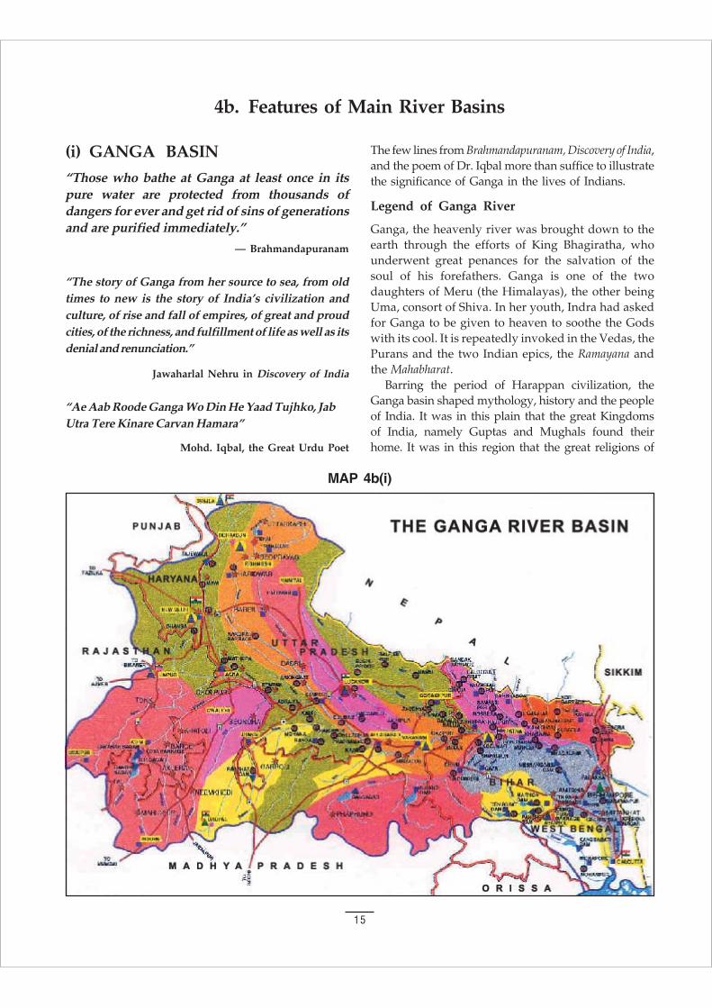
4b. Features of Main River Basins
MAP 4b(i)
(i) GANGA BASIN
“Those who bathe at Ganga at least once in itspure water are protected from thousands ofdangers for ever and get rid of sins of generationsand are purified immediately.”
— Brahmandapuranam
“The story of Ganga from her source to sea, from oldtimes to new is the story of India’s civilization andculture, of rise and fall of empires, of great and proudcities, of the richness, and fulfillment of life as well as itsdenial and renunciation.”
Jawaharlal Nehru in Discovery of India
“Ae Aab Roode Ganga Wo Din He Yaad Tujhko, JabUtra Tere Kinare Carvan Hamara”
Mohd. Iqbal, the Great Urdu Poet
The few lines from Brahmandapuranam, Discovery of India,and the poem of Dr. Iqbal more than suffice to illustratethe significance of Ganga in the lives of Indians.
Legend of Ganga River
Ganga, the heavenly river was brought down to theearth through the efforts of King Bhagiratha, whounderwent great penances for the salvation of thesoul of his forefathers. Ganga is one of the twodaughters of Meru (the Himalayas), the other beingUma, consort of Shiva. In her youth, Indra had askedfor Ganga to be given to heaven to soothe the Godswith its cool. It is repeatedly invoked in the Vedas, thePurans and the two Indian epics, the Ramayana andthe Mahabharat.
Barring the period of Harappan civilization, theGanga basin shaped mythology, history and the peopleof India. It was in this plain that the great Kingdomsof India, namely Guptas and Mughals found theirhome. It was in this region that the great religions of
16
Hinduism, Buddhism, Jainism and Sikhism wereestablished.
Ganga or Ganges is perhaps the most widely writtenabout and worshipped of all the renowned riversthroughout the world. Although a number of riversfeature in human civilization in pre history and history,Ganga is considered the most sacred, with rich mythologyrelated to it. The story of Ganga is the story of Indiancivilization and culture. It is the symbol of Indiantraditions and values providing physical and spiritualnourishment to millions of devotees. There are extensiveclassical and folk literature related to this heavenly riverknown by many as “Divine” river or “Devnadi”. Downthe ages people of all walks of life have worshipped thisgoddess of benevolence. There are a number of temples,ghats, ashrams and cities along Ganga descending fromRishikesh, Haridwar, Allahabad (Prayag), to Banares.10
They represent centuries of cultural development inIndia.
Course of the River
The Ganga river system, along with its tributaries, is thesingle largest river system in India. The mighty riveremerges from Gaumukh in the 25 km long Gangotriglacier. The point of origin is shaped like the mouth ofcow, and hence the name “Gaumukh”. The eternal flowis maintained by three Bhagirathi peaks where chunksof ice keep on falling in running water of Bhagirathi,which is only a few feet wide. At Devprayag, it assumesthe name Ganga after meeting with river Bhilangana atTehri and river Alakananda at Devprayag itself. TheGangotri shrine is about 22 km down the stream fromGaumukh.
The Bhagirathi Ganga takes many twists and turnsfrom Gangotri downwards traversing about 240 km longrocky path in Garhwal Himalaya. Then it comes toRishikesh taking a further southward turn for a distanceof about 30 km, coming down to the Indo-Gangetic plainsat Haridwar leaving the Shivaliks. The river suddenlychanges its profile at this point, widening to an extent of750 metres. There are numerous tributaries meeting themainstreams, the chief among them being the DedarGanga, Rudragaira and Jahanavi in Upper Ganga Valley.From Haridwar downwards, the river passes throughvarious cities, towns and villages of U P, Bihar and WestBengal before reaching finally to the Bay of Bengal,covering vast distance of about 2,525 km.
Major Religious Places and Towns
There are 692 towns and cities distributed over the nineGangetic States. During such a long journey in plains it
embraces many small torrents and tributaries, the firstmajor tributary being Ram Ganga at Kannauj followedby Yamuna at Allahabad. The united stream thus movestowards Varanasi. Uttarkashi, Devprayag, Rudraprayag,Karanprayag, Rishikesh, Haridwar, Allahabad andBanares are the important religious places on the bankof Ganga. It also flows past Garhmukteshwar in theGhaziabad district of U P the very place where GoddessGanga is said to have appeared to Shantanu (ancestorof Pandavas). From Haridwar to Allahabad, the Gangaflows parallel to the Yamuna, another important riverflowing through North India.
Allahabad is a sacred place with soul-cleansingpowers, particularly so because the mythical riverSaraswati is said to join the Ganga and Yamuna at thatpoint – a speck of white sand known as ‘sangam’. Invedic times there was a settlement at this confluence,then known as ‘Prayag’, where the Vedas were written.Brahma himself is said to have performed a sacrifice
0
2000
4000
6000
8000
10000
12000
20000
24000U
ttar
Pra
desh
Bih
ar
Mad
hya
Pra
desh
Raj
asth
an
Wes
t Ben
gal
Har
ayan
a
Del
hi
Him
acha
l Pra
desh
Tho
usan
d H
ecta
re
Irrigated Area
Sown Area
GROSS SOWN AND IRRIGATED AREAS IN GANGA BASIN
Fig 4b(i)
17
here. Huen Tsang – famous Chinese traveller visitedPrayag in 634 AD. It was under Mughal EmperorAkbar, that Prayag was renamed Illahabas, laterchanged to Allahabad.
It is difficult to describe Varanasi. As ShriRamakrishna once said, “one may as well try to drawa map of the universe as attempt to describe Varanasi.”It was already well known in the days of Buddha, some2500 years ago. It finds constant mention in ancientliterature and has all along been the pilgrimage centre,sacred to Shiva. Hindus consider it as an auspiciousplace to die, for one goes straight to heaven. Surprisingly,Varanasi does not mark one of Ganga’s greatconfluences, but is named after two small rivers thatjoin here, the Varuna and Asi.
Crossing the vast Gangetic plain, the Ganga flowspast Patna, the famous Pataliputra of yore. She flowspast Mokamah, itself famous as the place where thegreat hunter-conservationist Jim Corbett worked forseveral years. It flows past Farakka Barrage, built todivert more water from Ganga to Hooghly to prevent thelatter from silting. Soon, thereafter, the Ganga splits intonumerous tributaries that form the ‘Ganga delta’. TheHooghly, is one of these tributaries. The main channelproceeds to Bangladesh as the river Padma, so dearlyloved by Rabindranath Tagore.
The Ganga Basin
The total length of the Ganga from its source to its fallinto the sea is 2,525 km, shared as follows:
1450 km in UP including Uttaranchal445 km in Bihar520 km in West Bengal110 km in the boundary between UP and Bihar
The area of the river basin in India is 861,404sq.km and covers ten States. The percentage of catchmentarea to the area of the basin in India at state level isgiven below:
Name of the State Percentage
i) Uttar Pradesh including Uttaranchal 34.2ii) Himachal Pradesh 0.5iii) Haryana 4.0iv) Rajasthan 13.0v) Madhya Pradesh 23.1vi) Bihar 16.7vii) West Bengal 8.3viii) Delhi 0.2
The basin area of Ganga is slightly more than onefourth (26.3) of Indian geographical area and is thebiggest in the country. Some tributaries like the
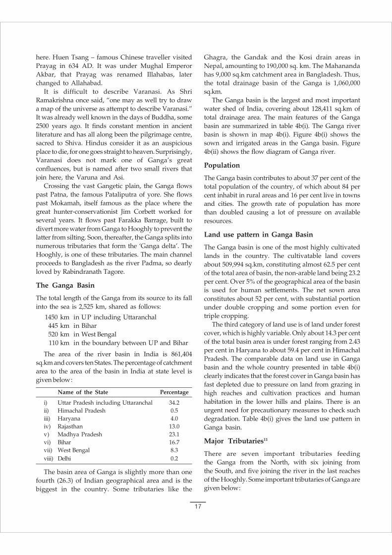
Ghagra, the Gandak and the Kosi drain areas inNepal, amounting to 190,000 sq. km. The Mahanandahas 9,000 sq.km catchment area in Bangladesh. Thus,the total drainage basin of the Ganga is 1,060,000sq.km.
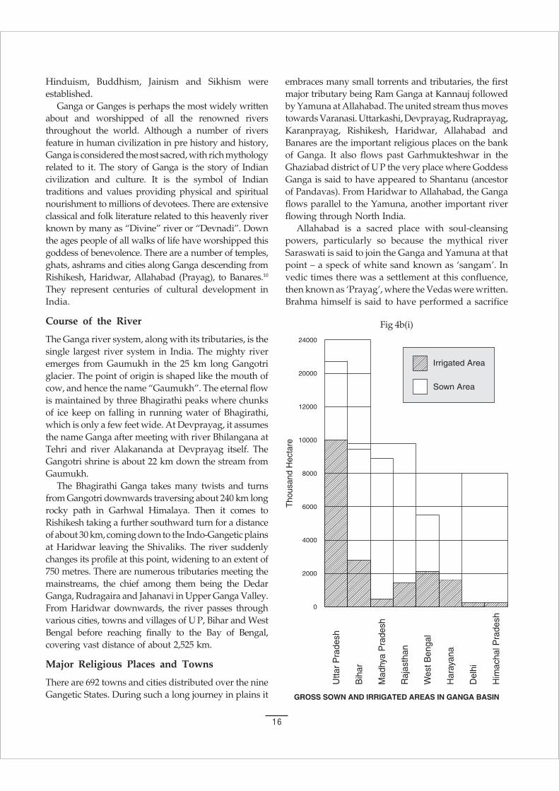
The Ganga basin is the largest and most importantwater shed of India, covering about 128,411 sq.km oftotal drainage area. The main features of the Gangabasin are summarized in table 4b(i). The Ganga riverbasin is shown in map 4b(i). Figure 4b(i) shows thesown and irrigated areas in the Ganga basin. Figure4b(ii) shows the flow diagram of Ganga river.
Population
The Ganga basin contributes to about 37 per cent of thetotal population of the country, of which about 84 percent inhabit in rural areas and 16 per cent live in townsand cities. The growth rate of population has morethan doubled causing a lot of pressure on availableresources.
Land use pattern in Ganga Basin
The Ganga basin is one of the most highly cultivatedlands in the country. The cultivatable land coversabout 509,994 sq.km, constituting almost 62.5 per centof the total area of basin, the non-arable land being 23.2per cent. Over 5% of the geographical area of the basinis used for human settlements. The net sown areaconstitutes about 52 per cent, with substantial portionunder double cropping and some portion even fortriple cropping.
The third category of land use is of land under forestcover, which is highly variable. Only about 14.3 per centof the total basin area is under forest ranging from 2.43per cent in Haryana to about 59.4 per cent in HimachalPradesh. The comparable data on land use in Gangabasin and the whole country presented in table 4b(i)clearly indicates that the forest cover in Ganga basin hasfast depleted due to pressure on land from grazing inhigh reaches and cultivation practices and humanhabitation in the lower hills and plains. There is anurgent need for precautionary measures to check suchdegradation. Table 4b(i) gives the land use pattern inGanga basin.
Major Tributaries11
There are seven important tributaries feedingthe Ganga from the North, with six joining fromthe South, and five joining the river in the last reachesof the Hooghly. Some important tributaries of Ganga aregiven below:

18
The Ramganga: The Ramganga river rises at analtitude of 3,110 metres in the Garhwal district, andemerges from the hills into the plains at Kalagarh, theboundary of the district. After traversing through somemore districts of UP, it joins the Ganga at Kannauj. Itstotal length is 596 km. The basin covers an area of32,493 sq.km.
The Gomti : Rises about 3 km east of Pilibhit town ofU P, at 200 metres elevation. It drains the area betweenthe Ramganga and the Ghaghra systems. Its tributariesare the Gachai, the Sai, the Jomki, the Chuha andSarayu. Lucknow is located on the banks of Gomti, thelength of the river is 940 km and it drains a total areaof 30,437 sq.km.
The Ghaghara: The Ghaghra is called Manchuand Karnali in Nepal and has its source near Lake
Mansarovar. Its total catchment area is 127,950sq.km of which 45% is in India. Its importanttributary is the Sarda or Chauka, which forms theboundary between India and Nepal. The othertributary in India is the Saryu, famous for thelocation of Ayodhya (the capital of DasharathKingdom) on its banks. It spills and causes floodingevery year in Azamgarh and Ballia districts in UP,sometimes to a width of 161 cm. Other tributaries arethe Rapti and the Little Gandak, which starts as anold channel of the Gandak at an elevation of 300 mand joins the Ghaghra in Shajahanpur district of UP.The Ghaghra joins the Ganga a few km down streamof Chapra, lower in Bihar. The length of the Ghaghrais 1,080 km and it carries more water than the Gangabefore its confluence.
Table 4b(2)Land Use Pattern
Area Cultivated Non-Curable Human Settlement Forest Net Sown
Ganga Basin 62.45 23.2 5.35 14.3 52.4
India 47.87 22.5 3.49 20.4 42.6
Table 4b(1)Main Features of Ganga Basin10
Features Measurements
Area of the river basin 861,404 sq.km
% in India 85%
Surface water availability 446 mill.acre feet (MAF)
Total cultivable area 21,109 sq.km.
Irrigation Potential 27,350 thousand hectares
Hydel Potential 11,579 mega watts (at 60% load factor)
Average annual rainfall 364 cm (total 78 cm in the upstream104 cm in the middle course, and
182 cm in the lower delta
Cultivable net area covering Gangetic States 0.6 x 10⁶ hectares (600,000 hectares)
Potential sites for dam 52 (total)29 completed23 proposed
Total flow availabilitya. Dry season (Nov.-May) 50 MAFb. Wet season (June-Oct.) 322 MAF
Sediment Load 2.4 bill. met. tons per year
Temperature gradient 10 – 40 C
Annual discharge 459,040 million cubic mt.
Drainage Area 128,411 sq.km
Total Catchment Area 1,060,000 sq. km (Tributaries flowing inNepal amounts to 190,000 sq.km and Mahananda
has 9000 sq.km in Bangladesh
19
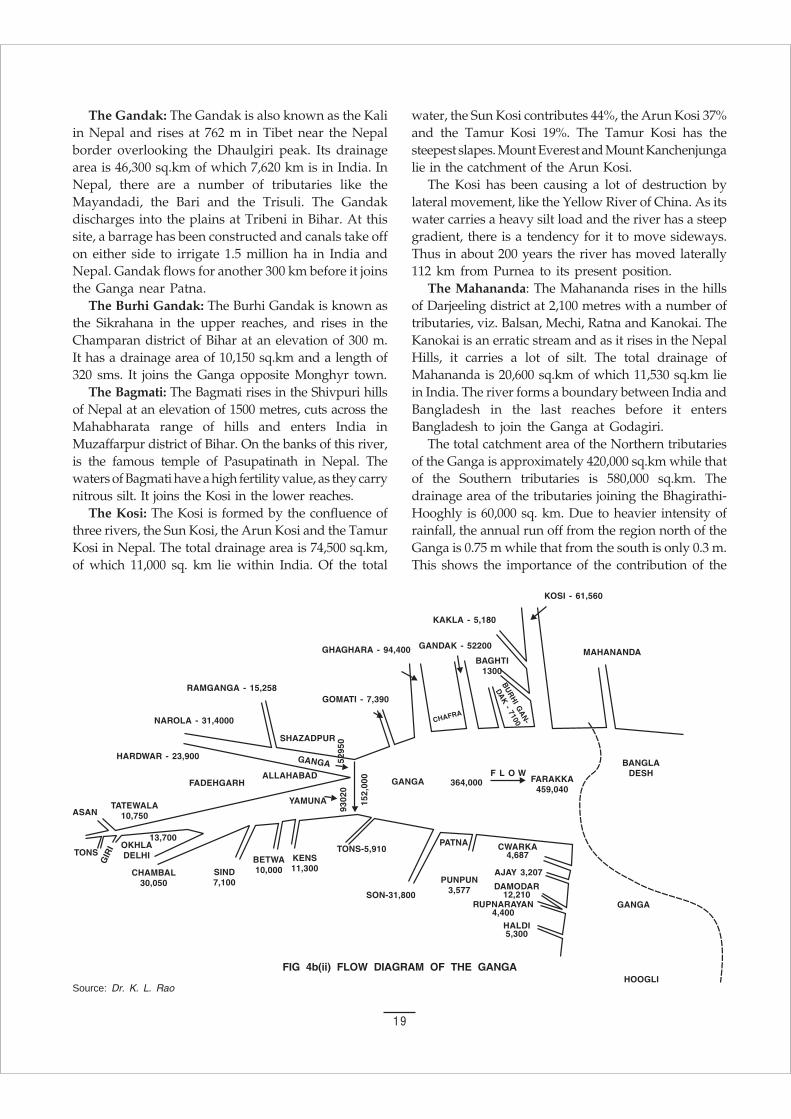
The Gandak: The Gandak is also known as the Kaliin Nepal and rises at 762 m in Tibet near the Nepalborder overlooking the Dhaulgiri peak. Its drainagearea is 46,300 sq.km of which 7,620 km is in India. InNepal, there are a number of tributaries like theMayandadi, the Bari and the Trisuli. The Gandakdischarges into the plains at Tribeni in Bihar. At thissite, a barrage has been constructed and canals take offon either side to irrigate 1.5 million ha in India andNepal. Gandak flows for another 300 km before it joinsthe Ganga near Patna.
The Burhi Gandak: The Burhi Gandak is known asthe Sikrahana in the upper reaches, and rises in theChamparan district of Bihar at an elevation of 300 m.It has a drainage area of 10,150 sq.km and a length of320 sms. It joins the Ganga opposite Monghyr town.
The Bagmati: The Bagmati rises in the Shivpuri hillsof Nepal at an elevation of 1500 metres, cuts across theMahabharata range of hills and enters India inMuzaffarpur district of Bihar. On the banks of this river,is the famous temple of Pasupatinath in Nepal. Thewaters of Bagmati have a high fertility value, as they carrynitrous silt. It joins the Kosi in the lower reaches.
The Kosi: The Kosi is formed by the confluence ofthree rivers, the Sun Kosi, the Arun Kosi and the TamurKosi in Nepal. The total drainage area is 74,500 sq.km,of which 11,000 sq. km lie within India. Of the total
water, the Sun Kosi contributes 44%, the Arun Kosi 37%and the Tamur Kosi 19%. The Tamur Kosi has thesteepest slapes. Mount Everest and Mount Kanchenjungalie in the catchment of the Arun Kosi.
The Kosi has been causing a lot of destruction bylateral movement, like the Yellow River of China. As itswater carries a heavy silt load and the river has a steepgradient, there is a tendency for it to move sideways.Thus in about 200 years the river has moved laterally112 km from Purnea to its present position.
The Mahananda: The Mahananda rises in the hillsof Darjeeling district at 2,100 metres with a number oftributaries, viz. Balsan, Mechi, Ratna and Kanokai. TheKanokai is an erratic stream and as it rises in the NepalHills, it carries a lot of silt. The total drainage ofMahananda is 20,600 sq.km of which 11,530 sq.km liein India. The river forms a boundary between India andBangladesh in the last reaches before it entersBangladesh to join the Ganga at Godagiri.
The total catchment area of the Northern tributariesof the Ganga is approximately 420,000 sq.km while thatof the Southern tributaries is 580,000 sq.km. Thedrainage area of the tributaries joining the Bhagirathi-Hooghly is 60,000 sq. km. Due to heavier intensity ofrainfall, the annual run off from the region north of theGanga is 0.75 m while that from the south is only 0.3 m.This shows the importance of the contribution of the
FIG 4b(ii) FLOW DIAGRAM OF THE GANGA
Source: Dr. K. L. Rao

20
Table 4b(3)Average Annual Flow in the Ganga and its Tributaries11
Sl. Name of the Sub-basin Average annual flow inNo Million cu.m.
1 Yamuna at Allahabad 93,020(a) Chambal (30,050)
2 Ganga at Allahabad 58,980(a) Ramganga (including Deoha) (15,258)
3 Ganga at Allahabad after confluence with Yamuna 152,000
4 Ganga at Patna 364,000a) Tons (5,910)b) Sone and other basins between Tons and Sone (31,800)c) Gomti (73090)d) Ghaghara (94,400)e) Gandak (52,200)
5 Ganga at Farakka 459,040a) Buri Gandak (7,100)b) Kosi (61,560)
6 Ganga at Confluence below the Haldi 493,400a) Dwarka (4,687)b) Ajoy (3,207)c) Damodar (12,210)d) Rupnarayan (4,400)e) Haldi (5,300)
flows from the Himalayan plain north of the Ganga tothe main river. Nearly 60% of the water flowing in theGanga comes from the drainage areas north of the river.Table 4b(3) gives the average annual flow in the Gangaand its tributaries.
Basin Data
The Ganga basin has by far the largest gross sown areaof nearly 58 million hectares. The gangetic basin hasapproximately one third of the cultivated area in northof the river and the balance in south of the river. Thepercentage of gross cultivated area to cultivable areais about 95%. Only a third of this area is irrigated, therest being rain fed. The important data such ascultivable area, sown area and irrigated area are givenin table 4b(5).
The soils in the northern portion of the basin aremainly of three types. In the hills brown soil prevails. Inthe area just at the foot of the hills, Terai soils are found.In the rest of the plains, the soils are rich fertile alluvialsoils. The depth of the soil is also variable throughoutthe basin, depending on the flow, rainfall andagricultural practices. The Himalaya being a youngmountain range remains prone to soil erosion. Thelower Peninsula receives the thick layer of sedimentwhile soil of various thickness is found in the SouthernPlateau. The high rate of siltation reduces the waterholding capacity of the Ganga, resulting in devastating
floods almost every year and causing innumerablesufferings to the inhabitants.
In the Southern region, Vindhya Plateau soil prevails;they are —
i) Vindhya upland coarse gravel–red, shallow andpoor in nutrients,
ii) Vindhya plains containing fine grain material thatcan retain moisture, and
iii) Vindhya low land soils, which are alluvial. Besidesthese in the hills, there are forest soils. In somedistricts, laterite soils prevail.
Basin Water Potential and Utilization
The total water flow in the surface flow of the basin is49,300 crore cu.m. There are four distinct regions in theGanga Basin
i) Bhabhar area
ii) Terai
iii) Ganga plain, and
iv) Southern flat areas.
In the Bhabar area, the aquifers are located deep butoccur under confined conditions. Until recently in Teraiareas, which are lower than the Bhabar areas, thewater table occurred near the surface and there wereexcellent ground water resources. The irrigated area inthe Ganga basin is 19.5 million ha. The various sources

21
of water for this utilization in different States are givenin table 4b(5). It is interesting to observe that 40% ofirrigation is by canals, 45% by ground water, and thebalance by tanks and miscellaneous sources.
(ii) THE YAMUNA BASINThe Yamuna is the most important tributary of Ganga,joining it on the right bank. The Yamuna originatesfrom the Yamnotri Glacier in Uttar Kashi district ofUttaranchal at an elevation of 6,330 metres. Manysmall streams including the Rishiganga, the Uma andthe Hanumanganga join it in the mountains. The Tons,the longest tributary, rises at an elevation of 3,900metres and joins Yamuna below Kalsi. At this site, theTons carries twice the water that is carried in theYamuna.
The river flows 1,367 km from its source to itsconfluence with Ganga at Allahabad. Near Tajewala,about 172 km from its source, the water is taken off bythe Western and Eastern canals. It flows further 280 kmdown to Okhla in Delhi territory from where the AgraCanal takes off. The Hindon, 256 km long, rises in thedistrict of Saharanpur in UP and joins the Yamuna onits left bank, 40 km below Okhla.
From Delhi, at 130 km is located the Holy place ofMathura and further down 50 km, the city of Agra.Small tributaries like the Karam, the Sagar and theSindhs join it on its left bank and the Chambal, the Sind,the Betwa, and the Ken, flowing from the Vindhyas,join it on the right bank.
The total catchment area of the river is 363,848sq.km of which 139,468 sq.km is the drainage area ofChambal alone. The State level catchment area is givenin the table 4b(4).
The Chambal rises in the Vindhya ranges and flowsfor 965 metres before it flows through the flatfertile Malwa Plateau and then enters a gorge at
Chaurasingarh. The gorge is about 96 km long andstretches up to Kotah City. The river runs foranother 34 km flowing through plains. As the riverflows much below the bank and due to poorrainfall, severe erosion has occurred over centuriesand numerous deep ravines have been formed inChambal Valley (Chambal ravines are notorious forbeing the dacoit infested area).
The Sindh rises in Vidisha district of Madhya Pradeshat an elevation of 543 m. It is 415 km long and drainsan area of 25,085 sq.km. It joins the Yamuna downstream of the confluence of the Chambal with theYamuna. The Parvati, Kunwari and Pahuj are sources ofits tributaries.
The Betwa rises at an elevation of 470 metres inthe district of Bhopal in Madhya Pradesh. It joins theYamuna near Hamirpur after flowing 590 km. Thetotal catchment area of Betwa is 45,580 sq.km.
Ken rises in the Kampur hills of Satna district ofMadhya Pradesh. It is 360 km long up to its point ofconfluence with Yamuna near Chilla. It drains an areaof 28,224 sq.km.
The Tons has a drainage area of 16,860 sq.km. Itrises in a tank at Tamakund in the Kaimur rangeof hills at an elevation of 610 metres and flowsthrough the fertile lands of Rewa and Satna districts.The river receives the Belan in UP and joins theGanga about 311 km downstream of the confluence ofGanga and Yamuna. The total length of the river is264 km.
The Sone rises at Sonabhadhra at an elevation of600 metres; it covers an area of about 71,259 sq.km.After passing in cascades over the hills, it receivesthe Rihand tributary and then passes through thePalamu district of Bihar. It joins the Ganga about 16km upstream of Dinapur in Patna district. The totallength of the river is 784 km. The important tributariesof the Sone (with their catchment shown in bracket)are the Mahanadi (4,843), the Banas (3,507), theGapat (5,998), the Rihand (17,110) and the Kankar(5,903).
(iii) CAUVERY BASINMythology has several stories about Kaveri’s descent to theearth. The most popular is that a king by the name ofKavera, who lived in the Brahmagiri Hills, prayed to theLord Brahma for a progeny. He was blessed with adaughter whom he named Kaveri. She was the water
Table 4b(4)Yamuna Sub-Basin and
Statewise Catchment Area (sq.km.)
State Total Catchment Area
Uttar Pradesh including Uttranchal 74,208
Himachal Pradesh 5,799
Haryana 21,265
Rajasthan 1,20,883
Madhya Pradesh 1,40,208
Delhi 1,485
Total 3,66,848

22
Table 4b(5)Basin Data – State wise11
State Culti- Net Gross Net Gross Sources of Irrigationvable Sown Sown Irrigated Irrigated Govt. & Tanks Other Tube WellsArea Area Area Area Area Private Sources wells
Canals
1 2 3 4 5 6 7 8 9 10 11
Indus Basin In thousand Hectares
Haryana 828 752 1063 695 712 628 1 3 20 60
Himachal Pradesh 1807 489 811 84 145 - - 144 - 1
Jammu & Kashmir 1209 679 815 317 383 90 - 292 - 1
Punjab 4289 3988 5435 3020 4354 2004 - 25 1525 800
Rajasthan 1505 1061 1198 654 740 740 - - - -
Total 9638 6969 9322 4770 6234 3462 1 464 1545 862
Ganga Basin
Bihar 9876 7233 9659 2448 3090 1399 98 776 500 317
Delhi 102 82 116 30 58 16 2 - 22 18
Haryana 3006 2765 4093 955 1684 868 2 14 400 400
Himachal Pradesh 179 57 87 12 15 - - 14 - 1
Madhya Pradesh 12788 8503 9227 875 1020 335 156 45 - 484
Rajasthan 8190 5424 6393 1179 1552 323 174 23 2 1030
Uttar Pradesh 20765 17396 22688 8750 10164 3865 412 287 3200 2400
West Bengal 5255 4587 5430 1800 1213 812 361 608 120 12
Total 60161 46047 57693 16049 19496 7618 1905 1767 4244 4662
Brahmaputra Basin Including Barak
Arunachal Pradesh 1630 55 55 - - - - - - -
Assam 2886 2153 2588 487 487 228 - 209 - 50
Manipur 80 71 75 5 5 - - 5 - -
Meghalaya 155 155 174 44 44 - - 44 - -
Mizoram 39 39 40 - - - - - - -
Nagaland 245 33 34 3 3 - - 3 - -
Tripura 298 192 273 20 22 - - 22 - -
West Bengal 312 722 864 128 205 100 3 22 - 80
Total 6145 3420 4103 687 766 328 3 305 - 130
Sabarmati Basin
Gujrat 1343 1884 1299 226 285 89 10 1 10 175
Rajasthan 205 80 104 24 33 - 5 2 1 25
Total 1548 1264 1403 250 318 89 15 3 11 200
Mahi Basin
Gujarat 806 750 836 102 166 91 13 1 11 50
Madhya Pradesh 464 362 383 19 19 2 1 1 - 15
Rajasthan 940 486 580 68 85 5 17 2 1 60
Total 2210 1598 1799 189 270 98 31 4 12 125
23
Narmada Basin
Gujarat 837 738 753 85 94 2 13 13 1 75
Madhya Pradesh 4984 3681 3922 130 185 9 40 6 10 125
Maharashtra 80 80 87 5 5 - - - - -
Total 5901 4499 4762 220 284 11 53 9 11 200
Tapti Basin
Gujarat 169 149 155 166 170 155 3 1 1 10
Madhya Pradesh 515 387 405 32 33 11 - 3 3 155
Maharashtra 3608 3264 3406 156 172 6 1 1 - 25
Total 4292 3800 3966 354 375 172 4 5 4 190
Subarnarekha Basin
Bihar 798 448 480 50 52 38 4 6 - 4
Orissa 207 155 172 24 33 4 6 18 - 5
West Bengal 189 150 164 48 52 50 - - - 2
Total 1194 753 816 122 137 92 10 24 - 11
Brahamani Basin
Bihar 918 537 584 75 12 - 3 5 - 4
Madhya Pradesh 70 50 53 2 3 - 1 1 - 1
Orissa 1372 895 1100 140 293 125 75 68 - 25
Total 2360 1482 1737 317 308 125 79 74 - 30
Mahanadi Basin
Bihar 42 25 25 1 - - - 1 - -
Madhya Pradesh 4078 3073 3711 512 444 322 90 16 - 15
Maharashtra 7 7 7 1 1 - 1 - - -
Orissa 3867 2519 3285 680 1115 795 125 150 - 45
Total 7994 5624 7028 1194 1560 1117 216 167 - 60
Godavari Basin
Andhra Pradesh 4039 2742 3006 712 1214 767 251 26 20 150
Karnataka 402 296 329 2 4 - 1 1 - 2
Madhya Pradesh 2439 1727 1911 160 189 67 85 7 - 30
Maharashtra 11118 9077 9568 879 906 303 160 15 8 420
Orissa 933 593 646 9 26 - 4 15 - 7
Total 18931 14435 15460 1762 2339 1137 501 64 28 609
Krishna Basin
Andhra Pradesh 5257 3627 4027 1130 1652 1292 170 20 20 150
Karnataka 9276 7093 7268 937 1056 565 214 52 - 225
Maharashtra 5766 4880 5062 563 743 286 9 40 8 400
Total 20299 15600 16357 2530 3451 2143 393 112 28 775
Pennar Basin
Andhra Pradesh 3028 1845 1973 366 415 97 90 16 12 200
Karnataka 509 236 244 53 61 - 30 1 - 30
Total 3537 2081 2217 419 476 97 120 17 12 230

24
direction. At 45 km from Mettur, it meets with its maintributary ‘Bhavani’. When it enters into Tiruchirpallidistrict, it meets with the Noyill and Amravati rivers.Here it is the widest and hence, it is called “AkhandKaveri”.
Of the total drainage area, Kerala has 3.3%,Karnataka 41.2%, and Tamil Nadu 55.5%. BelowTiruchirapalli, the river divides into two branches,Coleroon and Cauvery. The upper Anicut wasconstructed in 1836 across the Coleroon to send thelow flow into Cauvery. The two rivers join again 2.6 kmdown. Srirangam, the pilgrims centre, is locatedbetween the two branches of the river at the lowerjunction. The Grand Anicut was constructedin the first century AD across the Coleroon. TheCauvery splits again into two branches, the Cauveryand the Vennar. The great Tanjore delta is fed bythese two rivers.
The total cultivated area is 4.2 million ha and forms77% of the cultivable area of the land. The percentage ofirrigation is 44%. The soil types are black, red, laterite,alluvial, forest and mixed.
The maximum discharge of the river is 12,913 cusec.The mean annual flow is 20,950 million cu.m. InCauvery basin the irrigation had been practised fromancient times by wells and diversions from anicuts intosmall canals. The most important work is the GrandAnicut built in the first century AD. It was built of stoneand mud, covered with an outer facing of dressedgranite set in lime mortar.
The upper anicut was constructed by Sir ArthurCotton in 1836. The lower anicut was also built aboutthe same time, 110 km downstream. It irrigates 44,500hectares. The Krishnarajasagar and Mettur dams werebuilt in the thirties with live storage of 1,246 millioncu.m and 2,652 million cu.m respectively.
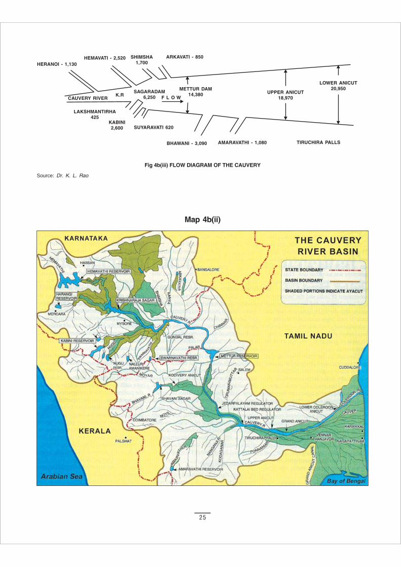
The principal tributaries of Cauvery are the Harangi,the Hemavati, the Lakshmanathirtha, the Kabani, theShimsha, the Arkavati and the Suvarnavati inKarnataka. In Tamil Nadu, they are the Bhavani, theNoyil and the Amravati. Brief discussion of theserivers is given in the Table 4b(7). Fig 4b(iii) shows theflow diagram of Cauvery, and map 4b(ii) shows theCauvery River Basin.
manifestation of the human form. The great sage Agastya,who married her, contained her in his “Kamandalu” alsospelt as ‘Kamandal’ (spouted jug). When a droughtencompassed the land, Ganesha in the guise of a crow,tipped the Kamandalu and outflowed Kaveri.
The river Cauvery, also spelt as ‘kaveri’ is an inter–state river in Southern India. It is one of the major riversof the Peninsula flowing east and runninginto the Bay of Bengal. Cauvery is among the mostsacred rivers of India and is known as “the DakshinaGanga” or the Ganga of the South. After flowing800 km, it joins the Bay of Bengal at Kaveripatnamas a small stream, all its waters being utilised higher-up.
The Cauvery rises at Talakaveri on the BrahmagiriRange of Hills in the Western Ghats, presently in theCoorg district of the State of Karnataka, at an elevationof 1341 m (4,400 ft.) above mean sea level. Thecatchment area of the entire Cauvery Basin is 81,155sq.km including the other basin States of the CauveryRiver System and their drainage areas, as indicated intable 4b(6).
The first dam built on this river is “KrishnarajSagar” at 19 km from Mysore where it meets withHemavati and Lakshmanathirtha rivers. After 25 kmfrom Srirangapatanam, it meets the Kabani andSuvarnavati rivers. Near Shivsamundram, it falls fromthe height of 90 metres and creates many beautiful waterfalls and springs. At 64 km from this place, it forms theborder of Karnataka and Tamil Nadu. Here it meets withthe Shimsha and Akravati rivers.
In Tamil Nadu, it flows in the east direction, butfrom the Hogenakkel water falls it flows in South
Table 4b(6)State Basins with Catchment Area of Cauvery
S.N. Name of the Basin State Catchment Area in sq.kms.
1 Karnataka 34,273
2 Kerala 2,866
3 Tamil Nadu 43,868
4 Pondicherry 148
Total 81,155
Cauvery Basin
Karnataka 2424 1448 1595 240 393 170 154 19 - 50
Kerala 154 114 124 15 21 - - 21 - -
Tamil Nadu 2945 2081 2462 866 1421 940 116 80 5 280
Total 5523 3643 4181 1121 1835 1110 270 120 5 330
Grand Total 149733 111215 130344 28984 37949 17599 2901 3135 5900 8414
25
Fig 4b(iii) FLOW DIAGRAM OF THE CAUVERY
Map 4b(ii)
Source: Dr. K. L. Rao
26
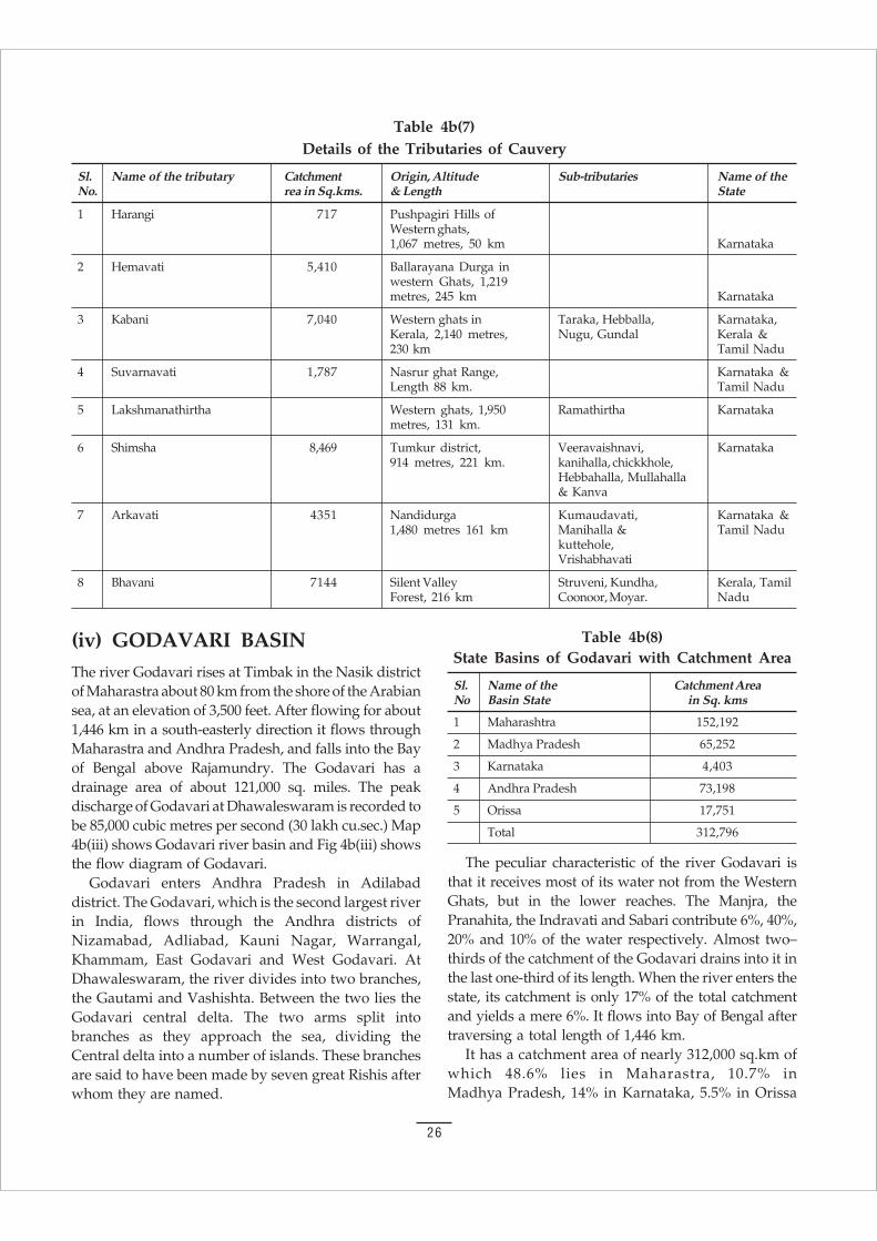
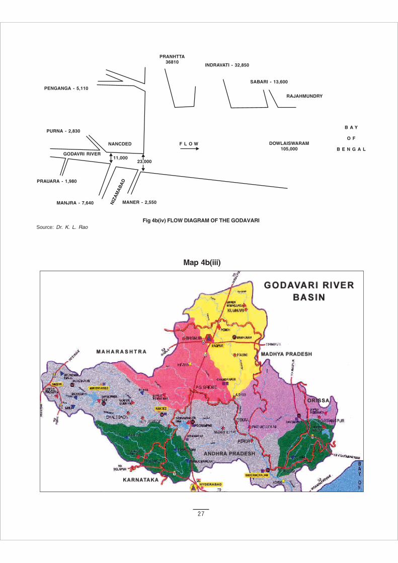
(iv) GODAVARI BASINThe river Godavari rises at Timbak in the Nasik districtof Maharastra about 80 km from the shore of the Arabiansea, at an elevation of 3,500 feet. After flowing for about1,446 km in a south-easterly direction it flows throughMaharastra and Andhra Pradesh, and falls into the Bayof Bengal above Rajamundry. The Godavari has adrainage area of about 121,000 sq. miles. The peakdischarge of Godavari at Dhawaleswaram is recorded tobe 85,000 cubic metres per second (30 lakh cu.sec.) Map4b(iii) shows Godavari river basin and Fig 4b(iii) showsthe flow diagram of Godavari.
Godavari enters Andhra Pradesh in Adilabaddistrict. The Godavari, which is the second largest riverin India, flows through the Andhra districts ofNizamabad, Adliabad, Kauni Nagar, Warrangal,Khammam, East Godavari and West Godavari. AtDhawaleswaram, the river divides into two branches,the Gautami and Vashishta. Between the two lies theGodavari central delta. The two arms split intobranches as they approach the sea, dividing theCentral delta into a number of islands. These branchesare said to have been made by seven great Rishis afterwhom they are named.
Table 4b(7)Details of the Tributaries of Cauvery
Sl. Name of the tributary Catchment Origin, Altitude Sub-tributaries Name of theNo. rea in Sq.kms. & Length State
1 Harangi 717 Pushpagiri Hills ofWestern ghats,1,067 metres, 50 km Karnataka
2 Hemavati 5,410 Ballarayana Durga inwestern Ghats, 1,219metres, 245 km Karnataka
3 Kabani 7,040 Western ghats in Taraka, Hebballa, Karnataka,Kerala, 2,140 metres, Nugu, Gundal Kerala &230 km Tamil Nadu
4 Suvarnavati 1,787 Nasrur ghat Range, Karnataka &Length 88 km. Tamil Nadu
5 Lakshmanathirtha Western ghats, 1,950 Ramathirtha Karnatakametres, 131 km.
6 Shimsha 8,469 Tumkur district, Veeravaishnavi, Karnataka914 metres, 221 km. kanihalla, chickkhole,
Hebbahalla, Mullahalla& Kanva
7 Arkavati 4351 Nandidurga Kumaudavati, Karnataka &1,480 metres 161 km Manihalla & Tamil Nadu
kuttehole,Vrishabhavati
8 Bhavani 7144 Silent Valley Struveni, Kundha, Kerala, TamilForest, 216 km Coonoor, Moyar. Nadu
The peculiar characteristic of the river Godavari isthat it receives most of its water not from the WesternGhats, but in the lower reaches. The Manjra, thePranahita, the Indravati and Sabari contribute 6%, 40%,20% and 10% of the water respectively. Almost two–thirds of the catchment of the Godavari drains into it inthe last one-third of its length. When the river enters thestate, its catchment is only 17% of the total catchmentand yields a mere 6%. It flows into Bay of Bengal aftertraversing a total length of 1,446 km.
It has a catchment area of nearly 312,000 sq.km ofwhich 48.6% lies in Maharastra, 10.7% inMadhya Pradesh, 14% in Karnataka, 5.5% in Orissa
Table 4b(8)State Basins of Godavari with Catchment Area
Sl. Name of the Catchment AreaNo Basin State in Sq. kms
1 Maharashtra 152,192
2 Madhya Pradesh 65,252
3 Karnataka 4,403
4 Andhra Pradesh 73,198
5 Orissa 17,751
Total 312,796
27
Fig 4b(iv) FLOW DIAGRAM OF THE GODAVARI
Map 4b(iii)
Source: Dr. K. L. Rao
28
Table 4b(10)Capacity of Existing Projects and Those Under Construction
Sl. No. Name of the Project TMC
1 Nizam Sagar 58.0
2 Kadam 11.60
3 Sriram Sagar St-1 140.27
4 Singur and Manjira Water Supply 15.99
5 Medium Irrigation Projects 48.44
6 Minor Irrigation Projects 85.70
7 Dhawaleshwaram 263.60
8 Medium Irrigation Projects 14.60
9 Minor Irrigation Projects 41.80
Total 680
and 23.8% in Andhra Pradesh. It is the largest of thePeninsular rivers and is held in reverence as ‘VridhaGanga’ (old Ganga). The delta of the river consists ofa wide belt of river borne alluvium and graduallyextends into the sea. It pierces through the EasternGhats flowing through a narrow gorge of 130 km fromthe sea. There are holy places on its bank in Nasik andBhadrachalam. State Basins of Godavari are shown intable 4b(8). Table 4b(9) gives the principal tributries ofGodavari. Capacity of existing projects and those underconstruction are shown in table 4b(10).
The maximum discharge is 80,137 cu.mecs and theminimum is 42 cumecs. The flow in the river indifferent reaches is given in figure 4b(iv).
A large part of the basin lies over ancient crystallineand metamorphic rocks which are poor water bearingstrata. The basin has 15.5 million hectare under
cultivation forming 82% of the cultivable area. Thepercentage of irrigation is 15%. Tanks and wells havebeen used in the basin from ancient times for irrigatinglands. The Godavari delta project was started in June1847 by Sir Arthur Cotton to irrigate nearly half amillion hectares. In Maharastra, the Godavari canalproject, consisting of a dam on a tributary and weiracross the Godavari built in 1915-16, irrigates 0.03million hectare. The Pravara project, built in 1926,consists of a dam at Bhandandura and a pick-up weirlower down which irrigates 0.023 million hectare.
The Ramtak project consisting of a dam on the Sur,a tributary of the Wainganga, and built in 1910irrigates 0.013 million hectare. The Wainganga canals,constructed in Madhya Pradesh in 1923, irrigate 0.03million hectare, and the Nizamnagar dam built in 1933irrigate 0.097 million hectare.
Table 4b(9)Particulars of the principal tributaries are of Godavari
River Source Sub-Tributaries Length km Catchment sq.km Remarks
1 2 3 4 5 6
The Pravara Western Ghats Mula 200 6,537 Poor rainfall
The Purna Ajanta Hills - 373 15,579 Tributary of Wardha
The Manjra Balaghat Tima, Kanaya 724 30,844
Penganga Buldana Range Pus, Arns, Aran 676 23,895
Wainganga Seoni Pench, Bagh, Andhari 609 61,093
Wardha Betul Distt. Wunna, Bermbla,Penganga 483 24,087
Pranhita - Wainganga Wardha 113 after confluence 109,077
Indravati Kalahand Narangi, Kotri,Bandia, Nandira 531 41,665
Maner - Haldi 13,106
Sabari (Kolab) Sinkaram Hills Sileru 418 140,427
29
(v) KRISHNA BASINThe river Krishna rises from a water spring inWestern Ghats at an altitude of 1,360 metres nearMahabaleshwar in Maharashtra. The place is held inhigh esteem.
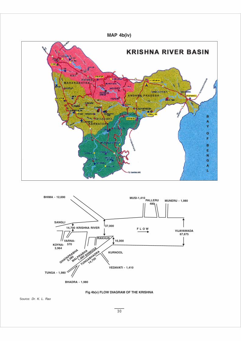
After flowing 1400 km it joins the Bay of Bengal.The catchment area of Krishna is about 258,448 sq.km, ofwhich 26.8% lies in Maharashtra, 43.8 % in Karnatakaand 29.4% in Andhra Pradesh. The river passesthrough a narrow gorge from Sangameswaram toNagarjunasagar, a distance of 130 km just below theconfluence of Tungabhadra with this river. It is inthis reach that two large reservoirs, the Sreesailamand Nagarjunsagar are located. Table 4b(11) showsthe State basins with catchment area, and table 4b(12)gives the tributaries of Krishna. Table 4b(13) givesthe water utilisation from Krishna. Map 4b(iv) shows theKrishna river basin; fig 4b(v) shows the flow diagram ofKrishna.
The chief tributaries of Krishna are the Koyna,the Ghataprabha, the Malaprabha, the Bhima, theTungabhadhra, the Musi and the Muneri. The maximumdischarge of Krishna river is 33,810 cu.mecs and theminimum is less than 3 cu.mecs. The total annual meanrun off is 57,764 million cu.m.
Soil consists of black, laterite, alluvial, and mixedsoils of saline and alkaline types. In areas underlain bycrystalline rocks like granites, the quality of water isunsuitable for domestic purpose due to the presenceof fluorides in excess of the prescribed safe limit. The
tanks and wells irrigate more than 40% of the totalirrigated areas. When the wells fail drought conditionprevails.
Irrigation was practised in the basin from theearliest times by tanks and diversion. The Krishnadelta canal system completed in 1855 providesirrigation for 0.56 million hectare. The original weirbreached in 1952 was replaced by a barrage. TheKurnool-Cuddapah canal takes off from Sunkesilaanicut to irrigate 100,000 hectares, though 39,510hectares only are irrigated in the scarcity districts ofKurnool and Cuddapah. The Kurnool-Cuddapah canalwas constructed in 1866. The Nira canal wasconstructed in 1846 and consists of a dam on the riverYelvandi at Bhotga and a canal system to irrigate82,700 hectares.
After independence a large number of projects werestarted in the basin. The most important of these areTungabhadhra, Rajolibanda, Musi, Nagarjunasagar,Radhanagri, Ghod, Khadakwasla, Koyna, Malprabha,Ghataprabha and Upper Krishna.
Table 4b(12)Details of the Tributaries of Krishna
Sl. Name of the Source Altitude Length (km) Catchment SubtributariesNo. Tributaries (Meters) Area sq.km
1 Ghataprabha Western Ghats 880 282 8,829 Hiranya kashi,Markandyu
2 Malaprabha - do - 789 304 11,548 Benihalla, Hirehalla,Tasnadi
3 Bhima - do - 941 861 76,614
4 Tungabhadra -do- 1193 531 71,417 Combained water of(at Gangamula) Tunga and Bhadra,
Varadi and Hagari
5 Musi Medak District - 240 11,212
6 Muneru - - 235 10,400
Table 4b(11)Krishna basin with catchment area
Sl.No. Name of the Basin State Catchment area in Sq.kms
1 Maharastra 69,422
2 Karnataka 76,249
3 Andhra Pradesh 113,276
Total 258,948
30
Fig 4b(v) FLOW DIAGRAM OF THE KRISHNA
MAP 4b(iv)
Source: Dr. K. L. Rao
31
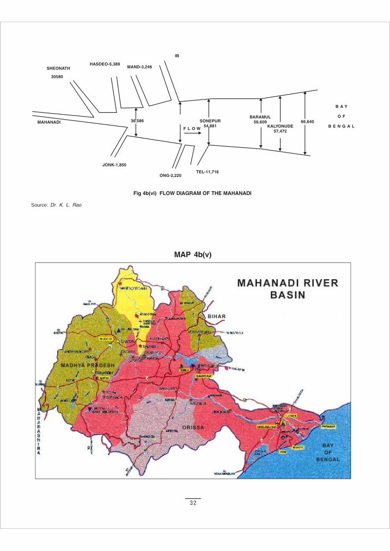
(vi) MAHANADI BASIN11
The Mahanadi rises from a pond near Pharsia village inRaipur district of Chhatisgarh. It drains an area of141,600 sq.km, of which 53.1% is in Chhatisgarh andMadhya Pradesh, 46.5% in Orissa and the balance inBihar (0.5%) and Maharashtra (0.1%). The length of theriver is 857 km. Towards the end, it flows for 23 kmthrough a narrow gorge starting 6 km upstream ofTikkapara Village, and finally emerges in the delta atNaraj 11 km West of Cuttak. Below Naraj the riverbreaks off into two branches, the Katjuri and the Birupa.The Mahanadi finally flows into the bay of Bengal. Theimportant tributaries of the river are given in the table4b(14). Fig 4b(vi) shows the flow diagram of Mahanadiand map 4b(v) shows the Mahanadi river basin.
After receiving the Sheonath river, below BalodaBazar, it turns east and enters Orissa State.
It is one of the most active silt depositing streams inthe Indian sub continent. The river supplies several
Table 4b(13)Water Utilization Under Existing Projects from Krishna River17
Sl. No. Name of the Prioject TMC
1 Nagarjuna Sagar 281.00
2 Krishna Delta 181.20
3 Kurnool-Cuddappah Canal 39.90
4 Tungabhadra Right Branch Canal 29.50
5 Tungabhadra Right High Branch Canal 32.50
6 Srisailam 33.00
7 Jurala Phase -1 17.84
8 Rajolibanda Diversion Scheme 15.90
9 Minor Irrigation Schemes 116.00
10 Other Projects 52.90
11 Total 800.00
Table 4b(14)Tributaries of Mahanadi
S.No River Source Length (km) Catchment (sq.km)
Left Bank
1 The Sheonath Kotgal 383 30,761
2 The Hasdeo North of Sarhat 333 9,803
3 The Mand Raigarh 241 5,237
4 The Ib Raigarh 251 12,447
Right Bank
5 The Jonk Khariar 196 3,673
6 The Ong Hill 204 5,182
7 The Tel Koraput 295 22,818
irrigation canals, mainly near Cuttak. At one of itsmouths is situated the famous pilgrimage site of Puri.
The basin consits of red and yellow soils. Mixed redand black soils are found in some districts likeSambalpur. In Puri and Cuttak district, laterite soils arefound. Coastal plains have saline and deltaic soils. TheMahanadi has a maximum discharge of 44,740 cusecs.Its annual flow is 66,640 million cubic metre.
Granite found in the upper parts of the basincontains water in the weathered mantle and along therift and horizontal joints. The sand stones are also goodaquifers. Costal alluvial tracts have fresh waterformations near the surface and depths below 150metres. In some areas, artesian conditions are also foundat depths of 200 metres. In costal areas, deeper aquifershave to be carefully exploited to avoid salineencroachment.
The Mahanadi basin has a gross sown area of7 million hectare, which is 88% of the cultivable area.The irrigated area is 22% only.
32
Fig 4b(vi) FLOW DIAGRAM OF THE MAHANADI
MAP 4b(v)
Source: Dr. K. L. Rao
33
Suez: privatising the Ganges to create watermarkets in Delhi
On August 9, 2002, on the eve of Quit India Day, morethan 5000 farmers of Muradnagar and adjoining areasof western Uttar Pradesh gathered in a Rally at VillageBhanera. They came to protest the laying of a giant 3.25metre-diameter pipeline to supply water from the riverGanga to the Sonia Vihar Water Plant for Delhi. Theproject, which has been contracted to Suez-OndeoDegrémont of France by the Government of Delhi, willdeprive the richest farmlands of India of irrigationwater.
The Sonia Vihar water treatment plant, which wasinaugurated on June 21, 2002 by the Chief Minister ofDelhi, is designed for a capacity of 635 million liters aday on a 10 year BOT (build-operate-transfer) basis, ata cost of 1.8 billion rupees (approx. 50 million dollars).
The contract between Delhi Jal Board (the Water SupplyDepartment of the Delhi Government) and the Frenchcompany Ondeo Degrémont (subsidiary of SuezLyonnaise des Eaux Water Division – the water giant ofthe world) is supposed to provide safe drinking waterfor the city.
The water for the Suez–Degrémont plant in Delhiwill come from Tehri Dam through the Upper GangaCanal up to Muradnagar in Western Uttar Pradesh andthen through the giant pipeline to Delhi. The UpperGanga Canal, which starts at Haridwar and carries theholy water of Ganga up to Kanpur via Muradnagar, isthe main source of irrigation for this region.
The 9th August Rally at Bhanera village was theculmination of the 300 kilometre-long mobilisation drivealong the Ganga by the farmers of Garhwal andinhabitants of the devastated city of Tehri to liberatethe river from being privatized. The rally was launched
4c. Linking the Ganga to the YamunaA Case Study in River Linking
Today, the 8th of August 2002, on the eve of the 60th
Anniversary of the “Quit India Movement”, we allhave gathered here to pledge that:
We will never let the river Ganga to be sold to anymultinational corporations. Ganga is revered as amother (Ganga Maa) and prayed to and on its banksimportant ceremonies starting from birth till death areperformed (according to Hindu religious practices).We will never allow our mother or its water to be soldto Suez-Degrémont or any other corporations.
The sacred waters of the Ganga cannot be theproperty of any one individual or a company. Ourmother Ganga is not for Sale.
We boycott the commodification and privatisation ofthe Ganga and any other water resources.
We pledge to conserve and judiciously use ourregional water resources to save our environment andecology, so that we would gift our coming generationa clean and beautiful environment as well assafeguard their right to water resources.
We pledge and declare that the local communitywill have the right over the local water resources. Itis the duty of the local community to conserve andsensibly utilize their resources. Anyone from outsidethe community whether an individual, anorganisation or a corporation have to take thepermission of the Gram Sabha for utilizing theseresources.
The river Ganga was brought upon the face of earthby Bhagirath through his yagna (prayers) to sustainthe existence of life on Earth. The Ganga is nowintrinsic to our culture and a part of our heritage andcivilisation. Our life and progress over the millenniahas been dependent upon the sacred waters ofGanga. We will fight any multinational companytrying to take away our right to life by privatisingGanga waters.
The “Water Liberation Movement” will continuetill we liberate the sacred waters of Ganga fromthe clutches of corporations like Suez-OndeoDegrémont.
Mother Ganga Is Not For SaleThe Haridwar Declaration
33
34
from Haridwar – one of the oldest and holiest cities ofIndia built on the banks of Ganga - where hundreds offarmers, together with priests, citizens and worshippersof Ganga announced that “Ganga is not for Sale,” andvowed to defend the freedom of this holy river.Thousands of farmers and others in villages along theroute joined the rally to declare that they would neverallow Suez to take over Ganga waters.
The rallyists joined by more than 300 people fromacross the country, representing over a hundredgrassroots groups, intellectuals, writers and lawyers, atthe 3-day ‘Convention on Earth Democracy – People’sRights to Natural Resources’, organised by Navdanyafrom 10 to 12 August 2002 at Indian Social Institute,New Delhi. The Convention sought to provide evidenceof the state’s violent appropriation of people’s land,water and biodiversity, and evolve common actionplans and strategies to defend collective communityrights to resources.
“There is only one struggle left – the struggle for theright to life,” said Magasaysay Award winning writerMahasweta Devi. Eminent author Arundhati Roy andeminent scientist Vandana Shiva stressed the urgentneed to take collective united action to defend people’srights to land, water and biodiversity.
Suez–degrémont water plant at Sonia Vihar
Ondeo Degrémont, a subsidiary of Suez Lyonnaise desEaux Water Division, has been awarded a 2 billionrupees contract (almost 50 million dollars) for thedesign, building and operation (for 10 years) of 635million liters/day Drinking Water Production Plant atSonia Vihar in New Delhi to cater to the three millioninhabitants of the capital.
Won through the collaboration of all the Groupcompanies, within the context of an international callfor tenders, this 2 billion rupees contract is the firstcontract of this size in India, after Bombay, forDegrémont.
Construction of the giant 3.25 metre-diameter pipe ona stretch of 30 kilometres from Muradnagar to SoniaVihar is going on and till date, about 10 kilometres ofpipeline has been laid down.
The disastrous impact of this project on the farmersof Western UP is evident from the fact that this areais totally dependent upon the canal for irrigation. Evenbefore being operationalised to divert 630 million litresof water/day from irrigation, farmers are already feelingthe impact of corporate greed for profits – the UpperGanga Canal is being lined to prevent seepage into theneighbouring fields (an important source of moisture
for farming) and recharge of ground water, and farmersare being prevented from digging wells even as they arereeling under severe drought.
The lining of the canal to prevent recharging ofgroundwater has terrified the farmers of the wholeregion of western UP. At a meeting organsied byNavdanya on 21 July at Chaprauli, the land ofChoudhury Charan Singh, ex-Prime Minister, farmersstated “we will not allow the Canal to be lined and tosupply water to Delhi. Instead the government shouldlink the Upper Ganga Canal to the Yamuna Canalpassing through this area to tackle the severe drought.”
Who is paying for corporate profits?
Privatization of water has been justified on the groundthat full cost must be paid when water giants get watermarkets, whereas with water privatization they demanda full price from the people. However, as the case of theDelhi Water plant shows, the corporations get thewater for free without paying for full social andenvironmental cost to those rural communities fromwhom the water is taken.
The country has got into huge debt for the loanstaken from World Bank for the Ganga Canal. At thesame time the giant 3.25 metre-diameter pipe is beingbuilt through public finances. In effect, the public paysthe price, while transnational companies make theprofit.
Delhi Jal Board claims that they have no intentionof raising the water rates for the time being. However,as has been seen in the case of Enron with electricity,the Orissa Lift Irrigation Corporation in Orissa, andother cases, privatization leads very quickly to a steeprise in the price of water and electricity. With regardsto concession to the poor, DJB said there would be nosuch proposal. DJB will continue to deliver the waterto Delhites and maintain infrastructure, i.e., burst waterpipes, billing etc. Thus the people of Delhi will not justbe paying Suez and the Jal Board for the water directly,they will be paying through taxes to maintain theinfrastructure, thus freeing the corporation of anyexpenses which might detract from their profits.
Water requirement and sources of water in Delhi
Delhi is experiencing increasing pressure to meetdemand for its water resources. Growing urbanization,improvements in living standards, and explodingpopulation are just some of the contributing factors.The population of Delhi is expected to cross 15 millionby the end of 2002. The city, at the moment, requires3,324 million litres of water a day (MLD), while what it
35
gets stands closer to 2,634 MLD. Average waterconsumption in Delhi is estimated at being 240 litresper capita per day (lpcd), the highest in the country.The large-scale extraction of groundwater is a result ofthis widening gap between the demand and supply ofwater. And still worse, serious doubts are also beingraised about both the quality and quantity ofgroundwater, which has gone down by about 8 metresin the last 20 years due to unsustainable demand anduse.
Delhi’s water and wastewater management iscontrolled by the Delhi Jal Board, which has signed thecontract with Suez Degrémont. With the demand-supply gap projections for water set to increase in thenext ten years, DJB have identified new raw watersources including Tehri, Renukal, Kishau and Lahawardams. Plans also centre on the construction of new andexisting sewage treatment plants (STPs) which willenable an increase in treatment capacity. Rainwaterharvesting is another option that DJB is considering.
Corruption in Delhi Jal Board’s Suez Degrémontplant
The process for allotment of contract for the SoniaVihar Plant to Ondeo Degrémont has not been withoutcontroversy and objections by senior DJB members. Ofthe 3 companies that bid for the tender, Ondeo Degrémontwas chosen despite being higher in cost than the twoother contenders, and allegedly an inferior technology. Itwas also known that Ondeo Degrémont had alreadyexperienced problems with previous contracts in Suratand Delhi (Okhla) where they were 2 years behind in theproject.
Jagdish Anand, a member of the Opposition party,has accused senior politicians of trying to bribe himinto silence. He said: “Earlier also, I had exposed theirregularities committed by the Jal Board and its officialswith regard to the allotment of Sonia Vihar 140 MGDplant … (they) approached me on more than oneoccasion. They independently requested me not toexpose the working of the Delhi Jal Board… They alsotried to tempt me with suitable reward and my adjustmentin lieu of my not exposing the irregularities beingcommitted by Delhi Jal Board...” (The Hindu, New Delhi,November 28, 2002).
Yet another accusation against the politicians andsenior DJB members was of pushing through a contractto Larsen and Toubro for laying of water pipeline inSonia Vihar at a cost that was approximately Rs 30 croremore than the justified amount. The clear watertransmission mains will supply water from Sonia Vihar
Water Treatment Plant to different parts of Trans-Yamuna Delhi.
Former mayors of Delhi, Yog Dhyan Ahuja andShakuntala Arya (both members of DJB), said thatthough the appropriate amount for laying the 33,.948km long water pipeline within Delhi was about Rs 85crore, the contract has been awarded for Rs 111.31crore.
Out of the four firms that were shortlisted, two didnot even submit their tenders and the lowest tender bidwas as high as Rs 148 crore. Though a final offer of Rs111.31 crore was made by Larsen and Toubro only onFebruary 27, 2001, the technical committee had alreadygiven its approval a month earlier.
Destruction of Tehri for water supply to Delhi
Ganga’s waters, the lifeline of northern India andIndia’s food security, are being handed over to Suez toquench the thirst of Delhi’s elite even as a hundredthousand people are being forcefully and violentlyevicted from their homes in Tehri for the Tehri Dam.
Tehri, the capital of the ancient kingdom of Garhwalon the banks of the Ganga in the Himalayas, is in theprocess of being submerged as the tunnels of thecontroversial Tehri Dam are being closed. More than ahundred thousand people have been displaced by theDam, costing thousands of crores of rupees. In 1994, abudget of Rs. 6,000 crores had been earmarked for it. Thefigure must have escalated substantially since then.
The Tehri dam project is located in the outerHimalaya in the Tehri-Garhwal district of Uttaranchal.
Uneven Distribution ofDrinking Water in Delhi
The per capita daily water supply should be at least 150litres as per the standards set by the Central PublicHealth and Environment Engineering Organisation ofthe Union Urban Development Ministry, Govt. of India.
Despite DJB claim of equal allocation of water, supply ofdrinking water in the Capital is charaterised by unequaldistribution, with posh colonies and VIP areas gettingseveral times more than the supply given to rural areasand resettlement colonies.
A recent report reveals that people in Mehrauli andNarela receive only 29 and 31 litres per person per dayrespectively, while those in the Cantonment Board get509 litres and Lutyen’s Delhi 462 litres. The Karol Baghzone receives 337 litres per person per day. It is alsoestimated that unless the depleted water table inMehrauli is maintained or replenished, Mehrauli willexperience dessertfication within the next ten years.
36
It is planned to be the fifth highest dam in the world-260.5 metres high and spread over an area of 45 squarekilometres in the Bhagirathi and Bhilangana valleysnear Tehri town. The dam will submerge 4200 hectaresof the most fertile flat land in the Bhagirathi andBhilangana valleys without really benefiting the regionin any way.
The huge Tehri dam is located in a seismic fault zone.This area is earthquake prone. Between 1816 and 1991,the Garhwal region has witnessed 17 earthquakes, therecent ones being the Uttarkashi earthquake of October1991 and the Chamoli earthquake of 1998. TheInternational Commission on Large Dams has declaredthe site “extremely hazardous”.
In case the dam collapses due to an earthquake orany other fault, the devastation will be unimaginable.The huge reservoir built at such a height will beemptied in 22 minutes. Within 60 minutes, Rishikesh
will be under 260 metres of water. Soon after Haridwarwill be totally submerged under 232 metres within next23 minutes. Bijnor, Meerut, Hapur and Bulandshaharwill be under water within 12 hours (SunderlalBahuguna). Thus, the dam is potentially dangerous forlarge parts of north-western India, and large areas inthe Gangetic plains could be devastated in the event ofa mishap. It is also estimated that the life of the damcould not be more than 30 years, because of heavysedimentation.
Ironically, the disaster management plan submittedby Tehri Project authorities states that Tehri dam hasno builtin provision for providing protection againstfloods and that flood management of the down-streamarea is not the direct responsibility of the projectauthorities.
Since 10% of the dams in India and abroad havefailed or collapsed, it is important to make the dam-break analysis and disaster management reportsmandatory. In fact, the disaster management reportsubmitted to the Union Ministry of Environment by theproject authorities clearly emphasises the need for suchreports. Further, the Union Ministry of Environment intheir conditional clearance insisted on the preparationof such a report in consultation with the people likely tobe affected in case of a major accident. However, suchreport has not yet been prepared and the safety of theTehri project have not been properly assessed.
Moreover, with the building of the dam, the riverGanga will become a dead river. Ganga is not just anyriver; it is a unique symbol of our ancient civilisationand culture. Ganga water has the quality of remainingfresh for many years and is, therefore, part of manysacred rituals, including the pouring of a few drops ofGanga jal into the mouth of a dying person. Peoplecome from all over the country to perform asthi pravah inthe Ganga at Haridwar. Once the Ganga is made to flowthrough tunnels dammed at Tehri (and also atBhaironghati Thala dam), this sacred river will soonlose the quality of freshness and purity it is mainlyrevered for.
Ever since the dam was sanctioned in 1972, localpeople have been opposing the dam and offeringresistance to its construction. Many scientists andenvironmentalists have pointed out the grave risksinvolved in building this dam in a highly earthquake-prone zone. But the government dismisses theseallegations of risk, saying that all those who oppose theTehri dam are “anti-development”.
Despite all these huge costs to the people and thegovernment exchequer, Suez-Degrémont is not paying
GANGA AT A GLANCE
Length : 2,525 sq. km
Source : Gaumukh (Gangotri glacier) at4,100 metres above MSL.
Ganga basin : more than one million sq. km(1,060,000 sq. km)
Drainage area : 861,404 sq. km (26.2 per cent ofIndia’s total geographical area)
Break up
Uttar Pradesh : 294,413 sq. kmMadhya Pradesh : 201,705 sq. kmBihar : 144,410 sq. kmRajasthan : 107,382 sq. kmWest Bengal : 72,010 sq. kmHaryana : 34,200 sq. kmHimachal Pradesh : 5,799 sq. kmDelhi : 1,485 sq. km
TOTAL : 861,404 sq. km
Annual flow: 468.7 billion cubic metres (25.2 percent of India’s total water resources)
Flow at Rishikesh: 27 billion cubic metres of water.
Important stations on the Ganga and distance fromsource:
Rishikesh 250 km, Balawali 330 km,Garhmukteshwar 440 km, Kachla Bridge 510 km,Fatehgarh 670 km, Kanpur 800 km,Allahabad 1,050 km, Mirzapur 1,170 km,Varanasi 1295 km, Buxar 1,430 km,Patna 1,600 km, Baharampur 2,175 km,Nabadwip 2,285 km
37
any of the social, ecological or financial cost for theconstruction of Tehri Dam. Rather, it will get free waterand will sell it to the people of Delhi at a very high cost.
Impact of diverting Ganga water on agricultureand food security
Upper Ganga Canal: the lifeline of Western UP
Upper Ganga Canal is one of the oldest canal in WesternUP Initial discharge of water in the canal was 6,750cusecs, which was later increased to 10,500 cusecs. Thelength of the canal is about 304 km and it irrigates about9.24 lakh hectares of land in Haridwar, Roorkee,Saharanpur, Muzaffarnagar, Meerut, Ghaziabad, GautamBudh Nagar, Bulandshahr, Aligarh, Mathura, Hathras,Mainpuri and Etah.
As said earlier, the 635 million litres daily (MLD) ofGanga water will be diverted from the Upper GangaCanal to Delhi, which would affect the agriculturepotential of the canal and the food security of the regionwhere the canal had been irrigating since more thanone century.
Some of the major crops in the area, which isirrigated by Upper Ganga Canal are Wheat, Rice(Basmati), Rice (Coarse), Sugarcane, Maize, Potato,Gram and others.
Water needs for different crops in the region
• 1 kg. of Basmati rice requires 4,200 litres.• 1 kg of coarse rice (long duration) requires 2,500
litres.• 1 kg. of coarse rice (short duration) requires 2,250
litres.• 1 kg. of wheat requires 700 litres of water.• 1 kg. of potatoes require 240 litres.
A) i) Water Requirement to grow wheat in WesternUP & Delhi
= 30-35 cm (6-7 irrigation5 cm per irrigation)
ii) For rice (Basmati) = 140-160 cmiii) Rice (coarse) = 120-150 cmiv) Maize = 30 cmv) Potato = 60 cm
B) 1 Hectare = 2.46 Acre1 Acre = .405 hec1 Acre = 4000 sqm1 hec = 1/.405
= 2.46 x 4,000 = 9,840 sqmor 1 hec = 10,000 sqm(approximate)
C) 1 hec = 100 × 100 m2
or 1 hec = 100 × 100 × 100 × 100 cm2
Volume of Water = 100 × 100 × 100 ×100 × 35 (CC)
or Volume of water = 100 × 100 × 100 ×100 × 35 litres =3,500,000 litre per hec1000
Water requirement for wheat
Average yield of wheat = 50 quintal per hectare(approximate)
Therefore, water requirement per quintal
= 3,500,000
50 = 700,00 litres.
Water requirement for wheat per kilogram
= 3,500,00050x100
= 700 litres.
So, 700 litres of water is required to grow 1 kg of wheat;or 70,000 litres of water is needed for 1 quintal
(100 kg.) of wheat;or 7,00,000 litres for 1 ton.
Water Requirement for Rice
Similarly, we may calculate the water requirement togrow rice.
Water requirement for rice (Basmati)= 140–160 cm per hectare
Average yield of rice Basmati= 35 quintal per hectare
(4200 litres of water is needed to grow 1 kg of basmati rice)
Water requirement for rice (coarse)= 120–150 cm per hectare (short duration)
Average yield of rice (coarse)= 60 quintal per hectare
(2250 litres of water is needed to grow 1 kg of coarserice (short duration)
Water requirement for rice (coarse)= 140–160 cm per hectare (long duration)
Average yield of rice coarse= 60 quintal per hectare
(2500 litres of water is required to grow one kg ofcoarse rice of long duration)
What does diverting water to Delhi mean fornational food security?
The annual water diverted to Delhi from the UpperGanga Canal at the rate of 635 million litres per day will
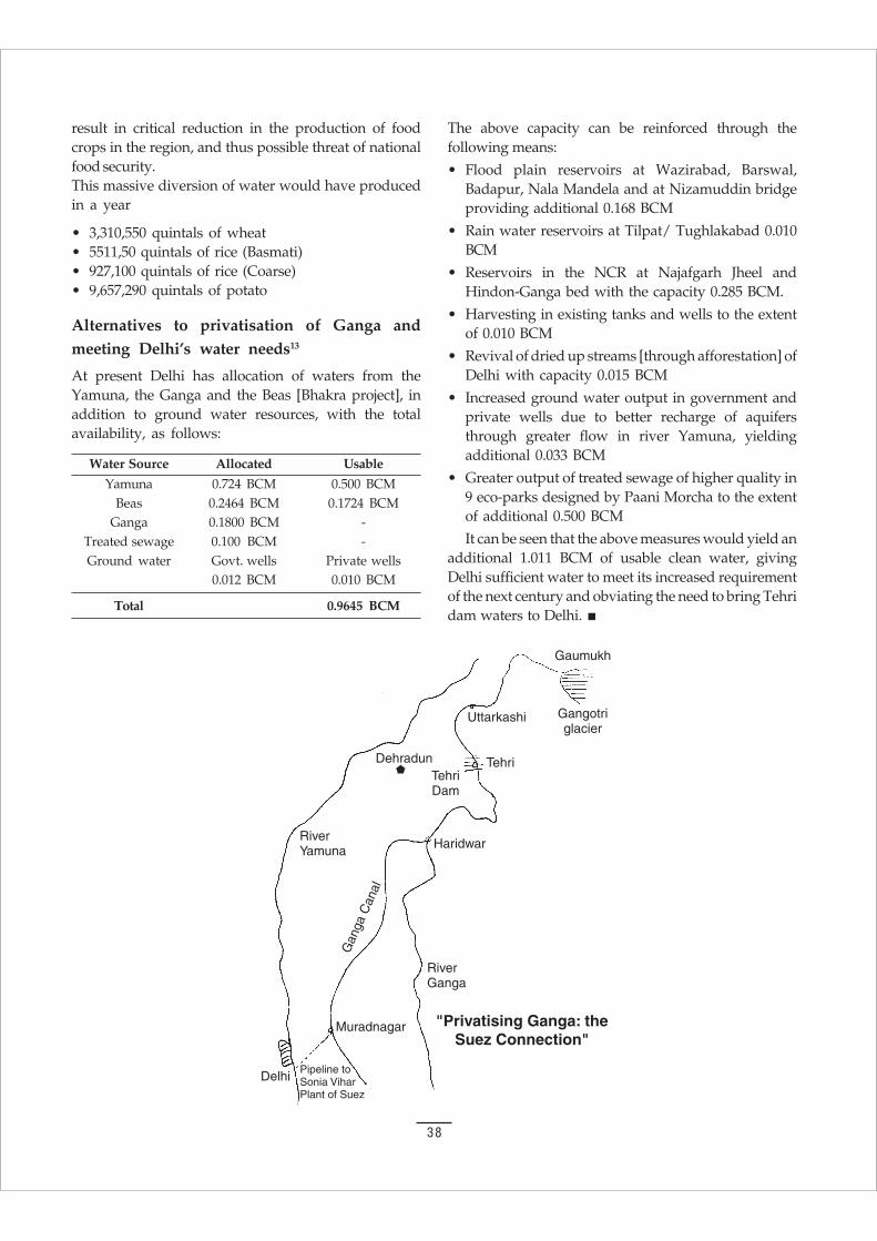
38
result in critical reduction in the production of foodcrops in the region, and thus possible threat of nationalfood security.This massive diversion of water would have producedin a year
• 3,310,550 quintals of wheat• 5511,50 quintals of rice (Basmati)• 927,100 quintals of rice (Coarse)• 9,657,290 quintals of potato
Alternatives to privatisation of Ganga andmeeting Delhi’s water needs13
At present Delhi has allocation of waters from theYamuna, the Ganga and the Beas [Bhakra project], inaddition to ground water resources, with the totalavailability, as follows:
Water Source Allocated Usable
Yamuna 0.724 BCM 0.500 BCMBeas 0.2464 BCM 0.1724 BCM
Ganga 0.1800 BCM -Treated sewage 0.100 BCM -Ground water Govt. wells Private wells
0.012 BCM 0.010 BCM
Total 0.9645 BCM
The above capacity can be reinforced through thefollowing means:
• Flood plain reservoirs at Wazirabad, Barswal,Badapur, Nala Mandela and at Nizamuddin bridgeproviding additional 0.168 BCM
• Rain water reservoirs at Tilpat/ Tughlakabad 0.010BCM
• Reservoirs in the NCR at Najafgarh Jheel andHindon-Ganga bed with the capacity 0.285 BCM.
• Harvesting in existing tanks and wells to the extentof 0.010 BCM
• Revival of dried up streams [through afforestation] ofDelhi with capacity 0.015 BCM
• Increased ground water output in government andprivate wells due to better recharge of aquifersthrough greater flow in river Yamuna, yieldingadditional 0.033 BCM
• Greater output of treated sewage of higher quality in9 eco-parks designed by Paani Morcha to the extentof additional 0.500 BCM
It can be seen that the above measures would yield anadditional 1.011 BCM of usable clean water, givingDelhi sufficient water to meet its increased requirementof the next century and obviating the need to bring Tehridam waters to Delhi.
39
The increased irrigation potential is a majorjustification of the River Linking Project. However,
this ignores the fact that major river diversions willalso deny irrigation to large fertile areas upstream anddownstream. Large dams are necessary for large riverbasin diversions. Major dams submerge some of themost fertile irrigated valleys. Major diversions alsodeprive downstream areas of irrigation, both becausethere is less river flow and there is less ground waterrecharge. Agriculture in the river basin is thereforedeprived of both surface and ground water sources ofirrigation when water is diverted.
Further, much irrigated land has gone out ofcultivation due to ecological problems such as waterlogging and salination. These are caused by large scaleintensive irrigation systems. New large irrigationprojects therefore do not necessarily translate into moreirrigated areas.
Large scale intensive irrigation does not lead tobetter agriculture or more food security. It is oftenforgotten that 75% of agriculture is under rainfedconditions and only about 25% is under irrigatedconditions. It is estimated that even if all the availablewater resources are developed for irrigation, about 55per cent of the cultivated area would still continue tobe rainfed. Irrigation can be either protective orintensive. Organic agriculture or indigenous agriculturedepends on protective irrigation. Chemical Farmingand Industrial agriculture (the Green Revolution) arebased on intensive irrigation and non-sustainablewater use. Green Revolution varieties need 4 to 5 timesmore water than traditional crop varieties. This is whylarge dams have been built and ground water has beenruined.
Water conservation in agriculture depends on thefollowing measures.
1. Water Harvesting. Indigenous water conservationsystems including Khadin and Johads in Rajasthan,Ahars and Pynes in Bihar, Eris in Tamil Nadu, havegiven water security to agriculture in spite of rainas low as 167 mm in Rajasthan and 200-600 mm inthe semi arid Deccan.
2. Increasing in-situ soil moisture conservation. Organicmatter and mulching increases water retention insoils dramatically.
3. Biodiversity and Mixed Cropping. Biodiversity andmixed cropping conserves moisture by reducingevaporation, increasing conservation, andimproving water use efficiency. Gram alone used12.51 cum of water and gave 10.68 Q/ha with awater use efficiency of 0.85. Barley alone used14.91 cum of water and gave 16.41 Q/ha with wateruse efficiency of 1.85. A mixture of barleyand gram used 15.89 cum of water, yielded 17.92Q/ha, and increased water use efficiency to 1.91.
4. Crop Selection. Green Revolution wheat use 5 timesmore water than indigenous wheat. Soya beanand Bajra needs 500 mm, while rice needs 1,200 mmand sugarcane 2,200 mm.
Green Revolution agriculture destroys water resourcesand hydrological balance at many levels.
1. Green Revolution varieties and hybrid seeds arethirsty, water demanding varieties, which lead tohigh water withdrawals from rivers andunderground aquifers.
2. Green Revolution varieties are dwarf varieties, bredto have lower biomass in terms straw, whichdeprives the soil of organic matter, and hencereduces soil moisture conservation, increasingdrought and desertification.
3. Green Revolution monocultures and industrialfarming reduce crop cover, lead to higher soil andwater loss, higher erosion, and higher evaporation.
4. The agrochemicals necessary for green revolutiongo to pollute ground water and surface water.Recent studies carried out by CSE have shown thatall bottled water, which is withdrawn from groundwater sources, is contaminated with pesticideresidues.
Besides depleting and destroying water throughoveruse and pollution, commercially driven agriculturealso destroys water resources by inducing a shift from
5. FOOD AND WATER SECURITY
5a. Prudent use of Water and Livelihood

40
water conserving crops for food security, to waterwasteful cash crops. Ground water resources ofMaharashtra have been destroyed because of theWorld Bank induced shift from jowar and bajra tosugarcane.
Ground water resources of Warangal are beingdestroyed because of the Corporate driven shift fromstaples such as ragi and tur to hybrid cotton.
Food insecurity and water insecurity therefore gohand in hand, and food security and water securityreinforce each other. The dominant industrialagriculture paradigm has reduced labour inputs andincreased chemical and water inputs. With respect towater, agricultural productivity has actually declined.Water conservation demands that we measureproductivity with respect to water use. Once we focuson conserving water, organic farming is moreproductive than industrial agriculture; millets are moreproductive than rice, and farmers breeding is moreefficient than the green revolution.18
Food and Water are our most basic needs. Withoutwater, food production is not possible. Traditionally,food cultures evolved in response to the waterpossibilities surrounding them. Water-prudent cropsemerged in water-scarce regions and water-demandingones evolved in water-rich regions.
The water-use efficiency of crops is influenced bytheir genetic variation. Maize, sorghum, and milletconvert water into biological matter most efficiently.Millet not only requires less water than rice, it is alsodrought-resistant, withstanding up to 75 per cent soilmoisture depletion. The roots of pulses and legumesallow efficient soil moisture utilization.
Since the Green Revolution, the crops that producehigher nutrition per unit of water used have beencalled inferior, and have been displaced by water-intensive crops. Water productivity has been ignored.
Industrial agriculture has pushed farmers to usemethods by which the water retention capacity of soilis reduced, and the demand for water is increased. Byfailing to recognize water as a limiting factor in foodproduction, industrial agriculture has promoted waste.The shift from organic fertilizers to chemical fertilizersand the substitution of water-prudent crops by water-thirsty ones have been recipes for water famines,desertification, water-logging, and salinization.
The advent of the Green Revolution pushed ThirdWorld agriculture toward wheat and rice production.The new crops demanded more water than millet andconsumed three times more water than the indigenousvarieties of wheat and rice. The introduction of wheat
and rice has also had social and ecological costs. Theirdramatic increase in water use has led to the instabilityof regional water balances. Massive irrigation projectsand water-intensive farming, by adding more water toan ecosystem than what its natural drainage system canaccommodate, have led to waterlogging, salinization,and desertification.
In the Krishna basin, waterlogging at theMalaprabha irrigation project led to farmer rebellions.Before the introduction of the irrigation project, the semi-arid region had produced water-prudent crops such asjowar and pulses. The sudden climatic change, theintensive irrigation, and the cultivation of water-demanding cotton aggravated the problem. Intensiveirrigation of black cotton soils, whose water retentioncapacity is very high, quickly created wastelands.While irrigation has been viewed as a means toimprove land productivity, it has had the opposite effectin the Malaprabha area.
The shift from rainfed food crops to irrigated cashcrops like cotton in Andhra Pradesh was expected toimprove the prosperity of farmers. Instead, it has ledto debt. Farmers borrowed money from banks forland development and for the purchase of seeds,chemical fertilizers and pesticides. While farmerswere struggling with unproductive land, banks weremaking payment demands. At the same time,irrigation authorities levied a development tax onwater, known as a betterment levy. The latterincreased from 38 cents to 63 cents per acre for jowar,and from 38 cents to over a dollar per acre for cotton.A fixed tax of 20 cents per acre was effective withor without water use.
Like wise, the Aral Sea, the world’s fourth-largestfreshwater body, has been ruined by unsustainableagricultural activity. Rivers that recharge the lake areincreasingly diverted toward the irrigation of 7.5million hectares of cotton, fruits, vegetables and rice.Over the past few decades, two-thirds of the waterhas been drained away, salinity has gone up six fold,and water levels have dropped by 20 metres. Between1974 and 1986, the Syr Darya river never reached theAral Sea.
Many proposals to solve the problem of agriculturalwater waste deny water for food production altogether.Industrial shrimp farming is a case in point. The mostobvious and important impacts of industrialaquaculture are land and water salinization anddrinking water depletion. Paddy fields once fertile andproductive are turning into what local people callgraveyards. This is true not just in India. In Bangladesh
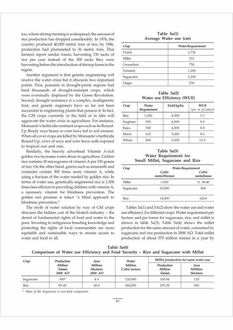
41
too, where shrimp farming is widespread, the amount ofrice production has dropped considerably. In 1976, thecountry produced 40,000 metric tons of rice; by 1986,production had plummeted to 36 metric tons. Thaifarmers report similar losses, harvesting 150 sacks ofrice per year instead of the 300 sacks they wereharvesting before the introduction of shrimp farms to theregion.
Another argument is that genetic engineering willresolve the water crisis but it obscures two importantpoints. First, peasants in drought-prone regions hadbred thousands of drought-resistant crops, whichwere eventually displaced by the Green Revolution.Second, drought resistance is a complex, multigenetictrait, and genetic engineers have so far not beensuccessful in engineering plants that possess it. In fact,the GM crops currently in the field or in labs willaggravate the water crisis in agriculture. For instance,Monsanto’s herbicide-resistant crops such as its Round-Up Ready soya beans or corn have led to soil erosion.When all cover crops are killed by Monsanto’s herbicideRound-Up, rows of soya and corn leave soils exposedto tropical sun and rain.
Similarly, the heavily advertised Vitamin A-richgolden rice increases water abuse in agriculture. Goldenrice contains 30 micrograms of vitamin A per 100 gramsof rice. On the other hand, greens such as amaranth andcoriander contain 500 times more vitamin A, whileusing a fraction of the water needed by golden rice. Interms of water use, genetically engineered rice is 1,500times less efficient in providing children with vitamin A,a necessary vitamin for blindness prevention. Thegolden rice promise is infact “a blind approach toblindness prevention.”
The myth of water solution by way of GM cropsobscures the hidden cost of the biotech industry – thedenial of fundamental rights of food and water to thepoor. Investing in indigenous breeding knowledge andprotecting the rights of local communities are moreequitable and sustainable ways to ensure access towater and food to all.
Table 5a(1)Average Water use (cm)
Crop Water Requirement
Paddy 1,756
Millet 521
Groundnut 750
Turmeric 1,200
Sugarcane 3,200
Ginger 250
Table 5a(2)Water use Efficiency (WUE)
Crop Water Yield kg/ha WUERequirement (per m of water)
Rice 1,200 4,500 3.7
Sorghum 500 4,500 9.0
Bajra 500 4,000 8.0
Maize 625 5,000 8.0
Wheat 400 5,000 12.5
Table 5a(3)Water Requirement for
Small Millet, Sugarcane and Rice
Crop Water RequirementCubic Cubic
metre/Hectare metre/tonne
Millet 1,000 11 90.40
Sugarcane 30,000 400
Rice 14,000 6264
Table 5a(4)Comparison of Water use Efficiency and Food Security – Rice and Sugarcane with Millet
Crop Production Area Water Millet production for same water use
Million Million Million Production AreaTonnes Hectares Cubic metres Million Milllion
2000 AD 2000 AD Tonnes Hectares
Sugarcane 300* 4.0 120,000 100.84 120
Rice 89.40 40.0 560,000 470.58 560
* Most of the Sugarcane is non-food component.
Tables 5a(1) and 5A(2) show the water use and wateruse efficiency for different crops. Water requirement perhectare and per tonne for sugarcane, rice, and millet isshown in table 5a(3). Table 5a(4) shows the milletproduction for the same amount of water, consumed bysugarcane and rice production in 2000 AD. Total milletproduction of about 570 million tonnes in a year by
42
using water resources efficiently will increase the foodsecurity of the country five fold without additionalirrigation capacity. What the country needs is changesin cropping patterns and biodiversity conservation, notriver linking.
Instead of transporting water by interlinking ofrivers, we should learn to manage water efficiently.We must adopt crops, which can be grown withminimum water. But the farmers of the Thanjavurdelta in Tamil Nadu keep growing three crops ofwater intensive paddy for short term commercial gain.In Tamil Nadu, 62% of the river basin grows ricethrice – Kuruvai, Thaladi and Samba. Studies haveshown that if it limits itself to a single crop, it can get
far higher yield than today’s three crops takentogether. In Karnataka, the farmers of Mandya havebeen cultivating sugarcane, a water intensive crop inthe name of protecting their rights. Similarly, farmersin Punjab are cultivating paddy, the high waterdemanding crop and the farmers in Western UP andMaharashtra are growing sugarcane on a large scale.Now the governments of these States are looking tothe myopic demand of the interlinking of rivers sothat the farmers can grow more cash crops wastefully.Punjab farmers in Ludhiana district have reducedwater use by 60% in paddy by mixed cropping, whileincreasing farm income. Reduced water use canensure more prosperity.
5b. Major Irrigation Projects
Water is vital for realizing the full potential ofthe agriculture sector and the country’s
development. Optimum development and efficientutilization of our water resources, therefore, assumegreat significance. Average run-off in the river systemof the country has been assessed as 1,869 km3 . Ofthis, the utilizable portion is estimated as about 690km3. In addition, there is substantial replenishableground water potential in the country estimated at432 km3. The per-capita availability of water hasreduced from about 5,175 cubic metre in the year1951 to the present level of 1,820 cubic metre. Thesituation may aggravate in the future due to the
growing water scarcity in the river basins. Expansionof irrigation facilities along with consolidation of theexisting systems has been the main strategy forincreasing production of food grains. Irrigationsupport is provided through major, medium, andminor irrigation projects and command areadevelopment. With sustained and systematicdevelopment of irrigation, irrigation potential hasincreased from 22.6 mha in 1951. When the processof planning began in India, it increased to about89.56 mha in 1997. Irrigation expense of the countryis given in the tables 5b(1) and 5b(2). Map 5b(i) givesthe source of irrigation in the country.
Table 5b(1)Major and Medium Irrigation Projects (Expenditure Incurred and Potential Created)
Period Outlay/Expenditure (Rs. Crore) Potential Created (mha) Cumulative
1 2 3 4
Pre-Plan period Not available 9.70 9.70
First Plan 1951-56 376 2.50 2.50
Second Plan 1956-61 380 2.13 14.33
Third Plan 1961-66 576 2.24 16.57
Annual Plans 1966-69 430 1.53 18.10
Fourth Plan 1969-74 1,242 2.60 20.70
Fifth Plan 1974-78 2,516 4.02 24.72
Annual Plans 1978-80 2,079 1.89 26.61
Sixth Plan 1980-85 7,369 1.09 27.70
Seventh Plan 1985-90 11,107 2.22 29.92
Annual Plans 1990-92 5,459 0.82 30.74
Eighth Plan 1992-97 21,838 2.22 32.96

43
Table 5b(2)Central Loan Assistance Released under Accelerated Irrigation Benefits Programme, 1996-99
(Rs. In crore)
S.No States Amount released1996-97 1997-98 1998-99
1 Andhra Pradesh 35.25 74.00 79.67
2 Assam 5.23 12.40 13.95
3 Bihar 13.50 14.04 47.82
4 Gujarat 74.77 196.90 423.82
5 Haryana 32.50 12.00 -
6 Jammu and Kashmir 1.30 - -
7 Karnataka 61.25 90.50 94.50
8 Kerala 3.75 15.00 -
9 Madhya Pradesh 63.25 114.50 90.75
10 Maharashtra 14.00 55.00 50.86
11 Manipur 4.30 26.00 10.78
12 Orissa 48.25 85.00 71.50
13 Punjab 67.50 100.00 -
14 Rajasthan 2.67 42.00 140.05
15 Tripura 3.77 5.10 3.97
16 Tamil Nadu 20.00 - -
17 Uttar Pradesh 43.50 78.00 76.50
18 West Bengal 5.00 20.00 10.00
19 Goa - 5.25 -
20 Himachal Pradesh - 6.50 5.00
Total 500.00 952.19 1,119.18
Major and Medium Irrigation Projects
Irrigation projects with a Culturable Command Area(CCA) between 2,000 and 10,000 hectares are classifiedas medium projects and those with a CCA of morethan 10,000 hectares as major projects. The expenditureincurred on major and medium projects, and theirrigation potential created during the various planperiods are given in table 5b(1). At the end of the EighthPlan, there were 162 major, 240 medium, and 74extension renovations and modernization schemescontinuing from the previous plans. These spilledover to the Ninth Plan, with a total spill-over cost ofRs. 79,317 crore.
Hydrology Project
Hydrology Project has been launched for a period of sixyears beginning from 1995-96 at an estimated cost of Rs.609.2 crore. The World Bank has extended a creditassistance of US dollar 142 million under the project.
The projects cover the peninsular States of India,namely, Andhra Pradesh, Orissa, Maharashtra, Gujrat,Madhya Pradesh, Karnataka, Tamil Nadu and Kerala.The main objective of the project is to improve theinfrastructure and staff capabilities of the Central andState agencies involved in surface and ground-waterhydrology. The project area covers collection andmanagement of hydrometric and water quality data,and the use of such data for water resources, evaluationand management.
Command Area Development Programme.
A Centrally-sponsored Command Area DevelopmentProgramme was launched in 1974-75 with the objectivesof improving the utilization of irrigation potential, andoptimizing agricultural production from the irrigatedareas by integrating all functions related irrigatedagriculture.
Beginning with 60 major and medium irrigationprojects in 1974, the programme included 217 irrigation
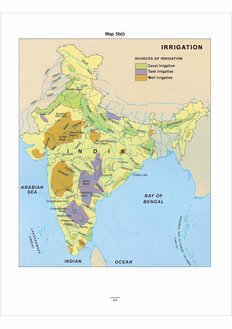
44
Map 5b(i)
45
projects at the end of 1998-99 with Culturable CommandArea (CCA) of 21.95 million hectares, spread over 23States and two Union Territories. Since inception, anamount of Rs. 199385 crore has been released to theStates as Central share for different activities of theProgramme, while an amount of Rs. 175.77 crore wasspent during 1998-99.
The programme involves execution of on-farmdevelopment works, like construction of field channelsand field drains, land levelling and shaping, andconjunctive use of surface and ground-water. Warabandi,or the rotational system of water distribution, isundertaken with a view to ensure equitable and timelysupply of water to the farmers. Adaptive trials,demonstrations and training of farmers are encouragedto disseminate technical know-how for establishingsuitable cropping patterns, improved farming practices,and for maintaining soil health.
Under the Programme, the Ministry is trying to shiftthe management pradigm from fully state managed
systems to farmer managed systems by encouragingfarmers’ participation in the management of irrigation.As an incentive, an one-time functional grant of Rs. 500/ha (Rs. 225/ha by Centre, Rs. 225/ha by State andRs. 50/ha by Farmers’ Association) is provided to theregistered and functional Farmers’ Associations.Reclamation of waterlogged areas in irrigated commandareas is also an important component of the Programme.
Minor Irrigation
All ground-water and surface schemes having CulturableCommand Area (CCA) up to 2,000 hectares individuallyare classified as minor irrigation schemes. Thedevelopment of ground-water is mostly done throughindividual and cooperative efforts of the farmers withthe help of institutional finance and through their ownsavings. Surface minor irrigation schemes are generallyfunded from the public sector outlay. Irrigation potentialcreated and utilised under minor irrigation during thevarious plan periods are given in table 5b(3).
Table 5b(3)Irrigation Potential Created and Utilised under Minor Irrigation
(In million hectares)
Plan Potential Utilisation
At the end of the Pre-Plan upto 1951 12.90 12.90
First Plan (1951-56) 14.06 14.06
Second Plan (1956-61) 14.75 14.75
Third Plan (1961-66) 17.00 17.00
Annual Plans (1966-69) 19.00 19.00
Fourth Plan (1969-74) 23.50 23.50
Fifth Plan (1974-78) 27.30 27.30
Annual Plans (1978-80) 30.00 30.00
Sixth Plan (1980-85) 37.52 35.25
Seventh Plan (1985-90) 46.61 43.12
Annual Plan (1990-92) 50.35 46.54
Eighth Plan (1992-97) (Provisional) 56.60 52.32
During 1997-98 00.80 01.44
5c. Major Dams
Land alienation since independence has beenprimarily the result of unsustainable agricultural
and development policies such as construction oflarge dams and takeover of people’s land forinfrastructure purposes, including urban housing.
During the last fifty years, an approximate 30 millionpeople have been displaced due to “development”projects. In Orissa, about 1.5 lakhs were deprived oftheir livelihood in the name of national development,between 1951 and 1995. Forty-two per cent of them are
46
tribal people. An approximate 91544,257 acres of landhas been alienated from tribals alone. Only 32% of allthe displaced persons, and fewer than 25% of the tribaldispossessed persons were resettled, at least partially.The rest were impoverished and often turned intobonded labourers.
Big dams have several effects on the environmentand the people, which are not foreseen during theplanning of these projects. One of the most importantof these effects is the degradation of soil in thecommand areas of irrigation projects, due to increasein soil salinity and water logging. The life of the Tehrireservoir may turn out to be only 30–40 years instead of100 years.
Table 5c(1) gives the State-wise and river-wisedistribution of large dams. Table 5c(2) lists Himalayanriver dams which are higher than 100 metre. Heavysiltation has substantially reduced the storage capacityand life span of many reservoirs. Siltation rates in thetables 5c(3) and 5c(4) show that the rates observedwere many times higher than the prediction. As a
India has over 4,000 large dams. Three quarters of India’s dams are in the three States of Gujarat, Maharashtra
and Madhya Pradesh, and most at them are for irrigation. Till 1994, all dams were built without an environmental
impact assessment (EIA). EIA become statutory only in 1994.12
Estimates of those displaced by large dams in India in the last 50 years vary from 21 to 56 million people.
Forty per cent of those displaced are adivasis (tribal people). Some time they are even more; for instance, in
the Sardar Sarovar Project area, the proportion of the tribal was about 56%. Less than 50% of people displaced
by large projects are rehabilitated. Construction occurs under the Official Secrets Act, access is denied,
information is withheld, participation is non-existent. The costs of dams are systematically underestimated and
their benefits are inflated. Accepted cost benefit ratio for large dams is not met in 8 out of 10 cases. Heavy silting
shortens the life of many dams. There have been 17 cases of earthquake tremor induced by large reservoirs
in India
Studies have shown that the submergence of the villages and the agricultural land is much more than
actually intended; sometimes, even two to three times. More than 50% of those displaced by large projects
have been pauperized; many times, the proportion is closer to 100 per cent. This includes farmers, adivasis,
non-adivasis, and other communities. People also starve to death or die of hopelessness. Most became rural
paupers or ended up as the cheapest of labour. Self-sufficient farmers who once had self respect became lowly
servants of others, grateful for a job as a watchman.
For every 10 displaced persons (DP), dams deprive six more of their livelihood without displacing them.
Government officials usurps the large portion of the compensation amount. The consequence of the
displacement is nothing but misery. For example, some 30,000 of the 150,000 construction workers of the Asiad
Village in 1982 were bonded labours from Orissa and Chattisgarh, brought to Delhi by labour contractors with
the promise of job in Baghdad. They had been displaced by Hirakud Dam and other projects.
As a result of some awareness about the Land Acquisition Act (LAA); people have started demanding their
rights. The compensation has to be paid according to the replacement value. The draconian LAA ignores this
basic issue. A new law that is favorable to the victim of development has to be enacted. The Act should begin
by solving the problem of the millions of DPs of past projects who have not been settled.13
result, reservoirs are incapable of absorbing heavyfloods and have to resort to panic discharges.
Map 5c(i) shows the major hydel thermal andatomic power in the country. Natural vegetationincluding forest and National Parks and wild lifeSanctuaries are shown in maps 5c(ii) and 5c(iii). Theinterlinking of rivers will cause irreversible damage tothe natural vegetation, parks and sanctuaries. Thegrandiose projects will also snatch the land frompoor tribals.
Land is the basis of agriculture; today more than 70%of India’s people depend on agriculture for their survival.The constitution has also been amended (the 73rdAmendment, and Extension Act in 1996) to allow tribalpeople to have total rights over their natural resources,including land together with the right to manage it. “Letit not be said of India that this great Republic in a hurryto develop itself, is devastating the green mother earthand uprooting our tribal populations,” said FormerPresident K. R. Narayan in his address on the eve ofRepublic day in 2001.
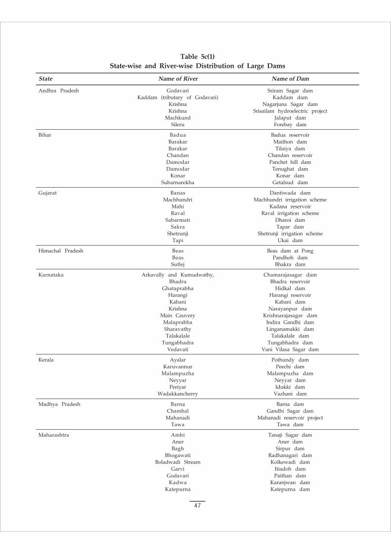
47
Table 5c(1)State-wise and River-wise Distribution of Large Dams
State Name of River Name of Dam
Andhra Pradesh Godavari Sriram Sagar damKaddam (tributary of Godavari) Kaddam dam
Krishna Nagarjuna Sagar damKrishna Srisailam hydroelectric project
Machkund Jalaput damSileru Forebay dam
Bihar Badua Badua reservoirBarakar Maithon damBarakar Tilaiya dam
Chandan Chandan reservoirDamodar Panchet hill damDamodar Tenughat dam
Konar Konar damSubarnarekha Getalsud dam
Gujarat Banas Dantiwada damMachhundri Machhundri irrigation scheme
Mahi Kadana reservoirRaval Raval irrigation scheme
Sabarmati Dharoi damSakra Tapar dam
Shetrunji Shetrunji irrigation schemeTapi Ukai dam
Himachal Pradesh Beas Beas dam at PongBeas Pandhoh damSutlej Bhakra dam
Karnataka Arkavally and Kumudwathy, Chamarajasagar damBhadra Bhadra reservoir
Ghataprabha Hidkal damHarangi Harangi reservoirKabani Kabani damKrishna Narayanpur dam
Main Cauvery Krishnarajasagar damMalaprabha Indira Gandhi damSharavathy Linganamakki damTalakalale Talakalale dam
Tungabhadra Tungabhadra damVedavati Vani Vilasa Sagar dam
Kerala Ayalar Pothundy damKaruvannur Peechi dam
Malampuzha Malampuzha damNeyyar Neyyar damPeriyar Idukki dam
Wadakkancherry Vazhani dam
Madhya Pradesh Barna Barna damChambal Gandhi Sagar damMahanadi Mahanadi reservoir project
Tawa Tawa dam
Maharashtra Ambi Tanaji Sagar damAner Aner damBagh Sirpur dam
Bhogawati Radhanagari damBoladwadi Stream Kolkewadi dam
Garvi Itiadoh damGodavari Paithan damKadwa Karanjwan dam
Katepurna Katepurna dam

48
Koyna Koyna damKrishna Dhom dam
Mula Mula damMutha Khadakwasla dam
Nirguna Nirguna damPawna Pawna damPench Kamthikhairy dam
Pravara Wilson damPurna Sidheshwar damPurna Yeldari dam
Pus Pus damWaghadi Waghadi dam
Wuna Kanholi damYelwandi Bhatghar dam
Orissa Kolab Upper Kolab damMachkund Balimela damMahanadi Hirakud dam
Rajasthan Chambal Jawahar Sagar damChambal Rana Pratap Sagar dam
Gomti Jaisamand tank
Tamil Nadu Aliyar Upper Aliyar damAmaravati Amaravathi dam
Avalanche Stream Avalanche damBhavani Lower Bhavani damBhavani Upper Bhavani damCauvery Mettur (Stanley) damEmerald Emerald dam
Gatanandi Gatana damKaruppanadhi Karuppanadhi dam
Kodayar Kodayar dam IKodayar Kodayar dam IIKodayar Peechiparai damKundah Kundapalam dam
Manimuthar Manimuthar damMukurthi Mukurthi dam
Nirar Lower Nirar damPalar Thirumurthi dam
Palar-Porandalar Palar Porandalar damParalayar Perunchani dam
Parambikulam Parambikulam damParappalar Parappalar dam
Parson’s Valley Stream Parson’s Valley damPegumbahalla Pegumbahalla dam
Periyar Periyar damPonnaiyar Sathanur dam
Porthimund Stream Porthimund damRamanadhi Ramanadhi dam
Sandy Nullah Stream Sandy Nullah damSholayar Sholayar dam
Thambraparani Thambraparani damTributary of Karampuzha Western catchment no.2 dam
Vaigai Vaigai damVarahapallam West West Varahapallam dam
Uttar Pradesh Betwa Matatila damBhagirathi Maneri Bhali hydroelectric project (stage 1)Ramganga Ramganga dam
Rihand Obra damRihand Rihand dam
Tons Ichari dam
West Bengal Kangsabati and Kumari Kangsabati-Kumari damMayurakshi Massanjore dam

49
Map 5c(i)

50
Map 5c(ii)
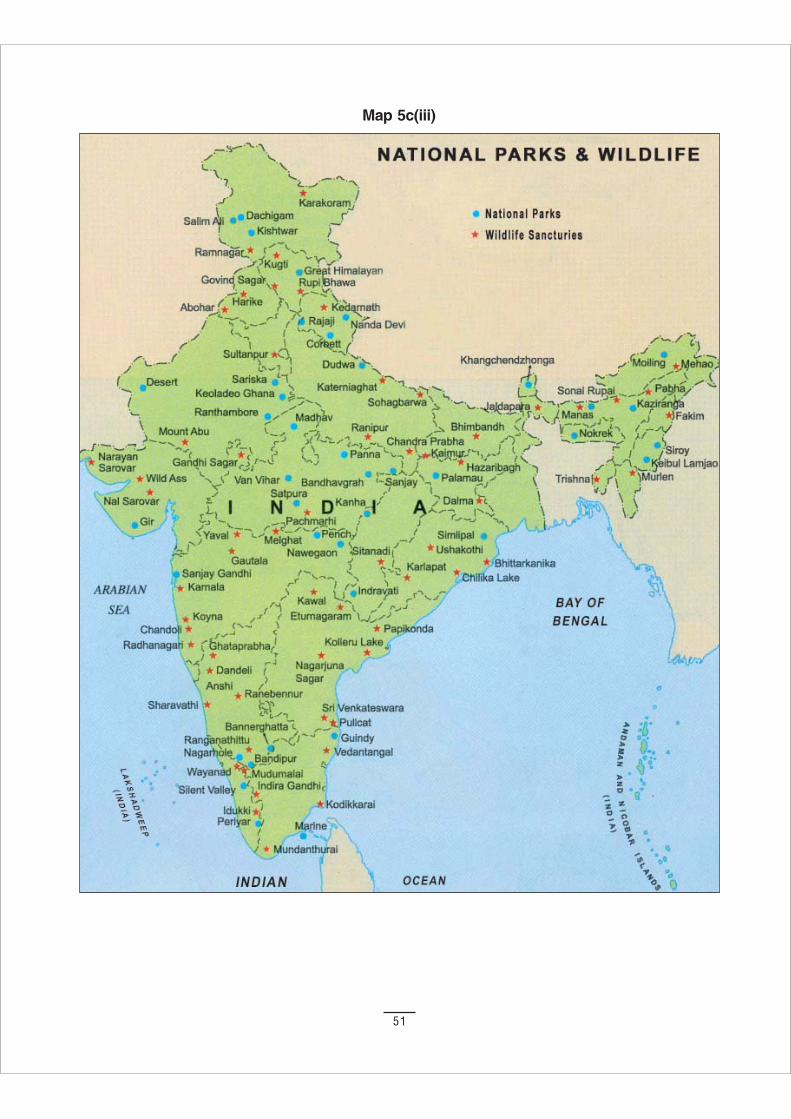
51
Map 5c(iii)
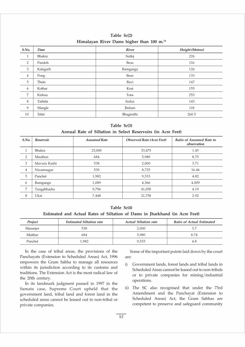
52
Table 5c(3)Annual Rate of Siltation in Select Reservoirs (in Acre Feet)
S.No. Reservoir Assumed Rate Observed Rate (Acre Feet) Ratio of Assumed Rate toobservation
1 Bhakra 23,000 33,475 1.45
2 Mauthon 684 5,980 8.75
3 Mavura Kashi 538 2,000 3.71
4 Nizamsagar 530 8,725 16.46
5 Panchet 1,982 9,533 4.82
6 Ramganga 1,089 4,366 4.009
7 Tungabhadra 9,796 41,058 4.19
8 Ukai 7,448 21,758 2.92
Table 5c(4)Estimated and Actual Rates of Siltation of Dams in Jharkhand (in Acre Feet)
Project Estimated Siltation rate Actual Siltation rate Ratio of Actual Estimated
Masanjor 538 2,000 3.7
Maithar 684 5,980 8.74
Panchet 1,982 9,533 4.8
Table 5c(2)Himalayan River Dams higher than 100 m.14
S.No. Dam River Height (Metres)
1 Bhakra Sutlej 226
2 Pandoh Beas 116
3 Kalagarh Ramganga 126
4 Pong Beas 133
5 Thein Ravi 147
6 Kothar Kosi 155
7 Kishau Tons 253
8 Tarbela Indus 143
9 Mangla Jhelum 118
10 Tehri Bhagirathi 260.5
In the case of tribal areas, the provisions of thePanchayats (Extension to Scheduled Areas) Act, 1996empowers the Gram Sabha to manage all resourceswithin its jurisdiction according to its customs andtraditions. The Extension Act is the most radical law ofthe 20th century.
In its landmark judgment passed in 1997 in theSamata case, Supreme Court upheld that thegovernment land, tribal land and forest land in thescheduled areas cannot be leased out to non-tribal orprivate companies.
Some of the important points laid down by the courtare:
i) Government lands, forest lands and tribal lands inScheduled Areas cannot be leased out to non-tribalsor to private companies for mining/industrialoperations.
ii) The SC also recognised that under the 73rdAmendment and the Panchayat (Extension toScheduled Areas) Act, the Gram Sabhas arecompetent to preserve and safeguard community
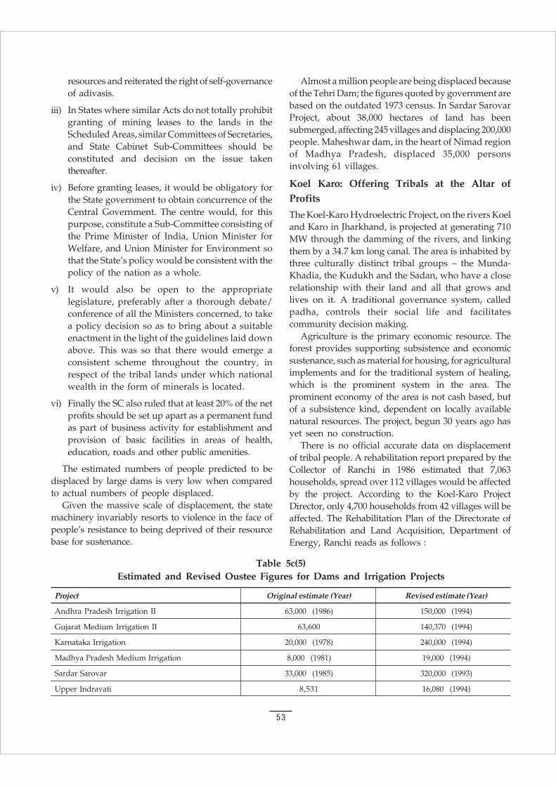
53
resources and reiterated the right of self-governanceof adivasis.
iii) In States where similar Acts do not totally prohibitgranting of mining leases to the lands in theScheduled Areas, similar Committees of Secretaries,and State Cabinet Sub-Committees should beconstituted and decision on the issue takenthereafter.
iv) Before granting leases, it would be obligatory forthe State government to obtain concurrence of theCentral Government. The centre would, for thispurpose, constitute a Sub-Committee consisting ofthe Prime Minister of India, Union Minister forWelfare, and Union Minister for Environment sothat the State’s policy would be consistent with thepolicy of the nation as a whole.
v) It would also be open to the appropriatelegislature, preferably after a thorough debate/conference of all the Ministers concerned, to takea policy decision so as to bring about a suitableenactment in the light of the guidelines laid downabove. This was so that there would emerge aconsistent scheme throughout the country, inrespect of the tribal lands under which nationalwealth in the form of minerals is located.
vi) Finally the SC also ruled that at least 20% of the netprofits should be set up apart as a permanent fundas part of business activity for establishment andprovision of basic facilities in areas of health,education, roads and other public amenities.
The estimated numbers of people predicted to bedisplaced by large dams is very low when comparedto actual numbers of people displaced.
Given the massive scale of displacement, the statemachinery invariably resorts to violence in the face ofpeople’s resistance to being deprived of their resourcebase for sustenance.
Almost a million people are being displaced becauseof the Tehri Dam; the figures quoted by government arebased on the outdated 1973 census. In Sardar SarovarProject, about 38,000 hectares of land has beensubmerged, affecting 245 villages and displacing 200,000people. Maheshwar dam, in the heart of Nimad regionof Madhya Pradesh, displaced 35,000 personsinvolving 61 villages.
Koel Karo: Offering Tribals at the Altar ofProfits
The Koel-Karo Hydroelectric Project, on the rivers Koeland Karo in Jharkhand, is projected at generating 710MW through the damming of the rivers, and linkingthem by a 34.7 km long canal. The area is inhabited bythree culturally distinct tribal groups – the Munda-Khadia, the Kudukh and the Sadan, who have a closerelationship with their land and all that grows andlives on it. A traditional governance system, calledpadha, controls their social life and facilitatescommunity decision making.
Agriculture is the primary economic resource. Theforest provides supporting subsistence and economicsustenance, such as material for housing, for agriculturalimplements and for the traditional system of healing,which is the prominent system in the area. Theprominent economy of the area is not cash based, butof a subsistence kind, dependent on locally availablenatural resources. The project, begun 30 years ago hasyet seen no construction.
There is no official accurate data on displacementof tribal people. A rehabilitation report prepared by theCollector of Ranchi in 1986 estimated that 7,063households, spread over 112 villages would be affectedby the project. According to the Koel-Karo ProjectDirector, only 4,700 households from 42 villages will beaffected. The Rehabilitation Plan of the Directorate ofRehabilitation and Land Acquisition, Department ofEnergy, Ranchi reads as follows :
Table 5c(5)Estimated and Revised Oustee Figures for Dams and Irrigation Projects
Project Original estimate (Year) Revised estimate (Year)
Andhra Pradesh Irrigation II 63,000 (1986) 150,000 (1994)
Gujarat Medium Irrigation II 63,600 140,370 (1994)
Karnataka Irrigation 20,000 (1978) 240,000 (1994)
Madhya Pradesh Medium Irrigation 8,000 (1981) 19,000 (1994)
Sardar Sarovar 33,000 (1985) 320,000 (1993)
Upper Indravati 8,531 16,080 (1994)
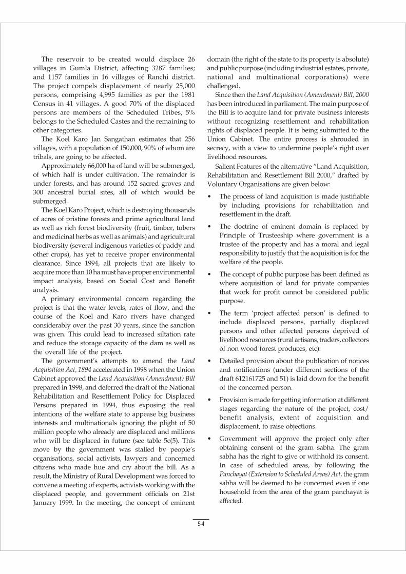
54
The reservoir to be created would displace 26villages in Gumla District, affecting 3287 families;and 1157 families in 16 villages of Ranchi district.The project compels displacement of nearly 25,000persons, comprising 4,995 families as per the 1981Census in 41 villages. A good 70% of the displacedpersons are members of the Scheduled Tribes, 5%belongs to the Scheduled Castes and the remaining toother categories.
The Koel Karo Jan Sangathan estimates that 256villages, with a population of 150,000, 90% of whom aretribals, are going to be affected.
Approximately 66,000 ha of land will be submerged,of which half is under cultivation. The remainder isunder forests, and has around 152 sacred groves and300 ancestral burial sites, all of which would besubmerged.
The Koel Karo Project, which is destroying thousandsof acres of pristine forests and prime agricultural landas well as rich forest biodiversity (fruit, timber, tubersand medicinal herbs as well as animals) and agriculturalbiodiversity (several indigenous varieties of paddy andother crops), has yet to receive proper environmentalclearance. Since 1994, all projects that are likely toacquire more than 10 ha must have proper environmentalimpact analysis, based on Social Cost and Benefitanalysis.
A primary environmental concern regarding theproject is that the water levels, rates of flow, and thecourse of the Koel and Karo rivers have changedconsiderably over the past 30 years, since the sanctionwas given. This could lead to increased siltation rateand reduce the storage capacity of the dam as well asthe overall life of the project.
The government’s attempts to amend the LandAcquisition Act, 1894 accelerated in 1998 when the UnionCabinet approved the Land Acquisition (Amendment) Billprepared in 1998, and deferred the draft of the NationalRehabilitation and Resettlement Policy for DisplacedPersons prepared in 1994, thus exposing the realintentions of the welfare state to appease big businessinterests and multinationals ignoring the plight of 50million people who already are displaced and millionswho will be displaced in future (see table 5c(5). Thismove by the government was stalled by people’sorganisations, social activists, lawyers and concernedcitizens who made hue and cry about the bill. As aresult, the Ministry of Rural Development was forced toconvene a meeting of experts, activists working with thedisplaced people, and government officials on 21stJanuary 1999. In the meeting, the concept of eminent
domain (the right of the state to its property is absolute)and public purpose (including industrial estates, private,national and multinational corporations) werechallenged.
Since then the Land Acquisition (Amendment) Bill, 2000has been introduced in parliament. The main purpose ofthe Bill is to acquire land for private business interestswithout recognizing resettlement and rehabilitationrights of displaced people. It is being submitted to theUnion Cabinet. The entire process is shrouded insecrecy, with a view to undermine people’s right overlivelihood resources.
Salient Features of the alternative “Land Acquisition,Rehabilitation and Resettlement Bill 2000,” drafted byVoluntary Organisations are given below:
• The process of land acquisition is made justifiableby including provisions for rehabilitation andresettlement in the draft.
• The doctrine of eminent domain is replaced byPrinciple of Trusteeship where government is atrustee of the property and has a moral and legalresponsibility to justify that the acquisition is for thewelfare of the people.
• The concept of public purpose has been defined aswhere acquisition of land for private companiesthat work for profit cannot be considered publicpurpose.
• The term ‘project affected person’ is defined toinclude displaced persons, partially displacedpersons and other affected persons deprived oflivelihood resources (rural artisans, traders, collectorsof non wood forest produces, etc):
• Detailed provision about the publication of noticesand notifications (under different sections of thedraft 612161725 and 51) is laid down for the benefitof the concerned person.
• Provision is made for getting information at differentstages regarding the nature of the project, cost/benefit analysis, extent of acquisition anddisplacement, to raise objections.
• Government will approve the project only afterobtaining consent of the gram sabha. The gramsabha has the right to give or withhold its consent.In case of scheduled areas, by following thePanchayat (Extension to Scheduled Areas) Act, the gramsabha will be deemed to be concerned even if onehousehold from the area of the gram panchayat isaffected.
55
• ‘Adult members’ includes both men and women ofthe household. The allotted lands should be in thejoint names of husband and wife. In any publichearing on the project related matters, 50% of theparticipants should be women.
• The amount of the solatium will be equal to thevalue of compensation awarded, i.e., 100%. Ifpersons and households are displaced for thesecond time within a period of 30 years anadditional amount of solatium will be paid.
• The State Land Acquisition and R&R Commissionwill monitor the implementation of the Act. Thepersons displaced before the commencement of thisAct shall also get some relief.
• There shall be provision for special officer for thecollection of data on displacement sinceindependence at State as well as national level.
• National Land Acquisition and R&R Commissionshall deal with households displaced in two ormore States.
• The process of land acquisition to be completedwithin 18 months of the notification of theintention of acquisition. If the land is notacquired within stipulated time, the notificationis deemed to be invalid. If the land is to beacquired again, the entire procedure will have tobe repeated.
• Land acquired for specific purpose cannot beutilised for another purpose.
• Displacement shall not take place unless thecompensation and solatium is paid, analternate land is allotted, and R&R processis completed.
56
“BIG IS BEAUTIFUL,” A Colonial Military Legacy
While water wells and irrigation systems in Indiaare ancient, building big was a colonial legacy.
In the early period of colonial rule, irrigation wasthe responsibility of the Engineer corps of the EastIndia Company under the overall charge of theMilitary Board.
In 1854, the Public Works Department (PWD) replacedthe Military Board. However, Military Engineerscontinued to execute irrigation projects. Arthur Cotton,Col. T Cautley, S L Jacob and John Colomn were amongthe army engineers who played a major role indeveloping irrigation systems.
These systems proved so profitable that two privatecompanies were floated in England to exploit theirrigation potential in India: the East India IrrigationCompany and the Madras Irrigation Company.However, these profit driven enterprises did notsurvive and were taken over by government.
Under the Montague Chelmsford Reforms and theGovernment of India Act, irrigation became aprovincial, but reserved subject, with control of Secretaryof State. With the Government of India Act 1935irrigation became a transferred subject falling within thesole legislative competence of the provinces.
Usurping Power from the States
Entry 17, list 11 of the seventh schedule of theConstitution recognizes the primary role of the Statesover water. It says: “Water, that is to say, water supplies,irrigation and canals, drainage and embarkments, waterstorage and water power subject to provisions of entry56 of list I. Entry 56, list I gives Centre the responsibilityof “regulation and development of interstate rivers andriver valleys to the extent to which such a regulation ofdevelopment under the control of the Union is decidedby Parliament by law to be expedient in the publicinterest.”
Beyond legislating the River Boards Act, the Centrehardly had any power in the matter of water
development. However, the River linking project allowsthe Centre to usurp the power of States and will be amajor source of Centre-State conflicts.
Usurping Power from People
The 73–74th Amendment and the Extension toScheduled Areas give local communities (gram sabha)rights to local water resources.
In any case, in common law, water is commonproperty. Johads and tanks have traditionally beenmanaged by communities. Mysore had a “TankPanchayat Act” for community management of waterresources.
The regulation of water systems in Rajasthan, Gujaratand Madhya Pradesh in contemporary times is basedon communities mobilizing as collective, working for thecommon good, conserving and utilizing water ascommons.
The River Linking Project usurps the rights of localcommunities, allows a Centralized State to actundemocratically on the principle of the eminentdomain in violation of the public trust doctrine and itcreates conditions for transfer of a common propertyto private ownership. It is, in effect, an enclosure of thehydrological commons.
Community control over common resourcesrepresents the only real mechanism for ensuringsovereign control over natural resources. Thisframework does not determine how community normsfunction. It merely recognizes the rights of communitiesand hence opens the legal option of limiting the rightsof corporations. National legislation needs to recognizecommunity rights.19
Justice Krishna Iyer stated in the closingaddress a seminar on Intellectual Property Rights,Community Rights and Biodiversity organized bythe Research Foundation for Science, Technologyand Natural Resources Policy at Delhi on February20, 1996:
“All of us have been progressing on the Ango-Saxon jurisprudential assumption that only
6. WATER RIGHTS
6a. Whom Does Water Belong To?
57
In this formulation, it is the community which hasbeen accorded the formal status of gram sabha. Moreover,the village community as gram sabha has also beenendowed with specific power. These powers includemanagement of community resources, resolution ofdisputes, approval of plans and programmes and alsomandatory consultation before the acquisition of theland. Conferral of certain other powers on the gramsabha concerning vital matters such as ownership ofminor forest produce, enforcement of prohibition,restoration of unlawfully alienated lands, control overmoney lending and marketing, etc., has been mademandatory under the Provisions of the Panchayats(Extension to the Scheduled Areas) Act 1996.
According to this Act, State legislature shall makesuitable laws accordingly, within a period of one year.Any such law of the State not in consonance with theprovisions of this Act shall become invalid thereafter.
The Act accepts the traditions of the people andtheir cultural identity in the key opening formulationunder section 4, sub-section (a). But can the culturalidentity of a people be sustained without honouringtheir traditional relationship with their habitat,comprising the natural resources, the very foundationof their community life? This has been provided for thefirst time in Indian legal history. Section 4(A) statesthat:
a state legislation on the panchayats that may be made,shall be in consonance with the customary law, socialand religious practices and traditional managementpractices of community resources.
It is important to note that the significance ofcommand over community resources has beenrecognised not in isolation, or as a mere economicissue, but in relation to the cultural identity of thepeople. Moreover, sub-section (d) of section 4 also sates:
every gram sabha shall be competent to safeguard andpreserve the traditions and customs of the people, theircultural identity, community resources and thecustomary mode of dispute resolution.
Thus, through the new Act, the sate recognises therelationship between the communities and thecommons, hence bestowing a very significant andpivotal role to the village communities to safeguardtheir interests and empowering them to meet thechallenges, both from within and outside.
The importance and significance of the Provisions ofthe Panchayats (Extension to the Scheduled Areas) Act of1996 to the recovery of the commons in India cannot beover-emphasised.
individuals had any rights. We have to revise ournotions about community wealth, community rightsand community property. The village communitiesin India have rights, they have legal persona, theycan go to court, they can fight for defense of whatthey have as a community. Collectivity itself is thepersona. It is time that we introduce this into thejurisprudence that is being taught. And communitiesare fluctuating bodies but they have a certainidentity. This right is embodied in the hierarchy ofdemocratic institutions where the gram-sabha whichis above all, even parliament. It is natural right. Sucha community right has already been recognized bythe highest court of Australia which had held thatthe occupation and colonization of Australia byBritain did not take away the rights of the aboriginalsas no compensation was given.”
Community rights are sacrosanct because thePreamble of the Indian Constitution speaks of ‘We, thePeople of India individually and collectively.’ Article 38of the Indian Constitution speaks of the social orderand not of individual rights and imposes on the state‘the bounden duty to guarantee the preservation of asocial order that is just’.
Further, Article 51 (a) of the Constitution states: ‘Itshall be the duty of every citizen of India to value,cherish and preserve the rich heritage of our compositeculture.’ India has an agricultural culture, a waterculture, a medicinal culture, a herbal culture, a curativeculture, a pharmaceutical culture, a therapeutic culture,a psychic culture, a national culture. ‘It is impossible,therefore, to conceive of Indians abdicating thefundamental duty of not fighting to preserve theirculture’.
For the first time, after 50 years of India’sIndependence, a significant step has been made by theintroduction of the Provisions of the Panchayats(Extension to the Scheduled Areas) Act 1996, wherebythe village communities (gram sabha) have beengranted legal recognition as a community entity. It hasalso recognized control over their commons. This newlaw (which provides as extension to the provision ofPart IX of the Constitution of India) for the scheduledareas, came into force on December 24, 1996. Itenvisages village communities (gram sabha) as beingthe basic unit of the self-governing system. Accordingto Section 4(b):
A village shall ordinarily consist of a habitation or agroup of habitations, or a hamlet or a group of hamletscomprising a community and managing its affairs inaccordance with traditions and customs.
58
Local common management of the water resourceshas been a historic reality in India. Several examples ofthe community control and management of the waterresources are still found in some parts of India. Thereare also examples of community efforts to create anecological and equitable system of water use in dryregions and droughts prone areas.
For example, the villages and tribal communities insome areas of Maharashtra have taken a revolutionarystep to establish their rights over water through amovement called ‘Pani Panchayat’ launched in 1972 bythe Gram Gourav Pratisthan (GGP). In the Pune districtof Maharashtra, the rainfall is rather scanty therefore, thearea usually faces water scarcity. With a view to meet theserious situation, people in the area prepared a plan anddecided to capture the water where it touches the groundand to use it optimally. The question of rights over theuse of water was amicably resolved and it was decidedthat everyone in the village could have equal rights overthe water for irrigation, irrespective of the size of land theymay have.
Therefore, a landless person could either sell hisshare of water to a land owner or he could use thatwater in a field in accordance with an arrangementwith the land owner in which both of them can shareits benefits. While members of the panchayat were freeto decide how to use their water allocation, sugarcane(an important cash crop in this drought affectedregion) cultivation was completely banned as beinginconsistent with the principles of responsible resourceuse. A suitable ‘Patkari’, or water distributor, wasappointed by the Pani Panchayat to assure fair day today allocations of water to all its beneficiaries.
The experiments of the Pani Panchayat havedemonstrated that it is possible to treat water as acommon resource, not as private property, and thatcommunity management of a scarce common resource isnecessary to ensure justice and sustainability.
Another initiative in the community managementover water resources was found in the village Prithvipur(Vijaypur Tehsil of Sabahautha district of Gujarat). Dueto scarcity of water, the village people decided to dig awell collectively with everyone contributing their labour.To meet the financial investment, the villagers collectivelyrequested the government for financial assistance. Whenthey failed to get assistance as a group, they presentedthe well construction scheme a collective effort and oneperson’s name was used only obtaining financialassistance. The community took full responsibility forthe repayment and possessed full rights over the welland ensuing benefits.
After the irrigation well was completed, the villagecommunity took an unusual decision concerning theuse of well water. Previously the village people weregrowing only Kharif, which required little irrigation.They decided to continue growing kharif in theirrespective fields. However, construction of this wellmade the growing of rabi crops now possible. A singlewell could not irrigate all the fields in the entire village,nor did everyone in the village have equal command.Therefore, to share the benefit from the well equally, allthe village people decided to do rabi cultivationcollectively and thus use the irrigation well for thecommon good. Regardless of the legal position of landownership, everyone in the village has a right over itfor rabi cultivation.
Another example of community control over wateris found in the north-east of India. The Bodo Kacharisin Kokrajhar and Darrang areas have over generationsdeveloped a very extensive traditional irrigationsystem called the dong or jampui, which take care ofthe water requirement during the dry season. Thesedongs are common property and generally all thevillagers participate in its construction. During the rainyseason tribals will make artificial dams (a bund) alongthe rice field which helps retain water. If this is notadequate, they regulate small nallahs and gullies anddivert water to the field through gravity canals. Toensure that water is available equally to all families, theyhave developed an inter-linked rotational system forwater distribution. These are successful examples ofequitably using water resources as common property,as well as equal rights and equal distribution of benefitsfrom the commons through collective or participatorymanagement.
The traditional irrigation system in the form ofcommunity managed tanks (Eries) was found in thepeninsular States of Andhra Pradesh, Tamil Naduand Karnataka. In these States, tanks have been amajor source of water for the irrigation system,which has survived over centuries. Many of themdate back many milennia, as testified by inscriptions.Under the traditional system, they were beingmanaged and controlled by local communities withthe proprietary rights resting with them. The tanks,being within the confines of a village or a smallgroup of villages, held no scope for an outsideauthority to control them.
Jal, Jangal, Jameen ( Water, Forest, Land)
The story of Tarun Bharat Sangh (TBS), founded by ShriRajendra Singh, can never be complete without the
59
mention of Gopalpura, a small village in Alwar Districtof Rajasthan. Rajendra Singh, an Aurvedic doctor whohails from Meerut district of U P, had no prior knowledgeof water conservation or water management. It was hissincerity, dedication and commitment to the mission,which moved village after village.20
This area faces a serious water shortage, and johads(water tanks) were constructed in the village as asolution with inputs from the local villagers themselves.In Goplapura, the villagers assessed topography, helpeddesign the checkdam system with local skills andtraditional technology, and contributed one-fourth ofthe cost, aside from giving shramadan (free labour). Asa consequence, the area classified as the ‘dark zone’ (aplace where there is insufficient potable water to sustainpopulation), was re-classified as the ‘white zone’ (wherepotable water is easily available) by the RajasthanGovernment.20
The successful construction of johads and theimmediate results (more water in the dry season,improved soil moisture and plant growth) providedthe confidence and the will to move to the protectionof forests. Villagers became increasingly more consciousof the relationship between Jal, Jangal, Jameen (Water,Forest, Land)
The then President of India Mr. K. R. Narayantravelled to this remote region to honour the villagersfor what he called their path breaking efforts. He toldthe gathering of about 10,000 villagers in Alwar thatthey had shown the world how one could achievedevelopment without causing any harm to the natureand the environment.
Some Facts : National Geographic, one of the mostprestigious journals of the world, on 26 July 2000 hadreported some facts about the glorious achievement ofMr. Rajendra Singh.21
• Inspite of two years chronic drought in the Alwardistrict of India’s desert State of Rajasthan, hundredsof villagers are flush with water because they havegone back to using traditional water harvesting asa way of life.
• Without financial support from the government,largely illiterate villagers have built over 3500water harvesting structures that have benefited750 villages, spread over 2,600 square miles (6,500square kilometres) sustaining over half a millionpeople.
• The region’s water table, which had dropped tobelow 100 feet (approximately 30 metres), hasslowly risen and stabilized, as ground water has
been boosted by villagers who did not rely ontrained civil engineers to design their dams, butused traditional construction.
There has been 400 per cent return on investmentfrom the traditional water harvesting structures.
Five rivers that in living memory had beenseasonal are now perennial source of water. Thiswas achieved, because the villagers protected withtenacity, and against all odds, the catchment forestsof the river.
This is the first time in India that rivers have beenbrought back to life. TBS did not start with the aimof bringing perennial flow to the dry rivers. Whenjohads were built and water run off arrested,percolation gradually recharged undergroundaquifers. As these slowly filled up, excess waterstarted to flow into the rivers.
With water more readily available, buffalo breadinghas received new inputs, the supply of milk increased,and the regional milk products are again beingoffered for sale. Women, freed from the timeconsuming task of fetching water, have more time toinvest in common life.
SMALL IS BEAUTIFUL
Studies in Israel and elsewhere in the world haveshown that small catchments manage to hold morewater than large ones. 3,000 micro-catchments of 0.1hectares each give five times more water than onecatchment of 300 hectares. Similar studies by the CentralSoil and Water Conservation Research Institute at itsvarious campuses have shown that 10 tiny dams withcatchments of one hectare each would collect morewater than one larger dam with a catchment of 10hectares.
It is also estimated that on average each Indianvillage can harvest about 3.75 billion litres of waterevery year, which will not only cater to all thedrinking water needs of the human and cattlepopulation, but will also provide for some irrigation.According to Himanshu Thakkar, a Delhi based waterexpert, the government has never assessed the potentialof rain water harvesting. Indian villages get most oftheir rain as a heavy downpour of just 100 hours outof the total 8,760 hours in a year. This water must bestored properly and used sensibly during the 8,660hours without rain.
The river linking project is virtual rejection of ‘Smallis Beautiful’, i.e., the decentralized water harvestingtechnologies, which can certainly meet all the legitimate
60
water needs at much cheaper costs. This is also thedenial of the potential of percolation tanks which, ifresurrected, can cope with successive years of droughtby preserving water underground in evaporation-freecondition.
Apparently, the government has also abdicated itsprimary duty of indicating:
1. which crops are suitable for which climate condition,
2. which combination of crops, including coarse
cereals, pulses and oil seeds is most suitable for thenutritional needs of the masses,
3. and which kind of irrigation or drainage is suitable.
While much noise is being made about the widenavigation opportunities to be provided by InlandWater Grid, not even the first step has been taken forencouraging large scale boat movements on the existinginland water ways to carry cargo. The water drivencargo crafts are known to be the cheapest mode oftransportation.
6b. Water Laws
The framers of the Indian constitution have drawnup very specific laws and provisions governing the
development and management of the country’s waterresources. During the 52 years, since the Constitution ofIndia was enacted in 1950, changes have becomenecessary in these laws.
Disputes relating to water: Article 262
“Adjudication of disputes relating to waters of Inter-State rivers or river valley -
1. Parliament may by law provide for the adjudicationof any dispute or complaint with respect to the use,distribution or control of the waters of, or in, anyInter-State river or river valley”.
2. “Notwithstanding anything in this Constitution,Parliament may by law provide that neither theSupreme Court nor any other court shall exercisejurisdiction in respect of any such dispute orcomplaint as is referred to in clause (1)”.
The Inter State water Disputes Act, 1956 (ISWD) hasbeen enacted by Parliament in exercise of the powerconferred by this article. The subject matter of the Actis not covered by any of the Entries in the LegislativeLists. Moreover, the power conferred by this articleoverrides the legislative Entries. Under this Act, fiveTribunals i.e., Krishna water Dispute Tribunal,Godavari water Dispute Tribunal, Narmada waterDispute Tribunal, Ravi Beas water Dispute Tribunaland Cauvery water Dispute Tribunal, have been setup,which are elaborated in subsequent sections. SomeInter-State disputes have been resolved through aprocess of negotiations.
Article 246: Provisions between Centreand State
The Constitutional provisions related to water betweenCentre and State are given in Article 246.
“Subject matter of laws made by Parliament and byLegislatures of States”
1. Notwithstanding anything in clauses (2) and (3),Parliament has exclusive power to make laws withrespect to any of the matters enumerated in List I inthe Seventh Schedule (in the Constitution referred toas the “Union List”).
2. Notwithstanding anything in clause (3), Parliament,and subject to clause (1), the Legislature of any Statealso, have power to make laws with respect to anyof the matters enumerated in List III in the SeventhSchedule (in the Constitution referred to as the“Government List”).
3. Subject to clause (1) and (2), the Legislature of anyState has exclusive power to make laws for suchState or part thereof with respect to any of thematters enumerated in List II in the SeventhSchedule (in the Constitution referred to as “StateList”).
4. Parliament has power to make laws with respectto any matter for any part of the territory in Indianotwithstanding that such matter is a matterenumerated in the State List”.
As per the existing Constitutional provisionsrelating to ‘water’, the primary responsibility fordevelopment rests with the State Governments.However, if water is transferred from List II to List III
61
- Concurrent List, as per Article 246(2), Parliament aswell as the legislature will have the power to makelaws with respect to water.
Entry 56 of List I does not deprive the States of anypower to which they are entitled under Entry 17 of ListII; List I stipulates in respect of “Regulation andDevelopment of Inter-State rivers and river valleys.”
Article 253: Legislation for giving Effect toInternational Agreement
“Notwithstanding anything in the foregoingprovisions of this chapter, Parliament has power tomake any law for the whole or any part of the territoryof India for implementing any treaty, agreement orconvention with any other country or any decisionmade at any international conference, association orother body.” Entry 10 of the Union List I underSeventh schedule, confers on the Union Parliamentright on “Foreign affairs; all matters which bring theUnion into relation with any foreign country” andEntry 14 empowers the Union to “Enter into treatiesand agreements with foreign countries forimplementation of treaties, agreements, andconventions with foreign countries.”
Article 253 makes it clear that the power to enterinto treaties conferred on Parliament carries with it,as incidental treaties, a power to override the Statelist, to enable the Union to implement the treaty. Thus,a law passed by the Parliament to give to aninternational convention shall not be invalidated onthe ground that it contained provisions relating to theState subjects.
The effect of Article 253 is that if a treaty, agreement,or convention with a foreign State deals with a subjectwithin the competence of the State legislature,Parliament alone has, notwithstanding Article 246(3),the power to make laws to implement the treaty,agreement or convention or any decision made at anyinternational conference, association or other body.The article deals with legislative power; thereby poweris conferred upon Parliament, which it may not possessotherwise.
Under the powers conferred under the above, theUnion of India signed the Indus water Treaty withPakistan in the year 1960. In conformity with theTreaty provisions, further Inter-State Agreements havebeen signed from time to time. Under the same Article,the Treaty with Nepal on the Integrated Developmentof the Mahakali Treaty, 1996 and the Treaty on Gangawater sharing at Farakka, 1996 with Bangladesh hadbeen signed.
Central Government Acts and Policies on Inter-State Water Resources
The Central Govt. has enacted a number of Acts andLaws on Inter-State Water Resources, and alsoenunciated a National Water Policy.
The River Board Act 1956
This Act, which came into effect on 12 September 1956,provides for the establishment of River Boards for theRegulation and Development of Inter-State rivers andriver valleys. The Central Government has not constitutedany River Board under this Act. The role of the RiverBoards, as envisaged in the Act, is only advisory innature. The Government of India, however, constitutedthe Betwa River Board, Bansagar Control Board,Tungabhadra Board, Brahmaputra Board, and YamunaBoard, outside the River Board Act 1956, for specificpurpose.
Inter-State Water Disputes Act 1956, as modified/amended up to 1986
This Act is to provide for the adjudication of disputesrelating to waters of Inter-State Rivers and RiverValleys. The Act came into effect on 28 August 1956,has been modified from time to time, and was lastamended on 18 March 1986 with the insertion of anew provision, Section 14, to achieve the objectivesset forth. The Act empowers the Central Governmentto set up, on a complaint from a State Governmentthat a water dispute with the Government ofanother in relation to the water of an Inter-Stateriver or river valley has arisen or is likely to arise,a tribunal for adjudication of the dispute. TheTribunal shall consist of a chairman and two othermembers nominated in this behalf by the ChiefJustice of India from among persons who at the timeof such nomination are judges of the Supreme Courtor of a High Court.
After constitution of the Tribunal under Section 4,the Central Government shall, under Section 5 of theAct, refer the dispute and any other matter appearingto be connected with, or relevant to, the waterdispute to the Tribunal for adjudication. The decisionof the Tribunal shall be published in the officialgazette and the decision shall be final and bindingon the Parties to the dispute and shall be given effectto by them. Under Section 6, no reference shall bemade to a Tribunal of any dispute that may ariseregarding any matter which may be referred to
62
arbitration under the River Board Act 1956. UnderSection 11, neither the Supreme Court nor any othercourt shall have, or exercise jurisdiction in respect of,any water dispute, which may be referred to aTribunal under this Act. The above Act has been usedto set up several Tribunals to settle the Inter-Statewater disputes.
Standing Committee on Inter-State Issues inWater Resources
This Committee has been set up by the Ministry of WaterResources on 6 April 1990, to assist the National WaterResources Council (NWRC), and to enable it to adviseon the modifications of resolving Inter-State differenceswith regard to specific elements of water Plans and suchother issues that may arise during the planning orimplementation of projects. The Committee comprises ofthe Union Minister of Water Resources as the chairman,and the Union Ministers of Agriculture, Energy, UrbanDevelopment, Environment and Forests, and Science &Technology as its members. The Secretary (WaterResources) serves as Member-Secretary. The ChiefMinisters of the concerned States are special invitees tothe meetings of the Committee. The recommendations ofthe Committee are advisory in nature, and are withoutprejudice to the provisions of the Inter-State WaterDisputes Act.
The Sarkaria Commission on Centre-StateRelations
This Commission, while examining matters of Inter-State relationships, also examined the Constitutionalprovisions related to water dealing with Inter-Statewater disputes. In the opinion of the Commission, thegoal of the constitution was that there was a need forunion control over waters of Inter-State rivers and rivervalleys for their regulation and control, but in mattersof local concern, as in the case of ‘land’, States shouldhave powers in respect of waters which are not part ofinter-State rivers and are located within the territory ofeach State.
The Commission was of the view that the existingarrangements in the constitution are the best possiblemethod of distributing powers between the Union andthe States with respect to a highly difficult and sensitive
subject. The Commission also ruled out entry of thesubject in the ‘Concurrent list’.
The Sarkaria Commission also examined theprovisions of the Inter-State water Dispute Act of1956. It made several recommendations for amendingthe Act, out of which the Inter-State council and itsStanding Committee, after examination, endorsed thefollowing.
Once an application under Section 3 of the Inter-State River water Disputes Act (33 of 1956) is receivedfrom a State, it should be mandatory on the UnionGovernment to constitute a Tribunal within a periodnot exceeding one year from the date of receipt ofcomplaint from any disputant State; modified by theCouncil to the extent that “the disputes already settledmay not be re-opened.”
There should be a Data Bank and InformationSystem at the national level and adequate machineryshould be set up for this purpose at the earliest.
There should be a provision in the Inter-State WaterDisputes Act, that States shall be required to givenecessary data, for which purpose the Tribunal maybe vested with the powers of a Court.
The Tribunal should give its award within a periodof three years from the date of its constitution.However, if for unavoidable reasons the award couldnot be given within the specified period of three years,the Union Government may extend the period suitablynot exceeding two years. The award should beimplemented two years from the date of notification ofthe award. If for unavoidable reasons the awardcould not be implemented within period of two yearsthe Union Government may extend the periodsuitably.
The Inter-State water Disputes Act, 1956 should beamended so that a Tribunal’s award has the sameforce and sanction behind it as an order or decree ofthe Supreme Court to make a Tribunal’s award reallybinding.
The Commission’s recommendations are beingworked upon. Other Commissions and Committeeshave from time to time given similar recommendationsand also suggested action on Sarkaria Commission’srecommendations. The Inter-State Water Dispute (ISWD)Act, as and when amended, may give effect to theSarkaria Commission’s recommendations.

63
India, considering it as one geographical unit, isendowed with potentially large water resources.
There are, however, serious constraints in fullyrealizing this potential. The monsoon climate is onesuch constraint. Over 80% of the precipitationoccurs in less than 90 days. The monsoon begins inMay at the southern tip of India and reaches theHimalayan foothills in July. The second constraint is thehighly uneven spatial and temporal distribution. Theentire annual rainfall may take place in one ortwo spells. The result is drought in some places andfloods in others, all in the same year. Water is notavailable where it is required and when it is required.The only way to get over these constraints is to storethe rainwater from the monsoon. Ecologicallysustainable water harvesting is based on small storagereservoirs, good forests in catchments, and rich organicmatter in soil.
However, our ancient time-tested systems wereignored. “Small is beautiful” philosophy of waterharvesting was replaced by “big is beautiful”. Post-independence (1947) India embarked on the constructionof large storage reservoirs. That was also the beginningof major water sharing conflicts. India is an agrarianeconomy. More than two thirds of the population hasagriculture as its occupation. Agriculture needs water,either as water retained in soil for rainfed farming, orrainwater has to be stored to ensure reliable watersupply to sustain irrigated agriculture. Large-scalediversion or storage on the upstream reduces flows onthe downstream, where agriculture might have developedhistorically and where the population has been used toenjoying their riparian rights. They then feel that theyhave been deprived of their natural rights.
Thus started the conflict between the upstream anddownstream stakeholders. As the large storages anddiversion increased, the conflicts became morepronounced. It would be accurate to say: “No dams, noconflicts.” To obtain some perspective of the conflicts, itis necessary to examine briefly the hydrological setup ofthe country.
Hydrological Set-up of India
India has an excellent network of river systems, whichhave been categorized into 20 major river basins. Thereare 12 major river basins that are Inter-State in nature,with a combined catchment area of 256 millionhectares (m. ha). There are 8 composite river basins
with a total catchment area of about 75 m. ha, andother water bodies, including tanks and ponds, draininga total area of 7 m. ha. The total water resources(surface and ground water) have been estimated atabout 2,300 billion cubic metres (BCM), of which thesurface water resources are estimated by the CentralWater Commission at 1,870 BCM, and the groundwater potential assessed by the Central Ground waterBoard to be about 431 BCM. The total utilizable flow isestimated as 1,086 BCM (surface water 690.03 BCM,and 395.6 BCM. of groundwater), of which 37% surfacewater and 38% ground water have been utilized so far.
Apart from being inter-State, the Indus, Ganga andBrahmaputra basins are also international river basins.It is a fact of geography that the Himalayas, throughthe large network of rivers originating from it, havelinked India with Pakistan on the West through theIndus system of rivers, and with Nepal, Bhutan andBangladesh through the Ganga-Brahmaputra-Meghnariver system (commonly known as the GBM region, thesecond largest hydrological system in the world). Indiaaccounts for 40% of the geographical area in the GBMbasin, and 9.8% in the Indus basin.
India is a union of States and Union Territories. Thepolitical boundaries of the States cut across thehydrological boundaries of the river basins, each ofwhich gets shared by more than one State. Thedemands of the States are not compatible with theavailability of water. The multi-party political systemof democracy makes the demands inflexible, andconflicts in sharing become intractable. The demandsare by and large a political expediency. The problemswith international basins are not dissimilar from thoseof inter-State basins.
(i) INTERNATIONAL CONFLICTS
(a) India–Pakistan Conflict on Indus River
The Indus basin extends over an area of 1,165,500 sq.km. and lies in Tibet (China), India, Pakistan andAfghanistan. According to the Indus water Treaty of1960, India has exclusive rights to the uses of the threeEastern rivers (the Sutlej, the Beas and the Ravi) andPakistan has full rights on the uses of the three Westernrivers (the Indus, the Jhelum, and the Chenab). Thedrainage area is nearly 9.8% of the total geographicalarea of the country. The basin lies in the States ofJammu and Kashmir, Himachal Pradesh, Haryana, andPunjab.
6c. Water Conflicts

64
For the three western rivers — Indus, Chenab andJhelum, India has only very limited rights forconsumptive uses, but full rights for non-consumptiveuses. The development has not been as extensive as inthe Eastern rivers of Ravi, Beas and Sutlej. As againsta power potential of 8,845 MW (60% load factor), only1,350 MW has been developed. Even the TulbulNavigation Project on the Jhelum in Jammu andKashmir is pending since 1984.
Pakistan’s objection to this project is that it is astorage project. Re-regulation is not permitted, andhence cannot be accepted under the Indus WaterTreaty. India argues that the scheme as envisaged isonly a control structure (barrage) to regulate thenatural storage of the Wullar Lake, without anyadditional storage and rise in water level in the lake.The objective is only to improve the navigable draft inthe river after the floods, over a period of four monthsduring the winter season. India has also highlightedthe additional power benefits that would accrue fromall the hydroelectric projects downstream, to both Indiaand Pakistan, due to increased regulated lean seasonflow, downstream of the lake. The objection of Pakistanis therefore not technical but political. There is noconflict if the Tulbul scheme is removed from thepolitical agenda.
(b) India-Nepal Conflict on Indus River
The basins of importance with respect to disputesbetween Nepal and India are the Ghaghra system(which includes its tributaries Mahakali and theKarnali), the Gandak, and the Kosi systems.
Ghaghra Sub Basin
One of the important tributaries of this sub-basin isthe Sarda River (Mahakali in Nepal), which forms thewestern border of Nepal with India. The UttaranchalState of India has a common border with Nepal up tothe Banbasa (Sarda) Barrage on the Sarda River.Below this barrage the river flows entirely in UttarPradesh State and joins the Ganga as Ghaghra. Theissues of dispute on this river arises from thefollowing:
i) The reservoir submergence of a small area at theborder in Nepal territory due to the constructionof the Tanakpur barrage and Power project in theIndian Territory:
ii) The power benefits are to be shared equally, withadditional water allocation for irrigation in Nepalareas from the barrage:
iii) Equal sharing of waters was demanded by Nepalon the basis that the river forms a common borderin certain stretches as against equitable sharingsuggested by India:
iv) The prescriptive rights of irrigation established inIndia, which according to Nepal, were to be treatedas an additional benefit from the proposed dam.
v) Incidental benefits of flood control in India shouldalso be assessed in working out benefits andapportioning the cost of the dam.
Nepal desired all hydropower projects to be designedas peaking stations, and a separate tariff to be workedout for the purpose based on the generation costs ofalternative energy from coal/nuclear/gas to decide therate of sale of power to India. However, under theMahakali Treaty signed in 1996 for the IntegratedDevelopment of the Mahakali (Sarda) River includingSarda Barrage, Tanakpur Barrage and PancheswarProject, it has been agreed that both countries haveequal entitlement to the utilization of the waters of theMahakali River without prejudice to their respectiveexisting consumptive uses of it.
There are no existing dams in the Ghaghra sub basinof the Ganga. However, several dams have beenproposed, of which the Pancheswar dam with 6.8 BCMof storage, with power generation of 4,000 to 6,000 MWand irrigation benefits on the Sarda (Mahakali) islocated along the common border between India andNepal.
Another important aspect in Nepal’s case is theapproval of the Treaty and any subsequent agreementsto build projects by the Nepalese Parliament by a two-thirds majority. While the Treaty has been ratified byNepal’s Parliament, it remains to be seen, in view of thehigh politicization of water issues in Nepal vis-à-visIndia, as to how the agreement for construction of thePancheswar Project will be worked out.
The other major dam proposed in the Ghaghra basinis the Karnali (Chisapani) dam with 15 BCM storage,power generation and irrigation) in Nepal territory forwhich no agreement has been possible over the lastfour decades. The Karnali dam project, for whichNepal has been preparing Detailed Project Report(DPR), has been discussed several times between thetwo countries but the issues of conflict have beenintractable. The disputes have mainly centered aroundNepal’s claim of sovereign rights (territorial ownership)over water, not recognising existing irrigation benefitsin India. India’s overall approach is that: Nepal has thefirst right to use the water of rivers for legitimate uses
65
in its territory, and should follow an equitable principleof sharing trans-boundary rivers, recognizing existinguses in India.
Gandak Sub Basin
The source of the Gandak River is in the GreatHimalayas in Tibet. The river flows through Nepal fora major stretch before it enters the Terai region of India.At the border, a major irrigation diversion scheme hasbeen built under a 1959 Agreement, called the“Agreement between the Government of India and theGovernment of Nepal on the Gandak Irrigation andPower Project.” The construction of the barrage wascompleted in 1968.
Water rights have been established under theagreement, with utilization planned on the left andright bank canal systems supporting irrigation in bothcountries. A navigation lock has also been constructedupstream of the barrage on the right bank for rivertraffic at the barrage. A power station with 15 MWcapacity has been built utilizing the drop on theWestern Canal at a location where the canal crosses theNepal territory. The Western Canal benefits Nepal asalso the Indian State of Uttar Pradesh in the upperreaches, and then flows into Bihar.
The Bihar government operates the barrage underthe guidelines that divide the water between Left andRight Bank canal systems. Nepal has planned to buildsix reservoirs on the tributaries of the Gandak.Negotiations have been held on all these projectsbetween Nepal and India, and no progress has beenachieved in reaching an agreement.
Kosi Sub Basin
This is a very important tributary of the Ganga, notonly from an international point of action, but also dueto the fact that it is the most flood-prone region in theIndian State of Bihar. The total catchment area of theriver up to its confluence with the Ganga is 74,500 sq.km, out which 35 % is in Tibet, 50% in Nepal and theremaining 15 % in India. This river is called the “riverof sorrow” on account of the devastation it causes dueto floods and frequent change of course in the Terairegion of Nepal and in Bihar.
The first bilateral agreement was signed betweenNepal and India in 1954, and revised in 1966, forconstructing a barrage on the river at the borderbetween India and Nepal. The Agreement gives fullfreedom to Nepal to use its waters in her territorywithout restriction, and as may be required in thefuture. The Government of India has been given the
right to regulate the balance of the supplies at thebarrage for irrigation and power benefits. As part of thisdevelopment undertaken by India, that country alsoinvestigated a high dam in Nepal upstream of thebarrage near Barakshetra as a long-term measure toaugment the lean season flow for irrigation, to controlfloods with specific flood cushion in the reservoir, andfor power generation.
(c) Indo-Bangladesh Conflicts
The major issue of dispute, which originated evenbefore Bangladesh came into existence as anindependent Nation, was the construction of theFarakka Barrage by India at the apex of the Gangadelta, a few km upstream of the common internationalborder. The main point of dispute initially was thediversion of 40,000 cusecs of water of the Gangainto the Bhagirathi tributary through a feedercanal, entirely in the Indian Territory, with theintention of increasing the flow in the HooghlyRiver. The goal was to flush siltation in the lowerreaches and improve the navigability of theBhagirathi-Hooghly stretch of the river. Thisenvisaged diversion of a part of the lean seasonflows (January to May), when the problem of waterscarcity is acute, and was resulting in insufficientflows of the Ganga in Bangladesh for maintainingagriculture and ecology.
With Bangladesh becoming an independent nationin 1971, the two countries set up the Indo-BangladeshJoint Rivers Commission (JRC) in 1972 to resolvethese issues and also to discuss all matterspertaining to the 54 common rivers between the twocountries, of which the four major rivers are theGanga, the Brahmaputra, the Teesta and the Barak/Meghna. Several exchanges of charges and countercharges took place between the two countries,regarding the adverse effects of Farakka Barrage inBangladesh due to diversion of flows in the leanseason. The matter was even taken to the UnitedNations by Bangladesh.
The adverse effects mentioned by Bangladesh were:
(i) Reduced flow in the tributaries of the Ganga(Gorai)
(ii) Increased water salinity
(iii) Reduced water in the lean season leading toreduced agricultural crops
(iv) lowering and salinization of ground water levels

66
(v) Reduced navigation, health risk from salinity ofdrinking water, and problems for water-usingindustries.
India countered the allegations with technicalexplanations. Special studies undertaken by expertscould not resolve the issues because of the complexityof the process involved, particularly the politicalovertones of the dispute. Eventually, politicalpragmatism prevailed and an agreement was reachedon the sharing of Ganga waters in September 1977, witha 5-year validity period. In spite of substantialconcessions by both sides with respect to the sharingof the lean season flows (Bangladesh got a share of60%), the agreement did not resolve the question ofhow to increase the lean season flows of the Ganga.
India and Bangladesh signed a Treaty in December1996 which came into effect from the first lean seasonstarting from January 1, 1997. This Treaty is generallyan equal sharing (50:50) agreement with certainstipulations. The Treaty provides for sharing theGanga waters at Farakka in 10-day periods from 1January to 31 May. It is based on a water sharingformula and an indicative schedule, which is basedon a 40-year (1949-1988) 10-day period averageavailability of water (as against 75% availability usedin the earlier agreements), at Farakka. The basicsharing formula is as mentioned below.
Availability at Farakka
Share of India Share of Bangladesh
70,000 cusecs or less 50% 50%
70,000-75000 cusecs Balance of flow
35,000 cusecs 75,000 cusecs or more
40,000 cusecs Balance of flow
The Treaty also states that every effort would bemade by the upper riparian (India) to protect the flowsof water at Farakka as in the 40 years-averageavailability. Bangladesh and India each shall receive aguaranteed 35,000 cusecs of water in alternate 10 dayperiods between 11 March and 10 May.
There is a clause in the treaty, which says if the flowfalls below 50,000 cusecs in any ten day period, the twogovernments will enter into immediate consultations tomake adjustments. The clause became operative as theflow in the river remained below 50,000 cusecs for a fewdays in March and April. This led to a serious dispute;Bangladesh accused India of violating the Treaty andwanted India to protect the average flows and assure35,000 cusecs to Bangladesh in its turn irrespective of theactual flows in the river at Farakka.
The issue remains unresolved. The issue may againcrop up, as it is very likely that the flows in the leanseason in future years may go down below the averagefigures and may also go down below 50,000 cusecs. Afinal solution is called for, since the Treaty also providesfor a review after every five years or earlier. The issueof joint observation also needs to be resolved, since thesecond site at Hardinge bridge in Bangladesh (about150 km below the first point of joint observations inIndia near Farakka Barrage) could lead to more confusion.
“Nepal has always been at the receiving and so muchso that the late Nepalese King Birendra was evenprompted to say Nepal has been cheated by India.”
“Even the latest Treaty on Pancheshwar IntegratedProject, popularly known as the Mahakali Treaty, hasgenerated overwhelming resentment with the Nepalese.It might not be irrelevant to bring to your notice herethat the Arun III hydro power project that could havechanged the face of Nepal to a great extent had to beabandoned on Indian pressure.”
“Nepalese people are against the Kosi High Damproject.”
Chenterdra Jung Himali in “Some burning issues ofNepal India Relations,” a paper presented at AsianSocial Forum, 1-7 Jan, 2003.15
“In the Dragon kingdom of Bhutan, nearly threedecades after a bilateral agreement on the Chukhahydro electric project, water authorities and experts arerepentant. India, being the facilitator, developer andoperator of the project, enjoys monopoly over Chukhawaters as Bhutanese hopelessly look on.”
Surendra Phuyal in a paper presented at Asian SocialForum, 1-7 Jan, 2003.16
(ii) INTER-STATE CONFLICTS
(a) Conflict Between Haryana and Punjab onRavi-Beas Waters
With the Reorganization of the Punjab into the twoseparate States of Punjab and Haryana in November1966, the distribution of the waters of the Ravi andBeas became a major issue of contention.Notwithstanding the special provisions made withrespect to the rights and liabilities of successor Statesin relation to Bhakra-Nangal Project and Beas Project,claims and counter-claims were raised by both Punjaband Haryana. A lasting and satisfactory solutioncould not be reached even after 20 years ofnegotiations. Finally an Accord, called the “PunjabSettlement,” was signed between Mr. Rajiv Gandhi
67
and Mr H. S. Longowal of Punjab in July 1985, whichalso dealt with the question of sharing of the Ravi-Beas waters.
This settlement led to the setting up of a Tribunal inApril 1986 to adjudicate the claims of the Statesregarding their share of the Ravi-Beas waters. TheTribunal was presided over by Justice BalakrishnaEradi, a Supreme Court Judge. The Tribunal, afterhearing the arguments of all the parties to the dispute,gave its report in January 1987. The Tribunal startedhearing the references in September 1987, but sincethen the hearings have only been held in fits and starts.The Final Award of the Tribunal, which was to beoriginally given within six months of constituting it, isyet to see the light of day. The Ravi-Beas water sharingconflict remains.
(b) Conflicts between UP, Delhi and Haryana onYamuna Water
The reach of the river from its origin up to Delhi is calledthe Upper Yamuna River, involving the States ofHimachal Pradesh, Haryana, Delhi, Uttaranchal andRajasthan. Near Tajewala, about 172 km from itssource, water is taken off by the Western and EasternCanals. It flows further 280 km to Okhla in Delhi.
The most recent agreement is the Upper YamunaAgreement of May 1994. This agreement has asignificant bearing on the evolution of the water Plansof the States, since it takes note of the maximization ofuse of the surface flow of the river through a numberof identified storage projects on the river, upstream ofTajewala. The Upper Yamuna Board, set up to monitorthe implementation of the agreement, is now fullyfunctioning. An interesting feature of these negotiationswas that the total demand of the basin States was overthree times the available flow in the river. Thesedemands were based purely on political grounds.Another interesting aspect of the conflict deals withthe established irrigation needs of Uttar Pradesh (UP)and Haryana, and the projected Municipal andIndustrial (M&I) needs of Delhi and Rajasthan.Notwithstanding the agreement, the conflict is farfrom over. The Courts had to intervene often to ensurethat Delhi gets its share to meet M&I needs. U P andHaryana can otherwise withdraw all the waterupstream of Delhi for irrigation.
(c) Conflict Between U P and Bihar over Sone River
The Sone River is a south bank tributary of the Ganga,covering the States of Madhya Pradesh, Uttar Pradesh,and Bihar. The utilization plans for the waters of this
river have been formulated, and specific agreementsreached among the co-sharing States for sharing of thewaters, as also the benefits from identified projects. TheBansagar Board, comprising the States of Bihar, MadhyaPradesh (MP) and Uttar Pradesh (UP) and the CentralGovernment, controls the construction and operationof the Bansagar dam project on the Sone under anagreement.
However, the Rihand dam constructed on theRihand river, a tributary of the Sone, has been built bythe Uttar Pradesh Government. Bihar, which has alarge irrigation system in its territory that developedsince 1874 through a weir (replaced by a barrage),commanding an area of 350,000 ha for irrigation, didnot contribute to the cost of construction of Rihanddam. They also did not object to the project. TheRihand dam has only a power generation componentand it can enhance the lean season flow in the river tothe advantage of Bihar. Bihar might have assumed thatthe water will be released through the power station tomeet their requirements.
The hydropower Plant at Rihand is operated to meetthe emergency requirements of the large U P power grid.The operation hardly ever synchronizes with Bihar’sneeds, creating a conflict that frequently requires theintervention of the Central Government.
(d) Conflict Between West Bengal and Jharkhandon Damodar
Damodar is the first basin in India where IntegratedRiver Basin development was started, patterned on thelines of the Tennessee Valley Authority (TVA) in USA.The development envisaged the building of sevenreservoirs on the Damodar and its tributary rivers, withthe joint participation of the basin States of then Bihar(now Jharkhand), West Bengal, and the CentralGovernment. The objectives of this integrateddevelopment were the construction and operation ofirrigation facilities, water supply, drainage, floodcontrol, hydro-electric generation, navigation, controlof soil erosion, and the agricultural, industrial,and economic development of the valley. Theimplementation of the Plan was initiated in 1948,when India was still a Dominion.
The Damodar Valley Corporation (DVC) was set upunder an Act of the Parliament as a semi-autonomousorganization. DVC has been faced with multipleconflicts. It would like to operate the dams foroptimization of power benefits, whereas West Bengalwants the water for irrigation. Irrigation and powerdemands do not coincide. The important benefit of flood
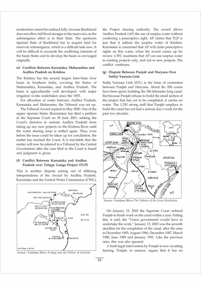
68
moderation cannot be realized fully, because Jharkhanddoes not allow full flood storages in the reservoirs, as thesubmergence effect is in their State. The upstreamriparian State of Jharkhand has to acquire land forreservoir submergence, which is a difficult task now. Itwill be difficult to reconcile the conflicting interests ofthe basin States and to develop the basin as envisagedoriginally.
(e) Conflicts Between Karnataka, Maharashtra andAndhra Pradesh on Krishna
The Krishna has the second largest Inter-State riverbasin in Southern India, covering the States ofMaharashtra, Karnataka, and Andhra Pradesh. Thebasin is agriculturally well developed, with majorirrigation works undertaken since the 1855.
For allocation of water between Andhra Pradesh,Karnataka and Maharastra, the Tribunal was set up.
The Tribunal Award expired in May 2000. One of theupper riparian States (Karnataka) has filed a petitionin the Supreme Court on 29 June 2001, seeking theCourt’s directive to restrain Andhra Pradesh fromtaking up any new projects on the Krishna River untilthe water sharing issue is settled again. Thus, evenbefore the issue could be taken up for conciliation, thematter has reached the Court. It is inevitable that thematter will now be referred to a Tribunal by the CentralGovernment after the case filed in the Court is heardand judgment is given.
(f) Conflict Between Karnataka and AndhraPradesh over Telugu Ganga Project (TGP)
This is another dispute arising out of differinginterpretations of the Award by Andhra Pradesh,Karnataka and the Central Water Commission (CWC),
the Project clearing authority. The award allowsAndhra Pradesh (AP) the use of surplus water withoutconferring a prescriptive right. AP claims that TGP isjust that it utilizes the surplus water of Krishna.Karnataka is concerned that AP will claim prescriptiverights on this water, when the award comes up forreview. CWC maintains that AP can use surplus waterin existing projects only, and not in new projects. Theconflict continues.
(g) Dispute Between Punjab and Haryana OverSutlej–Yamuna Link
Sutlej Yamuna Link (SYL) is the bone of contentionbetween Punjab and Haryana. About Rs. 850 croreshave been spent, building the 306 kilometre long canal.But because Punjab refuses to build the small section ofthe project that has yet to be completed, it carries nowater. The 1,700 strong staff that Punjab employs tobuild the canal has not had a serious day’s work for thepast two decades.
Source: Vandana Shiva Ecology and the Politics of Survival
On January 15, 2002 the Supreme Court orderedPunjab to finish work on the canal within a year. Failingthis, it said, the “Union government would have toundertake the work.” January 15, 2003 was the seventhdeadline for the completion of the canal, after the onesin December 1983, August 1986, December 1987, March1988, June 1989 and January 1991. Like the previousones, this was also ignored.
A fresh legal intervention by Punjab is now awaitinghearing. Punjab, in essence, argues that it has no
Source: Vandana Shiva The Violence of the Green Revolution
69
surplus water to release. Punjab argues that the releaseof water through the SYL canal is contingent on otherkey components of the 1985 Rajiv Gandhi and H. S.Longowal Accord, intended to end the terrorist violencein the State.
(h) Conflict Between Karnataka and Tamil Naduover Cauvery
The Inter-State River basin in the southern peninsulalies in the States of Karnataka, Kerala, Tamil Nadu andPondicherry. During the 200 years of British rule, untilIndia attained independence in 1947, substantialdevelopment of irrigation took place in the deltaicplains of Tamil Nadu and only partly in the princelyState of Mysore, now Karnataka. The two importantstorage projects of the pre-independence period are theKrishna Raja Sagar dam (1931) in Karnataka and theMettur dam (1934) in Tamil Nadu. Prior to these twodams, the Tanks and Anicuts dominated the irrigationdevelopment in the basin.
Since independence, the pace of development hasbeen remarkable and almost 95 % of the surface wateris reported to be utilized, which is the highest for anybasin in the country. The earliest Agreements thatgoverned the use and development of the Cauverywaters are the 1892 and 1924 Agreements between theerstwhile princely State of Mysore and the province ofMadras. These are the Agreements on which the caseof the Cauvery water Dispute hinges, with Karnatakacalling it unjust while Tamil Nadu swears by itsvalidity considering their established prescriptiverights.
Cauvery Tribunal
The 1924 Agreement, a water sharing agreement, cameup for review at the end of its 50 years of validity, andsince then the sharing of the waters of the Cauveryremained under discussions between Karnataka andTamil Nadu, with the Centre acting as a mediator. Thecourse of the negotiations from 1968 to 1990, until theTribunal was set up, at the bilateral level and at theCentral level, swung from periods of hope to periodsof despair. Even before the 50 years of validity periodexpired, Tamil Nadu approached Centre to refer thedispute to a Tribunal, and in the absence of anyresponse from the Central Government, approachedthe Supreme Court requesting for a direction to begiven to set up a Tribunal and to direct Karnataka notto proceed with its new projects.
Kerala also filed suits to refer the disputes to theTribunal. Efforts by the Central Government to find
a solution did not result in the settlement of thedispute. The writ petition of the Tamil NaduGovernment was heard by the Supreme Court in April1990, and it directed the Central Government to set inmotion the legal proceedings, as statutorily mandated.The Cauvery Waters Dispute Tribunal was accordinglyset up in June 1990 for adjudication of the dispute. Thecases made out by the Party States are summarizedbelow:
Arguments by Karnataka
The main arguments of Karnataka are:
i) The Agreements of 1892 and 1924 are void sincethey were ‘imposed’ by the British on the ‘ PrincelyState’ of Mysore.
ii) The 1924 Agreement has expired in its entirety in1974 at the end of the 50 year period. The 1892agreement placed restrictions on Karnataka forthe development of irrigation, while Tamil Naduhad no corresponding restrictions.
iii) Tamil Nadu has the benefit of being exposed to boththe South-West and North-East monsoons.
iv) Tamil Nadu’s canal systems are to be modernized.
v) Karnataka’s drought prone area is almost doublethat of Tamil Nadu, and has therefore a right to useof more water; Trans-basin diversions for irrigationor power should not be permitted.
vi) The ground water resources in the Delta region areto be taken into account for the purpose ofequitable distribution.
Objections of Tamil Nadu
Tamil Nadu’s objections are:
i) The Central Fact-Finding Commission’s (CFFC)reports of 1972 and 1973 with regard to yield andutilization should be revised.
ii) The average annual utilization is already higherthan the yield, even at 50% availability, and hencethere is no scope for savings.
iii) The 1892 and 1924 agreements are inviolable,binding on all the States, and there is no need towork out any fresh allocation of waters in terms ofactual quantum or periodic releases.
Argument of Kerala
The allocation of Cauvery waters should be made takinginto consideration the quantum and percentagecontribution of each State.
70
Demand of Pondicherry
The full allocation of a minimum quantity of 9.355 TMCof water for irrigation and drinking water purposesshould be made during normal years.
Interim Award
The Tribunal gave an interim order on 25 June 1991.Karnataka was directed to release 205 TMC of waterfrom its reservoirs in Karnataka so as to ensure thatit is available in Tamil Nadu’s Mettur Reservoir fromJune to May, effective from 1 July 1991 in accordancewith the monthly inflows schedule. Restrictions werealso placed on Karnataka not to increase its areaunder irrigation by the waters of the Cauvery beyondthe existing 11.2 lakh acres. Karnataka felt aggrievedand reacted very strongly to the above order andraised several legal and technical lacunae, some ofwhich are:
i) the interim relief is arbitrary, granted without primafacie assessing the yield, utilization, basin needsand other relevant matters;
ii) the unworkable schedule for the release of water isarbitrary, since it operates irrespective of availabilityof waters in Karnataka.
iii) It also represented to the Central Government not toimplement the Tribunal’s order, and to stay all theproceedings of the Tribunal until a National WaterPolicy was formulated and an appropriateamendment was brought to the Inter-State DisputesAct of 1956, and the Tribunal given clear guidelines.
Due to the urgent nature of the matter, Centreapproached the Supreme Court seeking clarifications.The Supreme Court ruled that the order of the Tribunalbe published in the official gazette. The Tribunalupheld its order. Following this, there was political one-upmanship in both the States. Until the end of the1994-95 season there was no crisis as the monsoon wasfavorable. However, in 1995, due to delayed monsoonand low flows in the river, the dispute again came upbefore the Supreme Court on the issue of non-complianceof the Tribunal’s order by Karnataka. The SupremeCourt, in December 1995, asked Tamil Nadu toapproach the Tribunal.
The Tribunal directed Karnataka to release 11 TMC,being the cumulative deficit up to mid December 1995,and to keep up further release of 17.4 TMC until end ofMay. Karnataka did not release the flows as directed bythe Tribunal. The Supreme Court on a petition by TamilNadu requested the Prime Minister to intervene and
find a solution within three days. The Prime Ministerafter intense parleys and discussions with the ChiefMinisters of the States, announced a three-point package,which diffused an otherwise explosive situation. Thedetails of the PM’s package are mentioned below.
Package 1: PM requested Karnataka for immediaterelease of 6 TMC of Cauvery waters, against 11 TMC asper the Tribunal Order, to Mettur in Tamil Nadu. Thiswas complied with. In subsequent years, this is beingdone under a formalized institutional arrangement.
Package 2: A three member Expert Group wasset up to make an on-the-spot assessment of thestatus of standing crops in Cauvery basin inTamil Nadu and Karnataka and their water storagelevels and immediate requirement of water to savestanding crops in both the States. This was only aninterim action to diffuse an otherwise sensitive situation.Such solutions may soon become necessary inexceptional cases in the future.
Package 3: This addressed the larger issue of sharingof river waters at a policy level by proposing to holda meeting of the National Water Resources Council(NWRC), on which all the Chief Ministers arerepresented, to evolve guidelines for sharing of Inter-State river waters. This meeting had been held and aWorking Group had been set up to work out themodalities for preparing the guidelines.
(iii) CENTRE STATE CONFLICTS
Fortunately, there has been no major conflict betweenCentre and States over sharing of river waters.Basically, ‘water‘ is a State subject, with the Union’srole limited to the Inter-State Rivers. The Constitutionalprovisions related to water are contained in theSeventh Schedule: Article 246, as discussed earlier. TheUnion list, concurrent list and State list cover water.Since water is a primary need, water resourcedevelopment could be covered under Concurrent Listalso. Only Entry 17 of List II has been in operation allalong. However, Entry 20 of List III (Concurrent List)could also be said to have operated indirectly in viewof the fact that the Central Government, through thePlanning Commission, has to clear water ResourcesDevelopment projects for investments if these projectsare to be eligible for central funds.
Centre may bring an appropriate legislation so thatthe need for the consent of the States will not arise. If alegislation under Entry 56 List 1 of the Constitution ismade, the need for the consent would not arise and theCentre would be in a position to undertake the project

71
and complete the same within a reasonable period oftime.
However, this will be a major source of Centre-Stateconflict.
(iv) STATE VS PEOPLE
The hydroelectric power generation from river water hascome into conflict with irrigation needs both in terms ofthe spatial and temporal characteristics of water storageand distribution. The maximization of power generationfrom Koyna demands that the water of the Krishnabasin, draining into Bay of Bengal, be diverted to theArabian Sea.
Industrial use of the river system is also a majorsource of conflict. For example, the pulp-basedindustries on Tungabhadra have polluted the river anddestroyed the fishing economy, 20 km downstream.Moreover, the large-scale cultivation of pulpwoodspecies like Eucalyptus in this part of the basin hasimpaired the groundwater recharge potential.
Dams for irrigation and/or power are also a sourceof conflict between the traditional rights of people toland and water and the role of the state to displace anduproot them for building river valley projects as in thecase of Srisailam Dam. Large dams require massivesubmergence areas, and hence necessitate thedisplacement of large number of people. Majordiversions from the river basin, as in the case of theTelugu-Ganga Canal taking off from Srisailam Dam,affect the riparian rights of the states and havegenerated unresolvable inter-State conflicts.
Farmers who are supposed to be the ‘beneficiaries’become victims of irrigation projects. The “MittiBachao Andolan” in the Tawa command area is anexample of such conflicts. In the Krishna basin,conflicts generated by irrigation projects werehighlighted by the farmers’ agitations in the commandarea of the Malaprabha project.
The Telugu Ganga Canal, which takes off fromthe Srisailam Dam, is probably the most conflict-ridden river diversion project in contemporary India.While the decision to supply drinking water to Madraswas agreed by all the States, conflicts arose when AndhraPradesh decided to use the Telugu Ganga project forirrigation.
Karnataka had objected to the Telugu Ganga irrigationscheme on the grounds that its own projects to harnessKrishna waters were still incomplete and what appearedto be excess, could be used in the future. Karnataka hadmade it clear that surplus Krishna waters would not beavailable for the Telugu Ganga project.
The intensive use of water also has major ecologicalimpacts. The dramatic increase in water use with theGreen Revolution has led to a total destabilization ofthe water balance in the region. The water cycle can bedestabilized by adding more water to an ecosystem thanthe natural drainage potential of that system. This leadsto desertification through waterlogging and salinisationof the land.
In India, 10 million hectares of canal irrigated landhave become waterlogged, and another 25 millionhectares are threatened with salinity. Land getswaterlogged when the water table is within 1.5 to 2.1metres below the ground surface. The water tablegoes up if water is added to a basin faster than it candrain out. Certain types of soils and certain typestopography are most vulnerable to waterlogging. Thewater logged areas in Punjab are shown in table 6c(1).
Table 6c(1)Distribution of water logged areas in
different districts of Punjab(Water table less than 1.5 m)
Sl. Districts Waterlogged area Percentage in eachNo. (Lakh hectares)
1 Faridkot 1.12 39.16
2 Ferozepur 1.02 35.66
3 Bhatinda 0.32 11.19
4 Sangrur 0.09 3.15
5 Amritsar 0.08 2.80
6 Hoshiarpur 0.07 2.45
7 Gurdaspur 0.06 2.10
8 Jalandhar 0.05 1.75
9 Ludhiana 0.04 1.40
10 Ropar 0.005 0.17
11 Patiala 0.005 0.17
Total 2.86
What the Punjab experience in conflicts over rivershas shown is that a ‘just’ distribution of water is nota matter of dividing a fixed stock of resources amonga fixed set of needs, because neither the resources northe demands are fixed. Injustice is being experienced byall parties concerned because of the fluidity of theresource, the exploding demand for water and thefluidity of political actors making a demand on theresource and on its control.
72
(v) PEOPLE VS PEOPLE
The relatedness of Water availability in different parts ofa basin, and the linkage between land use and water useentail that activities in one part of the river basin cannegatively or positively influence other parts of the basin.Yet it has been assumed that multi-purpose river valleyprojects that provide irrigation as well as generate hydro-power do not have conflicting objectives.
However, the very location of these projects isprimarily determined on the basis of these objectivesand water releases are also determined by priorities forpower or for irrigation. Other inter-sectoral conflictsinclude diversion of water for irrigation from drinkingwater, or for industry from agricultural and domesticuse. Not only do diverse uses conflict with each otherinter-sectorally, they can also occur on the basis ofconflicting interests between the rich and powerfuland the poor and marginal.22
Thus, state planned quarrying of minerals or timberextraction in the river catchments affects the riverflow. And generating marketable surpluses of cashcrops conflicts with people’s needs. Finally state planstend to serve the interests of the economically andpolitically powerful groups of society and hencegenerate new gaps between the rich and poor in termsof access to water resources.
These conflicts and destruction are more aggravatedin India than in America because India is a ripariancivilization, which had evolved in a monsoon climate.
One type of conflict relating to water projects arisesfrom the ecological impact of impounding largequantities of water, transporting it across drainageboundaries and using it for intensive irrigation.Displaced people are, of course, in direct conflict withthose who benefit from massive irrigation system.
Since water flow creates interconnectedness withinthe basin, each intervention in land and water use,depending on its scale, can become the source ofconflicts. The mining of iron ore at Kudremukh andManganese ore in Sandur in the upper catchments ofTungabhadra has seriously affected the stability of thecatchment and has led to severe soil erosion and siltingof the Tungabhadra reservoir, thus conflicting withirrigation needs.
(vi) POTENTIAL OF FUTURE CONFLICTWITH CHINA24
Where does Asia’s water come from? Due to itsgeographic location and geological formation, the Tibetanplateau is the main water shed for Asia. Some of the
world’s greatest rivers, such as Brahamputra, Yangtze,Mekong, Yellow River, Salween, Sutlej and the Indusoriginate in Tibet. When Mao invaded the Roof of theWorld in 1950, he knew Tibet’s strategic position andthat more than 90 per cent of the water running off tochina, South East Asia and South Asia come from theregion.
However, the most important factor seems to havebeen overlooked: who controls the flow of theBrahamputra, Indus and Sutlej in their Tibetansegment? In this context, it is interesting to go back to15 August 1950. On the day, in the evening, a terribleearthquake shook eastern Tibet. This was no ordinaryearthquake; it felt like the end of the world. Mountainsand valleys exchanged places insantly; hundreds ofvillages were swallowed up, and for hours afterwards,the sky over the South-eastern Tibet glowed with aninternal red light, diffused with the pungent scent ofsulphur. And during those few hours, the course ofthe Brahamputra changed. One may argue that onlynature can produce such an upheaval, but nothing iscertain.
On August 4, 2000, the Tribune reported a verystrange event. Even three days after the disaster, themystery of the flashfloods in the Sutlej, which wreakedhavoc along its 200 km length, remains unresolved.Experts were at a loss to understand where the hugemass of water came from. It was not possible tounderstand that from where 50 ft high walls of waterdescended into the gorges of Kinnaur in HimachalPradesh. In a few hours, more than 100 people died,120 km of a strategic highway in Cheni section waswashed away, and 98 bridges destroyed. A similarincident had been reported earlier in 2000 in ArunachalPradesh.
A detailed study carried out a few months later byISRO Scientists affirmed that the release of excesswater accumulated in man made and natural waterbodies in the Sutlej and the Siang river basins in Tibethad led to the flooding. These lakes disappeared, soonafter the disaster struck Indian territory.
It is possible that the Chinese had breached thesewater bodies and as a result lakhs of cusecs of waterwere released into the Sutlej and Siang river basins.Given the fact that the Chinese are planning topump 48 trillion litres of water a year from the Yangstse,across 800 miles to drought striken northern China,until a treaty like the Indus Water Treaty betweenIndia and Pakistan is signed between India and China,any plans of the Task Force to link rivers may turnto be futile.

73
It was only during Indira Gandhi’s time that theproject of river linking was seriously discussed and
given up because of formidable geographic hurdlesand colossal costs. At Patna, which is the only pointalong the course of Ganga with a divertible surplus, theGanga flows 200 ft. above the mean sea level (MSL).If it has to be linked with any river in the peninsula,the water has to be raised over the Vindhya chain, i.e.,2860 ft above MSL. Pumping 20,000 cusecs of water tothat height would have required the entire day’s powergenerated in the country at that time.2 Apart from thehuge demand on power, the project was likely to entaila construction of at least Rs. 200,000 crores (at the priceindex of 1972).
Let us suppose for a moment that, despite thecolossal financial costs, the country decides to take upthe interlinking project. The cost in terms of humandisplacement and ecological destruction will be terrible.The construction of barrages and excavations ofthousands of kilometres of canals will make villagesdisappear, flood towns, and cut through millions ofhectares of agricultural and forest lands. It willuproot millions, the number exceeding the populationshifts of partition.2
Even financially there is no accurate and reliableestimate regarding the mind boggling cost. There areat least three different estimates.
i) The NWDA budgets the entire project at Rs. 560,000crores ($112 billion) at 2002 prices.
ii) How ever Mr. Prabhu himself accepts that it couldgo up to 1,000,000 crores ($ 200 billion). Mr. Prabhuwould prefer to generate resources for the projectwithin the country. According to Mr. Prabhu,Hydro-electric and navigational projects are twoobvious areas where privatization will work well.25
iii) According to a former Secretary in the UnionWater Resource Ministry, the estimated cost ofonly the Peninsular component is about Rs.500,000 crores. These links stretch from the Sutlejin the North to the Vaippar in the South and from
7. UNASSESSED COSTS ANDUNANSWERED QUESTIONS
the Brahmaputra in the East to the Mahi in theWest.
Remember, all these figures have been estimated bythe government agency (NWDA), a well known expertin the field of Water Management and a former UnionMinister, who made a name as a Union Minister ofEnvironment and Forest? Which one is accurate?Nobody knows!
Before launching such a mammoth project,government should come out with reliable and accurateestimation dealing with each and every component ofthe task.
Incomplete Projects and Sources of Funds
The government spent 22% of its revenue on irrigationin 1966 which came down to 6% in the 1990s. Thegovernment’s 9th plan outlay is only Rs. 40,000 croresfor water and irrigation, just enough to pay salaries ofthe Water Resource Ministry. The tenth plan does noteven mention the interlinking of rivers.
There are 400 major and medium projects pending,which require an investment of Rs. 77,000 crore. Thecost to complete minor projects is 55,000 crores, andthe cost to implement the ground water rechargescheme is 24,500 crore. The total comes out to be 156,500crores. While the government is not able to generate thefunds even to complete the pending projects, onewonders from where the sum of Rs. 6.60 lakh crores willcome for interlinking of rivers?
Private Investment
Already it is clear that this money will not come frombudgetary allocation. According to Radha Singh, theAdditional Secretary, Water Resources, the private sectorwill be pitching in. The government will raise moneythrough joint ventures and private initiatives.
The Confederation of Indian Industries (CII) hasalready started discussing money with Stategovernments. It is also setting up its own WaterCommittee. With the Supreme Court’s directive, CII isin business.
74
Once industrialists invest money, water will becomea commodity. Eventually, the poor will be deprived oftheir rights of water. You cannot have dams like theroads where contractors charge on every vehicle. If itis going to be privatised, there are a number of questionswhich the government should answer. For instance,how it will be tied to water pricing, tarrif structure,diversification of cropping pattern, internal cost ofreturn, maintenace and so on?
Ecological Imbalance
Large-scale deforestation for dams and canals can leadto imbalances in the eco-system. Following theconstruction of dams, aquatic life is often grievouslyharmed. Changes in water velocity, water chemistry,temperature and turbidity disturbs the free passage offish. Weeds often proliferate in irrigation reservoirs.Many of these weeds can spread disease among humanbeings and cattle.
Construction of dams on many rivers make themlifeless, especially the smaller ones. The impounding ofriver waters in reservoirs reduces the flow in manyrivers to a trickle. Thus, they are unable to withstand theever-increasing pollution load.
One of the most important environmental effects ofthe big dams is the degradation of the soil in thecommand areas of irrigation projects, due to increasein the soil salinity and water logging.
There is always a threat of extinction posed by thedams to the tremendous variety of biological species.
Does the Government have any clue about theecological imbalance, which the interlinking of riverswill cause? Government should conduct a thoroughcomprehensive environmental impact assessment (EIA)before making project feasibility report (PFR) anddetailed project report (DPR)
Assault on Tribal Culture
Construction of dams effectively results in a directassault on the country’s tribal population. Dams areusually constructed in remote forest areas, wheremost of the tribal population lives. The sudden influxof the modern system, destruction of the surroundingnature in which their lives are dependent, andultimately displacement and resettlement will leave thetradition-bound tribal family totally bewildered,powerless and on the verge of total social, culturaland economic collapse. Among tribals, the basis ofmutual cooperation and relationship is not economic,but social and cultural. However, the displacementand resettlement will destroy this fabric oftribal culture.
The constitution has also been amended through the73rd Amendment to allow tribal people to have totalrights over their natural resources including landtogether with the right to manage it. Do not forget thewords of K. R. Narayanan: “Let it not be said of Indiathat this great Republic in a hurry to develop itself, isdevastating the green mother earth and uprooting ourtribal populations.”
Activists from around the world met at Navdanya’s organic farm on 16 December 2001 to develop national andglobal strategies to defend water as a collective community commons, and drafted the Water LiberationDeclaration.
The Declaration is supported by over five hundred signatories.
WATER LIBERATION DECLARATION
Water is life. It’s a gift of nature. The access to water is a natural and fundamental right. It is not to be treatedas a commodity and traded for profit. People shall have the right to freedom from thirst, and shall have adequateaccess to safe water for all of their living needs.
Experiences all over the world reveal quite convincingly that water which is “life”, is being privatized and broughtunder corporate control. This will deprive the people of water lifeline for survival. All the water resources shouldbe owned, controlled, managed and utilized by local communities in their natural setting.
We the people from all over the world will not allow our waters to be made a commodity for profit.
We will work together to liberate water from corporate/private agencies, control and return it to the people forcommon good.
We demand the Governments all over the world should take immediate action to declare that they accept watersin their territories a public good and exact strong regulatory structure to protect them.
75
The Jal Swaraj Abhiyan of Navdanya/RFSTEwill also take these questions to the people.
Let the people decide.
We will strive for Jal Swaraj and Water for all.
Ten Questions to the Task Force
1. Justice (Retd) B. N. Kirpal has clarified that theSupreme Court observation on linking of rivers wasonly a suggestion, not an order. What, then is the legalbasis of the Task Force?
2. Will the financial outlay of project of $ 200 billion tolink rivers not make privatization inevitable?
3. Is the project not violative of the Seventh Schedule?
4. In scheduled areas, will it not be violative of the FifthSchedule and the Provisions of the Panchayats(Extension to the Scheduled Areas) Act 1996?
5. How much land will be destroyed for the project?
6. How much land will go out of agriculture, downstreamof river diversions?
7. How many people will be displaced?
8. How much biodiversity of forests will be destroyed?
9. What will be the impact on the hydrological cycleon drainage when canals block natural flows, ondeltic regions when water does not reach the sea,and on rivers when water is diverted?
10. What are the alternatives which cost less, do not causeecological and social disruption, but provide moreequitable distribution of water for drinking andirrigation?
76
PEOPLES NATIONAL WATER FORUM15-16 March, 2003 at IIC Annexe
JAL SWARAJ ABHIYAN RASHTRIYA JAL BIRADARI
On 15-16 March 2003, the Jal Swaraj Abhiyan andthe Jal Yatra organised by the Jal Biradari met at a
two day forum to evolve collective strategies to conservewater, defined people’s water rights and resisted theriver linking project. The forum was opened by Dr.Vandana Shiva of Jal swaraj Abhiyan, SundarlalBahuguna of the Chipko movement, and Anil Chaudharyof Peace. Oscar Oliviera of Bolivia was special guest.
Mr. Ambuj of Tarun Bharat Sangh (TBS), AlwarDistrict, spoke about the success of reviving conventionalwater management practices. In Alwar district, theground water table has receded below the critical level,forcing the State Government to declare the area as ‘darkzone’. The people of Alwar district revived traditionalwater harvesting technology ‘Johad’ (water tank) torestore the ecological balance of the region. UnitedNations Environmental Programme (UNEP) made adocumentary about the water harvesting success ofNimmi village, which is 30 km from Jaipur. At present,more than 5000 Johads have been revived in entireRajasthan. The TBS success in constituting GramSabhas and ensuring that the village bodies have theultimate say in managing Johads and decision makingprocess is the key message.
But there is apprehension in the minds of the peoplethat the ‘Water Policy 2002’ will not allow grass-rootworkers to take initiative.
Arjun of Bhavata Koyala said: ”Even the cruelestking will not have control on water, but now theGovernment is going ahead to privatize water becausethere is a high profit in water.” Mr. Arjun went back totrace the history of TBS founded by Rajendra Singh. TBSbegan in 1984 in a village Bhikampura of Alwar.Rajendra Singh motivated the villagers to take waterharvesting by reviving Johads. Johads have transformedthe ecology, agriculture, economy and the general wellbeing of the population in the villages in the district.Handpumps are back to life and water gushes out ofthem at one stroke. Several seasonal rivers have beenconverted into perennial source of water. The ‘dark
zone’ had turned out to be the brightest spot.Prior to undertaking any developmental activity in
the village, the cost component is discussed by theGram Sabha, constituted by the villagers (Gram Sabhais a village institution created in each village associatedwith TBS it is different from the Gram Sabha denotedunder the Panchayat Raj Act in Rajasthan). Apart fromShram Dan (voluntary work), Gram Sabha has to payminimum 33% contribution of the total. TBS mainlycontributes resources for hiring skilled labour, buyingcement, iron and diesel for tractors. All the decision aretaken collectively by Gram Sabha.
According to Mr. Arjun, if Johads are to be saved,forest must be saved. The story of water harvesting byconstructing Johads moved the then President K. R.Narayanan who visited village Bhavata Kayala tohonour Arjun and other villagers.
Arjun was not the only one with the experience.Kajori Mai, who also took up water harvesting in avillage in Alwar, said that earlier water was notavailable easily. She used to walk miles to fetch water.Now, because of harvesting, water table has increased inthe wells and water is available in the wells without anydrudgery. Creation of the water harvesting structureshas benefited women immensely. The increasedavailability of water for cooking, washing and bathinghas definitely improved their quality of life.
“Though poverty is prevailing in Orissa, all globaltenders are floated and given to outsiders,” said Mr.Aditya Patnaik. He further added: “Privatisation hasruined the Orissa Life Irrigation Corporation (OLIC).Government may declare Pani Panchayat as defunctand will handover to MNC. Orissa is in the grip ofcolonialism, where present system is the root cause ofthis situation. 21 years ago, a project displaced about14,000 people; today only 8000 have been identified. Nobody knows where the rest have gone.”
According to Mr. K. R. Chaudhary of AndhraPradesh, C. B. Naidu, Chief Minister of Andhra Pradeshabruptly raised the issue of interlinking of rivers just to
77
divert the public attention from other burning issues. Inthe State, due to want of funds, the projects are pendingsince last 30 years without completion. Andhra PradeshGovernment is refusing to divert surplus to Tamil Naduand Pondichery but demanding the Ganga Cauverylink. Not only C. B. Naidu, even Lalu Prasad, of Biharhas denied sharing of surplus water. There isapprehension in the minds of the people about the costinvolved. Lifting of water will require half days’ energygenerated in the country.
To conserve the water, there should be change inthe cropping pattern. Paddy and sugarcane shouldbe replaced by water prudent corps.” emphasizedMr Chaudhary.
Parvesh Mishra from Chattisgarh pointed out aboutthe sufferings and hardship of the victims of Hirakuddam. Village like Udaigarh, once the richest village inthe region, has become the poorest village. Communitieslike Kewat, Maajhi and Nishad depending on the riverof Mahanadi have been pauperized. Governmentacquired the land in 1948; however, the people are yetto be settled. In the name of relief works, Governmenthas taken only constructing of roads where people arehired for digging of gitties (small stones) from DanavParbat. Instead of desilting of rivers or tanks,Government is throwing the dust, stones and waste inthe river which is chocking its flow.
Initially the height of the dam was 630 ft which lateron was reduced to 627 ft. The reduction in the heightcould have facilitated the return of land to 22 villages;however, State Government never returned the land tothe farmers.
Chhajju Ramji through a song conveyed the messageto save Johads and river to save water. He quoted greatHindi poet Rahim that without water, crops and humanbeings can not survive.
Aniket Alam, a journalist from The Hindu, Hyderabadprimarily delved upon the financial aspect of the riverlinking project. He briefly traced the origin of the project.This is not a new idea. The idea basically was given bySir Arthur Cotton in 1860. Even today he is very popularin South India. It is said about Sir Arthur that if he wasalive today, he could defeat NTR. Sir Arthur had theopinion that whole of the country could be linked withcanals so that people can transport their goods. For thattime, troops movement was essential. Britishers couldtransport their troops in ships from Calcutta to Kanpur.The idea was dropped because of two reasons. FirstRailway lobby was very strong in Britain, second he gotinvolved in one scam. It is said that his brother-in-lawwas making money, so the plan was shelved.
“The National Water Development Agency (NWDA)budgets the entire project as Rs.560,000 crores at 2002prices, which however may go up to 1000,000 crores.The NWDA plan has divided the project into two broadcomponents. The Himalayan part with 14 river linksestimated at Rs. 375,000 crores and the Peninsularcomponent with 17 river links estimated at Rs. 185,000crores,” said Mr. Aniket. If the economics of the schemeseems to make it extremely impossible, seriousreservations can be raised about some of its claims andassumptions too.
Oscar Olivera from Bolivia is one of the world’sleading water activists who with his people threw outone of the world’s biggest corporations. He said: “I amvery happy that you are interested to know about ourstruggle in Bolivia. US is planning to take over entireBolivia. Bolivia is a country with about 80 lakhpopulation. Out of this, 50 lakh are rural and 30 lakh areurban. Population of Cochabamba is about 10 lakh.India and Bolivia are common in many aspects. As faras the Bolivian Government is concerned, though it is ademocracy, it should be said that people are not allowedto participate. Government may take any decisionwithout consulting people.
In south Bolivia, there is water, but there was problemabout how to transport water. 50% of Bolivia’s watersupply come from Municipal sources, 30% from tanksand 20% from private sources.
To solve the problem, the Government under worldBank pressure gave the water contract to Bechtel, a MultiNational Corporation. There is a clause in the contract,by which even the private wells went in the hands of theMNC. By one signature even the personal resourceswere handed to the MNC.
Water Privatisation started in October 1999; however,service tax and the cost of water increased from 30%to 300%. Every Bolivian had to spend about 20% of hisincome only for water. Apart from economic aspect,water privatization caused cultural and moral impacts.Since centuries, there was tradition where people wereusing water the way they liked. The exploitation of thewater united the people against MNC.
People started fighting from January 2000 and theydemanded:
i) First cancel the contract and send back Bechtel.
ii) Instead of Bureaucrats, and Corporations, Publicwill run the show.
As a result of a the people’s movement, theGovernment was forced to cancel the contract withBechtel in April 2002.
78
Democracy took a new direction. Democracy wasrediscovered in Bolivia.
In Cochabamba, 1 lakh people organised the rallyand decided to run the water system on Four pricniples
(i) Transparency
(ii) Efficiency
(iii) Participation
(iv) Social justice
These four elements were absent in the earliercontract. Once the people have taken over the company,the people came to know about the corrupt practicesof the company. 50% was total corruption. The contractwas for 40 years with 17% guaranteed profits. Afterleaving Bolivia, the company filed a suit for 250 lakhdollar as compensation. The asset of the company is 12million dollars, double the total asset of the BolivianGovernment.
Every company says that your infrastructure ispoor, your technology is inferior. However, surprisinglyBechtel did not invest a single dollar in Bolivia. Thecompany used the same old infrastructure withoutputting any new technology.
Oscar Oliviera added “You should not be afraid ofMNCs, success will be yours. You have to take thedecision that you have to fight, on the basis that wateris a birth right. Finally you will win.”
Shri Ramaswamy R. Iyer, Former Secretary, Ministryof Water Resources said: ‘There has been a great deal ofpublicity regarding the river linking project in thenewspapers. It was Supreme Court which gave thedirection. In fact, it arose in the context of Cauvery issue.Supreme Court asked the Government of India whetherinterlinking of river is possible. Initially, the Governmentof India made a very cautious approach keeping in viewthe environmental and displacement cost. Governmentgave the idea that the project shall be completed within40 years. Government also gave some idea about themoney involved. Government constituted the Task Forceand appointed Mr. Suresh Prabhu, Former UnionMinister for Power as Chairman. One interesting aspectof this project is that before the Supreme Court’sdirection there was no mention of the project. NationalWater Development Agency (NWDA) has preparedvoluminous report, mainly on engineering works, onefor Peninsular component and other for Himalayancomponent. All these are the secret documents, notavailable for public. Except Ministry of Water Resources,nobody knows what is there in these reports.”
“People give the analogy of Highway construction.However, river is the creation of nature. They are not
pipelines. The inter river basin transfer must overcomethe natural barrier. Government officials claim thatwater will be lifted by gravity by minimum energy,but this is not true.
“In Constitution Law, we can amend theConstitution, but we cannot change the basic structure.Who gave the Government this Right? To avoid theCentre-State conflict, Government may bring the waterfrom the State list to the Centre list. Government wantsto get the political mileage by announcing this kind ofmega project. So even the leader of Opposition haswelcomed the initiative of the Government. This is thebattle, which we have to fight from outside theGovernment. Mr. Prabhu has invited me. He said,please find the way to accelerate the project, and heasked the participants and experts not to examine butto consider the project.
“There is no mention of this mega project in 9th or10th Plan. When P M addressed the National WaterCouncil in April 2002, there he did not mentionregarding this project. The river linking project willresult in the submergence of forest, displacement of thepeople, loss of biodiversity, change of morphology.Government is distorting the planning process. Anywater resource project first must be studied by NWDA,then it must go to Ministry of Environment and Forestsfor environmental clearance (to study whether projectwill cause any adverse ecological impacts and how itcan be avoided or mitigated). At the third stage, projectgoes to Planning Commission for investment approval.However, in this case the Planning process has beentotally distorted.
“With this kind of mega project, no money will be leftfor water harvesting. Once this kind of mega projectstarts, it will suck the entire money. We have alreadyseen this in Gujarat.”
Mr. Iyer praised Rajendra Singh. Rajendra Singh hasshown that where the rain fall’s as low as 20 mm, it ispossible to overcome the 3-4 consequent droughts.Regarding Cauvery, he said that there is no shortage ofwater in Cauvery basin. There is water mismanagement.If you grow only sugarcane in Mandya and Paddy inTamilnadu, there will be water shortage.
Mr. Sinha of Pani Morcha is a leading water activistof Delhi. “I have filed an application in Supreme Courtfor early hearing regarding the interlinking of rivers. Inthe petition, I have mentioned that first FeasibilityProject Report (FPR) should be conducted. If it isapproved then it must go to technical advisory committeefor Detailed Project Report (DPR). If PFR is approvedthen 1% of the total cost should be released for DPR. But
79
all these norms have been overlooked in interlinkingproject,” said Mr Sureshwar D. Sinha.
1500 years ago Al-Beruni, and Fahian visited Indiaand they said, that “wells never die in the country, evenif rain fails because there is flow of water in the river. Now,when the water table goes down 150 ft below, you needborewell. In war situation, all the power projects may getbombed, this is one of the long term adverse effect. Whenthere is enough ground water, it is sufficient to dilute thepollution. Today Arsenic poisoning is rampant. The daythe Government is going to start this project, Arsenicpoisoning is going to increase.
He added, “I have quoted a Government of Indiareport of last 50 years Project. Your aim was to irrigate30 million hectares, of which 6 million, i.e., 25% ofarable land has been lost due to salinity, alkalinityand water logging. I doubt that Government officialmay fudge the figures to get the approval of theproject. For instance, in Narmada’s case there wasonly 23 BCM water available. However, Governmentofficial claimed 28 BCM. The difference of 5 BCM. Theofficials who gives the false information should bepenalized.”
We want to supply water from Bhakra. But there is40% loss in the transfer. Tribunal has accepted that yourirrigation efficiency is 35% which means that 65% ofwater is lost. Therefore, with interlinking of rivers, at anaverage, 65% of water will be lost every year.
There are going to be water wars and millionmutinies. In the case of Ganga, the most importantitem which is ignored is that is being destroyed by thisproject. Forest cost is also not included in this project.This is just hoodwinking the public. Now it isinternationally recognized that river has the naturalrole of recharging your ground water. Now because ofthe low flow in the river, the polluted water isrecharging your ground water. Reservoirs also induceseismic activity. There are 71 reservoirs, which haveinduced earthquake. There is example in your owncountry where Koyna dam was burst in Maharashtra.Victims of major dams are not able to be resettled andsome of the victims take begging and prostitution.Likewise, Tehri dam may face the induced seismicactivity and earthquake because it is only 6 km awayfrom the fault line.
Shri Sundarlal Bahuguna, the famousenvironmentalist briefly spoke about the ‘austerity’and alternatives to avoid the wastage of water. Thereis need for afforestation. According to Shri Bahuguna,the solution of water problem will solve the problem ofFood, Fuel, Fertilizer, Fodder and Fibre, i.e., 5 F
According to Anil Choudhary of PEACE, water issuehas become important during last 5 years. To understand‘water privatisation’, we must understand the dividebetween rich and poor. The main aim of the marketforces is to increase the production and developtechnology. We have to understand why the MNCs arebehind water privatization. The community rightsover water must be clearly defined.
“Resettlement is a serious problem. Some peoplehave been settled in Dehradun and Haridwar. Nearly 8lakh people are estimated to be affected by theconstruction of the dam. Earthquake of 7 Richter scalewill devastate the new Tehri city. Though 66% area inUttaranchal is reserved as forest, reality is totallydifferent” said Mr. Upadhyay who is also a Minister inUttaranchal Government.
He pleaded for help on Tehri issue. Though the initialestimate was 2,000 crores, which later increased to10,000 crores in his assessment, it is about 16,000 crores.one doesn’t know whether Uttaranchal Government,Tehri Development Board or Centre is serious about thishuge investment. Tehri dam will generate about 2,400MW of electricity; at least 5% of it should be given toUttranchal. Dr. Ashok Panigrahi, in his presentation onthe Mahanadi, showed that contrary to the assumptionof the river linking project, Mahanadi is not a surplusriver.
Mr. Sat Pal Choudhary of Dehat Morcha highlightedabout the water diversion form Upper Ganga Canal.The total carrying capacity of upper Ganga is 1,110cusec. Out of this, 720 cusec, i.e., 70% is diverted forprivatization at Muradnagar. Not only this, nearly 110cusec is extracted at Masoori village in Ghaziabaddistrict by the private company. Dehat Morcha has beenable to stop the laying of concrete on the canal. Sat PalChoudhry and his organization are actively creatingawareness about the water diversion from Upper GangaCanal, and extraction of water at Masoori village.
Now, even river can be sold out like land by thegovernment. River Sheonath near Raipur in Chhatisgarhhas been sold out to one Kailash Soni by ChhatisgarhGovernment. “One most surprising aspect of this saleout is that government paid Rs. 4 crore loan to KailashSoni which he has not returned to the government.Nearly 60-70% of the people on the bank of the riverwere dependent on fishing. They are not allowed toenter in the river by Kailash Soni,” said Mr. Binayak Senwho is planning to file a case in Chhatisgarh HighCourt. From Raipur to Durg and Bhilai, Kailash Sonicontrols the river. Agreement exists for 30 years whichcan be further extended for another 15 years, i.e., total 45
80
years. Farmers are not allowed to take water from theriver. Meter has been attached to the pumps so that thefarmers can pay accordingly. There is a clause in thecontract, which says “take or pay,” which means evenif you are not taking any drop, you will have to pay thefixed amount.
Encouraged by the sale of Sheonath, government isplanning to sell Kharoon river to one Mr. Jaiswal, awell known industrialist in the region.
The plight of river Bhawani in Tamil Nadu wasillustrated by Mr. Shrinivasan. The river originatesfrom Western Ghats, goes to Coimbatore where metalplating units are polluting it. “In Tiruppur town thetextile industries are polluting ground water,” addedMr. Shrinivasan. A subsidiary of Vivendi has thecontract to collect the city garbage, which is beingdumped at the site of freshwater. There is a watermarket of Rs. 300 crores. Tamil Nadu government isforcing the people for privatization.
A joint venture of three companies by the name ofNew Tiruppur Development Authority has beenlaunched. The total cost of the venture is Rs. 1300crores of which 400 crores are equity. Three companiesinvolved in the venture are Mahindra & Mahindra,Bechtel and Universal. Bechtel will lay down thepipeline for a stretch of 60 km, Mahindra & Mahindrawill construct 25 reservoirs, and Universal will collectthe money from the users.
Mr. S. A. Naqvi, an engineer from Delhi Jal Board(DJB) gave the vivid description about religion and faith.Our faith in one form or other is linked to water. Mr.Naqvi particularly mentioned about the significance ofwater conservation in Islam. Islam lays emphasis to use3 jugs of water for taking bath. There are similarprovisions in Islam for other daily chores such aswashing clothes. He quoted a Sanskrit shloka whichmeans ‘water is the life for all living creatures’.
Multinational Corporations, World Bank and AsianDevelopment Bank, all are trying to control water andthey are successful to great extent. Vivendi is blamingDJB. While DJB is charging only Rs. 15, Vivendi ischarging Rs. 40 for the same amount of water. WorldBank is not contributing in the development of theNation. World Bank is only interested in privatizationof water, as it generates huge profits.
In 1998, World Bank team visited Delhi with apackage of Rs. 1,625 crore assistance for sanitation andwater supply. The terms and conditions laid down byWorld Bank are ridiculous. 35 companies will pre-qualify out of which 6 will be selected and finally onlytwo will be chosen, and none of them will be from India.
Mr Sanjay, also from DJB, mentioned about thecorrupt practices adopted by the MNCs like Vivendi toget the contract. Vivendi is total fraud. Though Vivendiclaims to have 2.80 lakh staff, however the investigationshows that the company has only 70,000 staff. LikewiseVivendi also says that the total turnover of the companyis 40 $ billion per year; however, its water business is of6.45 billion Euro dollar only.
There were other prominent speakers such as Dr.Bhartendu Prakash of Vigyan Shiksha Kendra, Bandaand Shri Shrivastava of Azadi Bachao Andolan whospoke about the water security in the country and theimplications of water privatization. Dr. BhartenduPrakash from Bundelkhand highlighted the need tocreate movements against river linking in his region,since many of the rivers to be divided originate inBundelkhand. Azadi Bachao Andolan has launcheda movement against Coke and Pepsi and also amovement for bringing back the culture Piaos. InPunjab, activists have started a movement to save thepublic water tap (Tooti Bachao Andolan), destroyedunder world Bank projects to impose privatisation onrural commnities.
JAL SURAKSHA, ADHIKAR,MUKTI DECLARATION
15-16 March 2003
Water is nature’s gift. The right to water is anatural basic right of all living beings, and a
human and fundamental right for human beings.Communities are the custodians of water resources
and the highest rights for conservation, management,sustainabale utilisation and equitable distribution shouldbe with the community.
Water cannot be commodified and privatised. Riversare natural living systems, which are the lifelines ofecosystems, biodiversity and human settlements.
Water conservation and rejuvenation, and riverrejuvenation need afforestation of catchments anddecentralised water harvesting and managementthroughout the basin.
81
Increasing water availability requires reduction inwater wastage in agriculture, mining, industry andurban domestic utilisation. Excessive water demandsfor wasteful activities is the main driving force forlong-distance transfer and over-exploitation.Recycling, pollution prevention and improving wateruse efficiency are necessary. In the urban context,water supply for potable and non-potable use shouldbe separated.
Sustainable traditional water systems in rural andurban areas should be rejuvenated and resources fortheir maintenance and repair should be ensured to alllocal authorities to keep water as a common naturalresource.
We reject the water privatisation in the New WaterPolicy and demand that the Community Rights be thefoundation of the New Water Policy.
Water cannot be treated as private property or anasset to be bought and sold, but as a natural commonresource.
We condemn the backdoor privatisation throughschemes like the Pani Panchayat in Orissa and WaterUsers’ Associations across the country, Swajal inUttaranchal and Uttar Pradesh and Swajal Dhara.Using Panchayats and NGOs to dismantle publicsystems and universal entitlement is the first steptowards privatisation.
Across the country communities have createdsustainable alternatives that conserve water throughreforestation and water harvesting, and improvedefficiency through water prudent agriculture such asorganic farming. Rivers have come alive as in Alwar,
Rajasthan, and ground water levels have risen as resultof people’s community efforts.
In spite of the proven experience of improving wateravailability and quality through conservation, reductionof waste, prevention of pollution, the government isrushing through the River Linking Project, which will besocially and ecologically destructive, killing our riversand creating newer sources of endless conflict.
Water is a State subject. The River Linking Projectamounts to a subversion of the federal structure of theConstitution and the balance of rights between State andcentre.
The Project is being rushed through withoutassessment, proper planning or transparency, or anyattempt to secure a people’s mandate. We condemnthis fait accompli and its use for narrow politicalagendas.
We demand that all project documents related toRiver Linking Project be put in the public domain andthat the entire planning exercise be subjected to theRight to Information.
No implementation of this Project should beginwithout democaratic clearance through a people’smandate and scientific clearance through independentevaluation. The JAL SWARAJ ABHIYAN and theRASHTRIYA JAL BIRADARI will be doing suchevaluation through the JAL YATRAS that are beingundertaken across the country.
If all of the above conditions are not met, the JALSWARAJ ABHIYAN and the RASHTRIYA JALBIRADARI will be compelled to launch JALSATYAGRAHAS.
ACTION PLAN
16 March 2003
1. Following the inspiration of community-based waterconservation and harvesting initiatives across thecountry, both ancient and contemporary, we commitourselves to promote water harvesting in everyhousehold and in every urban and rural humansettlement.
2. We commit ourselves to reducing water wastage indomestic use and agricultural activities and to actas the social conscience to ensure that industryuses water on the basis of the “Polluter Pays”principle.
3. We commit ourselves to the “SAVE THE PUBLICTAP, SAVE THE COMMUNITY WELL” (TootiBachao, Kunwa Bachao) Campaign to preventprivatisation, which begins by dismantling publicsupply and public taps, thus denying the publicthe right to water as a public service and acommon good.
4. We commit ourselves to boycott bottled andpackaged water which is being promoted as asource of “pure water” to destroy public supplyand access. Instead of privatising local water

82
supply, the government must ensure that localauthorities have adequate resources to performtheir mandatory pubic service funtions of providingclean water under the democratic control of society.
5. We will launch a campaign to stop the Railwaysfrom supplying packaged water, and to ensure thatevery tap at every station supplies clean potablewater.
6. We will rejuvenate the culture of piaos (watertemples) to provide safe drinking water.
7. We commit ourselves to taking The Campaign forthe Right to Water to future generations in schoolsand colleges.
8. We will assess the impat of the River LinkingProject and release reports to the public.
9. We are launching a Campaign on Transparencyand Right to Information to demand that alldocuments related to water projects are put in thepublic domain.
10. The National JAL YATRA will lead to theformation of JAL JAN AAYOG, and the releaseof White Papers on the status of India’s riversand India’s water systems. The next meetingwill be held on April 1 and 2, 2003 at Sewagram(Wardha).
11. We will support the relevant local groups inChattisgarh to fight on the issue of the privatisationof the River Shivnath and will support the PublicInterest Litigation for the cancellation of thecontract.
JAL YATRA
A People’s Movement to Rejuvenate RiversAnd
Reclaim Community Water Rights
India is her rivers, our National Anthem says:
For millennia our rivers have flown free and sustainedour people and life in all its forms. Rivers were kept aliveby the culture of care and conservation, which gave backto nature as much as it took, and in almost same purity.This kept alive hydrological cycle (Jal Chakra). Thecurrent crisis of the water scarcity is a result of breakingour links with our rivers and water, disrupting thehydrological cycle.
The culture of conservation has been replaced by the‘culture’ of over-consumption, waste and pollution. OurLiving Rivers have become dead severs! The water crisisstarted breaking our living relationship with water andundermining the ethics and practices of waterconservation, and is being addressed by false solutions,which will aggravate the crisis, instead of solving it.
The National Water Policy declared on 1 April 2002has defined water as property - a tradable commodityand is promoting water privatization. Thus, drive forprivatization and commoditification will further destroycommunity rights and erode community responsibilityin water conservation and its sustainable use. The JalYatra is committed to rejuvenating our culture and
practices of the water conservation. It will bring to thenation’s attention millions of local traditions andinitiatives to revive our rivers, recharge our aquifers, andrejuvenate nature.
In our opinion, the project of ‘Inter-linking of Rivers’is gigantic, entails huge financial outlay, and is not inthe interest of the people. This illusion and false promiseis ecologically and politically dangerous. At theecological level it perpetuates the culture of waste andnon-sustainability. It falsely identifies some river basinsas ‘surplus’ and some others as “scarce” and offeredlinking as a means to water balance. However, naturedid not create “surplus” and “scarcity”. The society hasmade dead and living rivers!
Rivers have been killed by pollution, large dams, andmajor diversions. Rivers that are still alive have waterflowing in them, where communities have organized toprotect the catchments and conserve the run off throughbuilding water harvesting structures like Johads, Ahars,Erries, Talabs and many other forms of check dams andutilized river waters within the limit of ecologicalsustainability.
The linking of our rivers simultaneously impliesdisrupting the hydrological cycle and ecological
83
relationship of people with the water. It also sows theseeds of conflict between regions and States asexperienced by river linking project such as SutlejYamuna Canal and Telugu Ganga. The River Linkinghas become a political stunt in the election year to divertpeople’s attention from local, sustainable,and equitable solutions, based on community rights.It creates opportunities for economic plunder andcorruption in the Rs. 560,000 crore project, whilesimultaneously creating a divide and rule policy.The RL project is also false promise and megalomaniabecause it is based on fallacious assumption that70% of the river flows of the most rivers is goingwaste (?) into the sea, when in fact the most rivers nolonger flow into the sea, due to diversion and overexploitation.
The Jal Yatra will be issuing periodic report to thenation on the state of our rivers from the concernedpeople on the basis of actual ground realities. While, theJal Yatra would continue to raise people’s consciousnesson the water conservation, we demand the governmentimmediately reverse its water privatization policy andrecognize and strengthen the people’s community rightsto water. The communities that conserve water need tobe rewarded and those who pollute and overexploitshould be penalized. We also demand that theirresponsible announcements related to the river linkingbe immediately stopped till the actual state of river flowsis verified by independent studies, full exploration ofconservation based alternatives is undertaken, andparticipatory plans and water sharing are made by theRiver Sansad (Water Parliament).

84
REFERENCES
1. MVV Ramana, Inter-State River Water Disputes inIndia Orient Longman, New Delhi, 1992
2. Sailendra Nath Ghosh, “Linking up Rivers: ARecipe for Disaster” Mainstream December 14, 2002
3. Aniket Alam, “Pipe Dreams!” The Hindu, Feb. 2, 2003.
4. Manoj Mitta, “The River Sutra, The Indian ExpressJuly 26, 2003.
5. Sujata Dutta Sachdeva, “River-Linking Network ofSolution or Problem” Times of India, December 19,2002.
6. Ramaswamy R. Iyer, “Linking of Rivers: JudicialActivism or Error?” Economic and Political Weekly,Nov. 16, 2002.
7. Shankar Aiyar, “Changing the Course,” India Today,Jan. 20, 2003.
8. Ramaswamy R Iyer, “Linking Rivers: Vision orMirage?” Frontline, December 20, 2002
9. Irrigation in Karnataka Government of Karnataka,Irrigation Department 1999–2000.
10. S. Kumar, Plant Diversity Along River Ganga, SaiPublishers, Dehradun 2001.
11. K. L. Rao, “River Basins of India”, Contribution toIndian Geography, edited by A. Ramesh, HeritagePublishers, New Delhi, 1984.
12. New Internationalist, July 2001, No. 336.
13. Walter Fernandes, “Displacement and the LandAcquisition Act 1894,” Combat Law, April–May 2002.
14. Ignoring Reason, Inviting Disaster: Threat to GangaHimalaya, Friends of Chipko, Dehradun, and RFSTENew Delhi.
15. Chenterdra Jung, “Some Burning Issues on Nepal-India Relation” Paper presented at Asian SocialForum, Jan. 2003.
16. Surendra Phuyal, “International Waters: At theCross Road of the New Millennium,” PaperPresented at Asian Social Forum, Jan. 2003,Hyderabad.
17. Neeti Samkhya, Let the Water Flow, A Backgrounderfor Citizen on Water Situation in Andhra Pradesh,Jan. 2003, circulated at Asian Social Forum,Hyderabad.
18. Vandana Shiva Water Wars: Privatisation, Pollutionand Profit, India Research Press, New Delhi, 2002.
19. Vandana Shiva, The Enclosure and Recovery of theCommons, Research Foundation for Science,Technology and Ecology, New Delhi 1997.
20. Tarun Bharat Sangh, Dialogue on Sariska, (Year notmentioned), Bhikampura, Kishori, Alwar(Rajasthan).
21. National Geographic, July 26, 2000.
22. Vandana Shiva, Ecology and the Politics of Survival:Conflicts Over Natural Resources in India, SagePublications, New Delhi.
23. Vandana Shiva, The Violence of the Green Revolution,Other India Press, Goa, 1992.
24. Claude Arpie, “China and the National RiverNetwork,” Pioneer, Feb. 13, 2003.
25. Shyamal Majmudar, “It is Time We Treated Water asValuble” Business Standard, February 28, 2003.
26. Oxford School Atlas, 30th Revised Edition 2002,Oxford University Press, New Delhi.
85
THE HUMBLE APPLICATION ON BEHALF OFTHE AMICUS CURIAE IN THE SUPREME
COURT OF INDIA
MOST RESPECTFULLY SHOWETH
1. That this is an application for directions in thepending Writ Petition wherein direction have beenissued from time to time to the effect that thereshould not be any discharge of polluting effluentin the River Yamuna and that the Pollution ControlBoard is to take effective steps in this regard andmonitor the effluent discharge of the industriesand also monitor as to whether the discharge iswithin the parameters prescribed under theEnvironment Protection Act and the Rules andotherwise prescribed by the Central PollutionControl Board.
2. That this application is being filed based on thepoints raised by his Excellency the President ofIndia in his address to the Nation on the eve ofIndependence Day, i.e., August 14, 2002 wherein hetold the Nation about problem which is perennialin nature and no thought is being given to thesame. The problem is such which can be solvedand it is in that context that this application hasbeen necessitated.
His Excellency the President in his address, aportion of which I most respectfully quote, stated:
“Let us now look at a long term problem. It isparadoxical to see floods in one part of countrywhile some other parts face drought. This draught-flood phenomenon is a recurring feature. The needof the hour is to have a water mission which willenable availability of water to the fields, villages,towns and industries throughout the year, evenwhile maintaining environmental purity. Onemajor part of the water mission would benetworking of our rivers. Technological andproject management capabilities of our country
can rise to the occasion and make this rivernetworking a reality with long term planning andproper investment.”
3. It is most respectfully submitted that today in acountry of a population of approximately 1.2billion citizens the vagaries of nature, despite theconsiderable scientific and technologicaladvancement, continues to play havoc while insome parts of the country there is perennially aproblem of floods, such as those mostly located inthe North-Eastern region and in the North as wellas Indo-Gangetic Plains causing great distress tothe citizens at large and causing harm and erosionof economies of the State, requiring considerableexpenditure year after year by the Exchequer tosave the lives of people and to save their homesand business, trade and occupation alike. It is hererelevant to mention that as far back as in 1980according to the statistics given by the NationalCommission on Floods the total loss caused byfloods during the three year period from 1976 to1978 amounted to Rs.3180 crores which works outto an average of over Rs.1000/- crores per annum,which itself speaks of the burden put by thesefloods on the Exchequer.
On the other hand, there are vast many placesthat have droughts year after year where nowater is available and people and animals/cattlealike have starvation deaths because of want ofwater and because of want of food. This greatcountry being agriculture based, which agricultureis based on water and which agriculture is notable to take off in all parts of the country becauseof the perennial droughts. There are several partsof the country, both on the Eastern side coastalregion and otherwise Central India and theWestern India, i.e., Orissa, Madhya Pradesh,Rajasthan and part of Andhra Pradesh wherethere is a problem of drought and starvationdeaths.
APPENDIX 1
SUPREME COURT ONINTERLINKING OF RIVERS
APPENDICES

86
The aforesaid itself enough reason for the CentralGovernment as well as for the State Governmentsto get together to work out a solution which is notonly ever lasting but also takes care of future sothat neither any part of the country suffers fromdrought nor any part of the country suffers fromfloods year-after-year. The same story need not berepeated and ought not to be repeated with somuch of money going down the drain, which is tosolve these problems year after year. There hasto be a long lasting solution and that long lastingsolution is in the form of networking of the riversthroughout the country, as has been spoken of byHis Excellency the President of India.
4. There are many benefits/advantages which will bederived from such networking and they are :
(a) We have been seeing that there is a perennialdispute going on between very many States –both in the Northern as well as in the Southernpart of the country – with reference to sharingof river waters and the disputes are sought tobe sorted out by adjudication through theinter-State River Water Disputes Tribunalswhich are working as per the provisions ofArticle 262 of the Constitution of India. Theperpetual problem that is complained of is thatthe State from which the river flows to anotherState, that State which is before the latter Statedoes not pass on enough water for the use ofthe other State causing acrimony and debates.It is most respectfully submitted that once allthe river water is networked and the rivers areconnected with each other, there will be noproblem of enough water being available andconsequently there would be no problem ofdistribution and use of such water. This willbe a major problem that would be taken careof apart from what has been stated inparagraph 3 above.
(b) That with the networking of rivers theavailability of water being the main source ofirrigation in the agriculture sector and ourcountry being an agriculture sector, theavailability of water will give a boost to theagriculture sector in almost all parts of thecountry, especially those areas where theagriculture suffers because of lack of water.The networking of rivers will make it possiblefor the availability of water and thus there willbe a great boost to the agriculture economy,
which will itself generate and uplift economyof this country raising as per capita income,etc.
(c) Internationally it is well known that river isused as a major form of transportation ofgoods and with the networking of the riversthe transportation of goods can also take placethrough rivers in the various parts of thecountry which will not only be a cheaper formof transportation, but would also lessen theburden on the traffic on the roads which isbecoming more and more hazardous everyday. That apart, it would be a considerablesaving for the Exchequer on the foreignexchange outgo of the country for the importof petroleum products from outside.
(d) It is a known natural phenomenon thatbecause of floods there is great amount of soilerosion, both of the top soil and of the sub-soiland this soil erosion causes great damage tothe agriculture sector as well as to the groundwater resources. It is most respectfullysubmitted that once networking of rivers isdone, the phenomena of floods would be byand large negatived thus helping in the causeof stopping erosion of the top-soil and thesub-soil.
(e) The ground water level will be greatly benefitedby adequate spread of water all over thecountry which would be re-charged by thisnetworking of rivers because water would beavailable in almost entire part of the Nationthrough the very many rivers that this countrynaturally possesses along with the very manytributaries of the very many rivers. The re-charging of the ground water level is the needof the hour for looking at the long termprospects of the availability of water.
(f) When there is continuous flow of water in therivers and the tributaries which would bepossible because of the networking of therivers, the quality of water would improveleading to the improvement of environment.The quality of water gets polluted mainlybecause of stagnant water and also becausethere is not enough water flow in the rivers. Itis known today that a lot many cities andtowns discharge their pollutants into therivers which are mostly untreated – bothindustrial and otherwise – causing deterioration

87
of the quality of water and making it entirelyunfit for drinking with places having zerooxygen in that water, such as the Yamuna atDelhi itself. By the networking of the riversthere will be constant flow of water in therivers which would consequently improve thequality of water and with various steps beingtaken not to discharge pollutants in the riversand that the discharge should be only after thetreatment of pollutants, the quality of waterwill greatly improve and the purity of therivers would be restored. This will be a greatboon for the environment of this country.
(g) That the monsoon in our country is very muchdependent on the vagaries of the nature anddependence on monsoon in very many part ofthe country would be of no effect because ofthe networking of rivers because there arecertain rivers which are always flooded andalways have enough or more than enoughwater because of the melting of the snow in themountains which give a constant flow ofwater. Thus the dependence of the agriculturesector only on monsoon would be minimised.
(h) That with the networking of the rivers onemore benefit would be of the development ofthe tourism sector. It is already known that inthe States of Kerala and West Bengal tourismis being promoted through the rivers and thewaterways. The promotion of tourism throughthe waterways with access to many parts ofthe country because of the networking willgenerate foreign exchange in our countrycausing a boost to the tourism sector.
(i) That the networking of the rivers would alsogenerate a lot of employment of all the factorstaken hereinabove cumulatively inasmuch as,firstly, the networking itself will generateemployment and thereafter the consequencesarising out of the networking such astransportation, the agriculture sector, tourismsector will all generate employment and thusit will have a great impact in a country wherethere is large scale unemployment. It will bea great boost to the fisheries sector as wellwhich by itself create a separate compartmentaltogether.
It is understood by the Amicus that what is beingstated hereinabove is not really a new phenomenoninasmuch as this has been thought of and talked of
after our independence by several bureaucrats andpoliticians who have talked of networking. It is alsounderstood that there was a Rao Committee Reportsubmitted in the early 80s with reference to networkingof rivers and subsequently spoken of by the CentralGround Water Board and also agriculture economists.One of the greatest basic resources of this great countryis land and water and if there is proper watermanagement, the land management would itself takenplace.
In the facts and circumstances stated hereinabove,it is in the interest of justice that appropriate directionsbe issued by this Hon’ble Court, in the first instance, toform a High Powered Committee to look into thissuggestion, as has been mooted by His Excellency thePresident of India, which would submit its report andthereafter to issue further directions in consonancewith the objective to be achieved of networking ofrivers.
PRAYER
It is therefore most respectfully prayed to this Hon’bleCourt that this Hon’ble Court may be pleased to :
a) Issue appropriate directions, in the first instance,to form a High Powered Committee to look into thesuggestion of networking of rivers, as has beenmooted by His Excellency the President of India,and, after the submission of its report, issue furtherdirections, in consonance with the objective to beachieved of networking of rivers,.
b) Dispense with filing of affidavit in support of thisapplication.
c) Pass such other Order or Orders as this Hon’bleCourt may deem fit and proper in the facts andcircumstances of the case.
(RANJIT KUMAR )AMICUS CURIAE
REPLY BY THE GOVERNMENTIN THE SUPREME COURT OF INDIA CIVILORIGINAL JURISDICTION WRIT PETITION
(CIVIL) NO.512 OF 2002
IN RE: NETWORKING OF RIVERS
COUNTER AFFIDAVIT ON BEHALF OFRESPONDENT NO.1 UNION OF INDIA
I, B.P. Pandey, age 36 years, presently working asDeputy Commissioner (Basin Management), Ministry
88
of Water Resources, Government of India, do herebysolemnly affirm and state as under:
1. That I am conversant with the facts andcircumstances of the case from the official recordspertaining to the matter and am competent toswear this affidavit on behalf of the Respondent –Union of India. I have read and understood thecontents of the Writ Petition.
PRELIMINARY SUBMISSIONS
2. Before giving a parawise reply the deponentcraves leave of this Hon’ble court to make thefollowing preliminary submissions:
(a) It is respectfully submitted that the assumptionon which the present writ petition isapparently based – that the networking ofrivers remains at the level of being “thoughtof and talked of … by several bureaucrats andpoliticians” – is not accurate. Even after theRao Committee Report, as submitted below,the Government of India has been studyingand planning for interlinking of rivers forover two decades now. Further it isrespectfully submitted that, taking intoconsideration the facts stated below, theprayer of the Petitioner to form a HigherPowered Committee may not be necessary.Most importantly, it is respectfully submittedthat there are four major constraints onimplementing the networking of river asfollows. First, the consent of all the Statesaffected by the interlinking of rivers, especiallythose from which surplus waters would bediverted, has to be obtained. Second, studiesand surveys are underway on the optimalroutes for various canals that would berequired for interlinking of rivers in order toavoid huge electricity charges for pumping ofwater. In some cases, even surveying theseoptimal routes requires permissions underenvironmental statutes for passing throughnature sanctuaries. Clearances sought fromthe Ministry of Environment and Forests forundertaking surveys have not been granted.Third, interlinking of rivers would involveconstruction of several storages andconveyance system resulting in displacementof human settlement and habitation. Fourth,the project, as currently envisaged, hasenormous financial implications. Estimates of
the project cost are in the region of Rs.560,000crores at current prices.
(b) The background to the work undertaken by theGovernment of India is as follows. Theerstwhile Ministry of Irrigation (now Ministryof Water Resources) and the Central WaterCommission (CWC) had formulated in 1980 aNational Perspective Plan (NPP) for optimumutilization of Water Resources in the Countrywhich envisages inter-basin transfer of waterfrom surplus to deficit areas. Apart fromdiverting water from rivers, which are surplusin ultimate stage of development to deficitareas, the plan enables mitigation of flood anddroughts also.
(c) The National Perspective Plan comprises oftwo main components, namely thePeninsular Rivers Development andHimalayan Rivers Development. Under thePeninsular rivers component, interlinking ofMahanadi-Godavari-Krishna-Cauvery riversand building storages at potential sites inthese basins involves major interlinking ofthe river systems where surpluses from theMahanadi and the Godavari are intended tobe transferred to the needy areas in theSouth, through the Krishna and Cauveryrivers. Interlinking of west flowing rivers,north of Bombay and South of Tapi providesfor taking water supply canal to themetropolitan areas of Mumbai; it alsoprovides irrigation in the coastal areas inMaharashtra. Interlinking of Ken-Chambalprovides for a water grid for Madhya Pradeshand Uttar Pradesh and interlinking canalbacked by as much storage as possible.Diversion of other west flowing riversinvolves construction of an interlinking canalsystem backed up by adequate storages tomeet all requirements of Kerala as also fortransfer of some waters towards the east tomeet the needs of drought affected areas.
(d) The Himalayan Rivers Component envisagesconstruction of storages on the principaltributaries of Ganga and the Brahmaputra inIndia and Nepal, along with interlinkingcanal systems to transfer surplus flows of theeastern tributaries of the Ganga i.e. Kosi,Gandak, Sarda and Ghagra to the deficit anddrought prone areas of Bihar, UP, Haryana,
89
Rajasthan and Gujarat. The surplus in theriver Ganga available through the proposedGandak-Ganga and Ghagra-Yamuna links areproposed to be diverted to the deficit areas ofCentral Bihar through the Chinar-Sone Barrageand Sone Dam, and Southern Tributaries ofGanga Links Cana Projects. In order to makethe surplus water of Himalayan river availableto the southern region, the Himalayan andPeninsular components are proposed to beintegrated by linking major tributaries ofBrahmaputra with Ganga through a linknamed Manas-sankosh–Tista–Ganga link.Then, Ganga is further proposed to be linkedwith Mahanadi, a major river of peninsularIndia, through two links namely, Ganga-Damodar–Subernarekha and Subernarekha –Mahanadi.
(e) On implementation of the proposed NationalPerspective Plan for inter-basin transfer ofwater, accrual of irrigation benefits would beto the extent of about 35 Million hectare (Mha)(25 Mha from surface water and 10 Mha byincreased use of ground water) which will beover and above the ultimate potential of 140Mha from Major, medium and Minor irrigationprojects and generation of 34 Million KiloWattof hydropower, apart from the benefits of floodcontrol, navigation, water supply, fisheries,salinity ingress and pollution control,recreational facilities, employment generation,infrastructure and socio-economic develop-ment, etc.
(f) The National Water Development Agency(NWDA) was set up in July, 1982 as anautonomous society under the SocietiesRegistration Act, 1860 under the Ministry ofWater Resources to carry out the waterbalance and other studies on a scientific andrealistic basis for optimum utilization ofWater Resources of the Peninsular RiversSystem for preparation of feasibility reportsfor inter basin transfer of water and thus togive concrete shape to Peninsular RiversDevelopment Component of NationalPerspective Plan envisaged by the Ministry ofWater Resources. The NWDA society is headedby the Minister of Water Resources and ChiefMinisters/Irrigation Ministers are the members.The Governing Body of the NWDA is headedby the Secretary (Water Resources) and
Technical Advisory Committee of NWDAheaded by Chairman, Central WaterCommission. In 1990, NWDA was alsoentrusted with the task of Himalayan RiversDevelopment Component of the NationalPerspective.
The pre-feasibility reports of all the 30 identifiedlinks under the Peninsular and Himalayancomponents have been completed by NWDA.The estimated costs for executing all thelinkage is around 560,000 crores (2002 prices).Copies of the Interbasin Water Transfer Linksunder Peninsular and Himalayan RiversDevelopment Components of NationalPerspective Plan for which Feasibility Reportsare being prepared by NWDA are annexedherewith and marked as Annexures R1 and R2respectively.
(g) Under Peninsular Component, feasibility reportsof the following six links have also beencompleted:
1. Keb Betwa Link
2. Par–Tapi–Narmada Link
3. Pamba–Achankovil–Vaippar Link
4. Godavari (Polavaram)–Krishna (Vijaywada)Link
5. Krishna (Srisailam)–Pennar (Prodattur) Link
6. Krishna (Nagarjunasagar)–Pennar(Somasila) Link
Currently, the surveys and investigations forpreparation of feasibility reports of 18 links areunder progress. Is programmed to completefeasibility reports of all the identified watertransfer link schemes under PeninsularComponent by the year 2004 and those underHimalayan Component by the year 2008.
(h) The implementation of the link schemes are tobe preceded by the following steps after thecompletion of feasibility report:
1. Negotiations and agreements amongst theconcerned States to arrive at consensusregarding surplus and deficit availability ofwater.
2. Preparation of Detailed Project Reports(DPRs) of the links.
3. Techno-economic Appraisal and InvestmentClearance by Planning Commission.

90
4. Funding arrangement and financing of theprojects.
5. Fixing Agencies and execution of the linkproject.
(i) The Programme of implementation ofinterbasin transfer of water depends of earlycompletion of the negotiations and interstateagreements to arrive at consensus amongst theStates regarding availability and surplus water,which is a pre-requisite for the preparation ofDetailed Project Report. In order to achievethis, it is necessary that the State Governmentsshould start a dialogue among themselvespromptly and earnestly and, if required, alsounder the aegis of the Central Government onimportant issues.
(j) Some States have expressed apprehensionsabout the reliability and adequacy of the watertransfer from distant sources. Other Stateshave apprehensions that the existing Tribunalsawards would get disturbed. They feel that onwater can be taken out of the basin due to theTribunal awards. Generally, the States havingsurplus water in the rivers flowing throughtheir territories have apprehensions regardingthe availability of such surpluses after meetingall the water requirements.
(k) At the ultimate stage of development, underthe Peninsular component, the major link isMahanadi-Ganga-Krishna-Cauvery-Vaigai. Inthe ultimate stage of development of interlinking proposals, the link from Brahmaputrato Mahanadi is proposed to be integrated withPeninsular link from Mahanadi – Vaigai inorder to provide additional supplementationto deficit Peninsular basins. The Manas-Sankosh-Tista-Ganga link, which does notinvolve any lift, was taken up for surveys andinvestigations for preparation of FeasibilityReport. The reach from Tista Barrage to Gangawas taken up by NWDA while the reach fromManas to Sankosh and Sankosh to Tista wasentrusted to CWC by the Ministry of WaterResources. The topographical survey work ofTista-Ganga reach by the NWDA is almostcomplete whereas in the case of other reach,CWC could not take up the surveys in theManas-Sankosh and a portion of the Sankosh– Tista reaches, because of denial of permissionof Ministry of Environment and Forests, since
these reaches fall under Manas and Buxa TigerReserves/other Wild Life Sanctuaries, in spiteof concerted efforts made by CWC and Ministryof Water Resources to obtain the same. Besides,the length of canal, which falls within Bhutanterritory, has also not been taken up for surveyand investigations, as the required permissionfrom the Royal Govt. of Bhutan is yet to beobtained.
(l) The Ministry of Water Resources through theNWDA has been striving to removeapprehensions of the States through technicalinteraction and dialogue with them. At thesemeetings, all the concerned States arerepresented on the above forums and thedecisions taken are with the consent of theStates. Further, a Group headed by Chairman,CWC and Secretaries of Water Resources/Irrigation Departments of concerned Statesas members, has been constituted by theMinistry of Water Resources to expedite theprocess of arriving at consensus amongst theStates and preparation of Detailed ProjectReports, etc.
(m) A presentation was made by the Ministry ofWater Resources on inter-linking of riversbefore the Hon’ble Prime Minister on October05, 2002, where the Dy. Prime Minister andother senior Ministers and officers were alsopresent. It was suggested after presentationthat a High Level Task Force can be formedwhich will go into the modalities for bringingconsensus among the States. A similarpresentation has also been made to HisExcellency the President of India on October16, 2002. In view of the above facts, it isrespectfully submitted that the prayer of thePetitioner to form a Higher PoweredCommittee may not be necessary at thisstage.
PARA-WISE REPLY
3. Para 1 of the Petition need no reply.
4. In reply to Para 2, it is respectfully submitted thatthe contents of the speech of His Excellency, thePresident of India, are a matter of record and needno reply.
5. In reply to Para 3, it is respectfully submitted thatthere can be no dispute about the importance tonational development and the future progress of
91
the nation to implement a plan of networking ofrivers after careful study and thorough preparation.The contents of the preliminary submissions maybe read as part of the reply to this paragraph aswell.
6. In reply to Para 4, it is respectfully submitted thatthe consent of the States is also necessary in orderto implement any scheme of networking of rivers.Further, as stated above, the networking of rivers,as currently planned, would bring importantbenefits to the agricultural sector, flood control,navigation, power generation, salinity ingress,employment generation, infrastructure and socio-economic development. The contents of thepreliminary submission may be read in reply tothis paragraph as well.
ORDER OF THE SUPREME COURT
Pursuant to the notice issued by this Court to all theStates and the Union Territories in relation to the inter-linking of the rivers, an affidavit has been filed by theUnion of India and also by the State of Tamil Nadu. Noother State or Union Territory has filed any affidavitand the presumption, therefore, clearly is that they donot oppose the prayer made in this writ petition andit must be regarded that there is a consensus amongstall of them that there should be inter-linking of riversin India.
In the counter affidavit filed on behalf of the Unionof India, it has, inter alia, been stated that after RaoCommittee’s Report was received, the Government ofIndia has been studying and planning for inter-linking of rivers for over two decades. It is almostmentioned in this affidavit that the Ministry of WaterResources had made a representation on 5th October,2002 before the Prime Minister on inter-linking ofrivers and in that presentation the Dy. Prime Ministerand other senior Ministers and Officers were alsopresent. It was suggested that a High Level Task Forcecan be formed which will go into the modalities forbringing consensus among the States. This affidavitfurther states that the presentation was also made tothe President of India on 16th October, 2002 which alsoshows interest of the President of India in this projectand it is in view of his broadcast to the nation on theeve of the Independence Day where emphasis waslaid on inter-linking of rivers that has given rise to thefiling of the present petition.
Learned Attorney General states that a High PoweredTask Force, as referred in the Affidavit of the Union ofIndia, has not yet been formed and by the next date of
hearing he should be in a position to inform this courtwith regard to the formation of the said task force aswell as the decision of the said Force. The Union ofIndia has accepted the concept of inter-linking of riversand in the Affidavit spelt out the benefits which willannure after the entire project has been completed.
The State of Tamil Nadu is the only State which hasresponded to the notice issued by this Court and filedan affidavit. The said State also supports inter-linking of the rivers and in its affidavit has prayedthat a direction be issued to the Union of India forconstituting a High Powered Committee in order tosee that the project is completed in time schedule.Alongwith this affidavit the prospective plan forimplementation of inter-basin water transfer proposalsprepared by the National Water Development Agencyin May, 2000 has been placed on record. We aredistressed to note that milestone for the perspectiveplan indicated in the report of the Agency shows thateven though the Pre Feasibility Reports regarding thePeninsular and Himalayan projects are alreadycompleted, the completion of the link projectsultimately will be by the year 2035 in respect ofPeninsular Link Project and 2043 regardingHimalayan Link Project.
It is difficult to appreciate that in this country, withall the resources available to it, there will be a furtherdelay of 43 years for completion of the project to whichno State has any objection and whose necessity anddesirability is recognised and acknowledged by theUnion of India. The project will not only give relief tothe drought prone areas but will also be an effectiveflood control measure and would be a form of waterharvesting which is being rightly propagated by theUnion of India and all the States.
Learned Attorney General states that a more realisticview will be taken and a revised programme oncompletion would be drawn up and be presented to thecourt. We do expect that the programme when drawnup would try and ensure that the link projects arecompleted within a reasonable time of not more thanten years. We say so because recently the NationalHighways Projects have been undertaken and the sameis nearing completion and the inter-linking of the riversis complimentary to the said Project and the water wayswhich are so constructed will be of immense benefit tothe country as a whole.
The report of the National Water DevelopmentAgency refers to negotiations and signing of agreements.This aspect is also adverted to by the Union of Indiain its affidavit when it mentioned that consent of all

92
the States affected by the Inter-linking of the rivers hasto be obtained. Learned Attorney General would liketo consider this aspect as it is contended by Mr. RanjitKumar that if a legislation under Entry 56 List I of theConstitution is made, the need for the consent wouldnot arise and the Centre would be in a position toundertake the project and complete the same within areasonable period of time.
It is not open to this Court to issue any directionto the Parliament to legislate but the Attorney Generalsubmits that the Government will consider thisaspect and, if so advised, will bring an appropriatelegislation.
Mr. Ranjit Kumar, Learned Amicus has drawn ourattention to River Board Act, 1956 which has beenenacted by the Parliament. Learned Attorney Generalwould look into this in order to examine whether anyfurther piece of legislation is necessary for bringingabout the inter-linking of the rivers.
ANNEXURE R-1
List of Water Transfer Links under Peninsular RiversDevelopment Component for which Feasibility Reportsare to be prepared by NWDA.
1. Mahanadi (Manibhadra)–Godavari(Dowlaiswaram) Link
2. Godavari (Polavaram)–Krishna (Vijayawada) Link
3. Godavari (Inchampalli)–Krishna (Nagarjunasagar)Link
4. Godavari (Inchampalli Low Dam)–Krishna(Nagarjunasagar Tail Pond) Link
5. Krishna (Nagarjunasagar)–P ennar (Somasila)Link
6. Krishna (Srisailam)–Pennar (Prodattur) Link
7. Krishna (Almatti)–Pennar Link
8. Pennar (Somasila)–Cauvery (Grand Anicut) Link
9. Cauvery (Kattalai)–Vaigai–Gundar Link
10. Parbati–Kalisindh–Chambal Link
11. Damanganga–Pinjal Link
12. Par-Tapi-Narmada Link
13. Ken-Betwa Link
14. Pamba–Achankovil–Vaippar Link
15. Bedti–Varda Link
16. Netravatii–Hemavani Link
ANNEXURE R-2
List of Water Transfer Links under Himalayan RiversDevelopment Component for which Feasibility Reportsare to be prepared by NWDA.
1. Kosi–Meethi Link
2. Kosi–Ghagra Link
3. Gandak–Ganga Link
4. Ghagra–Yamuna Link
5. Sarda–Yamuna Link
6. Yamuna–Rajasthan Link
7. Rajasthan–Sabarmati Link
8. Chunar–Sone Barrage Link
9. Sone Dam–Southern Tributaries of Ganga Link
10. Brahmaputra–Ganga Link (Manas-Sankosh-Tista-Ganga)
11. Brahmaputra–Ganga Link (Jogighopa–Tista–Farakka)
12. Farakka–Sunderbans Link
13. Ganga (Farakka)–Damodar–Subernarekha Link
14. Subarnarekha–Mahanadi Link
ON THE EVE OFTHE INDEPENDENCE DAY
(14.08.2002)ADDRESS BY THE PRESIDENTL OF INDIA
RELEVANT PARAGRAPH REGARDING
INTERLINKING OF RIVERS
Let us now look at as long-term problem. It isparadoxical to see floods in one part of our countrywhile some other parts face drought. This drought-flood phenomenon is a recurring feature. The need ofthe hour is to have a water mission which will enableavailability of water to the fields, villages, towns andindustries throughout the year, even while maintainingenvironmental purity. One major part of the watermission would be networking of four rivers.Technological and project management capabilities ofour country can rise to the occasion and make this rivernetworking a reality with long term planning andproper investment. In addition, the vast sea around uscan be held by providing potable water throughdesalination as a cost effective technology. There are of
93
course short term techniques such as water harvestingby revitalizing rural ponds, water recycling to waterconservation. Such programs should have a large scalepeople participation even at the conceptual and projectplanning stages. The entire programme should revolvearound economic viability leading to continuedprosperity for our people with larger employmentpotential, environmental sustainability, grass root levelmotivation and benefit sharing.
RESOLUTION
(TO BE PUBLISHED IN THE GAZETTE OF INDIAIN PART-I, SECTION-I) No.2/21/2002-BM
GOVERNMENT OF INDIAMINISTRY OF WATER RESOURCES
New Delhi, the 13th December, 2002
1. The Ministry of Water Resources (then known asMinistry of Irrigation) in the year 1980 formulateda National Perspective Plan for water resourcesdevelopment by transferring water from watersurplus basins to water deficit basins/regions byinter-linking of rivers. The National PerspectivePlan has two main components, i.e., the HimalayanRivers Development and Peninsular RiversDevelopment. The National Water DevelopmentAgency (NWDA) was set up as a Society under theSocieties Registration Act, 1860 in 1982 to carry outthe detailed studies and detailed surveys andinvestigations and to prepare feasibility reports ofthe links under the National Perspective Plan.
2. NWDA has, after carrying out detailed studies,identified 30 links for preparation of feasibilityreports and has prepared feasibility reports of 6such links. The various basins States have expresseddivergent views about the studies and feasibilityreports prepared by NWDA. With a view tobrining about a consensus among the States andprovide guidance on norms of appraisal ofindividual projects and modalities for projectfunding, etc, the Central Government hereby setsup a Task Force.
3. The Task Force shall be as under :
(i) Shri Suresh Prabhu, Member of Parliament, LokSabha, Chairman
(ii) Shri C. C. Patel, Vice-Chairman; and
(iii) Dr. C. D. Thatte, Member Secretary.
4. In addition to the above members of the Task Force,part-time members will also be nominated in
consultation with the Chairman of the Task Forceand with the approval of the Prime Minister. Thesepart-time members will be as under :
(i) a member from water deficit States,
(ii) a person from water surplus States,
(iii) an economist,
(iv) a sociologist, and
(v) a legal/world wildlife expert.
5. The terms of reference of the Task Force will be to:
i) Provide guidance on norms of appraisal ofindividual projects in respect of economicviability, socio-economic impacts,environmental impacts and preparation ofresettlement plans;
ii) Devise suitable mechanism for bringing aboutspeedy consensus amongst the States;
iii) Prioritize the different project components forpreparation of Detailed Project Reports andimplementation;
iv) Propose suitable organizational structure forimplementing the project;
v) Consider various modalities for project funding;and
vi) Consider international dimensions that maybe involved in some projects components.
6. The Task Force shall have its headquarters in NewDelhi and shall meet as and when necessary.
7. The terms and conditions for Chairman, Vice-Chairman, Member Secretary and other Membersshall be decided in due course.
8. The milestone/time table for achieving the goal ofinter-linking of rivers by the end of 2016 is asgiven below.
9. The financial provisions of the Task Force will beregulated as under:
i) All the capital and revenue expenditurerequired to be incurred by the Task Force shallbe borne by the Central Government throughthe grants-in-aid to National WaterDevelopment Agency; and
ii) National Water Development Agency willaccount for expenditure of the Task Force as apart of its establishment expenditure andwould provide such other secretarial/ministerial assistance as may be required.
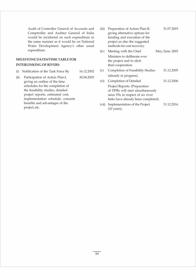
94
Audit of Controller General of Accounts andComptroller and Auditor General of Indiawould be incidental on such expenditure inthe same manner as it would be on NationalWater Development Agency’s other usualexpenditure.
MILESTONE DATES/TIME TABLE FOR
INTERLINKING OF RIVERS
(i) Notification of the Task Force By 16.12.2002
(ii) Participation of Action Plan-I, 30.04.2003giving an outline of the timeschedules for the completion ofthe feasibility studies, detailedproject reports, estimated cost,implementation schedule, concretebenefits and advantages of theproject, etc.
(iii) Preparation of Action Plan-II, 31.07.2003giving alternative options forfunding and execution of theproject as also the suggestedmethods for cost recovery.
(iv) Meeting with the Chief May/June 2003
Ministers to deliberate overthe project and to elicittheir cooperation.
(v) Completion of Feasibility Studies 31.12.2005
(already in progress).
(vi) Completion of Detailed 31.12.2006
Project Reports. (Preparationof DPRs will start simultaneouslysince FSs in respect of six riverlinks have already been completed).
(vii) Implementation of the Project 31.12.2016(10 years).
95
APPENDIX 2
NATIONAL WATER POLICY
(As adopted by National Water Resources Councilin its 5th meeting held on April 1, 2002)
Need for a National Water Policy
1.1 Water is a prime natural resource, a basic humanneed and a precious national asset. Planning,development and management of water resourcesneed to be governed by national perspectives.
1.2 As per the latest assessment (1993), out of thetotal precipitation, including snowfall, of around4000 billion cubic metre in the country, theavailability from surface water and replenishableground water is put at 1,869 billion cubic metre.Because of topographical and other constraints,about 60% of this, i.e., 690 billion cubic metre fromsurface water and 432 billion cubic metre fromground water, can be put to beneficial use.Availability of water is highly uneven in bothspace and time. Precipitation is confined to onlyabout three or four months in a year and variesfrom 100 mm in the western parts of Rajasthanto over 10,000 mm at Cherrapunji in Meghalaya.Rivers and underground aquifers often cut acrossState boundaries. Water, as a resource is one andindivisible: rainfall, river waters, surface pondsand lakes and ground water are all part of onesystem.
1.3 Water is part of a larger ecological system. Realisingthe importance and scarcity attached to the freshwater, it has to be treated as an essentialenvironment for sustaining all life forms.
1.4 Water is a scarce and precious national resourceto be planned, developed, conserved andmanaged as such, and on an integrated andenvironmentally sound basis, keeping in viewthe socio-economic aspects and needs of theStates. It is one of the most crucial elements indevelopmental planning. As the country hasentered the 21st century, efforts to develop,conserve, utilise and manage this important
resource in a sustainable manner, have to beguided by the national perspective.
1.5 Floods and droughts affect vast areas of thecountry, transcending State boundaries. One-sixtharea of the country is drought-prone. Out of 40million hectare of the flood prone area in thecountry, on an average, floods affect an area ofaround 7.5 million hectare per year. Approach tomanagement of droughts and floods has to be co-ordinated and guided at the national level.
1.6 Planning and implementation of water resourcesprojects involve a number of socio-economicaspects and issues such as environmentalsustainability, appropriate resettlement andrehabilitation of project-affected people andlivestock, public health concerns of waterimpoundment, dam safety, etc. Commonapproaches and guidelines are necessary on thesematters. Moreover, certain problems andweaknesses have affected a large number ofwater resources projects all over the country.There have been substantial time and costoverruns on projects. Problems of water loggingand soil salinity have emerged in some irrigationcommands, leading to the degradation ofagricultural land. Complex issues of equity andsocial justice in regard to water distribution arerequired to be addressed. The development, andoverexploitation of groundwater resources incertain parts of the country have raised theconcern and need for judicious and scientificresource management and conservation. All theseconcerns need to be addressed on the basis ofcommon policies and strategies.
1.7 Growth process and the expansion of economicactivities inevitably lead to increasing demandsfor water for diverse purposes: domestic, industrial,agricultural, hydro-power, thermal-power,navigation, recreation, etc. So far, the majorconsumptive use of water has been for irrigation.While the gross irrigation potential is estimated to
96
have increased from 19.5 million hectare at thetime of independence to about 95 million hectareby the end of the Year 1999-2000, furtherdevelopment of a substantial order is necessary ifthe food and fibre needs of our growing populationare to be met with. The country’s populationwhich is over 1,027 million (2001 AD) at presentis expected to reach a level of around 1,390 millionby 2025 AD. (Ministry of Water Resources, April 1,2002.
1.8 Production of food grains has increased fromaround 50 million tonnes in the fifties to about 208million tonnes in the Year 1999-2000. This willhave to be raised to around 350 million tonnes bythe year 2025 AD. The drinking water needs ofpeople and livestock have also to be met. Domesticand industrial water needs have largely beenconcentrated in or near major cities. However, thedemand in rural areas is expected to increasesharply as the development programmes improveeconomic conditions of the rural masses. Demandfor water for hydro and thermal power generationand for other industrial uses is also increasingsubstantially. As a result, water, which is alreadya scarce resource, will become even scarcer infuture. This underscores the need for the utmostefficiency in water utilisation and a publicawareness of the importance of its conservation.
1.9 Another important aspect is water quality.Improvements in existing strategies, innovation ofnew techniques resting on a strong science andtechnology base are needed to eliminate the pollutionof surface and ground water resources, to improvewater quality. Science and technology and traininghave to play important roles in water resourcesdevelopment and management in general.
1.10 National Water Policy was adopted in September,1987. Since then, a number of issues and challengeshave emerged in the development andmanagement of the water resources. Therefore,the National Water Policy (1987) has beenreviewed and updated.
Information System
2.1 A well developed information system, for waterrelated data in its entirety, at the national / statelevel, is a prime requisite for resource planning. Astandardised national information system shouldbe established with a network of data banks anddata bases, integrating and strengthening the
existing Central and State level agencies andimproving the quality of data and the processingcapabilities.
2.2 Standards for coding, classification, processing ofdata and methods/ procedures for its collectionshould be adopted. Advances in informationtechnology must be introduced to create a moderninformation system promoting free exchange ofdata among various agencies. Special effortsshould be made to develop and continuouslyupgrade technological capability to collect,process and disseminate reliable data in thedesired time frame.
2.3 Apart from the data regarding water availabilityand actual water use, the system should alsoinclude comprehensive and reliable projectionsof future demands of water for diverse purposes.
Water Resources Planning
3.1 Water resources available to the country shouldbe brought within the category of utilizableresources to the maximum possible extent.
3.2 Non-conventional methods for utilisation of watersuch as through inter-basin transfers, artificialrecharge of ground water and desalination ofbrackish or sea water as well as traditional waterconservation practices like rainwater harvesting,including roof-top rainwater harvesting, need tobe practiced to further increase the utilisablewater resources. Promotion of frontier researchand development, in a focused manner, for thesetechniques is necessary.
3.3 Water resources development and managementwill have to be planned for a hydrological unitsuch as drainage basin as a whole or for a sub-basin, multi-sectorally, taking into account surfaceand ground water for sustainable useincorporating quantity and quality aspects aswell as environmental considerations. Allindividual developmental projects and proposalsshould be formulated and considered within theframework of such an overall plan keeping inview the existing agreements/awards for a basinor a sub-basin so that the best possible combinationof options can be selected and sustained. (Ministryof Water Resources, April 1, 2002).
3.4 Watershed management through extensive soilconservation, catchment-area treatment,preservation of forests and increasing the forestcover and the construction of check-dams should
97
be promoted. Efforts shall be to conserve the waterin the catchment.
3.5 Water should be made available to water shortareas by transfer from other areas, includingtransfers from one river basin to another, based ona national perspective, after taking into accountthe requirements of the areas / basins.
Institutional Mechanism
4.1 With a view to give effect to the planning,development and management of the waterresources on a hydrological unit basis, alongwith a multi-sectoral, multi-disciplinary andparticipatory approach as well as integratingquality, quantity and the environmental aspects,the existing institutions at various levels underthe water resources sector will have to beappropriately reoriented/reorganised and evencreated, wherever necessary. As maintenance ofwater resource schemes is under non-plan budget,it is generally being neglected. The institutionalarrangements should be such that this vitalaspect is given importance equal or even morethan that of new constructions.
4.2 Appropriate river basin organisations should beestablished for the planned development andmanagement of a river basin as a whole or sub-basins, wherever necessary. Special multi-disciplinary units should be set up to preparecomprehensive plans taking into account notonly the needs of irrigation but also harmonisingvarious other water uses, so that the availablewater resources are determined and put tooptimum use having regard to existing agreementsor awards of Tribunals under the relevant laws.The scope and powers of the river basinorganisations shall be decided by the basin Statesthemselves.
Water Allocation Priorities
5. In the planning and operation of systems, waterallocation priorities should be broadly as follows:
Drinking water
Irrigation
Hydro-power
Ecology
Agro-industries and non-agricultural industries
Navigation and other uses.
However, the priorities could be modified or added ifwarranted by the area/region specific considerations.
Project Planning
6.1 Water resource development projects should as faras possible be planned and developed asmultipurpose projects. Provision for drinkingwater should be a primary consideration.
6.2 The study of the likely impact of a project duringconstruction and later on human lives,settlements, occupations, socio-economic,environment and other aspects shall form anessential component of project planning.
6.3 In the planning, implementation and operationof a project, the preservation of the quality ofenvironment and the ecological balance shouldbe a primary consideration. The adverse impacton the environment, if any, should be minimisedand should be offset by adequate compensatorymeasures. The project should, nevertheless, besustainable.
6.4 There should be an integrated and multi-disciplinary approach to the planning,formulation, clearance and implementation ofprojects, including catchment area treatmentand management, environmental and ecologicalaspects, the rehabilitation of affected people andcommand area development. The planning ofprojects in hilly areas should take into accountthe need to provide assured drinking water,possibilities of hydro-power development andthe proper approach to irrigation in suchareas, in the context of physical features andconstraints of the basin such as steep slopes,rapid run-off and the incidence of soil erosion.The economic evaluation of projects insuch areas should also take these factorsinto account.
6.5 Special efforts should be made to investigateand formulate projects either in, or for thebenefit of, areas inhabited by tribal or otherspecially disadvantaged groups such as sociallyweak, scheduled castes and scheduled tribes. Inother areas also, project planning should payspecial attention to the needs of scheduledcastes and scheduled tribes and other weakersections of the society. The economic evaluationof projects benefiting such disadvantagedsections should also take these factors intoaccount.

98
6.6 The drainage system should form an integral partof any irrigation project right from the planningstage.
6.7 Time and cost overruns and deficient realisation ofbenefits characterising most water related projectsshould be overcome by upgrading the quality ofproject preparation and management. Theinadequate funding of projects should be obviatedby an optimal allocation of resources on the basisof prioritisation, having regard to the earlycompletion of on-going projects as well as the needto reduce regional imbalances.
6.8 The involvement and participation of beneficiariesand other stakeholders should be encouragedright from the project planning stage itself.
Ground Water Development
7.1 There should be a periodical reassessment of theground water potential on a scientific basis,taking into consideration the qualit y of the wateravailable and economic viability of its extraction.
7.2 Exploitation of ground water resources should beso regulated as not to exceed the rechargingpossibilities, as also to ensure social equity. Thedetrimental environmental consequences ofoverexploitation of ground water need to beeffectively prevented by the Central and StateGovernments. Ground water recharge projectsshould be developed and implemented forimproving both the quality and availability ofground water resource.
7.3 Integrated and coordinated development ofsurface water and ground water resources andtheir conjunctive use, should be envisaged rightfrom the project planning stage and should forman integral part of the project implementation.
7.4 Over exploitation of ground water should beavoided especially near the coast to preventingress of seawater into sweet water aquifers.
Drinking Water
8. Adequate safe drinking water facilities should beprovided to the entire population both in urbanand in rural areas. Irrigation and multipurposeprojects should invariably include a drinkingwater component, wherever there is no alternativesource of drinking water. Drinking water needsof human beings and animals should be the firstcharge on any available water. (Ministry of WaterResources April 1, 2002).
Irrigation
9.1 Irrigation planning either in an individual projector in a basin as a whole should take into accountthe irrigability of land, cost-effective irrigationoptions possible from all available sources ofwater and appropriate irrigation techniques foroptimising water use efficiency. Irrigation intensityshould be such as to extend the benefits ofirrigation to as large a number of farm familiesas possible, keeping in view the need to maximiseproduction.
9.2 There should be a close integration of water-useand land-use policies.
9.3 Water allocation in an irrigation system shouldbe done with due regard to equity and socialjustice. Disparities in the availability of waterbetween head-reach and tail-end farms andbetween large and small farms should be obviatedby adoption of a rotational water distributionsystem and supply of water on a volumetric basissubject to certain ceilings and rational pricing.
9.4 Concerted efforts should be made to ensure thatthe irrigation potential created is fully utilised.For this purpose, the command area developmentapproach should be adopted in all irrigationprojects.
9.5.1 Irrigation being the largest consumer of freshwater, the aim should be to get optimal productivityper unit of water. Scientific water management,farm practices and sprinkler and drip system ofirrigation should be adopted wherever feasible.
9.6 Reclamation of water logged/saline affectedland by scientific and cost-effective methodsshould form a part of command area developmentprogramme.
Resettlement and Rehabilitation
10. Optimal use of water resources necessitatesconstruction of storages and the consequentresettlement and rehabilitation of population. Askeletal national policy in this regard needs to beformulated so that the project affected personsshare the benefits through proper rehabilitation.States should accordingly evolve their owndetailed resettlement and rehabilitation policiesfor the sector, taking into account the localconditions. Careful planning is necessary toensure that the construction and rehabilitationactivities proceed simultaneously and smoothly.
99
Financial and Physical Sustainability
11. Besides creating additional water resources facilitiesfor various uses, adequate emphasis needs to begiven to the physical and financial sustainabilityof existing facilities. There is, therefore, a need toensure that the water charges for various usesshould be fixed in such a way that they cover atleast the operation and maintenance charges ofproviding the service initially and a part of thecapital costs subsequently. These rates should belinked directly to the quality of service provided.The subsidy on water rates to the disadvantagedand poorer sections of the society should be welltargeted and transparent.
Participatory Approach to Water ResourcesManagement
12. Management of the water resources for diverseuses should incorporate a participatory approach;by involving not only the various governmentalagencies but also the users and other stakeholders,in an effective and decisive manner, in variousaspects of planning, design, development andmanagement of the water resources schemes.Necessary legal and institutional changes shouldbe made at various levels for the purpose, dulyensuring appropriate role for women. Water Users’Associations and the local bodies such asmunicipalities and gram panchayats shouldparticularly be involved in the operation,maintenance and management of waterinfrastructures/facilities at appropriate levelsprogressively, with a view to eventually transferthe management of such facilities to the usergroups / local bodies. (Ministry of Water Resources,April 1, 2002)
Private Sector Participation
13. Private sector participation should be encouragedin planning, development and management ofwater resources projects for diverse uses, whereverfeasible. Private sector participation may help inintroducing innovative ideas, generating financialresources and introducing corporate managementand improving service efficiency andaccountability to users. Depending upon thespecific situations, various combinations of privatesector participation in building, owning,operating, leasing and transferring of waterresources facilities may be considered.
Water Quality
14.1 Both surface water and ground water should beregularly monitored for quality. A phasedprogramme should be undertaken forimprovements in water quality.
14.2 Effluents should be treated to acceptable levelsand standards before discharging them intonatural streams.
14.3 Minimum flow should be ensured in the perennialstreams for maintaining ecology and socialconsiderations.
14.4 Principle of ‘polluter pays’ should be followed inmanagement of polluted water.
14.5 Necessary legislation is to be made for preservationof existing water bodies by preventingencroachment and deterioration of water quality.
Water Zoning
15. Economic development and activities includingagricultural, industrial and urban developmentshould be planned with due regard to theconstraints imposed by the configuration ofwater availability. There should be a waterzoning of the country and the economic activitiesshould be guided and regulated in accordancewith such zoning.
Conservation of Water
16.1 Efficiency of utilisation in all the diverse uses ofwater should be optimised and an awareness ofwater as a scarce resource should be fostered.Conservation consciousness should be promotedthrough education, regulation, incentives anddisincentives.
16.2 The resources should be conserved and theavailability augmented by maximising retention,eliminating pollution and minimising losses. Forthis, measures like selective linings in theconveyance system, modernisation andrehabilitation of existing systems including tanks,recycling and re-use of treated effluents andadoption of traditional techniques like mulchingor pitcher irrigation and new techniques like dripand sprinkler may be promoted, wherever feasible.
Flood Control and Management
17.1 There should be a master plan for flood controland management for each flood prone basin.

100
17.2 Adequate flood-cushion should be provided inwater storage projects, wherever feasible, tofacilitate better flood management. In highlyflood prone areas, flood control should be givenoverriding consideration in reservoir regulationpolicy even at the cost of sacrificing someirrigation or power benefits. (Ministry of WaterResources, April 1, 2002).
17.3 While physical flood protection works likeembankments and dykes will continue to benecessary, increased emphasis should be laid onnon-structural measures such as flood forecastingand warning, flood plain zoning and floodproofing for the minimisation of losses and toreduce the recurring expenditure on flood relief.
17.4 There should be strict regulation of settlementsand economic activity in the flood plain zonesalong with flood proofing, to minimise the loss oflife and property on account of floods.
17.5 The flood forecasting activities should bemodernised, value added and extended to otheruncovered areas. Inflow forecasting to reservoirsshould be instituted for their effective regulation.
Land Erosion by Sea or River
18.1 The erosion of land, whether by the sea in coastalareas or by river waters inland, should beminimised by suitable cost-effective measures.The States and Union Territories should alsoundertake all requisite steps to ensure thatindiscriminate occupation and exploitation ofcoastal strips of land are discouraged and that thelocation of economic activities in areas adjacentto the sea is regulated.
18.2 Each coastal State should prepare acomprehensive coastal land management plan,keeping in view the environmental and ecologicalimpacts, and regulate the developmental activitiesaccordingly.
Drought-Prone Area Development
19.1 Drought-prone areas should be made lessvulnerable to drought-associated problemsthrough soil moisture conservation measures,water harvesting practices, minimisation ofevaporation losses, development of the groundwater potential including recharging and thetransfer of surface water from surplus areas, wherefeasible and appropriate. Pastures, forestry orother modes of development, which are relatively
less water demanding, should be encouraged. Inplanning water resource development projects, theneeds of drought-prone areas should be givenpriority.
19.2 Relief works undertaken for providing employmentto drought-stricken population should preferablybe for drought proofing.
Monitoring of Projects
20.1 A close monitoring of projects to identify bottlenecksand to adopt timely measures to obviate time andcost overrun should form part of project planningand execution.
20.2 There should be a system to monitor and evaluatethe performance and socio-economic impact ofthe project.
Water Sharing /Distribution among the States
21.1 The water sharing/distribution amongst the Statesshould be guided by a national perspective withdue regard to water resources availability andneeds within the river basin. Necessary guidelines,including for water short States even outside thebasin, need to be evolved for facilitating futureagreements among the basin States.
21.2 The Inter-State Water Disputes Act of 1956 may besuitably reviewed and amended for timelyadjudication of water disputes referred to theTribunal.
Performance Improvement
22. There is an urgent need of paradigm shift in theemphasis in the management of water resourcessector. From the present emphasis on the creationand expansion of water resources infrastructuresfor diverse uses, there is now a need to givegreater emphasis on the improvement of theperformance of the existing water resourcesfacilities. Therefore, allocation of funds under thewater resources sector should be re-prioritisedto ensure that the needs for development aswell as operation and maintenance of the facilitiesare met.
Maintenance and Modernisation
23.1 Structures and systems created through massiveinvestments should be properly maintained ingood health. Appropriate annual provisionsshould be made for this purpose in the budgets.
101
23.2 There should be a regular monitoring of structuresand systems and necessary rehabilitation andmodernisation programmes should beundertaken.
23.3 Formation of Water Users’ Association withauthority and responsibility should be encouragedto facilitate the management includingmaintenance of irrigation system in a time boundmanner.
Safety of Structures
24. There should be proper organisationalarrangements at the national and state levels forensuring the safety of storage dams and otherwater-related structures consisting of specialistsin investigation, design, construction, hydrology,geology, etc. A dam safety legislation may beenacted to ensure proper inspection, maintenanceand surveillance of existing dams and also toensure proper planning, investigaton, design andconstruction for safety of new dams. TheGuidelines on the subject should be periodicallyupdated and reformulated. There should be asystem of continuous surveillance and regularvisits by experts.
Science and Technology
25. For effective and economical management of ourwater resources, the frontiers of knowledge needto be pushed forward in several directions byintensifying research efforts in various areas,including the following:
Hydrometeorology;
Snow and lake hydrology;
Surface and ground water hydrology;
River morphology and hydraulics;
Assessment of water resources;
Water harvesting and ground water recharge;
Water quality;
Water conservation;
Evaporation and seepage losses;
Recycling and re-use;
Better water management practices andimprovements in operational technology;
Crops and cropping systems;
Soils and material research;
New construction materials and technology(with particular reference to Roller-compactedconcrete, fib-reinforced concrete, newmethodologies in tunnelling technologies,instrumentation, advanced numerical analysisin structures and back analysis);
Seismology and seismic design of structures;
The safety and longevity of water-relatedstructures;
Economical designs for water resourceprojects;
Risk analysis and disaster management;
Use of remote sensing techniques indevelopment and management;
Use of static ground water resource as a crisismanagement measure;
Sedimentation of reservoirs;
Use of sea water resources;
Prevention of salinity ingress;
Prevention of water logging and soil salinity;
Reclamation of water logged and saline lands;
Environmental impact; and
Regional equity.
Training
26. A perspective plan for standardised trainingshould be an integral part of water resourcedvelopment. It should cover training in informationsystems, sectoral planning, project planning andformulation, project management, operation ofprojects and their physical structures and systemsand the management of the water distributionsystems. The training should extend to all thecategories of personnel involved in these activitiesas also the farmers.
Conclusion
27. In view of the vital importance of water forhuman and animal life, for maintainingecological balance and for economic anddevelopmental activities of all kinds, andconsidering its increasing scarcity, the planningand management of this resource and its optimal,economical and equitable use has become amatter of the utmost urgency. Concerns of thecommunity needs to be taken into account for

102
water resources development and management.The success of the National Water Policy willdepend entirely on evolving and maintaining anational consensus and commitment to itsunderlying principles and objectives. To achievethe desired objectives, State Water Policy backedwith an operational action plan shall beformulated in a time bound manner say in twoyears. National Water Policy may be revisedperiodically as and when need arises.
National Water Policy, 1987
The need for a National Water Policy (NWP) stated:“Water is a scarce and precious national resource tobe planned, developed and conserved as such, andon an integrated and environmentally sound basis,keeping in view the needs of the States concerned.”This policy was approved by the `National WaterResources Council’ (NWRC) in the meeting held in1987 under the chairmanship of the Prime Ministerof India, with participation by the Chief Ministers ofthe States and Administrators of Union Territories asmembers. The NWRC is an ‘Apex body’ to evolveNational Water Policy for the development and use ofWater Resources, in conformity with National interests.The National Water Policy has stated that Resourceplanning in the case of water has to be done for ahydrological unit such as a drainage basin as whole,or for a sub-basin.
All individual developmental projects and proposalsshould be formulated by the States and consideredwithin the framework of such an overall plan for abasin or a sub-basin, so that the best possible combinationof options can be made.” In the National Water Policy,water allocation priorities have been recommended asfollows:
Drinking water
Irrigation
Hydropower
Navigation
Industrial and other uses
The policy suggests an adjustment to suit particularregions (area specific considerations) and that drinkingwater needs of human beings and animals should bethe first charge on any available water. It further states:“Irrigation and multi purpose projects should invariablyinclude a drinking water component, wherever there isno alternative source of drinking water.” With regard toIrrigation, the policy document states: “There should bea close integration of water-use and land-use policies.
Water allocation in an irrigation system should be donewith due regard to equity and social justice.” No detailson the division of waters between the States werediscussed in the Policy paper.
National Water Policy (as Adopted in April, 2002)
National Water Policy was adopted in September 1987.Since then a number of issues and challenges haveemerged in the development and management of thewater resources. Therefore, the National Water Policy(1987) has been reviewed and updated, which states:“Water is a prime natural resource, a basic human needand a precious national asset. Planning developmentand management of water resource need to be governedby national perspectives. Realising the importance andscarcity attached to the fresh water, it has to be treatedas an essential environment for sustaining all lifeforms.”
As the country has entered the 21st century, effortsto develop, conserve, utilise and manage this importantresource in a sustainable manner have to be guided bythe national perspective. Approach to management ofdrought and floods has to be coordinated and guidedat the national level. The development and over-exploitation of ground water resources in certain partsof the country have raised the concern and need forjudicious and scientific resource management andconservation.
The demand in the rural areas is expected toincrease sharply as the development programmesimprove economic conditions of the rural masses.Demand for water for hydro and thermal powergeneration and for the other industrial uses is alsoincreasing substantially. As a result, water, which isalready a scarce resource, will become even scarce inthe future. This underscores the need for utmostefficiency in water utilization and public awareness. Inthe planning and operation of systems, water allocationpriorities should be broadly as follows:
Drinking Water
Irrigation
Hydropower
Ecology
Agro Industries and non-agricultrual Industries
Navigation and other uses.
However, the priorities could be modified or added ifwarranted by the area or region specific consideration.
(The full text of the National Water Policy 2002 isgiven in the Appendix 2).
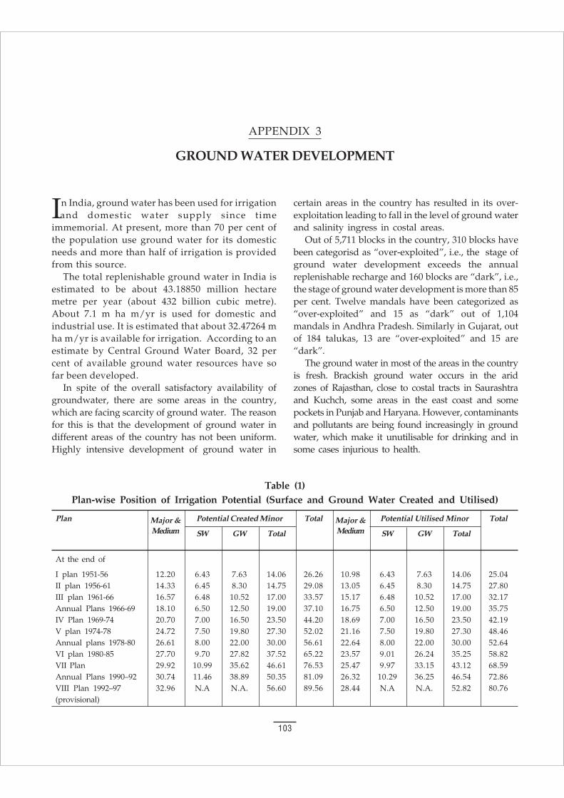
103
In India, ground water has been used for irrigationand domestic water supply since time
immemorial. At present, more than 70 per cent ofthe population use ground water for its domesticneeds and more than half of irrigation is providedfrom this source.
The total replenishable ground water in India isestimated to be about 43.18850 million hectaremetre per year (about 432 billion cubic metre).About 7.1 m ha m/yr is used for domestic andindustrial use. It is estimated that about 32.47264 mha m/yr is available for irrigation. According to anestimate by Central Ground Water Board, 32 percent of available ground water resources have sofar been developed.
In spite of the overall satisfactory availability ofgroundwater, there are some areas in the country,which are facing scarcity of ground water. The reasonfor this is that the development of ground water indifferent areas of the country has not been uniform.Highly intensive development of ground water in
certain areas in the country has resulted in its over-exploitation leading to fall in the level of ground waterand salinity ingress in costal areas.
Out of 5,711 blocks in the country, 310 blocks havebeen categorisd as “over-exploited”, i.e., the stage ofground water development exceeds the annualreplenishable recharge and 160 blocks are “dark”, i.e.,the stage of ground water development is more than 85per cent. Twelve mandals have been categorized as“over-exploited” and 15 as “dark” out of 1,104mandals in Andhra Pradesh. Similarly in Gujarat, outof 184 talukas, 13 are “over-exploited” and 15 are“dark”.
The ground water in most of the areas in the countryis fresh. Brackish ground water occurs in the aridzones of Rajasthan, close to costal tracts in Saurashtraand Kuchch, some areas in the east coast and somepockets in Punjab and Haryana. However, contaminantsand pollutants are being found increasingly in groundwater, which make it unutilisable for drinking and insome cases injurious to health.
APPENDIX 3
GROUND WATER DEVELOPMENT
Table (1)Plan-wise Position of Irrigation Potential (Surface and Ground Water Created and Utilised)
Plan Major & Potential Created Minor Total Major & Potential Utilised Minor Total
Medium SW GW Total Medium SW GW Total
At the end of
I plan 1951-56 12.20 6.43 7.63 14.06 26.26 10.98 6.43 7.63 14.06 25.04II plan 1956-61 14.33 6.45 8.30 14.75 29.08 13.05 6.45 8.30 14.75 27.80III plan 1961-66 16.57 6.48 10.52 17.00 33.57 15.17 6.48 10.52 17.00 32.17Annual Plans 1966-69 18.10 6.50 12.50 19.00 37.10 16.75 6.50 12.50 19.00 35.75IV Plan 1969-74 20.70 7.00 16.50 23.50 44.20 18.69 7.00 16.50 23.50 42.19V plan 1974-78 24.72 7.50 19.80 27.30 52.02 21.16 7.50 19.80 27.30 48.46Annual plans 1978-80 26.61 8.00 22.00 30.00 56.61 22.64 8.00 22.00 30.00 52.64VI plan 1980-85 27.70 9.70 27.82 37.52 65.22 23.57 9.01 26.24 35.25 58.82VII Plan 29.92 10.99 35.62 46.61 76.53 25.47 9.97 33.15 43.12 68.59Annual Plans 1990–92 30.74 11.46 38.89 50.35 81.09 26.32 10.29 36.25 46.54 72.86VIII Plan 1992–97 32.96 N.A N.A. 56.60 89.56 28.44 N.A N.A. 52.82 80.76(provisional)
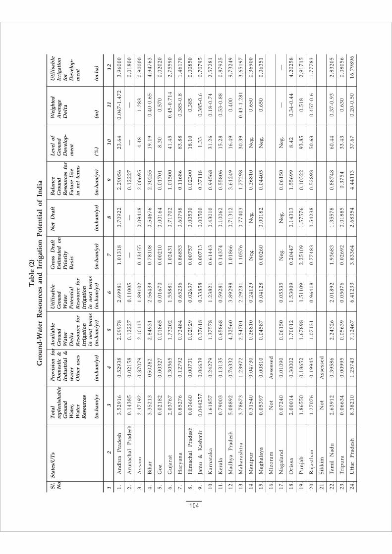
104
Tab
le (
2)G
roun
d-W
ater
Res
ourc
es a
nd I
rrig
atio
n Po
tent
ial
of I
ndia
Sl.
Stat
es/U
Ts
Tot
alPr
ovis
ion
for
Ava
ilab
leU
tili
sab
leG
ross
D
raft
Net
Dra
ftB
alan
ceLe
vel
ofW
eigh
ted
Uti
lisa
ble
No
repl
enis
habl
eD
omes
tic
&G
roun
dG
roun
dEs
tim
ated
on
Gro
und
Gro
und
Ave
rage
Irri
gati
onG
roun
dIn
dust
rial
&W
ater
Wat
erP
rior
ity
Res
ourc
es f
orD
evel
op-
Del
tafo
rW
ater
,w
ater
Del
taP
oten
tial
Bas
isFu
ture
Use
men
tD
evel
op-
Wat
erO
ther
use
sR
esou
rce
for
Res
ourc
e fo
rin
net
ter
ms
men
tR
esou
rces
irri
gati
onir
riga
tion
in n
ext
term
sin
nex
t te
rms
(m.h
am/y
r(m
.ham
/yr)
(m.h
am/y
r)(m
.ham
/yr)
(m.h
am/y
r)(m
.ham
/yr)
(m.h
am/y
r)(%
)(m
)(m
.ha)
12
34
56
78
91
011
12
1.A
ndhr
a P
rad
esh
3.52
916
0.52
938
2.09
978
2.69
981
1.01
318
0.70
922
2.29
056
23.6
40.
047-
1.47
23.
9600
0
2.A
runa
chal
P
rad
esh
0.14
385
0.02
158
0.12
227
0.11
005
——
0.12
227
——
0.01
800
3.A
ssam
2.47
192
0.37
079
2.10
113
1.89
102
0.13
455
0.09
418
2.00
695
4.48
1.28
30.
9000
0
4.B
ihar
3.35
213
0502
822.
8493
12.
5643
90.
7810
80.
5467
62.
3025
519
.19
0.40
-0.6
54.
9476
3
5.G
oa0.
0218
20.
0032
70.
0186
50.
0167
00.
0021
00.
0016
40.
0170
18.
300.
570
0.02
020
6.G
uja
rat
2.03
767
0.30
565
1.73
202
1.55
881
1.02
431
0.71
702
1.01
500
41.4
50.
45-0
.714
2.75
590
7.H
arya
na
0.85
276
0.12
792
0.72
484
0.65
236
0.86
853
0.60
798
0.11
686
83.8
80.
385-
0.8
1.46
170
8.H
imac
hal
Pra
des
h0.
0366
00.
0073
10.
0292
90.
0263
70.
0075
70.
0053
00.
0230
018
.10
0.38
50.
0085
0
9.Ja
mu
&
K
ashm
ir0.
0442
570.
0663
90.
3761
80.
3385
80.
0071
30.
0050
00.
3711
81.
330.
385-
0.6
0.70
795
10.
Kar
nat
aka
1.61
857
0.24
279
1.37
578
1.23
821
0.61
443
0.43
010
0.94
568
31.2
60.
18-0
.74
2.57
281
11.
Ker
ala
0.79
003
0.13
135
0.65
868
0.59
281
0.14
374
0.10
062
0.55
806
15.2
80.
53-0
.88
0.87
925
12.
Mad
hya
Pra
des
h5.
0889
20.
7633
24.
3256
03.
8929
81.
0186
60.
7131
23.
6124
916
.49
0.40
09.
7324
9
13.
Mah
aras
htr
a3.
7867
31.
2397
22.
5470
12.
2923
11.
1057
60.
7740
31.
7729
830
.39
0.43
-1.2
813.
6519
7
14.
Man
ipu
r0.
3154
00.
0473
00.
2681
00.
2412
9N
eg.
Neg
.0.
2681
0N
eg.
0.65
00.
3690
0
15.
Meg
hal
aya
0.05
397
0.00
810
0.04
587
0.04
128
0.00
260
0.00
182
0.04
405
Neg
.0.
650
0.06
351
16.
Miz
oram
Not
Ass
esse
d
17.
Nag
alan
d0.
0724
00.
0109
00.
0615
00.
0553
5N
eg.
Neg
.0.
0615
0N
eg.
——
18.
Ori
ssa
2.00
014
0.30
002
1.70
012
1.53
009
0.20
447
0.14
313
1.55
699
8.42
0.34
-0.4
44.
2025
8
19.
Pu
nja
b1.
8655
00.
1865
21.
6789
81.
5110
92.
2510
91.
5757
60.
1032
293
.85
0.51
82.
9171
5
20.
Raj
asth
an1.
2707
60.
1994
51.
0713
10.
9641
80.
7748
30.
5423
80.
5289
350
.63
0.45
7-0.
61.
7778
3
21.
Sikk
imN
otA
sses
sed
22.
Tam
il N
adu
2.63
912
0.39
586
2.24
326
2.01
892
1.93
683
1.35
578
0.88
748
60.4
40.
37-0
.93
2.83
205
23.
Tri
pu
ra0.
0663
40.
0099
50.
0563
90.
0507
60.
0269
20.
0188
50.
3754
33.4
30.
630
0.08
056
24.
Utt
ar
Pra
des
h8.
3821
01.
2574
37.
1246
76.
4123
33.
8336
42.
6835
44.
4411
337
.67
0.20
-0.5
016
.798
96
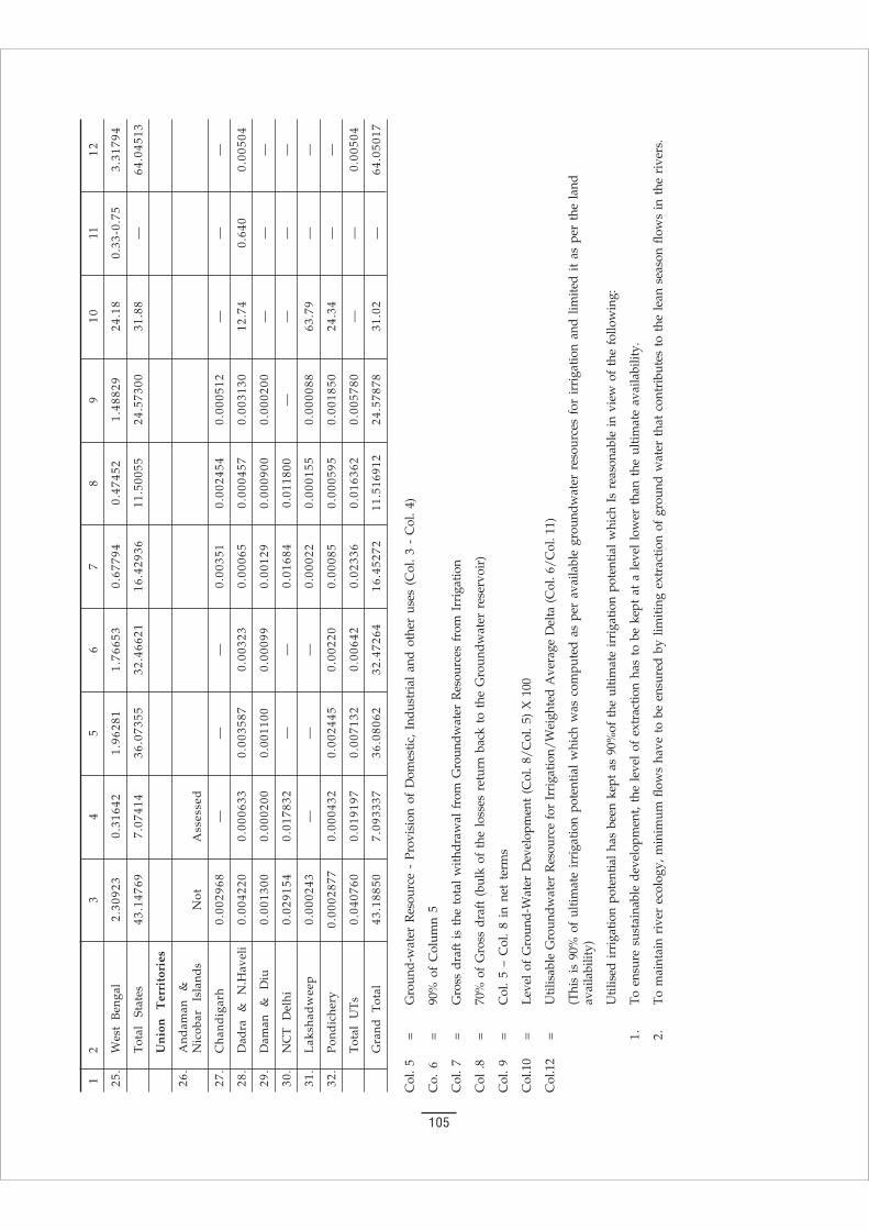
105
12
34
56
78
91
011
12
25.
Wes
t B
enga
l2.
3092
30.
3164
21.
9628
11.
7665
30.
6779
40.
4745
21.
4882
924
.18
0.33
-0.7
53.
3179
4
Tot
al
Stat
es43
.147
697.
0741
436
.073
5532
.466
2116
.429
3611
.500
5524
.573
0031
.88
—64
.045
13
Un
ion
T
erri
tori
es
26.
And
aman
&
Nic
obar
Is
land
sN
otA
sses
sed
27.
Cha
ndig
arh
0.00
2968
——
—0.
0035
10.
0024
540.
0005
12—
——
28.
Dad
ra
&
N.H
avel
i0.
0042
200.
0006
330.
0035
870.
0032
30.
0006
50.
0004
570.
0031
3012
.74
0.64
00.
0050
4
29.
Dam
an
&
Diu
0.00
1300
0.00
0200
0.00
1100
0.00
099
0.00
129
0.00
0900
0.00
0200
——
—
30.
NC
T D
elhi
0.02
9154
0.01
7832
——
0.01
684
0.01
1800
——
——
31.
Lak
shad
wee
p0.
0002
43—
——
0.00
022
0.00
0155
0.00
0088
63.7
9—
—
32.
Pon
dic
hery
0.00
0287
70.
0004
320.
0024
450.
0022
00.
0008
50.
0005
950.
0018
5024
.34
——
Tot
al
UT
s0.
0407
600.
0191
970.
0071
320.
0064
20.
0233
60.
0163
620.
0057
80—
—0.
0050
4
Gra
nd T
otal
43.1
8850
7.09
3337
36.0
8062
32.4
7264
16.4
5272
11.5
1691
224
.578
7831
.02
—64
.050
17
Col
. 5
=G
roun
d-w
ater
Res
ourc
e -
Prov
isio
n of
Dom
estic
, In
dust
rial
and
oth
er u
ses
(Col
. 3
- C
ol.
4)
Co.
6=
90%
of
Col
umn
5
Col
. 7
=G
ross
dra
ft i
s th
e to
tal
with
draw
al f
rom
Gro
undw
ater
Res
ourc
es f
rom
Irr
igat
ion
Col
.8
=70
% o
f G
ross
dra
ft (
bulk
of
the
loss
es r
etur
n ba
ck t
o th
e G
roun
dwat
er r
eser
voir
)
Col
. 9
=C
ol.
5 –
Col
. 8
in n
et t
erm
s
Col
.10
=Le
vel
of G
roun
d-W
ater
Dev
elop
men
t (C
ol. 8
/Col
. 5)
X 1
00
Col
.12
=U
tilis
able
Gro
undw
ater
Res
ourc
e fo
r Ir
riga
tion/
Wei
ghte
d A
vera
ge D
elta
(C
ol. 6
/Col
. 11)
(Thi
s is
90%
of
ultim
ate
irri
gatio
n po
tent
ial
whi
ch w
as c
ompu
ted
as p
er a
vaila
ble
grou
ndw
ater
res
ourc
es f
or i
rrig
atio
n an
d lim
ited
it as
per
the
lan
dav
aila
bilit
y)
Util
ised
irr
igat
ion
pote
ntia
l ha
s be
en k
ept
as 9
0%of
the
ulti
mat
e ir
riga
tion
pote
ntia
l w
hich
Is
reas
onab
le i
n vi
ew o
f th
e fo
llow
ing:
1.To
ens
ure
sust
aina
ble
deve
lopm
ent,
the
leve
l of
ext
ract
ion
has
to b
e ke
pt a
t a
leve
l lo
wer
tha
n th
e ul
timat
e av
aila
bilit
y.
2.To
mai
ntai
n ri
ver
ecol
ogy,
min
imum
flo
ws
have
to
be e
nsur
ed b
y lim
iting
ext
ract
ion
of g
roun
d w
ater
tha
t co
ntri
bute
s to
the
lea
n se
ason
flo
ws
in t
he r
iver
s.

106
Table 10(3)Categorisation of Blocks/Mandals/Talukas/Watersheds as Overexploited and Dark on all India Basis
Sl. States/UTs No. of No. of blocks/Taluks/ Mandals/Watersheds
No Blocks/Mandal/ Over-exploited DarkTaluks/Watersheds No. % No. %
States
1 Andhra Pradesh 1,104 12 1.09 14 1.27
2 Arunachal Pradesh 0 0 0.00 0 0.00
3 Assam 134 0 0.00 0 0.00
4 Bihar 589 3 0.51 9 1.53
5 Goa 12 0 0.00 0 0.00
6 Gujarat 184 13 7.07 15 8.15
7 Haryana 108 33 30.56 8 7.41
8 Himachal Pradesh 69 0 0.00 0 0.00
9 Jammu & Kashmir 123 0 0.00 0 0.00
10 Karnataka 175 7 4.00 9 5.14
11 Kerala 154 0 0.00 0 0.00
12 Madhya Pradesh 459 2 0.44 1 0.22
13 Maharashtra 231 2 0.87 6 2.60
14 Manipur 26 0 0.00 0 0.00
15 Meghalaya 29 0 0.00 0 0.00
16 Mizoram 20 0 0.00 0 0.00
17 Nagaland 21 0 0.00 0 0.00
18 Orissa 314 4 1.27 4 1.27
19 Punjab 138 72 52.17 11 7.97
20 Rajasthan 236 74 31.36 20 8.47
21 Sikkim 4 0 0 0 0
22 Tamil Nadu 384 64 16.67 39 10.16
23 Tripura 17 0 0.00 0 0.00
24 Uttar Pradesh 819 19 2.32 21 2.56
25 West Bengal 341 0 0.00 1 0.29
Total States 5,691 305 158
Union Territories
1 Andaman & Nicobar 0 0 0 0 0
2 Chandigarh 0 0 0 0 0
3 Dadar & Nagar Haveli 0 0 0 0 0
4 Daman & Diu 2 1 50.00 1 50.00
5 NCT Delhi 5 3 60.00 1 20.00
6 Lakshdweep 9 0 0.00 0 0.00
7 Pondicherry 4 1 25.00 0 0.00
Total UTs 20 5 2
Grand Total 5,711 310 160
107
Sujalam: Living WatersThe Impact of the River Linking Project
© Navdanya
First edition : April 2003Second edition : November 2003
Vandana ShivaKunwar Jalees
Published by:
NAVDANYAA-60, Hauz Khas, New Delhi-110016Tel.: +91-11-26968077, 26853772, 26561868Telefax: +91-11-26856795, 26562093E-mail: [email protected];
[email protected]: http://www.vshiva.net
Printed by:
SYSTEMS VISIONA-199, Okhla Industrial Area-I,New Delhi-110020
------ lqtyke~ lqQyke~ ey;t 'khryke~'kL; ';keyke~ ekrje~oUns ekrje~A
------ foUè; fgekpy ;equk xaxkmPNy tyfèk rjax
Contents1 Introduction ............................................................................. 1
2 The Financial Cost .................................................................. 4
3 Proposed National Plan for Interlinking of Rivers .......... 6
4 RIVER BASINS ...................................................................... 12
(a) Major River Basins in India ........................................ 12
(b) Features of Main River Basins ................................... 15(i) Ganga Basin ........................................................... 15(ii) The Yamuna Basin ............................................... 21(iii) Cauvery Basin ....................................................... 21(iv) Godavari Basin ...................................................... 26(v) Krishna Basin ........................................................ 29(vi) Mahanadi Basin ..................................................... 31
(c) Linking the Ganga to the YamunaA case study in River linking ..................................... 33
5 FOOD AND WATER SECURITY ....................................... 39
(a) Prudent use of Water and Livelihood ...................... 39
(b) Major Irrigation Projects ............................................. 42
(c) Major Dams .................................................................. 45
6 WATER RIGHTS ................................................................... 56
(a) Whom Does Water Belong to? .................................. 56
(b) Water Laws ................................................................... 60
(c) Water Conflicts ............................................................. 63(i) International Conflicts ......................................... 63(ii) Inter-State Conflicts .............................................. 66(iii) Centre State Conflicts .......................................... 70(iv) State vs People ..................................................... 71(v) People vs People .................................................. 72(vi) Potential of Future Conflicts with China ......... 72
7 Unassessed Cost & Unanswered Questions .................... 73Peoples National Water Forum ................................. 76Jal Suraksha, Adhikar, Mukti Declaration ................ 80Action Plan .................................................................... 81Jal Yatra .......................................................................... 82
8 References .............................................................................. 84
9 Appendices ............................................................................ 85(i) Supreme Court on Interlinking of Rivers ............... 85(ii) National Water Policy .................................................. 95(iii) Ground Water Development .................................... 103