Embed Size (px)
Citation preview
Journal of Geodesy and Geomatics Engineering 1 (2014) 1-10
Nature Conservation and Biodiversity Monitoring
through a Spatial Data Infrastructure
Cristina Oana, Cristian Vasile and Simona Ipate (Staiculescu)
Esri Romania, Bucharest 011774, Romania
Abstract: One of the main concerns of the European Union environment policy is the deterioration of natural habitats and the threats posed to certain species under the Habitat Directive. With its huge diversity of plant and animal species and high level of endemism, Romania is nominated as a European biodiversity hotspot. Biodiversity is being lost at a dramatic rate unless strategically conservation measurements are taken. Halting the loss of biodiversity is regarded as a priority to the European Member States which are encouraged to work together within the same strong legislative framework in order to protect our most vulnerable species and habitat types. Romania is also in the process of developing the Spatial Data Infrastructure in response to Geographic Information 2000 Initiative launched by the European Commission in 1996 and the INSPIRE (Infrastructure for Spatial Information in Europe) initiative launched in 2001. The focus of this article is the development of the geospatial architecture framework and applications required for efficient inventory and mapping of natural habitats and wild species of community interest. Implementing a biodiversity geoportal application is seen as critical in order to help users share the geospatial information in the environment and sustainable development sectors.
Key words: Geoportals, biodiversity, INSPIRE, metadata, standards.
1. Introduction
The natural heritage of the Carpathians and Danube
basin is highly important for the entire Europe due to
its unique flora, fauna, climate and landscape. As
many plants and animal species are under pressure due
to the habitat fragmentation and excessive exploitation
of the natural resources, Romania is considered one of
the European countries with the highest number of
endangered species. From the European perspective, Romania has to
ensure the establishment of Natura2000 network in
accordance to the Birds and Habitats Directives and to
prepare important protection measures for the
community interest sites. The management of
Natura2000 network is closely related to the natural
protected areas, therefore an appropriate management
and monitoring system has to be developed and
implemented for these areas.
Corresponding author: Cristina Oana, Ph.D., research
fields: GIS, GPS, Inspire, geospatial standards and biodiversity. E-mail: [email protected].
In the context of EU legislation, as a response to the
European Union Directives, regarding the reports on
biodiversity conservation in all Member States
Protected Areas (Article 6, Habitats Directive, 1992;
Articles 9 and 12, Birds Directive, 2009), assessing
the need for biodiversity information has been
addressed by managers of protected areas, scientists,
decision makers, researchers and many others. Most
of these people involved in work related to protected
areas are aware that the absence of reliable spatial
information can have the most serious consequences
for the understanding of biodiversity and for decision
making, which has been accessible to all interested
parties and integrated with other relevant information.
However, the situation is still critical, because usually
the current biodiversity data are available as text
documents, although the biodiversity data needed to
meet the conservation strategy should be centralized
in the form of geospatial databases and shared and
disseminated in order to allow interoperability and
interconnection between networks. This is where the
D DAVID PUBLISHING
Nature Conservation and Biodiversity Monitoring through a Spatial Data Infrastructure
2
ability of using webGIS and geoportal technologies as
a tool to monitor the habitat changes, to track wildlife
demographics, to predict future land and resources, to
use and share all this results according to the EU
policies, is essential to conservation goals and
practices.
Directive 2007/2/EC of the European Parliament
and of the Council of 14 March 2007 establishing an
INSPIRE (Infrastructure for Spatial Information in
Europe) entered into force on May 15 2007 and is
operated by the 27 Member States of the European
Union. The transposition into the Romanian
legislation was January 2010 and was published in the
Romanian Official Journal on January 29, 2010—OG1
04/2010. In the context of INSPIRE, an open and
transparent process for the national stakeholder
participation has been set up. Stakeholders are part of
the INIS (National Infrastructure for Spatial
Information) Council, which is under the coordination
of the National Cadaster Agency and Land
Registration as a Legal Mandated Organization in
INSPIRE. INIS Council includes 19 organizations
which are composed of Technical Working Groups
experts for developing the technical specifications for
each spatial theme in annexes which they are
personally responsible for. Ministry of Environment
and Climate Changes plays also a central role as Vice
President of the INIS 2 Council in reviewing and
testing the draft implementing rules and in assessing
their potential impact in respects to both costs and
benefits.
To accomplish all these goals, we have built a
geoportal application which provides added benefits to
the management of the natural protected areas and
biodiversity decision makers and offers improved data
for other projects in this environmental sector and for
our National Spatial Data Infrastructure.
1 Information can be found on http://eur-lex.europa.eu/LexUriServ/LexUriServ.do?uri=CELEX:72007L0002:EN:NOT#FIELD_RO. 2 INIS—National Infrastructure for Spatial Information in accordance to OG 04/2010, article 1, section 1.
2. The Challenge
Europe has established an extensive network of
protected areas to help protect endangered species and
habitat types. However, widespread alterations of the
landscape coupled with degradation of ecosystems
have prevented the EU from meeting its target of
halting biodiversity loss by 2010. At this moment, it
does not exist a standard and uniform information
system that would allow us differentiation of the
specific conservation measures, monitoring and
implementation of the management activities and
adjustments of the adaptive management percepts.
Romania’s natural capital is important for the
European Union due to rich flora and fauna and the
climate landscape offered by the
Carpathian-Danubian-Pontic area. Romania has a high
diversity of flora and fauna. However, there are many
species of plants and animals endangered because of
habitat fragmentation and overexploitation of natural
resources, combined with pressures caused by
economic development. Romania’s natural capital,
due to the biogeographic conditions, still contains a
very marked effect of number of species that are
classified as rare or endangered in Europe and
worldwide.
Developing the management and monitoring
framework of the protected areas, and especially
Natura2000 sites will trigger several actions, such as
the development of the administrative structures, the
development/revision of management plans for
protected areas, the implementation of specific
infrastructure, the preparation of specific scientific
studies, inventory, mapping, undertaking special
measures to conserve species and natural habitats,
information campaigns and public awareness, and
other actions.
Unitary systems are developed at the European
level in terms of monitoring methodologies and
strategies of environment reporting. UK has already
developed and implemented a Common Standards
Monitoring system to obtain and maintain Favorable
Nature Conservation and Biodiversity Monitoring through a Spatial Data Infrastructure
3
Conservation Status for all Natura2000 sites. France
and Germany have also established the monitoring
and reporting schemes without implementation of a
standard system. Nevertheless, Romania is in the
process of implementing a series of projects belonging
to the SOP ENV (Sectorial Operational Program
“Environment”), projects that are focused on
inventorying and mapping natural habitats and wild
species of community interest for the major natural
protected areas.
Regarding our technical challenges, very few
people understand or use the complexity of the
technical documentation of the INSPIRE architecture
and implementation of the technical specifications for
each spatial theme in annexes which they are
responsible for. Even using the guidelines for the
creation of metadata files that are compliant both with
the INSPIRE Implementing Rules for Metadata as
well as with relevant European and international
standards for geographic information represents a
technical challenge at this moment. The capacity to
sustain the training process, technical competencies,
consistence of training materials and translation into
Romanian language have to be built up by the
Ministry of Environment and Climate Changes and
national, regional and local authorities and
stakeholders. There have been significant efforts in
respect to the IT infrastructures to sustain coordination
of the INSPIRE activities.
Another important challenge is to maintain a high
level of commitment of all targeted user groups:
Ministry of Environment and Climate Changes,
National, Regional and Local Agency for the
environment protection, custodians and other experts
to contribute to the development of an appropriate
management and monitoring system. This is not trivial
and requires a notable amount of expertise, money,
time and commitment as resources to ensure a more
effective implementation. The difficult financial
climate of this period makes it potentially more
challenging to support investments in new IT
infrastructures, education and training services.
We do consider that our biodiversity geoportal
application will act as a foundation for producing,
sharing and consuming biodiversity and natural
heritage geospatial information, improving decision
making and operations with respect to these issues
that are affecting also Europe as a whole.
3. Case Study
This study focuses on only one of the Romanian
protected areas, but could be successfully applied in
many other related projects, as it describes a complete
solution to collecting, centralizing, analyzing and
sharing biodiversity data and new field data in a
standardized mode, in order to address biodiversity
assessment and monitoring purposes. Based on a
webGIS approach, the study outputs a geospatial
biodiversity monitoring system, adopted by many
protected areas in Romania, which integrates: (1) a
centralized database of biodiversity information
related to the study area, which supports thematic
maps and many other cartographic products; (2) the
analysis methodology that allows to assess the key
characteristics and the conservation status, which
designate the area as protected; and (3) a geoportal
application which is ensuring interoperability and
expanding the access to biodiversity geospatial data,
maps, metadata, web services and applications as part
of the Romanian National Spatial Infrastructure.
Standardized set of reports, presentations and graphics
has been created for each component of the system,
based on the Common Monitoring Standards [1].
The site related to this case-study represents a
11.300 ha protected area named Siriu, located in the
northern part of Buzau County, in Romania and
managed by the Administration of Buzau County
Council. The area was officially declared as a
protected site, by the order of the Ministry of
Environment No. 1964/2007, regarding the
declaration of protected sites as integrated part of
NATURA2000 European ecological network.
Nature Conservation and Biodiversity Monitoring through a Spatial Data Infrastructure
4
4. Biodiversity Geodatabase for ROSCI0229
Most of the data related to this studied protected
area were missing or lacking information and proved
to be very challenging also for us. First of all, there is
no country that has a comprehensive species list for
any of the species-rich groups, and, furthermore, the
costs of undertaking the preparation of such a list,
which generally requires work from scratch, will
generally be prohibitive. Secondly, background data
(topographical data) and data needed for the
morphometric analysis were missing or were out of
date. Data sources that we had to gather fall into the
following categories: (1) catalogues covering the
literature of entities names including countries of
origin and updating issues; (2) checklists and biotas
(floras and faunas), which are complementary tools
that provide a basis for a full account of species
including descriptions and keys; (3) the associations
between plants species and habitats; (4) topographic
data; (5) administrative data; (6) land cover data; (7)
EEA (European Environment Agency) reference grids
[2]—with different cell sizes used to mark the
presence/absence of species or habitat; (8) soil data; (9)
geology data; (10) data needed for morphometric
analysis (slope, curvature, aspect, altitude); (11)
landsat imagery—used for classification; (12)
currently available aerial photo—for feature extraction,
and other resources.
The first next step was to gather all the above
necessary information, using EEA automation tools
where possible (such as importing or loading from
different formats to GIS known formats), GIS spatial
analysis tools (to create slope, aspect, flow direction,
curvature rasters) or just basic GIS data collection
tools (to digitize features or manually collect attribute
data related to species and habitats). For this purpose,
we manually collected the list of species and habitats
with specific descriptions, codes and groups or
associations, using the Romanian Manual for
Interpretation of EU Habitats, and other Natura2000
documentation [3].
The data were sorted according to a type as spatial
or non-spatial in a geodatabase structure, designed
using ArcGIS software according to the data
specifications of INSPIRE Directive—Annex I [4].
The attributes and non-spatial data were associated
within the geospatial database as appropriate [5].
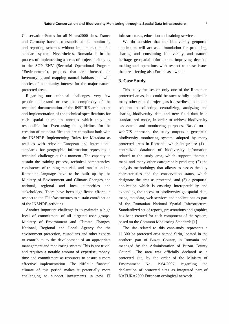
The geodatabase schema (Fig. 1) includes the
following geospatial themes: land cover, hydrography,
morphology, transportation, soils, geology,
biodiversity; habitats and species threats areas; field
surveys on habitats and species threats, etc.; EEA grid
reference system, and non-spatial tables (habitats,
species, plants association).
The ROSCI0229 geodatabase schema was properly
optimized in order to support all our project
workflows. The available data were migrated into the
geodatabase schema and using a Microsoft SQL Server
Fig. 1 ROSCI0229 Siriu—biodiversity geodatabase physical model.
Nature Conservation and Biodiversity Monitoring through a Spatial Data Infrastructure
5
database tied to ArcGIS; a GIS repository was created
for the whole studied area, consolidating data from
disparate sources and formats. Implementing this
enterprise geodatabase is a big step ahead for the
evolution of this type of projects, ensuring
interoperability and enabling accessibility to other
environmental users.
We have implemented some QA/QC (Quality
Assurance and Quality Control) mechanisms in order
to ensure the accuracy and quality of the existing and
acquired data from the field. The QA/QC process
included two phases: an automatic data check and a
visual data check. The data validation process was
successfully passed after a few more field surveys
which ensured data accuracy and after the completion
of the missing data attributes. After data cleaning and
assembling processes, we began to use it for next step
of the analysis and modelling in order to be able to
extract the information we needed.
5. Biodiversity GeoPortal
ROSCI0229 Siriu GeoPortal [6] based on geoportal
technology represents the public side of the project,
which is available to any user interested in
biodiversity, including all geospatial resources
obtained in the study. A geoportal, as indicated by the
prefix “geo”, is a portal that specializes in geospatial
information. A geoportal, also referred to as a spatial
portal, is a Web site that provides a single point of
access to geospatial data, Web services, and other
geospatially related resources. Put more simply, a
geoportal is a Web site where geospatial resources can
be discovered and, eventually, used [7].
5.1 Geoportal Functions
The biodiversity geoportal provides functionality to
each of the three roles—publisher, administrator and
users—associated with it. Publishers provide the
content to the geoportal. Administrators manage the
content and users can search for contents that meet
their specific criteria. The biodiversity geoportal
application allows users to perform a search in the
following ways:
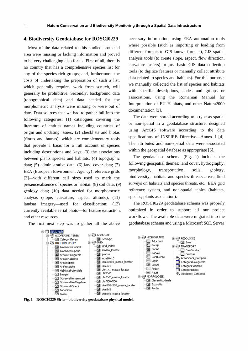
Web site [8]: users specify search criteria and
review the search results as presented in Fig. 2;
Programming interfaces: the REST 3 interface
can return search result in GeoRSS4, KML5, HTML6,
HTML fragments and JSON7 formats;
Widget: in the geoportal Flex-based Map Viewer
[9] users can view, query and explore published
resources, and users can locate and explore
Natura2000 Romanian monitored sites and
biodiversity content results, including: an enterprise
geodatabase, available for querying via web, a
complex detailed base-map, downloadable distribution
maps, survey data, pictures and reports.
5.2 Geoportal Resources Content
The ROSCI0229 Siriu biodiversity geoportal
incorporates the following:
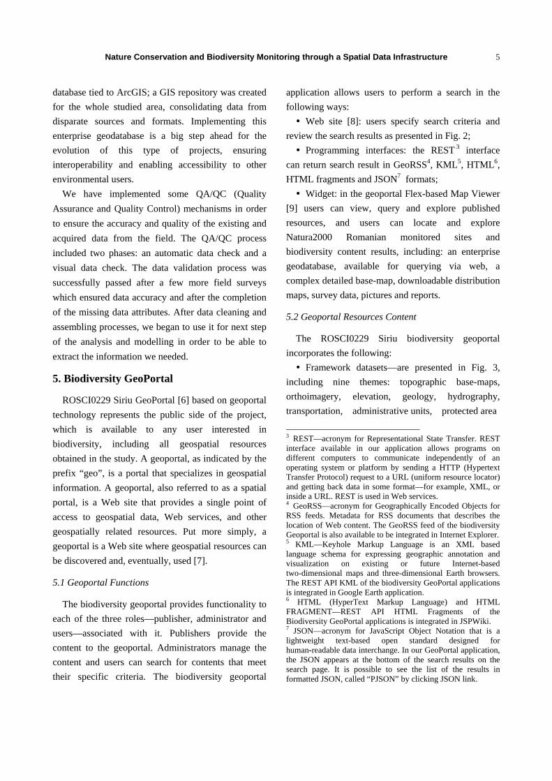
Framework datasets—are presented in Fig. 3,
including nine themes: topographic base-maps,
orthoimagery, elevation, geology, hydrography,
transportation, administrative units, protected area
3 REST—acronym for Representational State Transfer. REST interface available in our application allows programs on different computers to communicate independently of an operating system or platform by sending a HTTP (Hypertext Transfer Protocol) request to a URL (uniform resource locator) and getting back data in some format—for example, XML, or inside a URL. REST is used in Web services. 4 GeoRSS—acronym for Geographically Encoded Objects for RSS feeds. Metadata for RSS documents that describes the location of Web content. The GeoRSS feed of the biodiversity Geoportal is also available to be integrated in Internet Explorer. 5 KML—Keyhole Markup Language is an XML based language schema for expressing geographic annotation and visualization on existing or future Internet-based two-dimensional maps and three-dimensional Earth browsers. The REST API KML of the biodiversity GeoPortal applications is integrated in Google Earth application. 6 HTML (HyperText Markup Language) and HTML FRAGMENT—REST API HTML Fragments of the Biodiversity GeoPortal applications is integrated in JSPWiki. 7 JSON—acronym for JavaScript Object Notation that is a lightweight text-based open standard designed for human-readable data interchange. In our GeoPortal application, the JSON appears at the bottom of the search results on the search page. It is possible to see the list of the results in formatted JSON, called “PJSON” by clicking JSON link.
Nature Conservation and Biodiversity Monitoring through a Spatial Data Infrastructure
6
Fig. 2 ROSCI0229 Siriu Geoportal—harvest capability.
Fig. 3 ROSCI0229 Siriu Geoportal—framework datasets.
sites, and hydrological constructions;
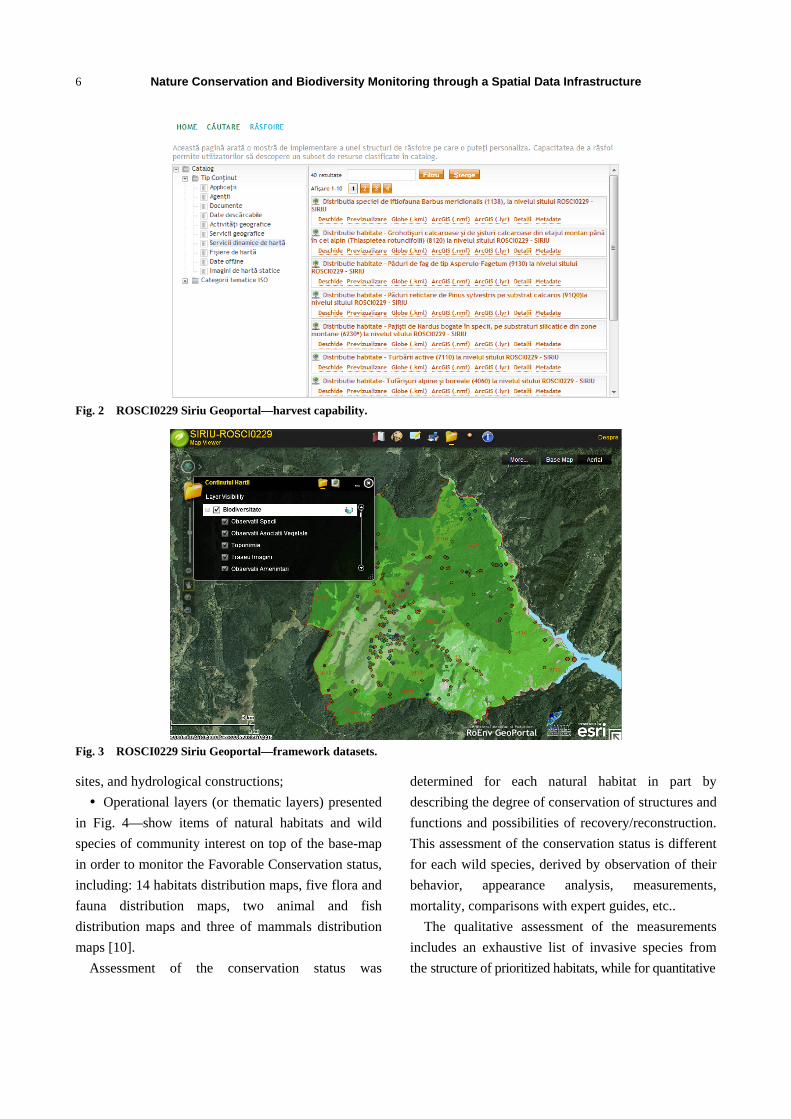
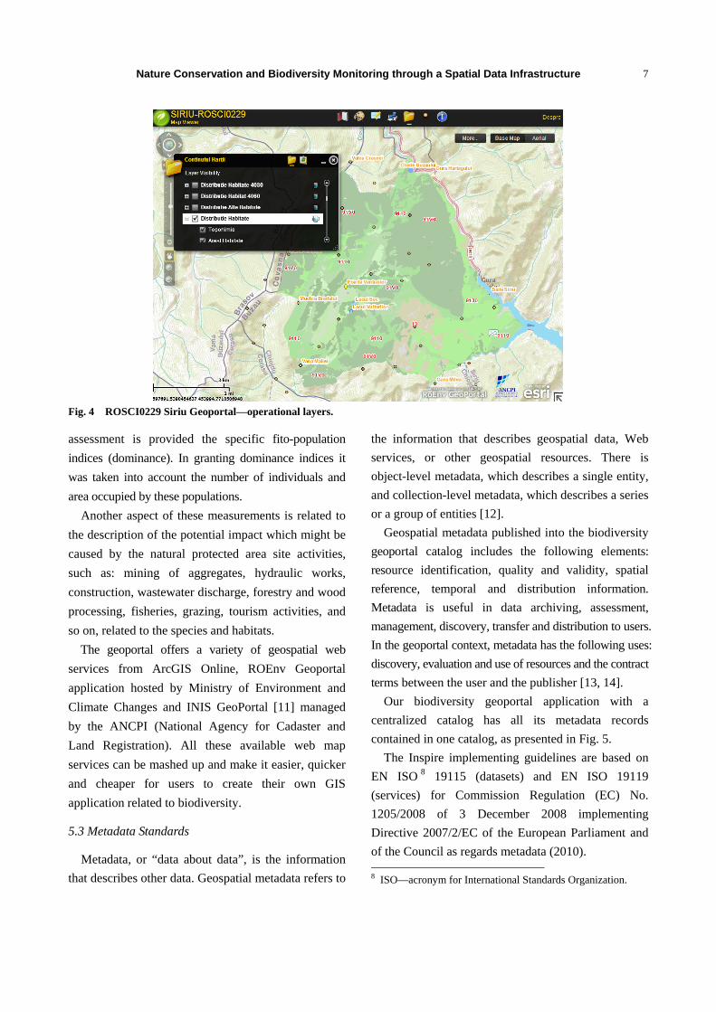
Operational layers (or thematic layers) presented
in Fig. 4—show items of natural habitats and wild
species of community interest on top of the base-map
in order to monitor the Favorable Conservation status,
including: 14 habitats distribution maps, five flora and
fauna distribution maps, two animal and fish
distribution maps and three of mammals distribution
maps [10].
Assessment of the conservation status was
determined for each natural habitat in part by
describing the degree of conservation of structures and
functions and possibilities of recovery/reconstruction.
This assessment of the conservation status is different
for each wild species, derived by observation of their
behavior, appearance analysis, measurements,
mortality, comparisons with expert guides, etc..
The qualitative assessment of the measurements
includes an exhaustive list of invasive species from
the structure of prioritized habitats, while for quantitative
Nature Conservation and Biodiversity Monitoring through a Spatial Data Infrastructure
7
Fig. 4 ROSCI0229 Siriu Geoportal—operational layers.
assessment is provided the specific fito-population
indices (dominance). In granting dominance indices it
was taken into account the number of individuals and
area occupied by these populations.
Another aspect of these measurements is related to
the description of the potential impact which might be
caused by the natural protected area site activities,
such as: mining of aggregates, hydraulic works,
construction, wastewater discharge, forestry and wood
processing, fisheries, grazing, tourism activities, and
so on, related to the species and habitats.
The geoportal offers a variety of geospatial web
services from ArcGIS Online, ROEnv Geoportal
application hosted by Ministry of Environment and
Climate Changes and INIS GeoPortal [11] managed
by the ANCPI (National Agency for Cadaster and
Land Registration). All these available web map
services can be mashed up and make it easier, quicker
and cheaper for users to create their own GIS
application related to biodiversity.
5.3 Metadata Standards
Metadata, or “data about data”, is the information
that describes other data. Geospatial metadata refers to
the information that describes geospatial data, Web
services, or other geospatial resources. There is
object-level metadata, which describes a single entity,
and collection-level metadata, which describes a series
or a group of entities [12].
Geospatial metadata published into the biodiversity
geoportal catalog includes the following elements:
resource identification, quality and validity, spatial
reference, temporal and distribution information.
Metadata is useful in data archiving, assessment,
management, discovery, transfer and distribution to users.
In the geoportal context, metadata has the following uses:
discovery, evaluation and use of resources and the contract
terms between the user and the publisher [13, 14].
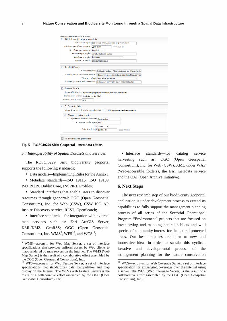
Our biodiversity geoportal application with a
centralized catalog has all its metadata records
contained in one catalog, as presented in Fig. 5.
The Inspire implementing guidelines are based on
EN ISO 8 19115 (datasets) and EN ISO 19119
(services) for Commission Regulation (EC) No.
1205/2008 of 3 December 2008 implementing
Directive 2007/2/EC of the European Parliament and
of the Council as regards metadata (2010). 8 ISO—acronym for International Standards Organization.
Nature Conservation and Biodiversity Monitoring through a Spatial Data Infrastructure
8
Fig. 5 ROSCI0229 Siriu Geoportal—metadata editor.
5.4 Interoperability of Spatial Datasets and Services
The ROSCI0229 Siriu biodiversity geoportal
supports the following standards:
Data models—Implementing Rules for the Annex I;
Metadata standards—ISO 19115, ISO 19139,
ISO 19119, Dublin Core, INSPIRE Profiles;
Standard interfaces that enable users to discover
resources through geoportal: OGC (Open Geospatial
Consortium), Inc. for Web (CSW), CSW ISO AP,
Inspire Discovery service, REST, OpenSearch;
Interface standards—for integration with external
map services such as: Esri ArcGIS Server;
KML/KMZ; GeoRSS; OGC (Open Geospatial
Consortium), Inc. WMS9, WFS10, and WCS11;
9 WMS—acronym for Web Map Server, a set of interface specifications that provides uniform access by Web clients to maps rendered by map servers on the Internet. The WMS (Web Map Server) is the result of a collaborative effort assembled by the OGC (Open Geospatial Consortium), Inc.. 10 WFS—acronym for Web Feature Server, a set of interface specifications that standardizes data manipulation and map display on the Internet. The WFS (Web Feature Server) is the result of a collaborative effort assembled by the OGC (Open Geospatial Consortium), Inc..
Interface standards—for catalog service
harvesting such as: OGC (Open Geospatial
Consortium), Inc. for Web (CSW), XML under WAF
(Web-accessible folders), the Esri metadata service
and the OAI (Open Archive Initiative).
6. Next Steps
The next research step of our biodiversity geoportal
application is under development process to extend its
capabilities to fully support the management planning
process of all series of the Sectorial Operational
Program “Environment” projects that are focused on
inventorying and mapping natural habitats and wild
species of community interest for the natural protected
areas. Our best practices are open to new and
innovative ideas in order to sustain this cyclical,
iterative and developmental process of the
management planning for the nature conservation 11 WCS—acronym for Web Coverage Server, a set of interface specification for exchanging coverages over the Internet using a server. The WCS (Web Coverage Server) is the result of a collaborative effort assembled by the OGC (Open Geospatial Consortium), Inc..
Nature Conservation and Biodiversity Monitoring through a Spatial Data Infrastructure
9
sites.
By developing the management framework and
awareness of owners and the main decision makers
involved in land management, our project contributes
also to the biodiversity and natural heritage protection
and conservation by supporting the management of
this protected area, including the implementation of
Natura2000—the objective of the Priority Axis
4—“Implementation of adequate management systems
for nature protection”. Another issue of the next
developments is addressed by the harmonization of
key spatial data themes across Ministry of
Environment and Climate Changes and NSDI
(National Spatial Data Infrastructure) Council to
support the European environmental policies.
7. Conclusions
During the next years, it will be important to
establish a monitoring and reporting system for each
protected area at local/regional level and it represents
the most significant initiative Romania could
undertake. It will create a more robust and
comprehensive knowledge base for supporting
effective planning and policy development, increased
agency accountability and support for conservation. It
will also provide the mechanism for the Ministry of
Environment and Climate Changes to report and
control local and regional agencies and the public on
conservation performance and improvement in
outcomes achieved.
The geospatial architecture framework and geoportal
application facilitates information sharing and
collaboration, including the bottom-up flow of
information, open and interoperable Web services,
mashups, cloud computing, and geobrowsers. Our
proposed solution is encouraging stakeholders and
biologists’ community participation so together we can
provide accurate and up-to-date information regarding
biodiversity conservation status in each Romanian
protected area. Our further work will focus on unifying
all these local platform solutions and data in a more
complex Biodiversity Monitoring and Reporting
System at the national level.
All of these technical advantages should also work
in favor of our NSDI and provide support for building
blocks of the European Commission’s SEIS (shared
environmental information system).
Acknowledgments
The authors wish to acknowledge the contributions
and support from our scientific project
experts—Multidimension and Ministry of
Environment and Climate Changes and Buzau County
Council. The project is under the Sectorial Operational
Program Environment—Priority Axis 4:
“Implementation of adequate management systems for
nature protection”.
References
[1] Joint Nature Conservation Committee. 2014. “Common
Standards Monitoring for Designated Sites.” Accessed
December 5, 2014. http://jncc.defra.gov.uk/page-2217.
[2] European Environment Agency. 2014. EEA Reference Grid Samples for Projection ETRS89-LAEA 52N 10E. Accessed December 5, 2014. http://www.eea.europa.eu/data-and-maps/data/eea-reference-grids.
[3] Donita, N., Popescu, A., Pauca, M., Mihailescu, S., and
Biris, I. 2005. Habitatele din Romania, Edit. Tehnica
Silvica, Bucuresti, ISBN 973-96001-4-X.
Gafta, D., Mountford, O. 2008. Manual de interpretare a
habitatelor Natura 2000 din Romania. Published under
EuropeAid/121260/D/SV/RC, Edit. Rosprint, Cluj, ISBN
978-973-751-697-8.
[4] European Commission. 2014. “INSPIRE Data Specification for the Spatial Data Theme Protected Sites version 3.1.0.” Accessed December 5, 2014. http://inspire.ec.europa.eu/documents/Data_Specifications/INSPIRE_DataSpecification_PS_v3.1.pdf.
[5] European Environment Agency. 2014. “CORINE
Biotypes —The Design, Compilation and Use of an
Inventory of Sites of Major Importance for Nature
Conservation in the European Community (version
2000).” Accessed December 5, 2014.
http://www.eea.europa.eu/data-and-maps/data/corine-biot
opes.
[6] Buzau County Council. 2014. “ROSCI0229 Biodiversity Geoportal Address.” Accessed December 5, 2014. http://www.geoportal-mediu.ro/geoportal/.
[7] Tait, M. G. 2005. “Implementing Geoportals:
Nature Conservation and Biodiversity Monitoring through a Spatial Data Infrastructure
10
Applications of Distributed GIS.” Computers, Environment and Urban Systems Journal 29 (1): 33-47.
[8] Buzau County Council. 2014. “ROSCI0229 Biodiversity Geoportal-Website Component.” Accessed December 5, 2014. http://www.geoportal-mediu.ro/.
[9] Buzau County Council. 2014. “ROSCI0229 Biodiversity Geoportal Flex-based Map Viewer.” Accessed December 5, 2014. http://www.geoportal-mediu.ro/Siriu/viewer/.
[10] Buzau County Council. 2014. “ROSCI0229 Biodiversity Geoportal Distribution Maps.” Accessed December 5, 2014. http://www.geoportal-mediu.ro/home/hartiDistributie.html.
[11] National Agency for Cadastre and Land Registration
(ANCPI). 2014. “Romanian INSPIRE Geoportal.” Accessed December 5, 2014. http://geoportal.ancpi.ro/geoportal/catalog/main/home.page.
[12] Goodchild, M., and Zhou, J. 2003. “Finding Geographic Information: Collection-Level Metadata.” GeoInformatica 7 (2): 95-112.
[13] Longley, P. A., Goodchild, M. F., Maguire, D. J., and Rhind, D. W. 2005. Geographic Information Systems and Science. 2nd ed.. San Francisco: John Wiley & Sons.
[14] Van Oosterom, P., and Zlatanova, S. 2008. Creating Spatial Information Infrastructures: Towards the Spatial Semantic Web. Boca Raton. Fla.: CRC Press, Taylor & Francis Group.