Embed Size (px)
Citation preview

____________________________________________________________________________________________________
Coastal Management Element 1-1
Natural Disaster Planning INTRODUCTION Among the lengthy list of hazards that can strike Pinellas County, Pinellas County is perceived to be most vulnerable to one of the more devastating of nature’s weather phenomena - the hurricane. As a peninsula that juts from the Florida West Coast into the Gulf of Mexico, Pinellas County is extremely susceptible to the hurricane threat. Hurricanes can generate wind speeds up to 200 miles per hour, and create a storm surge into the Tampa Bay area exceeding 20 feet. The potential for the loss of human life and the devastation of property to one of the more densely populated and heavily developed counties in Florida is almost unfathomable. While the Pinellas County population grew and development occurred to keep up with the increases in population, planning for natural disasters, such as a hurricane, did not keep up. Land use decisions throughout the County, in the past, had been made apparently without full consideration of how increases in residential densities would impact plans for evacuating and sheltering the present and anticipated population. As a result, Pinellas County presently has an emergency shelter deficit in a major hurricane, and those in the emergency planning profession feel that the regional evacuation routes would not adequately handle traffic resulting from an evacuation. This Natural Disaster Planning Chapter provides a discussion of the Coastal High Hazard Area (CHHA), an inventory and analysis of the anticipated evacuation in the event of severe tropical weather within the County, an inventory of hazard mitigation measures and programs, and a discussion of post-disaster redevelopment. In 1998, Pinellas County and its municipalities developed a unified, community-wide local mitigation strategy. Most of the burdens of recovering from a disaster are borne by local governments. Such disasters can bring extraordinary hardship to citizens, devastate the economic base, and diminish its quality of life for years to come. The purpose of the Pinellas County Local Mitigation Strategy (LMS) is to provide a countywide blueprint for a unified and consistent course of action needed to eliminate or minimize the impact of disasters that threaten Pinellas County and its municipalities. The LMS workgroup included county and municipal-government representation as well as a broad range of private and public sector interests, such as the regional planning council, public utilities, health care, schools, and the insurance industry. The future mitigation initiatives addressed in the LMS may be accomplished on an individual community basis or coordinated among jurisdictions. The initiatives are categorized by specific objectives which include critical facilities, public shelters, flood and storm water control, vegetative and beach management, new construction, infrastructure protection, property acquisition, community outreach, and elevation of flood-prone structures. Pinellas County Local Mitigation Strategy (LMS), as amended, becomes a coordinated part of the Natural Disaster Planning section of the Coastal Management Element of the Pinellas County Comprehensive Plan.

____________________________________________________________________________________________________
Coastal Management Element 1-2
COASTAL HIGH HAZARD AREA The coastal high-hazard area (CHHA) in the unincorporated areas of the County is of particular concern because of its extreme vulnerability to natural hazards. In 2006, the Florida Legislature passed a bill (HB1359) changing the definition of the CHHA from the Evacuation “A” zone to the “area defined by the Sea, Lake and Overland Surges from Hurricanes (SLOSH) model to be inundated from a category one hurricane.” The SLOSH model is a storm prediction model that predicts the tidal surge heights that result from hypothetical hurricanes that vary in pressure, size, forward speed, direction and winds. The SLOSH model was last updated by the National Hurricane Center in 1991, but did not change the actual storm surge data presented in the 1992 Tampa Bay Region Hurricane Evacuation Study. The 1992 Study did, however, use updated topographic data to revise the evacuation zones. New contour data were developed using laser terrain data (LIDAR). LIDAR and ground survey data allowed for the identification of evacuation areas using the detailed elevation data and the geographic information system computer mapping. The LIDAR remapping project of Pinellas County improved the elevation data, allowing for one-foot contours. This greater accuracy changed the boundary locations of the evacuation zones due to the improved data generated by the remapping project. The change in the definition of the CHHA now ties land use regulations to a scientific model rather than a zone or area delineated by roadways and familiar landmarks for evacuation purposes. This new CHHA definition, however, has the ramifications with two different issues: 1) public safety, and 2) land development. Figure 1 illustrates the CHHA for unincorporated Pinellas County. Development in the Coastal High Hazard Area Given the potential ramifications of the new CHHA definition, the Tampa Bay Regional Planning Council (TBRPC) led a regional task force in producing recommendations for the regional local governments to provide some relative consistency as to how the new CHHA definition is applied. With the definition of the CHHA now tied to a scientific model rather than a zone or area delineated by roadways and familiar landmarks, there is the potential for confusion as to how and whether the CHHA-specific land development regulations are applied to parcels that are partially within the CHHA. The scientific model does not follow parcel lines or other recognized boundaries; therefore, the CHHA boundary line may split a parcel, whereby part of the parcel is within the CHHA and the remainder is outside of the CHHA and not bound by CHHA-specific land development regulations. Its susceptibility to flood waters and its tendency to remain flooded for a relatively long time makes the CHHA vulnerable to natural hazards, such as hurricanes. County officials are particularly concerned about the potential damages to these low-lying areas from storm surges. According to the 2006 Tampa Bay Region Hurricane Evacuation Study, storm surges from 4.5 to 24 feet, depending on the storm severity, would inundate the Evacuation Level A area. Below are the predicted storm surge ranges for tropical storms to a category 5 hurricane:

____________________________________________________________________________________________________
Coastal Management Element 1-3
Tropical Storm Up to 5’ Category 1 Up to 7’ Category 2 Up to 11’ Category 3 Up to 16’ Category 4 Up to 20’ Category 5 Up to 24’
An important issue to note is that there are limitations of the SLOSH model regarding wave height. Though these limitations have always been incorporated into public safety decisions in determining hurricane evacuation zones, they should also be recognized in the development regulations of land. The SLOSH model does not include calculations for wave height. Therefore, there are parcels on barrier islands and other coastal areas that are now identified as not being within the CHHA, but remain vulnerable to velocity storm surge. According to Dr. Stephen Baig of the National Hurricane Center, “Storm surge is a short-term (6-12 hour) rise in sea level. Storm surge typically doesn’t destroy property; it drowns people and ruins the interior of structures but it doesn’t knock them (structures) down. However, because of this short-term rise in sea level, the ocean now reaches structures that it normally cannot. Instead of breaking at the normal beach, the wind-driven waves developed by the hurricane now break further inland, often at or near structure foundations. Because the structures were never contemplated or built to withstand the force of wind-driven ocean waves, they are in danger of being destroyed. Planners, property developers and residents must consider this regularly repeated scenario when they build on barrier islands (or coastal areas vulnerable to wave action)”. A second issue with the new definition of the CHHA is that it produces properties that become isolated since there are areas with limited access (such as barrier islands) or coastal developments (with canals and limited access) that become surrounded by the CHHA but are not within the designated area itself. Damage to property and public infrastructure would be severe; therefore, limiting the type and intensity of development within these CHHAs is encouraged to minimize the exposure of persons and property to natural hazards. Furthermore, areas isolated by CHHAs would also be included in an evacuation and would therefore, have an impact on shelter demand and clearance times. The area, inclusive of the CHHA and other lands isolated by the CHHA and that have an impact upon evacuation efforts, will be known as the Coastal Storm Area. The hurricane evacuation zones will be based upon the Coastal Storm Area which includes the CHHA and areas surrounded by the CHHA and isolated because of limited access to the mainland. The Coastal Storm Area for Pinellas County is generally depicted in Figure 2.
____________________________________________________________________________________________________
Coastal Management Element 1-4
FIGURE 1 COASTAL HIGH HAZARD AREAS

____________________________________________________________________________________________________
Coastal Management Element 1-5
FIGURE 2 COASTAL STORM AREA

____________________________________________________________________________________________________
Coastal Management Element 1-6
Most of the CHHA in Pinellas County is already developed with a mixture of resort facilities, housing and commerce. Today many structures built prior to current stringent federal, state and local regulations designed to protect them from hurricane hazards still exist. However, due to the age of these structures and the type of construction used prior to today’s building standards, these structures more susceptible to damage or destruction by major storms. Within incorporated Pinellas County, the existing and future land uses in the CHHA have changed little over the last few years. Despite development and economic pressures to build more intensely close to the coastline, continued direction to minimize the risks of life and property damage should remain paramount. It would behoove the County to maintain the present goals, objectives, and policies of the Comprehensive Plan that prohibit the construction of hospitals, nursing homes and assisted living facilities within the CHHA, and prohibit the siting of new and the expansion of existing mobile home development within the CHHA. Goals, objectives, and policies of the Comprehensive Plan should be amended to consider that proposed developments within the unincorporated County’s CHHA that will increase residential density above 5.0 units per acre on the Future Land Use Map must demonstrate the impact of the proposed development on shelter space can be satisfactorily mitigated, and that floodplain functions will not be adversely impacted. Infrastructure in Coastal High Hazard Area The County’s public infrastructure within the CHHA generally, are transportation facilities, parks and recreational facilities, public utilities and shore-hardening structures that protect other public facilities. Major transportation facilities located in the CHHA include the following: Dunedin Causeway Portions of Belleair Causeway Gandy Bridge Howard Frankland Bridge and Causeway Courtney Campbell Causeway Bayshore Boulevard Fred Howard Parkway Pinellas Bayway State Route 580 Bridge at Safety Harbor Bayside Bridge Lake Seminole Bridge A number of parks operated by the Pinellas County Culture, Education, and Leisure (CEL) Department are located within the CHHA. Among the kinds of infrastructure found within these parks are park administration buildings, maintenance buildings, park supervisors’ residences (at Anderson, Ft. DeSoto, Fred Howard, John Chestnut Sr., Lake Seminole, Sand Key, Phillippe, and War Veteran’s Memorial parks), parking lots, restrooms, changing facilities, fishing piers, boat ramps and dock facilities, playgrounds, walking/hiking/bicycle trails, and picnic facilities. Additionally, portions of the Pinellas Trail, as well as beach access parks as listed in the Recreation and Open Space Element, are also found in the CHHA. These facilities could be subject to storm surge damage and/or flooding due to tropical weather.

____________________________________________________________________________________________________
Coastal Management Element 1-7
Beach renourishment projects are addressed in the Beaches and Dunes chapter of the Coastal Management Element, as are other coastal or shore protection structures. Other important County-operated public facilities located within the CHHA are the South Cross Bayou Wastewater Treatment Plant, the W.R.E. Dunn (North Pinellas) Wastewater Treatment Plant, and portions of the St. Petersburg-Clearwater International Airport. INVENTORY AND ANALYSIS OF EVACUATION AND SHELTER POPULATIONS The inventory and analysis of evacuation and shelter populations is based upon the Tampa Bay Region Hurricane Evacuation Study 2006, prepared by the Tampa Bay Regional Planning Council. This study used the SLOSH numerical storm surge prediction model to analyze the expected hazards from potential hurricanes affecting the Tampa Bay region. The SLOSH model considered hypothetical hurricanes covering the entire range of the Saffir/Simpson Damage Potential Scale, from Category 1 (least intense) to Category 5 (most intense). Using the results of the SLOSH model, five levels of vulnerability to storm surge were identified for different intensities and types of approaching hurricanes. The results of this storm surge hazard analysis allow for the storm tide limits to be graphically identified based on the maximum storm surge for categories 1, 2, 3, 4, and 5 hurricanes. These five vulnerability levels are used to identify Pinellas County’s five evacuation levels (A through E) in which each evacuation level includes a successively larger land area that must be totally evacuated from overland storm surge and also all includes mobile home residents in the entire County. For hurricanes, these evacuation levels generally correspond to a hurricane’s intensity on the Saffir/Simpson Scale (see Table 1).
TABLE 1
HURRICANE CATEGORY AND ASSOCIATED EVACUATION LEVEL
PINELLAS COUNTY
HURRICANE CATEGORY
EVACUATION LEVEL
1 A 2 B 3 C 4 D 5 E
Source: Tampa Bay Region Hurricane Evacuation Study 2006

____________________________________________________________________________________________________
Coastal Management Element 1-8
INTENSITY OF LANDFALLING HURRICANE AND ASSOCIATED EVACUATION LEVEL FOR PINELLAS COUNTY Number of Persons Requiring Evacuation The number of persons requiring evacuation within Pinellas County which is based upon scenarios and assumptions provided by the Tampa Bay Regional Council (TBRPC) and population figures provided by the Pinellas County Planning Department, is a combination of the population-at-risk, including the seasonal population estimate and an additional shadow evacuation; i.e., the number of persons not-at-risk that would still evacuate. Table 2 shows the population-at-risk (high estimate), which is the number of persons residing in evacuation zones or mobile home residents who would be directly affected by a future evacuation order.
TABLE 2 PINELLAS COUNTY POPULATION-AT-RISK (HIGH)
EVACUATION LEVEL YEAR
A B C D E
2006 327,064 423,652 517,416 619,619 674,352
2011 331,894 430,593 527,990 631,178 686,787
Source: Tampa Bay Region Hurricane Evacuation Study, 2006
PINELLAS COUNTY POPULATION-AT-RISK (High) In every issued evacuation order situation, however, a percentage of persons who reside inside the evacuation areas and mobile homes will not evacuate. Additionally, another percentage of persons who live outside the surge-vulnerable areas and who do not live in mobile homes or substandard housing will evacuate (known as shadow population). Consequently, not all of the population-at-risk is expected to comply with an evacuation order. The result is a difference between the population-at-risk and the actual evacuation population. The Tampa Bay Region Hurricane Evacuation Study based the evacuation participation rates on three factors: distance from the water, site-built or mobile home construction, and the Saffir/Simpson intensity of the storm threat. Also considered was population age and income since these factors influence the ability to evacuate. Table 3 shows the predicted Evacuation Population.

____________________________________________________________________________________________________
Coastal Management Element 1-9
TABLE 3 EVACUATION POPULATION
EVACUATION LEVEL YEAR
A B C D E
2006 429,005 516,994 612,004 715,753 758,657
2011 435,242 525,157 622,647 728,328 771,943
Source: Tampa Bay Region Hurricane Evacuation Study, 2006
EVACUATION POPULATION Using the Tampa Bay Region Hurricane Evacuation Study model, Pinellas County estimated over 612,000 Pinellas County residents would have been in need of evacuation from the hurricane vulnerability zone (up to a Category 3 storm) in 2006. Figure 3 depicts the extent of Pinellas County that is considered the hurricane vulnerability zone (Evacuation Levels A through C).
____________________________________________________________________________________________________
Coastal Management Element 1-10
FIGURE 3 HURRICANE VULNERABILITY ZONE (MAP)

____________________________________________________________________________________________________
Coastal Management Element 1-11
Number of Persons Requiring Public Hurricane Sheltering To determine the estimates and projections depicted in Table 4, Pinellas County Public Shelter Demand, assumptions from the Tampa Bay Region Hurricane Evacuation Study 2006 were used. Based upon surveys conducted throughout the Tampa Bay area of evacuees’ destinations during Hurricane Elena (1985), Hurricane Georges (1998), and Hurricanes Charley, Frances, and Jeanne (2004). The Study contained estimates of the number of evacuees that would evacuate to different destinations based upon the behavioral assumptions that were derived from the survey results. These destinations were a friend’s resident, a hotel, a public shelter, or somewhere outside of their home county. The number of evacuees, whose destination would be a public shelter, is based upon the evacuation level in which they reside and their perceived threat from an approaching hurricane. The Study indicates that while public shelter use by evacuees has been shown to have decreased over the years, the demographics of the Tampa Bay region and its metropolitan character may lead to increased reliance on public shelters, if available. The anticipated shelter demand is presented in Table 4. Figure 4 depicts the location of the Pinellas County Public Shelters and Evacuation Routes.
TABLE 4
PINELLAS COUNTY PUBLIC SHELTER DEMAND
EVACUATION LEVEL YEAR
A B C D E
2006 30,613 58,437 72,685 88,246 94,684
2011 31,129 59,490 74,115 89,965 96,506
Source: Tampa Bay Region Hurricane Evacuation Study, 2006

____________________________________________________________________________________________________
Coastal Management Element 1-12
FIGURE 4 HURRICANE EVAUCATION ROUTES AND SHELTERS (MAP)

____________________________________________________________________________________________________
Coastal Management Element 1-13
Emergency Shelter Analysis When a hurricane is approaching and the evacuation order is given, most people who are located in the affected Hurricane Evacuation Zone will begin to seek alternative shelter from the storm. Several alternative forms of shelter are available at various distances from their home. Whether to evacuate to a less vulnerable location within the County or to leave the region entirely, is based upon the perception of risk and the strength of the storm. Evacuees not using public shelters will seek shelter in a variety of ways; i.e. leaving the region, checking into a hotel or motel, or staying with friends or relatives in less vulnerable areas of the County. Currently, Pinellas County is recommending the “Host Home” concept as the preferred kind of evacuation. The Host Home program solicits churches, businesses and organizations to pre-determine the evacuation status of all members, encourage members living in non-evacuation areas to host those living in evacuation areas or mobile homes, and in cases where the entire membership lives in evacuation areas or mobile homes, encourages a church/facility in a non-evacuation area to serve as the “Host” to the other organization’s membership. Additionally, public education and information are being used widely by the County to discourage people who do not need to evacuate from using public shelters. Other alternatives the Pinellas County continues to look at as alternatives to a traditional public sheltering include the retrofitting of existing structures, utilizing refuges of last resort as appropriate, and the evacuating of guests from transient accommodations to inland “sister” transient accommodations. Since not everyone will leave the County to seek shelter, or stay with a friend, check into a hotel or motel, or make alternative arrangements, some people will evacuate to public shelters. In order to meet the demand for public shelters, as shown in Table 4, Pinellas County coordinates with State and other local emergency management agencies, the American Red Cross, and the Pinellas County School Board to identify and retrofit shelter spaces for those residents who may need it. Shelter selection involves a number of structural and non-structural factors in addition to close coordination with local emergency management agencies and the American Red Cross. Chapter 252.385, Florida Statutes, requires a statewide shelter program and establishes the “Statewide Emergency Shelter Plan”. Within this Plan, American Red Cross Hurricane Evacuation Shelter Guidance (ARC 4496) sets the criteria and standards for hurricane shelters. Local jurisdictions are required to provide hurricane shelters that meet the standards of ARC 4496, as amended. The standards were substantially revised in April 2004 to incorporate new and more stringent physical standards for evacuation shelters. As a result of the 2004 amendments, the number of shelters identified in 1995 (90 shelters) that provided 87,935 spaces, was reduced to only 24 public shelters within Pinellas County, totaling 75,845 spaces met the new standards. Even though in 2006, number of shelters increased to 28, the number of available shelter spaces decreased to 73,440 due to further amendments to the shelter selection criteria in ARC 4496. The current public shelters throughout Pinellas County are listed in Table 5. While the County and the Pinellas County School Board continue to coordinate, and new schools are being designed to meet certain windloads and function as emergency shelters, a deficit remains. The deficit (see Table 6) would be realized if evacuation levels D and E were called. Given the projected shelter demand to 2011, and if no further shelter space was added, the deficit would be reached at evacuation levels C, D, and E. In addition to new construction, Pinellas County continues to apply to the Federal Emergency

____________________________________________________________________________________________________
Coastal Management Element 1-14
Management Agency’s (FEMA) Hazard Mitigation Grant Program for funding to strengthen existing structures for use as shelters. FEMA provides funds for building hardening project where the building can be retrofitted to meet the requirements of ARC 4496.
TABLE 5
PINELLAS COUNTY
HURRICANE EVACUATION SHELTERS, 2007
SHELTER ADDRESS CITY CAPACITY
Tarpon Springs Middle School 501 N. Florida Ave.
Tarpon Springs 2,617
Brooker Creek Elementary School
3130 Forelock Rd. East Lake 1,389
East Lake High School 1300 Silver Eagle Dr. East Lake 4,041
Carwise Middle School 3301 Bentley Dr. Palm Harbor 4,043 Palm Harbor University High School 1900 Omaha St. Palm Harbor 3,022
Palm Harbor Middle School 1800 Tampa Rd. Palm Harbor 2,848
White Chapel Harbor Hall 1190 Georgia Ave. Palm Harbor 85
Safety Harbor Middle School 901 - 1st Ave. N. Safety Harbor 7,707
Dunedin Highland Middle School */** 70 Patricia Ave. Dunedin 1,825 McMullen Booth Elementary School 3025 Union St. Clearwater 1,327
Kennedy Middle School *** 1660 Palmetto St. Clearwater 3,512
Oak Grove Middle School */** 1370 S. Belcher Rd. Clearwater 1,801
Largo High School 410 Missouri Ave. Largo 1,074
Bauder Elementary School 12755 - 86th Ave. N. Seminole 1,159
Pinellas Park High School 6305 - 118th Ave. N.
Pinellas Park 4,150
John M. Sexton Elementary School
1997 - 54th Ave. N.
St. Petersburg 1,372
Lealman Middle School 4900 - 28th St. N. St.
Petersburg 3,504
Northside Baptist Church 6000 - 38th Ave. N.
St. Petersburg 700
St. Petersburg High School *** 2501 - 5th Ave. N.
St. Petersburg 2,167
St. Petersburg Judicial Tower 545 - 1st Ave. N. St.
Petersburg 525

____________________________________________________________________________________________________
Coastal Management Element 1-15
Fairmount Park Elementary School 575 - 41st St. S.
St. Petersburg 1,157
Campbell Park Elementary School
1051 - 7th Ave. S.
St. Petersburg 2,660
John Hopkins Middle School ** 701 - 16th St. S. St.
Petersburg 1,113
Gibbs High School 850 - 34th St. S. St.
Petersburg 6,550
Jamerson Elementary School 1200 - 37th St. S. St.
Petersburg 1,347
Gulfport Elementary School 2014 - 52nd St. S. Gulfport 2,660
Thurgood Marshall Middle School *
3901 - 22nd Ave. S.
St. Petersburg 7,205
Sanderlin Elementary School 2350 - 22nd Ave. S.
St. Petersburg 1,255
TOTAL SHELTER SPACES 73,440
* Pet Friendly Shelter ** Special Needs Shelter *** Homeless Friendly Shelter Capacity based on square footage per person: General shelter: 10 square feet per person; Special Needs shelter: 40 square feet per person
Source: Pinellas County Emergency Management Department, 2007
TABLE 6
PINELLAS COUNTY
PUBLIC SHELTER DEFICIT
EVACUATION LEVEL YEAR
A B C D E
2006 0 0 0 14,806 21,244
2011 0 0 675 16,525 23,066
Source: Tampa Bay Region Hurricane Evacuation Study, 2006
Pinellas County Emergency Management Department, 2007
In an effort to develop regional actions to deal with public emergency shelter needs, the County will work with the Tampa Bay Regional Planning Council in conducting an emergency shelter workshop or summit. The primary purpose of this “shelter summit” would be to develop regional actions to increase the number of public shelters, reduce the existing regional shelter deficit, identify alternatives to traditional sheltering methods, and address issues regarding the consequences of increasing densities and intensities of land uses within the Coastal High Hazard Areas (CHHA) of the Tampa Bay Region. In recent years, each of the four counties in the Region (Hillsborough, Manatee, Pasco and Pinellas counties) have experienced steady population growth; however, the growth of public emergency shelter spaces has not kept up with the population growth in the region. Therefore, it appears that the issue of public shelter deficits is not confined to any one county in the Region; instead, it appears to be regional in

____________________________________________________________________________________________________
Coastal Management Element 1-16
nature. Additionally, land use decisions within the CHHA and the hurricane vulnerability zone can have a direct impact on shelter deficits and clearance items for regional evacuation routes. A “shelter summit” could be an opportunity for representatives of local planning and emergency planning agencies, countywide and nonprofit agencies traditionally responsible for sheltering, and regional and statewide agencies involved in sheltering to discuss common problems and work on solutions to this problems. In summary, Pinellas County should pursue a variety of alternatives in an effort to reduce the shelter deficit in the event of a major hurricane. Among the alternatives are:
1) utilization of the Host Home program to reduce evacuation population; 2) public education about evacuation; 3) begin a capital improvement program to construct new or retrofit existing shelters; 4) refinement of the contour intervals used to define the evacuation levels; 5) encourage retrofit activities of more inland residents to reduce shelter demand from
“shadow evacuees” 6) development of a mitigation program that includes collecting fees for development
with increased densities; these monies can be leverage for further capital improvement activities; and
7) encouraging businesses, churches and the like in providing shelter space and provide assistance for retrofitting non-governmental structures.
With a combination of activities, Pinellas County should be able to meet its objective of reducing the existing deficit of public shelter spaces within the County by five percent by 2012. To address the objective to reducing the existing deficit of public shelter space, it should be the long-term goal of the County to pursue certain capital improvements, along with other alternatives: Capital Improvements for Natural Disaster Planning: 1) Constructing Emergency Shelters Evacuation Routes The Tampa Bay Region, including Pinellas County, is extremely vulnerable to the threat of an intense hurricane. Distinct challenges due to the variety of vulnerable populations that must be considered in the evacuation process can be identified. For example, the barrier islands face significant storm surge inundation potential. Low-lying areas within the County are vulnerable to coastal and/or freshwater flooding. The County also has a significant mobile home population with homes that are highly susceptible to hurricane force winds. The County’s population located within these types of situations will be directly affected by a mandatory evacuation since they will be the first ones ordered to leave. During an evacuation, a significant number of vehicles will have to be moved across Pinellas County roads and the regional road network. Therefore, the County must be prepared to evacuate the vulnerable populations on critical routes, which may be concurrently evacuating populations from adjacent counties. Movement of traffic along the evacuation routes is directly affected by the planned destinations of evacuees and the availability of acceptable destinations such as homes of

____________________________________________________________________________________________________
Coastal Management Element 1-17
friends or relatives, hotel/motel units, and public shelters. These destinations can be located within the County or outside the County. Figure 4, which identifies emergency shelters within Pinellas County, also identifies the primary regional evacuation routes for people leaving Pinellas County as determined by Pinellas County Emergency Management. Table 7 and Figure 5 identify the critical evacuation route points on Pinellas County’s regional evacuation routes as they appear in the Pinellas County Comprehensive Emergency Plan (CEMP). Critical evacuation route points are those roadway intersections that could pose a problem with evacuation because of their low elevation, their vulnerability to flooding by pre-landfall gale force winds, as well as congestion points. The critical links and potentially crucial bottlenecks on the Pinellas County regional evacuation routes are identified as they appear in the Comprehensive Emergency Management Plan. Other regional critical roadway segments that have been updated in the Tampa Bay Region Hurricane Evacuation Study 2006 and are:
I-275/I-75 Interchange in Hillsborough County; I-275/I-4 Interchange in Hillsborough County; Roosevelt Boulevard/Gandy Boulevard North/4th Street North Intersection; Treasure Island Causeway and Pasadena Avenue South Intersection; Courtney Campbell Causeway; Ulmerton Road and U.S. 19 Intersection; and I-275 Northbound Ramps

____________________________________________________________________________________________________
Coastal Management Element 1-18
TABLE 7 PINELLAS COUNTY CRITICAL EVACUATION ROUTE TRAFFIC CONTROL POINTS AND CRITICAL LINKS
RESPONSIBLE ENTITY LOCATION POINT
Belleair Beach Police CR 183/Gulf Blvd & CR 416 (Causeway Blvd/West)
Clearwater Police U.S. 19 & Drew St.
U.S. 19 & SR 60 (Gulf-to-Bay)
U.S. 19 & Sunset Point Rd.
SR 60 & CR 611 (McMullen Booth at Bayside Bridge)
SR 60 & CR 611 (McMullen Booth at Bayside Bridge
SR 60 (Courtney Campbell Causeway) - ROAD BLOCK
SR 60 & U.S. 19A (Fort Harrison)
SR 60 & Highland Ave.
SR 60 & Belcher Rd.
U.S. 19 & Belleair Rd.
Florida Highway Patrol Gandy ROADBLOCK (when weather conditions warrant)
I-275/Howard Franklin Bridge (when weather conditions warrant)
CRITICAL LINK - I-275, between 9th St. and County Line
Largo Police SR 686 & 113th St. (Clearwater/Largo Rd.)
SR 686 & Starkey Rd. (Keene Rd.)
SR 686 & Belcher Rd.
SR 688 & Indian Rocks Rd.
SR 688 & Antilles
SR 688 & Vonn Rd.
SR 688 & 113th St.
U.S. 19A (Seminole Blvd.) & SR 688
SR 686 & Missouri Ave.
Pinellas Park Police SR 694 ( Park Blvd.) & 66th St.
SR 694 & 49th St.
U.S. 19 & SR 694
CRITICAL LINK - SR 694 between 49th St. and City Limits
Pinellas County Sheriff U. S. 19 & Klosterman Rd.
U.S. 19 & Alderman Rd.
U.S. 19 & CR 776 (Nebraska Ave.)
U.S. 19 & CR 752 (Tampa Rd.)
Tampa Rd. & East Lake Rd.
U.S. 19 & SR 586 (Curlew Rd.)
Keystone Rd. & East Lake Rd.
SR 586 & CR 611 (McMullen Booth Rd.)
CR 233 (Indian Rocks Rd.) & W. Bay Dr.

____________________________________________________________________________________________________
Coastal Management Element 1-19
TABLE 7 (CONTINUED) PINELLAS COUNTY CRITICAL EVACUATION ROUTE TRAFFIC CONTROL POINTS AND CRITICAL LINKS
RESPONSIBLE ENTITY LOCATION POINT
St. Petersburg Police
CRITICAL LINK - SR 694 (Gandy Blvd.) from City Limits and I-275
CRITICAL LINK - I-275 N to City Limits
POTENTIAL BOTTLENECK - SR 694 between I-275 and 4th St.
St. Pete Beach Police SR 699 (Gulf Blvd.) & Bayway (SR 682)
SR 699 & Corey Causeway (St. Pete Beach Causeway/75th Ave.)
CRITICAL LINK - SR 699 east on Pinellas Bayway to City Limits
Tarpon Springs Police U.S. 19 & SR 582 (Tarpon Ave.)
CRITICAL LINK - SR 582, from U.S. 19A to City Limits
Treasure Island Police SR 699 (Gulf Blvd.) & Treasure Island Causeway (107th Ave.)
Source: Pinellas County Comprehensive Emergency Management Plan, 2006

____________________________________________________________________________________________________
Coastal Management Element 1-20
FIGURE 5 CRITICAL EVACUATION ROUTE POINTS (MAP)
____________________________________________________________________________________________________
Coastal Management Element 1-21
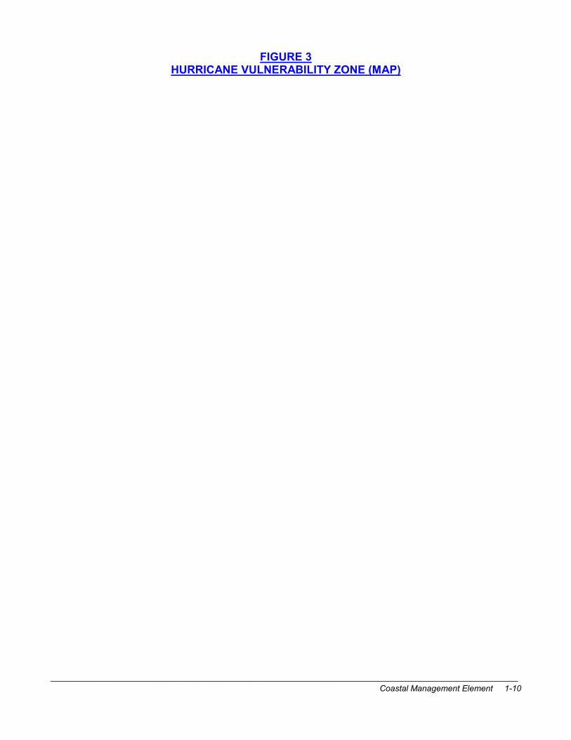
Evacuation Clearance Times Evacuation clearance time refers to the estimated time it would take to clear the roadway of all vehicles evacuating in response to a hurricane situation. Clearance time begins when the first evacuating vehicle enters the road network and ends when the last evacuating vehicle reaches an assumed point of safety. According to the Tampa Bay Region Hurricane Evacuation Study 2006, the assumed point of safety is identified as I-75 at the Florida Turnpike near Wildwood for northbound travel, and Orlando for eastbound movement. Clearance time does not relate to the time any one vehicle spends traveling on the road network and does not include time needed for local officials to assemble and make a decision to evacuate. Among the factors that are used in determining clearance time are:
Trip Generation: how many evacuees will move for a particular scenario; Trip Distribution: determining where evacuees will go; Development of Evacuation Road Network: which roads will be used for evacuation and what is the carrying capacity of each road; Trip Assignment: determining which routes evacuees will go to get from their point of origin to their destination; and Calculation of Clearance Time: determining how much time it will take to clear the evacuation network.
Table 8 shows the Pinellas County evacuation clearance times in hours by evacuation levels, and includes low and high seasonal population estimates.
TABLE 8
PINELLAS COUNTY
IN-COUNTY CLEARANCE TIMES
(IN HOURS)
EVACUATION LEVEL YEAR
SEASONAL POPULATION A B C D E
Low 16.5 - 19.25
18.5 - 21.75
19.25 - 21.75
20.5 – 23.0
23.0 – 25.75
2006
High 18.5 – 21.5
20.5 – 24.0
21.0 – 24.0
22.25 - 25.25
25.0 – 28.0
Low 16.5 - 19.25
18.75 - 22.0
19.25 – 22.0
20.5 – 23.0
23.25 - 25.75
2011
High 19.0 – 21.5
22.0 – 24.0
21.75 – 24.0
22.75 - 25.25
25.75 – 28.0
Source: Tampa Bay Region Hurricane Evacuation Study, 2006
Special Needs Population Table 9 lists those hospitals in Pinellas County that plan to evacuate under various evacuation levels. It is estimated that approximately 307 hospital patients would be required to evacuate

____________________________________________________________________________________________________
Coastal Management Element 1-22
from the hurricane vulnerability zone (Evacuation Levels A, B, and C), see Table 10 for number of evacuating hospital patients.
TABLE 9
PINELLAS COUNTY
HOSPITALS WITHIN EVACUATION LEVELS
HOSPITAL HURRICANE EVACUATION
LEVEL
Palms of Pasadena B
Bay Pines VA Hospital D
Kindred Hospital of St. Petersburg D
St. Petersburg General D
Suncoast Osteopathic Hospital E
Source: Pinellas County Emergency Management Department, 2007
Furthermore, 3,055 nursing home patients would require evacuation from the hurricane vulnerability zone (see Table 11). According to the 2006 American Community Survey approximately 20.7% (approximately 197,199 people) of the Pinellas County permanent residents are 65 years or older. Of the residents, 65 years and over, over 34% are identified as having one or more disabilities (Source: Bureau of the Census, 2006 American Community Survey). The Pinellas County Comprehensive Emergency Plan (CEMP) identifies 4,739 public shelter spaces for evacuees with special needs. Additionally the CEMP outlines how the County will conduct emergency transportation for those with special needs.
TABLE 10
NUMBER OF HOSPITAL PATIENTS
REQUIRING EVACUATION
EVACUATION LEVEL NUMBER OF
EVACUATING HOSPITAL PATIENTS
A 0
B 307
C 307
D 1,256
E 1,456
Source: Pinellas County Emergency Management Department, 2007

____________________________________________________________________________________________________
Coastal Management Element 1-23
The Pinellas County Comprehensive Plan prohibits the construction of hospitals, nursing homes and assisted living facilities (ALF) within Evacuation Level A and discourages the siting of such facilities within the Evacuation Level B. In addition, Pinellas County prohibits the expansion of existing hospitals, nursing homes and ALFs within the Evacuation Level A. Under the CEMP, hospital patients and nursing home and ALF residents are evacuated during a Category 1 hurricane if these facilities are located within the evacuation Level B, and therefore, allowing these facilities to expand in the Evacuation Level A and allowing new ones to be developed in the Evacuation Level B would have an impact on the overall evacuation system, which has a public shelter space deficit, and, in particular, a lack of special needs shelters. Additionally, the County will be evaluating the feasibility of limiting the capacity of hospitals, nursing homes, and ALFs within the Evacuation Level B area. Measures Taken to Maintain or Reduce Evacuation Clearance Times Listed below are measures that have been implemented or that are currently used to maintain or reduce evacuation clearance times for Pinellas County:
• Capital improvements on regional evacuation routes have been completed on Tampa Road, West Bay Drive, Central Avenue and Park Boulevard;
• In November 1990, the Board of County Commissioners adopted Ordinance 90-87,
which requires recreational vehicle parks and transient accommodations to develop hurricane evacuation plans;
• Pinellas County, through the Pinellas County Metropolitan Planning Organization’s
Transportation Improvement Program, encourages the State to give priority to road improvements on regional evacuation routes;
TABLE 11
NUMBER OF NURSING HOME PATIENTS REQUIRING EVACUATION
EVACUATION LEVEL
NUMBER OF EVACUATING
NURSING HOME PATIENTS
A 293
B 983
C 1,779
D 3,316
E 3,680
Source: Pinellas County Emergency Management Department, 2007

____________________________________________________________________________________________________
Coastal Management Element 1-24
• The feasibility of utilizing the countywide computerization traffic signalizing program as a mechanism to expedite hurricane evacuation was evaluated by the County’s Emergency Management staff, who concluded that while the system would assist the flow of hurricane evacuation traffic, evacuation traffic will be controlled primarily by law enforcement officers;
• Pinellas County has assisted with the development and publication of the annual
hurricane guide that is distributed countywide at the beginning of hurricane season;
• The County’s Emergency Management staff and the State Division of Emergency Management work together on evacuation and disaster preparedness plans, and Pinellas County participates in the State’s annual drill;
• Pinellas County conducts an annual hurricane drill to assess its ability to mobilize and
respond during a hurricane. The drill is evaluated by the County, and Pinellas County Emergency Management makes changes to its Comprehensive Emergency Management Plan based upon the observations made during the drill;
• Pinellas County Emergency Management staff initiates a Host Home Program.
HAZARD MITIGATION Overview Pinellas County is statistically subject to recurring natural hazards such as hurricanes and coastal storms which have the potential of staggering impacts on human lives and property. The structural damage in the County from Hurricane Elena during Labor Day weekend of 1985 was estimated at more than $100 million. The on-shore storm surge from this hurricane had an estimated frequency of ten to fifteen years. In other words, an event with the storm surge impact of Hurricane Elena can be expected to affect Pinellas County on average once every ten to fifteen years. Considering these factors, Hurricane Elena was not a rare event. Furthermore, National Hurricane Center historical records show that since 1871, 100 tropical storms and hurricanes have passed within 100 nautical miles of the Tampa Bay area. This results in an average recurrence frequency of one tropical storm or hurricane every 1.35 years. Specifically, the mean return of hurricanes to within 75 miles of the Tampa Bay Region has indicated:
Category 1 5.2 years Category 2 11 years Category 3 18 years Category 4 39 years Category 5 100 years
While no other hurricane since Elena with storm surge, high winds, high surf, beach erosion, heavy rains, and fresh water flooding has seriously threatened Pinellas County. Tropical storms in 1993 and 1996 did cause damage within the County. The Winter Storm of March

____________________________________________________________________________________________________
Coastal Management Element 1-25
1993, which has also been labeled “The Storm of the Century”, caused approximately $20 million in structural damage due to flooding and high winds. Tropical Storm Josephine, occurring in October of 1996, was responsible for approximately $25 million in structural damage due to flooding in low lying areas of the County. Destruction from both of these storms, which affected other counties in addition to Pinellas, resulted in Presidential Disaster declarations. Associated with these extreme storm events are hazards that pose a threat to Pinellas County. These hazards include, but are not limited to, the following:
• Wind damage; • Tornadoes; • Water and erosion damage caused by flooding, storm surge and wave action; • Inlet mitigation; and • Hazardous material accidents caused by flooding, storm surge and wave action.
With the exception of the wind impacts, the effects of these hazardous conditions affect primarily areas in proximity to the coastline and areas of low topography. As most of Pinellas County’s coastal areas are already developed with a mix of resort facilities, housing, commerce and employment centers, many of the structures were built prior to stringent federal, state and local regulations designed to protect them from hurricane hazards and are thus more susceptible to damage or destruction by major storms. For example, it was determined that most of the homes destroyed by Hurricane Elena were not elevated or built to specific National Flood Insurance Program design criteria. In the unincorporated County, most of the exposed barrier islands are contained within County or State parks. Mullet Key and Anclote Key will in general remain undeveloped except for scattered public investment in low scale recreational infrastructure. Tierra Verde, however, is a vulnerable barrier island which has been developed with a mixture of primarily residential development. However, since development on Tierra Verde is mostly of recent origin, many of the homes are elevated on piers or breakaway walls in compliance with federal and local floodplain regulations. Also within the unincorporated area, much of the Palm Harbor/Crystal Beach coastline is already developed with a mix of older, somewhat vulnerable single-family housing, parks, small scale commercial, as well as newer, more hurricane resistant condominiums and residences. Similarly, the Seminole area contains a mix of single-family housing, recreational facilities and commerce with a few multi-family developments. The Gateway area consists of either protected wetlands along the coastline with residential uses, campus-type office and industrial development, and some vacant land located on the adjacent uplands. Beaches and Dunes as Natural Mitigation Beaches and dunes provide a natural hazard mitigation function because they absorb the impact of the waves generated during a storm. Beaches and dunes can act as a buffer between the force of a wave and any development that may be upland from the beach. In

____________________________________________________________________________________________________
Coastal Management Element 1-26
areas where the beaches have eroded and the dunes have been destroyed due to development, there is no natural buffer to absorb the force from the wave action. Many beach renourishment projects are undertaken to restore this buffer as well as to preserve the recreational usefulness of the beach. Most of Pinellas County’s beaches are found in barrier island municipalities. The condition of these beaches varies from wide beaches with well-developed dunes and vegetation on Clearwater Beach Island to practically nonexistent on portions of northern Sand Key. For a more detailed discussion of beach and dune conditions in Pinellas County, please see the section on Beaches and Dunes. Structures with a History of Repeated Damage in Coastal Storms In 1993, the County (for unincorporated areas) began its participation in the National Flood Insurance Program’s (NFIP) Community Rating System (CRS) program. One requirement for participation in the CRS program is to identify areas with structures that have filed two or more NFIP claims of $1,000 or more. In the County’s CRS Repetitive Loss Plan, areas of repetitive loss are identified. While it is not necessarily known if the history of these losses were due to coastal storm surge or to rainfall events, all of the repetitive loss areas and several of the isolated repetitive loss properties lie within the CHHA. Figure 6 identifies the repetitive loss areas and the isolated repetitive loss properties in the CHHA.

____________________________________________________________________________________________________
Coastal Management Element 1-27
FIGURE 6 GENERALIZED LOCATIONS OF REPETITIVE LOSS PROPERTIES (MAP)

____________________________________________________________________________________________________
Coastal Management Element 1-28
Hazard Mitigation – An Analysis Although Pinellas County has been spared a direct hit from a major hurricane since 1921, lesser storms have impacted the County. Hurricane Elena in 1985 was a Category 3 storm that lingered 90 miles offshore for three days. With over $100 million in damages and losses countywide resulting from Hurricane Elena (a ten to fifteen-year storm event), the destruction resulting from a hurricane with a force expected every 100 or even 50 years would be staggering. In March of 1993, a winter storm with high winds and surf made landfall from the Gulf creating an estimated $20 million in damages. Then, in 1996 Tropical Josephine affected the County with high winds and surf, and heavy rainfall causing an estimated $25 million in damages. The 2004 hurricane season was unprecedented with four major hurricanes impacting Florida. Of the four, three barely affected Pinellas County; however, approximately $8.5 million in damages were created. None of the hurricanes were land-falling hurricanes which could potentially have had a more devastating effect on the Tampa Bay area. If a major hurricane were to make landfall in the Tampa Bay Region, the damages would far pass the damages experienced in past storms. With such large potential losses at stake, Pinellas County and its 24 jurisdictions need to consider which activities can be implemented to minimize the damage caused by such natural disasters. Such activities are termed hazard mitigation and fall under the local government’s responsibility to protect the public health, safety and general welfare. Hazard mitigation measures results from a long-term concern for avoiding the damages of future natural disasters. Planning for disasters to protect the public involves four phases: Mitigation, Preparedness, Response, and Recovery. Hazard mitigation is just one of four phases of disaster-related activity undertaken by a local government. Preparedness activities immediately precede a particular disaster; they help the community cope with immediate treats to life and property. Response activities immediately follow a particular disaster; they included search and rescue, damage assessment, and providing emergency housing and medical care. Recovery involves the full range of repair and reconstruction activities which seek to return the community to “normal”; these activities may continue for years after a particular disaster. Two of these four phases (recovery and mitigation) are primarily concerned with development management where the local government focuses on improving conditions in the face of disaster by providing a set of guidelines for development which maintain or improve the economic well-being of the community, protect the lives and property of its residents, and preserve the integrity of its natural environment. Consequently, there will be some overlap between the measures adopted to mitigate damages from natural hazards and for disaster recovery. When reconstruction following a natural disaster occurs, it should take into consideration mitigation measures to reduce exposure to the next storm or hurricane. Unless these hazard mitigation measures are adopted and in force before a disaster actually occurs, these long-term concerns will usually be dominated by short-term concerns to return to “normal” as quickly as possible. People begin rebuilding immediately and tend not to protect themselves against future damages unless guided by hazard mitigation policies already adopted by the community. Thus, there are two basic hazard mitigation policies: those that operate continuously (e.g., zoning regulations and construction standards), and those that operate only in response to disaster, such as relocation programs.

____________________________________________________________________________________________________
Coastal Management Element 1-29
CURRENT HAZARD MITIGATION MEASURES IN PINELLAS COUNTY Federal Programs National Flood Insurance Program – This program is administered by the Federal Emergency Management Agency’s (FEMA) Federal Insurance Administration, and offers federally-backed flood insurance to property owners and business owners located in designated flood hazard areas and to those in low flood risk areas. To receive this protection from FEMA, a community must participate in the program by enacting and enforcing comprehensive floodplain management measures to protect lives and properties from future flooding. All local governments in Pinellas County participate in this insurance program. Federal Disaster Assistance Programs – The numerous federal programs that provide disaster assistance to individuals, businesses, and state and local government will not be listed here. In order to better coordinate the federal response to the needs of a disaster-stricken community through its many programs, Interagency Regional Hazard Mitigation Teams have been assembled. After a Presidential Declaration of disaster or emergency, the teams conduct on-site analyses of the extent and severity of damage, identify mitigation opportunities, and complete a Hazard Mitigation Report within 15 days of the Presidential Declaration. The report recommends detailed mitigation measures and outlines how the disaster assistance available from each agency should be coordinated to carry them out. In this way, assistance from various programs can be coordinated and channeled into efforts that help a community mitigate future losses from natural disasters. Following the Winter Storm of March 1993, an Interagency Hazard Mitigation Report was completed in the summer of 1993. The final report on the Winter Storm of March 1993 received by County staff and emergency management officials, did not contain specific recommendations for reducing hazard within the unincorporated County; however, should any future reports contain such recommendations, the County may choose to adopt the recommendations, if appropriate. Section 409 of the Federal Disaster Relief Act requires state and local governments receiving federal disaster assistance to evaluate natural hazards in the disaster area and to take appropriate action to mitigate them. Joint federal/state/local survey and planning teams cooperate to prepare a Section 409 Hazard Mitigation Plan within 180 days following a Presidential Declaration. A Post-Disaster Hazard Mitigation Plan for the State of Florida was completed in June 1986 in response to Hurricanes Elena and Kate. Coastal Barrier Resources System (CBRS) – With certain exceptions, new federal expenditures and financial assistance for development are prohibited for structures located in the CBRS. This prohibition includes federal flood insurance. The CBRS units located in the unincorporated Pinellas County are the Reefs (a group of mangrove keys and an emergent barrier island located between Bunces Pass and Pass-A-Grille), and a small portion of Tierra Verde island, and the portion of Anclote Key within Pinellas County. State Programs Coastal Construction – The Coastal Zone Protection Act of 1985 required coastal Pinellas County to establish a coastal building zone, within which increased minimum standards for the construction of major habitable structures will apply. Currently, Pinellas County is using a

____________________________________________________________________________________________________
Coastal Management Element 1-30
suitable coastal construction code adopted by the Pinellas County Construction Licensing Board. The coastal building zone affects primarily barrier islands and does not extend onto the bay side of the County. The only unincorporated areas of Pinellas within the coastal building zone is Mullet Key, which is the location of Fort DeSoto Park, the small keys north of Bunces Pass, and the southern portion of Anclote Key. Pursuant to Chapter 161, Florida Statutes, a coastal construction control line (CCCL) was established in Pinellas County in 1974. The CCCL program mitigates hazards by restricting development seaward of this line. Grandfathered structures, however, are exempt from the permitting requirements of the CCCL program. In addition, the County must follow municipal building codes whenever a County project is constructed within an incorporated community. Permitting Programs – Permits are required from the Florida Department of Environmental Protection (FDEP) for construction of such items as piers, docks, breakwaters, groins, jetties, beach renourishment, and a number of other activities. These permits have some control over the initial location of new construction; however, their effectiveness following a disaster is uncertain because FDEP does not have the authority to prevent reconstruction of structures damaged by a hurricane or other severe coastal storm. As a result, these damaged structures can be repaired or replaced to pre-disaster conditions with the effect that they are grandfathered in without consideration for existing programs. Land Acquisition – Funds from the State’s Preservation 2000 program have been used to acquire land in the coastal planning area of Pinellas County. Lands acquired in the coastal planning area using funds have been either for recreational purposes or for protection of environmentally unique lands. Additional funding sources have included Florida Forever and the Penny for Pinellas. Florida’s Beach Management and Erosion Control Program – Section 161 of the Florida Statutes requires a statewide beach restoration management plan which must address long-term solutions to the problem of severely eroding beaches. A beach management plan for Pinellas County was completed and adopted by the FDEP. Several of the beach restoration and renourishment projects complete along Pinellas County’s eroded shoreline should help mitigate the hazards of life and property from hurricanes since a wide beach helps dissipate the energy of breaking waves. Coastal Infrastructure Policy – This State policy restricts state funding of infrastructure on coastal barrier islands in a number of ways. It prohibits state funding of infrastructure for any barrier island without a bridge or causeway. Also prohibited is the construction of projects which increase the capacity of infrastructure unless the expenditure is consistent with a local government’s approved coastal management element of its comprehensive plan. Local Mitigation Programs Pinellas County uses the following principal types of hurricane hazard mitigation approaches: Structural alteration and reinforcement of the coastal environment; provisions to strengthen buildings; development regulations; land acquisitions; limiting public facilities; public information; and natural resource protection.

____________________________________________________________________________________________________
Coastal Management Element 1-31
Structural Programs – Structural actions reinforce the shoreline environment to better protect development from storm wave and surge forces. In Pinellas County, a wide variety of shoreline protection devices are used to prevent the destruction of structures on fragile barrier islands. These devices, which include wave-absorbing seawalls, rip rap or concrete block revetments, breakwaters, and bulkheads are generally the responsibility of local municipalities. The Board of County Commissioners may become involved in the construction and maintenance of such devices if County property is threatened, but most of the shore protection structures presently found in Pinellas County waters are funded and maintained by coastal municipalities. However, the County has constructed a groin at Johns Pass, groins along Long Key near Pass-A-Grille, and an offshore breakwater at Redington Shores. Additionally, the County Park Department performs minor shoreline maintenance at County park facilities. One of the lessons learned from Hurricanes Elena and Juan is that bulkheads and seawalls do not provide sufficient protection for shoreline structures against even mild coastal wave action when other mitigation measure have not been taken. For example, the combination of no or little beach and a grandfathered structure building along the shore before the advent of more stringent local, state and federal construction standards often ended in damage or destruction of the structure. Pinellas County is the most popular tourist destination on the west coast of Florida, hosting approximately 5.5 million overnight visitors in 2005. To support the expanding residential population and the large number of visitors drawn to our area, enhancing our beaches is vitally important to our overall economy and quality of life in our community. A wide beach, together with a dune system, is a mitigative tool to help prevent beach erosion. To this end, the Pinellas County Board of County Commissioners has agreed to act as local sponsor with the U.S. Army Corps of Engineers to ensure that the beaches are maintained at a sufficient width for recreational and storm-protection benefits. Pinellas County has dedicated approximately $2 million annually from the tourist development tax to beach improvements. This tourist tax guarantees that no local ad valorem tax dollars are spent on beach nourishment. These funds are used to match the federal and State dollars that are necessary to complete the large and expensive nourishment projects. While the lessons taught by recent hurricanes, both local and elsewhere, have attested to the value of a wide beach in mitigating hazards from coastal storms, there are distinct limitations in the use of this mitigation measure. One is cost; beach renourishment is expensive. In heavily developed areas of Pinellas County, however the enormous private and public investment along the beaches justifies the expense at this time. A second limitation is the recurring need to renourish the beach, which are areas of high erosion like Sand Key can be every few years. Another consideration is that the beach represents only one component of the natural system that absorbs wave impacts on a barrier island. Primary and secondary dunes are instrumental in the efficient functioning of this natural system; however, in Pinellas County these crucial natural coastal defense structures have been largely replaced with bulkheads, condominiums, hotels and single-family homes. The beach, unaided by the dunes, provides an unreinforced line of defense against coastal storms and hurricanes. In response to this, the Department of Environmental Management, Coastal Management Section, has constructed in excess of 36 beach walkovers in Madeira Beach, Indian Shores, and Indian Rocks Beach and 20 dune walkovers and vehicle access structures along St.

____________________________________________________________________________________________________
Coastal Management Element 1-32
Petersburg Beach. Additionally, funding for the construction of dunes, the planting of native vegetation, and the installation of beach walkovers is included in the County’s Capital Improvement Program. The construction of dunes and the replanting of native vegetation will be monitored and is an important ongoing project within the beach renourishment program. Provisions to Strengthen Buildings and Public Facilities – While the strengthening and augmenting of the coastline itself is an important mitigative activity, it is also important that the structures required to withstand or resist hurricane forces be well constructed. Building codes are useful tools in this effort because they specifically address the interaction between the coastal environment and the structure. Pinellas County’s building codes and construction standards meet the minimum requirements of federal and state programs. The County participates in the National Flood Insurance Program (NFIP) and has amended the Flood Damage Prevention section of its Land Development Code to comply with NFIP requirements. Additionally, the County requires coastal buildings to be capable of withstanding 110 mph sustained winds or 130 mph gusts with a 3-second gust factor. New residential, commercial and industrial structures located within the 100-year floodplain (“A” zones) must meet certain flood-damage prevention building requirements. Structures constructed in the velocity zones (“V” zones), where destructive wave action may be present during a storm, must be elevated on pilings to or above 100-year flood waters. In both “A” and “V” zones, if any repairs, reconstruction, or addition equals or exceeds 50 percent of the market value of an existing structure before the damage occurred, the rebuilding or expansion of the structure must be consistent with current elevation and flood proofing requirements. Construction in the County is also regulated by the Standard Building Code and, in the coastal zones, the more stringent standards of the Coastal Construction Code. The latter code incorporates the requirements of Section 161.52 through 161.58, Florida Statutes (Coastal Zone Protection Act of 1985), and primarily affects construction on Pinellas County’s barrier island. These construction requirements were established by the State to serve as an effective means of preventing damage to the environment and private property and human life. Like the NFIP program, structures undergoing a substantial improvement, defined as an improvement values at more than 50 percent of the market value of the existing structure before the damage occurred, must comply with current code requirements. The Coastal Construction Code also requires certain public facilities such as wastewater treatment and public water supply systems to be flood-proof. Pinellas County also regulates development in the coastal zone through its Floodplain Management section of the Land Development Code. As noted earlier, this section of the County’s Land Development Code meets the requirements of the NFIP. The County ordinance, among other things, prohibits the manufacture or storage of hazardous substances within any floodplain, including the coastal zone. In addition, special requirements for floodproofing of new construction within the floodplain make hazardous construction practices less common today. These two provisions help mitigate some of the effects of major hurricanes. Development Regulations (Land Use Policies, Zoning and Subdivision Regulations) – One of the most basic hazard mitigation measures is reducing the quantity of development exposed in hurricane vulnerable areas by restricting densities. As was mentioned in a previous discussion, the Comprehensive Plan proposes to require for additional considerations when

____________________________________________________________________________________________________
Coastal Management Element 1-33
reviewing developments within the unincorporated County’s Coastal High Hazard Area (CHHA) that proposed residential densities above 5.0 units per acre on the Future Land Use Map for areas within the CHHA; prohibiting the construction of hospitals, nursing homes and assisted living facilities within the CHHA;, and prohibiting the siting of new and the expansion of existing mobile home development within the CHHA. Development setbacks have also been part of zoning and land use controls. The Coastal Construction Control Line (CCCL) established by the State affects Tierra Verde and Mullet Key in the unincorporated County. Pinellas County has also adopted zoning districts that permit structures to be “clustered”. While clustering does not affect the overall density permitted on a particular site, it does allow development to be concentrated on those portions of the site which are less hazardous. Clustering also permits the retention of the more hazardous portions of the site as open space. Tierra Verde Island has several parcels designed “RPD”, or Residential Planned Development, that have enabled clustering on this hurricane vulnerable island. Land Acquisition – the acquisition of land and property is one of the most effective ways of reducing exposure to natural hazards. In Pinellas County, the State Conservation and Recreation Lands (CARL) Program has provided funds for the purchase of several coastal properties including the Gateway Trace and the Largo Narrows. At this time, no properties in Pinellas County are presently on the eligibility list. Changes to the Chapter 163, Florida Statutes require local governments to establish a process prioritizing coastal properties within the unincorporated County for acquisition in a manner that is consistent with the State of Florida’s land acquisition program. To be consistent with the State’s program, the County’s process for identifying and prioritizing properties for acquisition shall, at a minimum, including the following criteria: The degree of environmental significance and pristine condition; Consistency with hazard mitigation requirements; Beach access and management opportunities; and Urban recreational needs. The County’s establishment of this process for prioritizing coastal properties is discussed in more detail in the Recreation and Open Space Element. Local funds for land acquisition are currently available from the One-Cent Local Option Infrastructure (Penny for Pinellas) Sales Tax. A list of potential purchase sites includes several areas located along the coast. Monies from a similar previous referendum passed in November 1982 were instrumental in the purchase of several environmentally sensitive properties within hurricane vulnerable areas. In addition to county funds, there are some municipal funds available for land acquisition. For example, the City of Largo recently helped purchase the Largo Narrows parcel in cooperation with the County and State. Also, Pinellas County and the City of Clearwater have recently jointly purchased Cooper’s Point, an area that was the proposed location of a residential project and which is subject to inundation from a Category One hurricane.

____________________________________________________________________________________________________
Coastal Management Element 1-34
Limiting Public Facilities – Because the coastal planning area has already been developed in most areas of Pinellas County, there are few opportunities for directing growth away from coastal high-hazard areas and other hurricane vulnerable areas through the judicious location of public facilities. Much of the more capital intensive public facility investments in such particularly hazardous areas as Tierra Verde have already been completed. It should be stressed, however, that the capacity of public facilities should not be increased in order to permit more development within the coastal high hazard areas of unincorporated Pinellas than what is currently planned for these areas. Policies in both the Coastal Management and the Capital Improvements element of the Comprehensive Plan restrict the expansion of existing and the construction of new pubic facilities within the Coastal High Hazard Area. Public Information – One non-structural approach to hazard mitigation that is readily recognized as a crucial component of any community’s program is the dissemination to the general public of information on natural hazards. Such information can help prevent panic, allow the public to act properly in the event of an emergency, and help reduce the inevitability prevalent desire to rebuild to “normalcy” immediately after a disaster. Pinellas County has initiated or has had cooperative into several aspects of public hurricane information. The Department of Emergency Management (DEM) assists with the preparation of complete annual hurricane guides published in area newspapers. The Department of Emergency Management and the Department of Communications has created an extensive public information program with how-to videos, presentations, newsletters, and other promotions to educate that hurricane preparedness is everyone’s responsibility. The Department conducts all emergency communications, and the local media are given a direct role during an event. The County also operates a Citizens Information Center Hotline during emergency conditions to answer any questions. In 1993, with the County’s acceptance into the NFIP’s Community Rating System program (CRS) measures to increase awareness of steps County residents can take to protect their properties were undertaken. In conjunction with CRS, Pinellas County adopted a Floodplain Management Plan which identifies properties within the unincorporated County that have been damaged at least twice by floods of at least $1,000 in any 10-year period of time. This Plan also identifies measures the County will take to mitigate flood hazard, and, in conjunction with the CRS, to educate the public on the NFIP and flood-related issues. Natural Resource Protection – The importance of dunes and coastal vegetation in hazard mitigation has been discussed elsewhere in this Element. Unfortunately, most of the dune systems and coastal vegetation in Pinellas County have been replaced by resort and residential development. Pinellas County’s land use policies and the Habitat Management and Landscaping chapter of the Land Development Code address the protection of environmentally significant coastal vegetation and attenuating the effects of waves and storm surge. These beneficial effects will be particularly evident in the upland areas located in the vicinity of the extensive mangrove forests situated in the Gateway area of the County. In addition, State law protects certain stabilizing coastal plants such as sea oats. Given the widespread destruction of dune systems, mitigation methods that rebuild these systems are important. As noted in the Beaches and Dunes Chapter of this Element, the
____________________________________________________________________________________________________
Coastal Management Element 1-35
County-sponsored beach renourishment program includes the attempted reconstruction of dune systems. POST-DISASTER REDEVELOPMENT This section concerns the recovery and reconstruction phase of disaster planning previously discussed in this Element. Following a storm, a community is presented with unique circumstances that can overwhelm the regenerative capacities of a local government if they have not been previously planned for. Because of the trauma associated with a major disaster, there is often a strong desire among a community’s residents to quickly rebuild. Unfortunately, ill-thought out reconstruction can leave a community as vulnerable to disaster as before the storm. The broad range of concerns associated with post-disaster recovery require numerous relatively rapid actions and decisions. To the extent that these concerns have been anticipated and planned for prior to the storm or hurricane, a community will be better prepared to organize post-disaster recovery activities. In accordance with the Goals, Objectives and Policies of its Comprehensive Plan, Pinellas County has proceeded with its own post-disaster redevelopment planning. In March of 1994, Pinellas County published the Post-Disaster Redevelopment Guide, which was incorporated into the County’s Disaster Recovery Plan. The Guide, which was created to provide guidance and instructions for the undertaking of post-disaster redevelopment, was also distributed to all local governments within Pinellas County, as well as to all local governments in the region, to the Tampa Bay Regional Planning Council, and to appropriate state agencies. The Post-Disaster Redevelopment Guide provided information on evaluating the effectiveness of hazard mitigation programs, defining and periods of recovery, restoring of essential services, utilizing damage assessment information, and establishing a post-disaster redevelopment task force. Additionally, the Post-Disaster Redevelopment Guide provided information on the concept of a temporary building moratorium, the redevelopment of public facilities and infrastructure and damaged personal property, the kinds of Federal and State assistance available after a disaster, and economic recovery. In 1994, Pinellas County established a Post-Disaster Redevelopment Task Force, and at their direction, a Post-Disaster Redevelopment Plan was developed for use by Pinellas County government. The Post-Disaster Redevelopment plan has been adopted by the County as a part of its Comprehensive Emergency Management Plan. The Post-Disaster Redevelopment Plan addresses the following areas related to redevelopment planning:
• Periods of Recovery: the three periods of recovery defined in the Redevelopment Plan are immediate emergency, short range restoration and long range reconstruction;
• Post-disaster redevelopment task force composition and duties;
• Prioritizing of essential services to be restored after a disaster;

____________________________________________________________________________________________________
Coastal Management Element 1-36
• How damage assessment information will be dispersed to County departments to assist with redevelopment activities;
• Issuance of building permits by the County after a disaster;
• Criteria to be used for evaluating the redevelopment of public facilities and
infrastructure;
• Guidelines for the build-back of damaged or destroyed structures; and
• Criteria for acquisition of damaged land and property. The Post-Disaster Redevelopment Plan is now going through an extensive rewrite and will be more comprehensive in scope – from short-term recovery to long-term redevelopment and will address new issues from lessons learned from past storms in the Tampa Bay area and elsewhere. Pinellas County’s post-disaster redevelopment planning is enhanced with the results of a countywide Local Hazard Mitigation Strategy (LMS) that began by the County in 1998. Pinellas County is the lead agency in cooperation with each of the municipalities in the development of the countywide LMS plan. Subsequently, each municipality within the County has adopted the LMS plan and has submitted projects for State Hazard Mitigation Grant Program (HMGP) funding that are designed to mitigate critical facilities and infrastructure. Some of these facilities are crucial to recovery within the municipality. Pinellas County received $666,500 from the State Department of Community Affairs Local Mitigation Strategy Grant Program to develop a vulnerability study for the entire County, and, based upon the vulnerability study, then developed a prioritized countywide list of pre- and post-disaster redevelopment projects. Projects submitted to the County for LMS inclusion for the HMGP funding can change depending upon the need or priority of the individual jurisdiction. Intergovernmental coordination and cooperation is crucial to the success of this project; therefore, Pinellas County subcontracted with each of the municipalities within the County to participate in the development of the hazard mitigation strategy study. The hazard mitigation strategy study resulted in one comprehensive hazard mitigation strategy to be used by all local governments within Pinellas County. Based upon the outcomes of the LMS plan, post-disaster redevelopment policies, the Post-Disaster Redevelopment Plan, and the Comprehensive Plan can incorporate any changes as a result of the strategy.