Embed Size (px)
Citation preview
1 of 81

This page intentionally left blank
2 of 81
_____________________________________________________________________________________________Tenth Avenue Marine Terminal Redevelopment Plan March 2015EIR Notice of Preparation
- 1 -
NOTICE OF PREPARATIONof a
DRAFT ENVIRONMENTAL IMPACT REPORT
for the
TENTH AVENUE MARINE TERMINAL REDEVELOPMENT PLAN
(UPD #EIR-2015-39)
Publication of this Notice of Preparation (NOP) initiates the San Diego Unified Port District’s (District’s) compliance with the California Environmental Quality Act (CEQA) for the proposed project. The NOP is the first step in the Environmental Impact Report (EIR) process. It describes the proposed project and is distributed to responsible agencies, trustee agencies, cooperating federal agencies, and the general public. As stated in CEQA Guidelines, Section 15375, the purpose of the NOP is “to solicit guidance from those agencies as to the scope and content of the environmental information to be included in the EIR.” The District is the CEQA lead agency and District’s Maritime Division is the project applicant.
PROJECT SUMMARYThe Tenth Avenue Marine Terminal (hereafter “Terminal” or “TAMT” or “project site”) Redevelopment Plan (hereafter “Redevelopment Plan” or “Plan”) would replace an existing 2008 Maritime Business Plan (hereafter “2008 Plan”) to meet current and future market conditions at the terminal. Depending on market opportunities, some improvements identified in the Plan may occur within a 5- to 10-year (Year 2025) planning horizon, whereas others may not occur until the 10- to 20-year (Year 2035) planning horizon. The proposed Plan includes a variety of infrastructure investments and improvements that may be undertaken over the long-term to accommodate a need to increase the terminal’s capabilities and capacity. These include up to five gantry cranes, additional and consolidated dry bulk storage capacity, enhancements to the existing conveyor system, demolition of the molasses tanks and Warehouse C, additional open storage space, and on-dock intermodal rail facilities. One component of the project would be analyzed at the project-level. This component, referred to as the Demolition and Initial Rail Component, would demolish Transit Sheds #1 and #2, relocate an existing dry bulk tenant from Transit Shed #2 to the consolidated dry bulk facility, provide on-terminal rail upgrades, add amodular office with restroom facilities to replace the office that would be demolished as part of Transit Shed #2.
PROJECT LOCATIONThe 96-acre TAMT site is located at 687 Switzer Street in San Deigo, CA 92101. It is located along San Diego Bay, south of downtown San Diego, east of the San Diego Convention Center and Hilton Bayfront Hotel, and west adjacent to the San Diego community of Barrio Logan. Harbor Drive is located near the northern boundary of the TAMT. Site access from Harbor Drive is provided at two locations:
Primary: from Cesar E. Chavez Parkway; this becomes Crosby Road as it approaches the terminal.
3 of 81
_____________________________________________________________________________________________Tenth Avenue Marine Terminal Redevelopment Plan March 2015EIR Notice of Preparation
- 2 -
Secondary: at the southern end of the Hilton hotel parking facility, adjacent to the backlands of the Dole container facility.
Major circulation facilities in the area include State Route 75, also known as the Coronado Bridge, located approximately 0.25 mile to the south, and Interstate 5, located about 0.5 mile to the north. Figure 1 shows the location of the project site.
BACKGROUNDThe San Diego Unified Port District’s (hereafter “District”) 2012–2017 COMPASS Strategic Plan establishes the goal of providing a “thriving and modern maritime seaport.” The District has two cargo terminals: The TAMT and the National City Marine Terminal (hereafter “NCMT”). The NCMT is managed under a long-term operating agreement with District tenant Pasha Automotive Services, while the TAMT is managed with multiple tenant leaseholds and open/covered terminal spaces for handling diverse cargos.
The District’s maritime strategy is currently guided by the 2008 Plan. The 2008 Plan, which used economic and market data collected during 2006 and 2007 and covered marketing activities at both the TAMT and NCMT, was to be used to present a “vision for maritime activity through 2030.” However, because of the dynamic nature of cargo markets, as well as the impact of the Great Recession of 2008 and 2009, the 2008 Plan no longer reflects existing and future market conditions for the cargos that the TAMT is ideally positioned to handle. District staff has determined that an update of the business plan for the TAMT, as well as planning for the redevelopment/infrastructure to implement the update, is appropriate. Accordingly, in June 2013, the District embarked on drafting the Plan.
PROJECT DESCRIPTIONThe proposed project is the Redevelopment Plan, which includes the near-term implementation of the Demolition and Rail Infrastructure Component of the Plan. Both the proposed Plan and the Demolition and Rail Infrastructure Component are described in further detail below.
Proposed Plan
The proposed Plan would establish the following nodes and infrastructure improvements:
Dry Bulk: The dry bulk node would be located in the general area of the southeastern portion of the terminal, also referred to as terminal “backlands.” This node would be served by Berth 10-5/10-6 and Berth 10-7/10-8. Infrastructure improvements would include adding a consolidated dry bulk discharge facility, upgrades to the existing bulk cargo handling and conveyor system, and new semi-permanent storage facilities for dry bulk products.
Liquid Bulk: The liquid bulk node and associated terminal infrastructure would be acknowledged by the proposed Plan, but no changes in location, capacity or infrastructure improvements are proposed. Preferred berths would be 10-1/10-2.
Refrigerated Container: The refrigerated container node would be located on the northern portion of the terminal and served by Berths 10-3/10-4, and overflow would be handled at Berths 10-5/10-6. The boundary between the refrigerated container node and the multi-purpose general cargo node would be imprecise by design. This open area would allow the terminal to be used for the handling of diverse cargos as market conditions and vessel schedules permit. As such, construction of the refrigerated container node and Neo bulk /
4 of 81
_____________________________________________________________________________________________Tenth Avenue Marine Terminal Redevelopment Plan March 2015EIR Notice of Preparation
- 3 -
Break Bulk / Multi-purpose General Cargo node would happen simultaneously. Infrastructure improvements would include one 100-foot mobile harbor crane at Berths 10-1/10-2 and up to three 100-foot electrical cranes at Berths 10-3/10-4 including associated electrical utility improvements to operate the cranes.
Neo Bulk / Break Bulk / Multi-purpose General Cargo: The Neo bulk / Break bulk / Multi-purpose General Cargo node would include an intermodal rail facility and would be located on the southern portion of the terminal in the area that is currently occupied by the eastern portion of Warehouse C and it would share Berths 10-3/10-4 and 10-5/10-6 with the refrigerated container node. Similar to the refrigerated container node, the boundary would be imprecise by design. This open area would allow the terminal to be used for the handling of diverse cargos as market conditions and vessel schedules permit. As such, construction of the refrigerated container and multi-purpose nodes would happen simultaneously. Infrastructure improvements include two gantry cranes at Berths 10-5/10-6 as well as various intermodal yard and backland improvements. Intermodal yard and backland improvements could include a bridge crane, full wheel container module with gantry cranes, rubber tired cranes for load-on and load off, straddle carrier (stacked for the intermodal facility), additional paving to 600-per-square-foot live load and container handling equipment to handle 100kip wheel live load. Improvements would include upgrades to shore-side power capabilities to provide shore power to two vessels at the same time
Central Gate Facility: The Central gate facility is the fifth redevelopment node contemplated by the proposed Plan. It would create a common gate facility, with a new truck weigh station, in the general location of the existing gate. It would be utilized by all terminal tenants and customers.
The TAMT Redevelopment plan also includes two additional conceptual options that will not be
analyzed as part of this PEIR. They are:
Full Refrigerated and Dry Container Build-Out: with an estimated total MPC of 5.8 million MT
of container cargo, and
Full Dry Container Build-Out: with an estimated total MPC of 6.0 million MT of container
cargo.
Both of these development concepts exclude Neo Bulk and/ Break Bulk cargo from consideration,
resulting in zero volume for these commodity types. However, the District has a longstanding
commitment to handling neo bulk, break bulk and roll-on/roll-off cargos. Additionally, the additional
metric tonnage potential for a full- container scenario is not significant to justify the exclusion of non-
containerized commodities. Finally, the market for container vessels suitable to TAMT is clearly
defined; focusing exclusively on a few carriers would represent a departure from an established and
successful business development strategy. For these reasons, it was determined that the PEIR
would focus on the first three redevelopment concepts as the primary options for analysis.
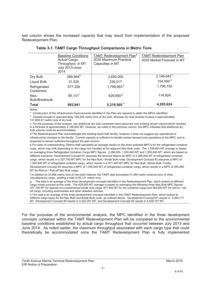
Table 3-1 below compares the TAMT’s existing environmental baseline condition by cargo type with the MPCs identified in the 2008 Plan and the proposed Redevelopment Plan. The TAMT’s existing environmental baseline condition is based on actual throughput calculations from July 2013 to June 2014, with June 2014 being the point in time at which the environmental analysis was initiated. The 2008 Plan identifies a MPC scenario if no infrastructure improvements are made. By contrast, the
5 of 81
_____________________________________________________________________________________________Tenth Avenue Marine Terminal Redevelopment Plan March 2015EIR Notice of Preparation
- 4 -
last column shows the increased capacity that may result from implementation of the proposed Redevelopment Plan.
Table 3-1. TAMT Cargo Throughput Comparisons in Metric Tons
Baseline ConditionsActual Cargo Throughput in MT July 2013-June 2014
TAMT Redevelopment Plana
2035 Maximum Practical Capacities in MT
TAMT Redevelopment Plan
2035 Market Forecast in MT
Dry Bulk 289,864b
2,650,000 2,146,645c
Liquid Bulk 31,520 239,017 154,000d
Refrigerated Containers
577,326 1,799,893e 1,790,155
Neo-Bulk/Breakbulk
85,131f
629,650g 114,824
Total 983,841 5,318,560 h 4,205,624
Notes:a
Construction of the infrastructure improvements identified in the Plan are required to attain the MPCs identified. b
Vessels brought in approximately 158,205 metric tons of dry bulk, whereas dry bulk tenants trucked in approximately 131,659.57 metric tons of dry bulk.
c For the purposes of the analysis, two additional dry bulk customers were assumed over existing tenant volume,which resulted in a forecast of approximately 2,146,645 MT. However, as noted in the previous column, the MPC indicates that additional dry bulk volume could be accommodated.
d The Redevelopment Plan acknowledges the existing liquid bulk facility, however it does not suggest any operational or
infrastructure changes to the facility. Current capacity is sufficient to handle market demand and operations at the MPC, and is
projected to remain sufficient throughout the plan horizon
e For ease of understanding, District staff calculated an average based on the three potential MPC’s for the refrigerated container
node, which may shift depending on the cargo mix handled at the adjacent Neo Bulk node. The 1,799,893 MT average is based
on averaging three Refrigerated Container Cargo MPC figures: 2,288,000, 1,555,840 MT and 1,555,840 MT, which are based on
different scenarios. Development Concept #1 assumes the terminal attains an MPC of 2,288,000 MT of refrigerated container
cargo, which results in a 327,700 MT MPC for the Neo Bulk / Break Bulk node. Development Concept #2 assumes a MPC of
1,555,840 MT of refrigerated container cargo, which results in a 977,400 MT MPC for Neo Bulk / Break Bulk. Finally,
Development Concept #3 assumes a MPC of 1,555,840 MT of refrigerated container cargo, which results in a MPC of 583,850
MT for Roll-on / Roll-off Neo Bulk cargo.
f In addition to 33,666 metric tons of neo-bulk material, the TAMT also processed 51,465 metric revenue tons of other miscellaneous cargo, yielding a total of 85,131 metric tons.
g . The total is an average of the three development concepts identified in the Redevelopment Plan, which looked at different cargo mixes pursued at this node. The 629,650 MT average is based on averaging the following three Neo Bulk MPC figures: 327,700 MT for special non-containerized break bulk cargo, 977,400 MT for dry container cargo and 583,850 MT for roll-on / roll-off cargo, including automobiles and other wheeled vehicles.
h The total is an average of the three development concepts identified in the TAMT Redevelopment Plan, which looked at different cargo types for the Neo Bulk and Break Bulk node, as outlined above. Development Concept #1 results in 5,504,717 MT, Development Concept #2 results in 5,422,257 MT, and Development Concept #3 results in 5,028,707 MT.
For the purposes of the environmental analysis, the MPC identified in the three development concepts contained within the TAMT Redevelopment Plan will be compared to the environmental baseline conditions established by actual cargo throughput that occurred between July 2013 and June 2014. As noted earlier, the maximum throughput associated with each cargo type that could theoretically be accommodated once the TAMT Redevelopment Plan is fully implemented
6 of 81
_____________________________________________________________________________________________Tenth Avenue Marine Terminal Redevelopment Plan March 2015EIR Notice of Preparation
- 5 -
represents the “worst case”1 scenario. As such, the Plan identifies the TAMT’s total MPC to be between 5 million and 5.5 million metric tons, depending on the type and mix of cargo types.
Conversely, the Redevelopment Plan’s 2035 Forecast listed in the third column in Table 3-1identifies a more realistic planning scenario based on discussions with current tenants, potential tenants, and knowledge of industry trends. The Plan’s 2035 Forecast is estimated to be approximately 4.2 million metric tons annually.
It is important to reiterate that the MPC’s identified in the three development concepts in the TAMT Redevelopment Plan would only be reached if its infrastructure improvements are constructed and if market conditions allow. The District determined that the environmental analysis should assume favorable market conditions because this approach would be the most conservative (i.e., all improvements would be constructed and MPC would be reached), and it would provide the District with the most flexibility with respect to pursuing future opportunities. The environmental document also analyzes potential environmental impacts associated with the construction and operation of the infrastructure improvements contemplated by the Plan.
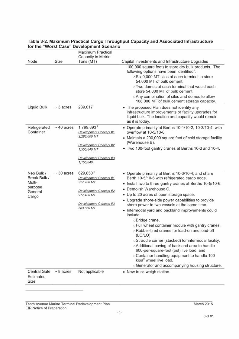
Table 3-2 summarizes maximum practical throughput based on the maximum capacity by cargo type, as well as the infrastructure improvements and operational enhancements that would be needed to attain such throughput levels.
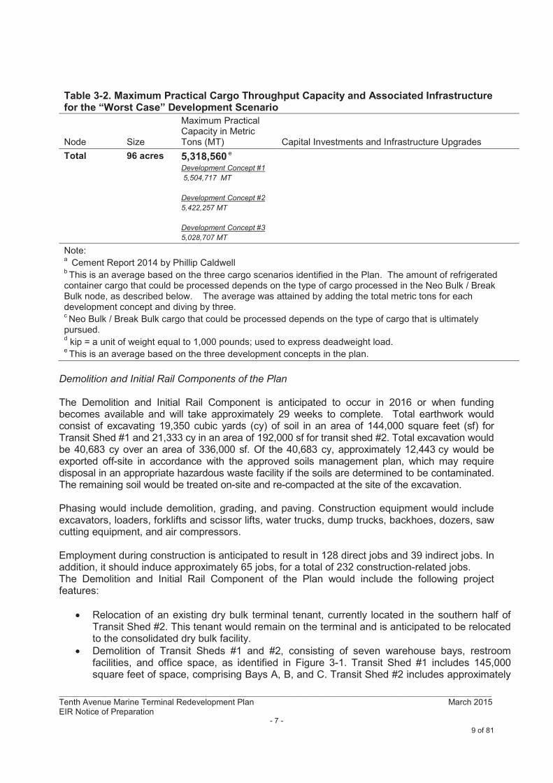
Table 3-2. Maximum Practical Cargo Throughput Capacity and Associated Infrastructurefor the “Worst Case” Development Scenario
Node Size
Maximum Practical Capacity in Metric Tons (MT) Capital Investments and Infrastructure Upgrades
Dry Bulk ~ 15 acres Up to 2,650,000 Operate primarily at Berths 10-5/10-6 and 10-7/10-8
Upgrade the existing conveyor system to handle multiple bulk commodities, such as cement, bauxite or soda ash.
Maintain approximately 5 acres of open-storage space between Water Street and Terminal Street.
Add a consolidated bulk discharge unloader using a 200 metric ton per hour vacuum for cementatious materials at Berth 10-7/10-8 (either a Kovaco, Siwertell or similar type system).
Demolish existing molasses tanks once new dry bulk storage has been established.
Relocate existing bulk tenants from Warehouse Cand Transit Shed 2 to the consolidated dry bulk facility prior to Transit Shed and Warehouse C demolition.
Establish a consolidated Multipurpose Dry bulk facility with two cement terminals and construct new semi-permanent (e.g. a Rubb style of building (www.rubb.com) storage facility (up to a total of
1Note that “worst case” refers to the development concept, or scenario, that would have the greatest potential impact
on the environment.
7 of 81
_____________________________________________________________________________________________Tenth Avenue Marine Terminal Redevelopment Plan March 2015EIR Notice of Preparation
- 6 -
Table 3-2. Maximum Practical Cargo Throughput Capacity and Associated Infrastructurefor the “Worst Case” Development Scenario
Node Size
Maximum Practical Capacity in Metric Tons (MT) Capital Investments and Infrastructure Upgrades
100,000 square feet) to store dry bulk products. The following options have been identified
2:
oSix 9,000 MT silos at each terminal to store 54,000 MT of bulk cement.
oTwo domes at each terminal that would each store 54,000 MT of bulk cement.
oAny combination of silos and domes to allow 108,000 MT of bulk cement storage capacity.
Liquid Bulk ~ 3 acres 239,017 The proposed Plan does not identify any infrastructure improvements or facility upgrades for liquid bulk. The location and capacity would remain as it is today.
Refrigerated Container
~ 40 acres 1,799,893b
Development Concept #1
2,288,000 MT
Development Concept #2
1,555,840 MT
Development Concept #3
1,155,840
Operate primarily at Berths 10-1/10-2, 10-3/10-4, with overflow at 10-5/10-6.
Maintain a 200,000 square feet of cold storage facility (Warehouse B).
Two 100-foot gantry cranes at Berths 10-3 and 10-4.
Neo Bulk / Break Bulk / Multi-purpose General Cargo
~ 30 acres 629,650c
Development Concept #1
327,700 MT
Development Concept #2
977,400 MT
Development Concept #3
583,850 MT
Operate primarily at Berths 10-3/10-4, and share Berth 10-5/10-6 with refrigerated cargo node.
Install two to three gantry cranes at Berths 10-5/10-6.
Demolish Warehouse C.
Up to 20 acres of open storage space.
Upgrade shore-side power capabilities to provide shore power to two vessels at the same time.
Intermodal yard and backland improvements could include:
oBridge crane,
oFull wheel container module with gantry cranes,
oRubber-tired cranes for load-on and load-off (LO/LO)
oStraddle carrier (stacked) for intermodal facility,
oAdditional paving of backland area to handle 600-per-square-foot (psf) live load, and
oContainer handling equipment to handle 100 kipa
dwheel live load,
oGenerator and accompanying housing structure.
Central Gate
Estimated Size
~ 8 acres Not applicable New truck weigh station.
8 of 81
_____________________________________________________________________________________________Tenth Avenue Marine Terminal Redevelopment Plan March 2015EIR Notice of Preparation
- 7 -
Table 3-2. Maximum Practical Cargo Throughput Capacity and Associated Infrastructurefor the “Worst Case” Development Scenario
Node Size
Maximum Practical Capacity in Metric Tons (MT) Capital Investments and Infrastructure Upgrades
Total 96 acres 5,318,560 e
Development Concept #1
5,504,717 MT
Development Concept #2
5,422,257 MT
Development Concept #3
5,028,707 MT
Note:a
Cement Report 2014 by Phillip Caldwell b This is an average based on the three cargo scenarios identified in the Plan. The amount of refrigerated
container cargo that could be processed depends on the type of cargo processed in the Neo Bulk / Break Bulk node, as described below. The average was attained by adding the total metric tons for each development concept and diving by three. cNeo Bulk / Break Bulk cargo that could be processed depends on the type of cargo that is ultimately
pursued.d
kip = a unit of weight equal to 1,000 pounds; used to express deadweight load.e This is an average based on the three development concepts in the plan.
Demolition and Initial Rail Components of the Plan
The Demolition and Initial Rail Component is anticipated to occur in 2016 or when funding becomes available and will take approximately 29 weeks to complete. Total earthwork would consist of excavating 19,350 cubic yards (cy) of soil in an area of 144,000 square feet (sf) for Transit Shed #1 and 21,333 cy in an area of 192,000 sf for transit shed #2. Total excavation would be 40,683 cy over an area of 336,000 sf. Of the 40,683 cy, approximately 12,443 cy would be exported off-site in accordance with the approved soils management plan, which may require disposal in an appropriate hazardous waste facility if the soils are determined to be contaminated. The remaining soil would be treated on-site and re-compacted at the site of the excavation.
Phasing would include demolition, grading, and paving. Construction equipment would include excavators, loaders, forklifts and scissor lifts, water trucks, dump trucks, backhoes, dozers, saw cutting equipment, and air compressors.
Employment during construction is anticipated to result in 128 direct jobs and 39 indirect jobs. In addition, it should induce approximately 65 jobs, for a total of 232 construction-related jobs.The Demolition and Initial Rail Component of the Plan would include the following project features:
Relocation of an existing dry bulk terminal tenant, currently located in the southern half of Transit Shed #2. This tenant would remain on the terminal and is anticipated to be relocated to the consolidated dry bulk facility.
Demolition of Transit Sheds #1 and #2, consisting of seven warehouse bays, restroom facilities, and office space, as identified in Figure 3-1. Transit Shed #1 includes 145,000 square feet of space, comprising Bays A, B, and C. Transit Shed #2 includes approximately
9 of 81
_____________________________________________________________________________________________Tenth Avenue Marine Terminal Redevelopment Plan March 2015EIR Notice of Preparation
- 8 -
200,000 square feet of warehouse space, comprising Bays E, F, G, and H. Demolition would also involve the proper removal of any asbestos, lead, polychlorinated biphenyls (PCBs), or other potentially hazardous materials that may be present in the transit sheds, followed by removal of the existing fire and electrical systems. Once completed, soil excavation and grading would occur, followed by paving and leveling across the site. The existing 90-foot-tall light poles at the loading docks and around the transit shed perimeter would be replaced.
On-terminal rail facility upgrades, which would include installation of a rail lubricator and a compressed air system on the existing track, thereby increasing safety and efficiency. Manual lubrication would be eliminated and replaced with automated lubrication to accommodate a sharp curve in the existing track. The compressed air system would include a compressed air generator with an accompanying housing structure, and piping to several rails within the terminal.
A temporary modular office with restroom facilities. Underground water, sewer, and electrical utilities would be installed to support the proposed modular structures.
An updated 100-year floodplain boundary that accurately depicts potential flooding hazards on the TAMT project site.
An increase in cargo throughput within the existing terminal footprint is an expected outcome ofthe Demolition and Initial Rail Component. Although the on-dock intermodal rail facility would enable cargo to move more efficiently between vessel and rail, which may offset some truck trips with rail trips, at least initially, the Demolition and Initial Rail is generally assumed to result in a net increase cargo throughput. As such, long-term employment is anticipated to increase by 290 direct jobs and 57 indirect jobs. In addition, it should induce another 112 jobs, for a total of 459. Once the existing underutilized infrastructure is removed, cargo nodes could be developed, as recommended by the proposed Plan, based on cargo type and market conditions. To ensure market conditions are favorable, the Plan does not recommend making any infrastructure improvements until the cargo node reaches 70% of the maximum practical capacity identified in the 2008 Plan.
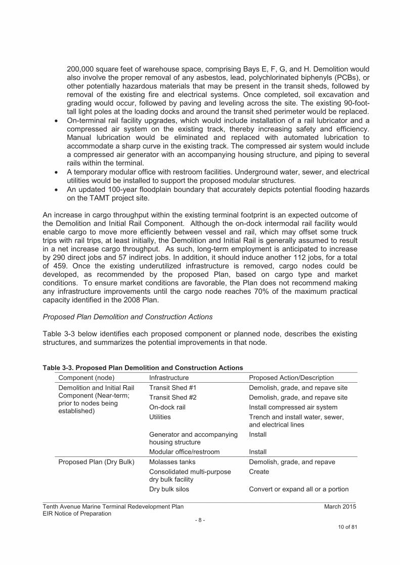
Proposed Plan Demolition and Construction Actions
Table 3-3 below identifies each proposed component or planned node, describes the existing structures, and summarizes the potential improvements in that node.
Table 3-3. Proposed Plan Demolition and Construction Actions
Component (node) Infrastructure Proposed Action/Description
Demolition and Initial Rail Component (Near-term; prior to nodes being established)
Transit Shed #1 Demolish, grade, and repave site
Transit Shed #2 Demolish, grade, and repave site
On-dock rail Install compressed air system
Utilities Trench and install water, sewer, and electrical lines
Generator and accompanyinghousing structure
Install
Modular office/restroom Install
Proposed Plan (Dry Bulk) Molasses tanks Demolish, grade, and repave
Consolidated multi-purpose dry bulk facility
Create
Dry bulk silos Convert or expand all or a portion
10 of 81
_____________________________________________________________________________________________Tenth Avenue Marine Terminal Redevelopment Plan March 2015EIR Notice of Preparation
- 9 -
Bulk cargo ground-storage facility
Construct a new structure to provide cover for ground-stored bulk products. Structure may consist of a dome, silo or other structure and be permanent or semi-permanent.
Warehouse Demolish, grade and repave site
Berths 10-7/10-8 unloading systems
Modernize
Proposed Plan (Liquid Bulk) No changes No changes
Proposed Plan (Refrigerated Bulk)
Gantry cranes Install two new electrical gantry cranes (100-foot gauge)
Proposed Plan (Neo-Bulk) Warehouse C Demolish
Centralized Common Gate Gate Facilities Modernize and upgrade
Weigh Station Install
ENVIRONMENTAL CONSIDERATIONS
The EIR will address the following potential project-related and cumulative environmental effects of the proposed project: Aesthetics and Visual Resources, Air Quality/Health Risk, Biological Resources, Cultural Resources, Geology and Soils, Greenhouse Gas Emissions/Sea Level Rise, Hazards and Hazardous Materials, Hydrology and Water Quality, Noise, Transportation and Traffic, and Utilities/Energy, and other potential impacts identified during the scopingprocess. The EIR will also address feasible mitigation measures and a reasonable range of alternatives, as well as the additional mandatory sections required by CEQA. The District will also prepare a mitigation monitoring and reporting program to address the potential significant impacts of the proposed project.
The Initial Study – Environmental Checklist is attached.
COMMENTS
This NOP is available for a 30-day public review period that starts on Thursday, March 12, 2015 and ends at 5:00 p.m. on Tuesday, April 14, 2015. Comments regarding the scope and content of the environmental information that should be included in the EIR and other environmental concerns should be mailed to:
San Diego Unified Port DistrictEnvironmental & Land Use Management Department
Attn: Larry Hofreiter3165 Pacific HighwaySan Diego, CA 92101
or emailed to [email protected]
PUBLIC SCOPING MEETING
A public scoping meeting to solicit comments on the scope and content of the EIR for the proposed project will be held on Wednesday, March 18, 2015, at 5:30 p.m. at the San Diego Unified Port District Administration Building, Training Room, 3165 Pacific Highway, San Diego, CA 92101.
11 of 81
_____________________________________________________________________________________________Tenth Avenue Marine Terminal Redevelopment Plan March 2015EIR Notice of Preparation
- 10 -
The District, as Lead Agency pursuant to CEQA, will review the public comments on the NOP to determine what issues should be addressed in the EIR.
Other opportunities for the public to comment on the environmental effects of the proposed project include:
A minimum 45-day public review and comment period for the Draft EIRA public hearing for the Board of Port Commissioners to consider certification of the EIR
For questions regarding this NOP, please contact Larry Hofreiter, Senior Redevelopment Planner, at 619.686.6257.
ATTACHMENTS
Figure 1 – Regional MapFigure 2 – Tenth Avenue Marine Terminal (TAMT) Aerial MapFigure 3 – TAMT Long Term Full Build Out Development Plan Map Initial Study/Environmental ChecklistExecutive Summary for the Tenth Avenue Martine Terminal (TAMT) Redevelopment Plan
12 of 81
Regional Map Figure 1
Paci c Ocean
Carlsbad
Encinitas
Solana Beach
San Diego
Coronado
Na onal City
Chula Vista
Imperial Beach
San Diego
Mexico
Del Mar
Poway
Santee
El Cajon
Project Site
13 of 81

This page intentionally left blank
14 of 81
¯
Tra
nsit
Sh
ed
#1
Tra
nsit
Sh
ed
#2
Ten
th A
ve
nu
e M
ari
ne
Te
rmin
al
(TA
MT
) A
eri
al P
ho
to
10
-3
10
-4
10
-5
10
-6
Fig
ure
2
Wa
re
ho
use
B
Wa
re
ho
use
C
15 o
f 81

This
page inte
ntionally
left
bla
nk
16 o
f 81
¯TA
MT
Lo
ng
Te
rm F
ull
Bu
ild
Ou
t D
eve
lop
me
nt
Pla
n
Liq
uid
Bu
lk
Term
ina
l
Re
frig
era
ted
Fre
sh
Fru
it C
on
tain
er
Term
ina
l
Mu
ltip
urp
ose
Co
nta
ine
r, N
eo
Bu
lk,
Pro
ject
Ca
rgo
Term
ina
l
Mu
ltip
urp
ose
Dry
Bu
lk
Ce
ntr
ali
zed
Co
mm
on
Ga
te
10
-3
10
-4
10
-5
10
-6
Fig
ure
3
17 o
f 81

This
page inte
ntionally
left
bla
nk
18 o
f 81
TENTH AVENUE MARINE TERMINAL (TAMT)
REDEVELOPMENT PLAN
INITIAL STUDY / ENVIRONMENTAL CHECKLIST
CALIFORNIA ENVIRONMENTAL QUALITY ACT
(CEQA)
Prepared by:
ICF INTERNATIONAL
MARCH 2015
19 of 81
San Diego Unified Port District
Contents
Tenth Avenue Marine Terminal Redevelopment Plan ii
March 2015 ICF 00165.14
Contents
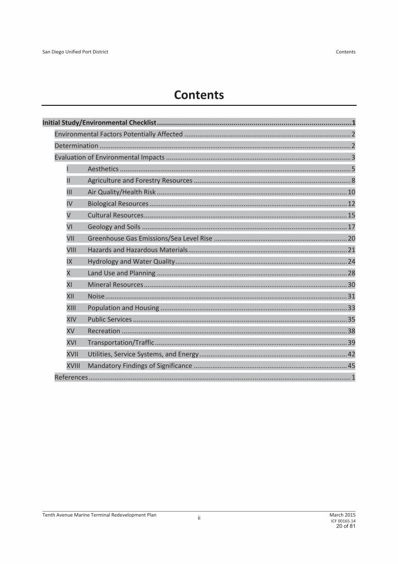
Initial Study/Environmental Checklist ................................................................................................. 1
Environmental Factors Potentially Affected .......................................................................................... 2
Determination ........................................................................................................................................ 2
Evaluation of Environmental Impacts .................................................................................................... 3
I Aesthetics ............................................................................................................................. 5
II Agriculture and Forestry Resources ..................................................................................... 8
III Air Quality/Health Risk ....................................................................................................... 10
IV Biological Resources ........................................................................................................... 12
V Cultural Resources .............................................................................................................. 15
VI Geology and Soils ............................................................................................................... 17
VII Greenhouse Gas Emissions/Sea Level Rise ........................................................................ 20
VIII Hazards and Hazardous Materials ...................................................................................... 21
IX Hydrology and Water Quality ............................................................................................. 24
X Land Use and Planning ....................................................................................................... 28
XI Mineral Resources .............................................................................................................. 30
XII Noise ................................................................................................................................... 31
XIII Population and Housing ..................................................................................................... 33
XIV Public Services .................................................................................................................... 35
XV Recreation .......................................................................................................................... 38
XVI Transportation/Traffic ........................................................................................................ 39
XVII Utilities, Service Systems, and Energy ................................................................................ 42
XVIII Mandatory Findings of Significance ................................................................................... 45
References .............................................................................................................................................. 1
20 of 81
San Diego Unified Port District
Contents
Tenth Avenue Marine Terminal Redevelopment Plan iii
March 2015 ICF 00165.14
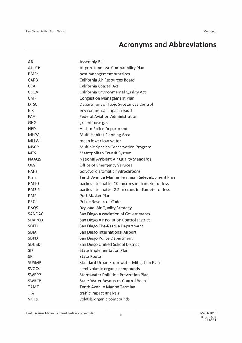
Acronyms and Abbreviations
AB Assembly Bill
ALUCP Airport Land Use Compatibility Plan
BMPs best management practices
CARB California Air Resources Board
CCA California Coastal Act
CEQA California Environmental Quality Act
CMP Congestion Management Plan
DTSC Department of Toxic Substances Control
EIR environmental impact report
FAA Federal Aviation Administration
GHG greenhouse gas
HPD Harbor Police Department
MHPA Multi-Habitat Planning Area
MLLW mean lower low-water
MSCP Multiple Species Conservation Program
MTS Metropolitan Transit System
NAAQS National Ambient Air Quality Standards
OES Office of Emergency Services
PAHs polycyclic aromatic hydrocarbons
Plan Tenth Avenue Marine Terminal Redevelopment Plan
PM10 particulate matter 10 microns in diameter or less
PM2.5 particulate matter 2.5 microns in diameter or less
PMP Port Master Plan
PRC Public Resources Code
RAQS Regional Air Quality Strategy
SANDAG San Diego Association of Governments
SDAPCD San Diego Air Pollution Control District
SDFD San Diego Fire-Rescue Department
SDIA San Diego International Airport
SDPD San Diego Police Department
SDUSD San Diego Unified School District
SIP State Implementation Plan
SR State Route
SUSMP Standard Urban Stormwater Mitigation Plan
SVOCs semi-volatile organic compounds
SWPPP Stormwater Pollution Prevention Plan
SWRCB State Water Resources Control Board
TAMT Tenth Avenue Marine Terminal
TIA traffic impact analysis
VOCs volatile organic compounds
21 of 81
Tenth Avenue Marine Terminal Redevelopment Plan 1
March 2015 ICF 00165.14
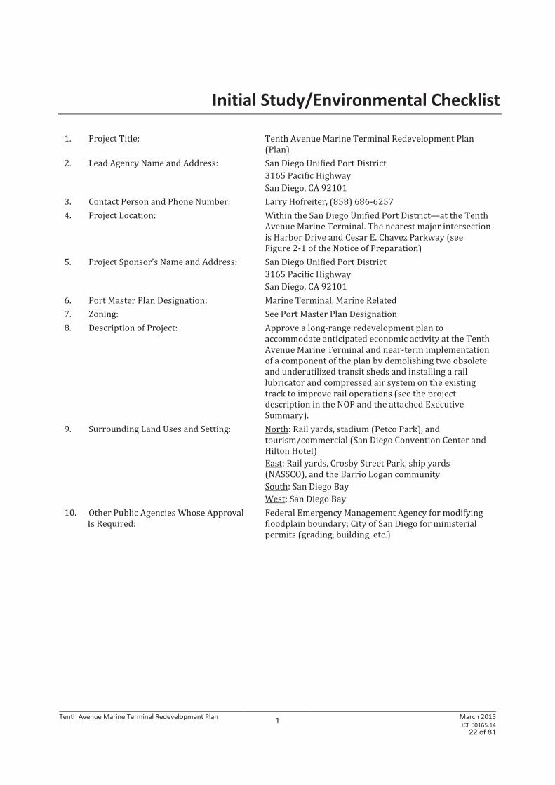
Initial Study/Environmental Checklist
1. Project Title: Tenth Avenue Marine Terminal Redevelopment Plan
(Plan)
2. Lead Agency Name and Address:
San Diego Unified Port District
3165 Pacific Highway
San Diego, CA 92101
3. Contact Person and Phone Number: Larry Hofreiter, (858) 686-6257
4. Project Location:
Within the San Diego Unified Port District—at the Tenth
Avenue Marine Terminal. The nearest major intersection
is Harbor Drive and Cesar E. Chavez Parkway (see
Figure 2-1 of the Notice of Preparation)
5. Project Sponsor’s Name and Address:
San Diego Unified Port District
3165 Pacific Highway
San Diego, CA 92101
6. Port Master Plan Designation: Marine Terminal, Marine Related
7. Zoning: See Port Master Plan Designation
8. Description of Project: Approve a long-range redevelopment plan to
accommodate anticipated economic activity at the Tenth
Avenue Marine Terminal and near-term implementation
of a component of the plan by demolishing two obsolete
and underutilized transit sheds and installing a rail
lubricator and compressed air system on the existing
track to improve rail operations (see the project
description in the NOP and the attached Executive
Summary).
9. Surrounding Land Uses and Setting: North: Rail yards, stadium (Petco Park), and
tourism/commercial (San Diego Convention Center and
Hilton Hotel)
East: Rail yards, Crosby Street Park, ship yards
(NASSCO), and the Barrio Logan community
South: San Diego Bay
West: San Diego Bay
10. Other Public Agencies Whose Approval
Is Required:
Federal Emergency Management Agency for modifying
floodplain boundary; City of San Diego for ministerial
permits (grading, building, etc.)
22 of 81
23 of 81
San Diego Unified Port District
Initial Study/Environmental Checklist
Tenth Avenue Marine Terminal Redevelopment Plan 3
March 2015 ICF 00165.14
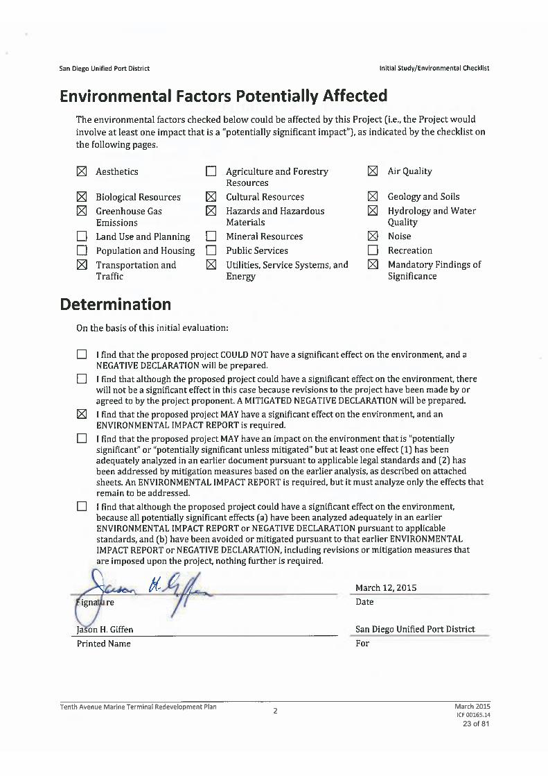
Evaluation of Environmental Impacts 1. A brief explanation is required for all answers except “No Impact” answers that are adequately
supported by the information sources a Lead Agency cites in the parentheses following each
question. A “No Impact” answer is adequately supported if the referenced information sources
show that the impact simply does not apply to projects such as the one involved (e.g., the project
falls outside a fault rupture zone). A “No Impact” answer should be explained if it is based on
project-specific factors as well as general standards (e.g., the project will not expose sensitive
receptors to pollutants, based on a project-specific screening analysis).
2. All answers must take account of the whole action involved, including off-site as well as on-site,
cumulative as well as project-level, indirect as well as direct, and construction as well as
operational impacts.
3. Once the Lead Agency has determined that a particular physical impact may occur, the checklist
answers must indicate whether the impact is potentially significant, less than significant with
mitigation, or less than significant. “Potentially Significant Impact” is appropriate if there is
substantial evidence that an effect may be significant. If there are one or more “Potentially
Significant Impact” entries when the determination is made, an Environmental Impact Report
(EIR) is required.
4. “Negative Declaration: Less than Significant with Mitigation Incorporated” applies when the
incorporation of mitigation measures has reduced an effect from a “Potentially Significant
Impact” to a “Less-than-Significant Impact.” The Lead Agency must describe the mitigation
measures and briefly explain how they reduce the effect to a less-than-significant level.
5. Earlier analyses may be used if, pursuant to tiering, program EIR, or other California
Environmental Quality Act (CEQA) process, an effect has been adequately analyzed in an earlier
EIR or negative declaration [Section 15063(c)(3)(D)]. In this case, a brief discussion should
identify the following:
a. Earlier Analysis Used. Identify and state where earlier analyses are available for review.
b. Impacts Adequately Addressed. Identify which effects from the above checklist were within
the scope of and adequately analyzed in an earlier document pursuant to applicable legal
standards and state whether such effects were addressed by mitigation measures based on
the earlier analysis.
c. Mitigation Measures. For effects that are “Less than Significant with Mitigation Incorporated,”
describe the mitigation measures that were incorporated or refined from the earlier
document and the extent to which they address site-specific conditions for the project.
6. Lead agencies are encouraged to incorporate into the checklist references to information sources
for potential impacts (e.g., general plans, zoning ordinances). Reference to a previously prepared
or outside document should, when appropriate, include a reference to the page or pages where
the statement is substantiated.
7. Supporting Information Sources: A source list should be attached, and other sources used or
individuals contacted should be cited in the discussion.
24 of 81
San Diego Unified Port District
Initial Study/Environmental Checklist
Tenth Avenue Marine Terminal Redevelopment Plan 4
March 2015 ICF 00165.14
8. This is only a suggested form, and lead agencies are free to use different formats; however, lead
agencies should normally address the questions from this checklist that are relevant to a project’s
environmental effects in whatever format is selected.
9. The explanation of each issue should identify:
a. The significance criteria or threshold, if any, used to evaluate each question; and
b. The mitigation measure identified, if any, to reduce the impact to a less-than-significant level.
25 of 81
San Diego Unified Port District
Initial Study/Environmental Checklist
Tenth Avenue Marine Terminal Redevelopment Plan 5
March 2015 ICF 00165.14
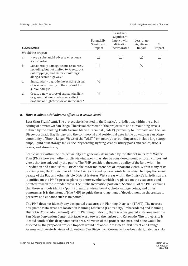
I. Aesthetics
Potentially
Significant
Impact
Less-than-
Significant
Impact with
Mitigation
Incorporated
Less-than-
Significant
Impact
No
Impact
Would the project:
a. Have a substantial adverse effect on a
scenic vista?
b. Substantially damage scenic resources,
including, but not limited to, trees, rock
outcroppings, and historic buildings
along a scenic highway?
c. Substantially degrade the existing visual
character or quality of the site and its
surroundings?
d. Create a new source of substantial light
or glare that would adversely affect
daytime or nighttime views in the area?
a. Have a substantial adverse effect on a scenic vista?
Less than Significant. The project site is located in the District’s jurisdiction, within the urban
setting of downtown San Diego. The visual character of the project site and surrounding area is
defined by the existing Tenth Avenue Marine Terminal (TAMT), proximity to Coronado and the San
Diego–Coronado Bay Bridge, and the commercial and residential uses in the downtown San Diego
community of Barrio Logan. Views of the TAMT from nearby surrounding areas include large cargo
ships, liquid bulk storage tanks, security fencing, lighting, cranes, utility poles and cables, trucks,
trains, and stored cargo.
Scenic vistas within the project vicinity are generally designated by the District in its Port Master
Plan (PMP); however, other public viewing areas may also be considered scenic or locally important
views that are enjoyed by the public. The PMP considers the scenic quality of the land within its
jurisdiction and establishes District policies for maintenance of important views. Within many of its
precise plans, the District has identified vista areas—key viewpoints from which to enjoy the scenic
beauty of the Bay and other visible District features. Vista areas within the District’s jurisdiction are
identified on the PMP’s precise plans by arrow symbols, which are placed on the vista areas and
pointed toward the intended view. The Public Recreation portion of Section III of the PMP explains
that these symbols identify “points of natural visual beauty, photo vantage points, and other
panoramas. It is the intent of [the PMP] to guide the arrangement of development on those sites to
preserve and enhance such vista points.”
The PMP does not identify any designated vista areas in Planning District 4 (TAMT). The nearest
designated vista areas are located in Planning District 3 (Centre City/Embarcadero) and Planning
District 6 (Coronado Bayfront). Within Planning District 3, there is a designated vista area near the
San Diego Convention Center that faces west, toward the harbor and Coronado. The project site is
located south of this designated vista area. No views of the project site exist, and none would be
affected by the proposed project. Impacts would not occur. Areas near First Street and Orange
Avenue with westerly views of downtown San Diego from Coronado have been designated as vista
26 of 81
San Diego Unified Port District
Initial Study/Environmental Checklist
Tenth Avenue Marine Terminal Redevelopment Plan 6
March 2015 ICF 00165.14
areas. The potential exists for views of the project site from Coronado to be affected with the
introduction of pole lighting, cranes, and utility structures. However, views from designated scenic
vistas originating from Coronado already include the TAMT and all of the maritime operations such
as pole lighting, cranes, and utility structures. Moreover, the 96-acre TAMT is only a small portion of
the viewshed from Coronado with TAMT dwarfed by the high-rise towers of downtown San Diego
and in character with the naval shipyards to the southeast. Therefore, the existing views from
Coronado would not substantially change if the project is implemented and the plan is adopted.
Impacts on scenic vistas would be less than significant and no further discussion in the EIR is
warranted.
b. Substantially damage scenic resources, including, but not limited to trees, rock outcroppings,
and historic buildings along a scenic highway?
Less than Significant Impact. The San Diego–Coronado Bay Bridge (State Route [SR] 75) is a
California State-designated scenic highway, located just south of the project area, that spans the Bay,
connecting the City of San Diego to the City of Coronado. Existing long-distance views of the project
site and the downtown area from the San Diego–Coronado Bay Bridge are dominated by a mix of
high-rise residential, commercial, and urban developments as well as a variety of maritime industrial
facilities (such as storage structures, large vessels, docks, piers, cranes, trucks, and other large pieces
of shipping equipment). From SR-75, the project site appears in front of the downtown skyline of San
Diego and behind the water of San Diego Bay. Ships, silos, warehouses, and heavy industrial
machinery are visible under existing conditions. Views of the site include transit sheds, warehouses,
cargo, and associated equipment at the terminal.
Implementation of the project is not anticipated to damage scenic resources, such as trees or rock
outcroppings, because there are no such resources at the project site. Visual changes associated with
the project would include internal terminal reconfiguration, including up to two new gantry cranes,
and increased cargo throughput. The increased cargo throughput would include additional vessel,
rail, and truck operations. Although these visual changes would be at least partly visible from
portions of SR-75, they would not be striking or noticeable because of the distance between the site
and SR-75. Additionally, the site would continue to be industrial in nature. Furthermore, motorists
traveling on SR-75 would generally be focused on the roadway in front of them. Their northerly
views while traveling westbound or eastbound would not be prolonged, and viewer sensitivity to the
proposed changes would be low. Removal of the potentially historic transit sheds would affect two
existing single-story industrial buildings that are not particularly noticeable or striking while
traveling on SR-75. The proposed additions at the project site would be similar in size, color, and
scale to elements of the existing developed site, which would continue to appear as a working marine
terminal. The effect on SR-75, a designated scenic highway, would not be substantial for reasons
discussed. Therefore, the impact on designated scenic highways would be less than significant and no
further discussion in the EIR is warranted.
c. Substantially degrade the existing visual character or quality of the site and its surroundings?
Potentially Significant Impact. The proposed project would reconfigure and improve import and
export operations at an existing marine terminal in an industrial and maritime area along San Diego
Bay. In general, views of the project site from surrounding areas are limited because of the site’s
location along San Diego Bay and the limited visibility from adjacent roadways; however,
intermittent and fleeting westerly views are available from northbound or southbound vehicles on
Harbor Drive. The proposed project would remove two transit sheds and introduce new visual
27 of 81
San Diego Unified Port District
Initial Study/Environmental Checklist
Tenth Avenue Marine Terminal Redevelopment Plan 7
March 2015 ICF 00165.14
elements (such as silos, large cargo stacks in open storage areas, a modular office, unloading systems,
and up to two gantry cranes), and although their introduction would be compatible and consistent
with the existing industrial and shipping-related visual character that exists at the site, further
discussion and analysis is warranted in the EIR.
d. Create a new source of substantial light or glare that would adversely affect daytime or
nighttime views in the area?
Potentially Significant Impact. The proposed project would include the replacement of existing
light poles on the project site, which could adversely affect daytime or nighttime views in the area.
Further discussion of potentially significant impacts related to substantial light or glare that would
adversely affect daytime or nighttime views in the area will be included in the EIR.
28 of 81
San Diego Unified Port District
Initial Study/Environmental Checklist
Tenth Avenue Marine Terminal Redevelopment Plan 8
March 2015 ICF 00165.14
II. Agriculture and Forestry Resources
Potentially
Significant
Impact
Less-than-
Significant
Impact with
Mitigation
Incorporated
Less-than-
Significant
Impact
No
Impact
In determining whether impacts on agricultural
resources are significant environmental effects,
lead agencies may refer to the California
Agricultural Land Evaluation and Site Assessment
Model (1997) prepared by the California
Department of Conservation as an optional model
to use in assessing impacts on agriculture and
farmland. In determining whether impacts on
forest resources, including timberland, are
significant environmental effects, lead agencies
may refer to information compiled by the
California Department of Forestry and Fire
Protection regarding the State’s inventory of
forestland, including the Forest and Range
Assessment Project, the Forest Legacy Assessment
Project, and forest carbon measurement
methodology provided in Forest Protocols adopted
by the California Air Resources Board. Would the
Project:
a. Convert Prime Farmland, Unique Farmland,
or Farmland of Statewide Importance
(Farmland), as shown on the maps prepared
pursuant to the Farmland Mapping and
Monitoring Program of the California
Resources Agency, to nonagricultural use?
b. Conflict with existing zoning for agricultural
use or conflict with a Williamson Act contract?
c. Conflict with existing zoning for, or cause
rezoning of, forestland (as defined in Public
Resources Code Section 12220(g)),
timberland (as defined by Public Resources
Code Section 4526), or timberland zoned
Timberland Production (as defined by
Government Code Section 51104(g))?
d. Result in the loss of forestland or conversion
of forestland to nonforest use?
e. Involve other changes to the existing
environment that, because of their location or
nature, could result in the conversion of
Farmland to nonagricultural use or the
conversion of forestland to nonforest use?
29 of 81
San Diego Unified Port District
Initial Study/Environmental Checklist
Tenth Avenue Marine Terminal Redevelopment Plan 9
March 2015 ICF 00165.14
a. Convert Prime Farmland, Unique Farmland, or Farmland of Statewide Importance (Farmland),
as shown on the maps prepared pursuant to the Farmland Mapping and Monitoring Program of
the California Resources Agency, to nonagricultural use?
No Impact. The project site does not contain any Prime Farmland, Unique Farmland, or Farmland of
Statewide Importance, as shown on the maps prepared pursuant to the Farmland Mapping and
Monitoring Program of the California Resources Agency. As such, there is no potential for any actions
to convert Farmland resources to a nonagricultural use. No impact would occur, and mitigation
measures are not necessary. Further discussion in the EIR is not warranted.
b. Conflict with existing zoning for agricultural use or conflict with a Williamson Act contract?
No Impact. The project site is not zoned for agricultural use, nor is there a Williamson Act contract
for the site. Therefore, the proposed project would not conflict with existing zoning for agricultural
use or a Williamson Act contract, and no impact would occur. Further discussion in the EIR is not
warranted.
c. Conflict with existing zoning for, or cause rezoning of, forestland (as defined in Public Resources
Code Section 12220(g)), timberland (as defined by Public Resources Code Section 4526), or
timberland zoned Timberland Production (as defined by Government Code Section 51104(g))?
No Impact. No land that has been zoned as forestland or timberland exists within the boundaries of
the project site. No impact would occur and further discussion of this topic in the EIR is not
warranted.
d. Result in the loss of forestland or conversion of forestland to nonforest use?
No Impact. As discussed in Item IIc, no land that has been zoned as forestland or timberland exists
within the boundaries of the project site. Approval of the proposed plan would not result in a loss of
forestland or the conversion of forestland to other uses; no impact would occur and further
discussion of this topic in the EIR is not warranted.
e. Involve other changes to the existing environment that, because of their location or nature,
could result in the conversion of Farmland to nonagricultural use or the conversion of forestland
to nonforest use?
No Impact. See Item IIa. No agricultural land, forestland, or timberland exists in the vicinity of the
project site, which is part of the Port of San Diego, near downtown San Diego. The proposed project
would not involve changes to the existing environment that, because of their location or nature, could
result in the conversion of Farmland to nonagricultural use or forestland to nonforest use; no impact
would occur and further discussion in the EIR is not warranted.
30 of 81
San Diego Unified Port District
Initial Study/Environmental Checklist
Tenth Avenue Marine Terminal Redevelopment Plan 10
March 2015 ICF 00165.14
III. Air Quality/Health Risk
Potentially
Significant
Impact
Less-than-
Significant
Impact with
Mitigation
Incorporated
Less-than-
Significant
Impact
No
Impact
Would the project:
a. Conflict with or obstruct implementation of
the applicable air quality plan?
b. Violate any air quality standard or contribute
substantially to an existing or projected air
quality violation?
c. Result in a cumulatively considerable net
increase in any criteria pollutant for which the
project region is in nonattainment for an
applicable Federal or State ambient air quality
standard (including releasing emissions that
exceed quantitative thresholds for ozone
precursors)?
d. Expose sensitive receptors to substantial
pollutant concentrations?
e. Create objectionable odors that would affect a
substantial number of people?
a. Conflict with or obstruct implementation of the applicable air quality plan?
Potentially Significant Impact. The San Diego Air Pollution Control District (SDAPCD) is required,
pursuant to the federal and state Clean Air Acts, to reduce emissions of criteria pollutants for which
the County is in nonattainment (i.e., ozone, particulate matter of 10 microns in diameter or smaller
[PM10], and particulate matter of 2.5 microns in diameter or smaller [PM2.5]). The most recent
SDAPCD air quality attainment plans are the 2009 Regional Air Quality Strategy (RAQS) and the 2002
and 2012 ozone maintenance plans. The RAQS outlines SDAPCD’s plans and control measures
designed to attain the state air quality standards for ozone, while the 2002 and 2012 maintenance
plans include the SDAPCD’s plans and control measures for attaining the National Ambient Air
Quality Standards (NAAQS) for ozone. The 2009 RAQS projects future emissions and determines the
strategies necessary for the reduction of stationary source emissions through regulatory controls.
The federal Clean Air Act also mandates that the state submit and implement a State Implementation
Plan (SIP) for local areas not meeting those standards. California Air Resources Board (CARB) mobile
source emission projections and San Diego Association of Governments (SANDAG) growth
projections are based on population and vehicle trends and land use plans developed by local
agencies. As such, projects that propose development that is consistent with the growth anticipated
by the relevant land use plans that were used in the formulation of the RAQS and SIP would be
consistent with the RAQS and SIP. The PMP is the governing land use document for physical
development under the jurisdiction of the Port District. Therefore, projects that propose
development consistent with growth anticipated by the current PMP are considered consistent with
the RAQS and SIP. Moreover, in the event that a project proposes development that is less dense than
anticipated within a general plan (or other governing land use document such as the PMP), the
project would likewise be consistent with the RAQS and SIP because emissions would be less than
estimated for the existing PMP. If a project proposes development that is greater than that
31 of 81
San Diego Unified Port District
Initial Study/Environmental Checklist
Tenth Avenue Marine Terminal Redevelopment Plan 11
March 2015 ICF 00165.14
anticipated in the PMP and SANDAG’s growth projections, the project would be in conflict with the
RAQS and SIP, and might have a potentially significant impact on air quality because emissions would
exceed those estimated for the existing PMP. This situation would warrant further analysis to
determine if a project would exceed the growth projections used in the RAQS for a specific
subregional area. Further discussion will be provided in the EIR.
b. Violate any air quality standard or contribute substantially to an existing or projected air
quality violation?
Potentially Significant Impact. Construction of the proposed project has the potential to create air
quality impacts through the use of heavy-duty construction equipment, construction worker vehicle
trips, truck haul and material delivery trips, off-gassing from paving activities, and fugitive dust from
demolition and grading activities. Mobile-source criteria pollutant emissions would result from the
use of construction equipment and vehicles, and paving operations would result in emissions of
volatile organic compounds (VOCs) associated with off-gassing. Operation of the proposed project
has the potential to create air quality impacts primarily associated with truck trips, rail activity,
vessel activity, worker commutes, cargo on- and offloading and drayage, and minor increases in area
sources associated with periodic painting of paved surfaces and structures. As such, the project has
the potential to significantly contribute to the violation of an air quality standard or significantly
contribute to an existing or projected air quality violation, and this issue area will be analyzed in the
EIR.
c. Result in a cumulatively considerable net increase in any criteria pollutant for which the project
region is in nonattainment for an applicable Federal or State ambient air quality standard
(including releasing emissions that exceed quantitative thresholds for ozone precursors)?
Potentially Significant Impact. The San Diego Air Basin is in nonattainment status for ozone
(8-hour standard) at the federal and state level and in nonattainment status for ozone (1-hour
standard), particulate matter less than or equal to 10 micrometers in diameter, and particulate
matter less than or equal to 2.5 micrometers in diameter at the State level. The proposed project
could result in a cumulatively considerable net increase in these criteria pollutants. Further
discussion will be provided in the EIR.
d. Expose sensitive receptors to substantial pollutant concentrations?
Potentially Significant Impact. Sensitive receptors in the area are primarily the residential areas
east of the project site in the Barrio Logan neighborhood. Technical air quality analyses will be
prepared and summarized within an air quality technical study to evaluate short-, medium-, and
long-term pollutant emissions and concentrations. Further discussion will be provided in the EIR.
e. Create objectionable odors that would affect a substantial number of people?
Potentially Significant Impact. According to the California Air Resources Board’s 2005 CEQA Air
Quality and Land Use Handbook, land uses associated with odor complaints typically include
agricultural uses, wastewater treatment plants, food processing plants, chemical plants, composting
facilities, refineries, landfills, dairies, and fiberglass molding facilities. The proposed project does not
include any uses identified by the California Air Resources Board as being associated with odors.
However, potential odor emitters during construction activities include diesel exhaust, asphalt
paving, and the use of any architectural coatings. Potential odor emitters during operations would
include diesel exhaust from truck and train activity as well as the use of any architectural coatings.
This topic will be discussed further in the EIR.
32 of 81
San Diego Unified Port District
Initial Study/Environmental Checklist
Tenth Avenue Marine Terminal Redevelopment Plan 12
March 2015 ICF 00165.14
IV. Biological Resources
Potentially
Significant
Impact
Less-than-
Significant
Impact with
Mitigation
Incorporated
Less-than-
Significant
Impact
No
Impact
Would the project:
a. Have a substantial adverse effect, either
directly or through habitat modifications, on
any species identified as a candidate,
sensitive, or special-status species in local or
regional plans, policies, or regulations or by
the California Department of Fish and
Wildlife or U.S. Fish and Wildlife Service?
b. Have a substantial adverse effect on any
riparian habitat or other sensitive natural
community identified in local or regional
plans, policies, or regulations or by the
California Department of Fish and Wildlife or
U.S. Fish and Wildlife Service?
c. Have a substantial adverse effect on federally
protected wetlands, as defined by
Section 404 of the Clean Water Act
(including, but not limited to, marshes,
vernal pools, coastal wetlands, etc.), through
direct removal, filling, hydrological
interruption, or other means?
d. Interfere substantially with the movement of
any native resident or migratory fish or
wildlife species or with established native
resident or migratory wildlife corridors or
impede the use of native wildlife nursery
sites?
e. Conflict with any local policies or ordinances
to protect biological resources, such as a tree
preservation policy or ordinance?
f. Conflict with the provisions of an adopted
habitat conservation plan, natural
community conservation plan, or other
approved local, regional, or State habitat
conservation plan?
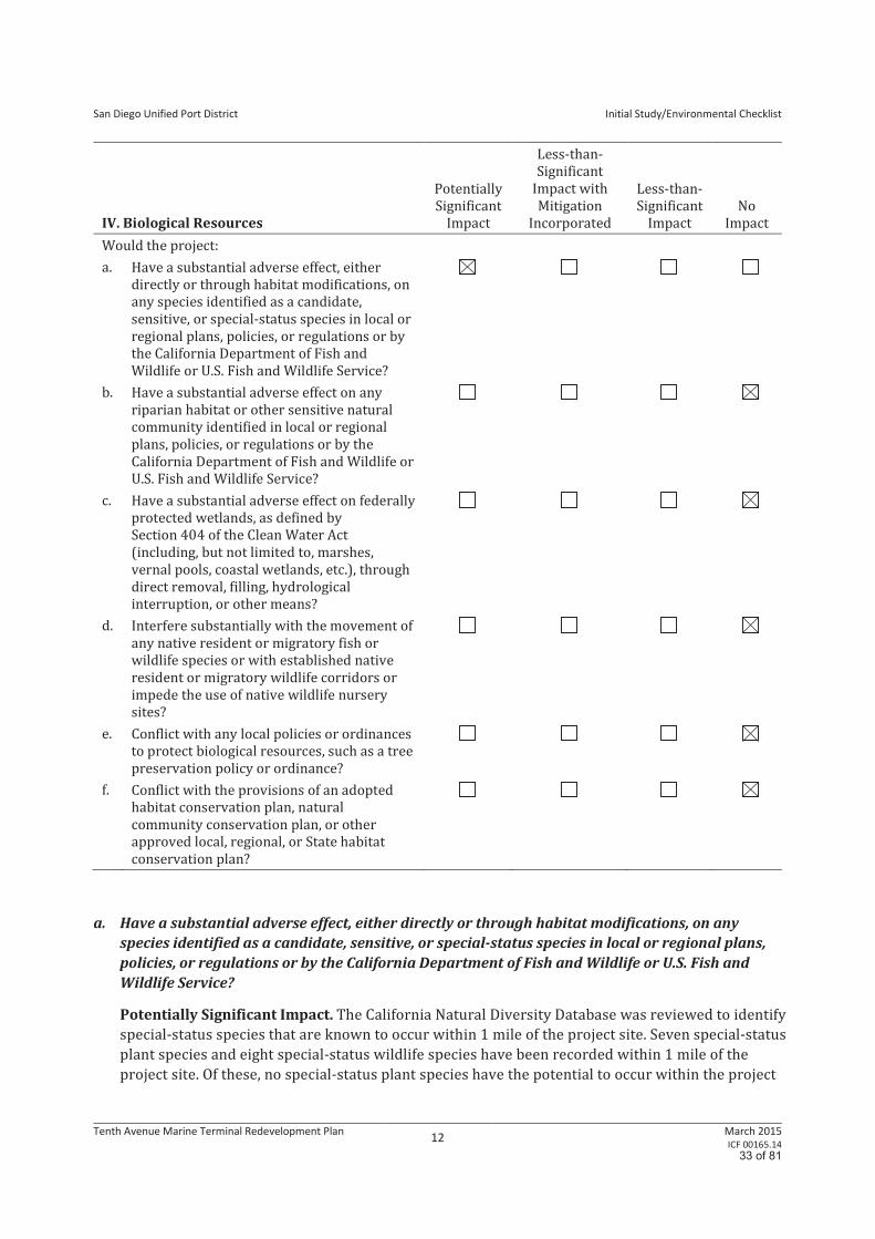
a. Have a substantial adverse effect, either directly or through habitat modifications, on any
species identified as a candidate, sensitive, or special-status species in local or regional plans,
policies, or regulations or by the California Department of Fish and Wildlife or U.S. Fish and
Wildlife Service?
Potentially Significant Impact. The California Natural Diversity Database was reviewed to identify
special-status species that are known to occur within 1 mile of the project site. Seven special-status
plant species and eight special-status wildlife species have been recorded within 1 mile of the
project site. Of these, no special-status plant species have the potential to occur within the project
33 of 81
San Diego Unified Port District
Initial Study/Environmental Checklist
Tenth Avenue Marine Terminal Redevelopment Plan 13
March 2015 ICF 00165.14
site. However, the potential exists for three special-status wildlife species to occur within the
project site. These include the western yellow bat (Lasiurus xanthinus), pocketed free-tailed bat
(Nyctinomops femorosaccus), and big free-tailed bat (Nyctinomops macrotis). Future demolition
activities at the TAMT could result in a significant impact on these three special-status wildlife
species.
Per the Migratory Bird Treaty Act and similar provisions in Sections 1600–1616 of the California Fish
and Game Code, the District would require qualified biologists to conduct preconstruction (i.e., prior
to building-disturbing activities) nesting bird surveys during the nesting season (February 15
through September 15). Prior to commencement of building-disturbing activities during this
timeframe, a qualified biologist would perform a preconstruction survey to determine whether nests
are present in or around the project area. If a nest is found, an appropriate buffer would be
established by the qualified biologist. No construction or other activities would be allowed to occur
within the buffer until the young have fledged or the nest becomes inactive. The results of the
preconstruction nesting bird survey would be provided to the District prior to the issuance of
construction permits.
Because the transit sheds that planned for demolition may provide suitable habitat for special-
status bats, a full analysis will be provided in the EIR to determine if a significant impact would
occur.
b. Have a substantial adverse effect on any riparian habitat or other sensitive natural
community identified in local or regional plans, policies, or regulations or by the California
Department of Fish and Wildlife or U.S. Fish and Wildlife Service?
No Impact. The project site consists entirely of developed land; there are no sensitive vegetation
communities or areas of riparian habitat on-site. Eelgrass beds are not known to occur in the area of
the Bay where the project would occur, and the depth of the Bay at the project site significantly
reduces the potential for growth. As such, no riparian or other sensitive natural community would be
affected by project activities and no further discussion in the EIR is warranted.
c. Have a substantial adverse effect on federally protected wetlands, as defined by Section 404
of the Clean Water Act (including, but not limited to, marshes, vernal pools, coastal wetlands,
etc.), through direct removal, filling, hydrological interruption, or other means?
No Impact. The project site consists entirely of developed land. No federally protected wetlands, as
identified under Sections 401 and 404 of the Clean Water Act or the California Coastal Act, are located
within or immediately adjacent to the project site. Future construction and operations at the TAMT
would adhere to Stormwater Pollution Prevention Plans (SWPPPs) and Urban Stormwater
Management Programs, as required, and no dredging, fill, or other waterside construction would
occur within the Bay. As such, no federally protected wetlands would be affected by project activities
and no further discussion in the EIR is warranted.
d. Interfere substantially with the movement of any native resident or migratory fish or wildlife
species or with established native resident or migratory wildlife corridors or impede the use of
native wildlife nursery sites?
No Impact. The project site consists entirely of developed land. Native species present on-site are
limited to those that commonly occur in heavily developed areas. Such species would not be
substantially affected by the project. Additionally, the site is not a wildlife corridor or a nursery site.
No further discussion in the EIR is warranted.
34 of 81
San Diego Unified Port District
Initial Study/Environmental Checklist
Tenth Avenue Marine Terminal Redevelopment Plan 14
March 2015 ICF 00165.14
e. Conflict with any local policies or ordinances to protect biological resources, such as a tree
preservation policy or ordinance?
No Impact. The City of San Diego Multiple Species Conservation Program (MSCP) and the City of
San Diego Multi-Habitat Planning Area (MHPA) do not apply to projects within the jurisdiction of the
District. Additionally, the project site is several miles outside the boundary of the MHPA, which is the
planned habitat preserve within the MSCP Subarea. Therefore, the proposed project does not conflict
with any local policies or ordinances to protect biological resources, such as a tree preservation
policy or ordinance. No impact would occur and no further discussion in the EIR is warranted.
f. Conflict with the provisions of an adopted habitat conservation plan, natural community
conservation plan, or other approved local, regional, or State habitat conservation plan?
No Impact. The project site is within the boundary of the City of San Diego MSCP but is several miles
from the City of San Diego MHPA. The project area is not inside the jurisdiction of any other adopted
plan. As such, no conflict would occur.
35 of 81
San Diego Unified Port District
Initial Study/Environmental Checklist
Tenth Avenue Marine Terminal Redevelopment Plan 15
March 2015 ICF 00165.14
V. Cultural Resources
Potentially
Significant
Impact
Less-than-
Significant
Impact with
Mitigation
Incorporated
Less-than-
Significant
Impact
No
Impact
Would the project:
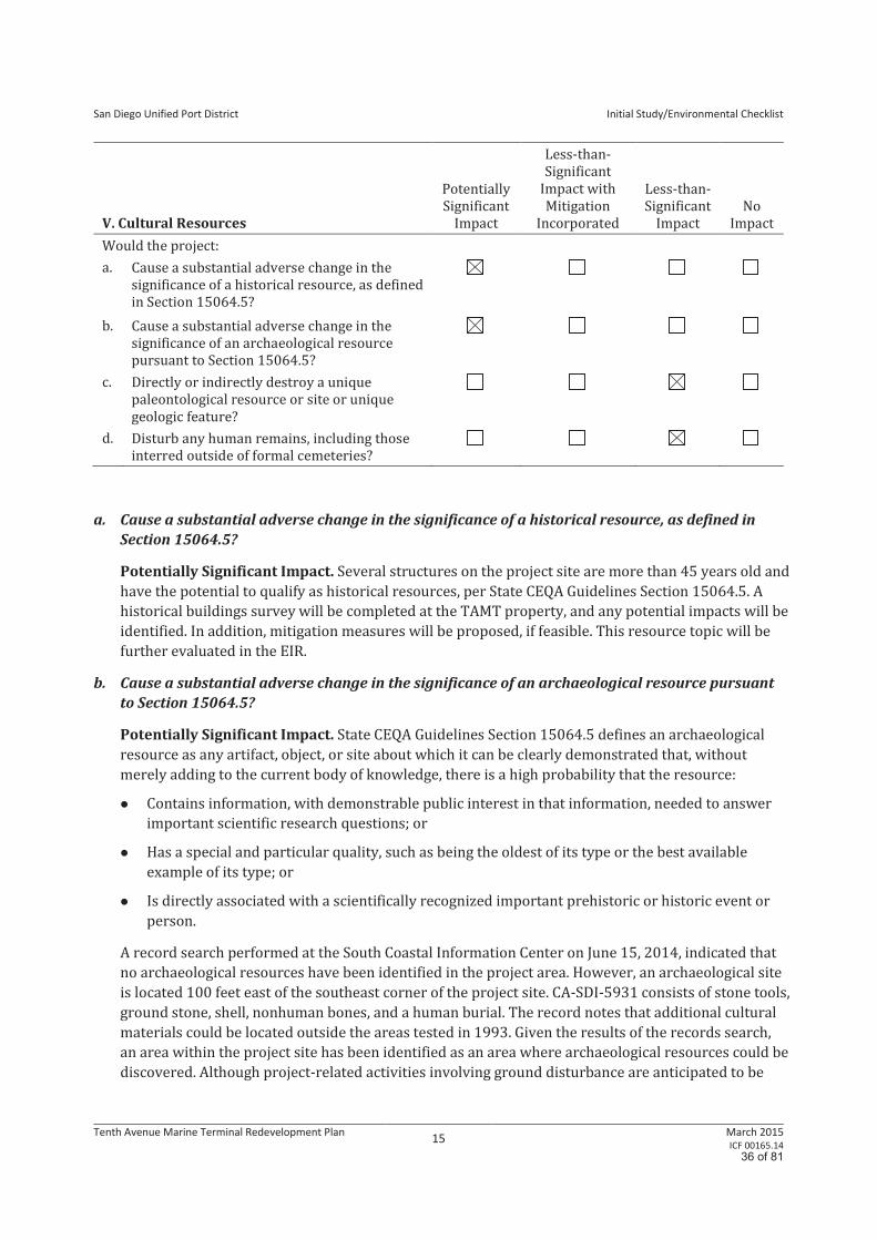
a. Cause a substantial adverse change in the
significance of a historical resource, as defined
in Section 15064.5?
b. Cause a substantial adverse change in the
significance of an archaeological resource
pursuant to Section 15064.5?
c. Directly or indirectly destroy a unique
paleontological resource or site or unique
geologic feature?
d. Disturb any human remains, including those
interred outside of formal cemeteries?
a. Cause a substantial adverse change in the significance of a historical resource, as defined in
Section 15064.5?
Potentially Significant Impact. Several structures on the project site are more than 45 years old and
have the potential to qualify as historical resources, per State CEQA Guidelines Section 15064.5. A
historical buildings survey will be completed at the TAMT property, and any potential impacts will be
identified. In addition, mitigation measures will be proposed, if feasible. This resource topic will be
further evaluated in the EIR.
b. Cause a substantial adverse change in the significance of an archaeological resource pursuant
to Section 15064.5?
Potentially Significant Impact. State CEQA Guidelines Section 15064.5 defines an archaeological
resource as any artifact, object, or site about which it can be clearly demonstrated that, without
merely adding to the current body of knowledge, there is a high probability that the resource:
Contains information, with demonstrable public interest in that information, needed to answer
important scientific research questions; or
Has a special and particular quality, such as being the oldest of its type or the best available
example of its type; or
Is directly associated with a scientifically recognized important prehistoric or historic event or
person.
A record search performed at the South Coastal Information Center on June 15, 2014, indicated that
no archaeological resources have been identified in the project area. However, an archaeological site
is located 100 feet east of the southeast corner of the project site. CA-SDI-5931 consists of stone tools,
ground stone, shell, nonhuman bones, and a human burial. The record notes that additional cultural
materials could be located outside the areas tested in 1993. Given the results of the records search,
an area within the project site has been identified as an area where archaeological resources could be
discovered. Although project-related activities involving ground disturbance are anticipated to be
36 of 81
San Diego Unified Port District
Initial Study/Environmental Checklist
Tenth Avenue Marine Terminal Redevelopment Plan 16
March 2015 ICF 00165.14
limited to areas near the existing transit sheds, any trenching or other ground disturbance within a
specific area in the northern portion of the site would require monitoring. Further discussion will be
provided in the EIR.
c. Directly or indirectly destroy a unique paleontological resource or site or unique geologic feature?
Less than Significant Impact. The project area rests on the Bay Point Formation, which is a near-
shore marine sedimentary deposit that dates from the late to middle Pleistocene, roughly 10,000 to
600,000 years ago. A tremendous variety of invertebrate and vertebrate fossils have been found in
this deposit, including both marine and terrestrial animals, with mammoth and whale remains being
some of the most significant. The formation is assigned high resource sensitivity by the City of
San Diego; however, the City of San Diego’s CEQA Significance Determination Thresholds state that
potential significant impacts on the Bay Point Formation could occur if project-related activities
reach depths greater than 10 feet and remove more than 1,000 cubic yards of soil. Utility work near
the transit sheds would occur between 5 and 10 feet below the ground; no other project-related
activities would affect areas beneath the terminal surface. Digging and trenching activities on the
project site are not anticipated to go deeper than 10 feet, and the project would not directly destroy a
unique paleontological resource, site, or unique geologic feature.
d. Disturb any human remains, including those interred outside of formal cemeteries?
Less than Significant Impact. No evidence in the historical record indicates that human remains
were buried on-site. It is highly unlikely that human remains would be encountered during
construction of the proposed project. The upper levels of the project site occur in filled lands that
date from the late 1800s to the 1940s. Most of this fill came from trash deposits or Bay dredging. Bay
Point Formation deposits that are marine in origin and date from 10,000 to 600,000 years ago
underlie these fill layers. However, if human remains should be discovered during construction,
however unlikely, they would be treated in accordance with applicable codes and regulations,
notably Public Resources Code (PRC) Section 5097 and Health and Safety Code Section 7050.5, which
would ensure that impacts would be less than significant.
37 of 81
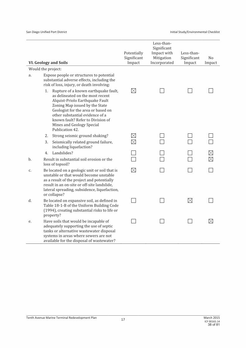
San Diego Unified Port District
Initial Study/Environmental Checklist
Tenth Avenue Marine Terminal Redevelopment Plan 17
March 2015 ICF 00165.14
VI. Geology and Soils
Potentially
Significant
Impact
Less-than-
Significant
Impact with
Mitigation
Incorporated
Less-than-
Significant
Impact
No
Impact
Would the project:
a. Expose people or structures to potential
substantial adverse effects, including the
risk of loss, injury, or death involving:
1. Rupture of a known earthquake fault,
as delineated on the most recent
Alquist-Priolo Earthquake Fault
Zoning Map issued by the State
Geologist for the area or based on
other substantial evidence of a
known fault? Refer to Division of
Mines and Geology Special
Publication 42.
2. Strong seismic ground shaking?
3. Seismically related ground failure,
including liquefaction?
4. Landslides?
b. Result in substantial soil erosion or the
loss of topsoil?
c. Be located on a geologic unit or soil that is
unstable or that would become unstable
as a result of the project and potentially
result in an on-site or off-site landslide,
lateral spreading, subsidence, liquefaction,
or collapse?
d. Be located on expansive soil, as defined in
Table 18-1-B of the Uniform Building Code
(1994), creating substantial risks to life or
property?
e. Have soils that would be incapable of
adequately supporting the use of septic
tanks or alternative wastewater disposal
systems in areas where sewers are not
available for the disposal of wastewater?
38 of 81
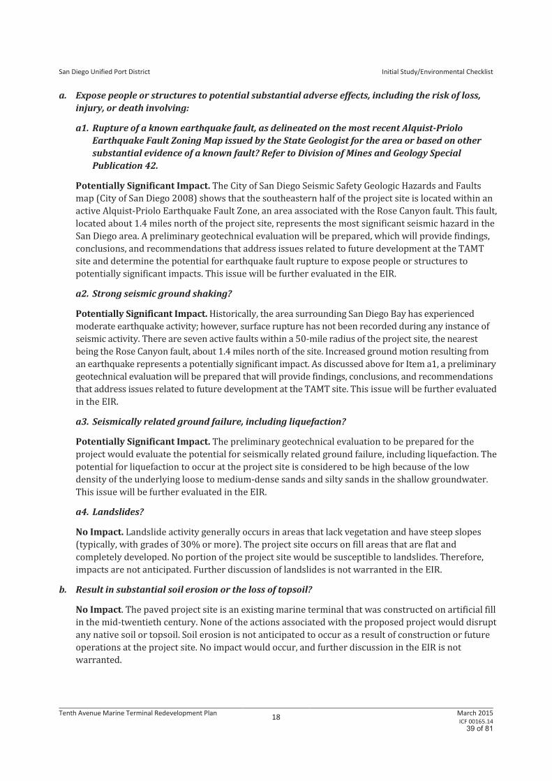
San Diego Unified Port District
Initial Study/Environmental Checklist
Tenth Avenue Marine Terminal Redevelopment Plan 18
March 2015 ICF 00165.14
a. Expose people or structures to potential substantial adverse effects, including the risk of loss,
injury, or death involving:
a1. Rupture of a known earthquake fault, as delineated on the most recent Alquist-Priolo
Earthquake Fault Zoning Map issued by the State Geologist for the area or based on other
substantial evidence of a known fault? Refer to Division of Mines and Geology Special
Publication 42.
Potentially Significant Impact. The City of San Diego Seismic Safety Geologic Hazards and Faults
map (City of San Diego 2008) shows that the southeastern half of the project site is located within an
active Alquist-Priolo Earthquake Fault Zone, an area associated with the Rose Canyon fault. This fault,
located about 1.4 miles north of the project site, represents the most significant seismic hazard in the
San Diego area. A preliminary geotechnical evaluation will be prepared, which will provide findings,
conclusions, and recommendations that address issues related to future development at the TAMT
site and determine the potential for earthquake fault rupture to expose people or structures to
potentially significant impacts. This issue will be further evaluated in the EIR.
a2. Strong seismic ground shaking?
Potentially Significant Impact. Historically, the area surrounding San Diego Bay has experienced
moderate earthquake activity; however, surface rupture has not been recorded during any instance of
seismic activity. There are seven active faults within a 50-mile radius of the project site, the nearest
being the Rose Canyon fault, about 1.4 miles north of the site. Increased ground motion resulting from
an earthquake represents a potentially significant impact. As discussed above for Item a1, a preliminary
geotechnical evaluation will be prepared that will provide findings, conclusions, and recommendations
that address issues related to future development at the TAMT site. This issue will be further evaluated
in the EIR.
a3. Seismically related ground failure, including liquefaction?
Potentially Significant Impact. The preliminary geotechnical evaluation to be prepared for the
project would evaluate the potential for seismically related ground failure, including liquefaction. The
potential for liquefaction to occur at the project site is considered to be high because of the low
density of the underlying loose to medium-dense sands and silty sands in the shallow groundwater.
This issue will be further evaluated in the EIR.
a4. Landslides?
No Impact. Landslide activity generally occurs in areas that lack vegetation and have steep slopes
(typically, with grades of 30% or more). The project site occurs on fill areas that are flat and
completely developed. No portion of the project site would be susceptible to landslides. Therefore,
impacts are not anticipated. Further discussion of landslides is not warranted in the EIR.
b. Result in substantial soil erosion or the loss of topsoil?
No Impact. The paved project site is an existing marine terminal that was constructed on artificial fill
in the mid-twentieth century. None of the actions associated with the proposed project would disrupt
any native soil or topsoil. Soil erosion is not anticipated to occur as a result of construction or future
operations at the project site. No impact would occur, and further discussion in the EIR is not
warranted.
39 of 81
San Diego Unified Port District
Initial Study/Environmental Checklist
Tenth Avenue Marine Terminal Redevelopment Plan 19
March 2015 ICF 00165.14
c. Be located on a geologic unit or soil that is unstable or that would become unstable as a result of
the project and potentially result in an on-site or off-site landslide, lateral spreading,
subsidence, liquefaction, or collapse?
Potentially Significant Impact. Bay deposits and fill layers that underlie the project site could be
unstable because of their liquefaction potential. The project site occurs on undocumented fill that
ranges from saturated sand to silty sand; this fill is compressible and liquefiable. This issue will be
further discussed in the EIR.
d. Be located on expansive soil, as defined in Table 18-1-B of the Uniform Building Code (1994),
creating substantial risks to life or property?
Less-than-Significant Impact. Expansive soils are fine-grained soils (generally, high-plasticity clays)
that can undergo a significant increase in volume with an increase in water content or, conversely, a
significant decrease in volume with a decrease in water content. Changes in the water content of an
expansive soil can result in severe distress to structures that have been built on the soil. As
mentioned above, expansive soils are generally high-plasticity clays, while liquefiable soils are
generally cohesionless sands. Also, although both conditions are influenced by the presence of
groundwater, soil expansion differs from soil liquefaction in that soil expansion is not seismically
induced. The majority of surficial soils throughout the project site are silty sands that have a low
potential for expansion, as defined by Table 18-1-B of the Uniform Building Code. Therefore,
construction of the proposed project would not result in substantial risks to life or property as a
result of being located on expansive soils. Impacts would be less than significant.
e. Have soils that would be incapable of adequately supporting the use of septic tanks or
alternative wastewater disposal systems in areas where sewers are not available for the
disposal of wastewater?
No Impact. No septic tanks or alternative wastewater disposal systems are proposed; therefore, no
impact would occur.
40 of 81
San Diego Unified Port District
Initial Study/Environmental Checklist
Tenth Avenue Marine Terminal Redevelopment Plan 20
March 2015 ICF 00165.14
VII. Greenhouse Gas Emissions
Potentially
Significant
Impact
Less-than-
Significant
Impact with
Mitigation
Incorporated
Less-than-
Significant
Impact
No
Impact
Would the project:
a. Generate greenhouse gas emissions, either directly or
indirectly, that may have a significant impact on the
environment?
b. Conflict with an applicable plan, policy, or regulation
adopted for the purpose of reducing the emissions of
greenhouse gases?
a. Generate greenhouse gas emissions, either directly or indirectly, that may have a significant
impact on the environment?
Potentially Significant Impact. The project would provide a plan that could be implemented to
increase marine terminal operations. Increased terminal operations would increase greenhouse gas
(GHG) emissions associated with vessel calls, truck trips and increased rail activity, worker trips, and
energy and water use. This increase in GHG emissions could potentially, either directly or indirectly,
have a significant impact on the environment by exceeding established thresholds for GHG emissions.
Further discussion will be provided in the EIR.
b. Conflict with an applicable plan, policy or regulation adopted for the purpose of reducing the
emissions of greenhouse gases?
Potentially Significant Impact. The Port District has enacted a variety of policies and plans to
reduce GHG emissions as part of its Climate Action Plan, including the implementation of shore
power, equipment and truck replacement/retrofits, vessel speed reductions, and the Clean Truck
Program. The project would increase GHG emissions at TAMT because of the greater throughput that
is forecasted with the project and may therefore conflict with or impede implementation of plans,
policies, or regulations that were adopted to reduce the emissions of GHG. In addition, sea level rise
will be discussed and the most current published guidance will be consulted to determine if the
project would be adversely affected. Therefore, these issues will be analyzed in the EIR.
41 of 81
San Diego Unified Port District
Initial Study/Environmental Checklist
Tenth Avenue Marine Terminal Redevelopment Plan 21
March 2015 ICF 00165.14
VIII. Hazards and Hazardous Materials
Potentially
Significant
Impact
Less-than-
Significant
Impact with
Mitigation
Incorporated
Less-than-
Significant
Impact
No
Impact
Would the project:
a. Create a significant hazard to the public or
the environment through the routine
transport, use, or disposal of hazardous
materials?
b. Create a significant hazard to the public or
the environment through reasonably
foreseeable upset and accident conditions
involving the release of hazardous materials
into the environment?
c. Emit hazardous emissions or involve
handling hazardous or acutely hazardous
materials, substances, or waste within
0.25 mile of an existing or proposed school?
d. Be located on a site that is included on a list
of hazardous materials sites compiled
pursuant to Government Code Section
65962.5 and, as a result, create a significant
hazard to the public or the environment?
e. Be located within an airport land use plan
area or, where such a plan has not been
adopted, be within 2 miles of a public
airport or public use airport and result in a
safety hazard for people residing or working
in the project area?
f. Be located within the vicinity of a private
airstrip and result in a safety hazard for
people residing or working in the project
area?
g. Impair implementation of or physically
interfere with an adopted emergency
response plan or emergency evacuation
plan?
h. Expose people or structures to a significant
risk of loss, injury, or death involving
wildland fires, including in areas where
wildlands are adjacent to urbanized areas or
where residences are intermixed with
wildlands?
42 of 81
San Diego Unified Port District
Initial Study/Environmental Checklist
Tenth Avenue Marine Terminal Redevelopment Plan 22
March 2015 ICF 00165.14
a. Create a significant hazard to the public or the environment through the routine transport, use,
or disposal of hazardous materials?
Potentially Significant Impact. The potential exists for the project to create a significant hazard to
the public or the environment through the routine transport, use, or disposal of hazardous materials
during the construction or operational phases of the project, depending on the types of cargo that are
stored on-site or transported to and from the site. This potentially significant impact will be further
discussed in the EIR.
b. Create a significant hazard to the public or the environment through reasonably foreseeable
upset and accident conditions involving the release of hazardous materials into the
environment?
Potentially Significant Impact. A previous site assessment indicates that petroleum hydrocarbons,
benzene, toluene, polycyclic aromatic hydrocarbons (PAHs), semi-volatile organic compounds
(SVOCs), and metals may be present in soil within portions of the project area. The presence of these
hazardous materials could create a significant hazard to the public or the environment if they were to
be disrupted during construction activities and released into the environment. This impact will be
further discussed in the EIR.
c. Emit hazardous emissions or involve handling hazardous or acutely hazardous materials,
substances, or waste within 0.25 mile of an existing or proposed school?
Potentially Significant Impact. The closest school is about 0.25 mile east of the project site. Because
the potential exists for hazardous materials to be released during project construction, impacts are
considered to be potentially significant. Further discussion will be provided in the EIR.
d. Be located on a site that is included on a list of hazardous materials sites compiled pursuant to
Government Code Section 65962.5 and, as a result, create a significant hazard to the public or
the environment?
Potentially Significant Impact. Pursuant to a check of the California Department of Toxic
Substances Control (DTSC) database (EnviroStor), it was determined that the project site is not
included on a list of hazardous material sites (DTSC 2014). The State Water Resources Control Board
(SWRCB) site (GeoTracker) identifies two open sites within the terminal, a diesel fuel spill site (Case
#H24706-002) beneath the bulk loader facility and a non-specified site (Case #9000000537) near
the center of the terminal (SWRCB 2014). A previous site assessment indicates that petroleum
hydrocarbons, benzene, toluene, PAHs, SVOCs, and metals may be present in soil within portions of
the project area. The potential exists for the project to result in a significant hazard to the public or
the environment. This is considered to be a potentially significant impact, which will be mitigated by
the measures included in the Soil Management Plan. Further discussion will be provided in the EIR.
e. For a project within an airport land use plan or, where such a plan has not been adopted, within
2 miles of a public airport or public use airport, would the project result in a safety hazard for
people residing or working in the project area?
Less-than-Significant Impact. The project site is about 2 miles south of San Diego International
Airport (SDIA). The site is within Review Area 2 of the Airport Influence Area, per the Airport Land
Use Compatibility Plan (ALUCP) for this airport (SDIA 2014). It is not anticipated that the project
would result in a safety hazard for people residing or working in the area; however, the Federal
Aviation Administration (FAA) would be notified at least 45 days prior to construction because of the
43 of 81
San Diego Unified Port District
Initial Study/Environmental Checklist
Tenth Avenue Marine Terminal Redevelopment Plan 23
March 2015 ICF 00165.14
proximity of the site to a navigation facility. Although a final determination has not been made by the
FAA, this impact is anticipated to be less than significant. In the event that the FAA requires changes
to the project, the changes will be reflected in the Project Description section of the EIR, thereby
ensuring that impacts related to a safety hazard for people residing or working in the project area
would not occur. There are no other airports or ALUCPs in the vicinity of the project site. Further
discussion of this impact is not required in the EIR.
f. For a project within the vicinity of a private airstrip, would the project result in a safety hazard
for people residing or working in the project area?
No Impact. The project is not located within the vicinity of a private airstrip. No hazard impacts
related to private airstrips would occur with implementation of the proposed project, and further
discussion of this threshold is not warranted in the EIR.
g. Impair implementation of or physically interfere with an adopted emergency response plan or
emergency evacuation plan?
Less-than-Significant Impact. Emergency response and evacuation is the responsibility of the police
and fire service providers, as detailed in Section XIV, Public Services. Redevelopment of the TAMT
site would involve the removal of existing buildings and improving operational efficiencies by
eliminating underperforming elements of the terminal and preparing for future expansion. The result
would be an increase in cargo throughput. Transport of the cargo both to and from the terminal
would continue in a planned and controlled manner that would not cause an impairment of executing
the approved emergency response plan.
The proposed project would be required to comply with applicable requirements set forth by the
County of San Diego Office of Emergency Services (OES) Operational Area Emergency Plan, the City of
San Diego Police Department, and the City of San Diego Fire Department. OES coordinates emergency
response at the local level in the event of a disaster, including fires. This emergency response
coordination is facilitated by the Operational Area Emergency Operations Center and responding
agencies to the proposed project site, the City of San Diego Police and Fire Departments and San
Diego Harbor Police Department. Impacts would be less than significant, and no further discussion is
warranted in the EIR.
h. Expose people or structures to a significant risk of loss, injury, or death involving wildland fires,
including in areas where wildlands are adjacent to urbanized areas or where residences are
intermixed with wildlands?
No Impact. The project site is located on San Diego Bay, near downtown San Diego, and completely
covered with impermeable surfaces. There are no wildlands or heavily vegetated areas in proximity
to the TAMT property, and as such, redevelopment of the terminal would not expose people or
structures to a significant risk of loss, injury, or death involving wildland fires. No impacts would
occur, and further discussion is not warranted in the EIR.
44 of 81
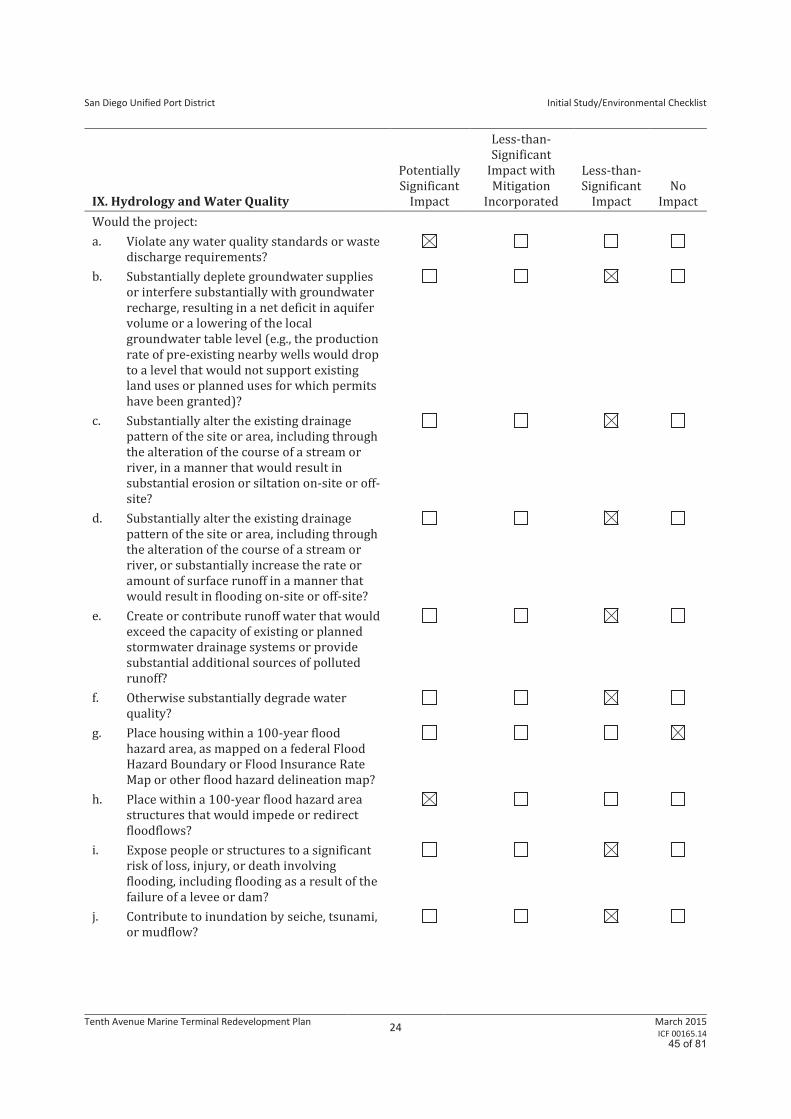
San Diego Unified Port District
Initial Study/Environmental Checklist
Tenth Avenue Marine Terminal Redevelopment Plan 24
March 2015 ICF 00165.14
IX. Hydrology and Water Quality
Potentially
Significant
Impact
Less-than-
Significant
Impact with
Mitigation
Incorporated
Less-than-
Significant
Impact
No
Impact
Would the project:
a. Violate any water quality standards or waste
discharge requirements?
b. Substantially deplete groundwater supplies
or interfere substantially with groundwater
recharge, resulting in a net deficit in aquifer
volume or a lowering of the local
groundwater table level (e.g., the production
rate of pre-existing nearby wells would drop
to a level that would not support existing
land uses or planned uses for which permits
have been granted)?
c. Substantially alter the existing drainage
pattern of the site or area, including through
the alteration of the course of a stream or
river, in a manner that would result in
substantial erosion or siltation on-site or off-
site?
d. Substantially alter the existing drainage
pattern of the site or area, including through
the alteration of the course of a stream or
river, or substantially increase the rate or
amount of surface runoff in a manner that
would result in flooding on-site or off-site?
e. Create or contribute runoff water that would
exceed the capacity of existing or planned
stormwater drainage systems or provide
substantial additional sources of polluted
runoff?
f. Otherwise substantially degrade water
quality?
g. Place housing within a 100-year flood
hazard area, as mapped on a federal Flood
Hazard Boundary or Flood Insurance Rate
Map or other flood hazard delineation map?
h. Place within a 100-year flood hazard area
structures that would impede or redirect
floodflows?
i. Expose people or structures to a significant
risk of loss, injury, or death involving
flooding, including flooding as a result of the
failure of a levee or dam?
j. Contribute to inundation by seiche, tsunami,
or mudflow?
45 of 81
San Diego Unified Port District
Initial Study/Environmental Checklist
Tenth Avenue Marine Terminal Redevelopment Plan 25
March 2015 ICF 00165.14
a. Violate any water quality standards or waste discharge requirements?
Potentially Significant Impact. The potential impacts of construction activities on water quality
concern primarily sediments, turbidity, and pollutants associated with sediments. Construction-
related activities that expose and move soils are responsible primarily for sediment releases. The
proposed project would involve soil disturbance from activities such as excavation for replacement
light poles and utility work as well as concrete removal, grading, and repaving related to building
demolition and construction. Demolition includes abatement associated with hazardous materials
on-site, removal of existing structures, removal of any concrete slabs, removal of any utilities, and
repaving the project site with asphalt concrete pavement. These project activities could result in
wind and rain erosion of on-site soil. They could also increase the amount of suspended solids
contained in storm flows resulting from erosion of exposed soil during construction. Other pollutants
of concern are toxic chemicals from heavy equipment or construction-related materials. Non-
sediment contaminants that could enter runoff from the construction site include metals, petroleum
products, and trash. Concrete, soap, trash, and sanitary wastes are other common sources of
potentially harmful materials on construction sites. Wash water from equipment and tools and other
waste dumped or spilled on the construction site can lead to seepage of pollutants into watercourses.
Also, construction chemicals may be accidentally spilled into watercourses. The impact of toxic
construction-related materials on water quality would vary, depending on the duration and timing of
activities. All of these contaminants could contribute to the degradation of water quality. The
proposed area of land disturbance is approximately 50 to 60 feet from the shoreline of the Bay and
direct discharges into the Bay from construction activities are less likely than discharges to storm
drains that lead to the Bay. Because there is a potentially significant impact related to water quality
during construction, this subject will be discussed in the EIR.
Potential pollutants that may be generated at the TAMT during operation of the proposed project
include gross pollutants, metals, nutrients, oil and grease, organics, sediment, and trash (San Diego
Unified Port District 2008). As part of the proposed project, cargo would be kept outside on the
terminal, within containers (i.e., silos or domes), as opposed to stored in existing terminal sheds.
Although the dry bulk storage area would not have a roof, it would be contained within walls, which
would prevent contaminants from being discharged. Operations at the port would also include
routine maintenance activities; waste storage, handling, and disposal; outdoor parking; as well as
vehicle and equipment storage, washing, and maintenance. Because the project would have the
potential to create a significant water quality impact during operations, this issue will be further
discussed in the EIR.
b. Substantially deplete groundwater supplies or interfere substantially with groundwater
recharge, resulting in a net deficit in aquifer volume or a lowering of the local groundwater
table level (e.g., the production rate of pre-existing nearby wells would drop to a level that would
not support existing land uses or planned uses for which permits have been granted)?
Less-than-Significant Impact. Although the proposed project would involve demolition and
repaving of existing impervious surfaces, it would result in no change to the amount of impervious
area. Given the depth of grading and trenching anticipated, dewatering is not likely. Should
dewatering activities be necessary, such activities would be short-term and require only minimal
volumes of water for the installation of underground utility lines. Because of the proximity to the Bay,
groundwater at the project site is saline from saltwater intrusion, and therefore, it is not used for
drinking water and consequently would not impact drinking water. Impacts related to lowering the
groundwater table and groundwater recharge would be less than significant.
46 of 81
San Diego Unified Port District
Initial Study/Environmental Checklist
Tenth Avenue Marine Terminal Redevelopment Plan 26
March 2015 ICF 00165.14
c. Substantially alter the existing drainage pattern of the site or area, including through the
alteration of the course of a stream or river, in a manner that would result in substantial erosion
or siltation on-site or off-site?
Less-than-Significant Impact. Topography at the project site is flat or sloping slightly downward
from east to west to the point where it meets the existing wharf. The existing storm drain system
includes catch basins that have been equipped with filter inserts and a water treatment system on the
main 36-inch-diameter storm drain discharge lines. The proposed project would most likely require
additional storm drains as a result of the transit sheds’ removal; the additional storm drains would be
appropriately sized and able to carry stormwater during a rain event, thereby preventing on-site
drainage issues. Because of the largely impervious nature of the site, erosion and siltation are
unlikely. As a result, impacts related to changes in the drainage pattern, including erosion and/or
siltation, would be less than significant.
d. Substantially alter the existing drainage pattern of the site or area, including through the
alteration of the course of a stream or river, or substantially increase the rate or amount of
surface runoff in a manner that would result in flooding on-site or off-site?
Less-than-Significant Impact. The existing drainage patterns would be left intact; no streams or
rivers exist on-site. As a result, no substantial changes in drainage patterns would occur, and the
project would not cause surface runoff to result in flooding on- or off-site. Therefore, impacts would
be less than significant.
e. Create or contribute runoff water that would exceed the capacity of existing or planned
stormwater drainage systems or provide substantial additional sources of polluted runoff?
Less-than-Significant Impact. The proposed project would not result in an increase in the volume
of runoff water that would exceed the capacity of the existing or planned stormwater drainage
system. The existing system would be evaluated for compliance with the County of San Diego
Standard Urban Stormwater Mitigation Plan (SUSMP) and upgraded as necessary to ensure its
effectiveness and compliance with appropriate regulations. In accordance with the County’s MS4
permit, stormwater specialists from the District’s Environmental and Land Use Management
Department review all engineering projects for compliance with the SUSMP. A summary report on
the projects and their SUSMP compliance determinations is submitted with the District’s annual
SUSMP compliance monitoring report to the SDRWQCB. In addition, the District performs a regular
inspection of catch basins with filters to evaluate the condition of the catch basin filter inserts.
Inserts are cleaned and maintained or replaced, as required; catch basins are cleaned of all debris
and sediment semiannually or more frequently, as required. The storm drain clarifier units are
inspected and cleaned regularly by the District’s Environmental and Land Use Management
Department and its contractors. Reports of these best management practice (BMP) maintenance
activities are submitted to the State Water Resources Control Board in accordance with the
terminal’s Industrial Stormwater Permit.
The proposed project would include additional storm drains, the design and placement of which
would be subject to the District’s engineering review. The drains would be appropriately sized and
able to carry stormwater during a rain event, thereby preventing on-site drainage issues.
Consequently, the project would not contribute additional sources of polluted runoff during
operation. Therefore, the proposed project would not create runoff water that would exceed the
capacity of existing or planned stormwater drainage systems or provide substantial additional
sources of polluted runoff. Impacts would be less than significant.
47 of 81
San Diego Unified Port District
Initial Study/Environmental Checklist
Tenth Avenue Marine Terminal Redevelopment Plan 27
March 2015 ICF 00165.14
f. Otherwise substantially degrade water quality?
Potentially Significant Impact. As described in Item IXa, short-term construction impacts and long-
term operational impacts on water quality would be potentially significant. Therefore, the project’s
potential to degrade water quality will be discussed in the EIR.
g. Place housing within a 100-year flood hazard area, as mapped on a federal Flood Hazard
Boundary or Flood Insurance Rate Map or other flood hazard delineation map?
No Impact. The majority of the project site is located outside the 100-year floodplain; a small area
north of the project site is located within 100-year Flood Zone A. However, no housing is proposed on
the project site. Therefore, no impacts would occur.
h. Place within a 100-year flood hazard area structures that would impede or redirect floodflows?
Potentially Significant Impact. The project proposes construction of a modular office building, with
an area of approximately 6,800 square feet and height of approximately 32 feet (12 feet above mean
lower low-water [MLLW] tide). Over the long-term, additional structures may also be constructed
within the 100-year flood area. As part of the proposed project, the District expects to work with the
necessary federal agencies to update the 100-year floodplain boundary to more accurately reflect
potential flooding hazards. Therefore, this issue will be further discussed in the EIR.
i. Expose people or structures to a significant risk of loss, injury, or death involving flooding,
including flooding as a result of the failure of a levee or dam?
Less-than-Significant Impact. Dam failures are rated as a low-probability, high-loss event. Only two
major dam failures have been recorded in San Diego County. These occurred in 1916 and were
caused by a flood event (County of San Diego 2010). The project site is not identified within a risk
zone of a potential dam failure (County of San Diego 2010). Thus, it is highly unlikely that the
proposed project would expose people or structures to a significant risk of loss, injury, or death
involving flooding as a result of the failure of a levee or dam. Impacts would be less than significant.
j. Contribute to inundation by seiche, tsunami, or mudflow?
Less-than-Significant Impact. Although the project site is within a designated high-risk zone for a
tsunami, the likelihood that an event would occur during the 29-week construction period is low. If
such an event were to occur, the likelihood that it would affect the project site is also low. The project
site is located on the Bayfront but approximately 2 miles from the Pacific Ocean. Coronado is located
between the site and the ocean. Moreover, the project site is located at approximately 10 feet MLLW.
Therefore, considering the distance from the ocean, the buffering provided by landmass, and the
height above sea level, the potential for hazards associated with direct wave action in the event of a
storm surge, tsunami, or seiche is low. Conditions under the proposed project would be similar to the
existing conditions and would not increase the potential of site inundation. Although inundation from
a tsunami or seiche is possible, it is unlikely; if it were to occur, damage would most likely be limited
to ground-floor water damage. People would be given sufficient warning to evacuate the project site
by the West Coast and Alaska Tsunami Warning Center, which monitors earthquakes and issues
tsunami warnings when a tsunami is forecast to occur. Consequently, although inundation from a
tsunami or seiche is reasonably foreseeable, any associated impacts would be less than significant.
The potential for large-scale slope instability at the site that could lead to mudflow is not present at
the project site. The project site is located on flat topography. Impacts would be less than significant.
48 of 81
San Diego Unified Port District
Initial Study/Environmental Checklist
Tenth Avenue Marine Terminal Redevelopment Plan 28
March 2015 ICF 00165.14
This page intentionally left blank
49 of 81
San Diego Unified Port District
Initial Study/Environmental Checklist
Tenth Avenue Marine Terminal Redevelopment Plan 29
March 2015 ICF 00165.14
X. Land Use and Planning
Potentially
Significant
Impact
Less-than-
Significant
Impact with
Mitigation
Incorporated
Less-than-
Significant
Impact
No
Impact
Would the project:
a. Physically divide an established community?
b. Conflict with any applicable land use plan,
policy, or regulation of an agency with
jurisdiction over the project (including, but
not limited to, a general plan, specific plan,
local coastal program, or zoning ordinance)
adopted for the purpose of avoiding or
mitigating an environmental effect?
c. Conflict with any applicable habitat
conservation plan or natural community
conservation plan?
a. Physically divide an established community?
No Impact. The proposed project would redevelop an existing marine terminal on San Diego Bay but
would not expand the physical boundaries of the terminal or develop areas outside of its current
boundaries. Therefore, the project would not physically divide an established community, and
impacts would not occur.
b. Conflict with any applicable land use plan, policy, or regulation of an agency with jurisdiction
over the project (including, but not limited to, a general plan, specific plan, local coastal
program, or zoning ordinance) adopted for the purpose of avoiding or mitigating an
environmental effect?
No Impact. The PMP is the guiding land use policy document for all areas under the District’s
jurisdiction. The proposed project is located within Planning District 4, which has been identified as
the only area in the entire San Diego region with an established waterfront industrial shipping
operation, which cannot be easily created or replaced. However, the TAMT is experiencing a shortage
of space. The proposed project would result in the adoption of near-term improvements and a
redevelopment plan for the TAMT site. This would allow the TAMT to continue its present use as a
marine terminal but would not result in any changes in land use. Project approval would be
consistent with the provisions of the California Coastal Act (CCA). The project site, which has been
used for industrial shipping operations since the early 1900s, exists for the benefit of water
dependent commerce, which is consistent with the CCA and the Public Trust Doctrine. Project-related
actions would involve the removal and demolition of existing structures and the rearrangement of
existing and future tenants at the TAMT. None of the project-related actions would present new
barriers or obstacles related to coastal access. The TAMT site would continue to be unavailable to the
general public, and no new impacts or changes regarding coastal access would result upon project
implementation. As such, the proposed project would not conflict with the PMP, CCA, or the Public
Trust Doctrine or any other land use document adopted for the purpose of avoiding or mitigating an
environmental effect. Impacts would not occur, and this issue will not be further discussed in the EIR.
50 of 81
San Diego Unified Port District
Initial Study/Environmental Checklist
Tenth Avenue Marine Terminal Redevelopment Plan 30
March 2015 ICF 00165.14
c. Conflict with any applicable habitat conservation plan or natural community conservation plan?
No Impact. As discussed under Item IVf, the proposed project would occur outside the boundaries of
the City of San Diego MSCP and the City of San Diego MHPA. Therefore, the proposed project would
not be in conflict with a habitat conservation plan or natural community conservation plan.
51 of 81
San Diego Unified Port District
Initial Study/Environmental Checklist
Tenth Avenue Marine Terminal Redevelopment Plan 31
March 2015 ICF 00165.14
XI. Mineral Resources
Potentially
Significant
Impact
Less-than-
Significant
Impact with
Mitigation
Incorporated
Less-than-
Significant
Impact
No
Impact
Would the project:
a. Result in the loss of availability of a known
mineral resource that would be of value to the
region and the residents of the State?
b. Result in the loss of availability of a locally
important mineral resource recovery site
delineated on a local general plan, specific
plan, or other land use plan?
a. Result in the loss of availability of a known mineral resource that would be of value to the region
and the residents of the State?
No Impact. The project site, an area characterized by industrial marine-related activities, does not
contain any known mineral resources. In addition, the project site is underlain by artificial fill
material. No commercial mining operations exist on the project sites or in the immediate vicinity. The
project site and the surrounding area are not designated or zoned as land with the availability of
mineral resources. In addition, the project sites do not contain aggregate resources and are not
located in a mineral resource zone that contains important resources, as designated by the California
Department of Conservation Division of Mines and Geology. Therefore, the proposed project would
not result in a loss of known mineral resources. No impact would occur.
b. Result in the loss of availability of a locally important mineral resource recovery site delineated
on a local general plan, specific plan, or other land use plan?
No Impact. See Item Xia, above. The project site is underlain by artificial fill material. The PMP does
not identify any mineral resources in the area or designated plans for mineral resource extraction.
The project site and the surrounding area do not contain locally important mineral resources.
Therefore, implementation of the project would not result in the loss of availability of a locally
important mineral resource recovery site, and no impact would occur.
52 of 81
San Diego Unified Port District
Initial Study/Environmental Checklist
Tenth Avenue Marine Terminal Redevelopment Plan 32
March 2015 ICF 00165.14
XII. Noise
Potentially
Significant
Impact
Less-than-
Significant
Impact with
Mitigation
Incorporated
Less-than-
Significant
Impact
No
Impact
Would the project:
a. Expose persons to or generate noise levels in
excess of standards established in a local
general plan or noise ordinance or applicable
standards of other agencies?
b. Expose persons to or generate excessive
ground-borne vibration or ground-borne noise
levels?
c. Result in a substantial permanent increase in
ambient noise levels in the project vicinity,
above levels existing without the project?
d. Result in a substantial temporary or periodic
increase in ambient noise levels in the project
vicinity, above levels existing without the
project?
e. Be located within an airport land use plan
area, or, where such a plan has not been
adopted, within 2 miles of a public airport or
public use airport and expose people residing
or working in the project area to excessive
noise levels?
f. Be located in the vicinity of a private airstrip
and expose people residing or working in the
project area to excessive noise levels?
a. Expose persons to or generate noise levels in excess of standards established in the local general
plan or noise ordinance, or applicable standards of other agencies?
Potentially Significant Impact. The potential exists for construction and additional operations at
the project site to result in significant impacts. Existing noise conditions will be documented and
compared with projected noise conditions with implementation of additional operations at the
project site. Noise levels during project construction and operation will be evaluated in the EIR.
b. Exposure of persons to or generation of excessive ground-borne vibration or ground-borne noise
levels?
Potentially Significant Impact. Limited ground disturbance related to the proposed project is
anticipated to occur. Although ground-borne vibration or noise generated by project actions would
most likely not travel to surrounding residential uses or other sensitive receptors, vibration levels
during project construction and operation will be evaluated in the EIR.
53 of 81
San Diego Unified Port District
Initial Study/Environmental Checklist
Tenth Avenue Marine Terminal Redevelopment Plan 33
March 2015 ICF 00165.14
c. A substantial permanent increase in ambient noise levels in the project vicinity, above levels
existing without the project?
Potentially Significant Impact. As described in Item XIIa, the proposed project could increase
permanent ambient noise levels during construction and operation. As a result, impacts are
potentially significant and will be evaluated in the EIR.
d. A substantial temporary or periodic increase in ambient noise levels in the project vicinity,
above levels existing without the project?
Potentially Significant Impact. As described in Item XIIa, site preparation–related activities could
result in a temporary or periodic increase in ambient noise levels. Therefore, impacts from noise are
potentially significant and will be evaluated in the EIR.
e. For a project located within an airport land use land use plan or, where such a plan has not been
adopted, within 2 miles of a public airport or public use airport, would the project expose people
residing or working in the project area to excessive noise levels?
No Impact. The proposed project would not construct any habitable structures and would not attract
large numbers of people to the project site. In addition, the project site is not located within the
Forecast Noise Exposure areas identified in Exhibit 2-1 of the SDIA ALUCP (May 2014). Therefore, the
project would not expose people residing or working in the project area to excessive airport noise
levels and no further discussion in the EIR is warranted.
f. For a project within the vicinity of a private airstrip, would the project expose people residing or
working in the project area to excessive noise levels?
No Impact. The project is not located within the vicinity of a private airstrip. No impacts related to
private airstrips would occur with implementation of the proposed project, and further discussion of
this threshold is not warranted in the EIR.
54 of 81
San Diego Unified Port District
Initial Study/Environmental Checklist
Tenth Avenue Marine Terminal Redevelopment Plan 34
March 2015 ICF 00165.14
XIII. Population and Housing
Potentially
Significant
Impact
Less-than-
Significant
Impact with
Mitigation
Incorporated
Less-than-
Significant
Impact
No
Impact
Would the project:
a. Induce substantial population growth in an
area, either directly (e.g., by proposing new
homes and businesses) or indirectly
(e.g., through extension of roads or other
infrastructure)?
b. Displace a substantial number of existing
housing units, necessitating the construction
of replacement housing elsewhere?
c. Displace a substantial number of people,
necessitating the construction of replacement
housing elsewhere?
a. Induce substantial population growth in an area, either directly (e.g., by proposing new homes
and businesses) or indirectly (e.g., through extension of roads or other infrastructure?
Less-than-Significant Impact. The proposed project would not construct any homes or businesses
or extend roads; however, additional employees and construction workers are anticipated to work at
the TAMT as a result of near-term optimization improvements and future redevelopment activities.
As stated above in the Project Description, approximately 232 jobs (direct, indirect, and induced)
would be created during the near-term construction period, and a total of 459 long-term (through the
life of the plan) direct and indirect jobs would be created as a result of the proposed redevelopment
plan.
Although implementation of the proposed project would require up to 459 new employees and
temporarily increase the number of construction workers in the area, the introduction of additional
employees would not result in a significant increase in the local population and would not induce
substantial population growth. The additional jobs are expected to be filled by residents who
currently live in the San Diego region. Furthermore, the permanent jobs would occur over an
extended period of time, and the workers could be accommodated with existing housing stock. The
jobs would not result in the relocation of any population. Therefore, the proposed project would not
directly or indirectly induce substantial population growth through the creation of new homes or
businesses in the San Diego region. Impacts would be less than significant, and no further discussion
is warranted in the EIR.
b. Displace substantial numbers of existing housing, necessitating the construction of replacement
housing elsewhere?
No Impact. No housing would be displaced with implementation of the proposed project. No impact
would occur, and no further discussion is warranted in the EIR.
55 of 81
San Diego Unified Port District
Initial Study/Environmental Checklist
Tenth Avenue Marine Terminal Redevelopment Plan 35
March 2015 ICF 00165.14
c. Displace substantial numbers of people, necessitating the construction of replacement housing
elsewhere?
No Impact. The project site is a working marine terminal on San Diego Bay and does not include
residential housing. Proposed project actions are concerned with redevelopment of the marine
terminal to accommodate market-driven cargo operations. It would not displace people or require
the construction of replacement housing elsewhere. No impact would occur, and further discussion is
not warranted in the EIR.
56 of 81
San Diego Unified Port District
Initial Study/Environmental Checklist
Tenth Avenue Marine Terminal Redevelopment Plan 36
March 2015 ICF 00165.14
XIV. Public Services
Potentially
Significant
Impact
Less-than-
Significant
Impact with
Mitigation
Incorporated
Less-than-
Significant
Impact
No
Impact
Would the project:
a. Result in substantial adverse physical
impacts associated with the provision of
new or physically altered governmental
facilities or a need for new or physically
altered governmental facilities, the
construction of which could cause
significant environmental impacts, to
maintain acceptable service ratios,
response times, or other performance
objectives for any of the following public
services:
1. Fire protection?
2. Police protection?
3. Schools?
4. Parks?
5. Other public facilities?
a1. Fire protection?
Less-than-Significant Impact. The project site is served by the City of San Diego Fire-Rescue
Department (SDFD) and by the San Diego Harbor Police Department (HPD) for fireboat operations.
Each department is discussed below.
City of San Diego Fire-Rescue Department
Four SDFD fire stations, including Fire Stations 1, 4, 7, and 11, are located within the project vicinity
and could respond in the event of an emergency; however, Fire Station 7 is the immediate responder
for the proposed project. Fire Station 7 is located at 944 Cesar E. Chavez Parkway, about 0.87 mile
northeast of the project site.
Although not first responders, Fire Stations 1, 4, and 11 could also respond to the project site. Fire
Station 1 is located at 1222 1st Avenue, about 1.1 miles north of the project site. Fire Station 4 is
located at 404 8th Avenue, about 1 mile west of the project site. Lastly, Fire Station 11 is located at
945 25th Street, about 1.5 miles northeast of the project. Although redevelopment activities would
occur at the project site through 2035, no physical expansion of the terminal’s boundaries would
occur. The SDFD would continue to provide emergency services at the project site. No significant
impacts are anticipated, and further discussion is not warranted in the EIR.
San Diego Harbor Police Department
The HPD provides law enforcement and marine firefighting services in and around San Diego Bay.
Three HPD offices serve the project area: downtown San Diego, Airport, and Shelter Island (HPD
2014). The downtown San Diego office is located at 3380 North Harbor Drive and serves as the
headquarters and administration building. The Airport and Shelter Island offices serve as dispatch
57 of 81
San Diego Unified Port District
Initial Study/Environmental Checklist
Tenth Avenue Marine Terminal Redevelopment Plan 37
March 2015 ICF 00165.14
centers; these offices would serve the project site in the event of an emergency in the Bay. The HPD
has two departments for fire protection and emergency response: marine firefighting and vessel
patrol (Port of San Diego 2014). Marine firefighter officers with the HPD are cross-trained as both
land and marine firefighters. Their patrol boats also serve as firefighting boats that can respond to
fire emergencies along the Bay. The vessels are staffed 24 hours a day and in all types of weather. The
HPD patrols San Diego Bay, its associated waterways, and coastal areas similar to the way in which it
patrols on land. Its primary function is to respond to all types of law enforcement–related issues.
However, part of its fleet is designed to respond to fire and rescue calls.
Under the proposed project, a new redevelopment plan, which would provide for future
improvements at the TAMT, would be adopted. Proposed operations at the TAMT site would be
similar to existing operations in terms of the need for fire protection services. Therefore, the
proposed project would not result in increased demand that would require new or physically altered
fire protection facilities; impacts would be less than significant. No further discussion in the EIR is
warranted.
a2. Police protection?
Less-than-Significant Impact. The HPD is the primary responder to calls for police protection
services at the project site; the San Diego Police Department (SDPD) is a secondary responder.
Harbor Police Department
As of July 2014, the HPD had 122 sworn law enforcement officers, all of whom are cross-trained as
firefighters and police officers (HPD 2014). HPD vehicle patrols monitor all land activity around the
Bay. The units that could be dispatched to the project site, in addition to vehicle patrols, include the
bicycle team, dive team, investigations unit, and reserve senior volunteer patrol.
City of San Diego Police Department
The SDPD provides law enforcement services for areas within District jurisdiction that generate tax
revenue for the City of San Diego (e.g., TAMT, hotels, restaurants). The proposed project is in the
SDPD’s Central Division, the headquarters for which is at 2501 Imperial Avenue, San Diego. The
division serves a population of 103,524 and encompasses 9.7 square miles, extending beyond the
boundaries of the Downtown Community Plan (City of San Diego 2014).
Similar to the SDFD and HPD, SDPD police protection is evaluated by tracking average response time
to an emergency call. There is also a Citywide goal for the SDPD to have 1.45 officers per
1,000 residents. With a City population of approximately 1,345,895 as of April 2014 (California
Department of Finance 2014) and 2,775 sworn police officers as of May 22, 2014 (AreaVibes 2014),
the current ratio of SDPD officers per 1,000 residents is 2.06.
The proposed project would adopt a new redevelopment plan that would include various
improvements to the terminal. Although operations would increase under the proposed project, the
TAMT is a monitored environment that has controlled access and active security. Operations under
the proposed project would be similar to operations under existing conditions in terms of the need
for police protection services given the restricted access and the available security services.
Therefore, the proposed project would not result in increased demand that would require new or
physically altered police protection facilities; no impact would occur. No further discussion in the EIR
is warranted.
58 of 81

San Diego Unified Port District
Initial Study/Environmental Checklist
Tenth Avenue Marine Terminal Redevelopment Plan 38
March 2015 ICF 00165.14
a3. Schools?
No Impact. The project site is within the boundary of the San Diego Unified School District (SDUSD),
the second-largest school district in California. SDUSD schools within the project vicinity include
Perkins Elementary School, located 0.25 mile east of the project site; Washington Elementary School,
located approximately 2 miles to the northeast; and Logan Elementary School, located 1.7 miles to
the east. High schools near the project site include Garfield High School, located about 1.5 miles north
of the project site, and San Diego High School, located about 1.6 miles north of the project site. There
are no other public schools within 2 miles of the project site.
The proposed project would not result in adverse impacts on schools. Physical impacts on school
facilities and services are usually associated with in-migration and population growth, which
increase the demand for schools and result in the new for new or expanded facilities. The proposed
project would have no effect on population growth and school demand. Therefore, the proposed
project would not result in increased demand that would require the need for new or physically
altered school facilities; no impact would occur. No further discussion in the EIR is warranted.
a4. Parks?
Less-than-Significant Impact. The project site does not contain any parks. The closest park is Cesar
Chavez Park, located immediately adjacent to the TAMT at 1449 Cesar E. Chavez Parkway. This park
offers arbors, bike paths, gazebos, picnic tables, play equipment, public art, and restrooms. The next-
closest park is Embarcadero Marina Park South, located 0.25 mile west of the project site at
200 Marina Park Way. This park offers arbors, bike parking, bike paths, concessions, exercise
stations, a fishing pier, gazebos, picnic tables, public art, restrooms, and telephones.
Although the proposed project would have a negligible effect on population growth, it is possible that
use of recreational facilities in the vicinity of the project sites could increase slightly due to the
increase in employees, particularly at lunch breaks.
However, this insignificant increase in use would result in very light use of the park (e.g. sitting at
benches eating lunch) and would not substantially degrade the existing facilities. Therefore, the
proposed project would not result in an increased demand requiring the need for new or physically
altered park facilities, and any related impact would be less than significant. No further discussion in
the EIR is warranted.
a5. Other public facilities?
No Impact. The proposed project would not result in adverse impacts on other public facilities. As
discussed above, physical impacts on public services are usually associated with in-migration and
population growth, which increase the demand for public services and facilities. The proposed
project would not increase the local population. Although additional employees are anticipated
during construction and operation, they are not expected to increase the use of existing public
facilities. Therefore, the proposed project would not result in increased demand that would require
the need for new or physically altered public facilities. No impact would occur, and further discussion
in the EIR is not warranted.
59 of 81
San Diego Unified Port District
Initial Study/Environmental Checklist
Tenth Avenue Marine Terminal Redevelopment Plan 39
March 2015 ICF 00165.14
XV. Recreation
Potentially
Significant
Impact
Less-than-
Significant
Impact with
Mitigation
Incorporated
Less-than-
Significant
Impact
No
Impact
Would the project:
a. Increase the use of existing neighborhood and
regional parks or other recreational facilities
such that substantial physical deterioration of
the facility would occur or be accelerated?
b. Include recreational facilities or require the
construction or expansion of recreational
facilities that might have an adverse physical
effect on the environment?
a. Increase the use of existing neighborhood and regional parks or other recreational facilities
such that substantial physical deterioration of the facility would occur or be accelerated?
Less-than-Significant Impact. An increase in the use of existing parks and recreational facilities
typically results from an increase in the number of housing units or residents in an area. The
proposed project would not result in an increase in the number of housing units or residents in the
vicinity. Although additional employees are anticipated during construction and operation, they are
not expected to heavily use the existing neighborhood or regional parks or any other recreational
facilities. Impacts would be less than significant, and no further discussion is warranted in the EIR.
b. Include recreational facilities or require the construction or expansion of recreational facilities
that might have an adverse physical effect on the environment?
Less-than-Significant Impact. The proposed project does not include the development of any
recreational facilities. The proposed project would redevelop portions of the TAMT. In addition, as
described in Item XVa, the project would not result in significant impacts on or require expansion of
existing recreational facilities. Therefore, the proposed project would not require construction or
expansion of recreational facilities that might have an adverse physical effect on the environment. As
a result, impacts related to recreation would be less than significant, and no further discussion is
warranted in the EIR.
60 of 81
San Diego Unified Port District
Initial Study/Environmental Checklist
Tenth Avenue Marine Terminal Redevelopment Plan 40
March 2015 ICF 00165.14
XVI. Transportation/Traffic
Potentially
Significant
Impact
Less-than-
Significant
Impact with
Mitigation
Incorporated
Less-than-
Significant
Impact
No
Impact
Would the project:
a. Conflict with an applicable plan, ordinance, or
policy establishing measures of effectiveness
for the performance of the circulation system,
taking into account all modes of
transportation, including mass transit and
nonmotorized travel, and relevant
components of the circulation system,
including, but not limited to, intersections,
streets, highways and freeways, pedestrian
and bicycle paths, and mass transit?
b. Conflict with an applicable congestion
management program, including, but not
limited to, level-of-service standards and
travel demand measures or other standards
established by the county congestion
management agency for designated roads or
highways?
c. Result in a change in air traffic patterns,
including either an increase in traffic levels or
a change in location that would result in
substantial safety risks?
d. Substantially increase hazards because of a
design feature (e.g., sharp curves or dangerous
intersections) or incompatible uses (e.g., farm
equipment)?
e. Result in inadequate emergency access?
f. Conflict with adopted policies, plans, or
programs regarding public transit, bicycle, or
pedestrian facilities or otherwise decrease the
performance or safety of such facilities?
a. Conflict with an applicable plan, ordinance, or policy establishing measures of effectiveness for
the performance of the circulation system, taking into account all modes of transportation,
including mass transit and nonmotorized travel, and relevant components of the circulation
system, including, but not limited to, intersections, streets, highways and freeways, pedestrian
and bicycle paths, and mass transit?
Potentially Significant Impact. Project operations would increase truck and automobile traffic and
could conflict with local policies that measure the effectiveness of the circulation system. A
transportation impact analysis (TIA) will be prepared for the proposed project and summarized in
the EIR.
61 of 81
San Diego Unified Port District
Initial Study/Environmental Checklist
Tenth Avenue Marine Terminal Redevelopment Plan 41
March 2015 ICF 00165.14
b. Conflict with an applicable congestion management program, including, but not limited to, level-
of-service standards and travel demand measures or other standards established by the county
congestion management agency for designated roads or highways?
Potentially Significant Impact. The designated congestion management agency for the San Diego
region is SANDAG, which is responsible for preparing the Regional Transportation Plan, of which the
Congestion Management Plan (CMP) is an element to monitor transportation system performance,
develop programs to address near- and long-term congestion, and better integrate land use and
transportation planning decisions. The CMP includes a requirement for enhanced CEQA review
applicable to certain large developments that generate an equivalent of 2,400 or more average daily
vehicle trips or 200 or more peak hour vehicle trips. These large projects must complete a traffic
analysis that identifies the project’s impacts on CMP system roadways, their associated costs, and
appropriate mitigation. Early coordination with affected public agencies, such as the Metropolitan
Transit System (MTS), is required to ensure that the impacts of new development on the CMP
performance measures are identified. This issue area will be analyzed in the EIR.
c. Result in a change in air traffic patterns, including either an increase in traffic levels or a change
in location that would result in substantial safety risks?
Less-than-Significant Impact. The project site is about 2 miles south of SDIA. The site is within
Review Area 2 of the Airport Influence Area, per the ALUCP (SDIA 2014). The FAA would be notified
at least 45 days prior to construction because of the proximity of the site to a navigation facility.
Although a final determination has not been made by the FAA, this impact is anticipated to be less
than significant. In the unlikely event that the FAA requires changes to the project (e.g. height
restrictions), the changes will be reflected in the Project Description section of the EIR, thereby
ensuring that impacts related to a safety hazard for people residing or working in the project area
would not occur. There are no other airports or ALUCPs in the vicinity of the project site. Further
discussion of this issue is not required in the EIR.
d. Substantially increase hazards because of a design feature (e.g., sharp curves or dangerous
intersections) or incompatible uses (e.g., farm equipment)?
Potentially Significant Impact. A new entrance gate would be constructed to replace the existing
gate on Crosby Road. The TIA may determine road improvements and/or other changes to the
circulation network are required by the project. Therefore, this issue will be discussed in the EIR.
e. Result in inadequate emergency access?
No Impact. Existing access to the TAMT is from an entrance gate on Crosby Road, near the
southeastern portion of the project site. Traffic arriving at the entrance gate is inspected by
security personnel prior to admittance. Under the proposed project, an updated gate complex
would be installed as part of the redevelopment plan. Final plans would be reviewed for safety and
would comply with fire access regulations, which ensure adequate access in the event of an
emergency. Approval of the emergency access plans would be required by the Harbor Police, and
the City’s police and fire departments. No impact would occur, and further discussion in the EIR is
not warranted.
62 of 81
San Diego Unified Port District
Initial Study/Environmental Checklist
Tenth Avenue Marine Terminal Redevelopment Plan 42
March 2015 ICF 00165.14
f. Conflict with adopted policies, plans, or programs regarding public transit, bicycle, or
pedestrian facilities or otherwise decrease the performance or safety of such facilities?
Potentially Significant Impact. See Item XVIa. The project site occurs at an operating marine
terminal with restricted access. While there are no public transit, bicycle, or pedestrian facilities
within the project site, the proposed project will be evaluated to determine if its implementation
would result in conflicts with any adopted policies, plans, or programs regarding public transit,
bicycle, or pedestrian facilities. Further discussion will be included in the EIR.
63 of 81
San Diego Unified Port District
Initial Study/Environmental Checklist
Tenth Avenue Marine Terminal Redevelopment Plan 43
March 2015 ICF 00165.14
XVII. Utilities, Service Systems, and Energy
Potentially
Significant
Impact
Less-than-
Significant
Impact with
Mitigation
Incorporated
Less-than-
Significant
Impact
No
Impact
Would the project:
a. Exceed wastewater treatment requirements
of the applicable Regional Water Quality
Control Board?
b. Require or result in the construction of new
water or wastewater treatment facilities or
expansion of existing facilities, the
construction of which could cause significant
environmental effects?
c. Require or result in the construction of new
stormwater drainage facilities or expansion of
existing facilities, the construction of which
could cause significant environmental effects?
d. Have sufficient water supplies available to
serve the project from existing entitlements
and resources, or would new or expanded
entitlements be needed?
e. Result in a determination by the wastewater
treatment provider that serves or may serve
the project that it has adequate capacity to
serve the project’s projected demand in
addition to the provider’s existing
commitments?
f. Be served by a landfill with sufficient
permitted capacity to accommodate the
project’s solid waste disposal needs?
g. Comply with Federal, State, and local statutes
and regulations related to solid waste?
h. Result in the wasteful, inefficient, and
unnecessary consumption of energy?
a. Exceed wastewater treatment requirements of the applicable Regional Water Quality Control
Board?
Potentially Significant Impact. The project would generate additional wastewater compared with
existing conditions due to the increase in the number of employees anticipated. Although it is not
anticipated that the additional wastewater would exceed the requirements of the Regional Water
Quality Control Board, this impact will be further discussed in the EIR.
b. Require or result in the construction of new water or wastewater treatment facilities or expansion
of existing facilities, the construction of which could cause significant environmental effects?
Potentially Significant Impact. The project would result in an increase in water demand related
to more employees being onsite and more cargo being processed. Further discussion of the need
for new or expanded water infrastructure will be discussed in the EIR. Wastewater generated at
64 of 81
San Diego Unified Port District
Initial Study/Environmental Checklist
Tenth Avenue Marine Terminal Redevelopment Plan 44
March 2015 ICF 00165.14
the TAMT would be minimal and conveyed by the existing sewer system, with some upgrades to
connect the sewer to the restrooms at the proposed modular office. A new sewer lateral from the
modular restroom would extend to the existing sewer system, which parallels Berths 10-3/10-4
and extends to an existing manhole between the transit sheds. This issue will be further discussed
in the EIR.
c. Require or result in the construction of new stormwater drainage facilities or expansion of
existing facilities, the construction of which could cause significant environmental effects?
Potentially Significant Impact. The project site consists almost entirely of impervious surfaces; no
new impervious surfaces would be created with implementation of the project. As part of the near-
term optimization improvements, the transit sheds would be removed and their footprints regraded
and paved to match the surrounding contour, with some slope for drainage. The existing storm drain
system and water quality treatment devices will be evaluated and modified to ensure sufficient flow
capacity and effective treatment of any contaminants from activities on the new paved areas. Further
discussion will be provided in the EIR.
d. Have sufficient water supplies available to serve the project from existing entitlements and
resources, or would new or expanded entitlements be needed?
Potentially Significant Impact. The proposed project would likely result in an increase in water
demand related to cargo and site washing as well as employee restroom and break room use. The
project’s additional water demand will be discussed in the EIR.
e. Result in a determination by the wastewater treatment provider that serves or may serve the
project that it has adequate capacity to serve the project’s projected demand in addition to the
provider's existing commitments?
Potentially Significant Impact. The proposed project would generate some additional wastewater
related to restroom and break room use as more employees will be working at TAMT in the future.
Further discussion of wastewater generation will be included in the EIR.
f. Be served by a landfill with sufficient permitted capacity to accommodate the project’s solid
waste disposal needs?
Potentially Significant Impact. During site preparation, concrete would be exported off-site to an
approved facility for recycling. Nine facilities in San Diego County accept concrete for recycling
(Recycle San Diego 2014).1 During operations, very small amounts of waste, associated with the
additional permanent employees, would be generated. However, further discussion in the EIR is
warranted.
g. Comply with Federal, State, and local statutes and regulations related to solid waste?
Less-than-Significant Impact. Assembly Bill (AB) 939 requires each city and county in the state to
divert at least 50% of its solid waste from landfill disposal through measures such as source
reduction, recycling, and composting. AB 939 mandates the reduction of solid waste disposal in
landfills and a minimum 50% diversion goal, and also requires cities and counties to prepare Source
Reduction Recycling Elements in their General Plans. Concrete and building materials associated with
1 Recycle San Diego. 2014. Recycling Concrete. Available: <http://recyclesandiego.org/item/concrete/>. Accessed:
April 30, 2014.
65 of 81
San Diego Unified Port District
Initial Study/Environmental Checklist
Tenth Avenue Marine Terminal Redevelopment Plan 45
March 2015 ICF 00165.14
demolition of the transit sheds and any other demolition that would occur during the life of the
redevelopment plan would be exported and recycled at one of several approved facilities in San
Diego County. During operations, the project would generate waste associated with the additional
employees, which would consist primarily of food and beverage packaging that would be disposed of
on site in appropriate waste and recycling receptacles. Therefore, the proposed project would have a
less-than-significant impact related to compliance with federal, state, and local statutes and
regulations related to solid waste.
h. Result in the wasteful, inefficient, and unnecessary consumption of energy?
Potentially Significant Impact. The proposed project would increase cargo throughput at the TAMT.
This would be partly accomplished by improving infrastructure at the TAMT including adding two
gantry cranes, more lighting, and additional open area storage by demolishing two transit sheds.
Therefore, the project could require additional energy beyond what is currently used at the TAMT.
According to Appendix F, Energy Conservation, of the State CEQA Guidelines, a project has the
potential to result in wasteful, inefficient, and unnecessary consumption of energy when considering:
The project’s energy requirements and its energy-use efficiencies by amount and fuel type for
each stage of the project, including construction, operation, maintenance, and/or removal.
The effects of the project on local and regional energy supplies and requirements for additional
capacity.
The effects of the project on peak- and base-period demands for electricity and other forms of
energy.
The degree to which the project complies with existing energy standards.
The effects of the project on energy resources.
Considering the proposed project’s increase in energy demand, impacts associated with the
consumption of energy are considered potentially significant and will be further analyzed in the EIR.
Further discussion in the EIR is warranted.
66 of 81
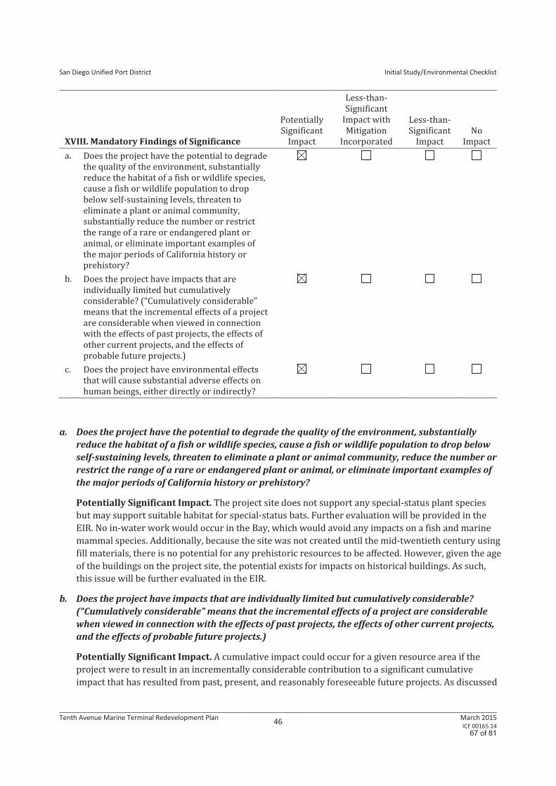
San Diego Unified Port District
Initial Study/Environmental Checklist
Tenth Avenue Marine Terminal Redevelopment Plan 46
March 2015 ICF 00165.14
XVIII. Mandatory Findings of Significance
Potentially
Significant
Impact
Less-than-
Significant
Impact with
Mitigation
Incorporated
Less-than-
Significant
Impact
No
Impact
a. Does the project have the potential to degrade
the quality of the environment, substantially
reduce the habitat of a fish or wildlife species,
cause a fish or wildlife population to drop
below self-sustaining levels, threaten to
eliminate a plant or animal community,
substantially reduce the number or restrict
the range of a rare or endangered plant or
animal, or eliminate important examples of
the major periods of California history or
prehistory?
b. Does the project have impacts that are
individually limited but cumulatively
considerable? (“Cumulatively considerable”
means that the incremental effects of a project
are considerable when viewed in connection
with the effects of past projects, the effects of
other current projects, and the effects of
probable future projects.)
c. Does the project have environmental effects
that will cause substantial adverse effects on
human beings, either directly or indirectly?
a. Does the project have the potential to degrade the quality of the environment, substantially
reduce the habitat of a fish or wildlife species, cause a fish or wildlife population to drop below
self-sustaining levels, threaten to eliminate a plant or animal community, reduce the number or
restrict the range of a rare or endangered plant or animal, or eliminate important examples of
the major periods of California history or prehistory?
Potentially Significant Impact. The project site does not support any special-status plant species
but may support suitable habitat for special-status bats. Further evaluation will be provided in the
EIR. No in-water work would occur in the Bay, which would avoid any impacts on a fish and marine
mammal species. Additionally, because the site was not created until the mid-twentieth century using
fill materials, there is no potential for any prehistoric resources to be affected. However, given the age
of the buildings on the project site, the potential exists for impacts on historical buildings. As such,
this issue will be further evaluated in the EIR.
b. Does the project have impacts that are individually limited but cumulatively considerable?
(“Cumulatively considerable” means that the incremental effects of a project are considerable
when viewed in connection with the effects of past projects, the effects of other current projects,
and the effects of probable future projects.)
Potentially Significant Impact. A cumulative impact could occur for a given resource area if the
project were to result in an incrementally considerable contribution to a significant cumulative
impact that has resulted from past, present, and reasonably foreseeable future projects. As discussed
67 of 81
San Diego Unified Port District
Initial Study/Environmental Checklist
Tenth Avenue Marine Terminal Redevelopment Plan 47
March 2015 ICF 00165.14
in Sections I though XVII, the proposed project could result in potentially significant impacts. Even
issues that were found to be less than significant with implementation of the project could contribute
to a cumulatively significant impact. As such, the potential cumulative impact from all resource issues
will be evaluated in the EIR.
c. Does the project have environmental effects that will cause substantial adverse effects on human
beings, either directly or indirectly?
Potentially Significant Impact. Given the analysis provided in Sections III (Air Quality), IV (Geology
and Soils), VII (Greenhouse Gas Emissions), VIII (Hazards and Hazardous Materials), IX (Hydrology
and Water Quality), XII (Noise), and XVI (Transportation/Traffic), the proposed project could result
in a potentially significant impact that could cause substantial adverse effects on human beings,
either directly or indirectly. Therefore, this issue will be further discussed in the EIR.
68 of 81
References
AreaVibes. 2014. San Diego Crime Rates and Statistics. Available:
http://www.areavibes.com/san+diego-ca/crime. Accessed: May 22, 2014.
California Air Resources Board. 2005. CEQA Air Quality and Land Use Handbook.
California Department of Finance. 2014. E-1: City/ County/ State Population Estimates with Annual
Percent Change, January 1, 2013, and 2014. Released: April 30, 2014.
California Department of Toxic Substances Control. 2014. EnviroStor. Available:
http://www.envirostor.dtsc.ca.gov. Accessed: September 9, 2014.
City of San Diego. 2008. Seismic Safety Study Geologic Hazards and Faults. Available:
http://www.sandiego.gov/development-services/industry/hazards/pdf/geo17.pdf. Accessed:
September 9, 2014.
City of San Diego. 2014. Neighborhood Divisions, Central Division. Available:
http://www.sandiego.gov/police/services/divisions/central/index.shtml. Accessed: May 22,
2014.
County of San Diego. 2010. Multi-Jurisdictional Hazard Mitigation Plan. August.
Port of San Diego. 2014. Functions of the Harbor Police Department. Available:
http://www.portofsandiego.org/harbor-police/harbor-police-functions.html. Accessed: May 23,
2014.
Recycle San Diego. 2014. Recycling Concrete. Available: http://recyclesandiego.org/item/
concrete/. Accessed: April 30, 2014.
San Diego International Airport. 2014. Airport Land Use Compatibility Plan. May. Available:
http://www.san.org/documents/aluc/SDIA_ALUCP_2014.pdf. Accessed: June 25, 2014.
San Diego Unified Port District. 2008. Jurisdictional Urban Runoff Management Program. March.
State Water Resources Control Board. 2014. GeoTracker. Available:
http://geotracker.waterboards.ca.gov/. Accessed: September 9, 2014.
Personal Communication
Jensen, Brian. San Diego Harbor Police Department. June 25, 2014—direct communication.
69 of 81

This page intentionally left blank
70 of 81

Executive Summary of the Tenth
Avenue Marine Terminal (TAMT)
Redevelopment Plan
Co-authored by:
Vickerman & Associates and
Unified Port of San Diego
March 2015
71 of 81

This page intentionally left blank
72 of 81
Page 2 of 10
Executive Summary of the Tenth Avenue Marine Terminal (TAMT) Redevelopment Plan
This summary to the Tenth Avenue Marine Terminal Redevelopment Plan has been co-authored the
Vickerman & Associates (“V&A”) team and the San Diego Unified Port District (“SDUPD” and “the District”)
staff to inform the preparation of a Programmatic Environmental Impact Report (PEIR) for three
Redevelopment concepts on the Tenth Avenue Marine Terminal.
The District commissioned the Vickerman and Associates team to update a maritime business plan (“2008
Business Plan”) that was published in December 2008 by the Port of San Diego. Cargo patterns and industry
economics have changed since the 2008 economic baseline was established. The global cargo market is
recovering following the 2008 global recession. At this time, future growth in both the container and non-
container cargo markets are projected, which is creating potential opportunities to handle additional volume at
TAMT. However, although potential market opportunities continue to increase, the terminal infrastructure
presents challenges to serve additional cargo volumes. An update to the 2008 Maritime Business Plan and
review of potential redevelopment concepts were warranted for these reasons.
The overall objective of the Tenth Avenue Marine Terminal Redevelopment Plan (“Redevelopment Plan” or
“the Plan”) is to provide the District with a series of market-driven port terminal development concepts for the
Tenth Avenue Marine Terminal (TAMT), which will appropriately position the Port of San Diego to maximize
cargo growth while maintaining sustainable and environmentally responsible cargo operations. While the
Plan developed by Vickerman & Associates was not intended to become the foundation of an Environmental
Impact Review document, as these development concepts were further refined and various infrastructure
improvements became apparent, the District concluded that a formal environmental analysis under the
California Environmental Quality Act (CEQA) would be necessary. As a result, the District decided to prepare
a Programmatic Environmental Impact Report (PEIR). The PEIR will analyze the three most likely
Redevelopment Plan concepts based on customer and cargo mix, core business strengths, and terminal
footprint. These three development concepts encompass a variety of cargos, including refrigerated and dry
containers. The remaining two concepts, which will not be advanced for full analysis, require the terminal be
converted nearly entirely to container operations. A full-container model is not consistent with the District’s
core maritime cargo strengths, and represents a departure from the existing markets and cargo mix served at
TAMT. For these reasons, the decision was made to proceed with an analysis of the “most impactful”
volumes generated by the three primary terminal redevelopment concepts. This document highlights the
Redevelopment Plans development concepts, as well as other pertinent data, that will be used to evaluate
potential environmental impacts associated with its implementation.
The TAMT Redevelopment Plan establishes an overall business framework to help make project level
decisions based on long range market needs to 2035. It includes an analysis of emerging industry-wide
maritime and intermodal trends. It also includes a review of the actual TAMT cargo throughput, market
assessments and forecasts, and proposes various infrastructure and transportation improvements that should
be implemented as market conditions allow1. It identifies development and improvement concepts by dividing
the TAMT into like operating nodes or modules. These nodes should be viewed as flexible “bladders” with
similar operational cargo characteristics capable of expanding or contracting to meet operational and market
conditions. The Plan identifies a Centralized Gate Complex as a tenant-in-common planning node, and the
following four operating nodes:
1A final determination on a specific investment should only be considered after a complete and full financial and
Return-On-Investment (ROI) analysis. This analysis needs to itemize all capital costs, ongoing District expenses,
revenues and provide a detailed cash flow. For planning purposes, however, the Redevelopment Plan suggests
improvements should be considered when each node reaches 70% of the MPC identified in the 2008 Maritime Business
Plan.
73 of 81
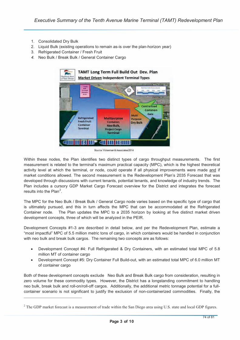
Page 3 of 10
Executive Summary of the Tenth Avenue Marine Terminal (TAMT) Redevelopment Plan
1. Consolidated Dry Bulk
2. Liquid Bulk (existing operations to remain as-is over the plan-horizon year)
3. Refrigerated Container / Fresh Fruit
4. Neo Bulk / Break Bulk / General Container Cargo
Within these nodes, the Plan identifies two distinct types of cargo throughput measurements. The first
measurement is related to the terminal’s maximum practical capacity (MPC), which is the highest theoretical
activity level at which the terminal, or node, could operate if all physical improvements were made and if
market conditions allowed. The second measurement is the Redevelopment Plan’s 2035 Forecast that was
developed through discussions with current tenants, potential tenants, and knowledge of industry trends. The
Plan includes a cursory GDP Market Cargo Forecast overview for the District and integrates the forecast
results into the Plan2.
The MPC for the Neo Bulk / Break Bulk / General Cargo node varies based on the specific type of cargo that
is ultimately pursued, and this in turn affects the MPC that can be accommodated at the Refrigerated
Container node. The Plan updates the MPC to a 2035 horizon by looking at five distinct market driven
development concepts, three of which will be analyzed in the PEIR.
Development Concepts #1-3 are described in detail below, and per the Redevelopment Plan, estimate a
“most impactful” MPC of 5.5 million metric tons of cargo, in which containers would be handled in conjunction
with neo bulk and break bulk cargos. The remaining two concepts are as follows:
Development Concept #4: Full Refrigerated & Dry Containers, with an estimated total MPC of 5.8
million MT of container cargo
Development Concept #5: Dry Container Full Build-out, with an estimated total MPC of 6.0 million MT
of container cargo
Both of these development concepts exclude Neo Bulk and Break Bulk cargo from consideration, resulting in
zero volume for these commodity types. However, the District has a longstanding commitment to handling
neo bulk, break bulk and roll-on/roll-off cargos. Additionally, the additional metric tonnage potential for a full-
container scenario is not significant to justify the exclusion of non-containerized commodities. Finally, the
2The GDP market forecast is a measurement of trade within the San Diego area using U.S. state and local GDP figures.
74 of 81
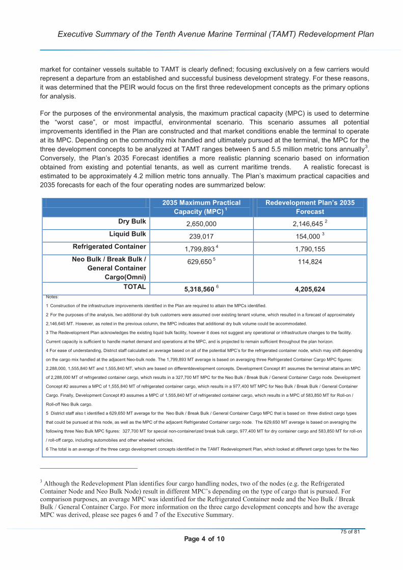
Page 4 of 10
Executive Summary of the Tenth Avenue Marine Terminal (TAMT) Redevelopment Plan
market for container vessels suitable to TAMT is clearly defined; focusing exclusively on a few carriers would
represent a departure from an established and successful business development strategy. For these reasons,
it was determined that the PEIR would focus on the first three redevelopment concepts as the primary options
for analysis.
For the purposes of the environmental analysis, the maximum practical capacity (MPC) is used to determine
the “worst case”, or most impactful, environmental scenario. This scenario assumes all potential
improvements identified in the Plan are constructed and that market conditions enable the terminal to operate
at its MPC. Depending on the commodity mix handled and ultimately pursued at the terminal, the MPC for the
three development concepts to be analyzed at TAMT ranges between 5 and 5.5 million metric tons annually3.
Conversely, the Plan’s 2035 Forecast identifies a more realistic planning scenario based on information
obtained from existing and potential tenants, as well as current maritime trends. A realistic forecast is
estimated to be approximately 4.2 million metric tons annually. The Plan’s maximum practical capacities and
2035 forecasts for each of the four operating nodes are summarized below:
2035 Maximum Practical
Capacity (MPC)1
Redevelopment Plan’s 2035
Forecast
Dry Bulk 2,650,000 2,146,6452
Liquid Bulk 239,017 154,000 3
Refrigerated Container 1,799,893 4
1,790,155
Neo Bulk / Break Bulk /
General Container
Cargo(Omni)
629,650 5
114,824
TOTAL 5,318,560 6
4,205,624Notes:
1 Construction of the infrastructure improvements identified in the Plan are required to attain the MPCs identified.
2 For the purposes of the analysis, two additional dry bulk customers were assumed over existing tenant volume, which resulted in a forecast of approximately
2,146,645 MT. However, as noted in the previous column, the MPC indicates that additional dry bulk volume could be accommodated.
3 The Redevelopment Plan acknowledges the existing liquid bulk facility, however it does not suggest any operational or infrastructure changes to the facility.
Current capacity is sufficient to handle market demand and operations at the MPC, and is projected to remain sufficient throughout the plan horizon.
4 For ease of understanding, District staff calculated an average based on all of the potential MPC’s for the refrigerated container node, which may shift depending
on the cargo mix handled at the adjacent Neo-bulk node. The 1,799,893 MT average is based on averaging three Refrigerated Container Cargo MPC figures:
2,288,000, 1,555,840 MT and 1,555,840 MT, which are based on differentdevelopment concepts. Development Concept #1 assumes the terminal attains an MPC
of 2,288,000 MT of refrigerated container cargo, which results in a 327,700 MT MPC for the Neo Bulk / Break Bulk / General Container Cargo node. Development
Concept #2 assumes a MPC of 1,555,840 MT of refrigerated container cargo, which results in a 977,400 MT MPC for Neo Bulk / Break Bulk / General Container
Cargo. Finally, Development Concept #3 assumes a MPC of 1,555,840 MT of refrigerated container cargo, which results in a MPC of 583,850 MT for Roll-on /
Roll-off Neo Bulk cargo.
5 District staff also t identified a 629,650 MT average for the Neo Bulk / Break Bulk / General Container Cargo MPC that is based on three distinct cargo types
that could be pursued at this node, as well as the MPC of the adjacent Refrigerated Container cargo node. The 629,650 MT average is based on averaging the
following three Neo Bulk MPC figures: 327,700 MT for special non-containerized break bulk cargo, 977,400 MT for dry container cargo and 583,850 MT for roll-on
/ roll-off cargo, including automobiles and other wheeled vehicles.
6 The total is an average of the three cargo development concepts identified in the TAMT Redevelopment Plan, which looked at different cargo types for the Neo
3Although the Redevelopment Plan identifies four cargo handling nodes, two of the nodes (e.g. the Refrigerated
Container Node and Neo Bulk Node) result in different MPC’s depending on the type of cargo that is pursued. For
comparison purposes, an average MPC was identified for the Refrigerated Container node and the Neo Bulk / Break
Bulk / General Container Cargo. For more information on the three cargo development concepts and how the average
MPC was derived, please see pages 6 and 7 of the Executive Summary.
75 of 81

Page 5 of 10
Executive Summary of the Tenth Avenue Marine Terminal (TAMT) Redevelopment Plan
Bulk and Break Bulk node, as outlined above. Development Concept #1 results in 5,504,717 MT, Development Concept #2 results in 5,422,257 MT, and
Development Concept #3 results in 5,028,707 MT. For more information, see pages 8 through 10 of the Executive Summary.
Source: San Diego Unified Port District
A description of the centralized gate facilities, as well as each of the four operating nodes, is summarized
below. The summary includes the nodes’ approximate location, the berth that serves the cargo in those
nodes, and any infrastructure improvements that would be needed to attain the maximum practical capacities
(MPC’s) identified in the Redevelopment Plan. It also identifies the Plan’s 2035 Forecast for each operating
node. To help ensure that future improvements are market-driven, the Redevelopment Plan suggests waiting
to make any improvements until the node reaches 70% of the MPC that was identified in the 2008 Maritime
Business Plan, as described below.
Central Gate Facilities: This node involves the creation of a common gate facility, with a new truck weigh
station, in the general location of the existing gate4. It would be utilized by all terminal tenants and customers.
Dry Bulk: This node includes products that are delivered in bulk or supersacks (also known as bulk-bags) to
the ground, flat storage, silo’s, and/or through a new consolidated facility. Dry bulk products include (but are
not limited to) cement, Fly-Ash, Slag, Bauxite, Chemical NEC, Potassium-Nitrate, Soda Ash, and other non-
hazardous bulk materials. The market forecast assumed a Compound Annual Growth Rate (CAGR) for
cement between 9% and 15% to year 2020, and a 3% CAGR thereafter. It also assumed a 1% CAGR for
export potash and a 2% CAGR for other dry bulk commodities. The Plan’s 2035 Forecast for Dry Bulk is
expected to be approximately 2,146,645 MT annually. The Dry bulk node would be located in the general
area of the southeastern portion of the terminal, also referred to as terminal “backlands.” This node would be
served by Berth 10-7/10-8, with overflow capacity handled at Berth 10-5/10-6. Under existing conditions, the
dry bulk node has a maximum practical capacity of 2,250,000. Therefore, the Plan recommends that
infrastructure improvements should not be considered until dry bulk throughput reaches 1,575,000 metric tons
annually. With the following infrastructure improvements identified in the Redevelopment Plan, the Dry Bulk
Node, would have a maximum practical capacity of 2,650,000 metric tons:
Establishing a consolidated Multi-purpose Dry-bulk facility with two cement handling facilities,
including a new semi-permanent storage facility (e.g. a Rubb style of building or equivalent) up to a
total of 100,000 square feet, to store dry bulk products.
Demolishing the existing inactive liquid-Molasses tanks once a new bulk storage facility has been
established, creating space that can be configured to serve dry bulk commodities.
Demolishing Warehouse C and transferring any dry bulk tenants to the proposed multi-purpose Dry-
bulk facility.
Upgrading or adding a new conveyor system to handle bauxite or soda ash, and connecting the new
semi-permanent dry bulk storage facilities to berths 10-5/10-6 and 10-7/10-8.
Adding a consolidated bulk discharge unloader using a 200 metric ton per hour vacuum (or better) for
cementatious materials at Berth 10-7/10-8 (either a Kovaco, Siwertell or similar type system).
Establishing approximately 5 acres of open-storage space between Water Street and Terminal Street
for various operational purposes.
4The Redevelopment Plan acknowledges that there may be interest in developing an Alternate Central Gate complex.
However, there have been no preliminary engineering studies or other technical work performed to evaluate its technical
feasibility or assess its potential environmental impacts. Therefore, the Alternate Central Gate complex is not identified
in the project description for the PEIR. However, if the PEIR finds that an Alternate Central Gate could help alleviate
certain environmental impacts, than it may be incorporated into the PEIR as a mitigation measure and/or as a project
alternative.
76 of 81
Page 6 of 10
Executive Summary of the Tenth Avenue Marine Terminal (TAMT) Redevelopment Plan
Liquid Bulk: Liquid bulk commodities currently handled at the TAMT include petroleum products and fuel for
vessels and the airport5. The Liquid bulk node and its existing infrastructure are acknowledged by the
proposed Redevelopment Plan, but the Plan does not propose any changes to its current location or any
infrastructure improvements. Preferred berths would continue to be 10-1/10-2 and 10-3/10-4. The current
maximum practical capacity according to the 2008 Business Plan is 220,000 metric tons of liquid bulk cargo.
The Redevelopment Plan estimates that the existing infrastructure is capable of handling slightly more than
what was identified in the 2008 Business Plan, and updates the maximum practical capacity to 239,017
metric tons for liquid bulk cargo. However, the plan acknowledges that, based on market fluctuations in the
price of liquid fuels, it is best practice to maintain a minimum level of fuel in storage. Should the market
dictate storing fuel in levels above 70% of capacity, the liquid bulk facility operator has indicated barges would
be employed to supplement the operation on a short term basis. As such, no changes to infrastructure or
customer base are recommended for the liquid bulk facility. For the purposes of the environmental analysis,
the District and Vickerman & Associates have determined that an annual figure of 154,000 MT of Liquid Bulk
would be an appropriate estimate for the Plan’s 2035 Forecast. This figure is 70% of the 220,000 MT MPC
that was identified in the 2008 Business Plan.
Refrigerated Container: The Refrigerated container node would include refrigerated and frozen perishable
commodities, and other containerized cargo that may or may not need to be refrigerated. It would be located
on the northern portion of the terminal and served by Berths 10-3/10-4, and overflow would be handled at
Berths 10-1/10-2 and 10-5/10-6, depending on vessel size and operational requirements. According to the
2008 Business Plan, the refrigerated container facility has a maximum practical capacity of approximately
730,000 metric tons. The future boundary between the proposed refrigerated container node and the
proposed multi-purpose general cargo node would be imprecise by design. The Redevelopment Plan calls for
these two areas of the terminal to be used for the handling of diverse cargos as market conditions and vessel
schedules permit. As such, construction of the refrigerated container node and Neo Bulk / Break Bulk /
General Container Cargo node would happen simultaneously.
The Redevelopment Plan forecasts substantial growth in the refrigerated container market. With the
improvements identified in the Plan, the Plan’s 2035 forecast for the refrigerated container cargo node is
1,790,893 MT. The Plan’s forecast assumes that the terminals current tenant (Dole Fresh Fruit Company)
would continue to operate through the year 2035 and that a new customer, specializing in refrigerated
container cargo would begin sometime in calendar year 2016. The Plan’s forecast assumes a second
refrigerated container carrier’s vessels would have a capacity of 350 forty-foot equivalent units (FEU) in 2016,
a 500 FEU capacity in 2021, and a 700 FEU capacity in 20306
Based on the three potential development concepts identified in the Redevelopment Plan, the District has
calculated an average maximum practical capacity of 1,799,893 metric tons for the Refrigerated
5Historically, molasses products were also handled at the TAMT. However, TAMT has not handled molasses for
several years and the Redevelopment Plan recommends demolition of the existing molasses tanks. 6
The Redevelopment Plan is not intended to address tenant projects or maintenance at the terminal, as these types of
projects have independent utility and do not rely on the adoption of the Redevelopment Plan. However, these types of
projects will be included as part of the cumulative analysis in the EIR. Therefore, it should be noted that the Dole Fresh
Fruits Company (Dole) has submitted an application to construct an additional 94 refrigerated racks within its leasehold.
The project is intended to help Dole accommodate additional cargo volume by increasing its on-site refrigerated storage
capabilities. The District has determined that the Dole project will require the issuance of a non-appealable Coastal
Development Permit (CDP), as well as a stand-alone environmental document, both of which will be processed
independently of the proposed TAMT Redevelopment Plan. The TAMT Redevelopment Plan, and its programmatic
environmental analysis, will assume Dole, or another similar type of tenant, will remain a tenant and that its proposed
infrastructure improvements will be made to its leasehold to accommodate additional cargo volume. By disclosing these
assumptions, the Redevelopment Plan can more accurately forecast market conditions for the refrigerated container node,
and the District can more easily comply with the provisions of the California Environmental Quality Act (CEQA).
77 of 81
Page 7 of 10
Executive Summary of the Tenth Avenue Marine Terminal (TAMT) Redevelopment Plan
Container node. The three development concepts affecting the MPC for the Refrigerated Cargo nodes are
summarized below:
1. The first MPC development concept assumes that the Neo Bulk / Break Bulk / General Container
Cargo node would continue to process large, heavy break-bulk items that are “high” and “wide”.
Under this development concept, the Refrigerated Container node would have a MPC of
approximately 2,288,000 MT; or
2. Under the second MPC development concept, the Refrigerated Container node would have a MPC of
approximately 1,555,840 MT, if the Neo Bulk / Break Bulk / General Container Cargo node processed
some break bulk cargo and was supplemented with dry container cargo; or
3. Under the third MPC development concept, the Refrigerated Container node would also have a MPC
of approximately 1,555,840 MT, if Roll-on / Roll-off cargo (e.g. automobiles) were processed at the
Neo Bulk / Break Bulk / General Container Cargo node.
Both estimates (the 2035 MPC and the Plan’s 2035 Forecast) would require the following infrastructure
improvements to be made within this node:
The demolition of Transit Sheds #1 and #2.
Constructing two to three 100 foot Gantry Cranes (intended to serve containerized cargo) at Berths
10-3 and 10-4, and the infrastructure required to support those cranes.
Maintaining Warehouse B (200,000 sq. ft.) as a cold storage facility.
Neo Bulk / Break Bulk with General Container Cargo: The Neo Bulk / Break Bulk / General Container
Cargo node includes the broadest range of cargo types including rolling vehicles, bagged and palletized
products, and large, heavy break-bulk items that cannot move in standard containers. The Neo Bulk / Break
Bulk / General Container Cargo node would be centrally located in the terminal, in the vicinity of portion of
what is currently Transit Shed #1, Transit Shed #2, and Warehouse C. This facility could also include an
intermodal rail facility, which would be located on the southern portion of the terminal in the area that is
currently occupied by the eastern portion of Warehouse C. The Neo-Bulk node would be primarily served by
berth 10-5/10-6, with overflow handled at Berths 10-3/10-4. As discussed above, it would share a boundary
with the Refrigerated Container node, which would be imprecise by design to allow flexibility for the area of
the two nodes. The area is intended to remain open to allow for the handling of diverse cargos as market
conditions and vessel schedules permit.
The Redevelopment Plan forecasts moderate growth in Neo Bulk / Break Bulk / General Container cargo.
Based in part on gross domestic product projections and market trends, as well as accounting for a broad
array of cargo types, the Plan’s 2035 Forecast estimates approximately 114,824 MT of Neo Bulk / Break Bulk
/ General Container cargo.
Conversely, the District identified an average maximum practical capacity for the Neo Bulk / Break Bulk /
General Container Cargo node is 629,650 metric tons, based on the development concepts presented in
the Redevelopment Plan. Similar to the Refrigerated Container node, the MPC for the Neo Bulk / Break Bulk /
General Container Cargo node varies based on what development concept, or cargo type, is ultimately
pursued, assuming the various infrastructure improvements identified in the Redevelopment Plan are
realized. The first development concept assessed the capacity of the terminal to continue to process “high”
and “wide” break bulk items that cannot move in standard containers. Under this development concept, the
MPC of the Neo Bulk / Break Bulk / General Container Cargo node would be approximately 327,700 MT
annually. The second development concept assessed the capability of the Neo Bulk / Break Bulk / General
Container Cargo node to process some break bulk cargo that would be supplemented with dry containers.
Under this development concept, the MPC of the Neo Bulk / Break Bulk / General Container Cargo would be
78 of 81
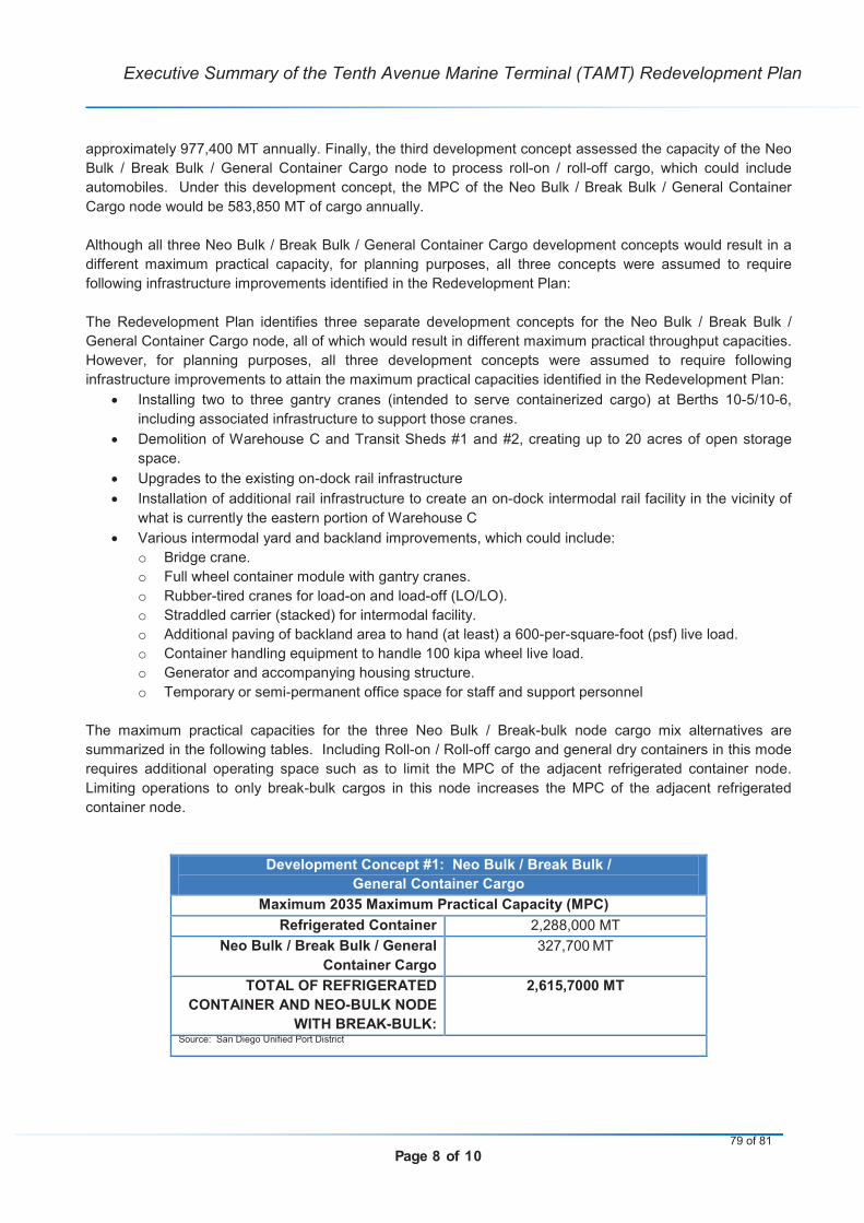
Page 8 of 10
Executive Summary of the Tenth Avenue Marine Terminal (TAMT) Redevelopment Plan
approximately 977,400 MT annually. Finally, the third development concept assessed the capacity of the Neo
Bulk / Break Bulk / General Container Cargo node to process roll-on / roll-off cargo, which could include
automobiles. Under this development concept, the MPC of the Neo Bulk / Break Bulk / General Container
Cargo node would be 583,850 MT of cargo annually.
Although all three Neo Bulk / Break Bulk / General Container Cargo development concepts would result in a
different maximum practical capacity, for planning purposes, all three concepts were assumed to require
following infrastructure improvements identified in the Redevelopment Plan:
The Redevelopment Plan identifies three separate development concepts for the Neo Bulk / Break Bulk /
General Container Cargo node, all of which would result in different maximum practical throughput capacities.
However, for planning purposes, all three development concepts were assumed to require following
infrastructure improvements to attain the maximum practical capacities identified in the Redevelopment Plan:
Installing two to three gantry cranes (intended to serve containerized cargo) at Berths 10-5/10-6,
including associated infrastructure to support those cranes.
Demolition of Warehouse C and Transit Sheds #1 and #2, creating up to 20 acres of open storage
space.
Upgrades to the existing on-dock rail infrastructure
Installation of additional rail infrastructure to create an on-dock intermodal rail facility in the vicinity of
what is currently the eastern portion of Warehouse C
Various intermodal yard and backland improvements, which could include:
o Bridge crane.
o Full wheel container module with gantry cranes.
o Rubber-tired cranes for load-on and load-off (LO/LO).
o Straddled carrier (stacked) for intermodal facility.
o Additional paving of backland area to hand (at least) a 600-per-square-foot (psf) live load.
o Container handling equipment to handle 100 kipa wheel live load.
o Generator and accompanying housing structure.
o Temporary or semi-permanent office space for staff and support personnel
The maximum practical capacities for the three Neo Bulk / Break-bulk node cargo mix alternatives are
summarized in the following tables. Including Roll-on / Roll-off cargo and general dry containers in this mode
requires additional operating space such as to limit the MPC of the adjacent refrigerated container node.
Limiting operations to only break-bulk cargos in this node increases the MPC of the adjacent refrigerated
container node.
Development Concept #1: Neo Bulk / Break Bulk /
General Container Cargo
2035Maximum 2035 Maximum Practical Capacity (MPC)(MPC)
Refrigerated Container 2,288,000 MT
Neo Bulk / Break Bulk / General
Container Cargo
327,700 MT
TOTAL OF REFRIGERATED
CONTAINER AND NEO-BULK NODE
WITH BREAK-BULK:
2,615,7000 MT
Source: San Diego Unified Port District
79 of 81
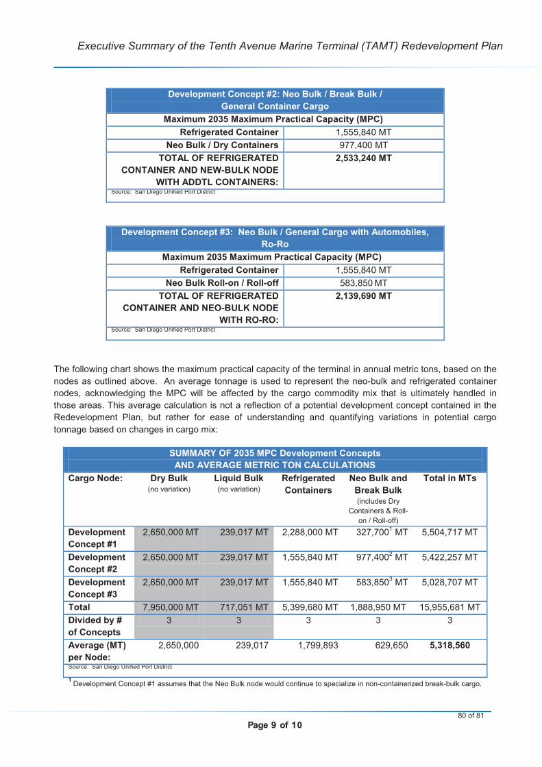
Page 9 of 10
Executive Summary of the Tenth Avenue Marine Terminal (TAMT) Redevelopment Plan
Development Concept #2: Neo Bulk / Break Bulk /
General Container Cargo
2035 Maximum 2035 Maximum Practical Capacity (MPC)(MPC)
Refrigerated Container 1,555,840 MT
Neo Bulk / Dry Containers 977,400 MT
TOTAL OF REFRIGERATED
CONTAINER AND NEW-BULK NODE
WITH ADDTL CONTAINERS:
2,533,240 MT
Source: San Diego Unified Port District
Development Concept #3: Neo Bulk / General Cargo with Automobiles,
Ro-Ro
2035Maximum 2035 Maximum Practical Capacity (MPC)(MPC)
Refrigerated Container 1,555,840 MT
Neo Bulk Roll-on / Roll-off 583,850 MT
TOTAL OF REFRIGERATED
CONTAINER AND NEO-BULK NODE
WITH RO-RO:
2,139,690 MT
Source: San Diego Unified Port District
The following chart shows the maximum practical capacity of the terminal in annual metric tons, based on the
nodes as outlined above. An average tonnage is used to represent the neo-bulk and refrigerated container
nodes, acknowledging the MPC will be affected by the cargo commodity mix that is ultimately handled in
those areas. This average calculation is not a reflection of a potential development concept contained in the
Redevelopment Plan, but rather for ease of understanding and quantifying variations in potential cargo
tonnage based on changes in cargo mix:
SUMMARY OF 2035 MPC Development Concepts
AND AVERAGE METRIC TON CALCULATIONS
Cargo Node: Dry Bulk(no variation)
Liquid Bulk(no variation)
Refrigerated
Containers
Neo Bulk and
Break Bulk(includes Dry
Containers & Roll-
on / Roll-off)
Total in MTs
Development
Concept #1
2,650,000 MT 239,017 MT 2,288,000 MT 327,7001
MT 5,504,717 MT
Development
Concept #2
2,650,000 MT 239,017 MT 1,555,840 MT 977,4002
MT 5,422,257 MT
Development
Concept #3
2,650,000 MT 239,017 MT 1,555,840 MT 583,8503
MT 5,028,707 MT
Total 7,950,000 MT 717,051 MT 5,399,680 MT 1,888,950 MT 15,955,681 MT
Divided by #
of Concepts
3 3 3 3 3
Average (MT)
per Node:
2,650,000 239,017 1,799,893 629,650 5,318,560
Source: San Diego Unified Port District
1 Development Concept #1 assumes that the Neo Bulk node would continue to specialize in non-containerized break-bulk cargo.
80 of 81
Page 10 of 10
Executive Summary of the Tenth Avenue Marine Terminal (TAMT) Redevelopment Plan
2 Development Concept #2 assumes that the Neo Bulk node would include dry container cargo.
3 Development Concept #3 assumes that the Neo Bulk node would pursue roll-on / roll-off cargo, including automobiles and
other wheeled vehicles.
The Redevelopment Plan identifies the following key principles and recommendations to be implemented in
conjunction with the various optimum development and improvement concepts discussed above.
1. Improvements need to be market-driven. The Redevelopment Plan includes a cursory market
forecast to 2035, but these forecasts may need to be updated as the 2035 horizon year approaches
and/or as market conditions change. The need for infrastructure improvements can be illustrated and
quantified using the (N = F – C) formula where forecast minus capacity equals need.
2. Demolition of Transit Sheds # 1 and # 2 is a high priority and will remove notable operational
constraints.
3. Improvements should maximize cargo throughput capabilities and efficiencies, be consistent with the
District’s Climate Action Plan goals, policies and measures, and provide the District with competitive
financial returns on the District’s investments.
4. All District marine-oriented industrial uses, such as TAMT, should be encouraged to modernize to
meet the present day expectations and requirements of the maritime industry. All of the development
concepts identified in the Redevelopment Plan rely on the Modular Operating Grid System (MOGS),
which involves standardized infrastructure improvements and large, open-storage space areas that
can accommodate a wide variety of cargo types. The Modular Operating Grid System (MOGS) should
be used in the planning, design and construction of improvements.
5. Employ a Central Gate node, in cooperation with TAMT users and tenants, and establish a practical
“freight only” gate complex. TAMT should also maintain a secondary access gate for emergency
egress situations.
6. When the market will sustain it, TAMT should employ on-dock intermodal operations to maximize
freight rail utilization for general cargo container operations and reduce annual truck trips from TAMT.
7. While the District continues its efforts to secure near-term maritime opportunities, it should also
anticipate long-term future cargo opportunities for TAMT. Although the actual booking of cargo
remains the responsibility of the carriers and customers, the District should continue to monitor long-
term market trends and work with carriers and customers to identify mutually beneficial terminal
infrastructure improvements based on market conditions.
8. While dredging all berths to 42 feet MLLW may be beneficial, the Plan does not recommend dredging
10-1 and 10-2 due to operational and financial constraints. This may need to be reassessed in future
plans.
81 of 81


![Optical and Electrical Properties of TTF-MPcs€¦ · Optical and Electrical Properties of TTF-MPcs ... well as for organic solar cells (OSC) [2]. ... in many applications, such as](https://img.pdfslide.net/doc/110x75/5f0859bd7e708231d421939c/optical-and-electrical-properties-of-ttf-mpcs-optical-and-electrical-properties.jpg)


![RBEs and MPCs in MSC.nastran2[1]](https://img.pdfslide.net/doc/110x75/577d20d31a28ab4e1e93d88c/rbes-and-mpcs-in-mscnastran21.jpg)