Embed Size (px)
Citation preview
1 Phrygia: an anarchist history, 950 BC–AD 100
peter thonemann
Introduction
In The Art of Not Being Governed: An Anarchist History of Upland Southeast
Asia, the anthropologist James C. Scott has offered an audacious series of
hypotheses about the historical sociology of a vast stretch of upland South
East Asia.1 This region – called by Scott ‘Zomia’ – is a huge inland massif of
some 2.5 million square kilometres, stretching from eastern China to north-
eastern India, and including the highland districts of five other modern
nation-states (Burma, Thailand, Laos, Vietnam and Cambodia). Today, the
highlands of Zomia are inhabited by more than 100 million members of
various minority peoples – the Kachin, the Wa, the Yao and others.
Scott makes three simple and provocative claims about this region. First,
a geographical claim: that it is intrinsically more difficult for states to extend
their power into mountainous inland regions than it is for them to control
lowland and maritime zones. Changes in altitude, ruggedness of terrain,
population dispersal and mixed cultivation all imposed direct and powerful
geographical constraints on state building in the pre-modern world. Second,
a historical claim: that this upland region has historically constituted a vast
‘shatter zone’, with a population made up of successive waves of refugees
from the various lowland states that have surrounded it. Third, a sociological
claim: that the existing societies of upland South East Asia have developed
a set of social institutions specifically designed to prevent states developing
in Zomia. As a result of their history as refugees from developing states, the
peasants of Zomia have consciously fostered a radically egalitarian social
structure, which both ‘thwarts incorporation by an outside state [and] also
inhibits crystallization of any internal statelike structure’.2 For example, the
peoples of Zomia are (or have been until very recently) largely illiterate.
In Scott’s account, this is not a state of pre-literacy, but post-literacy: many
Zomian societies had possessed writing at some point in the past, but
deliberately gave it up in order to avoid the kind of social stratification that
develops as a result of the practice of writing.3
1 Scott 2009. 2 Scott 2009: 277. 3 Scott 2009: 220–37; cf. Levi-Strauss 1973: 294–300. 1
www.cambridge.org© in this web service Cambridge University Press
Cambridge University Press978-1-107-03128-9 - Roman Phrygia: Culture and SocietyEdited by Peter ThonemannExcerptMore information
2 peter thonemann
Without doubt, all three hypotheses are open to empirical and theoretical
criticism. The specific historical claim, that the inhabitants of this upland
region are refugees from lowland states, is far from proven, and the geo-
graphical argument (that upland societies necessarily differ in character from
lowland societies) runs dangerously close to geographical determinism.4
Several readers, too, have felt that Scott’s interpretation of Zomian insti-
tutions, while romantically appealing, assumes exactly what needs to be
proved on the crucial question of human agency. Even if we accept Scott’s
account of Zomian radical egalitarianism, there remains a ‘world of differ-
ence between the recognition of the advantages of oral tradition and the
giving up of script as a conscious collective choice’.5
Nonetheless, the usefulness of Scott’s picture of ‘anarchist’ Zomia, I would
suggest, lies not so much in its empirical accuracy, or even in its theoretical
rigour, but in its analytic suggestiveness as an ‘ideal type’. An ideal-typical
model of a particular kind of society – in this case, a stateless, politically
and economically fragmented upland society – may well not map all that
closely onto observable reality. Indeed, as Weber puts it, ‘The more sharply
and clearly constructed the ideal types are – in other words, the more
unrealistic they are in this sense – the better they perform their function,
which is terminological and classificatory as well as heuristic.’6 A generation
ago, historians of the ancient world were notoriously resistant to the use
of simplifying sociological and economic models.7 This is no longer the
case; over the last decade or so, several ancient historians and archaeolo-
gists, particularly in the United States, have made increasingly sophisticated
attempts to model aspects of the ancient economy on modified neoclassical
principles (the New Institutional Economics).8 However, this intellectual
tradition, with its emphasis on state performance and individual and col-
lective economic rationality, has proved most fertile in helping to analyse
phases of rapid economic growth and increasing social complexity, such as
the development of certain parts of the Roman Empire between 200 BC
and AD 200.9 Its practitioners have shown less interest in those benighted
parts of the ancient Mediterranean world which refused to develop a
4 Sadan 2010; Subrahmanyam 2010; Krasner 2011; Randeria 2011. On geographicaldeterminism, see Harvey 2009: 202–13; Thonemann 2011a, esp. 17–19, 340–1.
5 Randeria 2011: 469. Cf. Subrahmanyam 2010 (‘a strong whiff of functionalism hanging over theintellectual enterprise as a whole’).
6 Weber, Wirtschaft und Gesellschaft, ch. 1.I (transl. Runciman 1978: 23–5); cf. Finley 1985: 60–1.7 Notable exceptions include, of course, Finley 1973 [1999]; Hopkins 1980 and 1995/6 [2002].8 Morris 2004; Manning and Morris 2005; Scheidel, Morris and Saller 2007; Bresson 2007–8. The
character of New Institutionalism is well described by Fine and Milonakis 2009: 78–87, 94–9.9 E.g. Hitchner 2005; Bowman and Wilson 2009.
www.cambridge.org© in this web service Cambridge University Press
Cambridge University Press978-1-107-03128-9 - Roman Phrygia: Culture and SocietyEdited by Peter ThonemannExcerptMore information
Phygia: an anarchist history, 950 BC–AD 100 3
market economy or whose states inexplicably failed to ‘perform’ with suffi-
cient dynamism and rationality.10
The chief argument of this chapter is that Scott’s account of the historical
development of upland South East Asia – or, one might say, its principled
refusal to develop – serves as a helpful simplifying model for understanding
the culture and society of Roman Phrygia. Judged on the criteria of eco-
nomic performance over time, levels of per capita consumption, and the
freedom of factor and commodity markets, upland inner Anatolia looks
like a classic example of a ‘failed society’.11 Between the tenth and sixth cen-
turies BC, as we shall see, inner Anatolia was home to a Phrygian state which
achieved quite respectable levels of urbanism, production beyond subsis-
tence, craft specialization and social complexity. Between the sixth and
fourth centuries, this Iron Age state ceased to exist, leaving a post-literate,
post-urban, highly fragmented, cellular agro-pastoral society across much
of central Anatolia. Graeco-Macedonian colonial settlement in Phrygia dur-
ing the third and second centuries BC did little to change this pattern. Even
during the Roman Imperial period, when – for cultural, not economic rea-
sons – a paper-thin facade of civic institutions and urbanization was erected
in parts of inner Anatolia, Phrygian society remained largely decentralized
and ‘underdeveloped’. In the face of this historical trajectory, we are faced
with a choice: either to wring our hands in despair at the millennial failure of
these stupid Anatolian peasants to follow the most basic rules of economic
rationality, or to try to formulate an alternative way of understanding their
curious long-term patterns of behaviour.12
‘Technical progress, economic growth, productivity, even efficiency have
not been significant goals since the beginning of time. So long as an accept-
able lifestyle could be maintained, however that was defined, other val-
ues held the stage.’13 Scott’s model of an ‘anarchist’ society – one which
10 In the chapters on Classical Greece in Scheidel, Morris and Saller 2007, the Greeks arerepeatedly ticked off for their ‘failure’ to develop effective factor and commodity markets. ‘Allthree expedients [for procuring flexible labour in Classical Greece] had one crucialshortcoming . . . they could not provide a labour force which could be closely controlled orcould be assembled at, or moved to, the loci of such production as was innovative in methodor scale’ (Davies 2007: 354); ‘[T]he institutional context of democracy improved theconditions for market-oriented commodity consumption. But even in Athens . . . markets didnot work without interference. The greatest problem was the variations in demand . . . ’ (vonReden 2007: 405).
11 For these criteria, see Scheidel, Morris and Saller 2007: 1–12.12 Manning and Morris 2005: 4, asserting ‘a commitment to assuming the basic rationality of
economic actors and systems’. For an excellent example of the ‘hand-wringing’ school ofAnatolian peasant history, see Kaplan 1992 (‘une agriculture bloquee par l’autarcie’).
13 Finley 1973 [1999]: 147.
www.cambridge.org© in this web service Cambridge University Press
Cambridge University Press978-1-107-03128-9 - Roman Phrygia: Culture and SocietyEdited by Peter ThonemannExcerptMore information
4 peter thonemann
consciously walks away from the state and its attendant socio-economic
differentiation – is by no means a perfect fit for Roman Phrygia. But it does
at least encourage us to take seriously the notion that, in post-Iron Age inner
Anatolia, we might not be dealing with a ‘failed’ society, but with one that
has, consciously or unconsciously, chosen its own destiny.
The land of Phrygia: a sketch
Let us picture a traveller, not so many years ago, setting out from Con-
stantinople for the high Anatolian plateau. Having taken ship to Nikomedeia
(modern Izmit), she rides out east to the lower Sangarios (Sakarya) river,
and thence upstream to Osmaneli (Byzantine Leukai), where she meets the
road from Nikaia (modern Iznik), six hours west of Leukai. From Leukai
(102 metres above sea level), the road starts to climb sharply; the Sangarios
swings away to the east, and our traveller continues on south up the Karasu
gorge, past Vezirhan to Bilecik (520 metres). From Bilecik, a very steep
road leads on up the defiles of the Karasu to Bozuyuk (ancient Lamounia,
740 metres), while an easier route branches off south-east to Sogud (650
metres).14 This zone marks a sharp ecological boundary: the olive does not
grow south of Bilecik, and Sogud is the last town where mulberry-cultivation
and silk-production is possible. South of Sogud, our traveller passes over
the forested heights of the Boz Dagı, still covered with dwarf oak and fir,
and descends into the great flat trough of Dorylaion (modern Eskisehir, 792
metres), her first taste of the grand Anatolian steppe. It is here, at the very
rim of the plateau, that Phrygia begins.
The arid plain of Dorylaion, thinly watered by the Porsuk Cayı (the
ancient river Tembris), is a different world from the fertile wooded valleys
to the north and west. There are no trees, little shade, and for much of the
last millennium the plain has been largely dedicated to stock rearing rather
than agriculture.15 East and south-east of Dorylaion stretches the flat, bare
landscape of the Upper Sangarios basin. The widely spaced towns of the
Upper Sangarios – Amorion to the south, Nakoleia to the west, Pessinous
and Germa to the east – controlled vast territories along the fringes of the
central Anatolian steppe; an inscription dating to the 320s AD shows that
14 R. P. Lindner 2007: 35–56. On the ancient roads in this region, see also Magie 1950: II 800–2.For Vezirhan as a point of contact between Phrygian- and Greek-speakers in the fifth centuryBC, see further below, p. 16.
15 MAMA V xi–xxii; Foss 1996; R. P. Lindner 2007: 58–67; Thonemann 2011a: 162. Cf. Cic. Flacc.41: Dorylensis . . . qui arborem numquam vidisset.
www.cambridge.org© in this web service Cambridge University Press
Cambridge University Press978-1-107-03128-9 - Roman Phrygia: Culture and SocietyEdited by Peter ThonemannExcerptMore information
Phygia: an anarchist history, 950 BC–AD 100 5
the small town of Orkistos, on an affluent of the Sangarios, formed part
of the territory of Nakoleia, more than 50 km to the north-west.16 At the
far east of this district, where the Sangarios makes its loop to the north,
the mound of Yassıhoyuk marks the site of ancient Gordion, the capital of
the Phrygian state of the early first millennium BC.17 The climate is severe
throughout this region, with bitterly cold winters and pitiless summers:
nowhere in upland Phrygia can the olive be cultivated without extreme
difficulty, and the relative brevity of the growing season seems to have
led the inhabitants of northern and eastern Phrygia to cultivate barley
in preference to wheat, due to its faster growth and relative resistance to
drought.18
Due south of Dorylaion rises the Turkmen Dagı mountain range, the
ancient Mt Elataeis (‘Fir-tree mountain’, 1,826 metres).19 The ridge of the
Turkmen Dagı separates the sombre plain of Dorylaion from a very differ-
ent ecological zone: the so-called Phrygian Highlands, the region known in
antiquity as the Arginousa (‘Shining-White’) after the extraordinary cones
of white tufa that appear here and there in the pinewood uplands.20 In
the mid-first millennium BC, this remote, wooded district was home to a
major Phrygian settlement (Midas City, at Yazılıkaya in the far east of the
Highlands) and several important religious sites.21 However, Midas City
was abandoned around the time of the Macedonian conquest of Asia, and
no other significant urban centres seem to have developed in the region dur-
ing the Hellenistic and Roman periods; the highlands were instead largely
carved up into private and Imperial estates, administered from the town of
Nakoleia, just east of the Highland region.
Continuing on south from the Highlands into central Phrygia, our trav-
eller is funnelled down into the basin of the Akar Cay (the ancient river
Kaystros), dominated by the great fortress of Afyon Karahisar (ancient and
16 Amorion: Katsari 2006; Lightfoot and Lightfoot 2007. Nakoleia: MAMA V xxv–xxxii;Drew-Bear 1978: 32–52. Pessinous: Devreker, Thoen and Vermeulen 2003; Claerhout andDevreker 2008; annual reports in Anatolia Antiqua. Germa: von Aulock 1968. Orkistos: MAMAVII 305; see further below, p. 36.
17 See further below, pp. 9–10.18 Robert, OMS VII 41–54 (olives and barley); on olives, see further Mitchell 2005b; Thonemann
2011a: 53–6. Archaeobotanical work at Gordion suggests that the cultivation ratiobarley:wheat varied from 1:1 to 2:1 over the course of the first millennium BC: N. F. Miller2010: 69, table 6.4; Marston 2012: 387–8.
19 Wrongly given as ‘Elaphoeis’ in the Barrington Atlas: for Elataeis, see Arist. Hist. an. 6.29(578b), ed. Balme 2002; Plin. HN 8.225. The mountain was probably known as Suwara in theHittite period: Forlanini 1996. For Roman-era villages on the north and west slopes of theTurkmen Dagı, Drew-Bear 1976: 251–2; Drew-Bear and Naour 1990: 1998–2001.
20 Haspels 1971; Robert 1980: 266–99. 21 Berndt 2002; Berndt-Ersoz 2006.
www.cambridge.org© in this web service Cambridge University Press
Cambridge University Press978-1-107-03128-9 - Roman Phrygia: Culture and SocietyEdited by Peter ThonemannExcerptMore information
6 peter thonemann
mediaeval Akroinos).22 In the hills immediately to the north-east of Afyon,
overlooking the valley of the Akar Cay, are the great marble quarries of
Dokimeion, intensively exploited throughout the Roman Imperial period
and beyond.23 The plain of the Akar Cay is one of the great crossroads of
central Anatolia; it was here that the battle of Ipsos was fought in the spring
of 301 BC. From Afyon, one can continue on the main highway to the
south-east, following the foothills of the Sultan Dagı mountains out along
the southern fringe of the central Anatolian steppe. This is the region known
as Phrygia Paroreios, with the small towns of Philomelion, Hadrianopolis,
Toriaion and ‘Burnt’ Laodikeia perched on the edge of the treeless plateau.24
Alternatively, one can turn south, to the ancient town of Synnada (mod-
ern Suhut) in its circle of mountains, the administrative centre of eastern
Phrygia in the Roman Imperial period.25 Finally, the road from Afyon to
the west leads down into the rich agricultural valleys of western Phrygia
and the Lydian borderlands. The chief landmark of western Phrygia is the
massive range of the Murat Dag, the ancient Mt Dindymos (2,312 metres),
whose fertile lower slopes are among the most favoured districts of inner
Anatolia.26 Many of the great perennial rivers of western Asia Minor rise
on the flanks of Mt Dindymos: the Gediz Cay (the ancient river Hermos)
rises on its western slopes, the Koca Cay (Rhyndakos) and Porsuk (Tembris)
flow to the north, and the Banaz Cayı (Sindros), a major affluent of the
Maeander, waters the plain to the south.
If we imagine our weary traveller looping anticlockwise around Mt
Dindymos, she finds herself first in the valley of the Upper Tembris (Porsuk
Cayı), north-east of the Murat Dagı, on the western edge of the Phrygian
Highlands. There is little evidence for the history of the valley before the
Roman Imperial period, when it was organized as a patchwork of senato-
rial and Imperial estates; just as in the Highlands, no real urban centres
ever developed in this region. However, the prosperity of the village com-
munities of the Upper Tembris in the Roman and Late Roman periods is
vividly attested by the hundreds of richly decorated funerary and votive
monuments surviving from the district.27
22 Kaystros plain: Lochman 2003: 109–34. Akroinos: TIB Phrygien 177–8; Cheynet andDrew-Bear 2004. The neighbouring town of Prymnessos (Sulun) was more important in theRoman period: Brixhe and Drew-Bear 2010.
23 Robert 1980: 221–56; Waelkens 1982a; Drew-Bear 1994; Christol and Drew-Bear 2005;Niewohner, Chapter 10 below.
24 Waelkens 1986: 254–69; Mitchell 1993: I 143–58; Thonemann 2008: 43–53. On the ecology ofthis region, see Wenzel 1937.
25 Robert, OMS VII 41–70, 109–21; G. M. Cohen 1995: 322–5; Drew-Bear and Sacco 2006–7.26 Robert, OMS VII 206–13.27 Strubbe 1975: 230–6; Levick and Mitchell in MAMA X, xv–xlv; Mitchell 1993: I 158–9;
Lochman 2003: 54–108; Thonemann, Chapter 6 below.
www.cambridge.org© in this web service Cambridge University Press
Cambridge University Press978-1-107-03128-9 - Roman Phrygia: Culture and SocietyEdited by Peter ThonemannExcerptMore information
Phygia: an anarchist history, 950 BC–AD 100 7
The historical development of the Upper Tembris valley could not differ
more starkly from that of the plain immediately to the west, the modern
Orencik ovası (c. 1,000 metres), north-west of Mt Dindymos. Although
the natural resources of the Orencik ovası are poorer than the Porsuk Cayı
basin, the small Hellenistic settlement at Aizanoi (modern Cavdarhisar)
nonetheless developed into one of the few major urban centres of Phry-
gia in the early Roman Imperial period.28 South of Aizanoi, the western
and south-western foothills of Mt Dindymos formed the cultural bor-
der with Lydia to the west. The chief modern city in this area is Usak
(ancient Temenouthyrai) which sits on the far western rim of the Anatolian
plateau.29
The first towns of Phrygia proper lie just to the east of Usak, in the rich
Banaz ovası, the ancient plain of Doias. The north-eastern corner of this
plain was occupied by the small town of Alioi, perched on a lower spur of
Mt Dindymos, on the watershed separating the Banaz river basin from the
Upper Tembris valley to the north.30 But the greater part of the Banaz ovası
was controlled by the most important town of central Phrygia in antiquity,
Akmoneia (modern Ahat), at the far south-east of the plain.31 Akmoneia
controlled a crucial bottleneck on the main west–east road through central
Phrygia, running from Sardeis up the Hermos valley to Usak, and skirting
the south side of Mt Dindymos on its way eastwards to Afyon and the
plateau.
Turning south from Akmoneia, our traveller skirts the western flank of a
massive chain of mountains (the Catma Dagı and Ak Dag ranges), 90 km in
length, separating the well-watered valleys of south-western Phrygia – the
wealthiest and most extensively urbanized part of the region in antiquity –
from the higher, drier plains to the north and east.32 Under the western edge
of this mountain range lie the prosperous modern towns of Sivaslı (ancient
Sebaste, on the lower Banaz Cayı), Civril (not far from ancient Eumeneia,
in the Upper Maeander valley) and Dinar (Apameia, at the source of the
Maeander). The apple gardens and strawberry plots of Civril and Sivaslı
make a stark contrast with the bare, treeless plains of the Pentapolis (the
modern Sandıklı ovası) and south-Phrygian Metropolis (Tatarlı), on the
eastern side of the Ak Dag.33
At last, with pleasure and relief, our traveller reaches the far south-western
corner of the Phrygian culture zone. This region, watered by two great
28 Levick and Mitchell in MAMA IX, xvii–xxix; Rheidt 2010; see further below, pp. 23, 25–6.29 Drew-Bear 1979; Waelkens 1986: 143–4; Mitchell, Chapter 8 below.30 Plain of Doias: Robert, OMS VII, 214–9. Alioi: Drew-Bear 1980a; Weiss 1993.31 Thonemann 2010. 32 Thonemann 2011a: 130–77.33 Pentapolis: Thonemann 2012. Metropolis: Robert 1980: 262–5.
www.cambridge.org© in this web service Cambridge University Press
Cambridge University Press978-1-107-03128-9 - Roman Phrygia: Culture and SocietyEdited by Peter ThonemannExcerptMore information
8 peter thonemann
perennial rivers, the Maeander and the Lykos, has little in common with the
arid, steppe-like landscape of central, eastern and northern Phrygia. The
two chief cities of the Lykos basin in the Roman Imperial period, Laodikeia
(near modern Denizli) and Hierapolis (modern Pamukkale), were large,
wealthy textile-producing urban centres, closely connected to the Aegean
lowlands via the middle and lower Maeander valley.34 Ecologically, the lower
Lykos valley forms a transitional zone of exactly the same kind as the area of
Bilecik and Sogud to the north; like Bilecik, Denizli marks the inland limit
of modern olive cultivation in western Turkey.
Phrygia 950–330 BC: society against the state
As indicated in the introduction above, the most striking and puzzling
event in the history of Phrygia is the process of ‘de-statification’ that took
place between 550 and 330 BC. From the ninth to the mid-sixth century
BC, upland inner Anatolia was home to a complex, sophisticated society,
possessing many of the characteristics of a state or proto-state.35 Large
ceremonial centres, palatial complexes and monumental cult-structures
are known in several different parts of Phrygian-speaking western and
central Turkey (Gordion, Midas City, Daskyleion, Kerkenes); the use of
writing, both in monumental contexts and elsewhere, was widespread; a
high degree of craft specialization can be inferred, and we have abundant
evidence for powerful hereditary rulers (including, in the late eighth century,
a certain ‘Midas’ or Mita) and an emergent urban and administrative elite.
However, by 330 BC at the very latest, this embryonic state had disappeared
almost without trace. As we shall see, the people of Phrygia in the last
three centuries BC formed a post-literate, post-urban, largely non-stratified
society. Monumental building works were all but unknown in Hellenistic
Phrygia. Writing was reintroduced only very gradually; it reappears in public
contexts in the first century BC, and becomes really widespread in inner
Anatolia only in the course of the second or even third century AD, later
than almost anywhere else in the Roman world. The aim of this section
is first to describe, and then to try to explain the first part of this curious
historical trajectory: why did Phrygia apparently experience such dramatic
retrograde social evolution in the mid-first millennium BC?
34 D’Andria and Silvestrelli 2000; Thonemann 2011a: 178–202. Laodikeia: des Gagniers 1969;Traversari 2000; Simsek 2007. Hierapolis: D’Andria 2001.
35 Overviews of Iron Age Phrygia: Fiedler 2003; Roller 2011.
www.cambridge.org© in this web service Cambridge University Press
Cambridge University Press978-1-107-03128-9 - Roman Phrygia: Culture and SocietyEdited by Peter ThonemannExcerptMore information

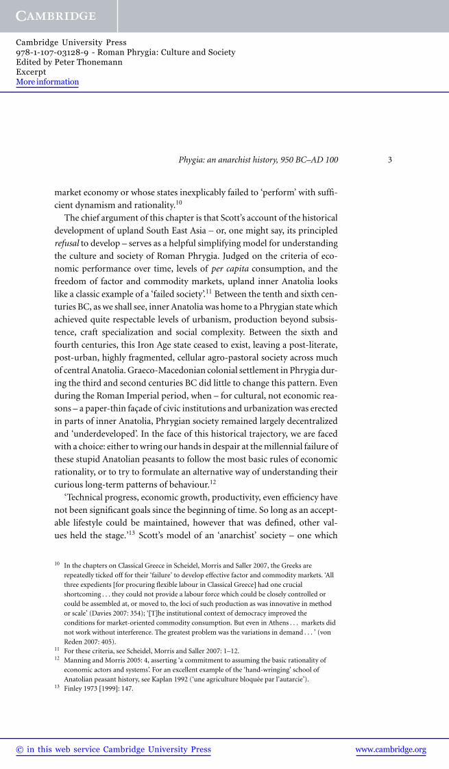
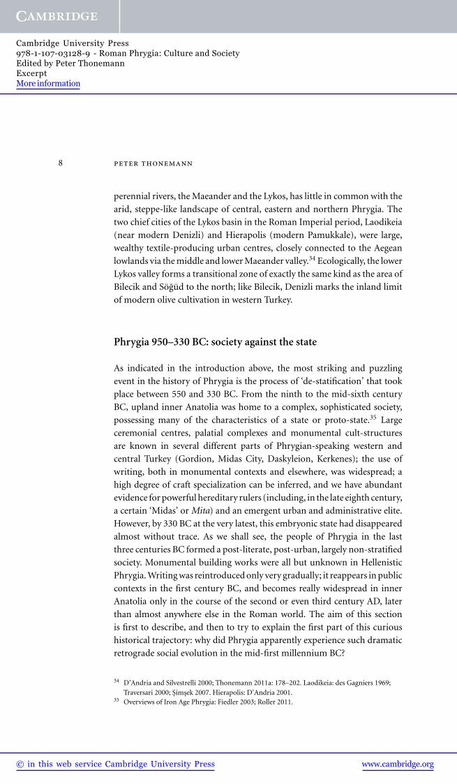
Phygia: an anarchist history, 950 BC–AD 100 9
TerraceBuilding Gate
Building
CCBuilding
2
3
1
5
4
3
2
0
Hemans, Cummer, Remsen, Hoffman, Alblinger
YASSIHÖYÜK/GORDIONEarly Phrygian PeriodYHSS Phase 6A
50 100 M
1
M3
M4 InnerCourt
OuterCourt
M12 M11
M10
M9
M2
M1
6
7
8
Figure 1.1. Gordion, site plan (Early Phrygian period). Courtesy of the Gordion
Archive, University of Pennsylvania Museum.
The earliest archaeological evidence for the emergence of social com-
plexity in Phrygia comes from the well-excavated site of Gordion in north-
eastern Phrygia. Over the course of the tenth and ninth centuries BC, the
Phrygian settlement at Gordion saw a series of massive building projects on
the site’s central Citadel Mound (Fig. 1.1).36 The eastern side of the mound
was given over to two spacious open courts, each of which was flanked by
a number of enormous halls (‘Megarons’), probably used both as reception
36 Voigt and Henrickson 2000; Dusinberre 2005: 8–10.
www.cambridge.org© in this web service Cambridge University Press
Cambridge University Press978-1-107-03128-9 - Roman Phrygia: Culture and SocietyEdited by Peter ThonemannExcerptMore information
10 peter thonemann
chambers and cult rooms. The courts were accessed from the lower town by
a massive ramped citadel gate. Immediately west of this large palace com-
plex stood two long buildings (105 metres in length), facing one another
across a broad street; each building was subdivided into eight smaller units,
each consisting of a stepped entrance leading to a small anteroom, with a
larger hall behind.37 These sixteen units, housing some 300 workers in total,
served as a single vast workshop-complex for food storage and preparation,
and for large-scale production of textiles. The workshops were equipped
with at least 125 looms – making this by far the largest attested weaving
operation in the eastern Mediterranean – and food-preparation facilities
(ovens, grain bins etc.) sufficient for feeding thousands of people.38 The
existence of this extraordinary mass-production unit, juxtaposed with the
lavish palatial complex to the east, suggests that Early Phrygian Gordion
(c. 950–800 BC) already enjoyed a sharply differentiated social structure,
combined with a very high degree of centralization of production and
distribution.
At the beginning of the Middle Phrygian period (c. 800–540 BC) – which
saw Phrygian cultural influence reaching its greatest extent in central and
western Anatolia – the monumental structures on the eastern part of the
Citadel Mound were destroyed by an extensive fire. The palace complex and
associated workshops were swiftly rebuilt in a form similar to their previous
Early Phrygian incarnation; on the far side of a broad paved avenue, on the
western peak of the Citadel Mound, a further group of lavish high-status
residences now appears, suggesting the emergence of a new, secondary elite
group at Gordion.39 Similar palatial structures also begin to appear at other,
widely-spaced Phrygian sites in Anatolia during this period. At Daskyleion,
a Phrygian settlement on the south shore of the Propontis, a large palatial
complex was built in the mid-eighth century BC.40 The huge walled city
at Kerkenes Dag, in the far east of the Phrygian zone of influence, and
apparently first occupied in the late seventh century BC, was dominated by
another huge palace unit, accessed through a monumental entrance with
fine sculptural decoration.41
Further indices of stratified political organization can be seen in the
last years of the Middle Phrygian period. In the Phrygian Highlands
between Eskisehir and Afyon, the first half of the sixth century BC saw the
37 Only the east building has been completely excavated; the west building has at least four units,and probably mirrored its counterpart.
38 Burke 2005; Burke 2010: 124–50. 39 Voigt and Young 1999: 197–220; Voigt 2007.40 Bakır-Akbasoglu 1997.41 Summers 2007; Draycott and Summers 2008; Kealhofer et al. 2010.
www.cambridge.org© in this web service Cambridge University Press
Cambridge University Press978-1-107-03128-9 - Roman Phrygia: Culture and SocietyEdited by Peter ThonemannExcerptMore information