Embed Size (px)
Citation preview
1
The Potential Impacts of Frac Sand Transport and Mining on Tourism and
Property Values in Lake Pepin Communities
By
Dominic Parker and Daniel Phaneuf
Department of Agricultural & Applied Economics
University of Wisconsin-Madison
May 14, 2013
2
Executive Summary
This report provides a review of economic theory and empirical research that is relevant
for evaluating the economic impacts of “frac sand” operations and transport on the Stockholm
and Pepin districts of Pepin County, Wisconsin. The authors were retained by Lake Pepin
Partners in Preservation (LPPP) to write a report documenting (a) our opinions, based on
currently existing data and research, about how frac sand operations and transport in the
Stockholm and Pepin districts could impact the local amenity-based economy, and (b) new
empirical research that could be carried out to measure the actual economic impacts.
To accomplish these objectives we first assembled census and other data files for the
region, which allowed us to demonstrate the importance of unique natural amenities to the
economic health of the Stockholm and Pepin districts. The statistics we present indicate that
Lake Pepin economies have evolved to capitalize on natural amenity endowments, implying that
actions to diminish the amenities could threaten economic health. We then surveyed economic
research measuring how increases in traffic congestion, noise, and diminished air quality have
adversely affected local property values in other regions of the country. We find that property
value decreases ranging from 3 to 8 percent are typically estimated for these disamenities. We
also examined studies measuring the impact that changes in recreation site quality can have on
residents and visitors to an area. Our review of this research demonstrates that the changes in
amenity conditions expected from increased mining operations and transport in the districts
could have substantial economic impacts.
To summarize, we are confident that (a) the impressive amenity endowments in the
Stockholm and Pepin districts contribute to higher property values, healthy population and real
estate value growth, and more tourism activity relative to the remainder of the county; and (b)
frac sand operations and transport absent the proposed ordinance has the potential to
significantly impair property values and tourist activity in Stockholm and Pepin districts.
These conclusions are, of course, qualitative. While we have confidence that expanded
frac sand operations and transport would have effects of the type described in the report, we
cannot precisely estimate their actual magnitudes without additional study. Further research
could generate more precise estimates by analyzing the distribution of housing prices across the
county landscape to assess how amenity changes observed to date have affected recent home sale
prices and trajectories. A survey of business and property owners throughout the affected and

3
unaffected areas of the county could also provide quantifiable measures of how people are (and
expect to be) impacted by any changes brought about by frac sand operations and transport.
4
1. Introduction
The recent surge in demand for western Wisconsin’s frac sand is creating new dilemmas
and choices for local and county governments. One path would allow frac sand development and
transportation to proceed apace within the existing regulatory framework, thereby generating
economic activity in the extractive and transportation industries. This may, however, come at
the expense of the region’s traditional emphasis on amenity-based economic activity from
tourism, recreation opportunities, and agriculture. A second path would place additional, targeted
restrictions on frac sand operations to limit their impact on amenity-dependent areas. This
approach is advocated by leaders in the Pepin County districts of Stockholm and Pepin, where an
ordinance has been proposed that would restrict mining operations and limit through-transport
from other areas of the county.
Both paths have merit as generic propositions. Some economic studies indicate that
mining booms can generate large, albeit temporary, gains in local employment and earnings that
may spillover beyond the mining sector into service and retail sectors (see Black et al. 2005,
Marchand 2012). Other studies have linked reliance on energy and mining sectors to slower long
run economic growth after the mining booms inevitably conclude (see James and Aadland 2011,
Papyrakis and Gerlagh 2007). This is because after the boom – when the bust comes – local
communities may be left with an undiversified economy and a footprint of degradation and
industrial pollution that could repel natural amenity-driven economic activity and also drive
down local property values.
Moving beyond generic tradeoffs, this report considers how frac sand mining and
transportation could adversely impact economic activity and property values in a specific region:
the Lake Pepin communities of Pepin and Stockholm along the Mississippi River in Pepin
County, Wisconsin. As we describe in the next section, Stockholm and Pepin are uniquely
endowed with scenic and natural amenities and their local economies have consequentially
evolved to be based largely on recreation, tourism, agriculture including orchards and vineyards,
and quality of life related in-migration and seasonal residency. To a greater extent than other
communities lacking unique amenities, Stockholm and Pepin risk losses in property values if
industrial transportation through these communities is allowed to proceed without additional
regulations.
5
2. Overview of Lake Pepin Communities
Located on the border of Wisconsin and Minnesota, Pepin County is small, rural, and
scenic. It ranks last among Wisconsin’s 72 counties by land area, at 232 square miles, and 69th
by 2012 population at 7,390 residents. Much of its economic activity is tied to the county’s
natural and scenic amenities. This is particularly true of Pepin and Stockholm townships and
villages, which abut Lake Pepin, the widest naturally occurring part of the entire Mississippi
River.
2.1. Natural Amenity and Resource Endowments
Raw natural amenity endowments are difficult to quantify, but efforts to do so rank Pepin
County well above the average Wisconsin county. One such effort is undertaken by McGranahan
(1999). He creates a county-level natural amenities index that combines climate, topography,
and access to water into a measure of natural features that humans find attractive. Criteria used in
the index imply that a county is more desirable with more varied terrain and a higher ratio of
water to land surface. The measures of topography and water area are normalized, and the entire
index is defined on a standard-normal scale meaning the average U.S. county has an amenity-
scale ranking of zero.
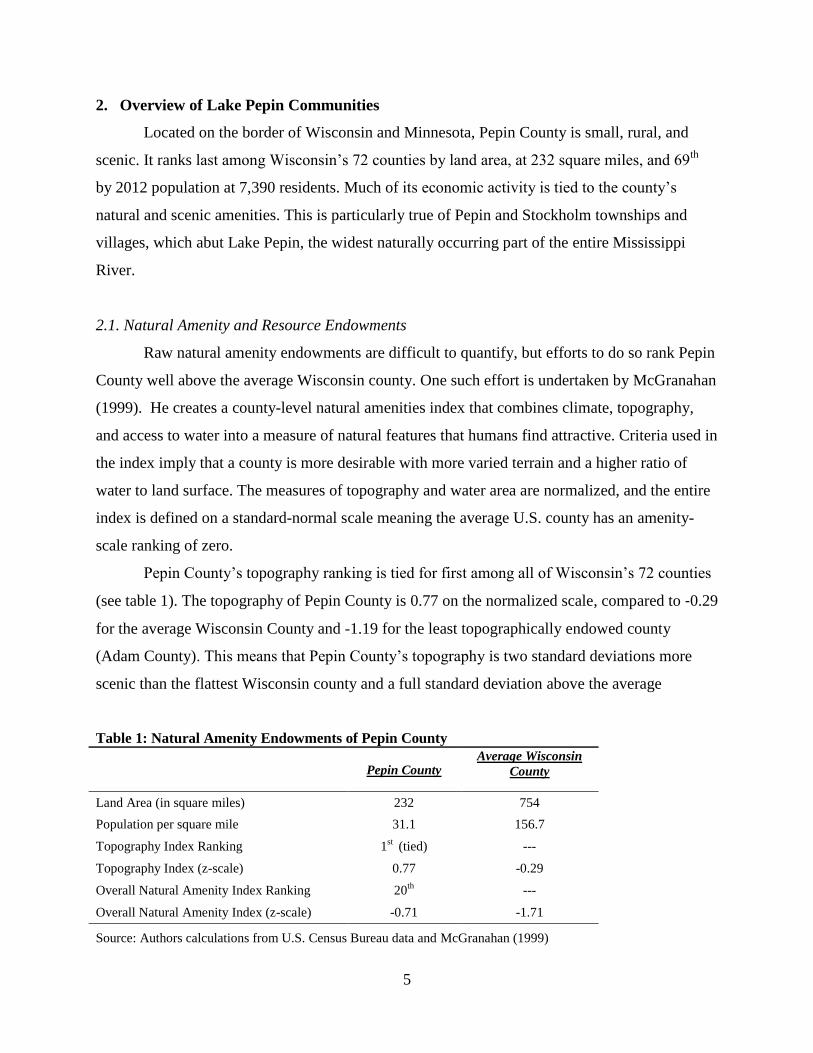
Pepin County’s topography ranking is tied for first among all of Wisconsin’s 72 counties
(see table 1). The topography of Pepin County is 0.77 on the normalized scale, compared to -0.29
for the average Wisconsin County and -1.19 for the least topographically endowed county
(Adam County). This means that Pepin County’s topography is two standard deviations more
scenic than the flattest Wisconsin county and a full standard deviation above the average
Table 1: Natural Amenity Endowments of Pepin County
Pepin County
Average Wisconsin
County
Land Area (in square miles) 232 754
Population per square mile 31.1 156.7
Topography Index Ranking 1st (tied) ---
Topography Index (z-scale) 0.77 -0.29
Overall Natural Amenity Index Ranking 20th ---
Overall Natural Amenity Index (z-scale) -0.71 -1.71
Source: Authors calculations from U.S. Census Bureau data and McGranahan (1999)
6
counties (Bayfield and Douglas). Pepin County also ranks high in terms of water to land area,
primarily because the southwest border of the county is adjacent to Lake Pepin.
The favorable statistical rankings of Pepin County’s scenic amenities match verbal
descriptions that laud the rich, rolling farmland and the scenic and towering limestone bluffs
overlooking Lake Pepin. Some of these bluffs are permanently protected natural areas, such as
the Maiden Rock Bluff State Natural Area. The area abutting Lake Pepin has been described as
having some of the “grandest scenery in the world.” It also provides habitat for threatened
wildlife such as peregrine falcons and a number of rare forbs.1
The Lake Pepin communities have other scenic, cultural, and recreational attributes that
are not quantified by indices. First, the area has not experienced significant industrial booms and
busts. Its bluffs and lake shore exist in a largely natural, undisturbed state.2 This feature enhances
its aesthetic appeal relative to other communities that show heavier footprints of past and present
industrial activity. Second, the communities have endowments of historic and cultural amenities.
For example, Pepin Township is a prominent setting in Laura Ingalls Wilder’s Little House on
the Prairie Series. Third, the communities hold one of the largest marinas on Lake Pepin, from
which lake and river recreation activities are launched.
Through Pepin and Stockholm runs the Great River Road/National Scenic Byway along
Highway 35 in Pepin County. It is Wisconsin’s only National Scenic Byway and is part of the
ten-state Great River Road National Scenic Byway, which follows the Mississippi River for
3,000 miles. The Great River Road Scenic Byway in Wisconsin was identified by a national poll
as “the prettiest scenic drive in America” in the Huffington Post.3 Travelers along this road stop
in the towns to shop, eat at restaurants, and stay at bed and breakfasts as well as to attend annual
festivals and events. The road has been a magnet for attracting federal and state grant dollars for
highway improvements, recreational trails, bikeways, scenic overlooks and historical
preservation.
1 From Wisconsin DNR website http://dnr.wi.gov/topic/Lands/naturalareas/index.asp?SNA=410 (accessed April
2013). 2 The landscape and ecology of the area are much more complex than can be described here. In commenting on this
an early reader of this report noted that
“…It isn't just the lake, but the lake and associated wetlands and floodplain forests; not just the bluffs, but
the bluffs and associated dry sand prairies. [A]nd for both, the biota associated with those distinctive and
much-prized habitats. [The] lake and bluffs can be appreciated passively as drive-by amenities, but their
lasting draw to residents and tourists…is the complex ecosystems that embrace them.” 3 Huffington Post, May 29, 2012.
7
In addition to the scenic, cultural, recreational, and ecological endowments just
described, Pepin County has a deep layer of Jordan sandstone below its surfaces. The shape of
the deposit’s silica particles and loose cementation make it an ideal material for processing into
the hydraulic fracture-grade sand (“frac sand”) used in the exploration, drilling, and recovery of
deep oil and gas deposits elsewhere in the nation. Silica sand that can be economically processed
into frac sand is found throughout much of Wisconsin, with the largest concentration in a
western swath that includes Pepin County. Silica mining (often referred to as frac sand mining)
has only recently become economically profitable, because of the oil and gas boom enabled by
new hydraulic fracking technologies. Absent this recent boom, frac sand would not be
considered an economically significant resource endowment.
2.2. Overview of Link between Natural Amenities and Economic Health
Before returning to the issue of frac sand mining, it is important to emphasize how the
natural amenities in Pepin and Stockholm townships and villages have shaped their local
economies. Research and economic reasoning suggest a positive link between amenity quality
and in-migration of households and firms and this link is also borne out in Lake Pepin
communities. McGranahan (1999), for example, finds that between 1970 and 1996 average
population growth was 120 percent in non-metropolitan counties with high levels of natural
amenities, while population growth was one percent in counties with low levels of natural
amenities. Other studies find similar effects of broad natural amenity measures on population and
employment growth (see Deller et al. 2001).
In general, there is recognition of the increasing importance of natural amenities in the
location decisions of migrants and the quality of life improvements that result. Rising levels of
income and wealth in nearby cities also increase demand for the types of location-specific
amenities that Lake Pepin communities have. Other factors include the growing influence of
retirees as a source of income. Because of the nature of retirement income, retirees base location
decisions on factors other than wages and employment and may continue to be a major income
source in the rural amenity-rich communities. This in-migration is one force that pushes property
values up in resource endowed communities.
It is worth emphasizing that economic reasoning suggests natural amenity endowments
enhance local property values to a greater extent than they enhance local wages and earnings.
8
This is because of a principle known as compensating differentials (see Roback 1982, 1988). The
basic idea is that, when all else is equal, people are willing to accept lower wages in order to
work and live in nice places. Employers benefit from having access to an affordable labor pool,
suggesting the possibility of abnormally high profits, relative to what one would otherwise
expect for the location and customer base. In a competitive marketplace, however, other factors
adjust that prevent this – namely, property values. This is another reason why there tends to be
upward pressure on property values in amenity rich locales. By contrast, the mining industry
pays relatively high wages in part to attract labor to an otherwise less attractive type of work.
2.3. Statistical Evidence of the Benefits from Lake Pepin Amenities
Statistics are useful for understanding how Lake Pepin economies and property values are
evolving because of their unique natural amenity endowments. Table 2 and table 3 on the
following page compare the Lake Pepin communities, which are directly adjacent to the lake and
to the Great River Road, with the broader county. As the table 3 shows, Lake Pepin communities
are experiencing faster population growth when compared to the remainder of Pepin County.
This finding is consistent with the idea that the unique natural amenities along Lake Pepin have
attracted healthy growth in recent years for quality of life reasons. Median incomes are generally
also higher in the Lake Pepin regions. This is consistent with theories suggesting that natural
amenities will attract well educated, high-earning professionals. In fact, the table indicates that
22.3 percent of the housing in Lake Pepin communities is for seasonal and recreational use. This
is a strong indication that natural amenities are attracting wealthier, second-home buyers to the
area. This market could be impaired by heavy industrial frac sand operations and transport as
discussed in the next section.
Tables 2 and 3 also show that property values tend to be higher in the Lake Pepin
communities when compared to the remainder of the county. This is true whether we measure
property values based on median housing values, or by real estate equalized value data collected
by the State of Wisconsin Department of Revenue. Moreover, the number of housing units and
the value of real estate grew at a much faster rate in Lake Pepin communities over the past
decade when compared to the remainder of the county. These comparisons support the idea that
natural amenities in Lake Pepin communities are capitalized into higher property values thereby
supporting growth in property tax receipts for the county as a whole. As we describe in the next
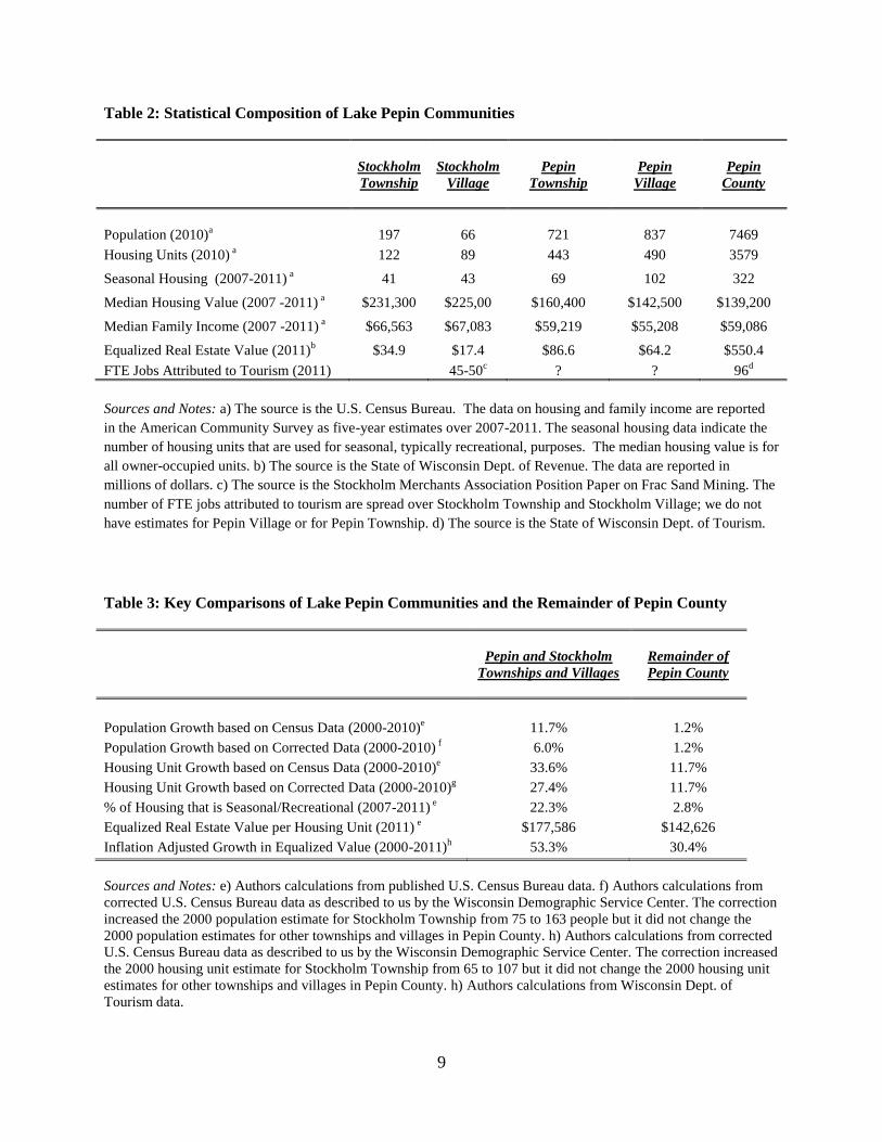
9
Table 2: Statistical Composition of Lake Pepin Communities
Stockholm
Township
Stockholm
Village
Pepin
Township
Pepin
Village
Pepin
County
Population (2010)a
197
66
721
837
7469
Housing Units (2010) a 122 89 443 490 3579
Seasonal Housing (2007-2011) a 41 43 69 102 322
Median Housing Value (2007 -2011) a $231,300 $225,00 $160,400 $142,500 $139,200
Median Family Income (2007 -2011) a $66,563 $67,083 $59,219 $55,208 $59,086
Equalized Real Estate Value (2011)b $34.9 $17.4 $86.6 $64.2 $550.4
FTE Jobs Attributed to Tourism (2011) 45-50c ? ? 96
d
Sources and Notes: a) The source is the U.S. Census Bureau. The data on housing and family income are reported
in the American Community Survey as five-year estimates over 2007-2011. The seasonal housing data indicate the
number of housing units that are used for seasonal, typically recreational, purposes. The median housing value is for
all owner-occupied units. b) The source is the State of Wisconsin Dept. of Revenue. The data are reported in
millions of dollars. c) The source is the Stockholm Merchants Association Position Paper on Frac Sand Mining. The
number of FTE jobs attributed to tourism are spread over Stockholm Township and Stockholm Village; we do not
have estimates for Pepin Village or for Pepin Township. d) The source is the State of Wisconsin Dept. of Tourism.
Table 3: Key Comparisons of Lake Pepin Communities and the Remainder of Pepin County
Pepin and Stockholm
Townships and Villages
Remainder of
Pepin County
Population Growth based on Census Data (2000-2010)e
11.7%
1.2%
Population Growth based on Corrected Data (2000-2010) f
Housing Unit Growth based on Census Data (2000-2010)e
Housing Unit Growth based on Corrected Data (2000-2010)g
6.0%
33.6%
27.4%
1.2%
11.7%
11.7%
% of Housing that is Seasonal/Recreational (2007-2011) e
Equalized Real Estate Value per Housing Unit (2011) e
Inflation Adjusted Growth in Equalized Value (2000-2011)h
22.3%
$177,586
53.3%
2.8%
$142,626
30.4%
Sources and Notes: e) Authors calculations from published U.S. Census Bureau data. f) Authors calculations from
corrected U.S. Census Bureau data as described to us by the Wisconsin Demographic Service Center. The correction
increased the 2000 population estimate for Stockholm Township from 75 to 163 people but it did not change the
2000 population estimates for other townships and villages in Pepin County. h) Authors calculations from corrected
U.S. Census Bureau data as described to us by the Wisconsin Demographic Service Center. The correction increased
the 2000 housing unit estimate for Stockholm Township from 65 to 107 but it did not change the 2000 housing unit
estimates for other townships and villages in Pepin County. h) Authors calculations from Wisconsin Dept. of
Tourism data.
10
section, property values are threatened if industrial frac sand operations and transport proceeds
without additional, targeted regulations.
Another dimension of the amenity-based economy is the revenue and jobs that are
generated by tourism-related activity along Highway 35, Wisconsin’s portion of the Great River
Road. There were 45-50 jobs in Stockholm attributed to tourism compared to 96 jobs for the
entire county of Pepin. The differences in jobs on a per-capita basis are stark and consistent with
verbal descriptions of tourism trips through Lake Pepin communities. Businesses owners along
Lake Pepin attest that the majority of visitors come from Minnesota, with most of the remainder
coming from Wisconsin cities such as Menominee, Eau Claire, and La Crosse.4 As we describe
in the next section, tourism activity is threatened with diminution if industrial frac sand
operations and transport proceeds without additional, targeted regulations.
3. Theory of the Potential Effects of Industrial Frac Sand Transport
3.1. Setting Prior to Frac Sand Demand Boom
To frame the mining issue in Pepin County, it is useful to begin with some conceptual
background. We conceive of a landscape – the county in our context – that is defined by political
boundaries and characterized physically by the topography and endowment of natural resources.
In Pepin County the political boundaries consist of individual townships that have some local
decision making authority. The natural amenities in the county arise from its position on Lake
Pepin in the west and the bluffs and rolling landscapes further east. The primary natural resource
endowments include the lake itself, the bluffs and wildlife habitat, the historical amenities (and
recently, the high volumes of frac sand available for mining).
The landscape also contains a stock of manmade infrastructure such as road networks,
business facilities, and housing areas. Given the physical and infrastructure characteristics of the
landscape, economic actors – households and firms – make decisions on how to pursue their
objectives, and where to engage in their activities. To begin, households select a neighborhood in
which to live based on their income and tastes for the many and varied attributes of the available
neighborhoods. Scenic attributes of different neighborhoods are often an important determinant
of household choices, as are other place-based features such as local traffic congestion, noise
levels, and air quality. The notion that households base migration decisions on amenities and dis-
4 This information comes from the Stockholm Merchants Association Position Paper on Frac Sand Mining.
11
amenities has long been an accepted idea in economics, formally dating back to Tiebout (1956).
In Tiebout’s model, households “vote with their feet”, by migrating to areas that provide optimal
bundles of public services, natural amenities, and taxes, among other things.
Based on households’ demand for neighborhoods and the supply of housing units across
the landscape a set of neighborhood home prices arises. Different neighborhoods have different
prices based on the supply of homes and the stock of attractive place-based features. For
example, we expect that neighborhoods with high scenic beauty, low levels of industrial noise,
better access to recreation opportunities, and little traffic congestion will be more in demand –
and hence command higher market prices. Knowing this households decide where to live, given
these prices, their income, and their own sense of how important local amenities are relative to
price. Households are individually and collectively ‘in equilibrium’ – i.e. do not wish to move –
when they have located to a neighborhood that contains the correct combination of home price
and place-based features, given their unique circumstances. So long as nothing changes in the
landscape, this relative housing market stability can continue for some time.
Firms in the landscape earn money (and pay their workers – the households) by using the
landscape and its infrastructure to produce something to sell. In a tourism-based economy firms
rely on the scenic beauty of a place, and the leisure opportunities it provides, as inputs to
production. These inputs are used to produce opportunities for natural, cultural, and historical
based tourism and vacation experiences. Rising levels of income and wealth in other regions also
act as a force to increase demand for tourism activities and for property in amenity rich
neighborhoods. In a mining economy firms focus on extracting the resource endowment for use
outside of the landscape; in general place-based attributes of the landscape are not important in
this sector.
Given the demand for the products in the various sectors – tourism and mining in these
two examples – a distribution across space of income-generating activities emerges. The
business economy is ‘in equilibrium’ when firms are not entering and leaving the market, and the
types of employment opportunities are relatively fixed among the existing sectors. Like the
housing market there is a strong spatial aspect to the business economy, in that tourism and
mining activities are highly location specific, and the available earnings depend on resource
endowments and features of the landscape.
12
The spatial aspects of economic activity within Pepin County prior to the boom in frac
sand demand are clear from table 2. The higher property values along Lake Pepin indicate that
neighborhood-specific amenity demand from households and businesses are reflected in property
values along Lake Pepin. The county as a whole was broadly in an ‘equilibrium’, with stable
populations and property values during 2000-2010. The Lake Pepin communities, however, have
been experiencing rapid growth via in-migration, with the resultant adjustments in property
values and per capita earnings.
The aggregation of households’ and firms’ decisions and their interactions leads to the
main economic characteristics of the landscape: incomes, the size and types of business sectors,
housing prices, traffic patterns, and the general well-being of residents. Absent abrupt outside
pressures, the features of the landscape may be stable for some time. However, abrupt outside
pressures can disrupt the economy and lead to different aggregate characteristics. In Pepin
County the increased demand for frac sand could dramatically change the distribution of
economic activity in the county, which has the potential to ripple through to affect the general
characteristics of the landscape.
3.2. Externalities from Frac Sand Transportation and Extraction
Abrupt disruptions of this type are not bad things in general, though there will be
individual people who are made better and worse off from the change. Economic theory suggests
that policies should not try to prevent local changes that result from outside market forces when
those forces work incrementally through the economic pricing system. For example, increased
frac sand mining could drive up the wages owners of tourism businesses must pay their workers.
Other things unchanged this is positive for wage earning workers and negative for wage paying
tourism firms. Economic policies to regulate frac sand mining in order to prevent this
competitive market effect from occurring would not be justified on economic grounds.
On the other hand, economic theory favors policies to discourage the activity when the
outside shock is large or abrupt enough to alter the competitive nature of markets, or when the
shock introduces spillover costs onto existing residents and business, which are not compensated
or mitigated through market interactions. The former may occur if an expansion of the mining
industry causes other sectors to completely disappear, leaving only one main employer. The
latter refers to the notion of external costs or externalities, and if these costs are large or
13
widespread enough, public intervention to mitigate the changes brought about by the outside
shock is warranted.
The changes brought about by the increased demand for frac sand in Pepin County are
associated with several specific types of externalities. As we discuss in more detail in the next
section, the extent to which any of these have measureable effects is an empirical question. The
following list describes several qualitative examples:
a) Increased congestion on local and scenic roadways. It is expected that expanded frac sand
mining and unregulated transportation will lead to an increase in truck traffic on local streets
and the scenic roadway along the river. Unregulated, the trucks would travel year round
through Lake Pepin communities carrying 80,000 to 100,000 pound loads. The increased
traffic congestion and noise may cause two external costs. Homeowners may see a drop in
property prices if the additional truck congestion and noise negatively affect the quality of
their neighborhoods. Business owners serving customers traveling the scenic river way may
see a drop in visitors if the increased truck congestion reduces the attractiveness of touring on
the river road.
b) Local land use spillovers. Expansion of industrial frac sand mining and transport will lead to
noise and light pollution and congestion spikes in residential areas bordering the sites and the
roads used for transport.
c) Decreases in local air quality. Sand mining may create local increases in particulate matter
air pollution, both at the mining site and via truck transport. There are potential costs of the
air quality degradation associated with elevated mortality and morbidity risks for county
residents.
d) Pecuniary and non-pecuniary impacts on leisure activities. Changes in the landscape arising
from the expansion of mining may affect the availability and quality of outdoor recreation
opportunities in the area. This may have pecuniary effects if it reduces the number of visitors
who come to the country as tourists. It may also impact the quality of life for local residents,
whose use of the local landscape is impacted. The latter constitutes a potential well-being
loss that is not reflected in market outcomes.
e) Existence values. Scenic river ways and roadways are so-designated because they are
deemed to have a cultural value associated with them. Implicit in this designation is the
presumption that the resource will be maintained for future generations to experience.
14
4. Review of Empirical Estimates
The discussion in the previous section was intended to lay out the different pathways
through which the expansion of frac sand mining, processing, and transportation in Pepin County
could lead to external costs. The extent to which these externalities actually occur is an empirical
question that requires careful data analysis to answer. In general there are three empirical tasks.
First, analysis is needed to predict how an increase in mining activities would alter the actual
environmental outcomes. For example, measurements would be needed on how the increased
mining and transportation activities alter the temporal and spatial distribution of traffic
congestion, local air quality, scenic vistas, water quality, and other physical/landscape attributes.
Second, a causal link would need to be established between changes in environmental outcomes
and things that matter to residents. Examples of the latter include property values, earnings from
the tourism sector, recreation opportunities, and health outcomes. Once there is evidence of an
effect, the final (and related) empirical task is to measure the size of the economic damages from
increased mining operations, as they manifest through the various externality channels.
Economists have developed several tools for establishing the existence and measuring the
size of external damages of the types we are interested in here. In this section we review these
tools and survey some of the empirical findings from other areas, which are relevant for our
context.
4.1. Property Value Approaches
The main approach for understanding how environmental externalities affect property
values is the hedonic model (Palmquist, 2005). The premise of this model is that a residential
property is a bundle of many individual attributes that households care about. Familiar examples
include square feet, structure maintenance and quality, and characteristics of the lot. Locational
aspects such as school quality and the state of the surrounding landscape are also components of
the bundle. The market price of a particular property depends on the bundle of attributes, and
prices adjust when attribute levels change. Most obviously, larger houses cost more than smaller
houses, all else equal. Using regression analysis it is possible to measure how other attributes,
such as aspects of the surrounding environment, cause prices to fluctuate. Specifically, it is
possible to estimate percentage changes in home prices from a change in environmental
15
conditions by using data on home prices, structural characteristics, neighborhood attributes such
as school quality, and measures of surrounding environmental outcomes.
The property assessment and environmental economics literatures contain several
examples of hedonic studies that are relevant for the Pepin County case. For example, a handful
of papers have examined how an increase in traffic congestion on local roadways affects
property values of proximate homes. New estimates from Larsen (2012) suggest that properties
in a small urban area that front ‘high traffic’ streets sell for 8% less than similar properties not
affected by traffic. Restricting attention to homes that are at least somewhat exposed to traffic,
the author finds that a doubling of traffic volume leads to a 2% decrease in home values. A
related externality arises from transport noise. To understand how exposure to noise pollution
affects property values, several researchers have examined how proximity to airport takeoff and
landing zones impacts prices. Pope (2008) is among the more recent and compelling papers in
this area. He finds that homes exposed to periodic plane traffic resulting in 55 to 60 decibels
(comparable to noise from a normal conversation), sell for a price discount of 2.3% relative to
similar homes, while homes in the 65 to 70 decibel range (comparable to a noisy restaurant) sell
for a 5.1% discount. For context, according to information gleaned from web searches, a dump
truck at a 50-foot distance registers 84 decibels.5 These traffic congestion and noise studies
suggest there is potential for the increased road congestion and noise from mining transport to
impact property values in the towns of Pepin and Stockholm.
Freight railway traffic through neighborhoods also creates nuisances related to noise,
trembles, fear of accidents, and visual blight. Several hedonic studies have estimated the impact
of distance to railways on residential property values, but a study by Simons and El Jaouhari
(2004) is probably the most relevant. Their study examines the before and after impacts of
reconfigured freight railroad traffic patterns during the late 1990s in Cuyahoga County, Ohio.
After the reconfiguration, some lines experienced substantial reductions (e.g., from 50 to 5 trips
per day) and others experienced substantial increases (e.g., from 10 to 45 per day). Using
standard hedonic regression models, Simons and El Jaouhari compare the sale prices of
properties in close proximity to rail lines before and after the traffic reconfiguration. Their
estimates suggest that properties within 750 feet of lines having increased freight traffic fell from
5% to 7% as a result of the associated externalities.
5 From http://ops.fhwa.dot.gov/wz/workshops/accessible/Schexnayder_paper.htm, accessed April 2013.
16
Researchers have also used hedonic property models to examine how proximity of
residential properties to locally undesirable land uses – landfills, industrial zones, hazardous
waste sites – impacts home prices. This literature is large enough that several meta-analyses
(summaries of empirical estimates from several papers) have been conducted. For example,
Ready (2010) summarizes papers that have estimated how home prices vary with distance to
landfills. He reports that properties adjacent to high volume and low volume sites sell for 13.7%
and 2.7% discounts, respectively, relative to similar non-exposed properties. The price discounts
fall with distance so that a home one mile away from a high volume landfill sells for 7.8% less
than a comparable distant property and a one mile distance from a low volume site sells for 1.4%
less. Newer primary studies include Davis (2011), who finds that homes located within two miles
of power plants sell for 3-7% less and Taylor et al. (2013), who find that homes in a large urban
area have 5% price discounts when they are near to large industrial or commercial properties.
When the industrial/commercial property is also listed as containing hazardous waste materials
the price discount is 7.5%. These studies are relevant for the Pepin County context if the
enhanced mining activities create external costs such as local congestion, noise, landscape
disamenities, or health risks similar to those implied by the urban and suburban industrial sites
that are the focus of the locally undesirable land use literature.
Although most of the hedonic price literature examining environmental issues has
focused on urban areas, there are a small number of studies looking at rural areas. These have
mainly examined how rural property values are impacted by proximity to large scale agricultural
operations. A recent example is Herriges et al. (2005), who consider how livestock operations
affect rural property values in Iowa. The authors demonstrate that being near livestock operations
negatively impacts property values, with the actual magnitude depending on the technology at
the facility, its distance, and the direction of prevailing winds (for reasons of odor). For example,
an upwind facility located 0.25 miles distance employing older waste handling methods
decreases property values by 14%; the similar figure for a facility 0.50 miles distant is 8%. These
estimates suggest that rural homes, like those in urban areas, can be affected by proximity to
industrial-like activities.
4.2. Measuring Health Impacts
A second class of models that economists have used to understand the external costs of
17
environmental externalities focuses on health impacts. There are many pollutant types that affect
human health through their impact on mortality risks and morbidity outcomes. Ambient
particulate matter (PM) – especially PM2.5, which includes particles with diameter less than 2.5
microns (thirty times smaller than a human hair) – has been identified as a particularly important
driver of pollution-related fatalities and illnesses. PM affects health through the respiratory and
cardiovascular systems and leads to elevated risks of heart disease, asthma attacks, bronchitis,
and other heart and lung problems. Children, the elderly, and people with pre-existing conditions
are particularly susceptible to elevated air pollution of this type.6 This is relevant in the Pepin
County because there is some speculation that frac sand mining activities can lead to elevated
levels of both PM2.5 and crystalline silica, a solid that can vary in size across the range at which
PM is measured.
To understand the economic consequences of the health risk associated with exposure to
pollution, economists use the concept of willingness to pay (WTP). This measures the amount of
money a person would (and could) pay to secure an improved outcome or to prevent a worse
outcome. It is a measure of economic value because it reflects tradeoffs – i.e. a willingness to
pay some amount of money means those funds are not available for use on other things.
Importantly, WTP is a method of measurement, and not an indication of what a person actually
does pay. One way that economists measure the willingness to pay for changes in health risks is
via the use of carefully structured surveys. In a typical application individuals report choices that
reveal tradeoffs they are willing to make between income and changes in mortality or morbidity
risk, which can inform policy decisions. For example, if exposure to a new pollution source (e.g.
PM2.5 from frac sand mining) changes the risks members of the exposed population face for a
serious nonfatal illness, we would want to know the WTP amongst people in the population to
avoid the risk change. In a state of the art study Cameron and DeShazo (2013) present several
estimates of this type. The authors present estimates of individuals’ willingness to pay for a suite
of health profile outcomes that are relevant for environmental risks. Specifically, the willingness
to pay by a single person for a 1 in 100,000 reduction in the risk of a yearlong nonfatal illness
(followed by complete recovery) is $20.42. If all the people in a community of 10,000 people
experienced this risk reduction (or avoided an increase) due to a policy action, its economic
6 Basic information on PM can be found at http://www.epa.gov/pmdesignations/basicinfo.htm (accessed April
2013).
18
value to the community would be over $200,000 per year (all people receive and value the risk
reduction). More dramatically, if a policy leads to a 1 in 100,000 decrease in the risk of an
illness profile that includes 5 years of sickness followed by death, a typical person would be
willing to pay $90.09 to have the risk decrease. This larger value for a more serious health
profile implies a community of 10,000 people would collectively be willing to pay over
$900,000 to avoid the increased risk.
Estimates of the economic value of risk reductions of this type need to be carefully
connected to the changes in risk for different health outcomes, which in turn depend on the
specific nature of the externality. As such there is substantial scope for the misuse and
misinterpretation of estimates such as those presented in Cameron and DeShazo (2013).
Nonetheless, when changes in local air pollution lead to measurable changes in the risk of major
illness or fatality, the economic benefits of avoiding these risks can be substantial.
More generally, economists have studied the impact of changes in air quality on
residential property values. One high-profile paper of this type is Chay and Greenstone (2005).
They use nationwide, county level data of housing values during the 1970s and 1980s, and
exploit the fact that air quality was improved much more dramatically in the subset of the
counties that were out of compliance with the federal Clean Air Act. Coinciding with the air
quality improvements, home prices in the counties that were forced into compliance increased
3% to 5% more than home prices in counties that experienced less dramatic air quality
improvements. It is not entirely clear why improved ambient air quality increased property
values, but one plausible channel is through the reductions in health risks that typically
accompany air quality improvements.
4.3. Recreation Impacts
A second area in which the concept of willingness to pay is relevant, is the consequences
of changes in landscape characteristics for recreation use. Though people do not often pay a
market price for using the outdoors for recreation purposes, such activities contribute directly to
well-being and therefore have economic value. There is a large literature investigating how
environmental quality contributes to the value of outdoor recreation (see Phaneuf and Smith,
2005, for a comprehensive review). The basic premise of this literature is that people spend
leisure time and transportation costs to access recreation destinations such as lakes, parks, hiking
19
trails, etc. If the environmental quality characteristics of their intended destination are no longer
adequate to support the activity, they will either forgo participation (thereby losing the well-
being the visit would have provided) or journey to an alternative destination (which may require
more time and travel expense to reach). Economists use the value of the travel time and expenses
needed to access a recreation site as a proxy for a person’s willingness to pay for a visit.
Similarly they use the extra travel time and expense needed to reach a destination of acceptable
quality as a proxy for additional willingness to pay for a higher quality experience (e.g., cleaner
water, superior landscape views, better visitor infrastructure). Table 1 in Phaneuf and Smith
(2005) provides a rough summary of several estimates of willingness to pay for various generic
recreation trips. They report estimates that are in the $30 to $40 per person, per trip range for
activities such as hiking, wildlife viewing, fishing, hunting, boating, and swimming. Values for
changes in recreation destination quality are harder to generalize because they depend on the
specific features of the landscape of interest, and the range of alternatives available to local
populations. One dimension that may be relevant for the Pepin County context is the role of
congestion, which has usually been studied in the context of crowding at recreation destinations.
For example, Timmins and Murdock (2007) consider how congestion at lakes throughout
Wisconsin affects the value of recreation fishing trips. On average they find that a 20% increase
in congestion at the site reduces willingness to pay by approximately $15 – roughly half to a
third of the trip value, based on the estimates reported in Phaneuf and Smith.
It is important to note that the estimates of willingness to pay discussed here and in the
previous subsection are different from (and therefore additive with) estimates of economic
impacts flowing from changes in market activity. Said another way, they are reflections of the
changes in well-being that residents and visitors may experience if environmental conditions
change, regardless of what is happening in other sectors. It is also important to stress that the
recreation value summaries discussed here are illustrative of potential magnitudes, but may not
be directly applicable to the Pepin County context.
4.4. Impacts on Environment-Dependent Businesses
A final way that changes in environmental quality can affect well-being is through the
impact on the market demand for tourism-related goods and services. For example, the demand
for recreation fishing guide services depends on the stock of fish available in a lake. If the fish
20
stock falls the demand for the guide’s services will fall, and his enterprise will earn less money.
Similar observations can be made for businesses serving visitors to ocean beaches following an
oil spill, and winter sport activity providers facing climate-changed induced shorter business
seasons. Understanding the impact of these environmental shocks requires measuring demand
(use flows) before and after the change, and then converting the lost use flows into lost profits
for the affected firms and industries. An example of this for a large scale oil spill in Spain is
described in Garza-Gil et al. (2006), and there are several papers exploring the impacts of
climate change on tourism (e.g. Hernandez and Ryan, 2011). There are few academic-style
studies of changes in tourism demand at the scale of the Pepin County case; we expect these are
more often presented as consulting outputs that are not in wide public circulation.
5. Methodology for Measuring Local Impacts
Among other things, the discussion in the previous section summarized the extent to
which property values in other places have been influenced by negative externalities similar to
those that may arise from frac sand mining and transport in Pepin County. We emphasize that
this summary is illustrative, and should not be interpreted as reflecting the actual economic
losses that may arise. In this section we therefore describe the type of data necessary to quantify
actual effects in Lake Pepin and surrounding communities. We note that some adverse effects
may have already occurred if prospective buyers of property in and around Stockholm and Pepin
are anticipating that heavy frac sand operations and transport will soon become a reality.
Consistent with this view is a comment from Sharon O’Flannigan, a realtor at Coldwell Banker
who works in the Lake Pepin areas. She states:
“The Pepin corridor is nearly dead as it relates to real estate … Sand fracking is now
having an impact on real estate as well. It is difficult to know how this issue will play out
but the topic came up several times concerning the [Lake Pepin corridor] property and
actually had the effect of killing a potential sale.”7
There are two possible approaches to statistically measuring the regional and local effects
from increased mining and transport. The first approach would exploit existing data on mining
7 This quote is from personal email correspondence during March 2013.
21
activity and real estate markets, while the second would require collection of original survey data
from Lake Pepin locales and surrounding areas. We briefly discuss these two possibilities in the
subsections that follow.
5.1. Using Existing Data
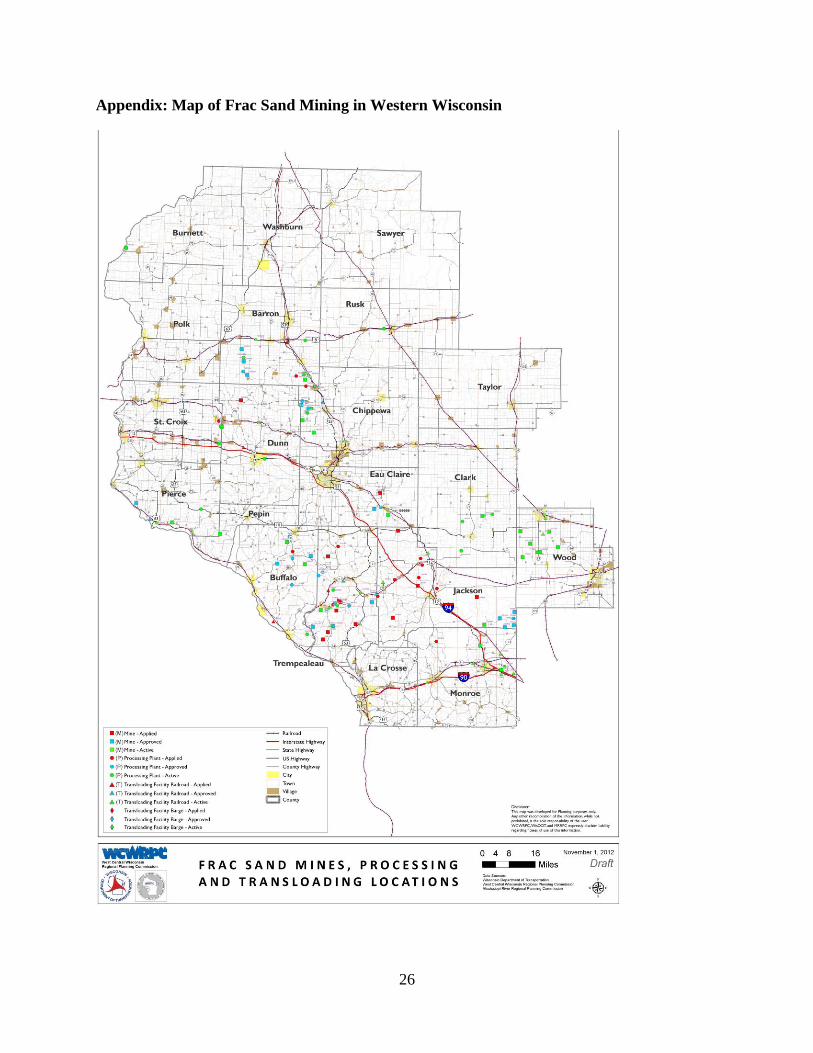
The starting point for assembling a mining activity data set is the map of frac sand mines
included as figure 1 in the appendix. The map shows the spatial location of frac mining and
transport facilities as of November 2012 but it does not indicate opening dates nor does it
describe transportation routes. To obtain more detailed information we have contacted the
Wisconsin Department of Transportation (DOT) officials that created the map. We have asked
the DOT officials for more information about the timelines of each site and on the volume of
outgoing traffic.
After assembling the mining activity data, we would try to match it with spatial and
temporal data on real estate activity in those counties. The real estate data would need to track
market activity before and after the onset of frac sand mining. Using terminology from clinical
trials in medical research, we would identify ‘treatment’ and ‘control’ groups of properties based
on their proximity to frac sand mining facilities, transport routes, and trans-loading facilities.
Alternatively, we could use county tax assessor data of property values before and after frac sand
mining. The drawback of tax assessor data is that it does not always accurately characterize
actual fair market values of properties – particularly if assessments lag important changes in the
property markets.
Using these data sets, we would employ ‘panel regression’ econometric methods to
estimate how real estate activity – e.g., the number of properties for sale, time on market, and
selling price – compares across the treatment (those exposed to frac sand externalities) and
control (those not exposed) groups. This would give us an overall estimate of the impact of frac
sand mining-related externalities on nearby properties, net of any other factors impacting the real
estate market. This approach would be well vetted in the economics literature, as it would mirror
very standard estimation procedures. Another benefit of the approach is that it would fully utilize
the temporal and spatial variation in mining activity over the entire western Wisconsin region.
The drawback is that it would not generate estimates that are specific to the Lake Pepin setting.
22
5.2. Creating Survey Data
An alternative and perhaps complementary approach is to create a data set specific to the
Lake Pepin setting by surveying business owners, real estate professionals, and residents of
Stockholm and Pepin. The survey would focus on how business and real estate conditions
changed after it become known that frac sand mining and transport could become a reality. It
would also query households to find out the various ways that the prospect of increased mining-
related activity has changed (or will change) their day-to-day activities and long-term plans. As
part of the survey effort we would also study nearby locations that are already fully affected by
frac sand mining activities, as well as locations where frac sand development is not anticipated.
These latter steps are needed to provide information to account for any changes not related
directly to the anticipated effects of the mining expansion.
6. Conclusions
This document presents a review of secondary data sources and existing empirical
research that is relevant for analyzing the economic impacts of frac sand operations and
transportation in Pepin County. While a primary study would be needed to offer quantitative
conclusions, several qualitative conclusions are supported by our review. In particular, we are
confident that: 1) impressive amenity endowments in Stockholm and Pepin communities are
responsible for higher property values, healthy population and real estate value growth, and
tourist activity; and 2) frac sand operations and transportation absent the proposed ordinance has
the potential to significantly impair property values and tourist activity in Stockholm and Pepin.
The reasons for our confidence are threefold. First, the economies and property values of
Lake Pepin communities have evolved to match predictions from more general economic theory.
Those theories predict that location-specific natural amenities will boost local property values
and support non-extractive economies, which is precisely what has happened in Lake Pepin
communities. Second, empirical evidence demonstrates how the introduction of noise, industrial
traffic congestion, and related dis-amenities has lowered property values in a multitude of
settings and locations. Third, resistance from local property and business owners in Stockholm
and Pepin to heavy industrial frac sand operations and transportation demonstrates that these are
real threats to their quality of life and to the investments they have made in Lake Pepin
communities.
23
To conclude, we emphasize that nothing in this report is meant to suggest that frac sand
mining and transport is generically bad for local economies. For some areas the recent surge in
demand for frac sand may provide a needed economic lift with little in the way of adverse
consequences on other sources of wealth and income. Lake Pepin communities, however, were
already on a healthy economic trajectory prior to the frac sand boom because of their unique
natural amenity endowments. For these particular communities, the costs of local frac sand
activity may exceed the benefits in both the short and long run.
24
References
Banzhaf, Spencer H., and Randall P. Walsh. 2008. Do People Vote with Their Feet? An
Empirical Test of Tiebout’s Mechanism. American Economic Review. 98(3): 843-863.
Blanchflower, David G., and Andrew J. Oswald. 1996. The Wage Curve. Cambridge MA: MIT
Press.
Cameron, T.A. and J.R. DeShazo. 2013. Demand for Health Risk Reductions. Journal of
Environmental Economics and Management. 65: 87-109.
Chay, Kenneth Y. and Michael Greenstone. 2005. Does Air Quality Matter? Evidence from the
Housing Market. Journal of Political Economy 113(4): 376-424
Davis, L.W. The Effect of Power Plants on Local Housing Values and Rents. Review of
Economics and Statistics. 93(4): 1391-1402.
Deller, Steven C., Tsung-Hsiu Tsai, David W. Marcouiller, and Donald B. K. English. 2001. The
Role of Amenities and Quality of Life in Rural Economic Growth. American Journal of
Agricultural Economics. 83: 352–365.
Garza-Gil, M.D., A. Prada-Blanco, M.X. Vazquez-Rodriguez. 2006. Estimating the Short-Term
Economics Damages from the Prestige Oil Spill in the Galician Fisheries and Tourism.
Ecological Economics. 58: 842-849.
Greenstone, Michael, and Justin Gallagher. 2008. Does Hazardous Waste Matter? Evidence
From the Housing Market and the Superfund Program. The Quarterly Journal of
Economics. 123(3): 951-1003.
Hernandez, A.B. and G. Ryan. 2011. Coping with Climate Change in the Tourism Industry: A
Review and Agenda for Future Research. Tourism and Hospitality Management. 17(1):
79-90.
Herriges, J.A., S. Secchi, and B.A. Babcok. 2005. Living with Hogs in Iowa: The Impact of
Livestock Facilities on Rural Residential Property Values. Land Economics. 81(4): 530-
545.
James, Aaron and David Aadland. 2011. The Curse of Natural Resources: An Empirical
Investigation of U.S. Counties. Resource and Energy Economics 33(2): 440-453.
Larsen, J.E. 2012. Surface Street Traffic Volume and Single-Family House Price. Transportation
Research Part D. 17: 317-320.
Marchand, Joseph. 2012. Local Labor Market Impacts of Energy Boom-Bust-Boom in Western
Canada. Journal of Urban Economics 71: 165-174
25
Marcouiller, David W. 1998. Environmental Resources as Latent Primary Factors of Production
in Tourism: The Case of Forest-Based Commercial Recreation. Tourism Economics. 4(2):
131-145.
McGranahan, D. A. 1999. Natural Amenities Drive Population Change. Food and Rural
Economics Division, Economics Research Service, U.S. Department of Agriculture.
Report 781. Washington, DC.
Palmquist, R.B. 2005. Property Value Models. In Handbook of Environmental Economics,
Volume 2, K. Mäler and J. Vincent, eds., North-Holland.
Papyrakis, Elissaios and Reyer Gerlagh. 2007. Resource Abundance and Economic Growth in
the United States. European Economic Review 51(4): 1011-1039.
Phaneuf, D.J. and V.K. Smith. 2005. Recreation Demand Models. In Handbook of
Environmental Economics, Volume 2, K. Mäler and J. Vincent, eds., North-Holland.
Pope, J.C. 2008. Buyer Information and the Hedonic: The Impact of a Seller Disclosure on the
Implicit Price for Airport Noise. Journal of Urban Economics. 63: 498-516.
Ready, R.C. 2010. Do Landfills Always Depress Nearby Property Values? Journal of Real
Estate Research 32(3): 321-339.
Roback, Jennifer. 1982. Wages, Rents, and the Quality of Life. Journal of Political Economy.
90(60): 1257–1277.
Roback, Jennifer. 1988. Wages, Rents, and Amenities: Differences Among Workers and
Regions. Economic Inquiry. 26(1): 23-41.
Simons, Robert A. and Abdellaziz El Jaouhari. 2004. The Effect of Freight Railroad Tracks and
Train Activity on Residential Property Values. The Appraisal Journal. Summer, 223-233.
Taylor, L., D. Phaneuf, and X. Liu. 2013. Disentangling the Impacts of Environmental
Contamination from Locally Undesirable Land Uses,” unpublished manuscript.
Timmins, C. and J. Murdock. 2007. A Revealed Preference Approach to the Measurement of
Congestion in Travel Cost Models. Journal of Environmental Economics and
Management 53: 230-249.
Tiebout, Charles. 1956. A Pure Theory of Local Expenditures. Journal of Political Economy.
64(5): 416-424.
26
Appendix: Map of Frac Sand Mining in Western Wisconsin