Embed Size (px)
Citation preview

Crossrail: Socio-Economic Technical Report -
- 132 -
10. Environmental baseline and assessment of impacts: Central section
10.1 Introduction
10.1.1 This chapter describes the central route section of Crossrail from Ladbroke Grove to Stratford and the Isle of Dogs, the baseline situation and the significant temporary and permanent socio-economic impacts that will arise from its construction and operation.
10.1.2 The basic socio-economic and demographic characteristics of the areas in this section served by Crossrail are set out in table 10.1.
TABLE 10.1: SOCIO-ECONOMIC AND DEMOGRAPHIC CHARACTERISTICS OF THE CENTRAL SECTION
<16 16-25 26-35 36-45 46-55 56-65 >65 Age structure
17% 19% 24% 14% 9% 7% 10%
White % Mixed % Asian % Black % Chinese % Ethnic groups
60% 3% 25% 7% 5%
No qualifications Level 1 Level 2 Level 3 Level 4/5 Other
Qualifications 23% 8% 12% 12% 41% 4%
Economic Activity Rate
Unemployment Rate Econ activity /
unemployment 62% 9%
Jobs Number of jobs
824,490
AB C1 C2 D E Social grade
29% 29% 8% 14% 20%
10.2 Overview of Crossrail works in the central section
10.2.1 The central route section represents the largest scale engineering component of the project. The route will comprise 6 m diameter twin-bore tunnels running under central London that will connect existing railways to the east and west. The tunnels will be up to 50 m deep, but generally between 20 m and 30 m deep26. At a point beneath Stepney Green, the route will fork: one route will
(1) The tunnel depth referred to here and throughout the ES is taken to be from street level to rail level within the tunnel.

Crossrail: Socio-Economic Technical Report -
- 133 -
continue northeastwards towards Stratford, the other will head southeastwards towards the Isle of Dogs.
10.2.2 New Crossrail stations will be provided at intervals along the new tunnel alignment at Paddington, Bond Street, Tottenham Court Road, Farringdon, Liverpool Street, Whitechapel and the Isle of Dogs. Each of these stations (except Whitechapel and the Isle of Dogs) will have two entrances and ticket halls to provide access to the east and west ends of the below ground platforms. At Whitechapel, it will be possible to provide a second ticket hall should demand for Crossrail require this, while at the Isle of Dogs, there will be passive provision for a second ticket hall.
10.2.3 New portal structures will be provided in the west at Royal Oak (Paddington) and in the east at Pudding Mill Lane (Stratford). For the southeast route to Docklands, the tunnel will be continued east of the Isle of Dogs – this is addressed in the southeast route section. At particular locations along the new railway, shafts connecting the tunnels with the surface will be provided for access and/or ventilation. Some of these shaft structures will be incorporated into the new station buildings; others will be located independently of the stations in accordance with safety requirements.
10.2.4 The twin-bore tunnels will be excavated using tunnel boring machines. Up to nine of these will be working in the central section at any one time. Excavated material will be removed at the west and east portals and via a temporary tunnel linking Hanbury Street shaft to a temporary shaft on Pedley Street, from where it will be taken by a conveyor to a holding site in Mile End Park prior to removal by rail.
10.2.5 Provision of new station entrance buildings and ticket halls will require that existing buildings be demolished. The Crossrail Bill does not provide powers for development to replace these for the reasons described in Section 3.8 of Chapter 3. However, it is extremely unlikely that such developments will not be constructed.
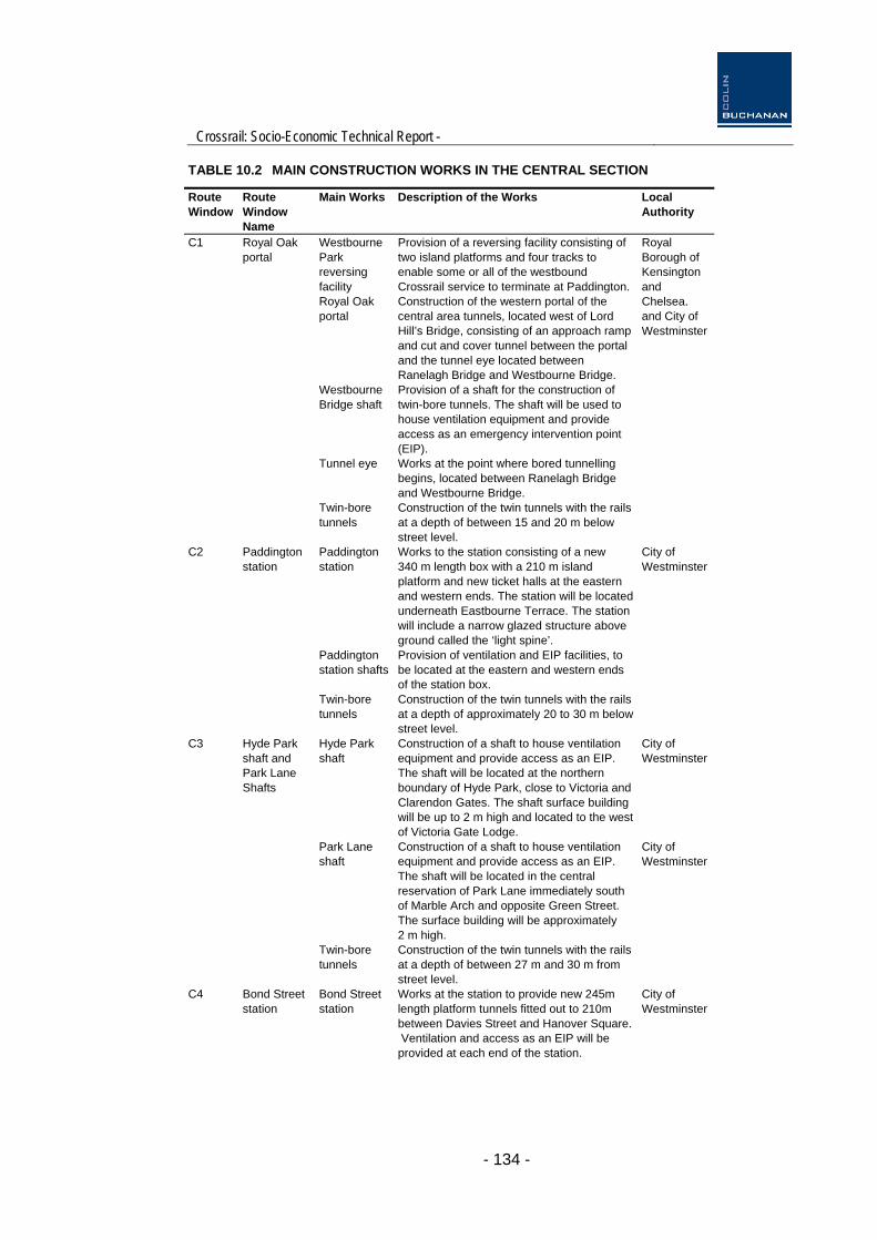
10.2.6 The main elements of the scheme are summarised in Table 10.2.
Crossrail: Socio-Economic Technical Report -
- 134 -
TABLE 10.2 MAIN CONSTRUCTION WORKS IN THE CENTRAL SECTION
Route Window
Route Window Name
Main Works Description of the Works Local Authority
C1 Royal Oak portal
Westbourne Park reversing facility
Provision of a reversing facility consisting of two island platforms and four tracks to enable some or all of the westbound Crossrail service to terminate at Paddington.
Royal Oak portal
Construction of the western portal of the central area tunnels, located west of Lord Hill’s Bridge, consisting of an approach ramp and cut and cover tunnel between the portal and the tunnel eye located between Ranelagh Bridge and Westbourne Bridge.
Royal Borough of Kensington and Chelsea. and City of Westminster
Westbourne Bridge shaft
Provision of a shaft for the construction of twin-bore tunnels. The shaft will be used to house ventilation equipment and provide access as an emergency intervention point (EIP).
Tunnel eye Works at the point where bored tunnelling begins, located between Ranelagh Bridge and Westbourne Bridge.
Twin-bore tunnels
Construction of the twin tunnels with the rails at a depth of between 15 and 20 m below street level.
C2 Paddington station
Paddington station
Works to the station consisting of a new 340 m length box with a 210 m island platform and new ticket halls at the eastern and western ends. The station will be located underneath Eastbourne Terrace. The station will include a narrow glazed structure above ground called the ‘light spine’.
City of Westminster
Paddington station shafts
Provision of ventilation and EIP facilities, to be located at the eastern and western ends of the station box.
Twin-bore tunnels
Construction of the twin tunnels with the rails at a depth of approximately 20 to 30 m below street level.
C3 Hyde Park shaft and Park Lane Shafts
Hyde Park shaft
Construction of a shaft to house ventilation equipment and provide access as an EIP. The shaft will be located at the northern boundary of Hyde Park, close to Victoria and Clarendon Gates. The shaft surface building will be up to 2 m high and located to the west of Victoria Gate Lodge.
City of Westminster
Park Lane shaft
Construction of a shaft to house ventilation equipment and provide access as an EIP. The shaft will be located in the central reservation of Park Lane immediately south of Marble Arch and opposite Green Street. The surface building will be approximately 2 m high.
City of Westminster
Twin-bore tunnels
Construction of the twin tunnels with the rails at a depth of between 27 m and 30 m from street level.
C4 Bond Street station
Bond Street station
Works at the station to provide new 245m length platform tunnels fitted out to 210m between Davies Street and Hanover Square. Ventilation and access as an EIP will be provided at each end of the station.
City of Westminster

Crossrail: Socio-Economic Technical Report -
- 135 -
Route Window
Route Window Name
Main Works Description of the Works Local Authority
Western and Eastern ticket halls
Construction of a new one storey western facility at 65 Davies St, to include a ventilation stack approximately 30 m high. Construction of a new 7m high eastern ticket hall to include a ventilation stack approximately 35 m high at 18/19 Hanover Square.
Twin-bore tunnels
Twin tunnels will be constructed with the rails at a depth of approximately 26 to 32 m from street level.
C5 Tottenham Court Road station
Works at the station to provide new 245 m length platform tunnels fitted out to 210 m between Great Chapel Street and Charing Cross Road.
Tottenham Court Road station
Western and Eastern ticket halls
Construction of a new ticket hall beneath the Plaza at the front of Centre Point. The deep station box at Goslett Yard will include a shaft that will house ventilation equipment and provide access as an EIP. This ticket hall is an extension of the existing London Underground ticket hall
City of Westminster and LB Camden
Construction of a new western ticket hall at Dean Street. Ventilation equipment and EIP access will be constructed at Fareham Street.
Fisher Street shaft
Construction of a shaft that will house ventilation equipment and provide access as an EIP at Fisher Street on the site of 8 - 10 Southampton Row. The original building façade to 8 - 10 Southampton Row will be retained.
Twin-bore tunnels
Construction of the twin tunnels with the rails at a depth of between 20 and 30 m from street level.
C6 Farringdon station
Farringdon station
Works at the station to provide new 245m length platform tunnels fitted out to 210m between Farringdon Road and Lindsey Street.
Construction of a new 8 m high western ticket hall at Farringdon Road (to include EIP access and ventilation equipment within its footprint).
LB Camden, LB Islington and City of London
Construction of a new 8 m high eastern ticket hall at Lindsey Street at the west end of Barbican station, to include EIP and ventilation equipment. Emergency escape will be via a new separate shaft in 38 - 42 Charterhouse Street.
Twin-bore tunnels
Construction of the twin tunnels with the rails at a depth of approximately 12 to 36 m from street level. A crossover will be constructed to the east of the station.
C7 Liverpool Street station
Liverpool Street station
Works at the station to provide new 245m length platform tunnels fitted out to 210m between Moorfields and Blomfield Street.
City of London and LB Tower

Crossrail: Socio-Economic Technical Report -
- 136 -
Route Window
Route Window Name
Main Works Description of the Works Local Authority
Moorgate ticket hall
Construction of a new 8 m deep western ticket hall at Moorgate station, to include EIP access and ventilation equipment within its footprint (shaft is approximately 20 m high).
Hamlets
Finsbury Circus
Replacement of the pavilion and bowling green and re-establishment of the gardens that are lost to the construction site at this location.
Blomfield Street shaft
Construction of a shaft approximately 28 m high at 11 – 12 Blomfield Street to contain ventilation equipment and provide EIP access.
Twin-bore tunnels
Construction of the twin tunnels with the rails at a depth of approximately 36 to 42 m from street level.
C8 Whitechapel station
Hanbury Street shaft
Construction of a shaft to contain ventilation equipment and provide EIP access; the surface structure will be approximately 12 m high.
LB Tower Hamlets
Hanbury Street to Pedley Street temporary tunnel and shaft.
Construction of a single bore temporary tunnel from the Hanbury Street shaft to a temporary shaft at Pedley Street. This tunnel and shaft will be used to transfer excavated materials from the central section tunnelling works by Conveyor, and then onto the stockpile at Mile End (Devonshire Street) sidings for onward transport by rail.
Whitechapel station
Works at the station to provide new 245 m length platform tunnels fitted out to 210m between Court Street and Cambridge Heath Road.
Western and Eastern ticket halls
Construction of a new eastern ticket hall at the junction of Cambridge Heath Road and Whitechapel Road, including ventilation and EIP.
New ticket hall over the London Underground District Line platforms including a new concourse at Essex Wharf to allow access to the western end of the Crossrail platforms.
Durward Street shaft
Construction of a ventilation and EIP access shaft as part of the Whitechapel Station Essex Wharf concourse structure.
Twin-bore tunnels
Construction of twin-bore tunnels with the rails at a depth of between 25 m and 38 m from street level.
C8A Mile End conveyor corridor
Temporary works
Temporary works will take place within this route window to construct a conveyor belt to take excavated material from Pedley Street to temporary excavated material handling facilities, to be constructed at Mile End (Devonshire Street) sidings and Mile End Park.
LB Tower Hamlets
C9 Stepney Green shafts
Stepney Green shaft
Provision of a ventilation, escape and EIP access shafts on Stepney Green between an all weather sports ground and Garden Street, which will include two 7.5 m high structures at ground level.
LB Tower Hamlets

Crossrail: Socio-Economic Technical Report -
- 137 -
Route Window
Route Window Name
Main Works Description of the Works Local Authority
Twin-bore tunnels
Construction of twin tunnels with the rails at a depth of between 22 m and 37 m from street level; two turn out caverns beneath Stepney Green will be constructed to allow for the junction between the Shenfield and the Abbey Wood branches.
C10 Lowell Street shaft
Lowell Street shaft
Construction of a ventilation, escape and EIP access shaft of approximately 15 m in height at the corner of Commercial Road and Basin Approach (610 Commercial Road).
LB Tower Hamlets
Twin-bore tunnels
Construction of the twin tunnels with the rails at a depth of between 32 m and 40 m from street level.
C11 Isle of Dogs station
Hertsmere Road shaft
Construction of an EIP access shaft on Hertsmere Road, which will include an 8m high structure at the surface.
LB Tower Hamlets
Isle of Dogs station
Construction of a station and crossover within a 475 m long box located below West India North Dock. The cross-over will be constructed within the western part of the box and the station, with a 210 m long island platform which will be constructed in the eastern part of the box. The crossover will enable trains to terminate at the station and return to central London or Abbey Wood.
Construction of a station entry/exit point to the west of Great Wharf Bridge, which will be rebuilt.
Construction of escape and ventilation shafts within the station box, one at the eastern end and one at the western end of the station platform.
Twin-bore tunnels
Construction of the twin tunnels with the rails at a depth of approximately 30 m to 50m from street level.
C12 Mile End Park and Eleanor Street shafts
Mile End Park shaft
Construction of a ventilation, escape and EIP access shaft in the southeast corner of Mile End Park next to Burdett Road, which will include a 7 m high surface structure.
LB Tower Hamlets
Eleanor Street shaft
Construction of an EIP access and ventilation shaft in the eastern end of the caravan park, which will include an 11 m high surface structure.
Twin-bore tunnels
Construction of twin tunnels with the rails at a depth of between 23 m and 28 m from street level.
C13 Pudding Mill Lane portal
Pudding Mill Lane portal
Construction of the eastern portal of the central area tunnels along with a shaft accommodating EIP and escape facilities.
The tunnel eye will be located to the east of the River Lea. A ramp will be provided to access the Great Eastern Mainline at track level, which will be partially enclosed in a cut and cover box.
LB Tower Hamlets and LB Newham
Demolition of and reconstruction of the Pudding Mill Lane DLR station to accommodate these works.

Crossrail: Socio-Economic Technical Report -
- 138 -
Route Window
Route Window Name
Main Works Description of the Works Local Authority
Road closures
Pudding Mill Lane will be permanently closed to road traffic. Marshgate Lane will be permanently opened to road traffic as compensation.
Changes to the Docklands Light Railway
Re-alignment of the DLR to the south and provision of a replacement DLR Pudding Mill Lane station.
Changes to Great Eastern Main Line
Re-alignment of the westbound (up line) electric track of the Great Eastern Mainline to Liverpool Street to accommodate Crossrail.
Twin-bore tunnels
Construction of twin tunnels with the rails at a depth of up to 38 m from street level and ground level.
C13A Abbey Mills Sewer diversion LB Newham

Crossrail: Socio-Economic Technical Report -
- 139 -
10.3 Route window C1: Royal Oak Portal
Baseline
10.3.1 Land uses within this part of London are predominantly residential, the elevated A40 Westway and the Great Western Main Line and the London Underground rail corridor to Paddington station. There are a number of commercial land uses to the north of the railway, including a concrete batching plant, transport-related uses (including a taxi servicing facility and Westbourne Park Bus Garage) and artist studios, including Great Western Studios. There are residential areas further to the north containing high-rise and medium-rise blocks. Residential areas also lie to the south of the railway corridor and to the east of Bishops Bridge Road. There are approximately 26,000 jobs located within the catchment area of the local underground station, Royal Oak.
Main works
10.3.2 The permanent works will consist of:
a train reversing facility at Westbourne Park and track alterations to the Great Western main line;
an approach ramp, a portal, at Royal Oak, a cut and cover tunnel, and twin-bore tunnel commencing at Westbourne Park; and
Westbourne Bridge shaft containing intervention and ventilation facilities.
10.3.3 Enabling works will comprise:
relocation of existing Network Rail maintenance facilities, trackworks and signalling;
relocation of an external bus parking compound adjacent to the eastern side of the Westbourne Park bus garage; and
relocation of electrical substation and cables within this area.
10.3.4 The relocation of the external bus parking compound, which currently lies immediately to the north of the Great Western Main Line, has been the subject of a separate planning application and is not assessed here.
Temporary impacts and mitigation
10.3.5 Paddington New Yard contains a concrete readymix plant providing 10 jobs that will be displaced by the construction works. However, it is proposed to reinstate the plant once the works are completed.
Permanent impacts and mitigation
10.3.6 The following businesses have been identified in Paddington New Yard and Taxi Yard as directly affected by permanent acquisition of premises during the construction and operation of Crossrail, (Great Western Studios Management Ltd, Marcon Topmix Limited, J. Murphy & Sons Limited, British Clean Fuels,
Crossrail: Socio-Economic Technical Report -
- 140 -
SGQ Ltd, London Cab Company Ltd, Taxi Tyre Service Limited, Enfield Taxi Motors Ltd, Royal Oak Taxi Centre Ltd, Dyno's Bike Ltd and 125 artists’ studios at Great Western studios). They will, therefore, need to seek alternative locations or close down.
10.3.7 Occupiers of Great Western studios tend to be on short leases and the turnover of companies and individuals in the premises is high. The needs of individuals renting these spaces are different from more traditional commercial outfits. The closure of the studios will result in 5 jobs at the Great Western Studios Management Ltd operation being at risk. It will also put the activity of the artists using the studios at risk given the shortage of suitable accommodation in the area for this type of activity.
10.3.8 Paddington New Yard also accommodates Murphy & Sons, a construction company employing 100-110 employees and Tarmac Topmix concrete readymix plant providing 10 jobs. Discussions with the local authority suggest that it is unlikely that Murphy & Sons will find suitable alternative premises in the immediate local area.
10.3.9 The other location facing permanent acquisition is Paddington Taxi Yard. This offers taxi drivers; parking, refuelling, mess and car washing facilities. There are not many such facilities left and no alternative facilities nearby. Eight companies have been identified on the site.
10.3.10 Around 260-300 jobs are at risk representing around 1% of employees in a one kilometre radius from Royal Oak station. Whilst, unemployment is low in Westminster (2.7% in October 2004). The displacement of jobs includes niche occupations in an important local cluster.
10.3.11 Significant impacts in this area, therefore, relate solely to the potential loss of niche employment opportunities associated with the loss of the Great Western Studios.
10.4 Route window C2: Paddington Station
Baseline
10.4.1 The Paddington station area accommodates a significant number of businesses (mostly retail) and the Great Western hotel (Hilton hotel). The surrounding area is a mixture of cafes and restaurants, offices, tourist accommodation and residential housing. Land uses in the area are dominated by Paddington station and associated rail land. The area is typically residential in character, with small retail uses lining Praed Street. Multi-storey offices front Eastbourne Terrace opposite the station. Surrounding streets consist mainly of residential and hotel accommodation, with St Mary’s Hospital and its associated medical school to the north of Paddington station. A spur of the Paddington branch of the Grand Union Canal passes immediately north of the station.
10.4.2 The area surrounding Paddington station is undergoing a regeneration programme and several major developments are under construction or have been recently completed. The area, which is referred to in the Westminster Unitary Development Plan as the Paddington Special Policy Area (PSPA), is the largest development area in Westminster and a site of strategic importance in London. The PSPA includes major redevelopments at Paddington Basin,

Crossrail: Socio-Economic Technical Report -
- 141 -
Paddington Goods Yard (Paddington Central) and St Mary’s Hospital. Some 38,000 jobs are located within a kilometre of Paddington station.
Main works
10.4.3 At Paddington station, the permanent works will consist of:
a new Crossrail station with two new ticket halls under Eastbourne Terrace; and
two new ventilation and emergency intervention structures one at each of the ticket halls.
10.4.4 The main works will commence after enabling works that will include:
diversion of public utilities (including the sewer in Eastbourne Terrace);
temporary relocation of the taxi rank from Eastbourne Terrace to the area on the north side of the station occupied by the Lynx building (formerly Red Star);
modifications to LUL infrastructure; and
alterations to utilities within MacMillan House as a result of the demolition works.
Temporary impacts and mitigation
10.4.5 In most cases, impacts are likely to be a mixture of noise, vibration and construction traffic. The Hilton Hotel will experience an increase in daytime noise levels for 14 months, though if it was a residential property it would not be eligible for noise insulation and hence there is anticipated to be no material impact on its business. The Sussex Court Public House on Spring Street is in the same position. There are, therefore, no significant impacts.
Permanent impacts and mitigation
10.4.6 A range of professional service businesses and retail units will be displaced due to the demolition or use of premises as worksites at 4-18 Bishop’s Bridge Road, 191-199 Praed Street, 19-22 Spring Street and a retail unit within the ticket hall area of the London Underground station. (Occupiers affected include, The Bridge Research, BMP DDB Ltd, Lynx Express Ltd, Fotosprint, Ashwin Amin, Leluu Accessories, Dallas Cars, Reload Internet, Mercury Change International, Desai News, Tutto, Fresco, Lolita, Sandro Sandwich Bar and WH Smith.)
10.4.7 In total between 60-100 jobs will be displaced. Even if all these jobs were lost this represents under 0.3% of the employment market within 1 kilometre of the station. Moreover, the borough’s low unemployment rate (2.7%) means alternative employment opportunities are likely to be readily available
10.4.8 As for the businesses themselves, office vacancy rates in central London (according to Chesterton’s quarterly Central London Offices) are presently over 12% and the stock of commercial floorspace is over 600,000m2 in a one kilometre radius around the station. This would suggest alternative locations would be available.
Crossrail: Socio-Economic Technical Report -
- 142 -
10.4.9 A small positive employment impact in terms of an increase in recruitment catchment area is expected at St Mary’s Hospital and the adjacent medical school at the back of the station. Indeed, Crossrail is expected to facilitate a 9% increase in the potential labour force accessible within a 45 minute catchment area from Paddington Station
10.4.10 Overall there are no significant impacts.
10.5 Route window C3: Hyde Park & Park Lane Shafts
Baseline
10.5.1 The main features of this route window are Hyde Park and Kensington Gardens. Hyde Park and residential and commercial properties along its edge dominate land uses within this part of London. There are various commercial land uses, including hotels, on the north side of Oxford Street and residential areas to the north of Bayswater Road and the east of Park Lane.
Main works
10.5.2 To comply with safety requirements, Crossrail will construct two shafts between Paddington and Bond Street stations. One is needed in the Hyde Park/Sussex Gardens area and the other is required in the Park Lane area.
Temporary impacts and mitigation
10.5.3 No temporary or permanent acquisition of land or buildings that materially affect employment activity is required for either Hyde Park or Park Lane vent shafts. There are, therefore, no significant temporary impacts.
Permanent impacts and mitigation
10.5.4 There are no significant impacts.
10.6 Route window C4: Bond Street Station
Baseline
10.6.1 This route window is centred on Bond Street Underground Station. The surrounding area is a prime retail centre and a major office location combined with significant numbers of residential properties. The route runs beneath Mayfair, Regent Street and the western edge of Soho. Retail uses dominate along Oxford Street; offices are the main land use in surrounding streets. There are also a number of residential properties around Davies Street and Hanover Square. Other land uses include the open spaces of Grosvenor Square and Hanover Square gardens. Bond Street and Oxford Circus Underground stations are to the north of the alignment, on Oxford Street. There are about 190,000 workers and 3.7 million m2 of commercial floorspace within a one kilometre radius of the station.
Crossrail: Socio-Economic Technical Report -
- 143 -
Main works
10.6.2 The permanent works will consist of two new twin-bore tunnels and a new station at Bond Street featuring two ticket halls.
Temporary impacts and mitigation
10.6.3 Properties at 65 Davies Street and 18/19 Hanover Square/1A Tenterden Street will be permanently acquired.
10.6.4 65 Davies Street will be the site of the Western Ticket Hall. It currently provides around 10,500m2 of floorspace and accommodates the London College of Fashion part of the University of the Arts. The University also has its main headquarters here. As the lease on 65 Davies Street runs out in 2008 the College is already looking for new premises. As a result of the permanent acquisition, 460 members of staff will be displaced.
10.6.5 For the construction of the Eastern Hall Ticket, buildings at 18-19 Hanover Square/1A Tenterden Street will be demolished. Although these are vacant at the moment, they have the capacity (11,500m2) to house between 500-800 employees.
10.6.6 Altogether, around 0.5% of the workforce in a one kilometre radius of the station will be temporarily displaced and just over 0.5% of retail and office space will be demolished. With low unemployment, a dynamic economy, considerable volumes of commercial floorspace and an office vacancy rate presently at 9% in the West End, the local labour and property market should readily absorb this displacement of activity and no significant temporary impacts are forecast.
10.6.7 Weighhouse Street (a one-way street) will be closed at the junction with Davies Street. The remainder of the street will be turned into a two way road in order to allow lorry movements out of the work site and deliveries into West One shopping centre. Aside from these lorry movements, the road closure may reduce car traffic. There will also be a loss of on-street parking in the wider area. Altogether, although potentially disruptive for businesses around both worksites no significant temporary impacts are expected.
Permanent impacts and mitigation
10.6.8 The Crossrail Bill does not provide powers for development to replace those demolished but it is extremely unlikely that only operational works will be constructed.
10.7 Route window C5: Tottenham Court Road Station
Baseline
10.7.1 This is a predominantly commercial area focused around Tottenham Court Road Station to the east, Oxford Street to the north and Great Chapel Street to the west. Aside from numerous retail outlets, the area is also home to several small advertising, television production and graphic design businesses as well as the Astoria nightclub and the Dominion theatre. Further east, this route window also covers Fisher Street ventilation shaft located just south of St Martin’s College of Art and Design. The existing land use is predominantly

Crossrail: Socio-Economic Technical Report -
- 144 -
commercial with several office blocks, most notably Centre Point, and retail uses. Oxford Street is an internationally renowned shopping area and Charing Cross Road is a specialist retail street noted for its large number of bookshops. Altogether, there are approximately 145,000 jobs and 4.4 million m2 of commercial floorspace within a one kilometre radius of the station.
Main works
10.7.2 The permanent works will consist of:
twin-bore tunnels;
a new station at Tottenham Court Road consisting of a new box at Goslett Yard and two new ticket halls;
ventilation and EIP facilities at Fareham Street and Goslett Yard;
a ventilation and EIP at Fisher Street; and
the closure of Andrew Borde Street and streetscape enhancement.
Temporary impacts and mitigation
10.7.3 The construction of the Eastern Ticket Hall at the corner of Oxford Street and Charing Cross Road will result in the permanent acquisition of several buildings accommodating a number of retail outlets, private teaching institutions, small television, advertising and graphic design businesses as well as the Astoria nightclub.
10.7.4 The Western Ticket Hall will also require the permanent acquisition of several buildings between Great Chapel Street to the west, Dean Street to the east, Oxford Street to the north and Diadem Court to the south. The occupants in these blocks tend to be media and property companies.
10.7.5 Additionally, two small blocks will have to be demolished to allow for the implementation of Fisher Street vent shaft: 8-10 Southampton Row, although the façade will be retained, and 1-2 Fisher Street combined with 2-6 Catton Street. The University of the Arts and its Student Union occupies 2-6 Catton Street and employs 45 members of staff. A bar occupies the ground and first floors of 8-10 Southampton Row with approximately 10 workers while the rest of the building is residential. Small professional services operate from Fisher Street and employ about 20 people. Altogether, between 75-85 people work in these buildings.
10.7.6 Overall, some 100 businesses with between 900 and 1,300 employees are expected to be displaced. However, it takes place in an area of buoyant economic activity. In fact, it only represents less than 1% of all jobs and around 0.8% of commercial property stock within a one kilometre radius of the station in a dynamic area with substantial employment opportunities and an office vacancy rate of around 9%. No significant impacts are, therefore, expected.
10.7.7 Occupiers who will be displaced have been identified as 1st Oxford College, A Vision, Alpha Angelo College, Ann Summers, Aquarius, ARD TV and Radio (Norddeutscher Rundfunk), Art4Noise, Astoria, B52 couriers, Barbara Music, Bella Napoli Pasta & Pizza, Benjys, Broadcast & Video Company, Bruce

Crossrail: Socio-Economic Technical Report -
- 145 -
Dunlop & Associates, Café Nero, Cambio Bureau de Change, CFS Independent, Chased by Cowboys, Chatsworth Television, Chopstix Noodle Bar, Clarks Shop, Computer Wire services, Couch PH, Creative Brief UK Ltd, Design Sensation Ltd, Doneli, Ealing Studios, EMI Music Publishing, EPK, Eurochange Ltd, Euromoney Exchange, Evening Entertainment Co, Finishing Touches, Flip Side Marketing, Flying Records, Fourth Hurdle Consulting, Fragile Films Ltd, GHA Group, Ghetto Nightclub, Google, Great Chapel College, Guiltronics, Harlequin Sports, Harmony, Karushi Ltd, KBA Design, Kitsch Casting, KPM Music House, LCC Trans-Sending Limited, Littlestar services Ltd, London Institute, Mars (club), Melfemi Entertainment, Metro Broadcast Ltd, Mexx & Monet, Mexx Factory Outlets, Michael Wildsmith, Mr Ted, Mr Toppers, MTV Films Europe, Nats Post Production, New Media Law, Office (shoe shop), OTM Studios, Peach Arch Films, Pierre Victorie, Pistol Marketing Ltd, Portavia, Primrose Agency, Promopromo, Pukka Post, Push, Rangepost Ltd, RDP Ltd, Real 451 Ltd, Red Veg Ltd, Reel Enterprises Ltd, Riccardo's Snack Bar, Richard Clark, Riddle International, Right Recruitment, Rouge Nightclub, Sainsbury's, Saks, Scidev. Net, Science & Development Network, Sensation, Shaw Graham Kersh Solicitors, Siguy Films, Stage One Storyboard, Study Eight Productions, Super 8 Rushes, Tai Buffet, The Annex (Films) Ltd, The Bath House, The Chinman Partnership, The Ivy House, The Link Asset & Securities Co Ltd, The Link Stores, The Mean Fiddler, The Project, Tidal Olive, TVFC, TVP Videodubbing Ltd, University of the Arts, Walji, Waterstones, William Hill and Wood Burden.
10.7.8 Although access to Centre Point will be maintained, occupiers are likely to be affected by disruption resulting from the long term worksites in the area, construction traffic and local road closures. However, it is not envisaged that there will be any significant employment impacts. The Royal Mail sorting office’s car park in Newman Street will be used as a lorry holding area. Although this may be disruptive, discussions with the Royal Mail confirm that the sorting office will continue to be able to operate during the use of the car park as a lorry holding area. The Tottenham Public House on Oxford Street will be affected by construction noise for varying periods. However, no significant impacts are anticipated.
Permanent impacts and mitigation
10.7.9 The Crossrail Bill does not provide powers for development to replace those demolished but it is extremely unlikely that only operational works will be constructed.
10.8 Route window C6: Farringdon Station
Baseline
10.8.1 The central feature of this area is Farringdon Station. The surroundings of the station offer a mixture of offices, restaurants, and retail outlets along with Smithfield wholesale market. Land uses within this part of London are mixed and include residential, commercial and retail uses. Smithfield Market is adjacent to the site of the eastern ticket hall. It is one of London’s oldest markets, where meat has been bought and sold for over 800 years. The Medical College of St Bartholomew’s Hospital, and the hospital itself, are located to the north and south of the Smithfield Market, respectively. The Barbican, a major residential and cultural development, is further to the east. Farringdon is on the City Fringe and presents a typical combination of modern office buildings with small convenience retail units by the station employing

Crossrail: Socio-Economic Technical Report -
- 146 -
around 180,000 people and providing 4.1 million m2 of commercial floorspace in a one kilometre radius from the station.
Main works
10.8.2 The permanent works will consist of two new twin-bore tunnels and a new station at Farringdon with two new ticket halls.
Temporary impacts and mitigation
10.8.3 The construction of the Western entrance and ticket hall to Crossrail (located south of Cowcross Street) will require the permanent acquisition of Cardinal House and several retail outlets while to the East some office space, retail and catering outlets will be affected.
10.8.4 Altogether, the construction of Farringdon station will result in the displacement of between 800-1,100 retail and office jobs. Occupiers affected have been identified as A J M Studios, Adams Kara Taylor, Ambient, Bar Bombay, Benjy's, Best Café, Buckley Deane Wakefield, Café Gulsman, Chambers and Partners Publishing Ltd, Charterhouse Bar, Criminal Injuries Compensation Appeal Panel, Dyer Brown & Associates, Fabermaunsell, Farringdon Flowers, Fox Haynes Ltd, Hallmark, Hallmark, Immigration Appellate Authority, Immigration Law Practioners Association, Improvement and Development Services for Local Government, John Stevens, Kentucky Fried Chicken, Laing O'Rourke, Lindsey Hotel, Magicalia, Mailround.com, Mal Architects Ltd, McColls Raj Tandoori, McDonald's, Messrs C, Moneybox Corporations Ltd, Ovum Ltd, Oyez Legal Technologies, Pinnacle PSG Ltd, Postercscope Ltd, Prontaprint, Pure, Robert Rolls & Co, Search Partners Ltd, Smithfield Tandoori, Springdene Ltd, Starbucks, Touch Group, Tribunals Group, Vacant, Whitecross Dental Care, William Hill and World Markets Research Centre.
10.8.5 It will entail the demolition of commercial premises of around 14,300m2 to the west and 2,100m2 to the east. This is not deemed a significant impact as it represents at most 0.6% of jobs and around 0.4% of commercial property stock within a one kilometre radius of Farringdon station. In addition office vacancy rates in Midtown are presently running at 11%.
10.8.6 Approximately half of Smithfield Market’s underground car park will be required for the works and construction traffic will have an impact on access to the market. However, this is not predicted to affect the on-going viability of the market, based on consultation with the Corporation of London’s Markets Division. The loss of off-street car parking spaces to worksites at Snow Hill, Cardinal House, Caxton House, as well as local road closures, will have some disruptive impacts on businesses in the area. However, these will not have a significant impact on employment
10.8.7 Overall there are no significant impacts
Permanent impacts and mitigation
10.8.8 The Crossrail Bill does not provide powers for development to replace those demolished but it is extremely unlikely that only operational works will be constructed.

Crossrail: Socio-Economic Technical Report -
- 147 -
10.9 Route window C7: Liverpool Street Station
Baseline
10.9.1 This route window covers Liverpool Street station and the surrounding area which is dominated by office developments combined with retail activity to the East (the Arcade). Land uses within this part of London are dominated by the financial and business services of the City, which extend about 1 km southwards to the River Thames. Moorgate Underground station is located in the west and Liverpool Street station and the vast commercial buildings of Broadgate predominate in the central part of the area. The one kilometre catchment area around the station is the most densely populated area along the route in terms of employment with approximately 210,000 jobs. The property market offers 330,000m2 of retail and 3.9 million m2 of office floorspace.
Main works
10.9.2 The new Crossrail station at Liverpool Street will have a new ticket hall connected to the western end of the station platforms. This will be adjoining the existing London Underground ticket hall at Moorgate Station and will require the demolition of buildings at 91 -109 Moorgate. A new passage will connect the eastern end of the Crossrail platforms with the existing London Underground ticket hall at Liverpool Street station. A new shaft structure at Blomfield Street will also result in demolition of 11-12 Blomfield.
Temporary impacts and mitigation
10.9.3 The main impact will be the demolition of the former AMRO Bank building, Moor House and 11-12 Blomfield Street site will entail the displacement of between 300-550 jobs or 0.2-0.3% of the local job market. In terms of floorspace, it means a temporary reduction of 0.3% of the office and retail property stock. Occupiers affected have been identified as ABN Amro Bank, Balls Brothers Limited, Benjys, Birleys Ltd, Bishop of Norwich, Blomfield Group, Boots, City People, Davy`s of London Limited, Ernst Jones, Firth Ross Martin Associates, Hitchmans Harrison, Hollingworth Consultants Limited, Jamies at The Pavilion, Julian Dove, K&O International, Lawson Clark Ltd, Medical Direct Clinics, N V Tyler, Norton Rose, Norwich Union Life & Pensions Limited, Oddbins, Origin HR Consulting, Robert Dyas, Snappy Snaps, Sudbroke Asset Management, The Shipping Corporation of India, Tiffinbites, Tim Bugler (Dental Surgery) and Victoria Steamship Co Ltd.
10.9.4 In addition, the Lord Aberconway pub will need to be closed to enable construction works to take place. The Pavilion Wine Bar at Finsbury Circus will also be displaced during the construction works. Once the works are completed they will be restored to their previous use. The temporary closure of Moorfields and the partial closure of Moorgate will cause some disruption to businesses but it will have no significant impact on employment. Overall, therefore, there are no temporary significant impacts.
Permanent impacts and mitigation
10.9.5 The Crossrail Bill does not provide powers for development to replace those demolished but it is extremely unlikely that only operational works will be constructed.
Crossrail: Socio-Economic Technical Report -
- 148 -
10.10 Route window C8: Whitechapel Station
Baseline
10.10.1 Land uses within this part of London are predominantly residential. The Hanbury Street shaft site is adjoined by residential and retail property. The Pedley Street worksite and temporary shaft site lie in an area comprising mainly warehousing, storage and retail buildings, a large number of which are vacant, particularly to the south, along with some residential properties. The areas around the Whitechapel Crossrail station and the Durward Street shaft site are characterised mostly by retail and educational uses. The Royal London Hospital is located on the south side of the A11 Whitechapel Road across from Whitechapel station. There are approximately 28,000 jobs available within one kilometre radius of the station and 930,000m2 of commercial use (a third of which is industrial).
Main works
10.10.2 Besides the Crossrail tunnels other permanent elements of the scheme will consist of:
a shaft at Hanbury Street;
a new station at Whitechapel with an interchange concourse beneath Durward Street and, integrated with it, a shaft structure; and
a new ticket hall over the District line tracks.
10.10.3 The Hanbury Street shaft will be connected via a temporary tunnel under Spital Street to a temporary construction shaft at Pedley Street. This will be used for the delivery and removal of materials during the construction phase. The temporary shaft at Pedley Street will be backfilled and the site reinstated.
Temporary impacts and mitigation
10.10.4 Some buildings around Hanbury Street, currently operating as retail and light industrial premises will be temporarily acquired. These are 68-80 and 82-102 Hanbury Street while the rear extensions of 63-67 Princelet Street will require demolition. The ground floor of 63-65 Princelet Street is occupied by several small travel agencies serving the large local Asian community. Given local street closures and noise impacts it is envisaged that these businesses would be unable to continue to operate and will be displaced. At this location, between 180-300 jobs are at risk. This represents just over 1% of jobs in the local area, they are also more likely to be filled by local people and unemployment in Tower Hamlets is high (5.7%) and, therefore, the impact is regarded as significant. Two businesses presently operating from under the railway arches of Valance Road will also be displaced.
10.10.5 Occupiers who may be displaced by the works have been identified as Aerospace Travel Agents, Air Express Travel and Tours, Al-Madina Travel Limited, ABN Amro Holdings (UK) Limited, D. Steinberger Limited, Mizuho International plc, Salamon & Seaber Limited, Sardar Properties (UK) Limited, Habitiat, Banjax, Collective of Bangladeshi Governors, Forest Reclaim, Jonota Travel Agency, KMC Travel and Zinda Bazar Cash & Carry.
Crossrail: Socio-Economic Technical Report -
- 149 -
10.10.6 At Whitechapel, while there will be a loss of parking at the Sainsbury’s car park to accommodate a worksite (see Traffic and Transport), this will not be sufficient to affect the viability of the store or give rise to job losses and no significant temporary impacts are foreseen at this location.
10.10.7 At Whitechapel, partial land take would include part of Sainsbury’s car park. This, however, will not affect the viability of the store. No significant temporary impacts are foreseen at this location.
10.10.8 Whitechapel Ticket Hall will be built on part of the Blind Beggar public house’s beer garden and require the demolition of its conservatory. It is expected that the pub will still be able to operate albeit at reduced capacity and no significant permanent impacts are reported at this site.
Permanent impacts and mitigation
10.10.9 The Crossrail Bill does not provide powers for development to replace those demolished but it is extremely unlikely that only operational works will be constructed.
10.11 Route window C8A: Mile End Conveyor Corridor
Baseline
10.11.1 This route window covers the Sand End sidings to Mile End Park spoil handling site. The area includes Mile End Park as well as some warehouses to the north of the railway and residential dwellings and the Royal London Hospital to the South.
Main works
10.11.2 The works will involve the installation of temporary conveyor which will run along the south side of the existing railway corridor. It will be used to carry excavated material, removed through the Pedley Street temporary shaft to Mile End (Devonshire Street) sidings and a holding area located within part of Mile End Park.
Temporary impacts and mitigation
10.11.3 The erection and dismantling of the conveyor may be disruptive to businesses based under the railway arches in this route window. However, this is not anticipated to have a material impact on employment and hence there are no significant impacts.
Permanent impacts and mitigation
10.11.4 The construction work will lead to the demolition of an empty retail unit on Globe Road displacing the opportunity for approximately 10 jobs. However, the possible displacement of employment is not regarded as material so there will be no significant impact.

Crossrail: Socio-Economic Technical Report -
- 150 -
10.12 Route window C9: Stepney Green Shafts
Baseline
10.12.1 Land uses within this part of London are dominated by residential properties and recreational areas. The Stepney Green shaft site is located in Stepney Green Park, an area of outdoor recreation that includes an all-weather sports pitch, an urban farm and a number of archaeological ruins. St Dunstan’s Church lies at its eastern edge.
Main works
10.12.2 To comply with safety requirements, Crossrail will construct shafts on to provide facilities for EIP, escape and ventilation.
Temporary impacts and mitigation
10.12.3 Stepping Stones Farm will experience disruption from the construction works, however, it is assessed as a community facility rather than as a business facility. There are no land use requirements directly affecting commercial premises in this area and hence no significant impacts.
Permanent impacts and mitigation
10.12.4 There are no significant impacts.
10.13 Route window C10: Lowell Street Shaft
Baseline
10.13.1 The area is mainly residential, but with some offices, storage/warehousing, retail and educational buildings. High value residential development at the waterside of Limehouse Basin, which is to the south of the site, contrasts with the run down, bustling east London character of Commercial Road. Regent’s Canal and Limehouse Cut run north-south from Limehouse Basin. The River Thames is located further to the south.
Main works
10.13.2 To comply with safety requirements, Crossrail will require a shaft to be located at the corner of Commercial Road and Basin Approach (at 610 Commercial Road).
Temporary impacts and mitigation
10.13.3 No significant temporary socio-economic impacts will occur in this area.
Permanent impacts and mitigation
10.13.4 Permanent acquisition of 622 Commercial Road and Mill Place will lead to the displacement of 11 jobs affecting S Ward & Co Ltd and Bronze Age Art Foundry Ltd. This is not regarded as significant.
Crossrail: Socio-Economic Technical Report -
- 151 -
10.13.5 The Crossrail Bill does not provide powers for development but it is extremely unlikely that only operational works will be constructed.
10.14 Route window C11: Isle of Dogs Station
Baseline
10.14.1 This route window is centred on Canary Wharf, a major commercial and retail development area and part of Docklands. The predominant land uses are offices and retail, with some outdoor recreation and storage/warehousing, surrounded by, or adjacent to, West India Dock. The River Thames lies to the south of the alignment beyond the docks, with Billingsgate Market being located towards the east end of the North Dock. In a one kilometre radius of the station, there are 24,000 jobs and 1.6 million m2 of commercial floorspace with the potential for future development.
Main works
10.14.2 The main permanent features within this route window comprise the Hertsmere Road shaft and the Isle of Dogs station. The main temporary features will be the North Quay and Billingsgate worksites.
10.14.3 The permanent works will consist of:
Hertsmere Road shaft;
Isle of Dogs station; and
twin-bore tunnels.
Temporary impacts and mitigation
10.14.4 Tunnelling work for Crossrail conflicts with the foundations of Hertsmere House leading to the need to acquire and demolish it. This building has the capacity to accommodate 350 to 450 jobs. However, a planning application has been approved to build a new tower on the site, Columbus Tower. While Hertsmere House currently provides 6,913 m2 of office space its proposed replacement will provide 93,423 m2 of hotel, office, retail, leisure, residential and catering. The design of the new tower has taken Crossrail tunnelling requirements into account and it is envisaged that the tower will be completed before Crossrail’s opening.
10.14.5 The cofferdam along the North Dock’s southern side means that barges on West India Quay will either have to move before the closure is implemented or accept to be blocked at this location for the construction phase. The only risk in adopting this option is that boats have to leave the Dock if they need major overall maintenance.
10.14.6 There are 8 boats on West India Quay including an architect studio, an art gallery, a photo gallery, a private venue and a bar. The bar and galleries rely on passing trade. A change in location would have an impact on them but it is not considered to be a significant socio-economic impact.
10.14.7 Billingsgate market is the largest inland fish market in the UK with 54 tenants and an average of 25,000 tonnes of fish sold through it each year for a
Crossrail: Socio-Economic Technical Report -
- 152 -
turnover in the region of £200 million. Billingsgate market will be impacted upon insofar as part of its car park will be needed as a work site. This will lead to the displacement of a fish processing unit but it is anticipated that this can be re-housed within the main building on the site. Consultation with the market confirms that the overall viability of the market will not be affected and, therefore, there is no significant temporary. The other main worksite in this area will utilise a temporary car park at North Quay. While disruptive this will not have a material impact on businesses.
10.14.8 On Hertsmere Road, the worksite will comprise the Cannon Workshops car parking area bounded by Cannon Drive along with the adjacent hard standing area on the forecourt to the building. The temporary loss of 27 parking spaces from the Cannon Workshops car park and close proximity of the worksite, while disruptive, will not have a material impact on employment at these businesses.
Permanent impacts and mitigation
10.14.9 No permanent acquisition that will materially impact on business will occur and hence there will be no residual significant impact.
10.15 Route window C12: Mile End Park and Eleanor Street Shafts
Baseline
10.15.1 The main land uses are residential, with many residential Victorian terraces. However, there are significant areas of open green space, including Mile End Park and Tower Hamlets Cemetery Park. Bow Road Underground station and Bow Church DLR station are to the north, with the Royal London Hospital further to the west, all on the A11 Bow Road. There are also a number of schools in the area.
Main works
10.15.2 The permanent works will consist of:
Mile End Park shaft;
Eleanor Street shaft; and
twin-bore tunnels.
Temporary impacts and mitigation
10.15.3 There are no temporary significant impacts in this area.
Permanent impacts and mitigation
10.15.4 The Eleanor Street construction site will require acquisition of the travellers’ caravan park which doubles up as a place of business with activities focused around car scrapping. This is not a significant economic impact and has been assessed as a community impact.

Crossrail: Socio-Economic Technical Report -
- 153 -
10.16 Route window C13: Pudding Mill Lane Portal
Baseline
10.16.1 This route window covers a highly built-up residential area in its western part, while the remainder consists of industrial areas, extensive railway lands and the north-south corridors of a number of rivers including the River Lea, the City Mill River, the Waterworks River and the Bow Back River.
Main works
10.16.2 Besides Crossrail’s twin-bore tunnels other elements of the scheme in this route window include a replacement Docklands Light Railway station and some realignment of existing railway. There are substantial enabling works including sewer diversions.
10.16.3 Permanent works will consist of:
Pudding Mill Lane Portal, ramp and cut and cover box;
a new Pudding Mill Lane Docklands Light Railway station and alignment;
re-alignment of the westbound (up line) electric track of the Great Eastern Main Line (GEML);
twin-bore tunnels; and
permanent closure of Pudding Mill Lane to road traffic and the opening up of Marshgate Lane to road traffic.
Temporary impacts and mitigation
10.16.4 Construction works will require the demolition of industrial units on Clement’s Wharf, Bow Railway Yard and on the Heron Industrial Estate. Overall, it is estimated that 800 to 1,300 jobs are at risk and over 30,000 m2 of industrial floorspace will be required. Industrial vacancy rates in Tower Hamlets are reported to be 8%, equivalent to 100,000 m2 and 15% in Newham or 190,000 m2. Given the scale of the potential job losses, high than average levels of unemployment in both Boroughs, the level of property loss in relation to potential vacancies, and that Pudding Mill Lane is a protected employment area in the Newham UDP and is identified as a Preferred Industrial Location in the London Plan, this is a significant temporary impact.
10.16.5 Occupiers identified as being affected by the works are Badat Brothers Limited, Bardon Aggregates, Bodyworks, Bolsons Ltd, Bow Midland Waste Recycling Limited, Capital Print & Display, Demenex Plant Hire, Discount (Construction) Double glazing, GEM Supplies, Goddard & Gibbs Studios Ltd, Grays Waste Services Limited, Hiremasters Ltd, Ilford Barratt Roofing Ltd, Jarroy (Importers) Limited, John Denton, Kendon Packaging Group, London Concrete Ltd, Mastpine Limited, Nagrecha bros, South Herts Waste Management Limited, Star Furniture, Tarmac Southern Limited and Top Office Equipment Ltd.

Crossrail: Socio-Economic Technical Report -
- 154 -
Permanent impacts and mitigation
10.16.6 Once work is completed, worksites will become available for possible redevelopment mitigating the displacement of jobs outlined above.
10.17 Route window C13A: Abbey Mills
Baseline and Main works
10.17.1 The works in this route window, which is located in LB Newham, comprise the diversion of the Hackney to Abbey Mills and Wick Lane sewers, as a result of alignment of the Crossrail running tunnels at Pudding Mill Lane (Route Window C13).
Temporary impacts and mitigation
10.17.2 There are no temporary significant impacts in this area
Permanent impacts and mitigation
10.17.3 There are no significant impacts in this area