Embed Size (px)
Citation preview

Published by Aeronautical Information Services, Airports Fiji Limited,Private Mail Bag, Nadi International Airport, Fiji Islands.
Tel: (679) 6725777, Fax: (679) 6731114, AFTN: NFFNYNYX. Email: [email protected]
AERONAUTICAL INFORMATION PUBLICATION
FIJI ISLANDS
AIRAC 16/12 AIP SUPPLEMENT 10 NOV 16
Effective at 16111000000 UTC
This AIP Supplement supercedes the AIP Supplement issued on 21 JUL 16
CONTENTS201314/13 Wakaya: Effective Operational Data 220149/14 Nadi: Trials for Departure Procedure for RWY 20
(Fiji Airways Only)3
13/14 Malolo Lailai: Effective Operational Data 3201512/15 Nadi Oceanic/FIR: ATC Separation Aircrew procedures 6
20161/16 Yasawa: Effective Operational Data 65/16 Nadi:Anemometer Status 76/16 Savusavu: Runway Surface 77/16 Matei: Runway Surface 712/16 Nadi: Terminal Building Modernization 714/16 Labasa: Taxiing Regulations 815/16 Nadi Oceanic/FIR: Approving authority for overflight 817/16 Cicia: Effective Operational Data 918/16 Gau: Effective Operational Data 1219/16 Koro: Effective Operational Data 1520/16 Vanuabalavu: Effective Operational Data 1821/16 Moala: Effective Operational Data 2122/16 Kadavu: Effective Operational Data 2423/16 Lakeba: Effective Operational Data 2624/16 Bureta: Effective Operational Data 2825/16 Ono-i-Lau: Aerodrome Information 3126/16 Nadi: Restricted Visibility from Nadi Control Tower 3127/16 Kaibu Island: Operational Data 31
AIRAC Supplements7/13, 1/14, 3/15, 4/15, 5/15, 8/15, 10/15, 2/16, 4/16, 8/16, 13/16NOTAMs cancelledD0229/16, D0233/16, D0234/16, D0235/16, D0237/16, D0239/16, D0240/16,D0242/16, D0243/16, D0241/16, A1218/16

SUP - 2
14/13 1.Wakaya: Effective Operational DataEffective: 30 JUL 09
The effective operational data for Wakaya (Private) aerodrome is shown in thetable below.
Aerodromeavailability:
Daylight hours only.
AerodromeReference Point:
S17 37 43 E179 00 36
AerodromeElevation:
130ft
MagneticVariation:
12_11' E
Physical CharacteristicsRWY Designator: 10 28True BRG: 118_ 298_RWYDimensions:
730m X 18m 730m X 18m
Stopway: 30m 30mClearway: Nil NilStripDimensions:
790m X 60m 790m X 60m
RWY Surface: Gravel GravelMaximum TotalWeightAuthorised:
5700Kg 5700Kg
Slope: -2% +2%DeclaredDistances: (inmeters)
TORA TODA ASDA LDA TORA TODA ASDA LDA
730 730 760 730 730 730 760 730
Caution 1. Declared distances are actual physical dimensions. Noapproach or takeoff gradients have been considered.
2. Turbulence on RWY10 Approach3. Sharp drop at end of RWY284. Animal (Deer) feeding on strip5. Due to the unavailability of ample parking space, no
other fixed wing aircraft is permitted to land at theairport when there is an aircraft on the aircraft parkingapron and within the runway strip except in anemergency or approval of the aerodrome operator.
6. Men and equipment may be on the runway/stripcarrying out maintenance works
7. All operators intending to operate into AD are requiredto fill out the indemnity form to be granted approval.
Address/Contact Wakaya Airport, Wakaya Club Limited, PO Box 15424, SuvaPhone: (679) 330 2654Fax: (679) 330 2714Chief Pilot (Mobile): (679) 990 8474

SUP - 3
9/14 SUPERSEDES 7/12 1 2.Nadi: Trials for Departure Procedure for RWY 20 (Fiji Airways ONLY)Effective: 24 JUL 14
The execution of early right turns by aircraft departing RWY 20 to assess theapplicability of Noise Abatement Departure Procedures Two (NADP 2) is beingtested. This trial is limited to Fiji Airways flights only and subject to ATCapproval.
13/14 SUPERSEDES 10/13 3.Malolo Lailai: Effective Operational DataEffective: 30 JUL 09
The effective operational data for Malolo Lailai (Private) aerodrome is shownin the table below.
Aerodromeavailability:
Daylight hours only.
AerodromeReference Point:
S17 46 41 E177 11 48
AerodromeElevation:
13ft
MagneticVariation:
12_08' E
Physical CharacteristicsRWY Designator: 12 30True BRG: 136_ 316_RWYDimensions:
685m X 30m 685m X 30m
Stopway: 30m 30mClearway: Nil NilStripDimensions:
707m X 120m 707m X 120m
RWY Surface: Gravel GravelMaximum TotalWeightAuthorised:
5700Kg 5700Kg
Slope: Slight SlightDeclaredDistances: (inmeters)
TORA TODA ASDA LDA TORA TODA ASDA LDA
685 685 715 685 685 685 715 685
SUP - 4
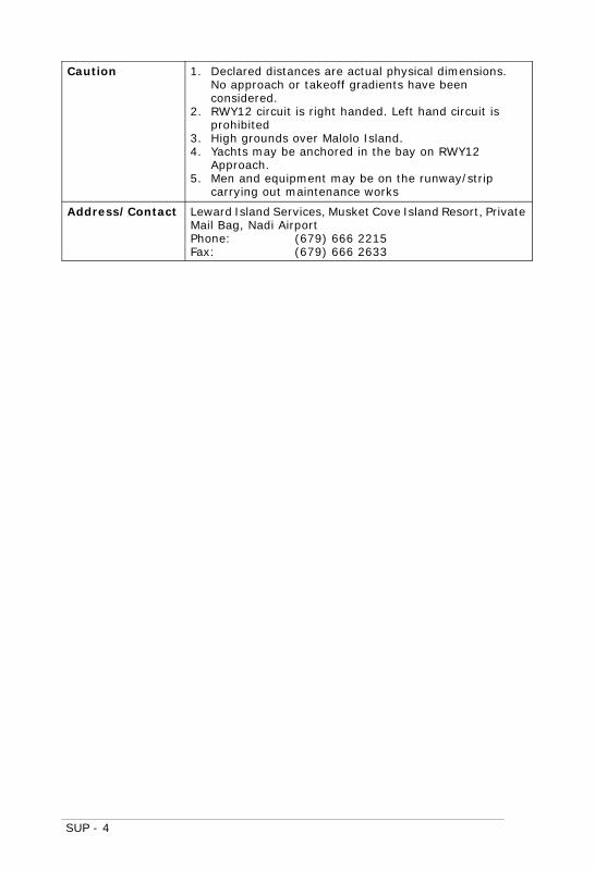
Caution 1. Declared distances are actual physical dimensions.No approach or takeoff gradients have beenconsidered.
2. RWY12 circuit is right handed. Left hand circuit isprohibited
3. High grounds over Malolo Island.4. Yachts may be anchored in the bay on RWY12
Approach.5. Men and equipment may be on the runway/strip
carrying out maintenance works
Address/Contact Leward Island Services, Musket Cove Island Resort, PrivateMail Bag, Nadi AirportPhone: (679) 666 2215Fax: (679) 666 2633

SUP - 5

SUP - 6
12/15 4.Nadi OCEANIC/FIR: ATC Separation Aircrew ProceduresEffective: 16 APR 15
In order to support cost index for econ speeds and maintain ATC separationspacing aircrew shall use the following procedures in the NFFF FIR. Pilots shallinform ATS via voice or CPDLC each time the cruising mach number varies oris expected to vary by a value equal to or greater than 0.02 mach from:
(a) the mach number at FIR entry or;
(b) any subsequent speed change notified to ATS in flight.
1/16 SUPERSEDES 15/13 5.Yasawa: Effective Operational DataEffective: 30 JUL 09
The effective operational data for Yasawa (Private) aerodrome is shown in thetable below.
Aerodromeavailability:
Daylight hours only.
AerodromeReference Point:
S16 45 34 E177 32 45
AerodromeElevation:
100ft
MagneticVariation:
11_54' E
Physical CharacteristicsRWY Designator: 12 30True BRG: 134_ 314_RWYDimensions:
640m X 25m 640m X 25m
Stopway: 60m 60mClearway: Nil NilStripDimensions:
840m X 50m 840m X 50m
RWY Surface: Compacted Earth Compacted EarthMaximum TotalWeightAuthorised:
5700Kg 5700Kg
Slope: -3% +3%DeclaredDistances: (inmeters)
TORA TODA ASDA LDA TORA TODA ASDA LDA
640 700 700 640 NU NU NU 640

SUP - 7
Caution 1. Declared distances are actual physical dimensions.No approach or takeoff gradients have beenconsidered.
2. Marked at threshold RWY12 an area 80m x 25munusuable due rocky surface.
3. Turbulence and steeper slope at western end of RWY.4. Due to the unavailability of ample parking space, no
other fixed wing aircraft is permitted to land at theairport when there is an aircraft on the aircraft parkingapron and within the runway strip except in anemergency or approval of the aerodrome operator.
5. Men and equipment may be on the runway/stripcarrying out maintenance works
Address/Contact Mr. Garth Downye, PO Box 10128, Nadi AirportPhone: (679) 666 3364Fax: (679) 666 5044
5/16 6.Nadi: Anemometer StatusEffective: 31 MAR 16
Anemometer for RWY 20 and RWY 27 unserviceable
6/16 7.Savusavu: Runway SurfaceEffective: 31 MAR 16
Runway operational but caution advised due to loose chips on RWY
7/16 8.Matei: Runway SurfaceEffective: 31 MAR 16
Runway operational but caution advised due to loose chips on RWY
12/16 SUPERSEDES 12/14 9.Nadi: Terminal Building ModernizationEffective: 11 DEC 14
Vehicles and construction personnel are moving within apron area. Pilots areadvised to exercise caution on entry to the apron and prior to engine start andpush-back. For further enquiries to be directed to Airports Fiji Limited onemail: [email protected].

SUP - 8
14/16 SUPERSEDES 9/16 10.Labasa: Taxiing RegulationsEffective: 31 MAR 16
Pilots of taxiing aircraft shall follow the taxi guidance line at all times to ensureseparation from other parked aircraft
15/16 SUPERSEDES 10/16 11.Nadi OCEANIC/FIR: Approving Authority for OverflightEffective: 31 MAR 16
Reference AIP Fiji page GEN 1.2-4 para 3.3.1, in addition to the informationprovided and for ease of contact for approval of overflight, the following emailcan also be used:
Alumita Lagicere: [email protected] Maharaj: [email protected]

SUP - 9
17/16 SUPERSEDES 3/15 12.9Cicia: Effective Operational DataEffective: 30 JUL 09
The effective operational data for Cicia aerodrome is shown in the table below.
OperationalHours:
RFFS is available only during weekdays(excl. public holidays). Monday to Friday 0800-1700L
Rescue and FireCover
Cat 2 DCP Available - 1x50kg &2x4.5kg (less by 131kg DCP)
1x9kg CO21x4.5kgCO2
AerodromeReference Point:
S17 44 37 W179 20 31
AerodromeElevation:
13ft
MagneticVariation:
12_16' E
Physical CharacteristicsRWY Designator: 17 35True BRG: 185_ 005_RWYDimensions:
920m X 23m 920m X 23m
Stopway: Nil NilClearway: Nil NilStripDimensions:
976m X 80m 976m X 80m
RWY Surface: Compact Earth on Sand Compact Earth on SandMaximum TotalWeightAuthorised:
5700Kg 5700Kg
Slope: +0.05% -0.05%

SUP - 10
DeclaredDistances: (inmeters)
TORA TODA ASDA LDA TORA TODA ASDA LDA
920 920 920 920 920 920 920 920
Caution 1. Declared distances are actual physical dimensions.No approach or takeoff gradients have beenconsidered.
2. Unmanned aerodrome. Outside the published hoursof operations, prior permission is to be obtained fromOperations Manager Outer Islands Airports.PO Box 30Nausori.Tel: (679) 347 8344Fax: (679) 347 9900
3. Due to the unavailability of ample parking space, noother fixed wing aircraft is permitted to land at theairport when there is an aircraft on the aircraft parkingapron and within the runway strip except in anemergency or approval of the aerodrome operator.
4. Men and equipment may be on the runway/stripcarrying out maintenance works.
5. Trees penetrating approach and transitional surface.6. Aircraft intending to be on the ground for more
than 90mins shall seek prior approval from AFL on9906129.

SUP - 11

SUP - 12
18/16 SUPERSEDES 4/15 13.Gau: Effective Operational DataEffective: 30 JUL 09
The effective operational data for Gau aerodrome is shown in the table below.
OperationalHours:
RFFS is available only during weekdays(excl. public holidays). Monday to Friday 0800-1700L
Rescue and FireCover
Cat 1 DCP Available - 1x45kg & 2x4.5kg(less by 91kg DCP)
1x5kg CO2
AerodromeReference Point:
S18 06 56 E179 20 23
AerodromeElevation:
50ft
MagneticVariation:
12_19' E
Physical CharacteristicsRWY Designator: 10 28True BRG: 117_ 297_RWYDimensions:
754m X 19m 754m X 19m
Stopway: Nil 50mClearway: Nil NilStripDimensions:
915 X 80m 915m X 80m
RWY Surface: Compacted Crushed Coral Compacted Crushed CoralMaximum TotalWeightAuthorised:
5700Kg 5700Kg
Slope: -0.5% +0.5%DeclaredDistances: (inmeters)
TORA TODA ASDA LDA TORA TODA ASDA LDA
754 754 754 754 754 754 804 754
SUP - 13
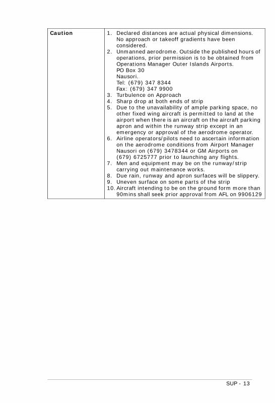
Caution 1. Declared distances are actual physical dimensions.No approach or takeoff gradients have beenconsidered.
2. Unmanned aerodrome. Outside the published hours ofoperations, prior permission is to be obtained fromOperations Manager Outer Islands Airports.PO Box 30Nausori.Tel: (679) 347 8344Fax: (679) 347 9900
3. Turbulence on Approach4. Sharp drop at both ends of strip5. Due to the unavailability of ample parking space, no
other fixed wing aircraft is permitted to land at theairport when there is an aircraft on the aircraft parkingapron and within the runway strip except in anemergency or approval of the aerodrome operator.
6. Airline operators/pilots need to ascertain informationon the aerodrome conditions from Airport ManagerNausori on (679) 3478344 or GM Airports on(679) 6725777 prior to launching any flights.
7. Men and equipment may be on the runway/stripcarrying out maintenance works.
8. Due rain, runway and apron surfaces will be slippery.9. Uneven surface on some parts of the strip10. Aircraft intending to be on the ground form more than
90mins shall seek prior approval from AFL on 9906129

SUP - 14

SUP - 15
19/16 SUPERSEDES 5/15 14.Koro: Effective Operational DataEffective: 30 JUL 09
The effective operational data for Koro aerodrome is shown in the table below.
OperationalHours:
RFFS is available only during weekdays(excl. public holidays). Monday to Friday 0800-1700L
Rescue and FireCover
Cat 1 DCP Available - 1x50kg & 3x9kg(less by 68kg DCP)
3x4.5kgCO2
AerodromeReference Point:
S17 20 45 E179 25 19
AerodromeElevation:
358ft (Threshold RWY10)
MagneticVariation:
12_07' E
Physical CharacteristicsRWY Designator: 10 28True BRG: 111_ 291_RWYDimensions:
793m X 22m 793m X 22m
Stopway: Nil NilClearway: Nil NilStripDimensions:
914m X 80m 914m X 80m
RWY Surface: Grass GrassMaximum TotalWeightAuthorised:
5700Kg 5700Kg
Slope: -10% +10%DeclaredDistances: (inmeters)
TORA TODA ASDA LDA TORA TODA ASDA LDA
793 793 793 NU NU NU NU 793

SUP - 16
Caution 1. Declared distances are actual physical dimensions. Noapproach or takeoff gradients have been considered.
2. Unmanned aerodrome. Outside the published hours ofoperations, prior permission is to be obtained fromOperations Manager Outer Islands Airports.PO Box 30Nausori.Tel: (679) 347 8344Fax: (679) 347 9900
3. One way operationsLand: RWY28Take-off: RWY10
4. Turbulence on Approach5. Due to the unavailability of ample parking space, no
other fixed wing aircraft is permitted to land at theairport when there is an aircraft on the aircraft parkingapron and within the runway strip except in anemergency or approval of the aerodrome operator.
6. Soft patches on THR RWY10 during rainy period.7. Men and equipment may be on the runway/strip
carrying out maintenance works.8. Trees penetrating Approach and Transitional surfaces.9. RWY and Apron slippery when wet after rain10.Aircraft intending to be on the ground form more than
90mins shall seek prior approval from AFL on 9906129

SUP - 17

SUP - 18
20/16 SUPERSEDES 8/15 15.Vanuabalavu: Effective Operational DataEffective: 30 JUL 09
The effective operational data for Vanuabalavu aerodrome is shown in thetable below.
OperationalHours:
RFFS is available only during weekdays(excl. public holidays). Monday to Friday 0800-1700L
Rescue and FireCover
Cat 2 DCP Available - 1x25kg & 1x9kg(less by 156kg DCP)Premix- 1x100liters (570litres less)
1x2.2kgCO21x5kg CO2
AerodromeReference Point:
S17 14 42 W178 57 33
AerodromeElevation:
156ft
MagneticVariation:
12_09' E
Physical CharacteristicsRWY Designator: 11 29True BRG: 123_ 303_RWYDimensions:
726m X 22m 726m X 22m
Stopway: Nil NilClearway: Nil 120mStripDimensions:
1000m X 80m 1000m X 80m
RWY Surface: Grass on gravel Grass on gravelMaximum TotalWeightAuthorised:
5700Kg 5700Kg
Slope: +5% -5%DeclaredDistances: (inmeters)
TORA TODA ASDA LDA TORA TODA ASDA LDA
NU NU NU 726 726 846 726 NU

SUP - 19
Caution 1. Declared distances are actual physical dimensions.No approach or takeoff gradients have beenconsidered.
2. Unmanned aerodrome. Outside the published hours ofoperations, prior permission is to be obtained fromOperations Manager Outer Islands Airports.PO Box 30Nausori.Tel: (679) 347 8344Fax: (679) 347 9900
3. One way operationsTake-off: RWY29Land: RWY11
4. RWY Surface slippery, braking action poor when wet.5. Turbulence on approach RWY11 in SE winds6. Due to the unavailability of ample parking space, no
other fixed wing aircraft is permitted to land at theairport when there is an aircraft on the aircraft parkingapron and within the runway strip except in anemergency or approval of the aerodrome operator.
7. Men and equipment may be on the runway/stripcarrying out maintenance works
8. Aircraft intending to be on the ground form more than90mins shall seek prior approval from AFL on 9906129

SUP - 20

SUP - 21
21/16 SUPERSEDES 10/15 16.Moala: Effective Operational DataEffective: 30 JUL 09
The effective operational data for Moala aerodrome is shown in the tablebelow.
OperationalHours:
RFFS is available only during weekdays(excl. public holidays). Monday to Friday 0800-1700L
Rescue and FireCover
Cat 1 DCP Available - 1x50kg & 1x25kg& 2x9kg (less by 52kg DCP)
1x2kg CO21x4.4kgCO2
AerodromeReference Point:
S18 34 02 E179 57 04
AerodromeElevation:
13ft
MagneticVariation:
12_28' E
Physical CharacteristicsRWY Designator: 15 33True BRG: 161_ 341_RWYDimensions:
750m X 23m 750m X 23m
Stopway: Nil NilClearway: Nil NilStripDimensions:
915m X 80m 915m X 80m
RWY Surface: Crushed Coral Sand Crushed Coral SandMaximum TotalWeightAuthorised:
5700Kg 5700Kg
Slope: +0.15% -0.15%DeclaredDistances: (inmeters)
TORA TODA ASDA LDA TORA TODA ASDA LDA
750 750 750 750 750 750 750 750

SUP - 22
Caution 1. Declared distances are actual physical dimensions. Noapproach or takeoff gradients have been considered.
2. Unmanned aerodrome. Outside the published hours ofoperations, prior permission is to be obtained fromOperations Manager Outer Islands Airports.PO Box 30Nausori.Tel: (679) 347 8344Fax: (679) 347 9900
3. Poor braking action4. Nil perimeter fence5. Due to the unavailability of ample parking space, no
other fixed wing aircraft is permitted to land at theairport when there is an aircraft on the aircraft parkingapron and within the runway strip except in anemergency or approval of the aerodrome operator.
6. Airline operators/pilots need to ascertain informationon the aerodrome conditions from Airport ManagerNausori on (679) 3478344 or GM Airports on(679) 6725777 prior to launching any flights.
7. Men and equipment may be on the runway/stripcarrying out maintenance works
8. Aircraft intending to be on the ground form more than90mins shall seek prior approval from AFL on 9906129

SUP - 23

SUP - 24
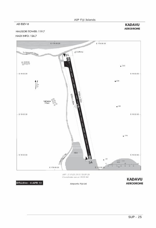
22/16 SUPERSEDES 2/16 17.Kadavu: Effective Operational DataEffective: 30 JUL 09
The effective operational data for Kadavu aerodrome is shown in the tablebelow.
OperationalHours:
RFFS is available only during weekdays(excl. public holidays). Monday to Friday 0800-1700L.
AerodromeReference Point:
S19 03 29 E178 09 26
AerodromeElevation:
6ft
MagneticVariation:
12_31' E
Physical CharacteristicsRWY Designator: 16 34True BRG: 173_ 353_RWYDimensions:
916m X 23m 916m X 23m
Stopway: Nil NilClearway: Nil NilStripDimensions:
935 X 80m 935m X 80m
RWY Surface: Chipseal ChipsealMaximum TotalWeightAuthorised:
5700Kg 5700Kg
Slope: 0% 0%DeclaredDistances: (inmeters)
TORA TODA ASDA LDA TORA TODA ASDA LDA
916 916 916 916 916 916 916 916
Caution 1. Declared distances are actual physical dimensions. Noapproach or takeoff gradients have been considered.
2. Unmanned aerodrome. Outside the published hours ofoperations, prior permission is to be obtained fromOperations Manager Outer Islands Airports.PO Box 30Nausori.Tel: (679) 347 8344Fax: (679) 347 9900
3. Turbulence on Approach4. Men and equipment may be on the runway/strip
carrying out maintenance works5. Loose chips on RWY6. Aircraft intending to be on the ground form more than
90mins shall seek prior approval from AFL on 9906129
SUP - 25

SUP - 26
23/16 SUPERSEDES 4/16 18.Lakeba: Effective Operational DataEffective: 30 JUL 09
The effective operational data for Lakeba aerodrome is shown in the tablebelow.
OperationalHours:
RFFS is available only during weekdays(excl. public holidays). Monday to Friday 0800-1700L
Rescue and FireCover
Cat 2 DCP Available - 1x50kg & 1x4.5kg(less by 135.5kg DCP)Premix-1x100liters
2x5kg CO21x3.5kgCO2
AerodromeReference Point:
S18 12 00 W178 48 58
AerodromeElevation:
280ft
MagneticVariation:
12_24' E
Physical CharacteristicsRWY Designator: 13 31True BRG: 140_ 320_RWYDimensions:
826m X 18m 826m X 18m
Stopway: 30m 30mRESA: 30 X 36m 30 X 36mClearway: Nil NilStripDimensions:
946m X 80m 946m X 80m
RWY Surface: Chipseal ChipsealMaximum TotalWeightAuthorised:
5700Kg 5700Kg
Slope: +1.9% -1.9%

SUP - 27
DeclaredDistances: (inmeters)
TORA TODA ASDA LDA TORA TODA ASDA LDA
NU NU NU 826 826 826 856 856
Caution 1. Declared distances are actual physical dimensions. Noapproach or takeoff gradients have been considered.
2. Unmanned aerodrome. Outside the published hours ofoperations, prior permission is to be obtained fromOperations Manager Outer Islands Airports.PO Box 30Nausori.Tel: (679) 347 8344Fax: (679) 347 9900
3. Turbulence on approaches.4. Taxiway and Apron soft after rain.5. No departures on RWY 13.6. Men and equipment may be on the runway/strip
carrying out maintenance works.7. AUG-NOV South East Trade winds develop after time
2200UTC. ACFT tailwind component, payload and RWYslope will be a critical factor in Take-Off.
8. Loose chips on RWY9. Aircraft intending to be on the ground form more than
90mins shall seek prior approval from AFL on 9906129

SUP - 28
24/16 SUPERSEDES 13/16 19.Bureta: Effective Operational DataEffective: 30 JUL 09
The effective operational data for Bureta aerodrome is shown in the tablebelow.
OperationalHours:
RFFS is available only during weekdays(excl. public holidays). Monday to Friday 0800-1700L.
AerodromeReference Point:
S17 42 42 E178 45 22
AerodromeElevation:
11ft
MagneticVariation:
12_11' E
Physical CharacteristicsRWY Designator: 08 26True BRG: 097_ 277_RWYDimensions:
672m X 18m 672m X 18m
Stopway: Nil 53mClearway: Nil 68mStripDimensions:
915m X 60m 915m X 60m
RWY Surface: Chipseal ChipsealMaximum TotalWeightAuthorised:
5700Kg 5700Kg
Slope: +0.2% -0.2%

SUP - 29
DeclaredDistances: (inmeters)
TORA TODA ASDA LDA TORA TODA ASDA LDA
NU NU NU 672 672 740 723 NU
Caution 1. Declared distances are actual physical dimensions. Noapproach or takeoff gradients have been considered.
2. Unmanned aerodrome. Outside the published hours ofoperations, prior permission is to be obtained fromOperations Manager Outer Islands AirportsPO Box 30Nausori.Tel: (679) 347 8344Fax: (679) 347 9900
3. One way operationsLand:RWY08Take-off:RWY26
4. Turbulence on approaches5. High ground East6. Aircraft departing aerodrome shall remain within 5NM
of aerodrome and not above 1500ft until ATCclearance is obtained.
7. Men and equipment may be on the runway/stripcarrying out maintenance works.
8. Trees penetrating Approach and Transitional surfaces.9. Loose chips and rough surface within 150meters from
threshold RWY 0810.Aircraft intending to be on the ground form more than
90mins shall seek prior approval from AFL on 9906129

SUP - 30

SUP - 31
25/16 20.Ono-i-Lau: Aerodrome InformationEffective: 21 JUN 16
Aircraft intending to be on the ground for more than 90mins shall seek priorapproval from AFL on 9906129
26/16 21.Nadi: Restricted Visibility from Nadi Control TowerEffective: 13 JUL 16
Due to restricted visibility from the Nadi Control Tower, push back from AircraftStands Gates 1,2,3,4 and 5 will be at pilots own discretion
27/16 SUPERSEDES 7/13 22.Kaibu Island: Effective Operational DataEffective: 30 JUL 09
The effective operational data for Kaibu Island (Private) aerodrome is shownin the table below.
Aerodromeavailability:
Daylight hours only.
AerodromeReference Point:
S17 15 16 W179 29 19
AerodromeElevation:
70ft
MagneticVariation:
12_08' E
Physical CharacteristicsRWY Designator: 14 32True BRG: 137_ 317_RWYDimensions:
770m X 18m 770m X 18m
Stopway: 30m 30mClearway: Nil NilStripDimensions:
830m X 45m 830m X 45m
RWY Surface: Concrete ConcreteMaximum TotalWeightAuthorised:
5700Kg 5700Kg
Slope: +2% -2%DeclaredDistances: (inmeters)
TORA TODA ASDA LDA TORA TODA ASDA LDA
770 770 770 770 770 770 770 770

SUP - 32
Caution 1. Declared distances are actual physical dimensions.No approach or takeoff gradients have beenconsidered.
2. Lower mid-runway section rising towards RWY 32.3. Deep gully on approach near threshold RWY14.4. Significant rocky ridge close on approach THR 325. Wind shear at the Thresholds6. Vegetation penetrates the Transitional Surfaces
Address/Contact Vatuvara Limited, PO Box 588, SuvaPhone: (679) 603 0991Fax: (679) 603 0987