Embed Size (px)
Citation preview
www.devexresources.com.au
T: +61 (0) 8 9322 3990 F: +61 (0) 8 9322 5800 E: [email protected]
DevEx Resources Limited Level 2, 1292 Hay Street, West Perth WA 6005, Australia GPO Box 2890, Perth WA 6001
10 September 2019
Further to yesterday’s announcement to the ASX titled “Exploration Update – West Arnhem-Nabarlek Project, Northern Territory” DevEx Resources Limited (ASX:DEV; “the Company”) provides the attached amended announcement further clarifying the following:
The timing of when drilling was completed, and assay results received for the West Arnhem-Nabarlek Project;
Updated Table in Appendix 1 of drilling collar details at West Arnhem-Nabarlek Project listing significant intercepts and further clarification on assay results not considered to be significant; and
Additional figures within the report showing plan view of the reported drill collar locations.
www.devexresources.com.au
T: +61 (0) 8 9322 3990 F: +61 (0) 8 9322 5800 E: [email protected]
DevEx Resources Limited Level 2, 1292 Hay Street, West Perth WA 6005, Australia GPO Box 2890, Perth WA 6001
10 September 2019
Exploration Update –West Arnhem-Nabarlek Project, Northern Territory
Drilling intersects uranium mineralisation beneath the historical Nabarlek Open Pit and at U40 opening up new
discovery opportunities
Highlights
• Diamond drilling beneath the historical high-grade Nabarlek Uranium Mine intersects anomalous uranium-gold bearing fault breccia beneath the Oenpelli Dolerite with a best intercept of 0.3m @ 525ppm U3O8.
• Mineralisation at the base of the breccia bears a strong similarity to that seen
within the historical Nabarlek ore zone, suggesting the potential for a Nabarlek-style deposit in the vicinity.
• This anomalous breccia is poorly tested beneath the dolerite and open to the south. Several beds of south-east dipping graphitic sediments intersected in the vicinity provide a target for follow-up drilling.
• Diamond drilling at U40 intersects open-ended uranium mineralisation on the
western flank of the IP anomaly with a best intercept of 0.7m @ 1,059 ppm U3O8.
• Next steps include a review of historical EM data to refine targets for possible further drilling.
DevEx Resources Limited (ASX: DEV; “the Company”) is pleased to advise that assay results have been received from recent diamond drilling at the Company’s 100%-owned West Arnhem-Nabarlek Project in the Northern Territory, confirming the presence of anomalous uranium mineralisation beneath the historical Nabarlek Mine and on the western side of the U40 Prospect.
Page | 2
In addition, the drilling has provided invaluable structural and geological information which indicates the potential to identify repetitions of the high-grade Nabarlek-type mineralisation in proximity to the recent drilling. Following completion of drilling on 22 July 2019, the Company advises that, because of delays at the assay lab in Darwin, final assay results were only received and interpreted late last week with the announcement being finalised over the weekend. Although the grades of the mineralisation are below the previous high-grade intercepts seen within the historical Nabarlek Mine and at the U40 Prospect, the results do confirm the continuation of mineralisation beneath Nabarlek and west of U40 with significant space surrounding this drilling to host repetitions of the high-grade Nabarlek type deposit.
Prospect Hole ID East North RL Depth Dip Azimuth From (m) To (m) Interval Au ppm
U3O8 ppm
Nabarlek 19NBDD002 317944 8638644 74 549.2 -53 242 458.1 458.4 0.3 0.25 526
U40 19U4DD002 326954 8645002 74 549 -60 88 179.5 180.2 0.7 0.01 1059
Table 1: 2019 Nabarlek and U40 diamond drill hole intercepts (>500ppm U3O8), drill intercepts are down-hole lengths. Both holes are co-funded under the Northern Territory Government’s Resourcing the Territory Initiative. Please refer to Appendix 1 for complete listing of drilling and intersections.
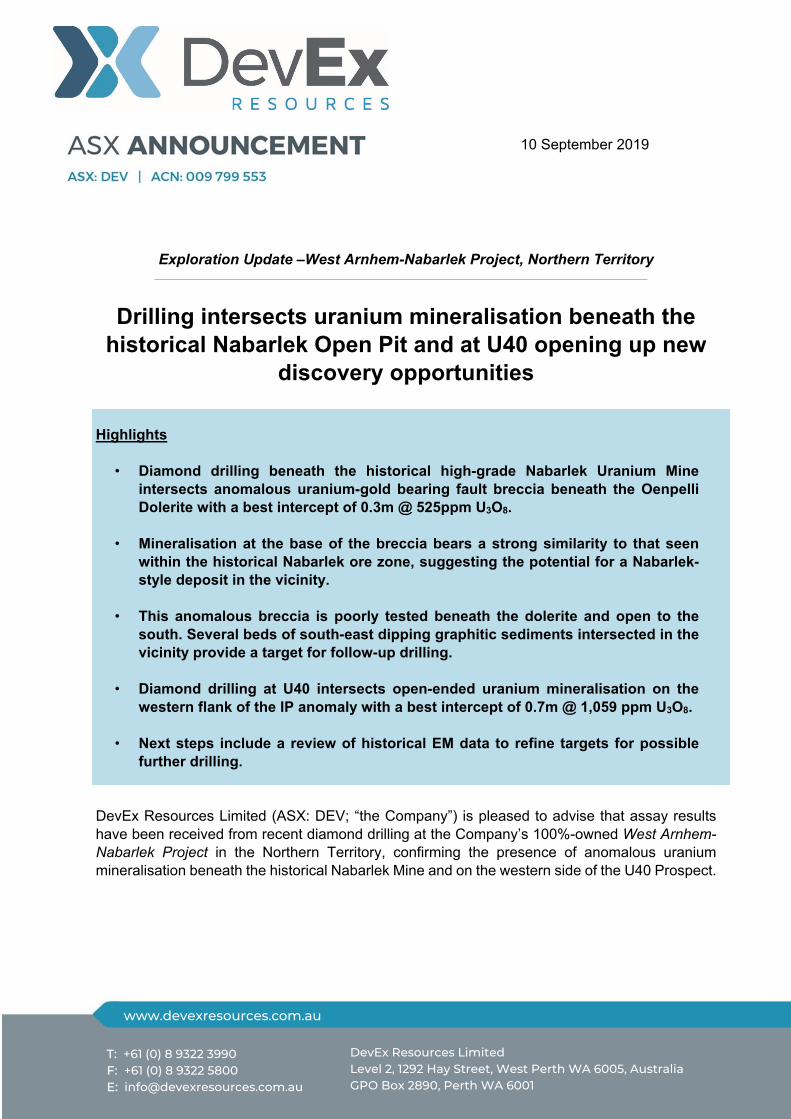
At Nabarlek, drilling into the primary target below the Oenpelli Dolerite intersected the targeted Nabarlek F6 Fault Breccia in Hole 1 (19NBDD001) and Hole 2 (19NBDD002). Low-grade uranium mineralisation was seen within this fault breccia in both holes with Hole 2 showing the most promising result, intersecting the strongly silicified F6 fault breccia comprising a broad zone of pyrite mineralisation which extends into the footwall schists. At the base of this fault zone, a thin interval of uranium and anomalous gold mineralisation was encountered (see Table 1 and Figure 1). Elevated uranium mineralisation (0.3m @ 525ppm U3O8) appears to be associated with a noticeable drop in silica content at the base of the breccia (possibly de-silicified). This style of mineralisation bears strong similarity to that seen within the historical Nabarlek ore zone suggesting the potential for a Nabarlek-style deposit to occur in the near vicinity.

Page | 3
Figure 1: Cross-section window 9490mN looking north beneath historical Nabarlek Mine, showing 2019 drilling beneath the Oenpelli Dolerite.
Several beds of south-east dipping graphitic sediments were also noted further down the hole (between 482.9m and 494.6m). Graphitic sediments are typically targeted by uranium explorers as they provide the catalyst for uranium enriched fluid to deposit along fault zones. The intersection of the F6 Fault Breccia and these or other graphitic sediments at Nabarlek will provide priority targets for further drilling. The Company plans to review structural orientation and available electromagnetic (EM) data for potential conductors beneath the Oenpelli dolerite and within proximity to Hole 2. Other drill holes into the shallower Nabarlek targets south of the historical mine tested areas where previous drilling was too broad spaced to effectively test for Nabarlek style mineralisation, including one hole in the Oenpelli dolerite. No significant uranium or gold mineralisation was encountered from this drilling. With the drill rig in the area, the Company also tested a single hole at GC 11 Prospect where previous drilling identified favourable alteration on the southernmost drill hole NAR7534 (see Company Announcement to the ASX announcement 7th October 2015). Hole 19GCRC001 did not encounter any significant uranium or gold mineralisation.
Page | 4
Figure 2: Nabarlek Long section showing the location of the 2019 drilling and the anomalous intercept in hole 19NBDD002 beneath the Oenpelli Dolerite.
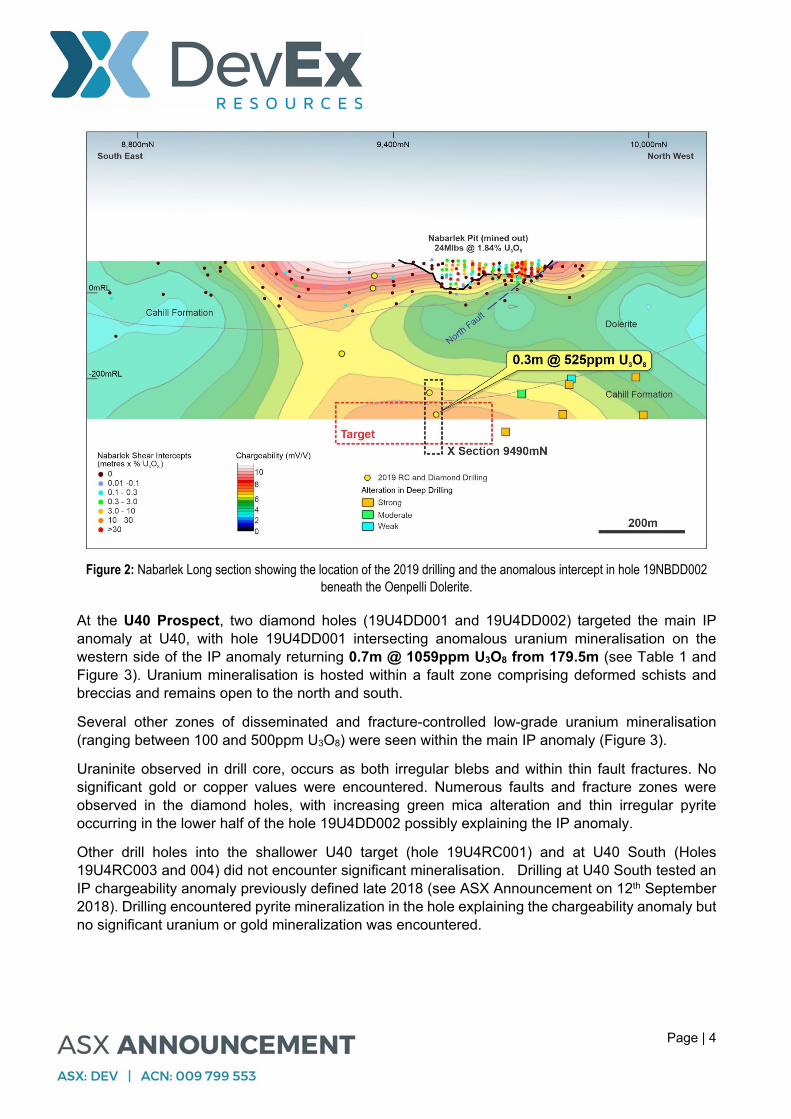
At the U40 Prospect, two diamond holes (19U4DD001 and 19U4DD002) targeted the main IP anomaly at U40, with hole 19U4DD001 intersecting anomalous uranium mineralisation on the western side of the IP anomaly returning 0.7m @ 1059ppm U3O8 from 179.5m (see Table 1 and Figure 3). Uranium mineralisation is hosted within a fault zone comprising deformed schists and breccias and remains open to the north and south.
Several other zones of disseminated and fracture-controlled low-grade uranium mineralisation (ranging between 100 and 500ppm U3O8) were seen within the main IP anomaly (Figure 3).
Uraninite observed in drill core, occurs as both irregular blebs and within thin fault fractures. No significant gold or copper values were encountered. Numerous faults and fracture zones were observed in the diamond holes, with increasing green mica alteration and thin irregular pyrite occurring in the lower half of the hole 19U4DD002 possibly explaining the IP anomaly.
Other drill holes into the shallower U40 target (hole 19U4RC001) and at U40 South (Holes 19U4RC003 and 004) did not encounter significant mineralisation. Drilling at U40 South tested an IP chargeability anomaly previously defined late 2018 (see ASX Announcement on 12th September 2018). Drilling encountered pyrite mineralization in the hole explaining the chargeability anomaly but no significant uranium or gold mineralization was encountered.

Page | 5
Although drilling was unable to identify a continuation of the isolated pod of high-grade mineralisation previously encountered at U40, the new zone of uranium mineralisation seen in hole 19U4DD001 requires further investigation along strike and closer to surface.
Figure 3: 2019 Drilling at the U40 Prospect, diamond drill holes 19U4DD002 and 19U4DD003 testing IP Pole-Dipole Chargeability Anomaly. Low-level disseminated uranium mineralisation was seen in both holes with 19U4DD001 intersecting anomalous uranium mineralisation on the western side of the IP anomaly returning 0.7m @ 1059ppm U3O8 from 179.5m
Next Steps
Confirmation of anomalous uranium-gold mineralisation beneath the Oenpelli Dolerite and near graphitic shales enhances the prospectivity for repetitions of Nabarlek-type mineralisation in the vicinity of hole 19NBDD002.
The Company is currently reviewing previous electromagnetics (EM) in the Nabarlek area for signs of conductors beneath the dolerite that may indicate where these graphitic sediments are thickest and abutting the Nabarlek F6 Fault Breccia.
Page | 6
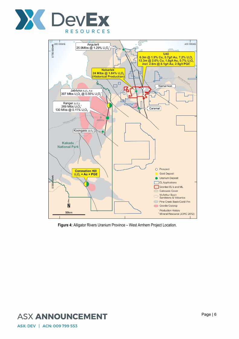
Figure 4: Alligator Rivers Uranium Province – West Arnhem Project Location.

Page | 7
Figure 5: 2019 Prospect and drill hole collar locations for Nabarlek and West Arnhem Projects.
Page | 8
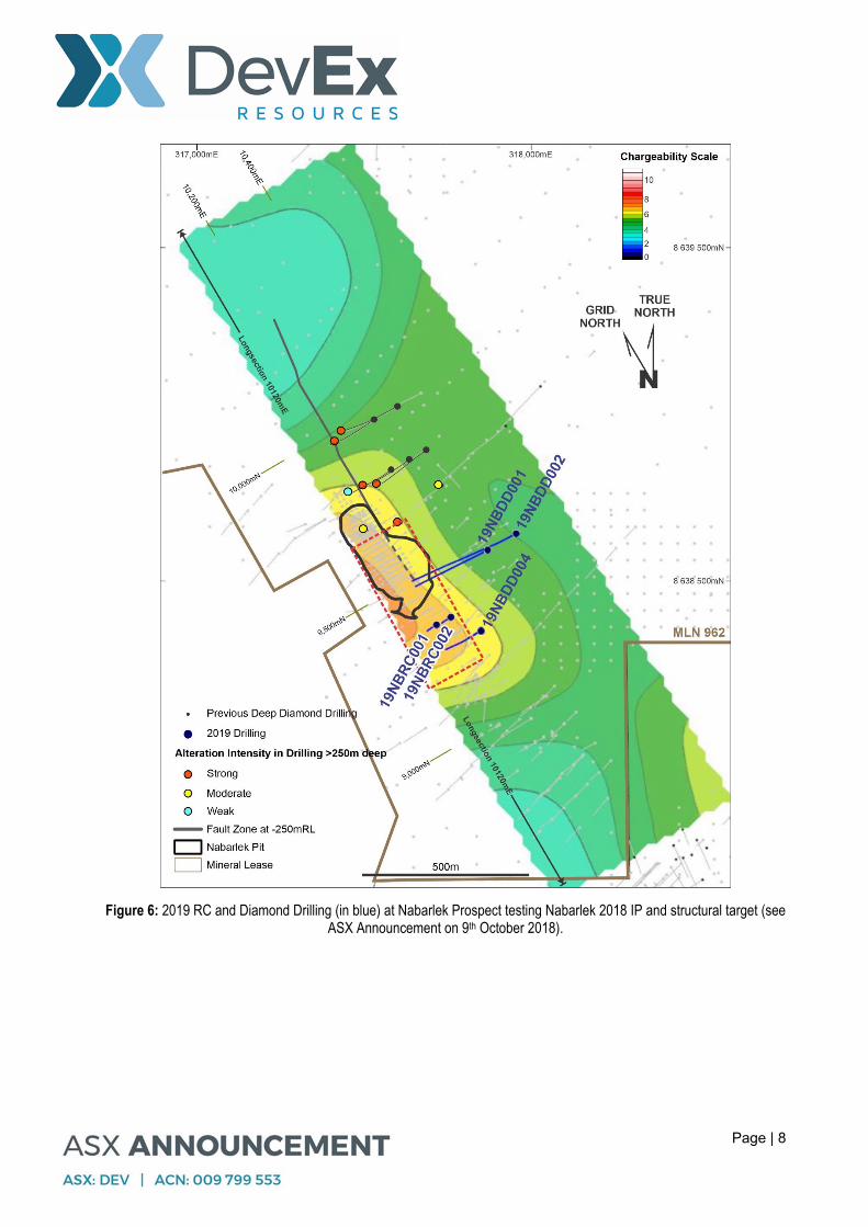
Figure 6: 2019 RC and Diamond Drilling (in blue) at Nabarlek Prospect testing Nabarlek 2018 IP and structural target (see ASX Announcement on 9th October 2018).
Page | 9
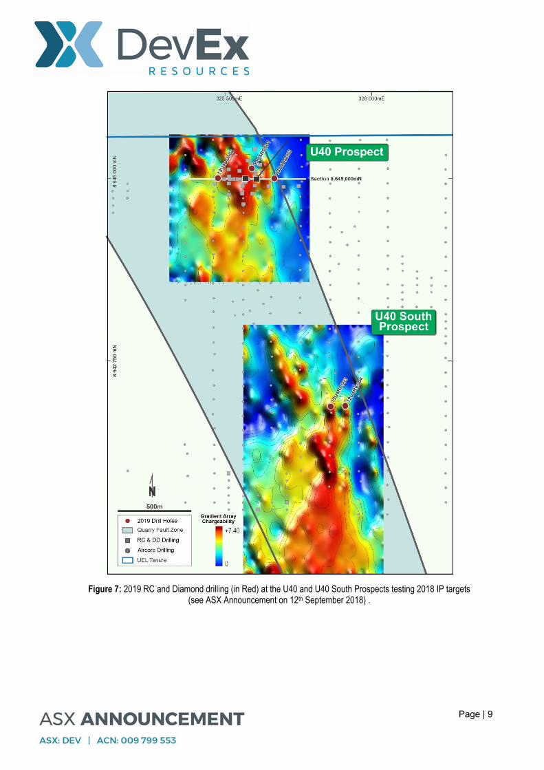
Figure 7: 2019 RC and Diamond drilling (in Red) at the U40 and U40 South Prospects testing 2018 IP targets (see ASX Announcement on 12th September 2018) .

Page | 10
Figure 8: Detailed plan of 2019 RC and Diamond Drilling (in blue) at U40 Prospect.

Page | 11
West Arnhem-Nabarlek Project Background
The Alligator Rivers Uranium Province in the Northern Territory is a world-class Proterozoic uranium province (Figure 4) hosting numerous large-scale uranium deposits.
The Company is focussed on exploring within its granted tenements (three Exploration Licences and one Mineral Lease) for:
(i) repetitions of the high-grade Nabarlek Uranium Deposit (24Mlbs U3O8 mined out at a
grade of 1.84%U3O8) along the Nabarlek Shear;
(ii) depth continuation of high-grade U-Cu-Au-PGE mineralisation (incl 6.3m @ 7.2% U3O8, 0.7g/t Au, 1.9% Cu) encountered in previous drilling at the U40 prospect; and
(iii) polymetallic mineralisation associated with regional basement faults, subparallel to the Nabarlek Shear, such as along the Quarry Fault south of the U40 Prospect.
Brendan Bradley Managing Director
For further information, please contact: Brendan Bradley, Managing Director DevEx Resources Limited Telephone +61 8 9322 3990
For media inquiries, please contact: Nicholas Read Read Corporate Telephone: +61 8 9388 1474
Page | 12
COMPETENT PERSON STATEMENT The information in this report that relates to Exploration results is based on information compiled by DevEx Resources Limited and reviewed by Mr Brendan Bradley who is the Managing Director of the Company and a member of the Australian Institute of Geoscientists. Mr Bradley is a shareholder of DevEx Resource Limited. Mr Bradley has sufficient experience that is relevant to the styles of mineralisation, the types of deposits under consideration and to the activities undertaken to qualify as a Competent person as defined in the 2012 edition of the “Australasian Code for Reporting of Exploration Results, Mineral Resources and Ore Reserves”. Mr Bradley consents to the inclusion in this report of the matters based on this information in the form and context in which it appears. The information in this report which relates to historical Drill Results for the U40 Prospect is extracted from the ASX announcement entitled “Uranium-copper-gold drill target defined at West Arnhem Project, NT” released on the 12th September 2018 and “UEQ Identifies High Grade Copper-Gold and Base Metal Potential at NT Uranium Projects” released on the 4th October 2017 and ASX announcement entitled “Higher Uranium Grades Returned from U40 Prospect – Nabarlek” on the 16th December 2010 and which are available on www.devexresources.com.au. The Company confirms that it is not aware of any new information or data that materially affects the information included in the original market announcement and that all material assumptions and technical parameters underpinning the estimates in the relevant market announcement continue to apply and have not materially changed. The company confirms that the form and context in which the Competent Person’s findings are presented have not been materially modified from the original market announcement. FORWARD LOOKING STATEMENT This announcement contains forward-looking statements which involve a number of risks and uncertainties. These forward looking statements are expressed in good faith and believed to have a reasonable basis. These statements reflect current expectations, intentions or strategies regarding the future and assumptions based on currently available information. Should one or more of the risks or uncertainties materialise, or should underlying assumptions prove incorrect, actual results may vary from the expectations, intentions and strategies described in this announcement. No obligation is assumed to update forward looking statements if these beliefs, opinions and estimates should change or to reflect other future developments.

DevEx Resources Limited
Page | 13
Appendix 1 – 2019 Nabarlek and West Arnhem Diamond and Reverse Circulation Drilling – Collar Details
Prospect Hole East GDA
North GDA
East Local
North Local
RL Depth (m)
Dip True Azi From (m) To (m) Interval Au ppm
U3O8 ppm
Nabarlek 19NBDD001 317,859 8,638,595 10,418 9,467 74 441 -56 243 No significant intercept
19NBDD002 317,944 8,638,644 10,518 9,467 74 549 -53 242 458.1 458.4 0.3 0.25 526 19NBRC001 317,706 8,638,371 10,174 9,351 81 78 -60 240 No significant intercept
19NBRC002 317,749 8,638,394 10,224 9,351 81 78 -60 240 No significant intercept
19NBDD004 317,839 8,638,352 10,283 9,271 80 254 -49 241 No significant intercept
GC11 19GCRC001 316,921 8,636,711 - - 74 223 -60 155 No significant intercept
U40 19U4DD002 326,954 8,645,002 - - 74 550 -60 88 179.5 180.2 0.7 0.01 1059 19U4RC001 327,182 8,645,069 - - 64 85 -55 267 No significant intercept
19U4DD003 327,338 8,645,000 - - 64 330 -52 272 No significant intercept
U40 South
19U4RC003 327,721 8,643,446 - - 92 162 -60 267 No significant intercept
19U4RC004 327,820 8,643,450 - - 92 140 -60 267 No significant intercept
Note: all assay results for the above-mentioned holes have been received and only those intersections identified in Table 1 on Page 2 are considered significant or material (>500ppm U3O8). Within the Company’s drilling database, assay results >500ppm U3O8 lie within the top 5% of total metres drilled and is therefore considered as a significant sign of uranium mineralisation.
www.devexresources.com.au
T: +61 (0) 8 9322 3990 F: +61 (0) 8 9322 5800 E: [email protected]
DevEx Resources Limited
Page | 14
Appendix 2. West Arnhem Project - JORC 2012 Table 2
Section 1 Sampling Techniques and Data
Criteria JORC Code explanation Commentary
Sampling techniques
Nature and quality of sampling (eg cut channels, random chips, or specific specialised industry standard measurement tools appropriate to the minerals under investigation, such as down hole gamma sondes, or handheld XRF instruments, etc). These examples should not be taken as limiting the broad meaning of sampling.
Include reference to measures taken to ensure sample representivity and the appropriate calibration of any measurement tools or systems used.
Aspects of the determination of mineralisation that are Material to the Public Report.
In cases where ‘industry standard’ work has been done this would be relatively simple (eg ‘reverse circulation drilling was used to obtain 1 m samples from which 3 kg was pulverised to produce a 30 g charge for fire assay’). In other cases more explanation may be required, such as where there is coarse gold that has inherent sampling problems. Unusual commodities or mineralisation types (eg submarine nodules) may warrant disclosure of detailed information.
Diamond drilling (NQ2) with core collected in core trays. HQ core was collected in the top of hole (between 70 to 100m depth)
Reverse circulation drilling was used for the shallower holes to produce 1m bulk samples (~25kg) collected in plastic bags. Representative composite samples using 5m composite spear were taken for analysis. Representative 1m split samples were collected using riffle splitter and placed in calico bags from collection if 5m composite samples proved anomalous.
Diamond drill core was halved using a core saw with intervals determined by onsite geologists base on geological observations with sample sizes ranging from 0.2m to 1.5m from which samples were crushed and pulverised in the laboratory.
Uranium mineralisation was visually noted in drill core using a hand held scintillometer and recorded in geological logs.
Industry standard practices have been applied on site to ensure sample representivity. The laboratory has applied appropriate QA-QC to sample preparation and appropriate calibration/QA-QC to analytical instruments.
Drilling techniques
Drill type (eg core, reverse circulation, open-hole hammer, rotary air blast, auger, Bangka, sonic, etc) and details (eg core diameter, triple or standard tube, depth of diamond tails, face-sampling bit or other type, whether core is oriented and if so, by what method, etc).
Sandvick 1200 multipurpose AWD truck mounted drill rig capable of RC and Diamond.
Reverse circulation drilling of shallow targets using 5-inch hammer
HQ and NQ2 diamond drilling with holes cored from surface.
An EZ orientation tool was used for orientation of drill core to allow structural measurements.
Drill sample recovery
Method of recording and assessing core and chip sample recoveries and results assessed.
Measures taken to maximise sample recovery and ensure representative nature of the samples.
Whether a relationship exists between sample recovery and grade and whether sample bias may have occurred due to preferential loss/gain of fine/coarse material.
Sample recovery was measured based on the length of drill core recovered relative to the drill core run length and recorded systematically.
No significant core loss was noted in the diamond drilling.
No sample bias has been established.
Logging Whether core and chip samples have been geologically and geotechnically logged to a level of detail to support appropriate Mineral Resource estimation, mining studies and metallurgical studies.
Whether logging is qualitative or quantitative in nature. Core (or costean, channel, etc) photography.
The total length and percentage of the relevant intersections logged.
Quantitative and Qualitative geological logging of drill samples was carried out systematically, using company and industry standard practice. Logging of samples included additional fields such as lithology, mineralogy, alteration and weathering with intensity reported as a number.
Wet drill core photographs were collected on a tray by tray basis
Uranium mineralisation was visually noted in drill core using a hand held scintillometer and recorded in geological logs. Reading were recorded on the side of the core tray for reference to handling practices. Close up photos of uranium mineralisation were also taken.
Detailed geological and structural logging of the drill core was carried out on site by experienced contract geologist together with supervision from
Page | 15
Criteria JORC Code explanation Commentary
company geologists. All RC chips were geologically logged on a 1m
basis and collected in chip trays for later reference. Graphite was noted in drill core during the core
cutting process when graphite was recorded floating in the water overflow. Graphite was recorded to the geological logs for these intervals.
Sub-sampling techniques and sample preparation
If core, whether cut or sawn and whether quarter, half or all core taken.
If non-core, whether riffled, tube sampled, rotary split, etc and whether sampled wet or dry.
For all sample types, the nature, quality and appropriateness of the sample preparation technique.
Quality control procedures adopted for all sub-sampling stages to maximise representivity of samples.
Measures taken to ensure that the sampling is representative of the in situ material collected, including for instance results for field duplicate/second-half sampling.
Whether sample sizes are appropriate to the grain size of the material being sampled.
Company procedures were followed to ensure sampling adequacy and consistency
Drill core was orientated, and metre marked, with cut line selected at 30 degrees from orientation line.
Half core was taken for analysis where alteration and mineralisation were noted including the margins of the alteration zones.
Sample sizes collected were based on geological observations and are appropriate for the project.
RC samples were split using a riffle splitter and collected in 1m calico bags. Five (5) metre composite spear samples were collected for all RC holes for analysis at the laboratory whereby anomalous results will see the 1 metre calico bag collected for reanalysis.
Where RC samples were collected, sample duplicates were collected.
Blanks and standards were submitted with RC and Diamond drill core
Quality of assay data and laboratory tests
The nature, quality and appropriateness of the assaying and laboratory procedures used and whether the technique is considered partial or total.
For geophysical tools, spectrometers, handheld XRF instruments, etc, the parameters used in determining the analysis including instrument make and model, reading times, calibrations factors applied and their derivation, etc.
Nature of quality control procedures adopted (eg standards, blanks, duplicates, external laboratory checks) and whether acceptable levels of accuracy (ie lack of bias) and precision have been established.
Assaying and lab procedures are appropriate. Samples were submitted to NTEL-Intertek Laboratory in Darwin, NT. Samples sent were either half core or for RC drilling, 5 metre composites or 1 metre samples where indicated. Entire samples were crushed and pulverised to 85% passing <75um. Pulps were then sent to Intertek in Perth and were selectively analysed from a combination of Ag, As, Bi, Cu, Pb, Zn, U with four acid digest 4A/OM and Au analysed by 50g fire assay FA25/OE04. Results are considered to be near total.
A comprehensive QA-QC program was implemented, comprising the submission of certified reference materials, blanks and laboratory duplicates
Gold analysis was by fire assay technique given the presence of sulphides within the core.
The Company submitted 23 blanks, 21 standards and 8 duplicates within the 840 samples. The relatively low number of duplicates was due to use of half core for analysis and the need to send the other half of the core to the NTGS as per the Collaboration Funding Agreement. No external laboratory checks were complete.
Acceptable levels of accuracy and precision have been established.
During the QA-QC process, Company staff noted several sample mismatches associated with submitted standards, the Company have resolved these mismatches and determine that they do not affect the accuracy and precision of the analysis.
Page | 16
Criteria JORC Code explanation Commentary
Verification of sampling and assaying
The verification of significant intersections by either independent or alternative company personnel.
The use of twinned holes. Documentation of primary data, data entry
procedures, data verification, data storage (physical and electronic) protocols.
Discuss any adjustment to assay data.
Drill hole intercepts for uranium have been verified by alternative company geologists and cross checks using hand held scintillometer.
Twinned drilling has not been carried out to validate the interpretation of the geological model.
Each sample bag was labelled with a unique sample number assigned prior to core cutting and spear sampling. Sample numbers are used to match analyses from the laboratory to the in-house database containing downhole drill data.
Laboratory analysis reporting for Uranium is as an element, consistent with industry standard U ppm is converted to ppm U3O8 by multiplying the U ppm value by 1.1792
No other adjustment to assay data has taken place
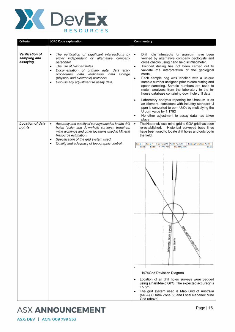
Location of data points
Accuracy and quality of surveys used to locate drill holes (collar and down-hole surveys), trenches, mine workings and other locations used in Mineral Resource estimation.
Specification of the grid system used. Quality and adequacy of topographic control.
The Nabarlek local mine grid to GDA grid has been re-established. Historical surveyed base lines have been used to locate drill holes and outcrop in the field.
1974 Grid Deviation Diagram
Location of all drill holes surveys were pegged using a hand-held GPS. The expected accuracy is +/- 5m.
The grid system used is Map Grid of Australia (MGA) GDA94 Zone 53 and Local Nabarlek Mine Grid (above).
Page | 17
Criteria JORC Code explanation Commentary
Downhole survey data for hole 19NBDD001 and 19NBDD002 was collected using an Axis North Seeking Gyro with readings taken every 23m on average. All other reported holes had downhole survey data collected using a Ranger Single Shot Camera with readings taken every 31m on average.
Data spacing and distribution
Data spacing for reporting of Exploration Results. Whether the data spacing and distribution is
sufficient to establish the degree of geological and grade continuity appropriate for the Mineral Resource and Ore Reserve estimation procedure(s) and classifications applied.
Whether sample compositing has been applied.
Drill hole spacing varied from site to site depending on target identified.
Data spacing, distribution and drilling is sufficient for geolgical interpretations, but not applicable to Mineral Resource estimations.
No sample compositing has occurred for diamond drilling.
For RC drilling 5m sample compositing has occurred.
Orientation of data in relation to geological structure
Whether the orientation of sampling achieves unbiased sampling of possible structures and the extent to which this is known, considering the deposit type.
If the relationship between the drilling orientation and the orientation of key mineralised structures is considered to have introduced a sampling bias, this should be assessed and reported if material.
Drill holes were ideally orientated to test the steep easterly dipping fault breccia at Nabarlek, whereas the subvertical mineralisation and U40 saw holes orientated to test the IP anomaly from both directions to ensure coverage.
Structures were recorded in diamond holes. Drilling orientation to structure is not considered to
have introduced a material sample bias. Sample security The measures taken to ensure sample security. Chain of custody is documented. All samples were
bagged and submitted to the laboratory by company staff or transport contractor.
Audits or reviews
The results of any audits or reviews of sampling techniques and data.
Reviews of sampling techniques and data have been carried out internally by staff geologists. No external audits or review have been completed for the programme due to the exploration stage it is at.
Page | 18
Section 2 Reporting of Exploration Results
Criteria JORC Code explanation Commentary
Mineral tenement and land tenure status
Type, reference name/number, location and ownership including agreements or material issues with third parties such as joint ventures, partnerships, overriding royalties, native title interests, historical sites, wilderness or national park and environmental settings.
The security of the tenure held at the time of reporting along with any known impediments to obtaining a licence to operate in the area.
The Nabarlek Prospect lies within granted Mineral Lease MLN962 and is owned by Queensland Mines Pty Limited (QML) a wholly owned subsidiary of DevEx Resource Limited. MLN962 is the renewal of Special Mineral Lease 94 granted on 23rd March 1979 to Mine and Process the Nabarlek Ore. MLN962 continues until the 22 March 2034 (thereafter subject to further application for renewal)
A Mining Agreements between QML and the Northern Land Council provides details for commercial mining and extraction of uranium ore within the MLN962. Additional deeds and agreements exist between QML and the NLC permitting the Company to explore the lease including benefits provided to the Traditional Owners.
The West Arnhem project forms part of three granted Exploration Licences (EL10176, EL24371 and EL23700). The IP Survey discussed within this report lies on EL10176. All three exploration licences form part of the West Arnhem JV in which the Company (DevEx Resources Limited) hold 100%. Cameco has a claw–back right for 51% of any deposit exceeding 50 million lbs of U3O8 within the West Arnhem JV see ASX Announcement on 11 September 2012. EL 10176 and EL24371 is subject to 1% royalties on gross proceeds from sale of uranium and other refined substances.
The company annually presents its exploration plans to Traditional Owners for comment and discussion. Planned activities, including drilling at Nabarlek were accepted by the Traditional Owners this year.
The company is unaware of any impediments to the company to operate in the area.
The company continue to operate under approvals given to is by the NT Government under its annual Mine Management Plans (MMP).
Exploration done by other parties
Acknowledgment and appraisal of exploration by other parties.
QML discovered the Nabarlek deposit in 1970 during costeaning of a significant airborne radiometric anomaly. During 1970 and 1971 the orebody was delineated by drilling.
The majority of drilling referred to in this report was undertaken by QML between 1970 to 2007 when the Company purchased QML. Following purchase of QML the Company has carried out exploration drilling within the MLN962 between 2009 and 2015.
At West Arnhem, the majority of the drilling was carried out by either the Company or by Cameco Exploration who operated the project separately, or under JV with the company between 2008 and 2017.
Geology Deposit type, geological setting and style of mineralisation.
Open cut mining at Nabarlek commenced in June 1979 and the entire orebody was mined over a period of 4 months and 11 days. Processing of the stockpiled ore took place between 1980 and 1988. Total production from the Nabarlek mill was 10,858 tonnes of U3O8 (McKay and Miezitis 2001
Page | 19
Criteria JORC Code explanation Commentary
Australia’s Uranium resources, geology and development of deposits” in AGSO Mineral Resources Report 1).
Nabarlek Uranium mineralisation is classed and a structurally-controlled, unconformity associated uranium deposit entirely hosted within basement rocks similar to other uranium mines in the Alligator Rivers Uranium Field (ARUF) and the Athabasca Basin Canada. New discoveries in Canada, such as the Arrow Uranium Deposit demonstrates that structure plays an important role in localising high grade uranium mineralisation at significant depths below the unconformity.
The rock types which host the Nabarlek orebody are metamorphic schists and amphibolites of the Myra Falls Metamorphics, which are reported to correlate with the Cahill Formation. The metamorphic rocks are faulted against the Palaeoproterozoic Nabarlek Granite (1818 Ma) which has been intersected in drilling at 450m below the deposit. The metamorphic schists were subsequently intruded by a sheet of Oenpelli Dolerite (1720 Ma) with uranium mineralization (1640) and structural deformation occurring later. At Nabarlek and surrounding prospects, uranium mineralization has been encountered in both the host metamorphic schists and the Oenpelli Dolerite.
The Nabarlek orebody was deposited within the Nabarlek breccias. Surface mapping of the Nabarlek Shear south of the pit identified a silica flooded fault breccia with minor uranium at the immediate pit boundary. Within the main ore body (inner zone) alteration is characterised by pervasive hematite, chlorite, white mica and the removal of quartz/silica (de-silicification). Chalcopyrite (copper sulphide) is reported in petrology as one of the dominant sulphides. Company hand held XRF spot analysis of available core from Nabarlek confirms a close association between copper and uranium at Nabarlek and other prospects such as U40.
Apart from uranium, there is no record of routine analysis of metals associated with the Nabarlek mineralisation including gold.
The Company view the Nabarlek Deposit and nearby U40 Prospect to bear close similarities including age, with the Coronation Hill Uranium, Gold and PGE deposit (see ASX announcement on 9th May 2019.
Drill hole Information
A summary of all information material to the understanding of the exploration results including a tabulation of the following information for all Material drill holes: o easting and northing of the drill hole collar o elevation or RL (Reduced Level – elevation
above sea level in metres) of the drill hole collar
o dip and azimuth of the hole o down hole length and interception depth o hole length.
If the exclusion of this information is justified on the basis that the information is not Material and this exclusion does not detract from the understanding of the report, the Competent Person should clearly
A summary of all drilling is provided as a table in the Appendix of this report, and highlights are provided within the body of the report.
This report contains historical drill hole intercepts from the historical Nabarlek Open Cut and U40 Prospects demonstrating style of mineralisation, continuity and grade as context to exploration targets beneath this mineralisation at depth. This drilling is plotted onto detailed and regional long sections and represented as pierce points which represent their position relative to the plane of mineralisation (the Nabarlek Shear) and projected to the long section. Uranium intercepts are thematically mapped by grade%U3O8 x metres (down hole) and discussed in further detail in the

Page | 20
Criteria JORC Code explanation Commentary
explain why this is the case. Company’s ASX announcement on the 9th October 2018.
This report references deep diamond drilling carried out in 2015 and released to ASX on 7th October 2015 including Table 1
Data aggregation methods
In reporting Exploration Results, weighting averaging techniques, maximum and/or minimum grade truncations (eg cutting of high grades) and cut-off grades are usually Material and should be stated.
Where aggregate intercepts incorporate short lengths of high grade results and longer lengths of low grade results, the procedure used for such aggregation should be stated and some typical examples of such aggregations should be shown in detail.
The assumptions used for any reporting of metal equivalent values should be clearly stated.
Significant exploration results have been reported within the table and figures of this report. Intercepts represent weighted average grades for uranium intercepts >500ppm U3O8. Within the Company’s drilling database, assay results >500ppm U3O8 lie within the top 5% of total metres drilled and the company view this as sign of a uranium system.Other uranium mineralisation that was noted in drill core but below <500ppm U3O8 are noted in the figures as blue dots to provide reference to disseminated uranium but which assay below 500ppm U3O8.
No metal equivalents have been used. Relationship between mineralisation widths and intercept lengths
These relationships are particularly important in the reporting of Exploration Results.
If the geometry of the mineralisation with respect to the drill hole angle is known, its nature should be reported.
If it is not known and only the down hole lengths are reported, there should be a clear statement to this effect (eg ‘down hole length, true width not known’).
At Nabarlek, mineralisation is interpreted to be controlled by a steep east dipping fault breccia.
Mineralisation is reported as down hole lengths as true width are unknown.
Diagrams Appropriate maps and sections (with scales) and tabulations of intercepts should be included for any significant discovery being reported These should include, but not be limited to a plan view of drill hole collar locations and appropriate sectional views.
Refer to figures in the body of text.
Balanced reporting
Where comprehensive reporting of all Exploration Results is not practicable, representative reporting of both low and high grades and/or widths should be practiced to avoid misleading reporting of Exploration Results.
Balanced reporting has been achieved through a consistent and comprehensive reporting of sampling and thresholds used for significant intercepts and the means of determining them.
Other substantive exploration data
Other exploration data, if meaningful and material, should be reported including (but not limited to): geological observations; geophysical survey results; geochemical survey results; bulk samples – size and method of treatment; metallurgical test results; bulk density, groundwater, geotechnical and rock characteristics; potential deleterious or contaminating substances.
Exploration targets identified in this report have utilised geological, alteration, geophysical and structural observations which are explained in the report.
There is no other meaningful or material exploration data that has been omitted from the report.
Further work The nature and scale of planned further work (eg tests for lateral extensions or depth extensions or large-scale step-out drilling).
Diagrams clearly highlighting the areas of possible extensions, including the main geological interpretations and future drilling areas, provided this information is not commercially sensitive.
Confirmation of anomalous uranium-gold mineralisation beneath the Oenpelli Dolerite and near graphitic shales enhances the prospectivity for repetitions of Nabarlek type mineralisation in the vicinity of hole 19NBDD002. The Company is currently reviewing previous electromagnetics (EM) in the Nabarlek area for signs of conductors beneath the dolerite that may indicate where these graphitic sediments are thickest and abutting the Nabarlek F6 Fault Breccia.
Interpretations and future areas for exploration are outlined in diagrams and discussed in the report .