Embed Size (px)
Citation preview
10 Valentine Avenue, Parramatta

2 | Ref: IRF19/1870
May 2019
© Crown Copyright, State of NSW through its Department of Planning and Environment 2018
Disclaimer
While every reasonable effort has been made to ensure this document is correct at time of printing,
the State of NSW, its agents and employees, disclaim any and all liability to any person in respect of
anything or the consequences of anything done or omitted to be done in reliance or upon the whole or
any part of this document.
Copyright notice
In keeping with the NSW Government’s commitment to encourage the availability of information, you
are welcome to reproduce the material that appears in the Gateway Assessment This material is
licensed under the Creative Commons Attribution 4.0 International (CC BY 4.0). You are required to
comply with the terms of CC BY 4.0 and the requirements of the Department of Planning and
Environment. More information can be found at: http://www.planning.nsw.gov.au/Copyright-and-
Disclaimer.

3 | Ref: IRF19/1870
Contents
Part 1 - Introduction 4
1.1 Description of Planning Proposal 4
1.2 Site Description 4
1.3 Surrounding Area 5
1.4 Existing Planning Controls 7
1.5 Existing Approval 8
1.6 Donations and Lobbyists 9
Part 2 – The Planning Proposal 9
2.1 Objectives or Intended Outcomes 9
2.2 Explanation of Provisions 11
2.3 Mapping 12
2.4 Need for the planning proposal 12
Part 3 – Key Issues and Recommendations 12
3.1 Social and economic 12
3.2 Environmental 13
3.3 Infrastructure 18
Part 4 – Strategic Assessment 18
4.1 Regional and District Strategic Plans 18
4.2 Local Strategic Plans 19
4.3 Section 9.1 Directions 20
4.4 State Environmental Planning Policies 21
Part 5 – Consultation 22
5.1 Community Consultation 22
5.2 Agencies 22
Part 6 – Timeframe 22
Part 7 – Local Plan-Making Authority 22
Part 8 – Conclusion 22
Part 9 – Recommendation 23

4 | Ref: IRF19/1870
Part 1 - Introduction
1.1 Description of Planning Proposal
The planning proposal (Attachment A) relates to the existing car park at 10 Valentine Avenue,
Parramatta. The site contains a commercial building within the northern part of the site which will be
retained and a multi-storey car park within the southern part of the site. The proposal seeks to amend
the Parramatta Local Environment Plan 2011 (PLEP 2011) by altering the floor space ratio (FSR) and
height of building (HOB) maps for the whole site and inserting three site-specific clauses, including:
o exempting office premises from the FSR calculation;
o prohibiting the subdivision of the aboveground carpark; and
o include a maximum car parking rates based on the Parramatta CBD Planning Proposal.
Each of these clauses, and their intent are discussed in greater detail in Part 2 of this report.
1.2 Site Description
The site (Lot 2 DP 1119257) is on the east side of Valentine Avenue, which is a one-way road from
the intersection of Parkes Street. Parramatta rail and bus interchange is located to the north of the
site. The site has a total area of 3,935 square metres and currently contains a 13-storey commercial
building and a five-storey car park (Figure 1). The commercial building on the north end of the site is
intended to be retained, and the multi-story car park is the subject of this proposal (Figure 2-3).
Figure 1 Aerial view of 10 Valentine Avenue, Parramatta (outlined in blue) and immediate surrounds (source: Nearmap).

5 | Ref: IRF19/1870
Figure 2 Corner of Parkes Street and Valentine Avenue looking towards the site (existing carpark (1) and commercial building (2)).
Figure 3 Arial photo showing existing building to the north proposed to be retained and existing car park to the south proposed to be redeveloped (Source: planning proposal).
1.3 Surrounding Area
The site is in the Parramatta CBD within 100m of the Parramatta transport interchange and the centre
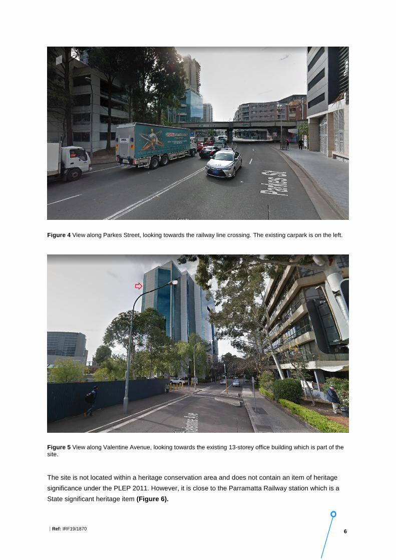
of the CBD. It is bounded by Parkes Street (Figure 4), Valentine Avenue and the railway line. Part of
the site contains an existing 13-storey 1980’s office tower to be retained (Figure 5). On the opposite
side of Valentine Avenue, there are several multi-story buildings within the B3 Commercial core zone.
6 | Ref: IRF19/1870
Figure 4 View along Parkes Street, looking towards the railway line crossing. The existing carpark is on the left.
Figure 5 View along Valentine Avenue, looking towards the existing 13-storey office building which is part of the site.
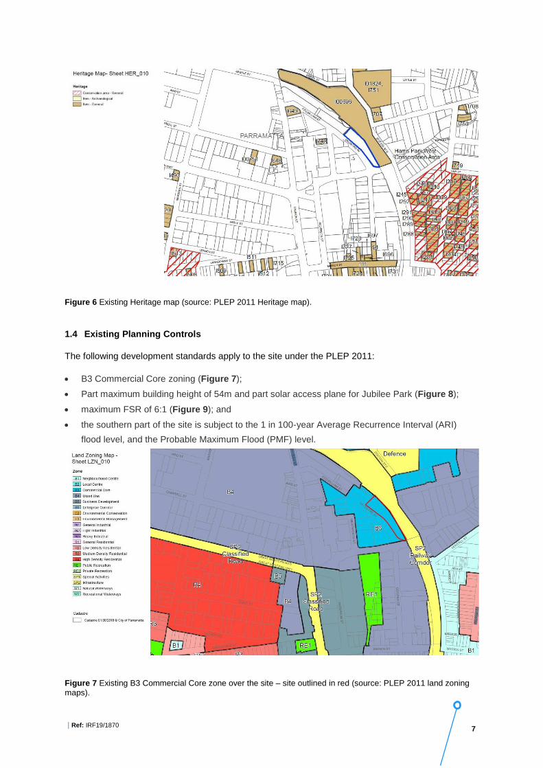
The site is not located within a heritage conservation area and does not contain an item of heritage
significance under the PLEP 2011. However, it is close to the Parramatta Railway station which is a
State significant heritage item (Figure 6).
7 | Ref: IRF19/1870
Figure 6 Existing Heritage map (source: PLEP 2011 Heritage map).
1.4 Existing Planning Controls
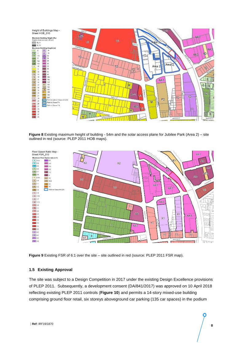
The following development standards apply to the site under the PLEP 2011:
• B3 Commercial Core zoning (Figure 7);
• Part maximum building height of 54m and part solar access plane for Jubilee Park (Figure 8);
• maximum FSR of 6:1 (Figure 9); and
• the southern part of the site is subject to the 1 in 100-year Average Recurrence Interval (ARI)
flood level, and the Probable Maximum Flood (PMF) level.
Figure 7 Existing B3 Commercial Core zone over the site – site outlined in red (source: PLEP 2011 land zoning maps).
8 | Ref: IRF19/1870
Figure 8 Existing maximum height of building - 54m and the solar access plane for Jubilee Park (Area 2) – site outlined in red (source: PLEP 2011 HOB maps).
Figure 9 Existing FSR of 6:1 over the site – site outlined in red (source: PLEP 2011 FSR map).
1.5 Existing Approval
The site was subject to a Design Competition in 2017 under the existing Design Excellence provisions
of PLEP 2011. Subsequently, a development consent (DA/841/2017) was approved on 10 April 2018
reflecting existing PLEP 2011 controls (Figure 10) and permits a 14-story mixed-use building
comprising ground floor retail, six storeys aboveground car parking (135 car spaces) in the podium

9 | Ref: IRF19/1870
and eight storeys commercial offices above (FSR of 6.9:1 and HOB of 54.4m). The existing
commercial building on the site is retained.
Figure 10 The winning design concept that reflects existing PLEP 2011 controls (FSR of 6.9:1 and HOB of 62.1m including Design Excellence Bonus) (Source: planning proposal).
1.6 Donations and Lobbyists
To the Department’s knowledge, there have been no donations or gifts to disclose and a political
donation disclosure is not required.
There have been no meetings or communications with registered lobbyists with respect to this
proposal.
Part 2 – The Planning Proposal
2.1 Objectives or Intended Outcomes
The objective of the planning proposal is to increase the permissible density for the land at 10
Valentine Avenue and to encourage the development of commercial floor space in accordance with
the future vision of the Parramatta CBD.
Two reference designs were submitted with the planning proposal (Attachment D). They reflect two
possible development application scenarios for the existing carpark, which also retains the existing
commercial building on the site.
Reference design 1 proposes a thirty-one storey building (120m high) with FSR of 12.29:1 (across
the entire site) and floor plates of approximately 1,259m2 (variable) net lettable area (NLA) comprising
6 levels of aboveground car parking (135 car parking spaces), 21 levels of commercial floor space

10 | Ref: IRF19/1870
(GFA: 30,746 m2 office space), and 3 levels of terrace facilities and 1 level for plant. The total NLA
envisaged in the reference design is 28,643m2 (Figure 11), which does not include the existing
building at 10 Valentine Avenue.
Reference design 1 reflects a development outcome where the existing building and the adjoining
approved building are retained, and additional floors are constructed on top of the approved (but not
yet constructed) building. Council advises that in this scenario, only a new development application for
the upper floors would be required and therefore, the additional approved parking (over and above the
new CBD rates for parking on sites that have been subject to site-specific planning proposal) would be
retained.
Figure 11 Applicant’s design concept (Reference Design 1) (Source: Reference Design report).
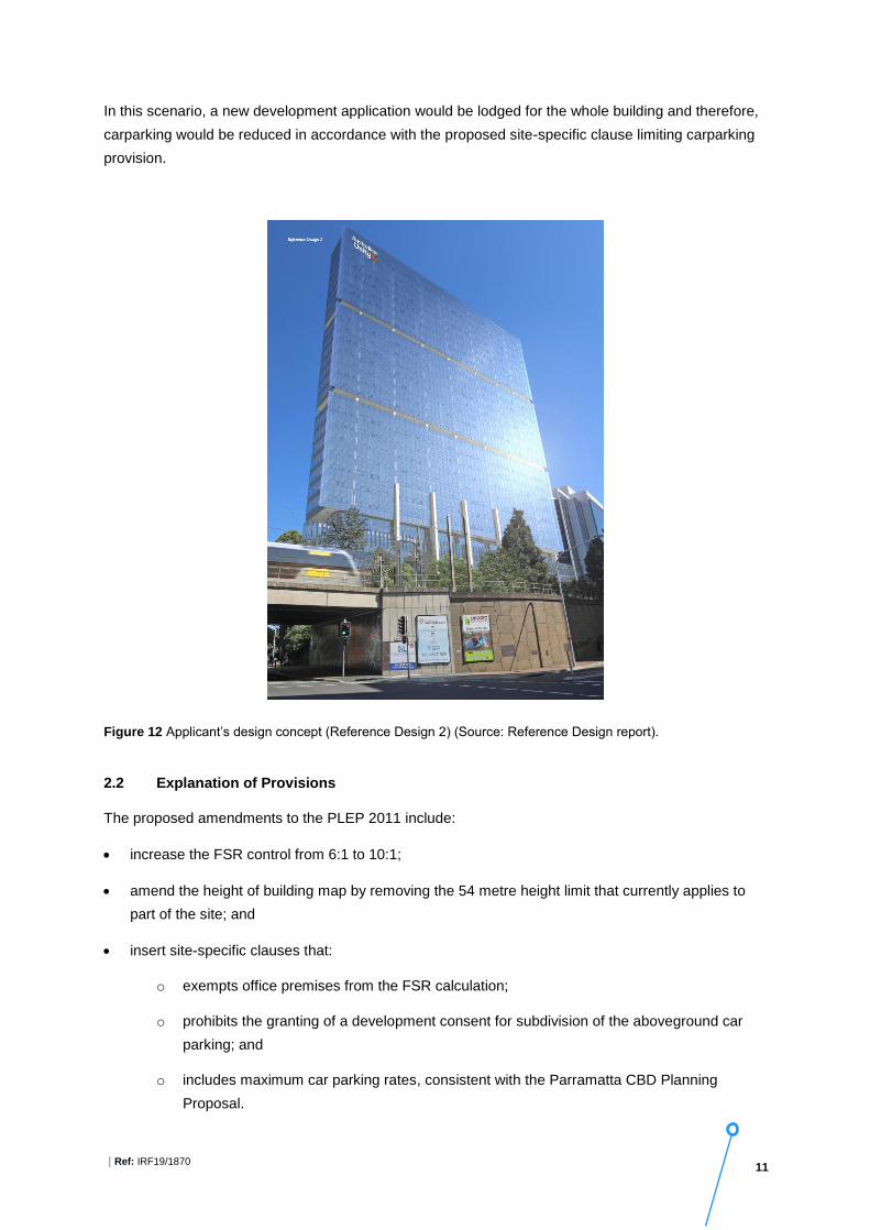
Reference design 2 proposes a thirty-one storey building (120m high) with FSR of 13.25:1 (across
the entire site) and floor plates of approximately 1,239m2 (variable) net lettable area (NLA) comprising
3 levels of aboveground car parking (41 car parking spaces), 24 levels of commercial floor space
(GFA: 34,522 m2 office space) and 3 levels of terraces and 1 level for plant. The total NLA envisaged
in the reference design is 31,891m2 (Figure 12), which does not include the existing commercial
building at 10 Valentine Avenue.
11 | Ref: IRF19/1870
In this scenario, a new development application would be lodged for the whole building and therefore,
carparking would be reduced in accordance with the proposed site-specific clause limiting carparking
provision.
Figure 12 Applicant’s design concept (Reference Design 2) (Source: Reference Design report).
2.2 Explanation of Provisions
The proposed amendments to the PLEP 2011 include:
• increase the FSR control from 6:1 to 10:1;
• amend the height of building map by removing the 54 metre height limit that currently applies to
part of the site; and
• insert site-specific clauses that:
o exempts office premises from the FSR calculation;
o prohibits the granting of a development consent for subdivision of the aboveground car
parking; and
o includes maximum car parking rates, consistent with the Parramatta CBD Planning
Proposal.

12 | Ref: IRF19/1870
The planning proposal includes a draft site-specific clause as a guide to demonstrate how the intent of
the proposal may be drafted. The intended effect of the above means that the planning proposal would
permit a commercial development with unlimited FSR, unlimited building height and a maximum car
parking rate. However, the recommended Gateway conditions require an amendment to the planning
proposal prior to community consultation, as recommended in this report.
2.3 Mapping
The planning proposal includes FSR, HOB and Special Provisions Area maps that show the current
and proposed controls (Attachment F). These maps require to be amended prior to community
consultation, subject to the recommendations in this report.
2.4 Need for the planning proposal
The planning proposal is not a result of any site-specific study or report, and it is a landowner-initiated
planning proposal. However, it was prepared to generally give effect to the Parramatta CBD Planning
Proposal, which was given a conditional Gateway determination on 13 December 2018.
The proposal aims to bring development forward to meet market demands for commercial
development within the CBD as set out in the Parramatta CBD Planning Strategy. The existing height
and FSR standards would not permit development as envisaged in the planning proposal.
The planning proposal is considered to have strategic merit and amending the PLEP 2011 is the most
effective mechanism to enable the development to occur.
Part 3 – Key Issues and Recommendations
The following section identifies the key issues and recommendations that are reflected in the Gateway
determination.
3.1 Social and economic
This planning proposal will facilitate the redevelopment of an existing carpark for a more intensive use
within the commercial core of the Parramatta CBD, which is consistent with the Parramatta CBD
Planning Proposal.
The proposed development intends to deliver commercial development with close proximity to existing
and planned transport links. The proposal identifies a commercial floorspace of approximately 30,746
m2 to 34,522 m2 which can support between 1,281 to 1,438 jobs, depending on the final design
outcome. The reference design also incorporates public art and a café into the ground floor of the
building to support further activation of Valentine Avenue. In general, it is anticipated the proposed
development will contribute to the economic growth and revitalisation of Parramatta CBD.

13 | Ref: IRF19/1870
3.2 Environmental
The site is within a highly modified urban environment and it is unlikely to contain critical habitat or
threatened species, populations or ecological communities, or their habitats.
3.2.1 Land use planning
The site’s location in the centre of the Parramatta CBD, and close to the Parramatta transport
interchange, make it an appropriate location to increase density and provide new modern commercial
floor space. The proposal aligns with the NSW Government’s policy to grow the Parramatta CBD.
As discussed previously, it is considered that the planning proposal is generally consistent with the
desired future character of the Parramatta CBD.
3.2.2 FSR control
The proposed mapped FSR of 10:1 is consistent with the Parramatta CBD Planning Proposal. It will
encourage commercial development within the commercial core of the Parramatta CBD.
Two proposed reference designs suggest the total FSR of 12.29:1 and 13.25:1 across the entire site
which are both beyond 10:1. The planning proposal also seeks to provide an exemption for commercial
floor space.
Under the conditions of the Parramatta CBD Gateway determination, unlimited office premises floor
space is proposed to be permissible in the B3 zone on a site over 1800m2. The intent of this provision
is to encourage A-Grade commercial office space in the CBD.
Given the site is relatively constrained, and the intent to impose a maximum building height (see
section 3.2.4), the site is considered suitable for the additional FSR over 10:1. Further, the design
excellence provisions of the Parramatta LEP will provide a level of certainty that the proposed
outcomes on the site will respond appropriately to site conditions and characteristics, particularly with
regard to ensuring an appropriate bulk and scale.
It is considered appropriate to issue a Gateway determination allowing the unlimited commercial floor
space provision to progress to community consultation, noting the consistency with Parramatta CBD
Planning Proposal and conditional gateway. However, a mapped maximum FSR of 10:1 is required to
provide a base FSR should the site be subdivided.
3.2.3 Sun access plane control
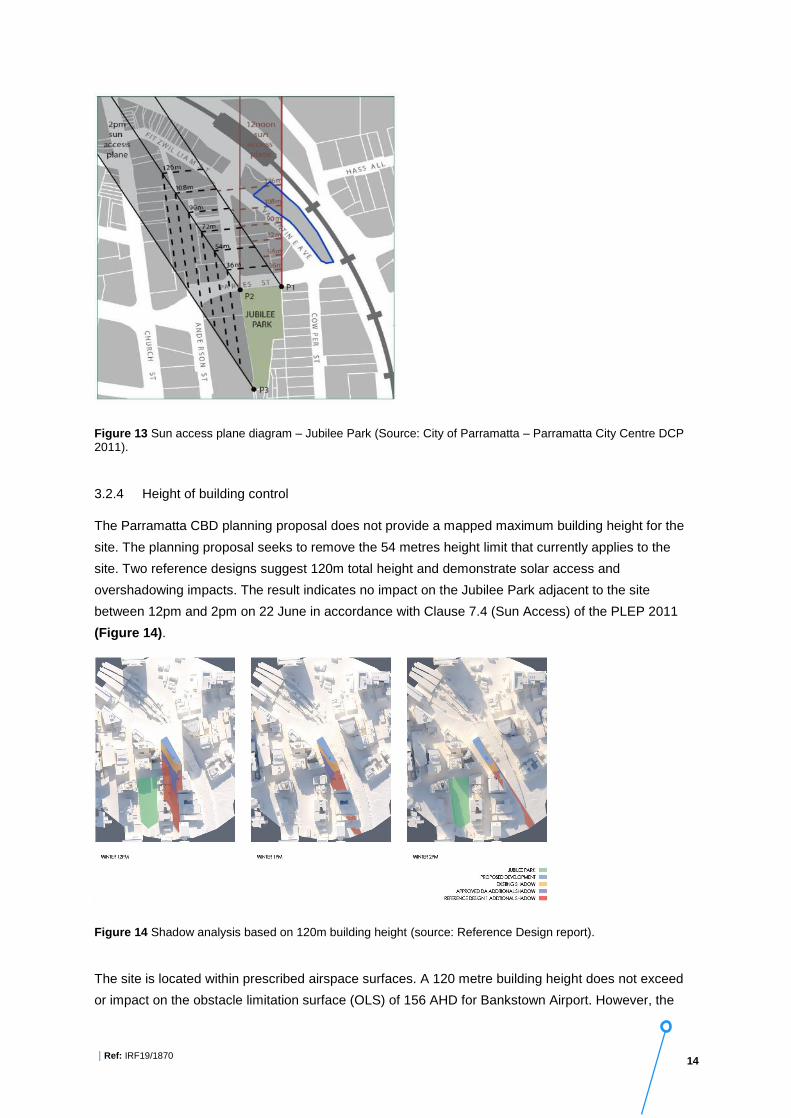
The site is close to the Jubilee Park, so it must comply with the sun access plane control established
for the Jubilee Park in PLEP 2011 and Parramatta DCP 2011 (Figure 13).
Figure 13 demonstrates the sun access plane is generated from sun access to Jubilee Park on June
22 between 12 noon and 2pm. The proposed development is located to the south of the existing sun
access plane, however, it is a relevant consideration as the planning proposal is for the whole site, not
just the southern portion of the site. The sun access plane is to be retained as part of the planning
proposal and no change is required as long as a maximum building height is provided.
14 | Ref: IRF19/1870
Figure 13 Sun access plane diagram – Jubilee Park (Source: City of Parramatta – Parramatta City Centre DCP 2011).
3.2.4 Height of building control
The Parramatta CBD planning proposal does not provide a mapped maximum building height for the
site. The planning proposal seeks to remove the 54 metres height limit that currently applies to the
site. Two reference designs suggest 120m total height and demonstrate solar access and
overshadowing impacts. The result indicates no impact on the Jubilee Park adjacent to the site
between 12pm and 2pm on 22 June in accordance with Clause 7.4 (Sun Access) of the PLEP 2011
(Figure 14).
Figure 14 Shadow analysis based on 120m building height (source: Reference Design report).
The site is located within prescribed airspace surfaces. A 120 metre building height does not exceed
or impact on the obstacle limitation surface (OLS) of 156 AHD for Bankstown Airport. However, the

15 | Ref: IRF19/1870
proposal seeks to remove the height of building control. No Aeronautical study or other potential
environmental constraints assessment has been submitted with this planning proposal to demonstrate
the impacts of building height beyond 120m.
The Department is unable to support an undefined height of building for the site. As per Clause 7.6
Airspace Operations in the PLEP 2011 any proposed development above the obstacle limitation
surface (OLS) of 156 AHD require approval from the Civil Aviation Safety Authority (CASA) and the
Department of Infrastructure, Regional Development and Cities (DIRDC).
It is recommended that prior to community consultation Council amends the planning proposal to
provide a maximum mapped building height. This is consistent with other site-specific planning
proposal in the Parramatta CBD.
3.2.5 Car parking spaces
On 10 April 2017, Council resolved to endorse the Parramatta CBD strategic transport study to reduce
the maximum car parking rates for all sites subject to planning proposals. In accordance with this
resolution, it is proposed to include maximum car parking rates, which is also consistent with other
recent Gateway determinations issued within the Parramatta CBD. In this respect, the proposal
intends to require that the site comply with the provisions of Clause 7.14 of the Parramatta LEP, which
imposes the required maximum carparking rates.
Applying the applicable formula to calculate maximum car parking rates for the proposed concept
design, the resulting maximum car parking rate is 79 spaces, as follows (Figure 15):
Reference design 1 provides for 162 car parking spaces which includes the parking that has already
been approved on the site under the existing development application approvals.
Reference design 2 provides 68 car parking spaces which complies with the maximum carparking
rates that would be required to be complied with if a new development application was lodged over the
site.

16 | Ref: IRF19/1870
Figure 15 Overall crossed sections – Reference design 1 (left)- Reference design 2 (right).
Given the site is located in the Parramatta CBD and close to public transport, provision of a maximum car
parking rate is supported and consistent with the Parramatta CBD Planning Proposal.
As noted, the Reference design submitted with the proposal indicates above ground car parking in the
podium (Figure 15). This is due to the intended alignment of the potential Parramatta to Epping Line
(PERL) which is identified though a protection corridor, will run diagonally across the end of the site.
To avoid a potential conflict with the PERL, basement development is not proposed (Figure 16).
Under the Parramatta DCP 2011, above ground carparking in CBD is permitted but needs to be fully
sleeved with active use. However, sleeving is not possible or practical due to the site’s narrow width,
as such Parramatta Council has permitted above ground carparking on this site through an existing
approved development application, but are seeking to legislate that the carparking cannot be
subdivided (particularly into strata units) to preserve the potential for this space to be converted to
commercial premises.

17 | Ref: IRF19/1870
Figure 16 Site constraint plan (source: Reference Design report).
3.2.6 Subdivision of above ground carparking
The planning proposal seeks to include a site-specific clause to prevent the subdivision of the carpark.
This clause seeks to ensure that part or all of the car parking areas can be converted to office
premises in the future. The Parramatta DCP 2011 contains provisions which support this clause
generally. In this regard, Objective O.3 within Section 4.3 of the DCP states:
“Provide car parking in a manner that would make a reduction in the amount and rate of car parking
provision possible as the city economy strengthens, and alternative modes of transport are developed
to serve the city.”
Control C.3 within Section 4.3 of the DCP provides for the following:
“To facilitate adaptation of car parking to other uses in the long term, consideration will be given to car
parking remaining as part of the common property and not part of, or attached to, individual strata
units.”
It is considered appropriate to include this site-specific provision within the PLEP 2011. It will preserve
the potential for the development to change over time. It is recommended that Council to ensure that
proposed aboveground carparking can provide a level of adaptability to enable office premises in the
future.
3.2.7 Heritage items
Parramatta Railway Station is listed heritage item of State significance. A heritage impact assessment

18 | Ref: IRF19/1870
study has not been submitted. Council’s Heritage Advisor notes that the proposal is consistent with the
Parramatta CBD Planning Proposal and has raised no objection.
It is noted that the proposed height of 120m does not impact on heritage conservation areas adjacent
to or within the CBD in terms of overshadowing, historic views or settings. However, a Gateway
condition has been proposed requiring consultation with the Office of Environment – Heritage prior to
community consultation.
3.2.8 Flood study
The southern side of the site close to the vehicular access point is subject to the 1 in 100-year
Average Recurrence Interval flood level and subject to the Probable Maximum Flood Level. A flood
study has not been submitted with the planning proposal, noting that this matter has been addressed
as part of the approved development application for the site and there is an approved solution to
address flood impacts on this site.
A Gateway condition has been proposed requiring consultation with the NSW State Emergency
Service prior to community consultation.
3.2.9 Traffic report
Council’s Traffic and Transport team has identified that Valentine Avenue may be widened to
accommodate a two-way traffic. No traffic or transport study has been submitted, however, it is noted
that the building footprint has already been approved under an existing development application, and
therefore any future road widening would be subject to a separate process.
3.3 Infrastructure
The site is within 200m walking distance of the Parramatta rail and bus interchange. The site also has
access to several open space areas (i.e. Jubilee Park, Centenary Square and Parramatta Park).
It is recommended that the intensification of the site and likely increased demand on local
infrastructure and services will be addressed through a future development application for the site.
As the proposal constitutes commercial development only, a satisfactory arrangements clause for
contributions towards state infrastructure is not required.
Part 4 – Strategic Assessment
4.1 Regional and District Strategic Plans
4.1.1 Greater Sydney Region Plan
The Greater Sydney Region Plan, A Metropolis of Three Cities, was prepared by the Greater Sydney
Commission. It provides a vision and plan for the delivery of 725,000 dwellings and an extra 817,000
jobs in the Greater Sydney region by 2036. The plan identifies the Central River City as one of the

19 | Ref: IRF19/1870
three cities to create a metropolis of three cities. Greater Parramatta and its CBD are identified as the
core of the Central River City.
The plan provides four key concepts to drive and establish the three cites vision:
• infrastructure and collaboration;
• liveability; productivity; and
• sustainability.
These key concepts are informed by ten key directions, which are supported by 40 objectives to
ensure the delivery of the vision for Sydney to 2056.
The planning proposal is generally consistent with the plan as it will deliver commercial development
close to existing and planned transport links and surrounding high-density residential development.
The proposed development seeks to increase permissible density on the site, create a minimum of
30,746 m2 office space and approximately 1,281 jobs, as well as incorporating public art and a café
into the ground floor to support the further activation of Valentine Avenue. In general, it is anticipated
the proposed development will contribute to the economic growth of Parramatta CBD.
4.1.2 Central City District Plan
The Central City District Plan provides a 20-year plan to manage growth in the context of economic,
social and environmental matters to achieve the 40-year vision of Greater Sydney. It is a guide for
implementing the Greater Sydney Region Plan at a district level and is a bridge between regional and
local planning.
The planning proposal is generally consistent with the priorities and actions set by the District Plan.
The Department is satisfied it will give effect to the District Plan, in accordance with section 3.8 of the
Environmental Planning and Assessment Act 1979.
4.1.3 Greater Parramatta and the Olympic Peninsula
The planning proposal is consistent with the Greater Parramatta and Olympic Peninsula vision to
design Parramatta as a 30-minute city by enabling a mixed-use tower to be developed in a central
location with excellent proximity to jobs, shops and community facilities.
4.2 Local Strategic Plans
The planning proposal is considered to meet the strategic objectives identified in Council’s strategic
plan by providing increased commercial space in the Parramatta commercial core close to public
transport and services. The proposal will encourage economic growth in the CBD and help to build the
CBD as a centre of high value-added employment.

20 | Ref: IRF19/1870
The Parramatta CBD planning strategy was adopted by Council on 27 April 2015 and sets the vision
for the growth of the Parramatta CBD as Australia’s next great city. The strategy established the
principles and actions to guide a new planning framework for the Parramatta CBD.
The planning proposal is considered to be generally consistent with the Council-endorsed CBD
strategy.
The CBD Planning Proposal received a Gateway determination by the Department on 13 December
2018 with several conditions requiring further studies and analysis (Attachment G).
The CBD Planning Proposal seeks to increase height and FSR for sites within the CBD, and to
remove the maximum FSR control for some sites that are zoned to permit commercial office
development. The CBD Planning Proposal proposes a 10:1 FSR for the subject site, which was
informed by the CBD Planning Strategy.
The CBD Planning Proposal also intends to enable sites over 1800m2 in the B3 Commercial Core
zone to be exempt from the maximum FSR controls. The subject planning proposal is consistent with
the proposed incentive FSR map in the CBD planning proposal of 10:1, and the unlimited floor space
provisions for commercial development. However, a mapped maximum FSR of 10:1 is required to
provide a base FSR should the site be subdivided.
This site-specific planning proposal is considered to have strategic merit to proceed ahead of the
broader Parramatta CBD planning proposal as it is consistent with the intended outcomes. It is
recommended that prior to public exhibition, Council determines an appropriate maximum mapped
building height.
A condition is also recommended that requires that prior to finalisation, that Council further consider
the consistency of the subject planning proposal with the Parramatta CBD planning proposal.
4.3 Section 9.1 Directions
The proposal is consistent with all Section 9.1 Directions. Further discussion in relation to applicable
Directions provided below:
The objective of this Direction is to conserve items, areas, objects and places of environmental
heritage significance and indigenous heritage significance. There are existing controls within the
Parramatta LEP to enable further consideration of heritage impacts at DA stage and therefore, there is
no inconsistency with this Direction.
A Gateway condition has been proposed requiring consultation with NSW Office of Environment and
Heritage – Heritage Division prior to community consultation.

21 | Ref: IRF19/1870
The site is located within prescribed airspace surfaces. The proposal provides two reference designs
with a 120m building height.
As the gateway determination requires the provisions of maximum building height, it is considered that
there is no inconsistency with this Direction.
The site is mapped as having Class 4 and Class 5 acid sulfate soils under PLEP 2011. The proposal
is inconsistent with this Direction as an acid sulfate soils study was not submitted with the planning
proposal to support the intensification of development.
This inconsistency is considered to be of minor significance as this matter can be appropriately
considered and addressed at the development application stage in accordance with clause 6.1 of
PLEP 2011 (which requires an acid sulfate soils management plan to be submitted at the development
application stage, if certain development thresholds are met).
It is recommended that the Secretary’s delegate agree that any inconsistency with this Direction is of
minor significance.
The southern side of the site is partially affected by the 1 in 100-year ARI and PMF flood events. A
flood study has not been submitted with the planning proposal. It was noted in the proposal that the
flood impact was appropriately considered through the existing development consent (DA/841/2017).
However, further consideration is required for any future development application for the site in
accordance with the existing provisions in PLEP 2011.
A Gateway condition has been proposed requiring consultation with NSW State Emergency Service
prior to community consultation.
It is recommended that the Secretary’s delegate agree that any inconsistency with this Direction is of
minor significance as there are appropriate provisions in place to ensure this matter can be
appropriately addressed at DA stage.
This Direction applies to the planning proposal as it includes three site-specific provisions including:
• unlimited office premises floor space in the B3 zone;
• prevents the granting of development consent for subdivision of aboveground car parking; and
• maximum car parking rates.
It is recommended that the Secretary’s delegate agree that any inconsistency with this Direction is of
minor significance as the provisions will facilitate redevelopment of the site and they are consistent
with Parramatta CBD Planning Proposal and Parramatta DCP 2011.
4.4 State Environmental Planning Policies
The planning proposal is generally consistent with the relevant state environmental planning policies.

22 | Ref: IRF19/1870
Part 5 – Consultation
5.1 Community Consultation
A community consultation period of 28 days is considered an appropriate amount of time to gauge the
community’s response.
5.2 Agencies
The following agencies are required to be consulted prior to the community consultation occurring:
• Office of Environment and Heritage – Heritage Division; and
• NSW State Emergency Service.
Part 6 – Timeframe
Council has requested 6 months to finalise the proposal. The Department recommends 9 months to
finalise the planning proposal. The proposal is required to be amended prior to community
consultation.
Part 7 – Local Plan-Making Authority
Council has requested to be the local plan-making authority in relation to this planning proposal. Given
the proposal is generally consistent with the Parramatta CBD Planning Proposal, has strategic and
site-specific merit, and no contribution toward State infrastructure is required. It is recommended that
Council be given authorisation to make the plan.
Part 8 – Conclusion
The planning proposal is supported as it:
• facilitates office development;
• create new jobs;
• generally aligns with future characteristics of Parramatta CBD; and
• gives effect to the Central City District Plan and Community Strategic Plan and is generally
consistent with the Paramatta CBD Planning Proposal.
It is recommended that a Gateway determination be issued, with conditions requiring amendments.

23 | Ref: IRF19/1870
Part 9 – Recommendation
It is recommended that the delegate of the Secretary:
1. agree that any inconsistencies with Section 9.1 Directions; Direction 4.1 Acid Sulfate Soils,
Direction 4.3 Flood Prone Land, and Direction 4.3 Development Near Regulated Airports, and
Direction 6.3 Site Specific Provisions are of minor significance.
It is recommended that the Director, Sydney Region West Planning Services, as delegate of the
Minister for Planning, determine that the planning proposal should proceed subject to the following
conditions:
1. Prior to community consultation Council is to update the planning proposal to:
(a) amend the Height of Building Map to remove the 54 metre height control and replace with a
defined maximum building height expressed in metres to be consistent with the updated
Reference design. The solar access plane for Jubilee Park (Area 2) on the Height of Building
Map is to be retained;
(b) provide a flooding map to show the extent of the flood impact on the subject site; and
(c) update the project timeline consistent with Part 6 of this report.
2. Community consultation is required under sections 3.34(2)(c) and schedule 1 clause 4 of the
Environmental Planning and Assessment Act 1979 as follows:
(a) the planning proposal must be made publicly available for a minimum of 28 days; and
(b) the planning proposal authority must comply with the notice requirements for public exhibition
of planning proposals and the specifications for material that must be made publicly available
along with planning proposals as identified in section 6.5.2 of A guide to preparing local
environmental plans (Department of Planning and Environment 2018).
3. Consultation is required with the following public authorities:
- Office of Environment and Heritage – Heritage Division; and - NSW State Emergency Service.
Each public authority/organisation is to be provided with a copy of the planning proposal and any
relevant supporting material and given at least 21 days to comment on the proposal.
4. A public hearing is not required to be held into the matter by any person or body under section
3.34(2)(e) of the Act. This does not discharge Council from any obligation it may otherwise have to
conduct a public hearing (for example, in response to a submission or if reclassifying land).
5. Prior to finalising the plan, Council is to ensure the planning proposal is consistent with the
Parramatta CBD planning proposal.
6. The time frame for completing the LEP is to be 9 months following the date of the Gateway
determination.

24 | Ref: IRF19/1870
7. Given the nature of the planning proposal, Council should be the local plan-making authority to
make this plan.
29/5/2019 29/05/2019
Christine Gough Ann-Maree Carruthers
Team Leader, Sydney Region West Director, Sydney Region West,
Planning Services
Assessment officer: Parisa Pakzad Phone: 9860 1584