Embed Size (px)
Citation preview

12 · Cartography in Vietnam
JOHN K. WHITMORE
The study of maps made in Vietnam over the past fivecenturies has barely begun. Any person attempting toexamine the Vietnamese cartographic tradition must casta wide net to gather the scattering of detail in variousforms that helps us understand how this tradition cameto be. Although scholars of the Ecole Fran~aise d'Extreme-Orient (such as Henri Maspero, Leonard Aurousseau, and Emile Gaspardone) laid the bibliographic foundation for the study of Vietnamese cartography, thecolonial period saw almost no work on historical maps.The only major exception was Gustave Dumoutier's 1896study of an early itinerary to the south (see below).
The main work available to us is a collection of mapscalled the Hong-dzrc ban do (Maps of the Hong-dfrcperiod [1471-97]), which was published three decadesago by the Vi~n Khao-Co (Institute of HistoricalResearch) in Saigon (now Ho Chi Minh City).1 Besidesreproductions of the maps, the work presents a goodindex to the names recorded on the maps and a briefintroductory study of the maps (in Vietnamese and, in ashorter version, French) by Trrro-ng Biru Lam. This introduction forms the core of our knowledge about pre-1800Vietnamese maps. It is supplemented by several articlespublished in Hanoi over the past decade by Bui Thietthat look at indigenous maps of the old capital (nowHanoi).2 Bui covers the same time period as the previousstudy but extends it into the nineteenth century. ThaiVan Kiem also produced several pieces dealing with mapping during the Nguy~n dynasty (1802-1945).3 Yet nosynthesis exists for the half millennium of premodernVietnamese mapping.
To attempt such a study in North America is difficult.The major collection of old Vietnamese manuscripts,including maps, is that developed by the Ecole Fran~aise
d'Extreme-Orient in Hanoi and taken over by the Democratic Republic of Vietnam in 1954-55. This collectionis now held at the Vi~n Nghien Cfru Han Nom (SinoNom Institute) in Hanoi, though its documents are stillidentified by the French system (A. plus a number).4 Theimperial library in Hue was divided in the late 1950s,with the Nguy~n dynasty archives going to Da Lat (nowin Ho Chi Minh City?) and the pre-1800 material deposited at the Vi~n Khao-Co. Little serious damage appearsto have been done to any of these collections during the
war. Upon the French withdrawal, microfilm copies weremade of the most important documents in Hanoi, andcollections of the microfilms were deposited in two locations, the above-mentioned Vi~n Khao-Co and the EcoleFran~aise d'Extreme-Orient in Paris. Other manuscriptcollections exist at the Societe Asiatique in Paris (theHenri Maspero Collection, designated by HM plus anumber) and the Taya Bunko (Oriental Library) inTokyo.
The only historical Vietnamese maps available in theUnited States are black-and-white reproductions (andsometimes reproductions of reproductions). The maps inthe published Hong-dzrc ban do are photographic reproductions from the negatives of a Japanese microfilm, andthe white-on-black illustrations are often none too clear.s
In general, the American scholar of Vietnamese maps isdependent on collections of the Ecole Fran~aise d'Ex-
1. Trttang Bu-u Lam, ed., Hong-du-c ban do (Saigon: BQ Quoc-giaGiao-dl;lC, 1962). Although A.2499 (reel 141, no. 253) is the main copyof this work, the scholars of the Vi~n Khao-Co used an almost identicalcopy (on microfilm) from the Toyo Bunko in Tokyo (number 100.891);Hong-du-c ban do, XVI-XVII, XXVIII-XXIX.
2. See Bui Thiet, "Sap xep the h~ cac ban do hi~n biet thanh ThangLong thai Le" (Establishing the generations of known maps of the cityof Thang Long from the Le dynasty, 1428-1787), Khao C(r HQc(Archaeology) 52, no. 4 (1984): 48-55, esp. 49-50.
3. Thai Van Kiem, "Lai noi dau" (Introduction), in L~c tinh NamVi~t (Dqi-Nam nhiit-thong chi) (The six provinces of southern Vietnam[Record of the unity of D~i Nam]) (Saigon: Phil QUOC-vl;l-Khanh D~c
Trach Van-Hoa, 1973), T~p Thttang, V-XIII; idem, "Interpretationd'une carte ancienne de Saigon," Bulletin de la Societe des Etudes Indochinoises, n.s., 37, no. 4 (1962): 409-31; idem, Co do Hue (The oldcapital of Hue) (Saigon: Nha Van-hoa B<) Quoc-gia Giao-dl}c, 1960).
4. For the holdings of this collection, see its catalog as microfilmedin 1954-55 (reel 3, nos. 8-9), containing cards for over 3,600 documents. A document with a map contained in this microfilm collectionis noted in this chapter by the document's reel and number(s). A listof the nearly six hundred microfilmed documents may be found in G.Raymond Nunn, ed., Asia and Oceania: A Guide to Archival andManuscript Sources in the United States, 5 vols. (New York: Mansell,1985),3:1054-60. All original documents designated by A. are in Hanoi;only microfilm copies of them exist elsewhere. For a list of early maps,including most in this chapter, see also Tran Nghia, "Ban do co Vi~t
Nam" (Old maps of Vietnam), Tqp Chi Han Nom (Han Nom review)2, no. 9 (1990): 3-10.
5. To avoid confusion, note that the grids of hnes drawn on themaps ,in the published Hong-du-c ban do were not on the originals andwere intended only as an index grid for the transcription of the Chinesecharacters.
478
Cartography in Vietnam
treme-Orient microfilms now at Cornell University andthe University of Hawaii, Honolulu. I have consequentlyfound it difficult to obtain a sense of the physical composition of the maps discussed below. Since the maps arenearly all in manuscript, not printed, and bound in theChinese fashion, questions of format, medium, size, scale,material, and exact style of illustration must be left tosomeone who is able to undertake a hands-on study ofe.xisting maps, preferably in Hanoi. Where such descriptIon appears below, it depends on Joseph E. Schwartzberg's examination of manuscripts held in France. He hasgraciously allowed me access to his notes. Any problemsin interpretation are naturally my own.
In this chapter I attempt to gather what data I can onpremodern Vietnamese maps, given the restrictionsabove, and to provide a historical outline for the furtherstudy of Vietnamese cartography. As we shall see, nomaps exist for the country of D'.li Vi~t (Great Viet) fromthe earliest major dynasties, the Ly (1010-1225) and theTdin (1225-1400). Countrywide mapping appears only inthe first century of the Le dynasty (1428-1527). The following M~c dynasty (1528-92) seems to have done somemapping, but the earliest existing body of maps was produced for the two families ruling under the Le after thelatter's restora~on (1592-1787), the Trinh in the capitaland the Nguyen on the southern border. Atlases anditineraries were compiled in the north, and an itinerarywas made in the south. A final surge of mapping tookplace during the nineteenth century when the Nguy~n
dynasty reunified and took power over the entire country,now known as D~i Nam (Great South). Unfortunately,we have little information on how any of this mappingwas done. During the thousand-year period, the countrywe call Vietnam grew from its original center in the northaround Hanoi all the way south down the east coast ofthe Indochinese peninsula. Most of this extensionoccurred in the seventeenth and eighteenth centuries, asnewcomers permeated the lowlands occupied by Chamsand Khmers and came in contact with other SoutheastAsian peoples around the Gulf of Siam. Vietnamesecartography from 1600 to 1900 reflects this growth.
The Vietnamese style of mapping is essentially aChinese one. Its development parallels the formation ofthe Chinese model in Vietnam over the period from thefifteenth to the nineteenth century. The Vietnamese intelligentsia, being literate in Chinese, could read texts fromChina, but the question of how far they were exposedto Sinic cartographic precepts must remain open. Vietnamese terms for "map" are variants of the Chinese wordtu (Sino-Vietnamese do), meaning illustration, drawing,plan, and by extension map-bantu (ban-do), ditu (diado), yutu (du--do), quantu (toan-do).
479
COSMOGRAPHY
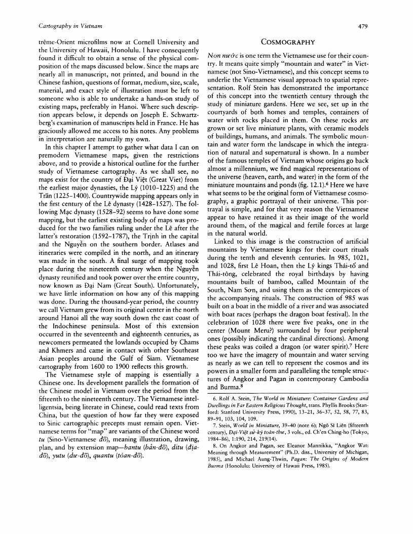
Non nu-ac is one term the Vietnamese use for their country. It means quite simply "mountain and water" in Vietnamese (not Sino-Vietnamese), and this concept seems tounderlie the Vietnamese visual approach to spatial representation. Rolf Stein has demonstrated the importanceof this concept into the twentieth century through thestudy of miniature gardens. Here we see, set up in thecourtyards of both homes and temples, containers ofwater with rocks placed in them. On these rocks aregrown or set live miniature plants, with ceramic modelsof buildings, humans, and animals. The symbolic mount~in and w~ter form the landscape in which the integratIon of natural and supernatural is shown. In a numberof the famous temples of Vietnam whose origins go backalmost a millennium, we find magical representations ofthe universe (heaven, earth, and water) in the form of theminiature mountains and ponds (fig. 12.1).6 Here we havewhat seems to be the original form of Vietnamese cosmography, a graphic portrayal of their universe. This portrayal is simple, and for that very reason the Vietnameseappear to have retained it as their image of the worldaround them, of the magical and fertile forces at largein the natural world.
Linked to this image is the construction of artificialmountains by Vietnamese kings for their court ritualsduring the tenth and eleventh centuries. In 985, 1021,and 1028, first Le Hoan, then the Ly kings Thai-to andThai-tong, celebrated the royal birthdays by havingmountains built of bamboo, called Mountain of theSouth, Nam So-n, and using them as the centerpieces ofthe accompanying rituals. The construction of 985 wasbuilt on a boat in the middle of a river and was associatedwith boat races (perhaps the dragon boat festival). In thecelebration of 1028 there were five peaks, one in thecenter (Mount Meru?) surrounded by four peripheralones (possibly indicating the cardinal directions). Amongthese peaks was coiled a dragon (or water spirit).7 Heretoo we have the imagery of mountain and water servingas nearly as we can tell to represent the cosmos and itspowers in a smaller form and paralleling the temple structures of Angkor and Pagan in contemporary Cambodiaand Burma.8
6. Rolf A. Stein, The World in Miniature: Container Gardens andDwellings in Far Eastern Religious Thought, trans. Phyllis Brooks (Stanford: Stanford University Press, 1990), 13-21, 36-37, 52, 58, 77, 83,89-91, 103, 104, 109.
7. Stein, World in Miniature, 39-40 (note 6); Ng6 S. Lien (fifteenthcentury), Dqi-Vi?t su--ky toan-thu-, 3 vols., ed. Ch'en Ching-ho (Tokyo,1984-86),1:190,214, 219(14).
8. On Angkor and Pagan, see Eleanor Mannikka, "Angkor Wat:Meaning through Measurement" (Ph.D. diss., University of Michigan,1985), and Michael Aung-Thwin, Pagan: The Origins of ModernBurma (Honolulu: University of Hawaii Press, 1985).
480 Cartography in Korea, Japan, and Vietnam
FIG. 12.1. VIETNAMESE COSMOGRAPHY. This drawing ofa miniature garden in the temple of Tran Vii (Hanoi) in theearly 1940s shows the pattern of mountains and water in Vietnamese cosmography.
Although there are no sources to say whether this formof royal ritual continued beyond 1028, we may easilytransfer the imagery to the Buddhist structures of thefollowing three centuries. Just north of the capital ofThang-long (now Hanoi) lay the temple of V~n-phuc,
which we know has existed since at least 1057. It is a140-foot brick tower built on ascending terraces andflanked by two sacred ponds. Though the temple is builtin Chinese fashion, the existence of the ponds was adistinctively Vietnamese trait and continued the conjunction of mountain and water as cosmic symbolism.9
This style of Buddhist temple, the tower, continued fromthe eleventh century into the fourteenth, the years of theLy and Tran dynasties. The Vietnamese state of thesecenturies was more akin to its contemporaries in Southeast Asia than to the Song state in China. The Vietnameseadministration depended on personal ties, not bureaucratic ones, and its cosmology was Hindu-Buddhist.
An attempt to strengthen central power occurred inthe mid-thirteenth century, but the Mongol threat andsubsequent invasions in the second half of the century
Size of the original: 12.7 X 19.2 em. From Rolf A. Stein, "Jardinsen miniature d'Extreme-Orient," Bulletin de l'Ecole Fran~aise
d'Extreme-Orient 42 (1943): 1-104, esp. pI. III.
deflected it. Royal power primarily covered the areaimmediately around the capital, while outer areas werecontrolled indirectly through local intermediaries orpowerful figures (royal or otherwise) designated by thethrone. In either case, the capital had no direct controlover these outer areas. The king gained access to theirresources only so far as the area remained loyal to thecenter. No maps of D~i Vi~t exist from these centuries,though the Vietnamese history Dqi-Vi~t su--ky toimthtr (Complete book of the historical records of GreatViet, 1479) mentions two that dealt with the outerreaches of the kingdom, one from the late eleventh century, the other from a century later. The first was drawnup by the famous minister Ly ThltO'ng Ki~t in 1075 andcovered the then southern frontier with Champa (southof Ngh~-an Province and the Col des Nuages, the old
9. Louis Bezacier, Cart vietnamien (Paris: Editions de l'Union Fran~aise, 1954), 135 If.; idem, Releves de monuments anciens du NordVi?t-nam (Paris: Ecole Fran~aise d'Extreme-Orient, 1959), pis. 14-23;Stein, World in Miniature, 14-15 (note 6).

Cartography in Vietnam
"southern border," Nam-gifri).lo The map of the 1170scalled the N am-hac phien-dai dia-do (Atlas of th;boundaries to the south and north), resulted, we are told,from a royal inspection tour of the coasts and the frontiers. II The Dqi-Vi?t sir-ky toan-thU' specifically noted"the mountains and the streams" (san xuyen in SinoVietnamese) as being the focal points for each effort.
In general, however, there is little evidence that theVietnamese before the fifteenth century had either muchinclination to map or the centralized control needed tobring data together for an atlas of the country. Thecosmography, which in its simplest form required just thesymbols of a mountain and a pond, continued throughthese centuries. Linked to it were the spirit cults, basedas they were in specific localities across the country. Thisspiritual geography, though unmapped, provided a senseof place for the Vietnamese. It also reflected the influenceof the Chinese science of geomancy. As Ungar has noted,"One envisions a spiritual map of sacred places: nodesof potent configurations of mountains and waters, connected by subterranean 'veins' (mqch) through which geomantic energy flowed." During these centuries, the Vietnamese were growing ever more conscious of theircultural territory and its boundaries. Rather than a vagueconception of their own territory fading into the distance,they began to develop a sense of where it ended and ofwhat cultural configurations lay on the other side. Thisterritory had originally included the Hundred Yue (inSino-Vietnamese Vi~t) and stretched from the YangtzeRiver in the north to Champa in the south.12 Across theVietnamese northern border lay China and its encroaching power, while to the south and west were SoutheastAsian peoples and kingdoms, the Chams, the Thais/Laos,and others.
By the late fourteenth century, the Vietnamese wereexplicitly setting themselves apart from their neighbors.In the 1370s the Vietnamese royal court banned "northern" (Chinese) clothing and the Cham and Lao languages.Over half a century later (in the 1430s), the first Vietnamese geography, DU' dia chi (Geographical record),modeled on the classic Chinese text the "Yu gong" (Tribute of Yu), continued this effort to draw a cultural linebetween the land of D~i Vi~t and the peoples beyond itsborders. I3 Yet the Vietnamese maintained their nonvisualapproach to their land. Even though both Vietnameseand Chinese texts of the late fourteenth and early fifteenth centuries were rich in detail on the riverine natureof Vietnam,14 no maps exist to show us the view fromthese times of either the intricate pattern of water communications or the territorial separation of Vietnameseand non-Vietnamese.
481
MAPS OF D41 VI~T
Maps became important for the Vietnamese when thegovernment of D~i Vi~t adopted the Sinic bureaucraticmodel in the second half of the fifteenth century. Following half a century of crisis from the 1370s to the 1420s(Cham invasions, 1371-90, the H6 regime, 1400-1407,and the Ming occupation, 1407-27), the liberator of Vietnam, Le Lgi, established a new dynasty that continuedmany of the elements of the old world. The new kingwas, however, very interested in maintaining a strongerresource base for the central government and acted toestablish a system of public land that would ensure it.At the same time, the Le court was ideologically open,and a new strand of modernist Neo-Confucian thoughtmodeled on that of Ming China appeared, advocated byyounger scholars.
After three decades of intermittent strife, the modernist group of scholars, with a young king supporting them,overcame the resistance of the conservative military oligarchy that had helped found the dynasty. The youngking, Le Thanh-tong (1460-97), promptly took theopportunity to change the orientation of the state. Duringthe 1460s, he initiated triennial Neo-Confucian examinations, used the successful scholars in his government,and established a centralized bureaucratic administration.The government, staffed by literati-officials, now penetrated all the way to the village and was able both topreach the new moral precepts and to gain a strongercontrol of local resources. Almost immediately, a largeamount of information began to flow from the provincesinto the capital of Thang-Iong, including population figures in 1465. Local officials were expected to travelthroughout their jurisdictions and to know them at firsthand. Within a hundred days of arriving at their posts,
10. Dqi-Vi~t su--ky toan-thu-, 1:248 (note 7). Specifically, the mappingcovered the three territories of Bo-chinh, Dia-Iy (Lam-binh), and Malinh (Minn-linh); see Hang-dire ban dO, 16-17, 46-48, 193 (note 1).
11. Dqi-Vi~t su--ky toan-thu-, 1:299 (note 7); Emile Gaspardone, "Bibliographie annamite," Bulletin de I'Ecole Fran~aise d'Extreme-Orient34 (1934): 1-173, esp. 45-46 (#21).
12. Esta S. Ungar, "From Myth to History: Imagined Polities in 14thCentury Vietnam," in Southeast Asia in the 9th to 14th Centuries, ed.David G. Marr and A. C. Milner (Singapore: Institute of Southeast AsianStudies, 1986), 177-86, quotation on 179; on Vietnamese geomancy,see Pierre Huard and Maurice Durand, Connaissanee du Viet-Nam(Hanoi: Ecole Fran<;aise d'Extreme-Orient, 1954), 70-71. .
13. O. W. Wolters, Two Essays on Dqi-Vi~t in the Fourteenth Century (New Haven: Council on Southeast Asia Studies, Yale Center forInternational and Area Studies, 1988), 31, 32, 41; John K. Whitmore,Vietnam, Ho Quy Ly, and the Ming (1371-1421) (New Haven: YaleCenter for International and Area Studies, 1985), 16; Nguy~n Trai(1380-1442), "Du- dia chi" (Geographical record), in NguyJn Trai ToanTIjp (Complete collection of the works of Nguy~n Trai) (Hanoi, 1969),186-227, esp. 222-23.
14. Wolters, Two Essays, xvii, xxxviii n. 21 (note 13).
482 Cartography in Korea, Japan, and Vietnam
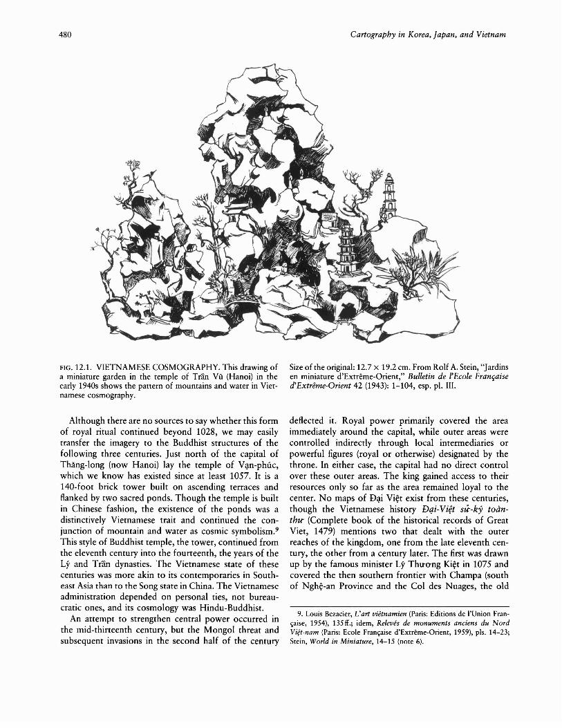
FIG. 12.2. TONG-QUAT MAP. This possibly sixteenth-century(M~c) map (the earliest extant Vietnamese map?) shows thecountry of D~i Vi~t but emphasizes the north rather than what
the officials had to submit a detailed report on their jurisdictions.Is
In 1467 the king sent the twelve provinces an order tomap the country. In it he commanded the officials todraw careful maps of their provinces' topography, illustrating the mountains and streams and pointing out thestrategic areas, the communication routes, and historicaland contemporary features. These maps were then to besent to the capital where, in 1469, they were combinedwith data on the numbers and different types of localcommunities to establish the official maps for the twelveprovinces. Twenty-one years later, in 1490, Thanh-tongaccepted the Thien-hq ban-do (Maps of all under heaven[the empire]) as the official atlas for his realm, nowexpanded to thirteen provinces with the conquest ofChampa in 1479 and the annexation of its northern territories. I6
The Hanoi scholar Bui Thiet has stated that there
was then the south (home of the Le). North is at the top.Photograph courtesy of Hamilton Library, University of Hawaiiat Manoa, Honolulu (microfilm collection, A.2499).
appear to be no existing maps from this first period ofVietnamese cartographyP As we shall see below, all themaps known to us that can be linked to these originalmaps are seventeenth century or later. Yet there is onemap, unstudied as far as I know, that offers the possibilityof being from before 1600. It is unlike what comes tobe the standard Le dynasty map and has much information on it. It will require a detailed examination forfull understanding. Here I can only introduce it and makesome initial comments.
This map, which I shall call the T6ng-qwlt map, is fixedas a sort of appendix to the Le atlas in a section called
15. John K. Whitmore, Transforming Dqi Vi~t: Politics and Confucianism in the Fifteenth Century (forthcoming), chap. 5.
16. Dqi-Vi~t su--ky toan-th£r, 2:665(62), 676(11), 736(8) (note 7); Gaspardone, "Bibliographie," 46 (#22) (note 11).
17. Bui, "Ban do," 49-50 (note 2).

Cartography in Vietnam
"Ban-quoc ban-do tong-quat m\lc-l\lc" (Index and overview of the maps of our country).18 It is unrelated to thewritten text attached to it and is totally concerned withD~i Vi~t, making almost no mention of any neighboringcountry or people (a local prefecture in southwesternChina being the lone exception). Bearing a northern orientation, this map is a sketch drawn in a simple style (fig.12.2). It apparently covers two sides of a sheet and consists of a line drawing showing the rivers and the landbetween them. No pattern was used to show water inthe rivers, and only a few scattered mountains are drawnin, employing the standard Chinese three-ridge style.19
Location is shown by the numerous written names, withno signs. The result is a map that gives a sense of crowdedplaces and of water where there is no land. Hence, stylistically, it could easily represent an early Vietnameseattempt to render a picture of the country.
The information provided by the names on the mapseems rather mixed, at least from my initial examinationof it. There are over three hundred names, fifteen of themcircled for emphasis. These fifteen place-names includethe capital city, called here An-nam Long-bien Thanh (areference to the days of Tang dynasty control in theregion), the West Lake outside the capital, the site of thecult to the legendary Hung kings, and twelve provinces.The term for province, used only for the five central (RedRiver Delta) provinces (Kinh-bc\c, Hai-du-o-ng, So-n-tay,So-n-nam, and An-bang), is thira-chinh (seat of the provincial government), derived from the term applied in the1460s. The other seven provinces, in the northern andwestern mountains and the then-southern plains, areidentified by name only. The curious point here is thatone of these "provinces" is Cao-b~ng, which did notbecome a separate province until the late seventeenthcentury. On the other hand, the normal twelfth provinceof 1469, the southernmost one of Thu~n-hoa, is herelisted uncircled in its two old parts of Thu~n-chau andHoa-chau. The new thirteenth province, listed in 1490,Quang-nam, south of Thu~n-hoa, also appears uncircledbut is shown as an estuary. Overall, this map shows adecided lack of interest in the southern area. There is noemphasis on Thanh-hoa and Ngh~-an provinces, whichformed the home base of the Le dynasty, and the WesternCapital (Tay-kinh), the original home of the Le, does notappear at all.
The most important evidence for an early date for thismap is that An-bang Province is not called An-quang, asit was from the late sixteenth century on, and Thai-nguyen is not called Ninh-soc, as it was between 1469 and1490.20 The capital is also known as Ph\lng-thien, a termLe Thanh-tong used for it. Although this set of termsmight have come from the late fifteenth century, my inclination is to see the map as a product of the M~c dynastyin the following century. This new dynasty ignored the
483
sites significant to its predecessor, did not control thesouth-hence its lack of focus in that direction-and hada decided interest in the northern mountains (especiallyCao-b~ng, where it would take refuge on its defeat). Inaddition, the M~c had a strong reason, as I shall discussbelow, to maintain the institutions of Le Thanh-tong'sHong-dfrc period (1471-97). Until a more detailed studyof the terms on this map can be made, we may see it asthe only extant pre-seventeenth-century Vietnamese map.
The standard Le dynasty atlas derives from the cartographic activity of the second half of the fifteenth century,but all extant copies show signs of having been redrawnin the seventeenth century or later. First of all, An-quangis the contemporary name for An-bang Province, and thischange occurred after the Le Restoration of 1592. Inaddition, the map of the capital shows the location ofthe Trinh chua's (lord's) residence, the palace of theprince (vu-ung phu). This is another indication of a postrestoration date, since the Trinh held power in Thanglong only after they had placed the Le back on thethrone.21
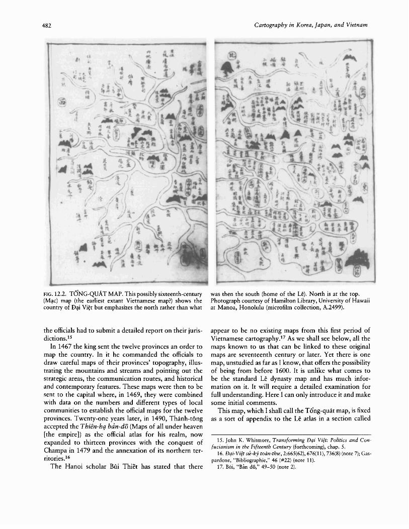
The Le atlas consists of fifteen maps: the entire country, the capital, and the thirteen provinces (fig. 12.3). Themaps generally have a western orientation22 and are moresophisticated than the Tong-quat map discussed above.In particular, water is shown in the rivers (the flow of thecurrent) and the sea (roiling waves), thus providing agreater sense of the solidity of the land. The mountainsare drawn in the same three-ridge style, but now they fillout the landscape more and provide a better sense ofVietnam's topography. Human constructions (walls, temples, and palaces), when drawn, are shown in frontal elevation on these maps. All other features are noted bywritten terms. The main purpose of these maps is administrative, and consequently they record the locations ofthe various jurisdictions (province, prefecture, and district), generally in rectangular boxes with no hierarchypresent. Other names record either mountains or riverinefeatures, with an occasional human construction noted,not drawn.
The map of D~i Vi~t as a whole includes borderlandsof the countries to the north and south, China and
18. Hong-du-c ban do, 50-53 (note 1).19. For the style of mountains in Chinese cartography, see David
Woo, "The Evolution of Mountain Symbols in Traditional ChineseCartography," paper presented at the 1989 annual meeting of the Association of American Geographers.
20. Hong-du-c ban do, 189, 196, 198 (note 1).21. Hong-du-c ban dO, XI, XIV-XV, XXV (note 1); see also Bili, "Ban
do," 50-52 (note 2).22. Hong-du-c ban dO, 2-49 (note 1). The maps of Kinh-bc\c and
Thai-nguyen have an eastern orientation and those of Hai-du-O'ng andL~ng-sO'n a northern one. The Le atlas also came to be known asHong-du-c ban dO, but I will refer to it in this chapter as the Le atlasto avoid confusion with the larger collection and published volume.

484 Cartography in Korea, Japan, and Vietnam
FIG. 12.3. REFERENCE MAP FOR THE STUDY OF DAIVI~T CARTOGRAPHY. .After Nguy~n Kh~c Vi~n, Vietnam: A Long History (Hanoi:Foreign Languages Publishing House, 1987),99.
Champa, and shows what demarcates Vietnam fromthese two states: walls on the north and a stone inscription on the south (fig. 12.4).23 To the northwest is thesouthwestern Chinese province of Yunnan, and to thenortheast are the southeastern Chinese provinces ofGuangxi and Guangdong, marked by fortresses and notedas being respectively "location of the Hundred Yue" and"location of the Yue, capital of Chao To" (Tri~u Ba,king of Nam Vi~t in the second century B.C.). These latterphrases are the result of the Vietnamese cultural boundary construction of the fourteenth century. The two Vietnamese capitals are located: Trung-do (Thang-long[Hanoi]) in the central Red River Delta and Tay-kinh (the
23. Hong-dire ban do, 4-5 (note 1).24. Keith W. Taylor, "Notes on the Vift Difn U Linh Ttjp," Vietnam
Forum 8 (1986): 26-59, esp. 38.25. Hong-dire ban dO, 8-9 (note 1); Hoang E>~o Thily, Thimg Long,
Dong Do, Hd NQi (Hanoi, 1971), plate between 46 and 47; NguyenThanh-nha, Tableau eeonomique du Viet Nam aux XVlle et XVlllesiecles (Paris: Editions Cujas, 1970), 111-17.
26. On this environment, see Pierre Gourou, Les paysans du deltatonkinois: Etudes de geographie humaine (1936; Paris: Mouron, 1965),17-108 ("Le milieu physique").
Western Capital) in the upriver part of Thanh-hoa Province. The only temples on this map reflect a ritual configuration. At the center, just outside the capital, lies thetemple to the spirit cult of Ly Ong TrQng, a mythic herobelieved to have helped the great Chinese emperor QinShihuang (third century B.C.) fight the barbarians and tohave protected the Vietnamese capital region thereafter.24
North, east, south, and west of the capital in the deltaare four Buddhist temples (Pha-h~i, Quynh-lam, Ph6minh, and Thien-phuc on Mount Ph~t-tich), standingguard over the Vietnamese domain.
The map of the capital, Thang-long, is the major citymap we have for Vietnam before 1800 (fig. 12.5). It isstrictly for government activities and court rituals, showing little of the thriving everyday and commerciallife.25
The shape of the outer citadel is irregular, fitted as it waswithin the watercourses surrounding the city. The imperial city within the citadel is, however, decidedly regular,with its proper Sinic north-south orientation. Outside thewalls of the citadel are shown the Bao-thien Buddhisttower, a central part of Vietnamese Hindu-Buddhistcosmography from the middle of the eleventh century,and the fifteenth-century site of the Nam-giao ceremony,the Confucian sacrifice to heaven. There are also theWhite Horse Temple (B~ch-ma tfr) and the temple ofTran Vii, sites of ancient cults, as well as the NationalCollege (Quoc-tu--giam). Within the walls of the citadelare various government buildings and palaces, togetherwith the grounds where the Confucian examinations wereheld.
The maps of the delta provinces (Kinh-b:\c, SO'n-tay,Hai-du-O'ng, An-quang, and especially SO'n-nam; fig. 12.6)reflect the riverine nature of their environment.26 In themwe find such features as the intertwining of streams meandering through the delta (nga-ba), canals (kinh), bridges(diu), channels (nra), and estuaries (man). In humanterms, we see Buddhist temples (tt{) and spirit cults(mieu), as well as some guard stations (tutin) and theoccasional major historical site (such as the old capitalat C6-loa) or tomb (for example, that of the old Tanggovernor Gao Pian). In the northern and western provinces (Thai-nguyen, Tuyen-quang, Hu-ng-hoa, and L~ng
sO'n), mountains are the dominant feature, both drawnand noted. Passes (ai) are indicated, as well as a scattering
I200 km
o
100 200 milesI I
Gulfof
Thailand
Cartography in Vietnam 485
FIG. 12.4. DAI VIET FROM THE LE ATLAS. This seventeenth-century (Tri~h) copy of the late fifteenth-century mapshows the country in its classic premodern format (west is atthe top).
of other natural features. The main human features aremilitary camps (doanh), guard posts (tuan), and walledcities (thanh). L~ng-sO"n Province shows a large fortresswith a gate leading into the Chinese province of Guangxi.Because the Le dynasty base was originally in the twosouthern provinces of Thanh-hoa and Ngh~-an, thesetwo maps come first in the atlas. But they, together withthe newer provinces of Thu~n-hoaand Quang-nam, sharethe same features. They are part of what is now centralVietnam, and they have narrow lowlands lying betweenthe mountains and the sea, with short streams runningparallel to each other, usually from west to east. Theprominent feature is consequently the estuary (man).
The political situation of the sixteenth, seventeenth,and eighteenth centuries ensured that the cartographicpattern established by the Le king Thanh-tong in the latefifteenth century would continue. When the dynasty fell
Photograph courtesy of Hamilton Library, University of Hawaiiat Manoa, Honolulu (microfilm collection, A.2499).
into chaos following the death of Thanh-tang's sonHien-tong in 1504, later rulers made various efforts torestore what Thanh-tong had established in his greatHong-dfrc period. This was achieved only when the powerful minister M~c Dang Dung seized the throne andbegan his own dynasty in 1528. His legitimacy and thatof his family lay in rebuilding central power along thebureaucratic lines Thanh-tong had first set up sixty yearsearlierP As far as we can tell from the surviving evidence,the M~c retained and developed the fifteenth-centuryinstitutions. If the T6ng-quat map is a M~c production,they continued the Hong-dfrc provincial organization, atleast in the territory they controlled.
27. John K. Whitmore, "Chung-hsing and Ch'eng-t'ung in D~i Vi~t:
Historiography in and of the Sixteenth Century," in Textual Studieson the Vietnamese Past, ed. Keith W. Taylor (forthcoming).

486 Cartography in Korea, Japan, and Vietnam
FIG. 12.5. THE CAPITAL FROM THE LE ATLAS. This seventeenth-century (Trinh) copy of the late fifteenth-century mapshows the Vietnamese capital of Thang-long (now Hanoi), fittedwithin the waters of the Red River and its delta (west is at thetop).
The Trinh military regime, which brought the Le backto the throne, picked up the Hong-dfrc institutions preserved by the M~c. The Trinh did not, however, emphasize the civilian elements as they contested the Le legacywith their erstwhile allies, the Nguy~n. The latter hadestablished their base on the southern frontier in thenewest province of Quang-nam during the sixteenth century and now claimed that the Trinh were usurpers. Sincethese two families remained at loggerheads for almosttwo centuries, the cartographic tradition stayed frozen:both sides considered Thanh-tang's thirteen provinces tobe the established pattern.
In the middle of the seventeenth century, the collectionthat we now call the Hong-dire ban JO began to cometogether. Le/Trinh literati evidently redid the Le atlas,continuing the Hong-dfrc work with minor changes. One
Photograph courtesy of Hamilton Library, University of Hawaiiat Manoa, Honolulu (microfilm collection, A.2499).
scholar, D6 Ba, compiled the above-mentioned "Banquac ban-do tong-quat ml;lc-ll;lc," joined it with the (possibly) M~c map, and placed it at the end of the redrawnatlas late in the century. He also added the set of fouritineraries that I shall discuss in the following section.28
To all appearances, these remained the official maps ofD~i Vi¢t for the following century to the end of the Ledynasty in 1787. Despite population growth, little changeoccurred in the organization of the kingdom.29
The major geographical change for the Trinh zone ofD~i Vi¢t came later in the seventeenth century when their
28. Hong-du-c ban do, XV-XVI, XXVII-XXVIII, 52-53, 68-69 (note 1).
29. D~ng PhU"O"ng-nghi, Les institutions publiques du Viet-Nam auXVllJe siecle (Paris: Ecole Fran"aise d'Extreme-Orient, 1969), 77-79;Gaspardone, "Bibliographie," 47 (nOle 11), noted a report of a 1723"newly established map" that maintained the old Hong-due system.
Cartography in Vietnam 487
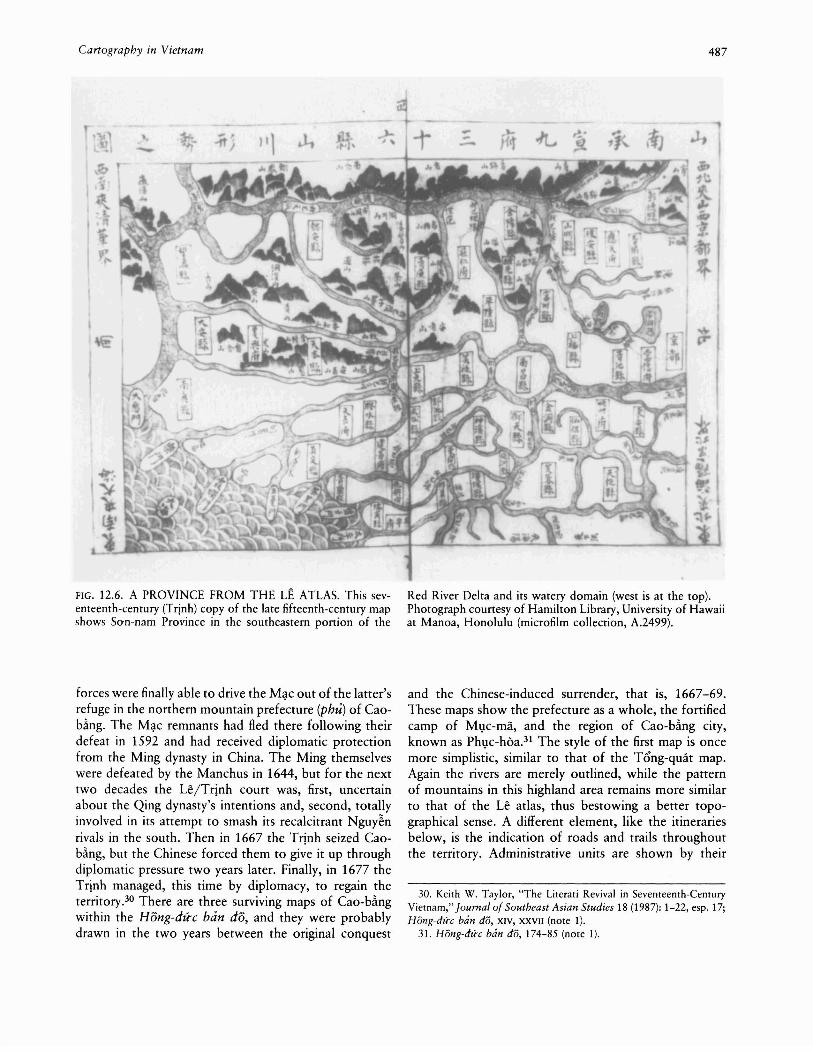
FIG. 12.6. A PROVINCE FROM THE LE ATLAS. This seventeenth-century (Trinh) copy of the late fifteenth-century mapshows So-n-nam Province in the southeastern ponion of the
forces were finally able to drive the M~c out of the latter'srefuge in the northern mountain prefecture (phu) of Caob~ng. The M~c remnants had fled there following theirdefeat in 1592 and had received diplomatic protectionfrom the Ming dynasty in China. The Ming themselveswere defeated by the Manchus in 1644, but for the nexttwo decades the U~/Trinh court was, first, uncertainabout the Qing dynasty's intentions and, second, totallyinvolved in its attempt to smash its recalcitrant Nguy~nrivals in the south. Then in 1667 the Trinh seized Caob~ng, but the Chinese forced them to give it up throughdiplomatic pressure two years later. Finally, in 1677 theTrinh managed, this time by diplomacy, to regain theterritory.3o There are three surviving maps of Cao-bhgwithin the Hong-dire ban do, and they were probablydrawn in the two years between the original conquest
Red River Delta and its watery domain (west is at the top).Photograph counesy of Hamilton Library, University of Hawaiiat Manoa, Honolulu (microfilm collection, A.2499).
and the Chinese-induced surrender, that is, 1667-69.These maps show the prefecture as a whole, the fortifiedcamp of Ml;lc-ma, and the region of Cao-bling city,known as Phl;lc-hoa.31 The style of the first map is oncemore simplistic, similar to that of the Tong-quat map.Again the rivers are merely outlined, while the patternof mountains in this highland area remains more similarto that of the Le atlas, thus bestowing a better topographical sense. A different element, like the itinerariesbelow, is the indication of roads and trails throughoutthe territory. Administrative units are shown by their
30. Keith W. Taylor, "The Literati Revival in Seventeenth-CenturyVietnam," Journal of Southeast Asian Studies 18 (1987): 1-22, esp. 17;Hong-du-c ban do, XIV, XXVII (note 1).
31. Hong-du-c ban do, 174-85 (note 1).
488 Cartography in Korea, Japan, and Vietnam
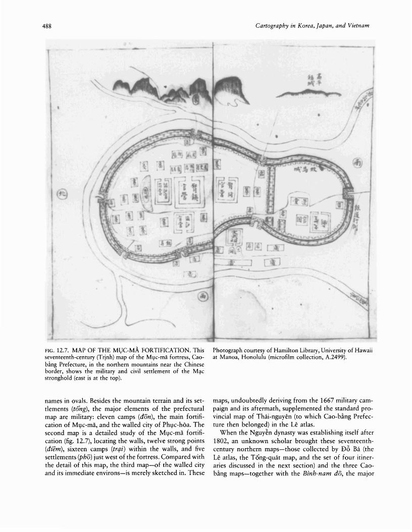
FIG. 12.7. MAP OF THE MUC-MA. FORTIFICATION. Thisseventeenth-century (Trinh) m'ap of the Ml,1c-ma fortress, Caob~ng Prefecture, in the northern mountains near the Chineseborder, shows the military and civil settlement of the M~c
stronghold (east is at the top).
names in ovals. Besides the mountain terrain and its settlements (torzg), the major elements of the prefecturalmap are military: eleven camps (don), the main fortification of Ml)c-ma, and the walled city of Phl)c-hOa. Thesecond map is a detailed study of the Ml)c-ma fortification (fig. 12.7), locating the walls, twelve strong points(diem), sixteen camps (trqi) within the walls, and fivesettlements (phD) just west of the fortress. Compared withthe detail of this map, the third map-of the walled cityand its immediate environs-is merely sketched in. These
Photograph courtesy of Hamilton Library, University of Hawaiiat Manoa, Honolulu (microfilm collection, A.2499).
maps, undoubtedly deriving from the 1667 military campaign and its aftermath, supplemented the standard provincial map of Thai-nguyen (to which Cao-b.ing Prefecture then belonged) in the Le atlas.
When the Nguy~n dynasty was establishing itself after1802, an unknown scholar brought these seventeenthcentury northern maps-those collected by Db Ba (theLe atlas, the Tong-quat map, and the set of four itineraries discussed in the next section) and the three Caob.ing maps-together with the Binh-nam do, the major

Cartography in Vietnam 489
FIG. 12.8. A PROVINCE FROM THE AN-NAM HiNHTHANG DO. This possibly mid-eighteenth-century (Trinh)copy of the late fifteenth-century map shows the northern highland province of Thai-nguyen and the new vertical style ofillustrating the mountains (west is at the top).
map made in the south, and the Dqi-Man quae-do, alater one from the north (both discussed below), probablyto help set up the administration of the then newly unifiedcoumry.32 This came to form the present collectioncalled the Hong-dire ban do. Although this is the mostimportant collection, others are known to exist, evidentlycopies (at least in part) of it.
The chief example of a later version is the An-namhinh-thdng do (Illustrated maps of An-nan).33 The versions of the Le atlas maps found in the An-nam hinh-
Photograph courtesy of Hamilton Library, University of Hawaiiat Manoa, Honolulu (microfilm collection, A.3034).
thdng do are basically the same as in the Hong-dire bandO; even the orientation of each map is the same (Kinhbk an eastern one, Hai-dl.r<rng northern). Yet the styleof the drawing differs greatly (fig. 12.8). Although againonly lines are used to delineate water and land, the mountains have moved from the earlier three-ridge style towardthe naturalistic landscape mode with its vertical exag-
32. Hong-du-c ban do, XIV, XVII, XXVII, XXIX (note 1).33. A.3034 (reel 114, no. 171).

490
geration, just as in Chinese cartography.34 In this way theVietnamese imitated the karst formations of their northern border. The mountains are no longer mere outlinesbut are well drawn, with specks of vegetation on them.Temples and walls are given a more Chinese quality aswell. One map even shows waves lapping the shore.Somewhat arbitrarily, I believe that the redrawing of themaps now in the An-nam hi'nh-th&ng do took place inthe eighteenth century. The one substantive change thatleaps to the eye is in the center of the map of the country.No longer is the temple to the cult of Ly Gng TrQngthere (though it is on the map of San-tay Province);rather, the Bao-thien tower now stands at the capital.The emphasis on this Buddhist protective element at thecenter of Dqi Vi~t may have been a result of the Buddhistresurgence in the seventeenth and eighteenth centuries.
In general, we may say that the tradition of the Le atlasremained a strong one in Vietnamese history. It appearsin a number of different versions and artistic stylesthrough the eighteenth and nineteenth centuries and intothe twentieth. Yet the information contained on the mapsvaried little. As Joseph Schwartzberg has noted in viewingthese collections, "There appears to be a variety of individuals drawing the maps, which would help to accountfor the wide variety of styles in the depiction of particulartypes of features. Here and there are some idiosyncratictouches."35 A good example of ,how far this atlas tradition continued and of how little it actually changedmay be seen in an artistically redrawn version from theearly twentieth century (see below). This version almostexactly maintains (with a few errors) the information contained in the Le atlas of at least two centuries earlier.36
ITINERARIES OF Di.\I VI~T
The other major type of Le dynasty map is the itinerary,generally tracing the route from the Vietnamese capitalto a location on or beyond either the southern or thenorthern border. This type of cartography seems to havebegun with the great military expedition led by Le Thanhtong as he crushed the southern state of Champa in 1471.The Dq,i-Vi~t su--ky toan-thtr noted that on this campaign the king consulted a map of Champa as his armiesmoved south and began to change the names linked tothe mountains and rivers there. With the Vietnamesemarching into Champa, Thanh-tong became apprehensive about the difficulties of knowing the terrain and hada local chief help draw up another, more detailed mapof the area, focusing on strategic points and on goodroutes through the mountains and across the streams.37
These efforts undoubtedly laid the foundation for thefirst of four sets of maps, the route south to Champa, inthe T hien-nam tir-chi h)-do thtr (Book of maps of themajor routes of Thien-nam). Again, when the maps were
Cartography in Korea, Japan, and Vietnam
originally drawn is unknown. The term Thien-nam (Southof Heaven) implies the fifteenth century, since Thanhtong was the first to use it.
Once more, we know the text only in its seventeenthcentury form. As I noted earlier, the scholar D6 Babrought it together with the Le atlas and the "Ban-quocban-do tong-quat m\lc-l\lc" late in the seventeenth century at a time when road maintenance had taken on addedimportance.38 The four routes move from the Vietnamesecapital of Thang-Iong: south to the Cham capital (thirtyone pages of maps); northeast to the two regions of Khamand Ni~m along the coast near the Chinese border (tenpages of maps); northwest to the southwestern Chineseprovince of Yunnan (ten pages of maps); and north tothe great gateway into the southeastern Chinese provinceof Guangxi (ten pages of maps).39 The style of these mapsalso returns to that of the Tong-quat map, with only linesseparating land and water. Again, however, as in the Leatlas, the topography is shown in the form of three-ridgemountains and the administrative units are indicated bynames within boxes. Some human construction issketched in, particularly the southern fortifications. Beingitineraries, the maps show the paths to be taken throughthe landscape (fig. 12.9). Although the text of each sectionseems to speak of routes by land, water, and sea, whatthey mean is that the maps show the distinctive featuresof all three environments, differing from route to route.
The route to the southern border and Champa40 beginsby noting the features for the different environments:land-inns and bridges; water-rivers, canals, and harbors; sea-estuaries, currents, shallows, and deeps. Compared with the Le atlas, the maps for these itinerariesshow much more detail of the common and commerciallife in Vietnam. As we move across the southern provinces, we encounter villages, markets, inns, temples, guardstations, and other local institutions lying close by theroad. Bridges, ferries, creeks, confluences of streams, rapids, estuaries, and dangerous places are noted. The route
34. Woo, "Evolution" (note 19).35. Personal communication (July 1991).36. T(;l TrQng Hi~p, "Les fonds de livres en Han Nom hors du Viet
nam: Elements d'inventaires," Bulletin de ['Ecole Fran~aise d'ExtremeOrient 75 (1986): 267-93, esp. 285-86. See also Bui, "Ban do," 51-52(note 2).
37. Dqi-Vi?t su--ky toan-thu-, 2:682(27) and 683(1) (note 7); GustaveDumoutier, "Etude sur un portulan annamite du xve siecle," Bulletinde Geographie Historique et Descriptive 11 (1896): 141-204, esp. 14142.
38. Hong-dire ban do, XII-XIII, XXV-XXVI (note 1); Henri Maspero,"Le protectorat general d'Annam sous les T'ang (I): Essai de geographiehistorique," Bulletin de ['Ecole Fran~aise d'Extreme-Orient 10 (1910):539-84, esp. 542; Nguyen, Tableau, 177-81 (note 25).
39. Hong-dire ban do, 66-137 (note 1). Curiously, the routes westinto Laos are ignored; see Nguyen, Tableau, 195 (note 25).
40. Hong-dire ban do, 70-103 (note 1).

Cartography in Vietnam 491
FIG. 12.9. THIEN-NAM Tli-CHi LQ-DOTHU, PORTIONOF THE ITINERARY TO THE SOUTH. This portion of theseventeenth-century (Trinh) itinerary shows the road throughthe mountainous area of southern Thanh-hoa Province and
moves out of the Red River Delta, across Thanh-hoa andNgh~-an, past the old southern border (Nam-gio-i), andinto the militarized zone. Here the Nguy~n, controllingthe south, built their defensive walls, which the Trinhassaulted sporadically without success for half a century(from the 1620s to the 1670s). Marked out on the mapare the series of walls, known generally under the nameDong-ho-i, and the military support accompanying them:arms depots, camps, entrenched and artillery positions,granaries, and elephant stables. Interspersed among thesefeatures are the villages and markets of everyday life. Thiszone ends on the map at about Da-n~ng. After that thedetail lessens somewhat-not surprisingly, since it was anitinerary to the south made in the north. Going past themajor port of HQi-an, villages, lagoons, estuaries, islands,
northern Ngh~-an Province in north-central Vietnam (west isat the top).Photograph courtesy of Hamilton Library, University of Hawaiiat Manoa, Honolulu (microfilm collection, A.2499).
and more mountains are the major features along thecoast as it stretches south. Beyond Nha-trang and Camranh Bay, the capital of Champa is reached. Here distances are distorted as the northern sense of locationbecame vague, trying to blend what mapmakers heard ofthe distant reality with the detail of their old maps.41
The other three routes in the collection all concernthe north, going from the Vietnamese capital to somepoint on or near the Chinese border. The first moves tothe northeast, going through the delta to the coast.Besides the usual inns, bridges, and streams, there is anemphasis on the sea, with its rocks and waves. The mainlocal human institution noted is the market, perhaps indi-
41. Hong-du-c ban do, XIII, XXVI (note 1).

492 Cartography in Korea, Japan, and Vietnam
J
FIG. 12.10. THIEN-NAM Tir-CHi LQ-VOTHU, PORTIONOF THE ITINERARY TO GUANGXI PROVINCE. This is thelast portion of the itinerary to the north through L'\Ing-sanProvince (and its citadel) to the gateway leading into Guangxi
eating a commercial route. The second route goes to thenorthwest, through the mountains to Yunnan. Here theemphasis is on the mountains and on the rivers passingthrough them. Military camps and posts are indicated,but the main human feature, noted only by name, is thetf/ng or upland community. The route moves upstream,through the headwaters, to Guangnan Prefecture in Yunnan. The final route was the official one for Vietnameseembassies traveling to the Chinese capital of Beijing.Going north from the capital, the map shows the usualfeatures, natural and human. Markets, posts, and campsappear before the route moves upriver through variousdefiles past the walled city of L~ng-sO'n to the great gateon the Chinese border leading into Guangxi Province (fig.12.10). These maps do not show the mountain communities as those of the previous route do.
Province, the route generally taken by Vietnamese embassiesto China.Photograph courtesy of Hamilton Library, University of Hawaiiat Manoa, Honolulu (microfilm collection, A.2499).
The Thien-nam tu--chi lQ-do thl< is thus a guide to agood part of the kingdom of D~i Vi~t. The maps showus the "beaten paths," the main communication routesthroughout the kingdom, and much of the natural andhuman detail lying along these routes. They also showus the international routes of communication by land,ignoring the important sea connections. Yet, as I havenoted, the maps cannot show us all of Vietnam at thetime. The Le/Trinh cartographers were blocked by theNguy~n and their defensive walls from penetrating thesouthern lands. Here Vietnamese society was expandingsouthward down the coastal lowlands through Cham territory into the Khmer domain, building roads as it went.For information on this area, we need to look at theBinh-nam do (Maps of the pacification of the south),covering "from [the walls of] Dong-h&i to the border of
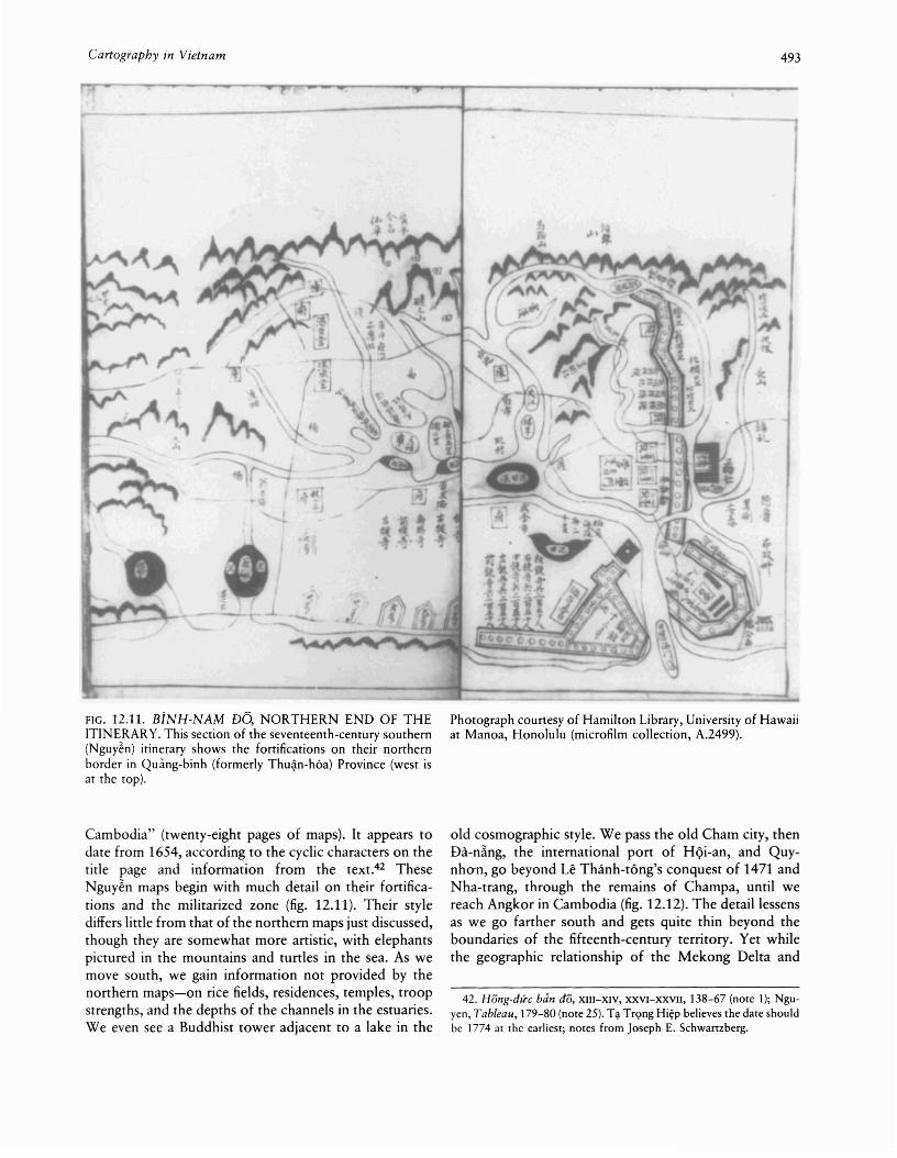
Cartography in Vietnam 493
FIG. 12.11. BiNH-NAM DO, NORTHERN END OF THEITINERARY. This section of the seventeenth-century southern(Nguy~n) itinerary shows the fortifications on their northernborder in Quimg-binh (formerly Thu~n-h6a) Province (west isat the top).
Cambodia" (twenty-eight pages of maps). It appears todate from 1654, according to the cyclic characters on thetitle page and information from the text.42 TheseNguy~n maps begin with much detail on their fortifications and the militarized zone (fig. 12.11). Their stylediffers little from that of the northern maps just discussed,though they are somewhat more artistic, with elephantspictured in the mountains and turtles in the sea. As wemove south, we gain information not provided by thenorthern maps-on rice fields, residences, temples, troopstrengths, and the depths of the channels in the estuaries.We even see a Buddhist tower adjacent to a lake in the
Photograph courtesy of Hamilton Library, University of Hawaiiat Manoa, Honolulu (microfilm collection, A.2499).
old cosmographic style. We pass the old Cham city, thenDa-n~ng, the international port of HQi-an, and Quynhan, go beyond Le Thanh-tong's conquest of 1471 andNha-trang, through the remains of Champa, until wereach Angkor in Cambodia (fig. 12.12). The detail lessensas we go farther south and gets quite thin beyond theboundaries of the fifteenth-century territory. Yet whilethe geographic relationship of the Mekong Delta and
42. Hong-dire ban dO, XIII-XIV, XXVI-XXVII, 138-67 (note 1); Nguyen, Tableau, 179-80 (note 25). T<;I Tr<;>ng Hiep believes the date shouldbe 1774 at the earliest; notes from Joseph E. Schwartzberg.
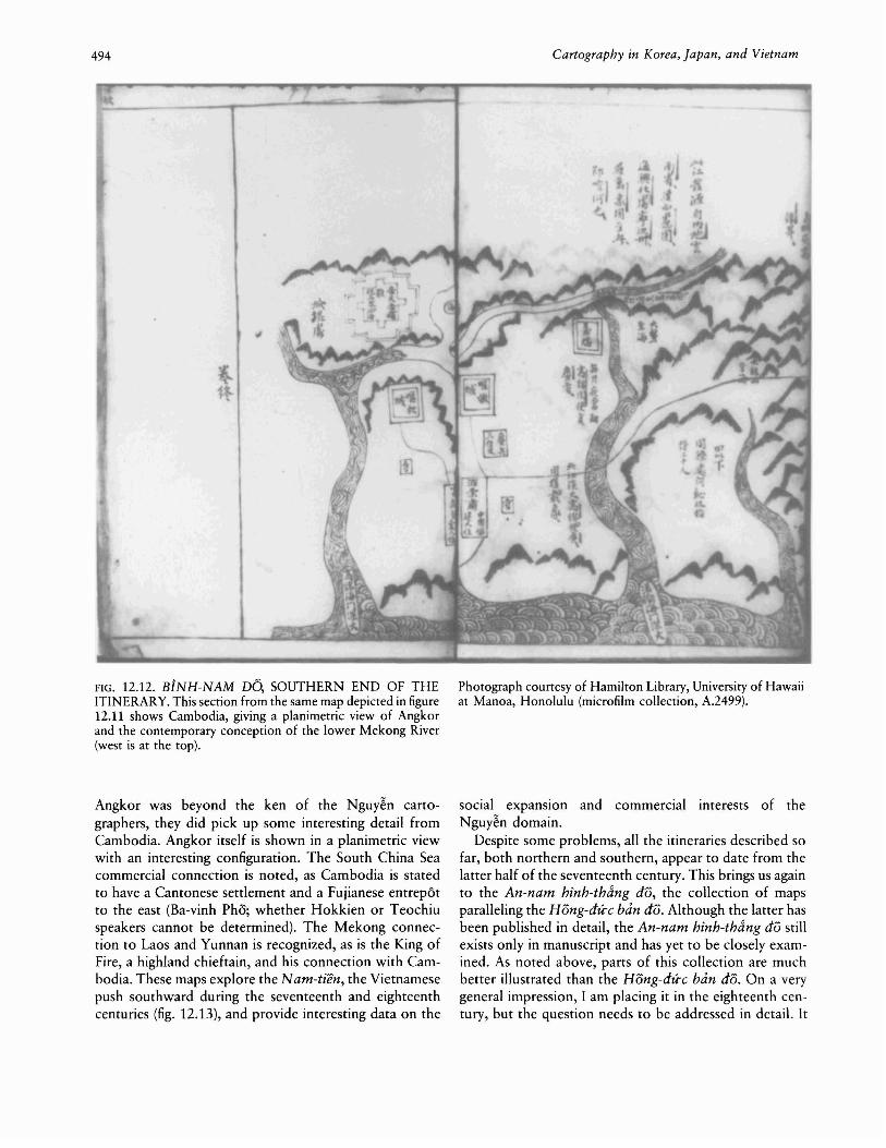
494 Cartography in Korea, Japan, and Vietnam
FIG. 12.12. BiNH-NAM DO, SOUTHERN END OF THEITINERARY. This section from the same map depicted in figure12.11 shows Cambodia, giving a planimetric view of Angkorand the contemporary conception of the lower Mekong River(west is at the top).
Angkor was beyond the ken of the Nguy~n cartographers, they did pick up some interesting detail fromCambodia. Angkor itself is shown in a planimetric viewwith an interesting configuration. The South China Seacommercial connection is noted, as Cambodia is statedto have a Cantonese settlement and a Fujianese entrepotto the east (Ba-vinh Pho; whether Hokkien or Teochiuspeakers cannot be determined). The Mekong connection to Laos and Yunnan is recognized, as is the King ofFire, a highland chieftain, and his connection with Cambodia. These maps explore the Nam-tien, the Vietnamesepush southward during the seventeenth and eighteenthcenturies (fig. 12.13), and provide interesting data on the
Photograph courtesy of Hamilton Library, University of Hawaiiat Manoa, Honolulu (microfilm collection, A.2499).
social expansion and commercial interests of theNguy~n domain.
Despite some problems, all the itineraries described sofar, both northern and southern, appear to date from thelatter half of the seventeenth century. This brings us againto the An-nam hinh-thdng do, the collection of mapsparalleling the Hong-du-c ban do. Although the latter hasbeen published in detail, the An-nam hinh-thdng do stillexists only in manuscript and has yet to be closely examined. As noted above, parts of this collection are muchbetter illustrated than the Hong-du-c ban do. On a verygeneral impression, I am placing it in the eighteenth century, but the question needs to be addressed in detail. It
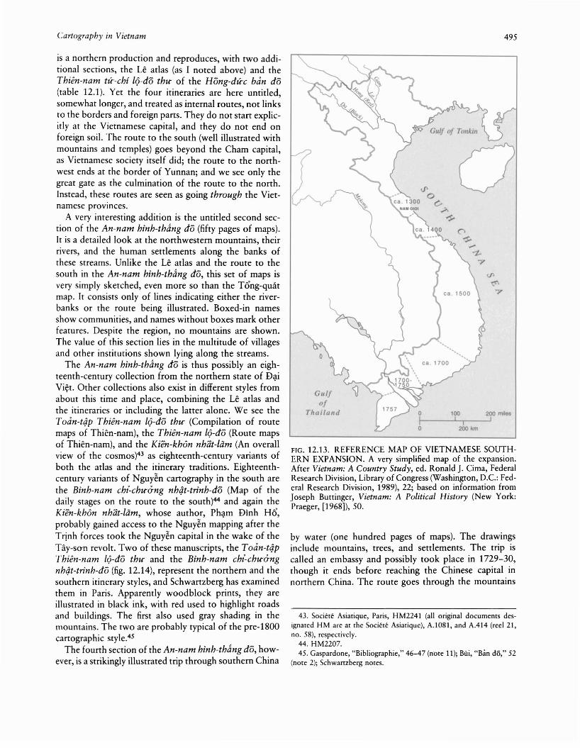
Cartography in Vietnam 495
43. Societe Asiatique, Patis, HM2241 (all otiginal documents designated HM are at the Societe Asiatique), A.l0Sl, and A.414 (reel 21,no. 58), respectively.
44. HM2207.45. Gaspardone, "Bibliographie," 46-47 (note 11); BiJi, "Ban do," 52
(note 2); Schwartzbetg notes.
by water (one hundred pages of maps). The drawingsinclude mountains, trees, and settlements. The trip iscalled an embassy and possibly took place in 1729-30,though it ends before reaching the Chinese capital innorthern China. The route goes through the mountains
FIG. 12.13. REFERENCE MAP OF VIETNAMESE SOUTHERN EXPANSION. A very simplified map of the expansion.After Vietnam: A Country Study, ed. Ronald J. Cima, FederalResearch Division, Library of Congress (Washington, D.C.: Federal Research Division, 1989), 22; based on information fromJoseph Buttinger, Vietnam: A Political History (New York:Praeger, [1968]), 50.
200km
'00 200 milesI I I
Gllifof
Thailalld
is a northern production and reproduces, with two additional sections, the Le atlas (as I noted above) and theThien-nam tic-chi IQ-do thtl' of the Hong-dice ban do(table 12.1). Yet the four itineraries are here untitled,somewhat longer, and treated as internal routes, not linksto the borders and foreign parts. They do not start explicitly at the Vietnamese capital, and they do not end onforeign soil. The route to the south (well illustrated withmountains and temples) goes beyond the Cham capital,as Vietnamese society itself did; the route to the northwest ends at the border of Yunnan; and we see only thegreat gate as the culmination of the route to the north.Instead, these routes are seen as going through the Vietnamese provInces.
A very interesting addition is the untitled second section of the An-nam hinh-thdng do (fifty pages of maps).It is a detailed look at the northwestern mountains, theirrivers, and the human settlements along the banks ofthese streams. Unlike the Le atlas and the route to thesouth in the An-nam hinh-thang do, this set of maps isvery simply sketched, even more so than the T6'ng-quarmap. It consists only of lines indicating either the riverbanks or the route being illustrated. Boxed-in namesshow communities, and names without boxes mark otherfeatures. Despite the region, no mountains are shown.The value of this section lies in the multitude of villagesand other institutions shown lying along the streams.
The An-nam hinh-thang do is thus possibly an eighteenth-century collection from the northern state of D~i
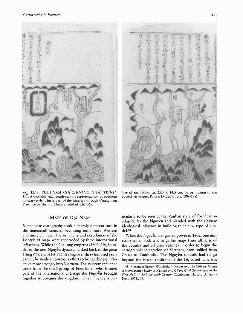
Vi~t. Other collections also exist in different styles fromabout this time and place, combining the Le atlas andthe itineraries or including the latter alone. We see theToan-t4p Thien-nam IQ-do thtl' (Compilation of routemaps of Thien-nam), the Thien-nam IQ-do (Route mapsof Thien-nam), and the Kien-khOn nhat-liim (An overallview of the cosmos)43 as eighteenth-century variants ofboth the atlas and the itinerary traditions. Eighteenthcentury variants of Nguy~n cartography in the south arethe Binh-nam chi-chtl'ang nh4t-trinh-do (Map of thedaily stages on the route to the south)44 and again theKien-kh6n nhat-liim, whose author, Ph~m Dlnh H6',probably gained access to the Nguy~n mapping after theTrinh forces took the Nguy~n capital in the wake of theTay-san revolt. Two of these manuscripts, the Toan-tqpThien-nam IQ-do thtl' and the Binh-nam chi-chtl'angnh4t-trinh-do (fig. 12.14), represent the northern and thesouthern itinerary styles, and Schwartzberg has examinedthem in Paris. Apparently woodblock prints, they areillustrated in black ink, with red used to highlight roadsand buildings. The first also used gray shading in themountains. The two are probably typical of the pre-1800cartographic style.45
The fourth section of the An-nam hinh-thang do, however, is a strikingly illustrated trip through southern China
496 Cartography in Korea, Japan, and Vietnam
TABLE 12.1 Comparison of Maps in the Hong-dire ban do and the An-nam hi'nh-th&ng do
Hong-du-c ban do
1 Le atlas, 15 maps (2 pages each for 9 maps and 1 pageeach for 6 maps)
2 "Ban-quoe ban-do tong-quat m\le-l\lc," 1 map (2 pages)
3 Thien-nam tu--chi IQ-dO thtl'Route to the south, 31 pages of mapsRoute to the northeast, 10 pages of mapsRoute to the northwest, 10 pages of mapsRoute to the north, 10 pages of maps
4 Binh-nam do, 28 pages of maps
5 Dqi-Man quae-do, 1 map (2 pages)
6 Cao-bdng phu toan dO (The complete map of the
prefecture of Cao-bang), 3 maps (2-3 pages each)
of northern Vietnam, the province of L~ng-so-n, and thegreat gate on the Guangxi border before picking up theChinese river system and passing through Siming, Taiping,Nanning, and Guizhou. The final map is of Huaian Prefecture in Jiangsu Province, east-central China.
Two other Vietnamese sets of maps are probably alsofrom the eighteenth century and are similarly rich in artistry. Both go all the way through China to the capital.In the first manuscript, for example, the rivers are in terracotta, the roads red, the mountains gray, blue, or violet,walls (single and double) of the towns and cities in red,gray, or blue, and village residences in black and white(plate 30).46 These sets of maps provide well-illustratedVietnamese views of southern China and of life along itsrivers. The view is from the river as both sides stretchaway from it-bridges, walls, banners, dwellings, temples,and mountains. The temples are in frontal elevation withconsiderable detail, and the mountains are in the naturalistic style with vertical emphasis.
The only other Vietnamese map we have of a foreigncountry before the nineteenth century is also the onlymap we possess from the Tay-so-n dynasty (1788-1802).This is the Dqi-Man quae-do (Map of the country of theGreat Man [Southern Barbarians]), drawn in the westernVietnamese mountain province of Hu-ng-hoa at the endof the eighteenth century (1798, with a preface of 1800)(fig. 12.15).47 The "country" concerned is an overview ofthe Thai world to the west of Vietnam, stretching fromthe mountains in the north to the sea in the south. It isfull of mang (in Thai muang) and tri'nh (chieng or xieng),local polities that ruled the wet rice villages. At the centerof the map is the Southern Barbarian country capital(apparently Ayudhya rather than Bangkok). Formerly ithad been part of Xiem-Ia (Siam), the map tells us. Thedepiction of the coast and its estuaries is inaccurate, asbefits a map drawn at an inland site. The map has a
An-nam hz'nh-thting do
1 Le atlas, 15 maps (2 pages each for 9 maps and 1 pageeach for 6 maps)
2 Untitled (northwest mountains), 50 pages of maps
3 Untitled (Thien-nam tu--chi lQ-do thtl')Route to the south, 38 pages of mapsRoute to the northeast, 12 pages of mapsRoute to the northwest, 11 pages of mapsRoute to the north, 12 pages of maps
4 Su- trinh thuy hang (An embassy [to China] by water), 100pages of maps
northern orientation, from the seacoast to the mountains.The rivers run from north to south with the Mae NamYom and Chao Phraya in the center. To the east is theMekong River system and to the west another river, possibly the Salween. On the eastern side lie Xieng Khouang,the Lao-long capital (Vientiane?), the former Khmer capital (Angkor), and Champa. Like the mapmakers in theearlier Bt'nh-nam do, these Vietnamese cartographers haddifficulty with the Mekong and its delta. Neither portraysthe great lake in Cambodia, and the entrances to the seaare confused. This map also shows a reliance on Chinesetexts in the terms used for Siam and Cambodia. Such amixture of prior text and contemporary report probablyconfused some of the political reality to the south andwest. In general, though, the map appears to reflect whatwas then known, and it was meant to serve as a guide,listing the number of days' travel between locations. Notethat all these itineraries are by land or river, not by sea.The style is standard for most of the pre-1800 Vietnamesemaps. Lines separate water and land, though as in Burmese maps many of the rivers are fringed by mountainsthat set off the streams and help define the land. Themountains are the usual three-ridge type and form a decoration on the eastern, northern, and western land fringesof the map, while also filling much of its surface. Linesconnecting locations (boxed-in names) show the communication routes. Only the Thai capital is drawn witha double set of boxes and a gate.
46. HM2182 (untitled) and HM2196 (titled Sir trinh do hQa [Illustrated map of an embassy (to China)]); for a description of the differentroutes taken by Vietnamese embassies north to Beijing, see Tran VanGiap, "Relation d'une ambassade annamite en Chine au XVIIIe siecle,"Bulletin de fa Societe des Etudes Indochinoises, n.s., 16, no. 3 (1941):55-81, esp. 55-58.
47. Hong-dire ban do, XIV, XXVII, 168-73 (note 1).
Cartography in Vietnam
FIG. 12.14. BiNH-NAM CHi-CHUaNG NH~T-TRiNHDO. A (possibly) eighteenth-century representation of southernitinerary style. This is part of the itinerary through Quang-nam.Province by the old Cham citadel of Cha-ban.
MAPS OF D~I NAM
Vietnamese cartography took a sharply different turn inthe nineteenth century, becoming both more Westernand more Chinese. The simplicity and sketchiness of theLe style of maps were superseded by these internationalinfluences. While the Gia-long emperor (1802-19), founder of the new Nguy~n dynasty, harked back to the greatHong-dfrc era of Le Thanh-tong over three hundred yearsearlier, he made a conscious effort to bring Chinese influences more strongly into Vietnam. The Western influencecame from the small group of Frenchmen who formedpart of the international melange the Nguy~n broughttogether to conquer the kingdom. This influence is par-
497
Size of each folio: ca. 25.5 x 14.5 em. By permission of theSociete Asiatique, Paris (HM2207, fols. 18b-19a).
ticularly to be seen in the Vauban style of fortificationadopted by the Nguy~n and blended with the Chineseideological influence in building their new type of citadel.48
When the Nguy~n first gained power in 1802, one necessary initial task was to gather maps from all parts ofthe country and all prior regimes in order to begin thecartographic integration of Vietnam, now unified fromChina to Cambodia. The Nguy~n officials had to gobeyond the frozen tradition of the Le, based as it was
48. Alexander Barton Woodside, Vietnam and the Chinese Model:A Comparative Study of NguyJn and Ch'ing Civil Government in theFirst Half of the Nineteenth Century (Cambridge: Harvard UniversityPress, 1971), 16.
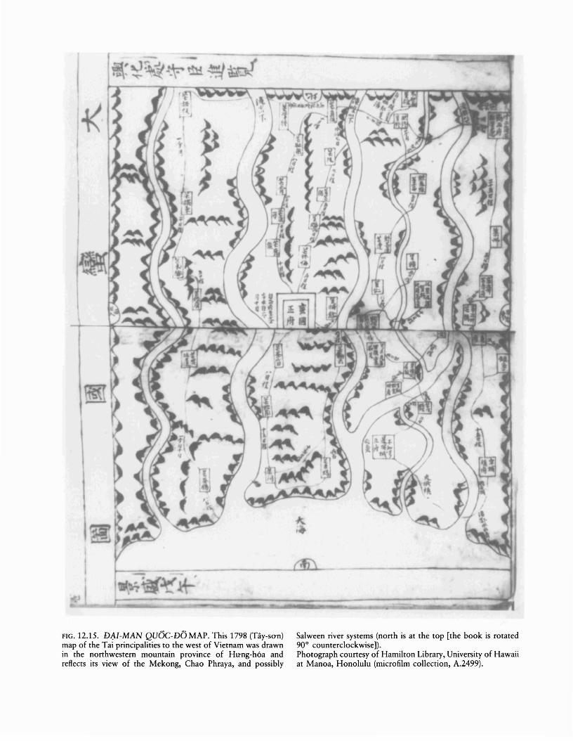
FIG. 12.15. DAI-MAN QUOC-DOMAP. This 1798 (Tay-san)map of the Tai principalities to the west of Vietnam was drawnin the northwestern mountain province of Hltng-h6a andreflects its view of the Mekong, Chao Phraya, and possibly
Salween river systems (north is at the top [the book is rotated90° counterclockwise]).Photograph courtesy of Hamilton Library, University of Hawaiiat Manoa, Honolulu (microfilm collection, A.2499).

Cartography in Vietnam
on the fifteenth-century work, and add the territory thatVietnamese society had encompassed under its ownregime in the south during the seventeenth and eighteenthcenturies. In addition, there was the broader Vietnameseknowledge of the international scene with which theNguyen had become so familiar during their years outof power. One result of this initial effort was the Hongdire ban do collection that I have used for the Le period.Though it actually originated in the seventeenth century,the memory of its derivation from the greatness of thefifteenth century remained.
In addition to the international influences, two otherelements need to be considered if we are to understandthe cartographic development under the Nguyen, onepolitical, the other bibliographic. Although the Gia-Iongemperor reigned over all of Vietnam, now called D~i
Nam (Great South), he chose not to rule directly in allparts of it. The Nguy~n court in Hue controlled centralVietnam (the old south and the base of its power forover two centuries) but decided to place viceroys incharge of the north and the far south. These viceroys,Nguyen Van Thanh and Le Van Duy~t, respectively, thusstood between the throne and the people they administered.49 In effect, the two were warlords. In the north,capital of the Le dynasty and home of its officials, thisindirect rule was meant to soothe injured feelings. In thesouth, the least developed section of the domain, it wasmerely convenient. In any case, this tripartite divisionhindered bureaucratic development throughout thecountry and hampered the accumulation of local data.The bureaucratic and cartographic development tookplace gradually over three decades. First, Thanh in thenorth was removed in 1816 following the crisis over thenewly appointed heir apparent, the future Minh-m~ng
emperor (1820-40). The latter, when he took the throneon his father's death in 1819, worked to extend thebureaucracy, but not in the south, where Duy~t held swayuntil he died in 1831. Only then did the throne moVe in,setting off a massive rebellion in 1833-34, which wascrushed. Thus an integrated bureaucratic entity came toexist in Vietnam only in the mid-1830s, and the cartographic achievements followed suit.
The bibliographic development that occurred was arejection of the atlas form used by the Le and the adoption of the geography as it evolved under the Ming andQing dynasties in China. This form was initially used bythe Ming government in 1461 under the name Da Mingyitong zhi (Comprehensive gazetteer of the Great Ming).The phrase yitong zhi (Vietnamese nhat thong chi) wouldcontinue to be used for this form, and it appeared inVietnam in the nineteenth century. The geography wasorganized by province and, within each section, dealtwith a standard list of topics. The first such new geography to appear in Vietnam (though without maps) had
499
been the O-ehau e4n-l~e (Modern record of O-chau), astudy of the southern Thu~n-an area from the sixteenthcentury during the M~c dynasty. Now, in the surge ofgovernment borrowing from China, the Nguy~n choseto develop this form of writing, and the official country,capital, and provincial maps would eventually appearwithin it.
In 1806, probably not long after the compilation ofthe Hong-dire ban do collection, Le Quang Djnh completed the N hat-thong du--dia ehi (Unified geography) forthe Gia-Iong emperor. Even though it was without maps,it was similar to the work compiled by D6 Ba some 150years earlier. Of the ten chapters, the first four coverroutes south and north from the capital, now in the centerat Hue, to the borders, and the final six look at theprovinces without any particular topical organization.5o
As noted, the Nguy~n court in Hue during this first reignfocused mainly on central Vietnam.
In the north, scholars carried on the Le cartographictradition as maps of the region appeared in various collections. In 1810 Dam Nghia Am compiled the Thientai nhan dam (Concerning ideas of a thousand years),which reproduced the Le atlas, following its basic pattern(such as the three-ridge mountains) while developing itstylistically. The map of the entire country provided anortherner's view of the southern expansion (fig. 12.16).51Just beyond Champa, Am put in Gia-djnh (the Saigonarea), and in a new map of the "southwest" he followedit with Cambodia (Cao-mien) and Siam (Xiem-Ia). In theprocess, he skipped over the southern coast lying betweenGia-djnh and the old Cham capital. Other maps in thetext, however, came from the southern Bi'nh-nam do andcover this missing territory. Artistic touches that wereadded include tigers romping in the ~ountains, a crabon the shore, and fish in the sea. The old capital is nolonger called the capital, just Thang-Iong, and certaindetails were added to its map that appear to reflect contemporary reality. Somewhat later (1830), another suchvolume appeared, this time called the Giao-ehau du--diado (Geographic maps of Giao-chau [an old Chinese namefor northern Vietnam]), with three sections of maps.52Drawn in black ink, the maps have an overpainting in
49. Woodside, Chinese Model, 102-3, 136, 141-42, 220, 284-85(note 48); Ralph B. Smith, "Politics and Society in Viet-Nam during theEarly Nguy~n Period (1802-62)," Journal of the Royal Asiatic Society
of Great Britain and Ireland, 1974, 153-69.50. A.1829; A.2667; Maspero, "Essai," 543 (note 38); Leonard
Aurousseau, Review of Charles B. Maybon, H istoire moderne du paysdJAnnam (1592-1820), in Bulletin de fEcole Fran~aise d'Extreme-Orient 20, no. 4 (1920): 73-121, esp. 83 n; Ralph B. Smith, "Sino-Vietnamese Sources for the Nguy~n Period: An Introduction," Bulletin ofthe School of Oriental and African Studies 30 (1967): 600-621, esp.609; Thai, "Leri n6i &iu," x (note 3).
51. HM2125; Bui, "Ban do," 52 (note 2); Schwartzberg notes.52. HM2240; A.2716 (reel 143, no. 267a); Schwartzberg notes.
500 Cartography in Korea, Japan, and Vietnam
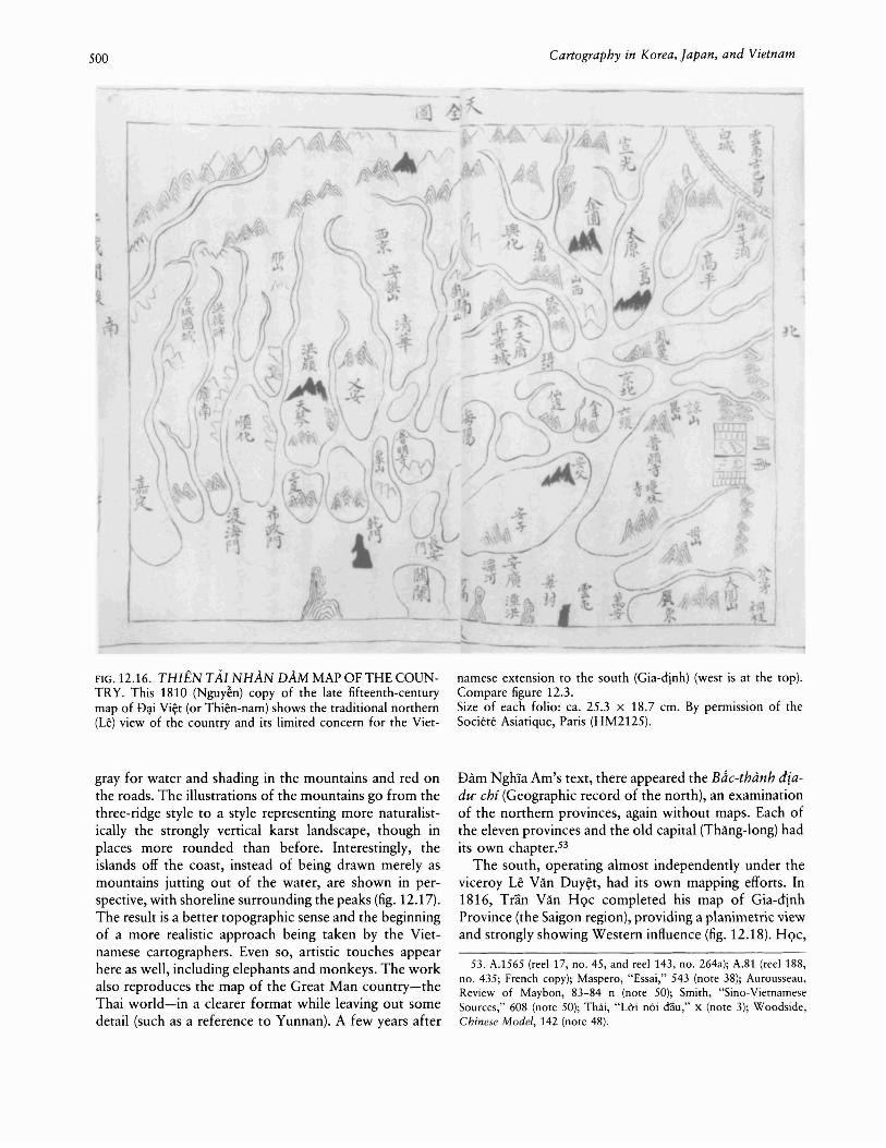
FIG. 12.16. THIEN TAl NHAN DAM MAP OF THE COUNTRY. This 1810 (Nguy~n) copy of the late fifteenth-centurymap of D~i Vi~t (or Thien-nam) shows the traditional northern(Le) view of the country and its limited concern for the Viet-
gray for water and shading in the mountains and red onthe roads. The illustrations of the mountains go from thethree-ridge style to a style representing more naturalistically the strongly vertical karst landscape, though inplaces more rounded than before. Interestingly, theislands off the coast, instead of being drawn merely asmountains jutting out of the water, are shown in perspective, with shoreline surrounding the peaks (fig. 12.17).The result is a better topographic sense and the beginningof a more realistic approach being taken by the Vietnamese cartographers. Even so, artistic touches appearhere as well, including elephants and monkeys. The workalso reproduces the map of the Great Man country-theThai world-in a clearer format while leaving out somedetail (such as a reference to Yunnan). A few years after
namese extension to the south (Gia-djnh) (west is at the top).Compare figure 12.3.Size of each folio: ca. 25.3 X 18.7 em. By permission of theSociete Asiatique, Paris (HM2125).
Dam NghIa Am's text, there appeared the Bdc-thimh diadu- chi (Geographic record of the north), an examinationof the northern provinces, again without maps. Each ofthe eleven provinces and the old capital (Thang-long) hadits own chapter.53
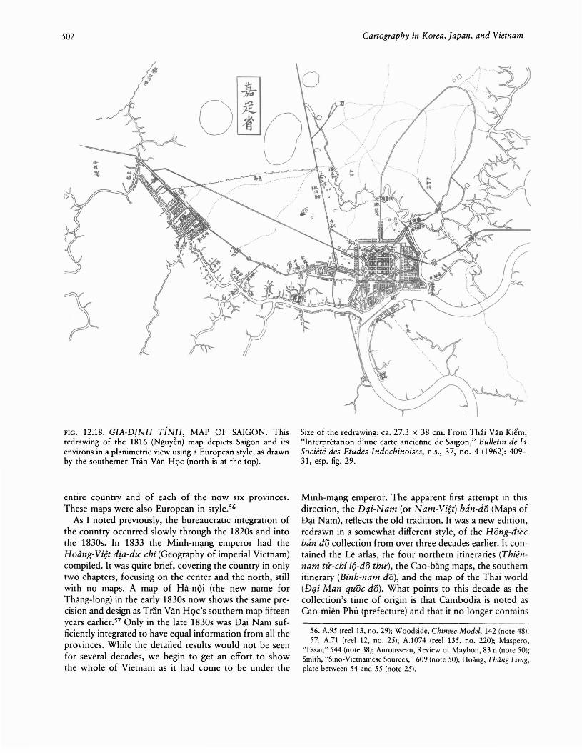
The south, operating almost independently under theviceroy Le Van Duy~t, had its own mapping efforts. In1816, Tran Van HQc completed his map of Gia-dinhProvince (the Saigon region), providing a planimetric viewand strongly showing Western influence (fig. 12.18). HQc,
53. A.1565 (reel 17, no. 45, and reel 143, no. 264a); A.81 (reel 188,no. 435; French copy); Maspero, "Essai," 543 (note 38); Aurousseau,Review of Maybon, 83-84 n (note 50); Smith, "Sino-VietnameseSources," 608 (note 50); Thai, "Uri noi oau," x (note 3); Woodside,Chinese Model, 142 (note 48).
Cartography in Vietnam 501
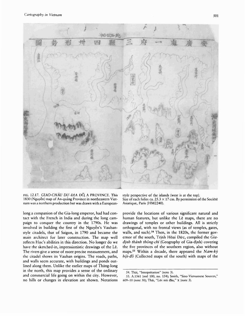
FIG. 12.17. GIAO-CHAu DU-DJA DO, A PROVINCE. This1830 (Nguyen) map of An-quang Province in northeastern Vietnam was a northern production but was drawn with a European-
long a companion of the Gia-long emperor, had had contact with the French in India and during the long campaign to conquer the country in the 1790s. He wasinvolved in building the first of the Nguy~n's Vaubanstyle citadels, that of Saigon, in 1790 and became themain architect for later construction. The map wellreflects HQc's abilities in this direction. No longer do wehave the sketched-in, impressionistic drawings of the Le.The rivers give a sense of more precise measurement, andthe citadel shows its Vauban origins. The roads, paths,and walls seem accurate, with buildings and ponds outlined along them. Unlike the earlier maps of Thang-longin the north, this map provides a sense of the ordinaryand commercial life going on within the city. However,no hills or changes in elevation are shown. Notations
style perspective of the islands (west is at the top).Size of each folio: ca. 25.3 x 17 cm. By permission of the SocieteAsiatique, Paris (HM2240).
provide the locations of various significant natural andhuman features, but unlike the Le maps, there are nodrawings of temples or other buildings. All is strictlyorthogonal, with no frontal views (as of temples, gates,walls, and such).54 Then, in the 1820s, the former governor of the south, Trinh Hoai Dfrc, compiled the Ciadinh thanh thOng-chi (Geography of Gia-dinh) coveringthe five provinces of the southern region, also withoutmaps.55 Within a decade, there appeared the Nam-kyhQi-do (Collected maps of the south) with maps of the
54. Thiii, "Interpretation" (note 3).55. A.1561 (reel 100, no. 154); Smith, "Sino-Vietnamese Sources,"
609-10 (note 50); Thiii, "Uri noi d"au," X (note 3).
502 Cartography in Korea, Japan, and Vietnam
FIG. 12.18. GIA-DINH TiNH, MAP OF SAIGON. Thisredrawing of the 1816 (Nguyen) map depicts Saigon and itsenvirons in a planimetric view using a European style, as drawnby the southerner Tran Van HQc (north is at the top).
entire country and of each of the now six provinces.These maps were also European in style.56
As I noted previously, the bureaucratic integration ofthe country occurred slowly through the 1820s and intothe 1830s. In 1833 the Minh-m~ng emperor had theHoang-Vi~tdia-dtr chi (Geography of imperial Vietnam)compiled. It was quite brief, covering the country in onlytwo chapters, focusing on the center and the north, stillwith no maps. A map of Ha-nQi (the new name forThang-long) in the early 1830s now shows the same precision and design as Tran Van HQc's southern map fifteenyears earlierF Only in the late 1830s was D~i Nam sufficiently integrated to have equal information from all theprovinces. While the detailed results would not be seenfor several decades, we begin to get an effort to showthe whole of Vietnam as it had come to be under the
Size of the redrawing: ca. 27.3 x 38 cm. From Thai Van Kiem,"Interpretation d'une carte ancienne de Saigon," Bulletin de faSociete des Etudes Indochinoises, n.s., 37, no. 4 (1962): 40931, esp. fig. 29.
Minh-m~ng emperor. The apparent first attempt in thisdirection, the Dqi-Nam (or Nam-Vi~t) ban-do (Maps ofD~i Nam), reflects the old tradition. It was a new edition,redrawn in a somewhat different style, of the Hong-diceban do collection from over three decades earlier. It contained the Le atlas, the four northern itineraries (Thiennam tic-chi 19-dO thtr), the Cao-b~ngmaps, the southernitinerary (Binh-nam do), and the map of the Thai world(Dqi-Man quae-do). What points to this decade as thecollection's time of origin is that Cambodia is noted asCao-mien Phli (prefecture) and that it no longer contains
56. A.95 (reel 13, no. 29); Woodside, Chinese Model, 142 (note 48).57. A.71 (reel 12, no. 25); A.1074 (reel 135, no. 220); Maspero,
"Essai," 544 (note 38); Aurousseau, Review of Maybon, 83 n (note 50);Smith, "Sino-Vietnamese Sources," 609 (nore 50); Hoang, Thang Long,plate between 54 and 55 (note 25).

Cartography in Vietnam 503
FIG. 12.19. MAP OF THE COUNTRY IN THE DAI-NAMTOAN-DO. The 1839 (Nguyen) map of the entire c~untry ofD;.ti Nam portrays a better sense of the Mekong River systemand the great lake in Cambodia (west is at the top). It is drawnin a European style.
the drawing of Angkor.58 Thus Cambodia had lost itssovereignty, as symbolized by Angkor, and had becomein Vietnamese eyes a part of their own administrativeapparatus. This was the result of Vietnam's temporaryconquest of Cambodia in the mid-1830s.
At the same time, the Vietnamese court -had becomerelatively open to technological and military advancesfrom the West.59 Thus encouraged, other Vietnamesecartographers had begun to use Western techniques indrawing a new set of maps for the now integrated country, which stretched all the way to the Gulf of Thailand.In 1839 there appeared the Dqi-Nam toan-dO (Completemaps of £)~i Nam).60 The map of the entire countryshows thirty-two provinces (including Cambodia) andeighty-two estuaries extending along the entire coastlineof nineteenth-century Vietnam (fig. 12.19). This map has
Photograph courtesy of Hamilton Library, University of Hawaiiat Manoa, Honolulu (microfilm collection, A.2559).
taken on the more realistic Western form, showing withgreater accuracy the shape of the coast and the hydrographic complexities, even of the Mekong River system(as the great lake of Cambodia). The provincial maps areindividualized, are European in outline, and concentratemore on the natural features. They show the river systemsin a dendritic manner, and though the mountains are onlyjotted in, using a simple three-ridge style, many of themare named. Large forests are also shown. The maps seemto be newly drawn, breaking with the previous tradition.Yet about this time there appeared two maps now contained in a copy of the northern set of itineraries, called
58. A.1603 (reel 139, no. 245); Schwartzberg notes; Hong-du-e bandO, x (n. 4), XXIV (n. 5) (note 1).
59. Woodside, Chinese Model, 281-84 (note 48).60. A.2559 (reel 18, no. 43).
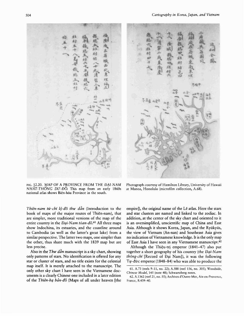
504
-
FIG. 12.20. MAP OF A PROVINCE FROM THE DA1-NAMNHAT-THONG DlJ-DO. This map from an eariy 1860snational atlas shows Bien-hoa Province in the south.
Thien-nam tu--chi h:>-do thtr dan (Introduction to thebook of maps of the major routes of Thien-nam), thatare simpler, more traditional versions of the map of theentire country in the Dqi-Nam toan-do.61 All three mapsshow Indochina, its estuaries, and the coastline aroundto Cambodia (as well as the latter's great lake) from asimilar perspective. The latter two maps, one simpler thanthe other, thus share much with the 1839 map but areless precise.
Also in the Thtr dan manuscript is a sky chart, showingonly patterns of stars. No identification is offered for anystar or cluster of stars, and no title exists for the celestialmap itself. It is merely attached to the manuscript. Theonly other sky chart I have seen in the Vietnamese documents is a clearly Chinese one included in a later editionof the Thien-hq ban-do (Maps of all under heaven [the
Cartography in Korea, Japan, and Vietnam
Photograph counesy of Hamilton Library, University of Hawaiiat Manoa, Honolulu (microfilm collection, A.68).
empire]), the original name of the Le atlas. Here the starsand star clusters are named and linked to the zodiac. Inaddition, at the center of the sky chart and oriented to itis an oversimplified, unscientific map of China and EastAsia. Although it shows Korea, Japan, and the Ryukyus,the view of Vietnam (An-nan) and Southeast Asia givesno indication of Vietnamese knowledge. It is the only mapof East Asia I have seen in any Vietnamese manuscript.62
Although the Thi~u-tri emperor (1841-47) also puttogether a short geography of his country (the Dqi-NamthOng-chi [Record of D<;li Nam]), it was the followingTl!-dfrc emperor (1848-84) who was able to produce the
61. A.73 (reels 9-11, no. 22); A.588 (reel 156, no. 305); Woodside,Chinese Model, 145 (note 48); Schwanzherg notes.
62. A.1362 (reel 21, no. 55); Archives d'Outre-Mer, Aix-en-Provence,France, B.439-40.
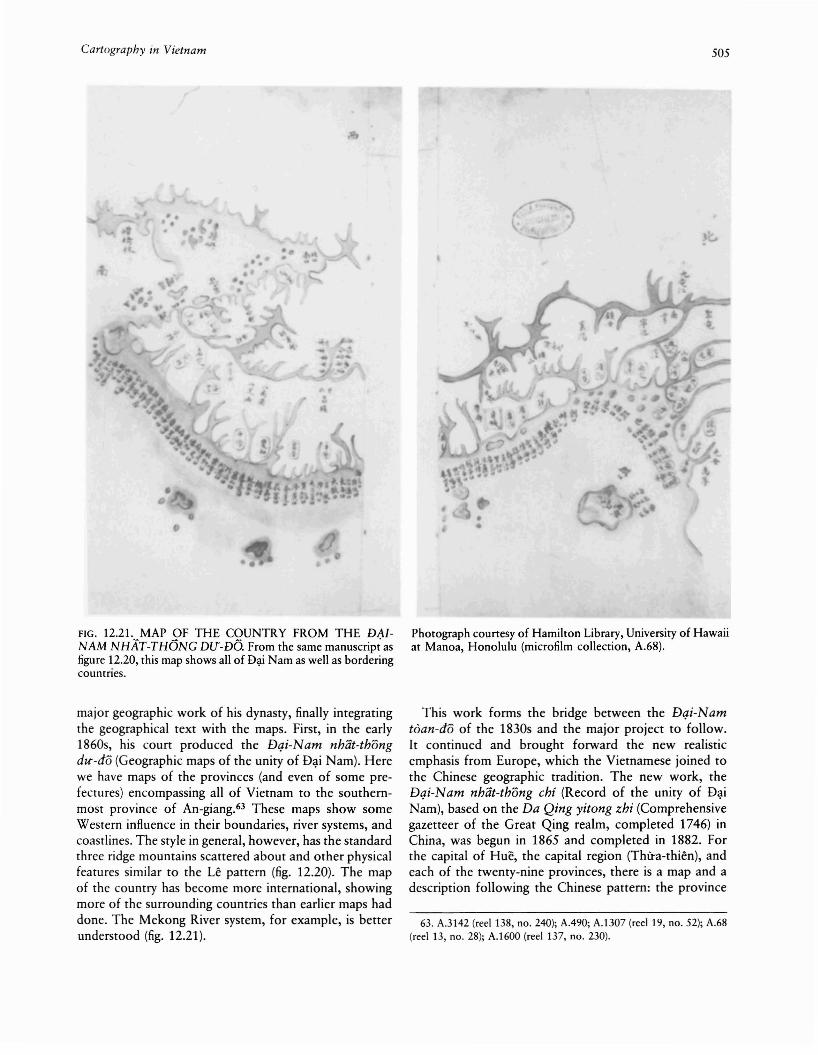
Cartography in Vietnam
FIG. 12.21. MAP OF THE COUNTRY FROM THE DAJNAM NHAT-THONG DrJ-DO. From the same manuscrip; asfigure 12.20, this map shows all of D~i Nam as weIl as borderingcountries.
major geographic work of his dynasty, finally integratingthe geographical text with the maps. First, in the early1860s, his court produced the Dqi-Nam nhat-thongdU"-do (Geographic maps of the unity of D~i Nam). Herewe have maps of the provinces (and even of some prefectures) encompassing all of Vietnam to the southernmost province of An-giang.63 These maps show someWestern influence in their boundaries, river systems, andcoastlines. The style in general, however, has the standardthree ridge mountains scattered about and other physicalfeatures similar to the Le pattern (fig. 12.20). The mapof the country has become more international, showingmore of the surrounding countries than earlier maps haddone. The Mekong River system, for example, is betterunderstood (fig. 12.21).
505
Photograph courtesy of Hamilton Library, University of Hawaiiat Manoa, Honolulu (microfilm coIlection, A.68).
This work forms the bridge between the Dqi-Namtoan-dO of the 1830s and the major project to follow.It continued and brought forward the new realisticemphasis from Europe, which the Vietnamese joined tothe Chinese geographic tradition. The new work, theDqi-Nam nhlit-thong chi (Record of the unity of D~i
Nam), based on the Da Qing yitong zhi (Comprehensivegazetteer of the Great Qing realm, completed 1746) inChina, was begun in 1865 and completed in 1882. Forthe capital of Hue, the capital region (Thfra-thien), andeach of the twenty-nine provinces, there is a map and adescription following the Chinese pattern: the province
63. A.3142 (reel 138, no. 240); A.490; A.1307 (reel 19, no. 52); A.68(reel 13, no. 28); A.1600 (reel 137, no. 230).

506
as a whole, its constituent parts, physical nature, climate,customs, cities, schools, taxes, mountains, rivers, temples,biographies, and products.64
The T1!-dfrc geography was the only one in the nineteenth century to cover the entire country. This was soeven though the six southern provinces were lost by theend of 1867. The emperor never gave up hope of reacquiring them, and the cartography represented the wishto reintegrate the land. Immediately after the French conquest of northern and central Vietnam in 1884-85, thenew Dong-khanh emperor (1885-89) brought out hisown geography, the Dong-khanh dia-dU' chi-lU'CTC (Geographic summary of the Dong-khanh era), more Europeanized still and covering just central and northernVietnam. There also appeared during this reign a collection of maps called the Dqi-Nam quac cU'O'ng-gi&i vibien [or vung-bien] (Boundaries of D~i Nam), by HoangHfru Xfrng.65 There is one map for the entire country,one for the capital, and one for each of the thirty-oneprovinces. The country map is about halfway betweenthe traditional style and that of the West. The Indochinese peninsula is generally recognizable, but the formof the coastline is like the old style. The Mekong systemresembles that of the Dqi-Nam nhat-thang dU'-do map.The provincial maps are similar, partway between therealistic and the traditional styles.
Then, two decades afterward (1909) under the Duytan emperor (1907-16), a reedition of the Dqi-Namnhat-thang chi came out, though only for central Vietnam. This edition has seventeen chapters, with a map foreach, covering eleven provinces, the capital, and the capital region, plus maps for the country, for central Vietnam, and for the forbidden city within the capital. Thesemaps are even more Western in style, with the four pointsof the compass shown and a legend defining the signsused on the map (including railroads). The rivers andcoastlines are quite realistic, but mountains are notshown.66
By this time, Vietnamese scholars under French colonial control had begun to develop a new style, one lessrealistic and more Sinic. We see this in two map collections. The first, the N am bac ky hoa do (Illustrated mapsof the northern and southern regions), is a copy of theearly 1860s Dqi-Nam nhat-thang dU'-do. It shows thedeveloping realistic influence of French cartography. Butit also has decided Chinese features-a roiling sea andthe vertical, karst-style mountains. The second collectionis a curious pastiche of earlier works. Called the Tien-LeNam-Vi~t ban-dO mo-ban (Copy of the atlas of Vietnamof the former Le dynasty), it is an artistic, colorful rendering (with a few errors) of the Le atlas.67 T~ TrQngHi~p believes it comes from the early twentieth century,produced by scholars working for the Ecole Fran~aise
d'Extreme-Orient in Hanoi.68 The one addition to the
Cartography in Korea, Japan, and Vietnam
Le atlas is the last map, a new drawing of the countrymap from the Dqi-Nam tDan-do of 1839. This mapshows the coastline and river systems of Indochina. Yetits rendering is a step away from the realistic Westernstyle of the nineteenth century and a move toward theimpressionistic Sinic style. In effect, these two works seemto represent a choice by Vietnamese literati in the Frenchcolonial system to reject scientific detail for artisticChinese style.
Other maps from the middle to late nineteenth centuryare of the citadels adapted by the Nguy~n from theFrench Vauban style. The Archive d'Outre-Mer has anumber of such maps, those of Ha-nQi, San-tay, Tuyenquang, Nam-dinh, and Nha-trang.69 Each is drawn somewhat differently, but all in Western style, reflecting varietytherein as well as in the designs of the walls themselves.Yet despite the differences, all these maps reflect the continuity from the original Vauban design as well as fromTran Van HQc's 1816 Gia-dinh map. These maps, however, are not the urban maps that HQc's was. In this sensethey are more like the maps of Thang-Iong from the Leperiod, showing only the walls and certain governmentand court ritual buildings, not the common, commerciallife.
The French, in their sweep across northern Vietnamin the 1880s, seem to have availed themselves of localmaps to aid their efforts. The Bibliotheque Nationale inParis and the Bayerische Staatsbibliothek in Munich holdmaps that the French apparently picked up and used inthe campaign.7o They may even have copied or commissioned some of them in order to gain local knowledgeof the terrain. The existence of romanized script (quacngu-) on the maps indicates their adaptation to Frenchneeds. Three maps are of Ha-nQi, two others of Ninhbinh and Nam-dinh, provinces in the southern portionof the Red River Delta, two of San-tay Province, andthe other six of mountain areas to the north and north-
64. A.1448 (reel 20, no. 54); A.69 (reel 191, no. 457); Maspero,"Essai," 544-45 (note 38); Aurousseau, Review of Maybon, 83 n (note50); Smith, "Sino-Vietnamese Sources," 609 (note 50); Thai, "Lai noiaau," X-XI (note 3).
65. HM2133; A.1342 (reel 179, no. 395); A.748 (reel 145[2], no.2586).
66. A.537 (reels 9-11, no. 17); HM2133; Aurousseau, Review ofMaybon, 83 n (note 50); Smith, "Sino-Vietnamese Sources," 609 (note50); Thai, "Lai noi &iu," XI (note 3); Tf;l, "Fonds," 284-85 (note 36);Schwartzberg notes.
67. Ecole Fran~aise d'Extreme-Orient, Paris, Viet.A.Geo.4; Schwartzberg notes.
68. A.95 (reel 13, no. 29); Tf;l, "Fonds," 285-86, pIs. 5-6 (note 36).69. Archives d'Outre-Mer, Aix-en-Provence, France, Est. A.80-81,
83, 85, and B.331; Schwartzberg notes.70. Departement des Cartes et Plans, Res. Ge. A.394-96, 15298,
D.9069-71, 9148, F.9443-44; Bayerische Staatsbibliothek, Cod. Sin. 8284; Schwartzberg notes.

Cartography in Vietnam
west (Lao-cai, Thai-nguyen, and L~ng-sO'n). The mapscontinue the earlier mode, being generally drawn in blackink with other colors used to illustrate different features(roads in red, rivers in blue, and mountains in brown orgray). Citadels (Ha-nQi and in the provinces) are drawnto show their Vauban characteristics. These thirteen mapsprovide some indication of the cartography availablelocally in the north during the second half of the nineteenth century.
Other local maps also exist from the Nguy~n period.The card catalog from the collection in Hanoi lists anumber of village maps, but I have seen no example ofthem.71 Another type of local map was most significantfor the central government, the land record (dia bi)).These records, village by village, show each piece of landin outline, along with its dimensions and type. The government undertook the surveys somewhat piecemeal,though we as yet know little of how the officials proceeded (some of the records have been lost). In dealingwith land and land taxes from 1836 to 1875, theNguy~n government divided its territory into three zonessimilar to, but not exactly the same as, its earlier politicaljurisdictions. In the old f)~i Vi~t of earlier centuries, fromHa-tlnh to the Chinese border, the taxes were heavy oncommunal lands and light on private lands. In centralVietnam, from Quang-binh to Khanh-hoa, taxes weremoderate and equal on both communal and private lands.In southern Vietnam, from Binh-thu~n through theMekong Delta, taxes were light in general. The development of the land records followed these same zones.The oldest records were undertaken in the first years ofthe dynasty (1805-6) in the nine northernmost provincesof the first zone. Then, from 1810 to 1818, the surveystook place in the central zone. No original surveys existfrom the Gia-long period for the four provinces in thesouthern section of the first zone or in the third zone tothe south. About 1830, the northern and central surveysalready done were confirmed, then the four provincesnot yet done in the first zone held their surveys in theearly 1830s. Finally, the provinces of the southern zoneheld theirs in 1836 following the defeat of Le Van Kh6i'srebellion in the mid-1830s. Right after that, in 1837-40,fouf marginal northern provinces were resurveyed, andevidence exists for mapping of newly developed lands inthe south.72
The final set of Vietnamese maps that concern us arequite different ones, and they bring us back to where webegan-the pattern of mountain and water. These mapsare diagrams of the Nguy~n imperial tombs (fig. 12.22).Differing greatly from Western diagrams of the tombs,they feature both mountains and water and reflect theincreasingly strong Sinic influence of the Nguy~n period.Stein has pointed out the strong parallel between tombsand the miniature gardens he has studied.73 Even as the
507
Vietnamese became more Sinic through the nineteenthcentury, these maps show that they retained the basicmagical elements of mountains and water that underlaytheir cartography into the modern era.
CONCLUSION
The development of Vietnamese cartography followedefforts of the governments to centralize and extend theircontrol over the country. Mapping was linked to thebureaucracy, and the atlases were meant to show thelocations of the different jurisdictions, often recording aswell the number and types of villages in each district.The Vietnamese government sought to gain access to theresources of the realm, human and material. Theseresources came out of the villages, and the maps weremeant to show their spread. Thus premodern Vietnamesemaps as they exist today were tied strongly to the government's adoption of the Chinese model, and with itthe Chinese mode of bureaucracy. That the maps weregenerally Sinic in style followed therefrom. The atlasesserved as bureaucratic tools in the efforts of the imperialcourt to manage the villages. In the earlier centuries, during the Ly and Tran dynasties when indirect control wasthe norm, the Vietnamese throne had had neither thecontrol nor the inclination to map the country. Duringthe Le and Nguy~n dynasties the bureaucracy providedthe means, and its purpose-resource control-the aimfor doing so. Thus the major efforts at mapping (or reproducing earlier maps) took place at times of bureaucraticstrength: the last third of the fifteenth century, the secondhalf of the seventeenth century, the 1830s, and the 1860s.
Vietnamese mapping was internal, not external. Theitineraries mainly led to the borders, north and south,and no farther. The southern route first went to the capital of Champa, but this territory soon became Vietnam-
71. A.1844, 1895-96,2964 from the microfilm of the Ecole Fran~aise
d'Extreme-Orient catalog list (reel 3, nos. 8-9).72. Smith, "Sino-Vietnamese Sources," 616-17 (note 50); Nguy~n
The Anh, "La reforme de l'impot foncier de 1875 au Viet-Nam," Bulletin de ['Ecole Fran~aise d'Extreme-Orient 78 (1991): 287-96, esp. 28889. No illustration exists of the dia hi). My description derives frompersonal observation of the documents in Da Lat during my visit therewith Ralph Smith in March 1966. This material, not yet studied to myknowledge, apparently is now held in Ho Chi Minh City. On the mapping of newly developed land in the south, 1838-40, see Paul]. Bennett,"Two Southeast Asian Ministers and Reactions to European Conquest:The Kinwun Mingyi and Phan-thanh-Gian," in Conference under theTamarind Tree: Three Essays in Burmese History (New Haven: YaleUniversity Southeast Asia Studies, 1971), 103-42, esp. 110, and LouisMalieret and Georges Taboulet, eds., "Foire Exposition de Saigon, Pavilion de I'Histoire, la Cochinchine dans Ie passe," Bulletin de la Societedes Etudes Indochinoises, n.s., 17, no. 3 (1942): 1-133, esp. 40-42.
73. Stein, World in Miniature, 104, 111-12 (note 6); Thai, Co doHue, pIs. 29, 36 (note 3).

508 Cartography in Korea, Japan, and Vietnam
@~ Corle aenamile du Tombeau'::f.J de Gia-Lon2
CommuniquN! par Ie Mfmsteredes Travaux Publics.& .
.J.,
FIG. 12.22. THE NGUYEN TOMBS, HUE. This redrawing ofthe Vietnamese diagram of the Gia-long emperor's tomb withthe rare (imperial) southern orientation shows again the cosmological mix of water and mountains.
ese. It eventually went to Angkor, which in turn became(temporarily) part of Vietnam. Only the routes into Chinaand Siam were non-Vietnamese subjects of Vietnamesecartography, and these were by land. Sea routes, as illustrated in charts, are not to be found. However, the international contacts of the Vietnamese in the late eighteenthand early nineteenth centuries did lead to inclusion ofmore of mainland Southeast Asia in maps of the country.Still, East Asian, general Asian, and world maps are essentially unknown in the Vietnamese collections. The itineraries supply interesting descriptive detail for Vietnamitself and remain within the cultural framework of thepre-1800 style. They do not seem to have made thechange into the realistic style of the mid-nineteenth century. The new style seems to have been reserved for thegovernment atlases.
From Charles Patris andL. Cadiere, Les Tombeaux de Hue:Cia-Long (Hanoi: Imprimerie d'Extreme-Orient, 1923), pI. XXI.
This chapter marks a beginning, and many questionsinevitably remain. Much more work is still to be doneon Vietnamese maps, using both those documents onmicrofilm and the manuscripts held in Hanoi. Such workwill undoubtedly bring forth significant cartographicmaterials, the interpretation of which will change thesynthesis supplied here. In particular, we must examinethe documentation of the nineteenth century moreclosely in order to gain a better sense of the cartographicefforts of the Nguy~n government. We need to understand better both the Western and the Chinese elementsavailable to the Vietnamese and their use of them. Overall, we must use the cartographic materials to further ourunderstanding of Vietnamese society and its developmentin the early modern world.