Embed Size (px)
Citation preview
41/457135
i Draf t environmental impact statement June 2015
Volume 2 Chapter 12 Cumulative and consequential impacts
12. Cumulative and consequential impacts
Table of contents 12. Cumulative and consequential impacts....................................................................... i
12.1 Introduction........................................................................................................12-1
12.1.1 Overview................................................................................................12-1
12.1.2 Objective................................................................................................12-1
12.2 Existing pressures ..............................................................................................12-1
12.2.1 Catchment pressures ...............................................................................12-1
12.2.2 Bio-subregion pressures ...........................................................................12-5
12.3 Cumulative impacts.............................................................................................12-5
12.3.1 Overview................................................................................................12-5
12.3.2 Proposed developments within the Fitzroy Basin catchment...........................12-5
12.3.3 Potential cumulative impacts on MNES ..................................................... 12-10
12.3.3.1 World Heritage properties and National Heritage places........................12-10
12.3.3.2 Listed threatened, migratory and marine species and ecological communities...................................................................................12-13
12.4 Consequential impacts ...................................................................................... 12-18
12.4.1 Overview.............................................................................................. 12-18
12.4.2 Potential consequential developments within the region .............................. 12-19
12.4.2.1 Industrial development.....................................................................12-19
12.4.2.2 Residential development ..................................................................12-20
12.4.2.3 Agricultural development..................................................................12-20
12.4.3 Potential consequential impacts on MNES ................................................ 12-21
12.4.3.1 World Heritage Properties and National Heritage Places .......................12-22
12.4.3.2 Listed threatened, migratory and marine species and ecological communities...................................................................................12-28
12.5 Summary......................................................................................................... 12-32
Table index Table 12-1 Current level of impoundment (Fitzroy, Dawson and Mackenzie rivers) ............. 12-4
Table 12-2 Extent of regional ecosystems within the bio-subregion study area ................... 12-5
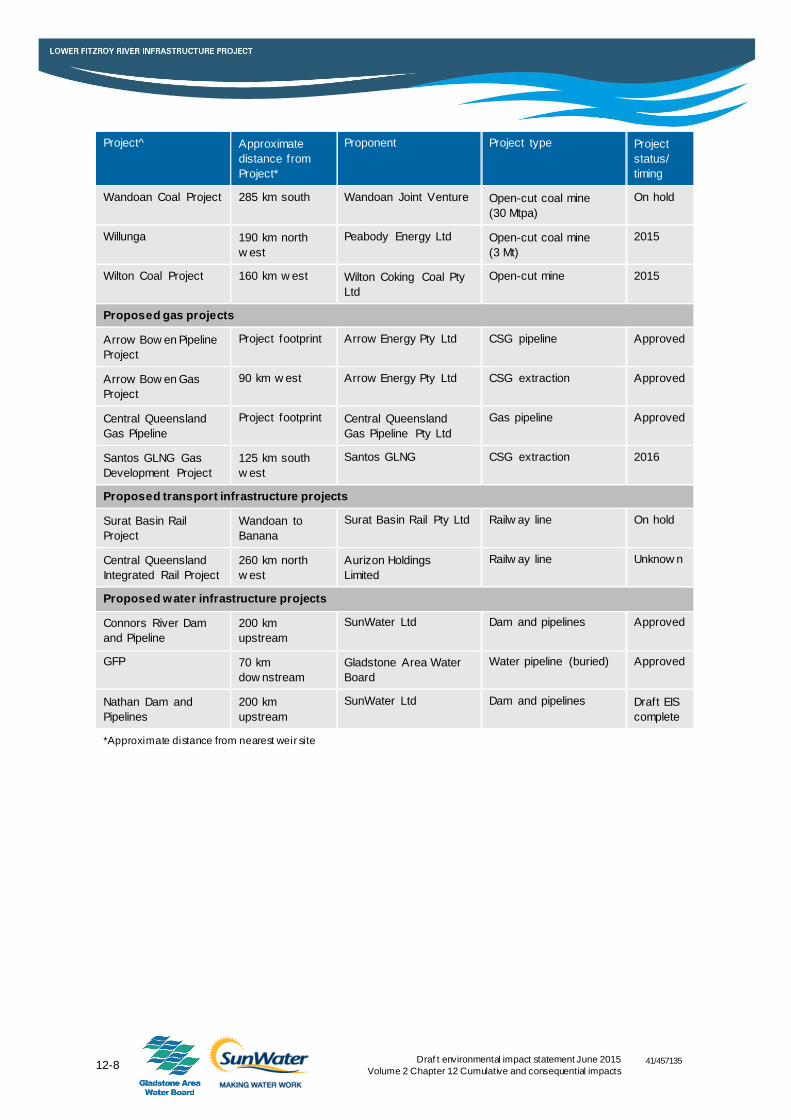
Table 12-3 Proposed projects..................................................................................... 12-6
Table 12-4 Cumulative impacts on the Great Barrier Reef..............................................12-11
Table 12-5 Project’s contribution to cumulative impacts on threatened, migratory and marine species ........................................................................................12-14
Table 12-6 Potential consequential impacts on the Great Barrier Reef .............................12-25
Table 12-8 Potential consequential impacts on threatened, migratory and marine species and ecological communities ......................................................................12-29
ii Draf t environmental impact statement June 2015
Volume 2 Chapter 12 Cumulative and consequential impacts
41/457135
Figure index Figure 12-1 Land use in the Fitzroy Basin catchment .............................................. 12-2
Figure 12-2 Existing activities .............................................................................. 12-3
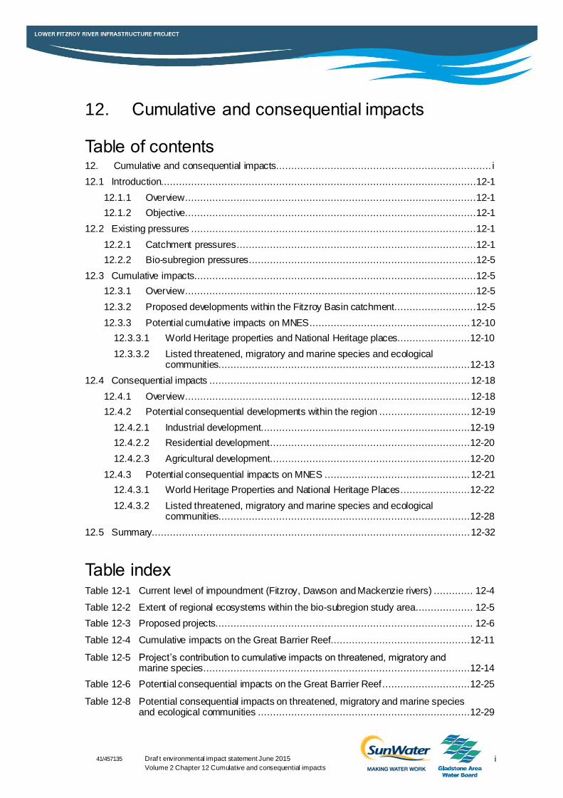
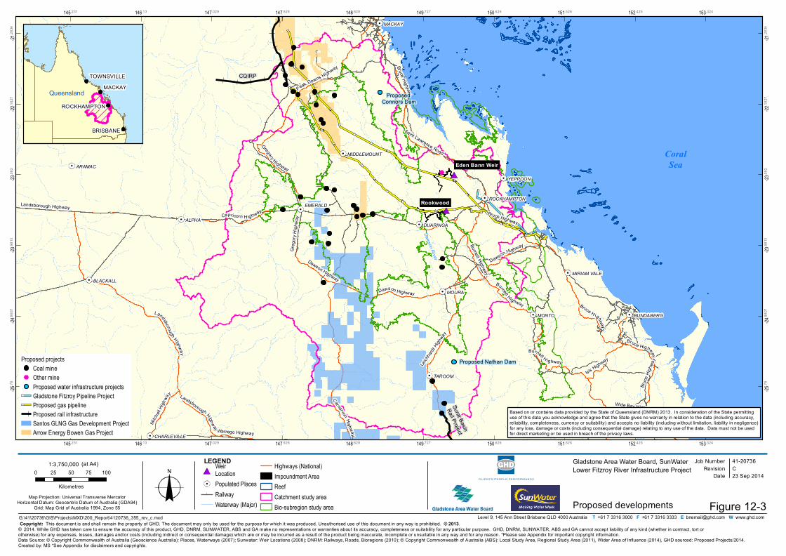
Figure 12-3 Proposed developments .................................................................... 12-9
41/457135
12-1 Draf t environmental impact statement June 2015
Volume 2 Chapter 12 Cumulative and consequential impacts
12.1 Introduction
12.1.1 Overview
The purpose of this chapter is to provide an assessment of the cumulative and consequential
impacts of the Lower Fitzroy River Infrastructure Project (Project) on matters of national
environmental significance (MNES). Project impacts are assessed with consideration to existing
and proposed activities in the region and methods by which these impacts can be reduced are
identified. Potential consequential impacts resulting from developments that may be facilitated by
the Project are also addressed. The assessment addresses Part C of the terms of reference
(ToR) for the environmental impact statement (EIS) in relation to cumulative and consequential
impacts. A table cross-referencing the ToR requirements is provided in Appendix B.
12.1.2 Objective
The objective of this assessment is to identify the potential cumulative impacts upon existing
environmental values as a result of constructing and operating the Project and other proposed
projects within relevant study areas. The assessment is to be undertaken considering the
following:
Impacts on a local and regional level
Accumulation of impacts over time
Exacerbation of impacts in intensity or scale, frequency or duration
Consideration of the Project either in isolation or combination with other known existing or
planned projects.
Further detail on the cumulative impact assessment methodology is provided in Chapter 6.
12.2 Existing pressures
12.2.1 Catchment pressures
The Fitzroy Basin catchment extends over approximately 142,000 km2 of central and eastern
Queensland near the Tropic of Capricorn. The catchment is the second largest in Australia and
opens onto the world heritage protected area of the Great Barrier Reef. The catchment is
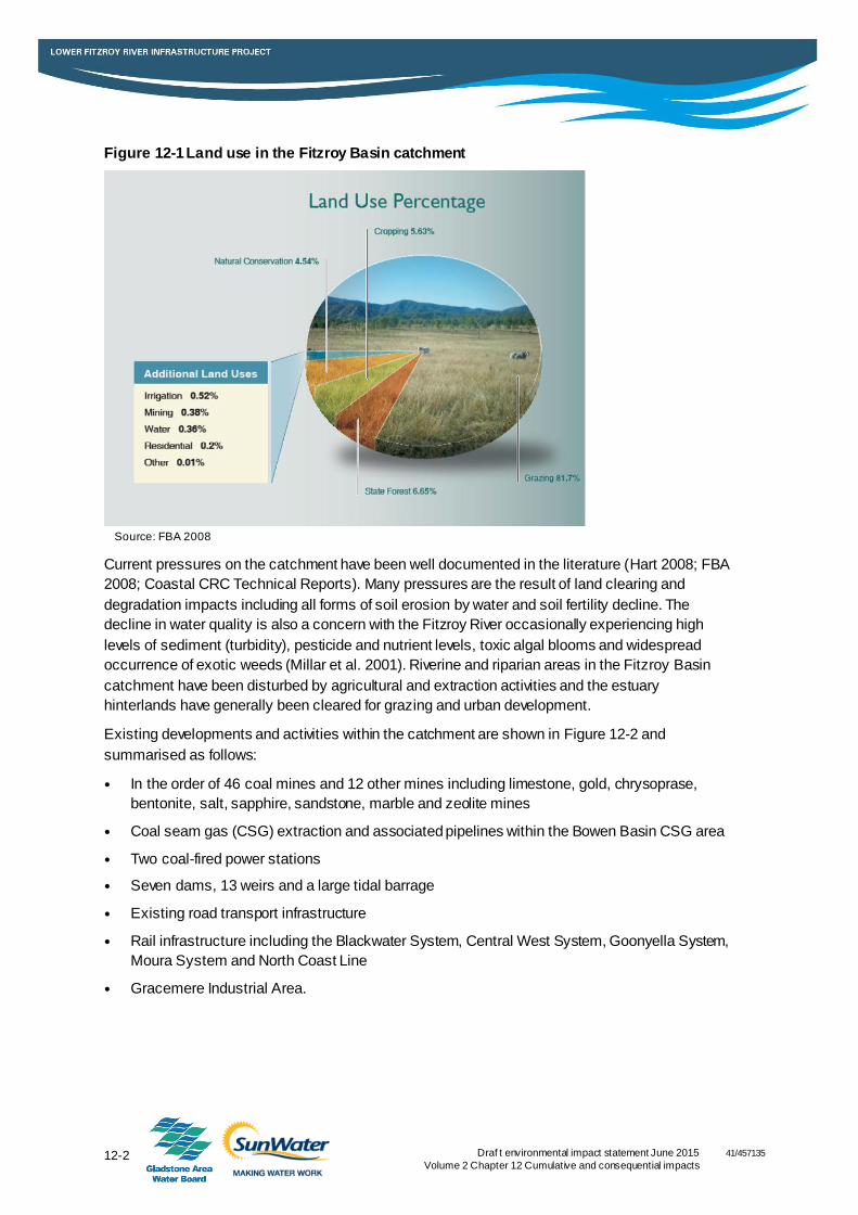
dominated by agriculture which accounts for almost 90 per cent of land use. Figure 12-1 provides
an overview of land use in the catchment. Water resources within the catchment are highly
regulated with seven dams (large and small), 13 weirs and a large tidal barrage. The catchment is
home to significant terrestrial floral and faunal assemblages with populations of threatened
species and internationally significant wetlands.
12-2 Draf t environmental impact statement June 2015
Volume 2 Chapter 12 Cumulative and consequential impacts
41/457135
Figure 12-1 Land use in the Fitzroy Basin catchment
Current pressures on the catchment have been well documented in the literature (Hart 2008; FBA
2008; Coastal CRC Technical Reports). Many pressures are the result of land clearing and
degradation impacts including all forms of soil erosion by water and soil fertility decline. The
decline in water quality is also a concern with the Fitzroy River occasionally experiencing high
levels of sediment (turbidity), pesticide and nutrient levels, toxic algal blooms and widespread
occurrence of exotic weeds (Millar et al. 2001). Riverine and riparian areas in the Fitzroy Basin
catchment have been disturbed by agricultural and extraction activities and the estuary
hinterlands have generally been cleared for grazing and urban development.
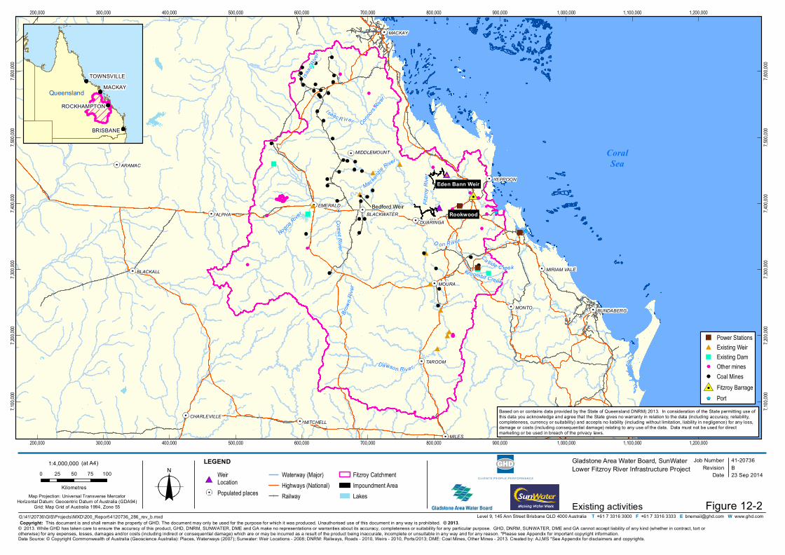
Existing developments and activities within the catchment are shown in Figure 12-2 and
summarised as follows:
In the order of 46 coal mines and 12 other mines including limestone, gold, chrysoprase,
bentonite, salt, sapphire, sandstone, marble and zeolite mines
Coal seam gas (CSG) extraction and associated pipelines within the Bowen Basin CSG area
Two coal-fired power stations
Seven dams, 13 weirs and a large tidal barrage
Existing road transport infrastructure
Rail infrastructure including the Blackwater System, Central West System, Goonyella System,
Moura System and North Coast Line
Gracemere Industrial Area.
Source: FBA 2008
Eden Bann Weir
RookwoodBedford Weir
Isaac R iver
Dawson Riv er
Mackenzie River
Ca llide C reek
D on R iver
Brow
n Riv e
r
Isaac
River
Fitzro
y Rive
r
Comet River
Nogoa River
Kroombit Creek
Connors
River
MILES
MOURA
MONTO
ALPHA
TAROOM
MACKAY
ARAMAC
EMERALD
YEPPOON
BLACKALL
KINGAROY
DUARINGA
MITCHELL
BUNDABERG
BLACKWATER
MIDDLEMOUNT
CHARLEVILLE
MIRIAM VALE
200,000
200,000
300,000
300,000
400,000
400,000
500,000
500,000
600,000
600,000
700,000
700,000
800,000
800,000
900,000
900,000
1,000,000
1,000,000
1,100,000
1,100,000
1,200,000
1,200,000
7,100,
000
7,100,
000
7,200,
000
7,200,
000
7,300,
000
7,300,
000
7,400,
000
7,400,
000
7,500,
000
7,500,
000
7,600,
000
7,600,
000
Job NumberRevision B
41-20736
G:\41\20736\GIS\Projects\MXD\200_Report\4120736_286_rev_b.mxd
Map Projection: Universal Transverse MercatorHorizontal Datum: Geocentric Datum of Australia (GDA94)
Grid: Map Grid of Australia 1994, Zone 55
0 25 50 75 100
Kilometres
© 2013. While GHD has taken care to ensure the accuracy of this product, GHD, DNRM, SUNWATER, DME and GA make no representations or warranties about its accuracy, completeness or suitability for any particular purpose. GHD, DNRM, SUNWATER, DME and GA cannot accept liability of any kind (whether in contract, tort or otherwise) for any expenses, losses, damages and/or costs (including indirect or consequential damage) which are or may be incurred as a result of the product being inaccurate, incomplete or unsuitable in any way and for any reason. *Please see Appendix for important copyright information.
Date 23 Sep 2014
Gladstone Area Water Board, SunWaterLower Fitzroy River Infrastructure Project
Existing activities
Data Source: © Copyright Commonwealth of Australia (Geoscience Australia): Places, Waterways (2007); Sunwater: Weir Locations - 2008; DNRM: Railways, Roads - 2010, Weirs - 2010, Ports/2013; DME: Coal Mines, Other Mines - 2013. Created by: AJ,MS *See Appendix for disclaimers and copyrights.
Level 9, 145 Ann Street Brisbane QLD 4000 Australia T +61 7 3316 3000 F +61 7 3316 3333 E [email protected] W www.ghd.comFigure 12-2
Copyright: This document is and shall remain the property of GHD. The document may only be used for the purpose for which it was produced. Unauthorised use of this document in any way is prohibited. © 2013.
LEGEND
CoralSea
BRISBANE
MACKAY
ROCKHAMPTON
TOWNSVILLE
QueenslandQueensland
Power StationsExisting WeirExisting DamOther minesCoal MinesFitzroy BarragePort
WeirLocationPopulated places
Waterway (Major)Highways (National)Railway
Fitzroy CatchmentImpoundment AreaLakes
1:4,000,000 (at A4)
Based on or contains data provided by the State of Queensland DNRM) 2013. In consideration of the State permitting use of this data you acknowledge and agree that the State gives no warranty in relation to the data (including accuracy, reliability, completeness, currency or suitability) and accepts no liability (including without limitation, liability in negligence) for any loss, damage or costs (including consequential damage) relating to any use of the data. Data must not be used for direct marketing or be used in breach of the privacy laws.
12-4 Draf t environmental impact statement June 2015
Volume 2 Chapter 12 Cumulative and consequential impacts 41/457135
It should be noted that small projects, agricultural development and urban centres and associated
pressures are not captured in this list however the impacts from these activities are a significant
contributor to pressures on the catchment and are considered in Section 12.3.3.
While there are a large number of mines operating within the Fitzroy Basin catchment, mining
only accounts for 0.38 per cent of land use within the catchment as shown in Figure 12-1.
Nevertheless, mining within the catchment is an important external influence particularly in regard
to fragmented land clearing, erosion and water quality impacts.
No existing mines are located in close proximity to either the proposed Eden Bann Weir or
Rookwood Weir Project footprints. The closest operating mines are the Baralaba coal mine
approximately 70 km south west of the Rookwood Weir site and the Cook, Yarrabee and Jellinbah
coal mines located approximately 110 km west of the Rookwood Weir site near Blackwater.
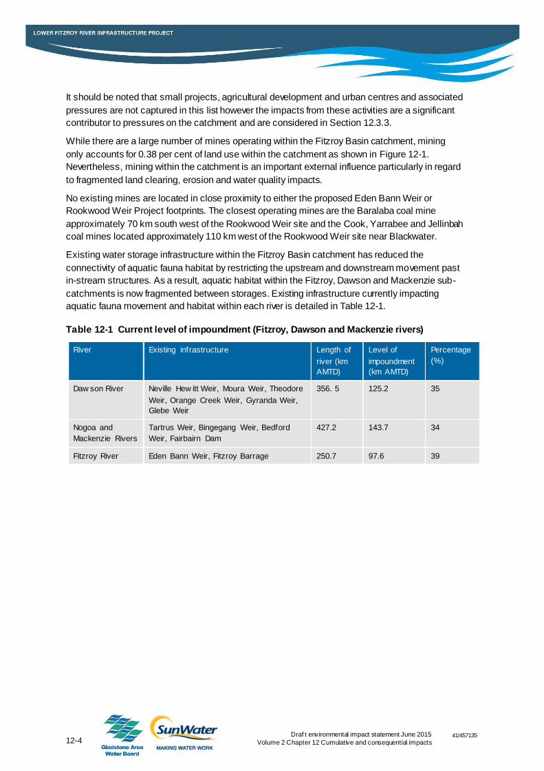
Existing water storage infrastructure within the Fitzroy Basin catchment has reduced the
connectivity of aquatic fauna habitat by restricting the upstream and downstream movement past
in-stream structures. As a result, aquatic habitat within the Fitzroy, Dawson and Mackenzie sub-
catchments is now fragmented between storages. Existing infrastructure currently impacting
aquatic fauna movement and habitat within each river is detailed in Table 12-1.
Table 12-1 Current level of impoundment (Fitzroy, Dawson and Mackenzie rivers)
River Existing infrastructure Length of
river (km
AMTD)
Level of
impoundment
(km AMTD)
Percentage
(%)
Daw son River Neville Hew itt Weir, Moura Weir, Theodore
Weir, Orange Creek Weir, Gyranda Weir,
Glebe Weir
356. 5 125.2 35
Nogoa and
Mackenzie Rivers
Tartrus Weir, Bingegang Weir, Bedford
Weir, Fairbairn Dam
427.2 143.7 34
Fitzroy River Eden Bann Weir, Fitzroy Barrage 250.7 97.6 39
41/457135
12-5 Draf t environmental impact statement June 2015
Volume 2 Chapter 12 Cumulative and consequential impacts
12.2.2 Bio-subregion pressures
The Brigalow Belt bioregion contains a variety of landscapes ranging from rugged ranges and
undulating hills to valleys and flat alluvial plains. This bioregion is characterised by the presence
of Brigalow (Acacia harpophylla). The bioregion is also characterised by a high level of habitat
loss. In particular, the lowlands (e.g. alluvial and clay plains) and riparian zones have been
extensively cleared for agriculture. Vegetation and fauna communities associated with these
landscapes have therefore declined significantly. Threatening processes identified within the
bioregion include: vegetation clearing, linear infrastructure development, urban development,
mining, road maintenance, grazing, altered water flows, impoundments, reduced water quality,
altered fire regimes, weeds and pests (DERM 2008).
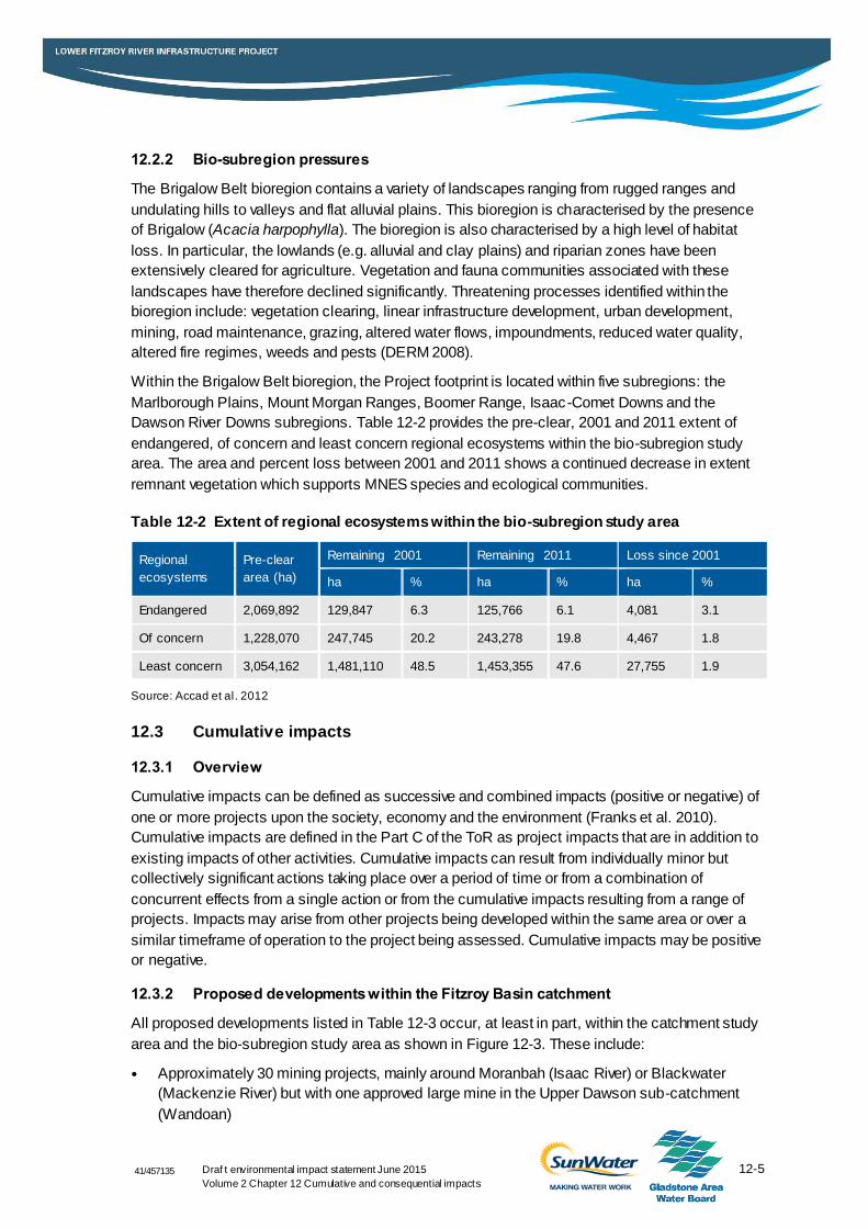
Within the Brigalow Belt bioregion, the Project footprint is located within five subregions: the
Marlborough Plains, Mount Morgan Ranges, Boomer Range, Isaac-Comet Downs and the
Dawson River Downs subregions. Table 12-2 provides the pre-clear, 2001 and 2011 extent of
endangered, of concern and least concern regional ecosystems within the bio-subregion study
area. The area and percent loss between 2001 and 2011 shows a continued decrease in extent
remnant vegetation which supports MNES species and ecological communities.
Table 12-2 Extent of regional ecosystems within the bio-subregion study area
Regional
ecosystems
Pre-clear
area (ha)
Remaining 2001 Remaining 2011 Loss since 2001
ha % ha % ha %
Endangered 2,069,892 129,847 6.3 125,766 6.1 4,081 3.1
Of concern 1,228,070 247,745 20.2 243,278 19.8 4,467 1.8
Least concern 3,054,162 1,481,110 48.5 1,453,355 47.6 27,755 1.9
Source: Accad et al. 2012
12.3 Cumulative impacts
12.3.1 Overview
Cumulative impacts can be defined as successive and combined impacts (positive or negative) of
one or more projects upon the society, economy and the environment (Franks et al. 2010).
Cumulative impacts are defined in the Part C of the ToR as project impacts that are in addition to
existing impacts of other activities. Cumulative impacts can result from individually minor but
collectively significant actions taking place over a period of time or from a combination of
concurrent effects from a single action or from the cumulative impacts resulting from a range of
projects. Impacts may arise from other projects being developed within the same area or over a
similar timeframe of operation to the project being assessed. Cumulative impacts may be positive
or negative.
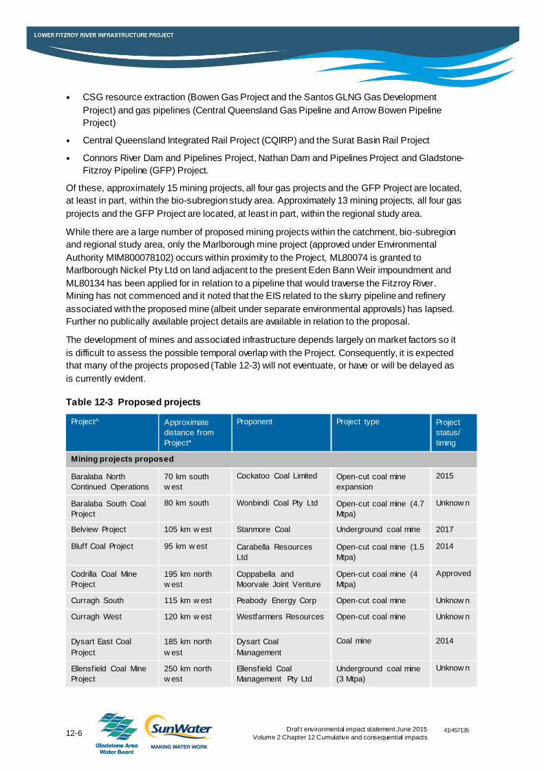
12.3.2 Proposed developments within the Fitzroy Basin catchment
All proposed developments listed in Table 12-3 occur, at least in part, within the catchment study
area and the bio-subregion study area as shown in Figure 12-3. These include:
Approximately 30 mining projects, mainly around Moranbah (Isaac River) or Blackwater
(Mackenzie River) but with one approved large mine in the Upper Dawson sub-catchment
(Wandoan)
41/457135
12-6 Draf t environmental impact statement June 2015
Volume 2 Chapter 12 Cumulative and consequential impacts
CSG resource extraction (Bowen Gas Project and the Santos GLNG Gas Development
Project) and gas pipelines (Central Queensland Gas Pipeline and Arrow Bowen Pipeline
Project)
Central Queensland Integrated Rail Project (CQIRP) and the Surat Basin Rail Project
Connors River Dam and Pipelines Project, Nathan Dam and Pipelines Project and Gladstone-
Fitzroy Pipeline (GFP) Project.
Of these, approximately 15 mining projects, all four gas projects and the GFP Project are located,
at least in part, within the bio-subregion study area. Approximately 13 mining projects, all four gas
projects and the GFP Project are located, at least in part, within the regional study area.
While there are a large number of proposed mining projects within the catchment, bio-subregion
and regional study area, only the Marlborough mine project (approved under Environmental
Authority MIM800078102) occurs within proximity to the Project, ML80074 is granted to
Marlborough Nickel Pty Ltd on land adjacent to the present Eden Bann Weir impoundment and
ML80134 has been applied for in relation to a pipeline that would traverse the Fitzroy River.
Mining has not commenced and it noted that the EIS related to the slurry pipeline and refinery
associated with the proposed mine (albeit under separate environmental approvals) has lapsed.
Further no publically available project details are available in relation to the proposal.
The development of mines and associated infrastructure depends largely on market factors so it
is difficult to assess the possible temporal overlap with the Project. Consequently, it is expected
that many of the projects proposed (Table 12-3) will not eventuate, or have or will be delayed as
is currently evident.
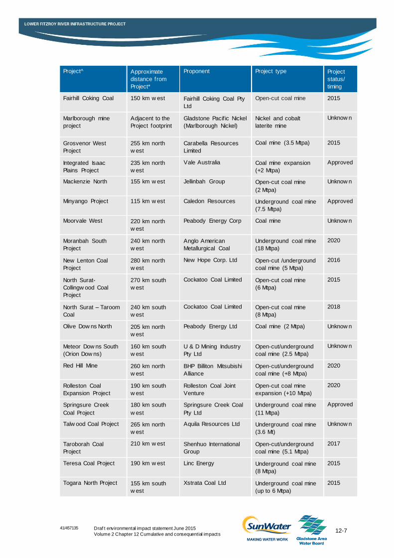
Table 12-3 Proposed projects
Project^ Approximate
distance from
Project*
Proponent Project type Project
status/
timing
Mining projects proposed
Baralaba North
Continued Operations
70 km south
w est
Cockatoo Coal Limited Open-cut coal mine
expansion
2015
Baralaba South Coal
Project
80 km south Wonbindi Coal Pty Ltd Open-cut coal mine (4.7
Mtpa)
Unknow n
Belview Project 105 km w est Stanmore Coal Underground coal mine 2017
Bluff Coal Project 95 km w est Carabella Resources
Ltd
Open-cut coal mine (1.5
Mtpa)
2014
Codrilla Coal Mine
Project
195 km north
w est
Coppabella and
Moorvale Joint Venture
Open-cut coal mine (4
Mtpa)
Approved
Curragh South 115 km w est Peabody Energy Corp Open-cut coal mine Unknow n
Curragh West 120 km w est Westfarmers Resources Open-cut coal mine Unknow n
Dysart East Coal
Project
185 km north
w est
Dysart Coal
Management
Coal mine 2014
Ellensfield Coal Mine
Project
250 km north
w est
Ellensfield Coal
Management Pty Ltd
Underground coal mine
(3 Mtpa)
Unknow n
41/457135
12-7 Draf t environmental impact statement June 2015
Volume 2 Chapter 12 Cumulative and consequential impacts
Project^ Approximate
distance from
Project*
Proponent Project type Project
status/
timing
Fairhill Coking Coal 150 km w est Fairhill Coking Coal Pty
Ltd
Open-cut coal mine 2015
Marlborough mine
project
Adjacent to the
Project footprint
Gladstone Pacif ic Nickel
(Marlborough Nickel)
Nickel and cobalt
laterite mine
Unknow n
Grosvenor West
Project
255 km north
w est
Carabella Resources
Limited
Coal mine (3.5 Mtpa) 2015
Integrated Isaac
Plains Project
235 km north
w est
Vale Australia Coal mine expansion
(+2 Mtpa)
Approved
Mackenzie North 155 km w est Jellinbah Group Open-cut coal mine
(2 Mtpa)
Unknow n
Minyango Project 115 km w est Caledon Resources Underground coal mine
(7.5 Mtpa)
Approved
Moorvale West 220 km north
w est
Peabody Energy Corp Coal mine Unknow n
Moranbah South
Project
240 km north
w est
Anglo American
Metallurgical Coal
Underground coal mine
(18 Mtpa)
2020
New Lenton Coal
Project
280 km north
w est
New Hope Corp. Ltd Open-cut /underground
coal mine (5 Mtpa)
2016
North Surat-
Collingw ood Coal
Project
270 km south
w est
Cockatoo Coal Limited Open-cut coal mine
(6 Mtpa)
2015
North Surat – Taroom
Coal
240 km south
w est
Cockatoo Coal Limited Open-cut coal mine
(8 Mtpa)
2018
Olive Dow ns North 205 km north
w est
Peabody Energy Ltd Coal mine (2 Mtpa) Unknow n
Meteor Dow ns South
(Orion Dow ns)
160 km south
w est
U & D Mining Industry
Pty Ltd
Open-cut/underground
coal mine (2.5 Mtpa)
Unknow n
Red Hill Mine 260 km north
w est
BHP Billiton Mitsubishi
Alliance
Open-cut/underground
coal mine (+8 Mtpa)
2020
Rolleston Coal
Expansion Project
190 km south
w est
Rolleston Coal Joint
Venture
Open-cut coal mine
expansion (+10 Mtpa)
2020
Springsure Creek
Coal Project
180 km south
w est
Springsure Creek Coal
Pty Ltd
Underground coal mine
(11 Mtpa)
Approved
Talw ood Coal Project 265 km north
w est
Aquila Resources Ltd Underground coal mine
(3.6 Mt)
Unknow n
Taroborah Coal
Project
210 km w est Shenhuo International
Group
Open-cut/underground
coal mine (5.1 Mtpa)
2017
Teresa Coal Project 190 km w est Linc Energy Underground coal mine
(8 Mtpa)
2015
Togara North Project 155 km south
w est
Xstrata Coal Ltd Underground coal mine
(up to 6 Mtpa)
2015
41/457135
12-8 Draf t environmental impact statement June 2015
Volume 2 Chapter 12 Cumulative and consequential impacts
Project^ Approximate
distance from
Project*
Proponent Project type Project
status/
timing
Wandoan Coal Project 285 km south Wandoan Joint Venture Open-cut coal mine
(30 Mtpa)
On hold
Willunga 190 km north
w est
Peabody Energy Ltd Open-cut coal mine
(3 Mt)
2015
Wilton Coal Project 160 km w est Wilton Coking Coal Pty
Ltd
Open-cut mine 2015
Proposed gas projects
Arrow Bow en Pipeline
Project
Project footprint Arrow Energy Pty Ltd CSG pipeline Approved
Arrow Bow en Gas
Project
90 km w est Arrow Energy Pty Ltd CSG extraction Approved
Central Queensland
Gas Pipeline
Project footprint Central Queensland
Gas Pipeline Pty Ltd
Gas pipeline Approved
Santos GLNG Gas
Development Project
125 km south
w est
Santos GLNG CSG extraction 2016
Proposed transport infrastructure projects
Surat Basin Rail
Project
Wandoan to
Banana
Surat Basin Rail Pty Ltd Railw ay line On hold
Central Queensland
Integrated Rail Project
260 km north
w est
Aurizon Holdings
Limited
Railw ay line Unknow n
Proposed water infrastructure projects
Connors River Dam
and Pipeline
200 km
upstream
SunWater Ltd Dam and pipelines Approved
GFP 70 km
dow nstream
Gladstone Area Water
Board
Water pipeline (buried) Approved
Nathan Dam and
Pipelines
200 km
upstream
SunWater Ltd Dam and pipelines Draft EIS
complete
*Approximate distance from nearest weir site
Eden Bann Weir
Rookwood
Dawson River
MOURA
MONTO
ALPHA
TAROOM
MACKAY
ARAMAC
EMERALD
YEPPOON
BLACKALL
DUARINGA
BUNDABERG
MIDDLEMOUNT
CHARLEVILLE
MIRIAM VALE
ROCKHAMPTON
Dawson HighwayPeak Downs Highway
Mitch
ellHig
hway
Landsborough Highway
Gregory Highway
Burnett Highway
Capricorn H ighway
Warrego Highway
Leichh
ardt H
ighwa
y
Saint Lawrence Road
Carnarvon Highway
Isis Highway
Bruce Highway
Wide Bay Highway
Bruce Highway
Burnett Highway
Bruce
High
way
Dawson Highway
Bruce H ighway
Bruce HighwayBurnett H ighway
Greg
ory H
ighwa
y
Landsborough Highway
Dawson Highway
Landsborough Highway
145.231
145.231
146.13
146.13
147.029
147.029
147.928
147.928
148.828
148.828
149.727
149.727
150.626
150.626
151.526
151.526
152.425
152.425
153.324
153.324
-25.78
-25.78
-24.88
07
-24.88
07
-23.98
13
-23.98
13
-23.08
2
-23.08
2
-22.18
27
-22.18
27
-21.28
34
-21.28
34
Job NumberRevision C
41-20736
G:\41\20736\GIS\Projects\MXD\200_Report\4120736_355_rev_c.mxd
Map Projection: Universal Transverse MercatorHorizontal Datum: Geocentric Datum of Australia (GDA94)
Grid: Map Grid of Australia 1994, Zone 55
0 25 50 75 100
Kilometres
© 2014. While GHD has taken care to ensure the accuracy of this product, GHD, DNRM, SUNWATER, ABS and GA make no representations or warranties about its accuracy, completeness or suitability for any particular purpose. GHD, DNRM, SUNWATER, ABS and GA cannot accept liability of any kind (whether in contract, tort or otherwise) for any expenses, losses, damages and/or costs (including indirect or consequential damage) which are or may be incurred as a result of the product being inaccurate, incomplete or unsuitable in any way and for any reason. *Please see Appendix for important copyright information.
Date 23 Sep 2014
Gladstone Area Water Board, SunWaterLower Fitzroy River Infrastructure Project
Proposed developments
Data Source: © Copyright Commonwealth of Australia (Geoscience Australia): Places, Waterways (2007); Sunwater: Weir Locations (2008); DNRM: Railways, Roads, Bioregions (2010); © Copyright Commonwealth of Australia (ABS): Local Study Area, Regional Study Area (2011), Wider Area of Influence (2014), GHD sourced: Proposed Projects/2014. Created by: MS *See Appendix for disclaimers and copyrights.
Level 9, 145 Ann Street Brisbane QLD 4000 Australia T +61 7 3316 3000 F +61 7 3316 3333 E [email protected] W www.ghd.comFigure 12-3
Copyright: This document is and shall remain the property of GHD. The document may only be used for the purpose for which it was produced. Unauthorised use of this document in any way is prohibited. © 2013.
LEGEND
CoralSea
BRISBANE
MACKAY
ROCKHAMPTON
TOWNSVILLE
QueenslandQueensland
1:3,750,000 (at A4)
Based on or contains data provided by the State of Queensland (DNRM) 2013. In consideration of the State permitting use of this data you acknowledge and agree that the State gives no warranty in relation to the data (including accuracy, reliability, completeness, currency or suitability) and accepts no liability (including without limitation, liability in negligence)for any loss, damage or costs (including consequential damage) relating to any use of the data. Data must not be used for direct marketing or be used in breach of the privacy laws.
WeirLocationPopulated PlacesRailwayWaterway (Major)
Highways (National)Impoundment AreaReefCatchment study areaBio-subregion study area
Proposed projectsCoal mineOther mineProposed water infrastructure projectsGladstone Fitzroy Pipeline ProjectProposed gas pipelineProposed rail infrastructureSantos GLNG Gas Development ProjectArrow Energy Bowen Gas Project
Proposed Nathan Dam
CQIRP
Proposed Connors Dam
Surat Basin
Rail Project
41/457135
12-10 Draf t environmental impact statement June 2015
Volume 2 Chapter 12 Cumulative and consequential impacts
12.3.3 Potential cumulative impacts on MNES
The assessment will discuss the likely cumulative impacts that the Project may have on MNES.
This will include the following:
The World Heritage values and National Heritage values of the Great Barrier Reef
Habitat for listed threatened, migratory and marine species and ecological communities.
12.3.3.1 World Heritage properties and National Heritage places
The Project is located on the Fitzroy River which flows into the Great Barrier Reef. The Great
Barrier Reef is listed as both a World Heritage property and a National Heritage place. No other
World Heritage properties or National Heritage places occur in proximity to the Project. As
described in Chapter 9 World Heritage properties and National Heritage places, the Project will
not significantly impact directly or indirectly on the world or national heritage values of the Great
Barrier Reef World Heritage Area (GBRWHA).
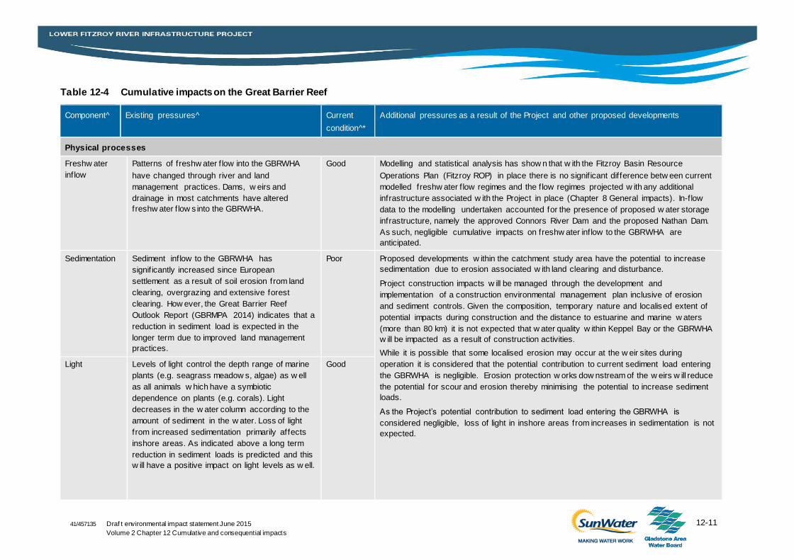
Assessment of the extent to which impacts of the Project may contribute to existing pressures on
the GBRWHA draws on ecosystem health assessment criteria identified in the Great Barrier Reef
Outlook Report (GBRMPA 2014). Existing pressures relevant to the Project were identified and an
assessment of the extent to which indirect impacts of the Project may contribute to each of these
pressures was undertaken as presented in Table 12-4.
12-11 Draf t environmental impact statement June 2015
Volume 2 Chapter 12 Cumulative and consequential impacts
41/457135
Table 12-4 Cumulative impacts on the Great Barrier Reef
Component^ Existing pressures^ Current
condition^*
Additional pressures as a result of the Project and other proposed developments
Physical processes
Freshw ater
inflow
Patterns of freshw ater f low into the GBRWHA
have changed through river and land
management practices. Dams, w eirs and
drainage in most catchments have altered
freshw ater f low s into the GBRWHA.
Good Modelling and statistical analysis has show n that w ith the Fitzroy Basin Resource
Operations Plan (Fitzroy ROP) in place there is no signif icant difference betw een current
modelled freshw ater f low regimes and the f low regimes projected w ith any additional
infrastructure associated w ith the Project in place (Chapter 8 General impacts). In-f low
data to the modelling undertaken accounted for the presence of proposed w ater storage
infrastructure, namely the approved Connors River Dam and the proposed Nathan Dam.
As such, negligible cumulative impacts on freshw ater inflow to the GBRWHA are
anticipated.
Sedimentation Sediment inflow to the GBRWHA has
signif icantly increased since European
settlement as a result of soil erosion from land
clearing, overgrazing and extensive forest
clearing. How ever, the Great Barrier Reef
Outlook Report (GBRMPA 2014) indicates that a
reduction in sediment load is expected in the
longer term due to improved land management
practices.
Poor Proposed developments w ithin the catchment study area have the potential to increase
sedimentation due to erosion associated w ith land clearing and disturbance.
Project construction impacts w ill be managed through the development and
implementation of a construction environmental management plan inclusive of erosion
and sediment controls. Given the composition, temporary nature and localised extent of
potential impacts during construction and the distance to estuarine and marine w aters
(more than 80 km) it is not expected that w ater quality w ithin Keppel Bay or the GBRWHA
w ill be impacted as a result of construction activities.
While it is possible that some localised erosion may occur at the w eir sites during
operation it is considered that the potential contribution to current sediment load entering
the GBRWHA is negligible. Erosion protection w orks dow nstream of the w eirs w ill reduce
the potential for scour and erosion thereby minimising the potential to increase sediment
loads.
As the Project’s potential contribution to sediment load entering the GBRWHA is
considered negligible, loss of light in inshore areas from increases in sedimentation is not
expected.
Light Levels of light control the depth range of marine
plants (e.g. seagrass meadow s, algae) as w ell
as all animals w hich have a symbiotic
dependence on plants (e.g. corals). Light
decreases in the w ater column according to the
amount of sediment in the w ater. Loss of light
from increased sedimentation primarily affects
inshore areas. As indicated above a long term
reduction in sediment loads is predicted and this
w ill have a positive impact on light levels as w ell.
Good
12-12 Draf t environmental impact statement June 2015
Volume 2 Chapter 12 Cumulative and consequential impacts
41/457135
Component^ Existing pressures^ Current
condition^*
Additional pressures as a result of the Project and other proposed developments
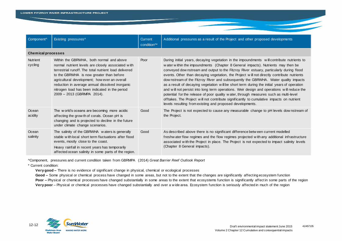
Chemical processes
Nutrient
cycling
Within the GBRWHA, both normal and above
normal nutrient levels are closely associated w ith
terrestrial runoff. The total nutrient load delivered
to the GBRWHA is now greater than before
agricultural development; how ever an overall
reduction in average annual dissolved inorganic
nitrogen load has been indicated in the period
2009 – 2013 (GBRMPA 2014).
Poor During initial years, decaying vegetation in the impoundments w ill contribute nutrients to
w ater w ithin the impoundments (Chapter 8 General impacts). Nutrients may then be
conveyed dow nstream and output to the Fitzroy River estuary, particularly during f lood
events. Other than decaying vegetation, the Project w ill not directly contribute nutrients
dow nstream of the Fitzroy River and subsequently the GBRWHA. Water quality impacts
as a result of decaying vegetation w ill be short term during the initial years of operation
and w ill not persist into long term operations. Weir design and operations w ill reduce the
potential for the release of poor quality w ater, through measures such as multi-level
offtakes. The Project w ill not contribute signif icantly to cumulative impacts on nutrient
levels resulting from existing and proposed developments.
Ocean
acidity
The w orld’s oceans are becoming more acidic
affecting the grow th of corals. Ocean pH is
changing and is projected to decline in the future
under climate change scenarios.
Good The Project is not expected to cause any measurable change to pH levels dow nstream of
the Project.
Ocean
salinity
The salinity of the GBRWHA w aters is generally
stable w ith local short term fluctuations after f lood
events, mostly close to the coast.
Heavy rainfall in recent years has temporarily
affected ocean salinity in some parts of the region.
Good As described above there is no signif icant difference betw een current modelled
freshw ater f low regimes and the f low regimes projected w ith any additional infrastructure
associated w ith the Project in place. The Project is not expected to impact salinity levels
(Chapter 8 General impacts).
^Component, pressures and current condition taken from GBRMPA (2014) Great Barrier Reef Outlook Report
* Current condition:
Very good – There is no evidence of signif icant change in physical, chemical or ecological processes
Good – Some physical or chemical process have changed in some areas, but not to the extent that the changes are signif icantly affect ing ecosystem function
Poor – Physical or chemical processes have changed substantially in some areas to the extent that ecosystems function is signif icantly affect in some parts of the region
Very poor – Physical or chemical processes have changed substantially and over a w ide area. Ecosystem function is seriously affected in much of the region
41/457135
12-13 Draf t environmental impact statement June 2015
Volume 2 Chapter 12 Cumulative and consequential impacts
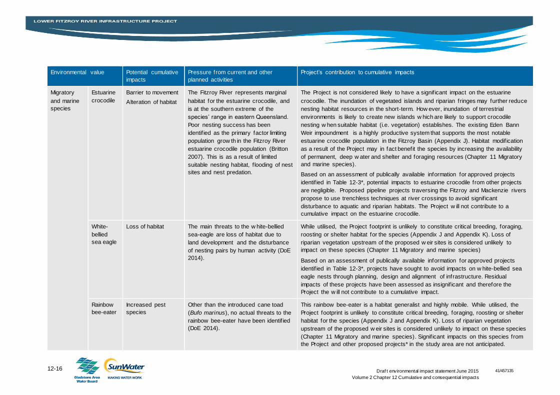
12.3.3.2 Listed threatened, migratory and marine species and ecological communities
One threatened ecological community, Brigalow (Acacia harpophylla dominant and co-dominant)
(Brigalow TEC), is known to occur within the Project footprint. In addition, three vulnerable species and
four migratory species are known to occur within the Project footprint as follows:
Listed vulnerable species:
– Squatter pigeon (southern) (Geophaps scripta scripta)
– Black ironbox (Eucalyptus raveretiana)
– Fitzroy River turtle (Rheodytes leukops).
Listed migratory and marine species:
– Estuarine crocodile (Crocodylus porosus)
– White-bellied sea-eagle (Haliaeetus leucogaster)
– Rainbow bee-eater (Haliaeetus leucogaster)
– Great egret, white egret (Ardea alba).
Table 12-5 provides an assessment of the Project’s contribution to cumulative impacts on the Brigalow
TEC and the above threatened, migratory and marine species.
Through the assessment it was determined that there is the potential for the Project to contribute to the
cumulative impacts on MNES as follows:
A cumulative loss of Brigalow TEC
Cumulative impacts on the Fitzroy River turtle as a result of:
– Cumulative loss/alteration of aquatic habitat within the catchment study area including the loss of
turtle nesting habitat and the conversion of riffle-run habitat to impounded habitat
– Cumulative risk of injury and mortality to aquatic fauna from the operation of water infrastructure
within the catchment
– Cumulative impact on aquatic fauna movement in the catchment.
No significant impacts to downstream marine and estuarine ecosystems are anticipated as a result of
the Project .The Project would not result in downstream loss or fragmentation of habitats, increased
predation or the introduction or spread of invasive weeds. The Project’s contribution to cumulative
impacts on downstream threatened, migratory or marine species is considered negligible.
12-14 Draf t environmental impact statement June 2015
Volume 2 Chapter 12 Cumulative and consequential impacts
41/457135
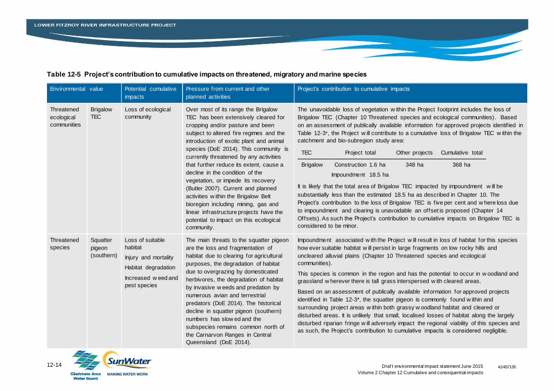
Table 12-5 Project’s contribution to cumulative impacts on threatened, migratory and marine species
Environmental value Potential cumulative
impacts
Pressure from current and other
planned activities
Project’s contribution to cumulative impacts
Threatened
ecological
communities
Brigalow
TEC
Loss of ecological
community
Over most of its range the Brigalow
TEC has been extensively cleared for
cropping and/or pasture and been
subject to altered f ire regimes and the
introduction of exotic plant and animal
species (DoE 2014). This community is
currently threatened by any activities
that further reduce its extent, cause a
decline in the condition of the
vegetation, or impede its recovery
(Butler 2007). Current and planned
activities w ithin the Brigalow Belt
bioregion including mining, gas and
linear infrastructure projects have the
potential to impact on this ecological
community.
The unavoidable loss of vegetation w ithin the Project footprint includes the loss of
Brigalow TEC (Chapter 10 Threatened species and ecological communities). Based
on an assessment of publically available information for approved projects identif ied in
Table 12-3*, the Project w ill contribute to a cumulative loss of Brigalow TEC w ithin the
catchment and bio-subregion study area:
TEC Project total Other projects Cumulative total
Brigalow Construction 1.6 ha
Impoundment 18.5 ha
348 ha 368 ha
It is likely that the total area of Brigalow TEC impacted by impoundment w ill be
substantially less than the estimated 18.5 ha as described in Chapter 10. The
Project’s contribution to the loss of Brigalow TEC is f ive per cent and w here loss due
to impoundment and clearing is unavoidable an offset is proposed (Chapter 14
Offsets). As such the Project’s contribution to cumulative impacts on Brigalow TEC is
considered to be minor.
Threatened
species
Squatter
pigeon
(southern)
Loss of suitable
habitat
Injury and mortality
Habitat degradation
Increased w eed and
pest species
The main threats to the squatter pigeon
are the loss and fragmentation of
habitat due to clearing for agricultural
purposes, the degradation of habitat
due to overgrazing by domesticated
herbivores, the degradation of habitat
by invasive w eeds and predation by
numerous avian and terrestrial
predators (DoE 2014). The historical
decline in squatter pigeon (southern)
numbers has slow ed and the
subspecies remains common north of
the Carnarvon Ranges in Central
Queensland (DoE 2014).
Impoundment associated w ith the Project w ill result in loss of habitat for this species
how ever suitable habitat w ill persist in large fragments on low rocky hills and
uncleared alluvial plains (Chapter 10 Threatened species and ecological
communities).
This species is common in the region and has the potential to occur in w oodland and
grassland w herever there is tall grass interspersed w ith cleared areas.
Based on an assessment of publically available information for approved projects
identif ied in Table 12-3*, the squatter pigeon is commonly found w ithin and
surrounding project areas w ithin both grassy w oodland habitat and cleared or
disturbed areas. It is unlikely that small, localised losses of habitat along the largely
disturbed riparian fringe w ill adversely impact the regional viability of this species and
as such, the Project’s contribution to cumulative impacts is considered negligible.
12-15 Draf t environmental impact statement June 2015
Volume 2 Chapter 12 Cumulative and consequential impacts
41/457135
Environmental value Potential cumulative
impacts
Pressure from current and other
planned activities
Project’s contribution to cumulative impacts
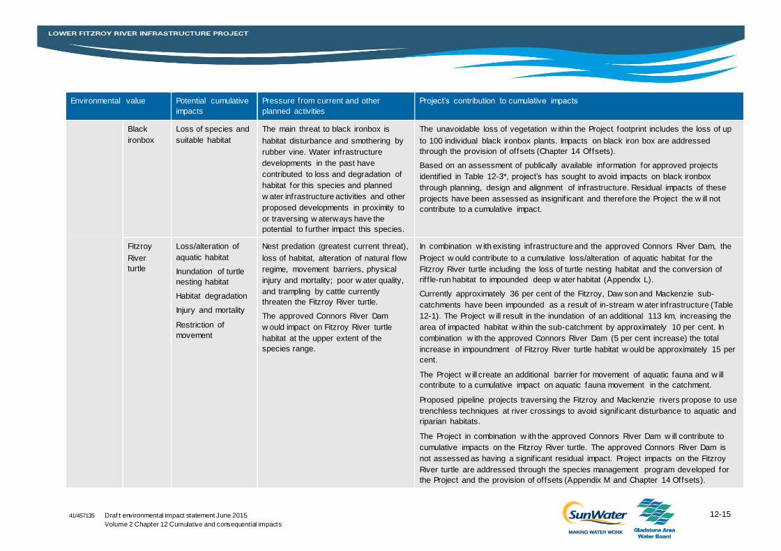
Black
ironbox
Loss of species and
suitable habitat
The main threat to black ironbox is
habitat disturbance and smothering by
rubber vine. Water infrastructure
developments in the past have
contributed to loss and degradation of
habitat for this species and planned
w ater infrastructure activities and other
proposed developments in proximity to
or traversing w aterways have the
potential to further impact this species.
The unavoidable loss of vegetation w ithin the Project footprint includes the loss of up
to 100 individual black ironbox plants. Impacts on black iron box are addressed
through the provision of offsets (Chapter 14 Offsets).
Based on an assessment of publically available information for approved projects
identif ied in Table 12-3*, project’s has sought to avoid impacts on black ironbox
through planning, design and alignment of infrastructure. Residual impacts of these
projects have been assessed as insignif icant and therefore the Project the w ill not
contribute to a cumulative impact.
Fitzroy
River
turtle
Loss/alteration of
aquatic habitat
Inundation of turtle
nesting habitat
Habitat degradation
Injury and mortality
Restriction of
movement
Nest predation (greatest current threat),
loss of habitat, alteration of natural f low
regime, movement barriers, physical
injury and mortality; poor w ater quality,
and trampling by cattle currently
threaten the Fitzroy River turtle.
The approved Connors River Dam
w ould impact on Fitzroy River turtle
habitat at the upper extent of the
species range.
In combination w ith existing infrastructure and the approved Connors River Dam, the
Project w ould contribute to a cumulative loss/alteration of aquatic habitat for the
Fitzroy River turtle including the loss of turtle nesting habitat and the conversion of
rif f le-run habitat to impounded deep w ater habitat (Appendix L).
Currently approximately 36 per cent of the Fitzroy, Daw son and Mackenzie sub-
catchments have been impounded as a result of in-stream w ater infrastructure (Table
12-1). The Project w ill result in the inundation of an additional 113 km, increasing the
area of impacted habitat w ithin the sub-catchment by approximately 10 per cent. In
combination w ith the approved Connors River Dam (5 per cent increase) the total
increase in impoundment of Fitzroy River turtle habitat w ould be approximately 15 per
cent.
The Project w ill create an additional barrier for movement of aquatic fauna and w ill
contribute to a cumulative impact on aquatic fauna movement in the catchment.
Proposed pipeline projects traversing the Fitzroy and Mackenzie rivers propose to use
trenchless techniques at river crossings to avoid signif icant disturbance to aquatic and
riparian habitats.
The Project in combination w ith the approved Connors River Dam w ill contribute to
cumulative impacts on the Fitzroy River turtle. The approved Connors River Dam is
not assessed as having a signif icant residual impact. Project impacts on the Fitzroy
River turtle are addressed through the species management program developed for
the Project and the provision of offsets (Appendix M and Chapter 14 Offsets).
12-16 Draf t environmental impact statement June 2015
Volume 2 Chapter 12 Cumulative and consequential impacts
41/457135
Environmental value Potential cumulative
impacts
Pressure from current and other
planned activities
Project’s contribution to cumulative impacts
Migratory
and marine
species
Estuarine
crocodile
Barrier to movement
Alteration of habitat
The Fitzroy River represents marginal
habitat for the estuarine crocodile, and
is at the southern extreme of the
species’ range in eastern Queensland.
Poor nesting success has been
identif ied as the primary factor limiting
population grow th in the Fitzroy River
estuarine crocodile population (Britton
2007). This is as a result of limited
suitable nesting habitat, f looding of nest
sites and nest predation.
The Project is not considered likely to have a signif icant impact on the estuarine
crocodile. The inundation of vegetated islands and riparian fringes may further reduce
nesting habitat resources in the short-term. How ever, inundation of terrestrial
environments is likely to create new islands w hich are likely to support crocodile
nesting w hen suitable habitat (i.e. vegetation) establishes. The existing Eden Bann
Weir impoundment is a highly productive system that supports the most notable
estuarine crocodile population in the Fitzroy Basin (Appendix J). Habitat modif ication
as a result of the Project may in fact benefit the species by increasing the availability
of permanent, deep w ater and shelter and foraging resources (Chapter 11 Migratory
and marine species).
Based on an assessment of publically available information for approved projects
identif ied in Table 12-3*, potential impacts to estuarine crocodile from other projects
are negligible. Proposed pipeline projects traversing the Fitzroy and Mackenzie rivers
propose to use trenchless techniques at river crossings to avoid signif icant
disturbance to aquatic and riparian habitats. The Project w ill not contribute to a
cumulative impact on the estuarine crocodile.
White-
bellied
sea eagle
Loss of habitat The main threats to the w hite-bellied
sea-eagle are loss of habitat due to
land development and the disturbance
of nesting pairs by human activity (DoE
2014).
While utilised, the Project footprint is unlikely to constitute critical breeding, foraging,
roosting or shelter habitat for the species (Appendix J and Appendix K). Loss of
riparian vegetation upstream of the proposed w eir sites is considered unlikely to
impact on these species (Chapter 11 Migratory and marine species)
Based on an assessment of publically available information for approved projects
identif ied in Table 12-3*, projects have sought to avoid impacts on w hite-bellied sea
eagle nests through planning, design and alignment of infrastructure. Residual
impacts of these projects have been assessed as insignif icant and therefore the
Project the w ill not contribute to a cumulative impact.
Rainbow
bee-eater
Increased pest
species
Other than the introduced cane toad
(Bufo marinus), no actual threats to the
rainbow bee-eater have been identif ied
(DoE 2014).
This rainbow bee-eater is a habitat generalist and highly mobile. While utilised, the
Project footprint is unlikely to constitute critical breeding, foraging, roosting or shelter
habitat for the species (Appendix J and Appendix K). Loss of riparian vegetation
upstream of the proposed w eir sites is considered unlikely to impact on these species
(Chapter 11 Migratory and marine species). Signif icant impacts on this species from
the Project and other proposed projects* in the study area are not anticipated.
12-17 Draf t environmental impact statement June 2015
Volume 2 Chapter 12 Cumulative and consequential impacts
41/457135
Environmental value Potential cumulative
impacts
Pressure from current and other
planned activities
Project’s contribution to cumulative impacts
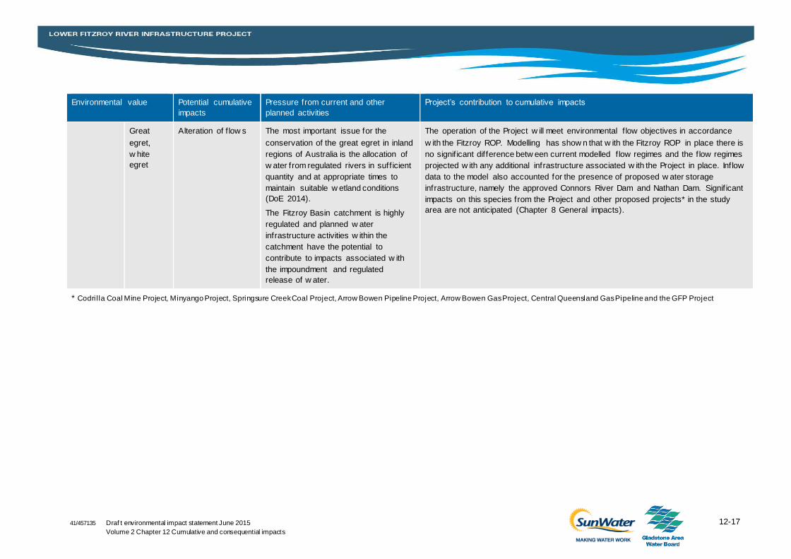
Great
egret,
w hite
egret
Alteration of f low s The most important issue for the
conservation of the great egret in inland
regions of Australia is the allocation of
w ater from regulated rivers in suff icient
quantity and at appropriate times to
maintain suitable w etland conditions
(DoE 2014).
The Fitzroy Basin catchment is highly
regulated and planned w ater
infrastructure activities w ithin the
catchment have the potential to
contribute to impacts associated w ith
the impoundment and regulated
release of w ater.
The operation of the Project w ill meet environmental f low objectives in accordance
w ith the Fitzroy ROP. Modelling has show n that w ith the Fitzroy ROP in place there is
no signif icant difference betw een current modelled f low regimes and the f low regimes
projected w ith any additional infrastructure associated w ith the Project in place. Inflow
data to the model also accounted for the presence of proposed w ater storage
infrastructure, namely the approved Connors River Dam and Nathan Dam. Signif icant
impacts on this species from the Project and other proposed projects* in the study
area are not anticipated (Chapter 8 General impacts).
* Codril la Coal Mine Project, Minyango Project, Springsure Creek Coal Project, Arrow Bowen Pipeline Project, Arrow Bowen Gas Project, Central Queensland Gas Pipeline and the GFP Project
12-18 Draf t environmental impact statement June 2015
Volume 2 Chapter 12 Cumulative and consequential impacts
41/457135
12.4 Consequential impacts
12.4.1 Overview
Consequential impacts arise where a project may create a requirement for additional development or
additional development may be facilitated to a significant extent by a project. The Project forms part of a
broader commitment by the Queensland Government to the National Water Initiative Agreement (2004).
In December 2004, the Queensland Government committed to developing the Central Queensland
Regional Water Supply Strategy (CQRWSS) (Chapter 1 Description of the action), a long term water
supply strategy for the region to address the following key issues:
Continued urban growth and industrial development, particularly in the Lower Fitzroy and Gladstone
areas, and mining development in the Bowen and Surat coal basins
Entitlements in some existing regional water supply systems are at or approaching full usage
Some existing water supply schemes are performing below water user requirements
Water demand projections indicate regional supply shortfalls exist to meet urban, industrial, coal
mining and agricultural requirements through to 2020.
The Project is integrally linked to the existing Fitzroy Barrage and the approved GFP Project (Chapter 1
Description of the action) to meet the current and immediate demands for water within the region. The
GFP Project pipeline will transport water from an extraction point within the Fitzroy Barrage impoundment
to Gladstone, connecting with existing water infrastructure in the Gladstone State Development Area
(GAWB 2008). Two other related projects include the approved Connors River Dam and Pipeline Project
and the proposed Nathan Dam and Pipeline Project which are subject to separate assessment and
approval. Neither the approved Connors River Dam and Pipeline Project nor the proposed Nathan Dam
and Pipeline Project, or the projects identified in Section 12.3.2 (excluding the GFP Project) are reliant
upon the development of the Project and as such do not represent a consequential impact. The GFP
Project has undergone separate environmental assessment. The EIS for the GFP Project was approved
by the Queensland Coordinator-General in February 2010 and by the Commonwealth Minister for
Environment in November 2011.
The Project’s objective is to provide water storage infrastructure on the Fitzroy River with the primary aim
of securing the strategic water infrastructure reserve; a nominal volume of 76,000 ML (for supplemented
allocations).
The Fitzroy WRP identifies unallocated water held as strategic water infrastructure reserve; a nominal
volume of 76,000 ML (for supplemented water allocations) reserved for water infrastructure on the
Fitzroy River, within which the Project is included. The Fitzroy ROP specifies that the chief executive may
accept submissions for making unallocated water available from the strategic infrastructure reserve on
the Fitzroy River as follows:
Gladstone Area Water Board: up to 30,000 ML of the reserve for urban and industrial water supplies
Local government authority: up to 4,000 ML of the reserve for urban water supplies for the Capricorn
Coast
Person or entity: up to the remaining 42,000 ML of the reserve.
A water supply use for the remaining 42,000 ML of the strategic water infrastructure reserve is not
specified. Based on development demand within the region it is reasonable to expect that this water
could be utilised for a mix of industrial, urban and agricultural uses. Regional planning documents and
policy indicate a focus on industrial development within the Gracemere-Stanwell Industrial Corridor
12-19 Draf t environmental impact statement June 2015
Volume 2 Chapter 12 Cumulative and consequential impacts
41/457135
(Fitzroy Planning Scheme 2005), urban residential development within the designated priority living
areas of the regional plan (DSDIP, 2013) and potential agricultural development within the Fitzroy
Agricultural Corridor (RDA 2014).
The following assessment is based on an estimate of potential development which could be influenced or
facilitated through the development of the Project. In the absence of specific proposals for development a
high level assessment is provided indicating reasonable assumptions in regard to the scale and class of
development.
12.4.2 Potential consequential developments within the region
12.4.2.1 Industrial development
Industrial development within the Gladstone and Rockhampton areas is predicted and planned for
through local and regional statutory planning documents and include the Gladstone State Development
Area and the Gracemere-Stanwell Industrial Corridor. The Gladstone State Development Area (SDA)
comprises some 29,000 ha of land set aside for the development of major industries. Land uses
considered suitable for the Gladstone SDA include (Department of State Development, 2015):
Large-scale, large-footprint industrial development
Industrial development requiring access to strategic port logistics and maritime facilities
Port-related activities and industries necessary to support major industrial development
Liquefied natural gas processing, storage and export facilities
Materials transportation infrastructure and utility and service infrastructure
Gas transportation infrastructure and other compatible infrastructure.
A number of the existing and future major industries within the Gladstone SDA require large volumes of
secure water. As stated in the Fitzroy ROP, up to 30,000 ML of the strategic water infrastructure reserve
is available to GAWB (on application) to supply development within the Gladstone SDA. Development
within the Gladstone SDA is subject to assessment of potential impacts through State and
Commonwealth legislation through implementation of the Gladstone SDA Planning Scheme and State
Planning Policies as well as the provisions of the EPBC Act where matters of national environmental
significance may be impacted.
Development within the Gladstone SDA has been planned for several decades and is dependent upon a
number of factors including water supply.
The Gracemere-Stanwell Industrial Corridor represents the major area of proposed future industrial
development within the Fitzroy region. The area encompasses approximately 940 ha. This area has
been identified within the Fitzroy Shire Planning Scheme 2005 for industrial development subject to
relevant planning provisions and other State and Commonwealth approval requirements. The
Rockhampton Regional Council Industrial Land use Study identified the demand for future industrial land
to the year 2031 as being 180 ha (GHD 2010). One of the restrictions to future growth within the
industrial corridor is water supply; as such the Project has the potential to facilitate development should
supply be connected.
It is anticipated that part of the 42,000 ML strategic water infrastructure reserve would be utilised to
provide supply to development within the industrial corridor.
12-20 Draf t environmental impact statement June 2015
Volume 2 Chapter 12 Cumulative and consequential impacts
41/457135
12.4.2.2 Residential development
The Central Queensland Regional Plan (DSDIP 2013a) predicts that demand for water is expected to
increase in the Central Queensland region due to several factors including ongoing population growth, in
particular within the key regional centres of Gladstone and Rockhampton (Appendix R).
Overall, the region has shown sustained population growth over five years to 2012 (7 per cent growth).
The majority of this growth has occurred in the Gladstone area due to the growth of industry and
employment opportunities there (largely associated with mining and natural gas resources). The region’s
population is projected to grow from 223,000 to 345,000 by 2031, representing an average annual
growth rate of 2.1 per cent over the 20 year period compared with 1.8 per cent for Queensland. Urban
water supply to support residential development within the Gladstone region would be supplied via the
GFP project and part of the 30,000 ML reserve identified in the Fitzroy ROP for GAWB.
Rockhampton City has experienced gradual increases in residential population from 2006 to 2011. It is
evident that growth is occurring inside Rockhampton City as well as outside the city in areas that still
have a strong reliance on Rockhampton City for goods and services and as a base for the region (RRC
2012). Population growth is expected to be driven predominately by mining and associated industry and
development. The projected population for Rockhampton City is also expected to increase. As a base for
the region, the increased population will generally be people residing in Rockhampton but working
elsewhere in the region.
As described in Chapter 1, one of the drivers for the Project is to increase water security for RCC which
would support urban growth within the City and region. As such the Project is considered to contribute to
this growth, although it is difficult to quantify the extent of this contribution. It is also clear that the
development within these regions is likely to occur without development of the Project as alternate
sources of water and demand management strategies could be utilised to support urban development. It
is anticipated that either the nominal reserve of up to 4,000 ML or part of the 42,000 ML reserve could be
utilised by local governments to provide supply to urban residential development within Rockhampton
and the wider Capricorn Coast region.
12.4.2.3 Agricultural development
Agricultural development has been identified as a priority for the Fitzroy region (RDA, 2014). Previous
studies, including the Fitzroy Industry Infrastructure Study (FIIS) (GHD 2006) and Queensland
Agricultural Land Audit (QALA) (DAFF 2013), have identified areas of suitable land for irrigated
agricultural development which could be facilitated through the provision of water supply. The areas are
defined based on direct access to water from the proposed Project storages or via ‘run of river’ methods.
The studies showed that the Lower Fitzroy Region is suitable for intensive livestock production and some
horticultural activities (Department of Infrastructure, 2007). As part of the FIIS a Fitzroy Agricultural
Development Area Land Suitability Study was conducted (GHD 2006). This study assessed the suitability
of land west of Rockhampton for the establishment of an Agricultural Development Area to support
primary industry, specifically intensive animal husbandry activities. The Commonwealth Government’s
White Paper on Developing Northern Australia (the Northern Australia White Paper) states that the
Queensland Government supports working with proponents in respect of agricultural development,
including the proposed agricultural precinct west of Rockhampton (Australian Government 2015) and that
the that the Project ‘facilitates the allocation of water entitlements and implements management
strategies to ensure equitable sharing of the resource amongst water users including the environment’.
The Agricultural Competitiveness White Paper (Commonwealth of Australia 2015) identifies the Project
as ‘having a strong potential for Commonwealth involvement’.
12-21 Draf t environmental impact statement June 2015
Volume 2 Chapter 12 Cumulative and consequential impacts
41/457135
The study area defined in the FIIS report encompasses the Eden Bann Weir and Rookwood Weir
inundation areas and has therefore been able to be utilised for the consequential assessment. The study
identified nine areas of potential agricultural development, totalling approximately 31,000 ha of
unconstrained land and a further 16,000 ha of moderately constrained land. The areas identified in the
Land Suitability Study (GHD, 2006) are generally consistent in location and constraint level compared to
the potential agricultural areas defined in the QALA. Where the agricultural potential was mapped by
combining biophysical and socio-economic spatial data with characteristics that best match the
requirements of each Agricultural Land Use Category (DAF 2015).
Agricultural development opportunities within the region are focusing on the development of intensive
animal husbandry, intensive agricultural/horticulture and broad acre cropping. The extent of future
agricultural development will be dependent on a range of matters from availability of water and suitability
of land, to the provision of supporting infrastructure and market demands for product, among others. The
Department of Agriculture and Fisheries (DAF) has identified a potential long term scenario for full
development of agricultural activities which could be achieved through provision of water from a number
of sources of which the Project represents one contributing source.
It is anticipated that part of the 42,000 ML reserve would be utilised to provide water supply to
agricultural development. The Project is intended to provide supplemented high priority water. This
classification would affect the economic viability of low value agricultural activities such as broad acre
cropping and limit the potential for its utilisation for irrigation in this regard. It is considered substantially
more likely that intensive agricultural land uses such as cattle feedlots, and intensive horticulture would
be sufficiently economically viable to justify the allocation and use of high priority water. Based on the
potentially available water volumes, the economic value of development and projected growth, the
following development scenario has been considered to represent the contribution the Project could have
to overall agricultural development within the region:
Two 10,000 standard cattle unit feedlots and 2,000 ha for irrigated green fodder/silage crops for use
in the feedlots
735 ha of irrigated broad acre crops (mix of cereals, legumes and other crops that are commonly
grown in Central Queensland)
315 ha of irrigated horticultural crops (vegetable crops, tree crops (citrus; lychee; mango)).
It is estimated that in the order of 20,000 ML of water would be required to support agricultural
development associated with this scenario. It is expected that this reserve could be allocated from the
42,000 ML strategic water infrastructure reserve as part of the Project.
Approximately 140 grazing properties and feedlots with a capacity of 135,000 animals are currently
located within the Fitzroy WRP area, the majority of which are small farms, each with less than 500
animals (DERM 2009). The potential consequential development attributable to the Project would
therefore represent an increase of approximately 15 per cent in the number of animals.
Existing irrigated cropping within the Fitzroy WRP area is estimated to be approximately 66,000 ha
(DERM 2009). The potential consequential development attributable to the Project would therefore
represent a minor increase in cropping of less than five per cent.
12.4.3 Potential consequential impacts on MNES
The assessment will discuss the likely consequential impacts that facilitating industrial development,
residential development and agricultural development may have on MNES. This will include the
following:

12-22 Draf t environmental impact statement June 2015
Volume 2 Chapter 12 Cumulative and consequential impacts
41/457135
The World Heritage values and National Heritage values of the GBRWHA
Habitat for listed threatened, migratory and marine species and ecological communities.
12.4.3.1 World Heritage Properties and National Heritage Places
The Project is located on the Fitzroy River which flows into the Great Barrier Reef. The Great Barrier
Reef is listed as both a World Heritage property and a National Heritage place. No other World Heritage
properties or National Heritage places occur in proximity to the study area.
Assessment of the extent to which consequential impacts may contribute to existing pressures on the
GBRWHA draws on ecosystem health criteria identified in the Great Barrier Reef Outlook Report
(GBRMPA 2014). Existing pressures relevant to consequential development were identified and an
assessment of the extent to which consequential impacts of the Project may contribute to each of these
pressures was undertaken as presented in Table 12-6.
Industrial and residential development
According to the Reef 2050 Long-Term Sustainability Plan (Commonwealth of Australia 2015), one
immediate, system-wide pressure facing the GBRWHA is land-based run-off including sediments;
pesticides; and debris which has a negative impact to marine water quality particularly within the inshore
areas. Increased industrial and residential development has the potential to contribute to this pressure
through increased stormwater run-off.
Industrial development is highly regulated through the local, State and Commonwealth environmental
legislation, which provides for the assessment and management of specific activities. Local and State
development assessments and approvals seek to minimise potential offsite environmental effects (as
defined in the Environmental Protection Act 1994). This can be achieved by ensuring that proposals for
individual developments have, as their underlying structure, the principles of best practice environmental
management. When managed correctly, environmental impacts can be kept within the accepted State
and National environmental parameters for water, air, waste and noise.
Urban residential development required to accommodate population growth has the potential to increase
pressures on MNES. Nonetheless, population growth and the associated land use pressure is from a
relatively small base compared to land area (a significant increase in population in Rockhampton is
unlikely to require a major new footprint) and the development will be subject to significant regulation.
Small scale project development (including residential development) will require assessment and
approval under the Sustainable Planning Act 2009 (Qld) (amongst others) and in accordance with State
planning policies and other relevant legislation. Where potential impacts to MNES are considered likely,
assessment under the EPBC Act would be required.
The potential for impacts arising from stormwater runoff from future industrial and residential
development areas impacting upon the GBRWHA is considered to be negligible having regard to the
stormwater management measures that are required through existing local and State planning controls
for any future development. These measures are likely to effectively control run-off volumes and quality
and limit any potential impact. Also potential impacts from treated sewage discharge is considered likely
to be negligible, with trade waste controls of local governments and sewage treated to a tertiary standard
under the control of an environmental authority as issued for an environmentally relevant activity (ERA)
administered by the Queensland Government. Sewage discharge from residential areas is estimated to
contribute less than four per cent of the total nitrogen load and less than one per cent of the total
phosphorous load annually discharged to the GBRWHA (DSDIP 2013b).The Great Barrier Reef Coastal
Zone Strategic Assessment (DSDIP 2013b) states that ‘while the urban development required to
12-23 Draf t environmental impact statement June 2015
Volume 2 Chapter 12 Cumulative and consequential impacts
41/457135
accommodate population growth in the Great Barrier Reef coastal zone will increase pressures on
MNES, it will generally be localised and of marginal significance relative to other pressures’.
Agricultural development
Management of the effects of agricultural development within GBRWHA catchments is being improved in
recent years as a result of direct regulation at Local, State and National government level, as well as
adoption of management practices through the implementation of actions identified in the Reef 2050
Long Term Development Plan (Commonwealth of Australia 2015) and specific programs such as the
Reef Water Quality Protection Plan (State of Queensland 2013).
The current condition of nutrient cycling in the GBRWHA is considered poor and heavily influenced by
land management practices (for example clearing of vegetation and the associated terrestrial run-off from
activities such as agricultural development). However the latest 2014 Outlook Report (GBRMPA 2014)
concludes that threats to the GBRWHA such as nutrients, sediment and pesticide loads are beginning to
be addressed through improved land management practices and voluntary behavioural changes
promoted by local and regional stewardship programs (for example the Fitzroy Basin Association’s
‘Sustainable agriculture through innovative practices in the Fitzroy’ and ‘Fitzroy water quality project’
funded through the Queensland Regional Natural Resource Management Investment Program).
Intensive animal husbandry
Potential impacts to MNES associated with intensive animal husbandry (feedlots) include:
Water quality degradation (nutrients, pesticides and sediments)
Groundwater degradation
Vegetation impacts (clearing).
Intensive animal husbandry is a highly regulated industry which triggers an ERA under the Environmental
Protection Regulation 2008 and requires an environmental authority for the operator and a development
permit for the property.
There are several guidelines that regulate cattle feedlots:
National Guidelines for Beef Cattle Feedlots in Australia, 2nd edition, (Agriculture and Resource
Management Council of Australia and New Zealand 1997)
National guidelines for beef cattle feedlots in Australia 3rd Edition (Meat and Livestock Australia
Limited, 2012a)
National beef cattle feedlot environmental code of practice 2nd Edition (Meat and Livestock Australia
Limited, 2012b).
Runoff, leaching or seepage from the feedlot yards, ponds or waste utilisation areas has the potential to
contaminate surface water; however cattle feedlots are not generally washed down and therefore runoff
is only generated by rainfall (GHD 2007). If nutrients and organic matter are allowed to enter surface
waters then algae and aquatic weed growth is promoted (FSA 2011). This may reduce dissolved oxygen
in the water which may have downstream impacts if poorly managed. Feedlots have the potential to
export nutrients through overtopping of effluent storage ponds or from irrigation of effluent over the
associated forage cropping irrigation areas. The Nutrient Export Risk from Hypothetical Feedlots report
(GHD 2007) showed that it is possible to construct feedlots in the Fitzroy Basin that are not expected to
exceed the Queensland Water Quality Guidelines 2006 values for either overtopping or irrigation, if the
feedlots are appropriately designed and managed.
12-24 Draf t environmental impact statement June 2015
Volume 2 Chapter 12 Cumulative and consequential impacts
41/457135
Due to the high level of regulation in the intensive animal husbandry industry, potential environmental
impacts are likely to be controlled and monitored and therefore the risk of potential significant
environmental impact is considered to be low.
Irrigated broad-acre cropping and intensive horticulture
Existing irrigated agriculture in the Fitzroy Basin mainly occurs in the Emerald and Theodore areas.
Other smaller areas occur along all major rivers and streams where there are weirs or water harvesting
in place (GBRMPA, 2013). An expansion of the area of irrigated agriculture due to the supply of irrigation
water from the Project has the potential to cause a number of environmental impacts relevant to MNES:
Water quality degradation (nutrients, pesticides and sediments)
Vegetation impacts (clearing).
These impacts all have the potential to place additional pressure on water quality in the GBRWHA
(GBRMPA 2013). Unsustainable land management practices could lead to increased levels of
suspended solids, nutrients and agrochemicals being exported to Keppel Bay and the GBRWHA.
Pesticides can cause damage to marine organisms including inhibiting the growth of corals, aquatic
plants, algae and seagrasses.
Land clearing and wheel tracks associated with cropping can lead to erosion, thus causing water quality
impacts through sedimentation (GBRMPA, 2013). Land clearing can also lead to salinisation of
groundwater. Groundwater quality within the Fitzroy River sub-catchment is slightly to moderately saline
and therefore the risk of land clearing causing salinisation is reduced (Chapter 8 General impacts).
Land management practices within the region, whilst not specifically regulated through permitting, are
increasingly being regulated and managed through the adoption of best management practices. Recent
Outlook Report results (GBRMPA 2014) indicate an overall trend of an increasing number of farms
adopting improved land management practices with a resultant improvement in water quality of the
GBRWHA.
In recent years an increased recognition of the need for sustainable management of natural resources
has been implemented by Horticulture Australia in collaboration with the Commonwealth Department of
Agriculture, Fisheries and Forestry.
Irrigated agriculture and intensive horticulture will also be subject to the expected increased pressure for
adoption of management practices under the actions of the Reef Water Quality Protection Plan (State of
Queensland, 2013).
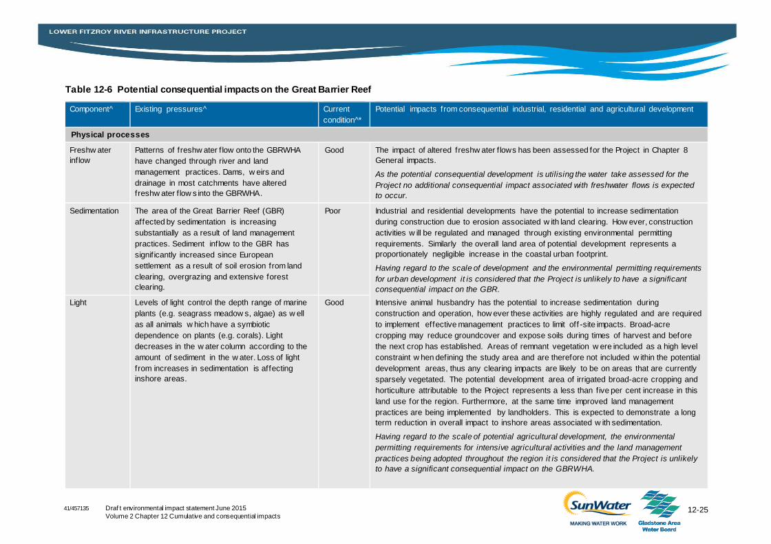
12-25 Draf t environmental impact statement June 2015
Volume 2 Chapter 12 Cumulative and consequential impacts
41/457135
Table 12-6 Potential consequential impacts on the Great Barrier Reef
Component^ Existing pressures^ Current
condition^*
Potential impacts from consequential industrial, residential and agricultural development
Physical processes
Freshw ater
inflow
Patterns of freshw ater f low onto the GBRWHA
have changed through river and land
management practices. Dams, w eirs and
drainage in most catchments have altered
freshw ater f low s into the GBRWHA.
Good The impact of altered freshw ater f lows has been assessed for the Project in Chapter 8
General impacts.
As the potential consequential development is utilising the water take assessed for the
Project no additional consequential impact associated with freshwater flows is expected
to occur.
Sedimentation The area of the Great Barrier Reef (GBR)
affected by sedimentation is increasing
substantially as a result of land management
practices. Sediment inflow to the GBR has
signif icantly increased since European
settlement as a result of soil erosion from land
clearing, overgrazing and extensive forest
clearing.
Poor Industrial and residential developments have the potential to increase sedimentation
during construction due to erosion associated w ith land clearing. How ever, construction
activities w ill be regulated and managed through existing environmental permitting
requirements. Similarly the overall land area of potential development represents a
proportionately negligible increase in the coastal urban footprint.
Having regard to the scale of development and the environmental permitting requirements
for urban development it is considered that the Project is unlikely to have a significant
consequential impact on the GBR.
Intensive animal husbandry has the potential to increase sedimentation during
construction and operation, how ever these activities are highly regulated and are required
to implement effective management practices to limit off -site impacts. Broad-acre
cropping may reduce groundcover and expose soils during times of harvest and before
the next crop has established. Areas of remnant vegetation w ere included as a high level
constraint w hen defining the study area and are therefore not included w ithin the potential
development areas, thus any clearing impacts are likely to be on areas that are currently
sparsely vegetated. The potential development area of irrigated broad-acre cropping and
horticulture attributable to the Project represents a less than f ive per cent increase in this
land use for the region. Furthermore, at the same time improved land management
practices are being implemented by landholders. This is expected to demonstrate a long
term reduction in overall impact to inshore areas associated w ith sedimentation.
Having regard to the scale of potential agricultural development, the environmental
permitting requirements for intensive agricultural activities and the land management
practices being adopted throughout the region it is considered that the Project is unlikely
to have a significant consequential impact on the GBRWHA.
Light Levels of light control the depth range of marine
plants (e.g. seagrass meadow s, algae) as w ell
as all animals w hich have a symbiotic
dependence on plants (e.g. corals). Light
decreases in the w ater column according to the
amount of sediment in the w ater. Loss of light
from increases in sedimentation is affecting
inshore areas.
Good
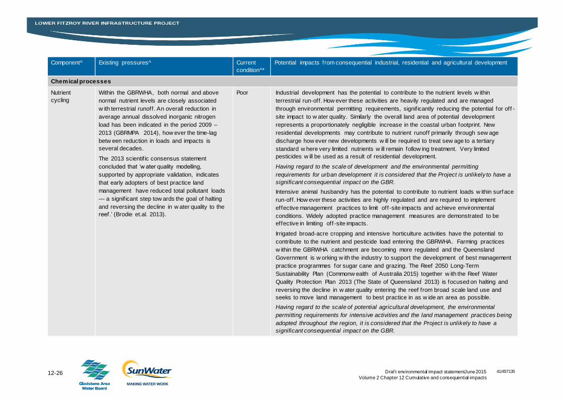
12-26 Draf t environmental impact statementJune 2015
Volume 2 Chapter 12 Cumulative and consequential impacts
41/457135
Component^ Existing pressures^ Current
condition^*
Potential impacts from consequential industrial, residential and agricultural development
Chemical processes
Nutrient
cycling
Within the GBRWHA, both normal and above
normal nutrient levels are closely associated
w ith terrestrial runoff. An overall reduction in
average annual dissolved inorganic nitrogen
load has been indicated in the period 2009 –
2013 (GBRMPA 2014), how ever the time-lag
betw een reduction in loads and impacts is
several decades.
The 2013 scientif ic consensus statement
concluded that ‘w ater quality modelling,
supported by appropriate validation, indicates
that early adopters of best practice land
management have reduced total pollutant loads
— a signif icant step tow ards the goal of halting
and reversing the decline in w ater quality to the
reef.’ (Brodie et.al. 2013).
Poor Industrial development has the potential to contribute to the nutrient levels w ithin
terrestrial run-off. How ever these activities are heavily regulated and are managed
through environmental permitting requirements, signif icantly reducing the potential for off -
site impact to w ater quality. Similarly the overall land area of potential development
represents a proportionately negligible increase in the coastal urban footprint. New
residential developments may contribute to nutrient runoff primarily through sew age
discharge how ever new developments w ill be required to treat sew age to a tertiary
standard w here very limited nutrients w ill remain follow ing treatment. Very limited
pesticides w ill be used as a result of residential development.
Having regard to the scale of development and the environmental permitting
requirements for urban development it is considered that the Project is unlikely to have a
significant consequential impact on the GBR.
Intensive animal husbandry has the potential to contribute to nutrient loads w ithin surface
run-off. How ever these activities are highly regulated and are required to implement
effective management practices to limit off -site impacts and achieve environmental
conditions. Widely adopted practice management measures are demonstrated to be
effective in limiting off -site impacts.
Irrigated broad-acre cropping and intensive horticulture activities have the potential to
contribute to the nutrient and pesticide load entering the GBRWHA. Farming practices
w ithin the GBRWHA catchment are becoming more regulated and the Queensland
Government is w orking w ith the industry to support the development of best management
practice programmes for sugar cane and grazing. The Reef 2050 Long-Term
Sustainability Plan (Commonw ealth of Australia 2015) together w ith the Reef Water
Quality Protection Plan 2013 (The State of Queensland 2013) is focused on halting and
reversing the decline in w ater quality entering the reef from broad scale land use and
seeks to move land management to best practice in as w ide an area as possible.
Having regard to the scale of potential agricultural development, the environmental
permitting requirements for intensive activities and the land management practices being
adopted throughout the region, it is considered that the Project is unlikely to have a
significant consequential impact on the GBR.
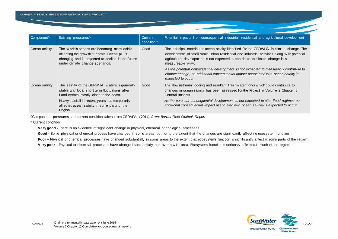
12-27 Draf t environmental impact statement June 2015
Volume 2 Chapter 12 Cumulative and consequential impacts 41/457135
Component^ Existing pressures^ Current
condition^*
Potential impacts from consequential industrial, residential and agricultural development
Ocean acidity The w orld’s oceans are becoming more acidic
affecting the grow th of corals. Ocean pH is
changing and is projected to decline in the future
under climate change scenarios.
Good The principal contributor ocean acidity identif ied for the GBRWHA is climate change. The
development of small scale urban residential and industrial activities along w ith potential
agricultural development is not expected to contribute to climate change in a
measureable w ay.
As the potential consequential development is not expected to measurably contribute to
climate change, no additional consequential impact associated with ocean acidity is
expected to occur.
Ocean salinity The salinity of the GBRWHA w aters is generally
stable w ith local short term fluctuations after
f lood events, mostly close to the coast.
Heavy rainfall in recent years has temporarily
affected ocean salinity in some parts of the
Region.
Good The dow nstream flooding and resultant freshw ater f lows which could contribute to
changes in ocean salinity has been assessed for the Project in Volume 2 Chapter 8
General impacts.
As the potential consequential development is not expected to alter flood regimes no
additional consequential impact associated with ocean salinity is expected to occur.
^Component, pressures and current condition taken from GBRMPA (2014) Great Barrier Reef Outlook Report
* Current condition:
Very good - There is no evidence of signif icant change in physical, chemical or ecological processes
Good - Some physical or chemical process have changed in some areas, but not to the extent that the changes are signif icantly affect ing ecosystem function
Poor – Physical or chemical processes have changed substantially in some areas to the extent that ecosystems function is signif icantly affect in some parts of the region
Very poor – Physical or chemical processes have changed substantially and over a w ide area. Ecosystem function is seriously affected in much of the region.
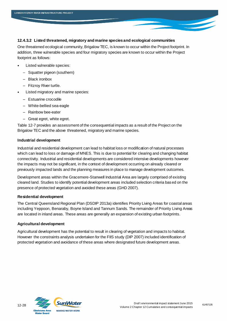
41/457135
12-28 Draf t environmental impact statement June 2015
Volume 2 Chapter 12 Cumulative and consequential impacts
12.4.3.2 Listed threatened, migratory and marine species and ecological communities
One threatened ecological community, Brigalow TEC, is known to occur within the Project footprint. In
addition, three vulnerable species and four migratory species are known to occur within the Project
footprint as follows:
Listed vulnerable species:
– Squatter pigeon (southern)
– Black ironbox
– Fitzroy River turtle.
Listed migratory and marine species:
– Estuarine crocodile
– White-bellied sea-eagle
– Rainbow bee-eater
– Great egret, white egret.
Table 12-7 provides an assessment of the consequential impacts as a result of the Project on the
Brigalow TEC and the above threatened, migratory and marine species.
Industrial development
Industrial and residential development can lead to habitat loss or modification of natural processes
which can lead to loss or damage of MNES. This is due to potential for clearing and changing habitat
connectivity. Industrial and residential developments are considered intensive developments however
the impacts may not be significant, in the context of development occurring on already cleared or
previously impacted lands and the planning measures in place to manage development outcomes.
Development areas within the Gracemere-Stanwell Industrial Area are largely comprised of existing
cleared land. Studies to identify potential development areas included selection criteria based on the
presence of protected vegetation and avoided these areas (GHD 2007).
Residential development
The Central Queensland Regional Plan (DSDIP 2013a) identifies Priority Living Areas for coastal areas
including Yeppoon, Benaraby, Boyne Island and Tannum Sands. The remainder of Priority Living Areas
are located in inland areas. These areas are generally an expansion of existing urban footprints.
Agricultural development
Agricultural development has the potential to result in clearing of vegetation and impacts to habitat.
However the constraints analysis undertaken for the FIIS study (DIP 2007) included identification of
protected vegetation and avoidance of these areas where designated future development areas.
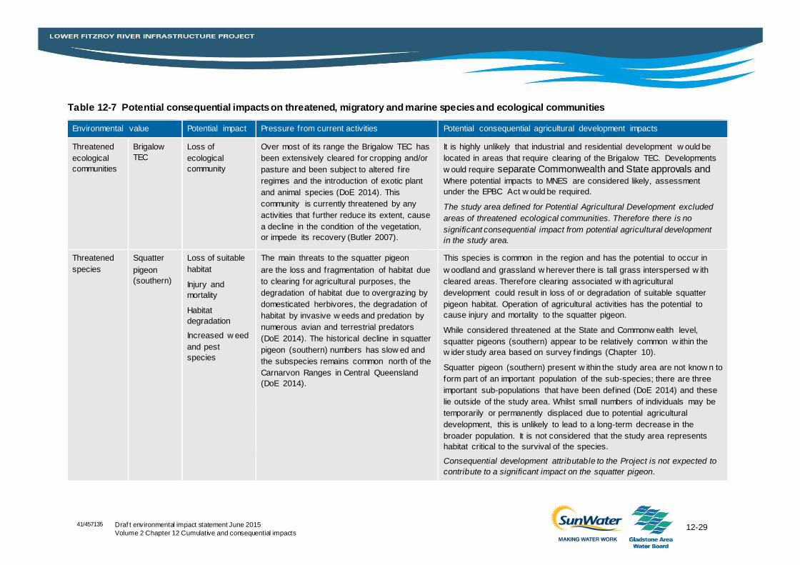
12-29 Draf t environmental impact statement June 2015
Volume 2 Chapter 12 Cumulative and consequential impacts
41/457135
Table 12-7 Potential consequential impacts on threatened, migratory and marine species and ecological communities
Environmental value Potential impact Pressure from current activities Potential consequential agricultural development impacts
Threatened
ecological
communities
Brigalow
TEC
Loss of
ecological
community
Over most of its range the Brigalow TEC has
been extensively cleared for cropping and/or
pasture and been subject to altered f ire
regimes and the introduction of exotic plant
and animal species (DoE 2014). This
community is currently threatened by any
activities that further reduce its extent, cause
a decline in the condition of the vegetation,
or impede its recovery (Butler 2007).
It is highly unlikely that industrial and residential development w ould be
located in areas that require clearing of the Brigalow TEC. Developments
w ould require separate Commonwealth and State approvals and where potential impacts to MNES are considered likely, assessment
under the EPBC Act w ould be required.
The study area defined for Potential Agricultural Development excluded
areas of threatened ecological communities. Therefore there is no
significant consequential impact from potential agricultural development
in the study area.
Threatened
species
Squatter
pigeon
(southern)
Loss of suitable
habitat
Injury and
mortality
Habitat
degradation
Increased w eed
and pest
species
The main threats to the squatter pigeon
are the loss and fragmentation of habitat due
to clearing for agricultural purposes, the
degradation of habitat due to overgrazing by
domesticated herbivores, the degradation of
habitat by invasive w eeds and predation by
numerous avian and terrestrial predators
(DoE 2014). The historical decline in squatter
pigeon (southern) numbers has slow ed and
the subspecies remains common north of the
Carnarvon Ranges in Central Queensland
(DoE 2014).
This species is common in the region and has the potential to occur in
w oodland and grassland w herever there is tall grass interspersed w ith
cleared areas. Therefore clearing associated w ith agricultural
development could result in loss of or degradation of suitable squatter
pigeon habitat. Operation of agricultural activities has the potential to
cause injury and mortality to the squatter pigeon.
While considered threatened at the State and Commonw ealth level,
squatter pigeons (southern) appear to be relatively common w ithin the
w ider study area based on survey f indings (Chapter 10).
Squatter pigeon (southern) present w ithin the study area are not know n to
form part of an important population of the sub-species; there are three
important sub-populations that have been defined (DoE 2014) and these
lie outside of the study area. Whilst small numbers of individuals may be
temporarily or permanently displaced due to potential agricultural
development, this is unlikely to lead to a long-term decrease in the
broader population. It is not considered that the study area represents
habitat critical to the survival of the species.
Consequential development attributable to the Project is not expected to
contribute to a significant impact on the squatter pigeon.
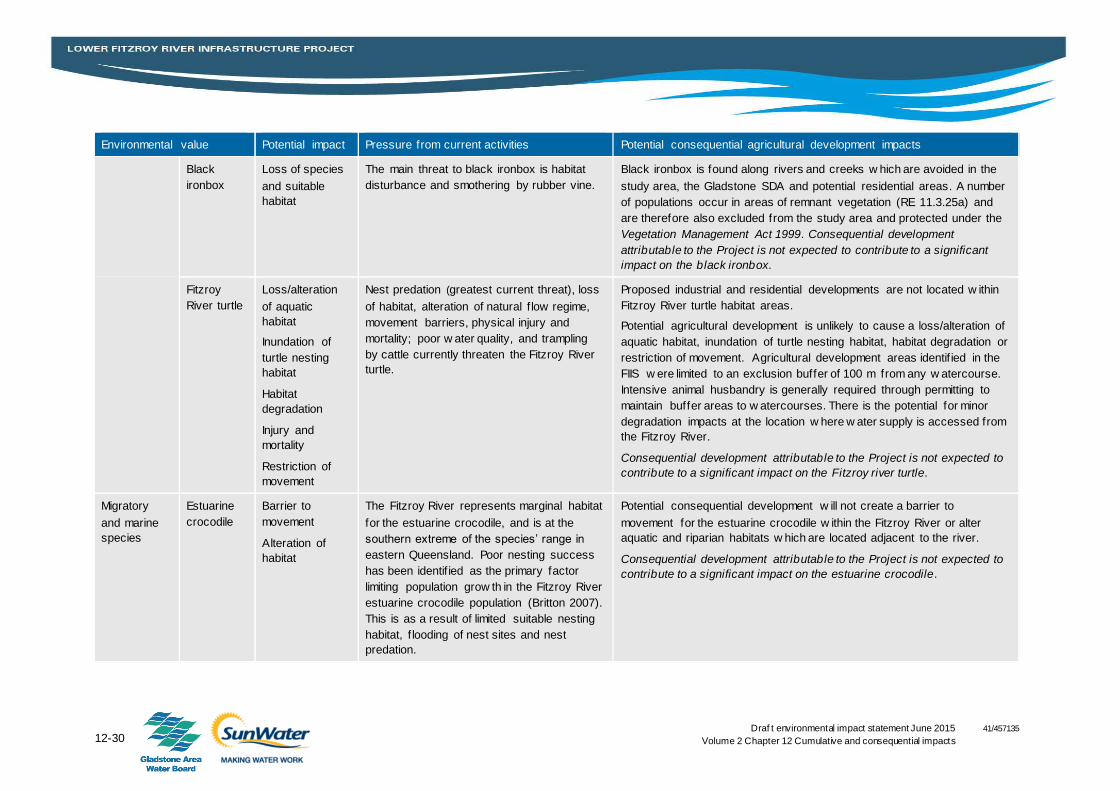
12-30 Draf t environmental impact statement June 2015
Volume 2 Chapter 12 Cumulative and consequential impacts
41/457135
Environmental value Potential impact Pressure from current activities Potential consequential agricultural development impacts
Black
ironbox
Loss of species
and suitable
habitat
The main threat to black ironbox is habitat
disturbance and smothering by rubber vine.
Black ironbox is found along rivers and creeks w hich are avoided in the
study area, the Gladstone SDA and potential residential areas. A number
of populations occur in areas of remnant vegetation (RE 11.3.25a) and
are therefore also excluded from the study area and protected under the
Vegetation Management Act 1999. Consequential development
attributable to the Project is not expected to contribute to a significant
impact on the black ironbox.
Fitzroy
River turtle
Loss/alteration
of aquatic
habitat
Inundation of
turtle nesting
habitat
Habitat
degradation
Injury and
mortality
Restriction of
movement
Nest predation (greatest current threat), loss
of habitat, alteration of natural f low regime,
movement barriers, physical injury and
mortality; poor w ater quality, and trampling
by cattle currently threaten the Fitzroy River
turtle.
Proposed industrial and residential developments are not located w ithin
Fitzroy River turtle habitat areas.
Potential agricultural development is unlikely to cause a loss/alteration of
aquatic habitat, inundation of turtle nesting habitat, habitat degradation or
restriction of movement. Agricultural development areas identif ied in the
FIIS w ere limited to an exclusion buffer of 100 m from any w atercourse.
Intensive animal husbandry is generally required through permitting to
maintain buffer areas to w atercourses. There is the potential for minor
degradation impacts at the location w here w ater supply is accessed from
the Fitzroy River.
Consequential development attributable to the Project is not expected to
contribute to a significant impact on the Fitzroy river turtle.
Migratory
and marine
species
Estuarine
crocodile
Barrier to
movement
Alteration of
habitat
The Fitzroy River represents marginal habitat
for the estuarine crocodile, and is at the
southern extreme of the species’ range in
eastern Queensland. Poor nesting success
has been identif ied as the primary factor
limiting population grow th in the Fitzroy River
estuarine crocodile population (Britton 2007).
This is as a result of limited suitable nesting
habitat, f looding of nest sites and nest
predation.
Potential consequential development w ill not create a barrier to
movement for the estuarine crocodile w ithin the Fitzroy River or alter
aquatic and riparian habitats w hich are located adjacent to the river.
Consequential development attributable to the Project is not expected to
contribute to a significant impact on the estuarine crocodile.
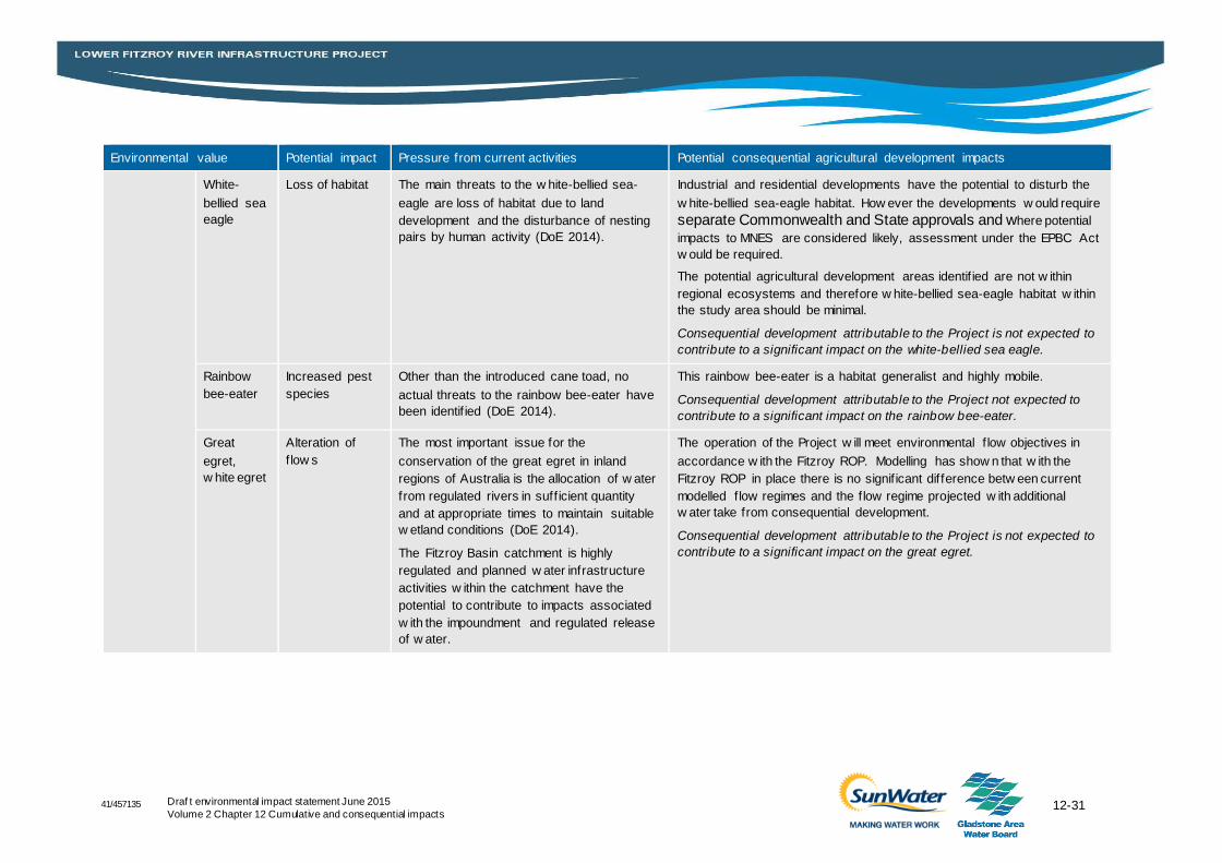
12-31 Draf t environmental impact statement June 2015
Volume 2 Chapter 12 Cumulative and consequential impacts 41/457135
Environmental value Potential impact Pressure from current activities Potential consequential agricultural development impacts
White-
bellied sea
eagle
Loss of habitat The main threats to the w hite-bellied sea-
eagle are loss of habitat due to land
development and the disturbance of nesting
pairs by human activity (DoE 2014).
Industrial and residential developments have the potential to disturb the
w hite-bellied sea-eagle habitat. How ever the developments w ould require
separate Commonwealth and State approvals and where potential
impacts to MNES are considered likely, assessment under the EPBC Act
w ould be required.
The potential agricultural development areas identif ied are not w ithin
regional ecosystems and therefore w hite-bellied sea-eagle habitat w ithin
the study area should be minimal.
Consequential development attributable to the Project is not expected to
contribute to a significant impact on the white-bellied sea eagle.
Rainbow
bee-eater
Increased pest
species
Other than the introduced cane toad, no
actual threats to the rainbow bee-eater have
been identif ied (DoE 2014).
This rainbow bee-eater is a habitat generalist and highly mobile.
Consequential development attributable to the Project not expected to
contribute to a significant impact on the rainbow bee-eater.
Great
egret,
w hite egret
Alteration of
f low s
The most important issue for the
conservation of the great egret in inland
regions of Australia is the allocation of w ater
from regulated rivers in suff icient quantity
and at appropriate times to maintain suitable
w etland conditions (DoE 2014).
The Fitzroy Basin catchment is highly
regulated and planned w ater infrastructure
activities w ithin the catchment have the
potential to contribute to impacts associated
w ith the impoundment and regulated release
of w ater.
The operation of the Project w ill meet environmental f low objectives in
accordance w ith the Fitzroy ROP. Modelling has show n that w ith the
Fitzroy ROP in place there is no signif icant difference betw een current
modelled f low regimes and the f low regime projected w ith additional
w ater take from consequential development.
Consequential development attributable to the Project is not expected to
contribute to a significant impact on the great egret.
41/457135
12-32 Draf t environmental impact statementJune 2015
Volume 2 Chapter 12 Cumulative and consequential impacts
12.5 Summary
A cumulative impact assessment has been undertaken to identify the potential cumulative impacts
upon MNES as a result of constructing and operating the Project in conjunction with other
proposed projects within relevant study areas. Consequential impacts attributable to the Project
development have been identified and assessed in relation to potential impacts on MNES.
Current pressures on the Fitzroy Basin catchment include land degradation, habitat disturbance
and alteration and impacts to water quality resulting primarily from agricultural and mining
activities. Similarly, threatening processes identified within the Brigalow belt bioregion include
vegetation clearing, linear infrastructure development, urban development, mining, grazing,
altered water flows, impoundments and reduced water quality.
The assessment of the Project’s contribution to cumulative impacts takes into consideration the
relative size, scale, proximity and nature of activities. Due to the localised and short term nature of
the Project’s construction impacts and the lack of other proposed projects within the vicinity of the
Project footprint, the Project’s contribution to cumulative impacts will mostly occur during the
operational phase or as a result of impoundment. Through the assessment, it was determined
that there is the potential for the Project to contribute to the cumulative impacts on MNES as
follows:
Minor contribution (approximately five per cent) to a cumulative loss of Brigalow TEC in the
local area which has been minimised through mitigation and management measures and will
be offset
Cumulative impacts on the Fitzroy River turtle as a result of:
– Cumulative loss/alteration of aquatic habitat within the catchment study area including the
loss of turtle nesting habitat and the conversion of riffle-run habitat to impounded habitat
(15 per cent increase in impounded habitat in combination with the approved Connors
River Dam)
– Cumulative risk of injury and mortality to aquatic fauna from the operation of water
infrastructure within the catchment
– Cumulative impact on aquatic fauna movement in the catchment.
In order to minimise its contribution to cumulative impacts, the Project has sought to avoid,
mitigate, manage and, where necessary, offset the impacts associated with Project activities.
Consequential development potentially occurring as a result of the Project development relate to
industrial and urban residential development within designated urban development areas and a
relatively small increase in agricultural development within the region. Growth within the region
will occur within the State and local government planning frameworks namely the Central
Queensland Regional Plan and the local planning schemes of the Rockhampton Regional
Council, Livingstone Shire Council, Central Highlands Regional Council and Woorabinda Shire
Council. Each of these planning documents includes planning controls for urban (industrial and
residential) and some types of intensive rural (agricultural) development within the overall context
of sustainable development under the Sustainable Planning Act 2009 (Qld). Environmental
approvals will also be required under the Environment Protection Act 1994 (Qld) (EP Act) for
intensive agricultural activities such as feedlots. Where potential impacts to MNES are considered
likely, assessment under the EPBC Act would be required. Larger scale development; such as
intensive agriculture and/or major industrial development would be expected to trigger the
41/457135
12-33 Draf t environmental impact statement June 2015
Volume 2 Chapter 12 Cumulative and consequential impacts
requirement for referral under the EPBC Act (where MNES had the potential to be affected) in
addition to local and State approval requirements.
The Coastal Zone Strategic Assessment Program Report (DSDIP, 2014) contains components,
including the SP Act, that provide a strong framework for ensuring that the planning for and
development of urban areas and activities do not have a significant impact on MNES and other
important natural values and resources.
Agricultural development within the GBRWHA catchment is becoming better managed as a result
of direct regulation (permitting) as well as adoption of management practices through the
implementation of actions identified in the Reef 2050 Long Term Development Plan and specific
programs such as the Reef Water Quality Protection Plan.
The assessment of the Project’s potential to facilitate consequential impacts takes into
consideration: the nature of activities; the likelihood of occurrence without the Project proceeding;
and the assessment and approval processes which control future development. Through the
assessment, it was determined that there is the limited potential for the Project to facilitate
consequential development that is not accommodated through existing planning and development
schemes and could proceed through alternate means of water supply.
With the implementation of environmental permitting requirements for intensive activities and the
land management practices being adopted throughout the region, it is considered that the Project
is unlikely to have a significant consequential impact on relevant MNES.