Embed Size (px)
Citation preview
Merced County 12-1 2030 Merced County General Plan July 2013 Recirculated Draft PEIR
12 HAZARDS AND HAZARDOUS MATERIALS
This chapter provides an evaluation of the potential environmental effects of implementing the proposed 2030 Merced County General Plan (2030 General Plan) on hazardous materials and public safety issues. As established in the Notice of Preparation for the proposed 2030 General Plan (see Appendix A, Notice of Preparation), urban development and other activities subject to the Plan may result in degradation of the environment from, or the exposure of the public to, hazardous materials, airport safety hazards, wildland fire hazards, accidental hazardous material releases, and other safety concerns that could impact emergency response and evacuation plans. Air quality emissions and hazards are evaluated in Chapter 7, Air Quality. Seismic and geological hazards are evaluated in Chapter 10, Geology, Soils, and Minerals, and flooding hazards are evaluated in Chapter 13, Hydrology and Water Resources of this Draft PEIR.
The following environmental assessment includes a review of the existing hazards and hazardous materials potentially affected by the implementation of the 2030 General Plan. It includes a description of the existing environmental hazards within the county, including hazardous or contaminated sites, airport safety hazards, wildland fire hazards, and other safety concerns. Also assessed are the effects that could result from urban development that would be allowed under the proposed 2030 General Plan.
This analysis includes a review of applicable regulations, requirements, plans and policies from the following federal, state, and local sources:
• United States Environmental Protection Agency (EPA) • Federal Emergency Management Agency (FEMA) • Disaster Mitigation Act of 2000 (Federal) • Hazardous Material Databases (CERCLIS, LUST, Geotracker) • California Department of Toxic Substances Control (DTSC) • California Code of Regulations (CCR) Title 22 • California Occupational Health and Safety (CalOSHA) • California Department of Health Services (DHS) • California Air Resources Board (CARB) • San Joaquin Valley Air Quality Management District (SJVAQMD) • Central Valley Regional Water Quality Control Board (CVRWQCB) • California Department of Forestry and Fire Protection (CAL FIRE) • Merced County Division of Environmental Health (MCDEH) • Merced County Airport Land Use Compatibility Plan (CLUP)
The existing condition of the natural and man-made hazards in the unincorporated county was determined by a review of the regional hazardous databases, and by survey and research. Rules and regulations influencing the hazard material use and safety conditions were identified by a review of federal and state regulations, and local agency General Plan goals and policies. Potential impacts related to hazards, hazardous materials, and safety issues, compiled and analyzed based on California Environmental Quality Act (CEQA) criteria, were determined by comparing potential urban development proposed under the 2030 General Plan to the existing environment, using guidelines adopted by state agencies and Merced County.
Hazards and Hazardous Materials
2030 Merced County General Plan 12-2 Merced County Recirculated Draft PEIR July 2013
12.1 SETTING
The environmental and regulatory setting of Merced County with respect to hazards, hazardous materials, and public safety resources is described in detail in the General Plan Background Report (Merced County 2007; updated 2012). That document is incorporated by reference into this Recirculated Draft PEIR pursuant to State CEQA Guidelines Section 15150 as though fully set forth herein. The updated Background Report is available for download from the Merced County General Plan website:
http://www.co.merced.ca.us/index.aspx?NID=1971.
Copies of the Background Report may be viewed during standard business hours (8:30 a.m. to 4:30 p.m.), Monday through Friday, at the Merced County Community and Economic Development Department, 2222 M Street, Merced, California 95340, and at the Main Branch of the Merced County Library located at 2100 O Street, Merced California 95340.
12.1.1 ENVIRONMENTAL SETTING The Background Report’s discussion of the hazard and safety environmental setting describes information on natural hazards, such as wildland fire hazards, and human-made hazards, such as hazardous wastes from products such as gasoline, paints, mining wastes, agricultural bi-products, household cleaning products, and other substances categorized as hazardous materials. The hazards and public safety issues discussed in the Background Report include:
FIRE HAZARDS • Urban Fire Hazards. Urban fires primarily involve the uncontrolled burning of residential,
commercial, or industrial structures due to human-made causes. Between 2001 and 2008, fires in structures accounted for approximately 20 percent of the Merced County Fire Department’s call volume, although the rural portions of Merced County have not dealt with large-scale fire threats.
The Insurance Services Office (ISO), the body that rates fire departments and assigns public protection classifications for the establishment of fire insurance rates, known as ISO ratings. The rating system is based on three areas of a community’s fire protection program including fire dispatch capabilities, Fire Department equipment and personnel, and water supply. The system ranges from Level 1 to Level 10, with Level 1 being the highest level of protection, and Level 10 being the lowest. The ISO ratings for Merced County have been identified at Level 5 for areas with fire hydrants, and at Level 8 for areas without hydrants, but within five miles of a fire station. The remainder of the County has a Fire Insurance Rating of 9.
• Wildland Fire Hazards. Wildfire hazard has increased as development occurs near the
foothills and large rangelands in the eastern and western areas of Merced County. Much of this land is within the State Responsibility Area (SRA), and is protected by CAL FIRE. The Merced County Fire Department provides primary response services to Local Responsibility Areas (LRA), and offers mutual automatic aid to many of the rural foothill and rangeland areas. Many of these rural areas have insufficient water supplies to adequately control the fire. Figure 12-1 shows SRAs used administratively to manage wildland fires within the county.
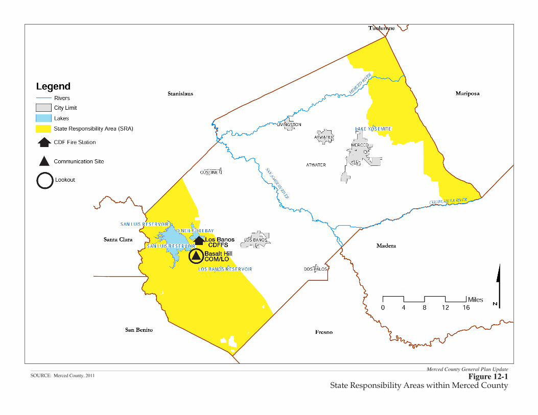
Merced County General Plan UpdateFigure 12-1
State Responsibility Areas within Merced CountySOURCE: Merced County, 2011
Hazards and Hazardous Materials
2030 Merced County General Plan 12-4 Merced County Recirculated Draft PEIR July 2013
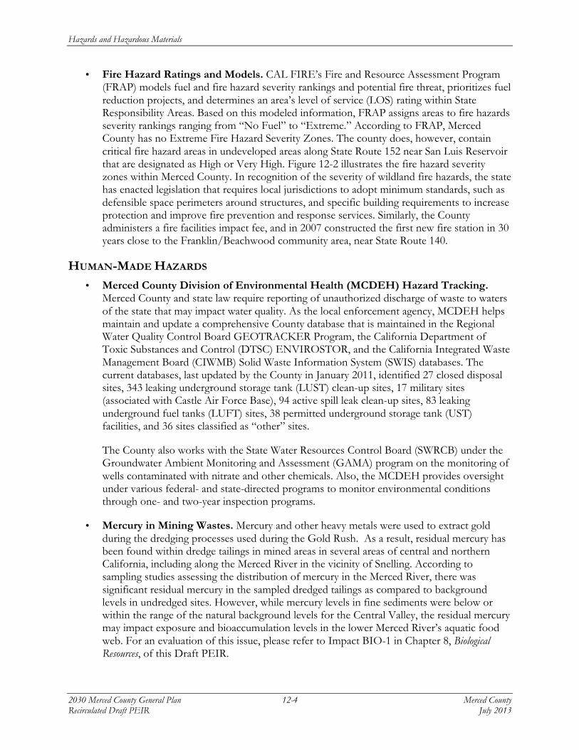
• Fire Hazard Ratings and Models. CAL FIRE’s Fire and Resource Assessment Program (FRAP) models fuel and fire hazard severity rankings and potential fire threat, prioritizes fuel reduction projects, and determines an area’s level of service (LOS) rating within State Responsibility Areas. Based on this modeled information, FRAP assigns areas to fire hazards severity rankings ranging from “No Fuel” to “Extreme.” According to FRAP, Merced County has no Extreme Fire Hazard Severity Zones. The county does, however, contain critical fire hazard areas in undeveloped areas along State Route 152 near San Luis Reservoir that are designated as High or Very High. Figure 12-2 illustrates the fire hazard severity zones within Merced County. In recognition of the severity of wildland fire hazards, the state has enacted legislation that requires local jurisdictions to adopt minimum standards, such as defensible space perimeters around structures, and specific building requirements to increase protection and improve fire prevention and response services. Similarly, the County administers a fire facilities impact fee, and in 2007 constructed the first new fire station in 30 years close to the Franklin/Beachwood community area, near State Route 140.
HUMAN-MADE HAZARDS • Merced County Division of Environmental Health (MCDEH) Hazard Tracking.
Merced County and state law require reporting of unauthorized discharge of waste to waters of the state that may impact water quality. As the local enforcement agency, MCDEH helps maintain and update a comprehensive County database that is maintained in the Regional Water Quality Control Board GEOTRACKER Program, the California Department of Toxic Substances and Control (DTSC) ENVIROSTOR, and the California Integrated Waste Management Board (CIWMB) Solid Waste Information System (SWIS) databases. The current databases, last updated by the County in January 2011, identified 27 closed disposal sites, 343 leaking underground storage tank (LUST) clean-up sites, 17 military sites (associated with Castle Air Force Base), 94 active spill leak clean-up sites, 83 leaking underground fuel tanks (LUFT) sites, 38 permitted underground storage tank (UST) facilities, and 36 sites classified as “other” sites.
The County also works with the State Water Resources Control Board (SWRCB) under the Groundwater Ambient Monitoring and Assessment (GAMA) program on the monitoring of wells contaminated with nitrate and other chemicals. Also, the MCDEH provides oversight under various federal- and state-directed programs to monitor environmental conditions through one- and two-year inspection programs.
• Mercury in Mining Wastes. Mercury and other heavy metals were used to extract gold during the dredging processes used during the Gold Rush. As a result, residual mercury has been found within dredge tailings in mined areas in several areas of central and northern California, including along the Merced River in the vicinity of Snelling. According to sampling studies assessing the distribution of mercury in the Merced River, there was significant residual mercury in the sampled dredged tailings as compared to background levels in undredged sites. However, while mercury levels in fine sediments were below or within the range of the natural background levels for the Central Valley, the residual mercury may impact exposure and bioaccumulation levels in the lower Merced River’s aquatic food web. For an evaluation of this issue, please refer to Impact BIO-1 in Chapter 8, Biological Resources, of this Draft PEIR.
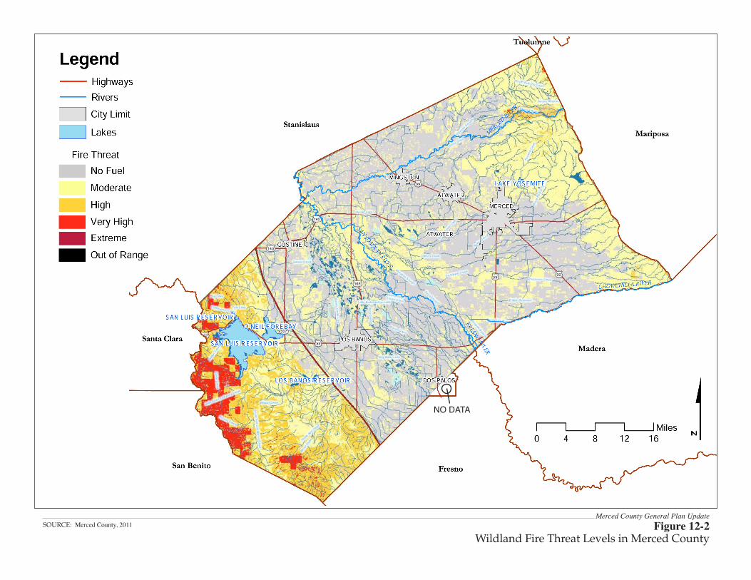
Merced County General Plan UpdateFigure 12-2
Wildland Fire Threat Levels in Merced CountySOURCE: Merced County, 2011
NO DATA
Hazards and Hazardous Materials
2030 Merced County General Plan 12-6 Merced County Recirculated Draft PEIR July 2013
• Residual Agricultural Chemicals. As the County continues to support expansion and intensification of the agricultural economy, risks associated with agricultural chemical products (pesticides and organic /inorganic fertilizers), residuals, and waste may increase. However, the increased use of natural organic supplements and best farming practices to control insects and fertilize ranchland may decrease the potential influence from farming.
• Land Application of Biosolids. Five ranches in the El Nido area of the county are used for agronomic land application of biosolids from the East Bay Municipal Utility District. These ranches contain approved management plans and undergo County inspections to ensure that safety hazards are minimized.
• Methamphetamine. Since 1995, the DTSC has administered the Clandestine Drug Lab Removal program in place to remove and dispose of hazardous substances discovered by law enforcement officials. This includes the illegal manufacturing of psychoactive drugs, primarily methamphetamine. According to information provided by DTSC and MCDEH, from 2000 to 2005, 103 sites were reported as methamphetamine (meth) drug houses. From 2006 to 2009, 29 properties had been reported with liens due to meth lab discoveries.
• Abandoned Pipelines. Abandoned oil, fuel, and chemical pipelines within Merced County may be a source of contaminants and hazards. Portions of the former Old Valley Pipeline (OVP) and Tidewater Associated Oil company (TAOC) pipeline existed within the boundaries of Merced County. These formerly active pipelines were constructed in the early 1900s and carried crude oil from the southern San Joaquin Valley to the San Francisco Bay Area. Pipeline operations for the OVP ceased in the 1940s, and in the 1970s for the TAOC pipelines. When pipeline operations ceased, the pipelines were taken out of commission. The degree and method of decommissioning varied; in some instances the pipelines were removed, while in others, they remained in place. Because these pipelines have been decommissioned, with the majority of pipelines having been removed, they are not readily identified as underground utilities through the Underground Service Alert North System or utility surveys. Figure 12-3 illustrates the location of the former OVP and TAOC rights-of-way with respect to the planning area and urban area boundaries in Merced County. The location of the pipelines shown in Figure 12-3 is based on historical as-built drawings and the approximated positional accuracy of the alignments is generally +/- 50 feet. The OVP and TAOC pipelines were installed at depths of up to 10 feet below ground surface. The steel pipelines were typically encased in a protective coating. (Chevron Environmental Management Company 2012)1
Working under the direction of State regulatory agencies, Chevron Environmental Management Company conducted risk assessments at numerous locations with known historical crude-oil release points along the former OVP and TAOC pipelines. Analytical results from these risk assessments indicated that the crude-contaminated soil was non-hazardous. Accordingly, it is likely that if soil affected by the historical release of crude oil from these former pipelines is encountered during construction activities it may be reused as backfill on site. Properly abandoned crude-oil pipelines may be left in the ground. Parties
1 Chevron Environmental Management Company, 2012. Letter from Mike Oliphant, Chevron, to Bill Nicholson,
Merced County providing information on abandoned pipelines. December 17, 2012.
Hazards and Hazardous Materials
Merced County 12-7 2030 Merced County General Plan July 2013 Recirculated Draft PEIR
considering construction activities in the vicinity of these former pipeline rights-of-way may wish to prepare for the possibility of encountering abandoned pipelines and pipeline-related hazardous materials during the course of their work. (Chevron Environmental Management Company 2012)
AIRPORT SAFETY • Merced County Airports. There are three types of airports in Merced County: private
landing strips for individual property owners and/or crop dusting use; municipal airports (usually within city limits) for public and commercial use; and regional facilities capable of accommodating cargo, passenger, training, maintenance, and transit operations, as well as general aviation. Air safety issues related to land use planning are significant because of incompatibility issues regarding noise and safety. For example, aircraft accidents are most prevalent in areas immediately adjacent to airports, and primarily occur during takeoff and landing. The areas of highest impact are at the end of runways due to higher risk for accidents and higher noise levels during takeoff. The Comprehensive Airport Land Use Plan provides policy direction for placing compatible land uses near airports and, in conjunction with regulations of the Federal Aviation Administration and the Caltrans Division of Aeronautics, establishing clear zones and safety zones for all of the County’s public airports.
Four municipal public airports owned by cities and one airport owned by Merced County are located within Merced County. Merced County and the cities of Gustine, Los Banos, Merced, and Turlock operate these airports. The four municipal airports include Gustine Municipal Airport, Los Banos Municipal Airport, Merced Regional Airport, and Turlock Municipal Airport. According to the criteria used by the Civil Aeronautics Board, both Merced Regional Airport and Castle Airport are both recognized as regionally significant airports. Figure 12-4 12-3 shows the locations of each public airport within the county. There are also eight private airstrips in Merced County. These airstrips generally serve as access to large or remote ranches and/or are used for agricultural related crop-dusting activities.
• Land Use Compatibility Policy Considerations. Safety compatibility policies should address both protection of people and property on the ground near airports and the protection of airport airspace from obstructions and other hazards to flight. Through compatibility plans, local regulations can be developed and implemented to promote land uses that will not conflict with airport activities.
• Protecting People and Property on the Ground. Protecting people and property on the ground from the potential consequences of near-airport aircraft accidents is a fundamental safety objective. To accomplish this, restrictions on land use are essential in developing safety compatibility criteria because the severity of an off-airport aircraft accident is highly dependent upon the nature of the land use at the accident site. Three characteristics assess the relative risk of various land uses: 1) the intensity of use, which is the number of people that development can attract per acre; 2) residential versus non-residential function, because residential uses are given a higher level of protection than non-residential uses; and 3) sensitive uses, which fall into two categories: low effective mobility occupancies (e.g., day care centers, schools, nursing homes) and hazardous materials that can contribute to the severity of an aircraft accident.
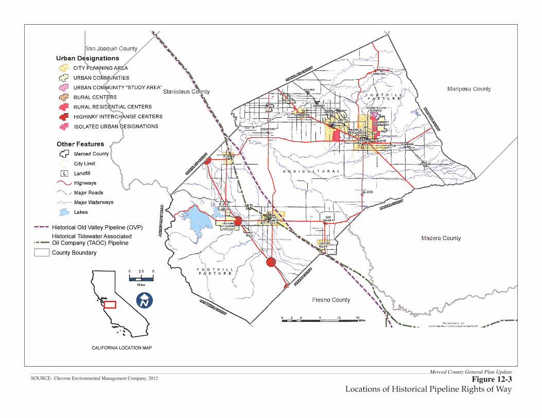
Merced County General Plan UpdateFigure 12-3
Locations of Historical Pipeline Rights of WaySOURCE: Chevron Environmental Management Company, 2012
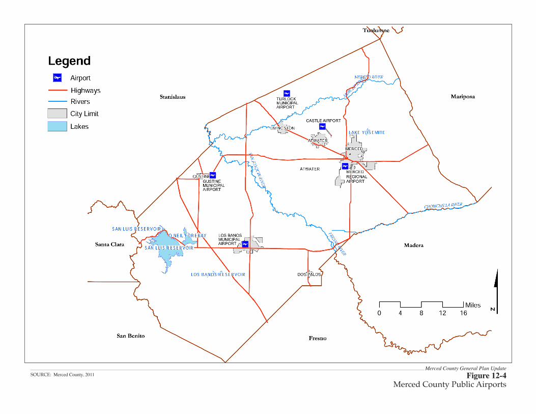
Merced County General Plan UpdateFigure 12-4
Merced County Public AirportsSOURCE: Merced County, 2011
Hazards and Hazardous Materials
2030 Merced County General Plan 12-10 Merced County Recirculated Draft PEIR July 2013
The major findings of the Background Report with respect to hazards and safety issues are set forth below.
WILDLAND FIRE HAZARDS • A lack of funding is the main obstacle to improving fire protection. • Wildland fire hazards exist across the county, but are most prevalent and potentially
destructive in rural foothill areas, specifically along State Route 152 near San Luis Reservoir, where fuels exist and water resources are scarce.
• CAL FIRE is responsible for protecting the majority of wildland areas in the county prone to wildland fire hazards.
• Merced County’s large tracts of range and wildland pose a major fire threat.
HUMAN MADE HAZARDS • Merced County has an aggressive program of tracking and inspecting hazardous waste and
other human-caused impacts to the environment and public health because federal, state, and local regulations mandate cooperative programs. The tracking system includes the collection of data on underground storage tanks, environmental release sites, and landfills. Over 150 leaky underground fuel tank sites have been tracked and recorded by the County inspection program, with assistance from the State.
• Relative impacts from human-made hazards are considered low due to the low populations in affected areas, and the relatively low density of hazardous sites and activities. However, field agriculture and agricultural processing sites, including dairies and cheese manufacturing plants, have been responsible for elevated salts and nitrates in surface water and ground water. Impacts to surface and ground water are analyzed in Chapter 13, Hydrology and Water Resources.
AIRPORT SAFETY • A key ingredient in aviation safety is compatible land use planning around airports. • Encroachment due to incompatible land use is one of the greatest threats to increasing the
capability and capacity of the County’s aviation system. • Merced County General Plan airport safety policies should address both protection of
people and property on the ground near airports, and protection of airport airspace from obstructions and other hazards to flight.
• The safety policies set forth in the Merced County Airport Land Use Commission’s (ALUC) Comprehensive Land Use Plan (CLUP) should be incorporated into the Merced County General Plan to the greatest extent possible to achieve compatibility.
Hazards and Hazardous Materials
Merced County 12-11 2030 Merced County General Plan July 2013 Recirculated Draft PEIR
12.1.2 REGULATORY SETTING The Background Report’s discussion of the hazards and safety regulatory setting include the following federal, state, and local regulations:
FEDERAL • Healthy Forests Restoration Act. Legislation passed in 2003 that gives incentives for
communities to engage in comprehensive forest planning. The Act emphasizes the need for federal agencies to work collaboratively with communities in developing hazardous fuel reduction projects, and includes statutory incentives for the U.S. Forest Service (USFS) and the Bureau of Land Management (BLM) to give consideration to the priorities of local communities as they develop and implement forest management and hazardous fuel reduction projects.
• National Fire Plan. The National Fire Plan was developed under Executive Order 11246 in August 2000, following a landmark wildland fire season. Its intent is to actively respond to severe wildland fires and their impacts to communities while ensuring sufficient firefighting capacity for the future. The Plan addresses Firefighting, Rehabilitation, Hazardous Fuels Reduction, Community Assistance, and Accountability.
• Disaster Mitigation Act of 2000. The federal Disaster Mitigation Act of 2000 requires a state mitigation plan as a condition of disaster assistance. There are two different levels of state disaster plans: “Standard” and “Enhanced.” States that develop an approved Enhanced State Plan can increase the amount of funding available through the Hazard Mitigation Grant Program. The Act has also established new requirements for local mitigation plans.
• U.S. Environmental Protection Agency. The U.S. EPA is primarily responsible for enforcement and implementation of federal laws and regulations pertaining to hazardous materials. Merced County is located within EPA Region IX, which includes Arizona, California, Hawaii, and New Mexico. Management of hazardous materials is governed by the following laws and agencies: the Comprehensive Environmental Response, Compensation, and Liability Act (CERCLA); the Superfund Amendments and Reauthorization Act of 1986; the Resource Conservation and Recovery Act (RCRA); the Federal Insecticide, Fungicide, and Rodenticide Act (FIFRA); the Toxic Substances Control Act of 1976 (TSCA), the Occupational Safety and Health Administration (OSHA); and the Hazardous Waste Operations and Emergency Response.
• U.S. Department of Transportation (DOT). The DOT is responsible for overseeing a national program to minimize the risks related to commercial transportation of hazardous materials.
• Federal Emergency Management Agency (FEMA). FEMA oversees floodplain safety, manages the national flood insurance program, and prepares Flood Insurance Rate Maps (FIRM) for communities participating in the federal flood insurance program.
• Federal Aviation Regulation (FAA) Airport Safety Program. The Airport Safety Program addresses general aviation airport safety, runway safety, airports certificated under 14 Code of Federal Regulations Part 139, and safety management systems (SMS).
Hazards and Hazardous Materials
2030 Merced County General Plan 12-12 Merced County Recirculated Draft PEIR July 2013
STATE • California Fire Plan. The Strategic California Fire Plan is the State’s road map for reducing
the risk of wildfire. The plan was finalized in June 2010, and directs each CAL FIRE Unit to prepare a locally specific Fire Management Plan.
• Madera-Mariposa-Merced Fire Unit Fire Management Plan. The Madera-Mariposa-Merced 2009 Fire Plan aims to reduce costs and losses from wildfire within the unit, and identifies the process to achieve this goal. The plan identifies and prioritizes target areas that will receive the majority of pre-fire management activities.
• Wildland-Urban Interface Building Standards. On September 20, 2007 the Building Standards Commission approved the Office of the State Fire Marshal’s emergency regulations amending the California Code of Regulations, Title 24, Part 2, known as the 2007 California Building Code (CBC). These new codes include provisions for ignition-resistant construction standards in the wildland urban interface.
• State Water Resources Control Board. The State Water Resources Control Board (SWRCB) has primary responsibility to protect water quality and supply. The Regional Water Quality Control Board is authorized by the Porter-Cologne Water Quality Control Act of 1969 to protect the waters of the state. The RWQCB provides oversight for sites where the quality of groundwater or surface waters is threatened.
• California Environmental Protection Agency/Department of Toxic Substance Control. The Department of Toxic Substances Control, a division of CalEPA, has primary regulatory responsibility over hazardous materials in California, working in conjunction with the federal EPA to enforce hazardous materials laws and regulations.
• California Department of Industrial Relations, Division of Occupational Health Administration. The California Department of Industrial Relations, Division of Occupational Safety and Health Administration (CalOSHA), assumes primary responsibility for developing and enforcing workplace safety regulations within the state.
• California Department of Transportation. The California Department of Transportation (Caltrans) regulates the transportation of hazardous materials on state highways. Both agencies use a system of placards, labels, and shipping papers required to identify the hazards of shipping each class of hazardous materials. Caltrans is required to implement regulations established by the DOT through the California Highway Patrol (CHP).
• California Office of Emergency Services. The California Office of Emergency Services (OES) prepares the State of California Multi-Hazard Mitigation Plan (SHMP). The SHMP identifies hazard risks, includes vulnerability analysis, and a hazard mitigation strategy. The SHMP is a federal requirement under the Disaster Mitigation Act of 2000 for the state to receive federal funding. The Disaster Mitigation Act of 2000 requires a state mitigation plan as a condition of disaster assistance.
Hazards and Hazardous Materials
Merced County 12-13 2030 Merced County General Plan July 2013 Recirculated Draft PEIR
LOCAL • Merced County Department of Public Health, Division of Environmental
Health/Certified Unified Program Agency (CUPA). The MCDEH is certified by the DTSC as the CUPA. The Department administers the California Accidental Release Program (CalARP), which aims to prevent releases of regulated substances into the environment. It also oversees the Hazardous Materials Program, Hazardous Waste Program, an Underground Storage Tank Program, Area Plan for Emergency Response to Hazardous Materials Incidents, County Agricultural Commissioner, and the County’s general health and safety codes.
• Merced County Airport Land Use Compatibility Plan. The Merced County Airport Land Use Commission has the authority to review public agency decisions regarding new land uses near airports, and determine whether actions are contrary to the best interests of the airport and adjacent areas. The Merced County Airport Land Use Compatibility Plan was prepared and adopted by the ALUC on June 21, 2012.
12.2 ENVIRONMENTAL EFFECTS
The hazards and public safety analysis evaluates whether implementation of the proposed urban development that would occur from total buildout under the 2030 General Plan program could result in adverse hazard and public safety effects.
12.2.1 SIGNIFICANCE CRITERIA The following criteria have been established to quantify the level of significance of an adverse effect being evaluated pursuant to State CEQA Guidelines Appendix G: Environmental Checklist Form, Section VIII. Hazards and Hazardous Materials. Implementation of the 2030 General Plan would result in a significant hazards or hazardous materials impact if the Plan would:
• Create a significant hazard to the public or the environment through the routine transport, use, or disposal of hazardous materials. (VIII.a)
• Create a significant hazard to the public or the environment through reasonably foreseeable upset and accident conditions involving the release of hazardous materials into the environment. (VIII.b)
• Emit hazardous emissions or handle hazardous materials, substances or waste within one-quarter mile of an existing or proposed school. (VIII.c)
• Be located on a site which is included on a list of hazardous materials sites compiled pursuant to Government Code Section 65962.5 and, as a result, create a significant hazard to the public or the environment. (VIII.d)
• For a project located within an airport land use plan or, where such a plan has not been adopted, within two miles of a public airport or public use airport, result in a safety hazard for people residing or working in the project area. (VIII.e)
• For a project within the vicinity of a private airstrip, result in a safety hazard for people residing or working in the project area. (VIII.f)
• Impair implementation of or physically interfere with an adopted emergency response plan or emergency evacuation plan. (VIII.g)
Hazards and Hazardous Materials
2030 Merced County General Plan 12-14 Merced County Recirculated Draft PEIR July 2013
• Expose people or structures to a significant risk of loss, injury, or death involving wildland fires. (VIII.h)
For an evaluation of the potential effect of interference with emergency response, please refer to Impact TRF-7 in Chapter 19, Transportation, of this Draft PEIR. The impact is identified as being less than significant after implementation of identified mitigation measures.
12.2.2 ANALYSIS METHODOLOGY The hazard and public safety evaluation includes a review of natural and man-made hazards in the county potentially affected by the implementation of the 2030 General Plan project and the total buildout envisioned under the Plan. The assessment consists of a qualitative review of the existing conditions in the unincorporated portion of the county and determines whether or not the 2030 General Plan goals and policies would contain adequate measures and provisions to address potential impacts associated with hazards and public safety.
12.2.3 ENVIRONMENTAL IMPACTS The following discussion examines the potential impacts of the proposed project based on the impact threshold criteria described above.
Impact HAZ-1: Create a s igni f i cant hazard to the publ i c or the environment through the rout ine transport , use , or disposal o f hazardous mater ia ls or through acc ident condit ions involv ing the re l ease o f hazardous mater ia ls into the environment.
Implementation of the proposed 2030 General Plan would lead to urban development and other land use activities that would require the routine transport, use, or disposal of hazardous materials and wastes within Merced County, and that could result in reasonably foreseeable upset and accident conditions involving the release of hazardous materials into the environment. Because General Plan policies, and existing state and County regulatory programs are, and would continue to be in place to reduce potential hazards, even with increasing commercial and industrial land uses proposed under the 2030 General Plan, this would be a less-than-significant impact.
Hundreds of businesses currently use hazardous materials within the county. Correspondingly, the transport, use, and disposal of hazardous materials regularly occurs within the majority of land uses designated under the 2030 General Plan, in particular industrial uses, agricultural uses and farming activities, commercial uses, and some residential uses. Because the implementation of the 2030 General Plan would result in an intensification of land uses within unincorporated Merced County, there would be a likely analogous increase in the amount of hazardous materials transported, stored, used, and disposed of in the county. Land uses within the 2030 General Plan industrial land use designation would generate the greatest quantities of hazardous materials because of the supplies and products typically used during industrial and manufacturing activities. Further, new development would likely increase the amount of hazardous materials transported along the county’s designated transportation routes, such as Interstate 5 and State Route 99. Accidental releases of hazardous materials could also impact air quality, surface and groundwater quality, and sensitive biological resources. For example, air quality conditions could worsen due to the release of hazardous pollutants, water quality could be impaired due to leaking underground storage tanks or from agricultural operation waste, and sensitive species could be exposed to hazardous material spills.
Hazards and Hazardous Materials
Merced County 12-15 2030 Merced County General Plan July 2013 Recirculated Draft PEIR
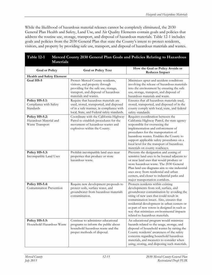
While the likelihood of hazardous material releases cannot be completely eliminated, the 2030 General Plan Health and Safety, Land Use, and Air Quality Elements contain goals and policies that address the routine use, storage, transport, and disposal of hazardous materials. Table 12-1 includes goals and policies from the 2030 General Plan that state the County’s intent to protect residents, visitors, and property by providing safe use, transport, and disposal of hazardous materials and wastes.
Table 12-1 Merced County 2030 General Plan Goals and Policies Relating to Hazardous Materials
Goal or Policy Goal or Policy Text How the Goal or Policy Avoids or Reduces Impact
Health and Safety Element Goal HS-5 Protect Merced County residents,
visitors, and property through providing for the safe use, storage, transport, and disposal of hazardous materials and wastes.
Minimizes upset and accident conditions involving the release of hazardous materials into the environment by ensuring the safe use, storage, transport, and disposal of hazardous materials and waste.
Policy HS-5.1: Compliance with Safety Standards
Require that hazardous materials are used, stored, transported, and disposed of in a safe manner, in compliance with local, State, and Federal safety standards.
Ensures that all hazardous materials used, stored, transported, and disposed of in the county comply with local, state, and federal safety standards.
Policy HS-5.2: Hazardous Material and Waste Transport
Coordinate with the California Highway Patrol to establish procedures for the movement of hazardous wastes and explosives within the County.
Requires coordination between the California Highway Patrol, the state agency responsible for overseeing the implementation and enforcement of procedures for the transportation of hazardous wastes. Enables the County to support applicable safety procedures on a local level for the transport of hazardous materials on county roadways.
Policy HS-5.3: Incompatible Land Uses
Prohibit incompatible land uses near properties that produce or store hazardous waste.
Prevents the designation and zoning of sensitive land uses to be located adjacent to or near land uses that would produce or store hazardous waste. The 2030 General Plan land use diagrams aim to site industrial uses away from residential and urban centers, and closer to industrial parks and major transportation corridors.
Policy HS-5.4: Contamination Prevention
Require new development proposals to protect soils, surface water, and groundwater from hazardous materials contamination.
Protects residents within existing developments from soil, surface, and groundwater contamination by avoiding the siting of new uses that could result in contamination issues. Also, ensures that residential development in urban centers or as part of new towns is designed in such as way that minimizes environmental impacts related to hazardous materials.
Policy HS-5.5: Household Hazardous Waste
Continue to administer educational programs to inform the public about household hazardous waste and the proper methods of disposal.
An educational program would minimize hazards related to the usage, storage, and disposal of household wastes by raising the County residents’ awareness of the safety concerns regarding household hazardous materials, and measures to consider when using, storing, and disposing such materials.
Hazards and Hazardous Materials
2030 Merced County General Plan 12-16 Merced County Recirculated Draft PEIR July 2013
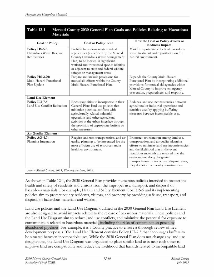
Table 12-1 Merced County 2030 General Plan Goals and Policies Relating to Hazardous Materials
Goal or Policy Goal or Policy Text How the Goal or Policy Avoids or Reduces Impact
Policy HS-5.6: Hazardous Waste Residual Repositories
Prohibit hazardous waste residual repositories (as defined by the Merced County Hazardous Waste Management Plan) to be located in significant wetland and threatened species habitats or adjacent to state and federal wildlife refuges or management areas.
Minimizes potential effects of hazardous waste treatment and repositories on the natural environment.
Policy HS-2.20: Multi-Hazard Functional Plan Update
Prepare and include provisions for mutual aid efforts within the County Multi-Hazard Functional Plan.
Expands the County Multi-Hazard Functional Plan by incorporating additional provisions for mutual aid agencies within Merced County to improve emergency prevention, preparedness, and response.
Land Use Element Policy LU-7.5: Land Use Conflict Reduction
Encourage cities to incorporate in their General Plans land use policies that minimize potential conflicts with agriculturally-related industrial operations and other agricultural activities at the urban interface through the provision of appropriate buffers or other measures.
Reduces land use inconsistencies between agricultural or industrial operations and sensitive uses by applying buffering measures between incompatible uses.
Air Quality Element Policy AQ-4.7: Planning Integration
Require land use, transportation, and air quality planning to be integrated for the most efficient use of resources and a healthier environment.
Promotes coordination among land use, transportation, and air quality planning efforts to minimize land use inconsistencies and the likelihood that in the event hazardous materials are released into the environment along designated transportation routes or near disposal sites, they do not affect nearby sensitive uses.
Source: Merced County, 2011; Planning Partners, 2012.
As shown in Table 12-1, the 2030 General Plan provides numerous policies intended to protect the health and safety of residents and visitors from the improper use, transport, and disposal of hazardous materials. For example, Health and Safety Element Goal HS-5 and its implementing policies aim to protect county residents, visitors, and property by providing safe use, transport, and disposal of hazardous materials and wastes.
Land use policies and the Land Use Diagram outlined in the 2030 General Plan Land Use Element are also designed to avoid impacts related to the release of hazardous materials. These policies and the Land Use Diagram aim to reduce land use conflicts, and minimize the potential for exposure to contamination related to hazardous materials, including the risks of contamination posed by abandoned pipelines. For example, it is a County practice to ensure a thorough review of new development proposals. The Land Use Element contains Policy LU-7.5 that encourages buffers to be situated between incompatible uses. While the 2030 General Plan does not change any land use designations, the Land Use Diagram was organized to place similar land uses near each other to improve land use compatibility and reduce the likelihood that hazards related to incompatible land
Hazards and Hazardous Materials
Merced County 12-17 2030 Merced County General Plan July 2013 Recirculated Draft PEIR
uses affect sensitive land uses. The Air Quality Element contains an analogous policy, Policy AQ-4.7, that requires land use, transportation, and air quality planning to be integrated for the most efficient use of resources and a healthier environment. These types of procedures and policies ensure that incompatible land uses are not located near each other, which minimizes the possibility that the routine use, transport, storage, and disposal of hazardous materials would create a significant public health or environmental hazard.
The Merced County Department of Environmental Health oversees the various state and local hazardous material programs. In this capacity, the County is responsible for providing regulatory oversight for investigation and clean-up at sites that have hazardous contamination or leaking underground storage tanks. The Merced County Local Oversight Program also oversees the implementation of various clean-up programs with coordination from the State Department of Toxic Substances Control and the State and Regional Water Quality Control Boards. Compliance with CUPA programs and plans, in conjunction with other federal and state programs and the 2030 General Plan policies, would reduce the impact of reasonably foreseeable accidents or upset conditions involving the release of hazardous materials.
The MCDEH also regularly updates the Area Plan for Emergency Response to Hazardous Material Incidents in Merced County, which serves as the County’s emergency response plan for hazardous material incidents. Policy HS-2.20 in the Health and Safety Element requires the County to prepare for and include provisions for mutual aid efforts within the County Multi-Hazard Functional Plan. This plan would contain preparedness measures, planning steps, and response strategies to prepare for, respond to, and mitigate emergencies involving hazardous materials and the accidental release of such materials into the environment.
There are numerous policies in place to protect the health and safety of residents and visitors from hazardous materials. Further, the activities and businesses in the county are generally well monitored, and the routine use, storage, transport, and disposal of hazardous materials and waste generated by the various land uses projected under buildout of the 2030 General Plan will occur within this policy and regulatory context. Both the State of California (Hazardous Materials Transportation Act) and Merced County have programs and policies in place that seek to limit the possibility of hazardous materials release and events that have the potential to result in the risk of death, injury, and property loss. Although the risk of upset and accident conditions involving the release of hazardous materials into the environment would remain, and the prevention of these types of accidental risks would not be completely avoided, no feature of the 2030 General Plan or its implementation would result in unusual land uses or reasonably foreseeable risks. This would be a less-than-significant impact.
Significance of Impact: Less than significant.
Mitigation Measure: None required.
Hazards and Hazardous Materials
2030 Merced County General Plan 12-18 Merced County Recirculated Draft PEIR July 2013
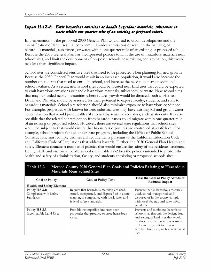
Impact HAZ-2: Emit hazardous emiss ions or handle hazardous mater ia ls , substances or waste within one-quarter mile o f an exist ing or proposed school .
Implementation of the proposed 2030 General Plan would lead to urban development and the intensification of land uses that could emit hazardous emissions or result in the handling of hazardous materials, substances, or waste within one-quarter mile of an existing or proposed school. Because the 2030 General Plan has incorporated policies to limit the use of hazardous materials near school sites, and limit the development of proposed schools near existing contamination, this would be a less-than-significant impact.
School sites are considered sensitive uses that need to be protected when planning for new growth. Because the 2030 General Plan would result in an increased population, it would also increase the number of students that need to enroll in school, and increase the need to construct additional school facilities. As a result, new school sites could be located near land uses that could be expected to emit hazardous emissions or handle hazardous materials, substances, or waste. New school sites that may be needed near communities where future growth would be directed, such as Hilmar, Delhi, and Planada, should be assessed for their potential to expose faculty, students, and staff to hazardous materials. School site selection should also minimize exposure to hazardous conditions. For example, properties with known historic industrial uses may have existing soil and groundwater contamination that would pose health risks to nearby sensitive receptors, such as students. It is also possible that the related contamination from hazardous uses could migrate within one-quarter mile of an existing or proposed school. However, there are several state regulations that school sites would be subject to that would ensure that hazardous exposures are controlled at a safe level. For example, school projects funded under state programs, including the Office of Public School Construction, must comply with several requirements pursuant to the California Education Code and California Code of Regulations that address hazards. Further, the 2030 General Plan Health and Safety Element contains a number of policies that would ensure the safety of the residents, students, faculty, staff, and visitors at public school sites. Table 12-2 lists the policies intended to protect the health and safety of administration, faculty, and students at existing or proposed schools sites.
Table 12-2 Merced County 2030 General Plan Goals and Policies Relating to Hazardous Materials Near School Sites
Goal or Policy Goal or Policy Text How the Goal or Policy Avoids or Reduces Impact
Health and Safety Element Policy HS-5.1: Compliance with Safety Standards
Require that hazardous materials are used, stored, transported, and disposed of in a safe manner, in compliance with local, state, and federal safety standards.
Ensures that all hazardous materials used, stored, transported, and disposed of in the county comply with local, federal, and state safety standards.
Policy HS-5.3: Incompatible Land Uses
Prohibit incompatible land uses near properties that produce or store hazardous waste.
Prevents and minimizes hazards to school sites through the designation and zoning of land uses that would produce or store hazardous waste to be located adjacent to or near sensitive land uses, such as residential uses.
Hazards and Hazardous Materials
Merced County 12-19 2030 Merced County General Plan July 2013 Recirculated Draft PEIR
Table 12-2 Merced County 2030 General Plan Goals and Policies Relating to Hazardous Materials Near School Sites
Goal or Policy Goal or Policy Text How the Goal or Policy Avoids or Reduces Impact
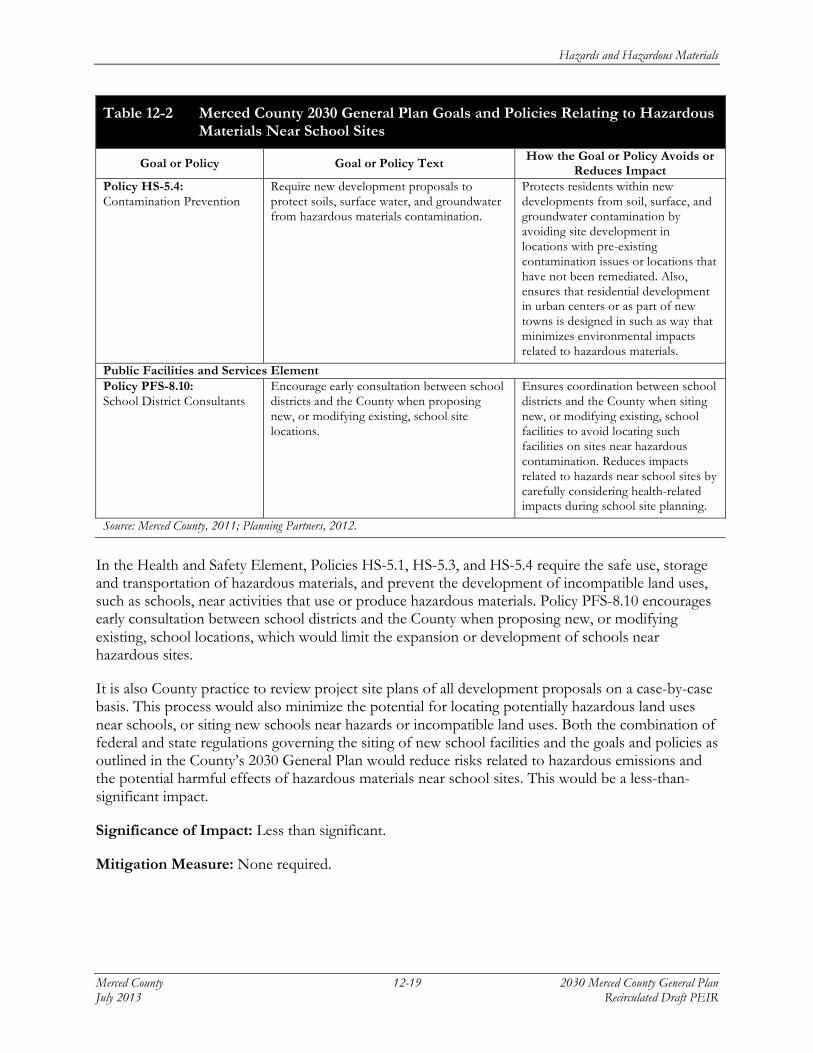
Policy HS-5.4: Contamination Prevention
Require new development proposals to protect soils, surface water, and groundwater from hazardous materials contamination.
Protects residents within new developments from soil, surface, and groundwater contamination by avoiding site development in locations with pre-existing contamination issues or locations that have not been remediated. Also, ensures that residential development in urban centers or as part of new towns is designed in such as way that minimizes environmental impacts related to hazardous materials.
Public Facilities and Services Element Policy PFS-8.10: School District Consultants
Encourage early consultation between school districts and the County when proposing new, or modifying existing, school site locations.
Ensures coordination between school districts and the County when siting new, or modifying existing, school facilities to avoid locating such facilities on sites near hazardous contamination. Reduces impacts related to hazards near school sites by carefully considering health-related impacts during school site planning.
Source: Merced County, 2011; Planning Partners, 2012.
In the Health and Safety Element, Policies HS-5.1, HS-5.3, and HS-5.4 require the safe use, storage and transportation of hazardous materials, and prevent the development of incompatible land uses, such as schools, near activities that use or produce hazardous materials. Policy PFS-8.10 encourages early consultation between school districts and the County when proposing new, or modifying existing, school locations, which would limit the expansion or development of schools near hazardous sites.
It is also County practice to review project site plans of all development proposals on a case-by-case basis. This process would also minimize the potential for locating potentially hazardous land uses near schools, or siting new schools near hazards or incompatible land uses. Both the combination of federal and state regulations governing the siting of new school facilities and the goals and policies as outlined in the County’s 2030 General Plan would reduce risks related to hazardous emissions and the potential harmful effects of hazardous materials near school sites. This would be a less-than-significant impact.
Significance of Impact: Less than significant.
Mitigation Measure: None required.
Hazards and Hazardous Materials
2030 Merced County General Plan 12-20 Merced County Recirculated Draft PEIR July 2013
Impact HAZ-3: Be located on a s i t e which is inc luded on a l i s t o f hazardous mater ia ls s i t es compi led pursuant to Government Code Sect ion 65962.5 and, as a resul t , create a s igni f i cant hazard to the publ i c or the environment .
Implementation of the proposed 2030 General Plan would lead to urban development and other activities that could be located at a location that is included on a list of hazardous materials sites compiled pursuant to Government Code Section 65962.5 and, as a result, could create a significant hazard to the public or environment. This would be a potentially significant impact.
There are a number of sites identified in Merced County that contain groundwater or soil contamination. They are included on a list (i.e., RWQCB Geotracker, Envirostor, CIWMB SWIS list) of hazardous materials or contaminated sites pursuant to Government Code Section 65962.5.2 The list is available at http://www.envirostor.dtsc.ca.gov/public/search.asp?basic=True. Among the sites, some have a history of contamination due to hazardous materials spills, leakage from underground storage tanks, landfills, or other releases that are subject to federal and state environmental laws and regulations. Many of these sites are also undergoing assessment or remediation overseen by the Merced County Division of Environmental Health, CalRecycle (formerly the Integrated Waste Management Board), or the Regional Water Quality Control Board. Other sites, particularly agricultural sites that have a history of former agricultural operations, may also contain chemicals including heavy metals and organic compounds that can persist in the soil and contain residues that could pose health risks to sensitive receptors. Additionally, land uses sited near abandoned pipelines could be exposed to potential contamination. As a result, land development allowed under the 2030 General Plan could create a hazard to the public or the environment if development occurs on contaminated sites. While many contaminated sites are likely to have development restrictions prior to clean-up and remediation, the possibility remains that future development under the 2030 General Plan could expose the public and the environment to site contamination hazards.
In addition to various state programs that require the clean-up of contaminated sites, the County would regulate hazardous material concerns and site contamination on a case-by-case basis as part of the development site review process for any future project within the county, including potential development adjacent to the routes of abandoned pipelines. Further, the 2030 General Plan contains various policies intended to ensure the safety of county residents, visitors, and businesses, and reduce the impacts of hazardous sites due to contamination. Table 12-3 lists the policies intended to protect the health and safety of county residents from contaminated sites.
2 Merced, County of. 2011. Merced County Contaminated Site Listing. Accessed on May 9, 2011 by Juliana Prosperi
(Planning Partners) at http://www.envirostor.dtsc.ca.gov/public/search.asp?basic=True
Hazards and Hazardous Materials
Merced County 12-21 2030 Merced County General Plan July 2013 Recirculated Draft PEIR
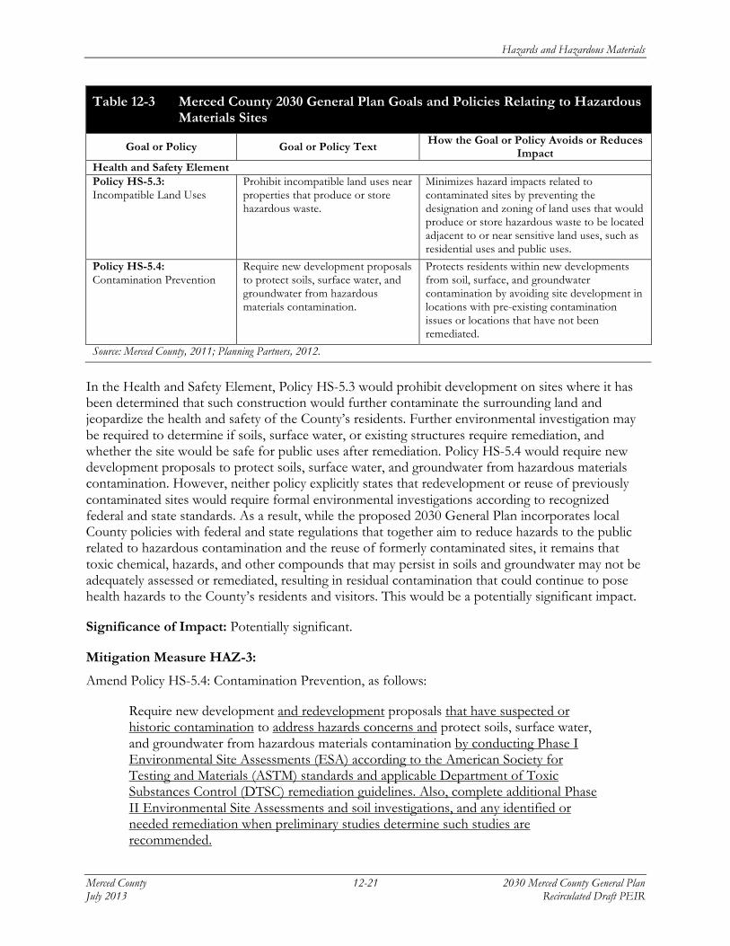
Table 12-3 Merced County 2030 General Plan Goals and Policies Relating to Hazardous Materials Sites
Goal or Policy Goal or Policy Text How the Goal or Policy Avoids or Reduces Impact
Health and Safety Element Policy HS-5.3: Incompatible Land Uses
Prohibit incompatible land uses near properties that produce or store hazardous waste.
Minimizes hazard impacts related to contaminated sites by preventing the designation and zoning of land uses that would produce or store hazardous waste to be located adjacent to or near sensitive land uses, such as residential uses and public uses.
Policy HS-5.4: Contamination Prevention
Require new development proposals to protect soils, surface water, and groundwater from hazardous materials contamination.
Protects residents within new developments from soil, surface, and groundwater contamination by avoiding site development in locations with pre-existing contamination issues or locations that have not been remediated.
Source: Merced County, 2011; Planning Partners, 2012.
In the Health and Safety Element, Policy HS-5.3 would prohibit development on sites where it has been determined that such construction would further contaminate the surrounding land and jeopardize the health and safety of the County’s residents. Further environmental investigation may be required to determine if soils, surface water, or existing structures require remediation, and whether the site would be safe for public uses after remediation. Policy HS-5.4 would require new development proposals to protect soils, surface water, and groundwater from hazardous materials contamination. However, neither policy explicitly states that redevelopment or reuse of previously contaminated sites would require formal environmental investigations according to recognized federal and state standards. As a result, while the proposed 2030 General Plan incorporates local County policies with federal and state regulations that together aim to reduce hazards to the public related to hazardous contamination and the reuse of formerly contaminated sites, it remains that toxic chemical, hazards, and other compounds that may persist in soils and groundwater may not be adequately assessed or remediated, resulting in residual contamination that could continue to pose health hazards to the County’s residents and visitors. This would be a potentially significant impact.
Significance of Impact: Potentially significant.
Mitigation Measure HAZ-3:
Amend Policy HS-5.4: Contamination Prevention, as follows:
Require new development and redevelopment proposals that have suspected or historic contamination to address hazards concerns and protect soils, surface water, and groundwater from hazardous materials contamination by conducting Phase I Environmental Site Assessments (ESA) according to the American Society for Testing and Materials (ASTM) standards and applicable Department of Toxic Substances Control (DTSC) remediation guidelines. Also, complete additional Phase II Environmental Site Assessments and soil investigations, and any identified or needed remediation when preliminary studies determine such studies are recommended.
Hazards and Hazardous Materials
2030 Merced County General Plan 12-22 Merced County Recirculated Draft PEIR July 2013
Environmental Effects of Measure: Because this mitigation measure would result in the additional protection against hazardous materials releases arising from the development of urban uses and infrastructure identified in the 2030 General Plan, there would be no additional impacts beyond those identified for such development in Chapters 5 through 22 of this Draft PEIR.
Level of Significance After Mitigation: Less than significant.
Implementation of Mitigation Measure HAZ-3 would result in a reduction in the potential hazard impacts to the public or environment due to redevelopment on a contaminated site, or development adjacent to a contaminated site or pipeline alignment. The policy would require that the owners or responsible parties of all sites proposed for new development or redevelopment that have perceived or potential historic contamination due to past agricultural, commercial, or industrial uses must conduct appropriate environmental site assessments, and remediate contamination if present. No further changes to County programs would be required.
Impact HAZ-4: Be located within an airport land use plan or , where such a plan has not
been adopted, within the v i c ini ty o f a publ i c or pr ivate airport , and thereby resul t in a safe ty hazard for people res iding or working in the pro jec t area.
Implementation of the proposed 2030 General Plan would lead to urban development and other land use activities that could be located within an area regulated by the Merced County Airport Land Use Commission’s adopted Airport Land Use Plan or in the vicinity of a private airport, and pose a safety hazard for people residing or working in the project area. Because the intent of the General Plan is to ensure that existing and future land uses function without imposing safety hazards or nuisances upon existing uses, the 2030 General Plan land uses are designed to be consistent with the Airport Land Use Commission adopted land use restrictions and compatibility criteria in accordance with the Federal Aviation Administration (FAA) for the areas around the five public airports in Merced County. However, although the 2030 General Plan contains goals and policies to ensure that all development within the vicinity of public airports do not result in safety hazards, additional measures may be necessary to ensure future development near private airport facilities does not pose safety hazards. Therefore, while public safety impacts associated with public airport hazards would result in a less-than-significant impact, public safety impacts associated with private airports could be potentially significant.
In June 2012, the ALUC adopted the Merced County Airport Land Use Compatibility Plan (ALUCP), which contains individual compatibility plans for all five public airports in the county. The basic function of the ALUCP is to promote land use compatibility between the airports in Merced County and the land uses that surround them. The ALUCP also sets compatibility criteria applicable to local agencies reviewing development proposals and preparing land use plans and zoning ordinances, and to landowners designing new development. The Merced County ALUCP is primarily concerned with the land uses near the five public use airports in the County: Castle Airport, Gustine Municipal Airport, Los Banos Municipal Airport, Merced Regional Airport, and the Turlock Municipal Airport. With the exception of the Castle Airport, each airport’s influence area extends approximately two miles from the airport runways. The Castle Airport influence area stretches approximately four miles from the runway end due to the heavy aircraft that the airport accommodates (Merced County 2012).
Hazards and Hazardous Materials
Merced County 12-23 2030 Merced County General Plan July 2013 Recirculated Draft PEIR
The 2030 General Plan is required to be consistent, to the greatest extent possible, with the policies adopted by the ALUC reflected in each individual airport’s ALUCP and its corresponding land use compatibility zone maps. Land uses not consistent with the ALUCPs would need to be modified by the County in the General Plan, Community Plans, and policy documents to ensure consistency. However, local agencies do not need to change land use designations to bring them into consistency with ALUC criteria if the current designations reflect existing development. Instead, applicable plans would need to establish policies to ensure that the non-conforming uses would not be expanded, and that redevelopment in the area would be made consistent with the compatibility criteria. In its June 2012 adoption of the ALUCP, the Merced County ALUC found that the 2030 General Plan was consistent with the ALUCP, and that there were no incompatible land use designations in the vicinity of the county’s public use airports.
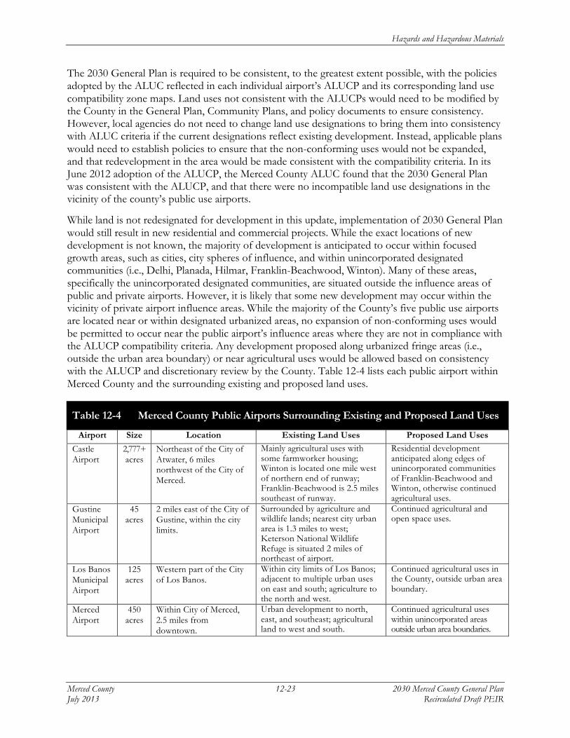
While land is not redesignated for development in this update, implementation of 2030 General Plan would still result in new residential and commercial projects. While the exact locations of new development is not known, the majority of development is anticipated to occur within focused growth areas, such as cities, city spheres of influence, and within unincorporated designated communities (i.e., Delhi, Planada, Hilmar, Franklin-Beachwood, Winton). Many of these areas, specifically the unincorporated designated communities, are situated outside the influence areas of public and private airports. However, it is likely that some new development may occur within the vicinity of private airport influence areas. While the majority of the County’s five public use airports are located near or within designated urbanized areas, no expansion of non-conforming uses would be permitted to occur near the public airport’s influence areas where they are not in compliance with the ALUCP compatibility criteria. Any development proposed along urbanized fringe areas (i.e., outside the urban area boundary) or near agricultural uses would be allowed based on consistency with the ALUCP and discretionary review by the County. Table 12-4 lists each public airport within Merced County and the surrounding existing and proposed land uses.
Table 12-4 Merced County Public Airports Surrounding Existing and Proposed Land Uses
Airport Size Location Existing Land Uses Proposed Land Uses
Castle Airport
2,777+ acres
Northeast of the City of Atwater, 6 miles northwest of the City of Merced.
Mainly agricultural uses with some farmworker housing; Winton is located one mile west of northern end of runway; Franklin-Beachwood is 2.5 miles southeast of runway.
Residential development anticipated along edges of unincorporated communities of Franklin-Beachwood and Winton, otherwise continued agricultural uses.
Gustine Municipal Airport
45 acres
2 miles east of the City of Gustine, within the city limits.
Surrounded by agriculture and wildlife lands; nearest city urban area is 1.3 miles to west; Keterson National Wildlife Refuge is situated 2 miles of northeast of airport.
Continued agricultural and open space uses.
Los Banos Municipal Airport
125 acres
Western part of the City of Los Banos.
Within city limits of Los Banos; adjacent to multiple urban uses on east and south; agriculture to the north and west.
Continued agricultural uses in the County, outside urban area boundary.
Merced Airport
450 acres
Within City of Merced, 2.5 miles from downtown.
Urban development to north, east, and southeast; agricultural land to west and south.
Continued agricultural uses within unincorporated areas outside urban area boundaries.
Hazards and Hazardous Materials
2030 Merced County General Plan 12-24 Merced County Recirculated Draft PEIR July 2013
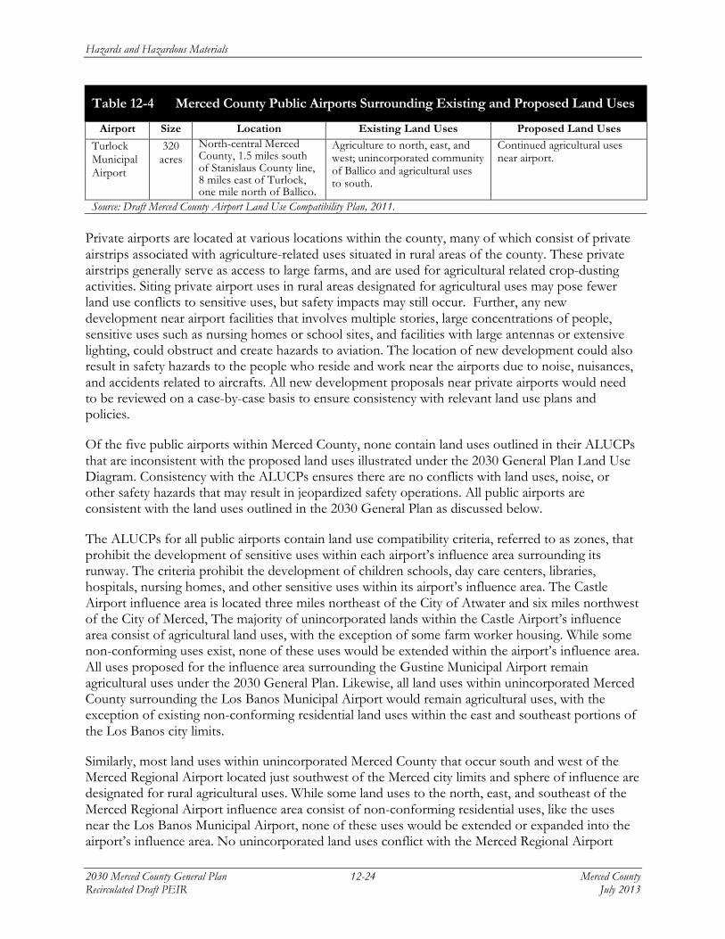
Table 12-4 Merced County Public Airports Surrounding Existing and Proposed Land Uses
Airport Size Location Existing Land Uses Proposed Land Uses
Turlock Municipal Airport
320 acres
North-central Merced County, 1.5 miles south of Stanislaus County line, 8 miles east of Turlock, one mile north of Ballico.
Agriculture to north, east, and west; unincorporated community of Ballico and agricultural uses to south.
Continued agricultural uses near airport.
Source: Draft Merced County Airport Land Use Compatibility Plan, 2011. Private airports are located at various locations within the county, many of which consist of private airstrips associated with agriculture-related uses situated in rural areas of the county. These private airstrips generally serve as access to large farms, and are used for agricultural related crop-dusting activities. Siting private airport uses in rural areas designated for agricultural uses may pose fewer land use conflicts to sensitive uses, but safety impacts may still occur. Further, any new development near airport facilities that involves multiple stories, large concentrations of people, sensitive uses such as nursing homes or school sites, and facilities with large antennas or extensive lighting, could obstruct and create hazards to aviation. The location of new development could also result in safety hazards to the people who reside and work near the airports due to noise, nuisances, and accidents related to aircrafts. All new development proposals near private airports would need to be reviewed on a case-by-case basis to ensure consistency with relevant land use plans and policies.
Of the five public airports within Merced County, none contain land uses outlined in their ALUCPs that are inconsistent with the proposed land uses illustrated under the 2030 General Plan Land Use Diagram. Consistency with the ALUCPs ensures there are no conflicts with land uses, noise, or other safety hazards that may result in jeopardized safety operations. All public airports are consistent with the land uses outlined in the 2030 General Plan as discussed below.
The ALUCPs for all public airports contain land use compatibility criteria, referred to as zones, that prohibit the development of sensitive uses within each airport’s influence area surrounding its runway. The criteria prohibit the development of children schools, day care centers, libraries, hospitals, nursing homes, and other sensitive uses within its airport’s influence area. The Castle Airport influence area is located three miles northeast of the City of Atwater and six miles northwest of the City of Merced, The majority of unincorporated lands within the Castle Airport’s influence area consist of agricultural land uses, with the exception of some farm worker housing. While some non-conforming uses exist, none of these uses would be extended within the airport’s influence area. All uses proposed for the influence area surrounding the Gustine Municipal Airport remain agricultural uses under the 2030 General Plan. Likewise, all land uses within unincorporated Merced County surrounding the Los Banos Municipal Airport would remain agricultural uses, with the exception of existing non-conforming residential land uses within the east and southeast portions of the Los Banos city limits.
Similarly, most land uses within unincorporated Merced County that occur south and west of the Merced Regional Airport located just southwest of the Merced city limits and sphere of influence are designated for rural agricultural uses. While some land uses to the north, east, and southeast of the Merced Regional Airport influence area consist of non-conforming residential uses, like the uses near the Los Banos Municipal Airport, none of these uses would be extended or expanded into the airport’s influence area. No unincorporated land uses conflict with the Merced Regional Airport
Hazards and Hazardous Materials
Merced County 12-25 2030 Merced County General Plan July 2013 Recirculated Draft PEIR
ALUCP. Lastly, the majority of the Turlock Municipal Airport and its influence area occur within the north-central portion of unincorporated Merced County. All land uses within the Turlock Municipal Airport influence area are consistent with the use outlined in its CLUP, as all land uses consist of agricultural activities. There is no potential that future sensitive land uses (e.g., residential uses) could be proposed within the Turlock Municipal Airport’s influence area that are not compatible with the compatibility zones outlined in the CLUP (Cumulative impacts are discussed in Chapter 22, Required CEQA Analyses).
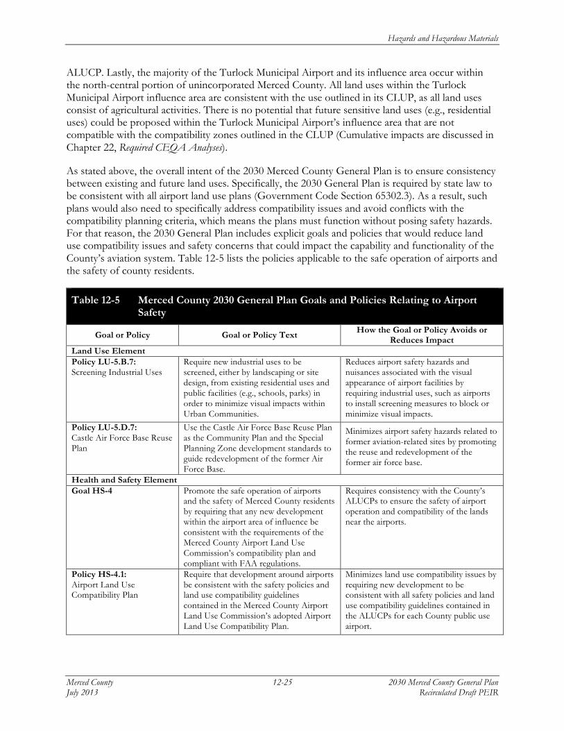
As stated above, the overall intent of the 2030 Merced County General Plan is to ensure consistency between existing and future land uses. Specifically, the 2030 General Plan is required by state law to be consistent with all airport land use plans (Government Code Section 65302.3). As a result, such plans would also need to specifically address compatibility issues and avoid conflicts with the compatibility planning criteria, which means the plans must function without posing safety hazards. For that reason, the 2030 General Plan includes explicit goals and policies that would reduce land use compatibility issues and safety concerns that could impact the capability and functionality of the County’s aviation system. Table 12-5 lists the policies applicable to the safe operation of airports and the safety of county residents.
Table 12-5 Merced County 2030 General Plan Goals and Policies Relating to Airport Safety
Goal or Policy Goal or Policy Text How the Goal or Policy Avoids or Reduces Impact
Land Use Element Policy LU-5.B.7: Screening Industrial Uses
Require new industrial uses to be screened, either by landscaping or site design, from existing residential uses and public facilities (e.g., schools, parks) in order to minimize visual impacts within Urban Communities.
Reduces airport safety hazards and nuisances associated with the visual appearance of airport facilities by requiring industrial uses, such as airports to install screening measures to block or minimize visual impacts.
Policy LU-5.D.7: Castle Air Force Base Reuse Plan
Use the Castle Air Force Base Reuse Plan as the Community Plan and the Special Planning Zone development standards to guide redevelopment of the former Air Force Base.
Minimizes airport safety hazards related to former aviation-related sites by promoting the reuse and redevelopment of the former air force base.
Health and Safety Element Goal HS-4
Promote the safe operation of airports and the safety of Merced County residents by requiring that any new development within the airport area of influence be consistent with the requirements of the Merced County Airport Land Use Commission’s compatibility plan and compliant with FAA regulations.
Requires consistency with the County’s ALUCPs to ensure the safety of airport operation and compatibility of the lands near the airports.
Policy HS-4.1: Airport Land Use Compatibility Plan
Require that development around airports be consistent with the safety policies and land use compatibility guidelines contained in the Merced County Airport Land Use Commission’s adopted Airport Land Use Compatibility Plan.
Minimizes land use compatibility issues by requiring new development to be consistent with all safety policies and land use compatibility guidelines contained in the ALUCPs for each County public use airport.
Hazards and Hazardous Materials
2030 Merced County General Plan 12-26 Merced County Recirculated Draft PEIR July 2013
Table 12-5 Merced County 2030 General Plan Goals and Policies Relating to Airport Safety
Goal or Policy Goal or Policy Text How the Goal or Policy Avoids or Reduces Impact
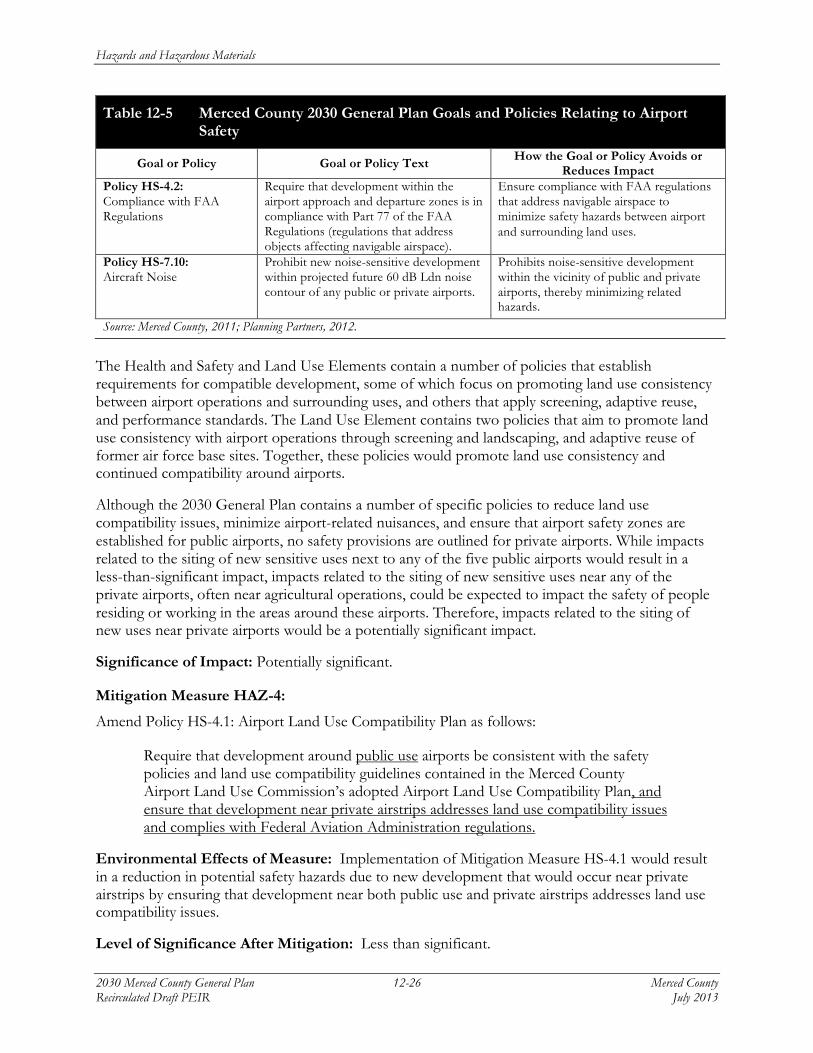
Policy HS-4.2: Compliance with FAA Regulations
Require that development within the airport approach and departure zones is in compliance with Part 77 of the FAA Regulations (regulations that address objects affecting navigable airspace).
Ensure compliance with FAA regulations that address navigable airspace to minimize safety hazards between airport and surrounding land uses.
Policy HS-7.10: Aircraft Noise
Prohibit new noise-sensitive development within projected future 60 dB Ldn noise contour of any public or private airports.
Prohibits noise-sensitive development within the vicinity of public and private airports, thereby minimizing related hazards.
Source: Merced County, 2011; Planning Partners, 2012.
The Health and Safety and Land Use Elements contain a number of policies that establish requirements for compatible development, some of which focus on promoting land use consistency between airport operations and surrounding uses, and others that apply screening, adaptive reuse, and performance standards. The Land Use Element contains two policies that aim to promote land use consistency with airport operations through screening and landscaping, and adaptive reuse of former air force base sites. Together, these policies would promote land use consistency and continued compatibility around airports.
Although the 2030 General Plan contains a number of specific policies to reduce land use compatibility issues, minimize airport-related nuisances, and ensure that airport safety zones are established for public airports, no safety provisions are outlined for private airports. While impacts related to the siting of new sensitive uses next to any of the five public airports would result in a less-than-significant impact, impacts related to the siting of new sensitive uses near any of the private airports, often near agricultural operations, could be expected to impact the safety of people residing or working in the areas around these airports. Therefore, impacts related to the siting of new uses near private airports would be a potentially significant impact.
Significance of Impact: Potentially significant.
Mitigation Measure HAZ-4:
Amend Policy HS-4.1: Airport Land Use Compatibility Plan as follows:
Require that development around public use airports be consistent with the safety policies and land use compatibility guidelines contained in the Merced County Airport Land Use Commission’s adopted Airport Land Use Compatibility Plan, and ensure that development near private airstrips addresses land use compatibility issues and complies with Federal Aviation Administration regulations.
Environmental Effects of Measure: Implementation of Mitigation Measure HS-4.1 would result in a reduction in potential safety hazards due to new development that would occur near private airstrips by ensuring that development near both public use and private airstrips addresses land use compatibility issues.
Level of Significance After Mitigation: Less than significant.
Hazards and Hazardous Materials
Merced County 12-27 2030 Merced County General Plan July 2013 Recirculated Draft PEIR
Impact HAZ-5: Expose people or s tructures to a s igni f i cant r i sk of loss , in jury , or death involv ing wi ldland f i res .
Implementation of the proposed 2030 General Plan would lead to urban development and other activities that would increase the need to expand existing fire protection services, and could expose people or structures to a significant risk of loss, injury, or death involving wildland fires. Because the 2030 General Plan contains specific goals and policies designed to prevent wildfire hazards related to wildland fuel reduction, emergency response, and design solutions, this would be a less-than-significant impact.
Both urban and wildland fire hazards exist in Merced County. However, according to the California Department of Forestry and Fire Protection, wildland fires comprise the majority of fires in the county. As a result, as the county continues to grow and more rural lands are developed, the potential for urban development within areas that are susceptible to wildland fire hazards will increase. The 2030 General Plan would allow new urban development near both existing cities and urban centers, and near rural centers that are located near foothill areas. Development in these rural areas is likely to be exposed to the greatest risks related to wildland fire hazards since the threat from wildfires in these areas is moderate to high, due to higher fuel loads and fewer water resources for fire suppression. The rural areas likely to be most exposed to high wildland fire threats are located in the far western and eastern parts of the county, particularly west of the San Luis Reservoir (see Figure 12-2). Some of the unincorporated communities areas that may be more susceptible to wildland fire hazards because they are located in or near high to very high fire hazard severity zones include, but are not limited to, the Villages at Laguna San Luis, Fox Hills, and Santa Nella in the western portion of the county, and the community of Snelling in the northeastern portion of the county. As the county continues to experience increased residential development within areas of unincorporated Merced County designated for agricultural and rural residential uses, such development would occur within the moderate to very high fire hazard severity zones. As a result, there will be increasing pressure to maintain adequate and safe roadways for emergency access and evacuation, upgrade fire safety facilities, and safeguard and serve the growing demand for wildland fire protection.
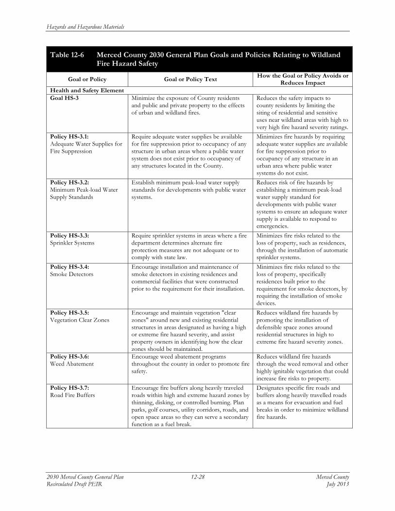
There are several 2030 General Plan goals, policies, and implementation programs contained in the Health and Safety Element related to increasing fire response capabilities, supporting fire prevention measures, and encouraging design solutions that provide better fire response and accessibility to reduce wildfire impacts. Table 12-6 lists all applicable policies related to wildland fire hazards and safety.
Hazards and Hazardous Materials
2030 Merced County General Plan 12-28 Merced County Recirculated Draft PEIR July 2013
Table 12-6 Merced County 2030 General Plan Goals and Policies Relating to Wildland Fire Hazard Safety
Goal or Policy Goal or Policy Text How the Goal or Policy Avoids or Reduces Impact
Health and Safety Element Goal HS-3 Minimize the exposure of County residents
and public and private property to the effects of urban and wildland fires.
Reduces the safety impacts to county residents by limiting the siting of residential and sensitive uses near wildland areas with high to very high fire hazard severity ratings.
Policy HS-3.1: Adequate Water Supplies for Fire Suppression
Require adequate water supplies be available for fire suppression prior to occupancy of any structure in urban areas where a public water system does not exist prior to occupancy of any structures located in the County.
Minimizes fire hazards by requiring adequate water supplies are available for fire suppression prior to occupancy of any structure in an urban area where public water systems do not exist.
Policy HS-3.2: Minimum Peak-load Water Supply Standards
Establish minimum peak-load water supply standards for developments with public water systems.
Reduces risk of fire hazards by establishing a minimum peak-load water supply standard for developments with public water systems to ensure an adequate water supply is available to respond to emergencies.
Policy HS-3.3: Sprinkler Systems
Require sprinkler systems in areas where a fire department determines alternate fire protection measures are not adequate or to comply with state law.
Minimizes fire risks related to the loss of property, such as residences, through the installation of automatic sprinkler systems.
Policy HS-3.4: Smoke Detectors
Encourage installation and maintenance of smoke detectors in existing residences and commercial facilities that were constructed prior to the requirement for their installation.
Minimizes fire risks related to the loss of property, specifically residences built prior to the requirement for smoke detectors, by requiring the installation of smoke devices.
Policy HS-3.5: Vegetation Clear Zones
Encourage and maintain vegetation "clear zones" around new and existing residential structures in areas designated as having a high or extreme fire hazard severity, and assist property owners in identifying how the clear zones should be maintained.
Reduces wildland fire hazards by promoting the installation of defensible space zones around residential structures in high to extreme fire hazard severity zones.
Policy HS-3.6: Weed Abatement
Encourage weed abatement programs throughout the county in order to promote fire safety.
Reduces wildland fire hazards through the weed removal and other highly ignitable vegetation that could increase fire risks to property.
Policy HS-3.7: Road Fire Buffers
Encourage fire buffers along heavily traveled roads within high and extreme hazard zones by thinning, disking, or controlled burning. Plan parks, golf courses, utility corridors, roads, and open space areas so they can serve a secondary function as a fuel break.
Designates specific fire roads and buffers along heavily travelled roads as a means for evacuation and fuel breaks in order to minimize wildland fire hazards.
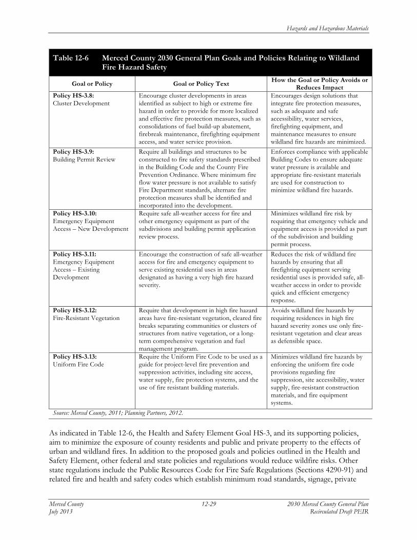
Hazards and Hazardous Materials
Merced County 12-29 2030 Merced County General Plan July 2013 Recirculated Draft PEIR
Table 12-6 Merced County 2030 General Plan Goals and Policies Relating to Wildland Fire Hazard Safety
Goal or Policy Goal or Policy Text How the Goal or Policy Avoids or Reduces Impact
Policy HS-3.8: Cluster Development
Encourage cluster developments in areas identified as subject to high or extreme fire hazard in order to provide for more localized and effective fire protection measures, such as consolidations of fuel build-up abatement, firebreak maintenance, firefighting equipment access, and water service provision.
Encourages design solutions that integrate fire protection measures, such as adequate and safe accessibility, water services, firefighting equipment, and maintenance measures to ensure wildland fire hazards are minimized.
Policy HS-3.9: Building Permit Review
Require all buildings and structures to be constructed to fire safety standards prescribed in the Building Code and the County Fire Prevention Ordinance. Where minimum fire flow water pressure is not available to satisfy Fire Department standards, alternate fire protection measures shall be identified and incorporated into the development.
Enforces compliance with applicable Building Codes to ensure adequate water pressure is available and appropriate fire-resistant materials are used for construction to minimize wildland fire hazards.
Policy HS-3.10: Emergency Equipment Access – New Development
Require safe all-weather access for fire and other emergency equipment as part of the subdivisions and building permit application review process.
Minimizes wildland fire risk by requiring that emergency vehicle and equipment access is provided as part of the subdivision and building permit process.
Policy HS-3.11: Emergency Equipment Access – Existing Development
Encourage the construction of safe all-weather access for fire and emergency equipment to serve existing residential uses in areas designated as having a very high fire hazard severity.
Reduces the risk of wildland fire hazards by ensuring that all firefighting equipment serving residential uses is provided safe, all-weather access in order to provide quick and efficient emergency response.
Policy HS-3.12: Fire-Resistant Vegetation
Require that development in high fire hazard areas have fire-resistant vegetation, cleared fire breaks separating communities or clusters of structures from native vegetation, or a long-term comprehensive vegetation and fuel management program.
Avoids wildland fire hazards by requiring residences in high fire hazard severity zones use only fire-resistant vegetation and clear areas as defensible space.
Policy HS-3.13: Uniform Fire Code
Require the Uniform Fire Code to be used as a guide for project-level fire prevention and suppression activities, including site access, water supply, fire protection systems, and the use of fire resistant building materials.
Minimizes wildland fire hazards by enforcing the uniform fire code provisions regarding fire suppression, site accessibility, water supply, fire-resistant construction materials, and fire equipment systems.
Source: Merced County, 2011; Planning Partners, 2012.
As indicated in Table 12-6, the Health and Safety Element Goal HS-3, and its supporting policies, aim to minimize the exposure of county residents and public and private property to the effects of urban and wildland fires. In addition to the proposed goals and policies outlined in the Health and Safety Element, other federal and state policies and regulations would reduce wildfire risks. Other state regulations include the Public Resources Code for Fire Safe Regulations (Sections 4290-91) and related fire and health and safety codes which establish minimum road standards, signage, private
Hazards and Hazardous Materials
2030 Merced County General Plan 12-30 Merced County Recirculated Draft PEIR July 2013
water supply standards, and defensible space requirements. Likewise, the California Building Commission’s Wildland-Urban Interface Code, adopted in late 2005 and updated in January 2008, also includes ignition-resistant construction standards in fire prone areas (similar to Policy HS-3.9). The proposed 2030 General Plan goals and policies, in combination with federal and state regulations, would result in a beneficial impact and would reduce wildfire risk and hazard impacts. This would be a less-than-significant impact.
Significance of Impact: Less than significant.
Mitigation Measure HAZ-5: None required.