Embed Size (px)
Citation preview
ENVIRONMENTAL RESOURCES MANAGEMENT CASTLE PEAK POWER COMPANY LIMITED
0308057_S12_LVIA_REV 3.DOCX APRIL 2016
12-1
12 LANDSCAPE & VISUAL
12.1 INTRODUCTION
This Section presents a landscape and visual impact assessment (LVIA) which
has been conducted based on a review of available literature, as well as field
surveys to help identify the existing conditions so as to be able to accurately
assess the potential landscape and visual impacts associated with the Project.
Figure 12.1 shows an aerial image of the Project Site and in addition to land-
based construction works, minor marine dredging works adjacent to the BPPS
seawall, close to the existing seawater intake and outfall, will be required
should a second CCGT unit be installed.
The remainder of the LVIA provides details on the following:
• Environmental Legislation, Standards and Guidelines;
• Review of Planning and Development Framework;
• Methodology for LVIA;
• Baseline Conditions, for Landscape and Visual elements;
• Identification of Impacts;
• Impact Assessment Prior to Mitigation, for Landscape and Visual
elements;
• Suggested Mitigation Measures;
• Residual Impacts;
• Cumulative Impacts; and
• Conclusion.
12.2 ENVIRONMENTAL LEGISLATION, STANDARDS AND GUIDELINES
This LVIA has been prepared according to Clause 3.2.1 (ix), Clause 3.4.11.1-3
and Appendix G of the EIA Study Brief No. ESB-286/2015.
Environmental Impact Assessment Ordinance (EIAO) legislation (Cap.499, S.16)
and the Technical Memorandum on EIA Process (EIAO-TM), particularly
Annexes 10 (Criteria for Evaluating Visual and Landscape Impact, and Impact
on Sites of Cultural Heritage) and 18 (Guidelines for Landscape and Visual
Impact Assessment) have been referred to in carrying out this assessment.
In addition, the following standards and guidelines have been referred to for
assessing the landscape and visual impacts associated with the Project:

ENVIRONMENTAL RESOURCES MANAGEMENT CASTLE PEAK POWER COMPANY LIMITED
0308057_S12_LVIA_REV 3.DOCX APRIL 2016
12-2
• Environmental Impact Assessment Ordinance Guidance Note 8/2010
(Preparation of Landscape and Visual Impact Assessment under the
Environmental Impact Assessment Ordinance);
• Hong Kong Planning Standards and Guidelines (HKPSG) issued by the
Planning Department;
• Lands Administration Office (LAO) Practice Note No. 7/2007 Tree Preservation
& Removal;
• DEVB TC(W) No. 7/2015 – Tree Preservation;
• DEVB TC(W) No.6/2015 – Maintenance of Vegetation and Hard Landscape
Features;
• ETWB TCW No. 11/2004 – Cyber Manual for Greening;
• ETWB TCW No. 29/2004 – Registration of Old and Valuable Trees, and
Guidelines for their Preservation;
• Hong Kong Planning Standards and Guidelines (November 2015), Chapter
11 Urban Design Guidelines; and
• Study on Landscape Value Mapping of Hong Kong (1).
12.3 REVIEW OF PLANNING & DEVELOPMENT CONTROL FRAMEWORK
The Project will be implemented within the boundary of the existing BPPS
which is not covered by any Outline Zoning Plan (OZP). The coast does not
form part of any Coastal Protection Area (CPA), and the Sha Chau and Lung
Kwu Chau Marine Park is located at least 4.4 km by sea from the BPPS. Pak
Nai Site of Special Scientific Interest (SSSI), which is an intertidal mudflat/
mangrove habitat, is approximately 5 km to the north. Figure 12.2 helps
illustrate this.
It should be noted that Lung Kwu Tan at Tuen Mun is one of five potential
near-shore reclamation sites that are being considered as part of the
Enhancing Land Supply Strategy: Reclamation Outside Victoria Harbour and
Rock Cavern Development (2). If selected it would provide 200-300 ha of land
to the south of Black Point that is currently positioned for business,
residential, and complimentary Government, Institution and Community
(GIC) facility uses, with local open space. Details of heights of buildings in
this area have not been finalised but are assumed to be no greater than 50 m (3)
(1) PlanD. Landscape Value Mapping of Hong Kong Final Report. Available at:
http://www.pland.gov.hk/pland_en/p_study/prog_s/landscape/landscape_final/index.html [Accessed November 2015]
(2) Advisory Council on the Environment (ACE) Paper 3/2015
(3) Agreement No. CE 14/2013 (CE) Cumulative Environmental Impact Assessment Study for the Three Potential
Nearshore Reclamation Sites in the Western Waters of Hong Kong - Investigation - Executive Summary (Final)
ENVIRONMENTAL RESOURCES MANAGEMENT CASTLE PEAK POWER COMPANY LIMITED
0308057_S12_LVIA_REV 3.DOCX APRIL 2016
12-3
i.e. they should not reach over the height of Black Point ridgeline which is just
over 130m at its peak, and therefore are not considered as future VRSs. In
addition there is a lack of detailed information or scheduling of the potential
project currently, and therefore it is not included as part of the assessment.
12.4 METHODOLOGY
This following section presents the methodology for the landscape and visual
impact assessment for the Project.
The methodology follows the criteria and guidelines state in section 1 of
Annex 10 and Annex 18 of the TM respectively, the EIAO Guidance Note GN
8/2010 Preparation of Landscape and Visual Impact Assessment under the
Environmental Impact Assessment Ordinance, and the report of Landscape Value
Mapping of Hong Kong, for evaluating and assessing the landscape and visual
impacts.
12.4.1 Baseline
Assessment Areas
As per Clause 3.4.11.2 of the Study Brief, the Assessment Area for Landscape
Impact Assessment (LIA) shall include areas within a 500 m distance from the
boundary of the Project site as indicated in Figure 12.1.
As per Clause 3.4.11.2 of the Study Brief, the Assessment Area for visual
impact assessment shall be defined by the visual envelope of the Project.
Identification of the visual envelope has been achieved by site visit and desk-
top study of topographic maps and photographs, and GIS analysis, to
determine potential visibility of the Project from various locations. GIS
analysis uses known data regarding the proposed built structures to model
the area that can potentially see the developments. Building heights
provided by CLP at the time of preparing this LVIA have been used to
generate the models and assume the highest facility is the +106mPD stack.
This is a worst case scenario as the stack height may be reduced. It should be
noted that GIS analysis uses topographic data as a baseline, disregarding
existing built forms and vegetation which reduce the actual visual envelope.
Landscape Baseline
LR and LCA identification
Site visits and desktop study of topographical maps, information databases
and photographs were used to identify the baseline landscape resources (LRs)
and landscape character areas (LCAs) found within the 500 m Assessment
Area. LR types have been mapped based on their principal physical
(2013). Retrieved October 6, 2015 from Civil Engineering and Development Department, Web site:
http://www.cedd.gov.hk/eng/landsupply/doc/Executive%20Summary%20on%20Final%20Report(S2)b.pdf
ENVIRONMENTAL RESOURCES MANAGEMENT CASTLE PEAK POWER COMPANY LIMITED
0308057_S12_LVIA_REV 3.DOCX APRIL 2016
12-4
landscape and visual characteristics which link them together, rather than
their habitat function. In mapping these resources, contiguous areas of the
LR types have been identified which may not always match ecological habitat
maps. LCAs are generally broader categorizations than LRs, and each one
encompasses a number of different LRs.
Broad Brush Tree Survey
A broad brush tree survey to identify dominant tree species, maturity, rarity
and any plant species of conservation interest, etc. was conducted within the
Assessment Area to provide baseline information on the landscape resources
and landscape character areas.
LR and LCA Sensitivity
Assessment of the sensitivity of LRs and LCAs is influenced by a number of
factors including the following:
• Quality and maturity, condition and value of LRs/ LCAs, taking into
account information from general quality, maturity and condition of
other types of vegetation. (Ranked as high, medium or low);
• Important / rarity of LRs/ LCAs (Ranked as high, medium or low);
• Whether a LR/ LCA is considered to be of local, regional, national or
global importance (taken into account and included in the descriptive
text only if relevant);
• Whether there are any statutory or regulatory limitations / requirements
relating to the LRs/ LCAs (taken into account and included in the
descriptive text only if relevant); and
• Ability of the LRs/ LCAs to accommodate change without compromising
their essential nature (ranked high, medium or low).
The sensitivity of each LR and LCA is based on the values of all the above
factors in totality and will be classified as follows:
High: Important landscape or landscape resources of particularly
distinctive character of high importance, sensitive to relatively
small changes.
Medium: Landscape or landscape resources of moderately valued landscape
characteristics reasonably to tolerant to change.
Low: Landscape or landscape resources of relatively unimportant
landscape characteristics largely tolerant to change.
ENVIRONMENTAL RESOURCES MANAGEMENT CASTLE PEAK POWER COMPANY LIMITED
0308057_S12_LVIA_REV 3.DOCX APRIL 2016
12-5
Visual Baseline
Identification of Visual Sensitive Receivers (VSRs) & Vantage Points (VPs)
Having determined the Assessment Area for the VIA, VSRs have been
identified within the visual envelope. As shown in Figure 12.7, no nearby
residents or villagers, (e.g. from Tuen Mun, Lung Kwu Tan, Lung Kwu
Sheung Tan or Ha Pak Nai) appear to fall within the visible area. Vantage
Points or Viewpoints (VPs) have been selected from which to help illustrate
the visual change that would be brought about by the proposed Project,
ensuring in combination they give a good overall representation of how the
Project will appear to different VSRs, both near and far.
Photomontages have been prepared from the VPs to conceptually illustrate
the visual impacts, both unmitigated and mitigated at Day 1 and mitigated at
Year 10 of operation and to supplement the visual changes described in the
text.
VSR Sensitivity
Assessment of the sensitivity of VSRs is influenced by a number of factors
including the following:
• Type of VSR. VSRs are categorized according to whether the viewer is
at home, at work or school, at play or leisure, or travelling (ranked by the
major VSR types, as described below):
- Residential VSRs – These VSRs are people living in the area and who
view the proposed Project from their homes. They are considered the
most sensitive VSRs due to the character of the view from their
homes having a substantial effect on their perception of quality and
acceptability of their home environment and general quality of life.
- Occupational VSRs – These VSRs are people working or in education
in the area, who view the proposed Project from their workplace or
education centre. Visual amenity is in general not considered a top
priority within the average workplace and these VSRs are
considered to be relatively less sensitive than residential VSRs as
their view will have a less important, although still material, effect
on their perception of quality of life. The degree to which this
applies to workers depends on whether their location is industrial,
retail or commercial. The VSRs in industrial areas, such as
factories, are generally considered to be the least sensitive, due to the
relatively low quality of their existing view in an industrial area.
- Recreational VSRs – These VSRs are people engaging in recreational
activities such as hikers on established trails and footpaths, people
participating in team sports at recreation grounds or at leisure.
Sensitivity of these VSRs depends on duration of stay, nature of the
activity and how enclosed the location is.
ENVIRONMENTAL RESOURCES MANAGEMENT CASTLE PEAK POWER COMPANY LIMITED
0308057_S12_LVIA_REV 3.DOCX APRIL 2016
12-6
- Travelling VSRs – These VSRs are people travelling on public roads
and railways, both in public and private vehicles and on foot. They
have varying sensitivity depending on the speed, nature and
frequency of travel, but are generally considered to be transitory to
the area with less regard for the surrounding views and with low
sensitivity.
• Number of individuals (ranked as very many, many, few or very few);
• Quality of existing view (ranked as good, fair or poor);
• Availability of alternative views (ranked as yes or no);
• Degree of visibility (ranked as full, partial or glimpse);
• Duration of view (ranked as long, medium or short); and
• Frequency of view (ranked as frequent, occasional or rare).
The sensitivity of each VSR is based on the values of all the above factors in
totality and classified as follows:
High: The VSR is highly sensitive to any change in their viewing
experience.
Medium: The VSR is moderately sensitive to any change in their viewing
experience.
Low: The VSR is only slightly sensitive to any change in their viewing
experience.
12.4.2 Identification & Assessment of Impacts
There are various construction works elements and operational procedures
that have the potential to generate landscape and visual impacts. These have
been identified and the significance of the impact assessed relative to the
sensitivity of the resource/receptor and the magnitude of change caused by
the impact.
Magnitude of Change
Landscape
The magnitude of change caused by a landscape impact is quantified
according to a number of factors including the following:
• The physical extent of the impact. This is assessed using a number of
factors, including: absolute area/length within the Project Site; relative
area/length within the Project Site compared to the Assessment Area;
impacts on existing trees; and current land use compared to proposed
land use i.e. taking into account some land, even though within the

ENVIRONMENTAL RESOURCES MANAGEMENT CASTLE PEAK POWER COMPANY LIMITED
0308057_S12_LVIA_REV 3.DOCX APRIL 2016
12-7
Project Site, may not be directly impacted (ranked as small, medium or
large);
• Compatibility of the Project and associated works with the existing and
planned landscape in the vicinity (ranked as good, fair, or poor);
• Duration of impacts (i.e. whether it is temporary or permanent, under
construction and operational phases); and
• Reversibility of change (ranked as reversible or irreversible).
The magnitude of landscape change on each LR/LCA will be based on the
values of all the above factors in totality and classified as follows:
Large: LRs or LCAs would incur a major change.
Intermediate: LRs or LCAs would incur moderate change.
Small: LRs or LCAs would incur slight or barely perceptible change.
Negligible: LRs or LCAs would incur no discernible change.
Visual
The magnitude of change caused by a visual impact is quantified according to
a number of factors including the following:
• Distance between the closest source of impact and the VSR (given in
meters);
• Scale of the development. This is assessed using a number of factors,
including: absolute dimensions of new built structures visible to the VSR;
relative dimensions of the new built structures compared to other
structures visible to the VSRs in their existing view (ranked as small,
medium or large);
• Potential blockage of view (ranked as full, partial or nil);
• Duration of the impacts (ranked as temporary [short/medium term] or
permanent);
• Compatibility of the Project and associated works with the existing and
planned landscape in the vicinity (ranked as good, fair or poor); and
• Reversibility of change (ranked as reversible or irreversible).
ENVIRONMENTAL RESOURCES MANAGEMENT CASTLE PEAK POWER COMPANY LIMITED
0308057_S12_LVIA_REV 3.DOCX APRIL 2016
12-8
The magnitude of change caused by visual impacts on each VSR is based on
the values of all the above factors in totality and classified as follows:
Large: VSRs would suffer a major change in their viewing experience.
Intermediate: VSRs would suffer a moderate in their viewing experience.
Small: VSRs would suffer a small change in their viewing experience.
Negligible: VSRs would suffer no discernible change in their viewing
experience.
Significance of Potential Impacts
Significance of an impact is categorised according to the relationship between
the magnitude of change it causes and the sensitivity of the receptor it acts
upon. Following the implementation of mitigation measures, the significance
of the impact (the residual impact) may be reduced.
Ranking Significance of Impact
By understanding the magnitude of change caused by an impact on a
particular receptor prior to mitigation, and the sensitivity of that receptor, it is
possible to categorize significance of impact for each receptor in a logical,
well-reasoned and consistent fashion. Table 12.1 shows the rationale for
dividing the degree of significance into four thresholds, namely insignificant,
slight, moderate, and substantial, depending on the combination of a
magnitude of change and sensitivity of sensitive receiver and can be applied
on assessing impacts before and after mitigation.
Table 12.1 Relationship between receptor sensitivity and magnitude of change in
defining impact significance
Magnitude of Change
Negligible Small Intermediate Large
Re
cep
tor
Se
nsi
tiv
ity
(LR
/L
CA
or
VS
R)
Low Insignificant Slight Slight/
Moderate
Moderate
Medium Insignificant Slight/
Moderate
Moderate Moderate/
Substantial
High Insignificant Moderate Moderate/
Substantial
Substantial
The four thresholds for the degree of significance are explained below. All
impacts will be assumed to be adverse in the text of the Report, unless
specifically identified otherwise.
Substantial: Adverse / beneficial impact where the proposed Project will
cause significant deterioration or improvement in existing landscape quality
ENVIRONMENTAL RESOURCES MANAGEMENT CASTLE PEAK POWER COMPANY LIMITED
0308057_S12_LVIA_REV 3.DOCX APRIL 2016
12-9
Moderate: Adverse / beneficial impact where the proposed Project will cause
a noticeable deterioration or improvement in existing landscape quality
Slight: Adverse / beneficial impact where the proposed Project will cause
barely perceptible deterioration or improvement in existing landscape quality
Insignificant: No discernible change in the existing landscape quality.
12.4.3 Mitigation Measures
Having identified and ranked the significance of potential impacts, measures
have been proposed to mitigate the impacts and reduce them to an acceptable
level. Firstly, means by which impacts can be avoided will be considered,
then possible means that might reduce the impact magnitude, and also
measures that potentially enhance existing landscape and visual quality.
Mitigation measures may take the form of:
• Adopting alternative design or revising the basic engineering and / or
architectural design, to prevent and / or minimize adverse impacts.
Alternative alignment(s), design(s) and construction methods that avoid
or reduce the identified landscape impacts will be evaluated for
comparison before adopting other mitigation or compensatory measures
to alleviate impacts;
• Remedial measures such as colour and textural treatment of physical,
engineering and building features; and
• Compensatory measures such as the implementation of landscape design
measures (e.g. tree planting, creation of new open space etc.) to
compensate for unavoidable adverse impacts and to attempt to generate
potentially beneficial long-term impacts.
To ensure their effectiveness throughout the construction and operational
phases of the Project and associated works, the relevant responsible parties for
the on-going management and maintenance of the proposed mitigation
measures have been identified. Approval-in-principle of the funding,
implementation, management and maintenance of the proposed mitigation
measures has been sought from the appropriate authorities, according to the
principles in ETWB TCW No. 2/2004.
12.4.4 Acceptability of Landscape & Visual Impacts
An overall assessment of the acceptability, or otherwise, of landscape and
visual impacts is provided in the Conclusion, in accordance with the five
criteria set out in Annex 10 of the EIAO-TM is provided, considering the
guidelines in paragraph 3.11 of Environmental Impact Assessment Ordinance
GN No. 8/2010.
ENVIRONMENTAL RESOURCES MANAGEMENT CASTLE PEAK POWER COMPANY LIMITED
0308057_S12_LVIA_REV 3.DOCX APRIL 2016
12-10
12.5 BASELINE CONDITIONS
Black Point, where the BPPS is situated, is located in the western-most part of
the New Territories. It comprises a headland extending from the east (land)
to the west (sea) with granitic soil underneath, typical of the Tuen Mun and
Castle Peak areas. The major development at Black Point is the BPPS (the
first natural gas-fired power plant in Hong Kong), which is located to the
north of the headland on reclaimed land and its construction was completed
in 1996. To the east and south, BPPS is surrounded by mountains which
largely shield its viewshed, while to the immediate north and west is the
mouth of Deep Bay. The Urmston Road shipping channel, a major vessel
fairway that connects the Pearl River Estuary, the west and northwestern
Hong Kong waters and the waters between Chek Lap Kok and Tuen Mun, is
also to the west of BPPS.
The proposed location for the Project is within the existing boundaries of the
BPPS site. The proposed location for each of the additional CCGT units is
illustrated in Figure 3.1. The size of the land reserved for the additional
generation units and the associated facilities (the Project Site) is about 4 ha. It
has been used for material storage in warehouse and temporary structures.
The northern half of the reserved land is not occupied by any buildings or
facilities, whereas the southern half is occupied by a single storey warehouse.
There are no other facilities or utilities within the reserved land except the
surrounding chain link fence.
12.5.1 Landscape Baseline Conditions
Broad Brush Tree Survey
A broad brush tree survey was carried out in the Assessment Area and a
visual inspection of the soft landscaping carried out within the BPPS site.
Full details are provided in Annex 12A and key details relating to trees within
the LCAs and LRs are included below.
Landscape Resources
As shown in Figure 12.3, nine (9) Landscape Resources (LRs) have been
identified in the vicinity of the Project. These are described below and Figure
12.4 provides representative photographs of each LR.
LR1 Artificial Shoreline – This is comprised of a revetment structure along the
edge of the BPPS that provides sea defence to the BPPS and an artificial sea
edge. This LR is of low quality, low rarity and low maturity. It is
considered to have low sensitivity.
LR2 Natural Rocky Shore – This LR makes up the natural coastal edge of Black
point and is generally comprised of rocks with some pockets of vegetation. It
is an attractive feature of the headland and is considered to have high
sensitivity.
ENVIRONMENTAL RESOURCES MANAGEMENT CASTLE PEAK POWER COMPANY LIMITED
0308057_S12_LVIA_REV 3.DOCX APRIL 2016
12-11
LR3 Highly Modified Area – This LR predominantly consists of infrastructure
associated with power generation including engineering structures, hardstand
areas and access roads but also part of the Tsang Tsui Ash Lagoon.
There is some soft landscaping within this LR including species in moveable
planters as well as at-grade, planted species.
Species in the moveable planters include trees such as Araucaria heterophylla,
Ficus microcarpa and Hibiscus tiliaceus, and palms such as Livistona chinensis.
At-grade species include shrubs such as Duranta erecta, ground cover such as
Ixora chinensis and Wedelia trilobata and trees/ palms such as Acacia confusa,
Casuarina equisetifolia, Schefflera octophylla and Bauhinia x blackeana. As
illustrated in Figure 12.3, although there is some soft landscaping, this LR is
predominantly modified by the existence of a power station, with any soft
landscaping within the Project Site boundary being in moveable planters.
This LR has a high ability to accommodate change and its sensitivity is
considered low.
LR4 Plantation - The LR is mainly found along road/ BPPS boundary edges,
and planted on cut/fill slopes. It is dominated by exotic species such as
Acacia confusa, Melaleuca cajuputi Roxb. subsp. cumingiana, Lophostemon
confertus and Cassia surratensis. The plants are generally less than 20 years
old. Within these areas, some Aquilaria sinensis trees have been found and
overall this LR is considered to have medium sensitivity.
LR5 Rocky Grassland/ Shrubland Slopes – This LR consists of natural exposed
rocky outcrops amongst grassland and shrubland on the southern slopes of
Black Point headland, including native species such as Alocasia macrorrhizos,
Cyclosorus parasiticus, Pteris semipinnata grasses and Glochidion eriocarpum,
Melastoma sanguineum and Viburnum odoratissimum shrubs, as well as exotic
species such as Bidens pilosa and Mikania micrantha grasses and Lantana camara
and Gardenia jasminoides shrubs. Rocky outcrops are a rarer HK feature and
overall this LR is considered to have medium sensitivity.
LR6 Mixed Shrubland – This LR is dominated by tall shrubs/trees which were
predominantly exotic along the transects walked, including Acacia
auriculiformis, Acacia confusa, Aleurites moluccana, Casuarina equisetifolia,
Eucalyptus citriodora, Eucalyptus robusta, Eucalyptus tereticornis, Ficus elastica
and the weedy Leucaena leucocephala, as well as shrubs including Clerodendrum
japonicum and Lantana camara. There are areas where the mixed shrubland is
less dense. Some exotic species within this LR have been planted, such as
Acacia spp. and Eucalyptus spp. trees but it also contains some species of
conservation interest such as young Aquilaria sinensis. This LR is relatively
abundant within the Assessment Area and of low rarity. It is considered to
have medium sensitivity.
LR7 Vegetated Modified Slopes – This LR comprises areas where slopes have
been modified by cut/fill in the past and are sparsely vegetated with species
such as Pennisetum purpureum, Youngia japonica and Miscanthus sinensis, with

ENVIRONMENTAL RESOURCES MANAGEMENT CASTLE PEAK POWER COMPANY LIMITED
0308057_S12_LVIA_REV 3.DOCX APRIL 2016
12-12
some bare rock areas also. Although vegetation is relatively immature, given
the bare rock outcrops which are a rarer HK feature, this LR is considered to
have medium sensitivity.
LR8 Water Channel – This LR is comprised of storm-water drainage channels
which are man-made and concrete lined. They run along the northern edge
of the Black Point headland hill slope and along Yung Long Road. This LR is
considered to have low sensitivity
LR9 Seascape – The seascape in this area has no significant characteristics such
as rock formations etc. It is abundant and of low rarity. While important in
Hong Kong, it is abundant, of high maturity and medium quality in the
Assessment Area, therefore overall is considered of medium sensitivity.
Landscape Character Areas
As illustrated in Figure 12.5, four Landscape Character Areas (LCAs) have
been identified in the vicinity of the Project. These are described below and
Figure 12.6 provides representative photographs of each.
LCA1 Deep Bay Inshore Landscape – This is a coastal area of water to the west
of the Project with a largely open, tranquil and natural aspect. It is
dominated by the presence of the BPPS at its eastern edge. The main
shipping channel of Urmston Road is outside this boundary and relatively few
vessels transit the area, with some small fishing vessels also frequenting it. It
is considered to have medium sensitivity.
LCA2 Black Point Power Station Landscape – This LCA encompasses the
existing BPPS. It is a highly modified landscape with some limited soft
landscape planting within the BPPS, including species in moveable planters as
well as at-grade, planted species.
Species in the moveable planters include trees such as Araucaria heterophylla,
Ficus microcarpa and Hibiscus tiliaceus, and palms such as Livistona chinensis.
At-grade species include shrubs such as Duranta erecta, ground cover such as
Ixora chinensis and Wedelia trilobata and trees/ palms such as Acacia confusa,
Casuarina equisetifolia, Schefflera octophylla and Bauhinia x blackeana. As
illustrated in Figure 12.5 although there is some soft landscaping, the LCA has
a predominantly industrial nature and any soft landscaping within the Project
Site boundary is in moveable planters. This LCA has a high ability to
accommodate change and it is considered to have low sensitivity.
LCA3 Black Point Headland Landscape - This LCA comprises the vegetated
hill slopes with occasional protruding rocky outcrops. The vegetation is
made up of shrubs and grasses with some trees and there is a transmission
tower near the summit of Black Point. It is considered to have medium
sensitivity.
LCA4 Tsang Tsui Hillside Landscape – This LCA generally has a natural
appearance although much of it in the vicinity of the Project is on modified

ENVIRONMENTAL RESOURCES MANAGEMENT CASTLE PEAK POWER COMPANY LIMITED
0308057_S12_LVIA_REV 3.DOCX APRIL 2016
12-13
slopes. It is vegetated with grassland, shrubs and trees in differing degrees
of density in different patches. This LCA is considered to have a medium
sensitivity
12.5.2 Visual Baseline Conditions
As detailed in Section 12.5 and illustrated in Figure 12.7, the BPPS, where the
Project is located, is located in a relatively isolated area from a visual
perspective. According to the predicted visual envelope, the Project will not
be visible to the nearest residential areas in Lung Kwu Sheung Tan, and the
Tsang Tsui hills also shield Tuen Mun from seeing the Project. Only workers
at the BPPS, those driving nearby and users of the sea in the vicinity of the
Project will have views to the site. Overall, six Visual Sensitive Receivers
(VSRs) have been identified within the Visual Envelope and these are
illustrated in Figure 12.8 and their details and sensitivity summarised in
Table 12.2.
Table 12.2 VSRs within the Visual Envelope
VSR * Name Quality of existing views
Alternative Views
Receiver population
Duration of view
Frequency of view
Degree of visibility
Sensitivity
R1 Transient Recreational Vessels
Fair Yes Very few Short Rare Full Low
R2 Recreational Hikers
Fair Yes Few Short Rare Partial Low
O1 Workers at BPPS Fair No Few Long Frequent Full Medium
O2 Fishermen Fair Yes Few Short Occasional Full Low
O3 Workers on Transient Marine Vessels
Fair Yes Few Short Occasional Full Low
T1 Travellers along Yung Long and Nim Wan Roads
Fair Yes Few Short Frequent Glimpse Low
* Type of VSR is denoted in the code where R = Recreational; O = Occupational; T = Travelling
To help assess visual impacts, four Vantage Points (VPs) have been selected
from which to create photomontages. They have been selected to provide, in
combination, an overall impression of what the new structures will look like
to relevant VSRs. The VPs are located both further away from the Project
Site, at sea near the Urmston Road key shipping channel, as well as on land
where the visual envelope is more contained. They are:
• VP1 – View to Project Site from Urmston Road (e.g. representing vessels
travelling along Urmston Road);
• VP2 – View to Project Site from near shore (e.g. representing fishermen or
recreational vessels);
ENVIRONMENTAL RESOURCES MANAGEMENT CASTLE PEAK POWER COMPANY LIMITED
0308057_S12_LVIA_REV 3.DOCX APRIL 2016
12-14
• VP3 – View to Project Site from trail on Black Point (Lan Kok Tsui)
headland (e.g. representing hikers); and
• VP4 –View to Project Site from just off Nim Wan Road (e.g. representing
travellers along the nearby roads).
12.6 IDENTIFICATION OF IMPACTS
Section 3 Project Description provides a good overview of the Project. The key
new components which may cause landscape and visual impacts are as
follows, as shown in Figure 3.2.
• Up to two CCGT units;
• Cooling water intake facility including a new cooling water pumping
station, a foam monitor house and underground water pipelines; and
• Cooling water discharge facility including a new water treatment
building and underground water pipelines and potentially a new outfall
for the second CCGT unit.
Given the possibility of a second CCGT unit being installed, in order to assess
the worst case scenario, the LVIA assumes two units will be built. If only one
CCGT unit is built, the LVIA impacts will be slightly reduced.
Construction landscape and visual impacts are considered to be limited to
within the BPPS site and its seawall and will be caused by:
• site clearance;
• excavation and other civil and building works;
• minor marine dredging (over two areas of about 100 m x 100 m each
with an estimated volume of around 20,000 m3 each, as further
described in Section 3.3.2 of the Project Description); and
• installation of the new facilities outlined above and as detailed in Section
3.3 of the Project Description.
Operational landscape and visual impacts are expected to be minimal and
arise from:
• the presence and operation of the new facilities within the existing BPPS
site; and
• potentially include maintenance dredging near the cooling water intake
and outfall locations, possibly every 4 to 5 years with dredged volume
around 33% of the capital dredging.
ENVIRONMENTAL RESOURCES MANAGEMENT CASTLE PEAK POWER COMPANY LIMITED
0308057_S12_LVIA_REV 3.DOCX APRIL 2016
12-15
Full details of these new facilities and dredging are provided in Section 3.4 of
the Project Description.
12.7 IMPACT ASSESSMENT PRIOR TO MITIGATION
12.7.1 Landscape Impact Assessment
The Landscape Assessment Area covers a large area, including nine LRs and
four LCAs. The Project only entails work within the existing BPPS and its
seafront, and therefore the landscape impacts are confined to this area.
Overall three LRs and two LCAs are affected, as illustrated in Figure 12.9 and
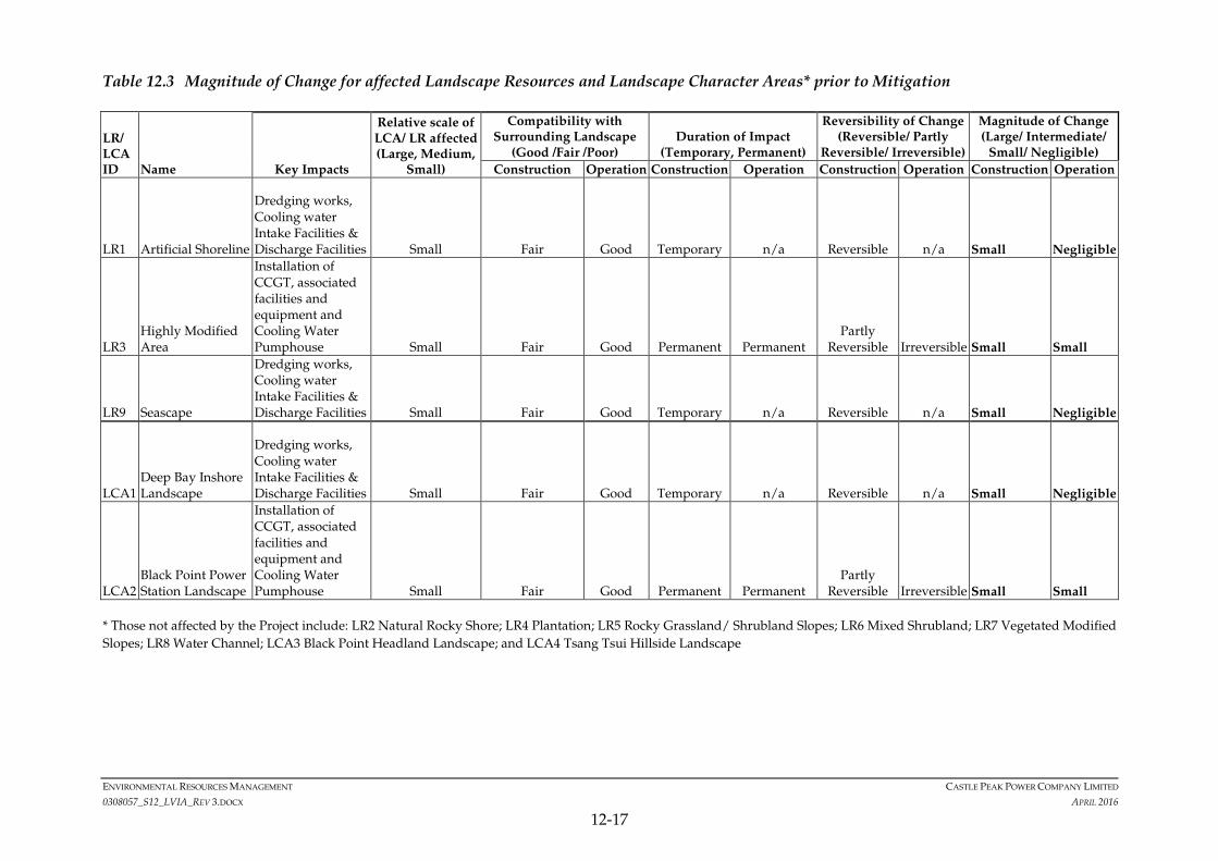
Figure 12.10 and detailed below. A summary of the magnitude of change to
LRs and LCAs prior to mitigation is provided in.Table 12.3 and later Table 12.6
summarises impacts on LRs and LCAs.
Landscape Resources
The Project works will affect:
• LR1 Artificial Shoreline – during the construction of the cooling water
intake facilities and discharge facilities of CCGT Unit No.2 only. Only a
minimal area will be affected and the magnitude of change is considered
small during construction. Once construction is complete the artificial
shoreline will be reinstated once again as artificial shoreline and therefore
magnitude of change is considered negligible during operation. Given
this is a low sensitivity LR, the significance of impact is slight during
construction and insignificant at operation.
• LR3 Highly Modified Area – This LR will be affected by the installation
of CCGT Unit No.1 and No.2 mainly, but also the installation of
underground water pipes, a new cooling water pumping station, a foam
monitor house, and a new water treatment facility. All these structures
are typical of power stations and highly compatible with the existing
landscape, which is an existing power station. One existing structure
(single-storey warehouse) will be demolished and removed and various
plants, all in movable planters (approximately 92 moveable planters) on
the boundary of the Project Site, will need to be removed. No at-grade,
planted trees will be affected and therefore no tree felling or
transplantation will be required. As detailed in Annex 12A, there are no
rare plants or species of conservation interest within this LR, either in
planters or at-grade. The magnitude of change is therefore considered
to be small. Given this is a low sensitivity LR, the significance of impact
is slight both during construction and at operation.
• LR9 Seascape – This LR will be affected by the installation of cooling
water intake facilities & discharge facilities and any necessary dredging
work should CCGT Unit No.2 be installed (construction dredging
estimated to fall over two areas of approximately 100 m x 100 m each
with an estimated total volume of around 40,000 m3). The areas affected
ENVIRONMENTAL RESOURCES MANAGEMENT CASTLE PEAK POWER COMPANY LIMITED
0308057_S12_LVIA_REV 3.DOCX APRIL 2016
12-16
are relatively small and the impact is temporary such that the magnitude
of change is considered to be small during construction and negligible
during operation. This is a medium sensitivity LR, but given the
relatively small area affected and it being close to the existing modified
BPPS modified landscape, the significance of impact is slight during
construction. At operation, there is some potential operational
maintenance dredging over the same areas possibly every 4 to 5 years
with dredged volume of around 6,600 m3 in each area. This is a low
volume impact and the magnitude of change is considered almost
negligible over this time period but rated as small to be cautious, thereby
leading to slight impact.
Landscape Character Areas
The Project works will affect:
• LCA1 Deep Bay Inshore Landscape – This LCA will be affected similarly
to LR9 as well as LR1, by the installation of cooling water intake facilities
& discharge facilities and any necessary dredging work (construction
dredging estimated to fall over two areas of approximately 100 m x 100 m
each with an estimated total volume of around 40,000 m3) of CCGT Unit
No.2. The area of this LCA affected is so small in the context of the
whole LCA, that the magnitude of change is almost negligible even at
construction. However given some small changes will occur, the
magnitude of change is given as small during construction. At
operation changes are negligible. This is a medium sensitivity LR, and
the significance of impact is slight during construction. At operation,
there is some potential operational maintenance dredging over the same
areas possibly every 4 to 5 years with dredged volume around 6,600 m3
in each area. This is a low volume impact and the magnitude of change
is considered almost negligible over this time period but rated as small to
be cautious, thereby leading to slight impact.
• LCA2 Black Point Power Station Landscape – This LCA will be affected
by the installation of CCGT Unit No.1 and No.2, underground water
pipes, a new cooling water pumping station, a foam monitor house, and a
new water treatment facility. All these structures are typical of power
stations and highly compatible with the existing landscape character,
which is an existing power station. There magnitude of change is
therefore considered to be small. Given this is a low sensitivity LR, the
significance of impact is slight both during construction and at
operation.
ENVIRONMENTAL RESOURCES MANAGEMENT CASTLE PEAK POWER COMPANY LIMITED
0308057_S12_LVIA_REV 3.DOCX APRIL 2016
12-17
Table 12.3 Magnitude of Change for affected Landscape Resources and Landscape Character Areas* prior to Mitigation
LR/ LCA ID Name Key Impacts
Relative scale of LCA/ LR affected (Large, Medium,
Small)
Compatibility with Surrounding Landscape
(Good /Fair /Poor) Duration of Impact
(Temporary, Permanent)
Reversibility of Change (Reversible/ Partly
Reversible/ Irreversible)
Magnitude of Change (Large/ Intermediate/
Small/ Negligible)
Construction Operation Construction Operation Construction Operation Construction Operation
LR1 Artificial Shoreline
Dredging works, Cooling water Intake Facilities & Discharge Facilities Small Fair Good Temporary n/a Reversible n/a Small Negligible
LR3 Highly Modified Area
Installation of CCGT, associated facilities and equipment and Cooling Water Pumphouse Small Fair Good Permanent Permanent
Partly Reversible Irreversible Small Small
LR9 Seascape
Dredging works, Cooling water Intake Facilities & Discharge Facilities Small Fair Good Temporary n/a Reversible n/a Small Negligible
LCA1 Deep Bay Inshore Landscape
Dredging works, Cooling water Intake Facilities & Discharge Facilities Small Fair Good Temporary n/a Reversible n/a Small Negligible
LCA2 Black Point Power Station Landscape
Installation of CCGT, associated facilities and equipment and Cooling Water Pumphouse Small Fair Good Permanent Permanent
Partly Reversible Irreversible Small Small
* Those not affected by the Project include: LR2 Natural Rocky Shore; LR4 Plantation; LR5 Rocky Grassland/ Shrubland Slopes; LR6 Mixed Shrubland; LR7 Vegetated Modified
Slopes; LR8 Water Channel; LCA3 Black Point Headland Landscape; and LCA4 Tsang Tsui Hillside Landscape

ENVIRONMENTAL RESOURCES MANAGEMENT CASTLE PEAK POWER COMPANY LIMITED
0308057_S12_LVIA_REV 3.DOCX APRIL 2016
12-18
12.7.2 Visual Impact Assessment
As illustrated in Figure 12.7, the predicted visual envelope for the Project is
relatively small and just six key VSR groups have been identified.
Photomontages illustrating the presence of CCGT Unit No.1 (Figure 12.11,
Figure 12.12, Figure 12.13, and Figure 12.14) and the presence of two additional
CCGT units (Figure 12.15, Figure 12.16, Figure 12.17, and Figure 12.18) show
that visual changes for most VSRs are limited. Those most affected will be
the workers at BPPS itself who are considered to experience an intermediate
change in view. However the new facilities are in the context of the existing
facilities and therefore the visual theme of the area remains the same.
The magnitude of change for the other five VSRs is considered small at worst
and since they are all considered of low sensitivity, the resulting impact
significance is considered slight.
A summary of the visual impacts prior to mitigation is provided in Table 12.4.
Table 12.4 Visual Impacts prior to Mitigation
VSR Name VSR
Sensitivity
(High/
Medium/ Low)
Magnitude of Change
(Large/ Intermediate/
Small/ Negligible)
Impact Significance
BEFORE Mitigation
(Substantial/ Moderate/
Slight/ Insignificant)
Construction Operation Construction Operation
R1 Transient Recreational Vessels
Low Small Small Slight Slight
R2 Recreational Hikers
Low Small Small Slight Slight
O1 Workers at BPPS Medium Intermediate Intermediate
Moderate Moderate
O2 Fishermen Low Small Small Slight Slight
O3 Workers on Transient Marine Vessels
Low Small Small Slight Slight
T1 Travellers along Yung Long and Nim Wan Roads
Low Small Small Slight Slight
* Type of VSR is denoted in the code
R = Residential; O = Occupational; T = Travelling
12.8 SUGGESTED MITIGATION MEASURES
Prior to mitigation, there are no impacts that are substantial.
The Project for the most part does not affect many landscape elements and for
the LRs and LCAs that are affected impacts are, at worst, slight during
construction and operation. All visual impacts are slight at construction and
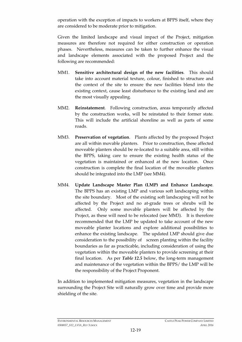
ENVIRONMENTAL RESOURCES MANAGEMENT CASTLE PEAK POWER COMPANY LIMITED
0308057_S12_LVIA_REV 3.DOCX APRIL 2016
12-19
operation with the exception of impacts to workers at BPPS itself, where they
are considered to be moderate prior to mitigation.
Given the limited landscape and visual impact of the Project, mitigation
measures are therefore not required for either construction or operation
phases. Nevertheless, measures can be taken to further enhance the visual
and landscape elements associated with the proposed Project and the
following are recommended:
MM1. Sensitive architectural design of the new facilities. This should
take into account material texture, colour, finished to structure and
the context of the site to ensure the new facilities blend into the
existing context, cause least disturbance to the existing land and are
the most visually appealing.
MM2. Reinstatement. Following construction, areas temporarily affected
by the construction works, will be reinstated to their former state.
This will include the artificial shoreline as well as parts of some
roads.
MM3. Preservation of vegetation. Plants affected by the proposed Project
are all within movable planters. Prior to construction, these affected
moveable planters should be re-located to a suitable area, still within
the BPPS, taking care to ensure the existing health status of the
vegetation is maintained or enhanced at the new location. Once
construction is complete the final location of the moveable planters
should be integrated into the LMP (see MM4).
MM4. Update Landscape Master Plan (LMP) and Enhance Landscape.
The BPPS has an existing LMP and various soft landscaping within
the site boundary. Most of the existing soft landscaping will not be
affected by the Project and no at-grade trees or shrubs will be
affected. Only some movable planters will be affected by the
Project, as these will need to be relocated (see MM3). It is therefore
recommended that the LMP be updated to take account of the new
moveable planter locations and explore additional possibilities to
enhance the existing landscape. The updated LMP should give due
consideration to the possibility of screen planting within the facility
boundaries as far as practicable, including consideration of using the
vegetation within the moveable planters to provide screening at their
final location. As per Table 12.5 below, the long-term management
and maintenance of the vegetation within the BPPS/ the LMP will be
the responsibility of the Project Proponent.
In addition to implemented mitigation measures, vegetation in the landscape
surrounding the Project Site will naturally grow over time and provide more
shielding of the site.
ENVIRONMENTAL RESOURCES MANAGEMENT CASTLE PEAK POWER COMPANY LIMITED
0308057_S12_LVIA_REV 3.DOCX APRIL 2016
12-20
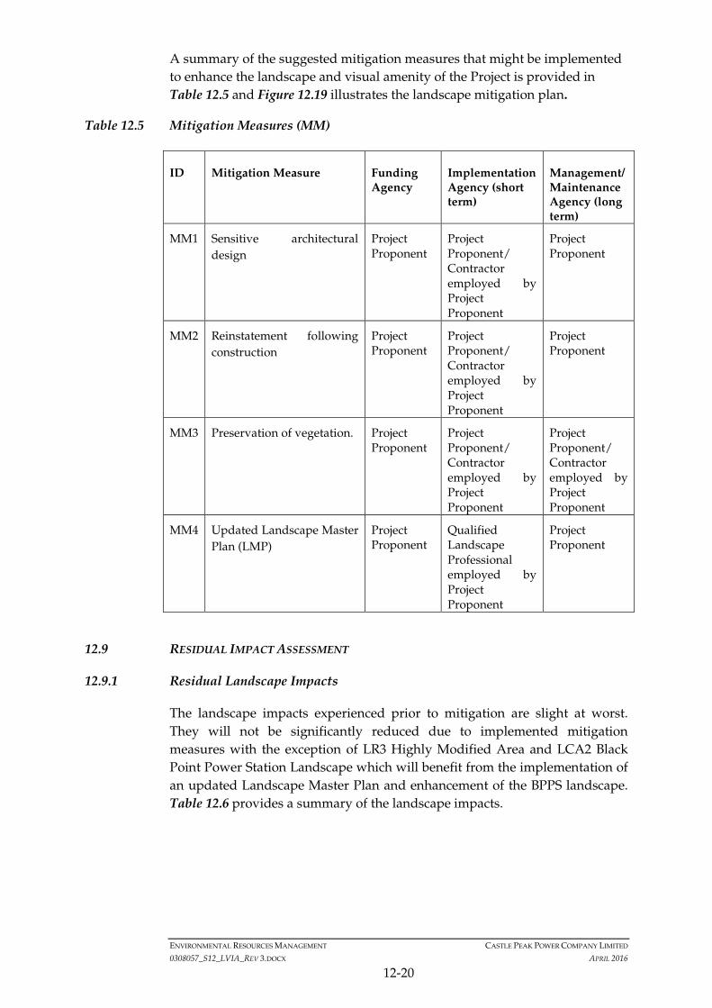
A summary of the suggested mitigation measures that might be implemented
to enhance the landscape and visual amenity of the Project is provided in
Table 12.5 and Figure 12.19 illustrates the landscape mitigation plan.
Table 12.5 Mitigation Measures (MM)
ID Mitigation Measure Funding Agency
Implementation Agency (short term)
Management/ Maintenance Agency (long term)
MM1 Sensitive architectural
design
Project Proponent
Project Proponent/ Contractor employed by Project Proponent
Project Proponent
MM2 Reinstatement following
construction
Project Proponent
Project Proponent/ Contractor employed by Project Proponent
Project Proponent
MM3 Preservation of vegetation. Project Proponent
Project Proponent/ Contractor employed by Project Proponent
Project Proponent/ Contractor employed by Project Proponent
MM4 Updated Landscape Master
Plan (LMP)
Project Proponent
Qualified Landscape Professional employed by Project Proponent
Project Proponent
12.9 RESIDUAL IMPACT ASSESSMENT
12.9.1 Residual Landscape Impacts
The landscape impacts experienced prior to mitigation are slight at worst.
They will not be significantly reduced due to implemented mitigation
measures with the exception of LR3 Highly Modified Area and LCA2 Black
Point Power Station Landscape which will benefit from the implementation of
an updated Landscape Master Plan and enhancement of the BPPS landscape.
Table 12.6 provides a summary of the landscape impacts.
ENVIRONMENTAL RESOURCES MANAGEMENT CASTLE PEAK POWER COMPANY LIMITED
0308057_S12_LVIA_REV 3.DOCX APRIL 2016
12-21
Table 12.6 Summary of Landscape Impacts
Sensitivity (High/
Medium/ Low)
Magnitude of Change (Large/ Intermediate/
Small/ Negligible)
Impact Significance BEFORE Mitigation
(Significant/ Moderate/ Slight/ Insignificant)
Recommended Mitigation Measures
Residual Impact Significance UPON Mitigation (Significant/ Moderate/
Slight/ Insignificant)
ID Descriptive Name Construction Operation Construction Operation Construction Operation Construction Operation (d1)
Operation (Y10)
LR1 Artificial Shoreline Low Small Negligible Slight Insignificant Reinstatement (MM2)
n/a Slight Insignificant Insignificant
LR2 Natural Rocky Shore High Negligible Negligible Insignificant Insignificant n/a n/a Insignificant Insignificant Insignificant
LR3 Highly Modified Area
Low Small Small Slight Slight Reinstatement (MM2)
Preserve Vegetation (MM3) & Update LMP & Enhance Landscape (MM4)
Slight Slight Insignificant
LR4 Plantation Medium Negligible Negligible Insignificant Insignificant n/a n/a Insignificant Insignificant Insignificant
LR5 Rocky Grassland/ Shrubland Slopes
Medium Negligible Negligible Insignificant Insignificant n/a n/a Insignificant Insignificant Insignificant
LR6 Mixed Shrubland Medium Negligible Negligible Insignificant Insignificant n/a n/a Insignificant Insignificant Insignificant
LR7 Vegetated Modified Slopes
Medium Negligible Negligible Insignificant Insignificant n/a n/a Insignificant Insignificant Insignificant
LR8 Water Channel Low Negligible Negligible Insignificant Insignificant n/a n/a Insignificant Insignificant Insignificant
LR9 Seascape Medium Small Small Slight Slight n/a n/a Slight Slight Slight
LCA1 Deep Bay Inshore Landscape
Medium Small Small Slight Slight Reinstatement (MM2)
n/a Slight Slight Slight
LCA2 Black Point Power Station Landscape
Low Small Small Slight Slight Reinstatement (MM2)
Preserve Vegetation (MM3) & Update LMP & Enhance Landscape (MM4)
Slight Slight Insignificant

ENVIRONMENTAL RESOURCES MANAGEMENT CASTLE PEAK POWER COMPANY LIMITED
0308057_S12_LVIA_REV 3.DOCX APRIL 2016
12-22
Sensitivity
(High/ Medium/
Low)
Magnitude of Change (Large/ Intermediate/
Small/ Negligible)
Impact Significance BEFORE Mitigation
(Significant/ Moderate/ Slight/ Insignificant)
Recommended Mitigation Measures
Residual Impact Significance UPON
Mitigation (Significant/ Moderate/ Slight/ Insignificant)
ID Descriptive Name Construction Operation Construction Operation Construction Operation Construction Operation (d1)
Operation (Y10)
LCA3 Black Point Headland Landscape
Medium Negligible Negligible Insignificant Insignificant n/a n/a Insignificant Insignificant Insignificant
LCA4 Tsang Tsui Hillside Landscape
Medium Negligible Negligible Insignificant Insignificant n/a n/a Insignificant Insignificant Insignificant
ENVIRONMENTAL RESOURCES MANAGEMENT CASTLE PEAK POWER COMPANY LIMITED
0308057_S12_LVIA_REV 3.DOCX APRIL 2016
12-23
12.9.2 Residual Visual Impacts
No substantial visual impacts were identified prior to mitigation. All
impacts are slight at construction and operation with the exception of impacts
to workers at BPPS which are moderate at worst, during construction and
operation. With sensitive architectural design of the new structures
(materials, textures, colours) and careful lighting, the impacts are considered
to reduce to slight at operation day 1. Careful soft landscaping of the BPPS
will continue with the new structures in place, but visual changes will still be
apparent and at year 10 of operation, impacts on VSR O3, workers in BPPS,
are still considered slight.
For VSRs at sea, mitigation measures will not significantly change the visual
impacts, therefore these remain slight at construction and operation day 1 and
year 10.
For land-based VSRs, over 10 years, although not a specific mitigation
measure, natural vegetation along Yung Long and Nim Wan Road and on
Black Point headland, will have grown such that views to the Project site are
likely to be further blocked and visual impacts reduce to insignificant levels.
Table 12.7 provides a summary of the visual impacts.

ENVIRONMENTAL RESOURCES MANAGEMENT CASTLE PEAK POWER COMPANY LIMITED
0308057_S12_LVIA_REV 3.DOCX APRIL 2016
12-24
Table 12.7 Summary of Visual Impacts
VS
R C
od
e
Name
VSR Sensitivity
(High/ Medium/
Low)
Magnitude of Change (Large/ Intermediate/
Small/ Negligible)
Impact Significance BEFORE Mitigation
(Substantial/ Moderate/ Slight/ Insignificant) Recommended Mitigation Measures
Residual Impact Significance UPON Mitigation (Substantial/ Moderate/
Slight/ Insignificant)
Construction Operation Construction Operation Construction Operation Construct
ion Operation
Day 1 Operation
Year 10
R1 Transient Recreational Vessels
Low Small Small Slight Slight Good practice (MM2)
Good practice (MM2) Slight Slight Slight
R2 Recreational Hikers Low Small Small Slight Slight Sensitive architectural design (MM1). Good practice (MM2)
Natural vegetation growth (not a specific mitigation measure)
Slight Slight Insignificant
O1 Workers at BPPS Medium Intermediate Intermediate Moderate Moderate Sensitive architectural design (MM1).
Soft Landscaping of the Site and review LMP (MM3)
Moderate Slight Slight
O2 Fishermen Low Small Small Slight Slight Sensitive architectural design (MM1). Good practice (MM2)
Soft Landscaping of the Site and review LMP (MM3)
Slight Slight Slight
O3 Workers on Transient Marine Vessels
Low Small Small Slight Slight Sensitive architectural design (MM1). Good practice (MM2)
Soft Landscaping of the Site and review LMP (MM3)
Slight Slight Slight
T1 Travellers along Yung Long and Nim Wan Roads
Low Small Small Slight Slight Sensitive architectural design (MM1). Good practice (MM2)
Natural vegetation growth (not a set mitigation measure)
Slight Slight Insignificant
* Type of VSR is denoted in the code
R = Recreational
O = Occupational
T = Travelling
ENVIRONMENTAL RESOURCES MANAGEMENT CASTLE PEAK POWER COMPANY LIMITED
0308057_S12_LVIA_REV 3.DOCX APRIL 2016
12-25
12.10 CUMULATIVE IMPACTS
Projects listed in Section 3.6 as concurrent projects have been considered with
respect to cumulative landscape and visual impacts. Noting the Visual
Envelope of this Project presented in Figure 12.7, most concurrent projects are
far enough away from the Project and out of its zone of visual influence or
assessment area. Only four projects within 1-2 km of the Project Site are
reviewed further:
• Decommissioning of West Portion of the Middle Ash Lagoon at Tsang Tsui,
Tuen Mun, approximately 1 km from the Project Site;
• Development of the Integrated Waste Management Facilities Phase 1,
which may be constructed at the Tsang Tsui Ash Lagoon;
• West New Territories (WENT) Landfill Extensions, approximately 2 km
away from the Project Site, targeted for commissioning and operation in
2019; and
• Potential Reclamation at Lung Kwu Tan has also been considered but as
detailed in Section 12.3, is not considered relevant for cumulative impact
assessment.
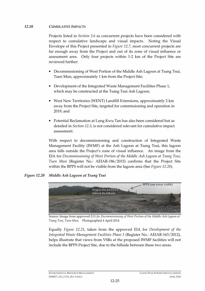
With respect to decommissioning and construction of Integrated Waste
Management Facility (IWMF) at the Ash Lagoon at Tsang Tsui, this lagoon
area falls outside the Project’s zone of visual influence. An image from the
EIA for Decommissioning of West Portion of the Middle Ash Lagoon at Tsang Tsui,
Tuen Mun (Register No.: AEIAR-186/2015) confirms that the Project Site
within the BPPS will not be visible from the lagoon area (See Figure 12.20).
Figure 12.20 Middle Ash Lagoon at Tsang Tsui
Source: Image from approved EIA for Decommissioning of West Portion of the Middle Ash Lagoon at
Tsang Tsui, Tuen Mun. Photographed 4 April 2014
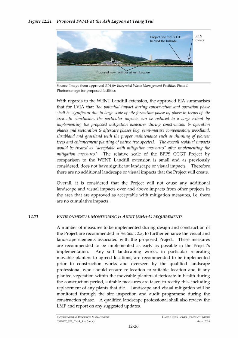
Equally Figure 12.21, taken from the approved EIA for Development of the
Integrated Waste Management Facilities Phase 1 (Register No.: AEIAR-163/2012),
helps illustrate that views from VSRs at the proposed IWMF facilities will not
include the BPPS Project Site, due to the hillside between these two areas.
BPPS (one tower visible)
Project Site for CCGT behind the hillside
ENVIRONMENTAL RESOURCES MANAGEMENT CASTLE PEAK POWER COMPANY LIMITED
0308057_S12_LVIA_REV 3.DOCX APRIL 2016
12-26
Figure 12.21 Proposed IWMF at the Ash Lagoon at Tsang Tsui
Source: Image from approved EIA for Integrated Waste Management Facilities Phase I.
Photomontage for proposed facilities
With regards to the WENT Landfill extension, the approved EIA summarises
that for LVIA that ‘the potential impact during construction and operation phase
shall be significant due to large scale of site formation phase by phase in terms of site
area…In conclusion, the particular impacts can be reduced to a large extent by
implementing the proposed mitigation measures during construction & operation
phases and restoration & aftercare phases [e.g. semi-mature compensatory woodland,
shrubland and grassland with the proper maintenance such as thinning of pioneer
trees and enhancement planting of native tree species]. The overall residual impacts
would be treated as “acceptable with mitigation measures” after implementing the
mitigation measures.’ The relative scale of the BPPS CCGT Project by
comparison to the WENT Landfill extension is small and as previously
considered, does not have significant landscape or visual impacts. Therefore
there are no additional landscape or visual impacts that the Project will create.
Overall, it is considered that the Project will not cause any additional
landscape and visual impacts over and above impacts from other projects in
the area that are approved as acceptable with mitigation measures, i.e. there
are no cumulative impacts.
12.11 ENVIRONMENTAL MONITORING & AUDIT (EM&A) REQUIREMENTS
A number of measures to be implemented during design and construction of
the Project are recommended in Section 12.8, to further enhance the visual and
landscape elements associated with the proposed Project. These measures
are recommended to be implemented as early as possible in the Project’s
implementation. Any soft landscaping works, in particular relocating
movable planters to agreed locations, are recommended to be implemented
prior to construction works and overseen by the qualified landscape
professional who should ensure re-location to suitable location and if any
planted vegetation within the moveable planters deteriorate in health during
the construction period, suitable measures are taken to rectify this, including
replacement of any plants that die. Landscape and visual mitigation will be
monitored through the site inspection and audit programme during the
construction phase. A qualified landscape professional shall also review the
LMP and report on any suggested updates.
BPPS towers
Project Site for CCGT behind the hillside
Proposed new facilities at Ash Lagoon
ENVIRONMENTAL RESOURCES MANAGEMENT CASTLE PEAK POWER COMPANY LIMITED
0308057_S12_LVIA_REV 3.DOCX APRIL 2016
12-27
Since no tree felling, transplanting or compensatory planting is required and
all vegetation affected are in moveable planters that will be relocated within
the BPPS site, no operation phase EM&A programme is required.
12.12 CONCLUSION
The Project comprises building certain new elements within an existing power
station that already has similar structures, and some minor temporary
dredging works. Landscape impacts are therefore limited and slight at
worst, even prior to mitigation. Any vegetation that might be affected by the
Project is in moveable planters that can readily be moved to a different
location within the BPPS and no at-grade trees or shrubs will be impacted by
the Project. The Project Site is relatively shielded from views due to
surrounding hills and headlands and located in a more remote area of Hong
Kong where there are fewer potential VSRs. The main VSRs are those who
work within the site itself or those passing close by on the sea and impacts are
moderate at worst prior to mitigation. Given the limited landscape and
visual impacts due to the Project, mitigation measures are therefore not
required for the construction and operation phases. Nevertheless, measures
are recommended to further enhance the visual and landscape elements
associated with the proposed Project, such as ensuring there is sensitive
architectural design of the new facilities, reinstatement of affected temporarily
during construction including the artificial shoreline, preservation of
vegetation, and an update of the existing LMP with a view to enhance the
landscape.
Overall therefore, the landscape and visual impacts from this Project are
considered acceptable.