Embed Size (px)
Citation preview
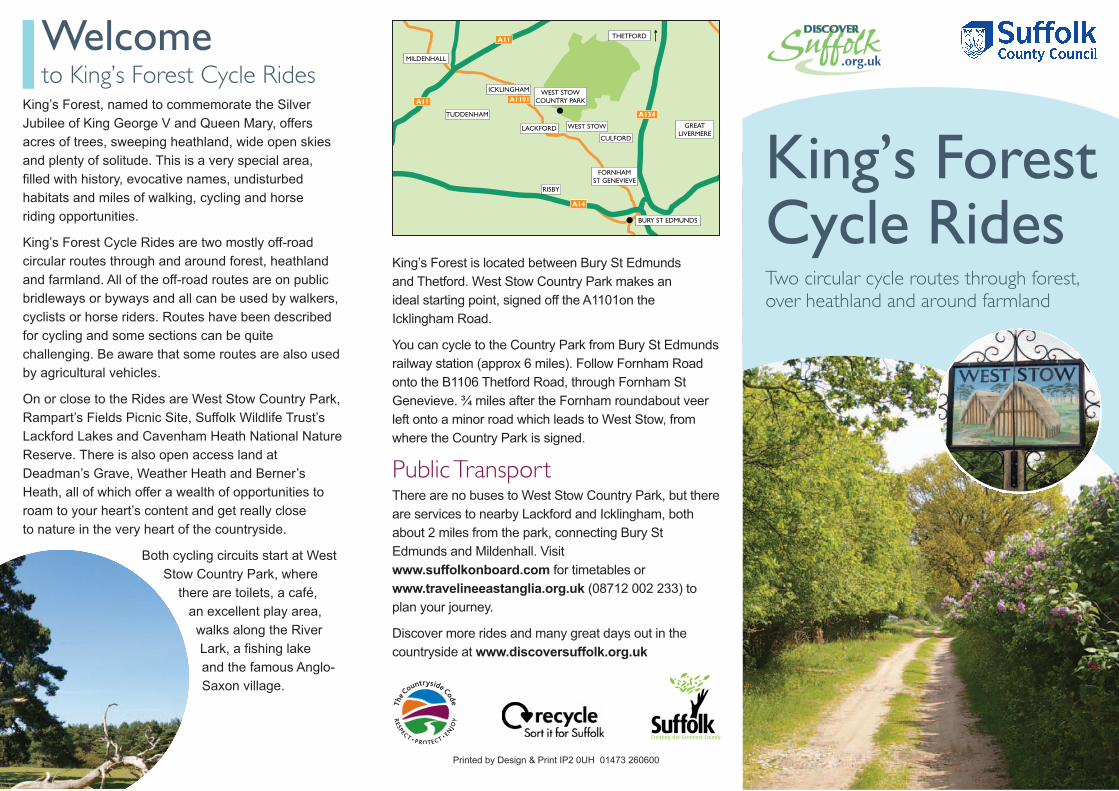
Two circular cycle routes through forest,over heathland and around farmland
King’s ForestCycle RidesBURY ST EDMUNDS
A134
A14
A11
A11
LACKFORD
FORNHAMST GENEVIEVE
WEST STOWCOUNTRY PARK
CULFORD
TUDDENHAM
MILDENHALL
GREATLIVERMERE
A1101
WEST STOW
THETFORD
RISBY
ICKLINGHAM
Printed by Design & Print IP2 0UH 01473 260600
King’s Forest is located between Bury St Edmunds
and Thetford. West Stow Country Park makes an
ideal starting point, signed off the A1101on the
Icklingham Road.
You can cycle to the Country Park from Bury St Edmunds
railway station (approx 6 miles). Follow Fornham Road
onto the B1106 Thetford Road, through Fornham St
Genevieve. ¾ miles after the Fornham roundabout veer
left onto a minor road which leads to West Stow, from
where the Country Park is signed.
Public TransportThere are no buses to West Stow Country Park, but there
are services to nearby Lackford and Icklingham, both
about 2 miles from the park, connecting Bury St
Edmunds and Mildenhall. Visit
www.suffolkonboard.com for timetables or
www.travelineeastanglia.org.uk (08712 002 233) to
plan your journey.
Discover more rides and many great days out in the
countryside at www.discoversuffolk.org.uk
Welcometo King’s Forest Cycle Rides
King’s Forest, named to commemorate the Silver
Jubilee of King George V and Queen Mary, offers
acres of trees, sweeping heathland, wide open skies
and plenty of solitude. This is a very special area,
filled with history, evocative names, undisturbed
habitats and miles of walking, cycling and horse
riding opportunities.
King’s Forest Cycle Rides are two mostly off-road
circular routes through and around forest, heathland
and farmland. All of the off-road routes are on public
bridleways or byways and all can be used by walkers,
cyclists or horse riders. Routes have been described
for cycling and some sections can be quite
challenging. Be aware that some routes are also used
by agricultural vehicles.
On or close to the Rides are West Stow Country Park,
Rampart’s Fields Picnic Site, Suffolk Wildlife Trust’s
Lackford Lakes and Cavenham Heath National Nature
Reserve. There is also open access land at
Deadman’s Grave, Weather Heath and Berner’s
Heath, all of which offer a wealth of opportunities to
roam to your heart’s content and get really close
to nature in the very heart of the countryside.
Both cycling circuits start at West
Stow Country Park, where
there are toilets, a café,
an excellent play area,
walks along the River
Lark, a fishing lake
and the famous Anglo-
Saxon village.
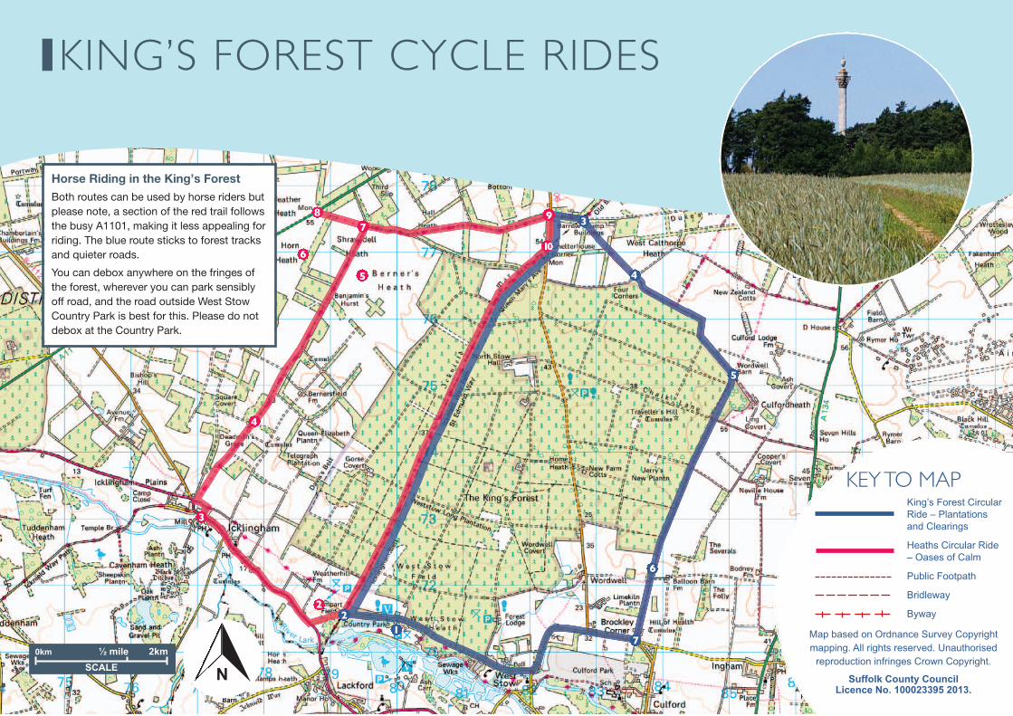
KING’S FOREST CYCLE RIDES
3
4
5
6
7
2
3
4
5
6
78 9
21
KEY TO MAP King’s Forest Circular
Ride – Plantations
and Clearings
Heaths Circular Ride
– Oases of Calm
Public Footpath
Bridleway
Byway
Map based on Ordnance Survey Copyright
mapping. All rights reserved. Unauthorised
reproduction infringes Crown Copyright.
Suffolk County Council Licence No. 100023395 2013.
N
10
0km 2km½ mile
SCALE N
Horse Riding in the King’s ForestBoth routes can be used by horse riders butplease note, a section of the red trail followsthe busy A1101, making it less appealing forriding. The blue route sticks to forest tracksand quieter roads.
You can debox anywhere on the fringes ofthe forest, wherever you can park sensiblyoff road, and the road outside West StowCountry Park is best for this. Please do notdebox at the Country Park.
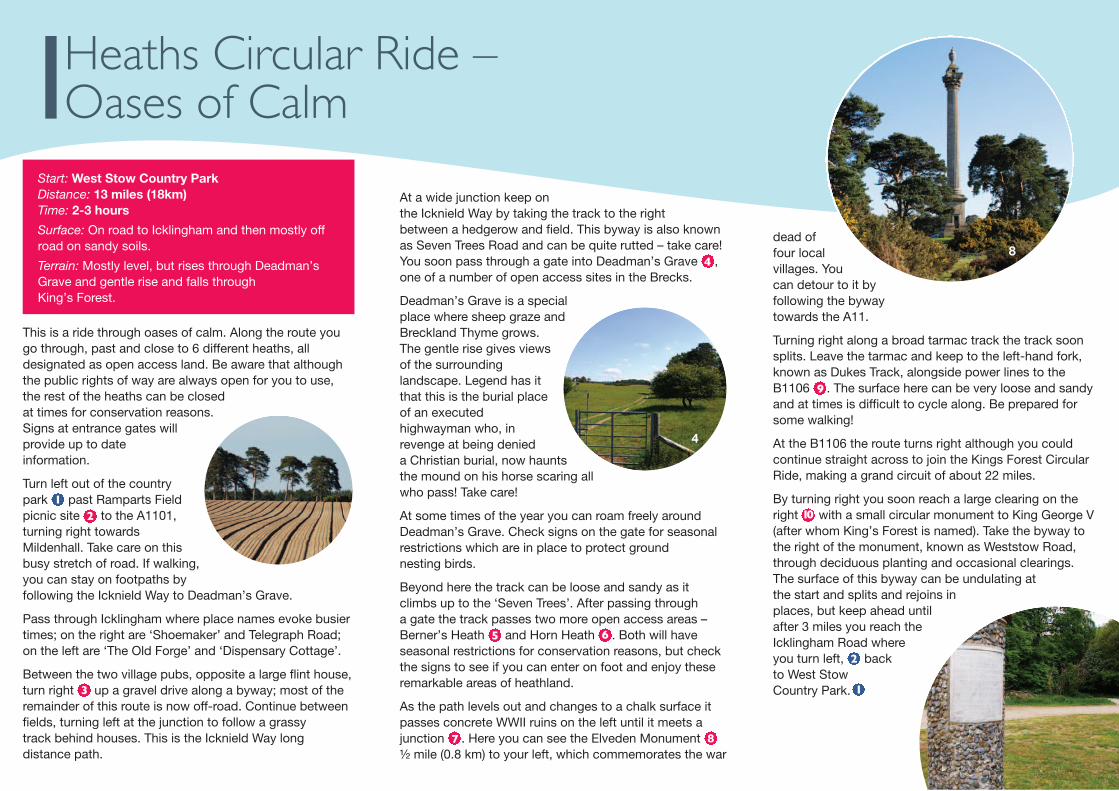
Start: West Stow Country ParkDistance: 13 miles (18km)Time: 2-3 hours
Surface: On road to Icklingham and then mostly offroad on sandy soils.
Terrain: Mostly level, but rises through Deadman’sGrave and gentle rise and falls through King’s Forest.
This is a ride through oases of calm. Along the route yougo through, past and close to 6 different heaths, alldesignated as open access land. Be aware that althoughthe public rights of way are always open for you to use,the rest of the heaths can be closedat times for conservation reasons.Signs at entrance gates willprovide up to dateinformation.
Turn left out of the countrypark past Ramparts Fieldpicnic site to the A1101,turning right towardsMildenhall. Take care on thisbusy stretch of road. If walking,you can stay on footpaths byfollowing the Icknield Way to Deadman’s Grave.
Pass through Icklingham where place names evoke busiertimes; on the right are ‘Shoemaker’ and Telegraph Road;on the left are ‘The Old Forge’ and ‘Dispensary Cottage’.
Between the two village pubs, opposite a large flint house,turn right up a gravel drive along a byway; most of theremainder of this route is now off-road. Continue betweenfields, turning left at the junction to follow a grassytrack behind houses. This is the Icknield Way longdistance path.
1
3
At a wide junction keep onthe Icknield Way by taking the track to the rightbetween a hedgerow and field. This byway is also knownas Seven Trees Road and can be quite rutted – take care!You soon pass through a gate into Deadman’s Grave ,one of a number of open access sites in the Brecks.
Deadman’s Grave is a specialplace where sheep graze andBreckland Thyme grows.The gentle rise gives viewsof the surroundinglandscape. Legend has itthat this is the burial placeof an executedhighwayman who, inrevenge at being denieda Christian burial, now hauntsthe mound on his horse scaring allwho pass! Take care!
At some times of the year you can roam freely aroundDeadman’s Grave. Check signs on the gate for seasonalrestrictions which are in place to protect groundnesting birds.
Beyond here the track can be loose and sandy as itclimbs up to the ‘Seven Trees’. After passing througha gate the track passes two more open access areas –Berner’s Heath and Horn Heath . Both will haveseasonal restrictions for conservation reasons, but checkthe signs to see if you can enter on foot and enjoy theseremarkable areas of heathland.
As the path levels out and changes to a chalk surface itpasses concrete WWII ruins on the left until it meets ajunction . Here you can see the Elveden Monument ½ mile (0.8 km) to your left, which commemorates the war
4
65
87
dead offour localvillages. Youcan detour to it byfollowing the bywaytowards the A11.
Turning right along a broad tarmac track the track soonsplits. Leave the tarmac and keep to the left-hand fork,known as Dukes Track, alongside power lines to theB1106 . The surface here can be very loose and sandyand at times is difficult to cycle along. Be prepared forsome walking!
At the B1106 the route turns right although you couldcontinue straight across to join the Kings Forest CircularRide, making a grand circuit of about 22 miles.
By turning right you soon reach a large clearing on theright with a small circular monument to King George V(after whom King’s Forest is named). Take the byway tothe right of the monument, known as Weststow Road,through deciduous planting and occasional clearings.The surface of this byway can be undulating atthe start and splits and rejoins inplaces, but keep ahead untilafter 3 miles you reach theIcklingham Road whereyou turn left, backto West StowCountry Park.
9
10
2
4
8
Heaths Circular Ride – Oases of Calm
2
1
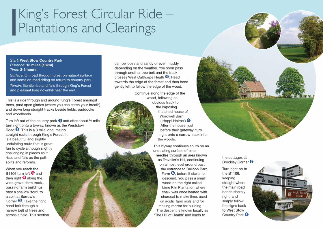
Start: West Stow Country ParkDistance: 13 miles (18km)Time: 2-3 hours
Surface: Off road through forest on natural surfaceand some on road riding on return to country park.
Terrain: Gentle rise and falls through King’s Forestand pleasant long downhill near the end.
This is a ride through and around King’s Forest amongsttrees, past open glades (where you can catch your breath)and down long straight tracks beside fields, paddocksand woodlands.
Turn left out of the country park and after about ½ mileturn right onto a byway, known as the WeststowRoad . This is a 3 mile long, mainlystraight route through King’s Forest. Itis a beautiful and slightlyundulating route that is greatfun to cycle although slightlychallenging in places as itrises and falls as the pathsplits and reforms.
When you reach theB1106 turn left andthen right along thewide gravel farm track,passing farm buildings,past a shallow ‘ford’ toa split at Barrow’sCorner . Take the righthand fork through anarrow belt of trees andacross a field. This section
2
109
3
can be loose and sandy or even muddy,depending on the weather. You soon passthrough another tree belt and the trackcrosses West Calthorpe Heath . Headtowards the edge of the forest and then bendgently left to follow the edge of the wood.
Continue along the edge of thewood, following an
obvious track tothe imposing
thatched house ofWordwell Barn(‘Happi Holme’) .After the house, justbefore their gateway, turnright onto a narrow track into
the woods.
This byway continues south on anundulating surface of pine-
needles through an area knownas Traveller’s Hill, continuingon almost level ground pastthe entrance to Balloon BarnFarm , before it starts todescend. You pass a smallwood on the right calledLime Kiln Plantation wherechalk was once heated withcharcoal to make lime, used
on acidic farm soils and formaking mortar for building.
The descent is known locally as‘The Hill of Health’ and leads to
4
5
6
the cottages atBrockley Corner .
Turn right on tothe B1106,keepingstraight wherethe main roadbends sharplyright, andsimply followthe signs backto West StowCountry Park . 1
7
7
King’s Forest Circular Ride –Plantations and Clearings
1