Embed Size (px)
Citation preview

14 State of the Art and Progress in the Earthquake Early Warning System in Taiwan
Yih-Min Wu1, Nai-Chi Hsiao2, William H.K. Lee3, Ta-liang Teng4, Tzay-Chyn Shin2
1 Department of Geosciences, National Taiwan University, Taipei, Taiwan 2 Central Weather Bureau, Taipei, Taiwan 3 U. S. Geological Survey (retired), Menlo Park, California, USA 4 Southern California Earthquake Center, University of Southern California, Los Angeles, California, USA
Abstract
We report here the recent progress and future development of real-time seismic monitoring in Taiwan, especially on earthquake early warning sys-tem (EWS) developed at the Central Weather Bureau (CWB), using the telemetered signals from strong-motion instruments. Utilizing a quick magnitude determination based on the first 10 sec of signals from a virtual and sub-network which is configured automatically, we were able to re-duce the earthquake rapid reporting time to about 30 sec or less. This represents a significant step towards a more realistic earthquake early warning capability. This early warning system has been in operation at CWB since 2002. Comprehensive earthquake reports have been issued mostly in less than 30 sec, with an average of about 22 sec from the origin time. At 3 km/sec for a typical crustal shear-wave velocity, the present op-eration is not useful if an earthquake occurs less than about 70 km from a city, but the lead time will increase to more than 10 sec for cities at dis-tances greater than 100 km from the earthquake source. In the latter case, a lead time of several seconds will allow pre-programmed emergency re-sponse to take place prior to the arrival of strong ground shaking. In order to offer earlier warning within an epicentral distance of less than 70 km, a τc and Pd method was experimented. We used the Taiwan Strong-Motion Instrumentation Program (TSMIP) accelerograms recorded within epicen-tral distances of less than 30 km from Mw > 5.0 crustal earthquakes. This method uses the first 3-sec length records from the onset of P-waves and could issue an on-site early warning within 10 sec after the event origin

2 Yih-Min Wu et al.
time, reducing the radius of the blind zone from 70 to 25 km from the epi-center.
14.1 Introduction
Located on the western circum-Pacific seismic belt with a plate conver-gence rate of 8 cm/year (Yu et al. 1999), Taiwan has experienced many destructive earthquakes with severe casualties and property losses. For ex-amples, on March 17, 1906 a damaging earthquake (M=7.1) occurred in Chiayi (Hsu 2003), in 1935, a disastrous earthquake (M=7.1) in the Hsinchu-Taichung area (Hsu 2003), and the 1999 Chi-Chi earthquake (Mw = 7.6) occurred in Nantou County (Teng et al. 2001, Shin and Teng 2001). The potential earthquake hazard will continue to increase along with popu-lation growth. Therefore, it is essential for Taiwan to seek means through scientific research to reduce future earthquake hazards.
Due to the extreme complexity involved in the earthquake processes, re-liable earthquake prediction is not currently possible (Kanamori 2003). Present technological advances in seismic instrumentation and in digital communication and processing permit implementation of a real-time earthquake monitoring system (Lee 1995). In terms of seismic hazards mitigation, an early warning system (EWS) is a practical and promising tool to reduce loss caused by a damaging earthquake (Nakamura 1988, Espinosa-Aranda et al. 1995, Lee et al. 1996, Kanamori et al. 1997, Teng et al. 1997, United States Geological Survey 1998, Wu et al. 1998, Wu and Teng 2002, Allen and Kanamori 2003, Lee and Espinosa-Aranda 2003).
The main purpose of this paper is to summarize the state of the art and progress in the earthquake early warning system in Taiwan. In a recent workshop on earthquake warning systems held on July 13-15, 2005 at the California Institute of Technology, Pasadena, Teng et al. (2005) summa-rized the development of earthquake rapid reporting and early warning systems in Taiwan; Hsiao et al. (2005) presented the current status of earthquake rapid reporting and early warning systems at the Central Weather Bureau (CWB) in Taiwan; and Lee et al. (2005) proposed a plan to the CWB to integrate tsunami warning with earthquake rapid reporting and early warning.
14 State of the Art and Progress in the Earthquake Early Warning System… 3
14.2 Physical Basis for Earthquake Early Warning and its Benefits
The physical basis for an earthquake early warning system is simple: (1) strong ground shaking from a damaging earthquake is caused by shear (S) waves and the following surface waves, (2) typical crustal P-wave velocity is about 6-8 km/sec, whereas S- and surface waves travel at about half the speed of the P-waves, and (3) the seismic wave velocities are much slower than electromagnetic signals transmitted by telegraph, telephone, or radio at about 300,000 km/sec.
Cooper (1868) was the first to propose an earthquake early warning sys-tem more than one hundred years ago. In the mid-nineteenth century, there were frequent earthquakes near Hollister, California, about 120 km southeast of San Francisco. Cooper proposed setting up seismic detectors near Hollis-ter and when an earthquake triggered them, an electric signal would be sent by telegraph to San Francisco. This signal would then ring a big bell in the City Hall to warn citizens that an earthquake had occurred. Unfortunately, Cooper’s scheme was never implemented. More than 100 years later, Heaton (1985) proposed a seismic computerized alert network for southern California. Nakamura (1988) implemented the single-station urgent earth-quake detection and alarm system (UrEDAS) for the “bullet” train system in Japan. Espinosa-Aranda et al. (1995) established the first earthquake early warning system for large events in the Oaxaca coastal region several hun-dred km away; the system should broadcast to the public in the Mexico City. Subsequently, earthquake early warning systems have been implemented, experimented, and commented upon by several different groups as reported in Chapters 5.2 to 5.14 in Zschau and Kuppers (2003). More recently, an in-ternational workshop on earthquake early warning was held on July 13-15, 2005 at the California Institute of Technology, Pasadena (website address: http://www.seismolab.caltech.edu/early.html).
An EWS forewarns an urban area of forthcoming strong shaking, nor-mally with a few seconds to a few tens of seconds of early warning time, i.e., before the arrival of the destructive S- and surface waves of a damag-ing earthquake. Even a few seconds of advanced warning time will be use-ful for pre-programmed emergency measures for various critical facilities, such as the deceleration of rapid-transit vehicles and high-speed trains to avoid potential derailment, the orderly shutoff of gas pipelines to minimize fire hazards, the controlled shutdown of high-technological manufacturing operations to reduce potential losses, and the safe-guarding of computer facilities to avoid the loss of vital data.

4 Yih-Min Wu et al.
14.3 Progress in Earthquake Early Warning in Taiwan
Progress has been made towards earthquake early warning, for example, in Japan, Mexico, and Taiwan (see e.g., Nakamura 1988, Espinosa-Aranda et al. 1995, Lee et al. 1996, Wu and Teng 2002). Two approaches have been tried: (1) using an array of seismic stations for regional warning, and (2) using a single seismic station for individual onsite warning. In (1), there are two variants: (a) detect an earthquake and decide if it is “large” enough to issue a warning message to the public, and (b) detect and locate an earthquake, and estimate its magnitude and the expected ground motions in the monitored region, then issue a more informative warning message to the public. In (2), the beginning of the ground motion (mainly P-waves) observed at a site is used to predict the ensuing ground motion (mainly by S- and surface waves) at the same site; either an attempt is made for a sin-gle-station event location and magnitude estimation, or no attempt is made to locate the event and estimate the magnitude. The first approach is more comprehensive, but takes a longer time and cannot be used for early warn-ing purposes at short epicentral distances. It has been used, for example, in Mexico and Taiwan. In contrast, the second approach is very fast, can pro-vide useful early warning to sites even at very short epicentral distances where an early warning is most needed, and has been used, for example, in Japan and United States.
The approach of the EWS in Taiwan was motivated by the experience of the 15 November, 1986 Hualien, Taiwan, earthquake of ML 6.8 (or MW 7.3). Although the epicenter of that earthquake was located near Hualien, the most severe damage occurred in the Taipei metropolitan area, about 120 km away (Fig. 14.1). According to the travel times of past earthquakes in Taiwan, shear waves traveling over this distance should take more than 30 sec. Thus, if a seismic monitoring system can reliably estimate the loca-tion and magnitude within 30 sec of a large earthquake that could threaten a metropolitan area, then several or more seconds of advanced warning will be available for emergency response.
A continuous telemetered strong-motion network was installed in Tai-wan, and a Rapid Earthquake Information Release System (RTD) was im-plemented by the CWB for monitoring earthquakes in real time since 1995 (Wu et al. 1997). In order to maximize the use of the data from this net-work, the CWB utilized its RTD system as a basis for the development of EWS capabilities.
This RTD system uses a real-time strong-motion accelerograph network that currently consists of 97 telemetered strong-motion stations distributed over Taiwan (Fig. 14.1), an area of 100 km x 300 km. Each station has 3-

14 State of the Art and Progress in the Earthquake Early Warning System… 5
component force-balanced accelerometers with signals being digitized continuously at 200 samples per sec per channel at 16-bit resolution, but telemetered at 50 samples per sec per channel using 4800-baud telemetry. The full recording dynamic range is ±2g, and has a sensitivity sufficient to record M > 4.0 events at distances of 100 km or more. Currently, RTD sys-tem can offer useful information about one minute after an earthquake oc-curs (Teng et al. 1997, Wu et al. 1997). Information includes earthquake location, its magnitude, and a shake map of Taiwan. Rapid damage as-sessment can also be determined and issued by the RTD system a minute or so later (Wu et al. 2002). By applying the sub-network approach (Wu et al. 1999, Wu and Teng 2002) and the ML10 method (Wu et al. 1998), the RTD system can achieve an earthquake reporting time of about 20 sec. Therefore, it can offer earthquake early warning for metropolitan areas lo-cated at 70 km from the epicenter and beyond.
Fig. 14.1 Distribution of the 97 real-time and 680 free-field strong-motion stations in Taiwan.

6 Yih-Min Wu et al.
The RTD system is a typical regional warning system for EWS. Re-cently, onsite EWS methods were also experimented in Taiwan (Wu and Kanamori 2005a, 2005b). It is possible to shorten the reporting time to about 10 sec. Therefore, this onsite method will play an important role for the future development of EWS in Taiwan.
14.4 Current Regional Warning System
The RTD system can routinely broadcast the location and magnitude of a strong earthquake as well as the intensity distribution in about 60 sec after the origin time of the earthquake. However, the 60-sec time lapse is too long to be practical for earthquake early warning purposes. Therefore, shortening of the reporting time of the RTD system is required in order to achieve early warning functions. Many studies include rapid event loca-tion, magnitude determination, sub-network, and virtual sub-network ap-proaches were developed by the CWB in recent years (Lee et al. 1996, Wu et al. 1998, 1999, Wu and Teng 2002).
14.4.1 Rapid Local Magnitude Determination – ML10 Method
Two major requirements for an earthquake early warning system are the near real-time estimation of the earthquake location and of its magnitude. The first requirement on rapid location can be achieved readily in the 10-sec time window immediately following the first P-arrival. On the other hand, the second requirement of rapid determination of earthquake magni-tude would be more difficult because the shear-wave trains may not be re-corded completely within this time window, and, more importantly, since a moment magnitude (Mw) or its equivalence must be developed for large earthquakes. Thus, a method for quick Mw magnitude determination for large events needs to be developed. Although many researchers (e.g., Na-kamura 1988, Grecksch and Kumpel 1997, Allen and Kanamori 2003, Kanamori 2005, Wu and Kanamori 2005a, Wu et al. 2006a, 2006b, Wu and Zhao 2006) have also tried to estimate magnitude from the initial por-tion of the seismograms, large uncertainties in magnitude are inevitable in these methods. Based on the current configuration of the RTD system and its monitoring area, we developed an empirical method to reliably deter-mine earthquake magnitude within 20 sec after the first P-wave arrives at the nearest stations.
Twenty-three sets of strong-motion data from moderate earthquakes (ML
> 5.0) in the Taiwan area are used to achieve this goal. For earthquakes

14 State of the Art and Progress in the Earthquake Early Warning System… 7
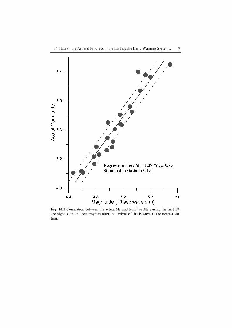
larger than ML 5, epicenters can be reliably determined in about 15 sec af-ter the arrival of the P-waves from the nearest stations. Figure 14.2 shows simulated Wood-Anderson seismograms from the 25 June, 1995 earth-quake (ML 6.5). In the first 10 sec, there are seven P phases and two S phases that can be used to locate the earthquake. The earthquake magni-tude ML cannot be determined in the same time frame due to the incom-plete recording of shear waves at some stations. However, the magnitude based on the first 10 sec of the signals (ML10) can be found to correlate with ML (Fig. 14.3) as follows:
ML = 1.28 * ML10 -0.85 ± 0.13. (14.1)
By applying this method for magnitude determination, the CWB system can determine hypocenter and magnitude with tolerable uncertainty in about 30 sec after the occurrence of an earthquake, and early warning is thus possible in Taiwan.
14.4.2 Sub-network Approach
In order to explore the feasibility of an earthquake early warning system for Taipei, a prototype early warning system was implemented in Hualien about 120 km away. Through previous studies (Wu et al. 1997), we con-cluded that using a dense sub-network under the RTD system is a good ap-proach to shorten the reporting time, and thus gaining some earthquake early warning capabilities. Thus, a dense, real-time monitoring system with high-density station coverage in the Hualien area, and lesser density outside the Hualien area (Fig. 14.4) was developed for testing early warn-ing capability from earthquake sources in the Hualien area. The high-density station coverage in the Hualien area was designed for recording shear waves to enhance magnitude determination, and the stations outside the Hualien area were designed to provide more P-arrivals to improve lo-cation quality.
For the 43 earthquakes with ML > 4.5 that occurred from August 1998 to June 2005, this system successfully reported earthquake information in about 19 sec (Fig. 14.5) after the origin time with the location uncertainty under 10 km and the magnitude uncertainty below 0.3. Therefore, it pro-vides about 15 sec of early warning time before shear-waves arrive in the Taipei urban area for earthquakes occurring in the Hualien area.

8 Yih-Min Wu et al.
Fig. 14.2 Simulated Wood-Anderson seismograms showing peak readings in the first 10 sec (open circle) and 50 sec (open diamond) after the arrival of the P-wave at the nearest station.
14 State of the Art and Progress in the Earthquake Early Warning System… 9
Fig. 14.3 Correlation between the actual ML and tentative ML10 using the first 10-sec signals on an accelerogram after the arrival of the P-wave at the nearest sta-tion.

10 Yih-Min Wu et al.
Fig. 14.4 Station distribution of the Hualien sub-network.
Fig. 14.5 Processing time of 43 events with magnitude larger than 4.5 from 1998 to 2005 being reported by the Hualien sub-network system.

14 State of the Art and Progress in the Earthquake Early Warning System… 11
14.4.3 Virtual Sub-Network (VSN) Approach
In the above experiment in Hualien, Taiwan, we demonstrated that earth-quake reporting time can be significantly shortened by using a smaller network (Wu et al. 1997, 1999). This leads to the design and configuration of a VSN within the hardware system of the ongoing RTD network. The VSN, automatically configured by the monitoring system, is event-dependent and its configuration varies with time. By working with the VSN, we can substantially reduce the reporting time such that an effective earthquake early warning capability is feasible to cover the entire Taiwan region.
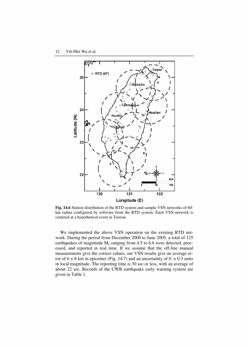
In hypocenter and magnitude determinations, only stations close to the epicenter (less than 60 km away) contribute the crucial information. Within the framework of the RTD network, we chose to process only sig-nals from a subset of the RTD stations that form a VSN network surround-ing an event. As soon as the RTD is triggered by an event, the system automatically extracts a subset of the RTD input signal channels and con-figures a VSN with a 60-km radius centered on that event. Figure 14.6 also gives a number of possible VSN configurations; each normally consists of about a dozen stations. The extracted data stream for this event forms the basic VSN input data for the subsequent EWS work.
Signals of all stations within a 60-km radius are grouped and extracted through a Multi-IO-Board to form the VSN input, which will then be proc-essed in parallel through the VSN software in a dedicated computer. We conducted a series of experiments to determine the optimum recording time for a 60-km radius network. Our results show that 10 sec is about the optimum. As soon as the 10-sec waveforms are presented at the VSN sys-tem, they will be immediately processed to give simulated Wood-Anderson seismograms for magnitude determinations that, in turn, will generate an equivalent moment magnitude. Further reduction of this re-cording time will cause a significant reduction in the reliability and stabil-ity of the magnitude determinations, since insufficient numbers of large S-wave amplitudes are available. An increase in the recording time, on the other hand, will severely cut into earthquake early warning time without significantly improving the magnitude determination. The VSN system is programmed to continue the recording of the waveforms up to 10 sec after the first P-arrival, after which hypocenter and magnitude determinations will be carried out. The results are disseminated automatically to the users.
12 Yih-Min Wu et al.
Fig. 14.6 Station distribution of the RTD system and sample VSN networks of 60-km radius configured by software from the RTD system. Each VSN network is centered at a hypothetical event in Taiwan.
We implemented the above VSN operation on the existing RTD net-
work. During the period from December 2000 to June 2005, a total of 125 earthquakes of magnitude ML ranging from 4.5 to 6.8 were detected, proc-essed, and reported in real time. If we assume that the off-line manual measurements give the correct values, our VSN results give an average er-ror of 6 ± 8 km in epicenter (Fig. 14.7) and an uncertainty of 0. ± 0.3 units in local magnitude. The reporting time is 30 sec or less, with an average of about 22 sec. Records of the CWB earthquake early warning system are given in Table 1.

14 State of the Art and Progress in the Earthquake Early Warning System… 13
Fig. 14.7 Location differences between the results of the VSN network and those from manual locations.
The Chengkung earthquake (Mw=6.8) occurred on December 10, 2003
with a focal depth of 10.0 km reported by the Central Weather Bureau. The main shock occurred at 23.10°N and 121.34°E along the eastern coast of Taiwan near the town of Chengkung (Fig. 14.8). The EWS of the CWB reported this earthquake information for the same location and magnitude 6.6 at 22 sec after the occurrence. This is a representative case for the CWB early warning system.
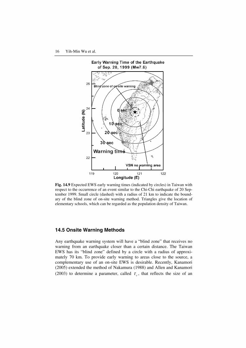
For regional warning, the CWB achieved a short earthquake reporting time of about 20 sec (Wu et al. 1998, 1999, Wu and Teng 2002). This can offer earthquake early warning for metropolitan areas located 70 km from the epicenter and beyond. For an event with the same location as the Sep-tember 20, 1999 Chi-Chi, Taiwan, earthquake, the Taipei metropolitan area is 145 km away, and would have more than 20 sec of early warning time. Figure 14.9 shows the expected early warning times for an event like the Chi-Chi earthquake for all parts of Taiwan. The small triangles in Fig. 14.9 give the locations of elementary schools, which essentially reflect the population density.

14 Yih-Min Wu et al.
Table 14.1 Part of the typical record of the CWB Earthquake Early Warning Sys-tem.
Auto-picking Manual-picking
Date Origin
time
Lat.
(N)
Lon.
(E)
Depth
(km)
ML Lat.
(N)
Lon.
(E)
Depth
(km)
ML Reporting
time
10/23/04 14:04:27 25.01 121.58 10.0 4.0 25.02 121.57 9.2 4.1 15
10/26/04 08:20:45 22.88 121.32 23.9 4.6 22.91 121.25 21.9 4.3 17
10/28/04 02:05:32 23.93 121.50 53.5 4.7 23.89 121.64 49.5 4.2 21
10/30/04 01:31:52 24.51 121.82 64.7 4.8 24.53 121.80 60.8 3.7 22
11/03/04 14:11:06 23.39 120.48 7.4 3.7 23.39 120.45 8.8 3.9 13
11/07/04 02:47:52 23.96 121.42 13.7 4.0 23.94 121.44 14.5 3.9 29
11/07/04 14:57:55 23.79 121.08 26.6 4.2 23.78 121.06 29.5 4.2 32
11/09/04 01:07:47 24.58 122.00 56.9 4.9 24.58 121.89 54.3 4.0 22
11/10/04 11:00:32 23.08 121.76 12.1 4.2 22.95 121.74 11.7 4.3 24
11/11/04 02:16:44 24.36 122.18 20.7 5.7 24.31 122.16 27.1 6.1 21
11/12/04 07:06:46 24.19 121.69 9.6 3.9 24.19 121.68 4.9 4.1 16
11/12/04 08:35:14 24.47 121.88 16.6 4.2 24.46 121.89 15.6 4.0 20
11/13/04 15:22:04 24.00 121.70 33.8 4.4 24.00 121.68 29.2 4.2 16
11/19/04 06:24:48 24.06 121.41 2.5 3.6 24.02 121.48 18.8 3.7 16
11/27/04 19:27:28 24.00 121.67 21.0 3.9 24.01 121.67 19.7 3.7 15
12/08/04 11:32:34 22.85 121.44 20.5 4.9 22.89 121.39 19.3 4.6 21
12/22/04 00:18:07 23.38 121.48 28.6 4.8 23.38 121.47 30.4 4.9 18
12/22/04 00:28:47 23.36 121.51 23.5 4.5 23.37 121.46 29.9 4.3 20
12/24/04 20:56:48 24.04 121.57 10.9 3.6 24.03 121.62 8.6 3.7 13

14 State of the Art and Progress in the Earthquake Early Warning System… 15
Fig. 14.8 Expected early warning times of the December 10, 2003 Chengkung, Taiwan, earthquake.
16 Yih-Min Wu et al.
Fig. 14.9 Expected EWS early warning times (indicated by circles) in Taiwan with respect to the occurrence of an event similar to the Chi-Chi earthquake of 20 Sep-tember 1999. Small circle (dashed) with a radius of 21 km to indicate the bound-ary of the blind zone of on-site warning method. Triangles give the location of elementary schools, which can be regarded as the population density of Taiwan.
14.5 Onsite Warning Methods
Any earthquake warning system will have a “blind zone” that receives no warning from an earthquake closer than a certain distance. The Taiwan EWS has its “blind zone” defined by a circle with a radius of approxi-mately 70 km. To provide early warning to areas close to the source, a complementary use of an on-site EWS is desirable. Recently, Kanamori (2005) extended the method of Nakamura (1988) and Allen and Kanamori (2003) to determine a parameter, called cτ , that reflects the size of an
14 State of the Art and Progress in the Earthquake Early Warning System… 17
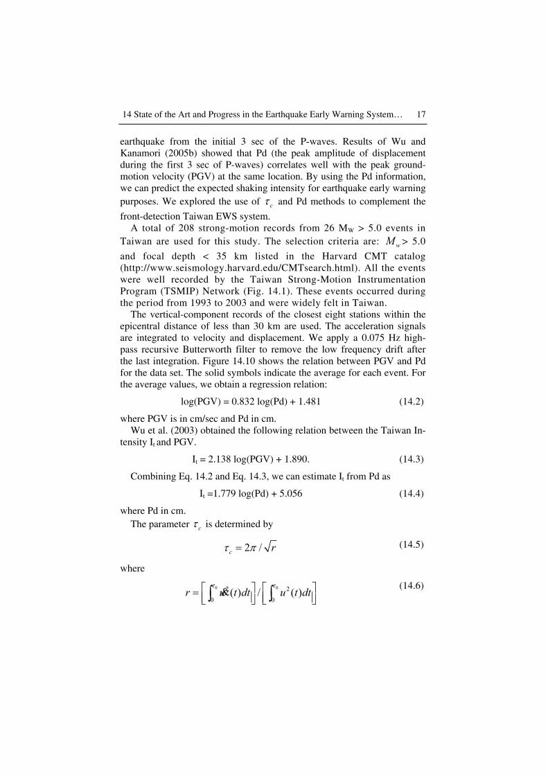
earthquake from the initial 3 sec of the P-waves. Results of Wu and Kanamori (2005b) showed that Pd (the peak amplitude of displacement during the first 3 sec of P-waves) correlates well with the peak ground-motion velocity (PGV) at the same location. By using the Pd information, we can predict the expected shaking intensity for earthquake early warning purposes. We explored the use of cτ and Pd methods to complement the
front-detection Taiwan EWS system. A total of 208 strong-motion records from 26 MW > 5.0 events in
Taiwan are used for this study. The selection criteria are: wM > 5.0
and focal depth < 35 km listed in the Harvard CMT catalog (http://www.seismology.harvard.edu/CMTsearch.html). All the events were well recorded by the Taiwan Strong-Motion Instrumentation Program (TSMIP) Network (Fig. 14.1). These events occurred during the period from 1993 to 2003 and were widely felt in Taiwan.
The vertical-component records of the closest eight stations within the epicentral distance of less than 30 km are used. The acceleration signals are integrated to velocity and displacement. We apply a 0.075 Hz high-pass recursive Butterworth filter to remove the low frequency drift after the last integration. Figure 14.10 shows the relation between PGV and Pd for the data set. The solid symbols indicate the average for each event. For the average values, we obtain a regression relation:
log(PGV) = 0.832 log(Pd) + 1.481 (14.2)
where PGV is in cm/sec and Pd in cm. Wu et al. (2003) obtained the following relation between the Taiwan In-
tensity It and PGV.
It = 2.138 log(PGV) + 1.890. (14.3)
Combining Eq. 14.2 and Eq. 14.3, we can estimate It from Pd as
It =1.779 log(Pd) + 5.056 (14.4)
where Pd in cm. The parameter cτ is determined by
2 /c rτ π= (14.5)
where
0 02 2
0 0( ) / ( )r u t dt u t dt
τ τ = ∫ ∫& (14.6)

18 Yih-Min Wu et al.
( )u t is the ground-motion displacement; 0τ is the duration of record used,
usually 3 sec, and cτ can be computed from the incoming data sequen-
tially. cτ reflects the size of an earthquake and in principle is independent
of the distance at least to the first order. Figure 14.11 shows cτ for all
events (open symbols) and the average cτ (solid symbols) as a function of
Mw. The cτ values generally increase with Mw and are useful for magni-
tude determinations (Kanamori 2005).
Fig. 14.10 Relationship between peak initial displacement amplitude (Pd) meas-urements and peak ground velocity (PGV) for the twenty-six events. Solid line shows the least square fit and two dashed lines show the range of one standard de-viation.

14 State of the Art and Progress in the Earthquake Early Warning System… 19
Fig. 14.11 Relationship between period parameter ( cτ ) for the twenty-six events
and moment magnitude (Mw).
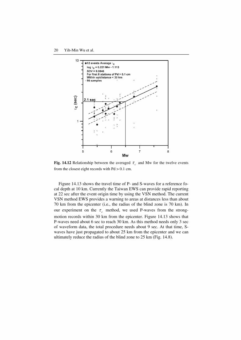
Although log cτ increases approximately linearly with magnitude, the
scatter is large for events with M < 5.5. The large scatter is primarily due to the low signal-to-noise (S/N) ratio when the amplitude during the first 3 sec is very small. Thus, we removed all the data with Pd < 0.1 cm and used only the first 8 stations within ∆ < 30 km to determine cτ . Figure 14.12
shows the results for which the first 8 records with Pd > 0.1 cm are used. Determinations were made for the 12 events for which such data are avail-able. The relationship between the average cτ and wM is given by,
113.1221.0log −= wc Mτ (14.7)
or, conversely,
036.5log525.4 += cwM τ . (14.8)
By using the cτ and Pd methods we can estimate the magnitude and
shaking intensity from the initial three seconds of the P waves.
20 Yih-Min Wu et al.
Fig. 14.12 Relationship between the averaged cτ and Mw for the twelve events
from the closest eight records with Pd > 0.1 cm.
Figure 14.13 shows the travel time of P- and S-waves for a reference fo-
cal depth at 10 km. Currently the Taiwan EWS can provide rapid reporting at 22 sec after the event origin time by using the VSN method. The current VSN method EWS provides a warning to areas at distances less than about 70 km from the epicenter (i.e., the radius of the blind zone is 70 km). In our experiment on the cτ method, we used P-waves from the strong-
motion records within 30 km from the epicenter. Figure 14.13 shows that P-waves need about 6 sec to reach 30 km. As this method needs only 3 sec of waveform data, the total procedure needs about 9 sec. At that time, S-waves have just propagated to about 25 km from the epicenter and we can ultimately reduce the radius of the blind zone to 25 km (Fig. 14.8).

14 State of the Art and Progress in the Earthquake Early Warning System… 21
Fig. 14.13 Rapid reporting time and warning distance of cτ and the VSN meth-
ods.
14.6. Prospects
Currently, EWS of the CWB is a reliable regional earthquake warning sys-tem. It can report information at about 20 sec after the occurrence of a large earthquake. In the future, by applying the cτ and Pd method it is pos-
sible to shorten the reporting time to about 10 sec with necessary hardware improvement. The cτ and Pd method is an onsite warning approach. Since
it estimates earthquake parameters from the initial portion of P-waves, large uncertainties in the estimates are inevitable. Thus, a hybrid of both onsite and regional warning approaches should be built into a future sys-tem. Because of the disastrous Sumatra earthquake and tsunami, Lee et al. (2005) proposed a plan to CWB to integrate tsunami warning with earth-quake warning. This integration plan is being studied for implementation in the near future.

22 Yih-Min Wu et al.
14.7 Acknowledgements
We wish to thank Prof. Hiroo Kanamori for his stimulating ideas and en-couragements. This research was supported by the Central Weather Bureau and the National Science Council of the Republic of China.
References
Allen R, Kanamori H (2003) The potential for earthquake early warning in South California. Science 300:786-789
Cooper JD (1868) Letter to Editor. San Francisco Daily Evening Bulletin, Nov. 3, 1868
Espinosa-Aranda J, Jiménez A, Ibarrola G, Alcantar F, Aguilar A, Inostroza M, Maldonado S (1995) Mexico City seismic alert system. Seism Res Lett 66: 42-53
Grecksch G, Kumpel HJ (1997) Statistical analysis of strong-motion accelerogram and it application to earthquake early-warning systems. Geophys J Int 129:113-123
Heaton TH (1985) A model for a seismic computerized alert network. Science 228:987-990
Hsiao NC, Lee WHK, Shin TC, Teng TL, Wu YM (2005) Earthquake rapid re-porting and early warning systems at CWB in Taiwan. Poster presentation, Earthquake Early Warning System Workshop, July 13-15, 2005 at the Cali-fornia Institute of Technology, Pasadena, California (website address: http://www.seismolab.caltech.edu/early.html)
Hsu M T (2003) Seismological observation and service in Taiwan (up to 1970). In: Lee WHK, Kanamori H, Jennings PC, Kisslinger C (eds) International Handbook of Earthquake and Engineering Seismology, Part B, CD#2\79_15China(Taipei)\Tai70Hist.pdf, Academic Press, Amsterdam
Kanamori H (2003) Earthquake prediction: an overview. In: Lee WHK, Kanamori H, Jennings PC, Kisslinger C (eds) International Handbook of Earthquake and Engineering Seismology, Part B, pp 1205-1216, Academic Press, Amsterdam
Kanamori H (2005) Real-time seismology and earthquake damage mitigation. An-nual Review of Earth and Planetary Sciences 33:5.1-5.20, doi: 10.1146
Kanamori H, Hauksson E, Heaton T (1997) Real-time seismology and earthquake hazard mitigation. Nature 390:461-464
Lee WHK (1995) A project implementation plan for an advanced earthquake monitoring system. Research Report of the Central Weather Bureau, Taipei, Taiwan, R.O.C., No. 448, 411 pp
Lee WHK, Espinosa-Aranda JM (2003). Earthquake early warning systems: Cur-rent status and perspectives. In: Zschau J, Kuppers AN (eds) Early Warning Systems for Natural Disaster Reduction, pp 409-423, Springer, Berlin

14 State of the Art and Progress in the Earthquake Early Warning System… 23
Lee WHK, Ma KF, Teng TL, Wu YM (2005) A proposed plan for integrating earthquake and tsunami warning at CWB in Taiwan. Poster presentation, Earthquake Early Warning System Workshop, July 13-15, 2005 at the Cali-fornia Institute of Technology, Pasadena, California (website address: http://www.seismolab.caltech.edu/early.html)
Lee WHK, Shin TC, Teng TL (1996) Design and implementation of earthquake early warning systems in Taiwan. Proc. 11th World Conf. Earthq. Eng., Paper No. 2133
Nakamura Y (1988) On the urgent earthquake detection and alarm system (UrE-DAS). Proc. of the 9th world conference on earthquake engineering, Tokyo-Kyoto, Japan
Shin TC, Teng TL (2001) An overview of the 1999 Chi-Chi, Taiwan, earthquake. Bull Seism Soc Am 91:895-913
Teng TL, Tsai YB, Lee WHK (2001) Preface to the 1999 Chi-Chi, Taiwan, Earth-quake Dedicated Issue. Bull Seism Soc Am 91:893-894
Teng TL, Wu YM, Shin TC, Lee WHK, Tsai YB, Liu CC, Hsiao NC (2005) De-velopment of earthquake rapid reporting and early warning systems in Tai-wan. Oral presentation, Earthquake Early Warning System Workshop, July 13-15, 2005 at the California Institute of Technology, Pasadena, California (website address: http://www.seismolab.caltech.edu/early.html)
Teng TL, Wu YM, Shin TC, Tsai YB, Lee WHK (1997) One minute after: strong-motion map, effective epicenter, and effective magnitude. Bull Seism Soc Am 87:1209-1219
United States Geological Survey (1998) A plan for implementing a real-time seismic hazard warning system – A report to congress required by public law 105-47. March 27, 1998, USA
Wu YM, Kanamori H (2005a) Rapid assessment of damaging potential of earth-quakes in Taiwan from the beginning of P Waves. Bull Seism Soc Am 95:1181-1185
Wu YM, Kanamori H (2005b) Experiment on an onsite early warning method for the Taiwan early warning system. Bull Seism Soc Am 95:347-353
Wu YM, Teng TL (2002) A virtual sub-network approach to earthquake early warning. Bull Seism Soc Am 92:2008-2018
Wu YM, Zhao L (2006) Magnitude estimation using the first three seconds P-wave amplitude in earthquake early warning. Geophys Res Lett 33:L16312
Wu YM, Chen CC, Shin TC, Tsai YB, Lee WHK, Teng TL (1997) Taiwan Rapid Earthquake Information Release System. Seism Res Lett 68:931-943
Wu YM, Shin TC, Tsai YB (1998) Quick and reliable determination of magnitude for seismic early warning. Bull Seism Soc Am 88:1254-1259
Wu YM, Chung JK, Shin TC, Hsiao NC, Tsai YB, Lee WHK, Teng TL (1999) Development of an integrated seismic early warning system in Taiwan – case for the Hualien area earthquakes. TAO 10:719-736
Wu YM, Hsiao NC, Teng TL, Shin TC (2002) Near real-time seismic damage as-sessment of the rapid reporting system. TAO 13;313-324

24 Yih-Min Wu et al.
Wu YM, Teng TL, Shin TC, Hsiao NC (2003) Relationship between peak ground acceleration, peak ground velocity, and intensity in Taiwan. Bull Seism Soc Am 93:386-396
Wu YM, Kanamori H, Allen RM, Hauksson E (2006a) Experiment using the τc and Pd method for earthquake early warning in Southern California. Submitted to Geophysical Journal International
Wu YM, Yen HY, Zhao L, Huang BS, Liang WT (2006b) Magnitude determina-tion using initial P waves: A single-station approach. Geophys Res Lett 33:L05306
Yu SB, Kuo LC, Punongbayan RS, Ramos EG (1999) GPS observation of crustal deformation in the Taiwan-Luzon region. Geophys Res Lett 26:923-926
Zschau J, Kuppers AN (eds) (2003) Early Warning Systems for Natural Disaster Reduction. Springer, Berlin, 834 pp