Embed Size (px)
Citation preview
The Australian Continent: A Geophysical Synthesis — Weathering and Regolith
14. Weathering and Regolith
The regolith consists of the zone at the Earth's surface between fresh rock and
the interface with the air. In Australia, regolith profiles can be up to several
hundred metres thick as a result of a very long history of weathering on ancient
landscapes that may have been exposed for hundreds of millions of years
(Pillans, 2008). Since unweathered and slightly weathered rocky exposures
cover less than 15 per cent of the 7.7 million km2 of the Australian landmass, the
nature of the regolith in areas of cover is of major importance.
Regolith materials range from thin soils over slightly weathered bedrock to
situations where weathering has reached more than 100 m beneath the surface.
A range of important geological and biochemical cycles operate with the regolith
zone: these include the passage of groundwater and nutrient cycles involving
carbon, nitrogen, oxygen, phosphorus and sulphur. Bioturbation can mix
materials in the near-surface, and geochemical processes can also transport
traces of deep-seated mineral systems into the surface zone.
In the upper part of the regolith—the pedolith—the original bedrock structure has
been destroyed by the weathering of the original minerals and the redistribution
of secondary materials such as clays and oxides. Often the pedolith develops in
situ but can also constitute transported materials. In the saprolith beneath the
pedolith, the bedrock fabric is weathered but the original bedrock structures can
be still recognised. Within the pedolith and saprolith there can also be secondary
induration with, e.g. cementing by silica, iron, aluminium and carbonate. Such
layers, such as calcrete, can play an important role in shaping the landscape and
the properties of the regolith across Australia.
Intensely weathered regolith is likely to arise from the interaction of a number of
factors:
landscapes where the rate of erosion is low compared with rates of
accumulation and with a long time span for weathering;
bedrock that contains highly weatherable materials; and
environmental conditions that promote rapid weathering through the action
of water, temperature and biological action.
Provided there is sufficient time to weather the bedrock, and denudation rates are
low, high weathering rates are not required to produce deep weathering. Thus
ancient landscapes with low relief and low slope angles can be highly weathered,
and can also be affected by more recent processes.
14.1 Weathering Intensity Index
The extent to which the regolith is weathered is linked to the factors that lead to
the formation of soils, including the nature of the substrate, topography, climate,
biological activity and time. As the weathering intensity increases, there are
progressive changes in the physical and geochemical characteristics of regolith
materials. With weak weathering, there is little change from the parent materials.
But with intense weathering and leaching of the regolith, almost all traits of the
original unweathered rock are overprinted or completely lost.
Weathering intensity has a strong influence on the extent to which the mineralogy
of the original bedrock is converted into secondary minerals such as clays and
oxides. With similar parent materials and climatic conditions, increasing
weathering intensity leads to a change in the nature and proportions of the
secondary minerals, so that more stable clays are produced and the regolith has
more distinct zones.
With increased weathering, soluble elements such as potassium, sodium and
calcium are lost into solution, while the more stable oxides and minerals such as
quartz and zircon are retained in the regolith. This enables a measure of
weathering intensity to be derived from geochemical indices based on the relative
proportions of the stable elements compared with their more mobile counterparts.
Measurements need to be taken from sample points through a weathering profile,
and cannot be easily extrapolated across the landscape from the specific sample
points.
With calibration at a broad range of sample points with different classes of
regolith, a weathering intensity index can be developed exploiting radiometric
information and terrain attributes from a digital elevation model (Wilford, 2012).
The field sites were assessed using a six-level classification scheme. Level 1
describes largely unweathered landscapes with a high proportion of fresh
bedrock exposed at the surface. Level 6 is assigned to areas where bedrock is
completely weathered to secondary materials such as clays and oxides. The
intermediate levels are based on the level of preservation of bedrock structures
and fabrics, the relative proportion of clay and the degree of mottling and iron
staining.
123
The Australian Continent: A Geophysical Synthesis — Weathering and Regolith
As discussed in Chapter 3, airborne gamma-ray
spectroscopy provides a measure of the flux emitted
from the major radioelements in soils and bedrock to a
depth of about 40 cm. For a 100 m flying height, about
80 per cent of the recorded gamma rays will originate
from about 600 m radius around the flight position.
Hence estimates of element concentration and total
flux (dose) provide averages over a significant footprint.
The full continental coverage of radiometric results
across Australia means that these results can be
exploited to provide proxies for weathering intensity in
conjunction with information on relief.
The concentration of potassium (K) generally
decreases with increase in weathering because its
compounds are soluble, and given sufficient time leach
from the weathering profile. In contrast, thorium (Th)
is less soluble, and by association with clays, oxides
and weathering resistant minerals is retained in
preference to the more soluble K. Very highly
weathered materials such as iron-rich duricrust and
bauxitic soils typically exhibit high-Th responses.
Some rock types contain few or no gamma-emitting
radioactive elements, e.g. highly siliceous sandstones
or ultramafic rock. Where the gamma-ray dose is very
low, it is necessary to exploit the relief derived from
digital elevation models on the assumption that
landscapes with high relief are likely to maintain thin
soil and slightly weathered bedrock.
Where the total dose is high (about 90 per cent of the
continent) a broader range of environmental variables
are brought into consideration for a weathering
intensity model, exploiting, in order of importance, K
concentration, relief, the Th/K ratio and the total dose.
Figure 14.1: Weathering intensity index with superposition of geological provinces.
124
The Australian Continent: A Geophysical Synthesis — Weathering and Regolith
These two classes of model for relating weathering intensity to aspects of the
surface and sub-surface have been trained by comparison with weathering
results from around 300 sites in southeastern Australia to develop regression
models for the weathering intensity index (Wilford, 2012). For intermediate
gamma-ray dose, a linear combination of the two models is employed to remove
any abrupt boundary effects on the final grid. This composite model has then
been further refined using machine learning techniques.
By this means, the combination of the radiometric results from Chapter 3 and
digital elevation data for the whole continent can be brought together to provide a
continent-wide measure of a relative weathering intensity index (Figure 14.1). As
might be expected, this index shows a strong correlation with geological province
boundaries, but also notable variation within provinces. Strong weathering is
commonly associated with major areas of sedimentary basins, but there are
many instances of strong weathering without sedimentary cover, e.g. in the North
Australian Craton and the southeastern Yilgarn Craton.
When examined in detail, the weathering index has a good correlation with prior
regolith-landform maps, with sharp boundaries in index behaviour often
corresponding to erosional scarps (Wilford, 2012). There is also reasonable
correlation with geochemical indices for weathering based on ratios of mobile and
immobile elements.
Weathering intensity reflects changes in the geochemical, physical and
hydrological aspects of the regolith as the bedrock breakdown under weathering
and leaching. Understanding the nature of weathering through the weathering
intensity index can help with understanding the pattern of pathfinder signals used
in geochemical exploration for mineral signatures, and potentially mapping of
paleo-landscape features.
Many upland areas of Australia show the impact of recent erosional processes
superimposed on much older features as a result of tectonic processes, e.g. tilt
and regional scale warping (Sandiford, 2007), changes in the base level of basins
and climate. The weathering intensity index allows assessment of the interplay of
such changes across a wide range of spatial scales.
14.2 Regolith Thickness
In addition to the radiometric estimates of the K, Th and U concentrations in the
near-surface, a number of other geophysical fields contain a signature from
shallow contrasts. Thus the Bouguer gravity anomaly (Figure 5.7) is sensitive to
the density contrast between the lower density regolith and the bedrock.
Gradients of the gravity field can also highlight contrasts in density. The local
magnetic anomaly (Figure 4.9) also provides information on bedrock structure.
Estimates of the depth to magnetic source based on the gradient properties of
the magnetic anomalies help to discriminate between magnetic and non-
magnetic components of the regolith and bedrock.
Wilford et al. (2016) have used the full range of such geophysical and geological
constraints in conjunction with multi-scale attributes from digital topography to
develop a model for regolith thickness across the whole continent. They use a
database of depth to bedrock derived from drillhole data as the training dataset.
The drillhole information has been extracted from the National Groundwater
Information System database. There is a broad spread of sites across the
continent, but uneven coverage and notable gaps, e.g. in arid areas. Automated
procedures were used to extract an estimate of the depth to fresh bedrock, from
the descriptions of the logging parameters. This was a complex procedure
because there had been no standard protocol for recording the drillhole
information. The datasets were winnowed to remove records that were
inconsistent with neighbouring drillhole estimates and landscape setting. The
weathering intensity index was also used to define areas with relatively fresh
bedrock.
This procedure yielded around 128,000 sites across the continent for which there
was an estimate of the depth to the base of the regolith. The statistical
distribution of these depth estimates is strongly skewed with a very long tail. to
limit the impact of possible spurious values, Wilford et al. (2016) restricted the
maximum depth to 200 m. This means that that regolith thickness will be
underestimated in regions of thick cover such as depositional basins.
The suite of drillhole estimates was then used to develop a multivariate model for
regolith thickness that could be used across the whole continent. The model
fitting was carried out using the logarithm of the drillhole depths, which ensures
that regolith thickness estimates remain positive.
125
The Australian Continent: A Geophysical Synthesis — Weathering and Regolith
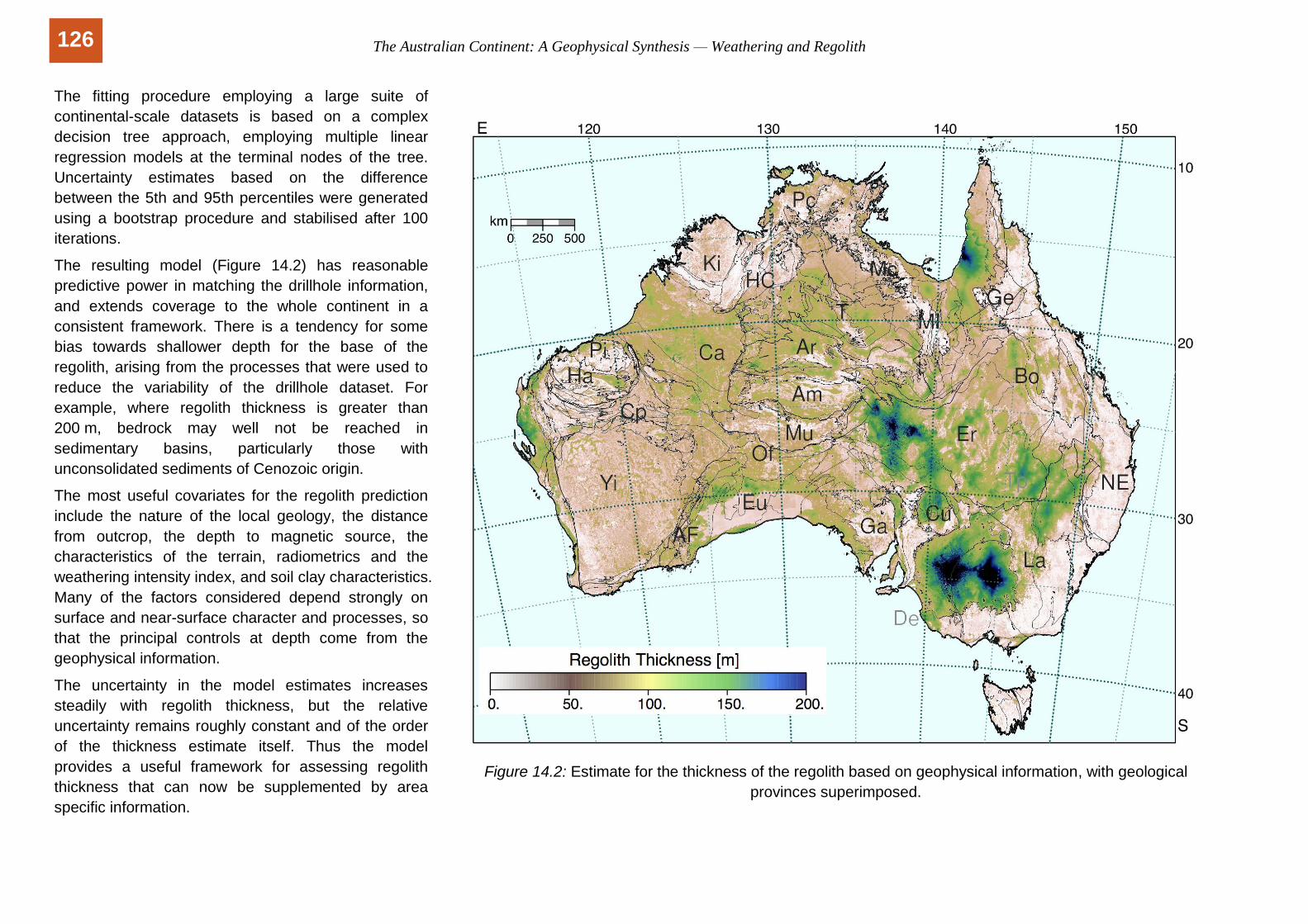
The fitting procedure employing a large suite of
continental-scale datasets is based on a complex
decision tree approach, employing multiple linear
regression models at the terminal nodes of the tree.
Uncertainty estimates based on the difference
between the 5th and 95th percentiles were generated
using a bootstrap procedure and stabilised after 100
iterations.
The resulting model (Figure 14.2) has reasonable
predictive power in matching the drillhole information,
and extends coverage to the whole continent in a
consistent framework. There is a tendency for some
bias towards shallower depth for the base of the
regolith, arising from the processes that were used to
reduce the variability of the drillhole dataset. For
example, where regolith thickness is greater than
200 m, bedrock may well not be reached in
sedimentary basins, particularly those with
unconsolidated sediments of Cenozoic origin.
The most useful covariates for the regolith prediction
include the nature of the local geology, the distance
from outcrop, the depth to magnetic source, the
characteristics of the terrain, radiometrics and the
weathering intensity index, and soil clay characteristics.
Many of the factors considered depend strongly on
surface and near-surface character and processes, so
that the principal controls at depth come from the
geophysical information.
The uncertainty in the model estimates increases
steadily with regolith thickness, but the relative
uncertainty remains roughly constant and of the order
of the thickness estimate itself. Thus the model
provides a useful framework for assessing regolith
thickness that can now be supplemented by area
specific information.
Figure 14.2: Estimate for the thickness of the regolith based on geophysical information, with geological
provinces superimposed.
126
This text is taken from The Australian Continent: A Geophysical Synthesis, by B.L.N. Kennett, R. Chopping and R. Blewett, published 2018 by ANU Press and Commonwealth of Australia (Geoscience Australia), Canberra, Australia.