Embed Size (px)
Citation preview

151217
6-17-15
29788ORDINANCE NO.
___________
An ordinance changing the zoning classification on the following property:
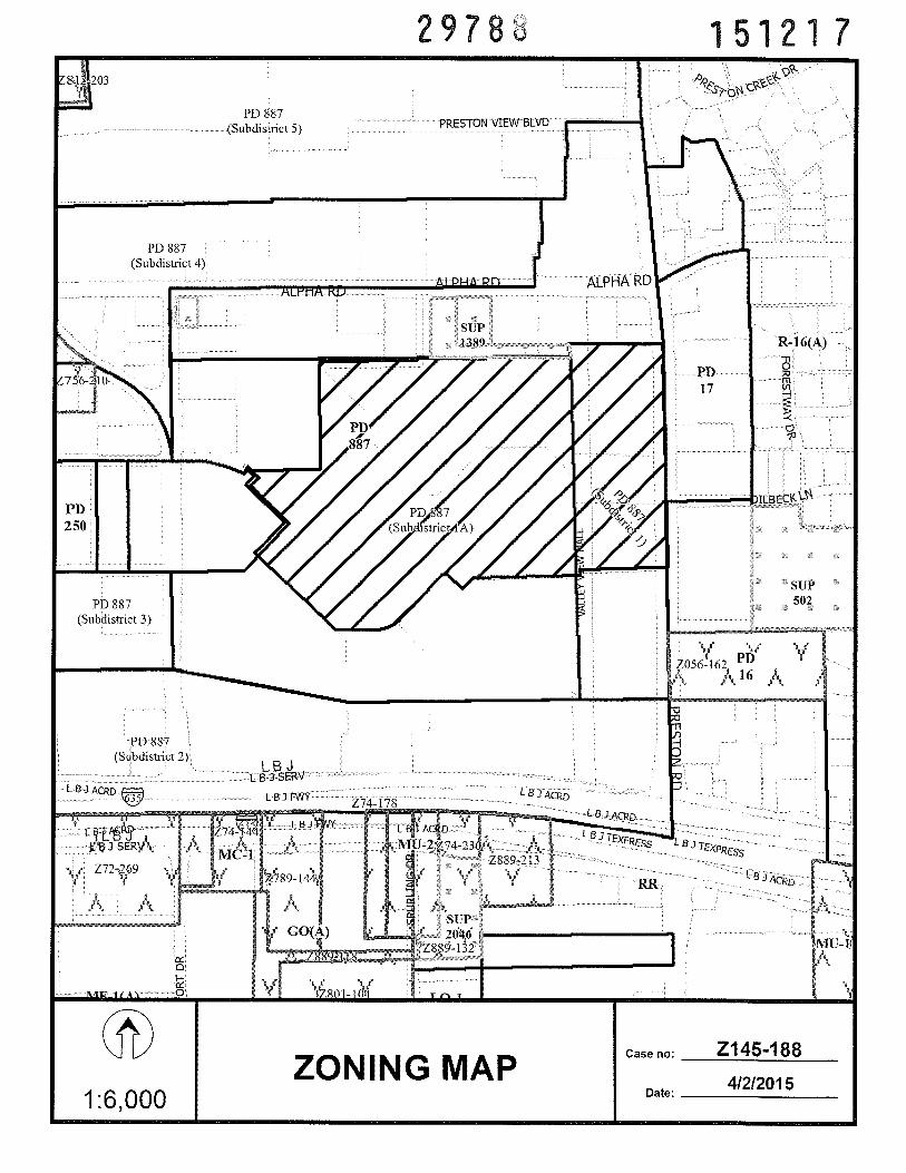
BEING an internal tract of land in City Block A17409 west of Preston Road, north of LBJFreeway, east of Montfort Drive, and south of Alpha Road; and containing approximately 12.29 1acres,
from Subdistrict 1A within Planned Development District No. 887 (Valley View-Galleria Area
Special Purpose District) to Subdistrict lB within Planned Development District No. 887;
amending Article 887, “PD 887,” of Chapter 51P, “Dallas Development Code: Planned
Development District Regulations,” of the Dallas City Code to reflect the change of zoning;
amending the creation of subdistricts, definitions, subdistrict regulations, landscaping
regulations, and street standards in Sections 51P-887.104, 51P-887.105, 51P-887.109, SiP-
887.111, and 51P-887. 115 of Article 887; providing a new district and subdistrict map; providing
a new Streets Plan; replacing the Exhibit A (property description) attached to Ordinance No.
29032; providing a penalty not to exceed $2,000; providing a saving clause; providing a
severability clause; and providing an effective date.
WHEREAS, the city plan commission and the city council, in accordance with the
Charter of the City of Dallas, the state law, and the ordinances of the City of Dallas, have given
the required notices and have held the required public hearings regarding the rezoning of the
property described in this ordinance and this amendment to the Dallas City Code; and
WHEREAS, the city council finds that it is in the public interest to amend Article 887 as
specified in this ordinance; Now, Therefore,
Z145-188(SM)(Amend PD 887)(alternate) - Page 1

9788 151217
BE IT ORDAINED BY THE CITY COUNCIL OF THE CITY OF DALLAS:
SECTION 1. That the zoning classification is changed from Subdistrict 1A within
Planned Development District No. 887 to Subdistrict lB within Planned Development District
No. 887 on the property described in Exhibit A, which is attached to and made a part of this
ordinance (“the Property”).
SECTION 2. That Section 51P-887.104, “Creation of Subdistricts,” of Article 887, “PD
887,” of Chapter 5 1P, “Dallas Development Code: Planned Development District Regulations,”
of the Dallas City Code is amended by adding a new Paragraph (2.1) to read as follows:
“(2.1) Subdistrict lB. Subdistrict lB is intended to be a walkable high-density,mixed-use area within the interior of Subdistrict 1A. At the core of this subdistrict is an enhancedesplanade that features additional pedestrian amenities and open space. Similar to Subdistrict1A, this subdistrict also allows for a mix of residential and nonresidential uses, including bothlarge-format and small-format retail.”
SECTION 3. That Section 51P-887.105, “Definitions,” of Article 887, “PD 887,” of
Chapter 51P, “Dallas Development Code: Planned Development District Regulations,” of the
Dallas City Code is amended by adding a new Paragraph (5.1) to read as follows:
“(5.1) PATHWAY means an area at street level that provides a passage forpedestrians.”
SECTION 4. That Section 5 1P-887. 109, “Subdistrict Regulations,” of Article 887, “PD
887,” of Chapter SiP, “Dallas Development Code: Planned Development District Regulations,”
of the Dallas City Code is amended to read as follows:
“SEC. 51P-887.109. SUBDISTRICT REGULATIONS.
(a) Subdistrict 1.
(1) In general. Except as provided in this article, the district regulations forthe WMU-12 Walkable Urban Mixed Use District apply.
Z145-188(SM)(Amend PD 887)(alternate) - Page 2

29788 15121 7
(2) Stories.
(A) Minimum number of stories above grade is two. The minimumheight provisions of Section 51A-13.302(b)(2), (3), (4), and (5) also apply.
(B) Maximum number of stories above grade is 12.
(3) Urban form setback. An additional 20-foot setback from the minimumsetback is required for any portion of a structure above five stories fronting on all streets exceptPreston Road.
(b) Subdistrict 1A.
(1) In general. Except as provided in this article, the district regulations forthe WMU-20 Walkable Urban Mixed Use District apply.
(2) Stories.
(A) Except as provided in this paragraph, minimum number of storiesabove grade is three. Minimum number of stories above grade for general commercialdevelopment types is two. The minimum height provisions of Section 51A-13.302(b)(2), (3),(4), and (5) also apply.
(B) Maximum number of stories above grade is 20.
(3) Urban form setback. An additional 20-foot setback from the minimumsetback is required for any portion of a structure above five stories fronting on all streets exceptPreston Road.
(c) Subdistrict lB.
fl In general. Except as provided in this article, the district regulations forthe WMU-20 Walkable Urban Mixed Use District apply.
Stories.
Except as provided in this paragraph, minimum number of storiesabove grade is three. Minimum number of stories above grade for general commercialdevelopment types is two. Structures constructed in an esplanade within Street Section Type B 1of the Streets Plan may not exceed one story. The minimum height provisions of Section 51 A13.302(b)(2), (3’), (4), and (5) also apply.
cm Maximum number of stories above grade is 20.
Z145-188(SM)(Amend PD 887)(alternate) - Page 3
29788 15121 7
f Urban form setback. An additional 20-foot setback from the minimumsetback is required for any portion of a structure above five stories fronting on all streets exceptPeterson Lane.
Esplanade within Street Section Type Bi. Except as provided in thissection, the requirements of Section 51A-13.304(k)(5) apply. For an esplanade within StreetSection Type B 1:
f Length. Minimum length is 600 feet.
rn Pedestrian movement.
j) A minimum five-foot-wide clear and unobstructed perviousor impervious pathway must be provided along the length of the esplanade.
jj) A maximum three-foot high physical barrier may be placedalong the perimeter of the esplanade to direct safe and orderly pedestrian connections to areasoutside of the esplanade.
Lull) The provisions regarding street trees and streetscapestandards in Section 51A-13.304(k)(5’)(B)(viii) do not apply.
) Site trees. Except as provided in this section, Section 51A-13.304(k)(5’)(B)(ix) applies. The ability to receive site tree credits for retained trees as describedin Section 51A-l0.125(b’)(3’)(B) may be applied to the Street Section Type Bi esplanade.
I) Structures.
Lj) Building use. The only uses allowed in a structure built onan esplanade are a restaurant or bar use or retail sales. See Section 51A-13.306 for additionalregulations.
jjJ Parking. Uses and parking must comply with the parkingregulations of Division 51A-13.400. No surface parking is permitted on an esplanade.
combined on an esnianade is 9.000below grade.
fix) Building setback. A minimum five foot setback is requiredfrom all lot lines.
fy) Story height.
fpg) Minimum story height is 15 feet above grade.
Floor area. The maximum floor area for all structuressquare feet above grade. There is no minimum floor area
Z145-188(SM)(Amend PD 887)(alternate) - Page 4

29783 151217
f! Maximum story height is 30 feet above grade.
yj) Building facade. The primary street facade must have aminimum 50 percent transparency. All other facades must have a minimum 25 percenttransparency. The maximum blank wall area is 20 linear feet.
fyjjj Shopfront windows. A minimum of 60 percent of thestreet-fronting window pane surface area must allow views into the use for a depth of at leastfour feet. Windows must be clear or unpainted, or, if treated, must be translucent. Spandrel glassor backpainted glass is not allowed.
(viii) Open space. Space left open in an esplanade contributes tothe amount of open space required in Section 51P-887.113.
Subdistrict 2.
(1) In general. Except as provided in this article, the district regulations forthe WMU-40 Walkable Urban Mixed Use District apply.
(2) Uses.
(A) Except as provided in this paragraph, retail uses must be small-format retail.
(B) Large-format retail is allowed if all required parking is provided ina parking structure.
(3) Stories.
(A) Minimum number of stories above grade is two. The minimumheight provisions of Section 51A-13.302(b)(2), (3), (4), and (5) also apply.
(B) Maximum number of stories above grade is 40.
(4) Urban form setback. An additional 20-foot setback from the minimumsetback is required for any portion of a structure above five stories fronting on all streets exceptPreston Road and the LBJ Freeway service road.
(e[4]) Subdistrict 3.
(1) In general. Except as provided in this article, the district regulations forthe WMU-20 Walkable Urban Mixed Use District apply.
(2) Uses. Retail uses must be small-format retail.
Z145-188(SM)(Amend PD 887)(alternate) - Page 5

29788 15121 7
(3) Stories.
(A) Minimum number of stories above grade is two. The minimumheight provisions of Section 5lA-13.302(b)(2), (3), (4), and (5) also apply.
(B) Maximum number of stories above grade is 20.
(4) Urban form setback. An additional 20-foot setback from the minimumsetback is required for any portion of a structure above five stories fronting on all streets.
(5) Fences. Fences in the front setback area of apartment development typesmay exceed three feet in height provided that the fence is 70 percent open and does not face theMidtown Commons area identified in the Valley View - Galleria Area Plan.
(f[e]) Subdistrict 4.
(1) In general. Except as provided in this article, the district regulations forthe WMU-12 Walkable Urban Mixed Use District apply.
(2) Uses. Retail uses must be small-format retail.
(3) Stories.
(A) Minimum number of stories above grade is two. The minimumheight provisions of Section 51A-13.302(b)(2), (3), (4), and (5) also apply.
(B) Maximum number of stories above grade is 12.
(4) Urban form setback. An additional 20-foot setback from the minimumsetback is required for any portion of a structure above five stories fronting on all streets.
(g{f]) Subdistrict 4A.
(1) In general. Except as provided in this article, the district regulations forthe WMU-20 Walkable Urban Mixed Use District apply.
(2) Uses. Retail uses must be small-format retail.
(3) Stories.
(A) Minimum number of stories above grade is two. The minimumheight provisions of Section 51A-13.302(b)(2), (3), (4), and (5) also apply.
(B) Maximum number of stories above grade is 20.
Z145-188(SM)(Amend PD 887)(alternate) - Page 6

29788 151217
(4) Urban form setback. An additional 20-foot setback from the minimumsetback is required for any portion of a structure above five stories fronting on all streets.
(h[g]) Subdistrict 5.
(1) In general. Except as provided in this article, the district regulations forthe WR-5 Walkable Residential District apply.
(2) Residential proximity slope. The provisions of Section 51A-4.412,“Residential Proximity Slope,” apply.
(3) Stories.
(A) Minimum number of stories above grade is two. The minimumheight provisions of Section 51A-13.302(b)(2), (3), (4), and (5) also apply.
(B) Maximum number of stories above grade is five.
(i[hj) Subdistrict 6.
(1) In general. Except as provided in this article, the district regulations forthe WMU-40 Walkable Urban Mixed Use District apply.
(2) Stories.
(A) Minimum number of stories above grade is two. The minimumheight provisions of Section 51A-13.302(b)(2), (3), (4), and (5) also apply.
(B) Maximum number of stories above grade is 40.
(3) Urban form setback. An additional 20-foot setback from the minimumsetback is required for any portion of a structure above five stories fronting on all streets exceptthe Dallas North Toliway service road.
(j[ij) Subdistrict 7.
(1) In general. Except as provided in this article, the district regulations forthe WMU-40 Walkable Urban Mixed Use District apply.
(2) Height.
(A) The existing structure identified on the development plan forPlanned Development District No. 322 as One Galleria Tower may have a maximum elevationabove mean sea level of 957 feet.
Z145-188(SM)(Amend PD 887)(alternate) - Page 7

29788 151217
(B) The existing structure identified on the development plan forPlanned Development District No. 322 as Two Galleria Tower may have a maximum elevationabove mean sea level of 945 feet.
(3) Stories.
(A) Minimum number of stories above grade is two. The minimumheight provisions of Section 51A-13.302(b)(2), (3), (4), and (5) also apply.
(B) Maximum number of stories above grade is 40.
(4) Urban form setback. An additional 20-foot setback from the minimumsetback is required for any portion of a structure above five stories fronting on all streets exceptthe LBJ Freeway service road and the Dallas North Tollway service road.”
SECTION 5. That Section 51P-887.111, “Landscaping,” of Article 887, “PD 887,” of
Chapter SiP, “Dallas Development Code: Planned Development District Regulations,” of the
Dallas City Code is amended by adding a new Subsection (d) to read as follows:
“(d) In Subdistrict 1B, outdoor seating areas with open air shade structures and amaximum three-foot-high fence are allowed in the planting zone. Adequate clearance fromparking and travel lanes must be provided.”
SECTION 6. That Section 51P-887.115, “Street Standards,” of Article 887, “PD 887,” of
Chapter 5 1P, “Dallas Development Code: Planned Development District Regulations,” of the
Dallas City Code is amended by adding a new Subsection (e), “Intersection of Peterson Lane and
FN5,” to read as follows:
“(e) Intersection of Peterson Lane and FN5.
(1) A traffic signal must be installed at the intersection of Peterson Lane andFN5 when warranted.
(2) Before the issuance of building permits for the first 100,000 square feet offloor area in Subdistrict 1B, a dedicated left turn lane must be provided at the intersection ofPeterson Lane and northbound FN5 in addition to the four lanes depicted on the Streets Plan.”
Z145-188(SM)(Amend PD 887)(alternate) - Page 8
29788 15121 7
SECTION 7. That, pursuant to Section 51A-4.701 of Chapter 51A of the Dallas City
Code, as amended, the property description in Section 1 of this ordinance shall be constructed as
including the area to the centerline of all adjacent streets and alleys.
SECTION 8. That the district and subdistrict map, Exhibit 887A of Article 887, “PD
887,” of Chapter 51P of the Dallas City Code, is replaced by the Exhibit 887A attached to this
ordinance.
SECTION 9. That the Streets Plan, Exhibit 887C of Article 887, “PD 887,” of Chapter
5 1P of the Dallas City Code, is replaced by the Exhibit 887C attached to this ordinance.
SECTION 10. That the Exhibit A (property description) attached to Ordinance No.
29032, passed by the Dallas City Council on June 12, 2013, is replaced with the Exhibit A to
Ordinance No. 29032 (property description) attached to this ordinance.
SECTION 11. That a person who violates a provision of this ordinance, upon conviction,
is punishable by a fine not to exceed $2,000.
SECTION 12. That Chapter 5 1P of the Dallas City Code, as amended, shall remain in
full force and effect, save and except as amended by this ordinance.
SECTION 13. That the terms and provisions of this ordinance are severable and are
governed by Section 1-4 of Chapter 1 of the Dallas City Code, as amended.
Z145-188(SM)(Amend PD 887)(alternate) - Page 9
29788 15121 7
SECTION 14. That this ordinance shall take effect immediately from and after its
passage and publication, in accordance with the Charter of the City of Dallas, and it is
accordingly so ordained.
APPROVED AS TO FORM:
WARREN M.S. ERNST, City Attorney
By__________Assistant Ity Attorney
Passed JUN 1 7 2015
Z145—188(SM)(Amend PD 887)(alternate) - Page 10
29788 151217GIS Approved
EXHIBIT A12.291 ACRE TRACTPart of Block A/7409
H. Wilburn Survey, Abstract No. 1567City ofDallas, Dallas County, Texas
SUBDISTRICT lB
DESCRIPTION, of a 12.29 1 acre tract of land situated in the H. Wilburn Survey, Abstract No.1567, Dallas County, Texas; said tract being part of Lot 3, Block A/7409, Valley View Center,an addition to the City of Dallas, Texas according to the plat recorded in Volume 72178, Page1879, as affected by Certificate of Error recorded in Volume 73134, Page 2254; said tract alsobeing part of that tract of land described as “Tract 1” in Special Warranty Deed to 13331 PrestonRoad, L.P. recorded in Instrument No. 201200118931; said 12.291 acre tract being moreparticularly described as follows (bearing system is based on the State Plane Coordinate System,North American Datum of 1983 (2011), Texas North Central Zone 4202. Distances shown havebeen adjusted to surface by applying the Dallas County TxDOT combination factor of1.000 136506.):
COMMENCING, at a point in the west right-of-way line of Preston Road (a variablewidth right-of-way); said point being the easternmost southeast corner of said Lot 3 andthe northeast corner of Lot 2, Block A!7409 of said Valley View Center; from said pointa 1/2-inch iron rod found bears North 67 degrees, 30 minutes West, a distance of 0.7 feet;
THENCE, in a westerly direction, departing the said west line of Preston Road and alongthe common line between said Lots 2 and 3, the following three (3) calls:
South 88 degrees, 26 minutes, 06 seconds West, a distance of 368.25 feet to a PK-nailfound for corner;
South 01 degrees, 33 minutes, 54 seconds East, a distance of 26.33 feet to a PK-nailfound for corner;
South 88 degrees, 26 minutes, 06 seconds West, a distance of 175.10 feet to the POINTOF BEGTNNLNG; (N: 7,025,089.42, E: 2,488,377.17, Grid)
THENCE, in a westerly direction, continuing along the said common line between Lots 2 and 3,the following six (6) calls:
South 88 degrees, 26 minutes, 06 seconds West, a distance of 344.30 feet to a 1/2-inchiron rod found;
South 43 degrees, 26 minutes, 06 seconds West, a distance of 72.31 feet to a point forcorner; from said point a 1/2-inch iron rod found bears South 85 degrees, 46 minutesEast, a distance of 0.3 feet;
Z145-188(SM)—Exhibit A—Page 1 of3

29788 151217GIS_Approved
North 46 degrees, 33 minutes, 54 seconds West, a distance of 104.47 feet to a point forcorner;
South 88 degrees, 26 minutes, 06 seconds West, a distance of 22.14 feet to a point forcorner;
South 43 degrees, 26 minutes, 06 seconds West, a distance of 299.93 feet to a “+“ cut inconcrete found for corner; from said point a “+“ cut in concrete found bears North 15degrees, 28 minutes East, a distance of 0.3 feet;
South 01 degrees, 33 minutes, 54 seconds East, a distance of 6.12 feet to a point forcorner at the beginning of a non-tangent curve to the right;
THENCE, in a southwesterly direction, departing the said common line between Lots 2 and 3,and along said curve to the right, having a central angle of 40 degrees, 32 minutes, 47 seconds, aradius of 172.00 feet, a chord bearing and distance of South 69 degrees, 10 minutes, 07 secondsWest, 119.19 feet, an arc distance of 121.72 feet to a point at the end of said curve;
THENCE, South 89 degrees, 26 minutes, 30 seconds West, a distance of 168.86 feet to a point atthe beginning of a tangent curve to the right;
THENCE, in a northwesterly direction, along said curve to the right, having a central angle of 06degrees, 54 minutes, 24 seconds, a radius of 172.00 feet, a chord bearing and distance ofNorth 87 degrees, 06 minutes, 17 seconds West, 20.72 feet, an arc distance of 20.73 feet to apoint for corner in the east line of a tract of land described in Special Warranty Deed to EFK LBJPartners, LP recorded in Instrument No. 201300199065 of said Official Public Records;
THENCE, North 46 degrees, 33 minutes, 54 seconds West, along the said east line of the EFKLBJ Partners tract, a distance of 12.94 feet to a point for corner at the beginning of a non-tangentcurve to the right;
THENCE, in a northwesterly direction, departing the said east line of the EFK LBJ Partners tractand along said curve to the right, having a central angle of 23 degrees, 24 minutes, 54 seconds, aradius of 150.00 feet, a chord bearing and distance of North 12 degrees, 15 minutes, 57 secondsWest, 60.87 feet, an arc length 61.30 feet to a point at the end of said curve;
THENCE, North 00 degrees, 33 minutes, 30 seconds West, a distance of 613.32 feet to a pointfor corner;
THENCE, North 89 degrees, 26 minutes, 30 seconds East, a distance of 683.00 feet to a point forcorner;
THENCE, South 00 degrees, 33 minutes, 30 seconds East, a distance of 31.50 feet to a point forcorner;
Z145-l88(SM) — Exhibit A — Page 2 of 3

151217GIS_Approved
THENCE, North 89 degrees, 26 minutes, 30 seconds East, a distance of 340.00 feet to a point forcorner;THENCE, South 00 degrees, 33 minutes, 30 seconds East, a distance of 402.56 feet to thePONT OF BEGINNING;
CONTAINING: 535,401 square feet or 12.29 1 acres of land, more or less.
This document was prepared under 22 TAC §663.21, does not reflect the results of an on theground survey and is not to be used to convey or establish interest in real property except thoserights and interests implied or established by the creation or reconfiguration of the boundary ofthe political subdivision for which it was prepared.
Zl45-188(SM) — Exhibit A— Page 3 of 3

29788 15121?GIS Approved
Exhibit A to Ordinance No. 29032
Overall Legal Description
BEGINNING at a point at the intersection of the centerlines of the Dallas North Tollway andInterstate 635, LBJ Freeway;
THENCE proceeding in a northerly direction along the centerline of the Dallas North Toliway toits point of intersection with the Dallas City Limit line;
THENCE proceeding in a easterly and then in a northwestwardly direction along the Dallas CityLimit line to the intersection with the centerline of McEwen Road;
THENCE proceeding in an eastwardly direction along the centerline of McEwen Road to theintersection with the centerline of the Dallas North Tollway;
THENCE proceeding in a northwardly direction along the centerline of the Dallas North Tollwayto its intersection with the centerline of Alpha Road;
THENCE proceeding in an easterly direction along the centerline of Alpha Road to itsintersection with the centerline of Barton Drive;
THENCE proceeding in a northwardly direction along the centerline of Barton Drive to itsintersection with the centerline of Southern Boulevard;
THENCE proceeding in an eastwardly direction along the centerline of Southern Boulevard to itsterminus at the centerline of Montfort Drive;
THENCE proceeding in a northerly direction along the centerline of Montfort Drive to itsintersection with the projected north line of Lot 2, Block E/7012;
THENCE proceeding in a northeastwardly direction across Montfort Drive and along thenorthern property line of said property to the northeasternmost corner of the said property Lot 2,Block E/7012 of MONTFORT PLACE in VOL 96024/2510 DDO13 196 in Dallas County;
THENCE in a southwardly direction along the eastern property line of BLK E/7012 LOT 2 ofMONTFORT PLACE in VOL 96024/2510 DD013196 in Dallas County to the northwesterncorner of the property described as WOODCHASE APARTMENTS in BLK B/7012 in DallasCounty;
THENCE proceeding in an eastwardly direction along the northern boundary of said property toits easternmost point;
Z145-188(SM) — Exhibit A to Ordinance No. 29032— Page 1 of 13

29788 151217GIS Approved
THENCE proceeding in a southwardly direction along the easternrnost boundary of said propertyto the northwest corner of the property described as PRESTON VIEW ESTATES BLK 7413 TR10 in Dallas County;
THENCE proceeding in an eastwardly direction along the northern boundary of said property,passing the northeastemmost point of the property where it meets the northwestern corner of Lot9, Block 7414, continuing on in an eastwardly direction along the northern boundary of saidBlock 7414, passing the northeasternmost point of the property where it meets the northwesterncorner of the property described as Lot 2, Block 7414 of PRESTON & PRESTON VIEW inDallas County and continuing on in an eastwardly direction along the northern boundary of saidproperty to its intersection with the centerline of Preston Road;
THENCE in a southerly direction along the centerline of Preston Road to the centerline ofInterstate 635, LBJ Freeway;
THENCE in a westerly direction along the centerline of Interstate 635, LBJ Freeway to thePOINT OF BEGTNMNG;
SAVE AND EXCEPT the following:
BEGINNING at the intersection of the centerline of Montfort Drive and the centerline of JamesTemple Drive;
THENCE S 89° 39’ 56” W, a distance of 1473.589 feet;
THENCE N 00° 01’ 51” E, a distance of 3 0.093 feet to the beginning of a curve to the Left;
THENCE along said curve to the Left through an angle of 33° 44’ 01”, with a Radius of 124.122feet and a Chord Direction of N 25° 41’ 52” E;
THENCE N 00° 18’ 28” W, a distance of 428.605 feet;
THENCE N 89° 16’ 29” E, a distance of 1082.88 1 feet;
THENCE S 89° 50’ 15” E, a distance of 515.432 feet to the beginning of a curve to the Right;
THENCE along said curve to the Right through an angle of 15° 20’ 31”, with a Radius of752.223 feet and a Chord Direction of S 72° 45’ 49” E;
THENCE N 26° 48’ 51” E, a distance of 38.5 feet;
THENCE S46° 01’ 29” E, a distance of 72.0 feet;
THENCE S 41° 41’13” W, a distance of 56.401 feet;
Z145-188(SM) — Exhibit A to Ordinance No. 29032— Page 2 of 13
29788 15121?GS Approved
THENCE S 46° 01’ 28” E, a distance of 258.02 feet;
THENCE S 42° 33’ 28” W, a distance of3lO.576 feet;
THENCE S 89° 39’ 56” W, a distance of 352.7 12 feet to the POINT OF BEGINNING of the“Save and Except” tract.
SUBDISTRICT LEGAL DESCRIPTIONS
SUBDISTRICT 1
COMMENCING at the intersection of the centerline of Montfort Drive and the centerline ofPeterson Lane;
THENCE N 00° 47’ 21” W, a distance of 415.92 feet;
THENCE N 01° 29’ 22” W, a distance of 70.383 feet to the POINT OF BEGINNING;
THENCE N 01° 29’ 22” W, a distance of 341.727 feet;
THENCE N 89° 35’ 36” E, a distance of 1758.8 14 feet;
THENCE N 00° 00’ 00” E, a distance of 139.625 feet;
THENCE 5 88° 43’ 37” E, a distance of 23.012 feet;
THENCE N 00° 25’ 06” E, a distance of 70.043 feet;
THENCE N 90° 00’ 00” E, a distance of 15.337 feet;
THENCE N 01° 05’ 47” W, a distance of 213.741 feet;
THENCE N 89° 52’ 28” E, a distance of 112.396 feet;
THENCE N 00° 00’ 00” E, a distance of 196.83 feet;
THENCE N 90° 00’ 00” E, a distance of 8.18 feet;
THENCE N 00° 54’ 08” W, a distance of 169.03 feet;
THENCE N 89° 42’ 59” E, a distance of 362.251 feet;
THENCE 5 05° 32’ 45” E, a distance of 765.806 feet;
Z145-188(SM) — Exhibit A to Ordinance No. 29032— Page 3 of 13
29788 15121?GIS Approved
THENCE S 05° 39’ 31” E, a distance of 306.29 feet;
THENCE S 01° 02’ 1 1” E, a distance of 516.954 feet;
THENCE S 00° 32’ 32” E, a distance of 231.751 feet;
THENCE 5 01° 02’ 58” E, a distance of 671.47 feet;
THENCE S 01° 00’ 22” E, a distance of 275.471 feet;
THENCE S 89° 06’ 59” W, a distance of 434.55 feet;
THENCE N 01° 28’ 45” W, a distance of 1641.151 feet;
THENCE S 89° 30’ 48” W, a distance of 1615.77 feet;
THENCE 5 89° 30’ 48” W, a distance of 305.139 feet to the POINT OF BEGiNNING.
SUBDISTRICT 1A
COMMENCING at the intersection of the centerline of Preston Road and the centerline of L B JFreeway (1-635);
THENCE N 01° 06’ 10” W, a distance of 180.444 feet;
THENCE N 01° 00’ 22” W, a distance of 490.707 feet;
THENCE 5 89° 06’ 59” W, a distance of 434.55 feet to the POINT OF BEGINNING;
THENCE S 89° 06’ 59” W, a distance of 1102.976 feet;
THENCE N 79° 25’ 25” W, a distance of 554.512 feet;
THENCE N 79° 25’ 25” W, a distance of 302.454 feet;
THENCE N 00° 59’ 11” W, a distance of 470.149 feet;
THENCE N 89° 39’ 56” E, a distance of 352.713 feet;
THENCE N 42° 33’ 28” E, a distance of3lO.576 feet;
THENCE N 46° 01’ 28” W, a distance of 258.02 feet;
THENCE N 41° 41’ 13” E, a distance of 56.401 feet;
Z145-188(SM) — Exhibit A to Ordinance No. 29032— Page 4 of 13

9788 1511 I iGS Approved
THENCE N 46° 01’ 29” W, a distance of 72.0 feet;
THENCE S 26° 48’ 51” W, a distance of 38.5 feet to the beginning of a curve to the Left;
THENCE along said curve to the Left through an angle of 15° 20’ 31”, with a Radius of 752.223feet and a Chord Direction of N 72° 45’ 49” W;
THENCE N 89° 50’ 14” W, a distance of 155.908 feet;
THENCE N 00° 47’ 21” W, a distance of 415.920 feet;
THENCE N 01° 29’ 22” W, a distance of 70.383 feet;
THENCE N 89° 30’ 48” E, a distance of 305.139 feet;
THENCE N 89° 30’ 48” E, a distance of 1615.77 feet;
THENCE S 01° 28’ 45” E, a distance of 1641.151 feet to the POINT OF BEGiNNING, SAVEAND EXCEPT that area which is described as SUBDISTRICT lB as follows.
SUBDISTRICT lB
DESCRIPTION, of a 12.29 1 acre tract of land situated in the H. Wilburn Survey, Abstract No.1567, Dallas County, Texas; said tract being part of Lot 3, Block A/7409, Valley View Center,an addition to the City of Dallas, Texas according to the plat recorded in Volume 72178, Page1879, as affected by Certificate of Error recorded in Volume 73134, Page 2254; said tract alsobeing part of that tract of land described as “Tract 1” in Special Warranty Deed to 13331 PrestonRoad, L.P. recorded in Instrument No. 201200118931; said 12.291 acre tract being moreparticularly described as follows (bearing system is based on the State Plane Coordinate System,North American Datum of 1983 (2011), Texas North Central Zone 4202. Distances shown havebeen adjusted to surface by applying the Dallas County TxDOT combination factor of1.000136506.):
COMMENCING, at a point in the west right-of-way line of Preston Road (a variablewidth right-of-way); said point being the easternmost southeast corner of said Lot 3 andthe northeast corner of Lot 2, Block A!7409 of said Valley View Center; from said pointa 1/2-inch iron rod found bears North 67 degrees, 30 minutes West, a distance of 0.7 feet;
THENCE, in a westerly direction, departing the said west line of Preston Road and alongthe common line between said Lots 2 and 3, the following three (3) calls:
South 88 degrees, 26 minutes, 06 seconds West, a distance of 368.25 feet to a PK-nailfound for corner;
Z145- 1 88(SM) — Exhibit A to Ordinance No. 29032 — Page 5 of 13

2978.8 151217GS Approved
South 01 degrees, 33 minutes, 54 seconds East, a distance of 26.33 feet to a PK-nailfound for corner;
South 88 degrees, 26 minutes, 06 seconds West, a distance of 175.10 feet to the POll’JTOF BEGfNNTNG; (N: 7,025,089.42, E: 2,488,377.17, Grid)
THENCE, in a westerly direction, continuing along the said common line between Lots 2 and 3,the following six (6) calls:
South 88 degrees, 26 minutes, 06 seconds West, a distance of 344.30 feet to a 1/2-inchiron rod found;
South 43 degrees, 26 minutes, 06 seconds West, a distance of 72.31 feet to a point forcorner; from said point a 1/2-inch iron rod found bears South 85 degrees, 46 minutesEast, a distance of 0.3 feet;
North 46 degrees, 33 minutes, 54 seconds West, a distance of 104.47 feet to a point forcorner;
South 88 degrees, 26 minutes, 06 seconds West, a distance of 22.14 feet to a point forcorner;
South 43 degrees, 26 minutes, 06 seconds West, a distance of 299.93 feet to a “+“ cut inconcrete found for corner; from said point a “+“ cut in concrete found bears North 15degrees, 28 minutes East, a distance of 0.3 feet;
South 01 degrees, 33 minutes, 54 seconds East, a distance of 6.12 feet to a point forcorner at the beginning of a non-tangent curve to the right;
THENCE, in a southwesterly direction, departing the said common line between Lots 2 and 3,and along said curve to the right, having a central angle of 40 degrees, 32 minutes, 47 seconds, aradius of 172.00 feet, a chord bearing and distance of South 69 degrees, 10 minutes, 07 secondsWest, 119.19 feet, an arc distance of 121.72 feet to a point at the end of said curve;
THENCE, South 89 degrees, 26 minutes, 30 seconds West, a distance of 168.86 feet to a point atthe beginning of a tangent curve to the right;
THENCE, in a northwesterly direction, along said curve to the right, having a central angle of 06degrees, 54 minutes, 24 seconds, a radius of 172.00 feet, a chord bearing and distance ofNorth 87 degrees, 06 minutes, 17 seconds West, 20.72 feet, an arc distance of 20.73 feet to apoint for corner in the east line of a tract of land described in Special Warranty Deed to EFK LBJPartners, LP recorded in Instrument No. 201300199065 of said Official Public Records;
THENCE, North 46 degrees, 33 minutes, 54 seconds West, along the said east line of the EFKLBJ Partners tract, a distance of 12.94 feet to a point for corner at the beginning of a non-tangentcurve to the right;
Z145-188(SM) — Exhibit A to Ordinance No. 29032— Page 6 of 13

29788 151217GIS Approved
THENCE, in a northwesterly direction, departing the said east line of the EFK LBJ Partners tractand along said curve to the right, having a central angle of 23 degrees, 24 minutes, 54 seconds, aradius of 150.00 feet, a chord bearing and distance of North 12 degrees, 15 minutes, 57 secondsWest, 60.87 feet, an arc length 61.30 feet to a point at the end of said curve;
THENCE, North 00 degrees, 33 minutes, 30 seconds West, a distance of 613.32 feet to a pointfor corner;
THENCE, North 89 degrees, 26 minutes, 30 seconds East, a distance of 683.00 feet to a point forcorner;
THENCE, South 00 degrees, 33 minutes, 30 seconds East, a distance of 31.50 feet to a point forcorner;
THENCE, North 89 degrees, 26 minutes, 30 seconds East, a distance of 340.00 feet to a point forcorner;THENCE, South 00 degrees, 33 minutes, 30 seconds East, a distance of 402.56 feet to thePOINT OF BEGINNING; and CONTAINING: 535,401 square feet or 12.291 acres of land,more or less.
SUBDISTRICT 2
BEGINNING at the intersection of the centerline of Preston Road and the centerline of L B JFreeway (1-635);
N 80° 34’ 54” W, a distance of 479.933 feet to the beginning of a curve to the Left;
THENCE along said curve to the Left through an angle of 06° 44’ 17”, with a Radius of 5611.22feet and a Chord Direction of N 85° 40’ 12” W;
THENCE 5 89° 18’ 33” W, a distance of 3334.437 feet;
THENCE N 00° 00’ 39” W, a distance of 179.898 feet;
THENCE N 00° 29’ 03” W, a distance of 519.812 feet;
THENCE N 89° 32’ 10” E, a distance of 2077.927 feet;
THENCE S 79° 25’ 25” E, a distance of 856.966 feet;
THENCE N 89° 06’ 59” E, a distance of 1537.526 feet;
THENCE S 01° 00’ 22” E, a distance of 490.707 feet;
Z145-188(SM) — Exhibit A to Ordinance No. 29032 — Page 7 of 13

9T88 15121 7GS Approved
THENCE S 010 06’ 10” E, a distance of 180.444 feet to the PONT OF BEGiNNING.
SUBDISTRICT 3
BEGINNING at the intersection of the centerline of Montfort Drive and the centerline of JamesTemple Drive;
THENCE S 000 59’ 11” E, a distance of 470.149 feet;
THENCE S 89° 32’ 10” W, a distance of 2077.927 feet;
THENCE N 00° 29’ 03” W, a distance of 466.161 feet;
THENCE N 00° 40’ 24” W, a distance of 531.808 feet;
THENCE N 00° 19’ 02” W, a distance of 477.166 feet;
THENCE N 89° 39’ 22” E, a distance of 1690.285 feet to the beginning of a curve to the Left;
THENCE along said curve to the Left through an angle of 18° 24’ 23”, with a Radius of 412.022feet and a Chord Direction of 5 62° 45’ 44” E to the beginning of a curve to the Right;
THENCE along said curve to the Right through an angle of 64° 04’ 04”, with a Radius of464.499 feet and a Chord Direction of S 33° 37’ 27” E;
THENCE N 89° 50’ 15” W, a distance of 359.522 feet;
THENCE 5 89° 16’ 29” W, a distance of 1082.881 feet;
THENCE 5 00° 18’ 28” E, a distance of 428.605 feet to the beginning of a curve to the Right;
THENCE along said curve to the Right through an angle of 33° 44’ 01”, with a Radius of124.122 feet and a Chord Direction of S 25° 41’ 52” W;
THENCE S 00° 01’ 51” W, a distance of 30.093 feet;
THENCE N 89° 39’ 56” E, a distance of 1473.589 feet to the PONT OF BEGINNING.
SUBDISTRICT 4
BEGINNING at the intersection of the centerline of Noel Road and the centerline of AlphaRoad;
THENCE N 89° 44’ 25” E, a distance of 1458.641 feet;
Z145-1 88(SM) — Exhibit A to Ordinance No. 29032 — Page 8 of 13

29788 151217GS Approved
THENCE N 06° 14’ 55” W, a distance of 401.273 feet;
THENCE N 89° 06’ 37” E, a distance of 723.344 feet;
THENCE N 03° 34’ 35” W, a distance of 7.011 feet;
THENCE N 89° 15’ 07” E, a distance of 418.99 feet;
THENCE N 03° 00’ 46” W, a distance of 12.22 feet;
THENCE N 89° 38’ 16” E, a distance of 1303.291 feet;
THENCE S 01° 05’ 47” E, a distance of 213.741 feet;
THENCE S 90° 00’ 00” W, a distance of 15.337 feet;
THENCE S 00° 25’ 06” W, a distance of 70.043 feet;
THENCE N 88° 43’ 37” W, a distance of 23.012 feet;
THENCE S 00° 00’ 00” W, a distance of 13 9.625 feet;
THENCE S 89° 35’ 36” W, a distance of 1758.814 feet;
THENCE S 01° 29’ 22” E, a distance of 412.111 feet;
THENCE S00° 47’ 21” E, a distance of 415.92 feet to the beginning of a curve to the Left;
THENCE along said curve to the Left through an angle of 64° 04’ 04”, with a Radius of 464.499feet and a Chord Direction of N 33° 37’ 27” W to the beginning of a curve to the Right;
THENCE along said curve to the Right through an angle of 18° 24’ 23”, with a Radius of412.022 feet and a Chord Direction of N 62° 45’ 44” W;
THENCE S 89° 39’ 22” W, a distance of 1690.285 feet;
THENCE N 00° 19’ 02” W, a distance of 353.056 feet to the POINT OF BEGINNING.
SUBDISTRICT 4A
BEGINNING at the intersection of the centerline of Noel Road and the centerline of AlphaRoad;
THENCE N 00° 33’ 42” W, a distance of 646.905 feet;
Z145-188(SM)—ExhibitAto Ordinance No. 29032—Page 9 of 13

29788 151217GS Approved
THENCE N 00° 36’ 43” W, a distance of 525.743 feet;
THENCE S 88° 24’ 40” E, a distance of 115.669 feet;
THENCE N 89° 25’ 02” E, a distance of 993 .957 feet to the beginning of a curve to the Left;
THENCE along said curve to the Left through an angle of 07° 52’ 47”, with a Radius of 837.983feet and a Chord Direction of N 82° 12’ 55” E;
THENCE N 77° 21’ 04” E, a distance of 118.651 feet;
THENCE N 04° 21’ 15” W, a distance of 69.181 feet;
THENCE N 89° 03’ 27” E, a distance of 45.062 feet;
THENCE S 88° 25’ 37” E, a distance of 201.67 feet;
THENCE S 06° 00’ 08” E, a distance of 17.339 feet;
THENCE S 06° 00’ 08” E, a distance of 33.091 feet;
THENCE S 88° 25’ 37” E, a distance of 71.83 feet;
THENCE S 06° 00’ 08” E, a distance of 355.95 feet;
THENCE S 88° 51’ 52” W, a distance of317.043 feet;
THENCE S 05° 57’ 40” E, a distance of 469.886 feet;
THENCE 5 06° 14’ 55” E, a distance of 401.273 feet;
THENCE S 89° 44’ 25 W 1458.64 1 feet to the POINT OF BEGINNING.
SUBDISTRICT 5
COMMENCING at the intersection of the centerline of Montfort Drive and the centerline ofAlpha Road;
THENCE N 06° 14’ 55” W, a distance of 401.273 feet to the POINT OF BEGINNING;
THENCE N 05° 57’ 40” W, a distance of 469.886 feet;
THENCE N 88° 51’ 52” E, a distance of 317.043 feet;
THENCE N 06° 00’ 08” W, a distance of 355.95 feet;
Z145-188(SM) — Exhibit A to Ordinance No. 29032— Page 10 of 13

THENCE N 88° 25’ 37” W, a distance of 71.83 feet;
THENCE N 06° 00’ 08” W, a distance of 33.091 feet;
THENCE N 89° 39’ 48” E, a distance of 72.295 feet;
THENCE N 89° 21’ 43” E, a distance of 283.295 feet;
THENCE N 89° 18’ 07” E, a distance of 624.023 feet;
29788 lbU} (GIS Approved
THENCE S 89° 52’ 28” W, a distance of 112.396 feet;
THENCE S 89° 38’ 16” W, a distance of 1303.291 feet;
THENCE 5 03° 00’ 46” E, a distance of 12.22 feet;
THENCE S 89° 15’ 07” W, a distance of 418.99 feet;
THENCE 5 03° 34’ 35” E, a distance of 7.011 feet;
THENCE 5 89° 06’ 37” W, a distance of 723.344 feet to the POINT OF BEGINNING.
THENCE 5 00° 45’
THENCE N 89° 25’
THENCE N 89° 05’
THENCE N 89° 09’
THENCE S 02° 12’
THENCE 5 05° 32’
THENCE S 89° 42’
THENCE S 00° 54’
THENCE S 90° 00’
THENCE 5 00° 00’
02” E, a distance of 160.387 feet;
05” E, a distance of 689.5 feet;
28” E, a distance of 728.424 feet;
00” E, a distance of 354.05 feet;
26” E, a distance of 276.276 feet;
45” E, a distance of 49.269 feet;
59” W, a distance of 362.251 feet;
08” E, a distance of 169.03 feet;
00” W, a distance of 8.18 feet;
00” W, a distance of 196.83 feet;
Z145-188(SM) — Exhibit A to Ordinance No. 29032— Page 11 of 13

29788 1b11 (GS Approved
SUBDISTRICT 6
BEGINNING at the intersection of the centerline of Noel Road and the centerline of AlphaRoad;
THENCE S 89° 13’ 26” W, a distance of 677.42 feet;
THENCE N 01° 17’ 15” W, a distance of 1141.72 feet;
THENCE N 88° 36’ 38” E, a distance of 404.75 feet to the beginning of a curve to the Left;
THENCE along said curve to the Left through an angle of 17° 21’ 13”, with a Radius of 413.785feet and a Chord Direction of N 81° 33’ 48” E;
THENCE along said curve to the Right through an angle of 15° 45’ 52”, with a Radius of429.248 feet and a Chord Direction of N 82° 47’ 32” E;
THENCE 5 86° 48’ 41” E, a distance of 46.20 feet;
THENCE S 00° 36’ 43” E, a distance of 525.743 feet;
THENCE S 00° 33’ 42” E, a distance of 646.905 feet to the POINT OF BEGINNING.
SUBDISTRICT 7
BEGINNING at the intersection of the centerline of Noel Road and the centerline of AlphaRoad;
THENCE S 00° 19’ 02” E, a distance of 830.222 feet;
THENCE S 00° 40’ 24” E, a distance of 531.808 feet;
THENCE S 00° 29’ 03” E, a distance of 985.973 feet;
THENCE S 00° 00’ 39” E, a distance of 179.898 feet;
THENCE S 89° 18’ 33” W, a distance of 778.425 feet;
THENCE N 16° 53’ 52” W, a distance of 628.896 feet;
THENCE N 85° 22’ 16” E, a distance of 56.298 feet;
THENCE N 85° 22’ 15” E, a distance of 55.629 feet;
THENCE N 85° 22’ 27” E, a distance of 1.2 feet;
Z145-188(SM) — Exhibit A to Ordinance No. 29032— Page 12 of 13

29788 ibUl 1GS Approved
THENCE N 16° 59’ 03” W, a distance of 574.202 feet;
THENCE N 17° 31’ 15” W, a distance of 61.613 feet;
THENCE N 89° 58’ 54” E, a distance of 58.271 feet;
THENCE N 01° 50’ 43” E, a distance of 106.776 feet to the beginning of a curve to the Left;
THENCE along said curve to the Left through an angle of 11° 23’ 22”, with a Radius of1575.536 feet and a Chord Direction of N 06° 38’ 26” W;
THENCE N 17° 02’ 41” W, a distance of 529.508 feet to the beginning of a curve to the Right;
THENCE along said curve to the Right through an angle of 12° 16’ 18”, with a Radius of1810.743 feet and a Chord Direction of N 12° 17’ 25” W;
THENCE N 89° 13’ 26” E, a distance of 1227.63 8 feet to the POINT OF BEGiNNING.
This document was prepared under 22 TAC §663.21, does not reflect the results of an on theground survey and is not to be used to convey or establish interest in real property except thoserights and interests implied or established by the creation or reconfiguration of the boundary ofthe political subdivision for which it was prepared.
Z145-188(SM) — Exhibit A to Ordinance No. 29032 — Page 13 of 13

. — . _ _ 1 •I I
J’J, I (ZJ
“I
I— ( _S V
DALLAS NORTH TOLLWAY
N
z
Ca
0
w I-
mzn0m
PRESTON CREEKDI
0,
n
FO RESTWAY

2 9:7 8 8
LEGEND:
151217
STUDY AREA BOUNDARY
PROPOSED AMENDMENTTOTHOROUGHFARE PLAN
FRONTAGE ROAD
CONCEPTUAL MINOR STREETS,DEVELOPMENT DRIVEN*
* THESE MINOR STREETS ARE CONCEPTUAL AND INTENDED ONLYTO ILLUSTRATE DESIRED CONNECTIVITY FOR NEW STREETS.ALTERNATIVE ALIGNMENTS MAY BE APPROVED BYTHE DIRECTOR OF PUBLIC WORKS IFTHEY PROVIDE EQUIVALENT CONNECTIVITYAND COMPLY WITH THE PROVISIONS OF SECTION 51 P-887.1 15 (STREET STANDARDS) AND SECTION 51 A-i 3.502 (NEW MINOR STREETS).
CONCEPTUAL STREET NETWORK EXHIBIT 887C C. 1
* NOT TO SCALE
STREETS PLAN APRIL 16,2015

29.788
REFERENCE THE VALLEY VIEW - GALLERIA AREA PLAN FOR GUIDANCE ON TREE PLANTING SPECIES.
PRESTON ROAD(FN8TO NORTHERN BOUNDARYOF STUDY AREA)
151217
EXHIBIT 887CSTREETS PLAN
C.2MAY 152013

29788
REFERENCE THE VALLEY VIEW - GALLERIA AREA PLAN FOR GUIDANCE ON TREE PLANTING SPECIES.
15121 7
PRESTON ROAD(FN8TO LBJ FREEWAY)
EXHIBIT 887CSTREETS PLAN
C.3MAY 15, 2013

29788
I0
-
0)-U>C)
0
C)m—
m
0
-I
mmCl)-oC)
REFERENCE THE VALLEY VIEW GALLERIA AREA PLAN FOR GUIDANCE ON TREE PLANTING SPECIES.
C.4MAY 15, 2013
151217
----
,— STORMWATER/ COLLECTION
SWALE
STORMWATERCOLLECTION
SWALE
117’ PROPOSED RIGHT OF WAY (REF. THOROUGHFARE PLAN)
MONTFORT DRIVE EXHIBIT 887CSTREETS PLAN

REFERENCE THE VALLEY VIEW - GALLERIA AREA PLAN FOR GUIDANCE ON TREE PLANTING SPECIES.
C.5MAY 15, 2013
29,788
AAAAAA
I
0
G)C),
>0
AAAAA
4
.4;L
0
—1C),
0
0
C-)mz-Imxi0z-IZn‘iimC,)-U
0
01
01
151217
A
AAAAA
AAAA
AAAAA
DOORYARDDOORYARD
90’ PROPOSED RIGHT OF WAY (REF. THOROUGHFARE PLAN)
NOEL ROAD EXHIBIT 887CSTREETS PLAN(ALPHA RDTO SOUTHERN BLVD)

REFERENCE THE VALLEY VIEW - GALLERIA AREA PLAN FOR GUIDANCE ON TREE PLANTING SPECIES.
NOEL ROAD(ALPHA RDTO LBJ FREEWAY)
EXHIBIT 887CSTREETS PLAN
A
A
A
A
A
AwI
z0Cl)mw>C)
A
A
A
A
A
Z9i8
01
0-1Cl)
10
:H F
151217A
A
A
A
A
A
A
A
II
A
A
A
A
A
A
DOORYARDDOORYARD
BUILDING PARKWAY’SET BACK
_________
; 80’ PROPOSED RIGHT OF WAY (REF. THOROUGHFARE PLAN)
PARKWAY BUILDING. SETBACK
C.6MAY 15,2013

REFERENCE THE VALLEY VIEW - GALLERIA AREA PLAN FOR GUIDANCE ON TREE PLANTING SPECIES.
ALPHA ROAD(EAST OF NOEL RD)
EXHIBIT 887CSTREETS PLAN
29788
H
H
H
H
H
H1c
I—
zHGC,)m—I
HcrJ>
H
H
II
H
H
H
C,’
151217
II
H
H
H
H
H
HH
H
H
H
H
1G)x-IC’)
>C)
C)m-Im
0z-I
mrna)-o
0
0,
II 7 PROPOSED RIGHT OF WAY (REF. THOROUGHFARE PLAN)
C.7MAY 15,2013

H
I
H
I
Hcz
F—ID
flG)C’)I,,—1
H
H
H
H
I
ALPHA ROAD(WEST OF NOEL RD)
EXHIBIT 887CSTREETS PLAN
29788
(31
15121 7
H
H
H
I
H
H
H
H
H
H
H
H
=-4C,)
C)m
I—I
!:rJ0
-413mmU)-u
0
ALPHA ROAD
1 105’ PROPOSED RIGHT OF WAY (REF. THOROUGHFARE PLAN) 1
REFERENCE THE VALLEY VIEW - GALLERIA AREA PLAN FOR GUIDANCE ON TREE PLANTING SPECIES.
C.8MAY 15, 2013

15121III
II
III
III
EXISTING RIGHT OF WAY I
LANDSCAPE BUFFER 1 OPTIONAL PARKING BAY(SINGLE OR DOUBLE LOADED)
35’ -95’
1 BUILDING
* REDUCE TO CONFORM WITH EXISTING R.O.W. AS NECESSARY** SIDEWALK PLACEMENT FLEXIBLE WITHIN THE BUILDING SET BACK AREA
REFERENCE THE VALLEY VIEW - GALLERIA AREA PLAN FOR GUIDANCE ON TREE PLANTING SPECIES.
LBJ FRONTAGE ROAD EXHIBIT 887C c. 9MAY 15, 2013
2978$II
!
7PERMEABLEPAVEMENT INPARKINGSTALLS
t
IIi
-U
0ml
STORMWATERCOLLECTION
SWALE
15’ 25’
PLANTINGZONE*
51’
30-60’
SIDEWALK\
BUILDING SET BACK
STREETS PLAN

A
A
AA
A
ACDciI-ci
C),m—ICD
C)
A
A
A
A
29788
REFERENCE THE VALLEY VIEW - GALLERIA AREA PLAN FOR GUIDANCE ON TREE PLANTING SPECIES.
C. 10MAY 15,2013
15121 7
CD
CD
0z0ci..C’)I
0-J
AA
A
A
AA
A
A
AA
A
AA
A
A
A
A
A
A
A
A L
A
A
A
A
A
A
AI
r5’7’6” L 1126”
69’ PROPOSED RIGHT OF WAY(REF. THOROUGHFARE PLAN)
TYPE A :4 LANE UNDIVIDED WITH PARKING ALLOWED DURING NON-PEAK HOURSTYPE B :2 LANE WITH 2 LANE PARKING
TYPICAL STREET TYPE A / B EXHIBIT 887CSTREETS PLAN

TYPICAL PLAN
I
I
I
I
Ia,
B
II
I
I
I
2 9. 78 8 15121 7I
I
I
I
I
I
I
I
I
I
II
II
ITYPICAL SECTION
ON-STREET PARKING ZONE CAN BE REPLACED WITH AN ENLARGED LANDSCAPE ZONE.U-TURN LANE REQUIRED AT INTERSECTION OF FN5.
REFERENCE THE VALLEY VIEW - GALLERIA AREA PLAN FOR GUIDANCE ON TREE PLANTING SPECIES.
TYPICAL STREET TYPE Bi EXHIBIT 887CSTREETS PLAN
c.10.1APRIL 16, 2015
IE]4 (
CD
RIGHTOFWA’(‘ (REF. THOROUGHFAflE PLAN)’
77’ TOTAL
-
R.O.W. ‘ (REF. THOROUGHFARE PLANT
PETERSON LANE (FN5TO ROAD 1)

II
G
II
29788
65’PROPOSED RIGHTOF WAY(REF. THOROUGHFARE PLAN
15121 7
TYPICAL STREET TYPE B2PETERSON LANE (ROAD 1 TO FN6)
EXHIBIT 887CSTREETS PLAN
C. 10.2APRIL 16, 2015
AAAA
II
III
IDOOR YARD
A
1O-2O
3U1LD1NGSET BACK
12’6 40’ 12’rPARKWAY PARKWAY UTINT
SETBACKROADWAY
I IS
REFERENCE THE VALLEY VIEW - GALLERIA AREA PLAN FOR GUIDANCE ON TREE PLANTING SPECIES.

29788
REFERENCE THE VALLEY VIEW - GALLERIA AREA PLAN FOR GUIDANCE ON TREE PLANTING SPECIES.
15121 7
ALTERNATIVE STREETTYPE B(SUBDISTRICT 1 ONLY)
EXHIBIT 887CSTREETS PLAN
c.11MAY 15, 2013

H
H
H
H
H
29788 15121
H
H
H
H
H
H
H
H
H
H
H
H
H
C. 12MAY 15, 2013
7
C)m-•1mrG)o-ia
m>mc)CI)ZG)C)
G)
0)
0)
75’ PROPOSED RIGHT OF WAY(REF. THOROUGHFARE PLAN)
REFERENCE THE VALLEY VIEW - GALLERIA AREA PLAN FOR GUIDANCE ON TREE PLANTING SPECIES.
TYPICAL STREETTYPE C EXHIBIT 887CSTREETS PLAN

29788 151217
4
SIDEWALK
BOLLARD LIGHTS
PLANTERS
COLORED CONCRETE
CUSTOM PAVERS
C. 13MAY 15, 2013
TYPICAL INTERSECTION EXHIBIT 887CSTREETS PLAN

—i
29788
if
151217
ART OR FEATURE PLANTING
TYPICAL INTERSECTION -
ROUND-ABOUT
LIGHTED BOLLARDS
PLANTERS
COLORED CONCRETE
CUSTOM PAyERS
C. 14MAY 15, 2013
I—
EXHIBIT 887CSTREETS PLAN
2978w 151217
PD 887(Subdistrict 5) PRESTON VIEW BLVD
PD 887(Subdistrict 4)
ZONING MAPZ145-188
4/212015
PD 887(Subdistrict 2)
L B] ACRD
LB JLB)SERV
18] FWY
B 3 TExPp
Z889-
L B JACRD
Case no:
1:6,000

151217
PROOF OF PUBLICATION - LEGAL ADVERTISING
The legal advertisement required for the noted ordinance was published inthe Dallas Morning News, the official newspaper of the city, as required bylaw, and the Dallas City Charter, Chapter XVIII, Section 7.
DATE ADOPTED BY CITY COUNCIL JUN 1 72015
ORDINANCE NUMBER 2 9 7 8 8
DATE PUBLISHED JUN 20 2015
ATTESTED BY:
OFFICE OF CITY SECRETARYP:\PROOF OF PUBLICATIONdocx