Embed Size (px)
Citation preview
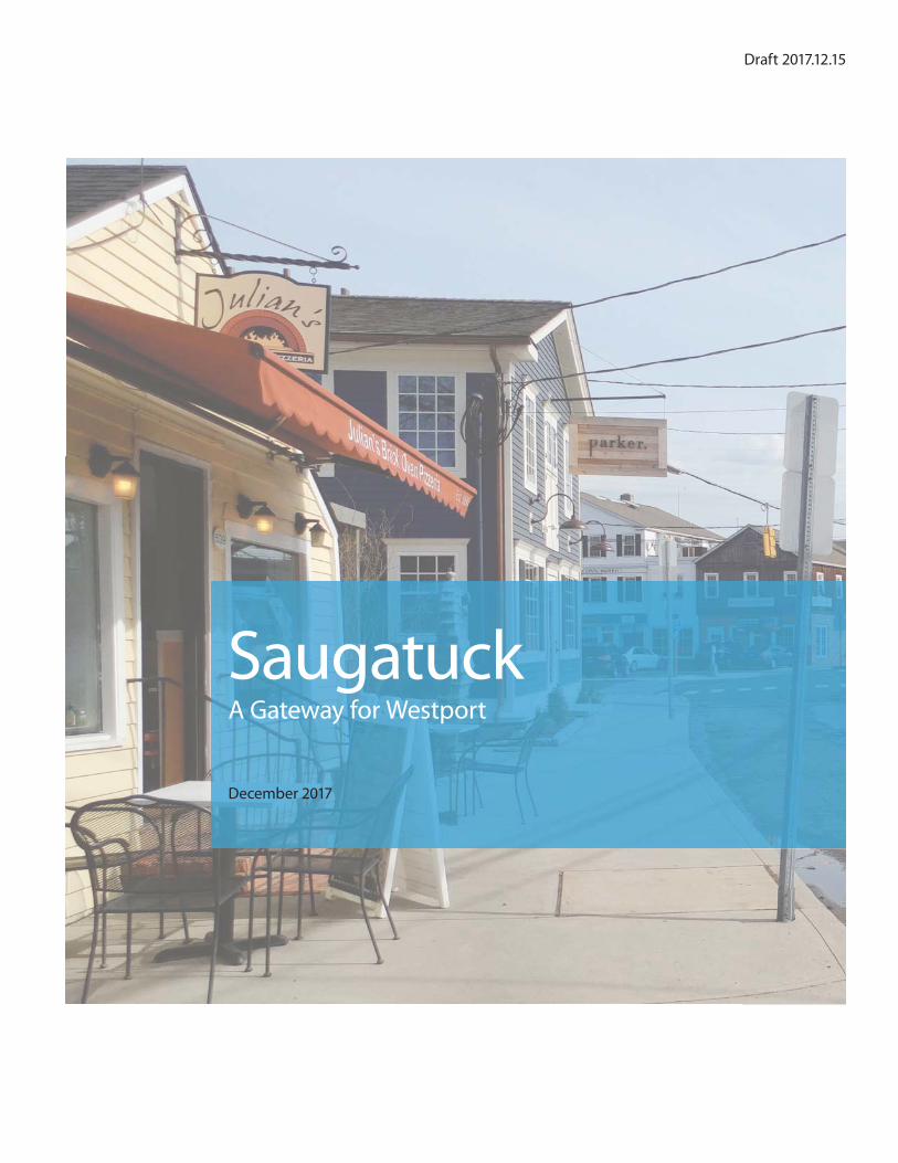
SaugatuckA Gateway for Westport
December 2017
Draft 2017.12.15
Public Archaeology Laboratory
WEBSITE:
www.gatewayforwestport.com
CONSULTANT TEAM:
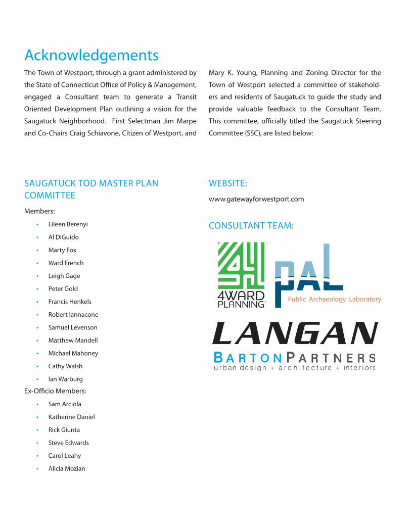
Acknowledgements
SAUGATUCK TOD MASTER PLAN COMMITTEE
Members:
• Eileen Berenyi
• Al DiGuido
• Marty Fox
• Ward French
• Leigh Gage
• Peter Gold
• Francis Henkels
• Robert Iannacone
• Samuel Levenson
• Matthew Mandell
• Michael Mahoney
• Cathy Walsh
• Ian Warburg
Ex-Offi cio Members:
• Sam Arciola
• Katherine Daniel
• Rick Giunta
• Steve Edwards
• Carol Leahy
• Alicia Mozian
The Town of Westport, through a grant administered by
the State of Connecticut Offi ce of Policy & Management,
engaged a Consultant team to generate a Transit
Oriented Development Plan outlining a vision for the
Saugatuck Neighborhood. First Selectman Jim Marpe
and Co-Chairs Craig Schiavone, Citizen of Westport, and
Mary K. Young, Planning and Zoning Director for the
Town of Westport selected a committee of stakehold-
ers and residents of Saugatuck to guide the study and
provide valuable feedback to the Consultant Team.
This committee, offi cially titled the Saugatuck Steering
Committee (SSC), are listed below:
• Executive Summary
• Community Outreach
• Case Studies
• Technical Analysis
• TOD Plan
• Implementation
• Appendix
1
19
Table of Contents

SAUGATUCK / GATEWAY FOR WESTPORT
DRAFT 12.15.17
EXECUTIVE SUMMARY
1
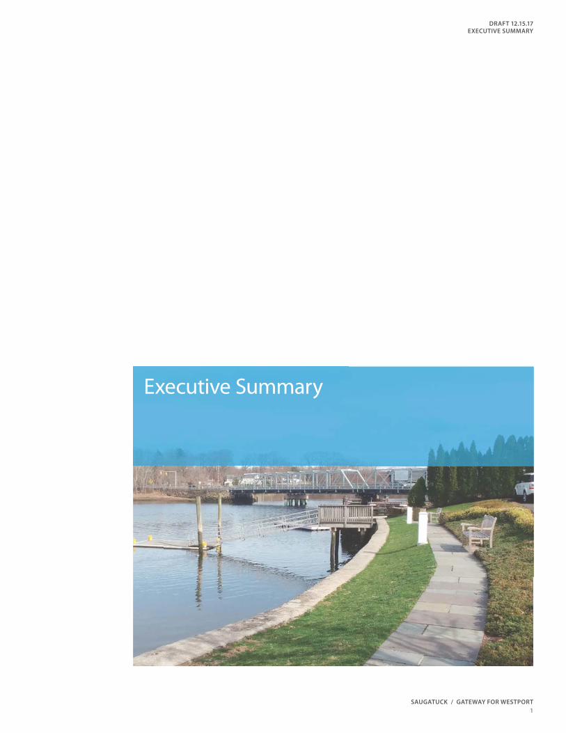
Executive Summary

2
SAUGATUCK / GATEWAY FOR WESTPORT
DRAFT 12.15.17
EXECUTIVE SUMMARY
3
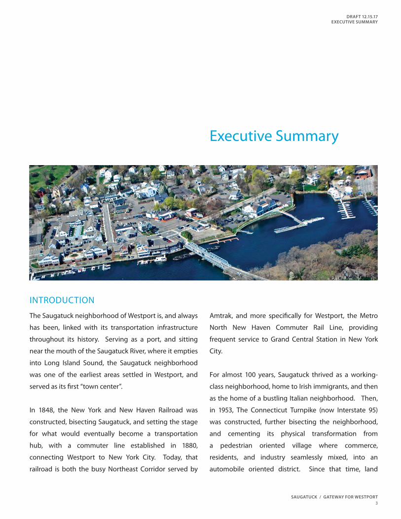
Executive Summary
The Saugatuck neighborhood of Westport is, and always
has been, linked with its transportation infrastructure
throughout its history. Serving as a port, and sitting
near the mouth of the Saugatuck River, where it empties
into Long Island Sound, the Saugatuck neighborhood
was one of the earliest areas settled in Westport, and
served as its fi rst “town center”.
In 1848, the New York and New Haven Railroad was
constructed, bisecting Saugatuck, and setting the stage
for what would eventually become a transportation
hub, with a commuter line established in 1880,
connecting Westport to New York City. Today, that
railroad is both the busy Northeast Corridor served by
Amtrak, and more specifi cally for Westport, the Metro
North New Haven Commuter Rail Line, providing
frequent service to Grand Central Station in New York
City.
For almost 100 years, Saugatuck thrived as a working-
class neighborhood, home to Irish immigrants, and then
as the home of a bustling Italian neighborhood. Then,
in 1953, The Connecticut Turnpike (now Interstate 95)
was constructed, further bisecting the neighborhood,
and cementing its physical transformation from
a pedestrian oriented village where commerce,
residents, and industry seamlessly mixed, into an
automobile oriented district. Since that time, land
INTRODUCTION
4
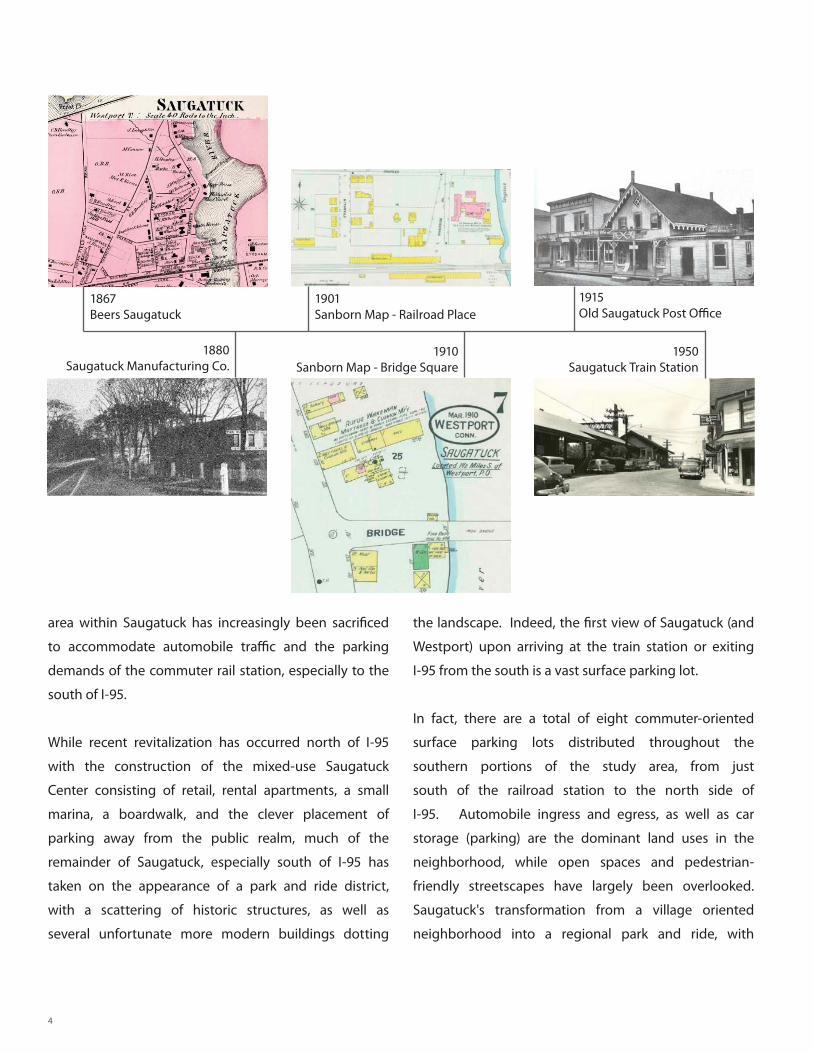
1867 Beers Saugatuck
1901Sanborn Map - Railroad Place
1880Saugatuck Manufacturing Co.
1910Sanborn Map - Bridge Square
1915Old Saugatuck Post Offi ce
1950Saugatuck Train Station
area within Saugatuck has increasingly been sacrifi ced
to accommodate automobile traffi c and the parking
demands of the commuter rail station, especially to the
south of I-95.
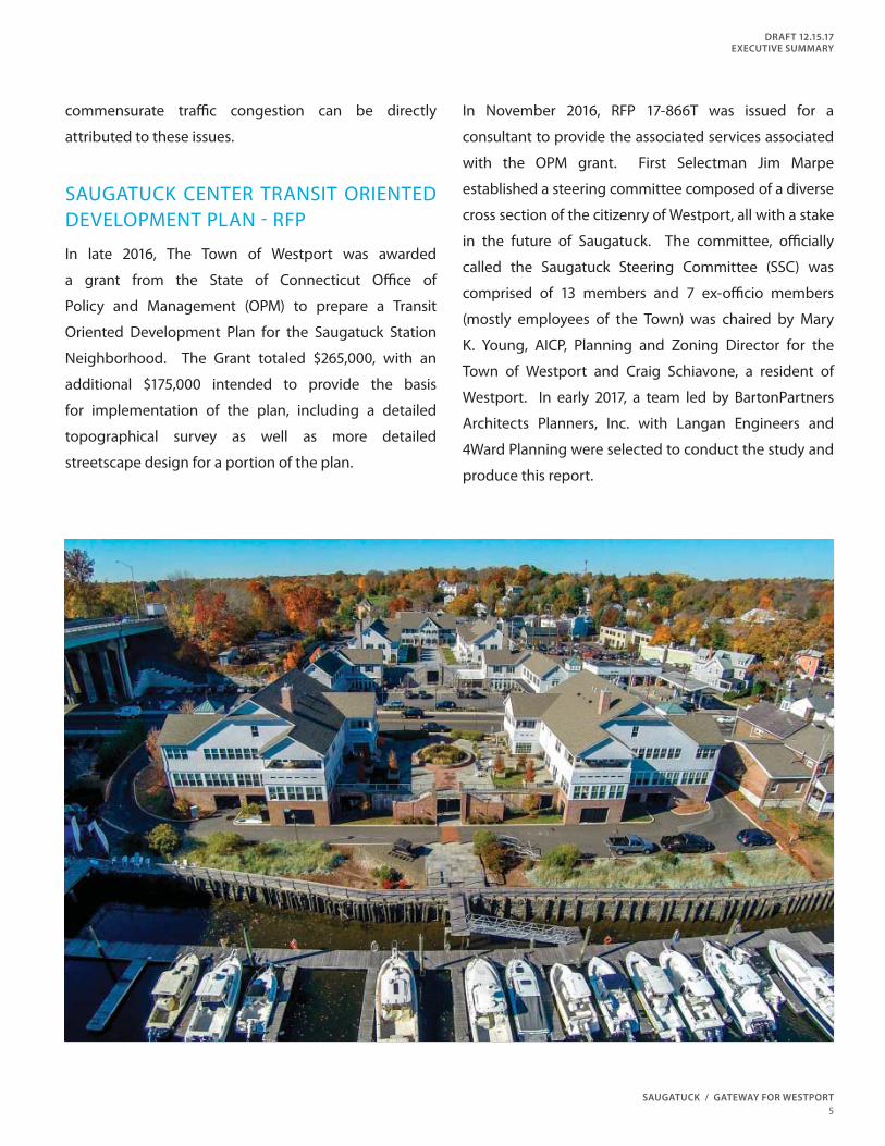
While recent revitalization has occurred north of I-95
with the construction of the mixed-use Saugatuck
Center consisting of retail, rental apartments, a small
marina, a boardwalk, and the clever placement of
parking away from the public realm, much of the
remainder of Saugatuck, especially south of I-95 has
taken on the appearance of a park and ride district,
with a scattering of historic structures, as well as
several unfortunate more modern buildings dotting
the landscape. Indeed, the fi rst view of Saugatuck (and
Westport) upon arriving at the train station or exiting
I-95 from the south is a vast surface parking lot.
In fact, there are a total of eight commuter-oriented
surface parking lots distributed throughout the
southern portions of the study area, from just
south of the railroad station to the north side of
I-95. Automobile ingress and egress, as well as car
storage (parking) are the dominant land uses in the
neighborhood, while open spaces and pedestrian-
friendly streetscapes have largely been overlooked.
Saugatuck's transformation from a village oriented
neighborhood into a regional park and ride, with
SAUGATUCK / GATEWAY FOR WESTPORT
DRAFT 12.15.17
EXECUTIVE SUMMARY
5
commensurate traffi c congestion can be directly
attributed to these issues.
SAUGATUCK CENTER TRANSIT ORIENTED DEVELOPMENT PLAN - RFP
In late 2016, The Town of Westport was awarded
a grant from the State of Connecticut Offi ce of
Policy and Management (OPM) to prepare a Transit
Oriented Development Plan for the Saugatuck Station
Neighborhood. The Grant totaled $265,000, with an
additional $175,000 intended to provide the basis
for implementation of the plan, including a detailed
topographical survey as well as more detailed
streetscape design for a portion of the plan.
In November 2016, RFP 17-866T was issued for a
consultant to provide the associated services associated
with the OPM grant. First Selectman Jim Marpe
established a steering committee composed of a diverse
cross section of the citizenry of Westport, all with a stake
in the future of Saugatuck. The committee, offi cially
called the Saugatuck Steering Committee (SSC) was
comprised of 13 members and 7 ex-offi cio members
(mostly employees of the Town) was chaired by Mary
K. Young, AICP, Planning and Zoning Director for the
Town of Westport and Craig Schiavone, a resident of
Westport. In early 2017, a team led by BartonPartners
Architects Planners, Inc. with Langan Engineers and
4Ward Planning were selected to conduct the study and
produce this report.
6
2 , 0 0 0 F T2 , 0
0 0 FT
N
0 100 200 400 ft
Sa
ug
at
uc
k
Av
e.
Sa
ug
at
uc
k
Av
e.
Fr
an
kl
in
St
.
C h a r l e s S t .
R a i l r o a d P l a c e
S a u g a t u c k R i v e r
P a r k S t .
F e r r y L a n e
I N T E R S T A T E 9 5
I N T E R S T A T E 9 5
K e t c h u m S t .
B r i d g e S t .
Ri v
er s
i de
Av
e.
Ri
ve
rs
id
e A
ve
.
A R E AO F
I N F L U E N C E
B u r r i t t C o v e
R a i l
S t a t i o n
A R E AO F
I N F L U E N C E
P R I M A R Y
S T U D Y
A R E A
SAUGATUCK / GATEWAY FOR WESTPORT
DRAFT 12.15.17
EXECUTIVE SUMMARY
7
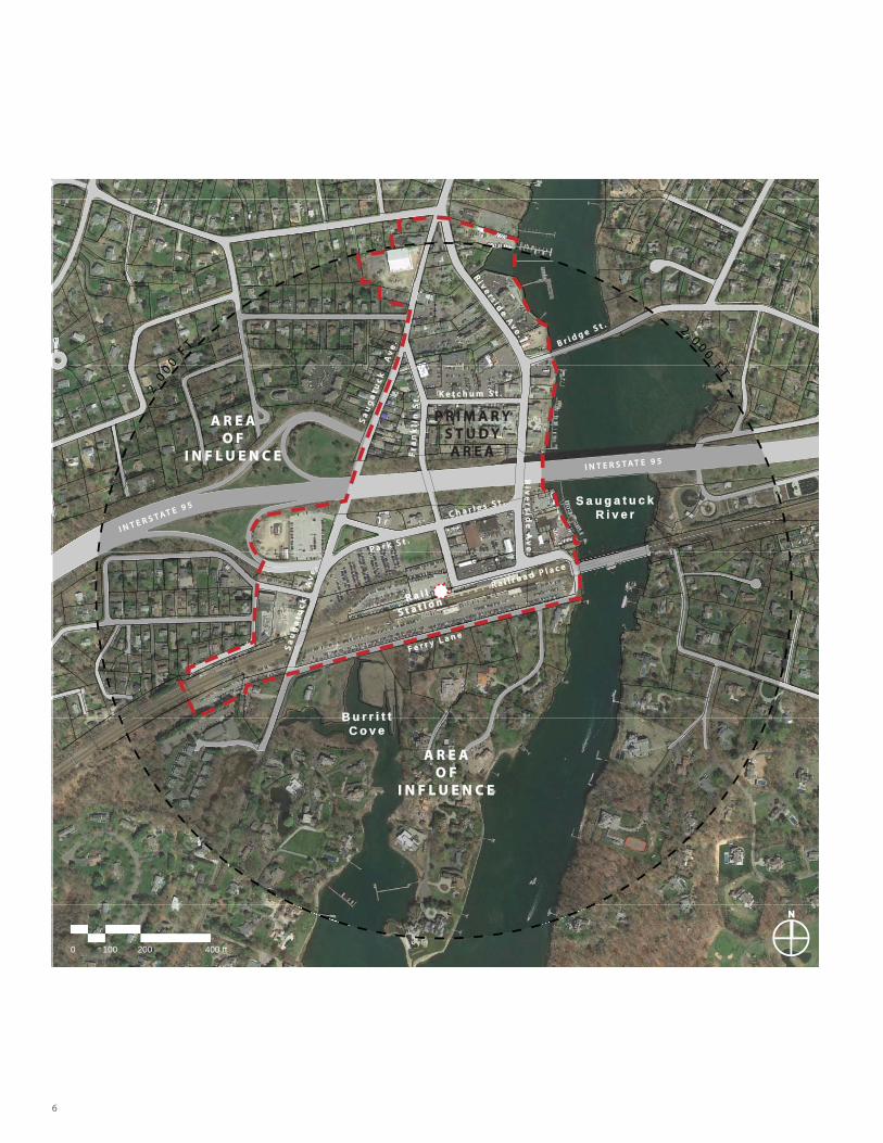
STUDY AREA
Upon selection, the BartonPartners team worked
with the SSC to refi ne the study area to include
approximately 68.5 acres, stretching from the fi ve-way
intersection of Riverside Avenue, Saugatuck Avenue
and Treadwell Avenue in the north, generally following
Saugatuck Avenue to the west, Ferry Lane in the south
and the Saugatuck River to the east. All commuter
parking areas were included within the primary study
area.
In addition, a secondary area, called an “Area of
Infl uence” was defi ned using a conventional 2000-foot
radius (a standard TOD measurement) from the center
of the railroad platform. A critical element within this
geography is the inclusion of the Cribari Bridge (Bridge
Street) within the area of infl uence.
INITIAL FINDINGS AND OBSERVATIONS
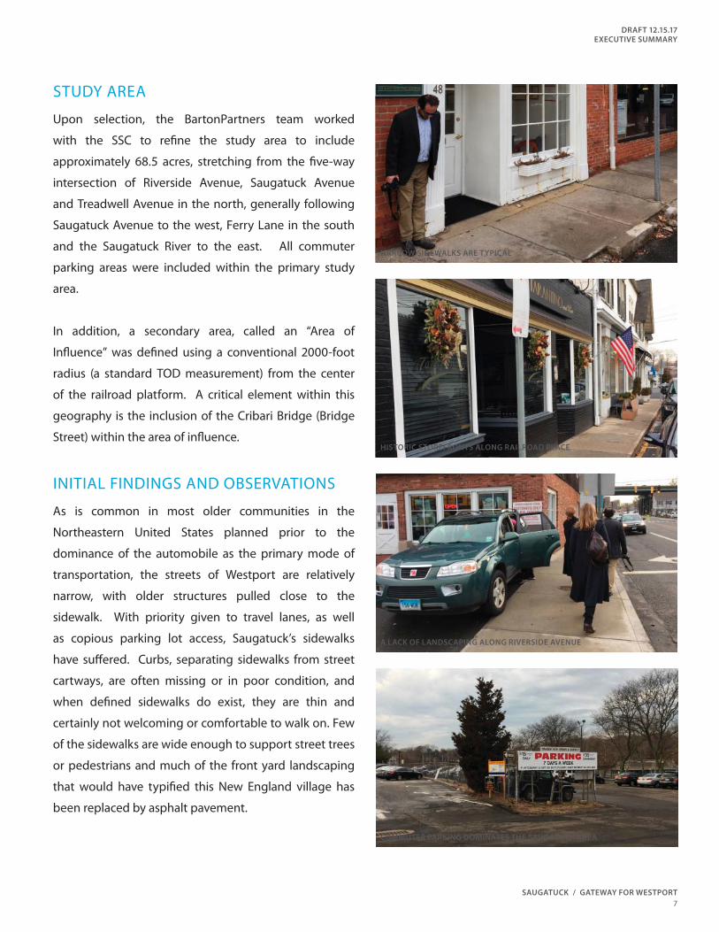
As is common in most older communities in the
Northeastern United States planned prior to the
dominance of the automobile as the primary mode of
transportation, the streets of Westport are relatively
narrow, with older structures pulled close to the
sidewalk. With priority given to travel lanes, as well
as copious parking lot access, Saugatuck’s sidewalks
have suff ered. Curbs, separating sidewalks from street
cartways, are often missing or in poor condition, and
when defi ned sidewalks do exist, they are thin and
certainly not welcoming or comfortable to walk on. Few
of the sidewalks are wide enough to support street trees
or pedestrians and much of the front yard landscaping
that would have typifi ed this New England village has
been replaced by asphalt pavement.
NARROW SIDEWALKS ARE TYPICAL
HISTORIC STOREFRONTS ALONG RAILROAD PLACE
A LACK OF LANDSCAPING ALONG RIVERSIDE AVENUE
COMMUTER PARKING DOMINATES THE SAUGATUCK AREA
8
for al fresco dining or other activities consistent with a
thriving mixed-use transit village.
This condition is prevalent throughout Saugatuck,
with parking areas and curb cuts encroaching on
sidewalks, making the pedestrian experience unsafe
and unpleasant. In certain places, the distinction
between what is a street and what is a parking lot is
unclear. Quite often the sidewalks feel less safe due
to a lack of on-street parking serving as a protective
barrier between moving vehicles and pedestrians.
While distances within the study area are not large,
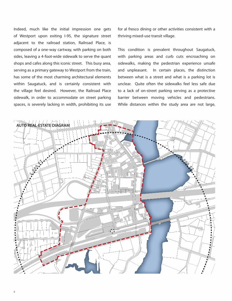
Indeed, much like the initial impression one gets
of Westport upon exiting I-95, the signature street
adjacent to the railroad station, Railroad Place, is
composed of a one-way cartway, with parking on both
sides, leaving a 4-foot-wide sidewalk to serve the quant
shops and cafes along this iconic street. This busy area,
serving as a primary gateway to Westport from the train,
has some of the most charming architectural elements
within Saugatuck, and is certainly consistent with
the village feel desired. However, the Railroad Place
sidewalk, in order to accommodate on street parking
spaces, is severely lacking in width, prohibiting its use
AUTO REAL-ESTATE DIAGRAM
SAUGATUCK / GATEWAY FOR WESTPORT
DRAFT 12.15.17
EXECUTIVE SUMMARY
9
the pedestrian experience leaves much to be desired,
leaving the impression that distances from parking to
area businesses are larger than they really are.
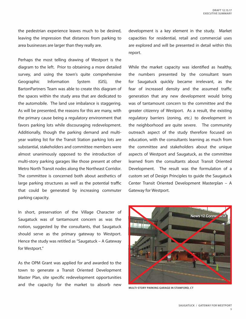
Perhaps the most telling drawing of Westport is the
diagram to the left. Prior to obtaining a more detailed
survey, and using the town’s quite comprehensive
Geographic Information System (GIS), the
BartonPartners Team was able to create this diagram of
the spaces within the study area that are dedicated to
the automobile. The land use imbalance is staggering.
As will be presented, the reasons for this are many, with
the primary cause being a regulatory environment that
favors parking lots while discouraging redevelopment.
Additionally, though the parking demand and multi-
year waiting list for the Transit Station parking lots are
substantial, stakeholders and committee members were
almost unanimously opposed to the introduction of
multi-story parking garages like those present at other
Metro North Transit nodes along the Northeast Corridor.
The committee is concerned both about aesthetics of
large parking structures as well as the potential traffi c
that could be generated by increasing commuter
parking capacity.
In short, preservation of the Village Character of
Saugatuck was of tantamount concern as was the
notion, suggested by the consultants, that Saugatuck
should serve as the primary gateway to Westport.
Hence the study was retitled as “Saugatuck – A Gateway
for Westport.”
As the OPM Grant was applied for and awarded to the
town to generate a Transit Oriented Development
Master Plan, site specifi c redevelopment opportunities
and the capacity for the market to absorb new
development is a key element in the study. Market
capacities for residential, retail and commercial uses
are explored and will be presented in detail within this
report.
While the market capacity was identifi ed as healthy,
the numbers presented by the consultant team
for Saugatuck quickly became irrelevant, as the
fear of increased density and the assumed traffi c
generation that any new development would bring
was of tantamount concern to the committee and the
greater citizenry of Westport. As a result, the existing
regulatory barriers (zoning, etc.) to development in
the neighborhood are quite severe. The community
outreach aspect of the study therefore focused on
education, with the consultants learning as much from
the committee and stakeholders about the unique
aspects of Westport and Saugatuck, as the committee
learned from the consultants about Transit Oriented
Development. The result was the formulation of a
custom set of Design Principles to guide the Saugatuck
Center Transit Oriented Development Masterplan – A
Gateway for Westport.
MULTI-STORY PARKING GARAGE IN STAMFORD, CT
10
After an extensive community outreach eff ort, including
individual meetings with committee members, an
online survey, as well as group discussions with
identifi ed stakeholders, the BartonPartners Team
proposed a set of Design Principles to guide the study.
In close collaboration with the Steering Committee, the
following Design Principles were established:
DESIGN PRINCIPLES
1. Enhance the pedestrian experience in
Saugatuck with emphasis on:
• Waterfront Access
• Additional Civic/ Park Space
• Sidewalk/ Streetscape/ Landscape/
Lighting Improvements throughout
2. Encourage and enhance multi-modal choices,
including local transit service to the station, to
reduce the demand for additional commuter
parking.
3. Provide parking strategies to support both
commuters and local businesses while
reducing the appearance of parking as the
primary land use in Saugatuck.
4. Enhance the gateway experience to
Saugatuck and the Town of Westport.
5. Promote a mix of uses that protects the
resiliency, vibrancy and character of
Saugatuck.
6. Reduce traffi c congestion and discourage cut
through traffi c.
7. The Cribari Bridge’s existing function and
structure shall be preserved.
8. Establish a regulatory framework for
implementation of development plan
recommendations that:
• Recognizes the importance of Saugatuck’s
transportation infrastructure
• Celebrates and integrates the existing
historic resources of Saugatuck
• Enhances the unique character of
Saugatuck
SAUGATUCK / GATEWAY FOR WESTPORT
DRAFT 12.15.17
EXECUTIVE SUMMARY
11
1
2
3
4
5
6
7
8
12
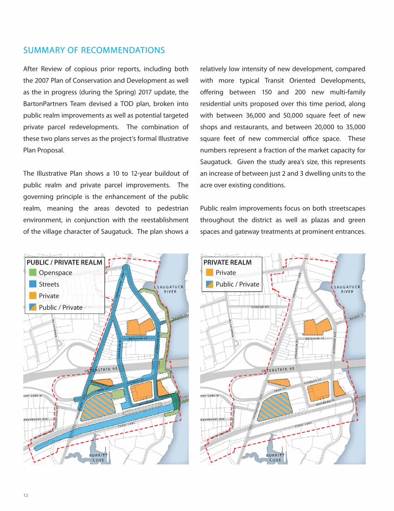
After Review of copious prior reports, including both
the 2007 Plan of Conservation and Development as well
as the in progress (during the Spring) 2017 update, the
BartonPartners Team devised a TOD plan, broken into
public realm improvements as well as potential targeted
private parcel redevelopments. The combination of
these two plans serves as the project’s formal Illustrative
Plan Proposal.
The Illustrative Plan shows a 10 to 12-year buildout of
public realm and private parcel improvements. The
governing principle is the enhancement of the public
realm, meaning the areas devoted to pedestrian
environment, in conjunction with the reestablishment
of the village character of Saugatuck. The plan shows a
relatively low intensity of new development, compared
with more typical Transit Oriented Developments,
off ering between 150 and 200 new multi-family
residential units proposed over this time period, along
with between 36,000 and 50,000 square feet of new
shops and restaurants, and between 20,000 to 35,000
square feet of new commercial offi ce space. These
numbers represent a fraction of the market capacity for
Saugatuck. Given the study area’s size, this represents
an increase of between just 2 and 3 dwelling units to the
acre over existing conditions.
Public realm improvements focus on both streetscapes
throughout the district as well as plazas and green
spaces and gateway treatments at prominent entrances.
SUMMARY OF RECOMMENDATIONS
PUBLIC / PRIVATE REALM PRIVATE REALM
Openspace
Streets
Private
Public / Private
Private
Public / Private
SAUGATUCK / GATEWAY FOR WESTPORT
DRAFT 12.15.17
EXECUTIVE SUMMARY
13
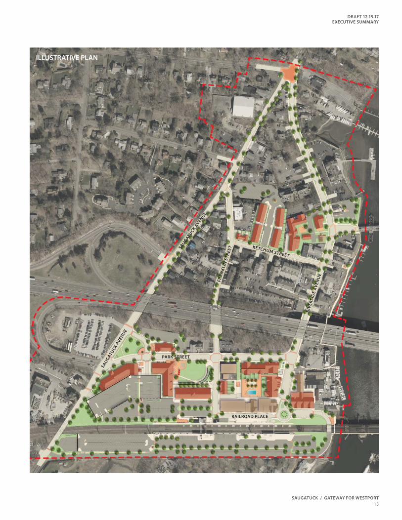
ILLUSTRATIVE PLAN
PARK STREET
RAILROAD PLACE
KETCHUM STREET
RIV
ER
SID
E A
VE
NU
E
FR
AN
KL
IN S
TR
EE
T
SA
UG
AT
UC
K A
VE
NU
E
SAU
GA
TU
CK
AV
ENU
E
14
These gateways include a reconfi gured Strofolino Park
at the western entrance, the intersection of Treadwell,
Saugatuck and Riverside Avenues at the northern
entrance, and the Bridge Street at Riverside Avenue
node as the eastern entrance.
Streetscape improvements focus primarily on the area
south of I-95, with on-street parking reconfi guration and
formal drop-off and pick-up locations at the southern
end of Riverside Avenue as well as at the junction
Railroad Place and Franklin Street. More specifi c
improvements are presented in the body of the report,
with the primary goal being the improvement of the
pedestrian experience by enhancing the streetscape,
landscape and architectural enclosure of streets and
civic spaces within the study area.
Other public realm improvements include the
re-imagining of Luciano Park into a multi-use civic open
space, which can be utilized both as an active public
gathering space for events, and as well as a passive
neighborhood park. The sidewalk along Railroad
Place is also doubled in width, to eight feet, with the
re-organization of on-street parking throughout the
southern portion of the study area.
TRAFFIC AND TRANSPORTATION
Specifi c targeted traffi c improvements can have a
positive mitigating eff ect on both the existing and
future conditions in Saugatuck. These improvements
will also address the nominal increases in traffi c over
the 12-year phase-in of the proposed development
program. Specifi c initiatives will be outlined further in
this document, inclusive of parking lot rationalization
discussed below.
However, in Saugatuck, it will be Transportation
Demand Management policies that will be the key to
addressing traffi c conditions in the district. Additional
roadway capacity is simply not possible through
expansions of right of ways.
Transportation Demand Management involves
implementation of policies and procedures that shift
behavior away from the single use automobile. These
include investigation of parking fees, enhancing multi-
modal connectivity (and ease of connectivity) as well
as regulatory changes in the zoning that currently
exacerbate the reliance on automobile use.
PARKING
As with all Transit Oriented Development districts, the
heavy parking demand of the transit station and the
desire for pedestrian-friendly streets and open spaces
often confl ict with one another. In Saugatuck, the desire
to maintain a small New England type village character
while simultaneously accommodating the necessary
regional infrastructure exacerbates this challenge.
During the outreach process, feedback on parking
issues within Saugatuck were quite varied. Some
stakeholders would welcome a reduction in the
amount of permit parking around the station. Others,
advocated for more business supportive parking,
specifi cally closer to the shops and restaurants within
the study area. Common to all feedback was the relative
discomfort associated with the perceived distance from
parking areas and the ultimate destination (whether
the train station or a business). Indeed, while the actual
distances are not great, the general lack of storefronts
to maintain visual interest in the pedestrian experience
SAUGATUCK / GATEWAY FOR WESTPORT
DRAFT 12.15.17
EXECUTIVE SUMMARY
15
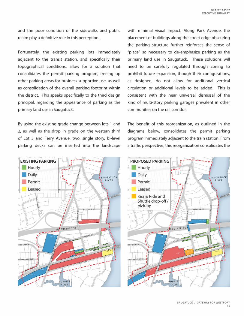
EXISTING PARKING PROPOSED PARKING
Hourly
Daily
Permit
Leased
Hourly
Daily
Permit
Leased
Kiss & Ride and Shuttle drop-off / pick-up
and the poor condition of the sidewalks and public
realm play a defi nitive role in this perception.
Fortunately, the existing parking lots immediately
adjacent to the transit station, and specifi cally their
topographical conditions, allow for a solution that
consolidates the permit parking program, freeing up
other parking areas for business-supportive use, as well
as consolidation of the overall parking footprint within
the district. This speaks specifi cally to the third design
principal, regarding the appearance of parking as the
primary land use in Saugatuck.
By using the existing grade change between lots 1 and
2, as well as the drop in grade on the western third
of Lot 3 and Ferry Avenue, two, single story, bi-level
parking decks can be inserted into the landscape
with minimal visual impact. Along Park Avenue, the
placement of buildings along the street edge obscuring
the parking structure further reinforces the sense of
“place” so necessary to de-emphasize parking as the
primary land use in Saugatuck. These solutions will
need to be carefully regulated through zoning to
prohibit future expansion, though their confi gurations,
as designed, do not allow for additional vertical
circulation or additional levels to be added. This is
consistent with the near universal dismissal of the
kind of multi-story parking garages prevalent in other
communities on the rail corridor.
The benefi t of this reorganization, as outlined in the
diagrams below, consolidates the permit parking
program immediately adjacent to the train station. From
a traffi c perspective, this reorganization consolidates the
16
ingress and egress scenarios associated with the existing
parking lots. These proposals endeavor to maintain the
overall permit parking count. Daily parking is relegated
to the perimeter, with a slight increase in capacity. More
importantly, hourly and business supportive parking
is signifi cantly increased by 60%, and distributed more
evenly throughout the district.
More detailed parking analysis, including discussion of
the fee structure for parking within Saugatuck will be
provided within the made body of this report.
IMPLEMENTATION
Given the tight regulatory environment, specifi cally
regarding the zoning within Saugatuck, the Town of
Westport and the Planning and Zoning Board have the
fi nal say in any implementation of the vision outlined
within this study. Indeed, the primary enabling
framework for this plan will be a recommendation
that a comprehensive re-write of the zoning ordinance
within Saugatuck be performed. This includes not only
an expansion of the GBD-S zoning district to include
parcels mainly south of I-95, but also a rather signifi cant
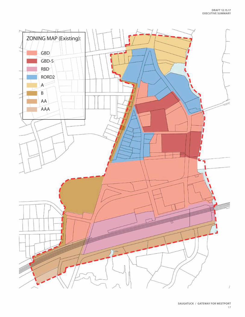
re-write of the GBD-S regulations themselves.
Secondly, for the GBD and RORDS districts that
encompass much of the rest of Saugatuck, our
recommendation is to establish a series of Village
District Overlays, one entitled Village Center Overlay,
and the other Village Edge Overlay. These two overlay
districts are intended to protect the historic fabric of
Saugatuck as the current zoning regulations covering
the majority of Saugatuck would not permit the existing
physical building fabric to be replaced if some natural
disaster were to befall the community.
In fact, the existing zoning throughout Westport
is written with standards that eff ectively prevents
economically viable development from occurring. The
defensive nature of this zoning is understandable given
the types of buildings and developments constructed
during the latter half of the 20th Century in Westport.
However, more sophisticated, form-based zoning
regulations can be applied to the Westport code to
protect the beloved character and scale of the Village.
We also recommend implementation of the historic
district as outlined in the Public Archaeology Laboratory
report to protect the character of existing structure
while promoting the use of historic rehabilitation tax
credits. This will assist property owners as they seek
to underwrite a portion of the costs associated with
adaptive reuse and preservation of key architectural
elements so important to the essential character of
Saugatuck.
Finally, the intensity of the development proposed
within this vision plan does not support extractions
from developers that can have a meaningful eff ect on
the public realm. The fi nancial returns on all proposed
development within this document are marginal at best,
and could most likely only be executed through existing
ownership entities serving as developer. In short, likely
land values cannot support the development yields
proposed within this document, even with the revised
zoning regulations proposed.
Therefore, short of additional state grants to support
streetscape improvements, the consultant team
proposed the creation of a Tax Increment Financing
(TIF) district to support the public realm improvements
proposed within this vision document.
SAUGATUCK / GATEWAY FOR WESTPORT
DRAFT 12.15.17
EXECUTIVE SUMMARY
17
ZONING MAP (Existing):
GBD
GBD-S
RBD
RORD2
A
B
AA
AAA
18
over-emphasis on parking as the primary land use
within the district has only made conditions deteriorate.
Through the implementation of a series of
transportation demand management strategies and
transportation improvements outlined in this report,
we believe this district can realize Saugatuck’s potential
as a transit-oriented village off ering a full array of
multi-modal transit alternatives while integrating the
recommended development program and successfully
mitigating the potential impact. Through the
coordinated implementation of traffi c enhancements,
transportation demand management strategies,
parking reconfi guration, historic preservation standards,
form-based code standards, streetscape design
recommendations and Tax Increment Financing policies,
Westport can realize its goals for Saugatuck.
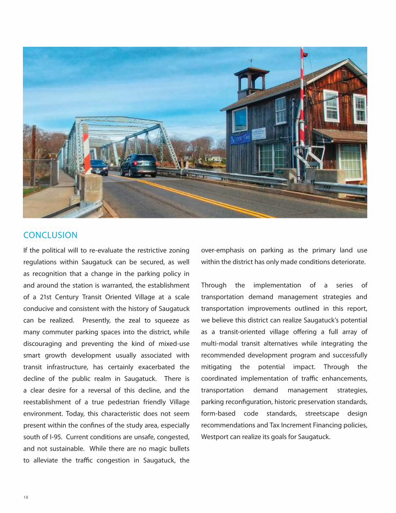
CONCLUSION
If the political will to re-evaluate the restrictive zoning
regulations within Saugatuck can be secured, as well
as recognition that a change in the parking policy in
and around the station is warranted, the establishment
of a 21st Century Transit Oriented Village at a scale
conducive and consistent with the history of Saugatuck
can be realized. Presently, the zeal to squeeze as
many commuter parking spaces into the district, while
discouraging and preventing the kind of mixed-use
smart growth development usually associated with
transit infrastructure, has certainly exacerbated the
decline of the public realm in Saugatuck. There is
a clear desire for a reversal of this decline, and the
reestablishment of a true pedestrian friendly Village
environment. Today, this characteristic does not seem
present within the confi nes of the study area, especially
south of I-95. Current conditions are unsafe, congested,
and not sustainable. While there are no magic bullets
to alleviate the traffi c congestion in Saugatuck, the