Embed Size (px)
Citation preview
No. 19
Check Lis t of Atolls
Issued by
THE PACIFIC SCIBJCE BOARD
National Academy of Sciences-National Research Council
Washington, I). C.
CHECK LIST OF ATOLLS
Com9iled for the Pacif ic Science Board
by E. H. Bryan, J r .
The foll.ov~ing i s a l i s t of is lands which are believed t o qualify as "a:tolls," as defined a t the Coral Atoll Symposium, held i n Honolulu, T.H., i n February 1951. Included are non-elevated limestone s t ructures with dry ---. land, with o r without a lagoon, and not associated olosely with high land. Excluded are elevated a t o l l s (height more than about 25 f e e t above the sea) , ~ u ~ ~ n ~ a t o l l s (without dry land), b ~ r r i e r reefs surrounding high islands (such as b e Trulc group), and reef s t ructures on fringing shelves o r p la t - forms adjacent t o land masses (such as those on the Great Barrier Reef or t o the north of western Java.)
This l i s t i s believed t o contain most of the reef s t ructures vhich qualify as "a to l l sw i n P c l p e s i a an6 Micronesia. The compiler i s ' l e s s fa- mili.er vnth the r ee f s of other regions, and it i s not unlikely t h a t some "atol ls" have been overlooked. Auditions and corrections are desired, and your help i s so l i c i t ed t o make a future edi t ion cf t h i s l i s t as complete a s possible. A number of sugges-tions have been received from D r . F.R.Fosberg, and h i s help i s grateful ly acltnowledged. Please send any data you may have t o the vwiter a t Bernice P. Bishop ~Jusewn, lIonclulu 17, I-Iawaii. Please in- clude the geographical coordinates of the reef , or reference t o some char t or publication, from which i t s qual i f icat ions as an "atol l" may be verified.
The arrangement i n t h i s l i s t i s similar t o t h a t used i n .the authorls various gazetteers of Pacif ic islands: a tabulation arranged geographically i s followed by an alphabetical l i s t of a l l the names, keyed t o the f i r s t l i s t by means of l e t t e r s and numbers. The l e t t e r s re fe r t o logical , con- venient, or established areas; the numbers t o islands within the %reas, i n soae def in i te sequence.
Under "notes", br ief reference i s ma.de t o such items of i n t o r e s t as elevations, number of i s l e t s , and the l ike; par t icu la r ly those which might indicate t h a t the reef i s n o t - a t$pical a t o l l . In the' l a s t column, refer- ence i s given t o a char t which shows the a t o l l o r i t s location. Most of the numbers re fe r t o U. S. Rydrographic Office charts.
About 400 a re l i s t ed . Of these, 136 are i n Polynesia, 92 i n Nicronesia, 65 i n hielanesia, 15 i n Indonesia, 5 northwest of Australia, 68 i n the r e s t of the Indian Ooean, 26 i n the Caribbean Sea, and only one i n the Atlantic. The greates t number i n any p o l i t i c a l subdivision i s the 75 i n the Tuamotu Archipelago; however, across &he central Pacifio and out through Nucronesia there are 136, one crowding close upon the heels of another. Motes soattered through t h i s l i s t explain uncer ta int ies regarding the exact s ta tus of reef s t ructures i n various groups, such a s the Louisiade krchipelagg [which has been added as MI], Indonesia, the islands northv~est of Australia, and the Caribbean region.
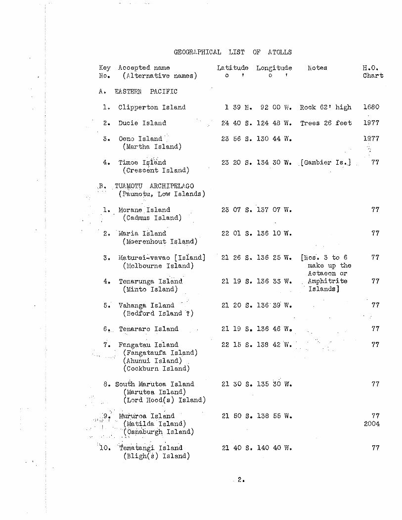
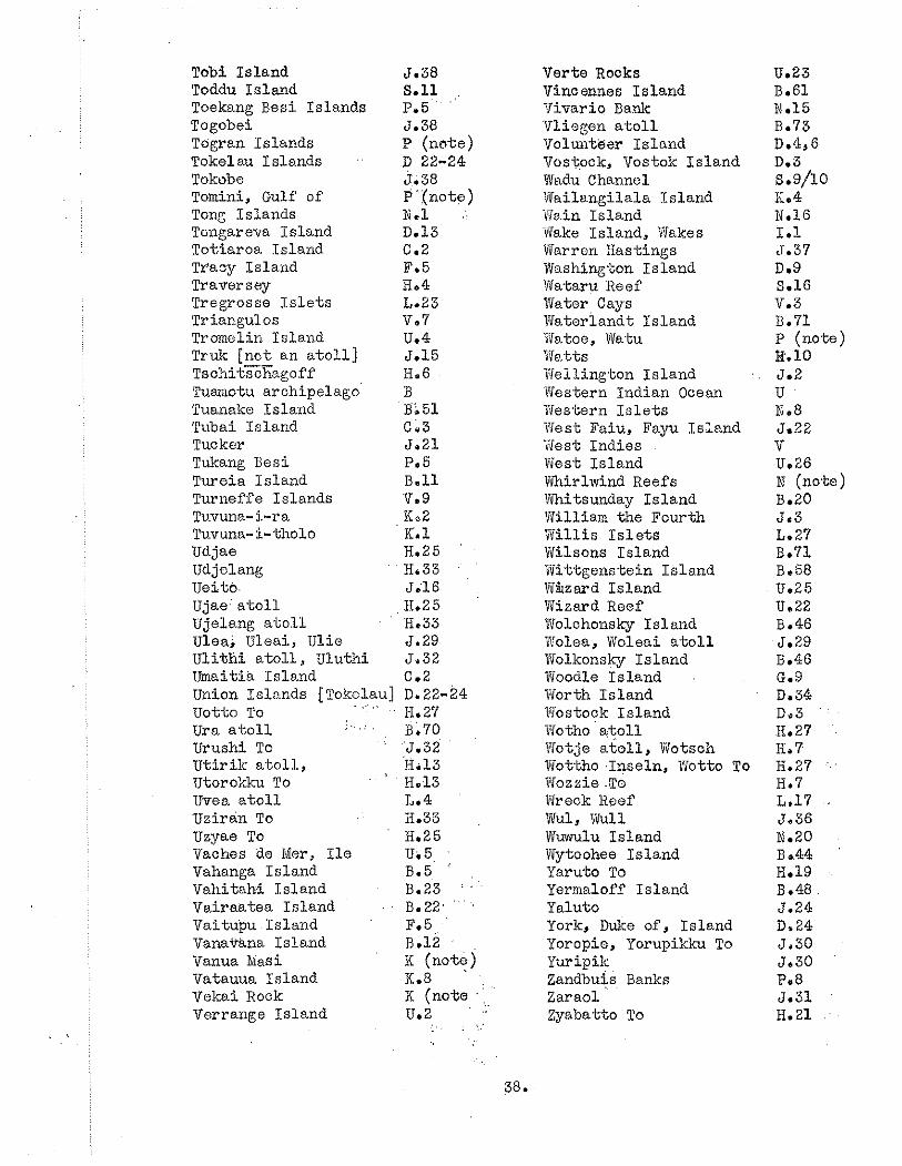
GEOGRAPHICAL LIST OP ATOLLS
Key Accepted name Latitude Longitude Kotes 0 . (Alternative names) o I o 7
A . FASTER% PACIFIC
1. Clipperton Island 1 39 IT. 92 00 Ti. Rock 62' high
2. Ducie Is land 24 40 S. 124 48 W. Trees 26 f e e t
3. O e ~ o Is land ' . 23 56 S. 130 44 W. (Wartha Is land)
4. Timoe 1ql;nd 23 20 S. 134 30 W. [Gambier Is..] (Crescent I s l and)
B . TUfQIOTU ARCHIPELP GO (Paumotu, Low Is lands )
1. Morane Is land 23 07 S. 137 07 W. (Cadrnus I s land)
2. Maria Is land 22 01 S. 136 1 O W . (Nberenhout I s l and)
3. Xaturei-vavao [ ~ s i a n d ] 2 1 26 S. 136 25 W. [Nos. 3 t o 6 (%elbourne island) make up the
Aotaeon or 4. Tonarunga 1 s i i i d ' 2 1 19 S. 136 33 W. . Amphitrite
(Minto Is land) Islands]
5 . Vahanga Is land " 21 20 S. 136'59' W. (Bedford Is land '?)
6. Tenararo Is land 21 19 S. 136 46 We
22 15 S. 138 42 W. ' ,
.. . 7. Fangatau 1sland
: (Fingataufa Is1,and) . .
(Ahutiui I s l and) (Cockburn Is land)
8. south Marutea Is land 2 1 30 S. 135 30 W. (Narutea B l a n d )
. . (Lord Iiood(s) I s l and)
. :9. i i ~ ~ r o a I S & I .;,./., : 2 1 50 S. 138 55 W.
. . , . . . (Matilda ' I s l and ) '( 'bsnabwkh I s land) . , .: . . . . ,. ~
'LO. $ematan@ Is land 21 40 S. 140 40 W. (Bligh(s) I s l and)
H.O. Chart
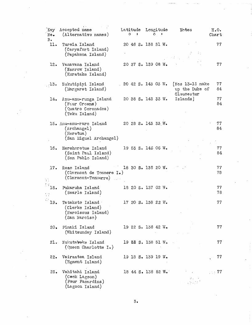
'Key Accepted dame La t i tude Longitude Fc. ( A l t e r n a t i v e names) o I o t
B. 11. Ture ia I s l a n d 20 46 S. 138 31W.
(Carys fo r t I s l and) (Papakena I s l a n d )
12. Vanavana I s l a n d 20 37 S. 139 08 V. (Barrow I s l a n d ) (Iiuratake I s l a n d )
. . -13. Nukutipipi I s l a n d 20 42 S. 143 03 W. (;iIargaret I s l a n d )
14. Anu-anu-runga I s l a n d 20 38 S. 143 33 'X. (Fcur Crowns ) (Quatro Coroiados) (Teku I s l a n d )
15. ,?nu-anu-ram I s l and 20 28 S. 143 33 W. (Archangel) (Beretua) ( San idiguel k c h a n g e l )
16. Hereheretue I s l a n d 19 53 S. 145 05 W. ( S a i n t Paul I s l a n d ) (San Pablo I s l and)
Notes H.O. Cha r t
[Nos 13-15 make 77 xp t h e Duke of 84 Glaucester I s l ands ] 77
8 4
17. Reao I s l a n d 18 30 S . 136 20 W. 7 7 (Clermont de Tonnere I.) 78 (Clermont-Tonnwre)
'18. Pukaruha I s l a n d 18 20 S. 137 02 'f l. 77 ( S e a r l e I s l e n d ) 7 8
19. Tatakoto I s l and 1 7 20 S. 138 22 'N. (Clerke I s l a n d ) (I:arcissus I s l and) (San Narciso)
20. Pinaki I s l a n d 19 22 S. 138 42 Vi. (Whitsunday I s l a n d )
21. Wukutakeke I s l a n d 19 166 S. 138 5 1 W. (Queen Char lo t t e I . )
22. Vai raa tea I s l a n d 19 18 S. 139 19 W. , 77 (Egmont I s l a n d )
23. Vahi tah i I s l a n d 18 44 S. 138 52 W. 77 (Ceok Lagoon) (Four Facardins) (Lagoon ~ s l a n d )
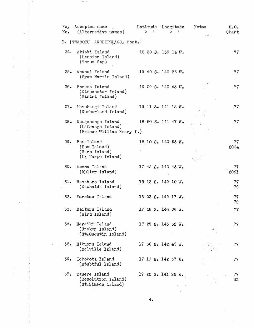
Key Accepted name ,, Latitude Longitude Notes H.O. 0 . (A1 ternative names ) o f o I . ., Chart
B. [TUAMOTU ARCIIIPXAGO, Cont.]
24. Akiaki Island 18 30 S. 139 14 W. (Lancier Island) (~hrum Gap)
25. Ahunui Island 19 40 S. 140 25 W. (Byam Martin Island)
26. Paraca Island 19 09 S. 140 43 Ti. 77 (Glbucester Island) (Hariri Island)
27. ITanuhangi Island 19 11 S. 141 15 W. 77 (Cumberland Island)
28. Nengcnengo Island 18 50 S. 141 47 W. (LfOrange Island) (Prince William Henry I.)
29. Hao Island 18 10 S. 140 55 Ti. 77 (Buw Island) 2004 (Harp Island) (La Harpe Island)
30. Ammu Island 17 48 S. 140 45 W. (FtIdler Island)
31. Ravahere Island 18 13 S. 142 10 W. (Dawhaida Island)
32. Karokau Island 18 03 S. 142 17 W.
33. Reitoru Island 17 48 S. 143 06 W. (Bird Island)
34. Harailci Island 17 28 S. 143 32 W. 77 (Crolcer Island) (St.Quentin Island)
35. Hikueru Island 17 36 S. 142 40 W. ., . . . . 77 (Melville Island) .; .;
36. Tekokota Island 17 19 S. 142 37 W. 77 (Nubtful Island)
37. Tauere Island 17 22 S. 141 28W. 77 (Resolution Island) 83 (St.Simeon Island)
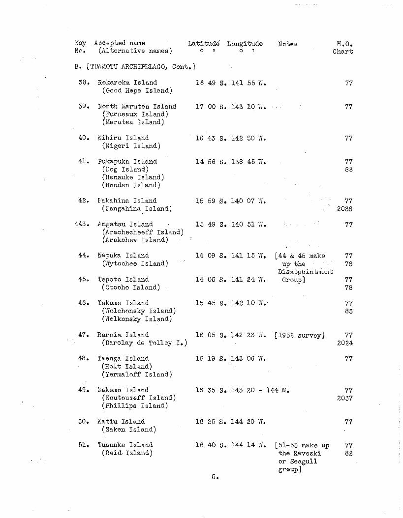
Key Accepted name La t i tude Longitude Notes H.O. No. (Al t e rna t ive names) o I o I Char t
B. [TlTAal:OTU ARCHIPSIAGO, Cont. ]
38. Rekareka I s l and 1 6 49 S. 141 55W. (Good Hope I s l and)
39. North ~ i a r u t e a I s l and 1 7 00 S. 143 10 W. 77 (Furneaux I s l and) (Xarutea I s l and)
40. Xihi ru I s l a n d 16 43 S. 142 50 W. (Wigeri I s l a n d )
41. Pukapuka I s land 1 4 56 S. 138 45 71. (Dog I s l a n d ) (iienauke I s l and) (Honden I s l a n d )
42. Fakahina I s l a n d 1 5 59 S. 140 07 W. 77 (Fangahha I s l and) 2038
143. Pngatau I s l a n d 1 5 49 S. 140 51 N, 77 (Arachecheeff island) (Arakchev I s l a n d )
44. Napuka I s l a n d 14 09 S. 141 15 W. [44 & 45 make 77 (Xytoohee I s l a n d ) up t h e 78
Disappointment 45. Tepoto I s l a n d 1 4 05 S. 141 2 1 W. Group] 77
(Otooho I s l a n d ) 78
46. Talcume I s l a n d 1 5 45 S. 142 1 0 W. (Volchonsky island) (Violkonsky I s l a n d )
47. Raroia I s l a n d 16 05 S. 142 23 W. [1952 survey] 77 (Rarclay de T ~ l l e y I.) 2024
48. Taenga I s l a n d 16 19 S. 143 06 lri. (Hol t I s l and) (Yermaloff ~ s l a n d )
49. Makerno I s l and 16 35 S. 143 20 - 144 W. 7 7 (Xoutousaf? I s l and) 2037 ( P h i l l i p s ~ s l a n d )
50. Ra t iu I s l a n d 1 6 25 S. 144 20 W. (Saken I s l and)
51. Tuanake I s l a n d 1 6 40 S. 144 1 4 Tf. [51-53 make up 77 (Reid I s l and) t h e Raveski 82
o r Seagull group1
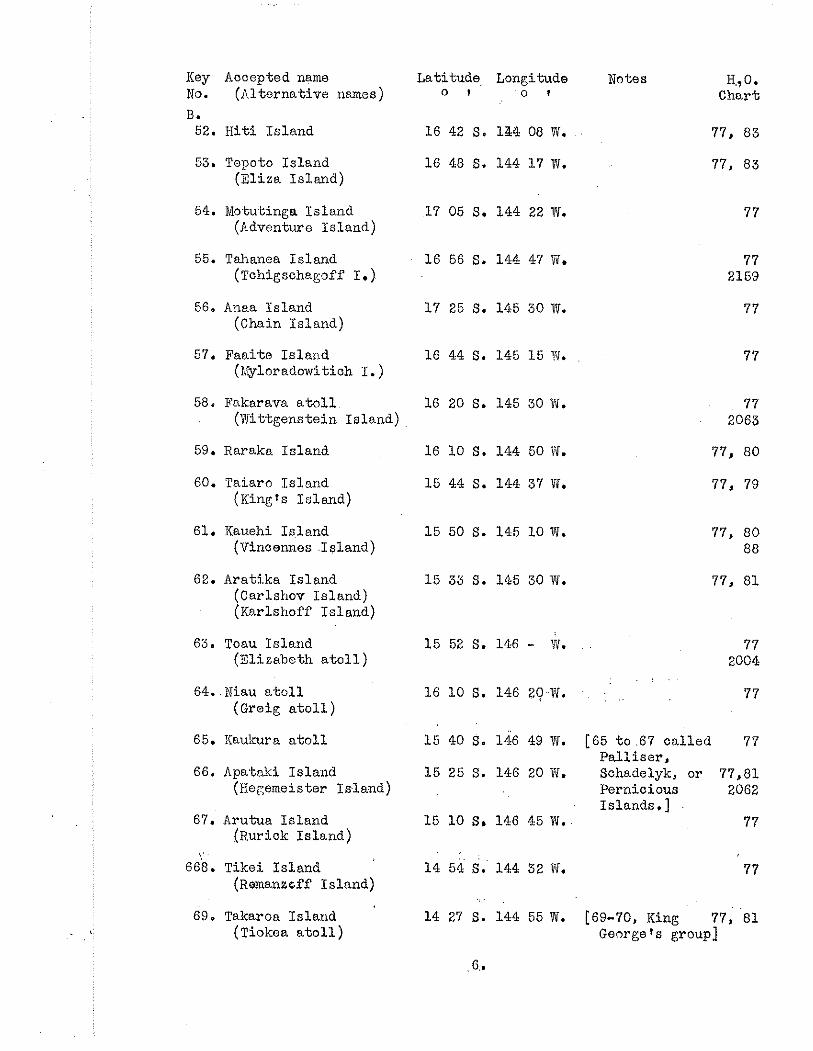
Key Accepted name No. (Alternative names)
B. 52. H i t i I s land
53. Topoto Island (El iza I s l and)
54. Motutinga Is land (Adventure Is land)
55. Talianea Is land (~chigschagoff I. )
56. Anaa Island (Chain Is land)
57. Faaite Ifiland ( ? ~ l o r a d o w i t i o h I. )
58, Fakarava a t o l l (wi t tgenste in Is land)
53. Raraka Is land
60. Taiaro Is land ( ~ i n g ~ s Is land)
61. Kauehi Is land (Vincennes I s l a n d )
62. Aratika Is land (Carlshov Is land) (Karlshoff Is land)
63. Toau Island (Elizabeth a t o l l )
64. Niau a t o l l (Graig a t o l l )
65. Kaukura a t o l l
66. Apataki Is land (Hegemeistsr I d a n d )
67. Arutua Is land ( ~ u r i c k I s land)
668. Tikei Is land (~emanzcff Is land)
63. Takaroa Is land (Tiokea a t o l l )
Latitude, Longitude 0 I 0 1
16 10 S. 144 50 V i .
15 44 S. 144 37 W.
Notes H,,O. Chart
77, 83
77, 83
[65 t o .67 ca l l ed 77 Pa l l i s e r , Sohadelyk, or 77,81 Pernicious 2062 Islands. ]
77
[69-70, King 77, '81 George 1s group]
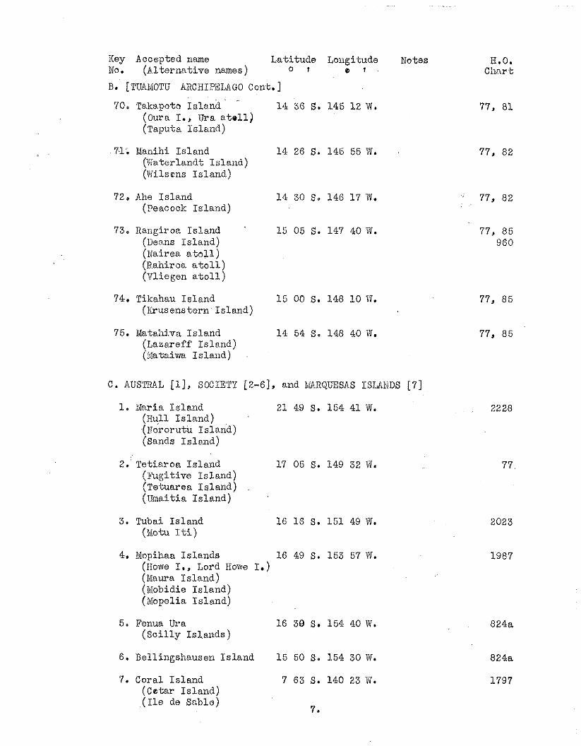
Key Accepted name La t i tude Lougitude Notes No. (Al t e rna t ive names) o r o 1
A. [TUAlviOTU ARCIIIPELIIGO Cont.]
70. Takapoto I s l a n d (0ura I., Ura a t e l l ) (Taputa I s l and)
71. Manihi I s l and (Katorlandt I s l a n d ) (Wilsons I s l a n d )
72. Ahe I s l a n d (Peacock I s l and)
73. Rangiroa I s l and (Deans I s l and) (Nairea a t o l l ) (Rahiroa a t o l l ) (Vliogen a t o l l )
74. Tikahau I s l a n d ( I i rusens t e rn I s l and)
75. Mata:iiva I s l a n d (Lazareff I s l and) (Mataivia I s l a n d )
C . AUSTRAL [l], SOCIETY [2-61, and MAIIIZRQUESAS ISLA1;IDS [7]
1. ~vinria I s l a n d 21 49 S. 154 41 W. (Hull I s l a n d ) (blororutu I s l and) (Sands I s lond)
2. Te-tiaroa I s l a n d 17 05 S. 149 32 W. (Fugi t ive I s l a n d ) (Tetuar t~a i s l a n d ) (Umaitia I s l a n d )
3. Tubai I s l and (Motu I t i )
4. Mspihaa I s l a n d s 16 49 S. 153 57 W. (Howe I,, Lord Howe I . ) (Maura I s l a n d ) (blobidie I s l and) (Mopelia I s l a n d )
5. Fenua Ura 16 38 S, 154 40 liri. ( S c i l l y I s l a n d s )
6 . Bellingshausen I s l and 15 50 S. 154 30 V i .
7. Coral I s l a n d 7 63 S. 140 23 11. (CE t a r I s l a n d ) ( I l e de Sable)
7.
H.O. Char t
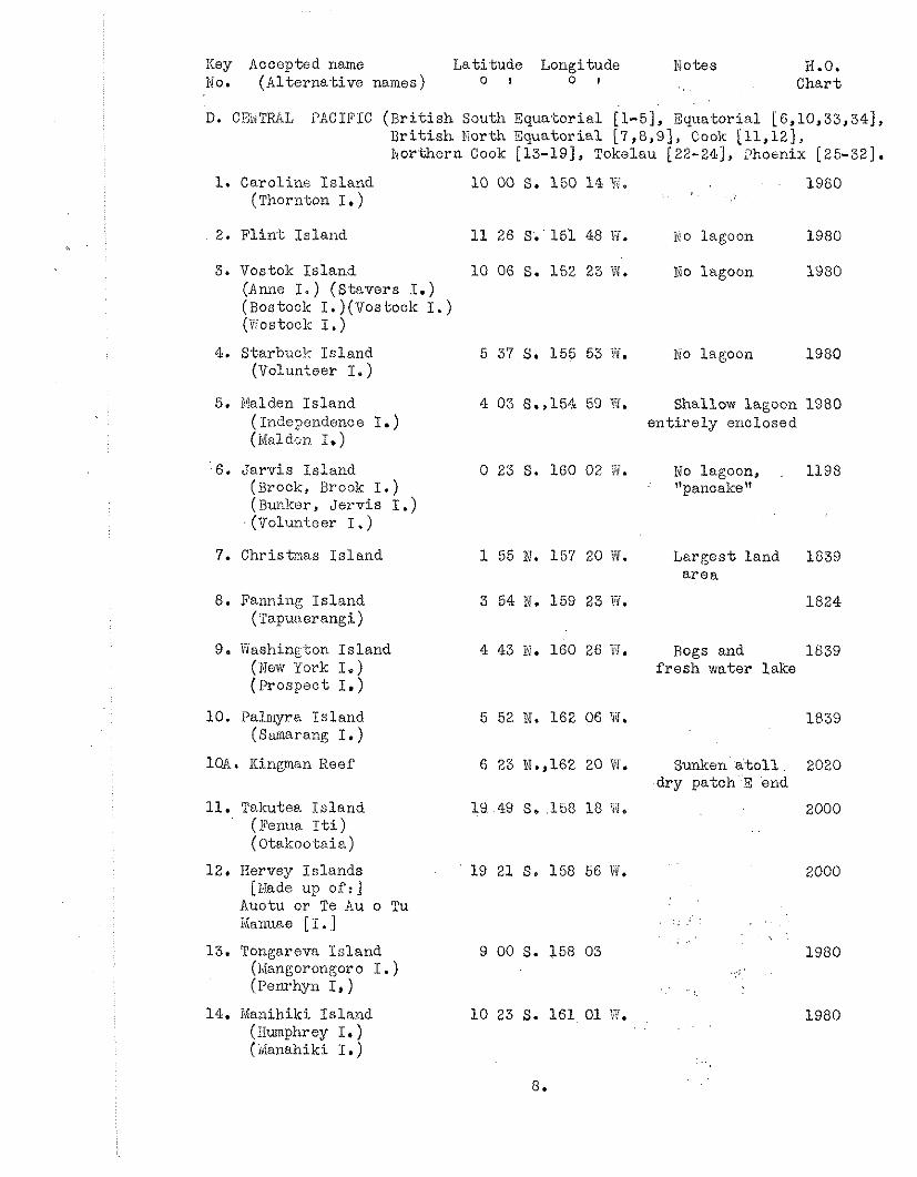
Key Accoptod name L a t i tude Longitude I'ictes H.O. No. (Al terna t ive names) o I o I Chart
D. CEivTRAL PACIFIC ( B r i t i s h South Equa.toria1 [l-51, Equatorial [6,10,33,34], B r i t i s h North Equator ia l [7,8,9], Cook [11,12), hor thern Cook [13-191, Tokelau [22-241, lhosn ix [25-321.
1. Caroline I s l a n d 10 00 S. 150 14 !;'. 1960 horn ton I. )
2. F l i n t I s l and 11 26 S. 151 48 Y?. No lagoon 1980
3. Vcstok I s l a n d 10 06 S. 152 23 W. No lagoon 1980 (Anne I . ) (S tavers I . ) (Rostock I.)(Vostock I. ) (Tostock I . )
4. Starbuck I s l and (TJolunteer I. )
5 37 S. 155 53 H. ivo lagoon 1980
5. Malden I s l and 4 03 S.,154 59 W. Shallow lagoon 1980 (Inde?endence I.) e n t i r e l y enclosed (Maldon I. )
6. J a r v i s I s l and 0 23 S. 160 02 J. No lagoon, 1198 (Brook, Brook I . ) "panoake" (Bunker, J e r v i s I.) (Voluni.cer I . )
7. Christmas I s l and 1 55 hi. 157 20 1Vi. Larges t land 1839 a r e a
8. Fanning Is land (Tapunerangi)
.. 9. N a s h i n ~ ton I s l and
(1)Iew "oyk I.) ( ~ r o s ~ a c t I . )
10. Palmyra Is land (Sanarang I. )
loA. Kingman Reef
11. Takutea I s l and (Fema I t i ) (Otakootaia)
12. Hervey Is lands [Xade up of: ]
Auotu or Te Au o Tu Hanuae [ I . 1
13. Tongareva I s l and (~Mangoron~oro I. ) ( P e n r h p I, )
14. Nanihiki Islarld (Iiumphrey I. ) (danahiki I. )
3 54 hi. 159 23 Fi. 1824
4 43 N. 160 26 B. Bogs and 1839 f r e s h water lake
6 23 N.,162 20 W. Sunken a t o l l 2020 dry patch 3 end
19 49 S. 158 18 Vi, 2000 . .
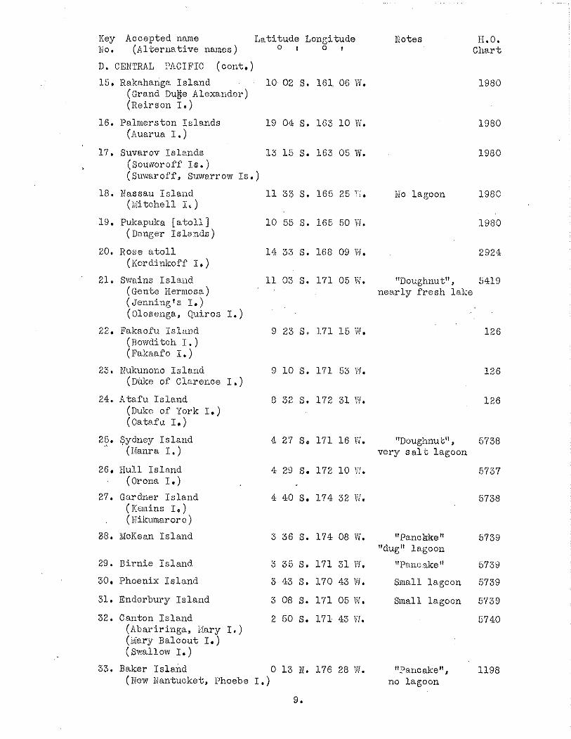
Key Accepted name . .
Lat i tude Longi-tude lvo. (Al-berliative names) 0 I 0 t
D. CENTRAL :'A.CIFIC (cont.)
15. Rakahariga I s l a n d 10 02 S. 161 06 Yf. (Grand Du&e Alexander) (Reirson I . )
16. Palmerston Is lands 19 04 S. 163 10 V!. (huarua I . )
17. Suvarov I s l ands 13 1 5 S. 163 05 Vi. (Souworoff I s . ) (Suwaroff, Suwerrow I s . )
18. Nassau I s l a ~ ~ d (iviitchell I' )
19. Pulca.puka [ a t o l l ] (Danger I s l ands )
20. Rose a t o l l (Kcrdinkoff I. )
21. Swains I s l a n d (Gen-be Herinosa) ( ~ e n n i n g s I, ) (Olosenga, Quiros I. )
2 2 Fakaofu I s l and owd ditch I . ) (Fakaaf o I. )
23. Nukunono I s l and (Dake of Ciarerice I .)
24. Atafu I s l a n d (Duke of Pork I. ) (Oatnfu I.)
25. Sydney I s l and (Nai ra I. )
26. Hull I s l and (0rona I.)
27. Gardner i s l a n d (Xanins I . ) (F ikmaro ro )
88. TvIcKean I s l and
29. E i r n i e Island.
30. Phoenix I s l a n d
31. Enderbury I s l a n d
32. Canton I s l a n d (hba r i r inga , Xary I.) (4iary Balcout I . ) (Swallow I.)
33. Baker I s l a n d (New Nantucket, Phoebe I. )
Ifotes Ii.0. Char t
ilo lagoon 1980
1980
2924
"Doughnut", 5419 nea r ly f r e s h laBe
"Doughnu ti?, 5730 very s o . l t lagoon
5737
"Panc$keU 5739 "dug" lagoon
"P nric ike" 5739
S ~ n a l l 1a.goon 5739
Sinall lagoon 5739
5740
"Qancake", 1198 no lagoon
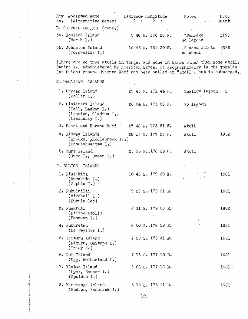
Key Accepted name Lat i tude Longitude Notes H.O. No. (Al t e rna t ive names ) o t o t Char t
D. CENTRAL PACIFIC (cont . ) 34. Howland I s l and
(Worth I . ) 0 48 We 176 38 W. "Pancake" 1198
no lagoon
35. Johnston I s l a n d 16 45 N. 169 30 t i . 2 sand i s l e t s 5356 (Cornwallis I. ) on s h o d
[There a r e no t r u e a t o l l s i n Tonga, and none i n Samoa o the r than Rose a t o l l . Swains I., adrriinistered by American Samoa, i s geographical ly i n t h e Tolcelau (o r Union) group. l i inerva Xeef has been c a l l e d a n "titoll", b u t i s submerged.]
1. Laysan I s l a n d 25 46 3, 171. 44 ?I. shailow lagoon 2 (sf011 e r I. )
2. L i s i ansk i I s l a n d 26 04 N. 173 58 Fl. No lagoon ( P e l l , Laskar I.) (Lassion, Cladius I. ) (Lisiansky I. )
3. P e a r l and liermes .Xeef 27 48 W. 1'75 51 Ne A t o l l
4. iUidway I s l ands 28 1 5 N. 177 23 3. A t o l l 1952 (Brooks, @ddlebrook Is. ) (i.Iassachusetts I. )
5. Kure I s l a n d 28 26 it. ,178 25 W. A t o l l (Cure I,, Ocean I . )
E'. ELLICE ISLIIIiDS
1. Niu lak i t a (Nurakita I. ) ( ~ o p h i a I . )
2. IJukulai lai (Mi tchel l I. ) (Kukulaelae )
3. Funafut i ( E l l i c e a t o l l ) (Fanaawa I. )
4. Nukuf e t a u (De Peyster I. )
5. Vaitupu I s l a n d (Aitupu, . Oaitupu I. ) (Tracy I.)
6. Nui I s l and (Egg, Netherland I .)
7. Miutao I s l and (Lynx, S e w e r I.) (Speiden I.)
8. Nanumanga I s l a n d (Hudson, Iiianoinanb I. )
10 45 S. 179 30 E. . . . .
9 '22 S. 179 51 E.
8 31 S. 179 08 E.
8 00 S.,178 29 E.
7 28 S. 178 41 E.
7 16 S. 177 10 E.
6 06 S. 177 16 E.
6 18 S. 176 21 E.
LO.
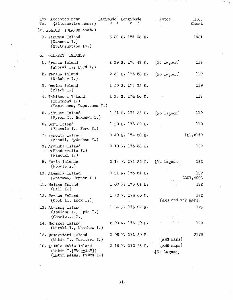
Key Accepted name Lati tude Longitude No. ljAlternative names) o I o t
(F. ELLICE ISLLNDS cont. )
9. Nanumea Is land 5 59 S. l a 6 08 E. (Nanomea I. ) (St.Augus-tine Is. )
G. GILBERT ISUNDS
L. Arorae Is land (Arorai I., Hurd I.)
2. Tamana Is land (Rotcher I.)
3, Onotoa Is land (C1ei.k I.)
4. Tabiteuea Is land ( Drumrnond I. ) ( ~ a p e t e u e a , Taputeuea I.
5. Nikunau Is lnnd (Byron I., Nulmau I.)
6. Beru Is land (Francis I., Peru I.)
7. Nonouti I s land (Eont~t i , Sydenham I. )
8. Aranuka Is land .(Renderville I. ) (Nanouki I. )
9. Kuria Islands (Woodle I.)
10. ~bem'anka Is land (Apamama, Hopper I. )
11. Maiana Is land (Hall I.)
12. Tarawa Is land (Cook I., Iinox I.),
13. Abaiang Islnnd (Apaiang I., Apia I. ) (Charlot te I. )
14. Marakei I s l and (Maraki I., Matthew I .)
15. B u t a r i t a r i I s land 1 I., T a r i t a r i I.)
16. L i t t l e Makin Is land (@akin I. [ "Muggin"] ) (Makin Meang, P i - t t s I.)
Notes H.O. Chart
1981
[NO lagoon] 119
[I40 lagoon] 119
119
119
[No lagoon] 119
[No lagoon] 122
122 [AMS and war maps]
123
2179 [nus maps]
[AUS maps]
.[No lagoon]
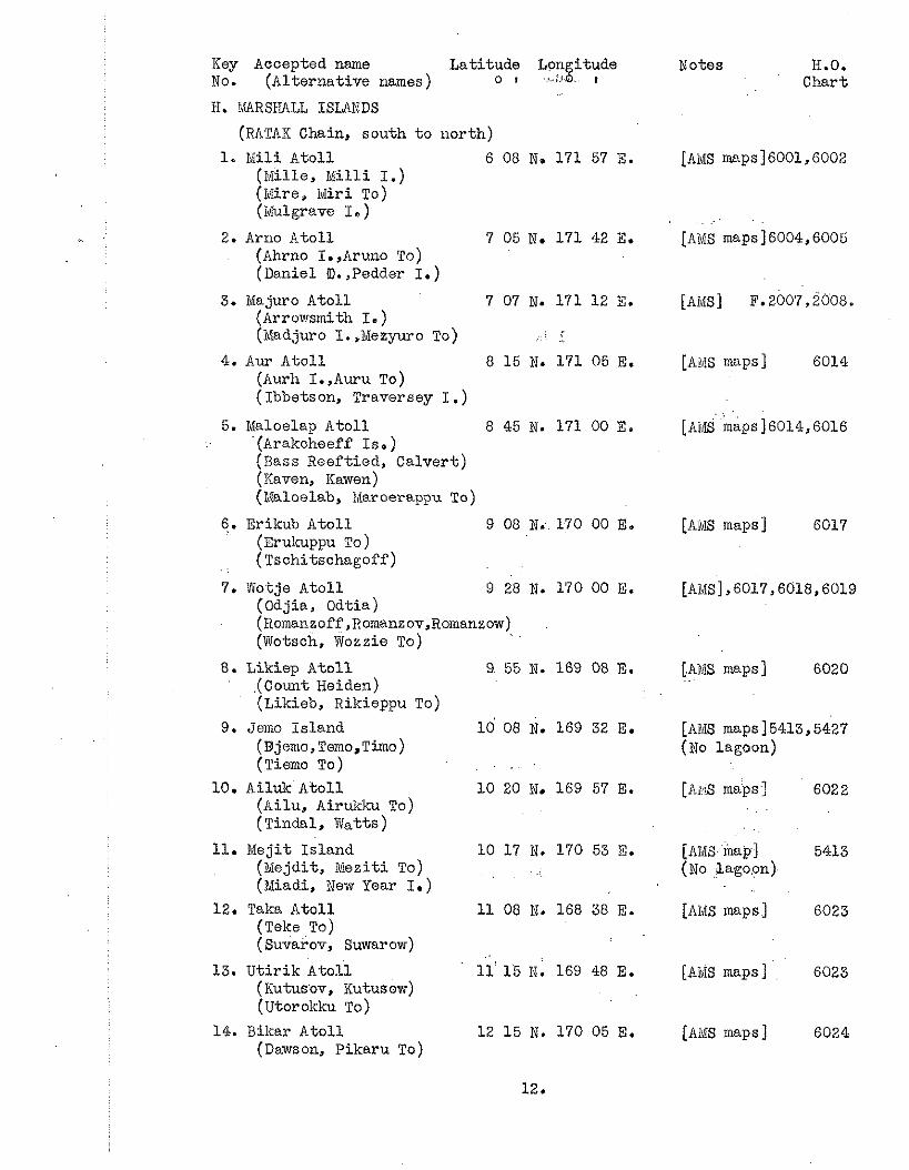
Key Accepted n m e Lati tude Longitude No. (Alternative names ) o t .:JO 1
H. MARSIIAJL ISLANDS
(RATAK Chain, south t o nor th)
1. I d i l i Atol l 6 08 N. 171 57 E. (Mille, Milli I.) (Mire, ivliri To) (iululgrave I. )
2. Arno Ato l l 7 05 N. 171 42 E. (Ahrno I. ,Aruno TO)
(Daniel a. ,Pedder I.)
3. Majuro Atol l 7 07 N. 171 12 E. (Arrowsmith I. ) (Madjuro I. ,Mezyuro To) * ,
4. Aur Ato l l 8 15 N. 171 05 E. (Aurh I.,Awu To) (Ibbetson, Traversey I . )
5. Maloelay, Atol l 8 45 N. 171 0 0 E . (Arakoheeff Is.) (Bass Reeft ied, Calvert) (Kaven, Kawen) (blaloalab, Maroerappu To)
6. Erikub Atol l 9 08 N. 170 00 E. (Erulcuppu To) (Tschitschagoff)
7. Wotje Atol l 9 28 N. 170 00 E. (Odjia, Odtia) (Romanzoff ,~omanzov,~omanzow) (Wotsch, Wozzie T O )
8. Liltiep A to l l (Count Heiden) (Likieb, Rikieppu To)
9. Jemo Is land (Djemo, Temo,Timo) (Tiemo To)
10. Ailuk Ato l l (Ailu, Airukku TO)
(Tindal, Watts)
11. Mejit Is land (Mejdit, iaezit i TO)
(Miadi, New Year I.)
12. Taka Atol l (Teke TO) ( Suvarov, Suwar ow)
13. U t i r i k Atol l (Kutusbv, Kutusow) (~torolcku To)
14. Bikar Atol l (Dawson, Pikaru To)
Notes 13.0. Chart
[ANIS maps] 6001,6002
[AMS] F. 2007,~008.
[ArjS maps ] 6014,6016
[MIS maps ] 6017
[AMS] ,6017,6018,6019
[AMS maps] 6020
[AMS maps] 5413,5427 (No lagoon)
[ A X maps] 6022
[AMS map1 5413 (NO Lagoon)
[AMS maps] 6023
[Aids maps 1 6023
[At%? maps ] 6024
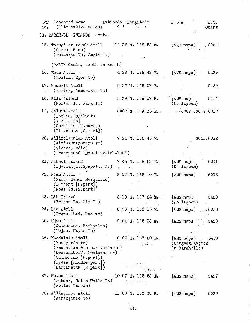
Key Accepted name Lat i tude Longitude No. (Al t e rna t ive names) o f o I
(B. HARSHALL ISLANDS cont. )
15. Taongi or Pokalc A t o l l 14 3 5 N. 168 58 E. (Easpar ~ i c o ) (Pokaakku To, Smyth I . )
(MLIK Chain, south t o nor th)
16. Ebon A t o l l 4 38 N. 168 43 E. (Boston, ,Epon To)
17. Nanlorik A t o l l 5 36 N. 168 07 E. . (Baring, Nanlurikku To)
18. ~ i l i ' 1 s l a n d 5 39 N. 169 07 E. ( ~ u a t e r I., Kiri TO)
19. ~ a l u i t ' ~ t o l 1 ($00 M. 169 35 E. (Boaham, D j a l u i t ) (Yaruto TO) (Coquil le [N.part] ) (El izabeth [S.part] )
20. Ailingla2ale.p &. to l l 7 25 N. 168 45 E. ( Airingu.rapurapu To ) (Elmore, Odia) (pronounced . . "Eye-ling-lub-lub"),
21. J a b ~ ~ o t I s l a n d 7 45 if. 168 59 E. (Djabwat .I., Zyabatto .To) , .
22. N~amu A t o l l 8 00 N. 168 1 0 E. (Xamo, Nemu, Musquillo) (Lambert [K .par t ] ) (Ross Is. pa part])
23. Lib I s l a n d 8 1 9 N. 167 24 E. ( ~ r i p p u To, Lip I. )
24. Lue A t o l l 8 56 N. 166 1 5 E. (Brown, Lai, Rae To) . .
25. Ujae A t o l l 9 04 N. 165 38 E. (Catherine, Katharine) ( ~ d j a e , Uzyae TO)
26. I(waja1ein A t o l l 9 05 N. i 6 7 20 E. (Kuezyerin To) , !.:
(Kwedhelin & o the r v a r i a n t s ) (Menschikoff, Mentschikow) (Catherine [N.par-t]) (Lydia [middle p a r t ] ) , . .
. .. . ..I:.' (Margaretta part]) 5 ;.! .:.:: . .
27. Wotho A t o l l 10 07 N. 165 58 E. (Schanz, Uotto,Wotto TO) , . .. (Trottho I n s e l n )
28. Ai l inginae A t o l l 11 08 No 166 30 E. ( ~ i r i n ~ i n a e To)
Notes H.O. Char t
[AMS maps] 6024
[AM8 r a p s ] 5429
5429
LAMS map] 5414 (NO lagoon)
6007 ,6008,6010
[AMS .&lap] 6011 (No lagoon)
[ h d ~ maps I 6013
[AIVIS map] 5428 (No lagoon)
[AMS maps] 6036
[AMS maps] 5428
[AM8 maps ] 5428 (Larges t lagoon i n Marshal ls)
' [AMS maps ] 5427
[ A & maps] 6026
Key Accepted name La t i tude Longitude $19. o t o I
(H. WRSHALL ISLANDS c o n t o )
29. Roiigerik A t o l l 11 20 N. 167 27 E. ... ( ~ e s o ~ q $ ~ ~ e ... Is;:) ,
(Rongirikku TO)
30. Rongelap A t o l l 11 20 N. 166 50 E. (Rimski-KorsakofP Is. ) . .
(Rongelab, Rongorappu To)
31. B i k i n i A t o l l 11 35 N. 165 23 E. ( ~ i g i n i , P ik inn i To) (Escholtz , Esohscholtz)
32. Eniwetok A t o l l 11 30 N. 162 1 5 E. (Worn, Eniaidok) (Zniwetakku . TO) .
33. Ujelang A t o l l 9 50 N. 160 55 E. (Arecifos, Providence) (Udjelang, Uziran TO)
I. ISOLATED ISLANDS I N NORT~VEST PACIFIC
1. Wake I s l a n d or A t o l l 19 17 M. 166 35 E. (Ealcyon, Mendana) . .
(San Francisco, 0 t o r i jima) (Wakes I . )
2. Marcus I s l a n d 24 18 it. 153 58 E. (iviinami Tor i hi ma)
3. Pareop; v.ela 20 25 N. 136 05.E. (Douglas Reef)
. .
Notes H.O. Char t
[AMS' maps] 6026
[ALXS maps ] 6029
[AMS maps] 6032 (Atomic t e s t s )
[AMS maps] 6033 (Atomic t e s t s )
[Afi,fS maps] 6035
(No lagoon) 5590
(Reported 5590 10 f t . elev.)
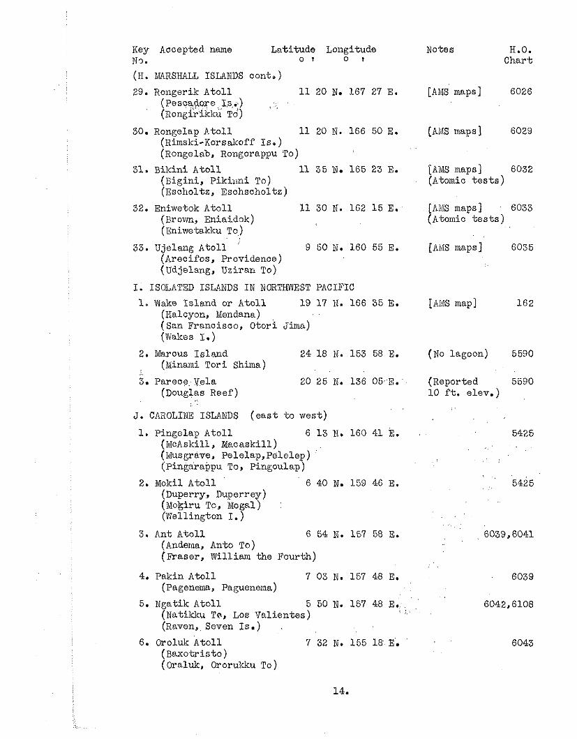
J. CAROLINE ISLANDS ( e a s t t o west)
1. Pingelap A t o l l 6 1 3 N. 160 41 E. ( M o b k i l l , ~ a c a s k i l l ) (Musgrave, p e l e l a p , ~ e l e l e ~ ) (Piniarappu To, Pingoulap)
2. Mokil A t o l l 6 40 N. 159 46 E. (Duperry, Duperrey) (Mokiru TO, Mogal) : (Wellington I. ) . .
. .
3. Ant A t o l l 6 54 N. 157 5% 3. (Anderna, Anto To) (Fraser , William the Fourth)
4. Pakin A t o l l 7 03 N. 157 46 E. (Pagenema, Paguenema)
. . 5. Ngatik A t o l l 5 50 N. 157 48 E. . '
(Natikku To, Los Va l i en te s ) ( I .
(Raven,, Seven Is .) . 6. Oroluk A t o l l 7 32 N. 155 18 E.
(Baxo t r i s to ) (oral&, Ororukku TO)
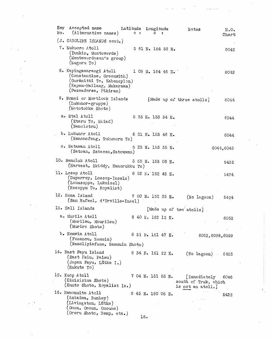
Key Accepted name L a t i t ~ t d ~ Longitude Notes H.0. No. (A l t e r n ~ t i v e names ) o 1 o I Char t (3. CAIIOJJNE ISLANDS cont. )
7. Nukuoro A t o l l 3 51 N. 154 58 E. 6042 (Dunkin, Monteverde) (i%ontevcrdosonls group) ( ~ u g ~ r u TO)
8. Kapingamarangi A t o l l 1 03 N. 154 46 E; ' 6012 (Constantine, Greenwish) ( G u r ~ i t t i To, Kabencylm) (Kwpen-Mailsne;, Makarma) (Pesoadores, P ik i ran)
9. Nomoi or Mortlock Is lands [Nade up of t h r e e a t o l l s ] 6044 (Lukunor-gruppe ) (Mototokke Shoto)
a. Eta1 A t o l l 5 35 N. 153 34 E. 6044 (E ta ru To, Neiad) ( X ~ i o l o t o u )
b. Lukunnr A t o l l 5 31. ti. 153 46 E. 6044 (Namonefeng, R?.il:unoru To)
c. Satawan A t o l l 5 23 N. 153 35 E. 8044,6045 (Satoan, Sataoan, Satovwan)
10, Namoluk A t o l l 5 55 N. 153 08 E. 5425 (Harvest, Skiddy, Namoruldcu TO)
11. Losap A t o l l 6 52 M, 152 42 E. 5424 (Duperrey, Lossop-Inseln) (Louasappe, Jdulcoisal) ( ~ o s o p p u To, Royal i s t )
12, Nma I s l and 7 00 N. 152 35 E. (No lngoon) 5424 (San Rafael, d rUrv i l l e - Inse l )
13. lIal1 Is lands [Made up o!? two a t o l l s ]
a. fiiurilo toll 8 40 lii. 152 12 E. 6052 o i e u Mourileu) ( i ~ ~ u r i r o Shoto)
b, Nornwin A t o l l 8 31 M. 151 47 E. 6052,6098,6099 ( ~ U . ~ O U , Namoin) (Namolipiafane, Namuuin Shoto)
14. E a s t Fayu I s l and 8 34 R. 151 22 E. (WO lagoon) 5425 (Eas t Paiu, E'aieu) (&pan Fayu, Ldtke I. ) (Rulmte To)
15. Iiuop A t o l l 7 04 N. 151 55 E. [Immediately 6046 (Kiniisisima Shoto) south of Truk, which (Kunto Shoto, R o y a l i s t IS .) i s - n o t an a t o l l . ]
16. Dononuito A t o l l 8 45 it. 150 05 E. 542 2 (Aniaima, Bunltey)
. (Livingston, Ldtke ) ( Onon, Onoun, Onoune) (Ororu Shoto, Remp, e t c . )
15.
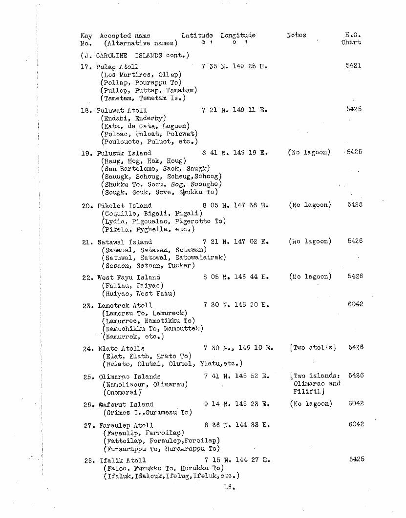
Key Accepted name La t i tude Longitude No. (Al terna t ive names) o I o t
( 5 . C!lROIdIEJT ISLAIIDS cont. ) 17. Pulap A t o l l 7 35 N. 149 25 E.
(Los Mart ires , 011 ap) (Pollap, Pourappu To) ( ~ u l l o ~ , Puttep, Tarnatom) (Tametam, Temetam Is .)
18. Puluwat A t o l l 7 21 N. 149 11 E. ( n d a b i , Enderby) ( ~ a t a , de Cata, Luguen) (Poloao, Poloat, polowat) (Poul.o;lote, Puluot, e tc . )
19. Pulusuk I s l a n d 6 41 N. 149 19 E. (Haug, Hog, Iiok, Houg) (San Bartolome, Saok, ~ a u g k ) (Sauugk, Schoug, Scheug,Schoog) (Shdcku To, Socu, Sog, Sooughe) (Sougk, Souk, Sove, S&kku TO)
20. P ike lo t I s l and 8 05 N. 147 38 E. (Coquille, Bigal i , ~ i g a l i ) (Lydia, Pigoualno, P i g e r o t t o To) (Pikel.a, Pyghella, e t c . )
21. Satawcl I s l and 7 21 N. 147 02 E. (Sataual , Satavan, ~ato.wan) (Satuwal, Batowal, ~ a t o w a l a i r a k ) (Sasaon, Setoan, Tucker)
22. West Fayu I s l a n d 8 05 N. 146 44 E. (Fa l iau , Faiyao ) (Huiyao, West Faiu)
23. Lamotrek & t o l l 7 30 N. 146 20 E. (Lamorsu To, ~amureok) (Lslnurrec, Namotikku TO) (Namochiklcu To, iuarnouttek) (Namurrek, etc.)
24. E la to A t o l l s 7 30 N., 146 1 0 8. ( E l a t , Ela th , Era to To) (Helato, Olutai , Olutel , $latu,etc . )
25. Olimarao I s l ands 7 41 N. 145 52 E. (Nariiollaour, Olimarau) ( Onomarai j
26. Qaferut I s l a n d 9 1 4 N. 145 23 E. (Grimes I. ,Gurimesu To)
27. Faraulep A t o l l 8 36 N. 144 33 E. (Faraulip, Fa r ro i l ap ) (Fa t to i l ap , F o r a u l e p , ~ o r o i l a p ) (Furaarappu To, Huraarappu To)
28. I f a l i k A t o l l 7 15 N. 1.44 27 E. (Faloo, Furukku To, Hurukku To) (Ifaluk,Idtalouk,Ifelug,ISel~~, e tc . )
16.
n'otes B.O. Chart
( N O lagoon)
(NO lagoon)
(NO lagoon)
( ~ i o lagoon)
[Two a t o l l s ]
[TWO i s lands : 5126 Olimarao and F i l i f i l l
(!To lagoon) 6042
Xey Accepted nxne La t i tude Longitude ito. (Al te r i l s t ive names) o I o t
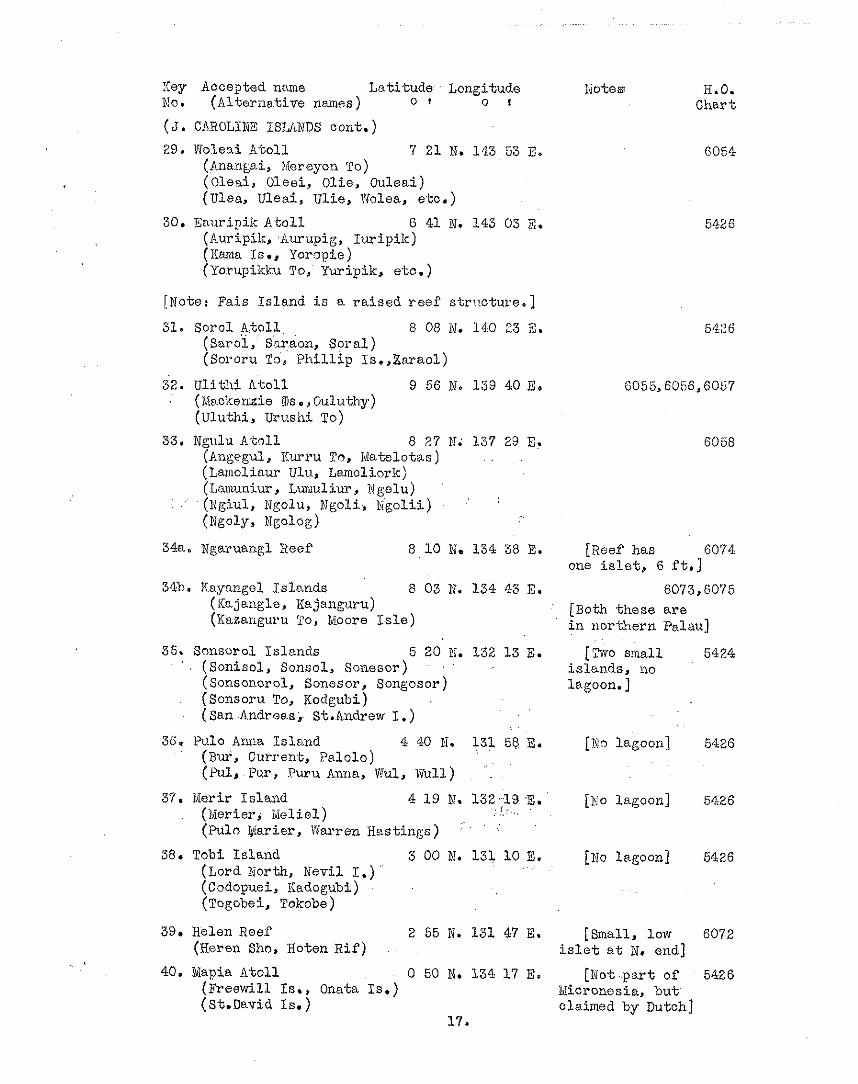
( 3 . CAROLINE ISJdXNDS cont . )
29. Woleai A t o l l 7 21 N. 143 53 X. ( ~ n a a g a i , Mereyon TO) ( ~ l e a i , Oleci, Olie , 0 u l e a i ) lea, Uleai , U l i e , Wolea, e tc . )
30. Enuripik A t o l l 6 41 N. 143 03 E. (huripil:, l ,urupig, I u r i p i k ) (IIma Is., Yampie) (Y'orupikku To, Yuripik, eto.)
[Note: Fa i s I s l a n d i s a r a i s e d r e e f str:!oture.]
31. So rc l A t o l l . 6 08 N. 140 33 E. ( ~ a r o ' i , ~ a r a o n , S p r a l ) ( S o ~ o r u TS, P h i l l i p Is. ,Zaraol)
32. U l i t h i A t o l l 9 56 hi. 139 40 E. (Yh~okeraie IDS., Guluthy) (Uluthi , Urushi To)
33, Ngulu A t o l l 8 27 N. 137 29 E. (AngeguL, Ilurru To, ivlatelotas) (Lariloliaur Ulu, Larnoliork) (Lanuniur , Lurul iur , N @u)
I . (i?giul, Ngolu, Ngoli, i $ g o l i i ) .'
(Ngoly, Ngolog)
34ao Wgaruangl Reef 8 1 0 N. 134 38 E.
34b. Kayangel Islcmds 6 03 N. 134 43 E. ( Ih jaugle , Xajanguru) (Kazanguru To, Moore I s l e )
Sonsoral I s l ands 5 20 N. 132 1 3 E. (Sonisol , Sonsol, ~ o n s s o r ) . .
(Sonsonorol, Sonesor, Songosor ) (Sonsoru To, Kodgubi) (San Andreas,. St.Andrew I .)
Pv.10 Arula I s l a n d 4 40 81. 131 56 E. (Bur, Current, Pa lo lo ) (i+Il, P u ~ , puru Anna, Vul, Wull)
Merir I s l and 4 1 9 N. 132..19 .E.' . . ( . . (Merier, Mel ie l ) . .. ...,
. . (Pulo Uiiarier, Warren Has t ings) ' '
Tobi I s l and 3 00 N. 131 10 E. (Lord Worth, Nevi1 I.) (Codopuei, ICadogubi) (Togobei, Tokobe)
Notes H.O. Char t
[Reef has 6074 one i s l e t , 6 f't.]
6073,6075 [Both t h e s e a r e i n no r the rn Palau]
[%o m a l l 5424 i s l ands , no lagoon. ]
[No lagoon] 5426
[XO lagoon] 5426
[No lagoon] 5426
Helen Reef 2 55 N. 131 47 E. [Small, low 6072 ( ~ e r e n Sho, Hoten R i f ) i s l e t a t N. end] Mapia A t o l l 0 50 N. 134 17 E. [Not p a r t of 5426
(lFreewill Is., Onata Is . ) Ddicronosia, b u t (St.David Zs.) olaimed by Dutch]
17.
Key Accepted name Latitude Longitude Notes H.O. No. (Alternative names) o r o r Chart
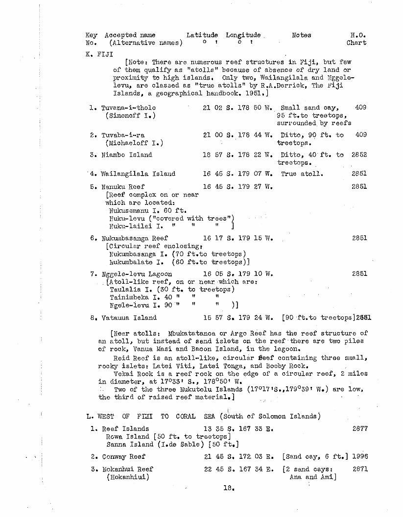
K. F IJ I [Note: There a r e numerous reef structures i n F i j i bu t few
of them qualify a s "a to l l s" because of absence of dry land or proximity to high islands, Only two, Tiailangilala and Nggele- l e m , are classed as "true a t o l l s " by R.A.Derrick, The F i j i Islands, a geographical handbook. 1951.1
1. Tuvsna- i-tholo 2 1 0 2 S . 1 7 8 50W. Smal l sandcay , 409 (Simonoff I. ) 95 f t . t o treetops,
surrounded by r e e f s
2. Tuvaba-i-ra 21 00 S. 178 44 W. Ditto, 90 f t . t o 409 (Michaeloff I. ) treetops.
3. Niambo Island 18 57 S. 178 22 W. Ditto, 40 f t . t o 2852 treetops.
4. 1Igailangilala Islarid 16 45 S. 179 07 W. True a to l l . 2851
5. Nanuku Reef 16 45 S. 179 27 W. 2851 [Reef oomplex on or near which a re located: Hukusemanu I. 60 f t. Fuku-levu ("covered with t rees") Kuku-lailai I. 11 " 1
6. Nukumbasanga Reef 16 17 S. 179 15 W. [Circular reef enclosing: Nukumbasanga I. (70 f t . t o treetops) iqukumbalate I. (60 f t . t o t reetops)]
7. Nggele-levu Lagoon 16 05 S. 179 10 W. 2851 [Atoll-like reef, on or near which are: Taulalia I. (30 f t . t o t ree tops) Tainimbeka I. 40 " II
tile-iem I. 90 !I " 11 8. Vatauua Island 15 57 S . 179 24 W. [90 f t . t c treetops]2881
[Wear a to l l s : Mbukatatanoa or Argo Reef has the reef s t ruc ture of an a to l l , but instead of sand i s l e t s on the r ee f - the re a r e two p i l e s of rock, Vanua Masi and Bacon Island, i n the lagoon.
Reid Reef i s an a tol l - l ike , c i rcu la r eeef containing three small, rocky i s l e t s : Latei V i t i , Latei Tonga, and Booby Rock.
Vekai Rock i s a reef rock on the edge of a c i rcu la r reef , 2 miles i n diameter, a t 17O33 1 S., 178O50' W. .'. Two of the three Nukutolu Islands (17°17f~.,179039t W.) are low, the t h i rd of ra i sed reef material.] . .
L. WEST OF FIaI TO CORAL SEA ( ~ b u t h of Solomon ~ s l a n d s )
1. Reef Islands 1 3 35 S. 167 33 E. Rowa Island [50 f t . t o t reetops] Sanna Island (I.de Sable) [50 ft.]
2. Conway Reef 2 1 45 S. 172. 03 E. [Sand cay, 6 f t . ] 1996
3. Noicanhui Reef 22 45 S. 167 34 E. [2 sand cays: 2871 (~okanh iu i ) Ana and Ami]
18.
Key Accepted name La t i tude J,onp,itude Notes H.O. No. (Al te rna t ive names) o T o t Chart
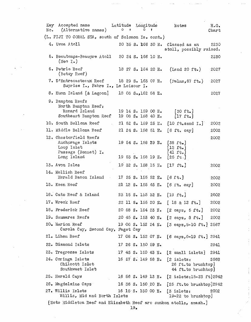
(7,. F I J I TO CORAL S3, south of Solomon Is. cont.)
4. Uvea A t o l l 20 3 5 S. kt16 30 E. Classed a s an 223J a t o l l , poss ib ly r a i sed .
5. Beauterps-Beaupre A t o l l 20 24 S. 166 1 0 E. (He9 I.*)
6. P e t r i e Reef (Betsy Pee f )
7. D tEntrecastecux Reef 18 29 S. 163 07 E. Supr ise I., Fabre I., Le Leizour I.
8. Huon I s l and [& agoo on] 1 8 03 S.,162 58 E.
9. Bampton Reefs North Bampton Reef:
Renard I s l a n d 19 14 S. 169 00 E. Southeast Bmpton Reef 19 08 S. 158 40 E.
10. South Bellona Reef 21 52 S. 159 25 E.
11, Niddle Bellona Reef 21 24 S. 158 51 E.
12. Ches te r f i e ld Reefs Ailohorage I s l e t s 1 9 54 S. 158 29 E. Loop I s l e t Passage (Bonnet) I. Long I s l and 19 53 S. 158 19 E.
13. Avon I s l e s 19 32 S. 158 1 5 E.
14. kIollish Xeef Herald Bacon I s l and 17 25 S. 155 52 E.
15. Keen Reef 21 12 S. 155 45 E.
16. Cato Reef & I s l a n d 23 1 5 S. 155 32 E.
17. Wreck Reef 22 11 S. 155 20 E.
18, Freder ick Reef 20 58 S. 154 23 E.
19. S~umarez Reefs 20 45 S.. 153 40 E.
(Land 20 f t . )
(?alms, 67 f t. )
[20 f t . ] [17 f t , ]
[ l o ft .sand 1.1 [6 f t . cay]
[ 6 f t . ]
[6 ft. cay]
[19 ft.]
[ 18 & 12 ft .]
[ Z cays, 5 f t . ]
[ Z cays, 8 f t . ]
20. Earion Reef 19 06 S. 152 24 E. 13 cays,5-10 ft.] 2567 Carola Cw, Second Cay, Paget Cay
21. Lihon Reef 17 08 S. 152 07 E. [6 cays,6-19 f t .] 2941
22. Diamond I s l e t s 17 26 S. 150 59 E. 2941
23. Tregrosse I s l e t s 1 7 43 S. 150 43 E. 12 small i s l e t s ] 2941
24. Coringa I s l e t s 16 57 S. 149 58 E. [2 i s l e t s : 3568 C h i l c o t t I s l e t 26 f t . t o brushtop] Southwest I s l e t 44 f t . t o brushtop]
25. Herald Cays 1 6 56 S. 149 1 3 E. [ 2 i s le t s :15-23 f t l 2942
26. i lagdelaine Cays 16 36 S. 150 20 E. [25 f t . t o brushtop12942
27. Willis I s l e t s 16 1 5 S. 160 00 E. [ 3 i s l e t s : 2002 W i l l i s , *lid and North I s l e t s 19-22 t o brushtop]
[Note $diddleton Reef and E l i zabe th Reef a r e sunken a t o l l s , awash.] 19 e
Key Accepted name Lat i tude Longitude Notes H.O. No. (Al ternat ive i~ames) c I c t Chart
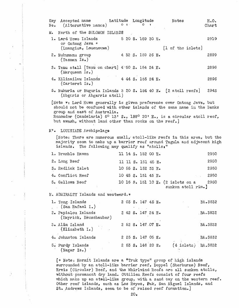
1vI. Nsrth of the SOLOMON ISLANDS
1. Lard IIowu Is lands 5 20 S. 159 30 B. 2910 or Ontong Java * ( ~ u a n ~ i u a , Leuene~~wa) [ l of the i s l e t s ]
2. N u h n u group (Tasman Is.)
3. Tanu a t s l l [Tauu on char t ] 4 50 S. 154 24 E. (iliarqueen I s . )
4. Ki l ina i l au Is lands 4 44 S. 155 24 E. (Car te re t Is .)
5. Nukuria 6r Nuguria Islands 3 20 S. 154 40 E. [2 a t o l l r ee f s ] 2943 (dbgcris or Abgarris a t o l l )
[Note *: Lord H6we general ly i s given preference over Ontong Java, bu t should not be confused with other i s l ands of Me sane name ill t h e Banks group aud e a s t of Austral ia . Rcncadsr (Candelaria) 6O 131 S., li39O 201 E., i s a c i r c u l a r a t o l l r e o f , bu t awash, without land other than rocks on Lhe reef .]
7 . LOUISIADE Archipelage
[Note: There a r e numerous small; a t o l l - l i k e r e e f s i n t h i s area , bu t the major i ty seem t o make up a b a r r i e r r e e f around Tagula and adjacent high is lands . The following may qualirjr a s " a t o l l s I "
1. Bramble Kaven 11 1 4 S. 152 00 E. 2950
2. Long Reef 11 11 S. 151 45 E. 2950
3. Redlick I s l e t 10 55 S. 152 33 E. 2950
4. Conf l i c t Reef 10 45 S. 151 45 E. 2950
5. Gallows Reef 1 0 16 S. 151 1 0 E. (2 i s l e t s on a 2950 sunken a t o l l rim.)
N. ADMIRALTY Islands and westward, * 1. Tong Islands 2 03 S. 147 45 E. : (San Rafael I.) 2. Papialou is lands 2 42 S. 147 24 E.
(Hayrick, 1-ieusohauber )
3. Alim Is land 2 52 S. 147 07 E. (Elizabeth I.)
4. Johnston Islands 2 25 S. 147 05 E. BA.3832
5. Purdy Is lands 2 53 S, 146 20 E. ( 4 i s l e t s ) BA.3832 (Dagar Is. )
[r Nwte: Hermit Islands a r e a "Truk type" group of high i s l ands surrounded by a n a t o l l - l i k e b a r r i e r r ee f . Doppel (Sherburne) Reef, Kreis (Ci rcu la r ) Reef, and the Whirlwind Reefs a r e a l l sunken a t o l l s , without permanent dry land. O t t i l i e n Reefs c o n s i s t of four r e e f s which make up an a t s l l - l i k e group, wi th a sand cay on t h e western ree f . Other r ee f i s lands , such a s Los Keyes, Pak, San BIiguel Islands, and S t . 4-ndrews Is lands , seem t o be of r a i s e d reef formation.]
20.
!icy Accepted name La t i tude La t i tude Notes H.B. No. (Al te rna t ive names) O 9 o t Chart
(N. ADiIIRALTY ISLANDS cont. ) Sabben Is lands 2 12 So 146 16 E. Extensive reef BA.3832
P a l z ~ a t I s l ands 1 56 S. 146 29 E. 3 low i s l e t s UA.3832
Western i s l e t s 2 1 3 S. 146 01 E. LOW i s l e t 36.3832
Kaniet I s lands 0 55 S. 145 30 E. 5 i s l e t s BA.3832 ( A ~ c h o r i t e IS.)
Sae I s l ands 0 46 S. 145 15 E. 2 i s l e t s BA.3832 (Ccmnerson I s . )
[ ~ o s . l l - 1 7 make up t h e N I N I G O group]
11. Heina a t o l l 1 07 S. 144 30 E.
12. Fe l le luhu or 1 08 S. 144 24 E. P e l l e l u c h a t o l l
13. Ninigo a t o l l 1 15 S. 144 16 E. (L f ~ c h i q u i e r )
14.. S m a "group" 1 24 S. 144 05 E.
15. Sumasuma or . 1 28 S. 144 03 E. Samussmu I s l and
16. Awin and Elaletin I s l ands 1 38 S. 144 03 E.
17. L i o t Ssland 1 24 S. 144 30 E.
6 i s l e t s 2969
12 islets 2969 a l l on E.side
28 i s l e t s 2969
3 i s l e t s 2969
1 i s l e t 2969
2 i s l o t s 2969
1 i s l e t 2969
18. %mu I s l a n d i 1 8 S. 143 35 E. F l a t i s l e t BA.3832 . .
. . (Al l i son I..)
19. Aua I s l a n d (Durour )
1 28 S. 143 06 E. 120 f t . t r e e t o p s may b e r a i s e d IiA.3832
20. Viuwulu I s l a n d 1 43 S. 142 50 E. May be r a i s e d BA.3032 (Katy I.)
21. As ia I s l ands 1 0 5 H. 131 15 E. 3 low i s l e t s 3003
P. INDONESIA [former E a s t Ind ie s ]
[Xotea A t o l l s and r a i s e d c o r a l i s l a n d s i n t h i s a r e a a r e l i s t e d by J.F.H,Unbgrove (Bu l l e t in , Geological Sooiety of America, 58 (8): 729-778, ?.ug. 1947). Although h e d i s t r i g u i s h e s " r a i sed a t o l l s " arid "almost a t o l l s " from others , t h e same symbol i s used f o r su r face a t o l l s and sunken a t o l l s , and s e v e r a l a r e marked w i t h a query. From a v a i l a b l e d a t a it i s d i f f i c u l t t o determine t h e e x a c t na tu re of many of t h e r ee f formations l i s t e d , e s p e c i a l l y those quer ied by Umbgrove himself .
The fdl lowing are ' omitted from t h i s l i s t f o r t h e reasons given: iJoelcwendi (probably one of t h e Padaido I s l a n d s ) , no da ta ; Ormsbee (sunken, -9 fathoms); Aurora (sunken, -7 fathoms); another , unnamed drowned a t o l l (-13 fcthoms) between t h e s e two; Gisser , Goram, and Watoe [Watu] Bela, SE of Ceram ( a l l seem t o have c l o s e l y associa- t e d h igh i s l ands ) ; Kabia, if t h e same as Kakabia or Bears I s l and [6O 541 S., 122O 1 3 ' E.,] ( r a i s e d , l i s t e d as having an eleva. t ion of 125 f e e t ) ; Pas i r Tengah and "East A to l l " [ i n the Gulf og Tomini,
(P. INDONESIA aontinued)
Celebes]( l ie i n c lose proximity t o the high Togran ~ s l a n d s ) ; of t he Sibutu group [north of Borneo] only. one i s of t r u e a t o l l formation, t h a t t a t he west being submerged and t o the eas t , ra ised; various other reef i s lands , such a s Amboengi and the L i t t l e Paternoster Is lands [off the southeast curve of Borneo], and t he %howand Islands ( including Dapur and Edam Is lands) i n the Bay of Batavia [north coas t of ~ a v a ] l i e on platforms s.djaoent t o high land masses.]
H.O. 1. Noelcori, Dauwi, Wamsoi S.E. of Biak I. 3003
and Roeni Islands 1°209 S. 136O401 E. [Nature & s t a t u s ? ]
2. Meati j Marang 8 15 S. 128 25 E. [ ~ n Sermatp. Is.] 3002 (Bris'oane I., Neati I.)
3. Gosong Boni 8 25 S. 122 15 E. [ ~ . o f F l o r e s I . ] YO02
4. Angelica Shoal 7 47 S. 1 2 2 20 E. [Dries i n p laces] 3002 (Pasi r Lajaran)
5. Tukang Besi Islands [Most of -this group 3002 (Toekang Besi) a r e high i s l ands ] '
Karang Keledupa 5 45 S. 123 45 E. [Atoll- l ike, high ? ] (Kg. Kaledoepa)
Karang Koka 6 04 S. 124 23 E. [low reef i s l ands?] Kenti Ole 5 45 S. 123 32 E.
6. Tijger [Tiger] Islands 6 50 S. 1 2 1 10 E. [ I s l e t s s c s t t e r ed 3046 (Taka Bond ~ a t B ) over in te rmi t t an t r ee f ]
7. Taka Garlarang 6 30 S. 121 1 5 E. [Exact nature ? ] 3002
8. ~ a n d b u i s Banks 7 47 S. 117 08 E. [Also adjacent . 3d06 ( Sadapur ) Maria Reigersbergen Banks ]
9. P a t e r n o ~ t e ~ Islandsr 7 30 S. 117 20 E. [Several small 5006 Pulo Tengah i s l e t s on extensive reef complex]
' Kg. Kapoposang Bal i Sailoes Saoedjoeng. Tampoang Kg. Satoenggoel
POSTILJON Islands 110 and 111 10. Sapuka Is lands (Sapoeka) 7 05 S. 118 10 E. [~.:iq.group] 3006
11. sabalana I'slands 6 50 S. 119 50 E. [N.E. group] . 3006 (Poeloe Sabalana) Soemanga I. Sabaroe I., etc.
12. Taka Rewataya 6 05 S. 118 54 E. [Sunken a t o l l ? 3045 (De B r i l ~ a n k ) . l i g h t on SW edge]
13. Dewakang Kechil 5 26 S. 118 22 E.. 3045 (Laars Is land) Dewakang Besar
. . . . . 14. Kalu Kdukang 5 1 2 S. 117-35 E; 3045
(Kaloe ~aloekocang) . ..
Key Accepted name Lati tude Longitude Notes H.O. . ' No. (Al ternat ive names) o I o t Chart
(P. INDONESIA continued)
15. Xuaras Reef (ircearas) 1 50 N. 118 55 E. 5044
Q. NO2TWlEST OF AUSTRALIA
[ A l l of the r e e f s immediately o f f t h e northwestern c o a s t of 'us t ra l ia l i e on the continental shel f . The major i ty a r e wi th in t h e 100 fathom l ine . Imperiei~se Reef, Clerlce Reef, Sco t t Reef and Car t i e r I s l e t l i e outsid-e the 100 fathom l i n e , bu t a r c on the outer edge of the s h e l f . Despite t h i s f a c t , they a r e included here because of t h e i r s i m i l a r i t y t o a atoll.^.^ Eermaid Reef, although or' a- tol l form, has no dry land. Cocos-Keeling Islands a r e the only t r u e a t o l l s i n t h i s area , ]
1. Imperieuse Reef 17O36' S. 118°50' E. [Sandy I. ,S f t . ] 3420
2. Clerke Reef 17 25 S. 119 20 E. [ " I . , 8 f t . ] 3420
3. S c o t t Reef 1 4 0 5 S. 1 2 1 5 0 E. [ " I . ,%f t . ] 3419
4. C a r t i e r I s l e t 12 32 S. 123 39 E. [Small i s l e t , 4 ft.3419 on small r e e f ]
5, Cocos-Keeling Islands 12 1 0 S. 96 50 E. [Two a t o l l s ] 3109 Cocus a t o l l North Keeling a t o l l
[Note: .F'elsart [ i n floutmants. Abrolhos, 2e056f S., 113'59 1 E.] i s n o t a n a t c l l , b u t cons i s t s of i s l e t s i n lagoon shape on the edgc of the cont inenta l shel f . ]
R . LqCCADIVE ISLANDS [Morth t o South]
1. Cherbaniani Reef 12 18 N. 71 54 E. Beleapani Reef
2. Byramgore Reef 11 50 N. 71 54 E. Chereapani Reef
3. Chet la t Is land 11 42 11. '72 42 E..
4. B i t r a Reef 11 92 N. 72 10 E.
5. Ki l tan Is land 11 29 N. 73 00 E.
6. Kardmat (Cardamum) 1. 11 1 3 W. 72 47 $2.
7. Peremul Par 11 1 0 N. 72 04 E.
8. hmeni (fmini) Is land 11 07 N. 72 45 E.
9. Aucutta or Agat t i I s l and , 10 51 N. 72 11 E. Kalputi I., P i r l i I. Tinnagara I.,Bunngara I. 10 56 N. 72 19 E.
10. Androth Is land 10 50 N. 73 41 E.
11. Kavarat t i I s land 10 33 N. 72 38 E. 12. Kalpeni I s l and 1 0 05 N. 73 38 E.
Charia Is land
13* Suheli Par 10 04 B. 72 17 E.
[2 sand cays]
[No dry land areas ?]
[Single i s l e t ]
[Tree I., t r e e s 55 f t . ]
[Small i s l e t ]
[Treetops 85 f t . ]
[Sand cay, 4 ft.]
[ I s l e t ' and sand cay] ' ~
[4 s m a l l i s lands; 80 f t . t o t r e e t o p s ] ,.
[on one reef patch]
[Small, narrow i s l e t ]
[Treetops 90 ft .]
[Treetops 84 ft .1 [2.5 m i . t o WNE]
[oval patch, 3 i s l e t s , palms 90 f t . ]
Key Accepted N g e Lati tude Longitude Notes. H.O. N o ( ~ l t e r n a t i v e names) 0 t 0 t Chart
(R. Lf-CCADIVE Islands continued)
14. Minikoi or Minicoy 8 30 N. 73 00 E. 1590
(Eight degree channel)
S. NILDIVE ISLANDS (Double l i n e of a t o l l s , nor th t o south) . 5661,1591
1. Ihvandiffulu a t o l l . .. 7 02 N. 72 55 E. [About 17 i s l e t s ] 5661
2. T i l adumat i a t o l l 6 15 N. 7 3 . 0 5 ' ~ . [Over 130 i s l e t s 5661 (Tills dou Matte) [N.part] and "rings "1
Miladmmdulu a t o l l [S .par t] (hIi1la dou Madou)
3. Malcolm or Malcaenudu a t o l l 6 18 N.72 35 E. [3 small i s l e t s ] 5661
4. North iflalosmadulu a t o l l 5 35 N. 72 55 E. [80 i s l e t s & rings15661
(Moresly channel) [ 2 miles wide]
5. South Malosmadulu a t o l l (Mahlos Mahdoo) Northern p a r t 5 20 N. 72 58 E. [12 i s l e t s & rings15661 Southern p a r t 5 10 N. 72 58 E. [62 i s l a t e & r ings ]
6. Horsburgh a t o l l 4 52 N. 72 53 E. [ 4 i s l e t s on 5663 nearly continuous r i m ]
7. Fadiffolu a t o l l 5 25 N. 73 30 E. [45 i s l e t s & rings15661
8. Gaha Faro [ I s l a n d ] ' 4 ' 45 N. 73 25 E. [E.end srnaflih a t o l l ] 5664
9. Male a t o l l 4 25 N. 73 30 E. [96 i s l e t s & rings15664 [Residence of Sultan and s e a t of government] 5662 (Wadu Channel ) [2:..3 mi,wide]
10. South Nale a t o l l 3 57 N. 73 25 E. [31 c i r cu l a r reefs15662
11. Toddd I s land 4 25 N. 72 57 E. [ i so l a t ed i s l e t ]
12. Rasdu a t o l l 4 18 N. 72 58 E. [3 i s l e t s , 2 r e e f s ] 5662
13. Ari a t o l l 3 50 N. 72 50 E. [I50 ree f patches] 5662
14. Nilandu (Nillandoo) a t o l l Northern p a r t 3 13 N. 72 55 E. [48 reef r n g s ] 5662 Southern p a r t 2 48 N. 72. 56 E. [56 ~ e e f r ings ]
15. Xe%&du (phalaedoo) a t o l l 3 30 N. 73 30 E. [75 r e e f r ings ] 5662
16. Wataru Reef , . . 3 1 5 N. 73 26 E. [2 m a l t i s l e t s< ] ,5662
17. Ivlulalcu (Moluque) a t o l l 3 0.0 N. 73 28 E. [70 reef patches] 5662
18. Kolomadulu a t o l l 2 23 N. 73.08 E. . . . . . [25 r i ngs & is lets15662
19. Haddumati a t o l l 1 55 N. 73 25 E. - [Isdu, Gang, and 3 5662 other i s l e t s on 5663
: (One and Half degree Channel). nearly oontinuaus r e e f ]
20. Suvadiva a t o l l 0 30: N. 73 15.. E. [84 c lose ly 5663 (Huoadu, Suadiva) spaced patches]
21. Ria Malaku Is land 0 17 S. 73 26 E. [ I s l e t , f r ing ing 5663 (Phoowa ~ o l o k u ) r e e f ] . .
22. Addu a t o l l 0 38 S. 73 10 E. [7 i s l e t s on 5663 (Addoo ) 2 curved reef patches]
24.
Xey Aocept?d name Lati . tude Longitude Notes- H.0. No. (Altek-nakive names) o I o t Chart
T. CHAGOS Aschipelago [A coaplex of a t o l k r e e f s , some w i t h isl 'e$s, o the r s completely sunken r ings . ] Br.3,4,3869
1, Peros Eai*ios 5 20 S. ' 7 1 50 E. [33 i s l e t s ] 3869 I l e cle Coin [ se t t l emen t ]
, . . 2, Saloincn i s l m d s [pear-shaped a t o l l ] 3867
Rod.dr:n I s l a n d . . [ a t S.point]
3. Ib l soce I s l a n d 5 41 S. 72 20 E. [on. N.side of a 3869 sunken a t o l l ]
4. Great C:iagos Bank [has t h e folloviing t h r e e groups of i s l e t s : ] 3869 Three l;ro%hers 6 10 S. 71 33 E. [ 3 small i s l e t s ] Xng2.e I s l e t s 6 1 0 S. 71 21 E. [2 " 1)an;;er Zsland
" I 6 22 S. 71 16 E. [40 f t . high.]
5. g m o d [a to l . l ] [6 small i s l e t s ] 3859
6. Diego 'Garcia 7 20 S. 72 25 E. [wedge-shaped lagoon 38G8 enclosed 1:j l and r im]
U. TvTST%RB INDIAN OCEAN
1. Cargados Carajos Shoals 16 30 S. 59 30 E. [6 i s l ands : ] 3864 Albat ross , North, South, S i r en , Pea r l , F r i g a t e
2, Ccoo Reef 16 25 t o 1 6 50 S. [ 6 i s l a n d s : ] 3864 I l e Fsphael, Avocare, Mapare, Verrange, Coco Is. [2]
3. Agalega Tslands 1 0 25 S. 56 40 E. [ 2 i s l e t s ] 3864
4. I l e Tromelin T r ome lln I. )
SCYCIIELLES group [Most of t h i s group a r e h igh i s lands ; s c a t t e r e d along a b w r i e r - l i k e reef a r e t h e fol lowing: . ( 5 to 8 ) 2809
5. Bird Is?.and 3 43 S. 55 1 2 E. [58 ft.] 3851 ( I l e Vasches de Mer)
6. Denis (Dennis) I s l and 3 48 S. 55 40 E. [30 ft.] 2809
7. P l a t t e I s l a n d 5 56 S. 55 20 E. 2809
8. Coetj.vy I s l and 7 06 S. 56 1 5 E. [40 f t .] 2809
ANImNTE I s l a n d s [ 9 t o 201
4 52 S. 53 20 E. [ 2 i s l o t s , l O f t . ] 2809
5 08 S. 53 15 E. [Treetops, 50 f t , ] 2809
6 25 S. 53 1 5 E. [Treetops 86 ft.] 3851
9. "Africa I s lands"
10. E ~ g l c I s l a n d
11. DfArrcs I s l a n d
12. St.Jospeh I s l ands Resource [40 f t . Benjamin 110 f t . P e l i o s n i2O f t . ]
13. Dosroohes I s l a n d (Amiraz~te)
14. Poivre I s l ands
15. E t o i l e Cay
5 26 S. 53 20 E. [Ci rcular r e e f with: 3851 1, Fourquet [4O f"t.1, St.Jcsep2i [ t r e e t o p s 80 f t . ] , 1, Cascassage (10 f t ] , Poule [ l o f t c ! , Chien I s l e t [20 ft .]
5 40 Set 53 40 E. [Treetops, 120 ft.13851
5 45 S., 53 1 5 E. [2 i s l e t s , 75 ft.13851
5 54 S., 53 1 5 E. [15 ft.] 3851
25.
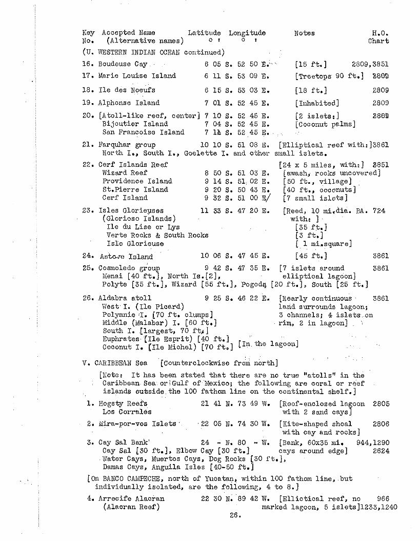
Key Accepted Name Latitude Longitude Notes H.O. No. (Alternative names) o I o I Chart
(U. WESTERN INDIAN OCEAN continued)
16. Boudeuse Cay 6 0 5 S . 5 2 5 0 ~ . - ' . [ 1 5 f t . ] 2809,3851
17. Uarie Louise Island 6 11 S. 53 09 E. [Treetops 90 ft.] 8880
18. I l e des igeufs 6 15 S. 53 03 E. [ l 8 f t . ] 2809
19. Alphcnse Island 7 01 S. 52 45 E. [~nhabi ted] 2809
20. [Atoll-like reef, center] 7 10 S. 52 45 E. [2 i s l e t s : ] 3809 Bijoutier Island 7 04 S. 52 45 E. [Coconut palms] San Francoise Island 7 1% S. 52 45 E. . . . . .
21. Parquhar group 10 10 S. 51 08 E. [E l l i p t i ca l reef with:]3861 North I., South I., Goelette I. and othe? small i s l e t s .
22. Cerf Islands Reef [24 x 5 miles, with:] 8851 Wizard Reef 8 50 S. 51 03 E. [awashj rocks uncovered] Providence Island 9 14 S. 51: 02 E. [50 ft., vi l lage] St.Pierre Island 9 20 S. 50 43 E. [40 f t . , coconuts] Cerf Island 9 32 S. 51 00 E/ [7 small i s l e t s ]
23. I s l e s Glorieyses 11 33 S. 47 20 E. [Reed, 10 mi.dia. BA. 724 (Glorioso Islands) with: ] I l e du Lise or Lys [35 f t . ] Verte Rocks & South Rocks [3 ft.] I s l e Glorieuse [ 1 mi,.square]
24. Astaro Island LO 06 S. 47 45 E. [45 ft.] 3861
25. Cosmoledo group 9 42 S. 47 35 E. [7 i s l e t s around 3861 Menai [40 f t . ] , North Ia.[2], e l l i p t i c a l lagoon] Polyte [35 ft.], Wizard [55 ft.], Pogodq. [20 f t . ] , South [25 f t . ]
26. Aldabra a t o l l 9 25 S. 46 22 E. [Nearly continuous 3861 ltiest. I. ( I l e picard) land surrounds lagoon; Polymnie :I. [70 f t . clumps] 3 channels; 4 islets- . on Middle (Malabar) I. [60 ft.] r i m , 2 i n lagoon] .
South I. .[largest, 70 f t r ] Euphrates. ( I l e Espr i t ) [40 f t . ] . .
Coconut I. [ I l e Michel) [70 f t . ] [ Inthe lagoon1
. . V. CARIBBEAN Sea [Counterclockwise f r & north]
[IL'ote: I t has been s ta ted t h a t there are no t rue "atolls" i n the Caribbean. Sea oriGulf of Nexico; the follornring are coral or reef islands ouhside. the 100 fathom l i n e on the continental shelf . ]
1. Hogsty ~ e e f s 2 1 41 N. 73 49 W. [Reef-enclosed lagoon 2805 LOS ~ o r m l e s with 2 sand cays]
2. ivlira-por-vos I s l e t s ' 22 05 N. 74 30 W. [Iiite-shaped shoal 2806 with cay and rocks]
3. Cay Sal Bank' 24 - N. 80 - 1. [Bank, 60x35 m i . 944,1290 Cay Sal [30 ft.], Elbow Cay [30 ft.] cays around edge] '1
2624 . tJater Cays, Muertos Cays, Dog Rocks [30 f t . ] , Damas Cays, Anguila I s l e s [40-50 f t . ]
[On BANCO CAIdPECHE, north of Yucatan, within 100 fathom l i n e , . b u t individually isolated, are the foliowing, 4 t o 8.1
4. Arrecife Alacran 22 30 N .89 42 Ti. [ E l l i c t i c a l reef , no 966 (ALacran Reef) marked lagoon, 5 islets]1233,1240
26.
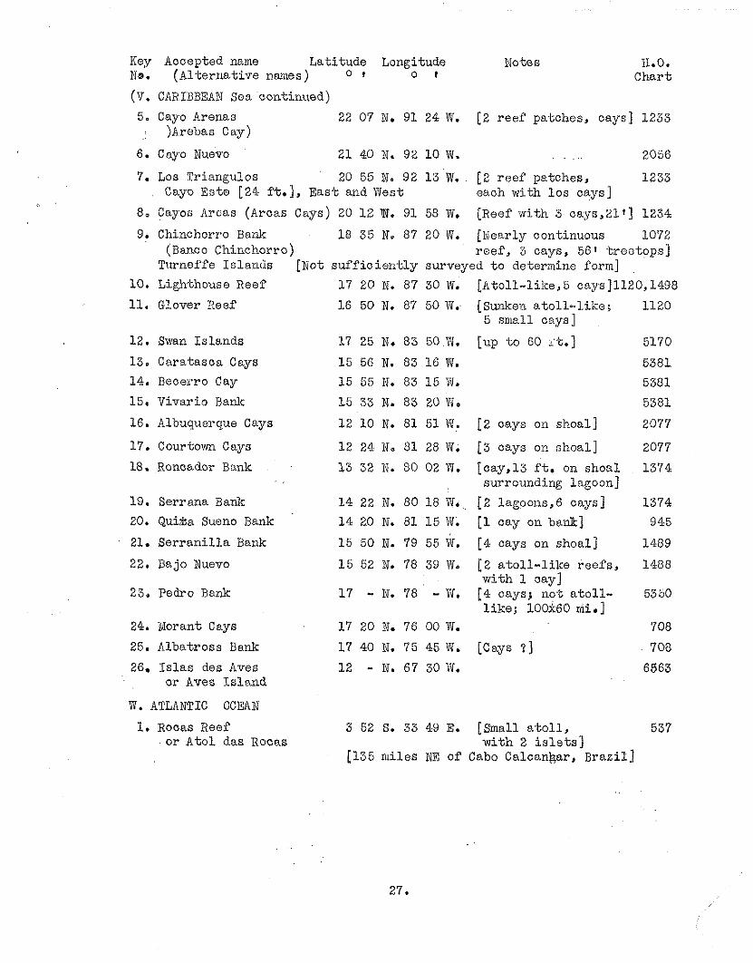
Key Accepted name Lat i tude Longitude Notes 11.0. No. (A1 t e r n a t i v e names ) 0 I o t Char t
(v. CARIBBEAN Sea continued)
5. Cayo Arenas 22 07 N. 91 24 W. [2 r ee f patches, cays] 1233 i )Arebas Cay)
6. Cayo Nuevc 21 40 N. 92 10 W. . . ... 2056
7. Los Triangulos 20 55 N. 92 1 3 W. [2 r ee f patches, 1233 Cayo Este [24 f t . ] , Eas t and West each wCbh 10s cays]
8, Cayos Arcas (Arcas Cays) 20 12 W. 91 58 W. [Reef witn 3 cays,Zlt] 1234
9. ~. Chinchorro Bank 18 35 N. 87 20 IT. [Ncarly continuous 10'72 (Banco Chinchorro) r e e f , 3 cays, 561 t r e e t o p s ]
Turncf'fe I s l ands [sot su f f io i e r i t ly surveyed t o determine form] 10. Lighthouse Reef 17 20 N. 87 30 W. [Atol l - l ike ,5 cays]l120,1498
11. Glover Reef 16 50 N. 87 50 W. [Sunken a to l l - . l i ke ; 1120 5 small cays]
12. Swan I s l ands 17 25 N. 83 50 W. [up t o 60 it.] 5170
13. Caratasca Cays 15 56 N. 83 16 W. 5381 14. Becerro Cay 15 56 N. 83 1 5 W. 5381
15. Vivario Bank 15 33 N. 83 20 W. 5381
16. Albuquerque Cays 12 10 N. 81 51 IT. [2 cays on shoal] 2077
17. Courtcwn Cays 12 24 N. 81 28 W. [ 3 cays on shoal ] 2077
18. Boncadcr Bank 13 32 N. 80 02 W. [cay , l3 f t . on shoal 1374 surrounding lagoon]
19. Serrana Bank 14 22 N. 80 18 V.. [2 lagccns,6 cays] 1374 20. Qui&a Sueno Bank 1 4 20 N. 81 1 5 W. [l cay on b a a ] 945
21. S e r r a n i l l a Bank 15 50 N. 79 55 'if. [4 oays on shoal ] 1489
22. Bajo Nuevo 1 5 52 N. 78 39 W. [2 a t o l l - l i k e r ee f s , 1488 wi th 1 cay]
23. Pedro Bank 1 7 - N. 78 - W. [4 cays; no-t a t o l l - 5350 l i k e ; 100x60 mi.]
24. Norant Cays 17 20 N. 76 00 W. 708
25. Albatross Bank 17 40 N. 75 45 bii. [Cays ? ] 708
26. I s l a s des Aves 12 - N. 67 30 W. 6963 or Aves i s l a n d
W. ATLANTIC OCEXN
1. Rocas Reef 3 52 S. 33 49 E. [Small a t o l l , 537 o r A t c l das R.ocas w i t h 2 i s l e t s ]
[ I35 mi les NE of Cabo Calcanfjar, Braz i l ]
ALPHABETICAL INDEX
Abaiang Island G.13 Abariringa D.32 Abemama Island G.10 Abgaris. Abgarris M.5 Actaeon Islands B.3-6 Addoo, Addu a t o l l S.22 Admiralty Islands N Adventure Island B.54 African Islands U.9 Agalega Islands ' U.3 Agatti Island R.9 Ahe Island B.72 Ahrno Island 11.2 Ahunui Island B.7,B.25 Ailinginae a t o l l H.28 Ailinglapalap a t o l l H.20 Ailu a-toll H.10
' Biluk a t o l l H.10 Airinginae To X. 28 Airingurapurapu To II.20 Airukku To H.10 Aitupu Island F. 5 Akiaki Island B.24 Alacran, Arrecife T.4 Albatross Bank V.25 A.lbatross Island U.1 Albuquerque Cays V.16 Aldabra a t o l l U.g6 Alexander, Gi-and Duke,I. D.15 A l i r n Island Allison Island Alphonse Island Amanu Island Amboengi Ameni Island Amirante:Island Amirante Islands 'Amphitrite Islands Anan Island Anangki Anchorage I s l e t s Anchorite Islands Andema Androth Island Angatau Island Angegul Angelica Shoal Anguila I s l e s Aninima Anne Island Ant a t o l l , Anto To Anu-anuroro Island Anu-anurunga Island Apaiang Island
N. 3 N.18 U.19 B.30 ,
P (note) B.8 u.13 U.9-20 B.3-6 Bb56 5.29 L.12 N.9 5.3 R.10 B.43 5.33 P.4 V.3 J.16 D.3 5.3 Be15 B.14 G.13
Apartarna Island Apataki Island Apia Island Arachecheeff Island Arakcheeff Islands Arakchev Island Aranuka Island Aratika Islaad
.' Arcas, Cayos Archangel [Island] hrceifos Arenas, Cayo Argo Reef A r i a t o l l Arno a t o i l Arorae, Arorai Island Arrecife Alacran Arrowsmith Island Aruno Arutua Island Asia Islands Astove 21and Atafu Island A t 0 1 das Hocas Aua Island Auarua Island Aucutto Island Auotu [Island] Aur atol1,Aurh Island Auripik Aurora Auru To Aurupig Australia, Nf of Aves Island Aves, I s l a s des Avooare Island Avon I s l e s Awin I s l e t Baars Island Bacon Island Bajo Nuevo Baker Island Bampton Reefs Banoo Camoeche Barclay d; Tolley Island Baring a t o l l Barrow Island Bass Reeftied Baxotristo Bay of Batavia Beautemps-Beaupre a t o l l Becerro Cay Bedford Island (? )
28.
G.10 B.66 G.13 B.43 1i.5 B.d-3 G.8 B.62 V.8 B. 1.5 H.33 V.5 K (note) So13 H.2 G . l V.4 H.3 "
H.2 B.67 N , 2 1 U.24 D.24 W"1 N.19 D,16 R.9 D.12 He4 5-30 P (note) H*&' J.30 Q V.26 V.26 u e 2 L-13 N.16 P (note) I< (note) V.22 D.33 L.9 .'
V.4-8 B.47 H.17 Be12 H. 5 5. 6 P (note) L.5 V.14 Be5
Beleapmi Reef R . l Cat0 Island, Reef L.16 Bellinghnusen Island C.5 Cay Sal Bank V.3 Bellona Reefs Benjamin I s l e t Eeanet Island Beru Island Betsy Reef Bigali ' Bigini Bijoutier Island Bikar a t o l l Bikini a t o l l Bird I s land . Birnie Island Bit ra Reef Bligh(s) Island Boddm Island Bonham a t o l l Booby Rrpck Bos tock Island Boston a t o l l Boudeuse Cay Bow Island Bovrditch Island. Bramble Iiaven Brisbane Island Brook, Brook Island Brooks Island Brown a t o l l Brown Islands Buchanan I s l e t Bucker Island Burkey Bunngara Island B lrr Butar i tar i Island Butoig. Butongang Bvm Martin Island - ., Byramgore Reef Byron Island C ~ ~ ~ I . I S Island Calvert Campeche Bunco Candelaria Caiiton Island Caratasca Cays Cargados Carajos Caribbean Sea C arola C 8.y Carlshov Island Caroline Island Caroline Islands Carteret Islands Cartier Island Carysfort Island Cascassage I s l e t Catherine
L.10,11 u112 L.12 G.6 L.6 J. 20 R.31 u* 20 H.14 H.31
B.53rU.5 D. 29 R.4 B.10 T.2 11019 K (note) D.3 He16 U.16 B.29 D.22 1881 P.2
G.5 B . l 11.5 V.4-8 Ivi (note) D.32 V.13
Shoals U.1 . V
Lo20 B.6Z D.1 J M.4 Q.4 B . l l
cayo .Arenas V.5 Cnyo Este V.7 Cay0 Neuvo V.6 Cayos Arcas V.8 Cerf Island, Reef U.22 Chagos Archipelago T Chain Island 19-56 Charia Island R.12 Charlotte Island G.13 Charlotte, Queen B.21 Cherbsniani Reef R . l Chereapani Reef R.2 Chesterfield Reefs L.12 Chetlat Island R.3 Chien I s l e t U.12 Chilcott I s l e t L.24 Chinchorro Bank V.9 Christmas Island D.7 Circular Reef N (note) Cladius Island E.2 Clarence, Duke of, Island D.,23 Clernlont de Tonnere I. B.17 Cleront-Tonnem [ ~ s l a n d ] E.17 Clerk Island G.3 Clerke Island Clerke Reef Clipperton Island Cockburn Islaiid Coeo Islands, Reef Coconut Island Cocos-Beeling Islands Codopuei Coetiyy Island Comerson Islands Conflict Reef Constantine Conway Reef Cook Island G.12 Cook Islands D Cook Lagoon B.23 Coquille H.19,, J.20 Coral Island '2.6 Coral Sea L Coralles, Los V.l Coringa I s l e t s L.24 Cornwallis Island B.35 Cosmoledo group U.25 Cotar Island C.7 Count Iiaiden Island H.8 Courtown Cays V.17 CrescenL Island A.4 Croker Island Be34 Cunberland Island Be27 Cure Island E.5 Current Island 5.36
Damas Cays Danger Island Danger Islands Daniel Island Dapur DsArros Island Dawhaida Island Dawson Deans Island De B r i l Bank De Co-ta Denis, Dennis Island D:Entrecasteaux Reef De Peyster Island Desroches Island Dewakang Besar Dcwalcang iiechil Diamond I s l e t s Diego Gardia Djabwa-t Island Djalui t Djeino Dcg Islemd Dog Rocks Doppel Reef Doubtful Island Douglas Reef Drrunmond Island Ducie Island
V.3 T.4 D.19 H.2 P (note) u.11 B.31 H.14 B.73 Po12 5-18 U* 6 L.7 F.4 U.13 P.13 P.13 L.22 T.6 H.21 H.19 H.9 B.41 V.3 N (note) Be36 1.3 G.4 A.2
Duke of Clarence' Island D.23 Duke of Gloucester Is. B.13-15 Duke of Yark Island D‘ 24 Dunkin J.7 Duperrey, Duperry 5.2,11 drUrville-Insel 5.12 Deour N,19 Eagle Island U.10 Eagle Islands T.4 East a t o l l P (note) East Faiu, East Fayu I. 5.14 :
Eauripik a t o l l 5.30 Ebsn a t o l l H.16 ,
Edam P. (note) Egg- Island . . F.6. Egmont a t h l l :: T .5 Egmont Island . . B.22 Elat, Elath : . &24 Elato a t o l l s J,24 Elbow Cay Vi3 El iza Island Be53 Elizabeth a t o l l : 0.63 Elizabeth Island H.19,N.3 Elizabeth Reef L (note) E l l ioe a t o l l F.3 E l l i ce Islands F Elmore a t o l l H.20
Endabi Enderbury Island Enderby Enaidok Bniwetakku To Eniwetok a t o l l Epon To Equatorial Islands Erato To Erikub a t o l l Erippu To Erukuppu To Escholtz, Eschscholtz Espri t , I l e Este, Cayo Eta1 a to l l , Etaru To Etoi le Cay Euphrates Island Faaite Island Fabre Island Eadiffolu a t o l l Faieu F'ais
5-18 D.31 5-18 H.32 11.32 He32 K.16
D 5.24 He8 H.23 H.6 Be31 U. 26 V. 7 J.9d U.15 U.26 B.57 L.7 5.7 J.14 J (note)
Faiu [see East -, West -1 Faiyao 5.22 Fakaafo Island 0.22 Fakahina Island Be42 F'alcaofu Island D.22 Falcarava a t o l l B.58 Faliau 5.22 Fa1 o c 5.28 Fanaawa Island 5'. 3 Fananou J.13b Fangahina Island B.42 Fangatau Island B.7 Fcngataufa Island Be7 Fanniny, Island D.8 Faraulep, Faraulip a t o l l 5.27, Farquhar group U.21 Farroilap, Fat toi lap 5.27 Fayu [see East -. West -1 Felidu a t o l l 5.15 Fenua I t i D . l l Fenua Ura C.5 p i ji . .' . K
L. F i j i to Coral Sea F l i n t ~ s l a n d ' ' ' ' D.2 Foraulep, Foroilap 5.27' F O & Crowns 0.14 Four Facardins Be23 Fourquet I s l e t U.12 Francis Island G. 6 Fraser 5.3 Frederick Reef L.18 Freewill Islands 5.40 Frigate Island U.1
Fua bhlaku Island S.21 Fugitive Island. C.2 Funafuti F. 3 Furaarappiu Ta J.27 Furneaux Island B.39 Furulcku To 5.28 Gaferut Island 5.26 Gaha Faro [Island] 8.8 Gallows Reef? Mr.5 Gang I s l e t S.19 Gardner Island 0.27 Gaspar Rico H.15 Gcnte Hermosa D.21 Gi lber t Isls.nds G Gisser P (note) Glcrieuses, ISles U.23 Glori.oso Islands U.23 Glouoes-Ler Island B.26 Gloucester, Duke of, 1s-B.13-15 Glover Reef V.11 Goelette Island U.21 Good Hcpe Island B.38 Goram P (note) Gosong Roni P. J Grand Duke Alexmder I. Du15 Great Chagos Baalc T -4 Greenv:ich Islands 5.8 Greig a t o l l B.64 Griuies Island 5-26 Gulf, of Bexioo V Guriinesu To Ja26 Wini t -Li To J.8 Itaddumati a t o l l 8.19 Iialcyon Island I ,1 i ia l l Island G , 1 1 Bali Islands J,13 Roo Island B029 FIaraiki Island B.34' Fiariri Island B.26 IIarp Isla3d B.29
; .X&ve s t J.10 I-Iaug J.19 tiauschauber N.2 Hawaiian Islands E Hayrick Islands N.2 ifagmeister Island Be66 IIeina a t o l l N . l l Relato j.24 Kelen Reef Jm39 Henauke Island B.41 Xenderville Island G.8 IIeo Island L . 5 Herald Beaoon Island L.14 Herald Cays L.25 Rereheretue Island ' ' B. 16 Heren Sho J.39
Heretun [Island] Hermit Islands Hervey Islands Hikueru Island H i t i Island Hog Island Rogsty Reef Ii0k Eiokanhiui Reef lioli; Island Hondon Island Hopper Island Horsburgh a t o l l Hoten R$f Xough IIou-tman 1 s Abrolhos Rowe Island Howland Island Iiudson Island Huiyao l iull Island Iiumphrey Island Hunter Island Huon Island, lagoon Huraarappu To Furd Island IIurukm To Eiuvadu a t o l l Ibbetson Ifalilc a t o l l Ifalouk, Ifaluk If elug, IfeEuk Ihvandiffulu a t o l l I l e de Coin I l e de Sable I l e des Noeufs I l e du Liso, Lys Tle Espr i t I l e lviichel I l e Picard I l e Raphael I l e Tromelin Lle Vaches de Uer Imperieuse Reef Independence Island Indian Ooean, Eastern Indian Ooean, Western Ind.onesia Isdu I s l e t I s l e s Aves I l e s Glorieuses Iur ipik Jabwot Island J a l u i t a t o l l Japan Fayu Jgrvis Island
Jemo Is land H.9 Jennings I s land D.21 J e rv i s Is land D.6 Joan de Wova U. 2 1 Johnston Island D.35 Johnston Is lands N.4 Kabeneyl on J.8 Kabia P (note) Kadogubi 5-36 Kajangle, ~{ajanguki J. 34b Kakab ia P , (note) Kaledoepa, Karang P.5 Kaloe Kalul.cuang P.14 lialpeni Is land R.12 K d p u t i Is land R.9 Kalu Kalulcuang P.14 Kalukuang, Kalu, Raloe P.14 Km Islands . . . . 5-30 ICaniet Is lands hie9 Kapen-~Via.ilnng 5.8 Kapingenlarangi a t o l l J.8 Kapoposang Bali, Kg. P.9 Karang Kaledoepa P. 5 Kardamat Is land R.6 Knrlshoff I s l and B.62 Ko. t a J .l.8 Katharine H.25 Katiu Island B.50 Kaukura a t o l l B.65 Kauehi l s l and B.61 Kavnra-tti I s land R . 1 1 Kavenj Kawen H.5 Kayangel Islands J.34b Kazuanguru J.34b Keeling a - t o l l % 5 Keen Reef L.15 Kemins I s land D.27 Kenti Ole P.5 Kentschikow 11.26 Kg. :[Karang] ( see 2nd word) K i l i I s land . . 11.18 Xi l inai lau Islands . . M.4 Kil tan Is land . " B.5 Kimisisima Shoto ' ' 5.15 Kingclan Reef . . >, ni ioa King's Island " ,' B.60 K i r i To ' ' H.18
. . Knox Is land ' G.12 Kodgubi J.35 Koka, Xwang P,5 '
Kolomadulu a t o l l S.18 Kornikoff Is land D.20 Iioutousoff Is land B.49 Yceis Reef N (note) Krusenstern Is land n.74. Kuezyerin To H.26
Kunto Shoto Kuop a t o l l Kurateke Is land Kure Is land Kuria Island Kurru To :<utusov, Kutusow Kwajalein a t o l l Kwedjelin Laars Is land Laccadive Islands Lae a t o l l Lagopn Island La Harpe Is land Lai a t o l l Lainbert Lmorsu Lamoliaur Ulu, Lamoliork 1,amotrek a t o l l Lamuniur Lnmureck, Lsnurreo Lancier Is land Laskar Island Lassion Island La te i Tonga La te i V i t i Laysan Is land Lazareff Is land L'Echiquie? Le Leizour Is land Leueneuwa Lib Is land Lighthouse &ef Lihon Reef Likieb, Likiep a t o l l L io t Is land Lip Is land Lise, I l e du Lisianski , Lisiansky I. L i t t l e Makin Is land L i t t l e Paternoster Is. Livingston Long Is land Long Reef Loop Island LtOrange Is land Lord Hood(s) ~ s l a n d ' Lord Hovw Is land Lord Howe Islands Lord North Is land Losap a t o l l Los Corrales Los i t a r t i r es Los Reyes Los Triangulos Los Valientes
5.15 J.15 B.12 E.5 G.9 5.33 II.13 11.26 H.26 P.13 R H.24 B.23 B.28 B.24 8.22 5.23 5.33 5-23 J.33 J.23 B.24 E.2 E.2 K (no te ) K (note) E.l 0.75 N.13 L.7: $4.1 R.23 V.10 L.21 B.8 N.17 H.23 U, 23 E.2 G.16 P (note) J.16 L.12 Ml.2 L.12 : B.28 B.O. C .4 M . l 5.38 J e l l V.1 5.17 N (note) v.7 5.5
Lossop-Inseln, Louasaope J.11 Louisiade Archipelago b!' Low Islands B Loyalty Islands L Luangiua M. 1 Luguen 5.18 Lukeisel 5.11 Lukurlor a t o l l J.9b Lukunor-gruppe J-9.. Lumul iu r 3.33 LUtlce Is land , J.14,16 Lydia H.26, 5.20 Lynx Islaad F.7 Ljs, I s l e du U.23 Macaslcill J.l .tAackenzie Islands 3-32 Madjuro Island H.3 Magdelaine Cays L.26 Ivlahlos !$ahdo9 8.5 Ctaiana Island G . l l Edajuro at711 H.3 Nakaenudu a t o l l S.3 iakarama 5.8 Xalcemo Island 0.49 2;Iakin Island G.15,16 iv1a.ki.n Me ang G.16 Idalab8.r Island U.26 Maloom a t o l l 5.3 3alden, Baldon Island. D.5 i'ilaldive Islands S Male a t o l l , Island S.9 Maletin Island W.16 &doelab, Laloelap a t o l l 11.5 Nalosmadulu a t o l l s S.4,5 Menahiki Island D.14 Liangor oagoro Island D.13 d8.nihi Island B.71 Xanihiki Island D.14 Manra Island D025 Manu IsLand Nd8 )!lanuae Island D.12 Xan-dlangi Island B.27 Xapara is land U.2 iiIapia a t o l l .. . 5.40 iviarakei I., i~faraki I. G.14 Marcus is land 1.2 Margaret Island 5.13 Margur e t t a H. 26 idaria Island B.2 , C . 1 iiIarie Louise Island U.17 Marion Reef L.20 &woerappu To H. 5 Mar okau Island B.32 hiarqueen Islands M.3 fdarshall Islands H Niartha IS land A.3
Maruroa Island B 19 Marutea Island [2] B.8,39 Mary, Maxsy Balcout Island D.32 Massachusetts Island $ ~ l a t a l ~ i ~ a , lhtaiwa Island Matelobs Matilda Islsnd Matthew Island Maturei-vavao Maty Island Maura Island Mbukatatanoa Reef IioAskill XcKean Island jde a ty tbfiarang Medjit, ib,eejit Island i ~ i c l b o u r ~ ~ Island Meliel Mellish Reef Helvi l le Island idenai Island Mendana I s 1 and I@enschikof E Mereyon To Iiker i e r , Her ir I slnnd Mermaid Reef ivleziti To ?dIezyuro To Miadi Michaeloff Island ;>dichel, I l e $]!id I s l e t iJiiddle Island i~liddle Bellona Reef . .
Middlebrook Islands ivliddleton Reef Midway Islands Nil la ' dou Madou ivIilladummadulu a t o l l Mili, ibfille, i!!illi a to l l
Ee4 R.75 5.33 13.9 G.14 B.3 N. 20 C.4 K (note) 6.1 D.28 P. 2 H e 1 1 B.3 5.37 L.14 13.35 U*25 1.1 Be26 3.29 5.37 Q (note) H e 1 1 H. 3 M . l l Kc2 U.2G L. 27 11.26 L.11 E . l I , . (note) E .4 S.2 S.2 H. l
hlinami Tori Shima 1.2 Minerva Reefs D-20 (note) Minicoy, Minikoi R.14 Sdinto Island B.4 Nira-por-vos I s l e t s V.2 @i re , M i r i To 13.1 Mitchell island D.18,F.Z ixobidie Island C.4 !Ioearas Reef P.15 NIoerenhout Island B.2 Bogal, ivlokil a t o l l J.2 ihokiru To 5.2 ' -
ivioller Island B.30,E.l iiloluque S.17 Uonteverde 5.7 Monteverdeson 1 s group 5.7
Moore I s l e J.34b Mopelia, Mopihaa Islands C :4 Morane Bland tiorant Cays Noresly channel Morileu Mortloclc Islands Mosley I s l e t Mototokke Shoto Motu Iti, Motu One Motutunga Island ivIouril ell Muaras Reef Dhuer-t,os Cay Mulaku & t o i l Mulgrave Island h r . i l o , W.~?-iro Shoto i:Iuriay I s i e t ?dus gr avo Mus yill o :@lo-cadowi.2ich Island Nagsr Tslnnds Naiad Uai~?ea a t o l l lTma Island N am0 Nmochikku To ii!amoliaour ?hmolipiaf ane Wamolotou i~amoluk a t o l l Namonefeng IL'amonuito a t o l l Namorik a t o l l kamoruldm To Namotikku To Nanolrin-atoll Nmouttek Namu a t o l l Mamurikku To, Namurrek Manuuin Shbto Icanomana Island lvanomea Island Nanouki Island Nanuku Reef Nanimanga Island Nanumea Island Napuka Island Narcissus Island Nassau. Island Natikku To Nelsons Island Nemu .- &engonengo Island Netherland Island
Nevi1 Island 5.38 New Calodonia L Ucw IIebrides L New W antucket Island D.33 New Year Island R.11 1ue.c. York ~ s l a n d D.9 Wgaruangl Reef J.34a Ngatik a t o l l J. 5 Wgele-lovu Island K.7 Ngelu 5-33 Ngkwle-levu Lagoon IC.7 Mgiul, Ngoli, Ngolii 'T.33 Ngolog, Eguiu, Ngoly 5.33 iigulu a k l l J.33 ~ < i m b o Island K.3 Niau s.t>:!.l Be64 Niger.6, 3 ih i ru Island Be40 Nikumar oro D.27 Ni.kimau ;slfind G. 5 Wilundu, 1Wlandoo a t o l l S.14 iqinigo z'toll N.13 NinFgu group N.11-17 Wiulalri~ja F.1 Niutao Xsland F. 7 Noelcori P.l Noelcwendi P (note) Noeufs, I l e des U.18 Nokanhui Reef L.3 Nomoi Islands J.9 Nomwin a t o l l J.13b Xonouti, Nonuti Island G.7 Nororutu Island C.1 North Bampton Reef L. 9 North Cay L.27(etce) North Island U.1,3,9,21 North Islands U.25 Mor-theast Cay L.25 Northern. Cook Islands D North Keeling Q.5 North Nalosmadulu S.4 North IvIarutea Island Be39 Northwest Pacif ic I Nuevo, Cayo I6.6 Nugoru To 5.7 INuguria Islaads M. 5 Nui Island F. G Nukufetau F.4 Wukulaelae F.2 Nukulailai F.2,1i.5 Nukulevu Island K. 5 Bukumanu group M.2 Muicumbalate Island I(. 6 Nukwbasanga I., Reef K.6 Nukunau Island G.5 Nukunono Island D.23 Mukuoro a t o l l 5.7
Nukusemanu I s l a n d K. 5 Nukutaveke I s l a n d B.21 Nuku.tolu K (no te ) Nukutipipi I s l a n d B.13 Nurakita I s l and F.l 0u.itupu Islanc! F. 5 Oatafu I s l and D. 24 Observatory Cay La21(etc. ) Ocean I s l and E.5 Odia a t o l l H. 20 Od jda, Odtia B.7 Oeno I s l a n d A.3 Oleai, Oleei, Olie J.29 Olimarao, Olirfianau I s . J$25 O l l ap 5.17 Olosenga, Olosega D.21 Olutei , O lu t s l J.24 Oilata I s l ands 5.40 One and Half Degree ~ h a n . ~ . 1 9 / 2 0 - Onnmar a i oaon Onotoa I s l a n d Onoun, Onoune Ontong Java Oralilk Ormsbee Oroluk a t o l l Orona I s l a n d Ororu Sho~tn Ororukku To Osnaburgh I s l a n d Otakoo te.ia Otooho I s l and Otor i Jima O t t i l i o n Reefs 0 ~ 1 ~ s i O U l u+.hy Oura I s l and Padaido I s l ands Pagenema Paget Cay Pak Pakin a t o l l Palavmt I s l ands Palmerston I s l a n d Palriyra I s l and Paolo Papialou I s l ands Papakena I s1an.d Paraoa. 1 s land Parece Vela P a s i r Tenaah w
Pasnage Island. pa ternos ter I s l ands P.9 Pa ternos ter , L , i t t l e , I s . P (note) Pam~o t u I s l ands B Peacock I s l a n d ' , . B.72
5.25 J.16 G.3 J.16 i d e l J " 6 P (no te ) J.6 D. 26 J.16 5.6 3.9 D e l l B945 1.1 N (note) 5.29 5.32 B.70 P (note) 5.4 L.20 8 (note) 5.4 111 * 7 D,16 D"10 5.36 igs2 B . 1 1 B,26 1.3 P (note) L.12
Prospect I s l a n d D.9 Providence I s l and Ha33,U.22 Pukapuka (Danger I s l ands ) D.19 Pukapulca I s l a n d B.41 Pukuruha I s l a n d B.10 Pu l 5.36
P e a r l I s l a n d P e a r l and Hermcs Reef Pedder I s l a n d Pedro Bank Pele lap , P e l e l ~ p P e l i c a n I s l e t Pe l1 I s l a n d P e l l e l u c h a t o l l Pe l l e luhu P e l s a r t Penrhyn I s l a n d . .
Per emu1 Par Peros Banhos Peru I s l a n d Pescadore I s lands Pescedores P e t r i e Reef Phaleedoo P h i l l i p I s l a n d h i l l . i p s I s l and Phoebe I s l and Phoenix I s l and Phoenix Is lands Phoovra Boloku Picard, I l e P i g a l i P i g e r o t t o To, Pigoualao Pikaru To P ike la , P i k e l o t 1slan.d Pikiram Pinaki I s l a n d Pingaraupu To Pingelap, Pingoul-p P i r l i I s l a n d P i t t s I s l a n d P l a t t e I s l a n d Poeloe Sa'balana Pogoda I s l a n d Poi-vre I s l a n d s Polca&ku To Pokak ' a t o l l Pokela Po l l ap Poloae, Poloa t , Polowat Polynmie I s l a n d Po1;yte I s l a n d P o s t i l j o n I s l ands Poule I s l e t Poulouo t e Pourappu To Pr ince William Henry I.
Pulap, Pullop a t o l l 5.17 Pulo Anna Islands 5.36' Pulo Marier 5.37 Puluot J.18 Pulusuk Island J.19 Puluwat a t o l l 5-18 Pur 5-36 Purdy Islands Na5 Furu Anna J.36 Pui;tep 5-17 Pyghelia 5-20 Quatro Coronados B.14 Queen Charmotte island. ~ B.21 Quiros Islsnd Dc21 Quita Sueno Bank V.20 Rae To H.24 Rahiroa a t o l l B.73 Rakahanga Island D.15 Ralik chain H.16-33 Rangiroa Island Be73 Raphael, i l e " U-2 Raraka Island R.59 Raroia Island B.47 Rasdu a t o l l S.12 Ratak chain +1-15 Ravahere Island k . 3 1 Raven group J,5 Reao Island B.17 Redlick I s l e t M I - 3 Reef Islands L.1 Reid Island B.51 Reid Reef IC (note) Reirson Island D.15 Reitoru Island B.33 Rekareka Island B.38 Remp J.16 Renard Island i.9 Resolution Island B.37 Resource I s l e t U.12 Rikieppu To H. 8 Rirnski-Xorsakoff Islands X.30 Ronianzoff Island B.68,H.7 R.ornanzow, Romanzov He7 Roncador ivi(note) Roncador Bank (Cay) V.18 Rocas Reef '8.1 Rongelab, Rongelap a t o l l H.30 Rongerik a t o l l H. 29 Rongirikku To B.29 Rongorappu To H.30 Rose a to l l , Island D.20 R O S O P ~ U TO J.11 Ross Islands H.22 Rotcher Island G.2 Rowa Island L.1 Royalist Island, Is. J.11,15 Rukunoru To J.9b
Rukute To riuriok Island Sabalana Islands Ss.baroe Island Sabben Islands Sable I s l e de Sadapur Sae. Islands ~ a . l i l o e s St.hndrew Island St,.Andrew Islands St.Augustine Island St.I)avid Islands St. Jospeh Islands 5t,Pau3. Island St.Pierre Island %.Quentin Island St.Simeon Island Saken Island Sa?., Cay Salomon Islands Sama "group" Yamarang Island Samoa, American S arnus anlu I s 1 and San Andreas San BartoXome Sands Island Sandy I s l e t San Francisoo Island San Francoise Island San Miguel Archangel San Miguel Islands Sanna Island S o n Narciso [Island] San Pablo Island
5.14 B.67 r.ll P.11 1Q.6
C.7,1J-1 P.8 N.10 P.9 5-35 N (note) F.9 Je40 u.12 B.16 u.22 B.34 B.37 B.50 V.3 T.2 D.14 D.10 D.20,21 N.15 J.35 J.19 C . l Q*1,8,3 1.1 U.20 8.15 N (note) L.1 B.19 B.16
San Rafael J.12,N.l Saoedjoeng P. 9 Saok E.19 Sapoeka, Ss.puka Islands P.10 Saraon, Sarol J.51 Sasaon, Satahual J.21 Sats.oan J.9c Sataual, Satavan 5.21 Satawal Island 5-21 Satawan a t o l l J.9c Satawan Island J.21 Sataon J.90 Satoenggoel, Karang P.9 Satouw8.n J.90 Satowal, Satowalairak 5.21 Eia tuwal 5.21 Saugk J.19 Saumarez Reefs L.19 S auuglc J.19 Schanz a t o l l H. 27 Scheug, Sohoog, Sohoug J.19
Sci l ly Islands C.5 Scott Reef Q.3 Searle Island B.18 Second Gay L.20 Sepper Island F.7 Sermata Islands P.2 Serrma Bank V.19 Serrani l la Bank V.21 Seteoel, Setoan J.21 Seven Islands 5.5 Seychelles group U. 5-8 Sheburne Reef N (note) Shukku To 5-19 Sibutu Islands P (note) Simonoff Island K.1 Siren Island U.1 Six Islands T.5 Skiddy 5.10 Slilpth Island H.15 Socu J.19 Soemanga Island Pa11 8% J.19 Solomon Islands, N.of M Sonesor, Songosor . 5.35 Sonsol, Sonsonorol 5.35 Sonsorol Islands 5.35 Sonsoru To 5.35 Sooughe J.19 Sophia Island F.l Sorol a to l l , Sororu To 5.31 Soug, Souk 5.19 South Rellona Reef L.10 Southeast Eamptori Reef L.9 South Island U.3,9,21,25,26 South Male a t o l l S.10 Sou-bh Ma1 osmadulu S.5 South Narutea Island B.8 South Rocks U.23 Southwest I s l e t L.24,25 Souworoff Islands D.17 Sove J.19 Speiden Island F.7 Starbuck Island D.4 Stavers Island D03 Suadiva S.20 Suheli Par R.13 Sumasuma N.15 Suprise Island L.7 Suvadiva a t o l l S.20 Suvarov, Suwarow H.12 Suvarov, Suvdaroff Is. D.17 Suwarrow Islands D.17. Swains Island D.21. Swallow Island D.32 Swan Island V.12 Sydenham Island G.7 Sydney Island D.25
Syukku To Tabiteuea Island Taenga Island :
Tagula Island Tahanea Island Taiaro Island Tainimbeka Taka a t o l l Taka Bond Rat6 Taka Garlarang Takapoto Island Takaroa Island Takume Island Takutea Island Tamana Island Tamatam, Tametam Tampoang Tanu. Taongi Island Tapeteuea Island Tapuaerangi Taputa Island Taputeuea Islnnd Tarawa Island Ta r i t a r i Island Tasman Islands Tatakoto Island Tauere Island Taulalia Island Tchigschagoff Island Teke To Tekokota Island Teku Island Tematangi Island Teme tern Temo Tenararo Island Tenarunga Island Tengah, Pasir Tepoto Island Totuaroa Island Thornton Island Thousand Islands Three Brothers T h m Cap Tiemo To T i l l a dou Matte . .
Tiger, Tijger Island6 Tikahau Island Tikei Island T i l a d m a t i a t o l l Tim0 Timoe Island Tindal Tinnagara Island Tiolcea a t o l l Toau Island
37.
J-19 G 14 B.48 81 1 (note ) H.55 R.60 iC.7 H.12 P.6 P.7 B.70 H.69 B.46 D . 1 1 G.2 5.17 P.9 Me3 He15 G.4 D.8 B.70 G.4 G.12 G.15 if. 2 B.19
H.12 R.36 Be14 13.10 5.17 11.9 Be6 B e 4 P (note) B.45,53 C.2 D.1 P (note) T.4 B.24 H.9 S.2 P.6 Be74 B.68 S.2 H. 9 A.4 H.10 Re9 B.69 Be63
Tobi Island Toddu Island Toelcnng Besi Islands Togobei Togran Islands Tokelau Islands . .
Tokobe Tomini, Gulf of Tong Islands Tongareva Island Totiaroa Island Tracy Island Traver sey Tregrosse I s l e t s Triangul os Tromelin Island Truk [not an a t o l l ] ~ s c h i t ~ & g o f f Tu.motu archipelago Tuanake Island Tubai Island Tucker Tukang Besi Tureia Island TurnefPe Islands Tuvuna- i - ra Tuvuna- i- tholo Udjae Udjolang Ueito. Ujae: a t o l l Ujelang atoS1 Uleaj Uleai, Ulie U l i th i a to l l , Uluthi Ihnaitia Island
5-38 S.11 ,.
Pa 5 5-38 P (note) D 22-24 2-38 P ' lno te ) fi-1 :.
D.13 C.2 F.5 He4 L.23 V.7 u.4 5.15 8.6 B g* 51 CY3 5.21 P.5 B e l l V.9 X a 2 K. 1 H.25 Ha33 5.16 11.25 B.33 5.29 5*32 C.2
Union Islands [Tokelau] D. 22-24 uot to To
. .. .. . . . II.27
Ura a t o l l , . . . B 170 Urushi To '5.32 Ut i r ik a t o l l , H.13 Utorokku To ' 11.13 Uvea a t o l l L.4 Uziran To B.33 Uzyae To H.25 Vaohes de Eer, ILe U.5, Vahanga Island B.5 ' Vahitah,i Island B.23 : .
Vairaatea Island B - 2 2 . Vaitupu Island F.5, Vanavana Island B.12 - .
Vanua hasi K (note) Vatauua Island K.8 . . Vekai Rook K (note - .
Verrange Island U. 2 . . ~. . . ..
Verte Rocks Vincennes Island Vivario Bank 'Vliegen a t o l l VoluntSer Island Vostook, Vostolc Island Wadu Channel liiailangilala Island Wain Island Wake Island, Wakes Warren 3astings Washington Island Viataru Keef Water Cays Waterlandt Island ivatoe, ?Wtu Vie.-tts Wellington Island Western Indian Ocean 'iiestern I s l e t s Wes-t Faiu, Fayu Island West Indies West Island Vfiirlwind Reefs Whitsunday Island William the Fourth Will is I s l e t s Wilsons Island Wittgenstein Island Whzard Island Wizard Reef Wolchonsky Island Wolea, N'oleai a t o l l Wolkonsky Island Woodle Island Vior t h Island IVostock Island Wotho a t o l l vfotje a t o l l , Wotsch Tiottho .Inseln, Wotto To Wozzie .Eo Wreck Reef Viul, wu11 Wrmvulu Island Viytoohee Island Yaruto To Yermaloff Island Yaluto York, Duke of, Island Yoropie, Yorupikku To Yuripik ~andbuis Banks Zaraol Zyabatto To
U.23 Be61 N.15 B.73 D.436 D.3 ~.9/10 He4 N.1G 1.1 5.37 D.9 S.16 V.3 B.71 P (note) $.lo 5.2 u N.8 5.22 V U.26 N (note) Be20 5.3 L.27 Be71 B.58 U.25 u.22 B.46 5.29 8.46 G.9 D.34 De3 33-27 Ha7 H.27 H.7 L.17 . Ja36 N.20 B 044 He19 B.48 5.24 Ds24 5,30 5.30 P.8 5.31 H.21


![Poultry production in the atolls [typescript]](https://img.pdfslide.net/doc/110x75/568bd8db1a28ab2034a4e7ef/poultry-production-in-the-atolls-typescript.jpg)