Embed Size (px)
Citation preview
The University of Sydney, PhD Thesis, Ana Gibbons, 2012 – Chapter 1 – Greater India and West Australia
1
Chapter 1 - Constraining the Jurassic extent of Greater India: tectonic evolution of
the West Australian margin
The University of Sydney, PhD Thesis, Ana Gibbons, 2012 – Chapter 1 – Greater India and West Australia
2
ABSTRACT
Alternative reconstructions of the Jurassic northern extent of Greater India differ by up
to several thousand kilometres. We present a new model that is constrained by revised
seafloor spreading anomalies, fracture zones and crustal ages based on drill
sites/dredges from all the abyssal plains along the West Australian margin and the
Wharton Basin, where an unexpected sliver of Jurassic seafloor (153 Ma) has been
found embedded in Cretaceous (95 My-old) seafloor. Based on fracture zone
trajectories, this NeoTethyan sliver must have originally formed along a western
extension of the spreading centre that formed the Argo Abyssal Plain, separating a
western extension of West Argoland/West Burma from Greater India as a ribbon
terrane. The NeoTethyan sliver, Zenith and Wallaby plateaus moved as part of Greater
India until westward ridge jumps isolated them. Following another spreading
reorganisation, the Jurassic crust resumed migrating with Greater India until it was re-
attached to the Australian plate ~95 Ma. The new Wharton Basin data and kinematic
model place strong constraints on the disputed northern Jurassic extent of Greater India.
Late Jurassic seafloor spreading must have reached south to the Cuvier abyssal plain on
the West Australian margin, connected to a spreading ridge wrapping around northern
Greater India, but this Jurassic crust is no longer preserved there, having been entirely
transferred to the conjugate plate by ridge propagations. This discovery constrains the
major portion of Greater India to have been located south of the large-offset Wallaby-
Zenith Fracture Zone, excluding much larger previously proposed shapes of Greater
India.
The University of Sydney, PhD Thesis, Ana Gibbons, 2012 – Chapter 1 – Greater India and West Australia
3
INTRODUCTION
The original, pre-collision extent of India’s northern margin, known as Greater India,
continues to be poorly constrained despite the many papers written on this topic. Greater
India was part of East Gondwana until the Early Cretaceous. East Gondwana,
comprising India, Africa, Madagascar, Sri Lanka, Australia, Antarctica and other micro-
continents, had a northern margin that was moulded by several major rifting events that
led to the formation of a succession of ancient ocean basins. The PaleoTethys bounded
this margin from the Middle/Late Devonian until the rifting and northward motion of
the Cimmerian Continent in the Early Permian (Metcalfe, 1996). The eventual collision
of Cimmeria led to the subduction of the entire PaleoTethys by the Late Permian. The
cycle was repeated with the MesoTethys following rifting and subsequent collision of
the Lhasa Block in the Late Triassic and Late Jurassic, respectively (Metcalfe, 1996).
Greater India’s northern margin stretching from Africa to East Timor, was finally
formed by Late Jurassic rifting of Argoland (also referred to as the West Burma Block),
shortly before Greater India’s westward migration commenced (Metcalfe, 1996). Most
tectonic models reconstructing East Gondwana breakup feature Greater India, as a
single block, rifting from the West Australian margin (Fig. 1.1). Yet, the estimated
extents for Greater India vary greatly with many different techniques used to constrain
its extent. A thorough summary of the alternative published models is provided by Ali
and Aitchison (2005). We include a short overview and table 1.1 to highlight these
discrepancies.
Seismic data show that the Himalayas are composed of stacked continental crust (Searle
et al., 1987) approximately 75-80 km thick (Hirn, 1988; Li et al., 2009; Teng, 1987),
The University of Sydney, PhD Thesis, Ana Gibbons, 2012 – Chapter 1 – Greater India and West Australia
4
while the Indian crust south of the Himalayas is only about 35 km thick (Zhang et al.,
2007). Models that derive crustal shortening estimates from balancing lithological cross-
sections from the India-Eurasian collision zone, between Himalaya and Tibet, often
result in the smallest estimates for the extent of Greater India, such as 500 km
(Ratschbacher et al., 1994). More crustal shortening is accommodated laterally, into
China (Wang et al., 2001). A pre-collision Greater India extent of only 500 km matches
poorly with the West Australian margin bathymetry as Greater India would not have
reached beyond the Naturaliste Plateau on the southwest edge of Australia (NP, Fig.
1.1), implying that there was no continental crust conjugate to the majority of the West
Australian margin.
Another approach to constrain Greater India’s extent is to look at the timing of collision
between Greater India and Eurasia, but a lack of consensus on this timing has led to a
diverse range of estimated extents. Estimates for the onset of India-Eurasia collision
range from 35 Ma (e.g. Aitchison et al., 2007; Aitchison and Davis, 2004), to 70 Ma
(e.g. Ding et al., 2005; Shi et al., 1996; Willems et al., 1996; Yin and Harrison, 2000).
The proposed 35 Ma collision is based on two distinct collision events: the collision of
an intra-oceanic island-arc with the Eurasian margin around 60-55 Ma (e.g. Acton,
1999; Klootwijk et al., 1991) and the collision of Greater India and Eurasia around 40-
35 Ma (e.g. Patriat and Achache, 1984; Searle et al., 1987). Some proponents of the 70
Ma collision also acknowledge this intra-oceanic arc may have contributed as the earlier
collision (Ding et al., 2005). Changes in convergence rates between India and Eurasia
can also help constrain the timing of their collision (e.g. McKenzie and Sclater, 1971;
Norton and Sclater, 1979; Schlich, 1982; Sclater and Fisher, 1974). Most studies agree
this took place at 50-55 Ma (e.g. Besse and Courtillot, 2002; Molnar and Tapponnier,
The University of Sydney, PhD Thesis, Ana Gibbons, 2012 – Chapter 1 – Greater India and West Australia
5
1975; Patriat and Achache, 1984; Torsvik et al., 2008). A more recent study using
seafloor spreading and plate circuits identified an initial slowdown in India-Eurasia
convergence from around 52 Ma, with a sharper drop at 42 Ma (Cande and Stegman,
2011). A 35 Ma collision requires a Greater Indian extent of ~1200 km, reaching the
Wallaby-Zenith Fracture Zone (WZFZ, Fig. 1.1), while a 55 Ma collision requires a
~2000 km Greater Indian extent, reaching the northern tip of the Exmouth Plateau (EP,
Fig. 1.1), but an extent of ~4000 km would be required for the 70 Ma collision, reaching
well beyond East Gondwana in a Mesozoic reconstruction. The 70 Ma collision
therefore could not have been Greater India but might have been another Gondwana-
derived tectonic block, such as the western extent of Argoland, which rifted from
Gondwana in the Late Jurassic (Heine and Müller, 2005).
Paleomagnetic studies combined with apparent polar wonder paths can show when and
by how much terranes migrated following tectonic events, but the results pertinent to
our study encompass a broad range. For instance, paleomagnetic data from the
Linzizong volcanics (from the Lhasa Block in Southern Tibet) show that the India-
Eurasia collision occurred between 64-44 Ma (Chen et al., 2010), but that the onset of
collision was at 53-49 ± 6 Ma (Liebke et al., 2010), or 46 ± 8 Ma, the latter producing a
total convergence of 2900 km ± 1200 km (Dupont-Nivet et al., 2010). Sun et al. (2010),
argue for a 55 Ma onset of collision resulting in an India-Eurasia combined shortening
of 3400 ± 1150 km, while Tan et al. (2010) date the onset of collision to 43 Ma,
implying a total of ~2000 km of convergence. A Greater Indian extent of 3400 km
would reach well over 500 km beyond the Exmouth Plateau in a Mesozoic Gondwana
reconstruction while 2000 km would reach just into the Exmouth Plateau. Klootwijk et
al. (1992) suggested a distinct reduction in India’s northward motion before 55 Ma
The University of Sydney, PhD Thesis, Ana Gibbons, 2012 – Chapter 1 – Greater India and West Australia
6
based on paleomagnetic data in the Ninetyeast Ridge. Combining this with a
comparison between north Indian margin paleolatitudes and collision-induced
secondary magnetisations, they defined a minimal Greater India extent reaching 1120
km from the Indian-Himalayan main boundary thrust (MBT), which includes 470 km of
cumulative crustal shortening across the Himalayas. This minimal extent of Greater
India would have reached the WZFZ. Within comparison, van Hinsbergen et al. (2011)
suggest a vast Greater Indian extent based on continental collision at 50 Ma and 650-
1050 km of intra-Asian shortening (north of the Himalayas), necessitating subduction of
extensively thinned continental crust for a prolonged period of time. An even greater
extent for Greater India has been proposed by Johnson (2002), who summarised existing
magnetic anomaly, paleomagnetic and volumetric balancing studies, finding that the
total convergence between India and Eurasia was 1800-2100 km in the west, 2475 km in
the centre and 2750-2800 km in the east, which outlines a wedge-shaped Greater India
that reached over 500 km beyond the northern tip of the Exmouth Plateau.
Another way to constrain the extent of Greater India is to use the morphology of the
Western Australian margin. The relatively undeformed morphology of the ocean basins
along the West Australian margin offers an abundance of constraints to apply to the
problem of Greater India, such as the Cape Range and Wallaby-Zenith Fracture Zones
or continental fragments such as the Wallaby and Naturaliste Plateaus (Fig. 1.1). In the
context of a reconstructed Mesozoic East Gondwana reconstruction, Ali and Aitchison
(2005) proposed that Greater India must have reached to the WZFZ, the equivalent of at
least 950 km north of where the Himalayas currently meet India. Lee and Lawver
(1995) also used West Australian bathymetry to propose that Greater India originally
reached the northern tip of the Exmouth Plateau. Even using a combined approach can
The University of Sydney, PhD Thesis, Ana Gibbons, 2012 – Chapter 1 – Greater India and West Australia
7
result in different estimates for Greater India. For instance, Powell et al. (1988), using
bathymetric and palaeomagnetic data, as well as Tibetan underplating, proposed a
Greater India extent of 1500 km, extending roughly to the Cape Range Fracture Zone
(CRFZ, Fig. 1.1). Yet, no studies have attempted to combine the morphological
evidence offshore West Australia with a regionally-constrained plate tectonic model.
The University of Sydney, PhD Thesis, Ana Gibbons, 2012 – Chapter 1 – Greater India and West Australia
8
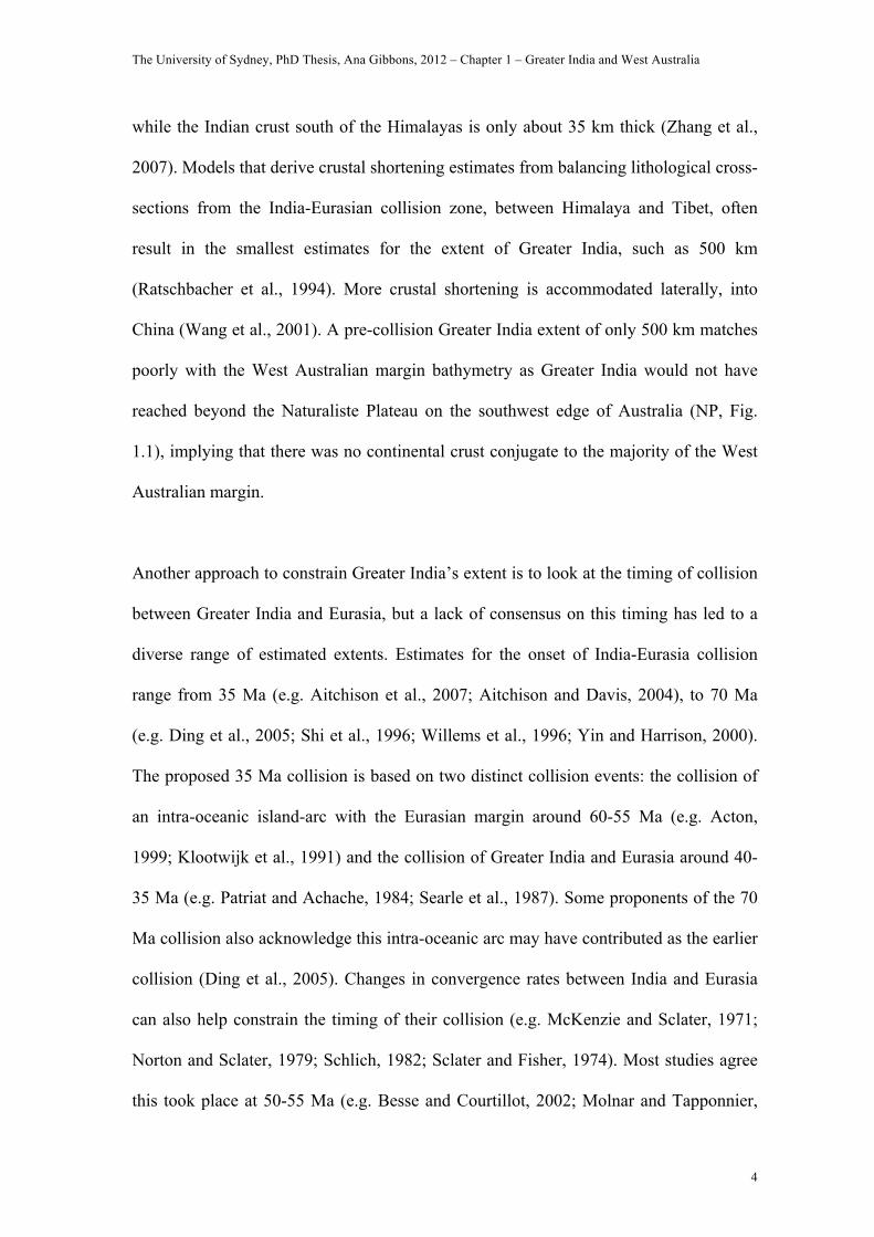
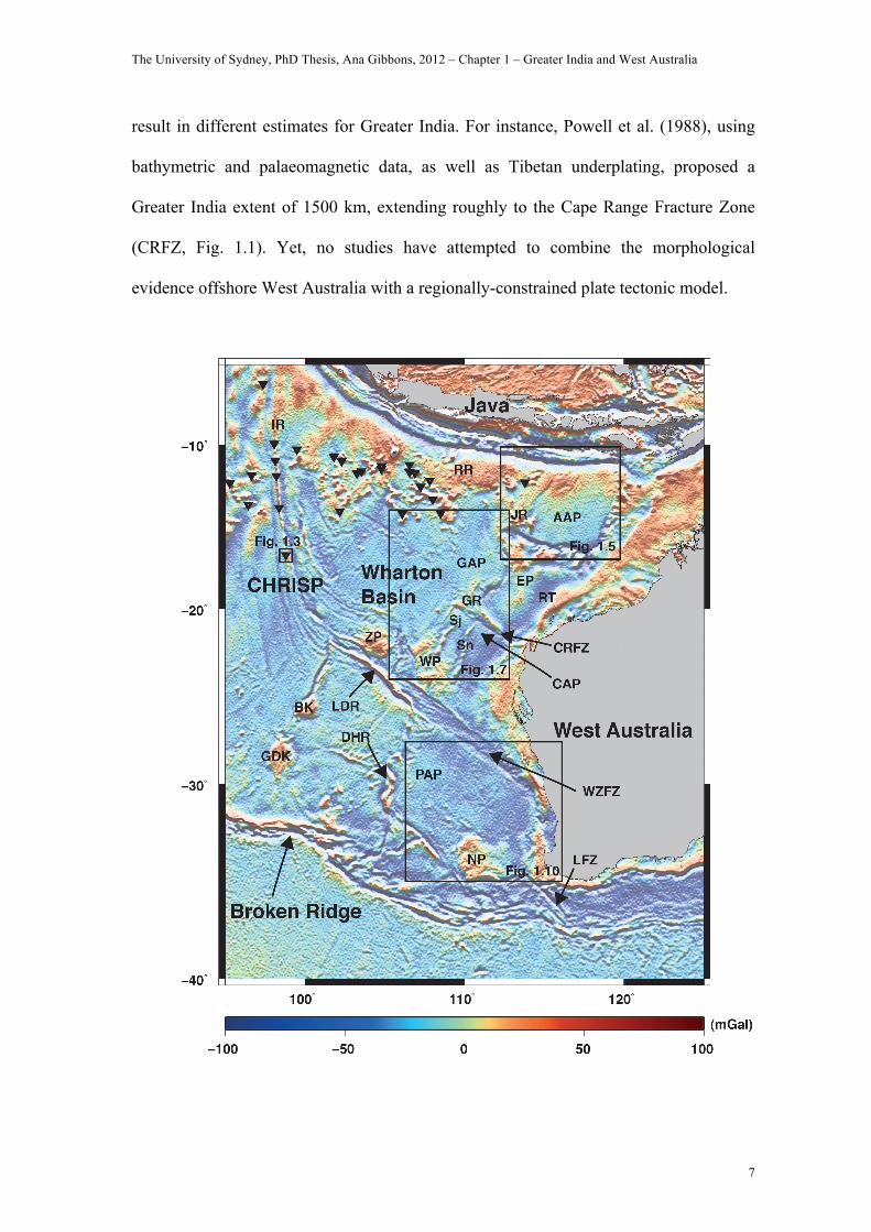
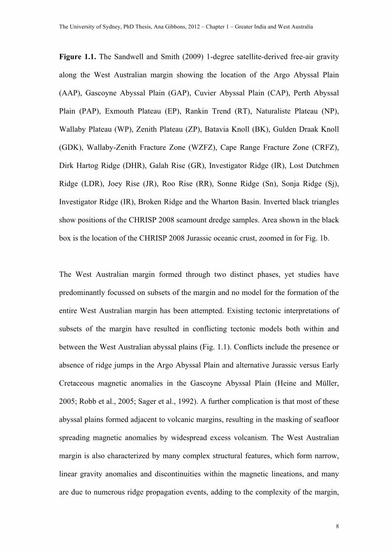
Figure 1.1. The Sandwell and Smith (2009) 1-degree satellite-derived free-air gravity
along the West Australian margin showing the location of the Argo Abyssal Plain
(AAP), Gascoyne Abyssal Plain (GAP), Cuvier Abyssal Plain (CAP), Perth Abyssal
Plain (PAP), Exmouth Plateau (EP), Rankin Trend (RT), Naturaliste Plateau (NP),
Wallaby Plateau (WP), Zenith Plateau (ZP), Batavia Knoll (BK), Gulden Draak Knoll
(GDK), Wallaby-Zenith Fracture Zone (WZFZ), Cape Range Fracture Zone (CRFZ),
Dirk Hartog Ridge (DHR), Galah Rise (GR), Investigator Ridge (IR), Lost Dutchmen
Ridge (LDR), Joey Rise (JR), Roo Rise (RR), Sonne Ridge (Sn), Sonja Ridge (Sj),
Investigator Ridge (IR), Broken Ridge and the Wharton Basin. Inverted black triangles
show positions of the CHRISP 2008 seamount dredge samples. Area shown in the black
box is the location of the CHRISP 2008 Jurassic oceanic crust, zoomed in for Fig. 1b.
The West Australian margin formed through two distinct phases, yet studies have
predominantly focussed on subsets of the margin and no model for the formation of the
entire West Australian margin has been attempted. Existing tectonic interpretations of
subsets of the margin have resulted in conflicting tectonic models both within and
between the West Australian abyssal plains (Fig. 1.1). Conflicts include the presence or
absence of ridge jumps in the Argo Abyssal Plain and alternative Jurassic versus Early
Cretaceous magnetic anomalies in the Gascoyne Abyssal Plain (Heine and Müller,
2005; Robb et al., 2005; Sager et al., 1992). A further complication is that most of these
abyssal plains formed adjacent to volcanic margins, resulting in the masking of seafloor
spreading magnetic anomalies by widespread excess volcanism. The West Australian
margin is also characterized by many complex structural features, which form narrow,
linear gravity anomalies and discontinuities within the magnetic lineations, and many
are due to numerous ridge propagation events, adding to the complexity of the margin,
The University of Sydney, PhD Thesis, Ana Gibbons, 2012 – Chapter 1 – Greater India and West Australia
9
though these features can also give clues as to the margin’s formation. Understanding
the temporal and spatial evolution of all the West Australian abyssal plains is crucial for
accurately constraining the extent and kinematic history of Greater India and other
blocks that rifted from the West Australian margin. Considering both local and regional
constraints, we build a tectonic reconstruction for the separation of Australia and India
that satisfies all the available constraints along this margin and fully links the Jurassic
and Cretaceous spreading episodes. We develop a dynamic, continuous plate tectonic
model for the formation of the West Australian Abyssal Plains by integrating (i)
recently collected magnetic shiptrack data with existing magnetic datasets, (ii) our
interpretations of fracture zones, pseudofaults (age discontinuities from ridge jumps),
extinct ridges and microcontinental rafts, and (iii) regional plate tectonic constraints
from the neighbouring Gondwana-derived continental blocks and local microblocks.
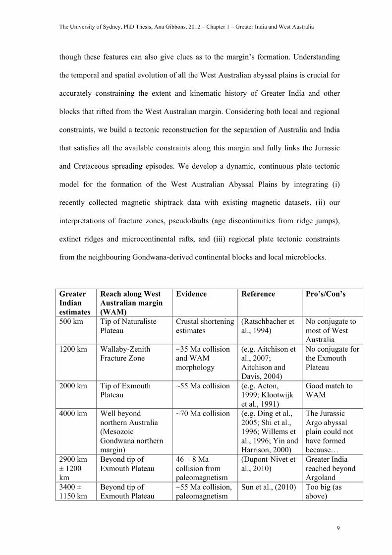
Greater Indian estimates
Reach along West Australian margin (WAM)
Evidence Reference Pro’s/Con’s
500 km Tip of Naturaliste Plateau
Crustal shortening estimates
(Ratschbacher et al., 1994)
No conjugate to most of West Australia
1200 km Wallaby-Zenith Fracture Zone
~35 Ma collision and WAM morphology
(e.g. Aitchison et al., 2007; Aitchison and Davis, 2004)
No conjugate for the Exmouth Plateau
2000 km Tip of Exmouth Plateau
~55 Ma collision (e.g. Acton, 1999; Klootwijk et al., 1991)
Good match to WAM
4000 km Well beyond northern Australia (Mesozoic Gondwana northern margin)
~70 Ma collision (e.g. Ding et al., 2005; Shi et al., 1996; Willems et al., 1996; Yin and Harrison, 2000)
The Jurassic Argo abyssal plain could not have formed because…
2900 km ± 1200 km
Beyond tip of Exmouth Plateau
46 ± 8 Ma collision from paleomagnetism
(Dupont-Nivet et al., 2010)
Greater India reached beyond Argoland
3400 ± 1150 km
Beyond tip of Exmouth Plateau
~55 Ma collision, paleomagnetism
Sun et al., (2010) Too big (as above)

The University of Sydney, PhD Thesis, Ana Gibbons, 2012 – Chapter 1 – Greater India and West Australia
10
2000 km Tip of Exmouth Plateau
~43 Ma collision, paleomagnetism
Tan et al., (2010) Good match
1120 km Almost to the Wallaby-Zenith FZ
Reduced plate motion ~55 Ma, paleomagnetism
Klootwijk et al., (1992)
No conjugate for Exmouth Plateau
1800-2800 km
Wedge-shaped Greater India reaching beyond East Gondwana (wider in the east)
Magnetic anomalies, paleomagnetism, volumetric balancing
Johnson (2002) Too big for WAM (beyond the Jurassic Argo Abyssal Plain)
1500 km To Cape Range FZ Bathymetry and paleomagnetism
Powell et al., (1988)
No conjugate for the Exmouth Plateau
Table 1.1. Summary of previously proposed extents for Greater India, including
comparisons with our Mesozoic Gondwana reconstruction.
GEOLOGICAL SETTING AND PREVIOUS WORK
The West Australian margin and its adjacent abyssal plains make up the
physiogeography of the eastern Indian Ocean (Heezen and Tharp, 1965). This passive
margin runs from the Java-Sunda subduction zone in the north to Broken Ridge in the
south and includes the Argo, Gascoyne, Cuvier and Perth Abyssal Plains (Fig. 1.1).
Much of the conjugate seafloor located offshore Greater India has now been consumed
by subduction/collision beneath Eurasia and Southeast Asia. The remaining seafloor
offshore Western Australia is riddled with tectonic anomalies such as seamounts,
volcanic plateaus and continental rafts.
The Argo Abyssal Plain, at roughly 600 km across and 5.7 km deep, is situated at the
northern tip of the West Australian margin. It is an almost featureless expanse of old
ocean floor bordered by submerged continental horsts, grabens and half-grabens from
The University of Sydney, PhD Thesis, Ana Gibbons, 2012 – Chapter 1 – Greater India and West Australia
11
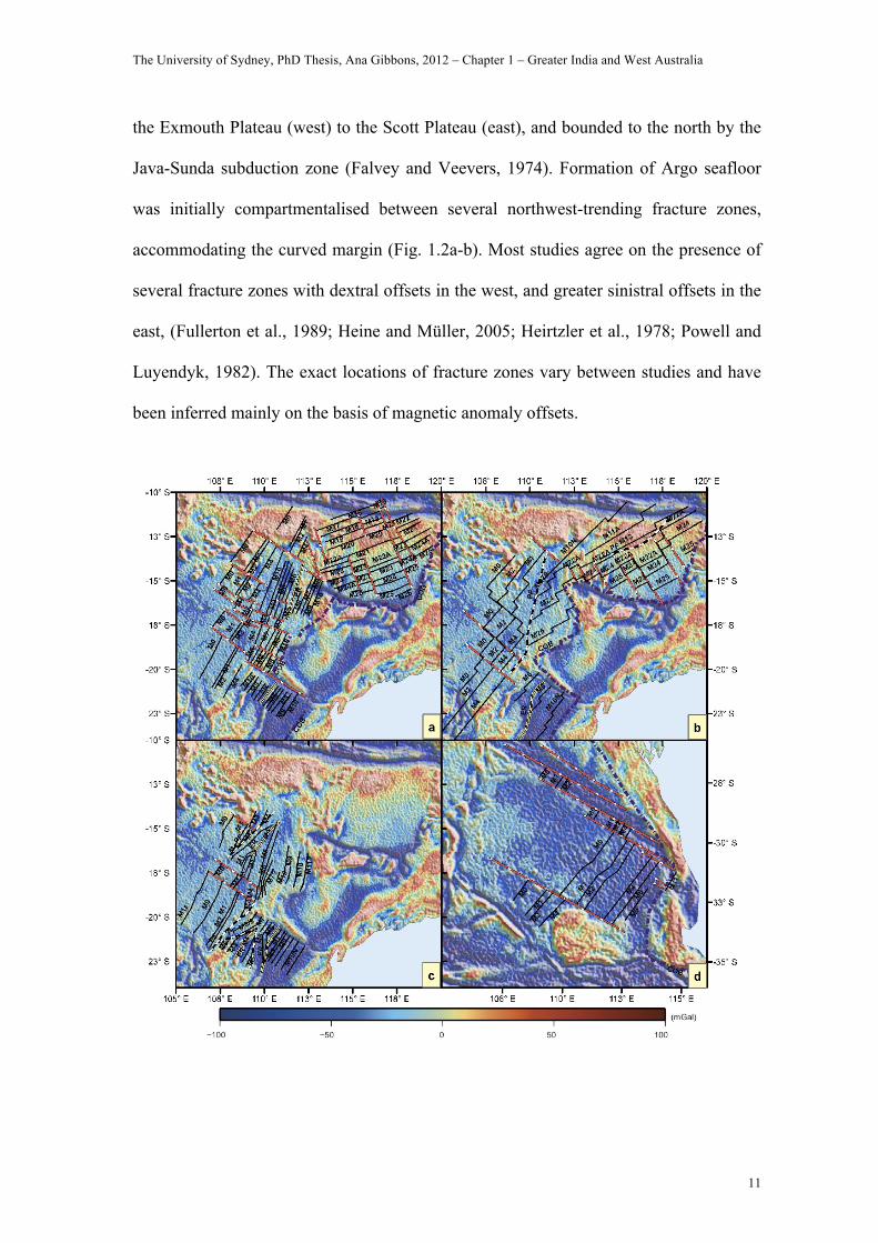
the Exmouth Plateau (west) to the Scott Plateau (east), and bounded to the north by the
Java-Sunda subduction zone (Falvey and Veevers, 1974). Formation of Argo seafloor
was initially compartmentalised between several northwest-trending fracture zones,
accommodating the curved margin (Fig. 1.2a-b). Most studies agree on the presence of
several fracture zones with dextral offsets in the west, and greater sinistral offsets in the
east, (Fullerton et al., 1989; Heine and Müller, 2005; Heirtzler et al., 1978; Powell and
Luyendyk, 1982). The exact locations of fracture zones vary between studies and have
been inferred mainly on the basis of magnetic anomaly offsets.
The University of Sydney, PhD Thesis, Ana Gibbons, 2012 – Chapter 1 – Greater India and West Australia
12
Figure 1.2: Comparison of previous magnetic anomaly, fracture zone and continent-
ocean boundary (COB) interpretations of the Abyssal Plains offshore Western Australia,
overlain on 1-degree satellite-derived free-air gravity (Sandwell and Smith, 2009) for
the Argo, Gascoyne and Cuvier Abyssal Plains: (a) Fullerton et al., 1989; (b), Heine and
Müller, 2005; (c), Robb et al., 2005; and Perth Abyssal Plain: (d) Markl 1974. Red
dashed lines indicate fracture zones, black lines indicate isochrons, purple dashed lines
indicate COB, black and white lines indicate pseudofaults (PF), yellow lines indicate
extinct ridges (ER). Isochrons are identified in black lettering.
Cenozoic magnetic anomalies C32-C24 (71-52 Ma), were initially identified in the Argo
Abyssal Plain trending at 60° (Falvey, 1972), but they were revised to the Mesozoic
after ODP Site 261 revealed a basement age of 152 Ma (Heirtzler et al., 1978; Veevers
et al., 1974). The first study to link the Argo spreading system to those to the southwest
proposed a southward ridge jump in only the western Argo at 136 Ma (essentially over
the Joey Rise), forming a triple junction, though this resulted in a large offset between
the Argo and Gascoyne anomalies (Powell and Luyendyk, 1982). Following the
acquisition of new aeromagnetic data, Fullerton et. al., (1989), identified chrons M25-
M15 (155-138 Ma, Fig. 1.2a), as a continuous sequence throughout the Argo Abyssal
Plain. Heine and Müller (2005) proposed a southward ridge jump at 136 Ma (chron
M14) over the north Argo Abyssal Plain, identifying a pseudofault following a high-
amplitude (-500nT) magnetic anomaly and prominent positive gravity anomaly near the
Sunda Rise. They also linked the Argo to the Gascoyne by extending the Argo Jurassic
anomalies M25-M22A around the Exmouth Plateau, juxtaposing them with anomalies
M6-M0 along a pseudofault that is not visible in the marine gravity grid (Fig. 1.2b).
The University of Sydney, PhD Thesis, Ana Gibbons, 2012 – Chapter 1 – Greater India and West Australia
13
Marking the western limit of the Argo Abyssal Plain is the Joey Rise, a set of almost
equally spaced volcanic ridges splaying north from the northwest tip of the Exmouth
Plateau, a platform of stretched and intruded continental crust composed of northeast-
oriented, subsided segments (Falvey and Veevers, 1974). The Exmouth Plateau marks
the eastern boundary of the Gascoyne Abyssal Plain, another smooth expanse of old
ocean floor with some seamounts in the north and a volcanic complex underlying the
Galah Rise further east (Rey et al., 2008). Fullerton et. al. (1989) identified conjugate
anomalies M10-M4 (130-127 Ma) reflected about an extinct ridge, with curving fracture
zones to account for the converging younger anomalies M4-M0 (126-120 Ma) further
west (Fig. 1.2a). This convergence is better explained by Robb et al. (2005), who
proposed a dominant southward propagating ridge, originating west of the Joey Rise,
that trapped conjugate anomalies M4-M2 (126-124 Ma), as the spreading centre
propagated south (Fig. 1.2c). This interpretation abandoned the conjugate series in the
eastern Gascoyne and did not attempt to link it with the Argo spreading system, having
not extended their study to that area. The Cape Range Fracture Zone (CRFZ), at the
southern end of the Exmouth Plateau, marks the north of the Cuvier Abyssal Plain,
which contains two north-striking linear features: the Sonne and Sonja Ridges (Fig. 1.1).
The Sonne Ridge is interpreted as an extinct spreading centre reflecting anomalies M11-
M5 (132-127 Ma) about its axis, while the Sonja Ridge is a pseudofault resulting from
the westward ridge jump (Mihut and Müller, 1998). Other magnetic anomaly studies
had similar results identifying conjugate anomalies M10-M5 (130-127 Ma) about the
Sonne Ridge and chron M4 as the oldest anomaly in the southern Gascoyne following a
westward ridge jump (Fullerton et al., 1989; Robb et al., 2005; Sager et al., 1992). Only
Robb et al., (2005), identified both the Sonja and Sonne as extinct ridges, resulting from
a duelling ridge scenario with anomalies M4-M6 and M10-M5 about their respective
The University of Sydney, PhD Thesis, Ana Gibbons, 2012 – Chapter 1 – Greater India and West Australia
14
axes. Further south, the Zenith and Wallaby Plateaus comprise the southern portions of
the Gascoyne and Cuvier Abyssal Plains, respectively. Dredging between the Wallaby
Plateau and the margin yielded tholeiitic basalts (von Stackelberg et al., 1980), a
product of oceanic ridges. Only one study identified magnetic anomalies M14-M11
(136-132 Ma), east of the Wallaby Plateau (Mihut and Muller, 1998). Seismic studies of
the Wallaby Plateau suggest a non-volcanic basement core modified by magma from
seafloor spreading (Borissova, 2002). Planke et al., (2002), reviewing seismic and
dredge data, proposed that both the Wallaby and Zenith Plateaus have continental cores
that were intruded by magmatic rocks emplaced by rift propagation events during the
breakup. More evidence of continental material was presented by Nelson et al., (2009)
who reported that dredge samples, south of the Wallaby Plateau, included volcanic
rocks showing variability in their silica content, as well as several terrigenous clastic,
fossil-rich rocks, which were likely deposited when a portion of the plateau was near or
above sea-level. Fossil assemblages dredged from the southern plateau, including
Oxfordian-Kimmeridgian foraminifera, date to between the Late Berriasian to
Berremian-Aptian, suggesting a pre-breakup sedimentary section exists (Stilwell et al.,
2012).
The Gascoyne and Cuvier Abyssal Plains, and their plateaus, are terminated to the south
by the 2000 km-long Wallaby-Zenith Fracture Zone (WZFZ), which has an unusually
large width (~200 km) and is composed of several smaller offset ridges oriented at acute
angles to its southern edge (Nelson et al., 2009). The WZFZ marks the northern limit of
the Perth Abyssal Plain, within which there are several major tectonic features,
including the Naturaliste Plateau, Lost Dutchmen Ridge, Dirk Hartog Ridge, and the
Batavia and Gulden Draak Knolls (Fig. 1.1). The Naturaliste Plateau, next to the
The University of Sydney, PhD Thesis, Ana Gibbons, 2012 – Chapter 1 – Greater India and West Australia
15
southernmost portion of the West Australian margin, has been identified as stretched
continental crust with intrusions from seafloor spreading (Symonds et al., 1998).
Samples from the Naturaliste Plateau contain reworked Mesoproterozoic crust with
affinities to the Albany-Fraser-Wilkes orogenic rocks of Australia and Antarctica
(Halpin et al., 2008). The crustal nature of the other anomalous features still remains
unclear due to a lack of investigation. The magnetic anomalies in the Perth Abyssal
Plain have been interpreted as M11-M0 (132-120 Ma), with M4-M0 (126-120 Ma)
offset dextrally southwest of the Naturaliste Plateau (Johnson et al., 1980; Markl, 1974,
1978; Veevers et al., 1991), Fig. 1.2d. The remainder of the Perth Abyssal Plain was
created during the Cretaceous Normal Superchron (CNS). The Wharton Basin,
northwest of the Zenith Plateau, contains a remarkable set of curved fracture zones (Fig.
1.1), which have been linked to the 100 Ma spreading reorganisation when the Indian
Ocean’s seafloor spreading ridges were realigned from trending 20 degrees to 90
degrees, so that Greater India could migrate north (Müller et al., 2000; Veevers, 2000).
These curved fracture zones have yet to be replicated in a tectonic model.
METHODOLOGY AND DATA
We formulate a new plate tectonic model for the breakup and early spreading history
between India and Australia using the oceanic crust offshore the West Australian
margin. This area provides numerous constraints, such as seafloor spreading magnetic
anomalies, fracture zones, extinct spreading ridges, pseudofaults, oceanic plateaus and
seamounts, with which we can define our tectonic blocks and their migration. We use
the satellite-derived gravity anomaly grid of (Sandwell and Smith, 2009) to interpret
fracture zones and features formed as a result of spreading reconfigurations, such as
The University of Sydney, PhD Thesis, Ana Gibbons, 2012 – Chapter 1 – Greater India and West Australia
16
extinct ridges and pseudofaults (a raised ‘step’ in the seafloor where a new ridge began
forming in older oceanic crust). Pseudofaults are visible as subtle differences in gravity
and magnetic anomaly strength between areas of the ocean floor, while extinct ridges
can appear as linear features and/or give an axis of symmetry in the magnetic anomalies.
Fracture zones are perceptible as linear negative gravity anomaly features. We also
identify areas of anomalous oceanic crust, which may be volcanic features or
continental rafts.
Tectonic outlines and micro-blocks
The Naturaliste, Wallaby and Zenith Plateaus, and Gulden Draak and Batavia knolls
(Fig. 1.1), may have been micro-continental blocks transferred to the Australian plate
during separate ridge jumps. The Wallaby Plateau was recently found to have a pre-
breakup sedimentary section (Stilwell et al., 2012), suggesting continental affinities,
while the Zenith Plateau appears a good fit to the western outline of the Wallaby but has
yet to be investigated. The Naturaliste Plateau has been identified as stretched
continental crust with intrusions from seafloor spreading (Borissova, 2002). We test
their fit in a Mesozoic reconstruction and define their boundaries using features
identified in the marine gravity grid. We take the WZFZ as the southern limit of the
Zenith and Wallaby Plateaus, and the CRFZ and Sonne ridge for the northern and
eastern limits of the Wallaby Plateau, respectively. The Wallaby Plateau’s western limit
is constrained by the location of the oldest magnetic anomalies we identify in the
southern Gascoyne Abyssal Plain. Batavia and Gulden Draak Knolls, if continental
rafts, would have originally abutted the Naturaliste Plateau, given the fracture zone
constraints, while Greater India’s eastern margin would have remained juxtaposed to the
The University of Sydney, PhD Thesis, Ana Gibbons, 2012 – Chapter 1 – Greater India and West Australia
17
west side of the Knolls, until their transferral to the Australian plate several million
years later. We identify the linear feature running west of the Knolls as a pseudofault
resulting from this transferral. Where there are no other constraints available, we pick
the COB using anomaly contrasts in the marine gravity grid (e.g. Naturaliste, Zenith,
East Knolls). We outline Australia’s northwest continent-ocean boundary (COB)
according to published interpretations north (Borissova, 2002; Müller et al., 2005), and
south (Brown et al., 2003), of the WZFZ (dashed line Fig. 1.5).
Seafloor spreading magnetic anomalies
We analyse GEODAS (Geophysical Data System) data from of the National
Geophysical Data Centre (NGDC), and new magnetic profiles acquired during the
August-September 2008 IFM-Geomar CHRISP research cruise. All magnetic shiptrack
data were smoothed by highpass (300 km) and lowpass (10 km) filters to remove
electromagnetic disturbances and noise. We make magnetic anomaly identifications for
the Argo, Gascoyne, Cuvier and Perth Abyssal Plains by comparing magnetic anomalies
from selected ship-track profiles against a synthetic model of seafloor spreading created
using Modmag (Mendel et al., 2005). Table 1.2outlines the parameters used for the
synthetic models. We use the combined timescale of Cande and Kent (1995) and
Gradstein et al. (1994). We pick the young end of the normal polarity for Mesozoic
magnetic anomalies: 26 (155 Ma), 25 (154.1 Ma), 24B (153.5 Ma), 24 (152.1 Ma), 23
(150.7 Ma), 22A (150.4 Ma), 22 (148.1 Ma), 21 (146.7 Ma), 12A (135 Ma), 11A (133.3
Ma), 11 (132.1 Ma), 10N (130.8 Ma), 10 (130.2 Ma), 9 (129.5 Ma), 8 (128.9 Ma), 6
(128.2 Ma), 4 (126.7 Ma), 2 (124 Ma), 0 (120 Ma). See Fig. 4 for the stacked plots of

The University of Sydney, PhD Thesis, Ana Gibbons, 2012 – Chapter 1 – Greater India and West Australia
18
our interpretation of selected tracks compared to our synthetic model for each abyssal
plain.
Parameters Argo Abyssal Plain Gascoyne/Cuvier/Perth
Spreading direction/profile
azimuth:
155 degrees 110 degrees
Spreading full-rate: 100 mm/yr after 136 Ma
70 mm/yr before 136 Ma
70 mm/yr
Axis (ridge) jump: 390 km south at 136 Ma n/a
Depth of the magnetized
layer:
6 km 6 km
Thickness of the
magnetized layer:
0.5 km 0.5 km
Magnetization on (and off)-
axis:
10 A/m 10 A/m
Magnetic field declination: 1 degrees -1 degrees
Magnetic field inclination: -46 degrees -55 degrees
Table 1.2. Parameters used for the Modmag synthetic block models (Gradstein et al.,
1994; Mendel et al., 2005).
The University of Sydney, PhD Thesis, Ana Gibbons, 2012 – Chapter 1 – Greater India and West Australia
19
40Ar/39Ar dating of CHRISP samples
Dredging during the August-September 2008 IFM-Geomar CHRISP research cruise in
the Wharton Basin recovered many samples for dating. One sample of volcanic glass,
dredged from the flank of the Investigator Ridge (Fig. 1.1 and 1.3), was found to have a
Jurassic age given the following procedure.
Fresh basalt glass fragments from dredged rock sample SO199-DR-30-1 were
handpicked, crushed, sieved split (250-500µm), washed, and cleaned using an ultrasonic
disintegrator. The glass separate was lined by cadmium foil and irradiated at the 5-MW
reactor of the GKSS Research Center (Helmholtz-Zentrum Geesthacht, Germany). The
neutron flux was monitored using Taylor Creek Rhyolite Sanidine (TCR-2: 27.87 ± 0.04
Ma); (Lanphere and Dalrymple, 2000). 40Ar/39Ar laser step-heating analyses were
carried out using a 20W SpectraPhysics Argon-Ion laser and an MAP 216 series noble
gas mass spectrometer. Argon isotope ratios from mass spectrometry were corrected for
mass discrimination, background and blank values, J-value gradients, and interfering
neutron reactions on Ca and K.
The University of Sydney, PhD Thesis, Ana Gibbons, 2012 – Chapter 1 – Greater India and West Australia
20
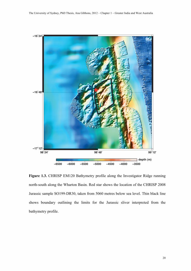
Figure 1.3. CHRISP EM120 Bathymetry profile along the Investigator Ridge running
north-south along the Wharton Basin. Red star shows the location of the CHRISP 2008
Jurassic sample SO199-DR30, taken from 5060 metres below sea level. Thin black line
shows boundary outlining the limits for the Jurassic sliver interpreted from the
bathymetry profile.
depth (m)
The University of Sydney, PhD Thesis, Ana Gibbons, 2012 – Chapter 1 – Greater India and West Australia
21
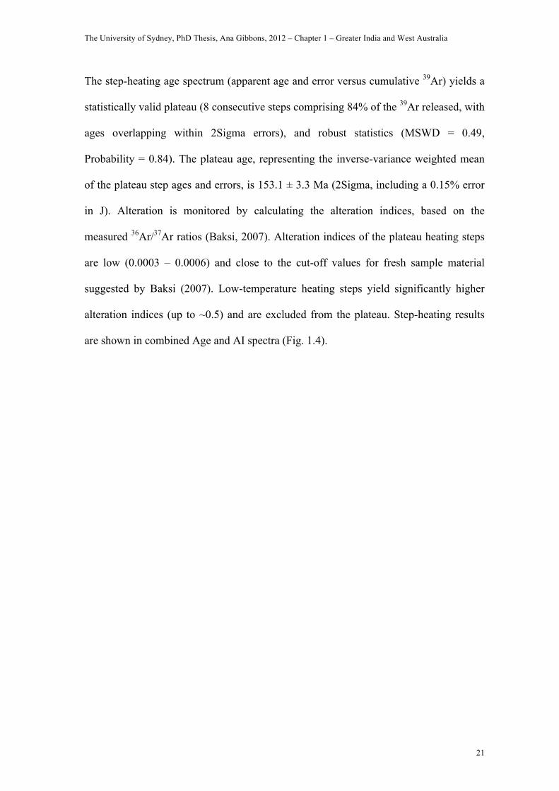
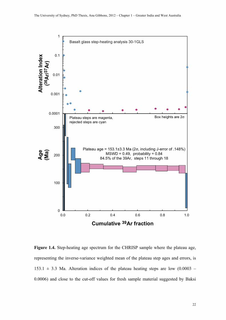
The step-heating age spectrum (apparent age and error versus cumulative 39Ar) yields a
statistically valid plateau (8 consecutive steps comprising 84% of the 39Ar released, with
ages overlapping within 2Sigma errors), and robust statistics (MSWD = 0.49,
Probability = 0.84). The plateau age, representing the inverse-variance weighted mean
of the plateau step ages and errors, is 153.1 ± 3.3 Ma (2Sigma, including a 0.15% error
in J). Alteration is monitored by calculating the alteration indices, based on the
measured 36Ar/37Ar ratios (Baksi, 2007). Alteration indices of the plateau heating steps
are low (0.0003 – 0.0006) and close to the cut-off values for fresh sample material
suggested by Baksi (2007). Low-temperature heating steps yield significantly higher
alteration indices (up to ~0.5) and are excluded from the plateau. Step-heating results
are shown in combined Age and AI spectra (Fig. 1.4).
The University of Sydney, PhD Thesis, Ana Gibbons, 2012 – Chapter 1 – Greater India and West Australia
22
Figure 1.4. Step-heating age spectrum for the CHRISP sample where the plateau age,
representing the inverse-variance weighted mean of the plateau step ages and errors, is
153.1 ± 3.3 Ma. Alteration indices of the plateau heating steps are low (0.0003 –
0.0006) and close to the cut-off values for fresh sample material suggested by Baksi
The University of Sydney, PhD Thesis, Ana Gibbons, 2012 – Chapter 1 – Greater India and West Australia
23
(2007). Low-temperature heating steps yield significantly higher alteration indices (up
to ~0.5) and are excluded from the plateau.
MAGNETIC ANOMALY INTERPRETATION
We identify two sequences of isochrons in the Argo Abyssal Plain: M26-M21 (155-147
Ma) and M14-M10N (136-131 Ma), becoming younger to the north, (Fig. 1.5 and 1.6),
and two fracture zones from offsets in the magnetic anomalies. Only the older
anomalies are bounded by the fracture zones, in the west and east, the latter having a
much greater offset (about 100 km), mimicking the margin. Our interpretation for the
older anomalies in the Argo Abyssal Plain is in good agreement with previous studies
(Fullerton et al., 1989; Heine and Müller, 2005; Sager et al., 1992). The younger
anomalies (M14-M10) we interpret in the northern Argo Abyssal Plain, are a good
match to a more recent model (Heine and Müller, 2005), (Fig. 1.2b). The M14-M10
anomalies are a better fit to our synthetic model than the M20-M16 anomalies arising
from a continuous sequence (Fullerton et al., 1989, Sager et al., 1992), (Fig. 1.2a). The
northern Argo anomalies have higher magnetic intensities, which also suggests younger
crust. Anomalies M21 and M22, located just south of the M14 (136 Ma) pseudofault
appear attenuated. Over the Joey Rise, an area masked by volcanism, we tentatively
identified chrons M12A-10N (135-131 Ma) trending at 20 degrees, which links the
Argo with the remaining abyssal plains located southwest.
The University of Sydney, PhD Thesis, Ana Gibbons, 2012 – Chapter 1 – Greater India and West Australia
24
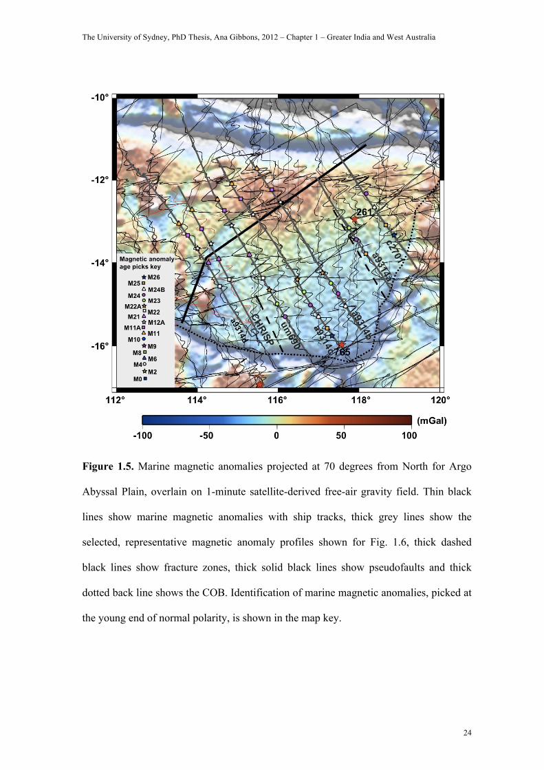
Figure 1.5. Marine magnetic anomalies projected at 70 degrees from North for Argo
Abyssal Plain, overlain on 1-minute satellite-derived free-air gravity field. Thin black
lines show marine magnetic anomalies with ship tracks, thick grey lines show the
selected, representative magnetic anomaly profiles shown for Fig. 1.6, thick dashed
black lines show fracture zones, thick solid black lines show pseudofaults and thick
dotted back line shows the COB. Identification of marine magnetic anomalies, picked at
the young end of normal polarity, is shown in the map key.
The University of Sydney, PhD Thesis, Ana Gibbons, 2012 – Chapter 1 – Greater India and West Australia
25
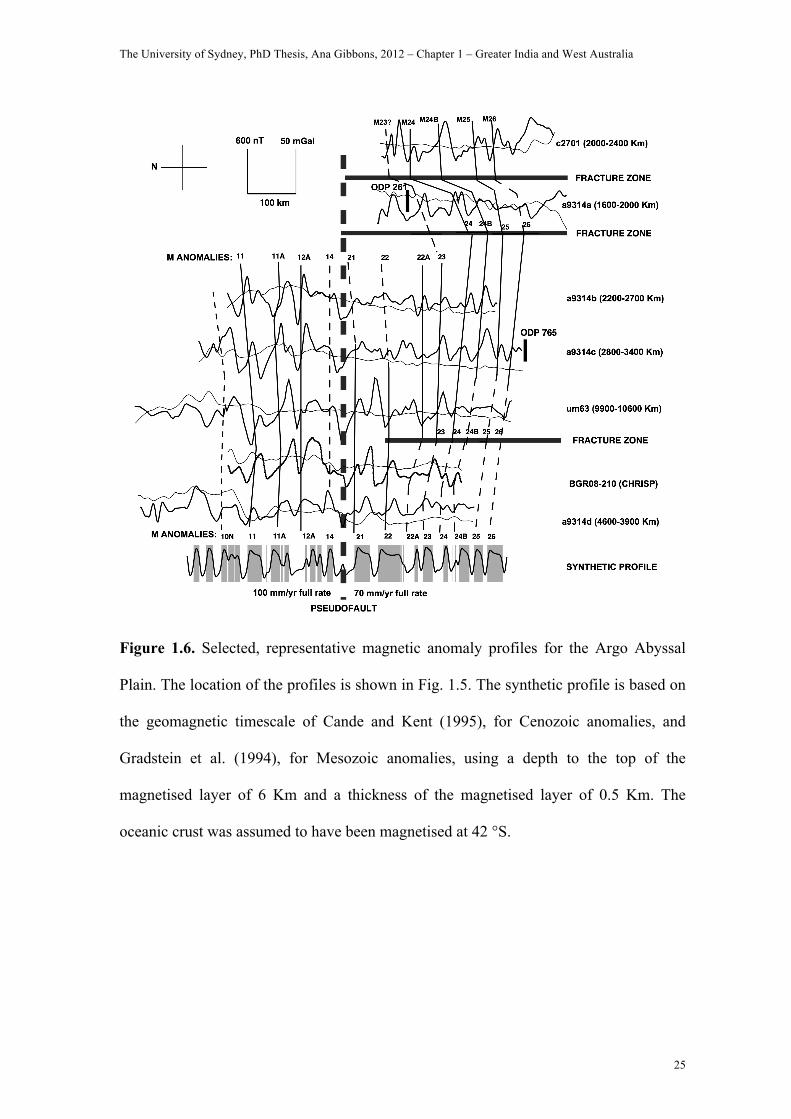
Figure 1.6. Selected, representative magnetic anomaly profiles for the Argo Abyssal
Plain. The location of the profiles is shown in Fig. 1.5. The synthetic profile is based on
the geomagnetic timescale of Cande and Kent (1995), for Cenozoic anomalies, and
Gradstein et al. (1994), for Mesozoic anomalies, using a depth to the top of the
magnetised layer of 6 Km and a thickness of the magnetised layer of 0.5 Km. The
oceanic crust was assumed to have been magnetised at 42 °S.
The University of Sydney, PhD Thesis, Ana Gibbons, 2012 – Chapter 1 – Greater India and West Australia
26
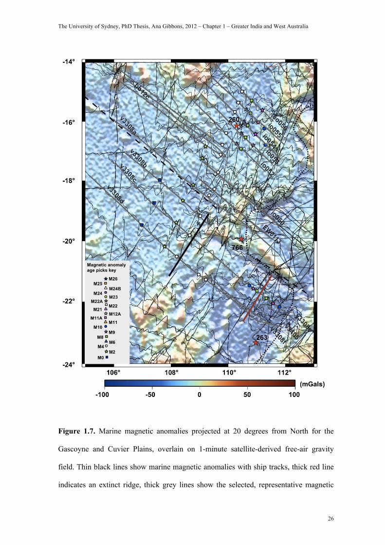
Figure 1.7. Marine magnetic anomalies projected at 20 degrees from North for the
Gascoyne and Cuvier Plains, overlain on 1-minute satellite-derived free-air gravity
field. Thin black lines show marine magnetic anomalies with ship tracks, thick red line
indicates an extinct ridge, thick grey lines show the selected, representative magnetic
The University of Sydney, PhD Thesis, Ana Gibbons, 2012 – Chapter 1 – Greater India and West Australia
27
anomaly profiles shown for Fig. 1.8 and 1.9, thick dashed black lines show fracture
zones, thick solid black lines indicate pseudofaults and thick dotted back line marks the
COB. Identification of marine magnetic anomalies, picked at the young end of normal
polarity, is shown in the map key.
The University of Sydney, PhD Thesis, Ana Gibbons, 2012 – Chapter 1 – Greater India and West Australia
28
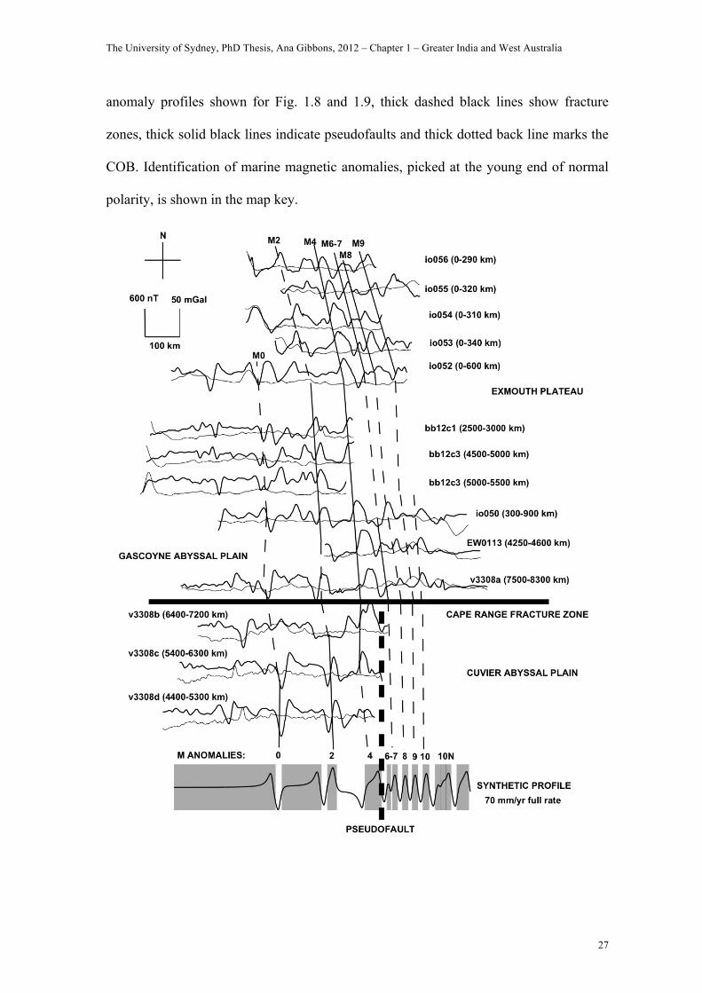
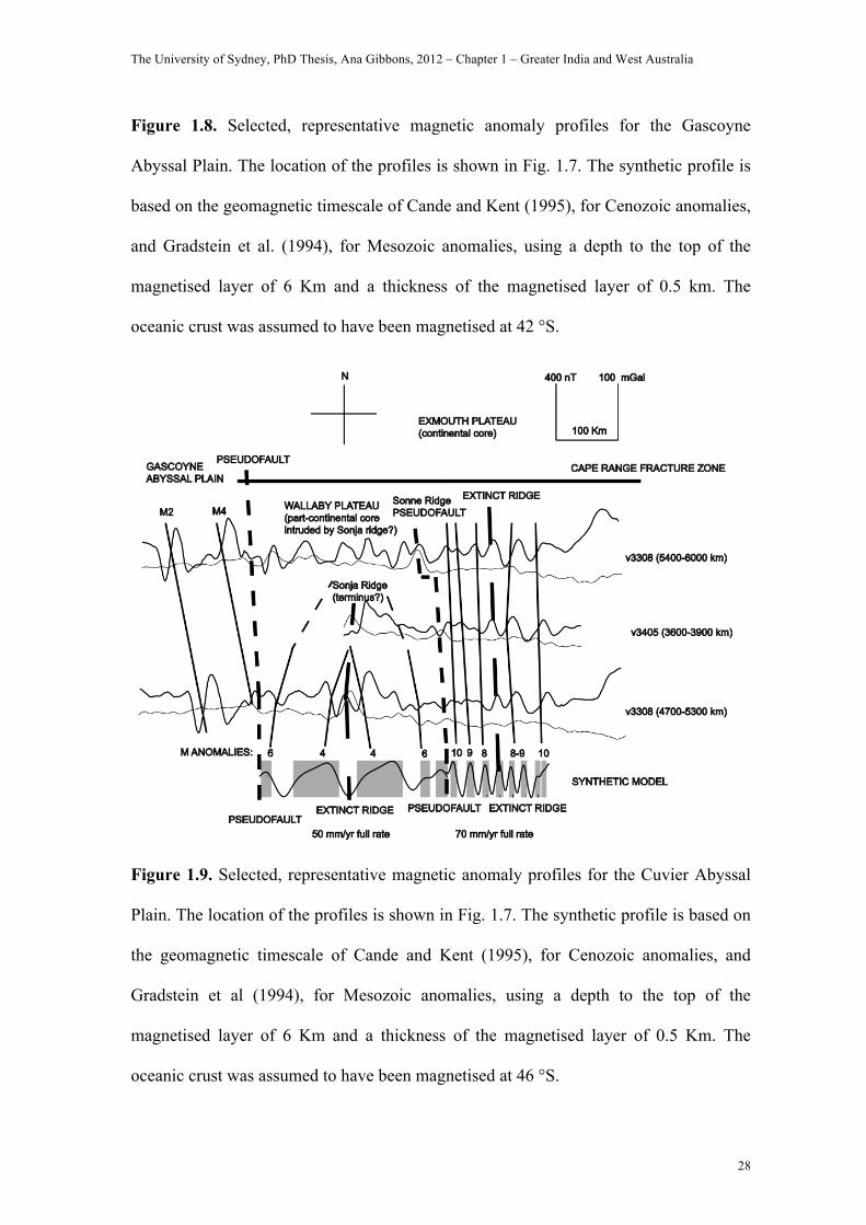
Figure 1.8. Selected, representative magnetic anomaly profiles for the Gascoyne
Abyssal Plain. The location of the profiles is shown in Fig. 1.7. The synthetic profile is
based on the geomagnetic timescale of Cande and Kent (1995), for Cenozoic anomalies,
and Gradstein et al. (1994), for Mesozoic anomalies, using a depth to the top of the
magnetised layer of 6 Km and a thickness of the magnetised layer of 0.5 km. The
oceanic crust was assumed to have been magnetised at 42 °S.
Figure 1.9. Selected, representative magnetic anomaly profiles for the Cuvier Abyssal
Plain. The location of the profiles is shown in Fig. 1.7. The synthetic profile is based on
the geomagnetic timescale of Cande and Kent (1995), for Cenozoic anomalies, and
Gradstein et al (1994), for Mesozoic anomalies, using a depth to the top of the
magnetised layer of 6 Km and a thickness of the magnetised layer of 0.5 Km. The
oceanic crust was assumed to have been magnetised at 46 °S.
The University of Sydney, PhD Thesis, Ana Gibbons, 2012 – Chapter 1 – Greater India and West Australia
29
In the Gascoyne Abyssal Plain, we interpret anomalies M10-M0 (130-120 Ma), as a
continuous sequence trending 20 degrees east from the Exmouth Margin (Fig. 1.7 and
1.8). The anomalies are bisected by a fracture zone, which is just discernable in the
marine gravity grid as faint lineation oriented at roughly 110 degrees, and may be a
westward extension of the CRFZ that is offset slightly to the north. We follow the
magnetic anomaly interpretations featuring Cretaceous seafloor in the Gascoyne
Abyssal Plain (Fullerton et al., 1989; Sager et al., 1992), as opposed to the Jurassic
seafloor of Heine and Müller (2005), Fig. 1.2b, though we cannot identify the conjugate
series M10-M4 (130-126 Ma) by the Exmouth margin (Fullerton et al., 1989; Sager et
al., 1992), Fig. 1.1. Our interpretation differs from that of Robb et al., (2005), because
the geometry and juxtaposition of their interpreted conjugate magnetic anomalies M2
and M4 cannot be accounted for by any reasonable plate motion/ridge propagation
model.
In the Cuvier Abyssal Plain, we identify two sets of conjugate anomalies divided by the
Sonne Ridge, here interpreted as a pseudofault (Fig. 1.7 and 1.9). East of the Sonne
Ridge, we identify anomalies M10-M8 (130.5-128.2 Ma), about an extinct spreading
axis. West of the Sonne Ridge, we identify M6-M4 (127.2-126.7 Ma), reflected about
the Sonja Ridge, a failed propagating ridge, as the anomalies appeared to converge to
the north. Our results differ from previous studies, which identify the Sonne as an
extinct spreading centre surrounded by the conjugate series M10/11-M5 (130/131-126
Ma), (Fullerton et al., 1989, and Mihut and Müller, 1998), though they are similar to
Robb et al., (2005), in having two conjugate sequences. Our results are supported by the
The University of Sydney, PhD Thesis, Ana Gibbons, 2012 – Chapter 1 – Greater India and West Australia
30
different intensity in the marine gravity grid on either side of the Sonne Ridge, and the
character of the CRFZ, which appears to be bisected directly north of the Sonne Ridge.
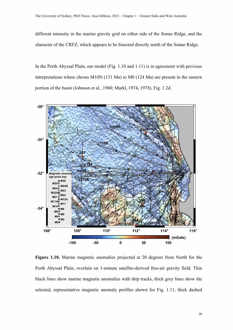
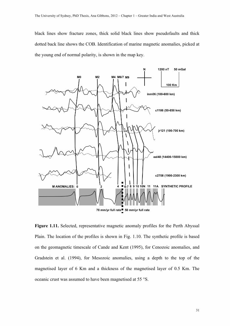
In the Perth Abyssal Plain, our model (Fig. 1.10 and 1.11) is in agreement with previous
interpretations where chrons M10N (131 Ma) to M0 (124 Ma) are present in the eastern
portion of the basin (Johnson et al., 1980; Markl, 1974, 1978), Fig. 1.2d.
Figure 1.10. Marine magnetic anomalies projected at 20 degrees from North for the
Perth Abyssal Plain, overlain on 1-minute satellite-derived free-air gravity field. Thin
black lines show marine magnetic anomalies with ship tracks, thick grey lines show the
selected, representative magnetic anomaly profiles shown for Fig. 1.11, thick dashed
The University of Sydney, PhD Thesis, Ana Gibbons, 2012 – Chapter 1 – Greater India and West Australia
31
black lines show fracture zones, thick solid black lines show pseudofaults and thick
dotted back line shows the COB. Identification of marine magnetic anomalies, picked at
the young end of normal polarity, is shown in the map key.
Figure 1.11. Selected, representative magnetic anomaly profiles for the Perth Abyssal
Plain. The location of the profiles is shown in Fig. 1.10. The synthetic profile is based
on the geomagnetic timescale of Cande and Kent (1995), for Cenozoic anomalies, and
Gradstein et al. (1994), for Mesozoic anomalies, using a depth to the top of the
magnetised layer of 6 Km and a thickness of the magnetised layer of 0.5 Km. The
oceanic crust was assumed to have been magnetised at 55 °S.
The University of Sydney, PhD Thesis, Ana Gibbons, 2012 – Chapter 1 – Greater India and West Australia
32
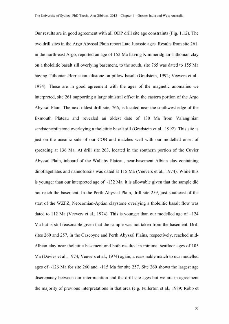
Our results are in good agreement with all ODP drill site age constraints (Fig. 1.12). The
two drill sites in the Argo Abyssal Plain report Late Jurassic ages. Results from site 261,
in the north-east Argo, reported an age of 152 Ma having Kimmeridgian-Tithonian clay
on a tholeiitic basalt sill overlying basement, to the south, site 765 was dated to 155 Ma
having Tithonian-Berriasian siltstone on pillow basalt (Gradstein, 1992; Veevers et al.,
1974). These are in good agreement with the ages of the magnetic anomalies we
interpreted, site 261 supporting a large sinistral offset in the eastern portion of the Argo
Abyssal Plain. The next oldest drill site, 766, is located near the southwest edge of the
Exmouth Plateau and revealed an oldest date of 130 Ma from Valanginian
sandstone/siltstone overlaying a tholeiitic basalt sill (Gradstein et al., 1992). This site is
just on the oceanic side of our COB and matches well with our modelled onset of
spreading at 136 Ma. At drill site 263, located in the southern portion of the Cuvier
Abyssal Plain, inboard of the Wallaby Plateau, near-basement Albian clay containing
dinoflagellates and nannofossils was dated at 115 Ma (Veevers et al., 1974). While this
is younger than our interpreted age of ~132 Ma, it is allowable given that the sample did
not reach the basement. In the Perth Abyssal Plain, drill site 259, just southeast of the
start of the WZFZ, Neocomian-Aptian claystone overlying a tholeiitic basalt flow was
dated to 112 Ma (Veevers et al., 1974). This is younger than our modelled age of ~124
Ma but is still reasonable given that the sample was not taken from the basement. Drill
sites 260 and 257, in the Gascoyne and Perth Abyssal Plains, respectively, reached mid-
Albian clay near tholeiitic basement and both resulted in minimal seafloor ages of 105
Ma (Davies et al., 1974; Veevers et al., 1974) again, a reasonable match to our modelled
ages of ~126 Ma for site 260 and ~115 Ma for site 257. Site 260 shows the largest age
discrepancy between our interpretation and the drill site ages but we are in agreement
the majority of previous interpretations in that area (e.g. Fullerton et al., 1989; Robb et
The University of Sydney, PhD Thesis, Ana Gibbons, 2012 – Chapter 1 – Greater India and West Australia
33
al., 2005, Sager et al., 1992). Just west of Batavia and Gulden Draak Knolls, and the
CHRISP Jurassic crust, drill site 256 reached Late Albian brown clay (Davies et al.,
1974) and drill site 212 reached basalt basement overlain by brown clay, (Von der
Borch et al., 1974), both reporting minimal ages of ~100 Ma, which is a reasonable
match to our interpreted seafloor ages of 108 and 100 Ma, respectively.
DISCUSSION OF TECTONIC MODEL AND CONSTRAINTS
Mesozoic reconstructions of East Gondwana remain poorly constrained and too tightly
fit, particularly around Madagascar (Lawver et al., 1998; Marks and Tikku, 2001). We
test a new fit-reconstruction for East Gondwana, which shifts the position of Australia,
relative to Antarctica, several hundred kilometres further east than previously modelled
at 83 million years (Williams et al., 2011), creating more accommodation space for the
tectonic blocks. As a result, our blocks have a reasonable fit within Mesozoic East
Gondwana that avoids excessive gaps or overlap. The two main tectonic blocks we
migrate are Argoland and Greater India (including its micro-continental rafts). We have
used all available constraints to define their tectonic outlines and motion, as follows.
The tectonic elements and rotation poles relating to this study can be found in the
supplementary file provided and viewed in GPlates (http://www.gplates.org/index.html).
Argoland extent and motion
New age data from seamounts sampled in the Wharton Basin (Fig. 1.1) during the 2008
CHRISP research cruise add a pivotal constraint to the extents of Argoland and Greater
India. Volcanic glass, dredged from the flanks of the Investigator Ridge (IR, Fig. 1.1),
The University of Sydney, PhD Thesis, Ana Gibbons, 2012 – Chapter 1 – Greater India and West Australia
34
was Ar-Ar dated at 153 ± 3.3 Ma, indicating the presence of a portion of Jurassic
oceanic crust. This finding is striking since Cretaceous seafloor is prevalent in the
abyssal plains inboard of the sample and we would expect this area to have been created
after the inboard abyssal plains. The CHRISP Jurassic seafloor formed coevally to the
seafloor in the Argo Abyssal Plain (from 155 Ma), as an extension of the spreading
ridge between Argoland and Greater India. This new data is therefore instrumental in
defining the southern extent of Argoland and the northern margin of Greater India. We
infer that the Jurassic CHRISP crust originally formed just west of the Zenith Plateau
and was transferred to its present-day position along the prominent curved fracture
zones. The CHRISP Jurassic sliver could not have formed east of the Zenith Plateau, as
it would have permanently joined the Australian plate when the Zenith Plateau was
transferred via a ridge jump, see next section.
We divide Argoland into West, Central and East portions to allow a multi-staged
accretion. The northern margins of all three Argoland blocks are minimum extents and
the width of the slivers varies along strike from 100 km in the east to 500 km in the west
(Fig. 1.13), due to the margin geometry, and the widest portions occur in West and
Central Argoland. West Argoland originally stretched from Africa to the Exmouth
Plateau, it was the longest of the Argoland slivers and was widest at its east. This larger
eastern width is constrained by the geometry of linking the ridge forming the Argo
Abyssal Plain to the CHRISP Jurassic seafloor forming west of the Zenith Plateau (Fig.
1.13b).
The Tethyan Himalayas are considered to have formed from a large area of highly
extended crust forming the northernmost extension of Greater India (e.g. van
The University of Sydney, PhD Thesis, Ana Gibbons, 2012 – Chapter 1 – Greater India and West Australia
35
Hinsbergen et al., 2011). However, greatly extended continental crust is prone to
breakup and subsequent seafloor spreading. The most straightforward way to explain
the provenance of the Tethyan Himalayas is that it actually separated from Greater India
and collided with Eurasia before Greater India. We propose that the Tethyan Himalayas
correspond to West Argoland. The presence of two blocks, divided by a north-northeast
striking boundary reaching the middle of the Lhasa block (Zhang et al., 2007), supports
the combined identity of West Argoland and the Tethyan Himalayas. Central Argoland,
also referred to as the West Burma Block, is wider in the middle because of the curving
geometry of its conjugate, the Argo Abyssal Plain. East Argoland, which stretched from
northeast of the Argo Abyssal Plain to Seram/Birdhead in the west, was conjugate to
Australia’s linear northern margin and we have outlined it as a narrow continental
sliver.
To reconstruct Argoland’s motion, we compute half stage Euler poles and convert them
into full-stage Euler poles given constraints from magnetic anomaly picks and fracture
zones from the Argo Abyssal Plain, including chrons M25-M11 (155-132 Ma). For time
periods where the oceanic crust of the Argo Abyssal Plain has been subducted,
including chrons M20-M15 (146-136 Ma), we maintain a similar rate and direction of
motion for Argoland to that of pre-146 Ma.
Active mid-ocean ridges terminate at strike-slip faults or triple junctions. The spreading
centre forming the Argo Abyssal Plain in the Late Jurassic was likely connected to the
spreading centre in the West Somali Basin as these spreading systems operated during
the same timeframe with compatible spreading configurations. When the Somali ridge
became extinct is contentious with models interpreting extinction at M10 (130 Ma)
The University of Sydney, PhD Thesis, Ana Gibbons, 2012 – Chapter 1 – Greater India and West Australia
36
(Eagles and Konig, 2008; Rabinowitz et al., 1983) or M0 (120 Ma) (Ségoufin and
Patriat, 1980). We prefer the latter model (extinct at 120 Ma) as this links better to the
extinction of the triple junction that temporarily divided Argoland, India and Australia
from 136-120 Ma. During this time, a triple junction would have existed offshore
northeast Africa, separating Africa from India and Argoland. The northern arm of this
triple junction would have been a strike-slip fault between the Western and Central
MesoTethys, so that it could accommodate the separate motions of Argoland relative to
the MesoTethys. The extinction of the active ridge (linking the triple junctions) north of
Greater India around 120 Ma could also explain India’s northward acceleration, (Muller,
2007), reaching ~20 mm/yr (Acton, 1999; Klootwijk et al., 1992; Patriat and Achache,
1984).
Greater India extent and motion
Based on the CHRISP Jurassic age and potential field data offshore West Australia, we
divide Greater India into three distinct portions: 1) the Gascoyne Block, a narrow
indenter sandwiched between West Argoland and the Exmouth Plateau, which created
the Gascoyne Abyssal Plain as it migrated from the Exmouth margin, 2) the Wallaby
and Zenith Plateaus, comprising all the Greater Indian continental material between
CRFZ and WZFZ, these became attached to the Australian plate following two
westward ridge jumps, and 3) the main portion of Greater India, located south of the
WZFZ, which reached roughly 3500 km to the west to meet the margins of Africa and
Madagascar in a Mesozoic full-fit plate reconstruction.
The University of Sydney, PhD Thesis, Ana Gibbons, 2012 – Chapter 1 – Greater India and West Australia
37
We bring the northern extent of Greater India (the Gascoyne Block) inline with the
northern tip of the Exmouth Plateau, a highly extended passive margin, which requires a
conjugate continental flank during rifting. The presence of continental crust west of the
Exmouth Plateau before breakup is supported by seismic stratigraphy in the Rankin
Trend (RT, Fig. 1.1) that reveals a northwest Precambrian sediment source was present
along the northwest shelf during most of the Palaeozoic and Mesozoic (Martison et al.,
1973). We outline the Gascoyne block as a narrow indenter because the ridge forming
the Argo Abyssal Plain reached about 800 km further south, around a slim portion of
Greater India and the potential Exmouth Plateau, to form the CHRISP crust just west of
the Zenith Plateau before its migration. The Gascoyne Block’s northeast margin, which
was conjugate to the Exmouth Plateau, is outlined to match the Australian COB and
allow the coeval oceanic crust, as dated by magnetic anomalies, to form halfway
between the blocks as they separate. The Gascoyne Block’s southern edge was
conjugate to the northwest Wallaby Plateau, to allow complete continental overlap
between itself, West Argoland and Greater India (including the plateaus), in a full-fit
Mesozoic reconstruction (Fig. 1.13a).
For Euler rotations describing the motion of Greater India, including its Gascoyne Block
indenter, we visually fit conjugate magnetic anomaly and fracture zone interpretations
in the Gascoyne, Cuvier and Perth abyssal plains and compute full-stage rotation poles
using GPlates (Boyden et al., 2011). The relative motions between Madagascar and
Africa and Antarctica provide additional constraints for the relative position and motion
of Greater India through time. There are several models available that describe the
initial motion for Africa-Antarctica and Africa-Madagascar. Here we adopt Konig and
Jokat, (2010) and Müller et al., (2008), respectively. To build robust plate tectonic
The University of Sydney, PhD Thesis, Ana Gibbons, 2012 – Chapter 1 – Greater India and West Australia
38
models it is important to consider regional constraints provided by neighbouring plates
to avoid excessive overlap or unlikely motion in regions further afield from the main
area of study. This is particularly significant for the commonly tight fit between
southwest India and Madagascar, which is difficult to resolve without causing overlap
between north India and the WZFZ, which was formed by India’s migration. We avoid
this overlap by fitting Greater India to Madagascar in such a way that it results in less
than 150 km of dextral strike-slip motion between the two plates.
We extend the 136 Ma spreading reorganisation, which formed the northern portion of
the Argo Abyssal Plain and Joey Rise ridges, into a triple junction operating until 120
Ma. The western arm of the triple junction is linked to the African triple junction, where
India’s anticlockwise motion prior to 120 Ma causes minor compression along East
Africa. This is supported by the presence of the Masirah ophiolite of eastern Oman.
Based on the age of potassic granites, the Masirah ophiolite was obducted around 125-
145 Ma (Smewing et al., 1991), inline with a Tithonian age obtained by the analysis of
radiolaria in cherts in the ophiolite (Moseley, 1990), which corresponds to Greater
India’s anticlockwise rotation, from 136-120 Ma. The nucleus of the West Australian
triple junction originated just east of the Joey Rise (Fig. 1.13), though subduction has
ensured there is little evidence remaining for the proposed triple junction, except
possibly for the volcanic Joey and Roo Rises. Its northeast spreading branch was
initiated after a relocation of the NeoTethyan spreading centre to the north Argo
Abyssal Plain, leaving the pseudofault near the Java subduction trench. The southeast
arm began rifting India from Australia, thereby linking the Jurassic and Cretaceous
spreading systems of West Australia.
The University of Sydney, PhD Thesis, Ana Gibbons, 2012 – Chapter 1 – Greater India and West Australia
39
The micro-continental blocks, including Zenith, Wallaby and Naturaliste Plateaus,
Batavia and Gulden Draak Knolls, share the same Euler poles as Greater India until they
are transferred to the Australian plate by localised ridge jumps. We date these ridge
jumps using our magnetic anomaly interpretations and/or interpolation of India-
Australia spreading rates to: Wallaby Plateau ~128 Ma, Naturaliste and West Wallaby
Plateau ~127 Ma, Zenith Plateau ~124 Ma (along with the CHRISP Jurassic seafloor),
Batavia and Gulden Draak Knolls ~108 Ma (transferring the CHRISP Jurassic seafloor
back to the Indian plate). Throughout the CNS, we maintain a steady spreading rate for
Greater India that compares with spreading rates before and after that time. However,
India’s motion alters ~99 Ma to satisfy the change in transform fault azimuths in the
Wharton Basin as India began to migrate north instead of northwest, ultimately resulting
in the curved fracture zones visible today. The onset of spreading between India and
Madagascar has commonly been dated as around 85 Ma (Storey et al., 1995; Yatheesh
et al., 2006); our model initiates this separation with ~200 km of dextral strike-slip
motion from ~99 Ma followed by seafloor spreading from ~94 Ma, progressing from
south to north (Gibbons et al., in prep). The timing of this separation fits well with a
major spreading reorganisation identified in the Indian Ocean ~100 Ma (Müller et al.,
2000; Veevers, 2000), and the emplacement of the Androy and Morondava basalts on
Madagascar’s east and west margins from 103 and 94 Ma, respectively (Bardintzeff et
al., 2010). As this new spreading regime was established, the CHRISP Jurassic seafloor
was attached to the Investigator ridge via a minor spreading reorganisation ~99 Ma.
The University of Sydney, PhD Thesis, Ana Gibbons, 2012 – Chapter 1 – Greater India and West Australia
40
Tectonic model
The West Australian margin began forming at ~155 Ma, with the onset of seafloor
spreading along the Argo Ridge. The ridge likely linked to a triple junction offshore
Somalia (west), having originated from East Timor. Spreading about this ridge caused
the northward migration of Argoland, creating the Argo Abyssal Plain and CHRISP
Jurassic crust (Fig. 1.13b). Argoland continued migrating north but its spreading system
underwent a reorganisation at 136 Ma, forming a new, steeper arm along the north Argo
Abyssal Plain pseudofault, roughly 800 km further south of the old Argo spreading
ridge at this time, (Fig. 1.6 and Fig. 1.13c). This new portion of the ridge reached
around the entire West Australian margin, forming the triple junction whose nucleus
was located between the Joey and Roo Rises (Fig. 1.13c). Separation between India and
Australia followed, with the formation of the Australian western margin abyssal plains.
Greater India and its northern indenter, the Gascoyne Block, began migrating from the
West Australian margin in an anticlockwise motion as the new spreading centre
propagated south from the Exmouth Plateau after the 136 Ma spreading reorganisation.
This is close to the onset of seafloor spreading between India and East Antarctica at 130
Ma (chron M9) (Gaina et al., 2007), and the ~6 million year discrepancy is reasonable
given the initial anticlockwise motion for Greater India about its southern pivot. India’s
anticlockwise motion is a vital component in our model to avoid overlap between
India’s southwest margin and Madagascar, and India’s northeast margin and the WZFZ.
As a result, spreading rates were higher in the northern part of the Western Australian
abyssal plains, with the maximum rates presumably at the Joey Rise volcanic province,
where the triple junction nexus was located. From 136 Ma, the Exmouth margin
The University of Sydney, PhD Thesis, Ana Gibbons, 2012 – Chapter 1 – Greater India and West Australia
41
underwent crustal stretching while the Joey Rise ridges formed at its north. These
volcanic ridges have been attributed to magma concentrated in crustal drainage channels
beneath the underplated Exmouth plateau, (Frey et al., 1998), or as failed rifts (Direen et
al., 2008), but the presence of sills connecting the Joey Rise to the Exmouth Plateau
(Heirtzler et al., 1978) support our interpretation that both formed concurrently. The
West Australian margin was formed in the following sequence: Perth margin from ~136
Ma, the Gascoyne margin from ~135 Ma and the Cuvier margin from ~133 Ma. This
unusual age progression is due to our allocated boundaries for the blocks, as discussed
earlier.
From 136 Ma to 100 Ma, Greater India continued its westward migration, leaving
several micro-continental blocks behind via ridge jumps. The first ridge jump occurred
in the Cuvier Abyssal Plain ~128 Ma, transferring the Wallaby Plateau to the Australian
Plate, trapping the older conjugate anomalies inboard of the Sonne Ridge and
introducing an offset in the middle of the CRFZ at the northern tip of the Sonne Ridge
(Fig. 1.12). The Naturaliste Plateau continental crust was stretched until ~127 Ma and
our plate reconstruction accurately models the formation of the Leeuwin Fracture Zone
located between the Naturaliste and the Southwest Australian margin and its conjugate,
the Vincennes fracture zone located east of the Bruce Rise on the Antarctic margin. The
second westward ridge jump, at roughly 127 Ma, transferred the West Wallaby Plateau
to the Australian plate. Between the West and East Wallaby Plateau, the Sonja Ridge is
the extinct ridge, or failed rift system, that corresponds to this second westward ridge
jump. The third westward ridge jump, at around 124 Ma, transferred the Zenith Plateau
and CHRISP Jurassic sliver to the Australian plate.
The University of Sydney, PhD Thesis, Ana Gibbons, 2012 – Chapter 1 – Greater India and West Australia
42
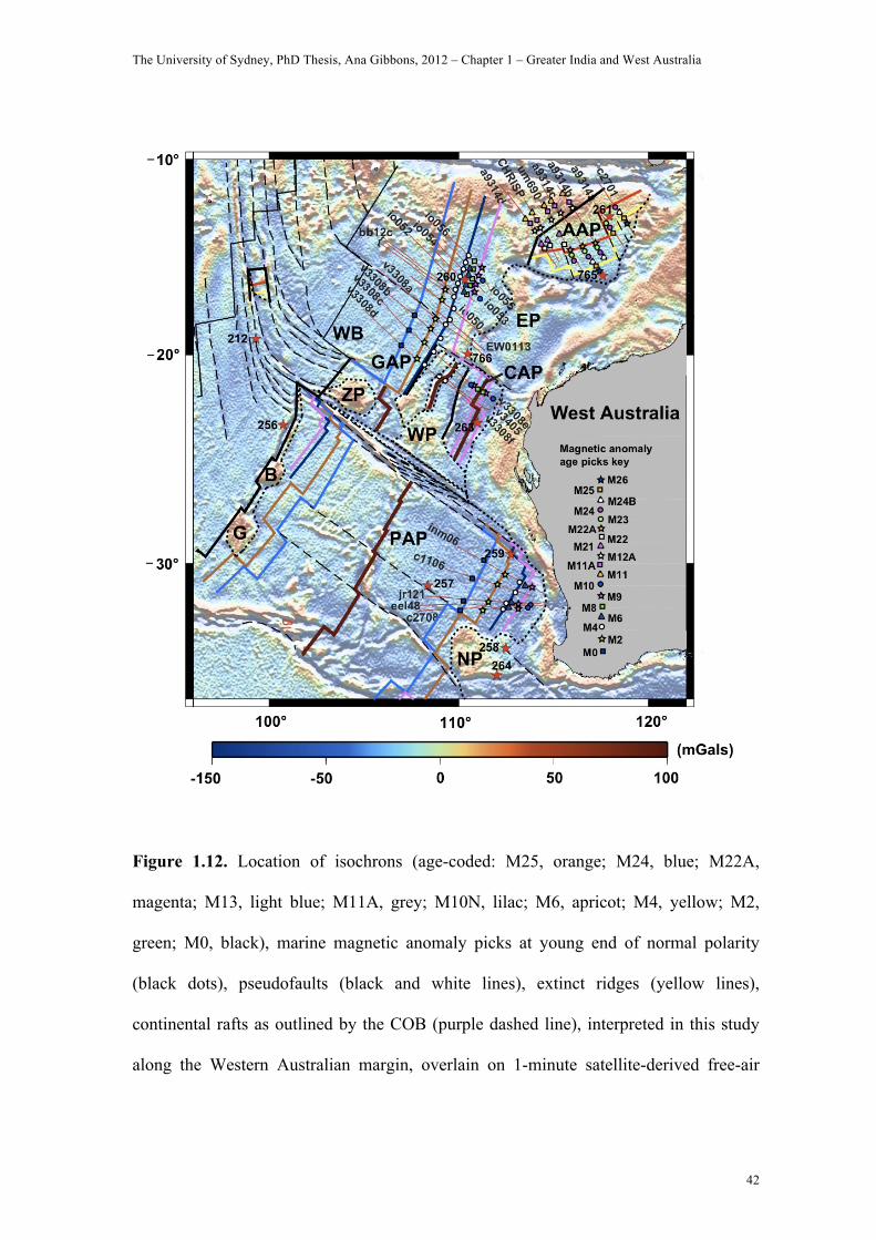
Figure 1.12. Location of isochrons (age-coded: M25, orange; M24, blue; M22A,
magenta; M13, light blue; M11A, grey; M10N, lilac; M6, apricot; M4, yellow; M2,
green; M0, black), marine magnetic anomaly picks at young end of normal polarity
(black dots), pseudofaults (black and white lines), extinct ridges (yellow lines),
continental rafts as outlined by the COB (purple dashed line), interpreted in this study
along the Western Australian margin, overlain on 1-minute satellite-derived free-air
The University of Sydney, PhD Thesis, Ana Gibbons, 2012 – Chapter 1 – Greater India and West Australia
43
gravity field. Red stars are the locations of ODP/DPSP drill sites relevant to this study.
Abbreviations are same as in Fig. 1.
The CHRISP Jurassic sliver (C, Fig. 1.13d) remained west of the Zenith Plateau from
124 Ma until a fourth ridge jump, at 108 Ma, attached Batavia and Gulden Draak Knolls
to the Australian plate (B and G, Fig. 1.13e), and the CHRISP Jurassic sliver to the
Indian plate (C, Fig. 1.13e). Two ridge jumps in opposing directions in adjacent
spreading corridors are modelled to satisfy key observations: south of the WZFZ a
westward ridge jump is required to attach Batavia and Gulden Draak Knolls to the
Australian plate, while north of the WZFZ an eastward ridge jump is required to attach
the CHRISP Jurassic sliver back to the Indian plate so that it can be transferred to its
present day location on the Investigator Ridge. This ridge jump also left an extinct
spreading centre in the middle of the Perth Abyssal Plain and presumably a conjugate
sequence of Mesozoic anomalies in the western portion, though the area is heavily
influenced by volcanism and a lack of magnetic anomaly tracks. We interpret Dirk
Hartog Ridge as this extinct spreading centre. This interpretation matches a continuous
spreading rate of roughly 70 mm/yr from 126.7-108 Ma with about 10% faster
spreading rates on the Australian flank, given the amount of seafloor produced in that
time. This >700 km westward relocation for the spreading centre at 108 Ma was likely a
ridge-hotspot induced ridge jump (Mittelstaedt et al., 2008), towards the Kerguelen
Plume, which was located about 300 km directly south of Gulden Draak Knoll at the
time (Fig. 1.13e).

The University of Sydney, PhD Thesis, Ana Gibbons, 2012 – Chapter 1 – Greater India and West Australia
44
Figure 1.13. Mercator-projected reconstructions of the West Australian margin at (a)
200 Ma, (b) 150 Ma, (c) 130 Ma and (d) 120 Ma (e) 100 Ma, (f) 90 Ma, constructed
using GPlates exported geometries with Australia fixed in present-day coordinates.
!""#$%# &'"#$%#
&("#$%# &!"#$%#
&""#$%# )"#$%#
*+,-.%/0%
*+,-.%/0%*+,-.%/0%
*+,-.%/0%
*+,-.%/0%
*+,-.%/0%
*1-%.2-02%
*1-%.2-02%*1-%.2-02%
*1-%.2-02%
*1-%.2-02%
3.4%-4.#5160%
3.4%-4.#5160%
3.4%-4.#5160%
5160%
3.4%-4.#5160%
3.4%-4.#5160%
37
37
37
3737
37
8*9
8*9
:*9
:*9
;*9;*9
<=<=
<=
<=
<=
<=
8=8=
8=
8= 8=
8=
>=>=
>=
>=
>=
>=
:
::
:
:
7
7
7
7
7
7
33
3
3
3
3 <=
;=;=
;= ;=
;=
;=$,4?@4-AB,
<4?@4-AB,
$,4?@4-AB,
<4?@4-AB,
<4?@4-AB,
3*=
3*=
**=
:*=
=*=
**= **=
3*=
=*=
=*=
87
**=
**=
:*=
3*=
:*=:*=
C4.D+4/41C4.D+4/41
87
$7@
%
2
4 E
6
F
;7;7
CC
C

The University of Sydney, PhD Thesis, Ana Gibbons, 2012 – Chapter 1 – Greater India and West Australia
45
Showing pseudofaults (green dashed lines), extinct ridges (blue dashed lines), COB
(thin black line, continental side filled in yellow), isochrons (red lines), spreading
centres (brown dashed lines). Yellow polygons indicate continental micro-fragments,
coastlines are filled in grey and large igneous provinces are shown in red. Abbreviations
include Argo Abyssal Plain (AAP), Batavia Knoll (B), CHRISP Jurassic sliver (C, not
drawn to scale), Elan Bank (EB), Cuvier Abyssal Plain (CAP), Gascoyne Abyssal Plain
(GAP), Gulden Draak Knoll (G), Kerguelen plume (K), Perth Abyssal Plain (PAP),
Exmouth Plateau (EP), Naturaliste Plateau (NP), Wallaby Plateau (WP) and Zenith
Plateau (ZP).
The Dirk Hartog Ridge is a linear feature mimicking the margin orientation and it is
linked along its northern limit to the Gulden Draak and Batavia Knolls via the Lost
Dutchmen Ridge. The crustal nature of the knolls is unknown as they have not been
dredged, but they could be continental rafts, or else associated with ridge propagation
events (extinct ridges and pseudofaults) and Kerguelen volcanism. We incorporated
Batavia and Gulden Draak Knolls into our model as tectonic blocks with continental
cores, as the 108 Ma ridge jump in the Perth Abyssal Plain conserves a reasonable COB
overlap (50-300 km) in a Mesozoic full-fit reconstruction (Fig. 1.13a), where the Knolls
fitted well about the western edge of the Naturaliste Plateau.
The anomalous Wallaby-Zenith and Wharton Basin fracture zones
Our model accurately reconstructs the unusual width and morphology of the WZFZ,
which was originally composed of three major east-west trending fracture zones. We
also identify the en-echelon offset ridges in the marine gravity grid, oriented southwest
The University of Sydney, PhD Thesis, Ana Gibbons, 2012 – Chapter 1 – Greater India and West Australia
46
from the base of the Wallaby, and agree with Nelson et al., (2009) that they were
formed gradually under a transtensional regime. We model the en-echelon fracture
zones as forming from ~110 Ma, bifurcating the original Wallaby-Zenith fracture zones
as Greater India underwent a slight southward motion just prior to the 108 Ma ridge
jump. This process can be seen in the curved fracture zones directly west of the southern
Zenith Plateau. This transtensional motion could also be responsible for creating Lost
Dutchmen Ridge via a leaky transform, west of the WZFZ, where the en echelon
fracture zones are not observed. This leaky transform (Lost Dutchmen Ridge) may have
extended to the Perth spreading centre (Dirk Hartog Ridge), which was to become
extinct at 108 Ma, and may have contributed to its volcanic appearance as seen in the
marine gravity grid.
This is the first study to reproduce the trace of the Wharton Basin curved fracture zones
in a tectonic reconstruction model. The curved fracture zones are only found west of the
Zenith Plateau so their prominence may be related to the presence of the older/colder
CHRISP Jurassic oceanic crust, when the ridge initiated spreading between the CHRISP
Jurassic seafloor and the Zenith Plateau at 108 Ma. The seafloor south of the curving
fracture zones formed closer to the Kerguelen hotspot, where warmer mantle may have
resulted in ocean floor with a smoother morphology. The seafloor northwest of the
Zenith Plateau is also smooth but this area did not experience a ridge jump at 108 Ma.
We propose that the curved fracture zones were a manifestation of the eastward ridge
jump that transferred the Jurassic CHRISP crust back to the Indian plate at 108 Ma, as
well as a continuation of the WZFZ.
The University of Sydney, PhD Thesis, Ana Gibbons, 2012 – Chapter 1 – Greater India and West Australia
47
CONCLUSIONS
We derive a comprehensive regional tectonic model that can account for all major
tectonic features visible in the marine gravity grid off the West Australian margin.
These include volcanic ridges, submerged plateaus/continental rafts, the CHRISP
Jurassic sliver, and fracture zones including the complex morphology of the WZFZ and
those curving in the Wharton Basin, coinciding with the 100 Ma spreading
reorganisation. Our plate tectonic model satisfies the potential field and ODP/CHRISP
age data, yet remains relatively simple and provides a complete scenario for the early
formation of the eastern Indian Ocean. The CHRISP Jurassic seafloor provides essential
new insights into the original extents of Argoland and Greater India so that the major
extent of Greater India lay south of the WZFZ in a Mesozoic West Australian margin
reconstruction. North of the WZFZ, Argoland must have extended hundreds of km
further west to the east African margin but, to form the CHRISP Jurassic seafloor so
that it could be emplaced where it is today, the spreading centre migrating Argoland
from Greater India veered around the margin that later became the Exmouth Plateau.
This ridge configuration reduced the portion of northern Greater India north of the
WZFZ, also conjugate to the Exmouth and Wallaby Plateaus, to an indenter roughly 750
km long by 100 km wide, which we call the Gascoyne Block. Our model links the
Jurassic and Cretaceous spreading episodes from the rifting of Argoland and Greater
India, respectively, via a spreading reorganisation at ~136 Ma. From which time, a triple
junction operated between Argoland, India and Australia, in order to avoid applying
India’s initial anticlockwise rotation to Argoland. The northwest Australian triple
junction linked to an East African triple junction but both triple junctions became
extinct around 120 Ma when Argoland and India were attached to the same pole of
The University of Sydney, PhD Thesis, Ana Gibbons, 2012 – Chapter 1 – Greater India and West Australia
48
rotation. The Early Cretaceous migration of Greater India formed West Australia’s
abyssal Plains, including the Gascoyne Abyssal Plain, which was formed by the
migration of its northern indenter, the Gascoyne Block. The Cuvier and Perth Abyssal
Plains became bounded by continental crust following ridge jumps isolating the Zenith
and Wallaby Plateaus, and Batavia and Gulden Draak Knolls, respectively, though this
occurred several million years earlier for the northern abyssal plain.
The University of Sydney, PhD Thesis, Ana Gibbons, 2012 – Chapter 1 – Greater India and West Australia
49
REFERENCES
Acton, G., 1999, Apparent Polar Wander of India Since the Cretaceous with Implications for Regional Tectonics and True Polar Wander: Memoir Geological Society of India, v. 44, p. 129-175.
Aitchison, J.C., Ali, J.R., and Davis, A.M., 2007, When and where did India and Asia collide?: Journal of Geophysical Research-Solid Earth, v. 112.
Aitchison, J.C., and Davis, A.M., 2004, Evidence for the multiphase nature of the India-Asia collision from the Yarlung Tsangpo suture zone, Tibet: Aspects of the Tectonic Evolution of China, v. 226, p. 217-233.
Ali, J.R., and Aitchison, J.C., 2005, Greater India: Earth-Science Reviews, v. 72, p. 169-188.
Baksi, A.K., 2007, A quantitative tool for detecting alteration in undisturbed rocks and minerals - I: Water, chemical weathering, and atmospheric argon.: Geological Society of America Special Paper 430, p. p. 285-303.
Bardintzeff, J.M., Liegeois, J.P., Bonin, B., Bellon, H., and Rasamimanana, G., 2010, Madagascar volcanic provinces linked to the Gondwana break-up: Geochemical and isotopic evidences for contrasting mantle sources: Gondwana Research, v. 18, p. 295-314.
Besse, J., and Courtillot, V., 2002, Apparent and true polar wander and the geometry of the geomagnetic field over the last 200 Myr - art. no. 2300: Journal of Geophysical Research-Solid Earth, v. 107, p. 2300-2300.
Borissova, I., 2002, Geological framework of the Naturaliste Plateau: Geoscience Australia Record 2002/20.
Brown, B.J., Muller, R.D., C., G., Struckmeyer, H.I.M., Stagg, H.M.J., and Symonds, P., 2003, Formation and evolution of Australian passive margins: implications for locating the boundary between continental and oceanic crust: Geol. Soc. Australia Spec. Publ. 22, and Geol. Soc. America Spec. Pap. 372, p. 223-243.
Cande, C., and Stegman, D.R., 2011, Indian and African plate motions driven by the push force of the Reunion plume head: Nature, v. 475.
Cande, S.C., and Kent, D.V., 1995, Revised calibration of the geomagnetic polarity timescale for the Late Cretaceous and Cenozoic: Journal of Geophysical Research, v. 100, p. 6093-6095.
Chen, J.S., Huang, B.C., and Sun, L.S., 2010, New constraints to the onset of the India-Asia collision: Paleomagnetic reconnaissance on the Linzizong Group in the Lhasa Block, China: Tectonophysics, v. 489, p. 189-209.
Davies, T.A., Luydendyk, B.P., Rodolfo, K.S., Kempe, D.R.C., MvKelvey, R.D., Leidy, R.D., Horvath, G.J., Hyndman, R.D., Thierstein, H.R., Herb, R.C., Boltovskoy, E., and Doyle, P., 1974, Init. Repts.of DSDP: Washington, D.C., DSDP.
The University of Sydney, PhD Thesis, Ana Gibbons, 2012 – Chapter 1 – Greater India and West Australia
50
Ding, L., Kapp, P., and Wan, X.Q., 2005, Paleocene-Eocene record of ophiolite obduction and initial India-Asia collision, south central Tibet - art. no. TC3001: Tectonics, v. 24, p. C3001-C3001.
Direen, N.G., Stagg, H.M.J., Symonds, P.A., and Colwell, J.B., 2008, Architecture of volcanic rifted margins: new insights from the Exmouth-Gascoyne margin, Western Australia: Aust J Earth Sci, v. 55, p. 341-363.
Dupont-Nivet, G., Lippert, P.C., van Hinsbergen, D.J.J., Meijers, M.J.M., and Kapp, P., 2010, Palaeolatitude and age of the Indo-Asia collision: palaeomagnetic constraints: Geophysical Journal International, v. 182, p. 1189-1198.
Eagles, G., and Konig, M., 2008, A model of plate kinematics in Gondwana breakup: Geophysical Journal International, v. 173, p. 703-717.
Falvey, D.A., 1972, Sea Floor Spreading in the Wharton Basin (Northeast Indian Ocean) and the Breakup of Eastern Gondwanaland: Australian Petroleum Exploration Association, v. 12, p. 2.
Falvey, D.A., and Veevers, J.J., 1974, Physiography of the Exmouth and Scott Plateaux, western Australia, and adjacent northeast Warton Basin: Mar. Geol., v. 17, p. 21-59.
Frey, O., Planke, S., Symonds, P.A., and Heeremans, M., 1998, Deep crustal structure and rheology of the Gascoyne volcanic margin, western Australia: Mar Geophys Res, v. 20, p. 293-312.
Fullerton, L.G., Sager, W.W., and Handschumacher, D.W., 1989, Late Jurassic-Early Cretaceous evolution of the eastern Indian Ocean adjacent to northwest Australia: Journal of Geophysical Research, v. 94, p. 2937-2953.
Gaina, C., Müller, R.D., Brown, B., Ishihara, T., and Ivanov, S., 2007, Breakup and early seafloor spreading between India and Antarctica Journal of Geophysics International, v. 170, p. 151-170.
Gibbons, A.D., Whittaker, J., and Dietmar Muller, R., in prep, A regional tectonic model for the Enderby Basin, East Antarctica, suggests a later breakup between India and Antarctica but an earlier breakup for India and Madagascar.
Gradstein, F.M., 1992, Leg 122-123, northwestern Australian margin; a stratigraphic and paleogeographic summary, in Gradstein Felix, M., Ludden John, N., Adamson Andrew, C., Baumgartner Peter, O., Beausillon, R., Bolmer, S.T., Bown Paul, R., Brereton, N.R., Buffler Richard, T., Castillo David, A., Compton John, S., Dumoulin Julie, A., Griffiths Cedric, M., Haig, D., Heggie David, T., Ishiwatari, A., Kaminski Michael, A., Kodama, K., Kopaska Merkel David, C., Marcoux Jean, P., McMinn, A., Moran Michael, J., Mutterlose, J., Ogg James, G., Brennan, O.N., Plank, T., Riggins, M., Schott, M., Simmons Gregory, R., Thurow, J., Stewart Sondra, K., Kennett Diana, M., and Mazzullo Elsa, K., eds., Proceedings of the Ocean Drilling Program, Argo abyssal plain/ Exmouth Plateau; covering Leg 123 of the cruises of the drilling vessel JOIDES
The University of Sydney, PhD Thesis, Ana Gibbons, 2012 – Chapter 1 – Greater India and West Australia
51
Resolution, Singapore, Republic of Sing., to Singapore, Republic of Sing., sites 765-766, 28 August 1988-1 November 1988., Volume 123: Proceedings of the Ocean Drilling Program, Scientific Results: College Station, TX, United States, Texas A & M University, Ocean Drilling Program, p. 801-816.
Gradstein, F.M., Agterberg, F.P., Ogg, J.G., Hardenbol, J., van Veen, P., Thierry, J., and Huang, Z., 1994, A Mesozoic time scale: Journal of Geophysical Research, v. 99, p. 24,051-24,074.
Heezen, B.C., and Tharp, M., 1965, Physiographic diagram of the Indian Ocean (with descriptive sheet): New-York.
Heine, C., and Müller, R.D., 2005, Late Jurassic rifting along the Australian Northwest Shelf: margin geometry and spreading ridge configuration: Australian Journal of Earth Science, v. 52, p. 27-39.
Heirtzler, J.R., Cameron, P., Cook, P.J., Powell, T., Roeser, H.A., Sukardi, S., and Veevers, J.J., 1978, The Argo Abyssal Plain: Earth and Planetary Science Letters, v. 41, p. 21-31.
Hirn, A., 1988, Features of the Crust Mantle Structure of Himalayas Tibet - a Comparison with Seismic Traverses of Alpine, Pyrenean and Variscan Orogenic Belts: Philosophical Transactions of the Royal Society of London Series a-Mathematical Physical and Engineering Sciences, v. 326, p. 17-32.
Johnson, B.D., Powell, C.M., and Veevers, J.J., 1980, Early spreading history of the Indian Ocean between India and Australia: Earth and Planetary Science Letters, v. 47, p. 131-143.
Johnson, M.R.W., 2002, Shortening budgets and the role of continental subduction during the India-Asia collision: Earth-Science Reviews, v. 59, p. 101-123.
Klootwijk, C.T., Gee, J.S., Peirce, J.W., Smith, G.M., and McFadden, P.L., 1992, An early India-Asia contact: Paleomagnetic constraints from Ninetyeast Ridge, ODP Leg 121: Geology, v. 20, p. 395-398.
Klootwijk, C.T., Gee, J.S., Peirce, J.W., Smith, G.M., Weissel, J.K., Taylor, E., Dehn, J., Driscoll, N.W., Farrell, J.W., Fourtanier, E., Frey, F.A., Gamson, P.D., Gibson, I.L., Janecek, T.R., Klootwijk, C.T., Lawrence, J.R., Littke, R., Newman, J.S., Nomura, R., Owen, R.M., Pospichal, J.J., Rea, D.K., Resiwati, P., Saunders, A.D., Smit, J., Tamaki, K., Weis, D., and Wilkinson, C., 1991, Constraints on the India-Asia convergence; paleomagnetic results from Ninetyeast Ridge: Proceedings of the Ocean Drilling Program, Scientific Results, v. 121, p. 777-882.
Konig, M., and Jokat, W., 2010, Advanced insights into magmatism and volcanism of the Mozambique Ridge and Mozambique Basin in the view of new potential field data: Geophysical Journal International, v. 180, p. 158-180.
The University of Sydney, PhD Thesis, Ana Gibbons, 2012 – Chapter 1 – Greater India and West Australia
52
Lanphere, M.A., and Dalrymple, G.B., 2000, First-principles calibration of 38Ar tracers: Implications for the ages of 40Ar/39Ar fluence monitors.: U.S. Geological Survey Professional Paper 1621, 10p.
Lawver, L.A., Gahagan, L.M., and Dalziel, I.W.D., 1998, A Tight Fit - Early Mesozoic Gondwana, A Plate Reconstruction Perspective: Memoirs of the National Institute of Polar Research, Special Issue, v. 53, p. 214-229.
Lee, T.-Y., and Lawver, L.A., 1995, Cenozoic plate reconstruction of Southeast Asia: Tectonophysics, v. 251, p. 85-138.
Li, Q., Gao, R., Lu, Z., Guan, Y., Zhang, J., Li, P., Wang, H., He, R., and Karplus, M., 2009, The thickness and structural characteristics of the crust across Tibetan plateau from active-sources seismic profiles: Earthquake Science, v. 22, p. 21-31.
Liebke, U., Appel, E., Ding, L., Neumann, U., Antolin, B., and Xu, Q.A., 2010, Position of the Lhasa terrane prior to India-Asia collision derived from palaeomagnetic inclinations of 53 Ma old dykes of the Linzhou Basin: constraints on the age of collision and post-collisional shortening within the Tibetan Plateau: Geophysical Journal International, v. 182, p. 1199-1215.
Markl, R.G., 1974, Evidence for the breakup of eastern Gondwanaland by the Early Cretaceous: Nature, v. 251, p. 196-200.
—, 1978, Evidence for the early Cretaceous breakup of Gondwanaland off southwestern Australia: Marine Geology, v. 26, p. 41-48.
Marks, K.M., and Tikku, A.A., 2001, Cretaceous reconstructions of East Antarctica, Africa and Madagascar: Earth & Planetary Science Letters, v. 186, p. 479-495.
Martison, N.W., Mcdonald, D.R., and Kaye, P., 1973, Exploration on Continental-Shelf Off Northwest Australia: American Association of Petroleum Geologists Bulletin, v. 57, p. 972-989.
McKenzie, D., and Sclater, J.G., 1971, The evolution of the Indian Ocean since the Late Cretaceous: Geophys. J. R. astr. Soc., v. 24, p. 437-528.
Mendel, V., Munschy, M., and Sauter, D., 2005, MODMAG, a MATLAB program to model marine magnetic anomalies: Computers & Geosciences, v. 31, p. 589–597
Metcalfe, I., 1996, Gondwanaland Dispersion, Asian Accretion and Evolution of Eastern Tethys: Australian Journal of Earth Sciences, v. 43, p. 605-623.
Mihut, D., and Muller, R.D., 1998, Volcanic Margin Formation and Mesozoic Rift Propagators in the Cuvier Abyssal Plain Off Western Australia: Journal of Geophysical Research-Solid Earth, v. 103, p. 27135-27149.
Mittelstaedt, E., Ito, G., and Behn, M.D., 2008, Mid-ocean ridge jumps associated with hotspot magmatism: Earth Planet Sci Lett, v. 266, p. 256-270.
The University of Sydney, PhD Thesis, Ana Gibbons, 2012 – Chapter 1 – Greater India and West Australia
53
Molnar, P., and Tapponnier, P., 1975, Cenozoic tectonics of Asia; effects of a continental collision: Science, v. 189, p. 419-426.
Moseley, F., 1990, The Structure of Masirah Island, Oman: Geology and Tectonics of the Oman Region, v. 49, p. 665-671.
Muller, R.D., 2007, Earth science - An Indian cheetah: Nature, v. 449, p. 795-797.
Müller, R.D., Gaina, C., Tikku, A., Mihut, D., Cande, S., and Stock, J.M., 2000, Mesozoic/Cenozoic tectonic events around Australia, in Richards, M., and Gordon, R., eds., The History and Dynamics of Global Plate Motions, Volume 121: American Geophysical Union Monograph, American Geophysical Union, p. 161-188.
Müller, R.D., Goncharov, A., and Kritski, A., 2005, Geophysical evaluation of the enigmatic Bedout basement high, offshore northwestern Australia: Earth and Planetary Science Letters, v. 237, p. 264-284.
Müller, R.D., Sdrolias, M., Gaina, C., and Roest, W.R., 2008, Age, spreading rates and spreading asymmetry of the world's ocean crust: Geochemistry, Geophysics, Geosystems, v. 9, p. Q04006, doi:10.1029/2007GC001743
Nelson, G., Hughes, M., Przeslawski, R., Nichol, S., Lewis, B., and Rawsthorn, K., 2009, Revealing the Wallaby Plateau - Recent survey delivers geophysical, geological and biophysical data: AusgeoNews, p. 1-4.
Norton, I.O., and Sclater, J.G., 1979, A model for the evolution of the Indian Ocean and the breakup of Gondwanaland: Journal of Geophysical Research, v. 84, p. 6803-6830.
Patriat, P., and Achache, J., 1984, India-Eurasia collision chronology has implications for crustal shortening and driving mechanisms of plates: Nature, v. 311, p. 615-621.
Powell, C.M., Roots, S.R., and Veevers, J.J., 1988, Pre-breakup continental extension in East Gondwanaland and the early opening of the eastern Indian Ocean: Tectonophysics, v. 155, p. 261-283.
Powell, T.S., and Luyendyk, B.P., 1982, The seafloor spreading history of the eastern Indian Ocean: Marine Geophysical Researches, v. 5, p. 225-247.
Rabinowitz, P.D., Coffin, M.F., and Falvey, D., 1983, The separation of Madagascar and Africa: Science, v. 220, p. 67-69.
Ratschbacher, L., Frisch, W., Liu, G.H., and Chen, C.S., 1994, Distributed Deformation in Southern and Western Tibet during and after the India-Asia Collision: Journal of Geophysical Research-Solid Earth, v. 99, p. 19917-19945.
Rey, S.S., Planke, S., Symonds, P.A., and Faleide, J.I., 2008, Seismic volcano stratigraphy of the Gascoyne Margin, Western Australia: J Volcanol Geotherm Res, v. 172, p. 112-131.
The University of Sydney, PhD Thesis, Ana Gibbons, 2012 – Chapter 1 – Greater India and West Australia
54
Robb, M.S., Taylor, B., and Goodliffe, A.M., 2005, Re-examination of the magnetic lineations of the Gascoyne and Cuvier Abyssal Plains, off NW Australia Geophysical Journal International, v. 163, p. 42-55.
Sager, W.W., Fullerton, L.G., Buffler, R.T., and Handschumacher, D.W., 1992, Argo Abyssal Plain magnetic lineations revisited: implications for the onset of seafloor spreading and tectonic evolution of the eastern Indian Ocean, Proceedings of the ODP., Scientific Results, Volume 123: College Station, Texas, ODP.
Sandwell, D.T., and Smith, W.H.F., 2009, Global marine gravity from retracked Geosat and ERS-1 altimetry: Ridge segmentation versus spreading rate: Journal of Geophysical Research-Solid Earth, v. 114.
Schlich, R., 1982, The Indian Ocean: aseismic ridges, spreading centers and oceanic basins, in Nairn, A., and Stehli, F., eds., The Ocean Basins and Margins, Volume 6: New York, Plenum, p. 51-147.
Sclater, J.G., and Fisher, R.L., 1974, Evolution of the east central Indian Ocean, with emphasis on the tectonic setting of the Ninetyeast Ridge: Geological Society of America Bulletin, v. 85, p. 683-702.
Searle, M.P., Windley, B.F., Coward, M.P., Cooper, D.J.W., Rex, A.J., Rex, D., Li, T.D., Xiao, X.C., Jan, M.Q., Thakur, V.C., and Kumar, S., 1987, The Closing of Tethys and the Tectonics of the Himalaya: Geological Society of America Bulletin, v. 98, p. 678-701.
Ségoufin, J., and Patriat, P., 1980, Existence d'anomalies mésozoïques dans le bassin de Somalie. Implications pour les relations Afrique-Antarctique-Madagascar: C. R. Acad. Sci. Paris, v. 291, p. 85-88.
Shi, X.Y., Yin, J.R., and Jia, C.P., 1996, Mesozoic to Cenozoic sequence stratigraphy and sea-level changes in the Northern Himalayas, Southern Tibet, China: Newsletters on Stratigraphy, v. 33, p. 15-61.
Smewing, J.D., Abbotts, I.L., Dunne, L.A., and Rex, D.C., 1991, Formation and Emplacement Ages of the Masirah Ophiolite, Sultanate of Oman: Geology, v. 19, p. 453-456.
Stilwell, J.D., Quilty, P.G., and Mantle, D.J., 2012, Paleontology of Early Cretaceous deep-water samples dredged from the Wallaby Plateau: new perspectives of Gondwana break-up along the Western Australian margin: Australian Journal of Earth Sciences: An International Geoscience Journal of the Geological Society of Australia, v. 59, p. 29-49.
Storey, M., Mahoney, J.J., Saunders, A.D., Duncan, R.A., Kelley, S.P., and Coffin, M.F., 1995, Timing of hot spot-related volcanism and the breakup of Madagascar and India: Science, v. 267, p. 852-855.
The University of Sydney, PhD Thesis, Ana Gibbons, 2012 – Chapter 1 – Greater India and West Australia
55
Sun, Z.M., Jiang, W., Li, H.B., Pei, J.L., and Zhu, Z.M., 2010, New paleomagnetic results of Paleocene volcanic rocks from the Lhasa block: Tectonic implications for the collision of India and Asia: Tectonophysics, v. 490, p. 257-266.
Symonds, P.A., Planke, S., Frey, O., and Skogseid, J., 1998, Volcanic evolution of the Western Australian continental margin and its implications for basin devlopement, in Purcell, P.G.R.R., ed., The sedimentery basins of Western Australia 2: Proceedings of the PESA Symposium., Petroleum Exploration Society, Perth, p. 33-54.
Tan, X.D., Gilder, S., Kodama, K.P., Jiang, W., Han, Y.L., Zhang, H., Xu, H.H., and Zhou, D., 2010, New paleomagnetic results from the Lhasa block: Revised estimation of latitudinal shortening across Tibet and implications for dating the India-Asia collision: Earth Planet Sci Lett, v. 293, p. 396-404.
Teng, J.W., 1987, Explosion Study of the Structure and Seismic Velocity Distribution of the Crust and Upper Mantle under the Xizang (Tibet) Plateau: Geophysical Journal of the Royal Astronomical Society, v. 89, p. 405-414.
Torsvik, T., Müller, R.D., Van der Voo, R., Steinberger, B., and Gaina, C., 2008, Global Plate Motion Frames: Toward a unified model: Reviews in Geophysics, v. in press.
van Hinsbergen, D.J.J., Steinberger, B., doubrovine, P.V., and Gassmoller, R., 2011, Acceleration and deceleration of India-‐Asia convergence since the Cretaceous: Roles of mantle plumes and continental collision: Journal of Geophysical Research, v. 116.
Veevers, J.J., 2000, Change of tectono-stratigraphic regime in the Australian plate during the 99 Ma (mid-Cretaceous) and 43 Ma (mid-Eocene) swerves of the Pacific: Geology, v. 28, p. 47-50.
Veevers, J.J., Heirtzler, J.R., and al., e., 1974, Leg XXVII, Initial Reports of the Deep Sea Drilling Project: Washington, U.S. Govt. Printing Office.
Veevers, J.J., Powell, C.M., and Roots, S.R., 1991, Review of seafloor spreading around Australia. I. Synthesis of the patterns of spreading: Australian Journal of Earth Sciences, v. 38, p. 373-389.
von Stackelberg, U., Exon, N.F., von Rad, U., Quilty, P., Shafik, S., Beiersdorf, H., Seibertz, E., and Veevers, J.J., 1980, Geology of the Exmouth and Wallaby plateaus off northwest Australia: sampling of seismic sequences: Journal of Australian Geology and Geophysics, v. 5, p. 113-140.
Wang, Q., Zhang, P.Z., Freymueller, J.T., Bilham, R., Larson, K.M., Lai, X., You, X.Z., Niu, Z.J., Wu, J.C., Li, Y.X., Liu, J.N., Yang, Z.Q., and Chen, Q.Z., 2001, Present-day crustal deformation in China constrained by global positioning system measurements: Science, v. 294, p. 574-577.
The University of Sydney, PhD Thesis, Ana Gibbons, 2012 – Chapter 1 – Greater India and West Australia
56
Willems, H., Zhou, Z., Zhang, B., and Grafe, K.-U., 1996, Stratigraphy of the Upper Cretaceous and Lower Tertiary strata in the Tethyan Himalayas of Tibet (Tingri area, China): Geol. Rundsch, v. 85, p. 723-754.
Williams, S.E., Whittaker, J., and Müller, R.D., 2011, Full-fit, palinspastic reconstruction of the conjugate Australian-Antarctic margins: Tectonics (submitted).
Yatheesh, V., Bhattacharya, G.C., and Mahender, K., 2006, The terrace like feature in the mid-continental slope region off Trivandrum and a plausible model for India-Madagascar juxtaposition in immediate pre-drift scenario: Gondwana Research, v. 10, p. 179-185.
Yin, A., and Harrison, T.M., 2000, Geologic evolution of the Himalayan-Tibetan orogen: Annual Review of Earth and Planetary Sciences, v. 28, p. 211-280.
Zhang, X.M., Sun, R.M., and Teng, J.W., 2007, Study on crustal, lithospheric and asthenospheric thickness beneath the Qinghai-Tibet Plateau and its adjacent areas: Chinese Science Bulletin, v. 52, p. 797-804.