Embed Size (px)
Citation preview

2. SEISMIC STRATIGRAPHY OFF GALICIA1
A. Mauffret, Departement Geologie Dynamique, Universite Pierre et Marie Curie, Paris, France and
L. Montadert , Institut Francais du Petrole, Rueil Malmaison, France
ABSTRACT
The seismic stratigraphic framework for the Galicia region is constructed using stratigraphic information from ODP Leg 103. Several rifting events since the Late Jurassic are outlined. A Valanginian prograding shelf was relatively close to the ODP sites. A structural and sedimentary evolution is proposed with several episodes of deep-sea channeling. There is a compressional event connected with the last Pyrenean orogeny of late Oligocene age.
INTRODUCTION SEISMIC STRATIGRAPHIC UNITS
Seismic profiles on the Galicia margin have been calibrated by both the Deep Sea Drilling Project (DSDP) Leg 47B results (Sibuet, Ryan, et al., 1979) and Ocean Drilling Program (ODP) Leg 103 results (Boillot, et al., 1985, 1986; Boillot, Winterer, et al., 1987). However, DSDP Site 398 holes were drilled in an isolated basin, and numerous horsts along the margin prevent direct correlation of the seismic statigraphy at that site with the sites drilled on ODP Leg 103. The correlations are mainly based on seismic facies (i.e., the transparent Albian black shales), which are not definitive and are subject to lateral variation. During ODP Leg 103, little stratigraphic information about the upper sedimentary cover was collected.
After the seismic stratigraphy was published by Groupe Galice (1979), seismic lines collected on the western side of Galicia Bank have been reprocessed and some new lines have been acquired and processed (source Flexichoc, streamer 2400 m, 24-fold, migration, and deconvolution). We present here a new stratigraphic analysis of the complete set (Fig. 1). Uninterpreted copies of the seismic profiles shown in Figures 2-5, 7-9, 16, and 17 appear in Winterer et al. (this volume). We have retained the former division adopted by Groupe Galice (1979), but to obtain a coherent sedimentary evolution, we have had to change the thicknesses, depths of bounding seismic reflectors, and acoustic attributes of formations 1 to 4 (Fig. 2; GG = definition of formation by Groupe Galice, 1979; new definition on the left). Both definitions are compared in Table 1. The thicknesses of the formations as defined at Site 398 and as presented in this paper are similar, whereas in comparison to Groupe Galice's (1979) definition, formation 2 is thinner and formation 3 is thicker. Formation 4 overlies in some places a formation 5 identified during Leg 103 (Boillot et al., 1985, 1986; Boillot, Winterer, et al., 1987). Formation 5 was subsequently divided into 5A and 5B (Mauffret and Montadert, 1987).
We have retained this division to avoid any more confusion. However, to obtain a more coherent division, 5A should be named 5 (Valanginian syn-rift formation), and 5B should be named 6 (Late Jurassic carbonate platform) and 7 (Oxfordian-Kimmeridgian sedimentary layers).
1 Boillot, G., Winterer, E. L., et al., 1988. Proc. ODP, Sci. Results, 103: College Station, TX (Ocean Drilling Program).
Formation 1 Formation 1 (compressional-wave velocity Vp = 1.8 km/s)
can be divided into three sequences. The upper sequence 1A has good reflection continuity and variable amplitude. Formation 1A is equivalent to formation la (Fig. 2) and contains upper Miocene to Recent pelagic sediments (Groupe Galice, 1979). Site 398 was drilled on a sedimentary ridge, whereas, off Galicia Bank, terrigenous turbidites were also expected. Indeed, upper Miocene to Pleistocene clays and turbidite sands were recovered from Site 637 (Fig. 2).
The middle sequence IB has moderate continuity and variable amplitude; it is overlain unconformably by sequence 1A (Figs. 2 and 3). However in the distal (western) part of the Iberian Abyssal Plain, sequences 1A and IB are conformable and overlap sequence 1C (Fig. 4). We will show in the last section the importance of this unconformity (Fig. 4, flexure indicated by a curved arrow). In the eastern proximal part of the Iberian Abyssal Plain, sequences 1A and IB are difficult to separate (Fig. 5), or sequence IB shows evidence of channeling (Fig. 6). Sequence IB is more or less equivalent to formation lb of Groupe Galice (1979), which is of Oligocene to early Miocene age at Site 398. However, the sedimentation rate is higher in the Iberian Abyssal Plain than in the Site 398 area, and sequence IB may represent a deep-sea fan deposited during the Miocene on the western side of Galicia Bank.
The lower sequence 1C was labeled formation 2 by Groupe Galice (1979) (Fig. 2). Table 1 shows that the new definition is more coherent than Groupe Galice's attribution. This sequence 1C has good continuity and high amplitude in the proximal part of the abyssal plain (Fig. 3) but moderate continuity and low amplitude in the distal region (Fig. 2). This change in seismic facies, from layered to transparent, is correlated with a change from a proximal to a distal environment. Sequence 1C corresponds to an Oligocene marly chalk layer drilled at Site 398 (Sibuet, Ryan, et al., 1979), but again, a turbiditic component is encountered west of Galicia Bank.
Formation 2 Formation 2 (Yp = 2.2 km/s) is separated by a prominent
unconformity from sequence 1C (Fig. 4). In the proximal part of the Iberian Abyssal Plain, formation 2 is well layered and shows good continuity and high amplitude (Fig. 5). However, some channels cut the upper part of formation 2 (Fig. 6, curved ar-
13

14
A. M
AU
FFRET, L.
MO
NTA
DER
T
Figure 1. Seismic line location map showing the ODP Leg 103 sites. Bathymetric contours (in meters) from Lallemand et al. (1985).

SEISMIC STRATIGRAPHY OFF GALICIA
5 Km GP12 Figure 2. Groupe Galice (1979) interpretation on the right side (GG). New interpretation on the left side. Site 637 is marked on the peridotite ridge (Boillot et al., 1985, 1986; Boillot, Winterer, et al., 1987). Formations 2 and 3 are affected by synsedimentary faulting (for location, refer to Fig. 1).
row). This erosional event is also documented by the accumulation of a detritus wedge at the front of a scarp (Fig. 3, curved arrow). This erosional feature is on the path of the Neogene canyon drilled at Site 638 (Fig. 1; Boillot, Winterer, et al., 1987). During the deposition of formation 2 and probably also formation 1, scarp retreat by erosion was a common phenomenon. The lower part of the cliffs where the Mesozoic carbonate platform and basement crop out (Mougenot et al., 1985; Fig. 7B) is not affected by erosion and forms a steep escarpment. In contrast, the upper part of the scarp where the soft syn-rift sequence 5A crops out (Fig. 7A) is deeply eroded. In the distal part of the Iberian Abyssal Plain, the continuity and amplitude decrease, and formation 2 is affected by sedimentary faulting (Fig. 2). Formation 2 comprises Santonian to Eocene red claystones and nannofossil chalks (Site 398; Sibuet, Ryan, et al., 1979). However, the sedimentary facies may change in the distal part of the Iberian Abyssal Plain where the characteristic layered and parallel reflection configuration seen in Figure 5 disappears. Formation 2 was not sampled during Leg 103.
Formation 3 Formation 3 (Vp = 2.5 km/s) is separated from formation 2
by a prominent unconformity. Formation 3 has a transparent seismic facies in the proximal part of the Iberian Abyssal Plain (Fig. 5). In the distal region, formation 2 and 3 are in paracon-formity, and both are affected by synsedimentary faulting (Fig. 2). A middle Cenomanian unconformity separates the Albian black shales and formation 2 (Groupe Galice, 1979). The black shales were also cored at Site 641 (Boillot et al., 1985, 1986; Boillot, Winterer, et al., 1987).
Formation 4 Formation 4 (Vp = 3 km/s) is separated from formation 3 by
a large unconformity. Formation 4 has a seismic facies that ranges from chaotic (Fig. 2) to well layered. A divergent configuration is a characteristic aspect of this syn-rift formation (Fig. 6). However, formation 4 may also onlap some previous slope (Fig. 8, u-shaped arrow). The upper unconformity is the so-called uppermost Aptian break-up unconformity. But we will show that this unconformity could be older (upper Barremian
or lowermost Aptian) than upper Aptian in the Site 398 area. At Site 398, formation 4 consists of Hauterivian pelagic carbonates and Barremian (to lowermost Aptian, see above) turbiditic sandstones and siltstones (Sibuet, Ryan, et al., 1979). Hauterivian turbidite sandstones and Aptian clays and marls have been cored at Site 638 (Boillot, Winterer, et al., 1987).
Formation 5 Formation 5 (Vp = 4 km/s) is tilted and block faulted (Figs.
3, 6, and 7) and was interpreted as a pre-rift layer (Groupe Galice, 1979). On the west side of Galicia Bank, however, syn-rift deposits were penetrated in the upper part of the formation (Boillot et al., 1985, 1986; Boillot, Winterer, et al., 1987). Formation 5 can be subdivided by some strong reflectors (Fig. 7, curved arrows) into two sequences: a syn-rift sequence 5A (5) and 5B pre-rift sequences (6 and 7).
Sequence 5A (or 5) On a tilted block (Fig. 9) we found evidence of a complex
progradation characterized by moderate continuity, variable amplitude, and sigmoid to oblique configuration (Sangree and Wid-mier, 1979). The bottomsets are indicated by small arrows (Fig. 9). This outer shelf prograded to the west. On a seismic line crossing the top of the block (GP-104 crossing shown in Fig. 9), the progradation to the south is obvious (Figs. 10A and 10B). The bottomsets are indicated by large arrows.
In the south, formation 5A (5) is much thicker than in the north and has a basin facies (good continuity and high amplitude, Fig. 11). At the western front of the progradational shelf, a wedge (Fig. 8A) appears to have been formed at the base of the slope. Sequence 5A (5) is made of Valanginian to Hauterivian sandstones and claystones (Boillot et al., 1985, 1986; Boillot, Winterer, et al., 1987).
Sequence 5B (or 6 and 7) The top of sequence 5B (or 6) is marked by prominent reflec
tors with a high amplitude, low frequency, and moderate continuity (Fig. 7, curved arrow; Fig. 9, large arrow; Fig. 10, curved arrow). These reflectors are from a carbonate platform (seismic facies defined by Vail et al., 1977) that is Late Jurassic in age.
15

A. MAUFFRET, L. MONTADERT
Table 1. Comparison between DSDP Site 398 results, seismic interpretation of Groupe Galice (1979), and seismic interpretation of this study.
DSDP 398
la-378m
lb -226m
2-287m
3-530m
4 -245m
;m%\\
LATE MIOCENE TO RECENT
EARLY MIOCENE TO OLIGOCENE
EOCENE TO SANTONIAN
CENOMANIAN TO ALBIAN
APTIAN TO HAUTERIVIAN
HAUTERIVIAN (75m) Acoustic basement
- 0
- 500
- 1000 m
WEST FLANK OF GALICIA BANK
GROUPE GALICE 1979 GP12 (fig.2)
la -180m lb -180m
2-220m
3-1183m
4 -450m
LATE MIOCENE TO RECENT EARLY MIOCENE TO OLIGOCENE
EOCENE TO SANTONIAN
CENOMANIAN TO ALBIAN
APTIAN TO HAUTERIVIAN
WEST FLANK OF GALICIA BANK this study GP12 (fig.2)
and GPU (fig. 8)
1A -180m IB -180m
lC-220m
2-385m
3-687m
4-450m
5A=5
1440m
5B=6 400m
5B=7
800m
LATE MIOCENE TO RECENT MIOCENE
OLIGOCENE
EOCENE TO SANTONIAN
CENOMANIAN TO LATE OR EARLY
APTIAN
EARLY APTIAN OR LATE BARREMIAN
TOHAUTERmAN
GP 11 (fig.8)
HAUTERIVIAN
TO
VALANGINIAN
BERRIASIAN TO TITHONIAN
KIMMERIDGIAN TO
OXFORDIAN
w
GP12 Figure 3. Large scarp erosion occurred during deposition of formation 2 (wedge marked by a curved arrow) (for location, refer to Fig. 1).
16

SEISMIC STRATIGRAPHY OFF GALICIA
Figure 4. Unconformity between 1A, IB, and 1C. This unconformity is assumed to be connected with a late Oligocene Pyrenean orogeny (for location, refer to Fig. 1).
w
5 Km GP11
Figure 5. Typical layered formation 2, which is separated from formation 3 by a prominent unconformity (for location, refer to Fig. 1).
This carbonate platform, which covers the whole Iberian margin, (Black et al., 1964; Dupeuble et al., 1976; Boillot et al., 1979; Groupe Galice, 1979; Mougenot et al., 1985) is as thick as 400 m at Site 639 (Boillot et al., 1985, 1986; Boillot, Winterer, et al., 1987). A 300-m-thick outcrop of the carbonate platform has been dredged in the lower part of a scarp (DR 01, Mongenot et al., 1985; Fig. 9). The carbonate platform rests directly upon the crystalline basement (Site 639; Boillot, Winterer, Meyer, et al., 1985; 1986; this volume) or is separated from basement by a transparent or chaotic interval (7) (Figs. 9 and 10) of Upper Jurassic material (see the preceding discussion).
DISCUSSION
Valanginian Paleoenvironment Evidence of a prograding continental shelf and slope facies
allows us to restore a picture of the margin (Fig. 12). We show a prominent bend in the continental slope and the location of ODP sites in the basin.
The reconstructed depth section (Fig. 13) of the deep sub-basin shown in Figure 11 emphasizes a thin formation 4 (Fig. 13, syn-rift 2) and a 2.5-km-thick (using Vp = 4 km/s) 5A (5) sequence (Fig. 13, syn-rift 1). As much as 750 m of syn-rift sediment deposited on the uptilted western block has been removed by erosion (Fig. 11, curved arrow, and Fig. 13B). Taking into account this erosion and the fan shape of syn-rift formation 4, the shape of the basin prior to the Hauterivian rifting can be restored. The center of this small sub-basin may have been as deep as 1 km. The throw of the main rift fault (eastern side of the cross section) was as great as 1000 m during the Hauterivian-Aptian rifting. The throw of the border fault that was active during deposition of formation 5A (5) is as much as 2.5 km. During this earlier event, the eastern side of the sub-basin collapsed, and the western side was uplifted and eroded, possibly close to sea level. The continental shelf was not very far north (Fig. 12). This indicates that the upper part of formation 5 A (5) was deposited in a previous graben active during the Valanginian sedimentation. The formation 5A thickness map (Fig. 14;
17

A. MAUFFRET, L. MONTADERT
W
5 Km GP10 Figure 6. Channels in sequence IB and formation 2 (curved arrow). Fan shape syn-rift formation 4 (for location, refer to Fig. 1).
w
Figure 7. The lower slope where Late Jurassic carbonate platform and Paleozoic basement crop out (Mougenot et al., 1985) is steep (B), whereas the upper slope where soft formation 5A (Valanginian to Hauterivian sandstones) crops out is deeply eroded (A) (for location, refer to Fig. 1).
Vp = 4 km/s) shows two deep sub-basins (2000 and 2500 m) separated by a high (Fig. 14, H). An east-northeast trend is probable, as shown by the prominent bend of the margin (Fig. 12), but the Hauterivian-Aptian north-trending rifting obliterates the previous structure. The Hauterivian-Valanginian restored section is 400 m thick in the Leg 103 area (Boillot et al., 1985, 1986; Boillot, Winterer, et al., 1987). This thickness is effectively found at Site 638 (Fig. 14), but deeper basins exist also north and east of the ODP sites.
Depth of the Valanginian Basin A possible model for the evolution of the Galicia margin,
based on profile GP-11 (Figs. 8 and 9), is shown in Figure 15. A
sedimentary wedge (Fig. 8B) is evidence of a first Valanginian rifting (Fig. 15B). A continental shelf and a basin formed later. The height of the progradational sigmoid body (700-900 m as shown in Fig. 9) is in good agreement with the geometric estimation (900 m as shown in Fig. 15). The present depth from crest to crest of the tilted blocks varies from 750 m (Fig. 11, GP-102) to 1100 m (Fig. 15, GP-11) and as deep as 1350 m (GP-101, eastern end). The maximum depth of the Valanginian basin should be 1350 m + 200 m (continental shelf) if we do not assume any differential movement during the last rifting event. The preferred estimate is a 900-1100-m depth (Fig. 14) for the Valanginian basin.
Late Jurassic Carbonate Platform The ODP holes (this volume) and the dredging (Black et al.,
1964; Dupeuble et al., 1976; Groupe Galice, 1979; Mougenot et al., 1985) indicate a large Late Jurassic carbonate platform that was shallow but with open-marine influence.
Late Jurassic Tectonic Event The seismic section shown in Figure 10 displays a thick se
quence 5B (7) (see also Fig. 9). A large tensional event of Oxfor-dian-Kimmeridgian age occurred in western Europe. This event corresponds to the first evidence for the formation of the rifted Parentis Basin in Aquitaine, France (BRGM et al., 1974; Bru-net, 1984). It is also clearly displayed in the Lusitanian Basin (Portugal) (Mougenot et al., 1979; Guery, 1984; Montenat et al., this volume; Table 2). This event may exist also in the Canadian margin (Arthur et al., 1982; Table 2), but it is yet poorly documented. The Galicia margin could have been affected by this Oxfordian-Kimmeridgian event; the carbonate platform could rest directly upon the crystalline basement (ODP Site 639) or upon a thick Upper Jurassic sedimentary layer (Fig. 15A).
Hauterivian-Valanginian Sediments and S Reflector At Site 640, a thin Hauterivian to Albian stratigraphic sec
tion was drilled (Fig. 16), and the S reflector, first described by de Charpal et al. (1978), has been assumed to be the base of the Hauterivian-Valanginian syn-rift sequence (5A or 5) (Boillot et al., 1985, 1986). However, the Hauterivian turbiditic sandstone may belong to the tilted and block-faulted sequence 5A, whereas the Barremian to Albian condensed section may be deposited in
18

SEISMIC STRATIGRAPHY OFF GALICIA
W
Figure 8. The straight arrows show the reflectors related to the carbonate platform. Curved arrow (A) denotes a wedge probably deposited at the foot of a continental slope. Curved arrow (B) shows a fan-shaped deposit rifted during the early Valanginian. The u-shaped arrow shows the onlap of the syn-rift formation 4 on a previous slope. DR 03 dredge of Mougenot et al. (1985) (for location, refer to Figs. 1 and 12).
Figure 9. Block-faulted segment of Valanginian prograding continental shelf. Small arrows show the bottomsets. Large arrow shows the reflectors related to the carbonate platform that crops out and has been dredged (DR 01; Mougenot et al., 1985). The crossing point of line GP-104 is shown (for location, refer to Figs. 1 and 12).
small pockets of sediments on the top of the block as shown on Figure 16 (small arrow). Moreover, S reflector can be drawn below the ODP Site (Fig. 17, large arrow). Recently, the submersible Nautile collected basement rocks on blocks underlain by the S reflector (Boillot et al., 1986). The S reflector is clearly an intrabasement horizon and probably a sole-fault zone (Gibbs, 1984) or a decollement where the listric faults die out (Mauffret and Montadert, 1987). A similar decollement was proposed by Brun and Choukroune (1983), but the basement was not involved in their hypothesis. Other possibilities to explain horizon S are offered in several hypotheses (see, for example, Le Pichon and Barbier, 1987; Boillot et al., this volume).
Unconformity 1B-1C and Pyrenean Orogeny
According to Groupe Galice (1979), the unconformity and flexure in Figure 18 (their fig. 13, p. 653) were caused by a Pyrenean orogeny. This flexure is the southwestern end of the slope that limits the Galicia Bank to the west and north (Fig. 1). The northern Galicia Bank and Spanish margin have been affected by a compressional event connected with the Pyrenean orogeny (Montadert et al., 1974; Mauffret et al., 1978; Grimaud et al., 1982). The middle Eocene age was mainly based on the occurrence of a major tectonic phase in the Pyrenees at this epoch. However, on the Spanish margin a compressional tectonic event
19

A. MAUFFRET, L. MONTADERT
N GP11
5 Km GP104
GP 101
Figure 10. A. Progradation to the south. The bottomsets are indicated by large arrows. Curved arrows show the reflectors related to the carbonate platform. Note the thick formation 5B. Cross lines GP-101 and GP-11 are indicated (for location, refer to Figs. 1 and 12). B. Enlarged portion of seismic line GP-104.
is also recorded during the Oligocene epoch (Montadert et al., 1974). According to our new interpretation (Table 1, unconformity between IB and 1C; Fig. 18) the flexure is as young as late Oligocene (early Miocene-Aquitanian?), and this event may also related to a late Oligocene-early Miocene rifting that occurred in King's Trough (Kidd et al., 1982).
Age of the Break-up Unconformity The unconformity that sealed the horst and graben activity
and forms the base of post-rift deposits is assumed to be late Aptian in the Bay of Biscay (Montadert, Roberts, et al., 1979), in the Vigo area (Site 398; Sibuet, Ryan, et al., 1979), and on the Galicia margin (Boillot et al., 1985, 1986). Off Goban Spur (northern Bay of Biscay) the first oceanic crust was emplaced during the Albian (de Graciansky, Poag, et al., 1985).
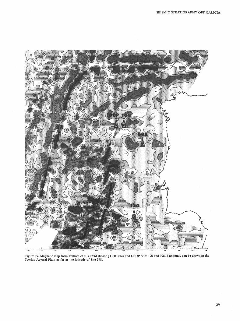
West of DSDP Site 398, the J anomaly is clearly displayed in the Iberian Abyssal Plain (Fig. 19) (Verhoef et al., 1986). Ac
cording to the recent geologic time scale of Kent and Gradstein (1985), anomaly J (MO to M4; Tucholke and Ludwig, 1982) is Barremian-earliest Aptian. Moreover, the paleomagnetic measurements performed on Site 398 samples did not detect any post-Barremain, pre-Santonian polarity reversal (Morgan, 1979). In order to understand this discrepancy between a Barremian-earliest Aptian first emplacement of crust west of Vigo sea-mount and a late Aptian break-up unconformity, we reinterpret the Site 398 seismic data (Fig. 20). The correlation between the seismic data and the core data was based on velocities determined by laboratory measurements (Sibuet, Ryan, et al., 1979); these velocities must be corrected. Although 10% was effectively added (Sibuet, Ryan, et al., 1979), they are still very low. If the numerous root-mean-square velocity analyses (Groupe Galice, 1979) are used, it appears that the hole ended in Hauterivian sediments but did not reach the basement, which may be made of Late Jurassic carbonate platform or crystalline base-
20

SEISMIC STRATIGRAPHY OFF GALICIA
w
GP102-A1
5 Km
GP102-A2 Figure 11. On the southern portion of the presumed continental shelf, a thick basin existed during the Valanginian time (sequence 5A). An erosional unconformity (curved arrow) occurred on the top of a rotated block (for location, refer to Figs. 1 and 12).
ment (Table 2). On the left side (Fig. 20) a Valanginian syn-rift layer cannot be excluded. The break-up unconformity corresponds to the late Barremian-earliest Aptian. This new identification fits well with the presence of J anomaly west of Site 398. Several slumps noted in the lower Aptian (de Graciansky et al., 1978) may correspond to the break-up unconformity. A similar Barremian unconformity was noted in the Lusitanian Basin (Table 2; Montenat et al., this volume) as well as at many DSDP sites in the North Atlantic (Muller et al., 1984).
Comparison with the Canadian margin is difficult. First, a last rifting event (pre-Cenomanian) is related to the opening of Labrador Sea and to the opening between Goban Spur and the north Grand Banks (Hubbard et al., 1985). Second, the same unconformity is dated, in Hibernia well, as pre-Aptian (Arthur et al., 1982) or mid-Aptian (Creany and Allison, 1987). Third, we may expect a propagation of the rift from south to north (Parson et al., 1984), and a general chart of the whole Canadian margin (Arthur et al., 1982) could not represent a good picture of this complex area. However, the late Barremian/middle Aptian age unconformity may be correlated with the unconformity of the same age in Site 398.
In the ODP Leg 103 sites, the unconformity may be slightly younger (middle or late Aptian) because the J anomaly does not exist offshore (Fig. 19), and a propagating rifting from south to north is possible.
CONCLUSIONS The previous seismic stratigraphy of the Galicia margin has
been updated according to the results of ODP Leg 103 and new seismic lines.
Two episodes of channeling in a deep-sea fanlike environment are evident. However, the Galicia Bank is too small to be a source of a real deep-sea fan, and this bank prevents any supply from the continent. These episodes of channeling are linked to erosion and retreating of cliffs. The main Cenozoic unconformity, linked to a last Pyrenean orogeny, is now attibuted to an Oligocene event. The break-up unconformity could have occurred in the Barremian-earliest Aptian at least in the Site 398 area, though it could be younger in the ODP Leg 103 region. According to the seismic statigraphy, a continental shelf existed 10 km east of the ODP Leg 103 sites during Valanginian time. A Late Jurassic tensional event is assumed. We would like to emphasize
21

22
Figure 12. Sketch of restored paleoenvironment during the Valanginian. Note the bending of the margin and the location of ODP Leg 103 sites in the basin.
A. M
AU
FFRET, L. M
ON
TAD
ERT

SEISMIC STRATIGRAPHY OFF GALICIA
Figure 13. Depth section (upper) and restored section (lower) of the Valanginian basin shown in Figure 11. Erosion was active during the late Valanginian on the top of the block (B). During the Hauterivian to late Barremian-earliest Aptian rifting event, the throw of the eastern fault
ACKNOWLEDGMENTS We thank Katlyn Scanlon, from U.S. Geological Survey, for the revi
sion of the English manuscript. We thank D. S. Roberts and K. D. Klitgord for critically reading the manuscript and for their thoughtful suggestions. We would also like to acknowledge G. Boillot and D. Mougenot for their suggestions and fruitful discussions. Contribution GEMC (UA 718) no. 412.
REFERENCES Arthur, K. R., Cole, D. R., Henderson, G.G.L., and Kushnir, D. W,
1982. Geology of the Hibernia discovery in subtle traps: new tool for the petroleum exploration. AAPG Bull., 32:181-195.
Black, M., Hill, M., Laughton, A. S., and Matthews, D. H., 1964. Three non-magnetic seamounts off the Iberian coast. Q. J. Geol. Soc. (London), 120:477-517.
Boillot, G., Auxietre, J. L., Dunand, J. P., Dupeuble, P. A., and Mauffret, A., 1979. The northwestern Iberian margin: a Cretaceous passive margin deformed during Eocene. In Deep Drilling Results in the Atlantic Ocean: Continental Margins and Paleoenvironment. Am. Geophys. Union, Maurice Ewing Sen, 3:138-153.
Boillot, G, Comas, M., Girardeau, J., Kornprobst, J., Loreau, J. P., Malod, J., Mougenot, D., and Moullade, M., 1986. Fonds sous-marins basaltiques et ultramafiques au pied d'une marge stable. Re-sultats preliminaires de la campagne Galinaute (plongees du submersible Nautile). C. R. Acad. Sci. Ser. 2, 303:1719-1724.
Boillot, G., Winterer, E. L., Meyer, A. W, Applegate, J., Baltuck, M., Bergen, J. A., Comas, M. C , Davies, T. A., Dunham, K., Evans, C. A., Girardeau, J., Goldberg, D. G., Haggerty, J., Jansa, L. F., Johnson, J. A., Kasahara, J., Loreau, J. P., Luna-Sierra, E., Moullade, M., Ogg, J., Sarti, M., Thurow, J., and Williamson, M. A., 1985. Resultats preliminaires de la campagne 103 du Joides Resolution (Ocean Drilling Program) au large de la Galice (Espagne): sedimentation et distension pendant le "rifting"' d'une marge stable; hypothese d'une denudation tectonique du manteau superieur. C. R. Acad. Sci. Ser. 2, 9:627-632.
, 1986. ODP Leg 103 drills into rift structures. Geotimes, 31: 15-17.
BRGM, Elf-Re, ESSO-REP, SNPA, 1974. Geologie du Bassin d'Aqui-talne. Bur. Rech. Geol. Min., 26 pl.
Brun, J. P., and Choukroune, P. H., 1983. Normal faulting block tilting and decollement in a stretched crust. Tectonics, 2(4):345-356.
was 1 km, whereas the Valangininan throw is greater (2.5 km).
Figure 14. Thickness map (in meters) of sequence 5A. The sub-basin is separated by a high (H). The ODP sites are shown.
the diversity of the margin; the lithostratigraphic column may differ from one block to another block, so that the uppermost Jurassic (Tithonian) carbonate platform can either overlie an Upper Jurassic sedimentary layer or rest on the basement. Blocks underwent one or two rifting events. In a such an environment, the ODP and DSDP results must be extrapolated with caution.
On the other hand, we note the permanence of some trends. The edge of the Valanginian continental shelf was probably con-tolled by faults that are as old as Late Jurassic (Oxfordian-Kim-meridgian). The earliest Cretaceous continental slope was reactivated during the Early Cretaceous rifting and became a listric fault. The old pattern is still identifiable in the present morphology.
23

A. MAUFFRET, L. MONTADERT
Brunet, M. F., 1984. Subsidence history of the Aquitaine Basin determined from subsidence curves. Geol. Mag., 121:421-428.
Creany, S., and Allison, B. H., 1987. An organic geochemical model of oil generation in the Avalon Flemish pass subbasins, east coast, Canada. Bull. Can. Pet. Geol., 25:12-23.
de Charpal, O., Guennoc, P., Montadert, L., and Roberts, D. G., 1978. Rifting, crustal attenuation and subsidence in the Bay of Biscay. Nature, 275:706-711.
de Graciansky, P. C., Muller, C , Rehault, J. P., and Sigal, J., 1978. Re-constitution de 1'evolution des milieux de sedimentation sur la marge continentale iberique au Cretace. Le flanc sud du Haut-fond de Vigo et le forage DSDP-1POD 398D. Problemes concernant la surface de compensation des carbonates. Bull. Soc. Geol. Fr., 20:389-399.
de Graciansky, P C , Poag, C. W., et al., 1985. Init. Repts. DSDP, 80, Washington (U.S. Govt. Printing Office).
Dupeuble, P. A., Rehault, J. P., Auxietre, J. L., Dunand, J. P., and Pas-touret, L., 1976. Resultats de dragages et essai de stratigraphic des bancs de Galice et des montagnes de Porto et de Vigo (marge occi-dentale iberique). Mar. Geol., 22:M37-M49.
Gibbs, A. D., 1984. Structural evolution of extensional basin margins. J. Geol. Soc. (London), 141:609-620.
Grimaud, S., Boillot, G , Collette, B, Mauffret, A., Miles, P. R., and Roberts, D. B., 1982. Western extension of the Iberian-European plate boundary during the Early Cenozoic (Pyrenean) convergence: a new model. Mar. Geol., 45:63-77.
Groupe Galice, 1979. The continental margin off Galicia and Portugal: acoustical stratigraphy, dredge stratigraphy and structural evolution. In Sibuet, J . -C, Ryan, W.B.F, et al., Init. Repts. DSDP, 47, Pt. 2: Washington (U.S. Govt. Printing Office), 633-662.
Guery, F , 1984. Evolution sedimentaire et dynamique du bassin marginal ouest Portugais au Jurassique [Thesis]. Univ. Lyon.
Hubbard, R. J., Pope, J., and Roberts, D. C , 1985. Depositional sequence mapping to illustrate the evolution of a passive continental margin. Mem., Am. Assoc. Pet. Geol., 39:92-115.
Kent, D. V, and Gradstein, F. M., 1985. A Cretaceous and Jurassic geochronology. Geol. Soc. Am. Bull., 96:1419-1472.
Kidd, R., Searle, R., Ramsay, A.T.S., Prichard, H., and Mitchell, J., 1982. The geology and formation of King's Trough, northeast Atlantic Ocean. Mar. Geol., 48:1-30.
Lallemand, F , Maze, J. P., Marti, F , and Sibuet, J . -C, 1985. Presentation d'une carte bathymetrique de PAtlantique nord-est. C. R. Acad. Sci. Sen 2, 300:145-149.
Mauffret, A., Boillot, G , Auxietre, J. L., and Dunand, J. P., 1978. Evolution Structurale de la marge continentale du Nord-Ouest de la Peninsule Iberique. Bull. Soc. Geol. Fr., 20:375-388.
Mauffret, A., and Montadert, L., 1987. Rift tectonics on the passive continental margin off Galicia (Spain). Mar. Pet. Geol., 4:49-70.
Montadert, L., Roberts, D. G , et al., 1979. Rifting and subsidence of the northern continental margin of Bay of Biscay. In Montadert, L., Roberts, D.G., et al., Init. Repts. DSDP, 48: Washington (U.S. Govt. Printing Office), 1025-1060.
Montadert, L., Winnock, E., Delteil, J. R., and Grau, G., 1974. Continental margins of Galicia-Portugal and Bay of Biscay. In Burk, C. A., and Drake, C. L. (Eds.), The Geology of Continental Margins: New York (Springer-Verlag), 323-342.
Morgan, G. E., 1979. Paleomagnetic results from DSDP Site 398. In Sibuet, J . -C, and Ryan, W.B.F, Init. Repts DSDP, 47, Pt. 2: Washington (U.S. Govt. Printing Office), 599-612.
Mougenot, D., Capdevila, R., Dupeuble, P. A., Mauffret, A., and Pa-lain, C , 1985. Les sediments ante-rift et le socle de la marge continentale de Galice. C. R. Acad. Sci. Ser. 2, 301:323-328.
Mougenot, D., Monteiro, J. H., Dupeuble, P. A., and Malod, J. A., 1979. La marge continentale sud-portugaise. Evolution Structurale et sedimentaire. Cien. de Terra Lisbon, 5:223-246.
Muller, C , Schaaf, A., and Sigal, J., 1984. Biochronostratigraphie des formations d' age Cretace dans les forages du DSDP dans l'Ocean Atlantique Nord (pt. 2). Rev. Inst. Fr. Pet., 39:3-24.
Sangree, J. B., and Widmier, J. M., 1979. Interpretation of depositional facies from seismic data. Geophysics, 44:131-160.
Sibuet, J . -C, Ryan, W.B.F, et al., 1979. Init. Repts. DSDP, 47, Pt. 2: Washington (U.S. Govt. Printing Office).
Tucholke, B. E., and Ludwig, W. J., 1982. Structure and origin of the J anomaly ridge, western north Atlantic Ocean. J. Geophys. Res., 87: 9389-9407.
Vail, P. R., Mitchum, R. M., and Thompson, S., 1977. Seismic stratigraphy and global changes of sea level. In Payton, C E. (Ed.), Seismic Stratigraphy Applications to Hydrocarbon Exploration: Mem., Am. Assoc. Pet. Geol., 26:83-97.
Verhoef, J., Collette, B. J., Miles, P. R., Searle, R. C , Sibuet, J . -C, and Williams, C. A., 1986. Magnetic anomalies in the northeast Atlantic Ocean (35-50°N). Mar. Geophys. Res., 8:1-25.
Date of initial receipt: 30 January 1987 Date of acceptance: 10 August 1987 Ms 103B-119
24

SEISMIC STRATIGRAPHY OFF GALICIA
x ^ W 5 ^ r x \ ^ V = 5 r r " - - - - r ^ E = ~ (A) LATE JURASSIC
x V x x x *
EARLY VALANGINIAN
MIDDLE VALANGINIAN
® LATE VALANGINIAN
LATE APTIAN
1 k m -VERTICAL EXAGGERATION
x2,5
Synrift I sediments (Sequence 4 )
Synrift I sediments (Sequence 5A)
Late Jurassic Carbonate Platform
rrq Upper Jurassic ? to Triassic ? Sediments (Sequence 5B)
r——| Metamorphic and Paleozoic LcJU basement
Figure 15. Sketch of the structural evolution of the Galicia margin based on a restored section of GP-11 (Figs. 8 and 9) (for explanation, see the text).
25

A. MAUFFRET, L. MONTADERT
w ODP 640
GP102-A3
OCEANIC W CRUST
LHERZOLITE RIDGE
I
GP102-A4
Figure 16. ODP Site 640 may have reached a pocket of sediments on the top of a basement block (small arrow).
26

SEISMIC STRATIGRAPHY OFF GALICIA
w
GP101-B2
Figure 17. The S Reflector is visible (large arrow) below ODP Site 639, where basement rock has been drilled (Boillot et al., 1985, 1986).
27

A. MAUFFRET, L. MONTADERT
VERTICAL EXAGGERATION X14.8
L — l 1 0 K m Figure 18. Left side shows previous interpretation by Groupe Galice (1979, fig. 13, p. 653). New interpretation is on the right side. The flexure (large arrow) is probably late Oligocene in age and marks the last Pyrenean orogeny. The flexure is the buried extension of the Galicia slope (for location, see Fig. 1).
28
SEISMIC STRATIGRAPHY OFF GALICIA
Figure 19. Magnetic map from Verhoef et al. (1986) showing ODP sites and DSDP Sites 120 and 398. J anomaly can be drawn in the Iberian Abyssal Plain as far as the latitude of Site 398.
29

A. MAUFFRET, L. MONTADERT
Table 2. Rifting events and hiatuses (framed) on the Canadian margin and on the Iberian margin.
Canadian Margin (Arthur et al.,1982)
^ ^ ^ ^ ^ ^ ^ ^ ^ ^ ^ ^
Lusitanian Basin (Montenat et al.,
this volume)
DSDP 398 (Sibuet, Ryan etal.,^"*
DSDP 398 (this study)
West flank of Galicia Bank
(this study)
CENOMANIAN
ALBIAN
APTIAN
BARREMIAN
HAUTERIVIAN
VALANGINIAN
BERRIASIAN
TITHONIAN
KIMMERIDGIAN
L M F L M E L M E L M
L M
_E_ L M E L M E L M
-E-L M
_E_ OXFORDIAN L
M _E_
RIFTING events ̂i
RIFTING
event
CALLOVIAN L M F
Black Shales
no MA
Acoustic basement
Hauterivian limestones
118 MA
RIFTING event II
RIFTING event n
RffTING event I (?)
RIFTING event I
Acoustic basement: Late Jurassic
carbonate platform or crystalline rocks
RIFTING
event ?
RIFTING
event ?
WNW I P 0 0 3 9 8 ESE 700 600 500 A 400 GP23 300
5 _ j 1 1 1 1 1 I 1 1 1 1 1 I I I I I I I I I I I I I I I I I I I I I I I I I I I I I 1 1 1 1 1 I 1 1 1 1 1 1 1 1 1 I i / \ i 1 1 1 1 1 1 1 1 1 1 1 1 1 1 1 1 I 1 1 1 1 i 1 1 1 1 I 1 1 - 5 i A
WNW LINE GP 19 398 ESE
Figure 20. Reinterpretation of DSDP Site 398 using the root-mean-square velocities (Groupe Galice, 1979). A = Aptian; B = Barremian; H = Hauterivian; 5A = possible Hauterivian to Valanginian layer. The hole ends in the Hauterivian and did not reach the basement. The break-up unconformity could be as old as Barremian.
30