Embed Size (px)
Citation preview
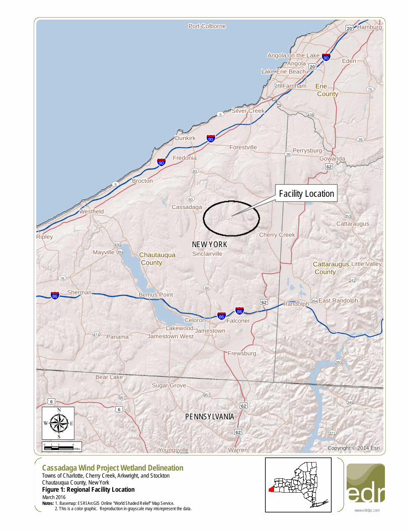
Facility Location
NEW YORK
PENNSYLVANIA
Chautauqua County Cattaraugus
County
Erie County
§̈¦90
§̈¦86
§̈¦90
§̈¦86
§̈¦90
§̈¦86
£¤20
£¤62
£¤6
£¤20
£¤6
£¤62
£¤62
£¤62
UV5
UV83
UV474
UV76
UV430UV394
UV353
UV60
UV75
UV957
UV249
UV39
UV321
UV438
UV280
UV242
UV346
UV426
UV60
UV957
UV39
UV5
UV394
Corry
Eden
Jamestown
Dunkirk
Fredonia
Port Colborne
Westfield
Randolph
Frewsburg
Panama
Hamburg
Mayville
Lake Erie Beach
Brocton
Ripley
Angola
LakewoodJamestown West
Sinclairville
Angola on the Lake
Farnham
Falconer
Gowanda
Cherry Creek
Youngsville
Forestville
Silver Creek
Cassadaga
Celoron
Sherman
Cattaraugus
Perrysburg
Little Valley
Sugar Grove
East Randolph
Bear Lake
Warren
Bemus Point
Copyright:© 2014 Esri
www.edrdpc.com
µFigure 1: Regional Facility LocationNotes: 1. Basemap: ESRI ArcGIS Online "World Shaded Relief" Map Service. 2. This is a color graphic. Reproduction in grayscale may misrepresent the data.
0 2 41Miles
March 2016
Cassadaga Wind Project Wetland DelineationTowns of Charlotte, Cherry Creek, Arkwright, and StocktonChautauqua County, New York
#
#
!=!
!=! !=!
!=!
!=!
!=!
!=!
!=!
!=!
!=!!=!
!=!
!=!!=!
!=!
!=!
!=!
!=!!=!
!=!
!=!
!=!
!=!
!=!
!=!
!=!
!=!
!=!
!=!
!=!
!=!
!=!
!=!
!=!
!=!
!=!
!=!
!=!
!=!
!=!
!=!
!=!
!=!
!=!!=!
!=!
!=!
!=!
!=!
!=!
!=!
!=!
!=!
!=!
!=!
!=!
!=!
!=!
Sinclairville
Cassadaga
Cherry Creek
UV83UV60
UV60
UV60
RT 77
RT
85
Hall Rd
RT 64
Hill R
d
RT 75
East Rd
RT 79
Plank
Rd
Shum
la Rd
Lewis
Rd
Cassadaga Rd
Damo
n Hill R
d
RT 380
Aldric
h Hill R
d
Terry Rd
Tarbox Rd
Hooker Rd
Villenova Rd
Harris Hollow Rd
Pickup Hill Rd
Cleland Rd
RT 72
Herric
k Rd
Hagerdon Rd
Risley Rd
Harpe
r Rd
Barnum Rd
Ames Rd
Hunt Rd
Butcher Rd
Meadows Rd
Housington Rd
Harris
Hill R
d
Dybkas Rd
Weaver Rd
Luce Rd
Round Top RdCR
133
Skinne
r Rd
Grisw
old R
d
Nobles RdBentley Hill Rd
Spod
en R
d
Bernard Rd
Engdahl Rd
Swanson Rd
Burnham Rd
Hamlet Rd
Prospect St
Moon Rd
RT 52
Cook Rd
C Johnson RdCR 85 Johnson Rd
Zahm Rd
Wade Hill Rd
Smith Rd
Putm
an R
d
Davis
on R
d
State Land RdHodge Rd
Roberts Rd
Dibble Hill RdShelters Rd
Ruttenbur Rd
CR 72
Wentw
orth R
d
RT 56
RT 66
RT 66
Hall Rd
RT 72
Cassadaga RdHo
dge R
d
RT 72
RT 72
Smith Rd
Ruttenbu
r Rd
Hill R
d
RT 79 Hill R
d
Prospect St
Shum
la Rd
Harris
Hill R
d
Hill R
d
Smith Rd
T1T2
T3
T4
T5
T6
T7
T8
T9
T10
T11
T12
T13
T14T15
T16
T17
T18
T19T20
T21
T22T24
T25
T26
T27
T28
T29
T30
T31
T32
T33
T34
T35T36
T37
T38
T39
T40T41
T42
T43
T44T45
T46
T47
T48 T49
T50
T51
T52
T53
T54
T55
T56T57
T58
Source: Esri, DigitalGlobe, GeoEye, Earthstar Geographics,CNES/Airbus DS, USDA, USGS, AEX, Getmapping, Aerogrid, IGN, IGP,swisstopo, and the GIS User Community
www.edrdpc.com
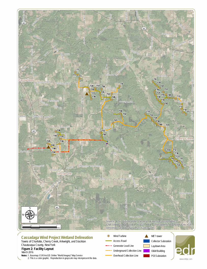
µCassadaga Wind Project Wetland DelineationTowns of Charlotte, Cherry Creek, Arkwright, and StocktonChautauqua County, New YorkFigure 2: Facility LayoutNotes: 1. Basemap: ESRI ArcGIS Online "World Imagery" Map Service 2. This is a color graphic. Reproduction in grayscale may misrepresent the data.
0 1 20.5Miles
March 2016
!=! Wind TurbineAccess RoadGenerator Lead LineUnderground Collection LineOverhead Collection Line
# MET towerCollector SubstationLaydown AreaO&M BuildingPOI Substation
#
#
!=!
!=! !=!
!=!
!=!
!=!
!=!
!=!
!=!
!=!!=!
!=!
!=!!=!
!=!
!=!
!=!
!=!!=!
!=!
!=!
!=!
!=!
!=!
!=!
!=!
!=!
!=!
!=!
!=!
!=!
!=!
!=!
!=!
!=!
!=!
!=!
!=!
!=!
!=!
!=!
!=!
!=!
!=!!=!
!=!
!=!
!=!
!=!
!=!
!=!
!=!
!=!
!=!
!=!
!=!
!=!
!=!T1
T2
T3
T4
T5
T6
T7
T8
T9
T10
T11
T12
T13
T14T15
T16
T17
T18
T19T20
T21
T22
T23
T24
T25
T26
T28
T29
T30
T31
T32
T33
T34
T35T36
T37
T38
T39
T40T41
T42
T43
T44T45
T46
T47
T48 T49
T50
T51
T52
T53
T54
T55
T56T57
T58
Copyright:© 2013 National Geographic Society, i-cubed
www.edrdpc.com
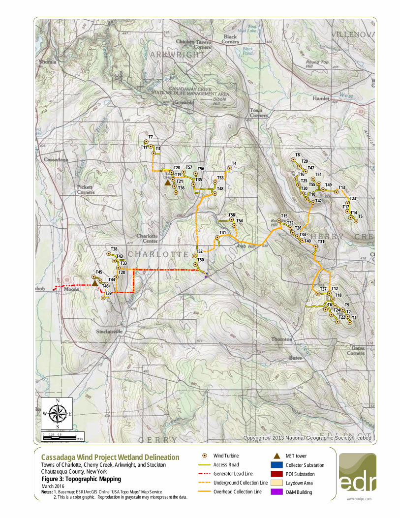
µCassadaga Wind Project Wetland DelineationTowns of Charlotte, Cherry Creek, Arkwright, and StocktonChautauqua County, New YorkFigure 3: Topographic MappingNotes: 1. Basemap: ESRI ArcGIS Online "USA Topo Maps" Map Service 2. This is a color graphic. Reproduction in grayscale may misrepresent the data.
0 0.5 10.25Miles
March 2016
!=! Wind TurbineAccess RoadGenerator Lead LineUnderground Collection LineOverhead Collection Line
# MET towerCollector SubstationPOI SubstationLaydown AreaO&M Building
!=!
!=!
!=!
!=!
!=!
!=!
!=!
!=!
!=!
!=!
!=!
!=!
!=!
!=!
!=!
!=!
!=!
!=!
!=!
!=!
!=!
!=!
!=!
!=!
!=!
!=!
!=!
!=!
!=!
!=!
!=!
!=!
!=!
!=!
!=!
!=!
!=!
!=!
!=!
!=!
!=!
!=!
!=!
!=!
!=!
!=!
!=!
!=!
!=!
!=!
!=!
!=!
!=!
!=!
!=!
!=!
!=!
!=!
T28
T33
T38
T39
T43
T44
T45T46
UV60
UV60
RT 77
Hall Rd
RT 75
Hooker Rd
Hill R
dHa
rper R
d
Ames Rd
CR 13
3
Luce Rd
Prospect St
Moon Rd
CR 85
CR 102
Reed St
Smith Rd
Nobles Rd
Andre
ws R
d
C Johnson Rd
East Rd
RT 52
Roberts Rd
CR 616
Bloomer St
CR 49 Maple St
Church St
Moon Station Rd
Reed Rd
Abbey Rd
Nicho
ls Rd
Hadley Dr
RT 66
Smith Rd
Andrews Rd
Source: Esri, DigitalGlobe, GeoEye, Earthstar Geographics,CNES/Airbus DS, USDA, USGS, AEX, Getmapping, Aerogrid, IGN, IGP,swisstopo, and the GIS User Community
www.edrdpc.com
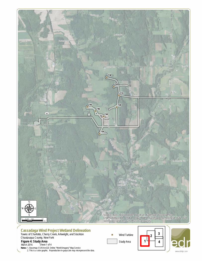
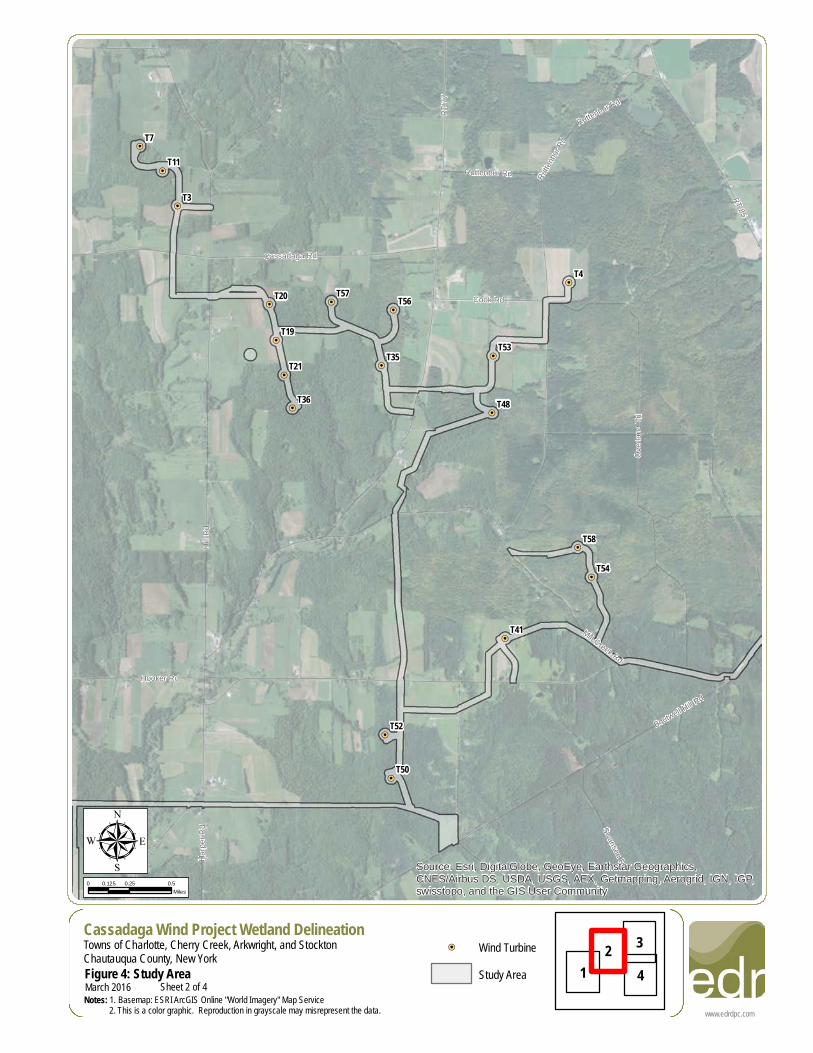
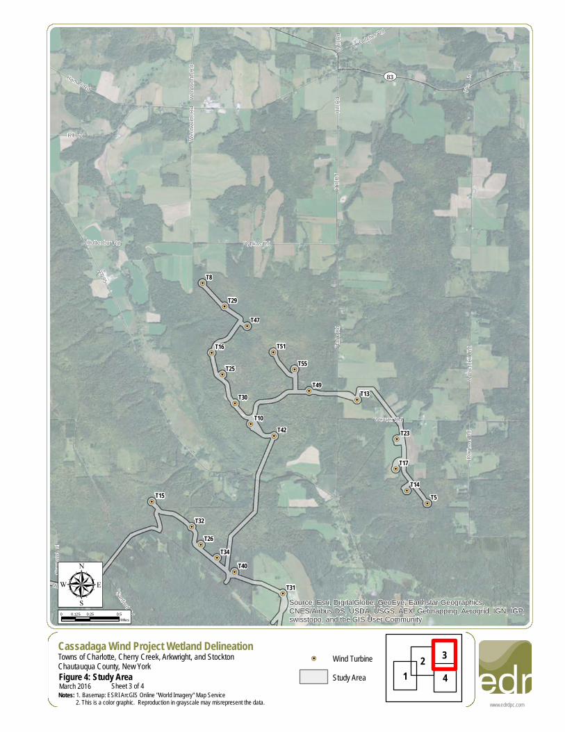
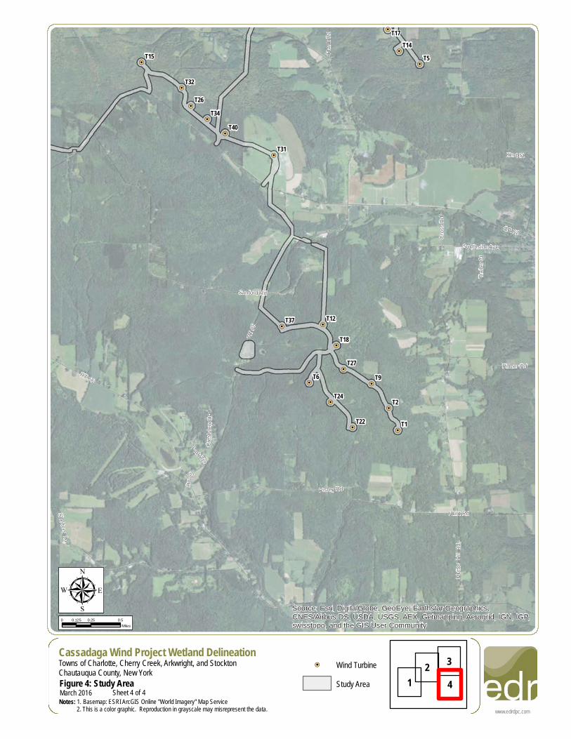
µCassadaga Wind Project Wetland DelineationTowns of Charlotte, Cherry Creek, Arkwright, and StocktonChautauqua County, New YorkFigure 4: Study AreaNotes: 1. Basemap: ESRI ArcGIS Online "World Imagery" Map Service 2. This is a color graphic. Reproduction in grayscale may misrepresent the data.
0 0.25 0.50.125Miles
March 2016
!=! Wind TurbineStudy Area 4
21
3
Sheet 1 of 4
!=!
!=!
!=!
!=!
!=!
!=!
!=!
!=!
!=!
!=!
!=!
!=!
!=!
!=!
!=!
!=!
!=!
!=!
!=!
!=!
!=!
!=!
!=!
!=!
!=!
!=!
!=!
!=!
!=!
!=!
!=!
!=!
!=!
!=!
!=!
!=!
!=!
!=!
!=!
!=!
!=!
!=!
!=!
!=!
!=!
!=!
!=!
!=!
!=!
!=!
!=!
!=!
!=!
!=!
!=!
!=!
!=!
!=!
T3
T4
T7
T11
T19
T20
T21T35
T36
T41
T48
T50
T52
T53
T54
T56T57
T58
RT 77
Hill R
d
RT 85
Overl
and T
rlMill Creek Rd
Boutwell Hill Rd
Cassadaga Rd
Cook Rd
Hooker Rd
Swanson RdHarpe
r Rd
Rutten
bur Rd
Ruttenbur Rd
Ruttenbur Rd
Source: Esri, DigitalGlobe, GeoEye, Earthstar Geographics,CNES/Airbus DS, USDA, USGS, AEX, Getmapping, Aerogrid, IGN, IGP,swisstopo, and the GIS User Community
www.edrdpc.com
µCassadaga Wind Project Wetland DelineationTowns of Charlotte, Cherry Creek, Arkwright, and StocktonChautauqua County, New YorkFigure 4: Study AreaNotes: 1. Basemap: ESRI ArcGIS Online "World Imagery" Map Service 2. This is a color graphic. Reproduction in grayscale may misrepresent the data.
0 0.25 0.50.125Miles
March 2016
!=! Wind TurbineStudy Area 4
21
3
Sheet 2 of 4
!=!
!=!
!=!
!=!
!=!
!=!
!=!
!=!
!=!
!=!
!=!
!=!
!=!
!=!
!=!
!=!
!=!
!=!
!=!
!=!
!=!
!=!
!=!
!=!
!=!
!=!
!=!
!=!
!=!
!=!
!=!
!=!
!=!
!=!
!=!
!=!
!=!
!=!
!=!
!=!
!=!
!=!
!=!
!=!
!=!
!=!
!=!
!=!
!=!
!=!
!=!
!=!
!=!
!=!
!=!
!=!
!=!
!=!
T5
T8
T10
T13
T14T15
T16
T17
T23
T25
T26
T29
T30
T31
T32
T34T40
T42
T47
T49
T51
T55
UV83
RT 85
Plank
Rd
Aldric
h Hill R
d
Weaver Rd
Hill R
d
Dybkas Rd
Davis
on R
d
RT 72
Hamlet Rd
Sanford Rd
Overl
and T
rl
Butcher Rd
Mill Creek Rd
Ruttenbur Rd
Wentw
orth R
d
Pen L
n
Hill R
dHil
l Rd
Wentw
orth R
d
Source: Esri, DigitalGlobe, GeoEye, Earthstar Geographics,CNES/Airbus DS, USDA, USGS, AEX, Getmapping, Aerogrid, IGN, IGP,swisstopo, and the GIS User Community
www.edrdpc.com
µCassadaga Wind Project Wetland DelineationTowns of Charlotte, Cherry Creek, Arkwright, and StocktonChautauqua County, New YorkFigure 4: Study AreaNotes: 1. Basemap: ESRI ArcGIS Online "World Imagery" Map Service 2. This is a color graphic. Reproduction in grayscale may misrepresent the data.
0 0.25 0.50.125Miles
March 2016
!=! Wind TurbineStudy Area 4
21
3
Sheet 3 of 4
!=!
!=!
!=!
!=!
!=!
!=!
!=!
!=!
!=!
!=!
!=!
!=!
!=!
!=!
!=!
!=!
!=!
!=!
!=!
!=!
!=!
!=!
!=!
!=!
!=!
!=!
!=!
!=!
!=!
!=!
!=!
!=!
!=!
!=!
!=!
!=!
!=!
!=!
!=!
!=!
!=!
!=!
!=!
!=!
!=!
!=!
!=!
!=!
!=!
!=!
!=!
!=!
!=!
!=!
!=!
!=!
!=!
!=!T1
T2
T5
T6 T9
T12
T14T15
T17
T18
T22
T24
T26
T27
T31
T32
T34
T37
T40
RT 85
RT 66
Hunt Rd
Sanford Rd
Risley Rd
Southside Ave
Pinner Rd
Cros
s Rd
Plank
Rd
Cres
tview
Dr
CR 62
Park Ter
Shelters Rd
Kent St
Mutto
n Hill R
d
Traile
r Ct
RT 85
Source: Esri, DigitalGlobe, GeoEye, Earthstar Geographics,CNES/Airbus DS, USDA, USGS, AEX, Getmapping, Aerogrid, IGN, IGP,swisstopo, and the GIS User Community
www.edrdpc.com
µCassadaga Wind Project Wetland DelineationTowns of Charlotte, Cherry Creek, Arkwright, and StocktonChautauqua County, New YorkFigure 4: Study AreaNotes: 1. Basemap: ESRI ArcGIS Online "World Imagery" Map Service 2. This is a color graphic. Reproduction in grayscale may misrepresent the data.
0 0.25 0.50.125Miles
March 2016
!=! Wind TurbineStudy Area 4
21
3
Sheet 4 of 4
!=!
!=! !=!
!=!
!=!
!=!
!=!
!=!
!=!
!=!!=!
!=!
!=!!=!
!=!
!=!
!=!
!=!!=!
!=!
!=!
!=!
!=!
!=!
!=!
!=!
!=!
!=!
!=!
!=!
!=!
!=!
!=!
!=!
!=!
!=!
!=!
!=!
!=!
!=!
!=!
!=!
!=!
!=!!=!
!=!
!=!
!=!
!=!
!=!
!=!
!=!
!=!
!=!
!=!
!=!
!=!
!=!
CR 62
9Gri
swold
Rd
Mecha
nicRd
Hadley Dr
Pen L
n
PineAcre
s Dr
HowardRd
RT 56
Abbey Rd
School RdNic
hols
Rd
Mead
owlar
kRd
Maple St
Traile
r Ct
Ulrich
Park
Dr
HallRd
Bernard Rd
Wentw
orth
Rd
DaleDr
Mill St
Bloomer St
Ruttenbur RdShelters Rd
RT 58
Davis
on R
d
Cres
tview
Dr
MoonStation Rd
Burnham Rd
RobertsRd
PinnerRd
Reed StCR 85
RT 52
CR 102
Smith Rd
PopeHill Rd
RuttenburRd
DibbleHill Rd
Hodge RdHarve
y Rd
Hill R
d
AndrewsRd
Cook Rd
Miller Rd
High St
P Joh
nson
Rd
Mutto
nHil
l Rd
Ruttenbur Rd
State
Land
Rd
Cassadaga Rd
Prospect St
Shum
la Rd
RT 79
RT 66
CR 13
3
Hill R
d
RT 85
SouthsideAve
Hamlet Rd
Luce Rd
Brainard Rd
Putm
an R
d
Moon Rd
Smith Rd
Zahm Rd
Harris Hill Rd
State Land Rd
RT 72
Engdahl Rd
Hodge Rd
Bernard Rd
Prospect St
Tarbox Rd
C Johnson Rd
Burnham Rd
Johnson Rd
Swanson Rd
Mutton Hill Rd
Wentw
orth R
d
Fuller
Gulf
Rd
Nobles Rd
Ames Rd
Davison Rd
Wade H
ill Rd
Dybkas Rd
RT 72
RT 68
Hunt Rd
Grisw
old R
d
Smith Rd
Harpe
r Rd
Risley Rd
Butcher Rd
RT 87
Barnum Rd
Weaver Rd
Skinn
er Rd
Bentley Hill Rd
Terry Rd
RT 56
Herric
k Rd Harris Hill Rd
Round Top Rd
Hagerdon Rd
RT 79
RT 72
Cleland Rd
RT 72
Hooker Rd
RT 75
Housington Rd Plank
Rd
Lewis
Rd
RT 71
Spod
en Rd
Picku
pHil
l Rd
Ball Rd
Meadows RdRT 5
2
Tarbox Rd
RT 85
RT 380
Sanford Rd
East Rd
Hill R
dShumla Rd
Villenova Rd
Overl
and T
rl
RT 75
Mill Creek Rd
Aldric
h Hill R
d
Hill R
d
Park Rd
Cassadaga Rd
Harris Hollow Rd
RT 72
Damo
n Hill R
d
RT 64
Boutwell
Hill Rd
Hall Rd
RT 50
Old Chautauqua Rd
RT 77
RT 85
RT 66
UV60
UV60UV83
UV60
£¤62
T58
T57 T56
T55
T54
T53
T52
T51
T50
T49T48
T47
T46T45 T44
T43
T42
T41 T40
T39
T38
T37
T36T35
T34
T33
T32
T31
T30
T29
T28
T27
T26
T25
T24
T23
T22
T21
T20T19
T18
T17
T16
T15 T14
T13
T12
T11
T10
T9
T8
T7
T6
T5
T4
T3
T2T1
1 2 3
4 5 6 7
Source: Esri, DigitalGlobe, GeoEye, Earthstar Geographics,CNES/Airbus DS, USDA, USGS, AEX, Getmapping, Aerogrid, IGN, IGP,swisstopo, and the GIS User Community, Copyright:© 2014 Esri
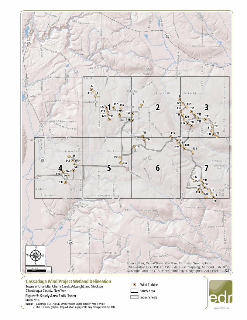
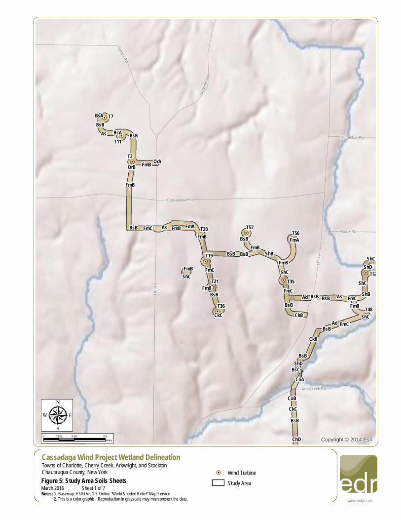
µCassadaga Wind Project Wetland DelineationTowns of Charlotte, Cherry Creek, Arkwright, and StocktonChautauqua County, New YorkFigure 5: Study Area Soils Index
0 0.5 10.25Miles
!=! Wind TurbineStudy AreaIndex Sheets
www.edrdpc.comNotes: 1. Basemap: ESRI ArcGIS Online "World Shaded Relief" Map Service 2. This is a color graphic. Reproduction in grayscale may misrepresent the data.
March 2016
!=!
!=!
!=!
!=!
!=!
!=!
!=!
!=!
!=!
!=!
!=!
!=!
!=!
!=!
!=!
!=!
!=!
!=!
!=!
!=!
!=!
!=!
!=!
!=!
!=!
!=!
!=!
!=!
!=!
!=!
!=!
!=!
!=!
!=!
!=!
!=!
!=!
!=!
!=!
!=!
!=!
!=!
!=!
!=!
!=!
!=!
!=!
!=!
!=!
!=!
!=!
!=!
!=!
!=!
!=!
!=!
!=!
!=!
Ruttenbur Rd
Cook Rd
Grisw
old R
d
Mill Creek Rd
Tarbox Rd
Cassadaga Rd
Hill R
d
RT 77
BsBBsB
BsB
BsA
BsB
BsB BsB
BsB
BsB
BsA
FmB
FmB
FmB
BsB
BsB BsB
FmA
OrAOrB
As
FmB
FmB
FmB
FmB
FmBFmB
ShC
As
FmC
FmC
FmC
FmAFmC
ShB
ShCShC
AdBsB
ShCAd
FmC
CkB
CkB
ShD
ShBShC
ShD
As
CkC
BsCCoA
CoBCkCBsB
ChD
T57T56
T53
T48T36
T35T21
T20
T19
T11
T7
T3
Copyright:© 2014 EsriµCassadaga Wind Project Wetland DelineationTowns of Charlotte, Cherry Creek, Arkwright, and StocktonChautauqua County, New YorkFigure 5: Study Area Soils Sheets
0 0.25 0.50.125Miles
!=! Wind TurbineStudy Area
www.edrdpc.comNotes: 1. Basemap: ESRI ArcGIS Online "World Shaded Relief" Map Service 2. This is a color graphic. Reproduction in grayscale may misrepresent the data.March 2016 Sheet 1 of 7
!=!
!=!
!=!
!=!
!=!
!=!
!=!
!=!
!=!
!=!
!=!
!=!
!=!
!=!
!=!
!=!
!=!
!=!
!=!
!=!
!=!
!=!
!=!
!=!
!=!
!=!
!=!
!=!
!=!
!=!
!=!
!=!
!=!
!=!
!=!
!=!
!=!
!=!
!=!
!=!
!=!
!=!
!=!
!=!
!=!
!=!
!=!
!=!
!=!
!=!
!=!
!=!
!=!
!=!
!=!
!=!
!=!
!=!
RT 85
Wentw
orth
Rd
Rutten
bur Rd
Dybkas RdRuttenbur RdRuttenbur Rd
Cook Rd
Mill Creek Rd
Ruttenbu
r Rd
RT 72
Housington Rd
Lewis
Rd
Overl
and T
rl
RT 85FmB
FmB
FmB
BsAAs
BsB
ShC
ShB
BsB
FmC
FmC
CkB
BsB
BsA
ShC
ShBShC
CkBShD
ShB
FmB
CkC
CkCShC
BsA
ChCChCChD
ShB
T58
T54
T53
T48
T25
T16
T15
T8
T4
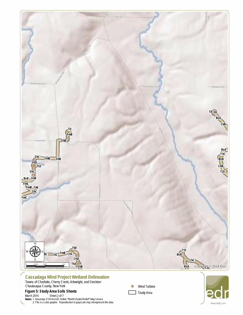
Copyright:© 2014 EsriµCassadaga Wind Project Wetland DelineationTowns of Charlotte, Cherry Creek, Arkwright, and StocktonChautauqua County, New YorkFigure 5: Study Area Soils Sheets
0 0.25 0.50.125Miles
!=! Wind TurbineStudy Area
www.edrdpc.comNotes: 1. Basemap: ESRI ArcGIS Online "World Shaded Relief" Map Service 2. This is a color graphic. Reproduction in grayscale may misrepresent the data.March 2016 Sheet 2 of 7
!=!
!=!
!=!
!=!
!=!
!=!
!=!
!=!
!=!
!=!
!=!
!=!
!=!
!=!
!=!
!=!
!=!
!=!
!=!
!=!
!=!
!=!
!=!
!=!
!=!
!=!
!=!
!=!
!=!
!=!
!=!
!=!
!=!
!=!
!=!
!=!
!=!
!=!
!=!
!=!
!=!
!=!
!=!
!=!
!=!
!=!
!=!
!=!
!=!
!=!
!=!
!=!
!=!
!=!
!=!
!=!
!=!
!=!
Hill R
d
Davis
on R
dDa
vison
Rd
Hill R
d
Dybkas Rd
Weaver Rd
RT 85
Plank
Rd
Aldric
h Hill R
d
BsAAs
BsB
BsB
BsB
BsB
BsB
BsB
CkB
ChF
ChF
BsA
FmBFmB
FmB
BsB
CkBCkB
ChDChE
ChECkC
CkBCkC
CkC
CkCCkBCkB
CkC
CkD
BsC
BsB
CkBChE W
ChE
VcC
CoB
CkCVaC
VaEChE
T55
T51
T49
T47
T42
T30
T29
T25
T23
T17
T16
T14
T13
T10
T8
T5
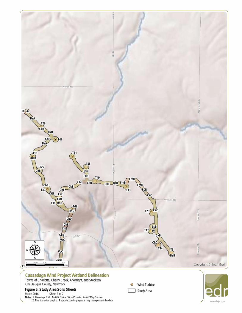
Copyright:© 2014 EsriµCassadaga Wind Project Wetland DelineationTowns of Charlotte, Cherry Creek, Arkwright, and StocktonChautauqua County, New YorkFigure 5: Study Area Soils Sheets
0 0.25 0.50.125Miles
!=! Wind TurbineStudy Area
www.edrdpc.comNotes: 1. Basemap: ESRI ArcGIS Online "World Shaded Relief" Map Service 2. This is a color graphic. Reproduction in grayscale may misrepresent the data.March 2016 Sheet 3 of 7
!=!
!=!
!=!
!=!
!=!
!=!
!=!
!=!
!=!
!=!
!=!
!=!
!=!
!=!
!=!
!=!
!=!
!=!
!=!
!=!
!=!
!=!
!=!
!=!
!=!
!=!
!=!
!=!
!=!
!=!
!=!
!=!
!=!
!=!
!=!
!=!
!=!
!=!
!=!
!=!
!=!
!=!
!=!
!=!
!=!
!=!
!=!
!=!
!=!
!=!
!=!
!=!
!=!
!=!
!=!
!=!
!=!
!=!
Hadley Dr
Nicho
lsRd
Abbey Rd
Nicho
ls Rd
CR 85
Moon Rd
Roberts Rd
Andrews Rd
Luce Rd
Prospect St
RT 75
RT 77
Prospect St
Ames Rd
Hooker Rd
Hall Rd
RT 75
UV60
BsBBsACkB
CkC
As
CkD
CkD
As
CkB
BsBBsB
BsB
BsB
BsB
BsB
As
RhCkC
CkC
CkC
CkC
CkBBsCCkB
CoB
CkB
BsB BsB
BsB
BsB
BsB
CkBCkB
CkCBsA
BsA
BsA
BsA
DaACkBMn
CkCLa
As
CkBCkB DaA
CkC
BsB BsB
VoB
Cc
CbGe AsCkBCkB
CkB
ChE
BsB
T46
T45
T44
T43
T39
T38
T33
T28
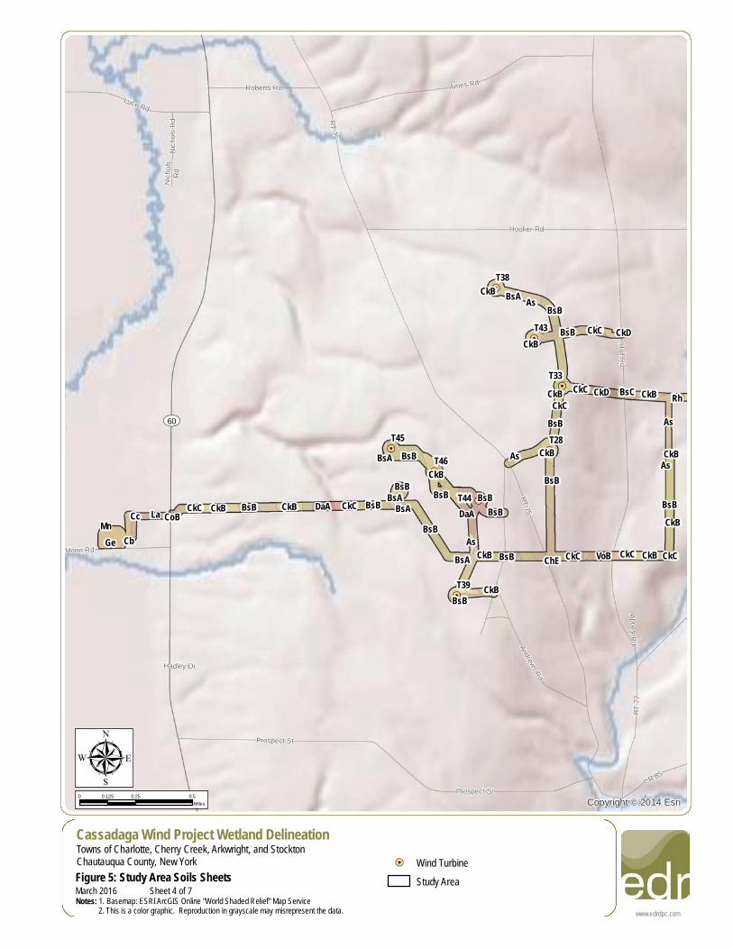
Copyright:© 2014 EsriµCassadaga Wind Project Wetland DelineationTowns of Charlotte, Cherry Creek, Arkwright, and StocktonChautauqua County, New YorkFigure 5: Study Area Soils Sheets
0 0.25 0.50.125Miles
!=! Wind TurbineStudy Area
www.edrdpc.comNotes: 1. Basemap: ESRI ArcGIS Online "World Shaded Relief" Map Service 2. This is a color graphic. Reproduction in grayscale may misrepresent the data.March 2016 Sheet 4 of 7
!=!
!=!
!=!
!=!
!=!
!=!
!=!
!=!
!=!
!=!
!=!
!=!
!=!
!=!
!=!
!=!
!=!
!=!
!=!
!=!
!=!
!=!
!=!
!=!
!=!
!=!
!=!
!=!
!=!
!=!
!=!
!=!
!=!
!=!
!=!
!=!
!=!
!=!
!=!
!=!
!=!
!=!
!=!
!=!
!=!
!=!
!=!
!=!
!=!
!=!
!=!
!=!
!=!
!=!
!=!
!=!
!=!
!=!
Hall Rd
CR 85
Johnson Rd
P Joh
nson
Rd
Hill R
d
Hooker Rd
C Johnson Rd
Clelan
d Rd
Harpe
r Rd Boutwell Hill Rd
East Rd
RT 66
RT 77
CkC
BsB
BsB
BsB
BsB BsB BsB
BsB
BsB
BsB
BsB
BsB
BsB
BsB
ChD
FmC
FmC
CkB
CkB
AsCkC
CkB
CkBCkB
BsA
Ho Ho
LnB ErB
RfClACnBAs
As
MdB
RhVoBVoB
VoB
VoBRh
MdBCkCCkBCkB CkB CkB
BsCAsBsB
BsB
CkB VoAAs
CkB
CkCCkB
T52
T50
T41
Copyright:© 2014 EsriµCassadaga Wind Project Wetland DelineationTowns of Charlotte, Cherry Creek, Arkwright, and StocktonChautauqua County, New YorkFigure 5: Study Area Soils Sheets
0 0.25 0.50.125Miles
!=! Wind TurbineStudy Area
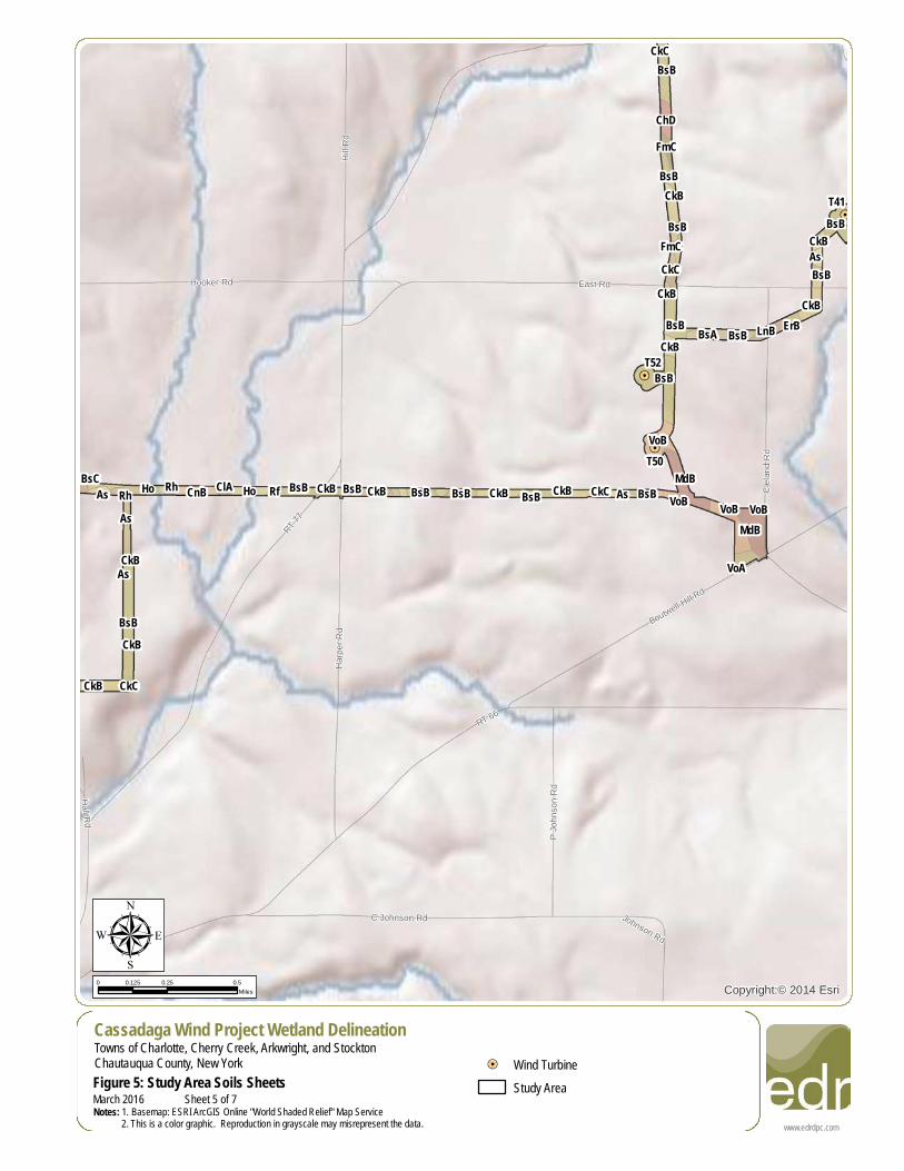
www.edrdpc.comNotes: 1. Basemap: ESRI ArcGIS Online "World Shaded Relief" Map Service 2. This is a color graphic. Reproduction in grayscale may misrepresent the data.March 2016 Sheet 5 of 7
!=!
!=!
!=!
!=!
!=!
!=!
!=!
!=!
!=!
!=!
!=!
!=!
!=!
!=!
!=!
!=!
!=!
!=!
!=!
!=!
!=!
!=!
!=!
!=!
!=!
!=!
!=!
!=!
!=!
!=!
!=!
!=!
!=!
!=!
!=!
!=!
!=!
!=!
!=!
!=!
!=!
!=!
!=!
!=!
!=!
!=!
!=!
!=!
!=!
!=!
!=!
!=!
!=!
!=!
!=!
!=!
!=!
!=!
ParkTerParkTer
Cres
tview
Dr
Housington Rd
Overland Trl
East Rd
Cleland Rd
Swanson Rd
Mill Creek Rd
Sanfo
rd Rd
RT 66
Boutwell Hill Rd
BsB
BsBFmB
FmB
CkCCkC
BsB
BsB
BsB
BsB
ShC
BsA
ChCChCChD
FmA
ShB
CkCShC
ShB
ChE
ChEBsB
FmBCkCLnC
FmBFmB
BsBBsB
AsAsBsBBsB
FmA
CkBFmA
LnB
T58
T54
T41 T34
T32T26
T15
Copyright:© 2014 EsriµCassadaga Wind Project Wetland DelineationTowns of Charlotte, Cherry Creek, Arkwright, and StocktonChautauqua County, New YorkFigure 5: Study Area Soils Sheets
0 0.25 0.50.125Miles
!=! Wind TurbineStudy Area
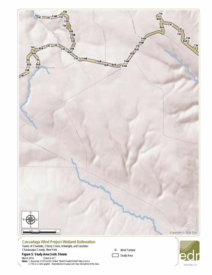
www.edrdpc.comNotes: 1. Basemap: ESRI ArcGIS Online "World Shaded Relief" Map Service 2. This is a color graphic. Reproduction in grayscale may misrepresent the data.March 2016 Sheet 6 of 7
!=!
!=!
!=!
!=!
!=!
!=!
!=!
!=!
!=!
!=!
!=!
!=!
!=!
!=!
!=!
!=!
!=!
!=!
!=!
!=!
!=!
!=!
!=!
!=!
!=!
!=!
!=!
!=!
!=!
!=!
!=!
!=!
!=!
!=!
!=!
!=!
!=!
!=!
!=!
!=!
!=!
!=!
!=!
!=!
!=!
!=!
!=!
!=!
!=!
!=!
!=!
!=!
!=!
!=!
!=!
!=!
!=!
!=!
CR62
ParkTerParkTer
Trailer Ct
Trailer
Ct
Cros
s Rd
Cres
tview
Dr
Pinner Rd
Sanford Rd
Southside Ave
Davison Rd
RT 68
Boutwell Hill Rd
Picku
pHil
l Rd
RT 85
BsB
BsB
BsB
ChE
VcC
CkCCkC
VaE
CkC
CkCCkC
CkC
ChF
BsC
BsC
CkC
ChDCkC
FeCkD CkD
CoA
ChD
ChE
ChDCkC
ToFChF
CoB
BsCCkD
ChE
BsB FmCBsC VaFCkC
CkC
CkD
CkDBsB
CkC CkD
BsB
BsB
CkC
CkC
CkC
CkC
BsA
BsB BsB
BsB
BsBBsB
FmA
CkB
CkB
AsBsB
CoB
BsA
CkB
CkB
VcC
CkB
CkB
Ad
ChD
CkB BsB
T40
T37
T34
T31
T27
T26
T24
T22
T18
T14
T12
T9T6
T5
T2
T1
Copyright:© 2014 EsriµCassadaga Wind Project Wetland DelineationTowns of Charlotte, Cherry Creek, Arkwright, and StocktonChautauqua County, New YorkFigure 5: Study Area Soils Sheets
0 0.25 0.50.125Miles
!=! Wind TurbineStudy Area
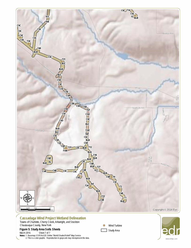
www.edrdpc.comNotes: 1. Basemap: ESRI ArcGIS Online "World Shaded Relief" Map Service 2. This is a color graphic. Reproduction in grayscale may misrepresent the data.March 2016 Sheet 7 of 7
!=!
!=! !=!
!=!
!=!
!=!
!=!
!=!
!=!
!=!!=!
!=!
!=!!=!
!=!
!=!
!=!
!=! !=!
!=!
!=!
!=!
!=!!=!
!=!
!=!
!=!
!=!
!=!
!=!
!=!
!=!
!=!
!=!
!=!
!=!
!=!
!=!
!=!
!=!
!=!
!=!
!=!
!=!!=!
!=!
!=!
!=!
!=!
!=!
!=!
!=!
!=!
!=!
!=!
!=!
!=!
!=!
Silver
Creek
DryBrook
Tuppe
rCre
ek
IndianBrook
MillCreek
Ackles
Brook
WheelerBrook
WestBranch-Conewango
Creek
Picket
t Broo
k
Fuller
Gulf C
reek
Conew
ango
Creek
Cherry Creek
BearCreek
Clear CreekMarkumBrook
Clinto
nBro
ok
Branch
Conew
ango
Creek
Dry CreekClear Creek
Mill Run Brook
WestBranch-Conewango
CreekCanadaway Creek
Conewango
CreekMill C
reek
Folso
m Cre
ekWa
lnut C
reek
Hatch
Creek
Cherry Creek
Clear Creek
Allen Brook
Twentyeighth Creek
Blaisdell Creek
Mill Cree
k
Canadaway
Creek
Branch Conewango Creek
Branch Conewango Creek
Canadaway Creek
Cassa
daga
Creek
T58
T57 T56T55
T54
T53
T52
T51
T50
T49T48
T47
T46T45
T44
T43
T42
T41
T40
T39
T38
T37
T36T35
T34
T33
T32
T31
T30
T29
T28
T27
T26
T25
T24
T23
T22
T21
T20 T19
T18
T17
T16
T15 T14
T13
T12
T11
T10
T9
T8
T7
T6
T5
T4
T3
T2T1
Source: Esri, DigitalGlobe, GeoEye, Earthstar Geographics,CNES/Airbus DS, USDA, USGS, AEX, Getmapping, Aerogrid, IGN, IGP,swisstopo, and the GIS User Community
www.edrdpc.com
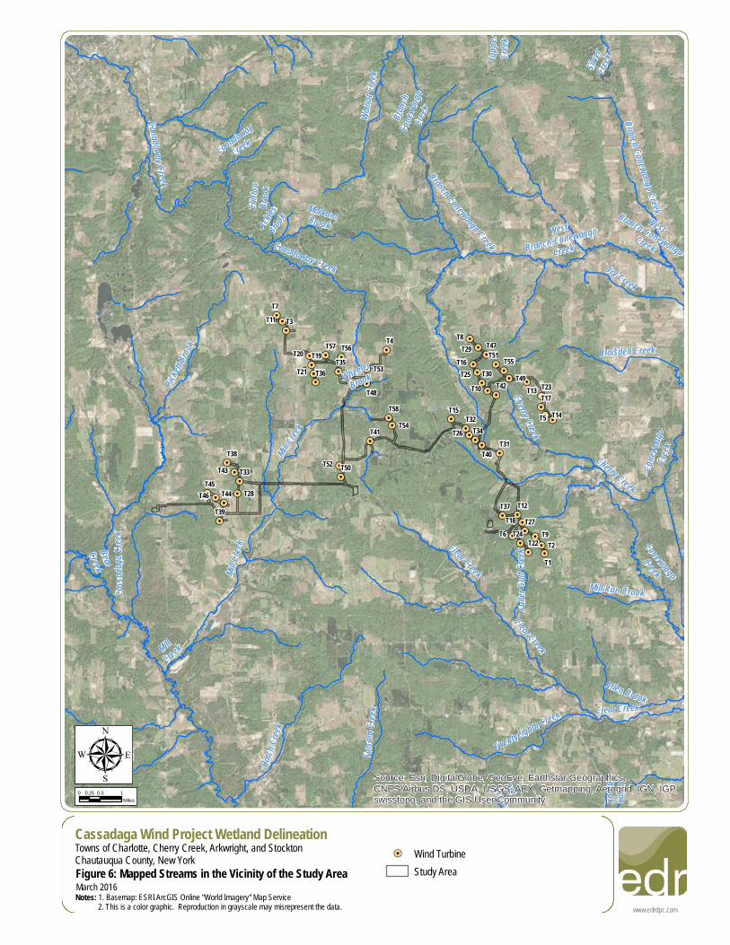
µCassadaga Wind Project Wetland DelineationTowns of Charlotte, Cherry Creek, Arkwright, and StocktonChautauqua County, New YorkFigure 6: Mapped Streams in the Vicinity of the Study AreaNotes: 1. Basemap: ESRI ArcGIS Online "World Imagery" Map Service 2. This is a color graphic. Reproduction in grayscale may misrepresent the data.
0 0.5 10.25Miles
March 2016
!=! Wind TurbineStudy Area
!=!
!=! !=!
!=!
!=!
!=!
!=!
!=!
!=!
!=!
!=!
!=!
!=!!=!
!=!
!=!
!=!
!=!!=!
!=!
!=!
!=!
!=!
!=!
!=!
!=!
!=!
!=!
!=!
!=!
!=!
!=!
!=!
!=!
!=!
!=!
!=!
!=!
!=!
!=!
!=!
!=!
!=!
!=!!=!
!=!
!=!
!=!
!=!
!=!
!=!
!=!
!=!
!=!
!=!
!=!
!=!
!=!
8
9
76
4
532
1
11
191810
17
15
1312
1614
£¤62
UV83UV60
UV60
UV60
T1T2
T3
T4
T5
T6
T7
T8
T9
T10
T11
T12
T13
T14T15
T16
T18
T19T20
T21
T22
T23
T24
T25
T26
T28
T29
T30
T31
T32
T33
T34
T35
T36
T37
T38
T39
T40T41
T42
T43
T44T45
T46
T47
T48 T49
T50
T51
T52
T53
T54
T55
T56T57
T58
RT 77
RT
85
Hall Rd
RT 64
Hill R
d
RT 75
Boutwell Hill Rd
East Rd
RT 79
RT 380
Plank
Rd
Shum
la Rd
Lewis RdCassadaga Rd
Villenova Rd
Aldric
h Hill R
d
Terry Rd
RT 71
Tarbox Rd
Hooker Rd Mill Creek Rd
Harris Hollow Rd
RT 68
Pickup Hill Rd
Herric
k Rd
Cleland Rd
RT 87
Hunt Rd
RT 72
Hagerdon Rd
Risley Rd
Harris
Hill R
d
Harpe
r Rd
Weaver Rd
Barnum Rd
Ames Rd
Butcher Rd
Meadows Rd
Housington Rd
Round Top RdSkinne
r Rd
Dybkas Rd
Bentley Hill Rd
Luce Rd
Spod
en R
d
CR 13
3
Grisw
old R
d
Nobles Rd
High St
Bernard Rd
Moon Rd
Zahm Rd
Engdahl Rd
Swanson Rd
Burnham Rd
Hamlet Rd
Prospect St
Miller
Rd
Mutto
n Hill R
d
RT 52
Cook Rd
C Johnson Rd
Davis
on R
d
Putm
an R
d
CR 85 Johnson Rd
CR 102
Southside Ave
Reed St
Smith Rd
State Land RdHodge Rd
Pinner Rd
Dibble Hill RdShelters Rd
Ruttenbur Rd
CR 72 Wentw
orth R
d
RT 56
RT 66
RT 66
Smith RdSh
umla
Rd
Ruttenbu
r Rd
RT 72
Hill R
d
Cassadaga Rd
RT 72
Hall Rd
Hodg
e Rd
Hill R
d
Smith Rd
RT 79
RT 72
Prospect St
Harris
Hill R
d
Hill R
d
Cassada
ga Creek
Clear Creek
Cherry Creek
Pickett B
rook
Cana
dawa
y Cree
k
Markum Brook
Clinto
n Broo
k
Fuller
Gulf C
reek
Wheeler
Brook
Mill Creek
Folsom
Creek
Canadaway Creek
Clear Creek
Source: Esri, DigitalGlobe, GeoEye, Earthstar Geographics,CNES/Airbus DS, USDA, USGS, AEX, Getmapping, Aerogrid, IGN, IGP,swisstopo, and the GIS User Community
www.edrdpc.com
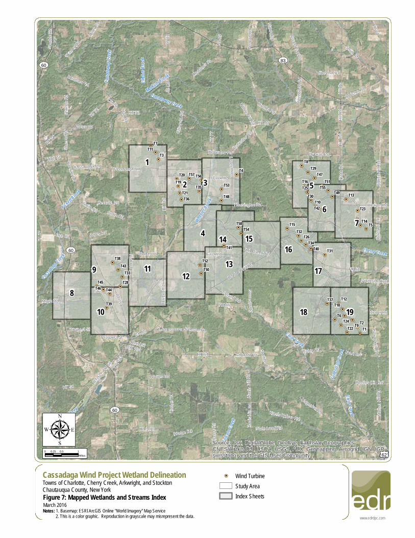
µCassadaga Wind Project Wetland DelineationTowns of Charlotte, Cherry Creek, Arkwright, and StocktonChautauqua County, New YorkFigure 7: Mapped Wetlands and Streams IndexNotes: 1. Basemap: ESRI ArcGIS Online "World Imagery" Map Service 2. This is a color graphic. Reproduction in grayscale may misrepresent the data.
0 0.5 10.25Miles
March 2016
!=! Wind TurbineStudy AreaIndex Sheets
!=!
!=!
!=!
!=!
!=!
!=!
!=!
!=!
!=!
!=!
!=!
!=!
!=!
!=!
!=!
!=!
!=!
!=!
!=!
!=!
!=!
!=!
!=!
!=!
!=!
!=!
!=!
!=!
!=!
!=!
!=!
!=!
!=!
!=!
!=!
!=!
!=!
!=!
!=!
!=!
!=!
!=!
!=!
!=!
!=!
!=!
!=!
!=!
!=!
!=!
!=!
!=!
!=!
!=!
!=!
!=!
!=!
!=!
T11
T7
T3
Griswold
Rd
Tarbox Rd
Cassadaga Rd
Hill R
d
Hall Rd
Class C
Class C
Class
C
PUBHxPUBHx
PUBHx
PUBHx
PUBHx
PEM5C
Source: Esri, DigitalGlobe, GeoEye, Earthstar Geographics,CNES/Airbus DS, USDA, USGS, AEX, Getmapping, Aerogrid, IGN, IGP,swisstopo, and the GIS User Community
www.edrdpc.com
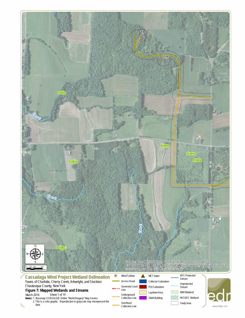
µCassadaga Wind Project Wetland DelineationTowns of Charlotte, Cherry Creek, Arkwright, and StocktonChautauqua County, New YorkFigure 7: Mapped Wetlands and StreamsNotes: 1. Basemap: ESRI ArcGIS Online "World Imagery" Map Service 2. This is a color graphic. Reproduction in grayscale may misrepresent the data.
0 250 500125Feet
March 2016
!=! Wind TurbineAccess RoadGenerator LeadLineUndergroundCollection LineOverheadCollection Line
# MET towerCollector SubstationPOI SubstationLaydown AreaO&M Building
NYS ProtectedStreamUnprotectedStreamNWI WetlandNYSDEC WetlandStudy Area
Sheet 1 of 19
#
!=!
!=!
!=!
!=!
!=!
!=!
!=!
!=!
!=!
!=!
!=!
!=!
!=!
!=!
!=!
!=!
!=!
!=!
!=!
!=!
!=!
!=!
!=!
!=!
!=!
!=!
!=!
!=!
!=!
!=!
!=!
!=!
!=!
!=!
!=!
!=!
!=!
!=!
!=!
!=!
!=!
!=!
!=!
!=!
!=!
!=!
!=!
!=!
!=!
!=!
!=!
!=!
!=!
!=!
!=!
!=!
!=!
!=!
T57
T56
T36
T35
T21
T20
T19
RT 77
Cassadaga Rd
Class
C
Class
C(T)
Class C
Class
C
PUBHx
PUBHx
PFO1E
Source: Esri, DigitalGlobe, GeoEye, Earthstar Geographics,CNES/Airbus DS, USDA, USGS, AEX, Getmapping, Aerogrid, IGN, IGP,swisstopo, and the GIS User Community
www.edrdpc.com
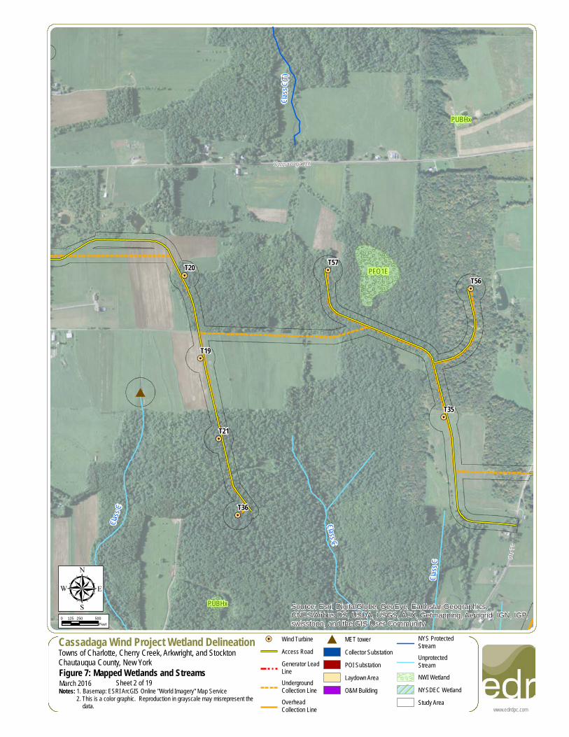
µCassadaga Wind Project Wetland DelineationTowns of Charlotte, Cherry Creek, Arkwright, and StocktonChautauqua County, New YorkFigure 7: Mapped Wetlands and StreamsNotes: 1. Basemap: ESRI ArcGIS Online "World Imagery" Map Service 2. This is a color graphic. Reproduction in grayscale may misrepresent the data.
0 250 500125Feet
March 2016
!=! Wind TurbineAccess RoadGenerator LeadLineUndergroundCollection LineOverheadCollection Line
# MET towerCollector SubstationPOI SubstationLaydown AreaO&M Building
NYS ProtectedStreamUnprotectedStreamNWI WetlandNYSDEC WetlandStudy Area
Sheet 2 of 19
!=!
!=!
!=!
!=!
!=!
!=!
!=!
!=!
!=!
!=!
!=!
!=!
!=!
!=!
!=!
!=!
!=!
!=!
!=!
!=!
!=!
!=!
!=!
!=!
!=!
!=!
!=!
!=!
!=!
!=!
!=!
!=!
!=!
!=!
!=!
!=!
!=!
!=!
!=!
!=!
!=!
!=!
!=!
!=!
!=!
!=!
!=!
!=!
!=!
!=!
!=!
!=!
!=!
!=!
!=!
!=!
!=!
!=!
T56
T53
T48
T4
Housington Rd
Overland Trl
Cassadaga Rd
Cook Rd
Lewis
Rd
RT 77
Class
C
Class C
Class C
PUBHx
PUBHx
PUBHhPUBHh
Source: Esri, DigitalGlobe, GeoEye, Earthstar Geographics,CNES/Airbus DS, USDA, USGS, AEX, Getmapping, Aerogrid, IGN, IGP,swisstopo, and the GIS User Community
www.edrdpc.com
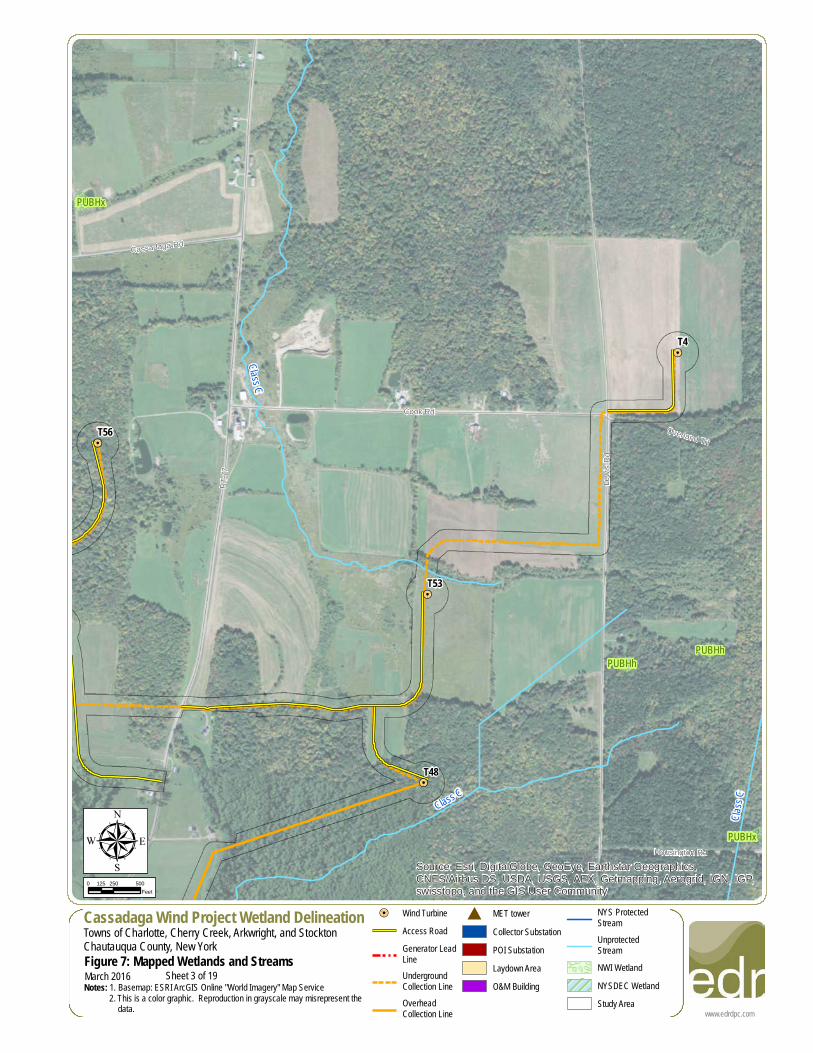
µCassadaga Wind Project Wetland DelineationTowns of Charlotte, Cherry Creek, Arkwright, and StocktonChautauqua County, New YorkFigure 7: Mapped Wetlands and StreamsNotes: 1. Basemap: ESRI ArcGIS Online "World Imagery" Map Service 2. This is a color graphic. Reproduction in grayscale may misrepresent the data.
0 250 500125Feet
March 2016
!=! Wind TurbineAccess RoadGenerator LeadLineUndergroundCollection LineOverheadCollection Line
# MET towerCollector SubstationPOI SubstationLaydown AreaO&M Building
NYS ProtectedStreamUnprotectedStreamNWI WetlandNYSDEC WetlandStudy Area
Sheet 3 of 19
!=!
!=!
!=!
!=!
!=!
!=!
!=!
!=!
!=!
!=!
!=!
!=!
!=!
!=!
!=!
!=!
!=!
!=!
!=!
!=!
!=!
!=!
!=!
!=!
!=!
!=!
!=!
!=!
!=!
!=!
!=!
!=!
!=!
!=!
!=!
!=!
!=!
!=!
!=!
!=!
!=!
!=!
!=!
!=!
!=!
!=!
!=!
!=!
!=!
!=!
!=!
!=!
!=!
!=!
!=!
!=!
!=!
!=!
RT 77
Mill Creek Rd
East Rd
Class C(T)
Class C
Class C
Class C
Class
C
Class C
PUBHx
PUBHhSource: Esri, DigitalGlobe, GeoEye, Earthstar Geographics,CNES/Airbus DS, USDA, USGS, AEX, Getmapping, Aerogrid, IGN, IGP,swisstopo, and the GIS User Community
www.edrdpc.com
µCassadaga Wind Project Wetland DelineationTowns of Charlotte, Cherry Creek, Arkwright, and StocktonChautauqua County, New YorkFigure 7: Mapped Wetlands and StreamsNotes: 1. Basemap: ESRI ArcGIS Online "World Imagery" Map Service 2. This is a color graphic. Reproduction in grayscale may misrepresent the data.
0 250 500125Feet
March 2016
!=! Wind TurbineAccess RoadGenerator LeadLineUndergroundCollection LineOverheadCollection Line
# MET towerCollector SubstationPOI SubstationLaydown AreaO&M Building
NYS ProtectedStreamUnprotectedStreamNWI WetlandNYSDEC WetlandStudy Area
Sheet 4 of 19
!=!
!=!
!=!
!=!
!=!
!=!
!=!
!=!
!=!
!=!
!=!
!=!
!=!
!=!
!=!
!=!
!=!
!=!
!=!
!=!
!=!
!=!
!=!
!=!
!=!
!=!
!=!
!=!
!=!
!=!
!=!
!=!
!=!
!=!
!=!
!=!
!=!
!=!
!=!
!=!
!=!
!=!
!=!
!=!
!=!
!=!
!=!
!=!
!=!
!=!
!=!
!=!
!=!
!=!
!=!
!=!
!=!
!=!
T55
T51
T49
T47
T42
T30
T29
T25
T16
T10
T8
RT 85
HA-4
Class C
Class C
Class C(T)
Class C
Class CPUBHx
PSS1C
PUBH
PUBHx
PEM5F
PEM5E
PUBHx
PFO1E
PUBHx
Source: Esri, DigitalGlobe, GeoEye, Earthstar Geographics,CNES/Airbus DS, USDA, USGS, AEX, Getmapping, Aerogrid, IGN, IGP,swisstopo, and the GIS User Community
www.edrdpc.com
µCassadaga Wind Project Wetland DelineationTowns of Charlotte, Cherry Creek, Arkwright, and StocktonChautauqua County, New YorkFigure 7: Mapped Wetlands and StreamsNotes: 1. Basemap: ESRI ArcGIS Online "World Imagery" Map Service 2. This is a color graphic. Reproduction in grayscale may misrepresent the data.
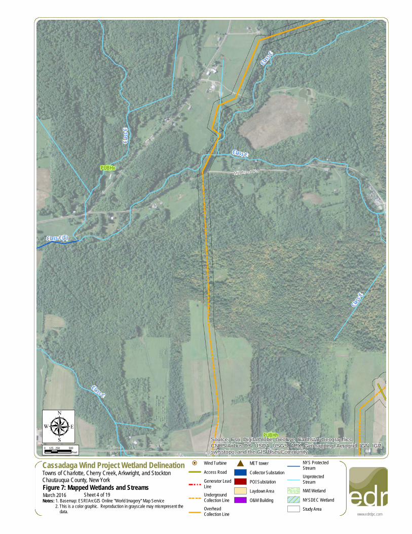
0 250 500125Feet
March 2016
!=! Wind TurbineAccess RoadGenerator LeadLineUndergroundCollection LineOverheadCollection Line
# MET towerCollector SubstationPOI SubstationLaydown AreaO&M Building
NYS ProtectedStreamUnprotectedStreamNWI WetlandNYSDEC WetlandStudy Area
Sheet 5 of 19
!=!
!=!
!=!
!=!
!=!
!=!
!=!
!=!
!=!
!=!
!=!
!=!
!=!
!=!
!=!
!=!
!=!
!=!
!=!
!=!
!=!
!=!
!=!
!=!
!=!
!=!
!=!
!=!
!=!
!=!
!=!
!=!
!=!
!=!
!=!
!=!
!=!
!=!
!=!
!=!
!=!
!=!
!=!
!=!
!=!
!=!
!=!
!=!
!=!
!=!
!=!
!=!
!=!
!=!
!=!
!=!
!=!
!=!
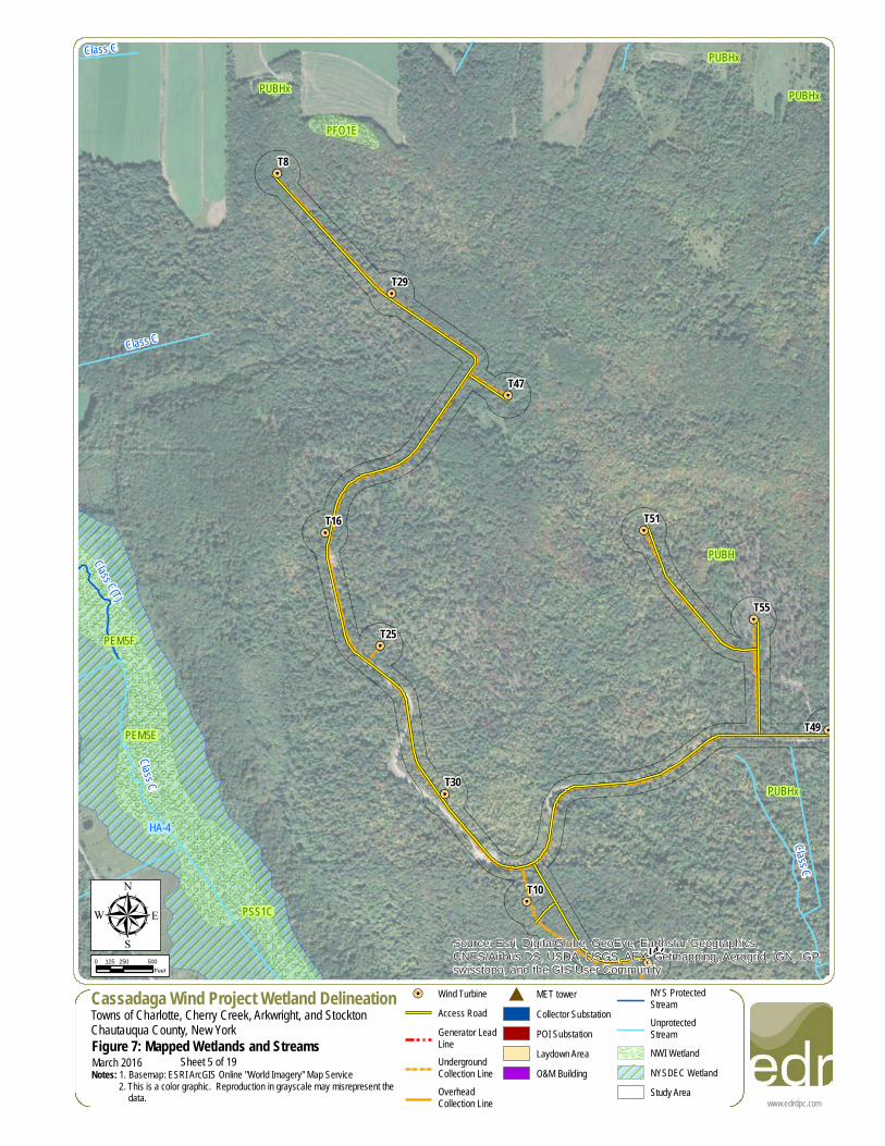
T55
T51
T49
T42
T30
T25
T13
T10Weaver Rd
RT 85
Plank
Rd
HA-4
HA-1
HA-4
Class
C
Class C
Class
C
PUBHx
PSS1C
PUBH
PSS1C
PEM5C
PUBHx
PUBHx
PUBHx
Source: Esri, DigitalGlobe, GeoEye, Earthstar Geographics,CNES/Airbus DS, USDA, USGS, AEX, Getmapping, Aerogrid, IGN, IGP,swisstopo, and the GIS User Community
www.edrdpc.com
µCassadaga Wind Project Wetland DelineationTowns of Charlotte, Cherry Creek, Arkwright, and StocktonChautauqua County, New YorkFigure 7: Mapped Wetlands and StreamsNotes: 1. Basemap: ESRI ArcGIS Online "World Imagery" Map Service 2. This is a color graphic. Reproduction in grayscale may misrepresent the data.
0 250 500125Feet
March 2016
!=! Wind TurbineAccess RoadGenerator LeadLineUndergroundCollection LineOverheadCollection Line
# MET towerCollector SubstationPOI SubstationLaydown AreaO&M Building
NYS ProtectedStreamUnprotectedStreamNWI WetlandNYSDEC WetlandStudy Area
Sheet 6 of 19
!=!
!=!
!=!
!=!
!=!
!=!
!=!
!=!
!=!
!=!
!=!
!=!
!=!
!=!
!=!
!=!
!=!
!=!
!=!
!=!
!=!
!=!
!=!
!=!
!=!
!=!
!=!
!=!
!=!
!=!
!=!
!=!
!=!
!=!
!=!
!=!
!=!
!=!
!=!
!=!
!=!
!=!
!=!
!=!
!=!
!=!
!=!
!=!
!=!
!=!
!=!
!=!
!=!
!=!
!=!
!=!
!=!
!=!
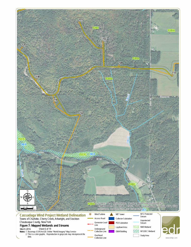
T23
T17
T14
T13
T5
RT 85
Weaver Rd
Plank Rd
HA-1
Class
C
Class C
Class C
Class C
PEM5C
PUBHxPUBHx
PSS1C
PUBHx
Source: Esri, DigitalGlobe, GeoEye, Earthstar Geographics,CNES/Airbus DS, USDA, USGS, AEX, Getmapping, Aerogrid, IGN, IGP,swisstopo, and the GIS User Community
www.edrdpc.com
µCassadaga Wind Project Wetland DelineationTowns of Charlotte, Cherry Creek, Arkwright, and StocktonChautauqua County, New YorkFigure 7: Mapped Wetlands and StreamsNotes: 1. Basemap: ESRI ArcGIS Online "World Imagery" Map Service 2. This is a color graphic. Reproduction in grayscale may misrepresent the data.
0 250 500125Feet
March 2016
!=! Wind TurbineAccess RoadGenerator LeadLineUndergroundCollection LineOverheadCollection Line
# MET towerCollector SubstationPOI SubstationLaydown AreaO&M Building
NYS ProtectedStreamUnprotectedStreamNWI WetlandNYSDEC WetlandStudy Area
Sheet 7 of 19
!=!
!=!
!=!
!=!
!=!
!=!
!=!
!=!
!=!
!=!
!=!
!=!
!=!
!=!
!=!
!=!
!=!
!=!
!=!
!=!
!=!
!=!
!=!
!=!
!=!
!=!
!=!
!=!
!=!
!=!
!=!
!=!
!=!
!=!
!=!
!=!
!=!
!=!
!=!
!=!
!=!
!=!
!=!
!=!
!=!
!=!
!=!
!=!
!=!
!=!
!=!
!=!
!=!
!=!
!=!
!=!
!=!
!=!
Hadley Dr
Moon Rd
UV60
CS-10
CS-10
CS-10
CS-8
CS-8
CS-8
CS-8
CS-9
Class C
Class C
Class C
PFO1/SS1E
PUBHx
PFO1A
PFO1A
PUBHx
PSS5/EM5C
PSS1E
PSS1E
PFO1A
PFO1A
PUBHx
PSS1E
PFO1A
Source: Esri, DigitalGlobe, GeoEye, Earthstar Geographics,CNES/Airbus DS, USDA, USGS, AEX, Getmapping, Aerogrid, IGN, IGP,swisstopo, and the GIS User Community
www.edrdpc.com
µCassadaga Wind Project Wetland DelineationTowns of Charlotte, Cherry Creek, Arkwright, and StocktonChautauqua County, New YorkFigure 7: Mapped Wetlands and StreamsNotes: 1. Basemap: ESRI ArcGIS Online "World Imagery" Map Service 2. This is a color graphic. Reproduction in grayscale may misrepresent the data.
0 250 500125Feet
March 2016
!=! Wind TurbineAccess RoadGenerator LeadLineUndergroundCollection LineOverheadCollection Line
# MET towerCollector SubstationPOI SubstationLaydown AreaO&M Building
NYS ProtectedStreamUnprotectedStreamNWI WetlandNYSDEC WetlandStudy Area
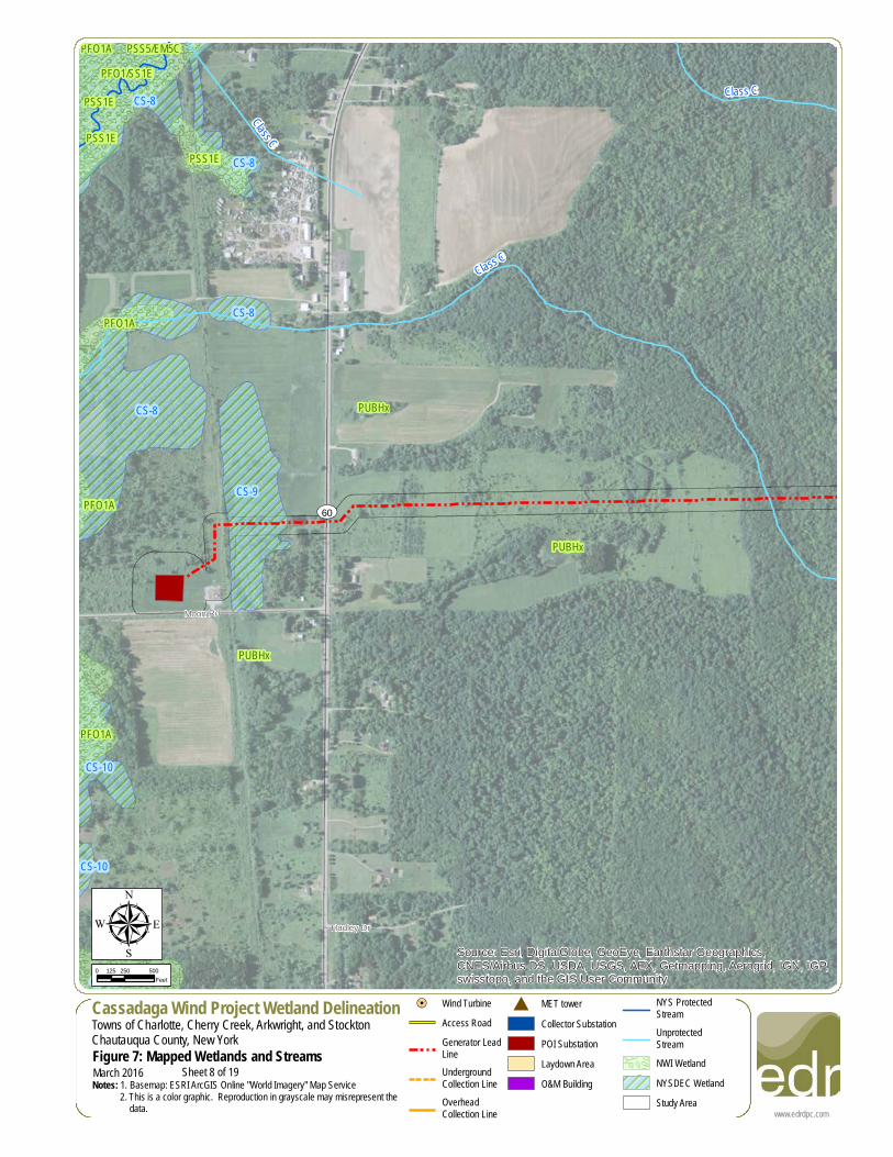
Sheet 8 of 19
#
!=!
!=!
!=!
!=!
!=!
!=!
!=!
!=!
!=!
!=!
!=!
!=!
!=!
!=!
!=!
!=!
!=!
!=!
!=!
!=!
!=!
!=!
!=!
!=!
!=!
!=!
!=!
!=!
!=!
!=!
!=!
!=!
!=!
!=!
!=!
!=!
!=!
!=!
!=!
!=!
!=!
!=!
!=!
!=!
!=!
!=!
!=!
!=!
!=!
!=!
!=!
!=!
!=!
!=!
!=!
!=!
!=!
!=!
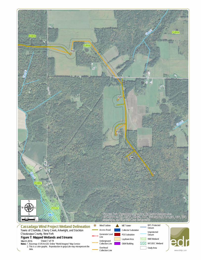
T46
T45
T44
T43
T38
T33
T28
Andre
ws R
d
RT 75
Hall Rd
Hooker Rd
RT 75
Class C
Class C
Class C
Class C
Class C
PUBHh
PUBHx
PUBHh
Source: Esri, DigitalGlobe, GeoEye, Earthstar Geographics,CNES/Airbus DS, USDA, USGS, AEX, Getmapping, Aerogrid, IGN, IGP,swisstopo, and the GIS User Community
www.edrdpc.com
µCassadaga Wind Project Wetland DelineationTowns of Charlotte, Cherry Creek, Arkwright, and StocktonChautauqua County, New YorkFigure 7: Mapped Wetlands and StreamsNotes: 1. Basemap: ESRI ArcGIS Online "World Imagery" Map Service 2. This is a color graphic. Reproduction in grayscale may misrepresent the data.
0 250 500125Feet
March 2016
!=! Wind TurbineAccess RoadGenerator LeadLineUndergroundCollection LineOverheadCollection Line
# MET towerCollector SubstationPOI SubstationLaydown AreaO&M Building
NYS ProtectedStreamUnprotectedStreamNWI WetlandNYSDEC WetlandStudy Area
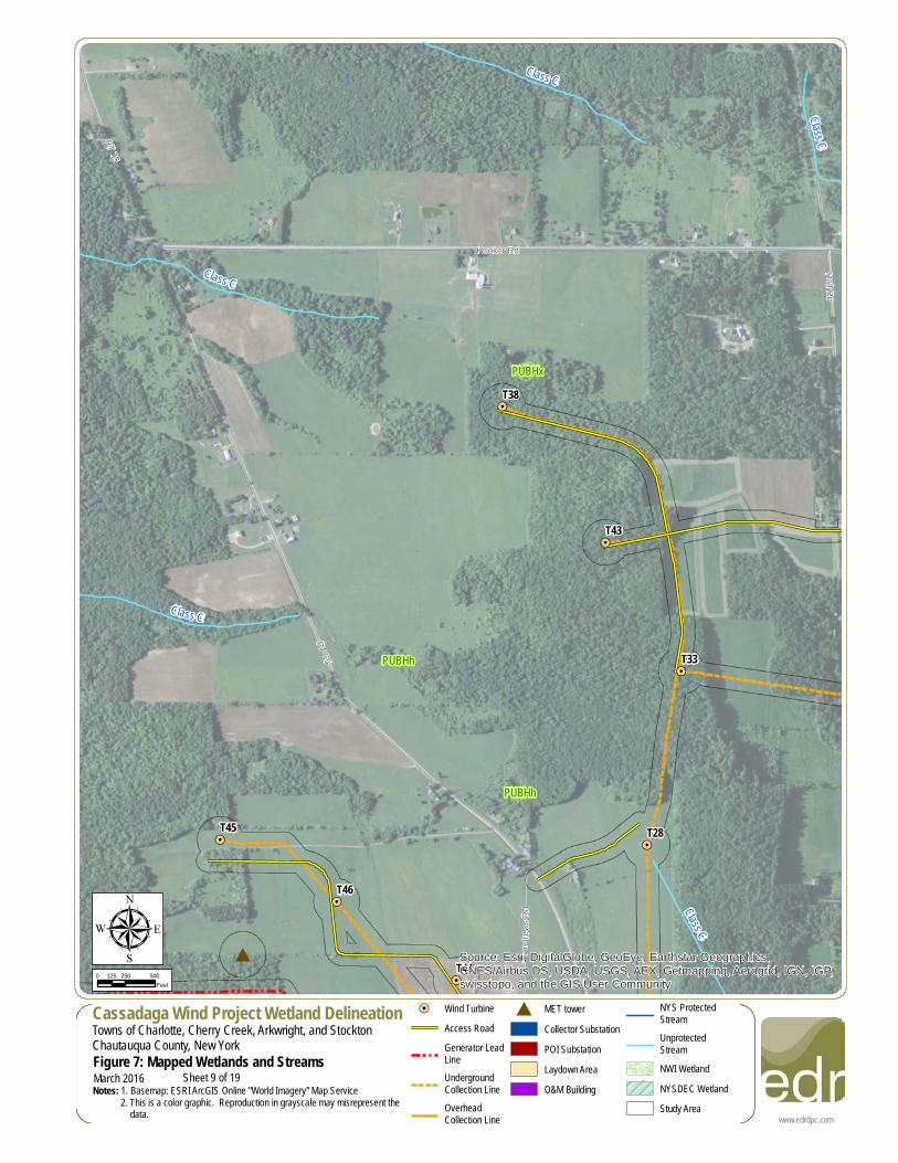
Sheet 9 of 19
#
!=!
!=!
!=!
!=!
!=!
!=!
!=!
!=!
!=!
!=!
!=!
!=!
!=!
!=!
!=!
!=!
!=!
!=!
!=!
!=!
!=!
!=!
!=!
!=!
!=!
!=!
!=!
!=!
!=!
!=!
!=!
!=!
!=!
!=!
!=!
!=!
!=!
!=!
!=!
!=!
!=!
!=!
!=!
!=!
!=!
!=!
!=!
!=!
!=!
!=!
!=!
!=!
!=!
!=!
!=!
!=!
!=!
!=!
T46
T45
T44
T39
T28
Prospect St
Hall R
d
Andrews Rd
Andre
ws R
d
Prospect St
RT 75
Class C
Class C
Class C(T)Class C
Class
C
PUBHh
PEM5C
PFO1E
PUBHx
Source: Esri, DigitalGlobe, GeoEye, Earthstar Geographics,CNES/Airbus DS, USDA, USGS, AEX, Getmapping, Aerogrid, IGN, IGP,swisstopo, and the GIS User Community
www.edrdpc.com
µCassadaga Wind Project Wetland DelineationTowns of Charlotte, Cherry Creek, Arkwright, and StocktonChautauqua County, New YorkFigure 7: Mapped Wetlands and StreamsNotes: 1. Basemap: ESRI ArcGIS Online "World Imagery" Map Service 2. This is a color graphic. Reproduction in grayscale may misrepresent the data.
0 250 500125Feet
March 2016
!=! Wind TurbineAccess RoadGenerator LeadLineUndergroundCollection LineOverheadCollection Line
# MET towerCollector SubstationPOI SubstationLaydown AreaO&M Building
NYS ProtectedStreamUnprotectedStreamNWI WetlandNYSDEC WetlandStudy Area
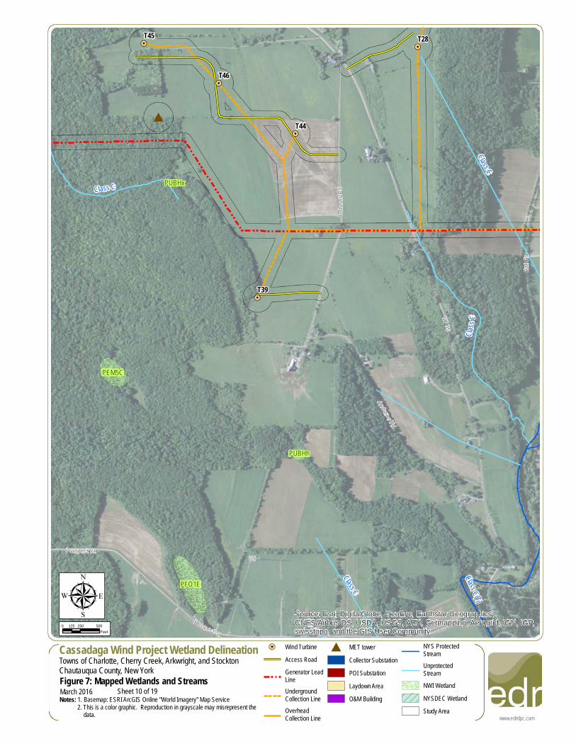
Sheet 10 of 19
!=!
!=!
!=!
!=!
!=!
!=!
!=!
!=!
!=!
!=!
!=!
!=!
!=!
!=!
!=!
!=!
!=!
!=!
!=!
!=!
!=!
!=!
!=!
!=!
!=!
!=!
!=!
!=!
!=!
!=!
!=!
!=!
!=!
!=!
!=!
!=!
!=!
!=!
!=!
!=!
!=!
!=!
!=!
!=!
!=!
!=!
!=!
!=!
!=!
!=!
!=!
!=!
!=!
!=!
!=!
!=!
!=!
!=!
Harpe
r Rd
Hall Rd
RT 77
Class C
Class C(T)
Class C
Class C
Class C
Class C
Class C(T)
Class C
(T)PUBHx
PFO1A
PUBHh
PEM5C
PSS1C
PUBHx
PUBHx
Source: Esri, DigitalGlobe, GeoEye, Earthstar Geographics,CNES/Airbus DS, USDA, USGS, AEX, Getmapping, Aerogrid, IGN, IGP,swisstopo, and the GIS User Community
www.edrdpc.com
µCassadaga Wind Project Wetland DelineationTowns of Charlotte, Cherry Creek, Arkwright, and StocktonChautauqua County, New YorkFigure 7: Mapped Wetlands and StreamsNotes: 1. Basemap: ESRI ArcGIS Online "World Imagery" Map Service 2. This is a color graphic. Reproduction in grayscale may misrepresent the data.
0 250 500125Feet
March 2016
!=! Wind TurbineAccess RoadGenerator LeadLineUndergroundCollection LineOverheadCollection Line
# MET towerCollector SubstationPOI SubstationLaydown AreaO&M Building
NYS ProtectedStreamUnprotectedStreamNWI WetlandNYSDEC WetlandStudy Area
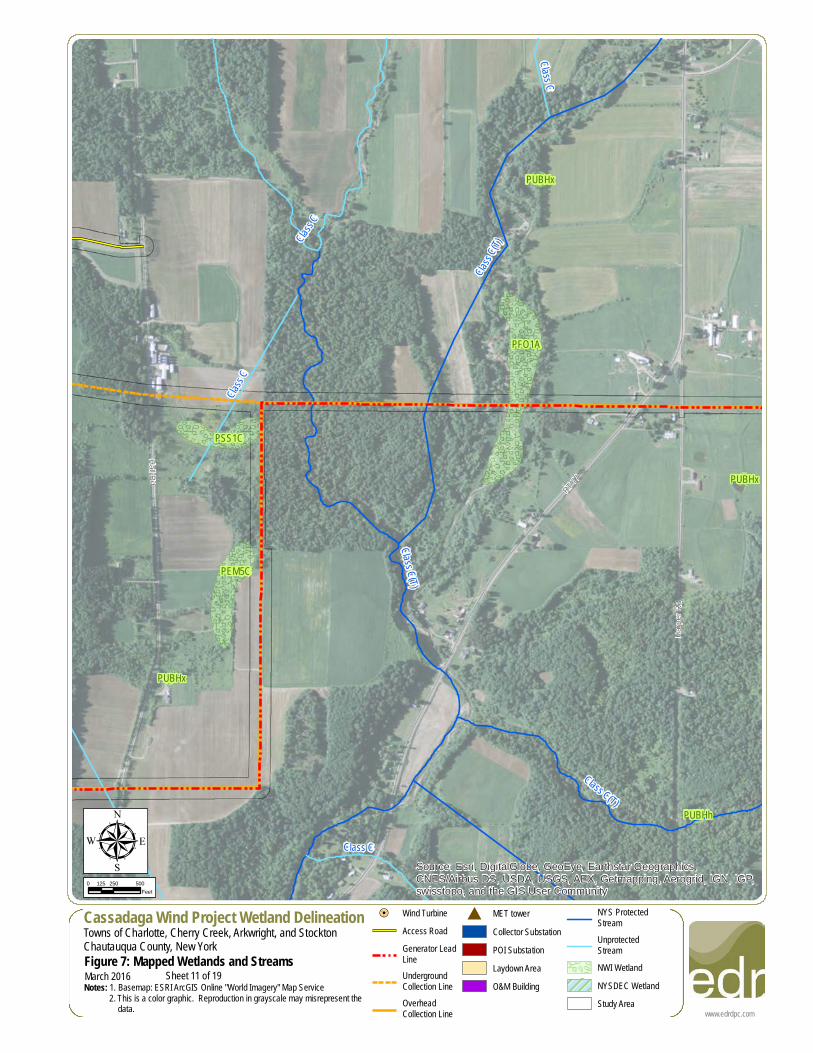
Sheet 11 of 19
!=!
!=!
!=!
!=!
!=!
!=!
!=!
!=!
!=!
!=!
!=!
!=!
!=!
!=!
!=!
!=!
!=!
!=!
!=!
!=!
!=!
!=!
!=!
!=!
!=!
!=!
!=!
!=!
!=!
!=!
!=!
!=!
!=!
!=!
!=!
!=!
!=!
!=!
!=!
!=!
!=!
!=!
!=!
!=!
!=!
!=!
!=!
!=!
!=!
!=!
!=!
!=!
!=!
!=!
!=!
!=!
!=!
!=!
T52
T50
Boutwell Hill Rd
East Rd
Class C(T)
Class C(T)
Class C(T)
Class C
Class C
PSS1E
PUBHx
Source: Esri, DigitalGlobe, GeoEye, Earthstar Geographics,CNES/Airbus DS, USDA, USGS, AEX, Getmapping, Aerogrid, IGN, IGP,swisstopo, and the GIS User Community
www.edrdpc.com
µCassadaga Wind Project Wetland DelineationTowns of Charlotte, Cherry Creek, Arkwright, and StocktonChautauqua County, New YorkFigure 7: Mapped Wetlands and StreamsNotes: 1. Basemap: ESRI ArcGIS Online "World Imagery" Map Service 2. This is a color graphic. Reproduction in grayscale may misrepresent the data.
0 250 500125Feet
March 2016
!=! Wind TurbineAccess RoadGenerator LeadLineUndergroundCollection LineOverheadCollection Line
# MET towerCollector SubstationPOI SubstationLaydown AreaO&M Building
NYS ProtectedStreamUnprotectedStreamNWI WetlandNYSDEC WetlandStudy Area
Sheet 12 of 19
!=!
!=!
!=!
!=!
!=!
!=!
!=!
!=!
!=!
!=!
!=!
!=!
!=!
!=!
!=!
!=!
!=!
!=!
!=!
!=!
!=!
!=!
!=!
!=!
!=!
!=!
!=!
!=!
!=!
!=!
!=!
!=!
!=!
!=!
!=!
!=!
!=!
!=!
!=!
!=!
!=!
!=!
!=!
!=!
!=!
!=!
!=!
!=!
!=!
!=!
!=!
!=!
!=!
!=!
!=!
!=!
!=!
!=!
T41Mill Creek Rd
Swanson Rd
East Rd
Boutwell Hill Rd
Clelan
d Rd
HA-8
HA-8
Class
C
Class C
Class C
Class C(T)
PSS1E
PFO1E
PFO5Hh
PUBHh
PUBHh
Source: Esri, DigitalGlobe, GeoEye, Earthstar Geographics,CNES/Airbus DS, USDA, USGS, AEX, Getmapping, Aerogrid, IGN, IGP,swisstopo, and the GIS User Community
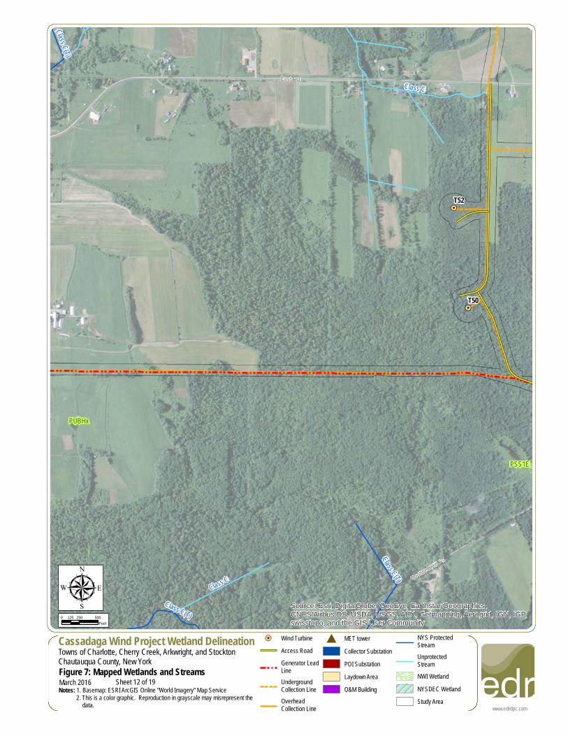
www.edrdpc.com
µCassadaga Wind Project Wetland DelineationTowns of Charlotte, Cherry Creek, Arkwright, and StocktonChautauqua County, New YorkFigure 7: Mapped Wetlands and StreamsNotes: 1. Basemap: ESRI ArcGIS Online "World Imagery" Map Service 2. This is a color graphic. Reproduction in grayscale may misrepresent the data.
0 250 500125Feet
March 2016
!=! Wind TurbineAccess RoadGenerator LeadLineUndergroundCollection LineOverheadCollection Line
# MET towerCollector SubstationPOI SubstationLaydown AreaO&M Building
NYS ProtectedStreamUnprotectedStreamNWI WetlandNYSDEC WetlandStudy Area
Sheet 13 of 19
!=!
!=!
!=!
!=!
!=!
!=!
!=!
!=!
!=!
!=!
!=!
!=!
!=!
!=!
!=!
!=!
!=!
!=!
!=!
!=!
!=!
!=!
!=!
!=!
!=!
!=!
!=!
!=!
!=!
!=!
!=!
!=!
!=!
!=!
!=!
!=!
!=!
!=!
!=!
!=!
!=!
!=!
!=!
!=!
!=!
!=!
!=!
!=!
!=!
!=!
!=!
!=!
!=!
!=!
!=!
!=!
!=!
!=!
T58
T54
T41
Clelan
d Rd
Lewis
Rd
Overland Trl
East Rd
Mill Creek Rd
Class C
(T) Class C
Class CCla
ss C
Class C
Class C
Class C
PFO1E
PFO5HhPFO1E
PFO1E
PUBHh
Source: Esri, DigitalGlobe, GeoEye, Earthstar Geographics,CNES/Airbus DS, USDA, USGS, AEX, Getmapping, Aerogrid, IGN, IGP,swisstopo, and the GIS User Community
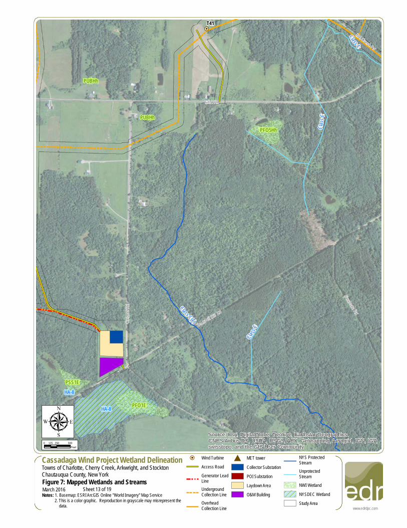
www.edrdpc.com
µCassadaga Wind Project Wetland DelineationTowns of Charlotte, Cherry Creek, Arkwright, and StocktonChautauqua County, New YorkFigure 7: Mapped Wetlands and StreamsNotes: 1. Basemap: ESRI ArcGIS Online "World Imagery" Map Service 2. This is a color graphic. Reproduction in grayscale may misrepresent the data.
0 250 500125Feet
March 2016
!=! Wind TurbineAccess RoadGenerator LeadLineUndergroundCollection LineOverheadCollection Line
# MET towerCollector SubstationPOI SubstationLaydown AreaO&M Building
NYS ProtectedStreamUnprotectedStreamNWI WetlandNYSDEC WetlandStudy Area
Sheet 14 of 19
!=!
!=!
!=!
!=!
!=!
!=!
!=!
!=!
!=!
!=!
!=!
!=!
!=!
!=!
!=!
!=!
!=!
!=!
!=!
!=!
!=!
!=!
!=!
!=!
!=!
!=!
!=!
!=!
!=!
!=!
!=!
!=!
!=!
!=!
!=!
!=!
!=!
!=!
!=!
!=!
!=!
!=!
!=!
!=!
!=!
!=!
!=!
!=!
!=!
!=!
!=!
!=!
!=!
!=!
!=!
!=!
!=!
!=!
T54
East Rd
Sanford Rd
Housington Rd
Mill Creek Rd
Overland Trl
Boutwell Hill Rd
HA-7
Class C
Class C
Class C
Class C
Class C
Class C
PFO1E
PEM5E
PFO1E
PFO1E
PFO1E
PUBHx
PFO1E
PFO1E
PFO1E
PUBHx
PFO1E
PUBHhPFO1E
PFO1E
PFO1E
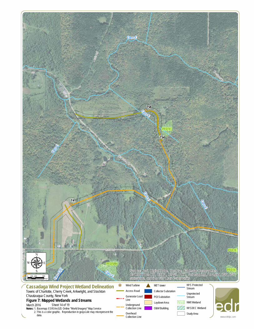
Source: Esri, DigitalGlobe, GeoEye, Earthstar Geographics,CNES/Airbus DS, USDA, USGS, AEX, Getmapping, Aerogrid, IGN, IGP,swisstopo, and the GIS User Community
www.edrdpc.com
µCassadaga Wind Project Wetland DelineationTowns of Charlotte, Cherry Creek, Arkwright, and StocktonChautauqua County, New YorkFigure 7: Mapped Wetlands and StreamsNotes: 1. Basemap: ESRI ArcGIS Online "World Imagery" Map Service 2. This is a color graphic. Reproduction in grayscale may misrepresent the data.
0 250 500125Feet
March 2016
!=! Wind TurbineAccess RoadGenerator LeadLineUndergroundCollection LineOverheadCollection Line
# MET towerCollector SubstationPOI SubstationLaydown AreaO&M Building
NYS ProtectedStreamUnprotectedStreamNWI WetlandNYSDEC WetlandStudy Area
Sheet 15 of 19
!=!
!=!
!=!
!=!
!=!
!=!
!=!
!=!
!=!
!=!
!=!
!=!
!=!
!=!
!=!
!=!
!=!
!=!
!=!
!=!
!=!
!=!
!=!
!=!
!=!
!=!
!=!
!=!
!=!
!=!
!=!
!=!
!=!
!=!
!=!
!=!
!=!
!=!
!=!
!=!
!=!
!=!
!=!
!=!
!=!
!=!
!=!
!=!
!=!
!=!
!=!
!=!
!=!
!=!
!=!
!=!
!=!
!=!
T40
T34
T32
T26
T15
HousingtonRd
Sanford Rd
RT 85
Boutwell Hill Rd
HA-4
HA-4
Class C
Class C
Class C
Class C
Class C
Class C
Class C(T)
PSS1C
PUBHx
PSS1C
PUBHh
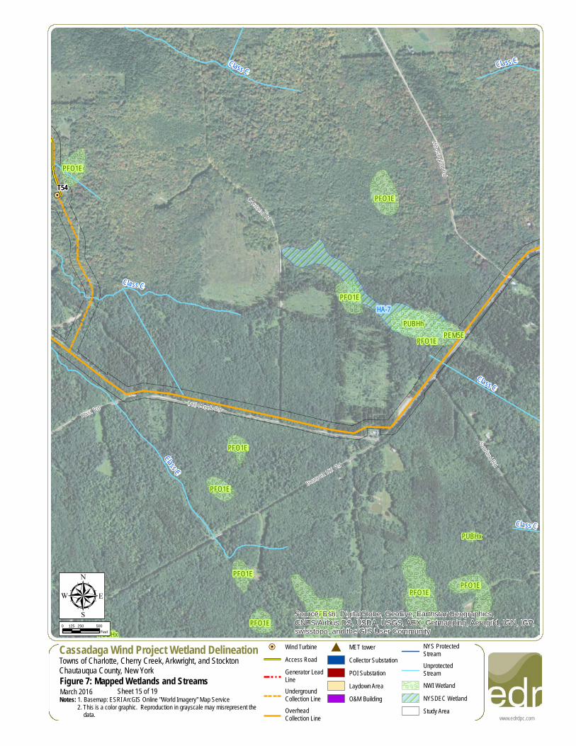
Source: Esri, DigitalGlobe, GeoEye, Earthstar Geographics,CNES/Airbus DS, USDA, USGS, AEX, Getmapping, Aerogrid, IGN, IGP,swisstopo, and the GIS User Community
www.edrdpc.com
µCassadaga Wind Project Wetland DelineationTowns of Charlotte, Cherry Creek, Arkwright, and StocktonChautauqua County, New YorkFigure 7: Mapped Wetlands and StreamsNotes: 1. Basemap: ESRI ArcGIS Online "World Imagery" Map Service 2. This is a color graphic. Reproduction in grayscale may misrepresent the data.
0 250 500125Feet
March 2016
!=! Wind TurbineAccess RoadGenerator LeadLineUndergroundCollection LineOverheadCollection Line
# MET towerCollector SubstationPOI SubstationLaydown AreaO&M Building
NYS ProtectedStreamUnprotectedStreamNWI WetlandNYSDEC WetlandStudy Area
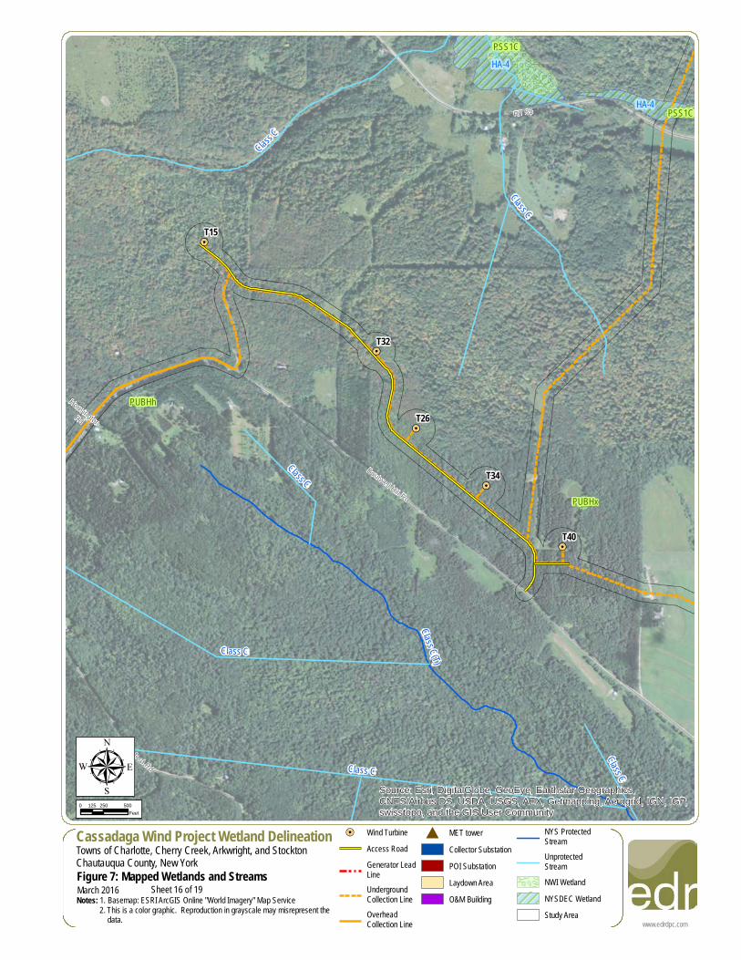
Sheet 16 of 19
!=!
!=!
!=!
!=!
!=!
!=!
!=!
!=!
!=!
!=!
!=!
!=!
!=!
!=!
!=!
!=!
!=!
!=!
!=!
!=!
!=!
!=!
!=!
!=!
!=!
!=!
!=!
!=!
!=!
!=!
!=!
!=!
!=!
!=!
!=!
!=!
!=!
!=!
!=!
!=!
!=!
!=!
!=!
!=!
!=!
!=!
!=!
!=!
!=!
!=!
!=!
!=!
!=!
!=!
!=!
!=!
!=!
!=!
T31
RT 68
Boutwell Hill Rd
RT 85
HA-1
CK-8
CK-8
Class
CClass C(T)
Class C
Class C
Class C(T)
Class
CPUBHx
PFO1CPUBHx
PUBHh
PUBHx
PUBHxPSS1C
PUBHx
Source: Esri, DigitalGlobe, GeoEye, Earthstar Geographics,CNES/Airbus DS, USDA, USGS, AEX, Getmapping, Aerogrid, IGN, IGP,swisstopo, and the GIS User Community
www.edrdpc.com
µCassadaga Wind Project Wetland DelineationTowns of Charlotte, Cherry Creek, Arkwright, and StocktonChautauqua County, New YorkFigure 7: Mapped Wetlands and StreamsNotes: 1. Basemap: ESRI ArcGIS Online "World Imagery" Map Service 2. This is a color graphic. Reproduction in grayscale may misrepresent the data.
0 250 500125Feet
March 2016
!=! Wind TurbineAccess RoadGenerator LeadLineUndergroundCollection LineOverheadCollection Line
# MET towerCollector SubstationPOI SubstationLaydown AreaO&M Building
NYS ProtectedStreamUnprotectedStreamNWI WetlandNYSDEC WetlandStudy Area
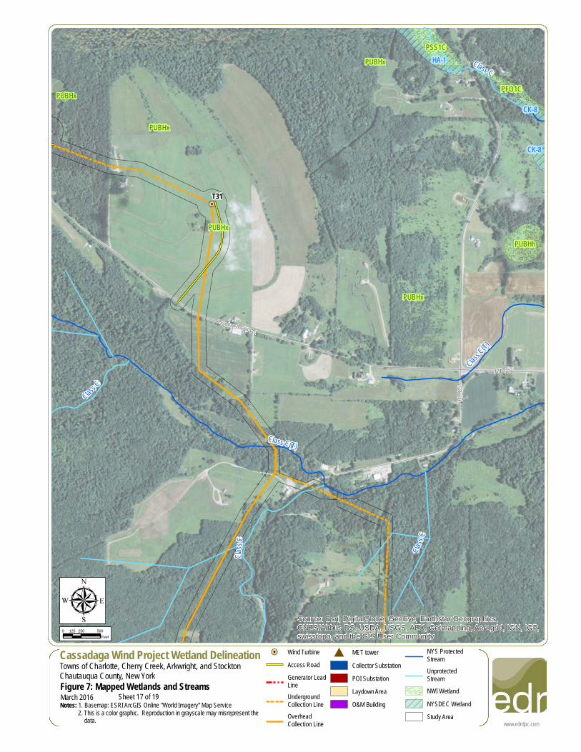
Sheet 17 of 19
!=!
!=!
!=!
!=!
!=!
!=!
!=!
!=!
!=!
!=!
!=!
!=!
!=!
!=!
!=!
!=!
!=!
!=!
!=!
!=!
!=!
!=!
!=!
!=!
!=!
!=!
!=!
!=!
!=!
!=!
!=!
!=!
!=!
!=!
!=!
!=!
!=!
!=!
!=!
!=!
!=!
!=!
!=!
!=!
!=!
!=!
!=!
!=!
!=!
!=!
!=!
!=!
!=!
!=!
!=!
!=!
!=!
!=!
T37
Park
Ter
Park
Ter
RT 66 Cres
tview
Dr
Sanford Rd
RT 85
HA-9
Class C
Class C(T)
Class C
Class
C
Class
C
Class C
Class C
Class
C(T)
Class C
PUBHh
PUBHx
PUBHx
PUBHhSource: Esri, DigitalGlobe, GeoEye, Earthstar Geographics,CNES/Airbus DS, USDA, USGS, AEX, Getmapping, Aerogrid, IGN, IGP,swisstopo, and the GIS User Community
www.edrdpc.com
µCassadaga Wind Project Wetland DelineationTowns of Charlotte, Cherry Creek, Arkwright, and StocktonChautauqua County, New YorkFigure 7: Mapped Wetlands and StreamsNotes: 1. Basemap: ESRI ArcGIS Online "World Imagery" Map Service 2. This is a color graphic. Reproduction in grayscale may misrepresent the data.
0 250 500125Feet
March 2016
!=! Wind TurbineAccess RoadGenerator LeadLineUndergroundCollection LineOverheadCollection Line
# MET towerCollector SubstationPOI SubstationLaydown AreaO&M Building
NYS ProtectedStreamUnprotectedStreamNWI WetlandNYSDEC WetlandStudy Area
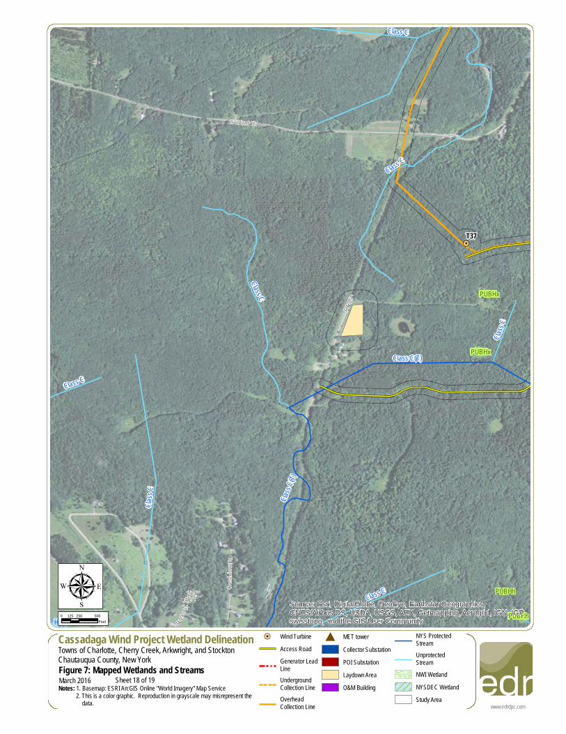
Sheet 18 of 19
!=!
!=!
!=!
!=!
!=!
!=!
!=!
!=!
!=!
!=!
!=!
!=!
!=!
!=!
!=!
!=!
!=!
!=!
!=!
!=!
!=!
!=!
!=!
!=!
!=!
!=!
!=!
!=!
!=!
!=!
!=!
!=!
!=!
!=!
!=!
!=!
!=!
!=!
!=!
!=!
!=!
!=!
!=!
!=!
!=!
!=!
!=!
!=!
!=!
!=!
!=!
!=!
!=!
!=!
!=!
!=!
!=!
!=!
T27
T24
T22
T18
T12
T9T6
T2
T1
RT 85
HA-3
Class C(T)
Class C
Class C
Class
C
Class C
Class
C
Class C(T)
PUBHh
PUBHx
PUBHx
PUBHh
PUBHhSource: Esri, DigitalGlobe, GeoEye, Earthstar Geographics,CNES/Airbus DS, USDA, USGS, AEX, Getmapping, Aerogrid, IGN, IGP,swisstopo, and the GIS User Community
www.edrdpc.com
µCassadaga Wind Project Wetland DelineationTowns of Charlotte, Cherry Creek, Arkwright, and StocktonChautauqua County, New YorkFigure 7: Mapped Wetlands and StreamsNotes: 1. Basemap: ESRI ArcGIS Online "World Imagery" Map Service 2. This is a color graphic. Reproduction in grayscale may misrepresent the data.
0 250 500125Feet
March 2016
!=! Wind TurbineAccess RoadGenerator LeadLineUndergroundCollection LineOverheadCollection Line
# MET towerCollector SubstationPOI SubstationLaydown AreaO&M Building
NYS ProtectedStreamUnprotectedStreamNWI WetlandNYSDEC WetlandStudy Area
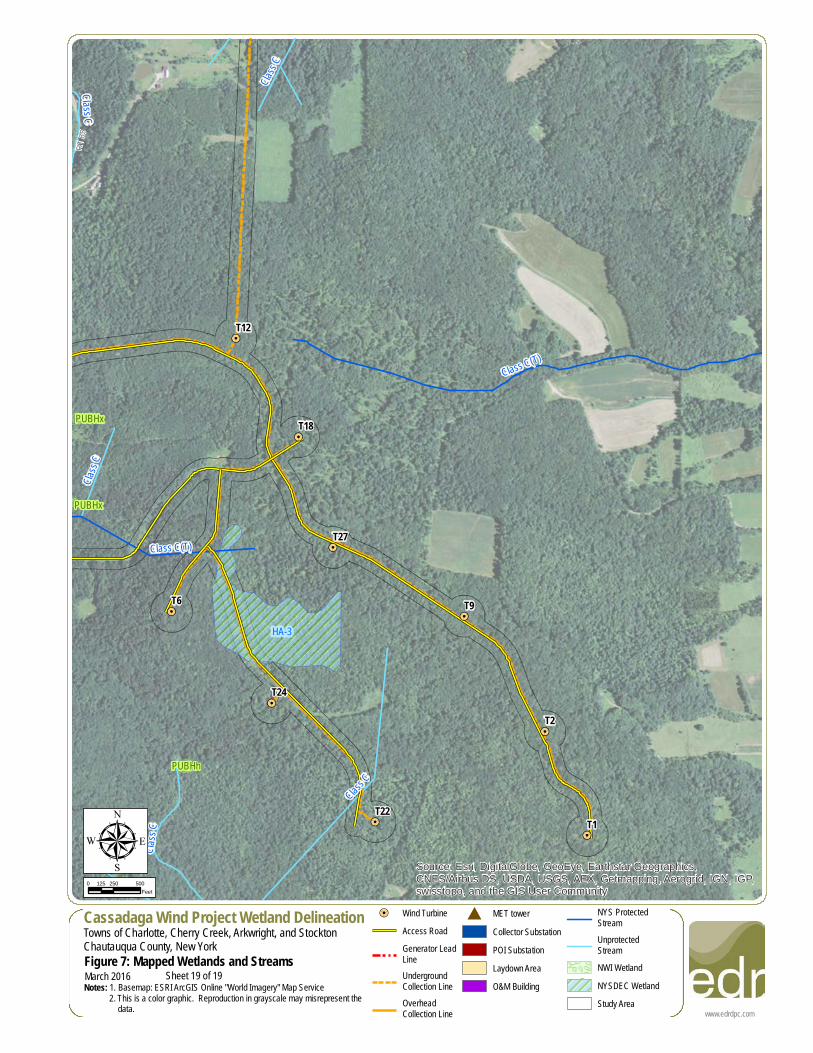
Sheet 19 of 19


![T24 Technical Manual - · PDF fileT24-BSi and T24-BSu [Base Station] ... Mantracourt Electronics Limited T24 Technical Manual 4 ... RF Exposure Limits](https://img.pdfslide.net/doc/110x75/5a809fa07f8b9aa24f8c9617/t24-technical-manual-and-t24-bsu-base-station-mantracourt-electronics-limited.jpg)