Embed Size (px)
Citation preview

Anchorage, Alaska September 24th – 26th
2007Arctic Science
Conference
Partnering for Northern FuturesScience • Policy • Education • Legacy • In the International Polar Year

Partnering for Northern Futures: Science • Policy • Education • Legacy
In the International Polar Year
Anchorage, AlaskaSeptember 24th – 26th, 2007
2007Arctic Science Conference
2007Arctic Science Conference

�
• Table of Contents •
Conference Dedication ………………………………………………………………………………………… 2Conference Sponsors …………………………………………………………………………………………… 3Conference Organization ……………………………………………………………………………………… 5Conference Program …………………………………………………………………………………………… 6Conference Schedule …………………………………………………………………………………………… 7Arctic Division AAAS Meeting History ………………………………………………………………………… 9Abstracts ………………………………………………………………………………………………………… 11Author Index ……………………………………………………………………………………………………… 74
Cover IPY honeycomb organization chart courtesy of www.ipy.org.
Copyright ©2007 Arctic Division AAAS. Visit www.arctic.aaas.org for reprint, usage, and contact information.

2007Arctic Science Conference
�
• Conference Dedication •
This meeting is dedicated to the pioneering work ofCharles David Keeling in the worldwide measurement of atmospheric carbon dioxide.
Climate scientist Charles David Keeling inspecting a manometer in his Scripps Institution of Oceanography laboratory, 1988. ©Scripps Institution of Oceanography, UC San Diego.
Charles David Keeling, 1928-2005
The 58th AAAS Arctic Science Conference honors the memory of Dr. Charles David Keeling. Dr. Keeling is remembered for his research on carbon dioxide in the ocean and atmosphere and an obituary in NATURE referred to him as a “Pioneer in the modern science of climate change”.
Roger Revelle, Director of the Scripps Institution of Oceanography (SIO) and one of the founders of the International Geophysical Year (IGY) persuaded Keeling in 1958 to continue his research on carbon dioxide which he started at Caltech in 1954. At SIO he received IGY funding to establish a carbon dioxide observatory at Mauna Loa, Hawaii and observations of carbon dioxide were also made at the South Pole in the Antarctic. By 1960 he had established that there are strong seasonal variations in atmospheric carbon dioxide especially in the land-rich northern hemisphere. In 1961, he was able to show that carbon dioxide levels were rising steadily, what is now commonly recognized as the Keeling curve.
Dr. Keeling encouraged John Kelley in 1960, then at the University of Washington and presently at the School of Fisheries and Ocean Sciences, University of Alaska Fairbanks, to establish a continuous carbon dioxide observatory in the Arctic at the Naval Arctic Research Laboratory, Barrow, Alaska in collaboration with his laboratory at SIO. Observation of carbon dioxide at Barrow, from aircraft transects and from arctic drift ice stations were made from 1961-1967. Eventually, NOAA established a monitoring site near Barrow in the early 1970s and began observations of carbon dioxide and other atmospheric variables which continue today.
Dr. Keeling received numerous honors for his research including the Special Achievement Award from Vice President Al Gore (1997) and the National Medal of Science, the highest US award for scientific research lifetime achievement by President George W. Bush in 2002.

�
• Conference Sponsors •
American Association for the Advancement of Science www.aaas.org
Arctic Institute of North AmericaUniversity of Alaska and University of Calgarywww.ucalgary.ca/aina
Association for Women in Science www.awis.org
College of Natural Science and Mathematics www.uaf.edu/cnsm
Sigma Xi, Alaska Chapterwww.sigmaxi.org
University of Alaska Fairbanks www.uaf.edu and www.uaf.edu/ipy
We thank the following sponsors for their support and the contributions that have made the 58th Annual Arctic Science Conference possbile:

2007Arctic Science Conference
�
• Conference Sponsors •
U.S. Arctic Research Commissionwww.arctic.gov
North Pacific Fishery Management Councilwww.fakr.noaa.gov/npfmc
School of Fisheries and Ocean Scienceswww.sfos.uaf.edu
Shell Oil Companywww.shell.com/us

�
• Conference Organization •
The Arctic Science Conference is an annual meeting that is organized and supported by the American Association for the Advancement of Science (AAAS) Arctic Division. The locations and themes of the conference vary from year to year, although the themes and locations are always related to the Arctic and the scientific endeavors of the Arctic Division AAAS members and their colleagues. It is a continuing goal of this conference that it be open and accessible to all scientific scholars who are working on Arctic, Alaskan, Canadian, northern or Antarctic issues, and to communicate their interests and discoveries at the event.
The theme of the 2007 Arctic Science Conference is "Partnering for Northern Futures." Although the conference is open to all scientific contributions related to the North and the Arctic, this theme was chosen to emphasize the interactions of researchers and policy makers during the IPY. This year's conference was organized by:
Conference Organizers
Conference ChairJohn Kelley, President, Arctic Division, AAAS, www.arctic.aaas.org
Conference CoordinatorArthur Roraff, The Coordinators Inc., www.thecoordinatorsinc.com
Conference AdvisorLawrence Duffy, Executive Secretary, Arctic Division, AAAS, www.arctic.aaas.org
Conference AssistantSerena Likar, Institute of Marine Science, School of Fisheries and Ocean Sciences, UAF
Exhibition Curator and Publication Design Annie Duffy, Duffy Infodesign, www.duffyinfodesign.com
Arctic Division AAAS Officers
PresidentJohn Kelley, School of Fisheries and Ocean Sciences, UAF (University of Alaska Fairbanks)
President ElectS. Craig Gerlach, Resilience and Adaptation Program, UAF
Past PresidentJohn Walsh, Center for Global Change and Arctic Systems Research, UAF
Executive SecretaryLawrence K. Duffy, College of Natural Science and Mathematics, UAF
Finance OfficerJennifer Templeton*, College of Natural Science and Mathematics, UAF*In memorium (1971 – 2007)
Area 1 Representative (Alaska, south of 63 degrees)Robert Foy, NOAA/Kodiak Fisheries Research Center
Area 2 Representative (Alaska, north of 63 degrees)Gary Laursen, Department of Biology and Wildlife, UAF
Area 3 Representative (Yukon, Northwest Territories, and Nunavut) Paul Driscoll, Arts and Sciences, Yukon College

2007Arctic Science Conference
�
• Conference Program •
General Information
Registration DeskThe AAAS registration staff will provide assistance with program information, audio and visual aids for sessions, and other administrative needs. The registration desk will be open:
Monday, Sept. 24th at the Captain Cook Hotel across from the Fore Deck from 8:00 a.m. to 5:00 p.m. Tuesday, Sept. 25th at the Captain Cook Hotel across from the Fore Deck from 8:00 a.m. to 5:00 p.m. Wednesday, Sept. 26th at the Captain Cook Hotel across from the Fore Deck from 8:00 a.m. to 5:00 p.m.
Conference Fees Full Conference: $200 Single Day: $70 Student: $90 Student Single Day: $15
*All registrations include snacks on the days registered.
BadgesEach participant should obtain a badge at the registration desk prior to attending any of the sessions.
Coffee and Registration AreaCoffee will be available inside the session meeting rooms.
List of ParticipantsA list of pre-registered conference participants will be available at registration.
Poster Sessions Posters will be on display according to the following schedule:
Monday, Sept. 24th from 4 p.m. to 5:30 p.m. Tuesday, Sept. 25th from 8 a.m. to 5 p.m. Wednesday, Sept. 26th from 8 a.m. to 12:30 p.m.
Authors are requested to be present to discuss their material at 4 p.m. on Monday or Tuesday or designate times when they will be available.
LunchThe conference has scheduled a hour and a half lunch break on each day.
AAAS Arctic Science Conference BanquetThe banquet will feature a special guest speaker and an awards presentation will be held at the Captain Cook Hotel at 7 p.m. on Tuesday evening. Tickets can be purchased for $30.
Featured Banquet Speaker: David Hik, Canadian IPY Secretariat Master of Ceremonies: Gary Laursen, Dept. of Biology and Wildlife, UAF

�
Monday, September 24th, 2007
8:00 a.m. Registration and Coffee Service Begins9:00 a.m. – 9:30 a.m. Welcoming and Opening Remarks John Kelley, President, Arctic Division AAAS Fore Deck Fran Ulmer, Chancellor, UAA Carl Benson, Chairman, Board of Governors, AINA Lawrence Duffy, Executive Secretary, Arctic Division AAAS
9:30 a.m. – 12:00 p.m. Plenary Speakers Carl Benson, Professor Emeritus, Geophysical Institute, UAF Fore Deck Donald Lynch, Professor Emeritus, Dept. of Geography, UAF Lars Kullerud, Director, UARCTIC (Arendal, Norway) William Althoff, Geologist/Historian, Whitehouse Station, NJ William Streever, BP Exploration (Alaska) Inc.
12:00 p.m. – 1:30 p.m. Lunch (on own)
1:30 p.m. – 3:30 p.m. Poster Display and Exhibition Set Up (Mid Deck) 1:30 p.m. – 4:00 p.m. Technical Sessions: Adventure Science and Politics (14th Arctic Round Table, Sponsored by AINA and Arctic Division AAAS)
Albert Teich, Director of Science and Policy Programs, AAAS and Carl Benson, Chairman, Board of Governors, AINA (moderator) Fore Deck Remediation and Environmental Science William Streever, BP Exploration (Alaska) Inc. Whitby Arctic Engineering Orson Smith, Dept. of Engineering, UAA
Endeavor Food and Agriculture in Alaska I Peter Bechtel and Brian Himmelbloom, FITC, SFOS/UAF
4:00 p.m. – 5:30 p.m. Poster Session with Refreshments (Mid Deck)6:00 p.m. – 9:00 p.m. Reception and Gallery Talk IGCA Conference and "Synthesis" Exhibition Reception and Gallery Talk *Located at the International Gallery of Contemporary Art (IGCA) 427 D Street, Anchorage, AK (approx. 5 blocks from the Captain Cook Hotel)
Tuesday, September 25th, 2007
8:00 a.m. Registration and Coffee Service Begins8:00 a.m. – 5:00 p.m. Poster Displays (Mid Deck)9:00 a.m. – 12:00 p.m. Technical Sessions:
Fore Deck Geology and Geophysics A. Sathy Naidu, School of Fisheries and Ocean Sciences, UAF
Endeavor EPSCoR (Workshop) Peter Schweitzer, Alaska EPSCoR, UAF
Adventure Food and Agriculture in Alaska II Peter Bechtel and Brian Himmelbloom, FITC, SFOS/UAF
• Conference Schedule •

2007Arctic Science Conference
�
Whitby "Arctic Eight" Policies and Global Affairs (Workshop) Karen Erickson, Southern New Hampshire University
12:00 p.m. – 1:30 p.m. Lunch (on own)
1:30 p.m. – 4:00 p.m. Technical Sessions:
Endeavor Human Dimensions of the Arctic System: Expanding the Framework for Research Maribeth Murray, Dept. of Anthropology, UAF
Fore Deck North Slope Science Initiative / Water Modeling and Geology John Payne, North Slope Science Initiative, DOI/BLM and Daniel White, Institute of Northern Engineering, UAF
Adventure Atmospheric Sciences Gary Hufford, NOAA/NWS
Whitby Circumpolar Health Alan Parkinson, Centers for Disease Control and Prevention, and Sven Ebbesson, Norton Sound Health Corporation
4:00 p.m. – 5:00 p.m. Poster Sessions with Refreshments (Mid Deck)7:00 p.m. – 9:00 p.m. AAAS Arctic Science Conference Banquet Aft Deck Featured Banquet Speaker: David Hik, Canadian IPY Secretariat Master of Ceremonies: Gary Laursen, Dept. of Biology and Wildlife, UAF
Wednesday, September 26th, 2007
8:00 a.m. Registration and Coffee Service Begins8:00 a.m. – 12:30 p.m. Poster Displays (Mid Deck)9:00 a.m. – 12:00 p.m. Technical Sessions: Fore Deck Terrestrial Ecology David McGuire, Institute of Arctic Biology, ACFWRU, UAF
Adventure Biodiversity in the Seas Rolf Gradinger, School of Fisheries and Ocean Sciences, IMS/UAF
Endeavor IPY Education Lars Kullerud, UARCTIC, and David Hik, Canadian IPY Secretariat
Whitby International Science Years Roger Smith, Geophysical Institute, UAF 12:00 p.m. – 1:30 p.m. Lunch (on own)
1:30 p.m. – 4:00 p.m. Technical Sessions:
Fore Deck Permafrost on a Warming Planet Jerry Brown, International Permafrost Association
Adventure Geography, History, and Archaeology Donald Lynch, Dept. of Geography, UAF,Jason Rogers, Alaska Maritima, and David McMahan, Dept. of Natural Resources, State of Alaska
Whitby AAAS Business Meeting
4:15 p.m. – 4:30 p.m. Closing Session and Final Remarks (Fore Deck)

�
The Arctic Division of the American Association for the Advancement of Science (AAAS) has a long and illustrious history. Founded in 1951 as the Alaska Division, the Arctic Division was established to foster scientific communication in the then rather isolated Arctic territory. The name was changed to Arctic Division in 1982 to reflect the membership's growing interest in high latitudes outside of Alaska. Most of the Division members reside in Alaska and Canada's Yukon, Northwest Territory, and Nunavut, but any AAAS member who has an interest in the Arctic or Antartic may join. More information about the Arctic Division AAAS can be found online at www.arctic.aaas.org.
Previous Arctic Division AAAS MeetingsNo. Dates Year Location Chair Theme1 Nov. 9 - 11 1950 Washington, D.C. John C. Reed Science in Alaska2 Sept. 4 - 8 1951 Mt. McKinley
National ParkLaurence Irving, UA Biology Dept. Science in Alaska
3 Sept. 22 - 27 1952 Mt. McKinley National Park
Laurence Irving, UA Biology Dept. Science in Alaska
4 Sept. 28 - Oct. 3 1953 Juneau Christian T. Elvey, UA Geophysical Inst.
Science in Alaska
5 Sept. 7 - 10 1954 Anchorage Hugh A. Johnson, US Dept. of Agriculture
Science in Alaska
6 Jun. 1 - 4 1955 College Neil W. Hosley, Univ. of Alaska Science in Alaska
7 Sept. 27 - 30 1956 Juneau Troy L. Pewe, US Geological Survey
Science in Alaska
8 Sept. 10 - 13 1957 Anchorage Victor P. Hessler, Univ. of Alaska Science in Alaska9 Sept. 2 - 5 1958 College Robert L. Rausch, Arctic Health
Res. Cntr., US Public Health Svc.Science in Alaska
10 Aug. 25 - 28 1959 Juneau Norman J. Wilimovsky, Univ. of British Columbia
Science in Alaska
11 Aug. 30 - Sept. 2 1960 Anchorage Roger R. Robinson, US Bureau Land Mgmt.
Science in Alaska
12 Aug. 28 - Sept. 1 1961 College John P. Hannon, Arctic Aeromedical Lab
Science in Alaska
13 Aug. 22 - 26 1962 Juneau James W. Brooks, AK Dept. of Fish and Game
Science in Alaska
14 Aug. 22 - 30 1963 Anchorage Allan H. Mick, AK Agricultural Exp. Sta.
Science in Alaska
15 Aug. 31 - Sept. 4 1964 College Charles J. Eagan, Arctic Aeromedical Lab
Science in Alaska
16 Aug. 30 - Sept. 1 1965 Juneau Richard M. Hurd, Inst. Northern Forestry
Science in Alaska
17 Aug. 29 - Sept. 2 1966 Anchorage William Davis, Alaska Methodist Univ.
Science in Alaska
18 Aug. 28 - Sept. 1 1967 College Peter R. Morrison, UA Inst. of Arctic Biology
Science in Alaska
19 Aug. 26 - 30 1968 Whitehorse Richard Hill, Dept. of Indian Affairs
Science in Alaska & Northern Development
20 Aug. 24 - 27 1969 College Victor Fisher, UA Inst. Social & Econ. Res.
Change in the North: People, Petroleum & Environment
21 Aug. 16 - 19 1970 College T. Neil Davis, UA Geophysical Inst.
Change in the North: UA Physical Environment
22 Aug. 17 - 19 1971 College Laurence Irving, UA Inst. of Arctic Biology
Adaptation for Northern Life
23 Aug. 15 - 17 1972 Fairbanks Gordon S. Harrison, UA Inst. of Social & Econ. Res.
Science and Policy in the North
24 Aug. 15 - 17 1973 Fairbanks Gunter E. Weller, UA Geophysical Inst.
Climate of the Arctic
25 Oct. 18 - 20 1974 Anchorage William Davis, Alaska Methodist Univ.
Behavioral Sciences in the North
26 Aug. 11 - 15 1975 Fairbanks* Donald W. Hood, UAF Inst. of Marine Science
Third International Conference on Port & Ocean Engineering Under Arctic Conditions (POAC)
27 Aug. 4 - 7 1976 Fairbanks George C. West, UAF Inst. of Arctic Biology
Resource Development: Processes and Problems
28 Sept. 22 - 24 1977 Anchorage David M. Hickok, UA Arctic Environ. Info. & Data Center
Science Information Exchange in Alaska
29 Aug. 15 - 17 1978 Fairbanks Donald H. Rosenberg, UA Alaska Sea Grant
Alaska Fisheries: 200 Years & 200 Miles of Change
• Arctic Division AAAS Meeting History •
2007Arctic Science Conference
�0
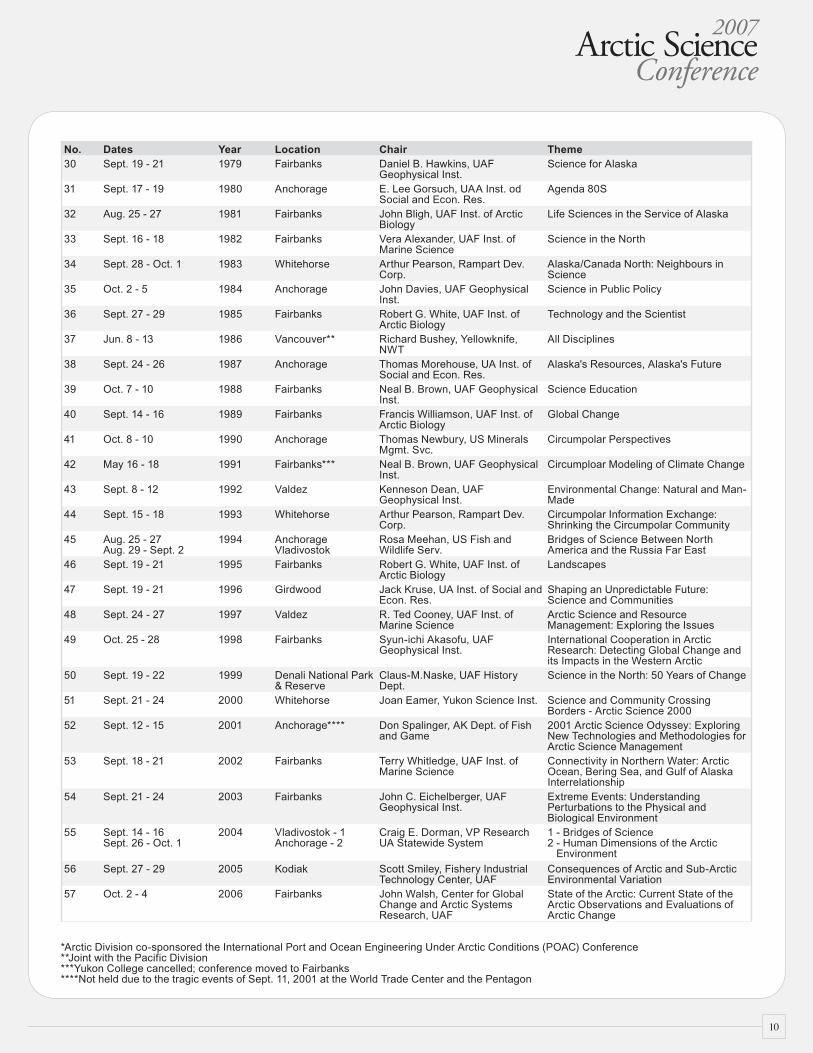
No. Dates Year Location Chair Theme30 Sept. 19 - 21 1979 Fairbanks Daniel B. Hawkins, UAF
Geophysical Inst.Science for Alaska
31 Sept. 17 - 19 1980 Anchorage E. Lee Gorsuch, UAA Inst. od Social and Econ. Res.
Agenda 80S
32 Aug. 25 - 27 1981 Fairbanks John Bligh, UAF Inst. of Arctic Biology
Life Sciences in the Service of Alaska
33 Sept. 16 - 18 1982 Fairbanks Vera Alexander, UAF Inst. of Marine Science
Science in the North
34 Sept. 28 - Oct. 1 1983 Whitehorse Arthur Pearson, Rampart Dev. Corp.
Alaska/Canada North: Neighbours in Science
35 Oct. 2 - 5 1984 Anchorage John Davies, UAF Geophysical Inst.
Science in Public Policy
36 Sept. 27 - 29 1985 Fairbanks Robert G. White, UAF Inst. of Arctic Biology
Technology and the Scientist
37 Jun. 8 - 13 1986 Vancouver** Richard Bushey, Yellowknife, NWT
All Disciplines
38 Sept. 24 - 26 1987 Anchorage Thomas Morehouse, UA Inst. of Social and Econ. Res.
Alaska's Resources, Alaska's Future
39 Oct. 7 - 10 1988 Fairbanks Neal B. Brown, UAF Geophysical Inst.
Science Education
40 Sept. 14 - 16 1989 Fairbanks Francis Williamson, UAF Inst. of Arctic Biology
Global Change
41 Oct. 8 - 10 1990 Anchorage Thomas Newbury, US Minerals Mgmt. Svc.
Circumpolar Perspectives
42 May 16 - 18 1991 Fairbanks*** Neal B. Brown, UAF Geophysical Inst.
Circumploar Modeling of Climate Change
43 Sept. 8 - 12 1992 Valdez Kenneson Dean, UAF Geophysical Inst.
Environmental Change: Natural and Man-Made
44 Sept. 15 - 18 1993 Whitehorse Arthur Pearson, Rampart Dev. Corp.
Circumpolar Information Exchange: Shrinking the Circumpolar Community
45 Aug. 25 - 27Aug. 29 - Sept. 2
1994 AnchorageVladivostok
Rosa Meehan, US Fish and Wildlife Serv.
Bridges of Science Between North America and the Russia Far East
46 Sept. 19 - 21 1995 Fairbanks Robert G. White, UAF Inst. of Arctic Biology
Landscapes
47 Sept. 19 - 21 1996 Girdwood Jack Kruse, UA Inst. of Social and Econ. Res.
Shaping an Unpredictable Future: Science and Communities
48 Sept. 24 - 27 1997 Valdez R. Ted Cooney, UAF Inst. of Marine Science
Arctic Science and Resource Management: Exploring the Issues
49 Oct. 25 - 28 1998 Fairbanks Syun-ichi Akasofu, UAF Geophysical Inst.
International Cooperation in Arctic Research: Detecting Global Change and its Impacts in the Western Arctic
50 Sept. 19 - 22 1999 Denali National Park & Reserve
Claus-M.Naske, UAF History Dept.
Science in the North: 50 Years of Change
51 Sept. 21 - 24 2000 Whitehorse Joan Eamer, Yukon Science Inst. Science and Community Crossing Borders - Arctic Science 2000
52 Sept. 12 - 15 2001 Anchorage**** Don Spalinger, AK Dept. of Fish and Game
2001 Arctic Science Odyssey: Exploring New Technologies and Methodologies for Arctic Science Management
53 Sept. 18 - 21 2002 Fairbanks Terry Whitledge, UAF Inst. of Marine Science
Connectivity in Northern Water: Arctic Ocean, Bering Sea, and Gulf of Alaska Interrelationship
54 Sept. 21 - 24 2003 Fairbanks John C. Eichelberger, UAF Geophysical Inst.
Extreme Events: Understanding Perturbations to the Physical and Biological Environment
55 Sept. 14 - 16Sept. 26 - Oct. 1
2004 Vladivostok - 1Anchorage - 2
Craig E. Dorman, VP ResearchUA Statewide System
1 - Bridges of Science2 - Human Dimensions of the Arctic Environment
56 Sept. 27 - 29 2005 Kodiak Scott Smiley, Fishery Industrial Technology Center, UAF
Consequences of Arctic and Sub-Arctic Environmental Variation
57 Oct. 2 - 4 2006 Fairbanks John Walsh, Center for Global Change and Arctic Systems Research, UAF
State of the Arctic: Current State of the Arctic Observations and Evaluations of Arctic Change
*Arctic Division co-sponsored the International Port and Ocean Engineering Under Arctic Conditions (POAC) Conference**Joint with the Pacific Division***Yukon College cancelled; conference moved to Fairbanks****Not held due to the tragic events of Sept. 11, 2001 at the World Trade Center and the Pentagon

��
2007 Arctic Science Conference AbstractsAbstracts are listed alphabetically according to first author.
1. Understanding Past Changes in the Aleutian Low Pressure System of the North PacificOcean Using Marine, Terrestrial, and Ice Proxy RecordsJason Addison, Bruce FinneyUniversity of Alaska Fairbanks, USA • E-mail: [email protected]
Understanding synoptic patterns of past climate variability is an important aspect of predicting future climatic change. General circulation models have shown that the Subarctic Northeast Pacific Ocean is an important player in Northern Hemisphere climate, yet a comprehensive understanding of the paleoclimatic history of this region is lacking. The interaction between the east-flowing North Pacific Current and the Aleutian Low pressure system has led to the generation of the upwelling Alaska Gyre, a recognized high-nitrate-low-chlorophyll zone. Via Ekman pumping, this shallow nutrient-rich water is advected towards the west coast of North American, where conditions along the continental margin favor high primary productivity. This high primary productivity results in one of the most productive marine fisheries in the world. Shifts in the Pacific Decadal Oscillation, controlled primarily by the strength and position of the Aleutian Low, historically occur over multi-decadal timescales and affect both physical conditions and marine ecosystem productivity. Here, we compare our results from high-resolution marine sedimentary records from the Gulf of Alaska to recently published high-resolution terrestrial paleoclimate and paleoecological records from the adjacent Northeast Pacific Ocean margin over the last 2000 years to understand the late Holocene evolution of the Aleutian Low. Our isotopic and biogeochemical results obtained from a suite of marine sedimentary cores recovered from the fjords and continental shelf reflect variations in both marine primary productivity, and terrestrial influx. The productivity proxies indicate shifts in climate dynamics, since the coupled Aleutian Low – Alaska Gyre system influences the marine ecosystem. This differs from the terrestrial influx indicators because these data reflect the intensity of freshwater runoff, independent of changes in the marine ecosystem. Both sets of proxies indicate a ‘baseline’ regime shifts at about AD 1850 and AD 1000, as well as significant multi-decadal cyclicity.
The carbonate δ18O record from Jellybean Lake in the Canadian Yukon, and the δ18O record in ice cores recovered from Mt. Logan have both been interpreted directly in terms of atmospheric dynamics controlled by the Aleutian Low. The sedimentary δ15N signal of Karluk Lake on Kodiak Island, Alaska, also reflects fluctuations in marine conditions driven by the Aleutian Low; however, this proxy dataset reflects variations in Pacific salmon abundance, which is governed in part by marine primary productivity levels. The timing of periods of major change in these records is similar to what we have observed in our marine records. This regional multi-proxy approach makes possible an assessment of the nature and impact of Aleutian Low variability over the last 2000 years. Changes in the δ18O records of Jellybean Lake and Mt. Logan reflect variations in moisture source and pathway, and the Gulf of Alaska terrestrial influx datasets may be interpreted in terms of coastal precipitation intensity. When viewed in this context, the Gulf of Alaska paleoproductivity and Karluk Lake δ15N records are compatible with the implied changes in Aleutian Low forcing. Prior to ~AD 1000, the Aleutian Low existed in a weakened state and/or more westerly location with a northern zonal moisture source, and reduced precipitation along the Gulf of Alaska margin that limited marine productivity. During the little ice age, between AD 1200 – 1850, the dynamics of this system altered drastically; the Aleutian Low generally became more intensified and/or easterly with moisture derived by means of a meridional circulation pattern. These changes resulted in increased precipitation and enhanced marine productivity within the Gulf of Alaska. These shifts in state are unprecedented in magnitude relative to the regime-shifts documented historically. The recognition of these differing modes of the linked Aleutian Low – Alaska Gyre system necessitate additional study that can be addressed by utilizing geographically diverse research localities and multi-proxy approaches.
2. The Arctic Water Resources Vulnerability Index (AWRVI): A New Tool for the NorthLilian Alessa, Andrew Kliskey, Richard Lammers, Christopher Arp, Daniel White, Larry Hinzman, Robert BuseyUniversity of Alaska Anchorage, USA • E-mail: [email protected]
People in the Arctic face uncertainty in their day-to-day lives as they contend with uncertain environmental changes from local to global scales. Freshwater is a critical resource to people and while water resource indicators have been
• Abstracts •

2007Arctic Science Conference
��
developed that operate from regional to global scales and for mid-latitude to equatorial environments no index exists for assessing the vulnerability of Arctic communities to changing water resources at the local scale. The Arctic Water Resource Vulnerability Index (AWRVI) is a new tool that Arctic communities can use to assess their relative vulnerability resilience to changes in their water resources from a variety of biophysical and socioeconomic processes. AWRVI is based on a social-ecological systems perspective that includes physical and social indicators of change.
3. Forgetting Change: Memory, Water and the Role of Perception in the Resilience of ArcticCommunities Lilian Alessa, Andrew Kliskey, Paula Williams, Michael BartonUniversity of Alaska Anchorage, USA • E-mail: [email protected]
This study provides some of the first empirical evidence to support existing anecdotal studies regarding the mechanisms by which human communities become vulnerable to rapid changes in natural resources. Residents of communities in Inupiat communities on the Seward Peninsula, Alaska, were contacted as collaborators. Using categorical indices as part of a semi-structured interview we invited a respondent's perception of the availability and quality of freshwater resources in their community as well as their perception of change in the availability and quality of freshwater during the period of their lifetime in that community. Significant relationships were observed between age groups for the perception of change in the availability of the local water source and the perception of change in its quality - older generations perceiving more change than younger age groups. These perceptions of change were examined with respect to recent historic changes in precipitation and temperature on the Seward Peninsula. These findings suggest that individual perceptions are instrumental in determining whether or not change merits response. The findings also provide evidence that oral traditional knowledge systems have shifted from continuous to discontinuous transmission, distancing the users from traditional resources. We discuss the role of collective knowledge, through the transmission of knowledge from elders to subsequent generations, in aiding the development of a community's ability to note and respond to changes in critical natural resources.
4. Drifting Stations in the Arctic Ocean: A Short HistoryWilliam AlthoffSmithsonian Institution, National Air and Space Museum, USA• E-mail: [email protected]
The circumpolar north is maritime--morphologically, an oceanic basin. Arctic exploration and study are largely naval stories. Signature feature: a dynamic sea-ice cover baring conventional passage.
To penetrate an ocean one needs platforms. Until the 1970s, surface ships could not reach the central arctic. An alternative: frozen-in ships. First to demonstrate the drift technique for systematic observation: explorer-scientist Fridtjof Nansen and the epic drift (1893-96) of iceship Fram.
Twentieth-century technology--the icebreaker, aircraft, telecommunications, nuclear submarines--opened the Arctic fully to researchers. To seaward, the pack itself is an exploitable platform--a natural if dangerous runway. The concept of air-supported at-sea bases was pioneered by the Soviet Union: in 1937, Leningrad's Arctic Institute installed the first semi-permanent ice-rafted camp. A path-breaking expedition, the nine-month drift of "North Pole-1" yielded the beginnings of real scientific understanding.
Following World War II, operations accelerated on, over, and under arctic ice. Offshore, airlifted spot observations were logged by both superpowers--the Soviets particularly. Still, the data from brief or "jumping" touchdowns were not synoptic. To support regular observations throughout the boreal year, a succession of semi-permanent field-research stations ensued. In 1952, the first U.S. camp deployed then supported by air (fuel, freight, personnel) was installed onto Ice Island T-3--a slab of freshwater shelf ice adrift with the pack. Orbiting off Alaska-Canada, T-3 floated research teams to 1974--more than two decades. Programs: oceanography and marine biology, meteorology, geology/glaciology, marine geophysics, sea-ice studies, underwater acoustics. For its "North Pole" series, the Soviet Union deployed two drifting stations in 1954 then sustained a continuous drift-presence to 1991--thirty-two long-haul outposts for science.

��
Forerunner to the current International Polar Year (IPY), the International Geophysical Year of 1957-58 held a strong polar research component. In support of IGY, the U.S. Air Force deployed two ice-rafted stations into the Northern Ocean. The Soviet Union also contributed two.
Danger is companion to ice-based inquiry: intense cold, months- long dark, the hazards of airlift re-supply. Bear, firearms, heavy equipment, and the handling of explosives boost the potential for emergencies. As well, the threat of fracture is ever-present.
5. Problems Attending Northern Transport: A Historical OverviewWilliam AlthoffSmithsonian Institution, National Air and Space Museum, USA• E-mail: [email protected]
The circumpolar north is a sprawl of forest, muskeg and tundra hosting a miscellany of camps, outposts, bases, settlements, projects. The great curve of Russia spans eleven time zones, Canada six. Transportation is the hindrance to investigation, development, and re-supply. Sheer scale, plus the absence of a road-rail infrastructure impede access. A 1936 map of Canada, for example, is devoid of roads anywhere in the Northwest Territories--an area the size of Europe. Construction (in soft soil: re-construction) of ground-links through all that landscape are difficult to engineer. In a warming world, moreover, winter-based (ice-road) transport to northern-tier locations is becoming increasingly problematic
The matter of supplies is crucial. Rivers, historically, are highways for the continental interiors. But offshore, pack ice interposes a horrendous seascape to transit. Twentieth-century technology and its platforms--the icebreaker, telecommunications, the air age, nuclear submarines--penetrate the boreal blanks, granting entrée to sites of military or scientific or economic interest.
Still, nature is decidedly in charge; man is interloper. Pack ice impedes all navigation and threatens offshore structures. The most powerful icebreakers face daunting ice; avoiding the central basin, shipping lanes are necessarily coastwise. Beneath the sea-ice canopy, the nuclear submarine confers an all-season capability. Yet, operating under ice is risky. Beyond the ground-based net, aviation services predominate: passengers along with light, valuable, and urgent freight move by air. Heavy or outsized cargo (notably fuel) is reserved for seaborne arrival, exploiting spring break-up. The sole means of regular and reliable access to most communities, weather stations, bases and bivouacs (ashore and ice-based) is by air. Similarly, logistic support to construction and resource-extraction sites is largely air-dependent.
The North is a desert; the logistics of air transportation are complex. And expensive--getting fuel in by air about ten times that via road delivery. Support facilities are scattered, the weather capricious, emergency strips few. Aloft, inertial-navigation systems overrule the magnetic compass – a further reward of technology.
During the IGY summer of 1958, two unique missions pressed northward. Both platforms were displacement craft--one a U.S. Navy blimp, the other a submarine. The former type would never again be ordered north; Nautilus (SSN 571), however, opened a new era in the maritime Arctic.
6. Monitoring the Seasonally Frozen Soil Effects on the Dynamic Behavior of a ParkingGarage in Anchorage, AlaskaFeifei Bai, Zhaohui Yang, Feng Xiong, He LiuPND Engineers, Inc., USA • E-mail: [email protected]
It is found that seasonal freezing of ground soils may affect the seismic response of bridge structures. A recent study using seismic data recorded on a 20-story moment-resistant steel-frame office building equipped with strong-motion instruments in Anchorage, Alaska also shows that the fundamental frequency of the building could change by 4% between winter and summer conditions due to seasonally frozen ground effects, and numerical simulation results indicate that the fundamental frequency of a reinforced-concrete (RC) building of similar geometry could change by as much as 30%. However, this finding regarding RC buildings has not been verified by any experimental data.
• Abstracts •

2007Arctic Science Conference
��
This paper presents the results of experimental and analytical studies on a three-story unheated RC parking garage located on the University of Alaska Anchorage (UAA) campus. With a 16-channel portable accelerograph deployed periodically on each story of the garage during the winter of 2006-2007, both ambient and forced vibration test data were collected. The test data were processed and analyzed by system identification software ARTeMIS Extractor to identify the dynamic properties of the structure, including fundamental frequency and mode shape. Meanwhile, based on as-built plans and geotechnical data of the site, a three-dimensional Finite Element (FE) model including both superstructure and soil has been developed by using general purpose FEM software ANSYS in order to simulate the effects of partially frozen ground on the dynamic behavior of the structure. The fundamental frequency identified from the recorded data was used to calibrate the FE model. With the calibrated FE model, modal analyses were performed for three different boundary conditions, i.e. rigidly-supported structure without soil, structure with unfrozen soil and structure with partially frozen soil to investigate the effects of frozen soils. Based on the results from field tests and numerical analyses, it is concluded that the effects of seasonally frozen soils on the dynamic properties of the garage system can be investigated by both field tests and finite element analysis successfully. It is found through the field tests that the fundamental frequency of the structure-soil system increases nearly 50% as the frost penetration progresses from the ground surface to 1.5 m deep. This finding is confirmed by the FE simulation results. The FE results also indicate that the dynamic properties of a RC garage structure are only sensitive to the freezing of the shallow soil layers (up to a depth of 1.5 to 2 m).
7. The Vulnerability of Carbon Storage in Boreal North America During the 21st Century inResponse to Increases in Wildfire ActivityMichael Balshi, A. David McGuireUniversity of Alaska Fairbanks, USA• E-mail: [email protected]
The boreal forest contains large reserves of carbon. Across this region, wildfires influence the temporal and spatial dynamics of carbon storage, which has the potential to be altered under a changing climate. The temporal and spatial dynamics of fire are also likely to be altered as the climate continues to change. In this study, we develop temporally and spatially explicit relationships between air temperature and fuel moisture codes derived from the Canadian Fire Weather Index System to estimate annual area burned at 2.5[o] resolution using a Multivariate Adaptive Regression Splines (MARS) approach across boreal North America. At the boreal North American scale, the empirical fire models explain on the order of 80% of the variation in annual area burned for the period 1960-2002. To understand how the temporal and spatial dynamics of fire might be altered by future climate change, the empirical fire models were driven by output from the A2 and B2 scenarios from the Canadian Climate Center CGCM2 global climate model to predict annual area burned through year 2100. Historical and future area burned estimates are then coupled to the process-based Terrestrial Ecosystem Model (TEM) to simulate fire emissions and changes in carbon storage for boreal North America in the context of changing atmospheric CO2 concentration and climate from the start of the historically recorded fire records in the 20th century through the end of the 21st century. Relative to the last decade of the 20th century, decadal total carbon emissions from fire increase on the order of 2.5 to 4.4 times by 2091-2100, depending on the climate scenario and assumptions about CO2 fertilization. The effect of CO2 fertilization is a major uncertainty in this analysis. For the 21st century, our simulations indicate that boreal North America is a carbon sink in response to CO2 fertilization, climate variability, and fire, but an increase in fire results in a decrease in the sink strength. While this study highlights the importance of future atmospheric CO2, climate, and fire on the carbon dynamics of boreal North America, several limitations and uncertainties exist and should be addressed in future process-based analyses. Future studies should incorporate the role of dynamic vegetation to more accurately represent post-fire successional processes, incorporate fire severity parameters that change in time and space, and integrate the role of other disturbances and their interactions with future fire regime.
8. Constraining the Time-Scale of Interaction of Sea Ice Sediments and Surface Sea Water inthe Arctic Ocean Using Short-Lived Radionuclide TracersMark Baskaran, Per Andersson, Jason Jweda, Rolf DahlqvistWayne State University, USA• E-mail: [email protected]
We measured the activities of short-lived radionuclides (Th-234, Be-7, Po-210, Pb-210, Cs-137, Th-234, Ra-226 and

��
Ra-228) and concentrations of several elements (Be, Pb, Fe, Al, Co, Ni, Cu and Zn) on a suite of ice-rafted sediments (IRS) collected during BERINGIA-2005 in the Western Arctic Ocean. A suite of water samples were also collected and analyzed for particulate and dissolved Be-7, Po-210, Pb-210, Th-234, Ra-226 and Ra-228. The activities of Be-7 and Pb-210 in the IRS are 1-2 orders of magnitude higher than those reported in the source sediments. Presence of excess Th-234 in the IRS indicates that the removal of Th-234 from surface seawater took place on time scales comparable to the mean-life of Th-234. While the Po-210/Pb-210 activity ratios in the source sediments (1.0) and the atmospheric depositional input (~0.1) are known, varying ratios of 0.78 to 1.0 were found in the IRS. This ratio can be utilized to obtain the residence time of the IRS in sea ice. The activity of Ra-226 and Ra-228 in all the IRS is nearly constant (within a factor of 1.6) and are comparable to the benthic sediments in the source region. The activities of atmospherically-delivered radionuclides, Be-7 and Pb-210, in IRS varied by factors of ~4.5 and 9, respectively, and this variation is attributed to differences in the extent of interaction of surface water with IRS and differences in the mean-lives of these nuclides. While significant enrichment of Be-7 and Pb-210 has been found, there is no enrichment of stable Pb or Be. The Al-normalized enrichment factor for elements measured (Co, Ni, Cu, Zn, Pb and Be) indicate that there is no significant enrichment of these elements, with Al-normalized enrichment factors less than 1.3.
9. Enhancing Utilization of Alaska Food and Agriculture ByproductsPeter BechtelUSDA Agricultural Research Service, USA • E-mail: [email protected]
In the past, the term “waste” was used for materials that were left over after primary food processing. Disposal of these so called “waste materials” was often considered a cost of doing business. However, a closer look finds that this “waste” can be used as the raw materials to make other products, which generate additional profit and possibly reduce environmental concerns. There are many examples where yesterdays “waste” became a valued raw material for further processing.
The largest source of food related byproducts in Alaska comes from the processing of wild marine fish. Over 50% of the total wild fish harvested and processed for human consumption in the USA comes from Alaska waters. In Alaska large amounts of pollock, salmon, cod and flat fish are harvested annually resulting in over 1million metric tones of byproducts, which can be utilized to produce a number of products. Major byproducts from the fish processing industry are heads, viscera, frames and skin. However, these products can be further fractionated into organs such as gonads, livers, stomachs and other tissues, which can be used as raw materials to produce unique and potentially valued food and feed ingredients and a host of other products. Alaska fish byproducts have several advantages because they are derived from sustainable fisheries and are initially of high quality because the fish were processed for human consumption.
Enhancing the utilization of byproducts can generate additional profit from raw materials. There are bio resources in Alaska that can be potentially utilized for the production of energy and other potentially interesting products. The array or byproducts available in Alaska and their potential utilization will be discussed.
10. Examples of IPY Outreach to K-12 Schools in AlaskaKatherine Berry Bertram, Amy HartleyUniversity of Alaska Fairbanks, USA • E-mail: [email protected]
This presentation will discuss the Arctic Climate Modeling Program (ACMP), a comprehensive project for 1700 Alaska Native students and 165 teachers in the Bering Strait School District (BSSD), an area suffering from low standardized test scores, high dropout rates, poverty and geographic isolation. ACMP offers progressive yearlong science, technology and math (STM) instruction incorporating information technology (IT) applications that culminate in the creation of computer models simulating possible climate change effects. Students apply knowledge to local problems and decision-making, and gain IT workforce skills applicable to current Arctic climate research and upcoming projects associated with the 2007-08 International Polar Year (IPY).
Program end products include a multimedia interactive CDROM, a Teacher's Manual of 60 hands-on class-room
• Abstracts •

2007Arctic Science Conference
��
lessons and 20 IT exercises, Student-Inquiry Handbooks with guidelines for annual ACMP youth camp experimental stations, and a Science Mentor Notebook, containing a DVD of 27 science lectures and related activities. At grant conclusion, instruction is distributed to 580 teach-ers and 7500 students in two Alaska districts used as program control groups, and is downloadable from the ACMP Website (http://www.arcticclimatemodeling.org/).
An overview of the Science Teacher Education Program (STEP) will show ways in which teachers from 8 Alaska school districts are learning about climate changes affecting the world. In July 2007, two 2-week STEP summer institutes were timed to coincide with the beginning of the International Polar Year. Because global climate change is a broad topic involving many facets, seven UAF scientists from a variety of disciplines were involved in training STEP teachers about the role the atmosphere, the world's oceans, and land surface play in Earth's changing climate. The 60 teachers participating (30 in each session) in STEP earned six upper level credits for participation. Alaska Science Consortium instructors helped teachers translate information learned from scientists into hands-on science lessons useable in their K-12 classrooms. All lessons developed by teachers align instruction and assessment with Alaska science Grade Level Expectations. After field-testing, these lessons will be posted to the STEP Web site (http://www.scienceteachereducationprogram.com/) and made available to all teachers in Alaska.
11. Land Rehabilitation in the Kuparuk OilfieldSusan Bishop, Timothy Cater, Torre JorgensonABR, Inc., USA• E-mail: [email protected]
ABR and CPAI (formerly PAI and ARCO) have conducted research on rehabilitation of disturbed sites in the Kuparuk oilfield for over 20 years. The program has included both experimental studies and full-scale rehabilitation of a variety of disturbance types, including gravel fill, gravel removal areas, reserve pits, mine sites, hydrocarbon and salt water spills, and tundra impacts and scuffs from a variety of causes.
For most rehabilitation sites, large or small, the steps in the rehabilitation process are similar. First, a site-specific rehabilitation plan is developed. Important components of each plan are goals and objectives, which are developed by CPAI and ABR in cooperation with the relevant regulatory agencies. In addition, performance standards are typically agreed upon in advance, so that the success of the rehabilitation effort can be objectively assessed and agreed upon by all parties
Once the goals, objectives and performance standards are established, a rehabilitation approach is designed to meet them. The plan includes the treatments to be applied, the monitoring methods used to assess performance, and the schedule for both treatment and monitoring.
Rehabilitation treatments that have been used successfully at a variety of sites include fertilizer application, seeding with native-grass cultivars, seeding indigenous sedges and forbs, and transplanting live plant materials, including cuttings of native willows, container-grown legumes, sprigs of the aquatic grass Arctophila fulva and plugs of tundra vegetation. Case studies of several long-term projects will be presented, to illustrate the lessons learned and successes achieved in the past twenty years.
12. Future Scenarios of Arctic Marine Navigation: Using Scenario Thinking in the ArcticMarine Shipping AssessmentLawson BrighamU.S. Arctic Research Commission, USA • E-mail: [email protected]
A key element of the ongoing work of the Arctic Council's Arctic Marine Shipping Assessment (AMSA) is the creation of a set of plausible scenarios for future Arctic marine navigation to 2050. A scenario framework was developed at two workshops held in San Francisco and Helsinki where brainstroming, work in small groups, and plenary discussions produced two key factors or uncertainties ~ Governance and Resources & Trade ~ that are most important in shaping the future of Arctic marine navigation to mid-century. A scenario matrix was formed by crossing these two critical uncertainties; this framework also allows the incorportaion of many other uncertainties explored at the workshops

��
including climate change and the increasing marine access throughout the Arctic basin. The Governance axis describes the degree of relative Governance stability both within the Arctic and internationally. Less stability implies shortfalls in the legal structure and a regulatory system; stakeholders work unilaterally rather than in a cooperative relationship. More stability implies an efficient and effective legal and regulatory system in the Arctic Ocean. The Resources and Trade axis describes the level of demand for Arctic natural resources and trade. More or high demand implies greater demand from a host of global actors for Arctic natrual resources; less demand implies that fewer gloabl stakeholders are pursuing Arctic natural resouces for the global marketplace. The set of scenario narratives will contain four different, plausible futures that will be relevant to a host of Arctic stakeholders. The scenarios will further be used to address a number of key, marine challenges for the eight Arctic States, including critical issues of environmental protection and sustainable development throughout the Arctic.
13. Separating Salmon By-Products to Preserve Quality of Individual ComponentsCindy BowerUSDA Agricultural Research Service, USA • E-mail: [email protected]
Alaska’s fishing industry generates over one million metric tons of fish by-products each year, much of which is discarded during processing unless fishmeal plants are located nearby. Other preservation methods, such as ensilage and fermentation, are less common, but can acidify perishable by-products to inhibit growth of spoilage bacteria. However, the stability and nutritional quality of individual fish components may be decreased when discarded with other materials in a single waste stream. In this study, salmon by-products (heads, viscera, and a mixture of the two) were stabilized through fermentation by lactic acid bacteria and through ensilage by direct acidification. Bacterial cell counts and lactic acid concentrations were recorded as a measure of microbial viability. All samples were analyzed for moisture, ash, and lipid composition. Additionally, the distribution of nitrogen was followed, since fish proteins degrade into shorter peptides and free amino acids during storage. Significant differences were apparent among initial pH values of salmon viscera, heads, and mixtures, and the differences remained for the entire 18 weeks of storage, suggesting that individual by-product varieties may require separate handling for best preservation. These findings have major implications for how fish processing waste should be collected and stored if maximum nutritional value is to be preserved.
14. Permafrost on a Warming PlanetJerry BrownInternational Permafrost Association, USA •E-mail: [email protected]
Permafrost develops and persists in regions where there is a negative heat balance at the Earth's surface; an ice-free land area that occupies upwards of 22% of the Northern Hemisphere. These negative temperatures, occurring to depths of hundreds of meters in the Earth's surface, respond over time to changes in air temperatures, radiation, precipitation, vegetation and other boundary conditions. During the last glaciation large areas of unglaciated lowlands and mountains and the exposed continental shelves experienced extensive and deep permafrost development with contemporaneous ground ice formation. Over the past 10, 000 years (Holocene) permafrost has warmed and, where the upper, ice-rich layers have thawed, thermokarst terrains developed. During recent decades warming of permafrost terrains have been observed in boreholes over many continental regions and mid-latitude mountains, accompanied in some cases by increased thickness of the seasonally thawed zone, or active layer. In addition to ground temperature measurements increased availability of remotely-sensed, time series and in situ measurements of trace gas fluxes are providing information on recent changes to the diverse, permafrost-dominated landscapes. These include changes in coastlines and lake-dominated terrains.
During the International Polar Year, four coordinated projects are underway that are designed to establish the current status of permafrost conditions and recent changes.
Permafrost Observatory Project: A Contribution to the Thermal State of Permafrost (TSP) will develop a spatially distributed set of observations on past and present status of permafrost temperatures and active layer thicknesses.
•
• Abstracts •

2007Arctic Science Conference
��
Antarctic and sub-Antarctic Permafrost, Periglacial and Soil Environments Project (ANTPAS) is aimed at integrating existing and new data on the distribution, thickness, age, history and physical and geochemical properties of soils and permafrost. Carbon Pools in Permafrost Regions (CAPP) project is aimed at quantifying soil organic matter quantity (stocks) and its quality in high-latitude and high-altitude regions and that are characterized by both permafrost and non permafrost terrains.Arctic Circum-Polar Coastal Observatory Network (ACCO-Net) will develop and coordinate a monitoring program for the arctic coastal regions.
Our collective IPY permafrost legacy is to establish a permanent, bipolar network of observatories and to encourage the development of the next generation of permafrost researchers. Initial results of these IPY and related activities will be presented in summer 2008 at the Ninth International Conference on Permafrost <www.nicop.org> and other international conferences.
15. Alaska’s Standing Water Budget Affected by Changes in the Permafrost Rena Bryan, Larry Hinzman, Robert Busey, Kenji YoshikawaUniversity of Alaska Fairbanks, USA • E-mail: [email protected]
The purpose of this study is to project the continuum of Alaskan watersheds from their present state to wetter and then to drier on the time scale of decades to centuries. We predict, as permafrost thaws, increased ponding will occur on the surface followed by, in areas of discontinuous permafrost, a rather sharp turn toward a much drier environment with open talik formation and connection to subpermafrost groundwater. However, the rate of change of each watershed’s transition from wetter to drier will vary significantly in areas of continuous and discontinuous permafrost. This study aims to capture the uniqueness of each watershed. This experiment encompasses all of Alaska with 300 m pixel resolution. The planned method for determining the ground water gradient and degree to which vertical percolation will be restricted is to analyze digital terrain information with hydrology, permafrost, soils, geology, and current climate data. To start the groundwater gradient computations we will focus on known areas with known hydrologic phenomena and elaborate on a vector based gradient map referencing the steepness of the terrain and the precipitation on the surrounding higher elevations. Once the present groundwater and surface water situation is captured, based on the future thawing of the permafrost in areas on the landscape, we propose to forecast the wetness and dryness across Alaska.
16. Integrating Climate Change into the Higher Education Curriculum: A Faculty Initiative ofthe University of Alaska AnchorageAllison ButlerUniversity of Alaska Fairbanks, USA • E-mail: [email protected]
Science and traditional knowledge have overwhelmingly confirmed the reality of climate change, and the people of Northern latitudes are experiencing these changes first-hand. Myriad global changes in social, economic, and ecological systems are accompanying the rise in temperature, and many of their impacts will be profound. Whether directly or indirectly, now or later, global change will affect us all.
Nevertheless, our education systems have not begun to adequately prepare our youth for the altered world they will inherit. Institutions of higher education bear a particularly large intellectual and moral obligation to address these issues, owing to our principal role in shaping tomorrow’s leaders and educators, and in contributing to humanity’s collective knowledge.
A recent survey1 conducted by the University of the Arctic suggests that only about two-thirds of their 102 circumpolar member institutions offer any global change courses in their formal curricula. Of these, most courses are in the natural and social sciences, with particular emphasis in courses pertaining to cultural and geophysical aspects of the Arctic. Woefully lacking were courses relating to health and economic issues, two of the key areas of global change impacts. Courses designed to train pre-service primary and secondary teachers were all but absent.
•
•
•

��
The University of Alaska Anchorage has begun to address these critical educational needs in part through faculty development initiatives. Our first faculty cohort has begun a year-long process of redesigning courses to address issues of climate change, beginning with an intensive workshop, continuing with collegial cooperation and information sharing, and culminating with new applications being learned by their students. The cohort represents a broad cross-section of disciplines, including the much-needed fields of health, economics, and education. In addition to presenting factual information on climate change, we have tailored examples of ways to integrate climate change into participants’ individual disciplines.
This presentation highlights the design, implementation, and initial outcomes of the workshop, and offers a model for adoption or adaptation by other colleges and universities.
1Moore, J., Kinnunen, H., and Boone, R. (2007). Global change education in the Arctic. Eos, 88(14), 158, 162-163.
17. ARCUS Internet Media Archive (IMA): A Window into the Arctic - An Online Resource forEducation and OutreachTina Buxbaum, Wendy Warnick, B. Zeb Polly, Katie BreenArctic Research Consortium of the U.S. (ARCUS), USA • E-mail: [email protected]
The ARCUS Internet Media Archive (IMA) is a collection of photos, graphics, videos, and presentations about the Arctic and Antarctic that are shared through the Internet. It provides the polar research community and the public at large with a centralized location where images and video pertaining to polar research can be browsed and retrieved for a variety of uses. The IMA currently contains almost 6,500 publicly accessible photos, including 4,000 photos from the National Science Foundation (NSF) funded Teachers and Researchers Exploring and Collaborating (TREC) program, an educational research experience in which K-12 teachers participate in arctic research as a pathway to improving science education. The IMA is also the future home of all electronic media from the NSF funded PolarTREC program, a continuation of TREC that now takes place in both the Arctic and Antarctic. The IMA includes 450 video files, 270 audio files, nearly 100 graphics and logos, 28 presentations, and approximately 10,000 additional resources that are being prepared for public access.
The contents of this archive are organized by file type, photographer's name, event, or by organization, with each photo or file accompanied by information on content, contributor source, and usage requirements. All the files are keyworded and all information, including file name and description, is completely searchable.
ARCUS plans to continue to improve and expand the IMA with a particular focus on providing graphics depicting key polar research results and findings as well as edited video archives of relevant scientific community meetings. To submit files or for more information and to view the ARCUS Internet Media Archive, please go to: http://media.arcus.org or email [email protected].
18. Atmospheric Chemistry at the Poles: What is Our Current State of Knowledge?Catherine CahillUniversity of Alaska Fairbanks, USA • E-mail: [email protected]
The study of atmospheric chemistry in the polar regions demonstrates how research changes the common knowledge about a region. Initially, the polar regions were considered ‘pristine’ and unworthy of detailed atmospheric study. Preliminary chance observations led to atmospheric chemistry research which showed that remote regions of the Arctic were impacted by emissions from sources located around the Arctic. Further research led scientists to understand that the polar regions are impacted by emissions from around the globe. The polar regions provide the end points of mid-latitude transport pathways which bring a wide variety of chemicals, both potential nutrients and pollutants, into the regions. The extreme light, temperature and humidity conditions observed at the poles drive unique atmospheric chemistry processes that cause chemical cycling pathways not observed in lower and mid-latitudes to dominate chemical
• Abstracts •

2007Arctic Science Conference
�0
deposition and revolatilization processes.
This paper will provide an overview of the history of polar atmospheric chemistry observations, describe commonly discussed atmospheric chemistry processes and phenomenon and discuss the current state of knowledge of atmospheric chemistry processes at the poles. Among the topics discussed will be: Arctic Haze, the ozone hole, carbon dioxide, persistent organic pollutants, mercury and Asian dust.
19. Areas of Plant Radiation and Migration in Alaska: Testing Hultén’s Ideas of ElementalAreas and Rare Plant Diversity in Alaska Matthew Carlson, Helen Cortes-Burns, Amy MillerUniversity of Alaska Anchorage, USA • E-mail: [email protected]
Ideas of the origins and biogeography of the arctic and boreal flora were largely shaped by the 1937 publication of Eric Hultén’s Outline of the History of Arctic and Boreal Biota during the Quarternary Period. This work was the first to propose that an unglaciated subcontinent linking Asia and North America, Beringia, served as a major repository of arctic and boreal species during the Quarternary. Hultén suggested that current geographic areas with high densities of narrowly endemic plants represent important “elemental areas” that correspond to unglaciated refugia. Southwestern Alaska was one of five elemental areas identified in North America. We evaluated the geographic pattern of narrowly endemic vascular plants as well as a random sample of the total native plant flora in Alaska to test whether southwestern Alaska is a center of plant radiation. We found that while the Aleutians harbor relatively high levels of endemism, the rest of southwestern Alaska has very few narrowly endemic species. Hot spots of geographically rare species are concentrated in northwestern Alaska and the eastern Interior. Areas of particularly low levels of endemism include the mid- to lower Yukon and Kuskokwim drainages and the area south of the Alaska Range. The flora as a whole, however, displays high diversity in southwestern Alaska. Southwestern Alaska, in fact appears to represents an important zone of convergence of previously largely isolated floras, rather than an area of radiation. Additionally, we note that the majority of rare plants in Alaska are oceanic or montane island endemics. These species face significant dispersal barriers in the context of global warming since mountain ranges generally run east-west rather than north-south in Alaska, hampering habitat tracking.
20. A Representation and Analysis of Social, Economic and Biological Factors in theManagement of Reindeer Herds on the Seward PeninsulaHenry ColeIndependent Scholar, USA • E-mail: [email protected]
The great reindeer herds of the Seward Peninsula transported to Alaska late in the nineteenth century from Russia now exist as free range herds living off existing forage and controlled by local herding management. To fully understand the behavior and future of this resource a comprehensive method of linking social, economic and biological factors that affect reindeer on the Seward Peninsula must be presented. We will start by building a causal loop mapping which shows the critical linkages between forces and variables of this system; this will lead to a full mathematical model of structure and behavior in this system.
The core of this representation begins with the basic biology connecting the health of reindeer and their habitat. Predation kills many animals and neighboring caribou migrations can quickly absorb and remove many other reindeer. Habitat quality and ease of overland travel can be modified by climatic impact which may cause a shift to more mechanical modes of transportation. Profit from herd ownership due to the sale of meat and antlers is used to pay herders or support the expenses of snowmobiles and ATVs and associated infrastructure. Such choices by herd owners erode the traditional herding knowledge base and practice and is an example of a familiar systems archetype: shifting the burden to the intervener, where a new methodology introduced into a community can increase system efficiency but in doing so erodes what had existed before.
The sustainability of this northern resource will depend not only upon successful growth and maintenance in the overall stocks of reindeer and humans but upon community strategies to counter various time delays in the system: the shock

��
• Abstracts •
of climate change, the rate of growth of herder mechanical transport capability, and the decline of traditional herding knowledge and the establishment and growth of mitigation strategies.
21. Hydrodynamic Effects of the Proposed Knik Arm Crossing Joseph Colonell, Phillip Mineart, Jeanne HudsonENTRIX, Inc., USA • E-mail: [email protected]
Extreme tides, an extraordinary sediment load, and seasonal ice cover combine to present unique challenges to the design and construction of a crossing of Knik Arm. Engineering concepts for a cost-effective crossing structure include combinations of a pile-supported bridge and gravel-filled approaches to span the 12,500-foot channel width. The preferred configuration of a proposed Knik Arm Crossing (KAC) consists of gravel-fill bridge approaches extending from either side of Knik Arm, bridged by a pile-supported bridge structure 8,200 feet (ft) in length.
Hydrodynamic modeling techniques were applied to address effects of KAC on the following processes in Knik Arm:
Tide stage (water surface elevation [WSE]) and phase (timing).Current velocities (maximum and mean values) beneath the bridge and both north and south of KAC alignmentSedimentation environment (erosion and deposition)Effects of accelerated flows around bridge abutments
Analysis of large-scale effects was accomplished with a suite of hydrodynamic (numerical) models that have been utilized for environmental hydrodynamic analyses for many complex situations around the world. The hydrodynamic models were calibrated and verified to Knik Arm conditions with extensive data sets developed during 2002, 2004, and 2005, which addressed all oceanographic processes considered essential for representation in the models. Small-scale effects were analyzed by a series of smaller specialized hydraulic analysis tools.Results of the modeling analyses indicate that the hydrodynamic effects of KAC would be generally limited to its immediate vicinity. While alterations to the sediment transport regime near the Port of Anchorage are numerically discernible in the computational results, they would likely be barely measurable.
22. Meteorological Data within the NPRA Region and its Application to Water UseManagementChad Cormack, Michael Lilly, Horacio Toniolo, Daqing YangUniverstiy of Alaska Fairbanks, USA • E-mail: [email protected]
Weather data in the National Petroleum Reserve, Alaska (NPRA) is scarce. Few Meteorological stations are in the area, and most of them have only been reporting data for a short time. Within these reporting stations, even fewer of them report precipitation and radiation data. One of the goals of our project is to analyze the available data in the area, and compare it other regional meteorological sites that have longer term data. Weather stations to the east in the Kuparuk and Prudhoe Bay regions have been reporting data for a much longer period of time. Directly applying this long term data into the NPRA region may not be an acceptable method of analysis since these regions might not represent the weather trends within NPRA.
As oil exploration expands into the NPRA region, water from local lakes will be used. In order to minimize environmental impacts to these lakes, management tools are being developed to appropriately determine which lakes have a higher amount of annual potential recharge. Weather data such as precipitation, snowfall, net radiation, and wind speed significantly influences the calculation of potential recharge. It is important to obtain a better understanding of the meteorological trends in the NPRA region with the limited data available. With a better distribution of weather data in NPRA, it will be possible to develop hydrologic tools to better aid water management in these regions with sparse data sets.
••
••

2007Arctic Science Conference
��
23. On the Importance of Sea Ice to Arctic Fish HabitatRichard CrawfordPrince William Sound Science Center, USA • E-mail: [email protected]
The cryopelagic Arctic cod Boreogadis saida is a key element of the Arctic food web. This species is often described as pagophilic (ice loving) and the epipelagic epontic zone is thought to be critical habitat. Recent warming has reduced ice cover and this reduction in epontic habitat would have significant negative ecological impact. Hydroacoustic studies in the High Arctic Canadian Archipelago revealed that putative Arctic cod of all sizes occurred throughout the under-ice water column. Fish distribution was characterized by two states, either scattered (i.e., non-schooling individuals) or aggregated (i.e., schooling fish). Mean size of non-schooling fish was largest near the bottom. Volume density was also highest near the bottom and up to 10 times greater in bays and inlets than in deeper areas. Small aggregations of fish occurred in the epontic zone but density was low compared to schools of larger fish in mid-depths. The preponderance of fish biomass was in enormous schools (estimated >100,000 t) in the lower half of the water column, revealing that the energetic basis of the Arctic marine food web occurs in the depths, at least in the Canadian Archipelago.
Results suggest resource partitioning splits the pelagic fish population among the three available habitats: epontic, pelagic, and benthic. A reduction of the epontic habitat will affect a relatively small proportion of the fish population, some of which will likely move deeper into the pelagic habitat. Predation on fish by ringed seals—acoustically detected in this study foraging near the bottom—will likely diminish. Fish mortality due to bird predation may also decrease if fish spend more time away from the surface. However, fish mortality due to predation by whales would likely increase given the wider window of opportunity for predation in areas where fish were previously protected by ice cover. Energy flow into the benthic habitat may be affected if the loss of ice algae as a source of biological snow is not offset by input from the expanded biomass of pelagic plankton. There may also be changes in benthic litter of fish carcasses from predation events on fish schools. If benthic production is altered it may affect the capacity of that habitat to support the massive biomass of fish presently there. Potentially significant threats to fish populations will arise from expanding commercial fisheries and oil spills (especially sinking oil) that will accompany increased shipping access in the North.
24. Archaeological Potential of Buried Terrestrial Landforms in the Beaufort Sea: A Review ofExisting Geological and Geophysical DataNancy Darigo, Owen Mason, Peter BowersURS Corporation, USA • E-mail: [email protected]
This presentation, based on existing core analyses and geoarchaeological/geophysical data, assesses the archaeological potential of submerged and buried terrestrial paleolandforms beneath the Alaskan Beaufort Sea. Past research suggested that relict terrestrial landforms such as stream terraces and coastal features dating from the last glacial advance and low sea level stands of late Pleistocene - early Holocene age were locations where preserved archaeological deposits could occur. Geophysical data from OCS lease areas in the Beaufort Sea indicated the potential presence of these types of relict landforms beneath the seafloor shoreward of approximately 20 m water depth, where shorefast winter ice tends to protect the seafloor from ice gouging. There have been insufficient data, however, to determine whether these landforms date from the last periods of low sea level, or from an earlier Pleistocene low sea level. The radiocarbon dates from this study were added to a compilation of all existing dates for the Beaufort Sea shelf, and interpreted in the context of regional data from the Chuckchi, Laptev, and Canadian Beaufort Seas. Our 14C dates ranged from 8,600 to 1,600 years B.P., confirming the Holocene age of sediment mapped from seismic data in these areas. Beaufort Sea dates from the late Pleistocene and early-mid Holocene range were generally considered unreliable due to recycling of organics. Dates from the later Holocene were considered more reliable due to the presence of potentially in situ peats. The results of our study indicate the following general Holocene paleo sea levels and rates of sea level rise for the Alaskan Beaufort Sea shelf: (1) at the beginning of the Holocene, about 11,000 years ago, sea level was at or below about 50 m below modern sea level (bsl), (2) after 10,500 years B.P., sea level had risen to at least 50 m bsl and flooded the Bering Strait, (3) between 9,000 and 7,500 years B.P., sea level rose rapidly from about 44 m bsl to 18/16 m bsl, a rate of about 1.8 cm/yr., (4) sea level was about 12 m bsl by 6,000 years B.P. and reached near modern levels (within 2 m bsl) by 5,000 years B.P., and (5) the rates of sea level rise between 7,500 and 4,500 years B.P., at 0.3 to 0.6 cm/yr, were more than ten times the present rate of 0.3 mm/yr. Many Beaufort Sea coastal and shelf depositional processes complicate the
��
• Abstracts •
interpretation of the radiocarbon data, such as river-eroded tundra redeposited at delta fronts, collapsed thaw lake banks recycled as lagoon peat, storm surges, and migrating barrier islands. Areas for future research could focus on paleolandforms that are relatively distinct based on seismic data, are preserved beneath a protective sediment cover, may be of terrestrial origin, and are likely to be early Holocene in age. These areas include buried channels with possible channel-edge features, the landward side of buried paleo-shorelines, terraced sides of buried peat-bogs or lagoons, and buried relict islands of coastal ridges containing terrestrial material.
25. Tomodensitometric Analysis of Basal IceMatthew Dillon, Daniel Fortier, Mikhail Kanevskiy, Yuri ShurUniversity of Alaska Fairbanks, USA • E-mail: [email protected]
Studies of contemporary basal ice cryostructures and their classification is an important tool in distinguishing between buried glacial and segregated ice in permafrost. Sampling of basal ice is often a difficult process due to inherently harsh field conditions and the limited availability of appropriate exposures. Tomodensitometric scans of basal ice cryostructures from the Matanuska glacier in Alaska were made using a micro-computed tomographic (CT) system. Tomodensitometric analysis of basal ice is a nondestructive procedure for revealing characteristics of basal ice. High-resolution scans are an excellent complement to field and laboratory studies of basal ice because of the level of details that they reach which is hardly obtained during field observations. Scan results are highly dependent on the scanner settings; therefore a thorough diagnostic must be performed to determine optimum settings for voltage, current, pixel size, and exposure time. Scan results must be calibrated against a known substance, such as pure ice. Once the scans are calibrated, three-dimensional (3D) models are generated. These models are used to study the 3D structure of ice and sediment inclusions, as well as the spatial distribution and dimension of air bubbles. The volumetric ice, sediment, and air contents of a sample can also be determined by using these models. Ultimately, this study will aide in creating a new cryostructures classification based on the 3D configuration of the basal ice.
26. Exploration and Estimation of Gravel Resource Potential in Southeast Chuckchi SeaContinental Shelf Off Kivalina, AlaskaAbhijith D'Souza, Sukumar Bandopadhyay, Sathy Naidu, John KelleyUniversity of Alaska Fairbanks, USA • Email: [email protected]
The Alaskan Continental Shelf covers 76 % of the total shelf area of the United States. There are a lot of potential gravel deposits in the Alaskan offshore region. The gravel resources are currently not feasible for mining for the following reasons (U.S Congress, 1987):
Much of the glacial gravel is poorly sortedGravel deposits are overlain by sandy and muddy layers
With the sea level expected to rise 70 cm in the next 100 years (Intergovernmental Panel on Climate Change, IPCC, 2001; Day, 2004), erosion of coastlines will be a major problem not only in Alaska but worldwide. Hence beach nourishment projects designed to minimize erosion will require large volumes of sand and gravel. Offshore areas will become a logical source for the fill material because of their proximity and ready availability. It is likely that future supply of coarse aggregate in Alaska may involve exploitation of marine deposits. The Chukchi Sea is a potentially favorable region for this type of mining because of extensive deposits of paleo beach and other relict gravel found in the near shore region (Stauffer, 1987). However a systematic analysis of potential gravel resource has not yet been conducted and it is the purpose of this research to estimate the size, extent and variability of gravel material that may be available in the continental shelf, offshore Kivalina.
The circum-Arctic coasts, including those in Alaska, have some of the highest rates of coastal erosion (1-20 m y-1) in the world, primarily because of combined impacts of thermo-erosion and storm surges on permafrost-dominated, unconsolidated deposits of shorelines. The high erosion and storm surges are deleterious to coastal communities. Kivalina, which is situated on a barrier island, in the southeast Chukchi Sea is exposed to these natural erosions. To address this chronic problem and to find a long-term solution, the Shishmaref and Kivalina village councils resolved
1.2.

2007Arctic Science Conference
��
to relocate the village from the barrier to an adjacent onshore site (Fairbanks Daily News-Miner, 2001).
However, the coastal plain identified for the village relocation has continuous permafrost, posing an unstable ground for erecting houses and infrastructures, which calls for special foundation measures. The relocation plan envisages that the active permafrost ground (estimated ~ 25 km2) be excavated to a depth of 4 m and filled with gravel. A region targeted as a potential source for the large volume of gravel needed is the continental shelf adjacent to the villages.
The investigations presented here consist of two major tasks: one in the field and the other in the laboratory. The field operations consisted of seismic survey and collection of grab samples and sediment cores, while the laboratory operations consisted of grain size analysis of the collected sediments and geotechnical testing of gravel as well as geostatistical analysis for reserve estimation The field studies off Kivalina were conducted in August 2004 aboard the University of Alaska Fairbanks (UAF) research ship R/V Alpha Helix. The geophysical survey was conducted with the assistance of Golder Associates, Seattle and the vibra core sampling was completed with the assistance of Innerspace Exploration Team (IET), also from Seattle. The grain size analysis was conducted at the Mineral Industry Research Laboratory (MIRL) at the University of Alaska Fairbanks. The geotechnical analysis was conducted at Shannon and Wilson, Inc, Fairbanks. The geostatistical analysis was conducted at the computer laboratory at the Department of Mining and Geological Engineering at UAF.
The major conclusions of this study are:
The seismic surveys were of limited use as they could not resolve the upper 1-2 m seafloor lithology. This was probably due to the use of a low frequency signal and due to the low resolving power of the hydrophones.Penetration of the vibracore was not deeper than 1 m, probably because of the hard substrate.Geostatistical analysis of the data indicated that at least 20 X 106 m3 of gravel above 90 % cut-off is present in the upper 0.5 m of the seafloor.The Paleogeographic history was a determining factor in gravel presence in the nearshore southeast Chukchi Sea region
27. Surficial Geology Research Program: Application to and Resource Development in theSouthern Mackenzie Valley, Northwest Territories Alejandra Duk-Rodkin, David Huntley, Rod Smith, Vern SinghroyGeological Survey of Canada, Canada • E-mail: [email protected]
Surficial geology research conducted by the Geological Survey of Canada in southern Mackenzie Valley from 2005 to 2007 has yielded a large amount of geoscience data, including: surficial geology maps, till geochemistry, geotechnical analyses, drift isopach maps, clast lithology-till provenance studies, glacial history and landscape evolution. Recognizing the pressing need for geoscience information in light of the development of northern communities, the proposed Mackenzie Valley Gas Pipeline and other supporting infrastructure (e.g., all-season roads and construction in general), we have not only undertaken a wide diversity of studies, but also the manner and formats in which this data is being published.
Three types of digital maps are being produced, with special emphasis on landslide and aggregate data: 1) Surficial geology maps on digital topography at 1:100 000-scale; 2) Surficial geology polygons on Radarsat; and 3) Landslide maps linked with a database. A fourth product is a CD-ROM containing all of the above mentioned maps, in addition to the geochemical data and drift isopach (thickness) and potential granular aggregate maps. Surficial geology polygons will be linked to sites and their description captured as figures showing stratigraphy accompanied by photographs, sample locations, pie charts of lithology, and geochronological data where possible. In turn, sample numbers will be linked with the geochemical data, age and macrofossil reports, and other information sources. These data sources will be a valuable resource for a range of end users in the region, including community developers, government agencies, industry partners, university researchers and the general public.
1.
2.3.
4.

��
• Abstracts •
28. Seismic Velocity Structure at the Delaney Park Downhole Array, Anchorage, Alaska,Inferred from the Waveform Inversion of Local Earthquake DataUtpal Dutta, Mrinal Sen, Niren Biswas, Zhaohui YangUniversity of Alaska Anchorage, USA • E-mail: [email protected]
The Delaney Park downhole seismic array in the downtown Anchorage was installed to determine the seismic wave propagation effects of the near surface sediments. The array consists of seven tri-axial accelerometers out of which one is located at the surface and six are in boreholes of depths 4.5m, 10m, 18m, 30m, 45.5m and 61m, respectively. The results of the waveform inversion using the horizontal and vertical components of the recorded ground motions from local earthquakes (ML= 3.5-4.8) are presented here. The synthetic seismograms of SH, SV and P- wave motions were computed at each sensor location for 1-D layered earth model using reflectivity technique. An inversion scheme based on the simulated annealing method has been adopted to search for optimal parameters (P- and S-wave velocities, densities and thicknesses) of earth models by minimizing the l1-norm error between the observed and computed waveforms. The results obtained from the inversion indicate the presence of 15-20 m thick Bootlegger Cove Formation with relatively lower S-wave velocity (210-270 m/sec) at a depth of 30 m significantly amplifies the S-wave motions at the array site. However, any decrease of the P-wave velocity across this formation has not been noticed and therefore the P-wave amplification through the soil column is found to be negligible. In the uppermost few tens of meters of the sediments, the Vp/Vs ratios vary from 3 to 8 and a difference occurs in shear wave velocities in the horizontals and vertical directions; it may be indicative of anisotropic nature of the sediments.
29. Building Biomedical Research in Alaska: Focus on Diet and NutritionSven Ebbesson, Lawrence DuffyNorton Sound Health Corporation, USA • E-mail: [email protected]
Alaskans inhabit a variety of ecosystems and live either an urban or rural lifestyle. They have many diverse cultural and social systems, but experience common health issues related to living in an extreme environment with nutritional and seasonal stresses. A review of the development of biomedical research over the last thirty years illustrates the importance of participatory research for a sustainable program, especially for research outside of state and federal agency efforts. The early Alaska-Siberian Project introduced a community participatory research model which had a strategic plan to: 1) determine prevalence of disease, 2) the identification of risk factors and the 3) development of intervention and prevention programs.
Because of ethnic and environmental differences, ethnic specific strategies are necessary. Two case studies, one on cardiovascular disease and nutrition and the other on contaminants will be discussed. The development of cohorts as well as improvements in technology has led to success in generating biomedical knowledge. However, maintaining the momentum of this effort requires a continued commitment to community directed research.
Supported in part by 2U54NS041 069-07 and RO1-HL64244, U01 HL082458
30. Fat Consumption, DM and CVD During the Acculturation of EskimosSven EbbessonNorton Sound Health Corporation, USA • E-mail: [email protected]
Eskimos were essentially free of DM and CVD only 40 years ago. The acculturation since that time involve the increasing consumption of specific store bought foods that can now be associated with DM and CVD. Studies during the last 15 years, involving 1800 participants reveal, both in cross sectional and intervention studies, that over consumption of palmitate and other saturated fatty acids are associated with these diseases. These studies have turned into a longitudinal study, the Genetics of Coronary Artery Disease in Alaska Natives (GOCADAN) funded by the NHLBI. The comprehensive genetic study includes measures of carotid plaque, ECG, blood chemistries, diet and blood pressure. Medical histories are obtained along with complete chart reviews. Emphasis on a participatory approach has resulted in 83% participation in 7 villages.

2007Arctic Science Conference
��
31. Arctic Sea-Ice Change and the Need for an Integrated Observing SystemHajo Eicken, Matthew Druckenmiller, Mark Johnson, Amy Lovecraft, Donald Perovich, Daniel Pringle, ChristinaWilliamsUniversity of Alaska Fairbanks, USA • E-mail: [email protected]
Over the past three decades the Arctic sea-ice cover has experienced substantial thinning and reductions in summer minimum ice extent. Climate models suggest that the perennial ice cover area is likely to continue its downward trend. Coastal communities have been registering the impacts of a changing sea-ice cover; traditional and local environmental knowledge provides a rich and valuable perspective on the nature and impacts of such change at the community level. At the same time, Arctic sea-ice retreat has also played a role in sparking broader stakeholder interests, such as those focusing on the Arctic from the perspective of marine shipping, oil and gas development or geopolitics.
Out of these varied, and often competing interests arises the need for an integrated observing system that provides information both scientifically relevant and responsive to stakeholder needs. In this contribution, we outline some key aspects of such an observing system and discuss how to integrate such observations across scales and different knowledge and information systems. We will describe how the concept of “sea-ice system services” was employed to ensure stakeholder relevance and help with the integration process during design and implementation of the observatory.
The International Polar Year 2007-08 provides us with an opportunity to test and refine different concepts on a pan-Arctic scale. We report on progress towards a seasonal ice zone observing network (SIZONet project) and present results from a nascent integrated coastal ice observing system at Barrow, Alaska, that is part of the Alaska Ocean Observing System.
32. Biomass Production, Nutritional Characteristics and Effect on Reindeer (Rangifertarandus tarandus) Production of Two pasture Grasses: Kentucky Nugget Bluegrass (Poapratensis) and Smooth Brome Grass (Bromus Inermis). Greg Finstad, George AguiarUniversity of Alaska Fairbanks, USA • E-mail: [email protected]
Farmed reindeer cannot survive on pasture alone but require supplementation with a concentrate. The concentrate, which usually consists of cereal grain and supplemental protein and minerals, is costly in Alaska and the amount fed will influence profitability of a reindeer operation. In this study, biomass production, nutritional profiles and animal offtake of two pasture grasses typically grown in Alaska; smooth bromegrass (Bromus inermis), (SBG) and Kentucky bluegrass (Poa pratensis), (NBG) were determined. The ad libitum daily dry matter intake (DMI) of a concentrate and corresponding weight gain of reindeer were also evaluated.
The project was carried out at the Agricultural and Forestry Experiment Station in Fairbanks with the Reindeer Research Program (RRP) reindeer herd. Two adjacent pens (100m x 100m) were constructed and planted with the two pasture grasses while a third was covered with gravel to prevent vegetative growth. Eighteen yearling reindeer steers were randomly allocated to the three treatment pens, where they had ad libitum access to the standard RRP ration throughout the experimental period of 8 weeks beginning June 6. All animals were weighed weekly. Ten random enclosures (1m2) were placed in each pasture and subplots clipped at the beginning and the end of the trial to determine biomass production while the grazed pastures were randomly sampled every two weeks to determine offtake and the nutritional composition of the grasses. Mean biomass in pastures and enclosures were 114.2 g/m2 ± 15.8, 142.8 g/m2 ± 13.8 (NBG); 111.6 g/m2 ± 21.4, 120.7 g/m2 ± 11.6 (SBG) respectively at the start of the trial and were not significantly different (p = 0.5) Mean biomass in pastures and enclosures were 322.1 g/m2 ± 32.3, 391.2 g/m2 ± 38.2 (NBG); 344.6 g/m2 ± 50.4, 562.7 g/m2 ± 49.1 (SBG) respectively, at the end of the trial and were significantly different (p = 0.001)

��
• Abstracts •
Fiber and nutrient concentrations of NBG and SBG at the start and the end (differential) of the trial were neutral detergent fiber (NDF) 40.8 % ± 0.5 (+17.4), 47.6 % ± 2.1 (+(10.0); acid detergent fiber (ADF) 17.6 % ± 0.3 (+10.7), 24.0 % ± 1.4 (+8.8); crude protein (CP) 17.2 % ± 1.2 (-4.6), 15.3 % ± 1.4 (-7.2); phosphorus (P) 0.26 % ± 0.01 (+0.01), 0.25 % ± 0.02 (+0.05); potassium (K) 1.8 % ± 0.04 (+0.3), 2.4 % ± 0.16 (-0.9); calcium (Ca) 0.44 % ± 0.03 (-0.04), 0.31 % ± 0.1 (-0.01); magnesium (Mg) 0.22 % ± 0.02 (-0.02), 0.17 % ± 0.01 (-0.01); sodium (Na) 110.3 µg/g ± 34.0 (-62.0), 12.3 µg/g ± 2.1 (-10.3), sulphur (S) 0.22 % ± 0.01 (-0.07), 0.18 % ± 0.02 (-0.08); copper (Cu) 5.9 µg/g ± 0.4 (+0.4), 6.9 µg/g ± 0.5 (-3.0); zinc (Zn) 18.0 µg/g ± 0.0 (+0.05), 28.0 µg/g ± 3.3 (-11.2); manganese (Mn) 27.2 µg/g ± 2.0 (+11.6), 28.0 µg/g ± 3.3 (+11.5); iron (Fe) 83.5 µg/g ± 4.6 (+49.0), 73.8 µg/g ± 8.8 (-30.0); molybdenum (Mo) 1.2 µg/g ± 0.1 (+0.9), 0.5 µg/g ± 0.1 (+0.3).
Mean dry matter intake (DMI) of concentrate was significantly different (p < .0001), across treatments while there was no significant difference in mean weight gain (p = 0.3). Control animals consumed 33.6g ± 0.004 concentrate/kg body weight/day with a mean total gain of 20.06 kg ± 2.6. The NBG animals consumed 22.4g ± 0.001 concentrate/kg of body weight/day with a mean total gain of 18.8 kg ± 2.8. The SBG animals consumed 21.9 g ± 0.00 concentrate/kg of body weight with a mean total gain of 14.3 kg ± 2.6.
The DMI of a concentrate fed ad libitum during June and July is significantly reduced by providing pasture for reindeer without compromising weight gain. Crude protein and minerals in SBG decline through the season and are less than found in NBG but offtake is greater for SBG, which may compensate for the lower nutrient concentrations. SBG has the benefit of higher biomass production which may support both grazing and the cutting and harvesting for hay.
33. Reindeer: Food for Alaska's FutureGreg FinstadUniversity of Alaska Fairbanks, USA • E-mail: [email protected]
Regional food production will become more attractive as worldwide markets place increased demand for locally produced food and prices escalate. The nationwide demand for crops is expected to grow by 70 to 85% and the expected rise in price of fossil fuels will dramatically increase the cost of transporting food products from distant markets to Alaska. Whereas, Alaska can produce considerable seafood it is still highly dependent on outside food production systems for cereal grain, dairy and red meat products. These events create an environment where Alaska needs to further develop economical, self sufficient and sustainable food production systems.
Alaska contains some of the most underutilized rangelands in North America that could be used to produce enough red meat to meet local needs. Arctic and alpine tundra biomes make up the majority of these rangelands and provide an ideal grazing environment for reindeer. Historically, the rangelands of Alaska have supported more than 600,000 reindeer and a production infrastructure that exported meat to continental U.S. markets. Rangeland currently in use could support more than 150,000 reindeer with annual meat production approaching 2,000,000 kg.
Reindeer are an excellent candidate on which to base an Alaskan red meat industry; they are well adapted to the environment, they are a domesticated species which can be successfully raised under both free range and farm operations, they have a generalized diet, their meat has an excellent nutritional profile including low fat content and tenderness and it exhibits strong market demand.
34. Sustaining the Bering Ecosystem: A Social Science Research PlanJ. Benjamin Fitzhugh, Henry Huntington, Mary Pete, Jennifer Sepez, and the participants of the Humans in theBering Sea Ecosystem Community Forum meetingsUniversity of Washington, USA • E-mail: [email protected]
The Bering Sea is changing from an ice-dominated to an increasingly open water system. The over-arching goal of the NSF-supported Bering Ecosystem Study (BEST) is to understand the effects of climate variability and change on the Bering Sea ecosystem. To the people who are simultaneously a part of that ecosystem and rely on its productivity for life and work, climate change and its effects are among the top concerns. Sustaining the Bering Ecosystem

2007Arctic Science Conference
��
articulates a vision and approaches for social science research as a component of the BEST Program (www.arcus.org/bering). This science plan seeks to initiate research to elucidate the dynamic relationship between the Bering Sea ecosystem and the humans who constitute an integral component of that system. To do so, this plan delineates a research program focused on three broad themes:
Impacts on humans: how past, current, and possible future changes in the Bering Sea ecosystem affect the health and well-being of people living and depending on this region for subsistence, employment, and cultural survival.Human impacts: how changing human uses of the Bering Sea region affect the natural cycles of this ecosystem by moderating and/or accelerating systemic changes.Dynamics of human and non-human natural systems: how the human-environmental dynamic has changed through time and may change in the future due to internal and external opportunities and pressures.
These themes are developed in the context of a community-driven approach based on the concerns, goals, and interests of Bering Sea residents and other stakeholders of the region. This plan has been drafted through the collaboration of Bering Sea residents (primarily Alaska Natives) and non-resident stakeholders, social scientists, and natural scientists to focus efforts around research questions important to stakeholders, which in various ways center on issues of sustainability (of resources, economic opportunities, ways of life, and culture itself). The research envisioned by this plan will provide a foundation for resident communities, regional corporations and tribal councils, industry stakeholders, resource managers and policy makers at various levels to plan for and face the future with less uncertainty. To accomplish this goal, research must be developed with attention to concrete and practical outcomes.
In this social science effort, and in the broader Bering Sea Ecosystem Study (BEST) of which it is a part, synergies must be explored that harness the strengths of multiple disciplines toward common purposes. For this reason, the research anticipated in this plan will:
generally involve interdisciplinary teams and projects that include a modeling component;may focus on more than one of the defined research themes; andrequire collaboration and partnership with Native and non-Native residents and stakeholders in the Bering Sea.
35. How Tightly are Aboveground and Belowground Communities Linked? A Comparison ofPrimary Successional Patterns Along a Proglacial Chronosequence in Kenai Fjords,AlaskaLindsey Flagstad, Matthew Carlson, Edward MitchellUniversity of Alaska Anchorage, USA • E-mail: [email protected]
The links among aboveground and belowground biotic communities are well understood to be multiple, reciprocal and specific, but the patterns of community interaction are not well-established in space and time. To gain a better understanding of the links between aboveground and belowground communities and to determine the consistency of community assembly patterns across scales and between functional groups, terrestrial plant and soil protozoan (testate amoeba) communities were surveyed along a proglacial chronosequence located in Kenai Fjords, Alaska. We show that the assembly patterns of plant and testate amoeba community diversity are remarkably similar. The diversity of both communities increases rapidly on recently deglaciated terrains and plateaus on older terrains, with terrain age, soil development and mesotopography influencing the composition and structure of both plant and testate amoeba communities across the chronosequence. The correlations between biotic (plant and testate amoeba) community structures are generally stronger and more significant than correlations between biotic communities and abiotic site variables. The tighter coupling between plant and testate amoeba community development relative to the couplings between either of these groups to measures of site condition suggest that interactions between aboveground and belowground biota are more important than change in site condition to ecosystem development in North Pacific maritime ecosystems. Future corroboration of these conclusions in ecologically and geographically disparate locations
1.
2.
3.
•••

��
• Abstracts •
may force us to reconsider the importance of macro-scale, abiotic site complexity to traditional successional theory.
36. Biodiversity and Biogeography of Bryozoa in Cook Inlet, Gulf of AlaskaNora Foster, Andrei Grischenko, Dennis LeesUniversity of Alaska Museum of the North, USA • E-mail: [email protected]
Specimens of Bryozoa were re-examined as part of an evaluation of disjunct Arctic fauna in Cook Inlet. Forty-six specimens of Bryozoa, collected by Dennis Lees, as part of NOAA OCSEAP intertidal and nearshore surveys, were considered. Fifty-four species, including 4 Cyclostomata, 7 Ctenostomata, and 43 Cheilostomata, were identified from these samples. The biogeographic affiliations include Boreal-Arctic and Circumpolar, and Pacific Boreal, with 34 Boreal-Arctic species and 19 species witha lower latitude Pacific Boreal distribution. Species from the western side of Cook Inlet have a distinct arctic- high boreal affiliation, and differ distinctly from those on the east side of the inlet. Lees first reported the strong similarity between thebryozoans and several other invertebrate phyla in western Cook Inlet, especially from Kamishak Bay, and the fauna from the Beaufort Sea off Point Barrow in the late 1970’s.
37. Development and Evaluation of a Habitat Suitability Model of Reindeer Calving Areas onthe Seward Peninsula, AlaskaRandy Fulweber, Norman Harris, Greg Finstad, Brad GriffithUniversity of Alaska Fairbanks, USA • E-mail: [email protected]
Reindeer herders on the Seward Peninsula, Alaska (SP) periodically need to move their parturient reindeer to new calving areas to prevent overgrazing, improve access to high quality vegetation, or improve herd management. Herders want to identify alternative calving areas on their individual grazing allotments that contain similar vegetation communities and physiographic habitat features currently used by their reindeer during the calving season.
A spatially-explicit habitat suitability model/map (HSM) for potential reindeer calving areas was developed using multi-criteria decision evaluation methods within a Geographic Information System. We examined six habitat factors thought to influence parturient reindeer habitat use on the SP during the spring calving season: slope, aspect, elevation, snow cover extent, vegetation, and temperature.
Previous research of North American caribou has stressed the importance of high quality vegetation in determining suitable calving areas. However, the Seward Peninsula reindeer calving season occurs almost a month earlier than the North American caribou calving season and often precedes the emergence of high quality forage while snow cover is still extensive and cold temperatures predominate.
We investigated whether the location of suitable SP reindeer calving areas may be influenced less by the immediate availability of high quality forage and more by the thermal regime of the landscape. The HSM is evaluated using satellite-collared female reindeer locations from the Thomas Gray reindeer herd (white Mountain, AK). Using a relative operating characteristic analysis, the area under the ROC curve assessed the performance of the HSM.
38. Understanding the Response and Recovery Characteristics of the Soil Active-LayerFollowing Small-Scale Disturbance, Prudhoe Bay, AlaskaDale Funk, Bill Streever, Steve McKendrickLGL Alaska Research Associates, Inc., USA • E-mail: [email protected]
Trenching has been used to bury powerlines and other cables within the Prudhoe Bay Oilfield. The majority of these trenches were cut at transitional road crossings to facilitate the movement of cranes and other large equipment between 2002 and 2004. Trenching has also been used to install power cables along pipeline routes between gravel pads where infrastructure is located for drilling and oil production.
Rehabilitation of the trenching sites has focused on correcting areas of material subsidence and the lateral spread of backfilled materials, preventing the trenches from capturing and/or channeling the flow of surface waters, and
2007Arctic Science Conference
�0
establishing a vegetative cover. Many of the trenches have fully recovered following rehabilitation treatments, but others have expanded to disturb a greater area than was initially disturbed by trenching or simply have not recovered from the original disturbance.
Preliminary assessment of the sites indicates that variability exists in the time required for recovery of the trenching sites and in the extent and degree of recovery within and between different landform, soil, and vegetation types. Understanding this variability is important in designing site-specific procedures to ensure rehabilitation of trenched sites and to minimize the disturbance associated with future trenching activities.
Important variables that appear to control aspects of site recovery following trenching include the size of the active layer (i.e., depth of thaw), soil bulk density, and soil moisture. Understanding the roles and interaction of these variables may help explain differences in recovery and rehabilitation between trenched sites.
This study was initiated in 2007 to compare the characteristics of trenched sites where rehabilitation has been successful with sites that have not recovered or have been slow to recover. We hypothesize that active layer thickness and recovery of the original permafrost depth is important to site recovery and rehabilitation. Further, soil moisture and bulk density appear important in determining how quickly the active layer thickness recovers following trenching. This information may provide insight into the temporal and spatial response/recovery systems of the active-layer and permafrost table following disturbance and allow more site-specific rehabilitation strategies for a wider range of trenched sites to be effective.
39. The Big Pay Out: Anticipated Community Consequences of the Exxon Valdez LitigationSettlementDuane Gill, Liesel RitchieMississippi State University, USA • E-mail: [email protected]
The 1989 Exxon Valdez oil spill set in motion a series of sociological impacts that continue 18 years after the event. Resolution of the high-stakes litigation is one of the remaining major sources of stress among residents in several Alaskan coastal communities. An important issue is how a settlement will affect communities that have significant numbers of plaintiffs. If there is a big pay out from the settlement, how will communities react? Will there be an economic boom or will massive out-migration create an economic downturn? Will resolution create a sense of closure that many residents are seeking or will it set off a new round of community conflict between the haves and have-nots?
We focus on Cordova, a community we have studied since 1989 in an attempt to understand how resolution of the litigation will affect documented patterns of chronic stress and social disruption, declines in social capital, lifescape changes, and subsistence activities. Using a combination of quantitative and qualitative data collected from 2001-2006, we will present community perspectives on likely outcomes of the settlement and suggest ways in which communities and individuals can better prepare themselves for the big payout.
40. ILULISSAT: An Artist's Response to the Greenland Ice Cap and Global Warming in theCircumpolar NorthJo GoingIndependent Artist, USA • E-mail: [email protected]
I just returned from Greenland, where I was Artist-in-Residence at the Upernavik Museum. My art project concerned creating sculptures and paintings in response to the Greelandic ice cap and global warming. My proposal to Arctic AAAS is to present a brief slide presentation of the art created in response to the ice sheet, glaciers, and resulting icebergs.
At present, much scientific inquiry is being devoted to the melting Greenland ice cap. During my stay in Greenland, many times my journey interfaced with various scientists who were in Greenland in response to global warming issues.

��
• Abstracts •
To site but one example, on the return plane trip, I sat with a contingent sponsored by the National Wildlife Association, and listened for 5 hours to fast flowing conversations among the scientists and committee members who were sitting all around me. As I had just spent 6 weeks deeply committed to the same concerns, but from the perspective and orientation of an artist, I really wanted to enter into dialogue with the scientists, to contribute my knowledge and experience from my creative perspective. But alas, there was no opening, no way into the conversation.
My presentation at Arctic AAAS would be that opening, bridging disciplines in response to concerns that affect scientists, artists, and anyone with any conscious feeling for our planet and the footprints we leave on our Earth.
41. The Arctic Ocean Diversity Project, a Contribution to the Census of Marine LifeRolf Gradinger, Bodil Bluhm, Russell Hopcroft, Falk HuettmannUniversity of Alaska Fairbanks, USA • E-mail: [email protected]
The Arctic climate is changing at a tremendous rate which make the effort to identify the diversity of life in the major three realms (sea ice, water column and sea floor) of the Arctic and sub-Arctic seas an urgent issue. Current knowledge indicates that the Arctic seas hold a multitude of unique life forms adapted to the extremes. This Arctic Ocean Diversity (ArcOD) project is part of the Census of marine Life program and funded through the Sloan foundation with project offices in Fairbanks, Alaska and Moscow and St. Petersburg, Russia. It aims at documenting the present Arctic biodiversity using an international Pan-Arctic view. Its components consists of collections of new and historical information and their compilation into an online data base on a Pan-arctic scale through strong international co-operation.
42. Linking the Biotic and Abiotic Carbon Cycle in High Arctic Environment, GreenlandBirgit Hagedorn, Roland Sletten, Jennifer HorwathUniversity of Alaska Anchorage, USA • E-mail: [email protected]
Carbonic aicd is a major contributor to chemical weathering in High Arctic environments. It is formed as CO[subscript 2] dissolves in water and therefore its concentration depends on the partial pressure of CO[subscript 2] in the soil atmosphere. The chemical weathering of silicate minerals is one of the primary sinks for atmospheric CO[subscript 2] which in addition stores carbon over long time periods (~10[superscript 6] years). The rate of mineral weathering depends on multiple factors including temperature, pH, surface area, and surface renewal. In addition, water carries the protons and ions and its flux can be rate limiting for weathering reactions. Since mineral weathering increases with increasing temperature and atmospheric CO[subscript 2] it is a negative feedback to increasing Greenhouse gases. Baseline weathering rates for various lithologies have been determined for tropical and temperate regions but estimates in High Arctic environments are scarce, thereby making it difficult to estimate the long-term contribution to carbon cycling.
Here we present some results from a 4-year study conducted in the High Arctic of Greenland comparing mineral weathering in vegetated and non-vegetated soils in various substrates by collecting and analyzing soil water and stream water chemistry. Complementary monitoring of soil moisture and temperature, soil-CO[subscript 2], discharge, and microclimate are used to evaluate catchment scale weathering fluxes/CO[subscript 2] consumption rates and evaluate the effect of climate (temperature and moisture) on weathering processes. These data provide a basis for estimating how climate change may alter chemical weathering in High Arctic environments.
43. The Effects of Multiple Disturbances on Carbon Cycle Dynamics in the TerrestrialEcosystems of the Pan-ArcticDaniel Hayes, A. David McGuire, David Kicklighter, Todd BurnsideUniversity of Alaska Fairbanks, USA • E-mail: [email protected]
Carbon dioxide concentrations in the atmosphere have been rapidly increasing over the last century, and its potential effects on global climate change are not adequately understood. High latitude ecosystems are considered of crucial importance to the global carbon cycle because of their high carbon storage capacity and their vulnerability to change

2007Arctic Science Conference
��
in climate and to natural and anthropogenic disturbances. A large release of CO2 and CH4 from high latitude terrestrial systems to the atmosphere has the potential to affect the climate system in a way that may accelerate global warming. The majority of the uncertainty involved with arctic system carbon cycle dynamics stems from insufficient data required for the identification of sources and sinks of carbon in terrestrial ecosystems.
This study was designed to improve our ability to quantify arctic system terrestrial carbon cycle dynamics through process-based ecosystem model simulations driven by spatially- and temporally-explicit data sets on climate variability, vegetation and disturbance across the pan-arctic / pan-boreal region. Carbon storage and flux were simulated for an historical period extended to year 2006 for all land area north of 45oN at half degree spatial resolution using the Terrestrial Ecosystem Model. Here, we describe the construction of driving data sets on climate variability, atmospheric CO2 concentrations, and ozone and nitrogen deposition levels. A new seamless, comprehensive map of potential vegetation types across the region is also introduced. The map was designed to capture upland vegetation community type mosaics and their transitions across spatial gradients, along with spatially-explicit data on wetland extent and type. We developed methods to integrate historical and modeled data on multiple disturbances, including fire, forest harvest, and agricultural establishment and abandonment. The result is a spatially-explicit and region-wide data set on land cover and stand-age distribution, needed for improved estimates of carbon storage and flux in the arctic system.
The process-based model analysis of arctic system terrestrial carbon dynamics compliments other assessments based on different methodologies. The results are compared with inventory-type approaches and can help explain the underlying processes that control the sources and sinks of CO2 in this region. They also add spatial and temporal detail to more coarse scale estimates from inverse approaches that ascertain the geographic patterns of these sources and sinks. Furthermore, these findings lay the foundation for improved predictions of carbon dynamics, and identify key system feedbacks, under changing climate conditions. Finally, we identify important gaps in the data sets and suggest priority areas for future research.
44. Growth and Microclimate of Populations of the Feathermoss Hylocomium Splendens(Hedw.) B. S. & G. in Different Latitudinal Biomes from Northern Alaska to OregonBrian Heitz, Bjartmar SveinbjornssonUniversity of Alaska Anchorage, USA • E-mail: [email protected]
Mosses are a major component of tundra, boreal and forested temperate ecosystems, where they contribute significantly to the net primary production of the ecosystem, and influence vegetation-atmospheric exchange of energy, carbon and water. The response of mosses to current and anticipated changes in climate are largely unknown. Increases in temperatures without a corresponding increase in precipitation may lead to increased evaporative stress of bryophytes. Having no short-term mechanisms to limit water loss (i.e. no stomatal control), the growth and ecological distribution of bryophytes is highly sensitive to environmental water conditions. Size, density and arrangement of shoots, branches, and leaves affect the moss’s ability to intercept, retain and evaporate water. Many species have evolved morphological structures or architectural properties that appear to enhance water uptake, water storage and/or limit water loss from branch and leaf surfaces. To study the effects of shoot morphology and canopy structure on moss water relations across a latitudinal gradient, monitoring sites were established at HJ Andrews Temperate Forest, Bonanza Creek Boreal Forest and Toolik Lake Arctic Tundra Long Term Ecological Research (LTER) sites. Patches of the feathermoss, Hylocomium splendens, have been transplanted between Bonanza Creek and the other two LTER sites. Tissue temperature and moisture, photon flux density, air temperature, humidity and wind speed are monitored. Wind tunnel experiments are being conducted at these sites to test the effects of shoot morphology and canopy structure on boundary layer resistance resistance to water loss. The plasticity of certain structural and physiological features are being examined to better understand if these populations are preadapted to endure changes in climate or if they will need to migrate to persist.

��
• Abstracts •
45. Comparison of Thermistor Sensors to Bandgap-Based Digital Sensors for GroundTemperature MeasurementsMikal HendeeUniversity of Alaska Anchorage, USA • E-mail: [email protected]
Ground temperature measurements in the arctic are essential for engineering design and monitoring of capital projects throughout their life. In recent years, the thermistor has become the standard temperature sensor due to its rugged and simple construction, reliability, and accuracy. Thermistors are analog resistors that increase resistance inversely with temperature.
Recently, the introduction of bandgap-based digital temperature sensors have simplified the acquisition of ground temperature measurements. They also make possible the direct digital measurement of ground temperatures, eliminating the analog to digital signal conversion and associated noise error. The potential for inexpensive and energy efficient digital data loggers that this technology facilitates will enable constant and real time ground temperature measurements.
This paper provides information on thermistor and bandgap-based temperature sensors and compares the two technologies for use in ground temperature acquisition.
46. Evidence for Discontinuous Ice-Bearing Permafrost Beneath the Beaufort SeaContinental ShelfBruce M. Herman, M. Scott CranswickU.S. Dept. of the Interior Minerals Management Service, USA • E-mail: [email protected]
Simple models for the thermal evolution of the upper several km of the Beaufort Sea continental shelf predict that the entire shelf should be underlain by a remnant layer of permafrost that formed during the last glacial period when the shelf was subaerially exposed to air temperatures of approximately -12C. It is expected to be present only at depth beneath the continental shelf because the contemporary bottom water temperature is roughly 0C. Direct observation of frozen rock beneath the continental shelf seafloor is limited to one hydrocarbon exploration well. Elsewhere, permafrost is indicated by the presence of ice-bearing strata, referred to as ice-bearing permafrost (IBPF). IBPF is inferred from either locally high resistivity values measured by wireline logging in hydrocarbon exploration wells or from reflection seismic velocity data.
Nearly all hydrocarbon exploration wells drilled on the barrier islands in the Beaufort Sea or landward of them appear to encounter IBPF. The inferred IBPF layer is roughly 300 m below sea level. Where both the top and base of the IBPF layer are indicated, it is up to approximately 200 m thick. Seaward of the barrier islands, resistivity values indicative of an IBPF are found in only about half of the more than 20 hydrocarbon exploration wells that have log measurements at depths at which it would have been observed were it present.
Reflection seismic velocity profiles beneath the continental shelf are made in the process of stacking multi-channel seismic reflection (MCS) data. These profiles of stacking velocity do not resolve an IBPF layer as such. Rather, the presence of IBPF increases the average velocity between the surface and any given depth relative to that in an area with no IBPF. Mapped average velocity at 1 sec two-way travel time (TWT) shows relatively high velocity on shore trending to lower velocity with increasing distance from the coastline. The barrier islands are surrounded by halos of relatively high average velocity at 1 sec TWT. Beyond the barrier islands the horizontal velocity gradient is negligible.
Reflection velocity profiles themselves also indicate the presence of IBPF because of the anomalously high stacking velocities detected in the upper half second of TWT. Average velocities of approximately 2.7 km/sec at 0.25 sec TWT decrease to 2.3 km/sec at roughly 1 sec TWT where an IBPF is suspected. Elsewhere, the respective typical average velocities are 1.8 km/sec and 2.0 km/sec. Although interpretation of the profiles is somewhat subjective most profiles landward of the barrier islands clearly exhibit inversions in the upper second of TWT. Outboard of the barrier islands,

2007Arctic Science Conference
��
far fewer profiles exhibit inversions and they tend to be smaller in degree.
These various lines of evidence suggest that IBPF is relatively common beneath the Beaufort Sea continental shelf between the coast and the barrier islands. Beyond the barrier islands, it appears to be discontinuous. Areas lacking apparent IBPF may be predominated by fine grained rocks that would have little free water available to form ice. Alternatively, lateral variations in heat transport due to advection with subsurface water flow may have melted the ice.
47. Seeing the Forest for the Fungi: Four Seasons in a Boreal Forest SoilIan Herriott, D. Lee TaylorUniversity of Alaska Fairbanks, USA • E-mail: [email protected]
Soil fungi are vital components of most terrestrial ecosystems. Without their functioning as symbionts, pathogens, and decomposers, the world would be unrecognizable. Despite their indisputable importances, no study has inventoried a complete species list of fungi for even a single location on earth. Because this most basic starting point is elusive, fundamental understanding of fungal ecology lags decades behind that of plants and animals. The explanation for this virtual ignorance of a vitally important kingdom in nature is that the majority of fungi are cryptic in soil and not amenable to growth in the lab. Aboveground structures like mushrooms do occur, but only for a tiny percent of species, and these are fickle indicators at best of belowground abundance and function.
Molecular (DNA) methods are the key to unlocking secrets held belowground. These methods have burgeoned in the last decade and have begun to illuminate soil fungal diversity and function for a few important ecosystems. Our lab group is applying DNA methods at an unprecedented scale to the boreal forest biome, which is vast and globally important. We have hypothesized that understanding fungal biology must inform our sampling strategy. Potential for rapid population growth and turnover means that niches may exist in time that have been neglected by almost all previous molecular studies.
In the study presented here we generated a massive dataset of soil fungal DNA sequences from a single mixed spruce stand which we sampled intensively in fall, winter, spring and summer of 2004-5. We sampled three soil horizons (organic litter, humic soil, and mineral soil) to investigate niche partitioning in the vertical profile. We also imposed a snow exclusion treatment to test for fungal community responses to a scenario of climate change. Our community characterizations revealed many patterns. First, though we succeeded in identifying hundreds of species overall, this site likely remains undersampled. This is because while there are several dominant taxa, there are very many more uncommon and rare taxa. Second, we found significant differences in community structure across space (soil horizon) and time (season) and to a lesser extent, snow exclusion. Basidiomycete fungi were predominant in organic and humic horizons, while ascomycete fungi diversity and abundance was highest in mineral soil. Across seasons within a horizon we found temporal shifts in community structure. Overall, we found that symbiotic mycorrhizal fungi are predominant across horizons and seasons (including winter), though there are many divergent evolutionary lineages of mycorrhizae that predominated at different spatiotemporal scales. We also found many fungi that are known but have unknown ecological functions, and a few fungi that are only distantly related to any known group. These results overall suggest that the remarkable diversity of soil fungi may in part be maintained by an axis for niche space in time, and that an incomplete picture may result if the temporal niche of seasonality is not considered in microbial ecology studies. This study has also highlighted fungal lineages with evolutionary adaptations to various levels of cold, the knowledge of which, coupled with an increasing knowledge of taxon function, increases predictive power to forecast shifts in ecosystem functioning in the context of climate change.
48. Threats to Food Safety in AlaskaBrian HimelbloomUniversity of Alaska Fairbanks, USA • E-mail: [email protected]
Various microbiological agents of a harmful nature exist. Coupling their presence with global climate change may allow proliferation as a challenge to our food security and agricultural resources. These vectors can occur in Alaska
��
• Abstracts •
and may be transported or distributed by macrofauna, the environment and anthropogenically. Should we be more afraid of these microorganisms?
49. Diversity and Vertical Distribution of Zooplankton in the Arctic’s Canada Basin Russell Hopcroft, Ksenia KosobokovaUniversity of Alaska Fairbanks, USA • E-mail: [email protected]
Zooplankton composition and abundance was determined at 12 stations in the Canada Basin during summer 2005. Up to 9 strata were sampled from the surface to the bottom, or a maximum of 3000 m. Most species occupied distinct depth ranges. Copepods dominated, with more 50 species collected; with biomass within the upper 200 m dominated by Calanus hyperboreus and C. glacialis, while 200-500 m was dominated by Metridia longa. Larvaceans and chaetognaths followed next in importance, but displayed little diversity. Cnidarians formed the second most diverse group with more than 15 species, but contributed relatively little to community biomass. Amphipods, ostracods, ctenophores, pteropods, polychaets, euphausiids, and the decapod Hymenodora glacialis, made variable (but generally minor) contributions to the zooplankton community. Our observations indicate relative consistency of zooplankton communities throughout the Arctic’s deep basins, with a few notable exceptions.
50. Inter-Annual Variations of Zooplankton Communities in the Northern Coastal Gulf ofAlaskaRussell Hopcroft, Kenneth CoyleUniversity of Alaska Fairbanks, USA • E-mail: [email protected]
The Seward Line in the Northern Gulf of Alaska has been the focus of multidisciplinary sampling for the past 10 years. We report on the observed inter-annual variations in the zooplankton community and its relationship to climatic influences. Over the study period we have observed years favorable and unfavorable to the local zooplankton species (e.g. a 5 fold range in Neocalanus plumchrus/flemingeri), and observed the summer import of southern species during warm years (e.g. Calanus pacificus, Mesocalanus tenuicornis, Paracalanus parvus). Surprisingly, even some subarctic species (e.g. Calanus marshallae, Limacina helicina) appear to do better during many warmer springs. Differences in temperature, along with chlorophyll, drive growth and reproduction of the zooplankton. This has consequences for the annual progression of the Neocalanus populations that dominate the spring, and the smaller species, such as Pseudocalanus, that dominate the summer zooplankton communities.
51. Genetic Diversity within Alaskan Boletus MushroomsLa Tia Jackson, Ian Herriott, József GemlUniversity of Alaska Fairbanks, USA • E-mail: [email protected]
We analyzed the genetic differences within the collection of Boletus mushroom from the UAF Fungal Herbarium, representing samples from all over Alaska. Upon analyzing the DNA sequence from 18 samples, we found that most Alaskan Boletus are closely related to samples from the same species found in other parts of the world (clades 1,2,5,6,8,12). We also found that some species collected in other parts of the world were not found in our sample collection (clades 4,7,9,10,11). Finally, our results suggested that clade 3 on our phylogenetic tree is not represented among the GenBank sequences from other parts of the world and may be a genetic lineage endemic to Alaska.
52. Modeling the Response of Lower Trophic Level Production to Changing Sea Ice Cover inthe Southeastern Bering SeaMeibing Jin, Clara DealUniversity of Alaska Fairbanks, USA • E-mail: [email protected]
The climate trends of reducing sea ice cover and rising temperature in the southeastern Bering Sea have profound impacts on the lower tropic level production and fishery production. The lower trophic level production from 1970 to 2005 was simulated using a vertically 1-D coupled ice-ocean ecosystem model that includes both pelagic and sea ice algal components. The model is forced by NCEP reanalysis data and sea ice concentration data from Hadley

2007Arctic Science Conference
��
Center (monthly) before 1978 and SSM/I (daily) after 1997. Model results are validated favorably with the following observations: 1) temperature, salinity, fluorometer data at 12m, 24m and 44m at NOAA/PMEL mooring from 1995-2005; 2) daily SeaWiFS chl a data (1997-2005). Interannual variability of the primary production was analyzed and statistical correlation of the lower trophic level production with regional climate and fisheries indices were discussed.
53. Nature and Extent of Permafrost Degradation in AlaskaTorre Jorgenson, Yuri Shur, Tom George, Tom OsterkampABR, Inc., USA • E-mail: [email protected]
The nature and extent of permafrost degradation was determined using high-resolution imagery because of the high variable spectral and spatial characteristics of thermokarst. We used photo-interpretation to detect the presence of thermokarst features at the center-points of 387 high-resolution airphotos taken along five flight lines across the discontinuous permafrost zone and of 303 airphotos in the continuous permafrost zone in Alaska in 2005 and 2006. The analysis revealed that in the discontinuous zone 5% of the area has thermokarst terrain, 62% has permafrost, and 21% is unfrozen with no recent permafrost (e.g., active floodplains, south-facing slopes); in the remaining 12% of the area the thermophysical status could not be determined. When considering only areas where current or recent permafrost was evident (67%), 7% of permafrost-affected areas have degraded. The most common types of thermokarst included: collapse scar fens (1.8% of total area); collapse-scar bogs (1.0%); thermokarst lakes (1.0%); thermokarst basins after lake drainage (0.3%), glacial thermokarst (0.5%), and thermokarst pits (0.3%) within the subarctic zone. Nearly all of the thermokarst (4.4% of 4.9% total area) occurred in lowland and associated lacustrine areas (43.5% of area combined) and the thermokarst covered 10% of these lowland areas. Most of the thermokarst was observed on meander abandoned floodplain deposits (2.1% of area), sand sheets with sandy ridges and loamy swales (1.3%), lowland loess (0.5%), retransported deposits (0.5%), and younger moraines (0.5%). The high proportion of thermokarst on abandoned floodplains (2.1% thermokarst on 8.5% of area) is in stark contrast to the low proportion of thermokarst on retransported deposits (0.5% thermokarst on 20.2% of area). The analysis indicates that ~40% of the discontinuous permafrost zone may be susceptible to thermokarst from climate warming and that the thermokarst of ice-rich terrain in lowland areas will cause large shifts in ecosystems. Analysis of the airphotos for the continuous permafrost zone in northern Alaska is pending.
54. Determination of Heterozygosity among Alaskan Populations of Arabidopsis LyrataSubsp. Kamchatica using Microsatellites.Linda Junge , Jessica Beecher, Diana WolfUniversity of Alaska Fairbanks, USA • E-mail: [email protected]
This study of Arabidopsis lyrata subsp. kamchatica is trying to determine the polymorphism of microsatellite loci that might be used to determine the self fertilization rate. Microsatellite loci were used; the high intraspecies variation made them optimum genes for such a wide population range. 1 sample from each of 8 seperate Alaskan populations was taken, collected from the northern Interior to coastal Southwest. The study was conducted using standard PCR and fragment analysis protocol. It was determinted that only 1 microsatellite locus of 6 analyzed had heterozygosity. There were too few samples analyzed to statistically conclude a reproductive pattern. Polymorphism in 1 locus might indicate ability to outcross (sexual reproduction). The lack of diversity overall might indicate reproduction through mostly self-fertilization (selfing). Since subsp. genetic ancestors were outcrossers (sexual reproduction), hybridization factors or mitation might have led to a reproductive preference to selfing. The objectives of this project were to discover polymorphic microsatellite loci using primers designed by Clauss et. al. 2002. Using these microsatellites, we can learn about various properties of Arabidopsis lyrata, especially the rate of reproductive tendencies.
55. Ground Ice of Beaufort Sea Coastal Plain, AlaskaMikhail Kanevskiy, Eva Stephani, Daniel Fortier, Torre Jorgenson, Lorene Lynn, Gary Michaelson, Chien-LuPing, Yuri Shur University of Alaska Fairbanks, USA • E-mail: [email protected]
During three field seasons (2005-2007) the cryogenic structures of coastal bluffs was studied at more than 50 sites

��
• Abstracts •
located along the Beaufort Sea from Barrow to the Canadian border. The field observations included description of natural exposures, drilling of boreholes, sampling of sediments for moisture content and other analyses.
Along the Beaufort Sea coast, ice wedges were the most common type of massive ground ice; they were observed at most of the sites. The upper parts of ice wedges were usually located no deeper than 10-20 cm beneath the permafrost table. In most cases, the tips of the ice wedges were located deeper than the exposed coastal bluffs. The volume of ice wedges was estimated to represent approximately 15% to 25% of the coastal exposures. However, these values varied between 1-2% and 40-45% in different sections. The highest ice wedge volume was observed in bluffs generally more than 2 m high, in alluvial-marine sediments. At such sites, the polygonal network at the surface was very dense with a spacing between ice wedges of 5-7 meters and an ice wedge width up to 3.5 meters. The lowest ice wedge volume was observed on accumulative surfaces such as coastal marshes, river deltas and recently drained lake basins. These terrains have large wedge polygons (up to 40 meters) and narrow ice wedges, usually less than 0.5 meters wide. No wedges were found in the active eolian sand dunes.
The ice contents of organic and mineral sediments were also very high at most of the studied sites. The mineral sediments (mostly silty clays and clayey silts) were characterized by ataxitic (suspended) and reticulate cryostructures. The volumetric ice content for sediments with ataxitic cryostructure sometimes reached 90-95%. Numerous ice lenses and layers up to 10-20 cm thick were often observed in boreholes and exposures. Many ice wedges at the coastal zone have been affected by underground thermal erosion. Refreezing of water in cavities resulted in the formation of bodies of massive ice bodies (thermokarst-cave ice) up to 70-80 centimeters thick within preexisting ice wedges.
The growth of ice wedges induced upward displacement of the sediment layers along the ice wedges walls. This process considerably modified the soil stratigraphy by creating of vertical stripes of coarse-grained sediments, essentially sand and gravel, and their redistribution within the active layer. Thickening of ice wedges led to deformation of previously formed cryogenic structure and the development of vertically oriented cryostructures.
The work was supported by the National Science Foundation EPS-0346770, OPP-0436179 and ARC-0454939 projects. Any opinion and findings expressed in this material are those of the authors and do not necessarily reflect the views of the NSF.
56. Investigation of a Potential Marine Placer, Cape Prince of Wales Area, Bering StraitJohn Kelley, Sathy Naidu, James Barker, Sukumar BandopadhyayUniversity of Alaska Fairbanks, USA • E-mail: [email protected]
A reconnaissance investigation shows that a series of mechanisms exist in the Bering Strait that can be characterized as a one-way conduit for net northward sediment transport. As a result, marine sands are being hydraulically sorted, the heavy mineral fraction becoming placer accumulations concentrated near the high energy Strait while lighter fractions are winnowed and transported onshore and further worked along the Shishmaref Spit. This conduit is the result of a succession of glacial, marine, climatic, and eolian processes. An area in excess of several km2 is identified immediately northeast of the Strait, which contains concentrations of heavy minerals in excess of 8%. The northern extent of the heavy mineral concentration, however, has not been determined. Sediments, delivered by strong bottom currents, are being sorted as a result of current differentials over and immediately east of the Cape Prince of Wales Shoal where divergent north and northeast currents and a eddy-like feature occurs. Data show that sediment thence delivered eastward to the beach is depleted in the heavy mineral fraction. The sediment transport conduit is further driven by littoral currents and eolian processes on shore that transport beach sediment northeast by dune progressions, thereby forming the extensive Shishmaref Spit.
The economic minerals present include titanium as ilmenite, anatase, rutile, and titanite; the rare-earth minerals including monazite and xenotime, zircon, accessory columbite, wolframite, and cassiterite. Trace to anomalous levels of gold and platinum metals are also found in assays of the heavy mineral splits of seafloor samples.
The heavy minerals are mostly derived from glacial sediments reworked as a result of multiple late Quaternary to

2007Arctic Science Conference
��
Holocene transgressions of the Bering Land Bridge (Beringia). These glacial sediments originated in the expansive and highly mineralized metallogenic provenances of the eastern Chukotka and the Seward Peninsulas. Closer to the Bering Strait, Cape Mountain and other nearby mountains are underlain by plutons that are part of the well-known western Seward Peninsula tin district where cassiterite has been historically mined from both placer and lode deposits. The metals tantalum, niobium, and the rare earths are associated with known deposits, and accessory zircon and titanium-bearing minerals are common. This district provides local sources of placer minerals to the marine environment. Similar deposits occur on the Chukotka Peninsula. The Bering Strait region is divided between the United States and Russia.
57. Ringed Seal Population Structure and the Threat of Early Snow Melts; An Internationaland Cross Cultural CollaborationBrendan Kelly, Roswell Schaeffer, Alex Whiting, Raynita HepaUniversity of Alaska Fairbanks, USA • E-mail: [email protected]
Ringed seals, an important resource to Native people and polar bears in the Arctic, depend on seasonal ice and snow cover. Scientists and Native hunters from Alaska, Canada, and Finland are cooperating in an investigation of the seals’ population structure and the impacts of reduced ice and snow cover. Ringed seals tracked with VHF and satellite-linked transmitters maintained small home ranges (rarely exceeding 1km2) in the winter and spring while ranging over thousands of kilometers during summer and fall. In successive years, adult seals returned to the same winter/spring home ranges. Tracking also demonstrated that increasingly early abandonment of subnivean lairs by ringed seals corresponded to advances in the timing of annual snow melt. We obtained DNA from shed skin samples collected from breeding sites. Analysis of 8 micro satellite markers collected at three sites suggested a high degree of population structuring with as many as 90% of the seals returning to their own natal sites to breed. The power of the analysis will be strengthened by analysis of additional micro satellite and mtDNA markers as well as by sampling additional sites. Additional samples have been collected in Alaska (Chukchi and Beaufort sea coasts), Canada (Beaufort Sea), and Finland (Baltic Sea and Lake Saaima). Those samples have been supplemented by an additional 1500 samples collected in the breeding season and archived at the University of Alaska Museum of the North. Reduced snow and ice cover, coupled with restricted gene flow, suggests the potential for local extinctions with adverse impacts on polar bear and human populations.
58. Consistency of Plant Cover Estimation using Two Vegetation Sampling Devices, PrudhoeBay Oilfield, AlaskaJanet Kidd, Bill StreeverABR, Inc., USA • E-mail: [email protected]:
Many land rehabilitation efforts conducted in the Prudhoe Bay Oilfield are tied to permit stipulations that require measurement of vascular plant cover. To develop an effective sampling method for ensuring consistency in results, we evaluated cover estimates made by different teams using two vegetation sampling devices on permanent transects. The transects (n = 30) were approximately 100 m long and were established at several land rehabilitation sites and in adjacent, undisturbed tundra in the Prudhoe Bay Oilfield. The transects crossed several types of oilfield disturbances (gravel pads, gravel removal areas, backfilled trenches) and undisturbed, wet and moist tundra communities dominated by sedges (Carex [italics] and Eriophorum [italics] sp.) and dwarf shrubs (predominantly Salix [italics] sp.). Plant cover was assessed independently by three teams using a walking point sampler in 2004 and by two teams using a laser pointer sampler in 2006. Preliminary results indicate that the walking point sampler yielded substantially less consistent cover measurements than the laser pointer. Results were most variable in undisturbed tundra with relatively high cover. Also, individual teams using the walking point method tended to be consistently higher or lower than the other teams, suggesting that the method allows for substantial subjective judgment by users. We did not observe similar patterns in the results for the two teams using the laser pointer. These results suggest that the laser sampler will yield more consistent results than the walking point method for tundra vegetation. Results also serve as a reminder that objective assessment of precise vegetation cover requirements may be challenging.

��
• Abstracts •
59. Tsunami Wave Scattering and Enhancement by Prominent Bathymetric Features: IndianOcean Tsunami, 2004 and Kuril Islands Tsunami, 2006Zygmunt Kowalik, Juan Horrillo, William KnightUniversity of Alaska Fairbanks, USA • E-mail: [email protected]
A global tsunami model (GTM) is applied to investigate the Indian Ocean Tsunami (IOT) of December 26, 2004 and Kuril Islands Tsunami (KIT) of November 15, 2006. The model domain covered the entire World Ocean extending from 80oS to 69oN. The model spatial resolution was 1 arcminute with approximately 200 million grid points. In order to carry out this simulation, a computer parallel code was developed and run on a supercomputer.
Tsunami waves traveling over global ocean are strongly modified by bathymetry through scattering, refraction and trapping. Enhancement of tsunami amplitude is observed over major oceanic ridges which act as waveguides for tsunami waves, transferring the tsunami energy from thousands kilometers apart without noticeable dissipation. Large seamounts scatter tsunami energy refocusing the tsunami signal more efficiently toward particular location. Along with the primary source of tsunami, sea level uplift due to earthquake, the secondary sources due to scattering and refocusing complicate the process of tsunami propagation. As amplified tsunami along ridges, and scattered wave by seamounts travel much slower than the direct signal from the primary source the interaction between wave fronts generated by primary and secondary sources leads to difficulties in prediction of arrival time for the tsunami with the largest amplitude.
In the wake of KIT the sea level at Crescent City (CC) initially surged up to 40-60 cm and 2-3 hours later the highest wave of about 90 cm amplitude was recorded. Numerical experiments identified bathymetric features which scatter the tsunami signal towards CC via the Mendocino Escarpment. This escarpment seems to be efficient in delivering enhanced tsunami energy if the approaching tsunami signal travels from the west along the escarpment. To pinpoint the sources of the late signal, a control volume is constructed around CC and the inflowing and outflowing energy fluxes are examined. The surprising results show the key role in refocusing tsunami signal towards CC by Koko Guyot and the Hess Rise located thousands of kilometers from CC.
The model for the IOT demonstrated how tsunami propagated over the entire World Ocean. In the Indian Ocean the tsunami properties were related to the source function, i.e., to the magnitude and direction of the sea bottom displacement. In the southern, Pacific, and especially Atlantic Ocean, tsunami propagation was marked by wave energy ducting over oceanic ridges. The path through the deep ocean to western North America carried miniscule energy, while the stronger signal traveled a much longer distance via South Pacific ridges. Again the travel time for these amplified energy fluxes was much longer than the arrival of the first wave. Such wave behavior indicates that the computations of tsunami travel time based on the ray theory of wave propagation might lead to large errors in predicting travel time for most energetic tsunamis. The tsunami wave traveling between Australia and Antarctic displayed the large energy fluxes. The sources for these larger fluxes were multiple reflections from the Seychelles, Maldives and the Bay of Bengal. The energy flux into the Atlantic Ocean (between Africa and Antarctic) showed a unidirectional pattern since the energy was pumped into this domain through the directional properties of the source function. On the other hand the energy flow into the Pacific Ocean was primarily generated by secondary sources, it accumulated (over time) approximately to 75% of the total inflow to the Atlantic Ocean. In many locations along the Pacific and Atlantic coasts, the first arriving signal, forerunner, had lower amplitude than the main signal, which often was much delayed. Understanding this temporal distribution of tsunami characteristics is important for the application to tsunami warning and prediction procedures and technology.
60. An Examination on Alaskan’s InnovatonPing LanUniversity of Alaska Fairbanks, USA • E-mail: [email protected]
As the last frontier of the United States, people assume that Alaska is a hotbed for entrepreneurs. However, our understanding on the innovativeness of Alaskan remains at a preliminary stage. Few researches have addressed the issues related to how innovation has been carried out in Alaska at the current stage. This paper suggests that

2007Arctic Science Conference
�0
assessment on the innovativeness of Alaska should be conducted from both macro and micro levels. At the macro level, patents generated by Alaska are a good indicator to measure the participation of Alaskan in high end innovation activities. At the micro level, examination on the innovation life cycles of enterprise reveals the features of Alaskan in realization creative ideas. More research is needed to constitute a framework for predicting the dynamics of innovation in Alaska.
61. "Successful Aging the Eyes of Yup'ik Eskimos" – An Ethnographic Look at SuccessfulAging in Bristol Bay, AlaskaJordan LewisUniversity of Alaska Fairbanks, USA • E-mail: [email protected]
The term "successful aging" first entered the gerontology field in 1961 and continues to elicit more questions about what it means to age successfully, or age well. The most common definition of successful aging focuses on the lack of disease and disability and healthy mental well-being, as defined by Rowe and Kahn. There are difficulties in studying successful aging. For example, there is no agreement on the nomenclature, let alone the definition and criteria for this term. The terminology used includes not only successful or healthy aging but also productive aging, effective aging, aging well, robust aging, and positive aging. However, none of these terms are entirely satisfactory because they all suggest that people who do not meet the specified criteria are those who have somehow failed to age successfully. In addition to stringent definitions of what it means to age successfully, there is very little research on ethnic minority elders and how they subjectively define a successful older age. Much of the literature addressing successful aging focuses on non-minority populations, establishing a broad definition of what it means to age successfully. This lack of a definition of successful aging for minority populations lumps them together with the generic definition by Rowe and Kahn and will most likely portray them as aging less successful than their non-minority counterparts.
Many researchers have used Rowe and Kahn's definition as the foundation of their work, but very few have studied successful aging from an Alaska Native perspective. As the Alaska Native population continues to grow older, it will be important to address the issues facing our elders and determine what they need to age successfully. This study will clarify the needs of the rural elders in Bristol Bay. Insight into how successful aging is defined by indigenous people will inform the factors that determine whether or not villages are able to meet the needs of their elders and enable them to live their remaining years as they wish. This research explores the concept of successful aging from a Yupik perspective and the idea that the presence of elders contributes to the health of the community.
62. Addressing Arctic Lake Water Use of Current and Future Users Through Improved WaterManagement PracticesMichael Lilly, Horacio Toniolo, Chad Cormack, Daniel WhiteGeo-Watersheds Scientific, USA • E-mail: [email protected]
Arctic lakes are the major source of water for communities and industry on the North Slope of Alaska. Management of these lakes has focused on the protection of fisheries resources during winter conditions. Winter is a time when industry uses increase for ice-road development and general winter operations, and fish are effectively locked into a limited resource. As development pressures increase, the need for more water will require better water-management approaches, which are currently being developed. This includes improving the understanding of Arctic lake hydrologic processes, interactions with lake watersheds, and improvements in regional information used to estimate water availability. Some of the simple yet effective improvements can include the separation of surface-ice removal from under-ice permitted water; improved definitions of lake-full conditions and use of actual ice thickness during winter conditions. These are some of the first steps in improving water use and management, while still protecting fisheries resources.

��
• Abstracts •
63. The Westerly Gap Wind in Lower Cook Inlet, Alaska – Observations and NumericalSimulationsHaibo Liu, Peter Olsson, Karl VolzUniversity of Alaska Anchorage, USA • E-mail: [email protected]
The westerly Iliamna jet is the most frequently occurring strong gap wind in Cook Inlet, Alaska. and presents a significant hazard to mariners and general aviation in the area. The horizontal and vertical structure of this jet are reproduced here through numerical modeling of 3 typical events. These three events characterized by differing Froude Numbers upstream of the gap. Available SAR-derived satellite wind images are employed to verify the model simulations at the surface.
The simulations reveal several interesting structures in this wind feature: a small scale strong wind zone upstream of the seaward edge of the gap, a vertically propagating wave followed by a low level transition zone in which the wind speed increases at a relatively slow rate, and a high speed jet core. The simulation and SAR satellite image both show that the jet can extend offshore up to several hundred of kilometers.
The modeling studies suggest this locally important wind feature is influenced by several factors. The topography of the gap helps shape the jet outflow, the uneven topography at the seaward end of the gap causes more asymmetric outflow, with a greater current out through the southern (lower) part of the gap than the northern part. The sidewall downstream of the gap prevents the flow from turning right and induces acceleration further downstream in the jet. The warm ocean actually decelerates the jet, at least near and in the boundary layer. The stability of the atmosphere greatly affects the distance the vertically- propagating wave associated with the jet can travel
64. The Linguistic Dimension in Research on ChangeOlga Lovick, Siri TuttleUniversity of Alaska Fairbanks, USA • E-mail: [email protected]
The Upper Tanana language is spoken in several communities in Alaska and Canada. There are fewer than 100 speakers of this language, most of them 60 years or older. Upper Tanana is a language in its own right, distinct from neighboring Athabascan languages such as Tanacross or Ahtna.
In less than 100 years, the Upper Tanana language area has seen dramatic changes, ranging from the influx of white people and the construction of the Alaska Highway to global warming. Despite the short timespan, changes have been considerable, especially with respect to language and culture, and in recent years, with respect to environmental concerns.
Traditionally, Upper Tanana Athabascans followed a yearly migration cycle, relocating their families and dwellings according to the passing of seasons and related events, such as caribou and bird migration, fishing, and plant food occurrence. Thus, their lifestyle has always been closely linked to the land. While the Upper Tanana have now given up their nomadic lifestyle, subsistence activities ensure that their knowledge of the land remains extensive. Because of their close connections to the land, they also hold very strong opinions about the changes that have taken place.
Talking about these changes in their own language provides a challenge for researcher and consultants both, but it adds an interesting dimension to the results. While it is hard to translate unfamiliar concepts like "pollution" or "greenhouse effect", talking about them in the Native language reveals much about the consultants' attitudes and judgments about them. Many of the elders are more fluent in the Upper Tanana language than they are in English. Thus, they tend to elaborate more, provide more illustrations, and generally offer more information than in interviews solely conducted in English.
One example for this is winds. Different winds bring different weather, and this is expressed in their names in the Upper Tanana language. Wind coming from the South is called tsaa–hah'ehts'iik 'it is windy bringing warm weather', while north wind is called de–k'üüdn hah'ehts'iik 'it is windy bringing cold weather'.

2007Arctic Science Conference
��
The Upper Tanana language is highly endangered and will in great likelihood not survive more than 50 years from now. Language death is a problem all around the world, and it is estimated that of the 6,000 languages currently spoken, only 600 will survive into the next century. As language and culture are part of each other, language loss usually means a simultaneous loss of cultural identity.
Linguistic documentation of the Upper Tanana language is sparse, and there are very few materials in the language publicly available. Therefore, talking to the elders in their language, recording and transcribing the interviews, and making the information available for interested parties, serves to at least document, if not revitalize, the language.
65. A Quantitative Approach to Cumulative Impacts Analysis of Climate and Change andDevelopment in the Alaskan ArcticWendy Loya, John SchoenThe Wilderness Society, USA • E-mail: [email protected]
Alaska’s arctic coastal plain and foothills provide invaluable nesting habitat for many species of waterbirds, calving, foraging, and insect relief habitats for caribou, on-land denning habitat for polar bears, and important subsistence resources for indigenous people. This vast landscape has also supported a largely undisturbed yet fragile foodweb ranging from psycrophilic microbes to Inupiat hunters for millennia. However, climate change is altering the arctic landscape, driven by burning the fossil fuels that lie deep below these and other lands. As species are forced to adapt to the rapid transformations of the landscape associated with climate change, they are also facing additional anthropogenic pressures. Oil and gas leasing, exploration, and development across the western Arctic is underway, and there is an urgent need to quantify the cumulative impacts of both industrial development and climate change on the flora, fauna and cultures that inhabit our most northerly latitudes. Since the completion a National Research Council report on the Cumulative Environmental Effects of Oil and Gas Activities on Alaska’s North Slope in 2003, an additional 60 million acres has opened for on and off shore oil and gas leasing with millions more to be opened in the next few years. This incremental sprawl of industrial development is occurring rapidly in the absence of a comprehensive master plan for the North Slope or even the western Arctic and there is still no protected area strategy for this important area. Thus, there is an even greater need for expanding our understanding from a qualitative approach to addressing cumulative impacts of oil and gas development to a quantitative approach to assessing the impacts of multiple large scale stressors. How do we begin to quantify the impacts of global climate change and large scale regional oil and gas development on Alaska’s Arctic? And how do we develop a master plan for this region that balances industrial development and conservation of the region’ unique biological resources and values? In addition to presenting a conceptual model we are developing to guide future quantitative impacts analyses, we present our preliminary assessment of the habitat fragmentation that will occur under the four proposed oil development scenarios for the National Petroleum Reserve Northeast section.
66. The Impact of Changes in Traditional Food Use Patterns on Food Cost and NutrientIntake among Alaska NativesBret Luick, Andrea BersaminUniversity of Alaska Fairbanks, USA • E-mail: [email protected]
Global-warming is likely to precipitate major changes in the local food system in Alaska Native communities. Evidence is accumulating indicating, for example, that seal hunting- an important source of nutrients- is less successful and more dangerous due to thinning ice. A reduced dependence on the local food system and increased dependence on imported foods will impact food and nutrient availability and affordability, ultimately affecting the burden of chronic disease in these communities. Diets rich in subsistence foods tend to be more dense in certain key nutrients (fat soluble vitamins, essential fatty acids) than diets more dependent on market food content. Per capita income in rural Alaska is considerably less than urban areas, which, combined with the relatively high cost of market foods and poor availability of fresh fruits and vegetables in rural Alaska, contribute to high intakes of consumer selection of relatively low-cost, energy dense but nutrient-poor market foods such as starches and oils. A continuum of age related dietary patterns which are keyed to subsistence food use are observable in the rural Alaska population. Decreased access to subsistence foods in this population for whatever reason (accessibility, declining stocks, contamination, urbanization)

��
• Abstracts •
can be expected to have an impact on diet quality, affecting both children and elders alike.
67. The Significance of Polar RegionsDonald LynchUniversity of Alaska Fairbanks, USA • E-mail: [email protected]
Polar Regions have been significant in human affairs for millennia. For the centers of civilization they have meant not just exotic tales, but also sources of important raw materials, and for the past several centuries as regions crossed by important trade routes. Critical areas include the North Atlantic and North Pacific great circle sailing and air routes, the air routes across the Arctic, and the Barents and White Seas. The northern tip of the Scandinavia Peninsula, the Kola Peninsula, and the Aleutian Islands remain important regions militarily. The most publicized resources are oil and gas in the Ob’ Basin, the Barents Sea, the Mackenzie River delta and Beaufort Sea, and the northern coast of Alaska. In addition, Polar Regions contain enormous deposits of coal and are major suppliers of such critical minerals as zinc, diamonds, palladium and nickel. Polar Regions are also becoming focii of international boundary disputes as well as major research programs designed to study climatic change. The indigenous peoples in many but not all parts of the Polar Regions have also begun to influence both national and to a smaller degree international politics as quasi-independence for some native (first nation) regions have arisen. Nunavut, Greenland, the Sami (Saami) of northern Scandinavia, and the Sokha Republic are examples of this factor. Polar Regions have also become sources of global air pollution as well as recipients of pollution from more southerly latitudes. There can be little doubt that the global significance of large portion of the Polar Regions can only increase.
68. Pedological Investigation along the Eroding Beaufort Sea Coast, AlaskaLorene Lynn, Chien-Lu Ping, Gary Michaelson, Torre JorgensonUniversity of Alaska Fairbanks, USA • E-mail: [email protected]
A decrease in seasonal extent of the polar ice cap coupled with increased storm intensity is causing a decline in protection to the vulnerable Beaufort Sea Coast, especially in the spring and fall when the ice barrier is no longer present. The Beaufort Sea coast is eroding at a rate of one to six meters per year, washing massive quantities of carbon-rich peat soils into the sea.
Pedological investigations of coastal plain soils are few and more information is needed to understand the future of the region as erosion increases. In order to understand the effects of coastal erosion on soil and permafrost dynamics, three representative sites on the Beaufort Sea coast were selected for study, one site each at Barrow, Prudhoe Bay, and Kaktovik. As a section of coastline erodes, the newly exposed permafrost and ice wedges melt and the soil drains, thus lowering the water table, increasing the depth of the active layer by up to 40 cm, and affecting the soil for a distance of up to 25m or more from the beach exposure. Ice volume can reach as high as 80% for the permafrost soil, and ice wedges comprise an additional 10-25% of the frozen ground volume. Both of these components of ice volume need to be evaluated and used to better understand the quantity of moisture that will drain from the soil as it thaws. The organic rich tundra soils are present not only in the active layer, but extend deep in to the permafrost up to two or three meters. Total carbon was measured in order to calculate the complete carbon content in the eroding active layer and permafrost. Carbon contents ranged from 25-40% and 2-20% in the active layer and permafrost respectively.
Soil carbon content affects several other soil properties, including bulk density, water and ice content, electrical conductivity, and pH. Physical erosion at the beach edge leads to exposure of the soil to thermal erosion that affects soil active layer depth and moisture in a gradation inland from the exposure. These effects are evident in the soil moisture/ice profiles of the upper meter. Sea salt spray increases sodium content present in the soil and can be measured by electrical conductivity. Higher sodium concentrations cause dispersion of soil particles and effect vegetative cover, both of which can increase the rate of erosion. Increasing storms may then develop a positive feedback to increased erosion. The pH of each site functions not only as an indicator of tundra type (acidic versus non-acidic), but can aid in predicting how increased salt spray concentrations will interact with soils and vegetation and guide predictions, especially in light of a warming climate.

2007Arctic Science Conference
��
69. Analysis of River Ice for Lena Basin using River 1DIpshita Majhi, Daqing YangUniversity of Alaska Fairbanks, USA • E-mail: [email protected]
Preliminary assessment of climate change impact on the Lena basin will be conducted by analyzing the change in the river ice thickness. In this analysis a one dimensional hydrodynamic model that includes river ice formation and melting process will be used.
70. Unique Seasonal Patterns of Respiratory Virus Hospitalizations in Alaska NativeChildrenKaren Miernyk, Rosalyn Singleton, Lisa Bulkow, Lori PruittCenters for Disease Control - Arctic Investigations Program, USA • E-mail: [email protected]
Background: Infants from the Yukon Kuskokwim Delta (YKD) of Alaska have some of the highest rates of lower respiratory tract infection (LRTI) hospitalizations (284/1,000/yr) in the United States (U.S.). Minimal data for Alaska are available on viral etiologies of LRTIs other than for respiratory syncytial virus (RSV). We conducted active surveillance to describe viral & bacterial etiologies and seasonal activity of LRTI hospitalizations among YKD children.
Methods: After informed consent, we obtained a nasopharyngeal (NP) swab and NP wash on YKD children <3 years of age hospitalized for LRTI. We also collected NP swabs on healthy children. We performed real time polymerase chain reaction (PCR) for RSV, influenza A and B, parainfluenza virus (PIV) 1-3, human metapneumovirus (hMPV), coronavirus and B. pertussis.
Results: From October 2005 through June 2007, we enrolled 411 hospitalized and 505 healthy children. Of the hospitalized children, 243 (59%) tested positive by PCR: 97 (24%) RSV, 70 (17%) PIV, 61 (15%) hMPV, 23 (6%) influenza, and 7 (2%) B. pertussis. 39 (9%) of the positive cases were co-infected with 2 or more viruses. During the first season, PIV 1 activity peaked in January; RSV, influenza and hMPV activity peaked in February. B. pertussis occurred from May-August. During year 2, PIV 3 activity peaked in October while RSV, influenza and hMPV peaked in March. During year 2, hMPV was the most commonly identified virus and there was RSV activity during November through June. For the entire study period, 105 (21%) control subjects tested positive: 25 for RSV, 11 for influenza, 17 for PIV, 35 for hMPV and 29 for coronavirus.
Conclusions: Peak RSV and PIV activity among Alaska children living in the YKD occurred 3-4 months after the U.S. peak activity. RSV was the most commonly identified virus during year one; however, hMPV was more common than RSV during year two. The RSV season in the YKD was longer than that reported for the U.S.
71. Viscosity Measurements of Nanofluids for Their Applications in the Arctic and the SubArctic RegionsBrij Mahagaonkar, Debendra DasUniversity of Alaska Fairbanks, USA • E-mail: [email protected]
Nanofluids are suspensions of metallic nanoparticles in conventional fluids, which possess higher thermal performance. In the cold regions of the world, these fluids can be used as a replacement for the commonly used 60:40 Ethylene Glycol/Water (EG/H2O) by mass, as automotive coolants, for building heating and in heat exchangers of industrial plants. In order to evaluate the fluid dynamic and the heat transfer performances, the viscosity of nanofluids must be known. However, there is not much data available for these nanofluids in EG/H2O solution. Firstly, we performed benchmark tests for viscosity with 60:40 EG/H2O, in the temperature range of -35oC to 50oC, without the dispersion of nanoparticles. The measured values agreed well with the data provided in the handbook of American Society of Heating, Refrigerating and Air Conditioning Engineers (ASHRAE). A maximum deviation of 3% and an average deviation of 1.5% were observed between measured viscosities and the ASHRAE data.
Following the benchmark tests, we conducted experimental studies on measuring the viscosities of several volume

��
• Abstracts •
concentrations of Al2O3 (Aluminum Oxide), ZnO (Zinc Oxide) and Sb2O5:SnO2 (Antimony-Tin Oxide) nanoparticles in a mixture of 60:40 EG/H2O. The volume concentrations tested were 1%, 2%, 4%, 6%, 8% and 10% for Al2O3; 2%, 4%, 6% and 7% for ZnO and 1%, 2%, 4% and 5.88% for Sb2O5:SnO2 nanofluids. From the measured data, empirical correlations were developed for viscosity as a function of temperature and concentration of the nanofluids. These correlations were found to be exponential in nature. They will be of great value in designing heat transfer systems for applications in cold regions. The use of nanofluids will reduce the size of the automobile radiators, building heating systems and heat exchangers in industries. This will lead to reduction in material and energy consumption which will be a right step toward finding the solution to the problem of global warming.
72. Persistent Organic Pollutants Analysis in Saxidomus giganteus and Siliqua patula inCook Inlet, AlaskaHolly Martinson, John KennishUniversity of Alaska Anchorage, USA • E-mail: [email protected]
Polychlorinated biphenyls (PCBs) and various pesticides commonly known as persistent organic pollutants (POPs) are known compounds that pose a significant risk to public health and the environment. Concentrations of POPs were analyzed in species of bivalves in Clam Gulch and Sadie Cove locate within Cook Inlet, Alaska. The species of interest are Saxidomus giganteus, the butter clam, and Siliqua patula, the pacific razor clam. POPs found in butter clams and fish outside of Seldovia may confirm contamination in butter clams in Sadie Cove. Razor clams from the Clam Gulch area have not been analyzed for POPs, but POP concentrations found in fish from the Cook Inlet area may provide evidence of POP contamination in Clam Gulch. The clams were harvested from May to August 2006. Method development was needed to insure high recoveries and low detection limits in order to determine the low concentrations of POPs found in the bivalves. The results from this study will be useful for determining POP guidelines for clams in the Cook Inlet area. The concentrations of POPs determined in the clams sampled, can be used as guidelines by the U.S. Environmental Protection Agency to determine how many clams from the Cook Inlet area can be consumed before causing a health risk.
73. The Costs in Addressing Alaska Coastal Erosion through Engineering Solutions: FailedRevetments on the Chukchi and Bering SeasOwen MasonInstitute of Arctic and Alpine Research (INSTAAR), USA • E-mail: [email protected]
Since the founding of Nome, Euro-American settlers in northwest Alaska have favored technological solutions to combat the shoreline transformations that arise during storm surges, ranging from bull-dozing dikes during storms to constructing hard structures. Revetments and sea walls were placed at Nome in the 1920s and 1949-50, Shishmaref and Barrow in the early and mid-1980s. In the last ten years, climate modelers have used the resulting developed shorelines as “canaries” for global change, ignoring that, in some cases, beaches were removed for construction material. Recent photogrammetric studies of erosion indicate considerably lower rates along the Chukchi Sea on undeveloped shorelines and those lacking permafrost. A survey of hard structures across the Chukchi Sea reveals that most revetments have exacerbated erosion and that the more extensive levees proposed for Barrow and Unalakleet should be reconsidered, in light that retreat from the coast represents a less costly approach.
74. The Role of Predation by Stellar Sea Lions in the Population Decline of Harbor Seals inGlacier Bay National Park, AlaskaElizabeth Mathews, Milo AdkisonUniversity of Alaska Southeast, USA • E-mail: [email protected]
Direct observations of predation by top-level carnivores on marine mammals are usually rare, sometimes leaving researchers to assume that their occurrence is also rare. However, upon quantification predation may be found to be important. From 1992–2002, harbor seal numbers in Glacier Bay National Park declined by more than 65%, from 7,200 down to 2,500 seals counted on haulouts. Increased predation by Steller sea lions is one hypothesis proposed for this large decline. Steller sea lions were first observed preying on seals in Glacier Bay in 1995; since

2007Arctic Science Conference
��
then 13 predatory attacks have been directly observed. We developed a model to evaluate the likelihood that sea lion predation was a factor in the population decline using a range of assumptions from realistic to conservative. Using five independent sets of observer data, we conducted this analysis on two scales: one of a large haulout area where long-term seal studies had been conducted (Spider Island complex) and the other four observer groups encompassed all of Glacier Bay. Each observer data set spanned 21-24 years. At the Spider Island complex, estimates of mortality from sea lion predation after 1994 ranged from 26 to 62 seals per year, and in 5 of the 7 years since 1995 our realistic model accounted for the entirety of annual pup production. The five types of observations (Spider Island Shore, Spider Island Aerial, from tourboats, biologists, and NPS Rangers) were each tested statistically both for equality of rates of predation before and after 1995, and for a relationship between rates of predation and an index of abundance of Steller sea lions. The probability that similar levels of predation had been occurring before 1995 was low at Spider Island and very low for all of Glacier Bay. We conclude that increased predation by Steller sea lions beginning around the mid-1990s is a factor in the population decline of harbor seals in Glacier Bay and that the increase in predation was not proportional to the number of sea lions.
75. Cross-Ecosystem Variation in Free Amino Acid Turnover is Tightly Correlated with SoilCarbon Availability Jack McFarland, Roger Ruess, Knut KiellandUniversity of Alaska Fairbanks, USA • E-mail: [email protected]
Free amino acids (FAA) represent a significant fraction of dissolved organic nitrogen (N) in forest soils and thus play an important role in the N cycle of these ecosystems. While a number of experiments have elucidated factors controlling the production and/or turnover of FAA, the primary motivation behind these research efforts has centered on issues pertaining to plant nutrition or the overall N economy of soils. Relatively little attention has been given to establishing linkages between the turnover of these labile substrates and the metabolic status of resident microbial populations. Heterotrophic growth in soil environments is often energy limited as the bulk of soil carbon (C) consists of complex polymers that are resistant to biodegradation. Still, in many soils the microbial biomass maintains a high level of endogenous energy which stems from the need to rapidly utilize exogenous inputs of labile substrate. We hypothesized that the residence time of simple C substrates such as FAA, are mechanistically linked to the turnover of indigenous C pools. We tested this hypothesis across a latitudinal gradient of forested ecosystems that sharply differ with regard to climate, overstory taxon, and edaphic properties. Using a combined laboratory and field approach, we compared the turnover of isotopically labeled glycine in situ to the turnover of mineralizable soil C (Cmin) at each site. Our results indicate that the turnover of glycine is rapid regardless of soil type. However, we noticed that across all ecosystems, glycine mineralization rates were correlated with some indices of soil organic matter quality. For example C:N ratios for the upper soil horizons explained ~ 80% of the variability observed in glycine turnover, and there a strong positive correlation between the turnover constants for glycine and Cmin. This suggests the overall decomposability of native C and hence the starvation-survival strategies of resident microbial populations influence the turnover dynamics of low-molecular-weight organic substrates such as glycine.
76. Evaluation of North Slope Tundra Rehabilitation Techniques and Data CollectionMethodsJay McKendrick, Kim BusseWeston Solutions, Inc., USA • E-mail: [email protected]
Oil and Gas Exploration and Development on the North Slope of Alaska will require rehabilitation after abandonment. Various state, federal, and private land and resource managers will play a role in this rehabilitation effort.
The challenge for rehabilitation and revegetation has been to determine what treatments and techniques are best suited for success, taking into consideration the extreme arctic weather, the presence of permafrost, and the scarcity of long-term historical data on efforts to rehabilitate disturbed arctic sites. Many rehabilitation projects have been implemented across the North Slope over the past decade. These projects have progressed and data describing site response to various seeding and fertilizing treatments has been collected.

��
• Abstracts •
A summary was prepared of the success of several different techniques that have been utilized at remote exploration drilling sites and at a long term revegetation test plot at Prudhoe Bay. Summary data collected from past rehabilitation efforts was used to identify the successful treatments and techniques that set a rehabilitated site up for revegetation success, and that will possibly reduce the number of years of monitoring required to assure the long-term success of sites. The analysis of this data has provided guidance to calibrate typical rehabilitation treatment techniques and data collection methods that are more efficient and effective in rehabilitating disturbed tundra in the Arctic.
The presentation will elaborate on issues such as vascular canopy cover, overburden vs. gravel rehabilitation techniques, fertilizing and seeding rates, and establishment of site topographic features in addition to vegetation.
77. Exploring Relationships Between Polar and Deep-Sea Ecosystems: Do Polar ShelvesInfluence Global Patterns of Marine Biodiversity?Sarah MincksUniversity of Alaska Fairbanks, USA • E-mail: [email protected]
A recent hypothesis suggests deep-sea community structure may be heavily influenced by the influx of planktonic juveniles from continental slopes, which settle at abyssal depths in such low densities as to constitute reproductively non-viable populations (referred to as the “abyssal sink” hypothesis). Still others have hypothesized that many deep-sea taxa originated on polar shelves and migrated into the deep-sea with the formation of cold bottom-waters. Such hypotheses, if correct, suggest potentially telescopic effects of changes in polar biodiversity that could impact vast areas of the ocean floor. Further, climate-related changes in ocean temperature and deep-water formation could also impact regions far beyond the poles themselves. One of the six key IPY research themes, understanding of such global linkages is crucial to our efforts to protect marine biodiversity in the face of climate change. Hypothesized links between polar and deep-sea biodiversity patterns recently presented in the literature will be discussed, and the case will be made for testing such hypotheses using Arctic fauna. Preliminary results of a simple modeling effort to test the abyssal sink hypothesis will also be presented, suggesting the hypothesis is unlikely to be correct for most taxa in the abyssal Pacific. Testing such conceptual models on a global scale requires much better information on species-level biodiversity patterns and life-history strategies, as well as dispersal capabilities, for benthic invertebrates. Molecular methods lend themselves particularly well to such questions. In particular, improved species identification, both for adults and for their planktonic larvae, is now possible. In addition, degrees of population connectivity can be better determined. A number of researchers are currently applying molecular methods to the search for evolutionary linkages between the deep-sea and polar shelves. However, much of this work is currently being done on Antarctic taxa. A research effort to gather such data for Arctic taxa, currently in the early stages, will be outlined.
78. Prevalence and Diversity of Avian Influenza Virus in Alaska Migratory Bird PondsDanielle Mondloch, Anke Kelly, Andrew Lang, Jonathan RunstadlerUniversity of Alaska Fairbanks, USA • E-mail: [email protected]
Avian influenza is a complex virus for which wild birds are a natural reservoir. Due to the appearance of the H5N1 avian influenza subtype in humans, concern has grown over the ability of influenza subtypes to cross species and result in epidemic disease. A major step in addressing this concern is an effort to catalogue the prevalence and diversity of the virus around the world. In particular, the documentation of influenza virus present in the environment is critical due to the propensity of the virus to reassort and recombine with other viruses present in the same environment. As Alaska is an intersection point for four major migration flyways, the ponds there likely serve as a depository for a wide variety of avian influenza viruses. Birds using the ponds can be infected by existing influenza virus and can carry and distribute the virus along their migration route.
The purpose of our study was to screen 49 samples of pond mud sampled during August and September of 2006 at Creamer's Field Migratory Waterfowl Refuge in Fairbanks, Alaska for the presence of avian influenza. We used polymerase chain reaction (PCR) techniques to screen for and amplify the viral matrix (M1) gene and 20 samples

2007Arctic Science Conference
��
were found to be positive. The samples positive for influenza virus were sequenced to characterize the diversity of the M1 gene. M1 DNA sequences from the fall of 2006 will be compared to sequences from the fall of 2005 and to known sequence in the public database in order to observe any significant temporal changes in the M1 gene and the relationship of Interior Alaska sequences to those found elsewhere.
Our success in identifying positive samples of a wide diversity supports continuing studies to determine the relationship of these viral segments to the current and historical viruses identified from birds in the area, to explore the potential for cross-species infections from these ponds, and to explore the role of pond ecology in the survival of intact virus. Perhaps most importantly, our results indicate that environmental sampling may provide an extremely important tool for understanding the local and seasonal ecology of influenza viruses.
79. Taking Polar Science Off-Campus: A Young Researchers’ Network for IPY Education andOutreach in AlaskaDerek Mueller, Laura Alvarez-Aviles, Daniel Carlson, Matthew Druckenmiller, Jeremy Harbeck, Kelly Newman,Chris Petrich, Daniel Pringle, Andrew Roberts, Yiming WangUniversity of Alaska Fairbanks, USA • E-mail: [email protected]
The University of Alaska International Polar Year (IPY) Young Researchers' Network is a group of graduate students and postdoctoral fellows associated with the University of Alaska. Our interdisciplinary group operates as a volunteer network to promote the International Polar Year through education and outreach aimed at the general public and Alaskan students of all ages. The Young Researchers’ Network sponsors and organizes science talks or Science Cafés by guest speakers in public venues such as coffee shops and bookstores. We actively engage high school students in IPY research concerning the ionic concentrations and isotopic ratios of precipitation through Project Snowball. Our network provides hands-on science activities to encourage environmental awareness and initiate community wildlife monitoring programs such as Wildlife Day by Day. We mentor individual high school students pursuing their own research projects related to IPY through the Alaska High School Science Symposium. Our group also interacts with the general public at community events and festivals to share the excitement of IPY for example at the World Ice Art Championship and Alaska State Fair). The UA IPY Young Researchers’ Network continues to explore new partnerships with educators and students in an effort to enhance science and education related to Alaska and the polar regions in general. For more information please visit: http://ipy-youth.uaf.edu or e-mail: [email protected].
80. Assessment of Longshore Transport Rate of Gravel and Sand on Narwhal Island, NorthArctic Alaska: Approaches, Challenges and ProgressSathy Naidu, John Kelley, Zygmunt Kowalik, William Lee, Martin Mille, Thomas Ravens, Orson Smith, BillStreeverUniversity of Alaska Fairbanks, USA • E-mail: [email protected]
Since 2006 we have been following multiple approaches to assess the net annual direction and rate of longshore transport of sand and gravel on Narwhal Island, a microtidal (tidal amplitude ~11 cm) barrier off the North Slope of Arctic Alaska. One approach consisted of time-interval (early summer 2006, fall 2006, and summer 2007) measurements of the drift rate of gravel tagged with 12mm long Passive Integrated Transponder (PIT) and sand tagged with fluorescent dye. At each of four seaward beach sites 35-50 tagged gravels and 6kg dyed sand were injected at MTL. This empirical approach has been only partially successful, because of the 8-9 months of massive reworking of shoreline sediment by shore fast ice. In July to August, 2006 ice-free summer waves and currents had moved gravels alongshore up to 1.3m. During the subsequent winter gravel had been transported up to 29m, likely by shore fast ice. On both occasions the drifts were westward coinciding with the net northeasterly wind. While recovery at shoreline of the tagged gravel in summer was ~45%, the post-winter detection was extremely poor (one in 35 at site 1 and none at other sites). Presumably, during winter the tagged gravel were entrained by ice-push under sand-gravel mounds at depths beyond PIT reader limit. During the one year study there was no significant movement of the 15-20 tagged gravels injected at the base of each of the four berm sites located at ~54cm MTL, which is not surprising as the maximum 2006 summer storm surge was ~52cm or less. In summer a clump of the dyed-sands and a few tagged

��
• Abstracts •
gravels were back washed into ~1m subtidal zone, whereas the rest of the sand was streaked at high-tide mark about the injected site. The post-winter beach sampling showed no dyed-sand particles, a likely consequence of dilution by ice-reworked untagged sand. It would, thus, seem that prolonged and haphazard ice action could complicate the assessment of the rate of littoral sediment transport along north Alaskan arctic beach.
Theoretical computation of the potential annual longshore sand transport rate is pending. The computation will be based on prevailing wave energy flux and resulting littoral currents, before, during and after storms, and using the SWAN wave propagation model. The wave climate statistics are currently being recorded at 10m water depth by an ADCP and wave gauge. We plan to study time-interval aerial and satellite images to understand long-term changes in the island’s morphodynamics and assess migration rates.
81. Numerical Investigation of Convective Heat Transfer and Fluid Dynamic Behavior ofNanofluids for Applications in Cold RegionsPraveen Namburu, Debendra DasUniversity of Alaska Fairbanks, USA • E-mail: [email protected]
Nanofluids are dispersions of nanometer size metallic particles (e.g. Silver, Copper and Aluminum etc.) of high thermal conductivity in conventional heat transfer fluids such as water, engine oil and ethylene glycol etc. Because of the presence of high thermal conductivity nanoparticles in the base fluid, the effective thermal conductivity of the nanofluids is higher than the base fluid. High thermal conductivity of nanofluids enhances the heat transfer coefficient remarkably in comparison with existing heat transfer fluids. A great deal of energy is expended heating residential and industrial buildings in the cold regions of the world. Due to the severe winter conditions, ethylene glycol or propylene glycol mixed with water in different volume percentages are typically used to lower the aqueous freezing point of the heat transfer medium. Such heat transfer fluids are used in heat exchangers, baseboard heaters in homes, automobiles and in industrial plants in cold regions. A 60 % ethylene glycol and 40 % water by weight fluid mixture is most commonly used in the sub-arctic and arctic regions of Alaska, in which various concentrations of nanofluids are dispersed. Numerical investigations of convective heat transfer and fluid dynamic behavior of nanofluids under laminar and turbulent flow regimes were carried out using computational fluid dynamics code FLUENT. For the developing laminar flow simulations, the heat transfer coefficient of the copper oxide nanofluids increased by 2.5 times over the base fluid. For the fully developed turbulent flow simulations, the heat transfer coefficient of copper oxide nanofluids increased by 1.75 times over the base fluid. Due to an increase in the heat transfer by nanofluids, the heat transfer system size can be reduced. This will lead to less material and less energy demand to fabricate and operate the heat transfer systems. Both of these positive attributes will mitigate the impact of global warming.
82. Modeling the Seasonal Distribution of Caribou in Response to Changing ClimaticConditionsCraig Nicolson, Matthew Berman, Colin West, Gary KofinasUniversity of Massachussests Amherst, USA • E-mail: [email protected]
The Porcupine Caribou Herd migrates each year from their calving grounds in northeast Alaska to several overwintering areas in the Yukon, the Northwest Territories, and eastern Alaska south of the Brooks Range. Relationships have previously been shown between seasonal caribou distribution and climatic conditions. This presentation describes a method for modeling the sequential movement of caribou throughout their annual cycle in response to a set of key climatic variables. Temproally, we divided the caribou’s annual cycle into eight ecologically-defined seasons, and spatially, we divided their 400,000-km2 range into twelve primary movement zones based on expert knowledge. Eight of these twelve large movement zones were further subdivided into a total of 34 hunting subzones relevant to the communities of Kaktovik, Old Crow, Arctic Village, Fort McPherson and Aklavik. Using satellite locations for the Porcupine Caribou herd (Rangifer tarandus granti), and we analyzed the probability of movement between pairs of zones for each season under two alternative environmental conditions for that season. These conditional movement probability tables were then incorporated into a simulation model which moves caribou sequentially around the landscape based on a set of specified environmental conditions. The goal of the model is to predict patterns of distribution relative to climate change and to assess the likely changes in caribou availability to communities. Based

2007Arctic Science Conference
�0
on expected climate trends, model results suggest an increase in access to Porcupine caribou for Aklavik hunters during winter and rut seasons, and for Arctic Village during midsummer. Earlier snowfalls in the fall may lead to reduced availability for Arctic Village. The model does not show significant changes in availability for any of the 5 communities during the spring migration. We discuss implications for hunting mortality based on caribou proximity to communities and to the Dempster Highway and for modeling population-level energetic effects of the caribou moving long distances on their migration routes.
83. A Boreal Forest Observatory on the UAA Campus and in Adjacent HabitatsPeter Olsson, Patrick Sullivan, Karl Volz, Jeff WelkerUniversity of Alaska Anchorage, USA • E-mail: [email protected]
The boreal forest is found within the region that is north of the arctic front in winter and south of the arctic front in summer. As such, boreal forests are found in regions with long winters where temperatures remain below freezing for more than 6 months at a time and short warm summers.
This poster summarizes the development and activity at the Boreal Forest Observatory (BFO), a research and teaching platform located on the University of Alaska Anchorage Campus. The observatory's aim is to quantify the abiotic and biotic processes of a forest in an urban setting and to provide real-time data for use by students, researchers, the public and resource managers.
The observatory consists of two fixed micrometerological towers in an upland (warm and dry) and a lowland site (cold and wet) on the UAA campus in addition to satellite sites along an elevational gradient in the Chugach Mountains near Anchorage, Alaska. The two fixed towers have a suite of sensors that measure soil and air temperatures, soil moisture and relative humidity, as well as photosynthetically active radiation and wind speed. In addition, we are measuring CO2 concentrations in the forest canopy, CO2 efflux through the snowpack in winter and rates of soil respiration during the summer. The current instrumentation of the BFO was selected to provide a means to view the realtime heartbeat of the forest and to record a baseline dataset for future research.
Diurnal and seasonal temperature fluctuations depict the sharp differences between white and black spruce dominated habitats. Soil temperatures in summer are consistently warmer in the white spruce stands and colder in the black spruce communities. However, in winter the reverse is true. Daily fluctuations in temperatures and humidity are identical for the two forest stands. Soil water is however consistently higher in the black as opposed to white spruce stand.
Canopy CO2 data are collected as part of a long-term monitoring effort to detect changes in the Anchorage airshed. Fluctuations in CO2 concentrations within the forest canopy reflect the combined effects of diurnal variation in the depth of the planetary boundary layer, fossil fuel combustion within the Anchorage bowl, build-up of ecosystem-respired CO2 within the forest canopy, and periodic atmospheric inversions.
84. The Role of the Recreation System in Building Community Resilience and AdaptiveCapacity Bill OverbaughUniversity of Alaska Anchorage, USA • E-mail: [email protected]
Residents of northern communities, both rural and urban have strong linkages to their natural environments. However, much of the work to date has focused on rural characteristics despite the majority of Alaskans residing in urban settings. The Recreation System is inherently complex and its management requires an interdisciplinary understanding involving social, biological, and physical infrastructure. The contribution of green spaces and recreation services to community resilience and adaptive capacity is explored through the holistic recreation benefits-based model for the first time. Relationships of individuals and their linkages and feedbacks to system outcomes are being modeled using a complexity framework. Individuals and service providers interact with the biophysical and administrative settings of green spaces as well as each other to produce system outcomes. These outcomes are both tangible and intangible

��
• Abstracts •
and include better mental and physical health, increased home values, increased desirability as a place to live and work, reduced juvenile delinquency, greater community support of parks and sustainable ecosystems, and stronger relationships with family and friends, among others. If managed correctly, these outcomes produce enhanced quality of life for both visitors and residents and added value to communities, economies, and the environment.
85. Contributions by the USDA-ARS Subarctic Agricultural Research Unit to the AgriculturalDevelopment of AlaskaAlberto PantojaUSDA Agricultural Research Service • E-mail: [email protected]
Because of its geographical isolation and climatic constraints, Alaska agriculture is considered relatively free of diseases and insect pests. Early colonizers into the state did not encounter the pest problems of modern farmers. However, since 1973, the winter temperatures in Alaska have increased by 2-3º. It is logical to assume that continued global climate change could produce conditions that are more favorable to insect development, the introduction of new crops, and the disappearance of crops and native plants that cannot adapt to climate change. The Subarctic Agricultural Research Unit (SARU) is part of the United Sates Department of Agriculture (USDA), Agricultural Research Service (ARS). Drawing on strong science and effective partnerships, the SARU create, share, and use knowledge and technology to: 1) improve the understanding and control of invasive pests of agricultural importance in subarctic cropping and Alaskan natural systems, 2) to collect and preserve important Arctic plant germplasm resources, and 3) to develop effective and economical utilization of byproducts from fish processing. This work reports on the contribution of the SARU and ARS to de development of agriculture in Alaska with emphasis on insect pest associated to agricultural settings in low input and organic crops in Alaska and the efforts to improve knowledge on the biological properties of high latitude species and native Alaska crops.
86. The International Polar Year and the Arctic Human Health InitiativeAlan ParkinsonCenters for Disease Control and Prevention, USA • E-mail: [email protected]
The Arctic Human Health Initiative (AHHI) is an Arctic Council IPY coordinating project that aims to increase the visibility and awareness of health concerns of Arctic peoples, to foster human health research, and promote health protection strategies that will improve the health and well-being of all Arctic Residents. Human health has not been a theme of any previous IPY and consequently provides an opportunity to highlight Arctic human health issues, concerns, research successes and challenges that face Arctic populations. The objectives of the AHHI are to promote international collaboration on health research, and health promotion in the areas of health disparity elimination, the effects of anthropogenic pollution, rapid social and economic changes and climate variability on human health. More than 30 project proposals have been submitted under the AHHI. These include projects that will focus on expanding health networks, address human health concerns that may result from the changing Arctic environment, prevention and control of infectious diseases, injury prevention, and projects promoting human health education, outreach, and communication.
87. Differential Photosynthetic Responses of Two Deciduous Shrub Species to Short andLong Term Increases in Snow Depth in Arctic Tussock Tundra of Northern AlaskaRobert Pattison, Jeff Welker, Bjartmar Sveinbjornsson, Patrick SullivanUniversity of Alaska at Anchorage, USA • E-mail: [email protected]
Shrub abundance is increasing in many ecosystems in the arctic. This change is likely to have large scale implications on carbon, water and energy balances both at local and global scales. A proposed mechanism underlying increased shrub abundance is a positive feedback where shrubs increase snow accumulation which insulates soils during the winter and increases nitrogen mineralization in these nutrient limited ecosystems. The deciduous shrub Betula nana has been implicated as an important driver of changes in snow accumulation. We examined the leaf-level photosynthetic rates of B. nana and another deciduous shrub species Salix pulchra after short (1 winter) and long-term (12 winters) increases in snow depth. Our results indicate differential photosynthetic responses of the two shrub

2007Arctic Science Conference
��
species with B. nana showing a 50% increase in photosynthesis in response to long term snow increases but not following 1 year of snow addition. Salix did not exhibit significant increases in leaf level photosynthesis in response to short or long term increases in snow depth. Higher leaf-level carbon fixation by Betula may partially explain its gradual dominance under deeper snow conditions in winter and may be associated with greater N availability and higher leaf N.
88. North Slope Gravel Pad Removal and the Response of the Underlying PermafrostJudd PetersonWeston Solutions, Inc, USA • E-mail: [email protected]
In the last six years, North Slope operators have conducted numerous corrective action projects to remove, remediate, rehabilitate and properly close inactive and abandoned exploration drilling sites constructed during the North Slope oil and gas exploration drilling boom which started in mid 1960’s. The goal of rehabilitation is to return the sites to sustainable and productive wetlands habitat. In the beginning, there was a real concern that the gravel removal would result in the collapse of the sites into lakes due to the melting of the underlying permafrost. In early gravel removal projects, a foot of gravel was often left on top of the tundra to “insulate” the permafrost. This resulted in sites being changed from thick gravel pad sites (2-8 feet) to thin gravel pad sites (1-2 feet), but still gravel pads. Agencies started to stipulate that the gravel be removed to approximate tundra grade. It was found that if all the gravel is removed to the underlying frozen tundra surface, the following spring the site will immediately turn into a muddy quagmire with extensive surface ponding. This seemed to support the concern that the site would collapse into lakes. However, it was also discovered that thermokarst troughs rapidly develop and crisscross the sites. These troughs are the result of the tops of the ice wedges in permafrost melting as the site is adjusting thermal equilibrium with the changed depth of the new active layer (seasonal thaw depth). This thermokarsting results in the sites developing the characteristic ice wedge polygon pattern of North Slope arctic geomorphology. The primary lost of surface elevation at most gravel removal sites is the ice wedges melting in the polygons troughs. These polygons collect water and drain the surface pools and ponds that develop on the flat portions of the excavated site. Over two and three summer seasons, the conduits of thermokarst troughs continue to expand and drain the surface ponds. Over time, gravel removal sites have less and less ponding until the only ponds left are pools of water in deeper thermokarst troughs and “star” ponds. Star ponds are deep pools of water (several feet) formed by the melting of the intersection of two ice wedges. The end result is a surface topped with a natural organic rich peat layer broken up by linear thermokarst troughs and intermittent pools of water. This natural organic rich surface is easily vegetated and the sites are slowly returning to productive and sustainable wetlands habitat.
There are three situations where gravel removal sites will turn into lakes. One is if the gravel pad area was a lake when the gravel was placed. If the gravel is removed, the area immediately returns to being a lake. The second is extreme over excavation of the site under the former gravel pad. If the area is excavated two or three feet below the former tundra surface, the site is excavated into a lake. Gravel pad removal requires diligent field oversight to make sure over excavation does not occur. The third is if constructed berms are left on the boundaries of the gravel removal areas. The gravel berms will prevent the lateral expansion of the thermokarst troughs and prevent the gravel removal area from draining.
89. New Legacies for International Research Supported by the Electronic Geophysical YearWilliam Peterson, Roger SmithUniversity of Colorado, USA • E-mail: [email protected]
The focus of the Electronic Geophysical Year is to address the needs of scientific communities for their data to be shared on an open and compatible basis. Information should be supplied efficiently and with precision that matches its applications. eGY has advocated and coordinated the creation of new methods of data communication. In addition to these, eGY has been very active assisting with the creation of virtual observatories as a means to the creation and sustaining of international scientific teams working with common datasets and addressing common questions. eGY engages in the seeding of legacies for the future of science according to its vision: “We can achieve a major step forward in geoscience capability, knowledge, and usage throughout the world for the benefit of humanity by

��
• Abstracts •
accelerating the adoption of modern and visionary practices for managing and sharing data and information”.
90. Cryogenesis and Carbon Stores in Arctic Tundra Soils, AlaskaChien-Lu Ping, John Kimble, Gary Michaelson, Donald WalkerUniversity of Alaska Fairbanks, USA • E-mail: [email protected]
The arctic region is characterized by cold ambient temperature, a short growing season and the presence of permafrost. Climate factors limit distribution and biomass production of vegetation communities and decomposition rates in addition to other biogeochemical processes in the soil. Biomass production decreases with increasing latitude due to decreased precipitation and the limited growing season with increasingly severe environment. The presence of permafrost serves as a barrier to root and water penetration but has the positive effect of keeping water in the rooting zone even when precipitation is limited. Frost heave due to thermal expansion and contraction causes churning of the soil that results in cryoturbated soils and redistribution of soil organic carbon and nutrients in the mineral soil. In newly formed soils such as those on flood plains, there is no or minimal cryoturbation thus most organic matter is accumulated in the surface horizons. These soils are mineral soils with permafrost within one meter to the surface and classified in the Orthel suborder of the Gelisol order in Soil Taxonomy. However, with time the effects of freeze-thaw cycles and frost heave have resulted in frost polygons and pattern grounds. The results are an increased degree of cryoturbation and frost-churning of the surface organic matter into the lower active layer and the upper permafrost. The soil horizons are broken and distorted due to the frost action. These are mineral soils with permafrost within 2 meters and classified in the Turbel suborder. Poorly drained soils have more than 40 cm of organic matter accumulation, generally have permafrost within one meter, and are classified in the Histel suborder. The Orthels store least organic carbon, ranging from 20-30 kgCm-2, the Turbels store 40-60 kgCm-2, and the Histels store 70 – 90 kgCm-2. In the Arctic foothills of Alaska most organic carbon is stored in the upper meter of mineral soil and most of the organic carbon is of Holocene origin. Organic matter stores in Histels can reach more than 3 meters in depth. However, the extent of organic Gelisols (commonly called peatlands) is limited to some very poorly drained narrow valleys. In a recent study, the carbon stores in soils of the Arctic Coastal Plain are much higher than previously estimated (>100 kgCm-2) because the carbon stores consist of the carbon of Holocene origin in the top 1-2 meters and that of Late Pleistocene origin more than 3 meter deep. In conclusion, cryoturbation in Arctic soils is the major mechanism of C-sequestration (relocation within the profile). Cryogenic soils have very significant C-stores into the upper permafrost that could be affected by climate change and have not generally been but should be recognized in climate change assessment modeling. Historical estimates for C-stores in Arctic regions should be as much as doubled based on current research findings.
91. Alaska: Ocean Ranching, Mariculture and AquacultureRaymond RaLondeUniversity of Alaska Anchorage, USA • E-mail: [email protected]
Climate change will cause profound changes in the quantity, quality, and safety for aquacultured salmon and shellfish. Environmental changes influence the physiology, health, and behavior of fish and shellfish that will require aquaculture operations to adjust practices to sustain production. Currently, ocean conditions are unstable, causing significant annual variation making production forecasting difficult and requiring rapid operational changes. The controlling aspect of aquaculture can use a number of techniques in response to environmental conditions; however, a comprehensive ocean environmental monitoring program in near-shore waters needs to be developed to measure and predict environmental changes that will enable timely response.
92. Morphodynamics of a North Slope Barrier Island (Narwhal Island, North Arctic Alaska)1955-2007 Thomas Ravens, Sathy Naidu, William LeeUniversity of Alaska Anchorage, USA • E-mail: [email protected]
In 1955, Narwhal island was a 4 km long and 30 to 200 m wide barrier island, located at 145 30’ W; 70 24’ N, about 20 km offshore of the North Slope coast by Foggy Island Bay and near Prudhoe Bay. According to available aerial

2007Arctic Science Conference
��
photography, by 1979, the island had been breached in 4 locations creating a five island chain. By 1984, the chain consisted of 3 pieces indicating a reformation process. In subsequent years, the chain appears to have gone through a couple more cycles of breakup and reformation. The island is subject to wind waves, sea-ice impacts, and storm surges. Preliminary GIS analysis and recent GPS surveys indicate that, in the past 50 years, the western end of the island had migrated about 200 m to the west consistent with the direction of sea-ice movement and consistent with the frequent east winds during the summer (open water) period. The rate of migration is consistent with the findings of earlier studies. The direction of migration was, however, not consistent with the available storm surge data which indicates that surge is mainly driven by winds from the northwest. In addition to the island’s westward migration, the northern (seaward) side of the island has retreated landward by about 5 m/year during the past decade.
Here, the details of the GIS and GPS work are described. In addition, a preliminary wave and sediment transport model is presented that explains the morphodynamics changes. Considering continued sea ice retreat consequent to global warming, we speculate about future morphodynamic changes.
93. The Relationship between the Distribution of Arctic Vegetation Types and PermafrostCharacteristics Martha RaynoldsUniversity of Alaska Fairbanks, USA • E-mail: [email protected]
The distribution of arctic vegetation types was mapped by the Circumpolar Arctic Vegetation Map (CAVM Team, 2003). The integrated vegetation mapping approach used to create the CAVM was based on the principle that a combination of environmental characteristics controls the distribution of vegetation. Vegetation type boundaries were drawn based on AVHRR false-color infrared imagery, bioclimate subzones, floristic regions, landscape categories, elevation, percent lake cover, substrate chemistry, and surficial and bedrock geology. An additional factor which strongly influences arctic vegetation is permafrost and its characteristics. The extent, ground ice content and depth of overburden of circumpolar permafrost were mapped by Brown et al. (1997). This paper presents a summary of the permafrost characteristics of the CAVM vegetation types, and the vegetation types that characterize different types of permafrost.
Most of the Arctic, the area north of treeline characterized by an arctic climate, arctic flora and tundra vegetation, has continuous permafrost. Areas without continuous permafrost include southern Greenland, Western Siberia, the Seward Peninsula, and southern parts of the Kuskokwim Delta. Only three vegetation types have < 90 % continuous permafrost: low shrub tundra; sedge, moss, low-shrub wetland; and non-carbonate mountain complex. The first two types are found in the warmest parts of the Arctic, and have up to 15 % discontinuous and sporadic permafrost. The mountain complex has over 4 % with isolated patches of permafrost. Continuous and discontinuous permafrost in the Arctic support a mix of vegetation types; sporadic permafrost mostly supports the two low-shrub vegetation types described above; and isolated permafrost the non-carbonate mountain complex vegetation.
High ice-content permafrost is found in the western Canadian Arctic Islands, the lowlands of Yakutia and Western Siberia, and the Alaska Coastal Plain. Low-ice content permafrost occurs in mountainous areas of Baffin, Greenland, Taimyr Peninsula, Chukotka, the Brooks Range and the eastern portions of the Canadian Shield. A range of vegetation types grow on low, medium and high ice-content permafrost. However, some vegetation types occur more commonly on specific types of permafrost. The cryptogam barren complex and erect dwarf-shrub tundra characteristic of the Canadian Shield grows mostly on low ice-content permafrost. Similarly, the prostrate/hemiprostrate dwarf shrub tundra characteristic of Baffin Island and the mountain vegetation complexes also occur mostly on low ice-content permafrost. The cryptogam herb barrens and prostrate dwarf-shrub, herb tundras characteristic of the High Arctic, and wetland vegetation types grow mostly on high ice-content permafrost.
Thin overburden (< 5-10 m) and exposed bedrock characterize mountainous areas throughout the Arctic and all of the Canadian Arctic Archipelago. Thick overburden occurs throughout western Siberia, much of the Yamal, Gydan and Taimyr Peninsulas in Russia; and the Yukon Delta, Seward Peninsula and foothills of the Brooks Range in Alaska. A range of vegetation types occurs on both types of overburden, though mountain complexes are especially

��
• Abstracts •
characteristic of thin overburden areas; and sedge, moss, low-shrub wetlands of thick overburden areas. Prostrate shrub vegetation types and mountain complexes grow predominantly on thin overburden, while vegetation types with taller dwarf-shrubs grow predominantly on thick overburden.
In summary, different types of permafrost support different types of arctic vegetation, and permafrost characteristics explain some of the variation between and within arctic vegetation types. Further analysis of these data along with satellite greenness data (NDVI) will be used to help determine the factors controlling the distribution of arctic vegetation.
References:Brown, J., et al. (1997), Circum-arctic Map of Permafrost and Ground-Ice Conditions, US Geological Survey.CAVM Team (2003), Circumpolar Arctic Vegetation Map, scale 1:7 500 000, U.S. Fish and Wildlife Service, Anchorage, Alaska.
94. Genetic Diversity Within Alaskan MorelsKeane RichardsUniversity of Alaska Fairbanks, USA • E-mail: [email protected]
We isolated DNA from 12 “true morels” (Morchella) and one “false morel” (Gyromitra) collected in interior Alaska. We PCR amplified the Internally Transcribed Spacer region of the ribosomal DNA genes. After cycle sequencing our amplified gene, we used the Sequencher program to assemble the raw sequences, ClustalW to align sequences across samples, and the GARLI program to create a phylogenetic tree of evolutionary history that compares our samples with all publicly available Morchella sequences, obtained from GenBank. We also included sequences obtained directly from interior AK forest soils and found close matches to aboveground morels. In general we found that our Alaskan samples span much of the diversity of various groups of “black” morels, but we found no “yellow” morels. Interestingly, five of our samples from 3 interior AK burn sites composed a group that appears distinctly Alaskan.
95. Future of Value-Added Alaska Food Processing and ProductsRobin Richardson Global Food Collaborative, USA • E-mail: [email protected]
While Alaska is recognized as an international harvester and supplier of seafood, it has a rich bounty of marine and land. Have we looked hard enough at that bounty to develop products that address environmental, nutritional or energy needs? Are there economic opportunities that, if developed, could provide sustainable businesses and place Alaska in an international leadership role?
Global Food Collaborative is a new business model, formed to support and unite the food, beverage and bio products businesses to explore these opportunities. The results are already proving out between and among its member companies. Learn how the private sector is working together to share knowledge and resources to maximize their businesses.
96. Experimental Increases in Snow Alter Physical, Chemical and Feedback Processes inthe High ArcticMatthew Rogers, Jeff Welker, S. Arens, Birgit Hagedorn, Roland Sletten, K. PerssonUniversity of Alaska Anchorage, USA • E-mail: [email protected]
Winter conditions are changing throughout the Arctic. There are observed increases in snowfall across portions of Greenland while the margins of the Greenland Ice Sheet are thinning. However, these changes and the consequences of altered surface dynamics on High Arctic terrestrial ecosystems and their potential feedbacks are unclear. Increases in snow may cause warmer soils in winter, greater rates of winter C losses, increases in winter N mineralization, shorter growing seasons and reduced net C gain in summer due to either reduced gross photosynthesis or increases

2007Arctic Science Conference
��
in ecosystem respiration. In this study, we have constructed replicated snow fences in prostrate dwarf shrub tundra (polar desert and semi-desert) ecosystems in NW Greenland. Our measurements were taken at the deep (1.0 m snow depth) and intermediate (0.35 m snow depth) points along the drift to address these questions: a) how do increases in snow depth alter the surface and subsurface physical and chemical processes of these ecosystems?, and b) to what extent do increases in snow depth alter net CO2 exchange, gross ecosystem photosynthesis and ecosystem respiration? After three years of treatment we have found that in winter, deep snow results in warmer soil temperatures and in the subsequent summer, areas with deep winter snow have colder soil temperatures. This effect is most pronounced immediately following snowmelt and temperatures slowly return to ambient conditions near the end of summer. Deeper snow results in higher soil water contents in early summer, but by mid-July soil water contents have returned to ambient levels. Net ecosystem CO2 exchange rates are consistently negative (CO2 source to the atmosphere) through most of the growing season and vary in their magnitude by snow depth and ecosystem type. Areas with the deepest snow during winter consistently have the largest rates of CO2 loss to the atmosphere. The middle snow depth treatment showed lower rates of respiration than the deep treatment in both ecosystem types and greater photosynthetic gains at the semi-desert site. Our study indicates that surface processes in the High Arctic are sensitive to winter snow depth and that the resultant changes in physical, chemical and biological processes alter the magnitude and patterns of feedbacks between High Arctic landscapes and the arctic atmosphere.
97. State and Fate of PermafrostVladimir RomanovskyUniversity of Alaska Fairbanks, USA • E-mail: [email protected]
Permafrost has received much attention recently because surface temperatures are rising in most permafrost areas of the earth, bringing permafrost to the edge of widespread thawing and degradation. The thawing of permafrost that already occurs at the southern limits of the permafrost zone can generate dramatic changes in ecosystems, in water and carbon cycles, and in infrastructure performance. If the current trends in climate change will continue into the future, there are no doubts that warming of permafrost will eventually trigger the widespread permafrost thawing. It is much more uncertain at what exact locations and areas permafrost will start to thaw first, what will be the rate of this thawing, and what exactly will be the consequences of this thawing for other components of the Arctic, sub-Arctic and Global Natural System. To better understand the possible rates and pathways of permafrost degradation in the future we have to pay closer attention to the permafrost development and disappearance in the past, especially during the last glacial-interglacial cycle. The two main reasons for this are: 1) the main present-day features in permafrost distribution both vertically and laterally were formed during last 100,000 years and 2) we can expect that with persistent future climate warming, the first permafrost to start to thaw will be the youngest Little Ice Age permafrost, then mid- and late-Holocene permafrost will follow, and the latest will be die-hard Late Pleistocene permafrost. In this presentation we will address what is known about permafrost development in Eurasia during the last glacial-interglacial cycle, its present thermal state in North America and Siberia, both on land and within the arctic shelves, and some projections of possible changes in permafrost during the current century. The possible consequences of permafrost degradation will also be discussed.
98. Reindeer (Rangifer t. tarandus) Demographics and Rangeland Evaluation on St. GeorgeIs., AlaskaMichelle St. Martin, Greg Finstad, Kris Hundertmark, Christine Hunter, Norman HarrisUniversity of Alaska Fairbanks, USA •E-mail: [email protected]
In 1980, 15 reindeer (Rangifer t. tarandus) were re-introduced to St. George Island located in the Bering Sea. The population grew to approximately 100 animals by 1991 and peaked in 2004 at roughly 450-550 animals. The primary concern of the stakeholders is that the population is near carrying capacity, and is beginning to overgraze lichen habitats on the island. Available winter forage, intraspecific competition for resources and some harvesting represents the main limiting factors for the reindeer herd. Therefore determining current population numbers and winter forage biomass is essential to establishing a sustainable herd size.

��
• Abstracts •
During May and early June of 2007, a population survey was conducted. During that time, 290 (120 adult cows, 75 (+/- 5) adult bulls, 17 yearling cows, 12 yearling bulls, and 66 calves) animals were counted and since then at least 7 have been harvested for local consumption. The calf/cow ratio was 48%. During July and August of 2007, lichen and Angelica lucida, a possible winter forage, biomass will be determined in order to estimate available winter forage.
99. BP’s Long-Term Ecological Monitoring Program on Alaska’s North Slope: Challenges,Progress and the FutureDiane Sanzone, Bill StreeverBP Exploration (Alaska) Inc., USA • E-mail: [email protected]
Over the past decade, hundreds of reports and papers on North Slope Oil Field birds, fish, plants, caribou, whales, seals, bears, vegetation, and similar topics have been produced. Most of these reports and papers focused on specific research questions related to development projects. In recent years, BP has began to summarize some of these long-term data sets with the hope of identifying trends over time that would be missed by more detailed, shorter-duration studies. This paper provides an overview of the long-term monitoring program supported by BP on Alaska’s North Slope. Some examples of long-term data sets include: an ongoing 26-year study of nearshore fish, a five-year study of the effects of underwater sound on whales, and several recently initiated studies of plants, birds, seals and arctic foxes. We hope to see this program grow into a collaborative effort that will one day involve academics, students, government agencies, nonprofit organizations, and the private sector and that will facilitate well informed and responsible environmental stewardship.
100. Detecting Unique Structures in Early Fall Lake Ice in Alaska North Slope Using Opticaland SAR ImagesSudipta Sarkar, Anupma Prakash, Rudiger GensUniversity of Alaska Fairbanks, USA • E-mail: [email protected]
The landscape of Alaska North Slope (ANS) is dominated by lakes, most of which start freezing in early fall. The initial ice formation and distribution is a complex and dynamic process. For this study we analyzed a panchromatic image (PRISM) from the ALOS satellite and synthetic aperture radar C band image from ERS-2 satellite, both acquired in October 2006, for a part of ANS around the Western Prudhoe Bay region. Image analysis showed that the lakes contain initial skim ice, cracks, pressure ridges, pools and wind redistributed ice blocks. Larger lakes show more complex structures generated by fracturing and redistribution of initial ice by the prevalent wind. Within the larger lakes small trigonal pools that are lined on one side by a curvilinear ridge like feature paralleling the long margins of the lake are observed to form conspicuous and unique structures. Similar orientation of these structures is indicative of the strong role the prevalent wind play in their formation. These trigonal pools appear dark on optical images and show very low SAR backscatter values (about -24 dB). The corresponding ridges along their edge show a bright signature on optical images and also have a strong SAR backscatter (about -10dB). Stronger returns for these zones in the calibrated ERS-2 C band image are indicative of both surface scattering from their rough surface as well as volume scattering from the interface of ice and air particles trapped within the blown out ice accumulation along the ridge. We classified the calibrated ERS-2 image into 4 classes using a simple thresholding (density slicing) technique and color coded each class to highlight the variations in backscatter related to water, ice, slush, snow, etc.. Fusing this classified SAR image with the ALOS panchromatic image helped to further highlight the various structures in lake ice.
101. δ15N-Values and Greater Needle Length Indicate that Picea Lutzii Acquires and UsesSalmon Derived Nutrients on the Kenai Peninsula, AlaskaAllison Sayer, Jeff Welker, Daniel Rinella, Mark Wipfli, Bjartmar SveinbjornssonUniversity of Alaska Anchorage, USA • E-mail: [email protected]
Marine derived nutrients enter terrestrial riparian systems through the carcasses of returning salmon and may be an important source of plant limiting elements. We compared Picea lutzii nutrient and needle characteristics between

2007Arctic Science Conference
��
two sets of salmon and non salmon streams on the Kenai Peninsula. We found that needles at salmon streams had higher C:N ratios, higher δ15N values, and higher P contents than needles at non salmon streams. We also found a positive correlation between δ15N values and needle length at the mouths of the salmon streams. Our results indicate that salmon derived nutrients are apparently an important source of N and P for conifers in riparian corridors and that these added nutrients lead to greater growth and potentially greater rates of carbon acquisition.
102. Effects of Sea Ice Extent and Food Availability on Spatial and Temporal Distribution ofPolar Bears During the Fall Open-Water Period in the Southern Beaufort SeaScott Schliebe, Karyn Rode, Jeff Gleason, Jim WildlifeU.S. Fish and Wildlife Service, USA • E-mail: [email protected]
In the Southern Beaufort Sea, recent observations suggest that polar bears (Ursus maritimus) are increasingly using terrestrial habitats in the fall. Because increased land use in other populations has been linked with reduced sea ice and attributed to declines in body condition and reproduction, we investigated the relationship between sea ice extent and land use by polar bears in the Southern Beaufort Sea. Weekly aerial surveys were conducted between mid-September and late October in 2000-2005 along the barrier islands and shoreline of the Alaskan Southern Beaufort Sea. A maximum of 8% of the Southern Beaufort Sea polar bear population were documented to come on land with 80% of sightings occurring near subsistence-harvested bowhead whale (Balaena mysticetus) carcasses. The number of bears on land both within and among years increased when sea-ice was retreated furthest from the shore. However, spatial distribution and annual variation in polar bear density also appeared to be related to the density of ringed seals (Phoca hispida) in offshore waters. Our results suggest that long-term reductions in sea-ice could result in an increasing proportion of the Southern Beaufort Sea polar bear population coming on land during the fall open-water period. While the opportunity to forage on subsistence-harvested bowhead whale carcasses may mitigate nutritional effects of a potential change in habitat use, bears could be exposed to other risks such as extended open-water swimming and increased bear-human interactions.
103. Agriculturally Important Ruminant Species in Alaska Now and in the FutureMilan ShipkaUniversity of Alaska Fairbanks, USA • E-mail: [email protected]
In Alaska, we currently import more than 90% of the animal products (red meat, dairy and fiber) available for commercial sale in the state. This figure has remained virtually unchanged for decades. Maintaining a large human population dependent on food transported long distances is risky at best. Furthermore, many consumers are requesting animal products of known origin or that are produced near their home. Several ruminant species currently make up the Alaska red meat industry and are available for commercial purchase of processed cuts including cattle, bison, elk, yak, and reindeer. Three species (bison, yak and muskoxen) are currently providing unique opportunities for some Alaskans in fiber production. This presentation is aimed primarily at ruminant animal production on the Alaska road system and some of the islands. Currently, there are some 15,000 cattle, 1500 bison, 300 elk, 150 yak, 100 muskoxen, and 350 reindeer on farms along the Alaska road system, primarily in the Tanana, Susitna and Matanuska valleys, on the Kenai Peninsula, and on Kodiak Island. There are a few islands that hold cattle, including a large cattle operation on Umnak, and there are reindeer on several islands of the Aleutian chain. Bison herds produced under ranch conditions range from 450 head on Kodiak Island, 350 head near Delta Junction, and 100 head near Palmer as well as small numbers on individual farms or ranches throughout the same road areas as cattle. Elk, yak, muskoxen and reindeer are scattered across these same areas. The Alaska Diversified Livestock Association has recently been formed in order for producers to work together and promote the use of non-traditional species for livestock production to complement current red meat production by cattle and reindeer in Alaska. The University of Alaska, through the School of Natural Resources and Agricultural Sciences, is working to further use of these species through research in reindeer production in the Reindeer Research Program and in reindeer and muskoxen production in the Reproductive Biology Program. Alaska conditions are highly suitable for livestock production. The greatest limitation to marketing red meat for the general Alaskan population is infrastructure, including USDA inspected slaughter facilities.

��
• Abstracts •
104. Automated Lagrangian Water-Quality Assessment System (ALWAS) Measurements ofNorth Slope Lakes and the Bering Glacier, AlaskaRobert Shuchman, Guy Meadows, John Payne, Liza LiversedgeMichigan Tech Research Institute, USA • E-mail: [email protected]
ALWAS is a relatively inexpensive, free-floating, sail-powered or jet-driven water quality measuring and watershed evaluation buoy. It is capable of measuring a data point with multiple parameters as rapidly as every 40 seconds. Data is transmitted for real-time viewing and is stored for future retrieval and analysis. The stored data is easily downloaded into geographic database (ESRI shapefile) and spreadsheet formats. ALWAS uses state-of-the-art sensors to measure water quality parameters and GPS data. The buoys presently measures depth, temperature, conductivity, salinity, total dissolved solids, dissolved oxygen, pH, oxidation-reduction potential, turbidity, chlorophyll-a, blue-green algae, nitrates, ammonium, and chlorides.
In a collaborative effort, the Michigan Tech Research Institute, the University of Michigan College of Engineering Marine Hydrodynamic Lab, the Bureau of Land Management, the Department of Energy, ConocoPhillips and the North Slope Science Initiative have demonstrated the ability of ALWAS to easily and thoroughly sample Alaskan North Slope lakes. The system provides a cost-effective means for local, state and federal agencies, as well as industry and academic institutions, to assess water quality on the North Slope. The buoy has also been used at the Bering Glacier to assess the status of ice marginal lakes. This presentation will summarize these field observations and will describe the ALWAS buoy.
105. Overview of Remote Sensing and GIS Activities on the North SlopeRobert ShuchmanMIchigan Tech Research Institute, USA • E-mail: [email protected]
This presentation will summarize the findings of the North Slope Science Initiative (NSSI), Remote Sensing and GIS Subgroup.
The North Slope Science Initiative is an inter-agency effort to increase collaboration at the local, state, and federal levels to address the research, inventory, and monitoring needs as they relate to oil and gas development activities on the North Slope. The NSSI Oversight Group identified Remote Sensing and GIS as priority areas for the NSSI, and the Subgroup was formed to provide recommendations to the NSSI in these fields.
The Subgroup summarized the suite of remote sensing satellite, airborne, and ground-based systems available to characterize North Slope land and ocean conditions. The committee also identified 88 GIS systems that addressed North Slope issues, as well as generated a draft list of layers for a dedicated NSSI GIS that will be part of GINA.
Over the past year, the NSSI Remote Sensing and GIS Subgroup has conducted meetings to identify North Slope remote sensing and GIS requirements and to address goals, objectives, functionality, and content of a North Slope information management system. The Subgroup used interviews, short courses, and focus group meetings as a means to solicit input from stakeholders.
106. Global Climate Change and Fisheries in AlaskaScott SmileyUniversity of Alaska Fairbanks, USA • E-mail: [email protected]
More than 80 different species can be harvested annually in Alaskan commercial fisheries and more than 2.2 million tons of fish and shellfish are landed. Increased temperatures in boreal waters, driven by global climate change, are likely to have considerable effects on Alaska’s commercial fisheries. Using the regime shift in the north Gulf of Alaska in the 1980s as a model, and historical information, we will look at the kinds of changes the Alaskan seafood industry is likely to face. Among these are strictures imposed by a suite of newer regulations governing who is able to participate in harvesting different species.

2007Arctic Science Conference
�0
107. Climate Change-Induced Costs to Alaska Public Infrastructure Orson Smith, Peter LarsenUniversity of Alaska Anchorage, USA • E-mail: [email protected]
A database of public infrastructure was compiled by the Institute of Social and Economic Research at the University of Alaska Anchorage to assess the public cost due to climate change. The coastal or riverine location of individual items is noted in the database, along with the regional prevalence of continuous, discontinuous, or sporadic permafrost. Regional projections of temperature and precipitation changes for the years 2030 and 2080 were attained from the National Center for Atmospheric Research, based on a consensus of atmosphere-ocean general circulation (climate change) model results. Algorithms were formulated to estimate the additional replacement costs due to the reduced useful life of public works associated with melting of permafrost, flooding, or erosion. Climate projections and related economic impacts are coupled and results report relative risk by type of infrastructure and location.
Climate change could add from $5.8 billion to $9 billion to Alaskan public infrastructure costs by 2030, which are 11 to 17 percent higher than without climate change. By 2080, climate change could add $7.6 billion to $14.9 billion to Alaska’s costs of replacing public infrastructure, from 8 to 16 percent above costs with no climate change. Climate change-induced infrastructure costs will be concentrated in floodplains, areas of discontinuous permafrost, and coastal communities of Alaska.
108. Polybrominated Diphenyl Ethers (PBDEs) in Alaskan Sea Otters Revathy Smith, Angela Doroff, Verena Gill, Pam TuomiUniversity of Alaska Anchorage, USA • E-mail: [email protected]
The goal of this study is to measure the concentration of polybrominated diphenyl ether (PBDE) congeners in Alaskan sea otters (Enhydra lutris kenyoni). Recently, Kachemak Bay sea otters have been declining at an unusual rate (USFWS, 2006). A significant percentage of necropsies conducted on these animals revealed heart damage (valvular endocarditis) caused by bacterial infection (Streptococcus bovis/equinus; USFWS, 2006). It is not known if these bacteria are part of a normal flora within sea otters or their marine environment. However, various studies have found elevated levels of pollutants such as tributyltin (Kannan et al., 1998), polychlorinated biphenyl, and dichlorodiphenyltrichloroethane (Kannan et al., 2004) compounds in dead sea otter tissues. The cumulative effect of these pollutants in sea otters is suspected to suppress immune function, potentially making them more susceptible to infections. This study was undertaken to identify whether the presence of PBDE in sea otter tissue is a potential factor in depressing the immune system. Sea otter cardiac muscle and skeletal muscle were analyzed for PBDE using gas chromatography with electron-capture detection (ECD). Preliminary data indicates lower molecular weight brominated congeners like BDE-47, BDE-99 and BDE-100 are present more often in tissue than the higher molecular weight brominated species.
109. Alaskan Science in the International ContextRoger SmithUniversity of Alaska Fairbanks, USA • E-mail: [email protected]
This is the year for international scientific cooperation. Alaska has strong participation in three of these international years, the International Polar Year, the International Heliophysical Year and the Electronic Geophysical Year. This session will review the activities and plans for each in terms of overall goals, individual projects and public outreach. After years of planning and proposal writing, there are many projects under way. These projects, together with the experience of the scientists and teachers who are participating will bring new technologies to apply to Alaskan needs and new understandings for Alaskan citizens.

��
• Abstracts •
110. The International Heliophysical YearRoger SmithUniversity of Alaska Fairbanks, USA • E-mail: [email protected]
Since its inception at the United Nations ceremony in February this year, the International Heliophysical Year has been in full swing. Introducing and developing the new science of heliophysics is one of the major aims of this international program. Heliophysics has been adopted as the name of a major science department at NASA and is being established in literature through the publication of a text book and through summer schools of advanced study. Two of these schools have been held in this past summer, one in Colorado, focusing mainly on solar physics and the other in Fairbanks, Alaska focusing on the ionosphere. Further schools will be held in European and Asian locations. Heliophysics is also being established in Africa through a United Nations sponsored program in basic space physics including the installation of low-cost ionospheric and radio-astronomical receiving stations that enable new international scientific projects with participation by the local faculty and students.
111. IPY GLOBE Seasons and Biomes: Engaging K-12 Students Worldwide in Climate ChangeResearchElena Sparrow, Jessica Robin, Kim Morris, Leslie Gordon, David Verbyla, Martin Jeffries, Elissa Levine,Martha Kopplin, Sheila Yule, Stephanie StockmanUniversity of Alaska Fairbanks, USA • E-mail: [email protected]
Primary and secondary students from polar and non-polar countries have began working on an International Polar Year (IPY) Earth system science project Seasons and Biomes by conducting climate change related research in their biomes. They are using standardized measurements developed in the Global Learning and Observations to Benefit the Environment (GLOBE) program for investigations on the atmosphere, phenology, soils, land cover biology, and hydrology. New measurements such as fresh water ice freeze-up and break-up, and mosquito phenology protocols have been developed and will also be used depending on the biomes. Professional development workshops for K-12 teachers have been conducted in Germany, Russia, and in the United States (US) with participants from Argentina, Bahrain, Cameroon, Canada, Czech Republic, Estonia, Mongolia, Norway, Switzerland, Thailand and northern US states. GLOBE alumni (undergraduate or new university graduates who were active GLOBE students in their pre-college years) also participated in the Seasons and Biomes workshop held in Fairbanks, Alaska, USA and are working in their respective countries and regions as IPY, and Seasons and Biomes ambassadors. The Earth system science approach will help students understand that what happens in their local environments has a regional and global effect and vice versa; similarly changes in polar regions affect non-polar regions and vice versa because of the interconnectedness of the Earth system components.
To launch the IPY, in early March 2007, the Seasons and Biomes project together with the GLOBE Program Office and GLOBE Argentina, held a Pole to Pole videoconference on climate change web chats and web forums that involved students and scientists. Nineteen scientists from the Arctic and Antarctic, the International Arctic Research Center, Geophysical Institute School of Natural Resources and Agricultural Sciences and the Institute of Arctic Biology at the University of Alaska Fairbanks (UAF), the University of Alaska, National Aeronautics and Space Administration, University Corporation for Atmospherics Research, National Science Foundation, and institutions in Argentina: Instituto de Estudios e Investigaciones Ambientales at the Universidad de Ciencias Empresariales Y Sociales, Instituto Antartico Argentino, Centro Argentino de Investigación Científico, Asuntos Circumpolares y Antarticos. One hundred students from four Alaska schools and from a school in Ushuaia, Argentina participated in the videoconference, and 300 students worldwide participated in the webchats and forum. These activities were followed by an international professional development workshop on IPY and Seasons and Biomes for thirty-eight educators and scientists held at the International Arctic Research Center, UAF. The Seasons and Biomes project is included in UAF’s IPY education outreach projects as well as the University of the Arctic Education IPY Higher Education and Outreach project cluster.

2007Arctic Science Conference
��
112. Climate Change and High Latitude AgricultureStephen Sparrow, Carol LewisUniversity of Alaska Fairbanks, USA • E-mail: [email protected]
Commercial agriculture is not a large industry in any of the polar regions although pockets of small-scale commercial agriculture occur throughout the Circumpolar North and non-commercial agriculture is probably an important component of many high latitude economies. Commercial agriculture in high latitude regions is limited by climate, lack of infrastructure, economics, and in some places, government policy and culture. A warmer climate would enhance the potential for commercial agriculture in high latitude regions by increasing growing season lengths and growing degree days, thus reducing cold related risks and increasing the number of crops that could be grown. In some regions, such as Alaska, the amount of potentially arable land is likely to increase by as much as 50%. However, under a some climate model scenarios, water is likely to become a major limited factor for some crops unless irrigation is used. We conclude that even under a warmer climate, factors other than climate are likely to limit development of large-scale agriculture in circumpolar regions in the near future.
113. Conservation Through 2100: Understanding Projected Climate Changes for Yukon FlatsNational Wildlife Refuge in Interior AlaskaAnna Springsteen, Wendy Loya, Mark Olson, Scott Rupp, John WalshThe Wilderness Society, USA •E-mail: [email protected]
Most climate models predict that high latitudes will experience a much larger rise in temperature than the rest of the globe over the coming century. Substantial warming has already occurred at high northern latitudes over the last half-century, and Arctic summers are now warmer than at any other time in the last 400 years. Between 1954 to 2003, high northern latitudes warmed by as much as 2 to 3ºC. Changes in precipitation and moisture balance during this same time period have proven more difficult to document, but most regions seem to have experienced an increase in precipitation over the last several decades, though in some cases warmer temperatures have offset increased precipitation. At present, GCM model outputs are standardized at a global resolution of 0.5º grids, which help determine how the earth as a whole will change, but do little to help understand how climate change effects at the scale of land management. Even in Alaska, in which large tracts of land have been preserved and where 80% of the United States’ National Wildlife Refuges (NWR) reside, the global resolution is too coarse to look at climate change effects at an applicable scale for land managers. Here we use 5 GCM model outputs downscaled to 2-km resolution grids to describe how climate change may affect the ecosystems in Yukon Flats NWR, located in eastern interior Alaska, and we review what continuing seasonal changes in temperature, precipitation, and PET may mean for the conservation and management of this refuge.
114. Theoretical Validation of a Geophysical Experiment Utilizing HAARP with aMagnetosphere-Ionosphere Coupling ModelRichard Stevens, Antonius Otto, Mindy Krzykowski, Daniel SolieUniversity of Alaska Fairbanks, USA • E-mail: [email protected]
Theoretical Model for a geophysical experiment conducted at the Polar Aeronomy and Radio Science Summer School in conjunction with the High Frequency Active Auroral Research Program (HAARP) is provided by a Magnetosphere-Ionosphere Coupling Model. The model includes the following terms: ion inertia, Ohm's law (Hall term, electron pressure term, electron neutral and electron ion collisions), ionization, recombination, electron energy (heat advection, conduction, heating through ionization, ohmic heating, gravity, energy loss to neutrals and ions), as well as parameterized collisions frequencies, and a height resolved neutral atmosphere. Atmospheric conditions for the time of the experiment (plasma density, temperature, etc) are used as initial conditions. The power and frequency of the HAARP facility are then used to compute the heating of the ionosphere. Data processing for the experiment and model are ongoing.

��
• Abstracts •
115. Update on BP Remediation Program for Old North Slope Exploration SitesChuck Stilwell, Jim Chatham, Brad AuthierBP Exploration (Alaska) Inc., USA • E-mail: [email protected]
This presentation provides an update to an ongoing program BP has had on the North Slope to remediate old, abdandoned exploration sites. From the 1960's until the 1980's, there were many exploration sites within the fields in and near Prudhoe Bay. Under an agreement with the State of Alaska, these sites have been investigated and entered into a program to remediate them over a specific time period. This program has been active since 2000, and is primarily overseen by the Alaska Department of Environmental Conservation.
The presentation will provide an overview of the program, including the basic environmental issues and remedies being used to address them. Also, some relevant statistics will be provided regarding the clean-up activities. Finally, this mature program has been able to overcome some of the challenges of working on the North Slope with innovative remediation approaches.
116. Collaborating for Success: Practical Guiding Principles for Working Across Sectors Bill StreeverBP Exploration (Alaska) Inc., USA • E-mail: [email protected]
When academic, industry, and government scientists collaborate, cultures collide. What might at first look like an opportunity to simultaneously advance knowledge, improve business performance, and enhance government capabilities can quickly turn into a travesty of misunderstandings, bitter accusations, and hurt feelings. Alternatively, what might begin as a small project of limited interest and usefulness to all parties can grow into a long-term and valuable relationship with benefits never imagined during initial planning.
Nine simple guiding principles will contribute to successful collaborative projects:
Start small.Try to understand the needs of all collaborators.Make sure your collaborators understand your needs.Before committing to a partnership, recognize that mutually exclusive needs may make collaboration impossible.People with different backgrounds will bring different strengths to a project, but all project collaborators deserve to be treated with respect.While an individual may represent an institution, a company, or an agency, individuals are human beings and as such will have feelings, aspirations, and opinions of their own.Reward good behavior.Resist all temptation to take anything personally.Assume nothing.
While these principles may seem obvious, reviewing them frequently and even overtly discussing them with collaborators will improve project outcomes. Examples and case studies will be used to demonstrate the value of these rules and to highlight successful projects.
117. Tundra Wetland Rehabilitation: Challenges on Alaska’s North SlopeBill StreeverBP Exploration (Alaska) Inc., USA • E-mail: [email protected]
While previous papers have summarized approaches to the rehabilitation of North Slope tundra wetlands impacted by oil development, high levels of activity in recent years along with new approaches to several aspects of rehabilitation justify an updated review. This review focuses on projects undertaken between the Staines River and Milne Point, Alaska, covering the area operated by BP Exploration (Alaska), Inc. Impacts caused by seismic trails, ice roads, dust
1.2.3.4.
5.
6.
7.8.9.

2007Arctic Science Conference
��
shadows, and old peat roads have attracted comparatively little attention, generally because they occurred before current standards evolved or because natural recovery takes place within a few years. In contrast, impacts from tundra damage, spills, trenching, and gravel placement can require earth works, fertilization, planting, and monitoring for up to ten years. Recent trends will be illustrated with specific case studies, including the Milne Point Unit tundra damage site, the GC2 oil spill site, the MS3 trenching site, the Put 1 seeding trial site, the West Kuparuk Airstrip gravel removal site, and the Milne Point Unit N pad gravel removal site. This paper emphasizes the importance of applied research on ground ice stability, effective plant establishment methods, reliable monitoring methods, and wetland functional assessment. In addition, this paper encourages collaborative efforts intended to find innovative solutions to rehabilitation challenges.
118. Continuous Estimates of Winter CO2 Efflux from the Soils of Arctic and BorealEcosystems in AlaskaPatrick Sullivan, Jeff Welker, Bjartmar SveinbjornssonUniversity of Alaska Anchorage, USA • E-mail: [email protected]
Continuous estimates of soil CO2 efflux were made in arctic tussock tundra and upland boreal forest using non-dispersive infrared CO2 sensors and complementary measurements snow depth, temperature and density. Daily estimates of CO2 efflux from the subnivean environment to the atmosphere were made using Fick’s law of diffusion through porous media.
In arctic tussock tundra, soils froze in mid-November, air and soil temperatures dropped to minima of -41°C and -14°C, respectively, the snowpack reached a sustained maximum depth of ~40 cm and soils thawed in early June. In upland boreal forest, soils froze in mid-December, air and soil temperatures dropped to minima of -27°C and -3°C, respectively, the snowpack reached a sustained maximum depth of ~55 cm and soils thawed in early June.
The seasonal pattern of winter soil CO2 efflux differed strongly between the two ecosystems. In tussock tundra, peak rates of CO2 efflux (~0.6 g C m-2 day-1) were observed during freeze-up in mid-November. Rates declined to near zero in early January (<0.02 g C m-2 day-1) and remained low until soil temperatures rose above -8°C in late April. Between early November and late May, our estimates suggest 18 g C m-2 were lost from the soils of our tussock tundra site to the atmosphere. Rates of CO2 efflux were much higher and the seasonal pattern of winter CO2 efflux was more dynamic in upland boreal forest than in tussock tundra. Peak rates of CO2 efflux (~2.0 g C m-2 day-1) were observed during snowpack development in early November, before soil freeze-up. Rates of CO2 efflux generally varied between 0.2 and 1.0 g C m-2 day-1 during the winter, responding to changes in air and soil temperatures. CO2 efflux rates showed a strong response to a brief thaw in early February, when soil temperatures were not affected, suggesting that trees may play a role in winter soil CO2 efflux. Between early November and mid-April, we estimate that 92 g C m-2 were lost from the soils of an upland boreal forest to the atmosphere. Our results highlight the importance of winter CO2 efflux to C budgets of arctic and boreal ecosystems, demonstrate the importance of soil temperature as a dominant control and shed light on complexities that emerge in forest ecosystems where trees may play an active role in the winter soil C cycle.
119. Vulnerability and Adaptation to Climate Related Fire Impacts in AlaskaSarah Trainor, F. Stuart Chapin III, Henry Huntington, Monika Calef, James Bell, Michelle Bifelt, La'Ona DeWilde, Nancy Fresco, Orville Huntington, Robert Lambrecht, Amy Lovecraft, A. David McGuire, David C. Natcher, Joanna Nelson, T. Scott Rupp, Erika Zavaleta University of Alaska Fairbanks, USA • E-mail: [email protected]
The magnitude and extend of the wildfire regime in Alaska is projected to increase with climate change. Building on the framework of vulnerability and adaptation analysis of the Intergovernmental Panel on Climate Change, this research highlights the importance and possibility of considering multiple stressors (climatic, economic and social), the coupled social ecological system, and existing as well as potential adaptation strategies when conducting vulnerability assessment.

��
• Abstracts •
Community vulnerability assessment requires interdisciplinary approach with analysis of coupled social ecological system. We analyze the vulnerability and adaptive capacity of two communities in interior Alaska (one urban/Fairbanks, one rural/Huslia) to wildfire risk given projected climate change. With specific attention to multiple stressors and ways in which different populations are differentially exposed and sensitive to these stressors, we report on how communities and fire managers respond to projected climate influenced changes in the fire regime, additional actions that can be taken to increase the adaptive capacity of communities to increasing fire regime in interior Alaska, and obstacles that are in the way of implementing these actions. We place these results in the larger context of pan-Arctic climate vulnerability and fire risk.
120. Sleeping Children Outdoors in the WinterMarjo Tourula, Hannu Rintamaki, Arja Isola, Juhani HassiUniversity of Oulu, FinlandE-mail: [email protected]
Data were collected using a questionnaire compiled for the purpose to give a window into a culturally bound childcare practice in northern Finland. The questionnaire was distributed to the parents of children under 2 years of age using the services of child welfare clinics in Oulu. The material analyzed consisted of 117 questionnaires. Sleeping a child outdoors in the winter is common and is taken for granted. It was usually commenced when the child was two weeks old, and was carried out once a day. Most parents evaluated that the coldest temperature when they had taken the child out was at -15°C. There were both adverse and beneficial health effects of this culturally bound childcare practice. Children took longer naps outdoors compared to naps taken indoors. Most parents estimated that their child was more active after naps taken outdoors and that the child clearly enjoyed sleeping outdoors. Parents felt that sleeping the child outdoors is healthy because of fresh air. Most parents had not faced potentially dangerous situations related to sleeping a child outdoors. However, 25% of children had cold fingers after sleeping outdoors at -15°C and more than 40% had sweaty necks at 0°C. These results led to measure infants skin temperatures during naps. The measurements appear to indicate that in general infants skin temperatures remain in the comfort range during naps taken outdoors, although a small decrease can be seen.
121. Density and Specific Heat Measurements of Nanofluids for Their Application in ColdRegionsRavikanth Vajjha, Debendra DasUniversity of Alaska Fairbanks, USA • E-mail: [email protected]
Nanofluids are suspensions of metallic nanoparticles in conventional fluids, which possess much better thermal performance. In the cold regions of the world these fluids can be used in the place of 60:40 Ethylene Glycol/Water (EG/H2O) mixture by mass for building heating, as automotive coolants and in heat exchangers of industrial plants. In order to evaluate the heat transfer performance, the thermophysical properties such as density and specific heat of nanofluids must be known. However, there is a lack of data for nanoparticles in EG/H2O solution, which is essential for arctic climate. First, we have performed benchmark tests for density and specific heat with 60:40 EG/H2O without the dispersion of nanoparticles. The measured values agreed well with the data provided in the handbook of American Society of Heating, Refrigerating and Air Conditioning Engineers (ASHRAE) for both properties. A maximum deviation of 2 % and an average deviation of 1.7 % were observed for the density and a maximum deviation of 8 % and an average deviation of 4.7 % were noted for the specific heat in comparison to ASHRAE data. Following the benchmark tests, we conducted experimental studies on measuring the density of several concentrations of Al2O3 (Aluminum Oxide) and ZnO (Zinc Oxide) nanoparticles in a mixture of 60:40 EG/H2O. Additionally, the specific heats of Al2O3 of volume concentrations ranging from 0 % to 10 % have been measured. From the measured data empirical correlations were developed for these properties as a function of concentration and temperature of the nanofluids. These correlations will be valuable for designing heat transfer systems for applications in cold regions. The use of nanofluids will reduce the size of building heating systems, automobile radiators and heat exchangers in industries. This will lead to a reduction in material and energy consumption which will be a right step towards the solution of the problem of global warming.

2007Arctic Science Conference
��
122. Anchorage Significant Snowfall Associated with an Analyzed Low in Prince WilliamSound Karl VolzUniversity of Alaska Anchorage, USA • E-mail: [email protected]
An examination of ten years of weather records for Anchorage Alaska shows single event snowfalls exceeding 6" are strongly associated with the presence of a center of low surface pressure in the vicinity of Prince William Sound(PWS). Ten years of daily snowfall amount for Anchorage were examined to create a comprehensive list of significant events where the snowfall occurrence was >6". For these events, mean sea-level pressure plots were generated from North American Regional Reanalysis (NARR) data using NARR online plotting tools. Using 2 domains centered upon PWS the period of each snowfall event is analyzed to determine if a low pressure minima was evident in the sound and for what duration. Thirteen events for the 10 year period are noted.
123. The North American Arctic Transect: An Interdisciplinary Study of Permafrost andPatterned Ground Across the Arctic Climate GradientDonald Walker, Howard Epstein, Vladimir Romanovsky, Chien-Lu PingUniversity of Alaska Fairbanks, USA • E-mail: [email protected]
The North American Arctic Transect (NAAT) consists of 11 locations along a bioclimate transect in the Arctic of northern Alaska and northwestern Canada. An intensive study of small patterned-ground features (PGFs) along the NAAT in 2001-2006 examined climate, permafrost, soils, vegetation, and soil invertebrates in a effort to understand the complex relationships between physical and biological factors involved in patterned-ground formation. Over 20 investigators participated in the project plus 59 other students and instructors who were involved with the educational component of the project. The interdisciplinary nature of the project, the standardized methods that were used at all the locations, and several physical models that were developed using the field data contributed to a more full understanding of the patterned-ground formation. The PGFS included small non-sorted polygons, turf hummocks, larger non-sorted polygons, non-sorted circles, and earth hummocks. We focused on zonal sites (those where the soils and vegetation represent the climax expression of the regional climate).
Biological processes (plant succession and organic soil horizons) interact with and mediate the effects of the dominant physical processes (cracking, differential frost heave, formation of aggradation ice, and needle ice formation) that affect the morphology of PGFs. Steep temperature gradients within small PGFs occur as a result of vegetation differences between the centers and the margins of the features. Soil temperature differences drive the movement of water, affect the formation of aggradation ice, promote differential soil heave, and regulate a host of system properties that affect the ability of plants to colonize the centers of these features. The variation in the thickness of the moss mat and height of the plant canopy are most strongly correlated with the insulative properties of the vegetation and soil organic soil horizons. Winter snow cover also strongly affects the thermal regime of the soils and is a major factor in patterned ground formation. Here we present an overview of the project and some of the key findings.
Each Arctic bioclimate subzone along the NAAT has a distinctive set of common patterned-ground features, vegetation types, and soils that occur on flat zonal sites.Vegetation on zonal sites along the climate gradient varies from Subzone A, the coldest subzone where barren or very sparse plant canopies are dominated by shallowly rooted small forbs, lichens, and mosses, Subzone E, the warmest subzone which has tclosed tundra canopies dominated by strongly rooted erect dwarf shrubs, sedges and thick moss layers. The vegetation shows a distinctive trend of higher total total biomass, taller plant canopies, thicker moss layers, and thicker organic soil horizons toward the south, and from the centers of PGFs to the areas between the PGFs. These trends in vegetation are important determinants of the thermal regimes of the soils.Vegetation plays a key role affecting the morphology of non-sorted PGFs by (a) insulating the soil surface and changing the thermal regime of the soil, (b) stabilizing of the soil with roots and developing of organic soil horizons, and (c) masking and effectively smothering the effects of cracking and heaving.Large soil-temperature differences occur between the relatively poorly vegetated centers and well-vegetated
1.
2.
3.
4.

��
• Abstracts •
margins of PGFs. These temperature differentials control the flow of water within PGFs, and promote the development of aggradation ice and differential frost heave. The n-factor is an index of the total insulative effect of the soil organic horizons, vegetation, and snow. In summer the n-factor is most strongly correlated with the thickness of the green moss layer, and also showed strong correlations the total height of the vegetation and the thickness of the soil organic horizons. In winter the n-factor is highly correlated with the depth of snowpack.A generalized conceptual model of PGF formation along the climate gradient is presented. Small initial differences in temperature occur when mosses and lichens colonize the cracks of small non-sorted polygons. Over time feedbacks between the vegetation, soil temperatures, soil moisture, and the active layer lead to a reduction in the active layer in the margins of the PGFs. Taller vegetation, thicker moss mats, and thicker soil organic horizons all contribute to the insulation of the soil and the reduction of the thaw layer, and an increase of aggradation ice in the areas between the PGFs. The development of bowl-shaped depression in the permafrost beneath the centers of PGFs is an important step in the evolution of these features.Ecosystems with a large component of PGFs have distinctive ecosystem properties when compared to areas without patterned ground (e.g., warmer soils, greater heat flux, less carbon storage, less total biomass, but greater plant diversity). Small patterned-ground features cover large areas of the Arctic, but their total areal extent is unknown. These systems are clearly important to the total Arctic System and need to be considered in evaluation of the effect of climate change in the Arctic.
124. The Dew Line Fifty Years AgoJesse WalkerLouisiana State University, USA • E-mail: [email protected]
It was on July 31, 1957, some fifty years ago, that Western Electric Corporation turned the DEW Line over to the Air Force, adding another line of defense in North America to the two that were already in existence.
In March and April of that year (1957), I made a trip across the DEW Line from Baffin Island to Barrow, Alaska. The present paper touchs on some of the environmental factors faced by the construction crews with an emphasis on water supply (a paper on which was presented at the 1961 Arctic Division Meetings in Alaska) and transportation. The research trip was conducted under the auspices of the Arctic, Desert, Tropic Information Center of the United States Air Force.
125. Fifty Years of Erosion By The Colville River of the Gubik Formation Near Nuiqut, AlaskaJesse Walker, Molly McGrawLouisiana State University, USA • E-mail: [email protected]
The earliest vertical photographs of the Colville River delta date from 1948-49. They are of such quality that ice-wedge polygons and other surface forms can be distinguished clearly, making the determination of morpholgic change possible.
The most recent (2002-2006) images, along with several sets made between 1948 and the present, have permitted the calculation of riverbank modification. Field measurements, begun in 1961 and continued periodically until the present, have provided additional documentation. The total amount of bluff erosion since 1948 along the Gubik near Nuiqsut ranges from nine m at its southern end to nearly 70 m at its northern end. Thus, erosion rates increase with distance north from Nuiqsut along the riverbank. In addition, the rates, at any particular location, vary with time. The data show a tendency toward a decreasing rate with time the onset of which appears to be delayed as one progresses from south to north.
Possible reasons for such a trend include depositional changes in the upper channel, changes in the in the meander near Nuiqsut, and maybe even the dredging that occurred during the early 1980s uptream from Nuiqsut.
5.
6.

2007Arctic Science Conference
��
126. Impacts of Permafrost Degradation on Methane Emissions from Arctic LakesKatey WalterUniversity of Alaska Fairbanks, USA • E-mail: [email protected]
A recent first-order estimate suggests that arctic lakes are significant emitters of methane (CH4) contributing as much as ~6% of global atmospheric CH4 sources annually. Emissions from arctic lakes are projected to increase as permafrost thaws in the Arctic, releasing tens of thousands of teragrams to the atmosphere in the form of bubbles. Emissions are particularly high from lakes influenced by permafrost degradation, a process that discharges labile organic matter to anaerobic lake bottoms, fueling biological methane production and emissions. Thaw of permafrost beneath lakes may lead to emission of methane from other sources including geological methane. Despite the potential for release of intra- and subpermafrost methane pools to the atmosphere, little is known about the occurrence, extent, and vulnerability of these methane sources. Quantifying, mapping, and projecting biological and geological methane emissions from arctic lakes in Alaska and Siberia in conjunction with permafrost degradation are the goals of our research group during the International Polar Year. By pioneering new methods of measuring methane bubbling (dominant mode of emissions) from lakes using geophysical measurements, isotope geochemistry, remote sensing and the establishment of a Pan-Arctic Lake-Ice Methane Monitoring Network (PALIMMN) we hope to understand better patterns of CH4 emission from lakes at regional scales. We aim to link paleo-records of thaw lake emissions to earth-system modeling to improve understanding of the role of thaw lakes in climate change over millennial time scales and to project emissions from arctic lakes in the future as permafrost continues to warm and thaw.
127. The Arctic Research Consortium of the United States (ARCUS)Wendy Warnick, Helen WigginsArctic Research Consortium of the United States (ARCUS), USA • E-mail: [email protected]
The Arctic Research Consortium of the United States (ARCUS) is a nonprofit membership organization composed of universities and institutions that have a substantial commitment to research in the Arctic. ARCUS was formed in 1988 to serve as a forum for planning, facilitating, coordinating, and implementing interdisciplinary studies of the Arctic; to act as a synthesizer and disseminator of scientific information on arctic research; and to educate scientists and the general public about the needs and opportunities for research in the Arctic. ARCUS, in collaboration with the broad science community, relevant agencies and organizations, and other stakeholders, coordinates science planning and educational activities across disciplinary and organizational boundaries.
Examples of current ARCUS science planning activities include: serving as the project office for the multi-agency Study of Environmental Arctic Change (SEARCH) program and providing support to the related Bering Ecosystem Study (BEST), and serving as the Science Management Office for the National Science Foundation (NSF) Arctic System Science (ARCSS) Program. ARCUS' central educational activity is PolarTREC (Teachers and Researchers Exploring and Collaborating), an International Polar Year (IPY) program whereby K-12 educators and researchers work together in hands-on field experiences in the Arctic and Antarctic to advance polar science education. Additional science planning, educational, information, and outreach activities include the Witness the Arctic newsletter, the Arctic Visiting Speakers' Series, the ArcticInfo listserve, the Internet Media Archive (IMA), the annual Arctic Forum conference, and many others.
More information about these and other ARCUS activities can be found at the ARCUS website at www.arcus.org.
128. PolarTREC-Teachers and Researchers Exploring and Collaborating: Science Educationfrom the Poles to the WorldWendy Warnick, Katie Breen, Janet Warburton, Kristin FischerArctic Research Consortium of the United States (ARCUS), USA • E-mail: [email protected]
PolarTREC-Teachers and Researchers Exploring and Collaborating is a three-year (2007-2009) teacher professional development program celebrating the International Polar Year (IPY) that advances polar science education by bringing K-12 educators and polar researchers together in hands-on field experiences in

��
• Abstracts •
the Arctic and Antarctic. Currently in its second year, the program fosters the integration of research and education to produce a legacy of long-term teacher-researcher collaborations, improved teacher content knowledge through experiences in scientific inquiry, and broad public interest and engagement in polar science.
Through PolarTREC, over 40 U.S. teachers will spend two to six weeks in the Arctic or Antarctic, working closely with researchers in the field as an integral part of the science team. Research projects focus on a wide range of IPY science themed topics such as sea-ice dynamics, terrestrial ecology, marine biology, atmospheric chemistry, and long-term climate change. While in the field, teachers and researchers will communicate extensively with their colleagues, communities, and hundreds of students of all ages across the globe, using a variety of tools including satellite phones, online journals, podcasts and interactive "Live from IPY" calls and web-based seminars. The online outreach elements of the project convey these experiences to a broad audience far beyond the classrooms of the PolarTREC teachers. In addition to field research experiences, PolarTREC will support teacher professional development and a sustained community of teachers, scientists, and the public through workshops, Internet seminars, an e-mail listserve, and teacher peer groups.
To learn more about PolarTREC visit the website at: http://www.polartrec.com or contact [email protected] or 907-474-1600. PolarTREC is funded by NSF and managed by the Arctic Research Consortium of the US (ARCUS).
129. Long-Term Increases in Snow Depth Alter Physical and Biological Processes in ArcticTundra: An IPY Study of Snow-Shrub Interactions and FeedbacksJeff Welker, Patrick Sullivan, Bjartmar Sveinbjornsson, Lina TavenaUniversity of Alaska Anchorage, USA •E-mail: [email protected]
Winter processes have only recently become a focus of research by terrestrial ecologists seeking to understand the arctic system. Our observations and experiments have been designed to quantify the magnitudes and dynamics of carbon, nitrogen and water cycling as well as attributes of soil active layer depths, soil carbon pools and the magnitudes of aboveground biomass production in response to increases in snow depth. As part of IPY, we are utilizing a long-term snow increase experiment with a new set of experimental treatments to more fully articulate how snow depth increases effect soil, vegetation and trace gas processes. We have found that thresholds are exhibited by arctic tundra, where by the deepest snow cause reductions in plant growth while increasing the active layer to its greatest depths. Concurrently, intermediate snow depth appears to be ideal for the stimulation of shrub growth which may be attributed to either changes mineral nutrition, water relations, phonologic patterns or acceleration of leaf/ecosystem carbon gain. New experimental treatments are designed to separate deeper snow effects between winter warming, added summer water or changes in the patterns and or synchrony of soil and plant processes. Our findings will be discussed in terms of changing vegetation traits and the consequences of altered soil, active layer and trace gas processes in arctic tundra.
130. Climate Change in AlaskaGerd Wendler, Martha ShulskiUniversity of Alaska Fairbanks, USA • E-mail: [email protected]
For about a century, meteorological observations are available for Alaska. In general, a warming has been observed. For Fairbanks, a station for which we have data since 1906, the best linear fit for the 100 year time period, results in a warming of 2.3°F. However, such warming was not linear at all, a result which might be expected from increasing CO2. The beginning of the century was cooler than normal, followed by 2 decades of warm conditions. 1926 is still the warmest year on record for Fairbanks. In the mid-forties, cooling occurred which lasted for 3 decades. A sudden temperature jump was observed in the mid-seventies, which can be related to the PDO (Pacific Decadal Oscillation), which brought more warm air advection to Alaska, especially in winter. Hence, it can be seen that the temperature increase depends strongly on the time period chosen. The amount of warming in Alaska for the last 60 years is about twice as large as for the last 100 years. Looking at the last 30 years, the time period for which climatological normals are calculated, no additional warming has occurred, even though combined the last 3 decades were the warmest on the record. The only exception is the Arctic, where the warming has continued up to the present. Warming was

2007Arctic Science Conference
�0
strongest in winter, followed by spring. The days with very low temperatures have decreased substantially, while the number of days with very warm temperature increased only slightly. Further, the length of the growing season has slightly increased.
Mean annual precipitation has decreased in Interior and Northern Alaska, while the results for Southern Alaska are mixed. An increase in temperature with a decrease in precipitation, a result that is counter-intuitive, leads to more droughts, which is naturally important for agriculture and forestry.
In general, the average trends were strongest in the Arctic, followed by Interior Alaska. Changes in the coastal southern and western regions changes were less pronounced, typical for maritime climate zone.
131. Revising the Native Peoples and Languages of Alaska Map Using GISColin West, Meghan Wilson, Jim KerrUniversity of Alaska Anchorage, USA • E-mail: [email protected]
The Native Peoples and Languages of Alaska Map is an iconic document found throughout many Alaskan offices, museums, schools, and businesses. It beautifully represents the linguistic heritage of the State. However, it is also controversial because some of the content the map displays is viewed as incorrect by some Native Alaskan groups. A number of of the names associated with particular groups are outdated or misrepresent the ways in which certain groups themselves identify. The map was last updated in 1984 and much has changed in Alaska since this time. A small group of researchers have begun to revise the map to update information and correct some of these problems. In particular, they have re-created the map using a Geographic Information System (GIS). GIS technology facilitates cartographic representation because information can be quickly and easily updated or changed making revisions efficient. The technology also permits data integration, which allows information to be displayed in a variety of different ways. This poster and presentation represent our first draft of a revised map of Alaska’s Native Languages and the potential benefits of using GIS.
132. Modeling Dissolved Oxygen During Winter Conditions to Improve Water-UseManagement in Arctic LakesDaniel White, Hannah Clilverd, Lauren Little, Michael LillyUniversity of Alaska Fairbanks, USA • E-mail: [email protected]
Communities and industry on Alaska's North Slope rely on arctic lake water resources for potable water, construction of ice roads, and other industrial applications. Water is in short supply, however, as many lakes freeze completely by the end of winter. For lakes that do not freeze completely, the available water under ice cover also is an important ecological resource. Fish also rely on these lakes for overwintering habitat. Resource managers have responsibility for protecting fish habitat when permitting winter water use. One of the critical components in lake overwinter habitat is dissolved oxygen. In this research, we are developing a dissolved-oxygen model to help water users and resource managers. The model can be used to forecast dissolved oxygen concentrations throughout the water column and throughout the winter in arctic lakes on the North Slope. Although still in development, the preliminary version of the model allows the user to simulate water extraction from a lake on a continuous basis or in a series of short duration pumping events.
133. Effects of Rising Electric Load and Ambient Air Temperature on Diesel ElectricGenerators in Alaska Rural VillagesRichard Wies, Larre Brouhard, Ron Johnson, Chuen-Sen LinUniversity of Alaska Fairbanks, USA • E-mail: [email protected]
Electric power systems in Alaska rural villages generally consist of diesel electric generators (DEGs) serving relatively low and highly cyclical loads the majority of the time and operating over a wide range of ambient air temperatures. The efficiency of the DEG engine is directly proportional to the electric load and indirectly proportional to the ambient air temperature. While increased electrical loads cause an increase in operating efficiency due to the engine operating

��
• Abstracts •
closer to its rated output, higher ambient air temperatures cause a decrease in engine efficiency mainly due to rejecting heat to a temperature closer to the engine's exhaust temperature. With projected increases in the average electrical load and the average ambient air temperature in Alaska, the overall efficiency of the DEGs in Alaska's rural villages is expected to increase since the increase in electrical load has a greater impact on efficiency than the increase in temperature.
This work investigates the relationship between village electrical loads, ambient air temperatures and DEG efficiency. Load and ambient air temperature profiles for two systems: 1) a DEG at the UAF Energy Center representative of those found in an Alaska rural villages and 2) the Alaska rural village of Buckland are analyzed to determine correlations between electrical loads, ambient air temperature and DEG engine efficiency. The results demonstrate how future increases in electrical load and ambient air temperature could have both beneficial and adverse effects on the efficiency of DEGs in Alaska rural villages.
134. Community Needs Assessment and Portal Prototype Development for an Arctic SpatialData Infrastructure (ASDI)Helen Wiggins, Wendy Warnick, Lamont Hempel, Jordan HenkArctic Research Consortium of the United States (ARCUS), USA • E-mail: [email protected]
As the creation and use of geospatial data in research, management, logistics, and education applications has proliferated, there is now a tremendous potential for advancing science through a variety of cyber-infrastructure applications, including Spatial Data Infrastructure (SDI) and related technologies. SDIs provide a necessary and common framework of standards, securities, policies, procedures, and technology to support the effective acquisition, coordination, dissemination and use of geospatial data by multiple and distributed stakeholder and user groups. Despite the numerous research activities in the Arctic, there is no established SDI and, because of this lack of a coordinated infrastructure, there is inefficiency, duplication of effort, and reduced data quality and search ability of arctic geospatial data. The urgency for establishing this framework is significant considering the myriad of data that is being collected in celebration of the International Polar Year (IPY) in 2007-2008 and the current international momentum for an improved and integrated circum-arctic terrestrial-marine-atmospheric environmental observatories network. The key objective of this project is to lay the foundation for full implementation of an Arctic Spatial Data Infrastructure (ASDI) through an assessment of community needs, readiness, and resources and through the development of a prototype web-mapping portal.
135. White Mold in the Cold; A Tale of Two Fungi in AlaskaLoretta Winton, Roseann LeinerUSDA Agricultural Research Service, USA • E-mail: [email protected]
White mold is a plant disease that often causes significant financial losses in commercial vegetable production in Alaska. Cabbage, lettuce, and other vegetables are infected by spores before harvest, and infections rapidly develop wet rot in cool moist weather. We found that two closely related fungal species simultaneously cause the same symptoms in Alaska and cause disease in nearly equal proportions. Sclerotinia sclerotiorum is known as a worldwide pathogen commonly found on broad-leaved plants in flower gardens and vegetable fields. We have provisionally named the second pathogen Sclerotinia subarctica nom. prov. (provisional nomenclature). This species is probably native to the high north as it was previously only reported (but not named) from Norway on wild plants and to a very limited extent on cultivated potato. Microsatellite markers were used to compare and contrast the population structures and reproductive modes of the two species of Sclerotinia in Alaska.
136. A Dynamic Soil Layer Model for Assessing the Effects of Wildfire on High LatitudeTerrestrial Ecosystem DynamicsShuhua Yi, A. David McGuire, Jennifer Harden, Eric KasischkeUniversity of Alaska Fairbanks, USA • E-mail: [email protected]
Wildfire is considered an important disturbance to boreal and arctic ecosystems. It can affect high latitude carbon

2007Arctic Science Conference
��
dynamics directly through combustion emissions, and indirectly through vegetation succession and removal of the surface organic layer, which might accelerate the degradation of permafrost and hence the release of soil carbon. At the regional scale, the direct effects of fire have received a lot of attention, but the evaluation of the indirect effects has been more limited because the appropriate tools have not yet been developed for application at the regional scale.
In this study, we developed a dynamic soil layer model (DSLM) used in the Terrestrial Ecosystem Model (TEM) to investigate the effects of changes of surface organic layer on soil temperature, moisture, and carbon dynamics. The DSLM consists of (1) a simultaneously heat and water transfer scheme, in which a Two-Directional Stefan Algorithm was used to provide a stable and efficient simulation of soil thermal dynamics in both seasonal frost and permafrost regions; (2) an explicit vertical distribution of soil carbon; (3) a conceptual model of removal of organic layer by wildfire; (4) and a conceptual model of recovery of organic layer after wildfire.
DSLM-TEM was tested on a tundra burn site and two black spruce fire chronosequences. Sensitivity tests were also performed by changing surface organic layer thickness. Initial results showed that: (1) soil temperatures and soil moistures were well simulated, and (2) active layer depth was sensitive to the thickness of the organic layer.
137. Retrogressive Thaw Slump in Western AlaskaKenji Yoshikawa, Ray Hander, Larry Hinzman, Mikhail KanevskiyUniversity of Alaska Fairbanks, USA • E-mail: [email protected]
The discontinuous permafrost region in Alaska is particularly sensitive to climatic change. The intense summer rain, and/or extreme drying summer will result in accelerated rates of thermal erosion and thermokarst activity by changing the surface thermal conditions in areas of ice-rich permafrost. The Kotzebue Sound area, Western Alaska is widely recognized as one of the most ice-rich and thaw-sensitive areas in Alaska. In particular, glaciated areas are prone to develop retrogressive thaw slumps. Retrogressive thaw slumps are common thermokarst landforms along the Selawik, Noatak, and Wulik Rivers that have been increasing in both frequency and extent in recent years due to increased thawing of massive ground ice. The volume of sediment and ground ice eroded by retrogressive slump activity have discharged large amounts of suspended sediments to the river system. The fish spawning environments as well as drinking water resources of remote villages are strongly impacted by this very silty water. We have attempted to provide an estimation of the volume of sediment/ground ice eroded since 2004 in a Selawik River retrogressive thaw slump using stereophotogrammetric analysis methods of airborne remote sensing imagery. The temporal analysis of the 1980s aerial photographs suggest that this is a second generation retrogressive thaw slump adjacent to the first generation thaw slump, which developed during the 60s.
138. Sustainable Agriculture in Subarctic AlaskaMingchu Zhang, Stephen Sparrow, Peter BetchelUniversity of Alaska Fairbanks, USA •E-mail: [email protected]
The purpose of sustainable agriculture is to maintain soil productivity, and one of the key components for soil productivity is soil fertility. In subarctic Alaska, soils are poorly developed, and soil nutrient levels (mainly nitrogen) are low. Short growing season limits the use of legumes as a mean to improve soil fertility. High energy price and transportation cost limit the use of chemical fertilizers in arable land. Amending soils with organic residues may be an economic way for producers in Alaska to improve crop production. There are several organic amendments commonly used in Alaska: fish meal, yard compost, animal manure etc. An experiment was conducted in Fairbanks and Delta Junction in 2006 and 2007 to evaluate nutritional values of three fish byproducts: fish meal, fish bone meal, and fish hydrolysate, on crop growth and soil fertility. The nitrogen application rate in the experiment was 0, 50, 100 and 150 kg N/ha for all fish byproducts. The preliminary results of 2006 showed that soil mineral N status and matured barley biomass from fish meals were comparable with that of urea fertilizer applied at the same rate. However, since nitrogen in fish meals are in organic forms and released in a timely manner through mineralization, the beneficial effect on growth of barley from 2006 applied fish meal nitrogen still were observed in 2007. In addition, there are large amount of organic carbon (average 25%) added along with fish meal application, an increase in soil organic matter content and improvement of soil properties are expected to occur. With more than 1 million tons of fish byproducts produced

��
• Abstracts •
each year from Alaska fish industries, use of these byproducts in arable land for crop production plays a vital role in sustainable agriculture. However, the success of using the byproducts in arable land depends on the economics of the products (price, cost of transportation, and application) and thorough understanding of nutrient release characteristics of each product and its optimum application rate for each crop in different regions of Alaska.

2007Arctic Science Conference
��
Author Name ................................. Page Number
Addison, Jason .............................. 11Adkison, Milo ................................. 45Aguiar, George .............................. 26Alessa, Lilian ................................. 11, 12Althoff, William ............................... 12, 13Alvarez-Aviles, Laura ..................... 48Andersson, Per .............................. 14Arens, S. ........................................ 55Arp, Christopher ............................ 11Authier, Brad .................................. 63Bai, Feifei ....................................... 13Balshi, Michael .............................. 14Bandopadhyay, Sukumar ............... 23, 37Barker, James................................ 37Barton, Michael ............................. 12Baskaran, Mark ............................. 14Beecher, Jessica ........................... 36Bell, James .................................... 64Berman, Matthew .......................... 49Bersamin, Andrea .......................... 42Bertram, Katherine Berry .............. 15Betchel, Peter ................................ 15, 72Bifelt, Michelle ............................... 64Bishop, Susan ............................... 16Biswas, Niren ................................. 25Bluhm, Bodil .................................. 31Breen, Katie ................................... 19, 68Brouhard, Larre ............................. 70Bryan, Rena .................................. 18Bower, Cindy ................................. 17Bowers, Peter ................................ 22Brigham, Lawson ........................... 16Brown, Jerry .................................. 17Bulkow, Lisa ................................... 44Burnside, Todd .............................. 31Busey, Robert ................................ 11, 18Busse, Kim .................................... 46Butler, Allison ................................. 18Buxbaum, Tina .............................. 19Cahill, Catherine ............................ 19Calef, Monika ................................. 64Carlson, Daniel .............................. 48Carlson, Matthew .......................... 20, 28Cater, Timothy ............................... 16Chapin III, F. Stuart ........................ 64Chatham, Jim ................................ 63Clilverd, Hannah ............................ 70Cole, Henry ................................... 20Colonell, Joseph ............................ 21Cortes-Burns, Helen...................... 20Coyle, Kenneth .............................. 35Cormack, Chad ............................. 21, 40Cranswick, M. Scott....................... 33Crawford, Richard ......................... 22Dahlqvist, Rolf ............................... 14
Author Name ................................. Page Number
Darigo, Nancy ................................ 22Das, Debendra .............................. 44, 49, 65Deal, Clara ..................................... 35DeWilde, La'Ona ........................... 64Dillon, Matthew .............................. 23Doroff, Angela ............................... 60Druckenmiller, Matthew ................. 26, 48D'Souza, Abhijith ........................... 23Duffy, Lawrence ............................ 25Duk-Rodkin, Alejandra .................. 24Dutta, Utpal ................................... 25Ebbesson, Sven ............................ 25Eicken, Hajo .................................. 26Epstein, Howard ............................ 66Finney, Bruce................................. 11Finstad, Greg ................................. 26, 29, 27, 56Fischer, Kristin ............................... 68Fitzhugh, J. Benjamin .................... 27Flagstad, Lindsey .......................... 28Fortier, Daniel ................................ 23, 36Foster, Nora ................................... 29Fresco, Nancy ............................... 64Fulweber, Randy ............................ 29Funk, Dale ..................................... 29Geml, József.................................. 35Gens, Rudiger ............................... 57George, Tom .................................. 36Gill, Duane ..................................... 30Gill, Verena .................................... 60Gleason, Jeff ................................. 58Going, Jo ....................................... 30Gordon, Leslie ............................... 61Gradinger, Rolf .............................. 31Griffith, Brad .................................. 29Grischenko, Andrei ........................ 29Hagedorn, Birgit ............................ 31, 55Hander, Ray ................................... 72Harbeck, Jeremy ........................... 48Harden, Jennifer ............................ 71Hartley, Amy .................................. 15Harris, Norman .............................. 29, 56Hassi, Juhani ................................. 65Hayes, Daniel ................................ 31Heitz, Brian .................................... 32Hempel, Lamont ............................ 71Hendee, Mikal ................................ 33Henk, Jordan ................................. 71Hepa, Raynita ................................ 38Herman, Bruce M. ......................... 33Herriott, Ian ................................... 34, 35Himelbloom, Brian ......................... 34Hinzman,, Larry ............................. 11, 18, 72Hopcroft, Russell ........................... 31, 35Horrillo, Juan ................................. 39Horwath, Jennifer .......................... 31
• Author Index •

��
• Author Index •
Author Name ................................. Page Number
Hudson, Jeanne ............................ 21Huettmann, Falk ............................ 31Hundertmark, Kris ......................... 56Hunter, Christine ............................ 56Huntington, Henry ......................... 27, 64Huntington, Orville ......................... 64Huntley, David ............................... 24Isola, Arja ...................................... 65Jackson, La Tia ............................. 35Jeffries, Martin ............................... 61Jin, Meibing ................................... 35Johnson, Mark ............................... 26Johnson, Ron ................................ 70Jorgenson, Torre ........................... 16, 36, 43Junge, Linda .................................. 36Jweda, Jason................................. 14Kanevskiy, Mikhail ......................... 23, 36, 72Kasischke, Eric .............................. 71Kelley, John ................................... 23, 37, 48Kelly, Anke ..................................... 47Kelly, Brendan ............................... 38Kennish, John ................................ 45Kerr, Jim ........................................ 70Kicklighter, David ........................... 31Kidd, Janet..................................... 38Kielland, Knut ................................ 46Kimble, John .................................. 53Kosobokova, Ksenia ...................... 35Kliskey, Andrew ............................. 11, 12Knight, William ............................... 39Kofinas, Gary ................................. 49Kopplin, Martha ............................. 61Kowalik, Zygmunt .......................... 39, 48Krzykowski, Mindy ......................... 62Lambrecht, Robert......................... 64Lammers, Richard ......................... 11Larsen, Peter ................................. 60Lan, Ping ....................................... 39Lang, Andrew ................................ 47Lee, William ................................... 48, 53Lees, Dennis.................................. 29Leiner, Roseann ............................ 71Levine, Elissa ................................ 61Lewis, Carol ................................... 62Lewis, Jordan ................................ 40Lilly, Michael .................................. 21, 40, 70Lin, Chuen-Sen ............................. 70Little, Lauren .................................. 70Liu, Haibo ...................................... 41Liu, He ........................................... 13Liversedge, Liza ............................ 59Luick, Bret...................................... 42Lovecraft, Amy .............................. 26, 64Lovick, Olga ................................... 41Loya, Wendy .................................. 42, 62
Author Name ................................. Page Number
Lynch, Donald ................................ 43Lynn, Lorene .................................. 36, 43Mahagaonkar, Brij ......................... 44Majhi, Ipshita ................................. 44Martinson, Holly............................. 45Mason, Owen ................................ 22, 45Mathews, Elizabeth ....................... 45McFarland, Jack ............................ 46McGraw, Molly ............................... 67McGuire, A. David ......................... 14, 31, 64, 71McKendrick, Jay ............................ 46McKendrick, Steve......................... 29Meadows, Guy .............................. 59Michaelson, Gary .......................... 36, 43, 53Miernyk, Karen .............................. 44Mille, Martin ................................... 48Miller, Amy ..................................... 20Mincks, Sarah ................................ 47Mineart, Phillilp .............................. 21Mitchell, Edward ............................ 28Mondloch, Danielle ........................ 47Morris, Kim .................................... 61Mueller, Derek ............................... 48Naidu, Sathy .................................. 23, 37, 48, 53Namburu, Praveen ........................ 49Natcher, David C. ......................... 64Nelson, Joanna ............................. 64Newman, Kelly ............................... 48Nicolson, Craig .............................. 49Olson, Mark ................................... 62Olsson, Peter ................................. 41, 50Osterkamp, Tom ............................ 36Otto, Antonius ................................ 62Overbaugh, Bill .............................. 50Pantoja, Alberto ............................. 51Parkinson, Alan ............................. 51Pattison, Robert............................. 51Payne, John ................................... 59Perovich, Donald ........................... 26Persson, K. .................................... 55Pete, Mary ..................................... 27Peterson, Judd .............................. 52Peterson, William ........................... 52Petrich, Chris ................................. 48Ping, Chien-Lu ............................... 36, 43, 53, 66Polly, B. Zeb .................................. 19Prakash, Anupma .......................... 57Pringle, Daniel ............................... 26, 48Pruitt, Lori ...................................... 44RaLonde, Raymond ....................... 53Ravens, Thomas ........................... 48, 53Raynolds, Martha .......................... 54Richards, Keane ............................ 55Richardson, Robin ......................... 55Rinella, Daniel ............................... 57

2007Arctic Science Conference
��
Author Name ................................. Page Number
Rintamaki, Hannu .......................... 65Ritchie, Liesel ................................ 30Roberts, Andrew ............................ 48Robin, Jessica ............................... 61Rode, Karyn .................................. 58Rogers, Matthew ........................... 55Romanovsky, Vladimir ................... 56, 66Ruess, Roger................................. 46Runstadler, Jonathan ..................... 47Rupp, T. Scott ................................ 62, 64St. Martin, Michelle ........................ 56Sanzone, Diane ............................. 57Sarkar, Sudipta .............................. 57Sayer, Allison ................................. 57Schaeffer,, Roswell ........................ 38Schliebe, Scott .............................. 58Schoen, John ................................ 42Sen, Mrinal .................................... 25Sepez, .......................................... 27Shipka, Milan ................................. 58Shuchman, Robert ........................ 59Shulski, Martha .............................. 69Shur, Yuri ....................................... 23, 36Singleton, Rosalyn ......................... 44Singhroy, Vern ............................... 24Sletten, Roland .............................. 31, 55Smiley, Scott .................................. 59Smith, Orson ................................. 48, 60Smith, Revathy .............................. 60Smith, Rod ..................................... 24Smith, Roger.................................. 52, 60, 61Solie, Daniel .................................. 62Sparrow, Elena .............................. 61Sparrow, Stephen ......................... 62, 72Springsteen, Anna ......................... 62Stephani, Eva ................................ 36Stevens, Richard ........................... 62Stilwell, Chuck ............................... 63Stockman, Stephanie .................... 61Streever, Bill (William) ................... 29, 38, 48, 57, 63Sullivan, Patrick ............................. 50, 51, 64, 69Sveinbjornsson, Bjartmar .............. 32, 51, 57, 64, 69Tavena, Lina .................................. 69Taylor, D. Lee ................................. 34Toniolo, Horacio ............................. 21, 40Tourula, Marjo ............................... 65Trainor, Sarah ................................ 64Tuomi, Pam ................................... 60Tuttle, Siri....................................... 41Vajjha, Ravikanth ........................... 65Verbyla, David ............................... 61Volz, Karl ....................................... 41, 50, 66Walker, Donald .............................. 53, 69Walker, Jesse ................................ 67Walsh, John ................................... 62
Author Name ................................. Page Number
Walter, Katey ................................. 68Wang, Yiming ................................ 48Warburton, Janet ........................... 68Warnick, Wendy ............................ 19, 68, 71Welker, Jeff .................................... 50, 51, 55, 57, 64, 69Wendler, Gerd ............................... 69West, Colin .................................... 49, 70White, Daniel ................................. 11, 40, 70Whiting, Alex.................................. 38Wies, Richard ................................ 70Wiggins, Helen .............................. 68, 71Wildlife, Jim ................................... 58Williams, Christina ......................... 26Williams, Paula .............................. 12Wilson, Meghan ............................. 70Winton, Loretta .............................. 71Wipfli, Mark .................................... 57Wolf, Diana .................................... 36Xiong, Feng ................................... 13Yang, Daqing ................................. 21, 44Yang, Zhaohui ............................... 13, 25Yi, Shuhua ..................................... 71Yoshikawa, Kenji ............................ 18, 72Yule, Sheila .................................... 61Zavaleta, Erika ............................... 64Zhang, Mingchu ............................. 72

��
• Notes •

2007Arctic Science Conference
��
Arctic DivisionAmerican Association for the Advancement of Science
P. O. Box 80271 • Fairbanks, AK 99708Tel.: 907.474.7525 • Email: [email protected]
www.arctic.aaas.org
Anchorage, Alaska September 24th – 26th
Arctic DivisionAmerican Association for the Advancement of Science
P. O. Box 80271 • Fairbanks, AK 99708Tel.: 907.474.7525 • Email: [email protected]
www.arctic.aaas.org
Partnering for Northern FuturesScience • Policy • Education • Legacy • In the International Polar Year