Embed Size (px)
DESCRIPTION
wa climb guide
Citation preview
© Copyright 2008 The Mountaineers 1
Table of Conte
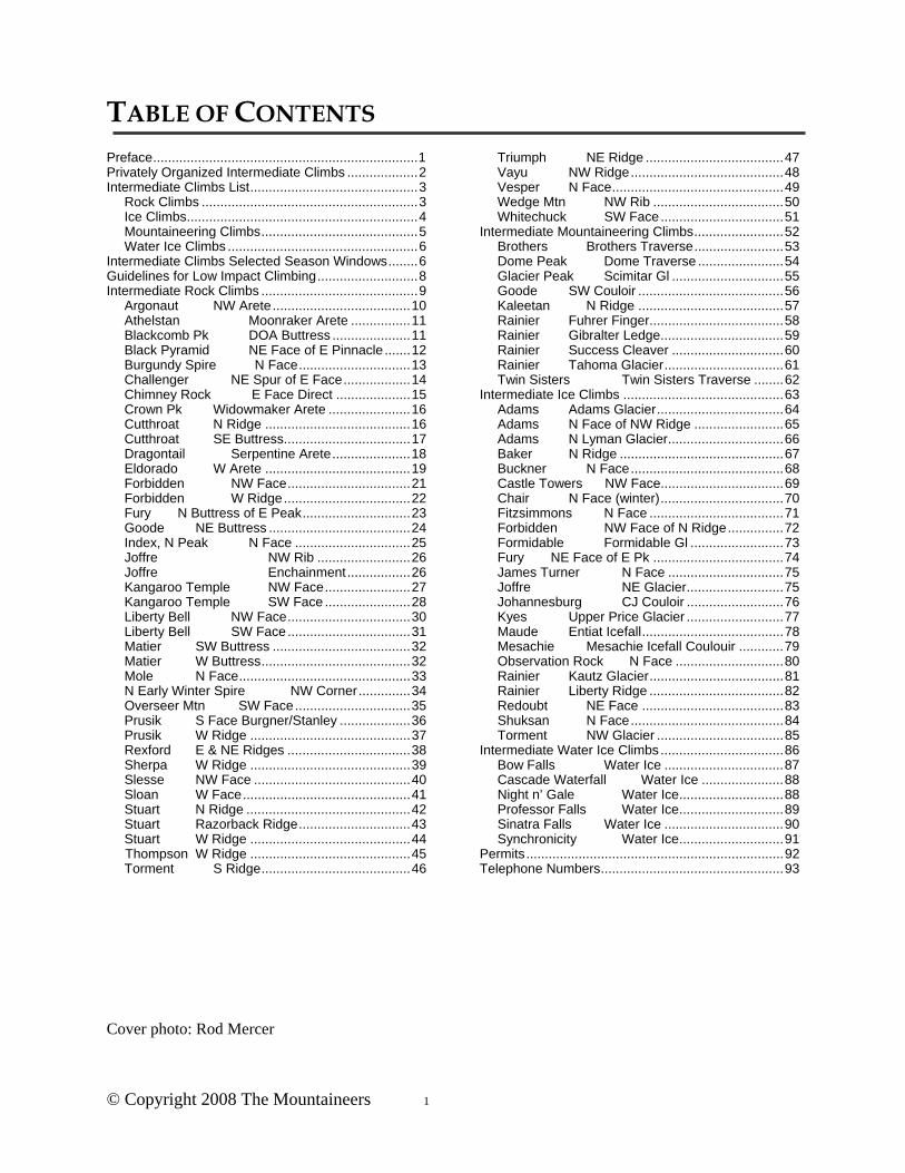
TABLE OF CONTENTS Preface ....................................................................... 1 Privately Organized Intermediate Climbs ................... 2 Intermediate Climbs List ............................................. 3
Rock Climbs .......................................................... 3 Ice Climbs.............................................................. 4 Mountaineering Climbs .......................................... 5 Water Ice Climbs ................................................... 6
Intermediate Climbs Selected Season Windows ........ 6 Guidelines for Low Impact Climbing ........................... 8 Intermediate Rock Climbs .......................................... 9
Argonaut NW Arete ..................................... 10 Athelstan Moonraker Arete ................ 11 Blackcomb Pk DOA Buttress ..................... 11 Black Pyramid NE Face of E Pinnacle ....... 12
Burgundy Spire N Face .............................. 13 Challenger NE Spur of E Face .................. 14 Chimney Rock E Face Direct .................... 15 Crown Pk Widowmaker Arete ...................... 16 Cutthroat N Ridge ....................................... 16 Cutthroat SE Buttress.................................. 17 Dragontail Serpentine Arete ..................... 18 Eldorado W Arete ....................................... 19 Forbidden NW Face ................................. 21 Forbidden W Ridge .................................. 22 Fury N Buttress of E Peak ............................. 23 Goode NE Buttress ...................................... 24 Index, N Peak N Face ............................... 25 Joffre NW Rib ......................... 26 Joffre Enchainment ................. 26 Kangaroo Temple NW Face ....................... 27 Kangaroo Temple SW Face ....................... 28 Liberty Bell NW Face ................................. 30 Liberty Bell SW Face ................................. 31 Matier SW Buttress ..................................... 32 Matier W Buttress ........................................ 32 Mole N Face .............................................. 33 N Early Winter Spire NW Corner .............. 34 Overseer Mtn SW Face ............................... 35 Prusik S Face Burgner/Stanley ................... 36 Prusik W Ridge ........................................... 37 Rexford E & NE Ridges ................................. 38 Sherpa W Ridge ........................................... 39 Slesse NW Face .......................................... 40 Sloan W Face ............................................. 41 Stuart N Ridge ............................................ 42 Stuart Razorback Ridge .............................. 43 Stuart W Ridge ........................................... 44
Thompson W Ridge ........................................... 45 Torment S Ridge ........................................ 46
Triumph NE Ridge ..................................... 47 Vayu NW Ridge ......................................... 48 Vesper N Face .............................................. 49 Wedge Mtn NW Rib ................................... 50 Whitechuck SW Face ................................. 51
Intermediate Mountaineering Climbs ........................ 52 Brothers Brothers Traverse ........................ 53 Dome Peak Dome Traverse ....................... 54 Glacier Peak Scimitar Gl .............................. 55 Goode SW Couloir ....................................... 56 Kaleetan N Ridge ....................................... 57 Rainier Fuhrer Finger.................................... 58 Rainier Gibralter Ledge ................................. 59 Rainier Success Cleaver .............................. 60 Rainier Tahoma Glacier ................................ 61 Twin Sisters Twin Sisters Traverse ........ 62
Intermediate Ice Climbs ........................................... 63 Adams Adams Glacier .................................. 64 Adams N Face of NW Ridge ........................ 65 Adams N Lyman Glacier ............................... 66 Baker N Ridge ............................................ 67 Buckner N Face ......................................... 68 Castle Towers NW Face................................. 69 Chair N Face (winter) ................................. 70 Fitzsimmons N Face .................................... 71 Forbidden NW Face of N Ridge ............... 72 Formidable Formidable Gl ......................... 73 Fury NE Face of E Pk ................................... 74 James Turner N Face ............................... 75 Joffre NE Glacier .......................... 75 Johannesburg CJ Couloir .......................... 76 Kyes Upper Price Glacier .......................... 77 Maude Entiat Icefall ...................................... 78 Mesachie Mesachie Icefall Coulouir ............ 79 Observation Rock N Face ............................. 80 Rainier Kautz Glacier .................................... 81 Rainier Liberty Ridge .................................... 82 Redoubt NE Face ...................................... 83 Shuksan N Face ......................................... 84 Torment NW Glacier .................................. 85
Intermediate Water Ice Climbs ................................. 86 Bow Falls Water Ice ................................ 87 Cascade Waterfall Water Ice ...................... 88 Night n’ Gale Water Ice ............................ 88 Professor Falls Water Ice ............................ 89 Sinatra Falls Water Ice ................................ 90 Synchronicity Water Ice ............................ 91
Permits ..................................................................... 92 Telephone Numbers ................................................. 93
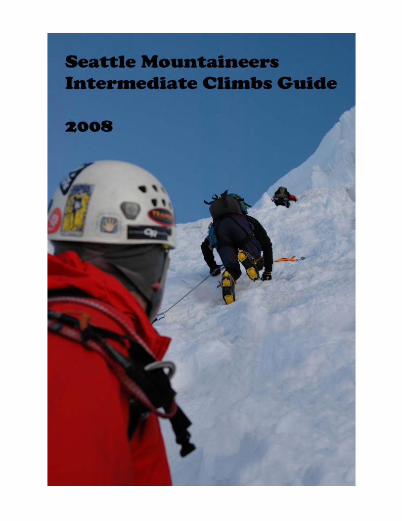
Cover photo: Rod Mercer
© Copyright 2008 The Mountaineers 1
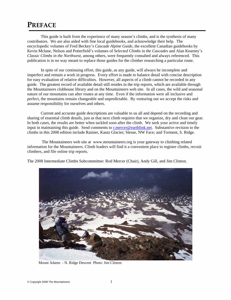
PREFACE This guide is built from the experience of many season’s climbs, and is the synthesis of many
contributors. We are also aided with fine local guidebooks, and acknowledge their help. The encyclopedic volumes of Fred Beckey’s Cascade Alpine Guide, the excellent Canadian guidebooks by Kevin Mclane, Nelson and Potterfield’s volumes of Selected Climbs in the Cascades and Alan Kearney’s Classic Climbs in the Northwest, among others, were frequently consulted and always referenced. This publication is in no way meant to replace those guides for the climber researching a particular route. In spite of our continuing effort, this guide, as any guide, will always be incomplete and imperfect and remain a work in progress. Every effort is made to balance detail with concise description for easy evaluation of relative difficulties. However, all aspects of a climb cannot be recorded in any guide. The greatest record of available detail still resides in the trip reports, which are available through the Mountaineers clubhouse library and on the Mountaineers web site. In all cases, the wild and seasonal nature of our mountains can alter routes at any time. Even if the information were all inclusive and perfect, the mountains remain changeable and unpredictable. By venturing out we accept the risks and assume responsibility for ourselves and others. Current and accurate guide descriptions are valuable to us all and depend on the recording and sharing of essential climb details, just as that next climb requires that we organize, dry and clean our gear. In both cases, the results are better when tackled soon after the climb. We seek your active and timely input in maintaining this guide. Send comments to [email protected]. Substantive revision to the climbs in this 2008 edition include Rainier, Kautz Glacier; Slesse, NW Face; and Torment, S. Ridge. The Mountaineers web site at www.mountaineers.org is your gateway to climbing related information for the Mountaineers. Climb leaders will find it a convenient place to register climbs, recruit climbers, and file online trip reports. The 2008 Intermediate Climbs Subcommittee: Rod Mercer (Chair), Andy Gill, and Jim Clinton.
Mount Adams - N. Ridge Descent Photo: Jim Clinton
© Copyright 2008 The Mountaineers 2
PRIVATELY ORGANIZED INTERMEDIATE CLIMBS
Of the five required climbs, two may be done as privately organized climbs. However, only one climb of any specific category (i.e., ice, rock, or mountaineering) may be privately organized. Private climbs can give intermediate students the opportunity to organize and lead a climb under the guidance of a climb leader and allows the opportunity of climbing with a group of friends. To receive credit, privately organized climbs must adhere to the following rules: 1. Obtain the approval of the Intermediate Climbs subcommittee chair prior to the climb if the climb is NOT listed in the database found online in the Activities Setup section of the Mountaineers website. The Activities Setup page, http://www.mountaineers.org/source/aDestinations/DestinationList.cfm is the location for trip registration and must be accessed by a recognized climb leader.
2. A member of the climb leaders list must register the climb by going to the Activities Signup page listed above, and must participate in the climb.
3. The party must be made up of Mountaineer members and follow the climbing code. Note that a party limit of 3 is the minimum for all climbs in alpine areas. Water ice or crag climbs may have a party minimum of 2.
4. Sign up all party members with the clubhouse before the climb.
5. After the climb, file a trip report on the Mountaineers.org web site to obtain credit. This report is appreciated even if you did not make the summit.
Privately organized climbs offer an excellent opportunity to climb outside the state of Washington for credit. Conider the following partial list of guidebooks to help plan your adventures.
• Alpine Select – Climbs in SW BC & NW Washington, Kevin McLane • Bugaboo Rock - A Climbers Guide, Randall Green and Joe Bensen • Climbers and Hiking Guide to Wind Rivers, Joe Kelsey • Classic Climbs in the Northwest, Alan Kearney • Climbers Guide to North America, East Coast Rock Climbs, John Harlin, III • Climbers Guide to the Interior Ranges of British Columbia South, Robert Kruszyna &
William Putnam • Climbers Guide to West Coast Ice, Don Serl & Bruce Kay • Guide to the World’s Mountains, Michael R. Kelser • Joshua Tree, Randy Vogel • Mexico’s Volcanoes, Second Edition, R. J. Secor • Ouray Ice, Bill MacTiernan • Rock Climbers Guide to Europe, David Jones • Rock Climbers Guide to Squamish, Kevin McLane • Rock n Road Rock Climbing - Areas of North America, Tim Toula • Rocky Mountain National Park, Bernard Gillett • Selected Alpine Climbs in Canadian Rockies, Sean Dougherty • Selkirks South, David P. Jones • Tahquitz & Suicide, Randy Vogel and Bob Gains • Teton Classics, Richard Rossiter • The High Sierra, R. J. Secor • Waterfall Ice Climbs in the Canadian Rockies, Third Edition, Joe Josephson • Yosemite Climbs, Don Reid
© Copyright 2008 The Mountaineers 3
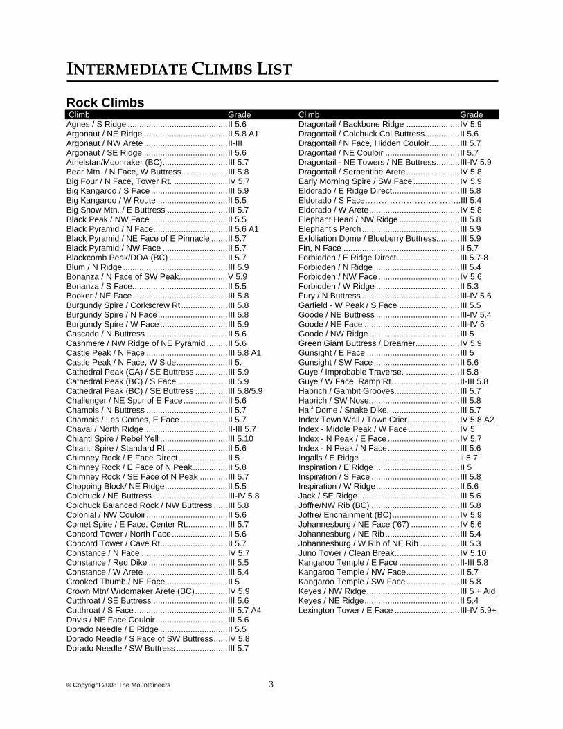
INTERMEDIATE CLIMBS LIST Rock Climbs Climb Grade Climb GradeAgnes / S Ridge ........................................... II 5.6 Argonaut / NE Ridge .................................... II 5.8 A1 Argonaut / NW Arete .................................... II-III Argonaut / SE Ridge .................................... II 5.6 Athelstan/Moonraker (BC) ............................ III 5.7 Bear Mtn. / N Face, W Buttress.................... III 5.8 Big Four / N Face, Tower Rt. ....................... IV 5.7 Big Kangaroo / S Face ................................. III 5.9 Big Kangaroo / W Route .............................. II 5.5 Big Snow Mtn. / E Buttress .......................... III 5.7 Black Peak / NW Face ................................. II 5.5 Black Pyramid / N Face ................................ II 5.6 A1 Black Pyramid / NE Face of E Pinnacle ....... II 5.7 Black Pyramid / NW Face ............................ II 5.7 Blackcomb Peak/DOA (BC) ......................... II 5.7 Blum / N Ridge ............................................. III 5.9 Bonanza / N Face of SW Peak..................... V 5.9 Bonanza / S Face ......................................... II 5.5 Booker / NE Face ......................................... III 5.8 Burgundy Spire / Corkscrew Rt .................... III 5.8 Burgundy Spire / N Face .............................. III 5.8 Burgundy Spire / W Face ............................. III 5.9 Cascade / N Buttress ................................... II 5.6 Cashmere / NW Ridge of NE Pyramid ......... II 5.6 Castle Peak / N Face ................................... III 5.8 A1 Castle Peak / N Face, W Side ...................... II 5. Cathedral Peak (CA) / SE Buttress .............. III 5.9 Cathedral Peak (BC) / S Face ..................... III 5.9 Cathedral Peak (BC) / SE Buttress .............. III 5.8/5.9 Challenger / NE Spur of E Face ................... II 5.6 Chamois / N Buttress ................................... II 5.7 Chamois / Les Cornes, E Face .................... II 5.7 Chaval / North Ridge .................................... II-III 5.7 Chianti Spire / Rebel Yell ............................. III 5.10 Chianti Spire / Standard Rt .......................... II 5.6 Chimney Rock / E Face Direct ..................... II 5 Chimney Rock / E Face of N Peak ............... II 5.8 Chimney Rock / SE Face of N Peak ............ III 5.7 Chopping Block/ NE Ridge ........................... II 5.5 Colchuck / NE Buttress ................................ III-IV 5.8 Colchuck Balanced Rock / NW Buttress ...... III 5.8 Colonial / NW Couloir ................................... II 5.6 Comet Spire / E Face, Center Rt.................. III 5.7 Concord Tower / North Face ........................ II 5.6 Concord Tower / Cave Rt ............................. II 5.7 Constance / N Face ..................................... IV 5.7 Constance / Red Dike .................................. III 5.5 Constance / W Arete .................................... III 5.4 Crooked Thumb / NE Face .......................... II 5 Crown Mtn/ Widomaker Arete (BC) .............. IV 5.9 Cutthroat / SE Buttress ................................ III 5.6 Cutthroat / S Face ........................................ III 5.7 A4 Davis / NE Face Couloir ............................... III 5.6 Dorado Needle / E Ridge ............................. II 5.5 Dorado Needle / S Face of SW Buttress ...... IV 5.8 Dorado Needle / SW Buttress ...................... III 5.7
Dragontail / Backbone Ridge ....................... IV 5.9 Dragontail / Colchuck Col Buttress ............... II 5.6 Dragontail / N Face, Hidden Couloir ............. III 5.7 Dragontail / NE Couloir ................................ II 5.7 Dragontail - NE Towers / NE Buttress .......... III-IV 5.9 Dragontail / Serpentine Arete ....................... IV 5.8 Early Morning Spire / SW Face .................... IV 5.9 Eldorado / E Ridge Direct ............................. III 5.8 Eldorado / S Face……………………………..III 5.4 Eldorado / W Arete ....................................... IV 5.8 Elephant Head / NW Ridge .......................... III 5.8 Elephant’s Perch .......................................... III 5.9 Exfoliation Dome / Blueberry Buttress .......... III 5.9 Fin, N Face .................................................. II 5.7 Forbidden / E Ridge Direct ........................... III 5.7-8 Forbidden / N Ridge ..................................... III 5.4 Forbidden / NW Face ................................... IV 5.6 Forbidden / W Ridge .................................... II 5.3 Fury / N Buttress .......................................... III-IV 5.6 Garfield - W Peak / S Face .......................... III 5.5 Goode / NE Buttress .................................... III-IV 5.4 Goode / NE Face ......................................... III-IV 5 Goode / NW Ridge ....................................... III 5 Green Giant Buttress / Dreamer ................... IV 5.9 Gunsight / E Face ........................................ III 5 Gunsight / SW Face ..................................... II 5.6 Guye / Improbable Traverse. ....................... II 5.8 Guye / W Face, Ramp Rt. ............................ II-III 5.8 Habrich / Gambit Grooves. ........................... III 5.7 Habrich / SW Nose. ...................................... III 5.8 Half Dome / Snake Dike. .............................. III 5.7 Index Town Wall / Town Crier. ..................... IV 5.8 A2 Index - Middle Peak / W Face ...................... IV 5 Index - N Peak / E Face ............................... IV 5.7 Index - N Peak / N Face ............................... III 5.6 Ingalls / E Ridge .......................................... ii 5.7 Inspiration / E Ridge ..................................... II 5 Inspiration / S Face ...................................... III 5.8 Inspiration / W Ridge .................................... II 5.6 Jack / SE Ridge ............................................ III 5.6 Joffre/NW Rib (BC) ...................................... III 5.8 Joffre/ Enchainment (BC) ............................. IV 5.9 Johannesburg / NE Face (’67) ..................... IV 5.6 Johannesburg / NE Rib ................................ III 5.4 Johannesburg / W Rib of NE Rib ................. III 5.3 Juno Tower / Clean Break ............................ IV 5.10 Kangaroo Temple / E Face .......................... II-III 5.8 Kangaroo Temple / NW Face ....................... II 5.7 Kangaroo Temple / SW Face ....................... III 5.8 Keyes / NW Ridge ........................................ III 5 + Aid Keyes / NE Ridge ......................................... II 5.4 Lexington Tower / E Face ............................ III-IV 5.9+
© Copyright 2008 The Mountaineers 4
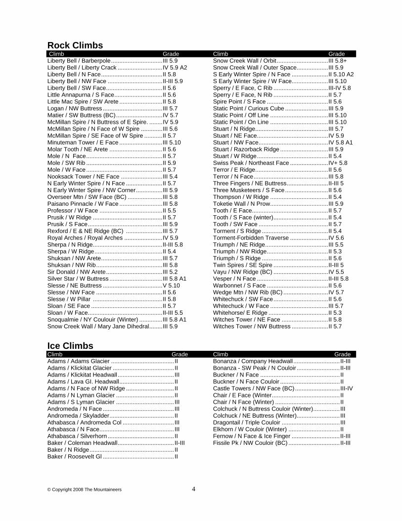
Rock Climbs Climb Grade Climb GradeLiberty Bell / Barberpole ............................... III 5.9 Liberty Bell / Liberty Crack ........................... IV 5.9 A2 Liberty Bell / N Face ..................................... II 5.8 Liberty Bell / NW Face ................................. II-III 5.9 Liberty Bell / SW Face .................................. II 5.6 Little Annapurna / S Face ............................. II 5.6 Little Mac Spire / SW Arete .......................... II 5.8 Logan / NW Buttress .................................... III 5.7 Matier / SW Buttress (BC) ............................ IV 5.7 McMillan Spire / N Buttress of E Spire. ........ IV 5.9 McMillan Spire / N Face of W Spire ............. III 5.6 McMillan Spire / SE Face of W Spire ........... II 5.7 Minuteman Tower / E Face .......................... III 5.10 Molar Tooth / NE Arete ................................ II 5.6 Mole / N Face .............................................. II 5.7 Mole / SW Rib .............................................. II 5.9 Mole / W Face .............................................. II 5.7 Nooksack Tower / NE Face ......................... III 5.4 N Early Winter Spire / N Face ...................... II 5.7 N Early Winter Spire / NW Corner ................ III 5.9 Overseer Mtn / SW Face (BC) ..................... III 5.8 Paisano Pinnacle / W Face .......................... III 5.8 Professor / W Face ...................................... II 5.5 Prusik / W Ridge .......................................... II 5.7 Prusik / S Face ............................................. III 5.9 Rexford / E & NE Ridge (BC) ...................... III 5.7 Royal Arches / Royal Arches ....................... IV 5.9 Sherpa / N Ridge .......................................... II-III 5.8 Sherpa / W Ridge ......................................... II 5.4 Shuksan / NW Arete ..................................... III 5.7 Shuksan / NW Rib ........................................ III 5.8 Sir Donald / NW Arete .................................. III 5.2 Silver Star / W Buttress ................................ III 5.8 A1 Slesse / NE Buttress .................................... V 5.10 Slesse / NW Face ........................................ II 5.6 Slesse / W Pillar .......................................... II 5.8 Sloan / SE Face ........................................... II 5.7 Sloan / W Face ............................................. II-III 5.5 Snoqualmie / NY Coulouir (Winter) .............. III 5.8 A1 Snow Creek Wall / Mary Jane Dihedral ........ III 5.9
Snow Creek Wall / Orbit ............................... III 5.8+ Snow Creek Wall / Outer Space ................... III 5.9 S Early Winter Spire / N Face ...................... II 5.10 A2 S Early Winter Spire / W Face...................... III 5.10 Sperry / E Face, C Rib ................................. III-IV 5.8 Sperry / E Face, N Rib ................................. II 5.7 Spire Point / S Face ..................................... II 5.6 Static Point / Curious Cube .......................... III 5.9 Static Point / Off Line ................................... III 5.10 Static Point / On Line ................................... III 5.10 Stuart / N Ridge ............................................ III 5.7 Stuart / NE Face ........................................... IV 5.9 Stuart / NW Face .......................................... IV 5.8 A1 Stuart / Razorback Ridge ............................. III 5.9 Stuart / W Ridge ........................................... II 5.4 Swiss Peak / Northeast Face ....................... IV+ 5.8 Terror / E Ridge ............................................ II 5.6 Terror / N Face ............................................. III 5.8 Three Fingers / NE Buttress ......................... II-III 5 Three Musketeers / S Face .......................... II 5.6 Thompson / W Ridge ................................... II 5.4 Toketie Wall / N Prow ................................... III 5.9 Tooth / E Face.............................................. II 5.7 Tooth / S Face (winter) ................................. II 5.4 Tooth / SW Face .......................................... II 5.7 Torment / S Ridge ........................................ II 5.4 Torment-Forbidden Traverse ....................... IV 5.6 Triumph / NE Ridge ...................................... III 5.5 Triumph / NW Ridge ..................................... II 5.3 Triumph / S Ridge ........................................ II 5.6 Twin Spires / SE Spire ................................. II-III 5 Vayu / NW Ridge (BC) ................................. IV 5.5 Vesper / N Face ........................................... II-III 5.8 Warbonnet / S Face ..................................... II 5.6 Wedge Mtn / NW Rib (BC) ........................... IV 5.7 Whitechuck / SW Face ................................. II 5.6 Whitechuck / W Face ................................... III 5.7 Whitehorse/ E Ridge .................................... II 5.3 Witches Tower / NE Face ............................ II 5.8 Witches Tower / NW Buttress ...................... II 5.7
Ice Climbs Climb Grade Climb Grade Adams / Adams Glacier ...................................... II Adams / Klickitat Glacier ..................................... II Adams / Klickitat Headwall .................................. III Adams / Lava GI. Headwall ................................. II Adams / N Face of NW Ridge ............................. II Adams / N Lyman Glacier ................................... II Adams / S Lyman Glacier ................................... III Andromeda / N Face ........................................... III Andromeda / Skyladder ....................................... II Athabasca / Andromeda Col ............................... III Athabasca / N Face ............................................. III Athabasca / Silverhorn ........................................ II Baker / Coleman Headwall .................................. II-III Baker / N Ridge ................................................... II Baker / Roosevelt Gl ........................................... II
Bonanza / Company Headwall ............................ II-III Bonanza - SW Peak / N Couloir .......................... II-III Buckner / N Face ................................................ II Buckner / N Face Couloir .................................... II Castle Towers / NW Face (BC) ........................... III-IV Chair / E Face (Winter ......................................... II Chair / N Face (Winter) ....................................... II Colchuck / N Buttress Couloir (Winter) ................ III Colchuck / NE Buttress (Winter) .......................... III Dragontail / Triple Couloir ................................... III Elkhorn / W Couloir (Winter) ............................... II Fernow / N Face & Ice Finger ............................. II-III Fissile Pk / NW Couloir (BC) ............................... II-III
© Copyright 2008 The Mountaineers 5
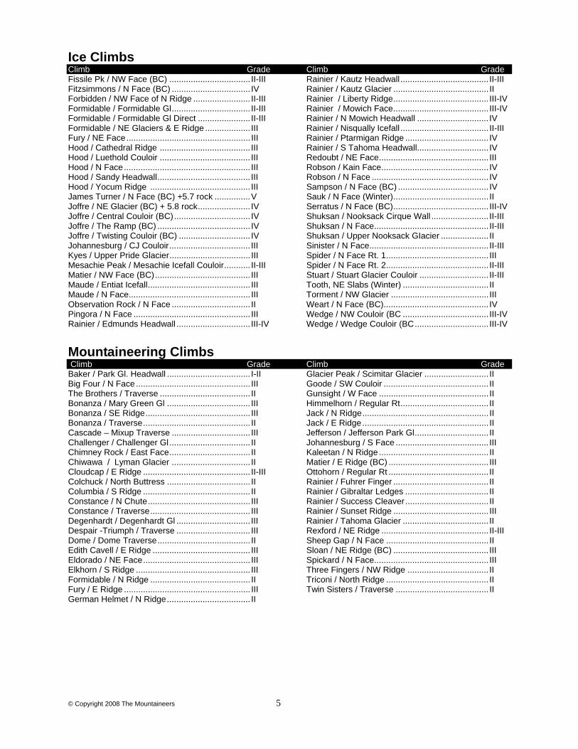
Ice Climbs Climb Grade Climb Grade Fissile Pk / NW Face (BC) .................................. II-III Fitzsimmons / N Face (BC) ................................. IV Forbidden / NW Face of N Ridge ........................ II-III Formidable / Formidable Gl ................................. II-III Formidable / Formidable Gl Direct ...................... II-III Formidable / NE Glaciers & E Ridge ................... III Fury / NE Face .................................................... III Hood / Cathedral Ridge ...................................... III Hood / Luethold Couloir ...................................... III Hood / N Face ..................................................... III Hood / Sandy Headwall ....................................... III Hood / Yocum Ridge .......................................... III James Turner / N Face (BC) +5.7 rock ............... V Joffre / NE Glacier (BC) + 5.8 rock ...................... IV Joffre / Central Couloir (BC) ................................ IV Joffre / The Ramp (BC) ....................................... IV Joffre / Twisting Couloir (BC) .............................. IV Johannesburg / CJ Couloir .................................. III Kyes / Upper Pride Glacier .................................. III Mesachie Peak / Mesachie Icefall Couloir ........... II-III Matier / NW Face (BC) ........................................ III Maude / Entiat Icefall ........................................... III Maude / N Face ................................................... III Observation Rock / N Face ................................. II Pingora / N Face ................................................. III Rainier / Edmunds Headwall ............................... III-IV
Rainier / Kautz Headwall ..................................... II-III Rainier / Kautz Glacier ........................................ II Rainier / Liberty Ridge ........................................ III-IV Rainier / Mowich Face ........................................ III-IV Rainier / N Mowich Headwall .............................. IV Rainier / Nisqually Icefall ..................................... II-III Rainier / Ptarmigan Ridge ................................... IV Rainier / S Tahoma Headwall.............................. IV Redoubt / NE Face .............................................. III Robson / Kain Face ............................................. IV Robson / N Face ................................................. IV Sampson / N Face (BC) ...................................... IV Sauk / N Face (Winter) ........................................ II Serratus / N Face (BC) ........................................ III-IV Shuksan / Nooksack Cirque Wall ........................ II-III Shuksan / N Face ................................................ II-III Shuksan / Upper Nooksack GIacier .................... II Sinister / N Face .................................................. II-III Spider / N Face Rt. 1 ........................................... III Spider / N Face Rt. 2 ........................................... II-III Stuart / Stuart Glacier Couloir ............................. II-III Tooth, NE Slabs (Winter) .................................... II Torment / NW Glacier ......................................... III Weart / N Face (BC) ............................................ IV Wedge / NW Couloir (BC .................................... III-IV Wedge / Wedge Couloir (BC ............................... III-IV
Mountaineering Climbs Climb Grade Climb Grade Baker / Park Gl. Headwall ................................... I-II Big Four / N Face ................................................ III The Brothers / Traverse ...................................... II Bonanza / Mary Green Gl ................................... III Bonanza / SE Ridge ............................................ III Bonanza / Traverse ............................................. II Cascade – Mixup Traverse ................................. III Challenger / Challenger Gl .................................. II Chimney Rock / East Face .................................. II Chiwawa / Lyman Glacier ................................. II Cloudcap / E Ridge ............................................. II-III Colchuck / North Buttress ................................... II Columbia / S Ridge ............................................. II Constance / N Chute ........................................... III Constance / Traverse .......................................... III Degenhardt / Degenhardt Gl ............................... III Despair -Triumph / Traverse ............................... III Dome / Dome Traverse ....................................... II Edith Cavell / E Ridge ......................................... III Eldorado / NE Face ............................................. III Elkhorn / S Ridge ................................................ III Formidable / N Ridge .......................................... II Fury / E Ridge ..................................................... III German Helmet / N Ridge ................................... II
Glacier Peak / Scimitar Glacier ........................... II Goode / SW Couloir ............................................ II Gunsight / W Face .............................................. II Himmelhorn / Regular Rt ..................................... II Jack / N Ridge ..................................................... II Jack / E Ridge ..................................................... II Jefferson / Jefferson Park Gl ............................... II Johannesburg / S Face ....................................... III Kaleetan / N Ridge .............................................. II Matier / E Ridge (BC) .......................................... III Ottohorn / Regular Rt .......................................... II Rainier / Fuhrer Finger ........................................ II Rainier / Gibraltar Ledges ................................... II Rainier / Success Cleaver ................................... II Rainier / Sunset Ridge ........................................ III Rainier / Tahoma Glacier .................................... II Rexford / NE Ridge ............................................. II-III Sheep Gap / N Face ........................................... II Sloan / NE Ridge (BC) ........................................ III Spickard / N Face ................................................ III Three Fingers / NW Ridge .................................. II Triconi / North Ridge ........................................... II Twin Sisters / Traverse ....................................... II
© Copyright 2008 The Mountaineers 6
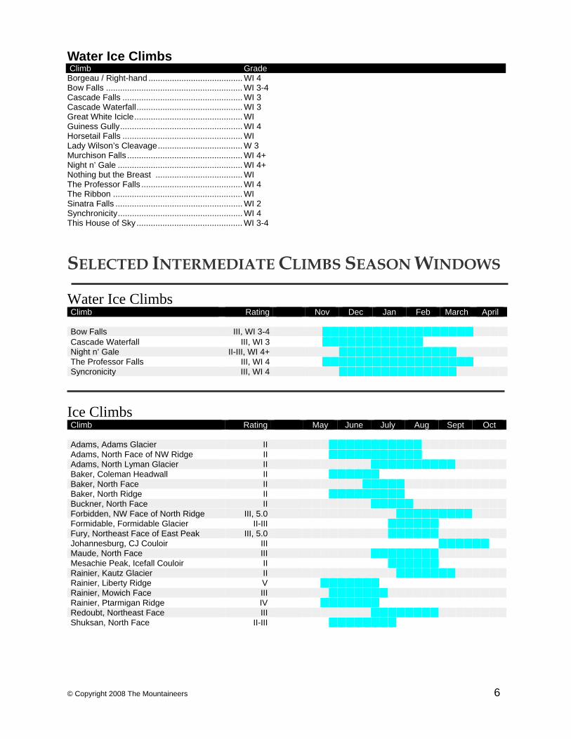
Water Ice Climbs Climb Grade Borgeau / Right-hand ........................................ WI 4 Bow Falls .......................................................... WI 3-4 Cascade Falls ................................................... WI 3 Cascade Waterfall ............................................. WI 3 Great White Icicle .............................................. WI Guiness Gully .................................................... WI 4 Horsetail Falls ................................................... WI Lady Wilson’s Cleavage .................................... W 3 Murchison Falls ................................................. WI 4+ Night n’ Gale ..................................................... WI 4+ Nothing but the Breast ..................................... WI The Professor Falls ........................................... WI 4 The Ribbon ....................................................... WI Sinatra Falls ...................................................... WI 2 Synchronicity ..................................................... WI 4 This House of Sky ............................................. WI 3-4
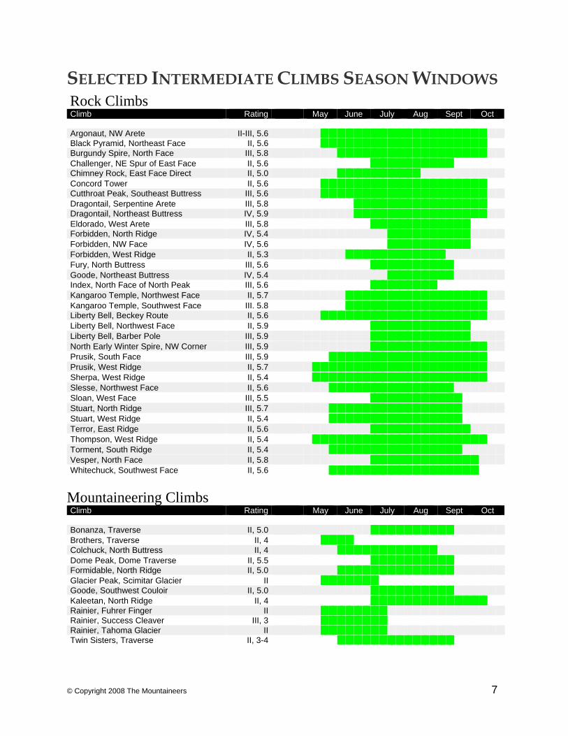
SELECTED INTERMEDIATE CLIMBS SEASON WINDOWS Water Ice Climbs Climb Rating Nov Dec Jan Feb March April Bow Falls III, WI 3-4 Cascade Waterfall III, WI 3 Night n’ Gale II-III, WI 4+ The Professor Falls III, WI 4 Syncronicity III, WI 4
Ice Climbs Climb Rating May June July Aug Sept Oct Adams, Adams Glacier II Adams, North Face of NW Ridge II Adams, North Lyman Glacier II Baker, Coleman Headwall II Baker, North Face II Baker, North Ridge II Buckner, North Face II Forbidden, NW Face of North Ridge III, 5.0 Formidable, Formidable Glacier II-III Fury, Northeast Face of East Peak III, 5.0 Johannesburg, CJ Couloir III Maude, North Face III Mesachie Peak, Icefall Couloir II Rainier, Kautz Glacier II Rainier, Liberty Ridge V Rainier, Mowich Face III Rainier, Ptarmigan Ridge IV Redoubt, Northeast Face III Shuksan, North Face II-III
© Copyright 2008 The Mountaineers 7
SELECTED INTERMEDIATE CLIMBS SEASON WINDOWS Rock Climbs Climb Rating May June July Aug Sept Oct Argonaut, NW Arete II-III, 5.6 Black Pyramid, Northeast Face II, 5.6 Burgundy Spire, North Face III, 5.8 Challenger, NE Spur of East Face II, 5.6 Chimney Rock, East Face Direct II, 5.0 Concord Tower II, 5.6 Cutthroat Peak, Southeast Buttress III, 5.6 Dragontail, Serpentine Arete III, 5.8 Dragontail, Northeast Buttress IV, 5.9 Eldorado, West Arete III, 5.8 Forbidden, North Ridge IV, 5.4 Forbidden, NW Face IV, 5.6 Forbidden, West Ridge II, 5.3 Fury, North Buttress III, 5.6 Goode, Northeast Buttress IV, 5.4 Index, North Face of North Peak III, 5.6 Kangaroo Temple, Northwest Face II, 5.7 Kangaroo Temple, Southwest Face III. 5.8 Liberty Bell, Beckey Route II, 5.6 Liberty Bell, Northwest Face II, 5.9 Liberty Bell, Barber Pole III, 5.9 North Early Winter Spire, NW Corner III, 5.9 Prusik, South Face III, 5.9 Prusik, West Ridge II, 5.7 Sherpa, West Ridge II, 5.4 Slesse, Northwest Face II, 5.6 Sloan, West Face III, 5.5 Stuart, North Ridge III, 5.7 Stuart, West Ridge II, 5.4 Terror, East Ridge II, 5.6 Thompson, West Ridge II, 5.4 Torment, South Ridge II, 5.4 Vesper, North Face II, 5.8 Whitechuck, Southwest Face II, 5.6
Mountaineering Climbs Climb Rating May June July Aug Sept Oct Bonanza, Traverse II, 5.0 Brothers, Traverse II, 4 Colchuck, North Buttress II, 4 Dome Peak, Dome Traverse II, 5.5 Formidable, North Ridge II, 5.0 Glacier Peak, Scimitar Glacier II Goode, Southwest Couloir II, 5.0 Kaleetan, North Ridge II, 4 Rainier, Fuhrer Finger II Rainier, Success Cleaver III, 3 Rainier, Tahoma Glacier II Twin Sisters, Traverse II, 3-4
© Copyright 2008 The Mountaineers 8
GUIDELINES FOR LOW IMPACT CLIMBING
Our wildlands are special places of fragile beauty and remoteness. You can help keep them that way by
taking to these areas the light tread of one who is educated and equipped for minimum impact travel, camping and climbing. As a large organization, the Mountaineers attract a significant amount of attention for their impact on local climbing areas. We should seek to set an example for the care of our remaining wild places by “leaving no trace” while enjoying the recreational uses of the back country. Show consideration for fellow users of the areas you venture into by traveling in smaller groups and cooperating with and respecting others in the backcountry.
It is very important that we set the best possible example by doing our part to preserve the magnicifient
heritage of the wild Cascades. Please refer to Chapter 7; Leave No Trace, and Chapter 8; Stewardship and Access in Freedom of the Hills, 7th Edition for complete recommendations for backcountry responsibility.
Contact the appropriate land management agency about any problems with the area, approach or route of the climb which should be dealt with beyond the capacity of your group. Show your appreciation for this magnificent climbing country by setting a good example and encouraging others to “leave no trace”. Pass the word on, volunteer, get involved.
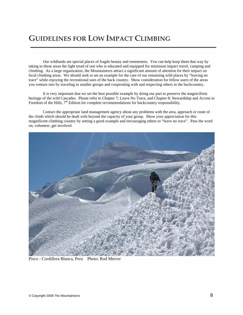
Pisco - Cordillera Blanca, Peru Photo: Rod Mercer
© Copyright 2008 The Mountaineers 9
INTERMEDIATE ROCK CLIMBS
Unlike Basic Rock, Intermediate Rock Climbs require all party members to swing leads.
Additional skills, technical proficiency and judgement are needed for placing protection on lead and constructing anchors for belay. Intermediate Rock Climbs are also more technical, include a greater number of pitches, and may also feature a strenuous approach, carry-over and difficulty of retreat. Simply stated, far more commitment is required. The extent of technical difficulty varies considerably among Intermediate Rock Climbs. Some have as few as four pitches while others require 20 pitches or more. Some have interspersed third and fourth class sections where parties may opt to unrope. Others may involve difficult and strenuous climbing, sustained over consecutive pitches. Typically, Intermediate Rock Climbs are not bolted routes, although pitons and bolts, some rather old, are occasionally encountered. Parties are expected to carry and place their own protection, which can be the most difficult aspect of the climb. The climbs described will often require an early start, rapid progress and prolonged endurance. Party members should be well rested, in excellent physical condition and accustomed to carrying heavy loads. Before rock climbing at the intermediate-level, you are advised to get in good shape, participate in other moderate climbs (scrambles and rope leading at the basic level) and invest significant time in rock climbing practice at Leavenworth, Smith or elsewhere. Being physically capable and mentally prepared will contribute greatly to your safety, success, and enjoyment of Intermediate Rock Climbing.
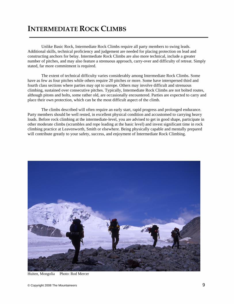
Huiten, Mongolia Photo: Rod Mercer
© Copyright 2008 The Mountaineers 10
Argonaut / NW Arete 8,453’, Enchantments Grade II-III , 5.6 Rock Reference & Data • • • • Jurisdiction: Alpine Lakes Wilderness / Wenatchee National Forest • Ranger Station: Leavenworth Ranger Station / 509-548-6977
• Equipment: Moderate Alpine Rack, ice axe and possibly crampons • USGS Maps: Cashmere Mt, Enchantment Lakes
• Beckey: Cascade Alpine Guide I, 3rd Edition, pp. 293-296.
Time Elevation gain/loss Mileage • Seattle to TH 3 hrs 3,600’ 145 • TH to Camp 4-8 hrs + 3,000’ • Camp to Summit 7-9 hrs + 2,150’ • Summit to Cars 7-9 hrs - 5,150’
Approach • • • • • • • • • • • For the more frequently done Mountaineer Creek approach, drive US 2 over Stevens Pass to just W
of Leavenworth. Turn right on Icicle Creek road and drive 8.6 miles to Eightmile Road. Turn left and drive 3.5 miles to road end and the Stuart Lake Trail, 3,600’. Hike the Stuart Lake Trail about 3 miles to where Mountaineer Creek enters. Past the stream junction, leave Stuart Lake Trail at first minor switchback after meadows ca. 4,640’, cross stream flowing from Stuart Lake, then locate faint path heading up the west side of Mountaineer Creek. Hike up Mountaineer Creek to where the valley forks at 4,800’ (3-4 hours) and possible camps but not recommended. Follow the east most fork up towards the Argonaut Colchuck Col. At 6,400’ good bivy sites are recommended in Argonaut’s North basin. Alternate approaches via Argonaut Colchuck col are 1) via Colchuck Lake to Colchuck Col, then skirting Colchuck Peak’s south flanks or 2) via Ingalls Creek Trail to Porcupine Creek then up to col.
Climbing Route • • • • • From Argonaut’s N Basin climb to snow finger leading up to the Northwest Buttress (visible to
right in picture, CAG I, p. 268). Ascend to the top of the gully to a small col and the start of 6 to 8 pitches of rock climbing. Straightforward routefinding leads up blocky, generally solid but not sustained climbing.
Descent • • • • • • • • • • • 4 rappels of the east ridge takes you to Argonaut Colchuck col. From here, descent options are
Mountaineer Creek, Colchuck Col & Lake, or Porcupine/Ingalls Creeks. If one approached from Mountaineer Creek, one can descend that way and retrace route, though the basin is reported brushy. Colchuck Col, depending on season, offers a snow/ice & talus descent to Colchuck Lake and trail. Ingalls Creek would only be chosen if the climb was approached that way.
Comments • • • • • • • • • Note that the route is listed in CAG I as a West Ridge variation without detailed route description.
(Do NOT follow approach directions for West Ridge). With a Mountaineer Creek Fork camp, 10-12 hours may be required to reach the summit. Two days recommended. Snow finger may be hard and intimidating in late season. Permits required to camp on the north side of the Stuart Ridge.
© Copyright 2008 The Mountaineers 11
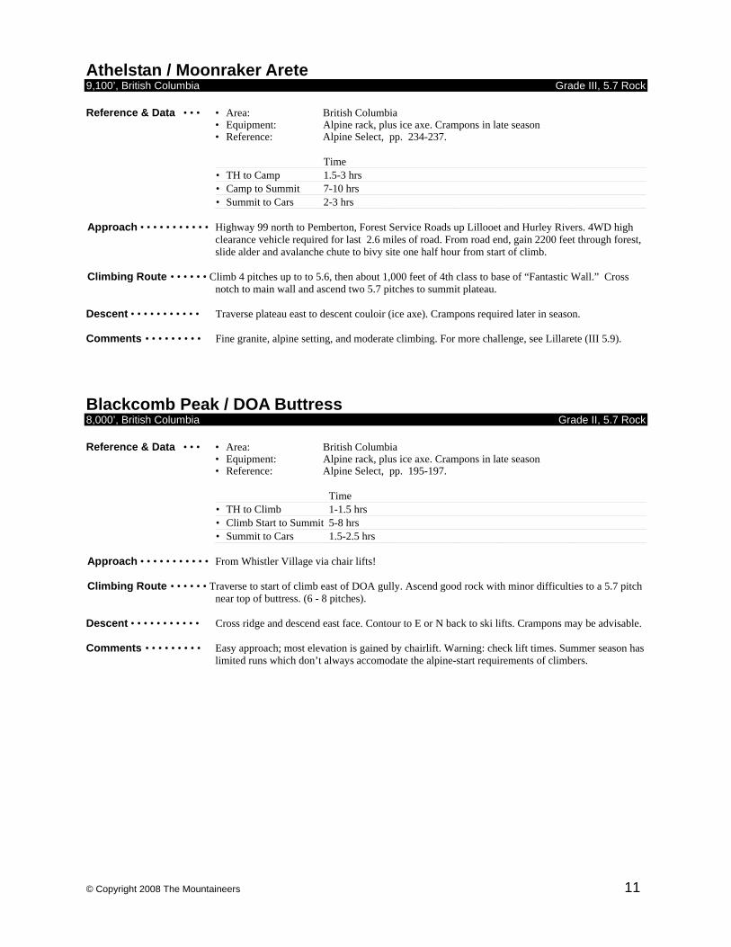
Athelstan / Moonraker Arete 9,100’, British Columbia Grade III, 5.7 Rock Reference & Data • • • • Area: British Columbia
• Equipment: Alpine rack, plus ice axe. Crampons in late season • Reference: Alpine Select, pp. 234-237.
Time • TH to Camp 1.5-3 hrs • Camp to Summit 7-10 hrs • Summit to Cars 2-3 hrs
Approach • • • • • • • • • • • Highway 99 north to Pemberton, Forest Service Roads up Lillooet and Hurley Rivers. 4WD high
clearance vehicle required for last 2.6 miles of road. From road end, gain 2200 feet through forest, slide alder and avalanche chute to bivy site one half hour from start of climb.
Climbing Route • • • • • • Climb 4 pitches up to to 5.6, then about 1,000 feet of 4th class to base of “Fantastic Wall.” Cross
notch to main wall and ascend two 5.7 pitches to summit plateau. Descent • • • • • • • • • • • Traverse plateau east to descent couloir (ice axe). Crampons required later in season. Comments • • • • • • • • • Fine granite, alpine setting, and moderate climbing. For more challenge, see Lillarete (III 5.9).
Blackcomb Peak / DOA Buttress 8,000’, British Columbia Grade II, 5.7 Rock Reference & Data • • • • Area: British Columbia
• Equipment: Alpine rack, plus ice axe. Crampons in late season • Reference: Alpine Select, pp. 195-197.
Time • TH to Climb 1-1.5 hrs • Climb Start to Summit 5-8 hrs • Summit to Cars 1.5-2.5 hrs
Approach • • • • • • • • • • • From Whistler Village via chair lifts! Climbing Route • • • • • • Traverse to start of climb east of DOA gully. Ascend good rock with minor difficulties to a 5.7 pitch
near top of buttress. (6 - 8 pitches). Descent • • • • • • • • • • • Cross ridge and descend east face. Contour to E or N back to ski lifts. Crampons may be advisable. Comments • • • • • • • • • Easy approach; most elevation is gained by chairlift. Warning: check lift times. Summer season has
limited runs which don’t always accomodate the alpine-start requirements of climbers.
© Copyright 2008 The Mountaineers 12
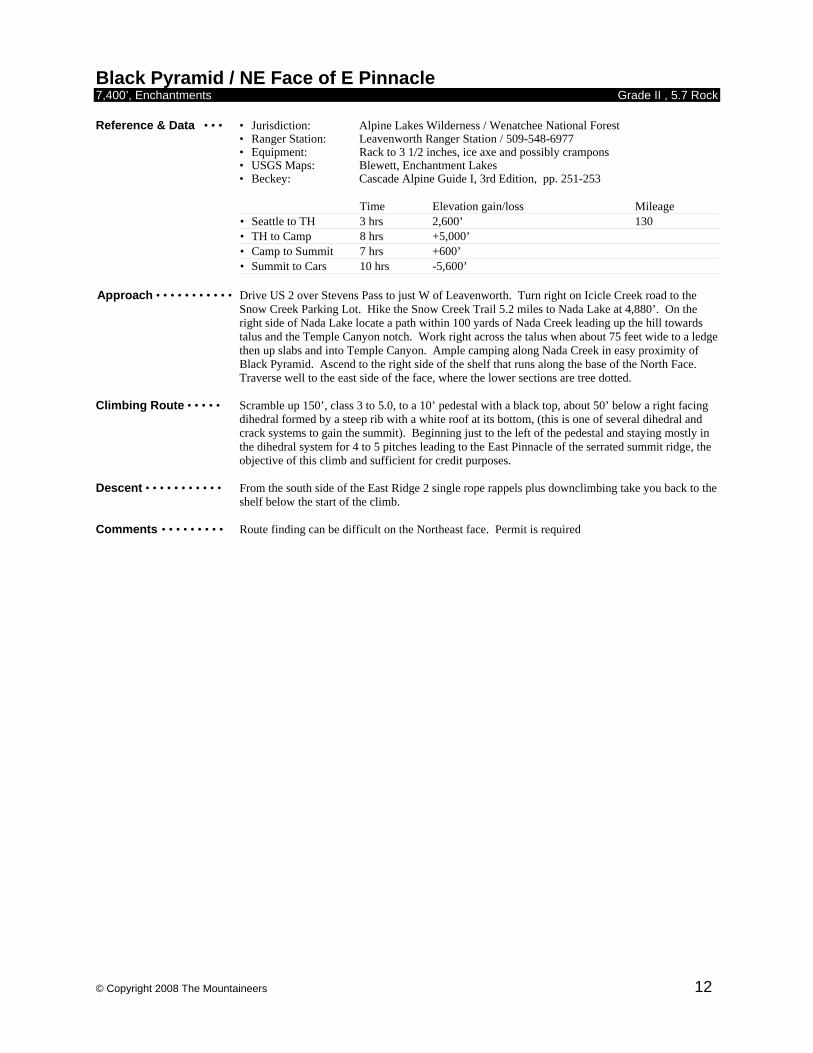
Black Pyramid / NE Face of E Pinnacle 7,400’, Enchantments Grade II , 5.7 Rock Reference & Data • • • • Jurisdiction: Alpine Lakes Wilderness / Wenatchee National Forest • Ranger Station: Leavenworth Ranger Station / 509-548-6977
• Equipment: Rack to 3 1/2 inches, ice axe and possibly crampons • USGS Maps: Blewett, Enchantment Lakes
• Beckey: Cascade Alpine Guide I, 3rd Edition, pp. 251-253
Time Elevation gain/loss Mileage • Seattle to TH 3 hrs 2,600’ 130 • TH to Camp 8 hrs +5,000’ • Camp to Summit 7 hrs +600’ • Summit to Cars 10 hrs -5,600’
Approach • • • • • • • • • • • Drive US 2 over Stevens Pass to just W of Leavenworth. Turn right on Icicle Creek road to the Snow Creek Parking Lot. Hike the Snow Creek Trail 5.2 miles to Nada Lake at 4,880’. On the right side of Nada Lake locate a path within 100 yards of Nada Creek leading up the hill towards talus and the Temple Canyon notch. Work right across the talus when about 75 feet wide to a ledge then up slabs and into Temple Canyon. Ample camping along Nada Creek in easy proximity of Black Pyramid. Ascend to the right side of the shelf that runs along the base of the North Face. Traverse well to the east side of the face, where the lower sections are tree dotted.
Climbing Route • • • • • Scramble up 150’, class 3 to 5.0, to a 10’ pedestal with a black top, about 50’ below a right facing
dihedral formed by a steep rib with a white roof at its bottom, (this is one of several dihedral and crack systems to gain the summit). Beginning just to the left of the pedestal and staying mostly in the dihedral system for 4 to 5 pitches leading to the East Pinnacle of the serrated summit ridge, the objective of this climb and sufficient for credit purposes.
Descent • • • • • • • • • • • From the south side of the East Ridge 2 single rope rappels plus downclimbing take you back to the
shelf below the start of the climb. Comments • • • • • • • • • Route finding can be difficult on the Northeast face. Permit is required
© Copyright 2008 The Mountaineers 13
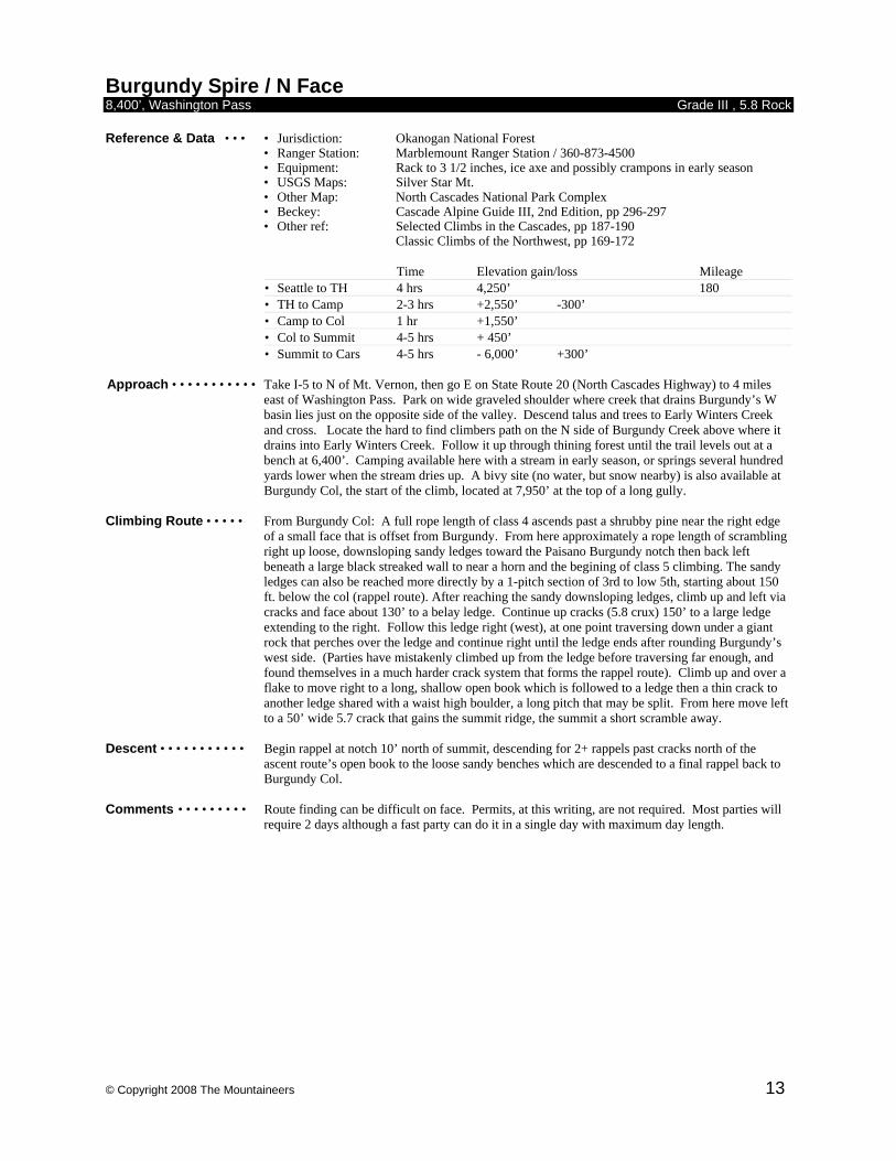
Burgundy Spire / N Face 8,400’, Washington Pass Grade III , 5.8 Rock Reference & Data • • • • Jurisdiction: Okanogan National Forest • Ranger Station: Marblemount Ranger Station / 360-873-4500
• Equipment: Rack to 3 1/2 inches, ice axe and possibly crampons in early season • USGS Maps: Silver Star Mt.
• Other Map: North Cascades National Park Complex • Beckey: Cascade Alpine Guide III, 2nd Edition, pp 296-297 • Other ref: Selected Climbs in the Cascades, pp 187-190 Classic Climbs of the Northwest, pp 169-172
Time Elevation gain/loss Mileage • Seattle to TH 4 hrs 4,250’ 180 • TH to Camp 2-3 hrs +2,550’ -300’ • Camp to Col 1 hr +1,550’ • Col to Summit 4-5 hrs + 450’ • Summit to Cars 4-5 hrs - 6,000’ +300’
Approach • • • • • • • • • • • Take I-5 to N of Mt. Vernon, then go E on State Route 20 (North Cascades Highway) to 4 miles
east of Washington Pass. Park on wide graveled shoulder where creek that drains Burgundy’s W basin lies just on the opposite side of the valley. Descend talus and trees to Early Winters Creek and cross. Locate the hard to find climbers path on the N side of Burgundy Creek above where it drains into Early Winters Creek. Follow it up through thining forest until the trail levels out at a bench at 6,400’. Camping available here with a stream in early season, or springs several hundred yards lower when the stream dries up. A bivy site (no water, but snow nearby) is also available at Burgundy Col, the start of the climb, located at 7,950’ at the top of a long gully.
Climbing Route • • • • • From Burgundy Col: A full rope length of class 4 ascends past a shrubby pine near the right edge
of a small face that is offset from Burgundy. From here approximately a rope length of scrambling right up loose, downsloping sandy ledges toward the Paisano Burgundy notch then back left beneath a large black streaked wall to near a horn and the begining of class 5 climbing. The sandy ledges can also be reached more directly by a 1-pitch section of 3rd to low 5th, starting about 150 ft. below the col (rappel route). After reaching the sandy downsloping ledges, climb up and left via cracks and face about 130’ to a belay ledge. Continue up cracks (5.8 crux) 150’ to a large ledge extending to the right. Follow this ledge right (west), at one point traversing down under a giant rock that perches over the ledge and continue right until the ledge ends after rounding Burgundy’s west side. (Parties have mistakenly climbed up from the ledge before traversing far enough, and found themselves in a much harder crack system that forms the rappel route). Climb up and over a flake to move right to a long, shallow open book which is followed to a ledge then a thin crack to another ledge shared with a waist high boulder, a long pitch that may be split. From here move left to a 50’ wide 5.7 crack that gains the summit ridge, the summit a short scramble away.
Descent • • • • • • • • • • • Begin rappel at notch 10’ north of summit, descending for 2+ rappels past cracks north of the
ascent route’s open book to the loose sandy benches which are descended to a final rappel back to Burgundy Col.
Comments • • • • • • • • • Route finding can be difficult on face. Permits, at this writing, are not required. Most parties will
require 2 days although a fast party can do it in a single day with maximum day length.
© Copyright 2008 The Mountaineers 14
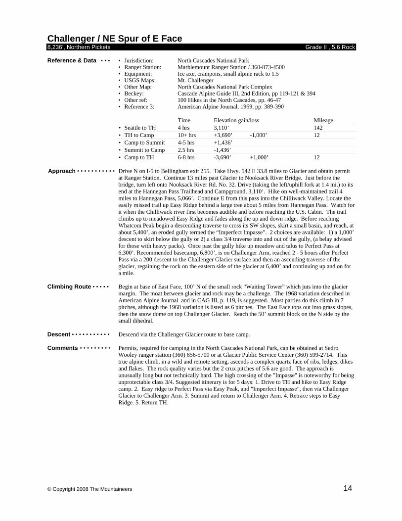
Challenger / NE Spur of E Face 8,236’, Northern Pickets Grade II , 5.6 Rock Reference & Data • • • • Jurisdiction: North Cascades National Park • Ranger Station: Marblemount Ranger Station / 360-873-4500
• Equipment: Ice axe, crampons, small alpine rack to 1.5 • USGS Maps: Mt. Challenger
• Other Map: North Cascades National Park Complex • Beckey: Cascade Alpine Guide III, 2nd Edition, pp 119-121 & 394 • Other ref: 100 Hikes in the North Cascades, pp. 46-47 • Reference 3: American Alpine Journal, 1969, pp. 389-390
Time Elevation gain/loss Mileage • Seattle to TH 4 hrs 3,110’ 142 • TH to Camp 10+ hrs +3,690’ -1,000’ 12 • Camp to Summit 4-5 hrs +1,436’ • Summit to Camp 2.5 hrs -1,436’ • Camp to TH 6-8 hrs -3,690’ +1,000’ 12
Approach • • • • • • • • • • • Drive N on I-5 to Bellingham exit 255. Take Hwy. 542 E 33.8 miles to Glacier and obtain permit
at Ranger Station. Continue 13 miles past Glacier to Nooksack River Bridge. Just before the bridge, turn left onto Nooksack River Rd. No. 32. Drive (taking the left/uphill fork at 1.4 mi.) to its end at the Hannegan Pass Trailhead and Campground, 3,110’. Hike on well-maintained trail 4 miles to Hannegan Pass, 5,066’. Continue E from this pass into the Chilliwack Valley. Locate the easily missed trail up Easy Ridge behind a large tree about 5 miles from Hannegan Pass. Watch for it when the Chilliwack river first becomes audible and before reaching the U.S. Cabin. The trail climbs up to meadowed Easy Ridge and fades along the up and down ridge. Before reaching Whatcom Peak begin a descending traverse to cross its SW slopes, skirt a small basin, and reach, at about 5,400’, an eroded gully termed the “Imperfect Impasse”. 2 choices are available: 1) a 1,000’ descent to skirt below the gully or 2) a class 3/4 traverse into and out of the gully, (a belay advised for those with heavy packs). Once past the gully hike up meadow and talus to Perfect Pass at 6,300’. Recommended basecamp, 6,800’, is on Challenger Arm, reached 2 - 5 hours after Perfect Pass via a 200 descent to the Challenger Glacier surface and then an ascending traverse of the glacier, regaining the rock on the eastern side of the glacier at 6,400’ and continuing up and on for a mile.
Climbing Route • • • • • Begin at base of East Face, 100’ N of the small rock “Waiting Tower” which juts into the glacier
margin. The moat between glacier and rock may be a challenge. The 1968 variation described in American Alpine Journal and in CAG III, p. 119, is suggested. Most parties do this climb in 7 pitches, although the 1968 variation is listed as 6 pitches. The East Face tops out into grass slopes, then the snow dome on top Challenger Glacier. Reach the 50’ summit block on the N side by the small dihedral.
Descent • • • • • • • • • • • Descend via the Challenger Glacier route to base camp. Comments • • • • • • • • • Permits, required for camping in the North Cascades National Park, can be obtained at Sedro
Wooley ranger station (360) 856-5700 or at Glacier Public Service Center (360) 599-2714. This true alpine climb, in a wild and remote setting, ascends a complex quartz face of ribs, ledges, dikes and flakes. The rock quality varies but the 2 crux pitches of 5.6 are good. The approach is unusually long but not technically hard. The high crossing of the "Impasse" is noteworthy for being unprotectable class 3/4. Suggested itinerary is for 5 days: 1. Drive to TH and hike to Easy Ridge camp. 2. Easy ridge to Perfect Pass via Easy Peak, and "Imperfect Impasse", then via Challenger Glacier to Challenger Arm. 3. Summit and return to Challenger Arm. 4. Retrace steps to Easy Ridge. 5. Return TH.
© Copyright 2008 The Mountaineers 15
Chimney Rock / E Face Direct 7,860’, Snoqualmie Grade II , 5 Rock Reference & Data • • • • Jurisdiction: Alpine Lakes Wilderness / Mt. Baker-Snoqualmie National Forest • Ranger Station: Snoqualmie Pass Visitor Center / 425-434-6111
• Equipment: Ice axe, crampons, glacier gear, medium alpine rack. • USGS Maps: Chikamin Peak, Big Snow Mountain
• Beckey: Cascade Alpine Guide I, 3rd Edition, pp. 179-184
Time Elevation gain/loss Mileage • Seattle to TH 2.5 hrs 2,900’ 110 • TH to Camp 15 hrs +4,500’ • Camp to Summit 3 hrs +400’ • Summit to Cars 10-12 hrs -4,960’
Approach • • • • • • • • • • • Drive I-90 E to exit 80, and then 3 miles N to Roslyn. Continue N on Forest Service 903 for 17.5
miles to Cooper Pass road (Forest Service 46). Turn left and drive 4.5 miles to junction with Cooper River Road. Take right and continue to road end and parking for the Pete Lake Trail #1323. Follow trail to Pete Lake then take Trail 1323B to the Pacific Crest Trail. Follow PCT north about a mile to an avalanche path with large blowdowns crossing the trail near confluence of creek from Chimney Glacier. Leave PCT and work across the avalanche path to the right side of “Chimney Creek” and locate climber’s trail. In about 200 yards, the trail crosses to Chimney Creek’s left, recrossing back right a half mile further, where it remains until the Chimney Glacier moraine is reached. Descend 200’ to the lower Chimney Glacier. Rope up and ascend lower glacier. Three options are available to gain the upper glacier. Most common is via the rock or snow gully in cliff leading to upper glacier just left of ice fall. Alternately, a snow finger on the far left can be used, or the icefall can be tackled directly if conditions and tools (screws, crampons, etc.) are suitable. Once on upper glacier, ascend to east face of main peak of Chimney Rock directly beneath summit. A moat will often form at the top of the glacier edge.
Climbing Route • • • • • Photo CAG, p 183. Climb one lead up from glacier to broad heather ledge system (possible bivy).
At the right side of the ledge system, climb another leftward sloping ledge system to faces and gullies towards the north end (right side) of the prominent key ledge two-thirds up the face. Bivy at “Key Ledge” (about 4 hours from glacier) with space for about 6 people, but questionable water. From ledge 3 leads climb to summit: An obvious gully leads to scrambling right to reach final 50’ chimney (2 1/2 hours from bivy ledge).
Descent • • • • • • • • • • • Two rappels return to “Key Ledge”. 2 options are available from here: 1) Make 6 rappels down to
glacier (good anchors reported all the way). 2) Descend the “normal” East Face route: Traverse to notch between the main and south peaks and make a scrambling, traversing descent S onto the east face of south peak until grassy ledges can be followed down. One rappel will be necessary to reach same level as heather incline. Traverse over to East Face Direct route and make 1 rappel back to glacier (4 1/2 hours from summit).
Comments • • • • • • • • • Long days are required as outlined. Many parties plan the climb for 2 days but end up taking a 3rd.
Without efficient movement or early start, “Key Ledge” will not be reached before dark, with consequently a longer second day or second bivy before returning to cars. Consider planning as a 3 day climb. While not technically difficult, this large face has an exposed feel and can be difficult to protect in places.
© Copyright 2008 The Mountaineers 16
Crown Mtn / Widowmaker Arete 4,931’, British Columbia Grade IV, 5.9 Rock Reference & Data • • • • Area: British Columbia
• Equipment: Moderate rack.• Reference: Alpine Select, pp. 146-147.
Time • TH to Climb 3.5-4.5 hrs • Climb Start to Summit 5-7 hrs • Summit to Cars 3-4.5 hrs
Approach • • • • • • • • • • • From top of Grouse Mtn chair lift follow trails to Crown Pass and descend about 700 feet to
scree slopes which lead to start of climbing. Climbing Route • • • • • • Ascend sharp crest, mostly easy climbing with short difficult sections (10 - 12 pitches). Descent • • • • • • • • • • • • • Traverse easy, exposed slabs to trail back to Crown Pass. Comments • • • • • • • • • • •Although the summit is of very modest altitude, the length of the climb and difficulty of the harder
sections require a fast and competent climbing party.
Cutthroat / North Ridge 8,050’, Washington Pass Grade II , 5.6 Rock Reference & Data • • • • Jurisdiction: North Cascades National Park • Ranger Station: Marblemount Ranger Station / 360-873-4500
• Equipment: Light rack of mostly medium to larger. • USGS Maps: Washington Pass
• Other Map: North Cascades National Park Complex • Beckey: Cascade Alpine Guide III, 2nd Edition, pp. 355.
Time Elevation gain/loss Mileage • Seattle to TH 3.5 hrs 5,000’ 162 • TH to Climb 3-4hrs +2,000’ • Climb Start to Summit 3-6 hrs +1,000’ • Summit to Cars 2-3 hrs -3,050’
Approach • • • • • • • • • • • Drive I-5 N to exit 232 (Cook Road) at Burlington. Turn east to Sedro Wooley and junction of
State Route 20. Turn left and drive through Marblemount (47 miles) and on to Rainy Pass. From PCT trailhead, N of highway 20 at Rainy Pass, follow PCT north for about 20 minutes. Leave trail at small streambed just before large creek, and ascend steep open timber to basin NW of the peak (brief avalanche swath debris to cross before entering basin. Ascend to head of basin and 7,520+ ft. notch between N and S peaks.
Climbing Route • • • • • Gain ridge via obscure gully 200 - 300 feet S of notch. On ridge, rock improves significantly.
5th class steps and easier climbing lead to base of summit block. Ascend easy broken chimney to summit. Running belays are frequently useful on this route.
Descent • • • • • • • • • • • Downclimb route; easy with several short rappels. One longer rappel to notch. Or, descend Basic
route on W. Ridge route (reportedly loose). Comments • • • • • • • • • Short approach from North Cascades Highway to a short, uncrowded climb of modest technical
difficulty. Some parties prefer to bivy in basin below ridge night before climb.
© Copyright 2008 The Mountaineers 17
Cutthroat / SE Buttress 8,050’, Washington Pass Grade III , 5.6 Rock Reference & Data • • • • Jurisdiction: North Cascades National Park • Ranger Station: Marblemount Ranger Station / 360-873-4500
• Equipment: Light rack of mostly larger pro (1-2inches). • USGS Maps: Washington Pass
• Other Map: North Cascades National Park Complex • Beckey: Cascade Alpine Guide III, 2nd Edition, pp. 357-359 (S Buttress). • Other Ref: Selected Climbs in the Northwest Vol. II, pp 179-182
Time Elevation gain/loss Mileage • Seattle to TH 3.5 hrs 5,000’ 162 • TH to Camp 2 hrs +1,500’ • Camp to Summit 5-6 hrs +1,550’ • Summit to Cars 4 hrs -3,050’
Approach • • • • • • • • • • • Drive I-5 N to exit 232 (Cook Road) at Burlington. Turn east to Sedro Wooley and junction of
State Route 20. Turn left and drive through Marblemount (47 miles) and on to Rainy Pass. Continue east about three more miles and park along highway near Whistler Mountain sign. Descend from highway to crossing of State Creek. Ascend open slopes on east side of SE draining stream to basin immediately south of Cutthroat Peak.
Climbing Route • • • • • Ascend to basin headwall and climb twin gullies to notch at base of Southeast Buttress. Start in
right gully and traverse into left gully before notch. Above notch, easy scrambling leads to short, steep face. Stay generally near crest of buttress, then follow large ledge to the left. This leads to a gully that must be ascended to “Tarzan Jump” at its top. Scramble sandy gully above to notch between the false summit humps, then climb mixed 3rd, 4th and 5th Class rock to summit.
Descent • • • • • • • • • • • Rappel and downclimb route or West Ridge. Comments • • • • • • • • • Very short approach from North Cascades Highway. Not an especially difficult route, but the
overall length mandates efficient climbing to avoid a headlamp return or bivy, especially later in season. Some parties prefer to bivy in basin below peak night before climb.
© Copyright 2008 The Mountaineers 18
Dragontail / Serpentine Arete 8,840’, Enchantments Grade IV , 5.8 Rock Reference & Data • • • • Jurisdiction: Alpine Lakes Wilderness / Wenatchee National Forest • Ranger Station: Leavenworth Ranger Station / 509-548-6977
• Equipment: Standard rack. • USGS Maps: Enchantment Lakes, Cashmere Mountain
• Beckey: Cascade Alpine Guide I, 3rd Edition, pp. 279-286. • Other ref: Selected Climbs in the Cascades, pp 73-80. • Reference 3: Mountaineer Library Intermediate Trip Reports.
Time Elevation gain/loss Mileage • Seattle to TH 3 hrs 3,400’ 145 • TH to Camp 3 hrs +2,100’ 5 • Camp to Climb 1 hr +1,300’ • Climb to Summit 6-10 hrs +2,040’ • Summit to Camp 3-4 hrs -3,340’ • Camp to TH 2.5 hrs -2,100’
Approach • • • • • • • • • • • Drive U.S. 2 over Stevens Pass to just W. of Leavenworth. Turn right on Icicle Creek Road and
drive 8.6 miles to Eightmile Road. Turn left and drive 3.5 miles to road end and Mountaineer Creek Trail. Hike 2-1/2 miles to where it forks. Go left (Colchuck Lake Trail) 1-1/2 miles to the lake, and 1 mile along the lake to camps on S. side of lake.
Climbing Route • • • • • Ascend talus and moraine from camp, working left onto the lateral moraine trending to the base of
Serpentine Arete. Aim for a large orange-toned area of rock visible at the base of the arete. Above is a large black triangle of rock topped with a pillar. Cross short section of glacier to the rock. The first 2 pitches follow broken rock up first left then right, heading for the left side of the large black triangle. Pitch 3 follows the left side of the black rock, to a large sandy ledge. These are full pitches. Traverse right around the base of the pillar on a good ledge and set up belay (very short pitch or unbelayed). The pillar can be climbed (5.8) on either side, but a 5.8 finger to hand crack that begins about 10’ right of the pillar is the usual route. The pitch ends at a horn above and slightly to right of the pillar. The 5th pitch steps left on easy friction, then ascends dihedral and chickenheads (5.7-5.8 then easing) to base of an easy chimney that trends to the left. The 6th pitch works up the chimney and towards the crest of the arete. The 7th pitch takes you up onto the crest. The remaining climbing (8 more pitches) is 3rd to mid-5th class. Key to staying on route is to keep to the arete. Very loose blocky rock is present on some 3rd class sections. Stay out of the large whitish gully to the right and stay on the arete. Eventually a downclimb is necessary, followed by 1-2 easy pitches to the summit block, which is climbed directly (5.7, several routes) or via a short 4th class detour to the left and then to the summit. Approximately 15 pitches total.
Descent • • • • • • • • • • • Walk to major pass E of summit, then descend glacier which has a good runout for glissading., and
other easy descents and trails are possible. Traverse to Aasgard Pass and descend paths or snow to Colchuck Lake.
Comments • • • • • • • • • Permit is required to camp at Colchuck Lake.
© Copyright 2008 The Mountaineers 19
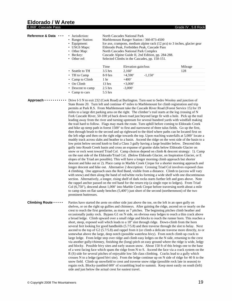
Eldorado / W Arete 8,868’, Cascade Pass Grade IV , 5.8 Rock Reference & Data • • • • Jurisdiction: North Cascades National Park • Ranger Station: Marblemount Ranger Station / 360-873-4500
• Equipment: Ice axe, crampons, medium alpine rack (12 pcs) to 3 inches, glacier gear • USGS Maps: Eldorado Peak, Forbidden Peak, Cascade Pass
• Other Map: North Cascades National Park Complex • Beckey: Cascade Alpine Guide II, 2nd Edition, pp. 284-288. • Other ref: Selected Climbs in the Cascades, pp. 150-151.
Time Elevation gain/loss Mileage • Seattle to TH 3.5 hrs 2,160’ 128 • TH to Camp 8-9 hrs +4,590’ -1,150’ • Camp to Climb 1 hr +400’ • On Climb 13 hrs +3,000’ • Descent to camp 2.5 hrs -3,000’ • Camp to cars 5.5 hrs
Approach • • • • • • • • • • • Drive I-5 N to exit 232 (Cook Road) at Burlington. Turn east to Sedro Wooley and junction of
State Route 20. Turn left and continue 47 miles to Marblemount for climb registration and trip permits at Park R.S. From Marblemount take the Cascade River Road (Forest Service 15) for 19 miles to a large dirt parking area on the right. The climber’s trail starts at the log crossing of N Fork Cascade River, 50-100 yd back down road just beyond large fir with a hole. Pick up the trail leading away from the river and turning upstream for several hundred yards with windfall making the trail hard to follow. Flags may mark the route. Turn uphill before coming to Eldorado Creek and hike up steep path in forest 1500’ to first and narrowest of three talus fields. Go up the first, then through brush to the second and up rightward to the third where paths can be located first on the left edge and then on the right edge towards the top. Upon reaching waterfalls at 5,000’ locate a muddy track across slabs and heather to a basin. Ascend the ridge on the west side of the basin to a low point below second knob to find a Class 3 gully having a large boulder below. Descend this gully into Roush Creek basin and cross an expanse of granite slabs below Eldorado Glacier on snow or rock west toward Triad Col. Camp choices depend on climb & descent strategy: 1). Camp on the east side of the Eldorado/Triad Col. (Below Eldorado Glacier, on Inspiration Glacier, or E slopes of the Triad are possible). This will have a longer morning climb approach but shorter descent and hike out or 2). Place camp in Marble Creek Cirque for a shorter morning approach and longer descent and hike out. Alternative 2 description: Crossing Triad Col involves exposed class 4 climbing. One approach uses the Red Band, visible from a distance. Climb to (access will vary with snow) and then along the band of red/white rocks forming a wide shelf with one discontinuous section. Alternatively, a longer, rising shelf of dark rocks starts further left and goes above. Note the rappel anchor passed on the red band for the return trip (a single rope to ledges). From Triad Col (6,750’), descend about 1,000’ into Marble Creek Cirque before traversing north about a mile to camp sites on flat sandy benches (5,400’) just short of the second (northernmost) of the two prominent buttresses.
Climbing Route • • • • • Parties have started the arete on either side just above the toe, on the left in an open gully on
shelves, or on the right up gullies and chimneys. After gaining the ridge, ascend on or nearly on the crest to reach the first gendarme, as many as 7 pitches. The beginning pitches climb heather and occasionally junky rock. Bypass G1 on N side, on obvious easy ledges to reach a thin crack above a broad ledge. Climb upward over a small ridge and blocks to reach the runner horn. This reaches a short, steep, exposed wall which leads to a 18" slot through ridge. Down-climb from the horn several feet looking for good handholds (5.7/5.8) and then traverse through the slot to belay. Next ascend to the top of G2 (5.7/5.8) and rappel from it (or climb a delicate traverse more directly, to or somewhat above the large, deep notch (possible waterless bivy). From notch climb up crack to large ledge. From ledge step over ridge and climb easy ledges on the N side, returning to the crest via another gully/chimney, finishing the (long) pitch on easy ground where the ridge is wide, ledgy and blocky. Possible bivy sites and early season snow. About 150 ft of this brings one to the base of a west facing face which spans the ridge from N to S. Ascend the face via a crack system on the R (S) side for several pitches of enjoyable low 5th class climbing. Cracks lead to a gully which crosses N to a ledge (good bivi site). From the ledge continue up on N side of ridge for 40 ft to the snow field. Climb up snowfield to crest and traverse snow ridge (possible rock late in season) to regain rock. Blocky-jumbled 600’ of scrambling lead to summit. Keep most easily on south (left) side and just below the actual crest for easiest travel.

© Copyright 2008 The Mountaineers 20
Descent • • • • • • • • • • • Begin the descent on the narrow snow arete of the east ridge (Basic route) and drop down to 8,400’
level on the Inspiration Glacier. To return to Marble Creek Cirque, if necessary, traverse northward (avoiding crevasses) to a glacier pass between Deans Spire and Tyee Crag (CAG photo p 286). Crossing northwest/west the McAllister Glacier to and through McAllister col (right or northern of two notches south of Dorado Needle) brings you back into Marble Creek Cirque.
Comments • • • • • • • • • The arete’s 3,000’ length has forced parties less than fast and efficient to bivy on the route. An
alternate approach via Sibley Creek starts at higher elevation, but is more an up-and-down, cross-country experience and is described well in Selected Climbs. Previous descriptions of rotten rock are exaggerated. A near-desperate bale out route exists, rappelling (2-3 single raps) from sling horn of crux pitch down to broad ledges on arete’s north side with water and bivy sites. Descent on snow/ice off and below ledges is briefly exposed to significant rockfall hazard. Permits are required, obtainable at the Marblemount Ranger Station, (360) 873-4500.
© Copyright 2008 The Mountaineers 21
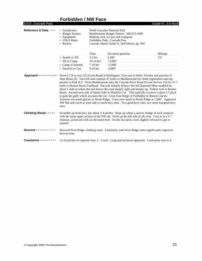
Forbidden / NW Face 8,815’, Cascade Pass Grade IV , 5.6 Rock Reference & Data • • • • Jurisdiction: North Cascades National Park • Ranger Station: Marblemount Ranger Station / 360-873-4500
• Equipment: Medium rack, ice axe and crampons. • USGS Maps: Forbidden Peak , Cascade Pass
• Beckey: Cascade Alpine Guide II, 2nd Edition, pp. 304.
Time Elevation gain/loss Mileage • Seattle to TH 3.5 hrs 3,200’ 131 • TH to Camp 10-14 hrs +3,900’ • Camp to Summit 7-10 hrs +2,000’ • Summit to Cars 8-10 hrs -5,600’
Approach • • • • • • • • • • • Drive I-5 N to exit 232 (Cook Road) at Burlington. Turn east to Sedro Wooley and junction of
State Route 20. Turn left and continue 47 miles to Marblemount for climb registration and trip permits at Park R.S. From Marblemount take the Cascade River Road (Forest Service 15) for 21.7 miles to Boston Basin Trailhead. The trail initially follows the old Diamond Mine roadbed for about 1 mile to where the trail leaves the road sharply right and steeply up. Follow trail to Boston Basin. Ascend west side of Quien Sabe to Sharkfin Col. This typically involves a short 5.7 pitch to gain the gully which accesses the col. Cross East Ridge of Forbidden to Boston Glacier. Traverse crevassed glacier to North Ridge. Cross over notch in North Ridge at 7,680’. Approach NW Rib and circle to west side to reach bivy sites. Two good bivy sites, two more marginal bivy sites.
Climbing Route • • • • • Scramble up from bivy site about 3-4 pitches. Rope up where a narrow bridge of rock connects
with the steep upper section of the NW rib. Work up the left side of rib crest. Crux is at a 5.7 chimney, protected with an old rusted bolt. On the last pitch, work slightly leftward to get to summit.
Descent • • • • • • • • • • • Descend West Ridge climbing route. Familiarity with West Ridge route significantly improves
descent time. Comments • • • • • • • • • 13-18 pitches of exposed class 3 - 5 rock. Long and technical approach. Limit party size to 4.
© Copyright 2008 The Mountaineers 22
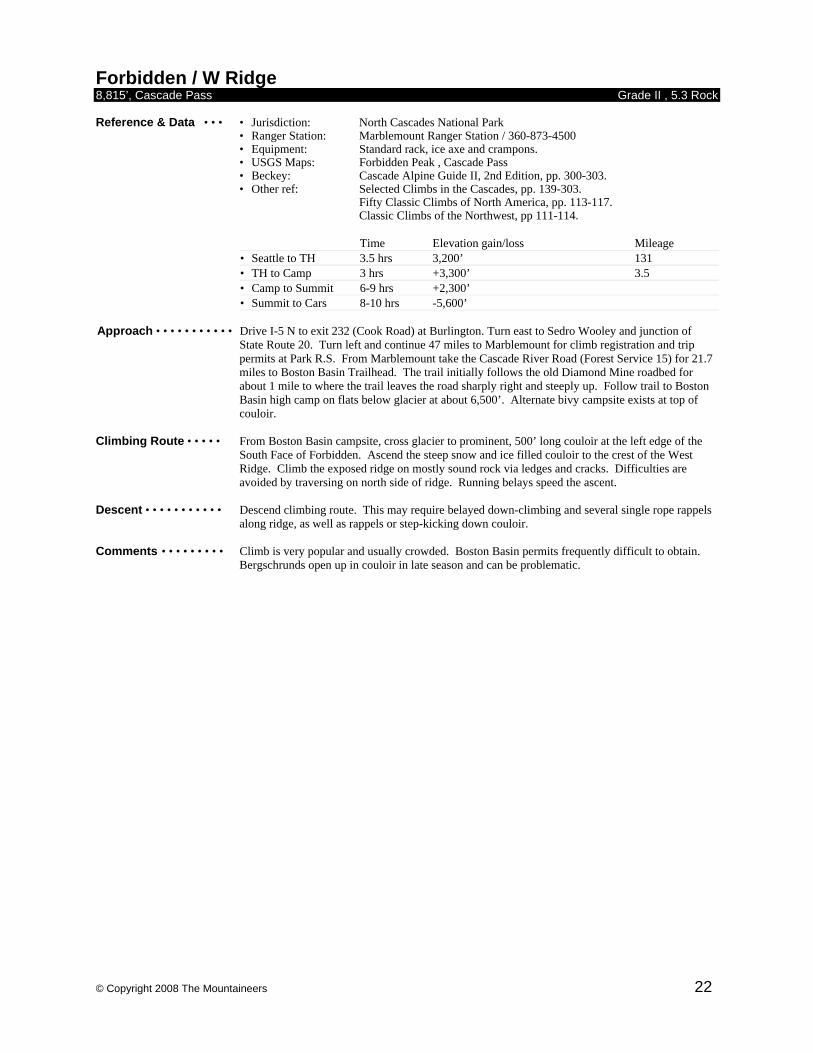
Forbidden / W Ridge 8,815’, Cascade Pass Grade II , 5.3 Rock Reference & Data • • • • Jurisdiction: North Cascades National Park • Ranger Station: Marblemount Ranger Station / 360-873-4500
• Equipment: Standard rack, ice axe and crampons. • USGS Maps: Forbidden Peak , Cascade Pass
• Beckey: Cascade Alpine Guide II, 2nd Edition, pp. 300-303. • Other ref: Selected Climbs in the Cascades, pp. 139-303. Fifty Classic Climbs of North America, pp. 113-117. Classic Climbs of the Northwest, pp 111-114.
Time Elevation gain/loss Mileage • Seattle to TH 3.5 hrs 3,200’ 131 • TH to Camp 3 hrs +3,300’ 3.5 • Camp to Summit 6-9 hrs +2,300’ • Summit to Cars 8-10 hrs -5,600’
Approach • • • • • • • • • • • Drive I-5 N to exit 232 (Cook Road) at Burlington. Turn east to Sedro Wooley and junction of
State Route 20. Turn left and continue 47 miles to Marblemount for climb registration and trip permits at Park R.S. From Marblemount take the Cascade River Road (Forest Service 15) for 21.7 miles to Boston Basin Trailhead. The trail initially follows the old Diamond Mine roadbed for about 1 mile to where the trail leaves the road sharply right and steeply up. Follow trail to Boston Basin high camp on flats below glacier at about 6,500’. Alternate bivy campsite exists at top of couloir.
Climbing Route • • • • • From Boston Basin campsite, cross glacier to prominent, 500’ long couloir at the left edge of the
South Face of Forbidden. Ascend the steep snow and ice filled couloir to the crest of the West Ridge. Climb the exposed ridge on mostly sound rock via ledges and cracks. Difficulties are avoided by traversing on north side of ridge. Running belays speed the ascent.
Descent • • • • • • • • • • • Descend climbing route. This may require belayed down-climbing and several single rope rappels
along ridge, as well as rappels or step-kicking down couloir. Comments • • • • • • • • • Climb is very popular and usually crowded. Boston Basin permits frequently difficult to obtain.
Bergschrunds open up in couloir in late season and can be problematic.
© Copyright 2008 The Mountaineers 23
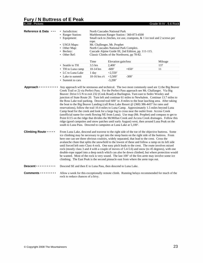
Fury / N Buttress of E Peak 8,288’, Pickets Grade III-IV , 5.6 Rock Reference & Data • • • • Jurisdiction: North Cascades National Park • Ranger Station: Marblemount Ranger Station / 360-873-4500
• Equipment: Small rack to 2inches, ice axe, crampons, & 1 ice tool and 2 screws per rope.
• USGS Maps: Mt. Challenger, Mt. Prophet • Other Map: North Cascades National Park Complex. • Beckey: Cascade Alpine Guide III, 2nd Edition, pp. 111-115. • Other Ref: Classic Climbs of the Northwest, pp 78-82.
Time Elevation gain/loss Mileage • Seattle to TH 3.5 hrs 2,400’ 137 • TH to Luna camp 10-14 hrs -600’ +650’ 11 • LC to Luna Lake 1 day +2,550’ • Lake to summit 10-16 hrs r/t +3,500’ -300’ • Summit to cars -3,200’
Approach • • • • • • • • • • • Any approach will be strenuous and technical. The two most commonly used are 1) the Big Beaver
Creek Trail or 2) via Perfect Pass. For the Perfect Pass approach see Mt. Challanger. Via Big Beaver: Drive I-5 N to exit 232 (Cook Road) at Burlington. Turn east to Sedro Wooley and junction of State Route 20. Turn left and continue 61 miles to Newhalem. Continue 13.7 miles to the Ross Lake trail parking. Descend trail 600’ in .8 miles to the boat lauching area. After taking the boat to the Big Beaver Landing (call Ross Lake Resort @ (360) 386-4437 for rates and reservations), follow the trail 10.4 miles to Luna Camp. Approximately 1.5 miles beyond Luna Camp head for the creek and look for a large log to cross near the outlet from Access Creek (unofficial name for creek flowing NE from Luna). Use map (Mt. Prophet) and compass to get to Point 6115 on the ridge that divides the McMillan Creek and Access Creek drainages. Follow this ridge (good campsites and snow patches until early August) west, then around Luna Peak on the south to Luna Pass. Descend to campsites at Luna Lake at 5,100’.
Climbing Route • • • • • From Luna Lake, descend and traverse to the right side of the toe of the objective buttress. Some
ice climbing may be necessary to get into the steep basin on the right side of the buttress. From here one can see three obvious couloirs, widely separated, that lead to the crest. Cross the avalanche chute that splits the snowfield to the lowest of these and follow a ramp on its left side until forced left onto Class 4 rock. One easy pitch leads to the crest. The route involves mixed rock (mostly class 3 and 4 with a couple of moves of 5.4-5.6) and snow (to 45 degrees), with one double-rope rappel into a deep notch which can also be down climbed, but where protection would be wanted. Most of the rock is very sound. The last 100’ of the firn arete may involve some ice climbing. The East Peak is the second pinnacle east from where the arete tops out.
Descent • • • • • • • • • • • Descend SE and then E to Luna Pass, then descend to Luna Lake. Comments • • • • • • • • • Allow a week for this exceptionally remote climb. Running belays recommended for much of the
rock to reduce chances of a bivy.
© Copyright 2008 The Mountaineers 24
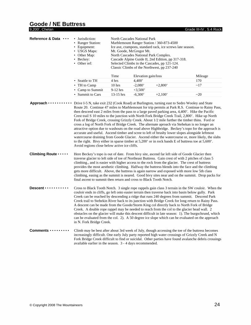
Goode / NE Buttress 9,200’, Chelan Grade III-IV , 5.4 Rock Reference & Data • • • • Jurisdiction: North Cascades National Park • Ranger Station: Marblemount Ranger Station / 360-873-4500
• Equipment: Ice axe, crampons, standard rack, ice screws late season. • USGS Maps: Mt. Goode, McGregor Mt.
• Other Map: North Cascades National Park Complex. • Beckey: Cascade Alpine Guide II, 2nd Edition, pp 317-318. • Other ref: Selected Climbs in the Cascades, pp 121-124. Classic Climbs of the Northwest, pp 237-240
Time Elevation gain/loss Mileage • Seattle to TH 4 hrs 4,400’ 170 • TH to Camp 10 hrs -2,080’ +2,800’ ~17 • Camp to Summit 9-12 hrs +3,500’ • Summit to Cars 13-15 hrs -6,300’ +2,100’ ~20
Approach • • • • • • • • • • • Drive I-5 N, take exit 232 (Cook Road) at Burlington, turning east to Sedro Wooley and State
Route 20. Continue 47 miles to Marblemount for trip permits at Park R.S. Continue to Rainy Pass, then descend east 2 miles from the pass to a large paved parking area, 4,400’. Hike the Pacific Crest trail S 10 miles to the junction with North Fork Bridge Creek Trail, 2,800’. Hike up North Fork of Bridge Creek, crossing Grizzly Creek. About 1/2 mile further the timber thins. Ford or cross a log of North Fork of Bridge Creek. The alternate aproach via Stehekan is no longer an attractive option due to washouts on the road above Highbridge. Beckey’s topo for the approach is accurate and useful. Ascend timber and scree to left of brushy lower slopes alongside leftmost watercourse draining from Goode Glacier. Ascend either the watercourse or, more likely, the slabs to the right. Bivy either in sparse timber at 5,200’ or in rock bands E of buttress toe at 5,600’. Avoid regions close below active ice cliffs.
Climbing Route • • • • • Here Beckey’s topo is out of date. From bivy site, ascend far left side of Goode Glacier then
traverse glacier to left side of toe of Northeast Buttress. Gain crest of with 2 pitches of class 5 climbing., and is easier with higher access to the rock from the glacier. The crest of buttress provides the most aesthetic climbing. Halfway the buttress blends into the face and the climbing gets more difficult. Above, the buttress is again narrow and exposed with more low 5th class climbing, easing as the summit is neared. Good bivy sites near and on the summit. Drop packs for final ascent to summit then return and cross to Black Tooth Notch.
Descent • • • • • • • • • • • Cross to Black Tooth Notch. 3 single rope rappels gain class 3 terrain in the SW couloir. When the
couloir ends in cliffs, go left onto easier terrain then traverse back into basin below gully. Park Creek can be reached by descending a ridge that runs 240 degrees from summit. Descend Park Creek trail to Stehekin River back to its junction with Bridge Creek for long return to Rainy Pass. A descent can be made from the Goode/Storm King col directly back to North Fork of Bridge Creek. A double rope rappel may be needed to reach from the col to the glacier head wall. 2 obstacles on the glacier will make this descent difficult in late season: 1). The burgschrund, which can be evaluated from the col. 2). A 50 degree ice slope which can be evaluated on the approach in N. Fork Bridge Creek.
Comments • • • • • • • • • Climb may be best after about 3rd week of July, though accessing the toe of the buttress becomes
increasingly difficult. One early July party reported high water crossings of Grizzly Creek and N Fork Bridge Creek difficult to find or suicidal. Other parties have found avalanche debris crossings available earlier in the season. 3 - 4 days recommended.
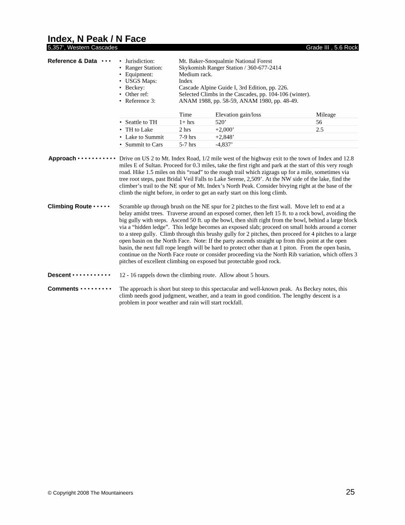
© Copyright 2008 The Mountaineers 25
Index, N Peak / N Face 5,357’, Western Cascades Grade III , 5.6 Rock Reference & Data • • • • Jurisdiction: Mt. Baker-Snoqualmie National Forest • Ranger Station: Skykomish Ranger Station / 360-677-2414
• Equipment: Medium rack. • USGS Maps: Index
• Beckey: Cascade Alpine Guide I, 3rd Edition, pp. 226. • Other ref: Selected Climbs in the Cascades, pp. 104-106 (winter). • Reference 3: ANAM 1988, pp. 58-59, ANAM 1980, pp. 48-49.
Time Elevation gain/loss Mileage • Seattle to TH 1+ hrs 520’ 56 • TH to Lake 2 hrs +2,000’ 2.5 • Lake to Summit 7-9 hrs +2,848’ • Summit to Cars 5-7 hrs -4,837’
Approach • • • • • • • • • • • Drive on US 2 to Mt. Index Road, 1/2 mile west of the highway exit to the town of Index and 12.8
miles E of Sultan. Proceed for 0.3 miles, take the first right and park at the start of this very rough road. Hike 1.5 miles on this “road” to the rough trail which zigzags up for a mile, sometimes via tree root steps, past Bridal Veil Falls to Lake Serene, 2,509’. At the NW side of the lake, find the climber’s trail to the NE spur of Mt. Index’s North Peak. Consider bivying right at the base of the climb the night before, in order to get an early start on this long climb.
Climbing Route • • • • • Scramble up through brush on the NE spur for 2 pitches to the first wall. Move left to end at a
belay amidst trees. Traverse around an exposed corner, then left 15 ft. to a rock bowl, avoiding the big gully with steps. Ascend 50 ft. up the bowl, then shift right from the bowl, behind a large block via a “hidden ledge”. This ledge becomes an exposed slab; proceed on small holds around a corner to a steep gully. Climb through this brushy gully for 2 pitches, then proceed for 4 pitches to a large open basin on the North Face. Note: If the party ascends straight up from this point at the open basin, the next full rope length will be hard to protect other than at 1 piton. From the open basin, continue on the North Face route or consider proceeding via the North Rib variation, which offers 3 pitches of excellent climbing on exposed but protectable good rock.
Descent • • • • • • • • • • • 12 - 16 rappels down the climbing route. Allow about 5 hours. Comments • • • • • • • • • The approach is short but steep to this spectacular and well-known peak. As Beckey notes, this
climb needs good judgment, weather, and a team in good condition. The lengthy descent is a problem in poor weather and rain will start rockfall.
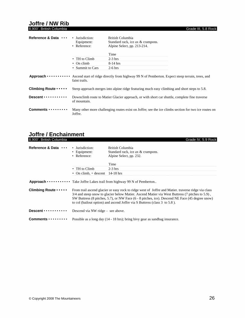
© Copyright 2008 The Mountaineers 26
Joffre / NW Rib 8,900’, British Columbia Grade III, 5.8 Rock Reference & Data • • • • Jurisdiction: British Columbia
Equipment: Standard rack, ice ax & crampons. • Reference: Alpine Select, pp. 213-214.
Time • TH to Climb 2-3 hrs • On climb 8-14 hrs • Summit to Cars 2-6 hrs
Approach • • • • • • • • • • • Ascend start of ridge directly from highway 99 N of Pemberton. Expect steep terrain, trees, and
faint trails. Climbing Route • • • • • Steep approach merges into alpine ridge featuring much easy climbing and short steps to 5.8. Descent • • • • • • • • • • • Downclimb route to Matier Glacier approach, or with short car shuttle, complete fine traverse
of mountain. Comments • • • • • • • • • Many other more challenging routes exist on Joffre; see the ice climbs section for two ice routes on
Joffre. Joffre / Enchainment 8,900’, British Columbia Grade IV, 5.9 Rock Reference & Data • • • • Jurisdiction: British Columbia
• Equipment: Standard rack, ice ax & crampons. • Reference: Alpine Select, pp. 232.
Time • TH to Climb 2-3 hrs • On climb, + descent 14-18 hrs
Approach • • • • • • • • • • • Take Joffre Lakes trail from highway 99 N of Pemberton.. Climbing Route • • • • • From trail ascend glacier or easy rock to ridge west of Joffre and Matier. traverse ridge via class
3/4 and steep snow to glacier below Matier. Ascend Matier via West Buttress (7 pitches to 5.9) , SW Buttress (8 pitches, 5.7), or NW Face (6 - 8 pitches, ice). Descend NE Face (45 degree snow) to col (bailout option) and ascend Joffre via S Buttress (class 3 to 5.8 ).
Descent • • • • • • • • • • • Descend via NW ridge – see above. Comments • • • • • • • • • Possible as a long day (14 - 18 hrs); bring bivy gear as sandbag insurance.
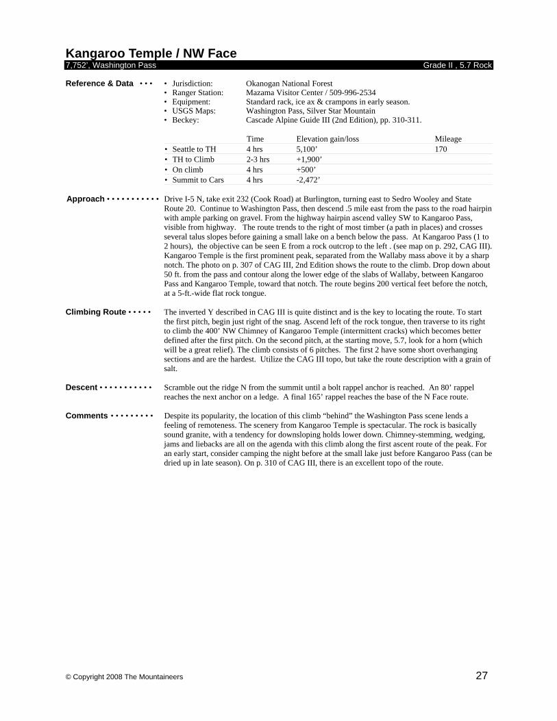
© Copyright 2008 The Mountaineers 27
Kangaroo Temple / NW Face 7,752’, Washington Pass Grade II , 5.7 Rock Reference & Data • • • • Jurisdiction: Okanogan National Forest • Ranger Station: Mazama Visitor Center / 509-996-2534
• Equipment: Standard rack, ice ax & crampons in early season. • USGS Maps: Washington Pass, Silver Star Mountain
• Beckey: Cascade Alpine Guide III (2nd Edition), pp. 310-311.
Time Elevation gain/loss Mileage • Seattle to TH 4 hrs 5,100’ 170 • TH to Climb 2-3 hrs +1,900’ • On climb 4 hrs +500’ • Summit to Cars 4 hrs -2,472’
Approach • • • • • • • • • • • Drive I-5 N, take exit 232 (Cook Road) at Burlington, turning east to Sedro Wooley and State
Route 20. Continue to Washington Pass, then descend .5 mile east from the pass to the road hairpin with ample parking on gravel. From the highway hairpin ascend valley SW to Kangaroo Pass, visible from highway. The route trends to the right of most timber (a path in places) and crosses several talus slopes before gaining a small lake on a bench below the pass. At Kangaroo Pass (1 to 2 hours), the objective can be seen E from a rock outcrop to the left . (see map on p. 292, CAG III). Kangaroo Temple is the first prominent peak, separated from the Wallaby mass above it by a sharp notch. The photo on p. 307 of CAG III, 2nd Edition shows the route to the climb. Drop down about 50 ft. from the pass and contour along the lower edge of the slabs of Wallaby, between Kangaroo Pass and Kangaroo Temple, toward that notch. The route begins 200 vertical feet before the notch, at a 5-ft.-wide flat rock tongue.
Climbing Route • • • • • The inverted Y described in CAG III is quite distinct and is the key to locating the route. To start
the first pitch, begin just right of the snag. Ascend left of the rock tongue, then traverse to its right to climb the 400’ NW Chimney of Kangaroo Temple (intermittent cracks) which becomes better defined after the first pitch. On the second pitch, at the starting move, 5.7, look for a horn (which will be a great relief). The climb consists of 6 pitches. The first 2 have some short overhanging sections and are the hardest. Utilize the CAG III topo, but take the route description with a grain of salt.
Descent • • • • • • • • • • • Scramble out the ridge N from the summit until a bolt rappel anchor is reached. An 80’ rappel
reaches the next anchor on a ledge. A final 165’ rappel reaches the base of the N Face route. Comments • • • • • • • • • Despite its popularity, the location of this climb “behind” the Washington Pass scene lends a
feeling of remoteness. The scenery from Kangaroo Temple is spectacular. The rock is basically sound granite, with a tendency for downsloping holds lower down. Chimney-stemming, wedging, jams and liebacks are all on the agenda with this climb along the first ascent route of the peak. For an early start, consider camping the night before at the small lake just before Kangaroo Pass (can be dried up in late season). On p. 310 of CAG III, there is an excellent topo of the route.
© Copyright 2008 The Mountaineers 28
Kangaroo Temple / SW Face 7,752’, Washington Pass Grade III , 5.8 Rock Reference & Data • • • • Jurisdiction: Okanogan National Forest • Ranger Station: Mazama Visitor Center / 509-996-2534
• Equipment: Medium rack & cams for pockets. Ice ax & crampons in early season. • USGS Maps: Washington Pass, Silver Star Mountain
• Beckey: Cascade Alpine Guide III (2nd Edition), pp. 310-311.
Time Elevation gain/loss Mileage • Seattle to TH 4 hrs 5,100’ 170 • Cars to climb 2-3 hrs +1,900’ • Climb to summit 4 hrs +800’ • Summit to cars 4 hrs -2,472’
Approach • • • • • • • • • • • Drive I-5 N, take exit 232 (Cook Road) at Burlington, turning east to Sedro Wooley and State
Route 20. Continue to Washington Pass, then descend .5 mile east from the pass to the road hairpin with ample parking on gravel. From the highway hairpin ascend valley SW to Kangaroo Pass, visible from highway. The route trends to the right of most timber (a path in places) and crosses several talus slopes before gaining a small lake on a bench below the pass. At Kangaroo Pass (1 to 2 hours), the objective can be seen E from a rock outcrop to the left . (see map on p. 292, CAG III). Kangaroo Temple is the first prominent peak, separated from the Wallaby mass above it by a sharp notch. The photo on p. 307 of CAG III shows the route to the climb. Drop down about 50 ft. from the pass and contour along the lower edge of the slabs of Wallaby, between Kangaroo Pass and Kangaroo Temple, toward that notch. If the tread is lost in some of the shrubby stands of fir or pine, regain it skirting the base of obvious slabs. At the chute from the notch N of KT, leave tread to traverse and descend to the base of the climb.
Climbing Route • • • • • Two routes of similar difficulty exist on this face with variations. CAG, between the two editions,
is confusing over route locations. Below is described left and right routes which share the same direct start but diverge near the end of pitch 2. Higher starting variations miss the slab’s high quality granite and delightful friction. Right: Pitch 1, 180+’, (use long ropes, may require 2nd to climb slightly) starts just up from the toe of the slab where one can scramble up to some small cracks and edges to place a belay. Angle to the left end of an arched roof where a rusty 1/4 inch bolt “protects” moves up steps along the left side and about 20’ higher, a 3/8 inch bolt protects friction and face climbing aiming toward the prominent pine at a roomy belay, 5.8. Pitch 2 continues directly up chimneys and cracks, bypassing one narrow chimney on the face right and continues to a small tree, 160’, 5.7 to 5.8. Pitch 3 remains strenuous for most of its length, but could easily be split into 2 pitches with double bolts (1/4 inch) halfway for a semi hanging stance. The crack system is just right of a right facing dihedral, with jams and laybacks, and at its crux, nice hand jams over an overhanging bulge. Towards the end of the pitch, a wide stem and step right gains a crack that widens to off width before reaching a roomy tree belay next to a cave, 165’, 5.8+. Pitch 4 steps right around the corner from the cave and edges along a vertical wall past an old fixed pin before stepping down to a slab/dihedral and following a crack line through a narrow chimney with a watermelon sized chock stone wedged near its top. Squirmy moves through the chimney lead to easier cracks and broken terrain and a belay tree next to the S entrance of the Gallery, a deep cave with another entrance on the W. 150’, 5.8. (The left SW face route passes that W entrance). Pitch 5 steps right around the corner and moves up a crack system. At a friable bulge, a lip will accept a medium-small camming device to protect a hard move to a new angle piton. Above the pin the crack eases to a broken face, passes another large cave and continues right of it and up to reach a long ledge with a dead tree and a horn near its right edge, 160’, 5.8+. Pitch 6 climbs a 5.6 chimney R of the ledge, easing to class 4 up loose blocks and sand. Class 3-4 gains the summit.
Left: Pitch 1 same as right. Pitch 2 continues as before ~ 120’ to near a dead shrub, and before the end of pitch 2 right. At this point the route diverges left, aiming for a parallel crack system that cannot be seen from here. Pitch 3 traverses up and left into the left facing dihedral that leads to the right corner of a major roof. Move right out of the dihedral just below the roof, move up until the leftward traverse can continue on the slab above the roof. A hanging belay was placed on the traverse, ~80-90’. Pitch 4 continues left until gaining the major crack/chimney system. A friable roof is worked to the right and onto a short face until back into system and up to a belay in the chimney at 150’. Pitch 5 moves up until, at about a half rope length, slabs are available on the

© Copyright 2008 The Mountaineers 29
right. Diagonal up these, then negotiate some easy broken cracks to gain a dead tree at 150’, for a belay. Pitch 6 goes directly up cracks and chimneys to the W entrance of the Gallery cave. Continue past, on the right of the entrance, up to a tree belay at 150’. Pitch 7 continues to a pleasant dihedral friction section then a more broken area to reach a 2 foot diameter pine at a full 165’. 2 more pitches of class 3-4 to the top.
Descent • • • • • • • • • • • Scramble out the ridge N from the summit until a bolt rappel anchor is reached. An 80 foot rappel
reaches the next anchor on a ledge. A final 165’ rappel reaches the base of the N Face route. Comments • • • • • • • • • On the right variation, pitches 6 and 7 climb through loose rock and sand. All this material is
effectively funneled to the chimney below on pitch 6. To avoid being in a debris shower, rope 2 advised to wait in relative safety at the belay until rope 1 completes the relatively quick pitches 6 and 7 before starting pitch 6. In early season snow cover on the starting slab can reach nearly to the first bolt.
© Copyright 2008 The Mountaineers 30
Liberty Bell / NW Face 7,720’, Washington Pass Grade II-III , 5.9 Rock Reference & Data • • • • Jurisdiction: Okanogan National Forest • Ranger Station: Marblemount Ranger Station / 360-873-4500
• Equipment: Rack to 2 1/2 inches. Ice ax & crampons in early season. • USGS Maps: Washington Pass
• Other Map: North Cascades National Park Complex • Beckey: Cascade Alpine Guide III, 2nd Edition, pp 340-342. • Other ref: Selected Climbs in the Cascades, pp 180-181.
Time Elevation gain/loss Mileage • Seattle to TH 4 hrs 5,200’ 165 • TH to Climb 2 hrs +2,000’ • On climb 2-6 hrs +500’ • Summit to Cars 3 hrs -2,500’
Approach • • • • • • • • • • • Drive I-5 N, take exit 232 (Cook Road) at Burlington, turning east to Sedro Wooley and State
Route 20. Continue to Washington Pass. Park at the Blue Lake trailhead, 5,200’, 1.5 miles W of the pass. Follow the Blue Lake trail about 1.5 miles to a small meadow. Locate the climbers path left, just after a small stream. Follow path up through slabs, talus and meadow to below the gully descending from between Liberty Bell and Concord Tower. The path will split; bear left, heading up to the Liberty Bell Concord Tower notch. When just below a prominent split in the gully, perhaps 200’ below the notch, scramble left and up to gain the broad sloping bench on Liberty Bell’s west side. Traverse left at the base of slabs and up through thin timber to a left leaning crack/groove with a bush sprouting halfway up about 80’ before the bench ends.
Climbing Route • • • • • Pitch 1: Climb the easy class 5 crack/groove to a spacious ledge on the corner with a large rock
wrapped with slings. Pitch 2: Climb the outside corner above the ledge for 150’. Chimney moves and a move off a horn gain a long sloping ledge extending to the right. Move the belay to the right to where some rounded, somewhat crumbly left facing flakes ascend directly up below a dihedral a half rope length above. Do not be confused by the sharp clean flake to the left. Pitch 3: Layback the flakes past one fixed pin to where one can make a wide step right to gain the left facing open book, climbed to a small ledge belay, 5.8+. This zig zag pitch has potential rope drag. Pitch 4: A long and fun dihedral is climbed for a long 165’, 5.8+. Pitch 5 moves a short, low class 5 distance up to the top of the west spur with the summit a few minutes away of class 3-4.
Descent • • • • • • • • • • • From the summit, downclimb and/or rappel the Beckey route until about 200’ below the summit.
Turn left (east) and downclimb through trees and loose rocks about 100’. Bear right, looking right across an exposed sloping ledge, 2 rappel bolts can be located on the steep wall. One double rope rappel or 2 single rope rappels reach the Liberty Bell Concord notch.
Comments • • • • • • • • • If this climb is done late enough in the season to avoid snow in the approach gully, one may wish to
gear up and leave packs/boots at a secure place before gaining the west side bench. Excellent topo in CAG III, p 340.
© Copyright 2008 The Mountaineers 31
Liberty Bell / SW Face 7,720’, Washington Pass Grade II , 5.6 Rock Reference & Data • • • • Jurisdiction: Okanogan National Forest • Ranger Station: Marblemount Ranger Station / 360-873-4500
• Equipment: Rack to 3 inches. Ice ax & crampons in early season. • USGS Maps: Washington Pass
• Other Map: North Cascades National Park Complex • Beckey: Cascade Alpine Guide III, 2nd Edition, pp 335-338. • Other ref: Selected Climbs in the Cascades, pp 176-178. Classic Climbs of the Northwest, pp 140-144.
Time Elevation gain/loss Mileage • Seattle to TH 4 hrs 5,200’ 165 • TH to Notch 2 hrs +2,100’ • Notch to Summit 2-4 hrs +420’ • Summit to Cars 3 hrs -2,500’
Approach • • • • • • • • • • • Drive I-5 N, take exit 232 (Cook Road) at Burlington, turning east to Sedro Wooley and State
Route 20. Continue to Washington Pass. Park at the Blue Lake trailhead, 5,200’, 1.5 miles W of the pass. Follow the Blue Lake trail about 1.5 miles to a small meadow. Locate the climbers path left, just after a small stream. Follow path up through slabs, talus and meadow to below the gully descending from between Liberty Bell and Concord Tower. The path will split; keep left, heading up to the Liberty Bell Concord Tower notch, 7,300’. The gully is usually snow filled until late June and rockfall there is high after snowmelt.
Climbing Route • • • • • From the tree about 30’ below the notch between Liberty Bell and Concord Tower the first pitch
begins. Traverse left and up a low fifth class gully, chimney past ledges and small trees to a belay at the base of a steeper chimney. The second pitch climbs a 5.5 chimney to large ledge. A excellent variation for the second pitch avoids the chimney and takes face climbing (5.6) left and then up to rejoin the standard route at the start of pitch 3. The third pitch climbs low angle rock to a small roof where a finger tip traverse to the left (5.6) leads around the roof. Continue up and right on friction and a lay back crack around the corner to a ledge and good belay station. The final pitch begins with a 20’ friction slab, 5.5. A short scramble leads to the summit.
Descent • • • • • • • • • • • From the summit, downclimb and/or rappel the route until about 200’ below the summit. Turn left
(east) and downclimb through trees and loose rocks about 100’. Bear right, looking right across an exposed sloping ledge, 2 rappel bolts can be located on the steep wall. One double rope rappel or 2 single rope rappels reach the Liberty Bell-Concord notch.
Comments • • • • • • • • • Known as the Beckey Route, this is the most popular route in the Washington Pass area, with
frequent traffic jams of climbers on weekends during the height of the climbing season. It is short and presents few technical difficulties, remaining on the Intermediate Rock Climbs list largely due to the force of tradition. If the Beckey Route taxes your skills, or takes excessively long to complete, more practice is called for. During the peak season, it’s best to do this climb midweek to beat the crowds; even then you’ll need an early alpine start.
© Copyright 2008 The Mountaineers 32
Matier / SW Buttress 9,100’, British Columbia Grade IV , 5.7 Rock Reference & Data • • • • Jurisdiction: British Columbia
• Equipment: Medium rack; ice axe and crampons. • Reference Alpine Select, pp 225-229.
Time Elevation gain/loss • TH to Climb Start 4-5 hrs +3,700’ • On climb 2.5 – 3.5 hrs • Summit to Cars 1-1.5 hrs
Approach • • • • • • • • • • • Take Joffre Lakes trail from highway 99 N of Pemberton to Matier Glacier. Gain glacier and
ascend to col west of Matier. Drop several hundred feet down the glacier to foot of long SW Buttress.
Climbing Route •• • • • • • Climb buttress; stay to right of crest. At top of buttress; traverse summit ridge to actual summit. Descent • • • • • • • • • • • Traverse summit and descend NE Face; scrambling and snow to 45 degrees. Comments • • • • • • • • • If the party has extra time in the area, there are more fine clmbs to do for credit. Matier’s NW Face
(Gr. III Ice) is an Intermediate Ice climb, and Matier’s E Ridge (Gr. III 5.5 Rock) is an Intermediate Mountaineering climb.
Matier / W Buttress 9,100’, British Columbia Grade IV , 5.9 Rock Reference & Data • • • • Jurisdiction: British Columbia
• Equipment: Medium rack; ice axe and crampons. • Reference Alpine Select, pp 225-229.
Time Elevation gain/loss • TH to Climb Start 4-5 hrs +3,700’ • On climb 3.5 – 5 hrs • Summit to Cars 1-1.5 hrs
Approach • • • • • • • • • • • Take Joffre Lakes trail from highway 99 N of Pemberton to Matier Glacier. Gain glacier and
ascend to col west of Matier. Climbing Route • • • • • • • This climb features, in succession; three pitches of 5.6, two of 5.7, one 5.8, one 5.9, and an easy
summit ridge. Descent • • • • • • • • • • • Traverse summit and descend NE Face; scrambling and snow to 45 degrees. Comments • • • • • • • • • Described as “one of the best rock climbs in the area,” (Alpine Select, McLane).
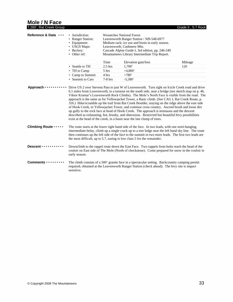
© Copyright 2008 The Mountaineers 33
Mole / N Face 7,280’, Rat Creek Group Grade II , 5.7 Rock Reference & Data • • • • Jurisdiction: Wenatchee National Forest • Ranger Station: Leavenworth Ranger Station / 509-548-6977
• Equipment: Medium rack; ice axe and boots in early season. • USGS Maps: Leavenworth, Cashmere Mtn.
• Beckey: Cascade Alpine Guide I, 3rd edition, pp. 246-249 • Other ref: Mountaineers Library Intermediate Trip Report.
Time Elevation gain/loss Mileage • Seattle to TH 2.5 hrs 1,700’ 120 • TH to Camp 5 hrs +4,800’ • Camp to Summit 4 hrs +780’ • Summit to Cars 7-8 hrs -5,580’
Approach • • • • • • • • • • • Drive US 2 over Stevens Pass to just W of Leavenworth. Turn right on Icicle Creek road and drive
6.1 miles from Leavenworth, to a turnout on the south side, near a bridge (see sketch map on p. 46, Viktor Kramar’s Leavenworth Rock Climbs). The Mole’s North Face is visible from the road. The approach is the same as for Yellowjacket Tower, a Basic climb. (See CAG I, Rat Creek Route, p. 316.) Hike/scramble up the trail from Rat Creek Boulder, staying on the ridge above the east side of Hook Creek, to Yellowjacket Tower, and continue cross country. Ascend brush and loose dirt up gully to the rock face at head of Hook Creek. The approach is strenuous and the descent described as exhausting, hot, brushy, and obnoxious. Restricted but beautiful bivy possibilities exist at the head of the creek, in a basin near the last clump of trees.
Climbing Route • • • • • The route starts at the lower right hand side of the face. In two leads, with one semi-hanging,
intermediate belay, climb up a single crack up to a tree ledge near the left hand sky line. The route then continues up the left side of the face to the summit in two more leads. The first two leads are the most difficult, up to 5.7, easing to low class 5 for the remainder.
Descent • • • • • • • • • • • Downclimb to the rappel route down the East Face. Two rappels from bolts reach the head of the
couloir on East side of The Mole (North of chockstone). Come prepared for snow in the couloir in early season.
Comments • • • • • • • • • The climb consists of a 500’ granite face in a spectacular setting. Backcountry camping permit
required, obtained at the Leavenworth Ranger Station (check ahead). The bivy site is impact sensitive.

© Copyright 2008 The Mountaineers 34
N Early Winter Spire / NW Corner 7,760’, Washington Pass Grade III , 5.9 Rock Reference & Data • • • • Jurisdiction: Okanogan National Forest • Ranger Station: Marblemount Ranger Station / 360-873-4500
• Equipment: Rack with numerous pieces 2 1/2 to 4 inches plus selection of smaller stoppers. Ice ax & crampons in early season.
• USGS Maps: Washington Pass • Beckey: Cascade Alpine Guide III, 2nd Edition, p 327. • Other ref: Selected Climbs in the Cascades, pp 168-170.
Time Elevation gain/loss Mileage • Seattle to TH 4 hrs 5,200’ 165 • TH to Climb 2 hrs +2,000’ • On climb 4-6 hrs +500’ • Summit to Cars 3 hrs -2,500’
Approach • • • • • • • • • • • Drive I-5 N, take exit 232 (Cook Road) at Burlington, turning east to Sedro Wooley and State
Route 20. Continue to Washington Pass. Park at the Blue Lake trailhead, 5,200’, 1.5 miles W of the pass. Follow the Blue Lake trail about 1.5 miles to a small meadow. Locate the climbers path left, just after a small stream. Follow path up through slabs, talus and meadow to below the gully descending from between Liberty Bell and Concord Tower. The path will split; take the right path which continues to the Early Winter Spires. When just below N Early Winter Spire, hike up through open country to the NW corner where a stance can be found off the ground next to a flake and a right leaning chimney is visible above.
Climbing Route • • • • • Pitch 1: From the flake climb up deteriorating rock to a 5.6 chimney and easier rock to stretch out
the full rope length to a tree. Pitch 2: Class 3-4 scramble to move the belay through trees and left around a corner to a dihedral below the distinctive “zig zag flakes”. Pitch 3: Climb the dihedral and undercling around the overhanging flakes, protecting with large cams to finish with an athletic lieback at the base of the long, prominent dihedral. Pitch 4: Jam or layback the 4 inch corner off width crack, 5.9, again using those large cams and hexes to a belay where the dihedral indents to an alcove. Pitch 5 continues up the alcove’s left slab around the roof, up more dihedral and a bulge, 5.9, to a belay stance behind a boulder on a ledge. Here the climbing eases with a pitch of 5.0 to the summit area.
Descent • • • • • • • • • • • From the summit, descend SW to locate a broken chimney gully with rappel anchors. 2 double
rappels reach the notch, another down the gully from the notch, then scramble down to the top of a giant chockstone from which a 50’ overhanging rappel is made from a bolt anchor. Continue the scramble down until one last rappel reaches the base.
Comments • • • • • • • • • Also known as the “Boving Route”, this climb has some exceptional climbing on exquisite granite.
Pitches 3 and 4 are memorable classics, but require refined crack climbing skills. Bring large cams and hexes to protect those wide cracks.
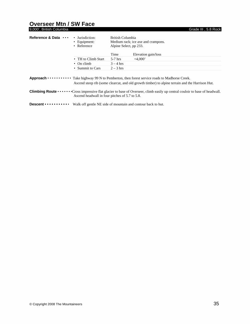
© Copyright 2008 The Mountaineers 35
Overseer Mtn / SW Face 9,000’, British Columbia Grade III , 5.8 Rock Reference & Data • • • • Jurisdiction: British Columbia
• Equipment: Medium rack; ice axe and crampons. • Reference Alpine Select, pp 233.
Time Elevation gain/loss • TH to Climb Start 5-7 hrs +4,000’ • On climb 3 – 4 hrs • Summit to Cars 2 – 3 hrs
Approach • • • • • • • • • • • Take highway 99 N to Pemberton, then forest service roads to Madhorse Creek.
Ascend steep rib (some clearcut, and old growth timber) to alpine terrain and the Harrison Hut. Climbing Route • • • • • • •Cross impressive flat glacier to base of Overseer, climb easily up central couloir to base of headwall.
Ascend headwall in four pitches of 5.7 to 5.8. Descent • • • • • • • • • • • Walk off gentle NE side of mountain and contour back to hut.
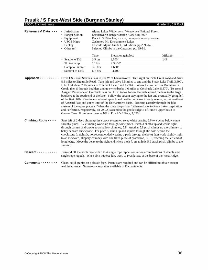
© Copyright 2008 The Mountaineers 36
Prusik / S Face-West Side (Burgner/Stanley) 8,000’, Enchantments Grade III , 5.9 Rock Reference & Data • • • • Jurisdiction: Alpine Lakes Wilderness / Wenatchee National Forest • Ranger Station: Leavenworth Ranger Station / 509-548-6977
• Equipment: Rack to 3 1/2inches, ice axe, crampons in early season. • USGS Maps: Cashmere Mt, Enchantment Lakes
• Beckey: Cascade Alpine Guide I, 3rd Edition pp 259-262. • Other ref: Selected Climbs in the Cascades, pp. 89-91.
Time Elevation gain/loss Mileage • Seattle to TH 3.5 hrs 3,600’ 145 • TH to Camp 10 hrs + 3,650’ • Camp to Summit 3-6 hrs + 650’ • Summit to Cars 6-8 hrs - 4,400’
Approach • • • • • • • • • • • Drive US 2 over Stevens Pass to just W of Leavenworth. Turn right on Icicle Creek road and drive
8.6 miles to Eightmile Road. Turn left and drive 3.5 miles to end and the Stuart Lake Trail, 3,600’. Hike trail about 2 1/2 miles to Colchuck Lake Trail 1559A. Follow the trail across Mountaineer Creek, then S through boulders and up switchbacks 1.6 miles to Colchuck Lake, 5,570’. To ascend Aasgard Pass (labeled Colchuck Pass on USGS topo), follow the path around the lake to the large boulders at the south end of the lake. Follow the stream staying to the left and eventually going left of the first cliffs. Continue southeast up rock and heather, or snow in early season, to just northeast of Aasgard Pass and upper limit of the Enchantment basin. Descend easterly through the lake system of the upper plateau. When the route drops from Talisman Lake to Rune Lake (Inspiration and Perfection, respectively, on USGS) ascend to the gentle ridge E of Rune’s upper basin to Gnome Tarn. From here traverse NE to Prusik’s S Face, 7,350’.
Climbing Route • • • • • Start left of 2 deep chimneys in a crack system on steep white granite, 5.8 to a belay below some
shrubby pines. 5.7 climbing works up through some pines. Pitch 3 climbs up and works right through corners and cracks to a shallow chimney, 5.8. Another 5.8 pitch climbs up the chimney to belay beneath chockstone. For pitch 5, climb up and squirm through the hole behind the chockstone (a tight fit, not recommended wearing a pack through the hole) then work slightly right to an awkward, slippery chimney with one fixed piece of protection, 5.9+, reaching the left end of long ledge. Move the belay to the right end where pitch 7, an athletic 5.9 crack pitch, climbs to the summit.
Descent • • • • • • • • • • • Descend off the north face with 3 to 4 single rope rappels or various combinations of double and
single rope rappels. When able traverse left, west, to Prusik Pass at the base of the West Ridge. Comments • • • • • • • • • Clean, solid granite on a classic face. Permits are required and can be difficult to obtain except
well in advance. Numerous camp sites available in Enchantments.
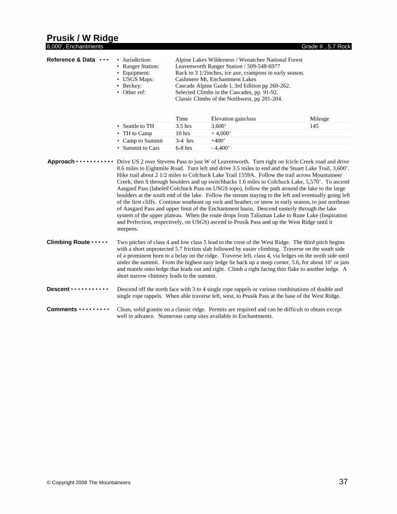
© Copyright 2008 The Mountaineers 37
Prusik / W Ridge 8,000’, Enchantments Grade II , 5.7 Rock Reference & Data • • • • Jurisdiction: Alpine Lakes Wilderness / Wenatchee National Forest • Ranger Station: Leavenworth Ranger Station / 509-548-6977
• Equipment: Rack to 3 1/2inches, ice axe, crampons in early season. • USGS Maps: Cashmere Mt, Enchantment Lakes
• Beckey: Cascade Alpine Guide I, 3rd Edition pp 260-262. • Other ref: Selected Climbs in the Cascades, pp. 91-92. Classic Climbs of the Northwest, pp 201-204.
Time Elevation gain/loss Mileage • Seattle to TH 3.5 hrs 3,600’ 145 • TH to Camp 10 hrs + 4,000’ • Camp to Summit 3-4 hrs +400’ • Summit to Cars 6-8 hrs - 4,400’
Approach • • • • • • • • • • • Drive US 2 over Stevens Pass to just W of Leavenworth. Turn right on Icicle Creek road and drive
8.6 miles to Eightmile Road. Turn left and drive 3.5 miles to end and the Stuart Lake Trail, 3,600’. Hike trail about 2 1/2 miles to Colchuck Lake Trail 1559A. Follow the trail across Mountaineer Creek, then S through boulders and up switchbacks 1.6 miles to Colchuck Lake, 5,570’. To ascend Aasgard Pass (labeled Colchuck Pass on USGS topo), follow the path around the lake to the large boulders at the south end of the lake. Follow the stream staying to the left and eventually going left of the first cliffs. Continue southeast up rock and heather, or snow in early season, to just northeast of Aasgard Pass and upper limit of the Enchantment basin. Descend easterly through the lake system of the upper plateau. When the route drops from Talisman Lake to Rune Lake (Inspiration and Perfection, respectively, on USGS) ascend to Prusik Pass and up the West Ridge until it steepens.
Climbing Route • • • • • Two pitches of class 4 and low class 5 lead to the crest of the West Ridge. The third pitch begins
with a short unprotected 5.7 friction slab followed by easier climbing. Traverse on the south side of a prominent horn to a belay on the ridge. Traverse left, class 4, via ledges on the north side until under the summit. From the highest easy ledge lie back up a steep corner, 5.6, for about 10’ or jam and mantle onto ledge that leads out and right. Climb a right facing thin flake to another ledge. A short narrow chimney leads to the summit.
Descent • • • • • • • • • • • Descend off the north face with 3 to 4 single rope rappels or various combinations of double and
single rope rappels. When able traverse left, west, to Prusik Pass at the base of the West Ridge. Comments • • • • • • • • • Clean, solid granite on a classic ridge. Permits are required and can be difficult to obtain except
well in advance. Numerous camp sites available in Enchantments.
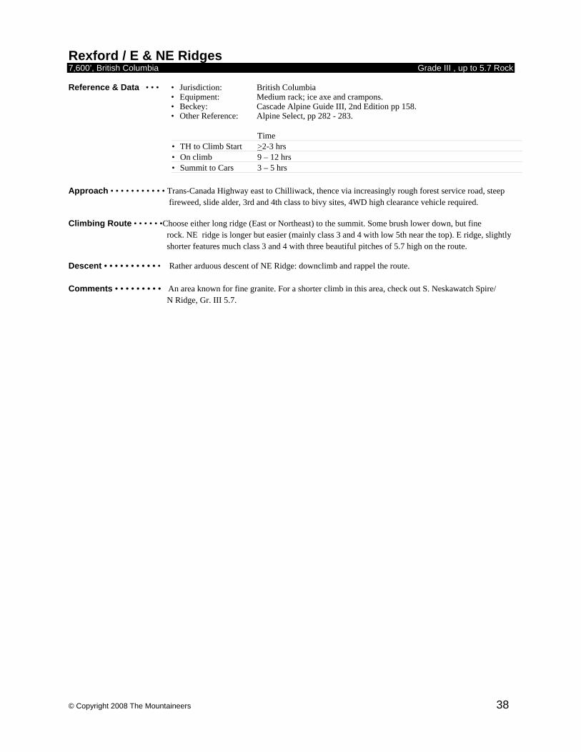
© Copyright 2008 The Mountaineers 38
Rexford / E & NE Ridges 7,600’, British Columbia Grade III , up to 5.7 Rock Reference & Data • • • • Jurisdiction: British Columbia
• Equipment: Medium rack; ice axe and crampons. • Beckey: Cascade Alpine Guide III, 2nd Edition pp 158. • Other Reference: Alpine Select, pp 282 - 283.
Time • TH to Climb Start >2-3 hrs • On climb 9 – 12 hrs • Summit to Cars 3 – 5 hrs
Approach • • • • • • • • • • • Trans-Canada Highway east to Chilliwack, thence via increasingly rough forest service road, steep
fireweed, slide alder, 3rd and 4th class to bivy sites, 4WD high clearance vehicle required. Climbing Route • • • • • •Choose either long ridge (East or Northeast) to the summit. Some brush lower down, but fine rock. NE ridge is longer but easier (mainly class 3 and 4 with low 5th near the top). E ridge, slightly
shorter features much class 3 and 4 with three beautiful pitches of 5.7 high on the route. Descent • • • • • • • • • • • Rather arduous descent of NE Ridge: downclimb and rappel the route. Comments • • • • • • • • • An area known for fine granite. For a shorter climb in this area, check out S. Neskawatch Spire/ N Ridge, Gr. III 5.7.
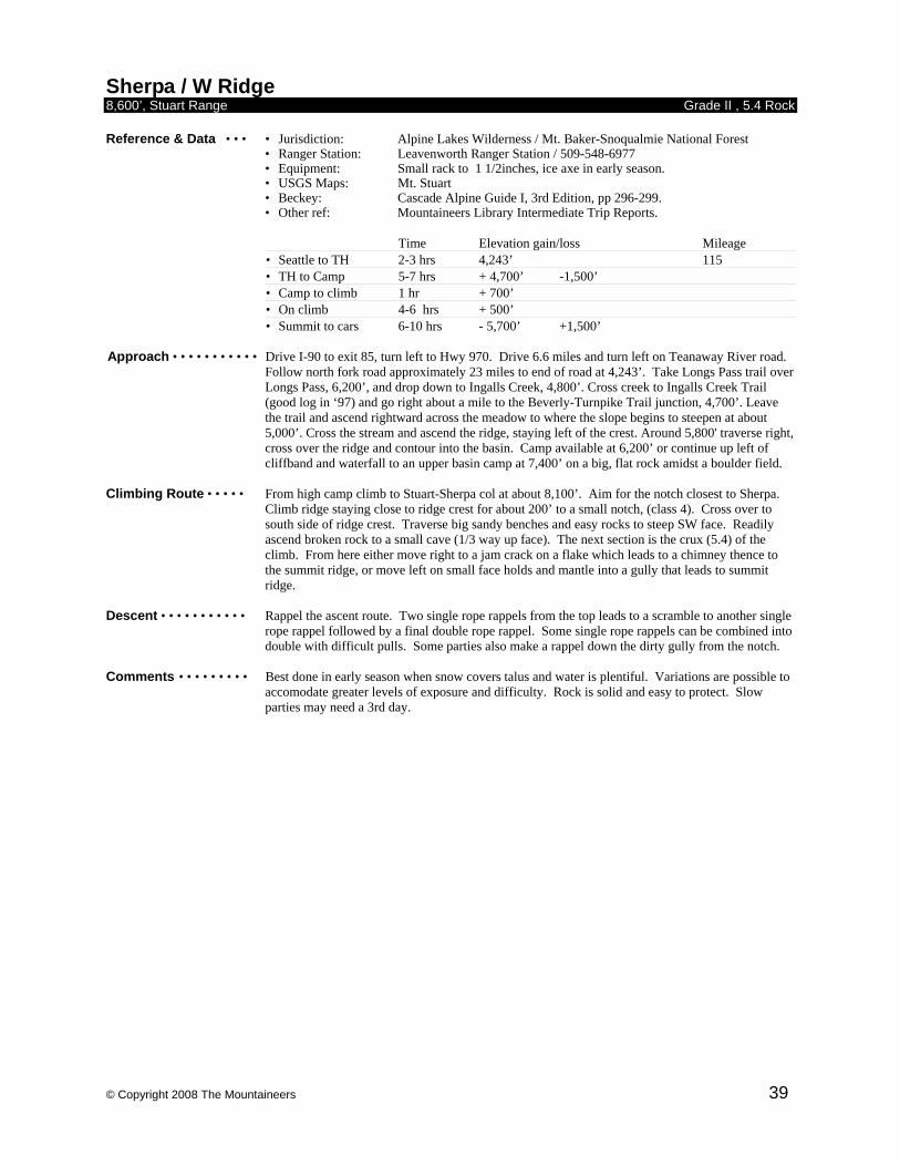
© Copyright 2008 The Mountaineers 39
Sherpa / W Ridge 8,600’, Stuart Range Grade II , 5.4 Rock Reference & Data • • • • Jurisdiction: Alpine Lakes Wilderness / Mt. Baker-Snoqualmie National Forest • Ranger Station: Leavenworth Ranger Station / 509-548-6977
• Equipment: Small rack to 1 1/2inches, ice axe in early season. • USGS Maps: Mt. Stuart
• Beckey: Cascade Alpine Guide I, 3rd Edition, pp 296-299. • Other ref: Mountaineers Library Intermediate Trip Reports.
Time Elevation gain/loss Mileage • Seattle to TH 2-3 hrs 4,243’ 115 • TH to Camp 5-7 hrs + 4,700’ -1,500’ • Camp to climb 1 hr + 700’ • On climb 4-6 hrs + 500’ • Summit to cars 6-10 hrs - 5,700’ +1,500’
Approach • • • • • • • • • • • Drive I-90 to exit 85, turn left to Hwy 970. Drive 6.6 miles and turn left on Teanaway River road.
Follow north fork road approximately 23 miles to end of road at 4,243’. Take Longs Pass trail over Longs Pass, 6,200’, and drop down to Ingalls Creek, 4,800’. Cross creek to Ingalls Creek Trail (good log in ‘97) and go right about a mile to the Beverly-Turnpike Trail junction, 4,700’. Leave the trail and ascend rightward across the meadow to where the slope begins to steepen at about 5,000’. Cross the stream and ascend the ridge, staying left of the crest. Around 5,800' traverse right, cross over the ridge and contour into the basin. Camp available at 6,200’ or continue up left of cliffband and waterfall to an upper basin camp at 7,400’ on a big, flat rock amidst a boulder field.
Climbing Route • • • • • From high camp climb to Stuart-Sherpa col at about 8,100’. Aim for the notch closest to Sherpa.
Climb ridge staying close to ridge crest for about 200’ to a small notch, (class 4). Cross over to south side of ridge crest. Traverse big sandy benches and easy rocks to steep SW face. Readily ascend broken rock to a small cave (1/3 way up face). The next section is the crux (5.4) of the climb. From here either move right to a jam crack on a flake which leads to a chimney thence to the summit ridge, or move left on small face holds and mantle into a gully that leads to summit ridge.
Descent • • • • • • • • • • • Rappel the ascent route. Two single rope rappels from the top leads to a scramble to another single
rope rappel followed by a final double rope rappel. Some single rope rappels can be combined into double with difficult pulls. Some parties also make a rappel down the dirty gully from the notch.
Comments • • • • • • • • • Best done in early season when snow covers talus and water is plentiful. Variations are possible to
accomodate greater levels of exposure and difficulty. Rock is solid and easy to protect. Slow parties may need a 3rd day.
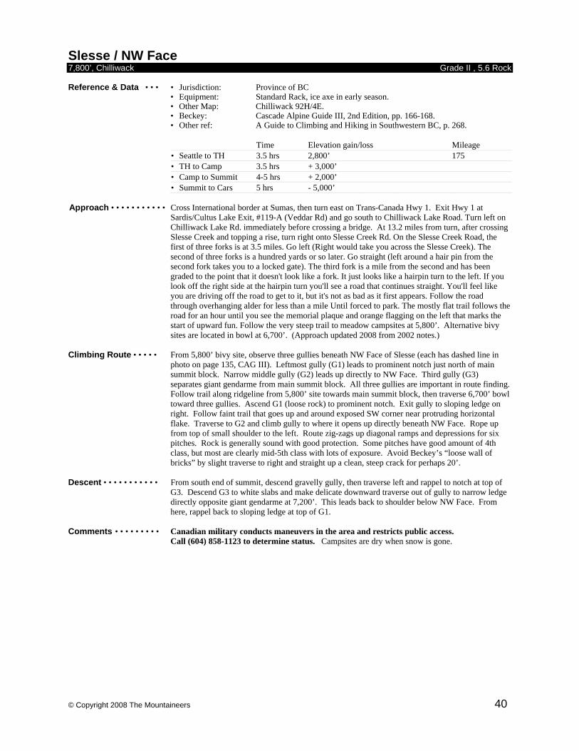
© Copyright 2008 The Mountaineers 40
Slesse / NW Face 7,800’, Chilliwack Grade II , 5.6 Rock Reference & Data • • • • Jurisdiction: Province of BC
• Equipment: Standard Rack, ice axe in early season. • Other Map: Chilliwack 92H/4E. • Beckey: Cascade Alpine Guide III, 2nd Edition, pp. 166-168. • Other ref: A Guide to Climbing and Hiking in Southwestern BC, p. 268.
Time Elevation gain/loss Mileage • Seattle to TH 3.5 hrs 2,800’ 175 • TH to Camp 3.5 hrs + 3,000’ • Camp to Summit 4-5 hrs + 2,000’ • Summit to Cars 5 hrs - 5,000’
Approach • • • • • • • • • • • Cross International border at Sumas, then turn east on Trans-Canada Hwy 1. Exit Hwy 1 at
Sardis/Cultus Lake Exit, #119-A (Veddar Rd) and go south to Chilliwack Lake Road. Turn left on Chilliwack Lake Rd. immediately before crossing a bridge. At 13.2 miles from turn, after crossing Slesse Creek and topping a rise, turn right onto Slesse Creek Rd. On the Slesse Creek Road, the first of three forks is at 3.5 miles. Go left (Right would take you across the Slesse Creek). The second of three forks is a hundred yards or so later. Go straight (left around a hair pin from the second fork takes you to a locked gate). The third fork is a mile from the second and has been graded to the point that it doesn't look like a fork. It just looks like a hairpin turn to the left. If you look off the right side at the hairpin turn you'll see a road that continues straight. You'll feel like you are driving off the road to get to it, but it's not as bad as it first appears. Follow the road through overhanging alder for less than a mile Until forced to park. The mostly flat trail follows the road for an hour until you see the memorial plaque and orange flagging on the left that marks the start of upward fun. Follow the very steep trail to meadow campsites at 5,800’. Alternative bivy sites are located in bowl at 6,700’. (Approach updated 2008 from 2002 notes.)
Climbing Route • • • • • From 5,800’ bivy site, observe three gullies beneath NW Face of Slesse (each has dashed line in
photo on page 135, CAG III). Leftmost gully (G1) leads to prominent notch just north of main summit block. Narrow middle gully (G2) leads up directly to NW Face. Third gully (G3) separates giant gendarme from main summit block. All three gullies are important in route finding. Follow trail along ridgeline from 5,800’ site towards main summit block, then traverse 6,700’ bowl toward three gullies. Ascend G1 (loose rock) to prominent notch. Exit gully to sloping ledge on right. Follow faint trail that goes up and around exposed SW corner near protruding horizontal flake. Traverse to G2 and climb gully to where it opens up directly beneath NW Face. Rope up from top of small shoulder to the left. Route zig-zags up diagonal ramps and depressions for six pitches. Rock is generally sound with good protection. Some pitches have good amount of 4th class, but most are clearly mid-5th class with lots of exposure. Avoid Beckey’s “loose wall of bricks” by slight traverse to right and straight up a clean, steep crack for perhaps 20’.
Descent • • • • • • • • • • • From south end of summit, descend gravelly gully, then traverse left and rappel to notch at top of
G3. Descend G3 to white slabs and make delicate downward traverse out of gully to narrow ledge directly opposite giant gendarme at 7,200’. This leads back to shoulder below NW Face. From here, rappel back to sloping ledge at top of G1.
Comments • • • • • • • • • Canadian military conducts maneuvers in the area and restricts public access.
Call (604) 858-1123 to determine status. Campsites are dry when snow is gone.
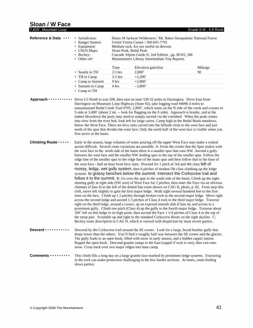
© Copyright 2008 The Mountaineers 41
Sloan / W Face 7,825’, Mountain Loop Grade II-III , 5.5 Rock Reference & Data • • • • Jurisdiction: Henry M Jackson Wilderness / Mt. Baker-Snoqualmie National Forest • Ranger Station: Verlot Visitor Center / 360-691-7791
• Equipment: Medium rack. Ice axe useful on descent. • USGS Maps: Sloan Peak, Bedal Peak
• Beckey: Cascade Alpine Guide II, 2nd Edition , pp. 80-83, 346 • Other ref: Mountaineers Library Intermediate Trip Reports.
Time Elevation gain/loss Mileage • Seattle to TH 2.5 hrs 2,800’ 90 • TH to Camp 3-5 hrs +2,200’ • Camp to Summit 9 hrs +2,800’ • Summit to Camp 4 hrs - 2,800’ • Camp to TH
Approach • • • • • • • • • • • Drive I-5 North to exit 208, then east on state 530 32 miles to Darrington. Drive East from
Darrington on Mountain Loop Highway (State 92), take logging road #4096 4 miles to unmaintained Bedal Creek Trail #705, 2,800’, which starts on the N side of the creek and crosses to S side at 3,400’ (about 2 mi. -- look for flagging on the S side). Approach is brushy, and at the timber blowdown the party may need to simply ascend via the creekbed. When the peak comes into view from the river bed, look left for large cairns. Camp high in the Bedal Basin meadows, below the West Face. There are bivy sites carved into the hillside close to the west face and just north of the spur that divides the west face. Only the north half of the west face is visible when you first arrive at the basin.
Climbing Route • • • • • Early in the season, large volumes of water pouring off the upper West Face may make a central
ascent difficult. Several route variations are possible. A: From the corner that the Spur makes with the west face in the north side of the basin there is a smaller spur that runs NW. Ascend a gully between the west face and the smaller NW tending spur to the top of the smaller spur. Follow the ridge line of the smaller spur to the ridge line of the main spur and then follow that to the base of the west face - half an hour from bivy sites. Proceed for 1 pitch of 3rd and 4th class left of mossy, ledgy, wet gully system, then 6 pitches of modest 5th class climbing up the ledge systems to grassy benches below the summit. Intersect the Corkscrew trail and follow it to the summit. B: Go over the spur to the south side of the basin. Climb up the right-slanting gully at right side (SW arm) of West Face for 2 pitches, then enter the Face via an obvious chimney (Class 4) to the left of the dotted line route shown on CAG II, photo, p. 82. From atop this cleft, move left slightly to gain the first major ledge. Walk right several hundred feet to the first trees on the face. Climb up 1.5 pitches through broken rock to the second major ledge. Move right across the second ledge and ascend 1.5 pitches of Class 4 rock to the third major ledge. Traverse right on the third ledge, around a corner, up an exposed smooth slab (Class 4), and across to a prominent gully. Climb one pitch (Class 4) up the gully to the fourth major ledge. Traverse about 100’ left on this ledge to its high point, then ascend the Face 1 1/4 pitches of Class 4 to the top of the steep part. Scramble up and right to the standard Corkscrew Route on the right skyline. C: Beckey route description in CAG II, which is viewed with skepticism by most recent parties.
Descent • • • • • • • • • • • Descend by the Corkscrew trail around the SE corner. Look for a large, broad heather gully that
drops lower than the others. You’ll find it roughly half way between the SE corner and the glacier. The gully leads to an open book, filled with snow in early season, and a hidden rappel station. Rappel the open book. Descend granite ramps to the East (rappel if rock is wet), then exit onto snow. Cross back over two major ridges into base camp.
Comments • • • • • • • • • This climb fills a long day on a large granite face marked by prominent ledge systems. Fracturing
in the rock can make protection challenging in the few harder sections. At times, route-finding slows parties.
© Copyright 2008 The Mountaineers 42
Stuart / N Ridge 9,415’, Stuart Range Grade II-III , 5.7 Rock Reference & Data • • • • Jurisdiction: Alpine Lakes Wilderness / Wenatchee National Forest • Ranger Station: Leavenworth Ranger Station / 509-548-6977
• Equipment: Rack to 3 1/2inches, ice axe and crampons. • USGS Maps: Mt. Stuart
• Beckey: Cascade Alpine Guide I, 3rd Edition, pp 308-313. • Other ref: Selected Climbs in the Cascades, pp 61-64. Classic Climbs of the Northwest, pp 221-225.
Time Elevation gain/loss Mileage • Seattle to TH 2.5 hrs 4,243’ 115 • TH to Camp 6-8 hrs +3,660’ -250’ • Camp to Summit 9-12 hrs + 1,865’ -100’ • Summit to Cars 6-8 hrs - 4,400’ +1,000’
Approach • • • • • • • • • • • Drive I-90 to exit 85, turn left to join Hwy 970. Drive 6.6 miles and turn left on Teanaway River
road. Follow north fork road approximately 23 miles to end of road at 4,243’. Take this trail to Ingalls Pass (6,480’) and on to Ingalls Lake. From the north end outlet of Ingalls Lake traverse toward Mt. Stuart staying to the east of the ridge line until coming to Stuart Pass. Staying on the south, right, side of the ridge ascend a climbers trail to the saddle at the base of the West Ridge. Descend talus and snow below the West wall until able to ascend to Goat Pass, 7,650’. Bivy sites available here.
Climbing Route • • • • • From Goat Pass, descend on snow or ice about 100’ to 200’ to the Stuart Glacier and traverse
toward the North Ridge. Caution advised because the moderately steep glacier passes above some large crevasses. Also beware of falling ice and rock. To access the ridge, climb a snow filled gully leading from the glacier at 7,800’, usually via 4th class rock on the edge of the gully, to the ridge at 8,200’ and possible bivy sites. The route follows the jagged ridge crest for 11 pitches until it narrows sharply just below a giant buttress, the Great Gendarme. The gendarme can be climbed directly via a crack (5.9) for a direct finish. Most parties rappel 75’ off the right side of the ridge below the buttress, then traverse into and across a gully, snow and wet or icy rock until mid summer (low 5th class). Traverse upward to a ledge and climb another 4 to 5 pitches of class 4 and low class 5 to the summit.
Descent • • • • • • • • • • • Scramble to the false summit. Descend steep snow or scree then keep right through sparse trees to
enter the Cascadian couloir, descended to the valley floor. From the base, hiking west on Ingalls Cr. trail a short distance will bring you to a fork. The left crosses Ingalls Cr. and climbs over Long’s Pass. The right leads back to Ingalls lake.
Comments • • • • • • • • • Last available water is at Ingalls Lake. A very popular and crowded climb. Variations can be done,
including the full North Ridge or the Great Gendarme, making the route significantly longer and more technical. Permit required. Contact Leavenworth Ranger Station, (509) 548-6997, for updated backcountry regulations for the area.
© Copyright 2008 The Mountaineers 43
Stuart / Razorback Ridge 9,415’, Stuart Range Grade III , 5.9 Rock Reference & Data • • • • Jurisdiction: Alpine Lakes Wilderness / Wenatchee National Forest • Ranger Station: Leavenworth Ranger Station / 509-548-6977
• Equipment: Rack, ice axe and crampons. • USGS Maps: Mt. Stuart
• Beckey: Cascade Alpine Guide I, 3rd Edition, pp 306-308.
Time Elevation gain/loss Mileage • Seattle to TH 2.5 hrs 4,243’ 115 • TH to Camp 3 hrs + 3,750’ -250’ • Camp to Summit 13 hrs + 1,200’ • Summit to Cars 4-6 hrs - 4,400’ +1,000’
Approach • • • • • • • • • • • Drive I-90 to exit 85, turn left to join Hwy 970. Drive 6.6 miles and turn left on Teanaway River
road. Follow north fork road approximately 23 miles to end of road at 4,243’. From the end of the North Fork of the Teanaway River Road. Hike to the north end of Ingalls lake, circling the lake on the W side. Camp in the meadows below the outlet (camping is not allowed at lake). Could be buggy. From the meadow make a rising traverse to Stuart Pass Ridge then ascend a climber’s trail up the ridge toward Stuart. Drop left off the ridge and cross the basin to Goat pass at 7,600’. Good bivy sites, but no water. Traverse to the base of Razorback ridge, in the middle of the Stuart Glacier, just right of the Stuart Glacier couloir. Scramble up the first 50’ or so.
Climbing Route • • • • • The first pitch works over blocks and into a right facing corner. The second pitch climbs this
corner. There are three vertical steps to this corner. The third step is the crux of the route and starts with a hard 5.8 (5.9?) off-width which then eases a bit and constricts to fist then hand crack. Can be protected by small nuts in crack to the right. Above the climbing varies with most pitches having some solid mid 5th class steps in them. Stray left of the crest for easier climbing on slabs or right for steep face climbing with nauseating exposure. Excellent bivy ledge on 7th pitch can squeeze up to 4. After 11 full pitches, top out just west of the West Ridge Notch. Good bivy sites round here. Follow the west ridge route to the summit in 5 more pitches. About 16 pitches total. Peer down on the route and ponder how anything so steep could be called a ridge...
Descent • • • • • • • • • • • Scramble to the false summit. Descend steep snow or scree then keep right through sparse trees to
enter the Cascadian couloir, descended to the valley floor. From the base, hiking west on Ingalls Cr. trail a short distance will bring you to a fork. The left crosses Ingalls Cr. and climbs over Long’s Pass. The right leads back to Ingalls lake.
Comments • • • • • • • • • This route is climbed once for every 50 ascents of the North Ridge. It is longer, harder, and less
aesthetic. But don't let that put you off: it provides interesting, challenging climbing on very good rock, in a beautiful setting. Permit required. Contact Leavenworth Ranger Station, (509) 548-6997, for updated backcountry regulations for the area.
© Copyright 2008 The Mountaineers 44
Stuart / W Ridge 9,415’, Stuart Range Grade II , 5.4 Rock Reference & Data • • • • Jurisdiction: Alpine Lakes Wilderness / Wenatchee National Forest • Ranger Station: Leavenworth Ranger Station / 509-548-6977
• Equipment: Small rack to 2inches, ice axe in early season. • USGS Maps: Mt. Stuart
• Beckey: Cascade Alpine Guide I, 3rd Edition pp. 302-305. • Other ref: Mountaineers Library Intermediate Trip Reports.
Time Elevation gain/loss Mileage • Seattle to TH 2.5 hrs 4,243’ 115 • TH to Climb 4-6 hrs + 2,500’ • Climb to LJT 4 hrs + 1,000’ • LJT to WR notch 4-5 hrs + 350’ • WRN to summit 4-6 hrs + 400’ • Summit to cars 7 hrs - 4,400’ +1,000’
Approach • • • • • • • • • • • Drive I-90 to exit 85, turn left to join Hwy 970. Drive 6.6 miles and turn left on Teanaway River
road. Follow north fork road approximately 23 miles to end of road at 4,243’. Take this trail to Ingalls Pass, 6,480’, and on to Ingalls Lake. (Some parties take an earlier cutoff and go to Long’s Pass, then on down to Ingalls Creek, instead.) Descend to Ingalls Creek; cross the creek on a log bridge. At upper meadows of Ingalls Creek, short of Stuart Pass, ascend to base of West Ridge. Occasionally, parties opt to overnight in meadows near head of creek, to get an earlier start on the climb itself. Most parties do this climb as a carryover, with a bivy near the summit.
Climbing Route • • • • • Ascend scrub and enter a deep gully on the lower ridge, the middle of three parallel gullies. This
gully has a big rock “like a house” at its base. Climb up and to the right. At the end of the gully scramble through the notch and look at Long John Tower. Climb up chimney to left of the tower; it is about 3/4 a pitch with a chockstone near the start. Contine up to a notch where you will see the ridge crest and the west ridge tower; continue to the base of the tower. There are ledges around the right (south) of the tower with an airy step on the south. Do not go to the ridge crest itself, but scramble on benches about 50 yards below the crest. Scramble to the West Ridge notch. Just south of the notch, climb up easy blocks (class 4) for one full rope length. Head to the right ridge and up about 20-30 ft.; traverse left via some airy steps, but with solid holds, about 1/2 a rope length. Then climb up obvious chimney for about 1/2 a rope length, and traverse right to a crack with a chockstone at the top. Scramble to below summit block, then traverse down and along benches to the south. At the end make a slightly rising traverse until no more traversing can be done, and climb up a chimney for 1/2 a rope length. Then scramble up 1 rope length to another chimney. This last pitch is about 1/2 a rope length, and look for the two pitons in the chimney.
Descent • • • • • • • • • • • Scramble to the false summit. Descend steep snow or scree then keep right through sparse trees to
enter the Cascadian couloir, descended to the valley floor. From the base, hiking west on Ingalls Cr. trail a short distance will bring you to a fork. The left crosses Ingalls Cr. and climbs over Long’s Pass. The right leads back to Ingalls lake.
Comments • • • • • • • • • This athletic climb is largely scrambling on a huge granite massif. Fast efficient parties who travel
light are favored. Route-finding dilemmas tend to occur at Long John Tower, at exposed section of West Ridge Notch, and in descent (not staying right). Snow patches along the route should be utilized for drinking water. Large rats, aka snafflehounds, inhabit the summit bivy area, so be careful about anything (including boots) with salt on it; they will try to eat it. Most of route is traveled unroped. The key to this climb is traveling light. Contact Leavenworth Ranger Station, (509) 548-6997, for updated backcountry regulations for the area.
© Copyright 2008 The Mountaineers 45
Thompson / W Ridge 6,554’, Snoqualmie Pass Reference & Data • • • • Jurisdiction: Alpine Lakes Wilderness / Mt. Baker-Snoqualmie National Forest • Ranger Station: Snoqualmie Pass Visitor Center / 360-434-6111
• Equipment: Rack to 3inches, ice axe in early season. • USGS Maps: Snoqualmie Pass, Chikamin Peak
• Beckey: Cascade Alpine Guide I, 3rd Edition, pp 170-172.
Time Elevation gain/loss Mileage • Seattle to TH 1 hr 3,022’ 53 • TH to Camp 4 hrs + 2,500’ • Camp to Summit 6 hrs + 1,000’ • Summit to Cars 4-6 hrs - 3,500’
Approach • • • • • • • • • • • Drive I-90 East from Seattle to Exit 52, Snoqualmie Pass. Turn left then make the first right on the
paved road to the parking area of the Pacific Crest Trail, 3,022’. Take the Crest Trail north about 8 miles to Bumblebee Pass, 5,400’, about 1/2 mile past Ridge Lake. Scramble a climbers trail up and over Bumblebee Pass and down (north) into the basin directly in front of Mt. Thompson. Snow fills the basin until mid season and water is available throughout the summer. Bivy sites can be found in the western part of the basin.
Climbing Route • • • • • From this basin, contour northwest to a notch at the base of the West Ridge, 5,960’ where the first
pitch begins starting slightly to the left, north. The first pitch goes straight up the West Ridge for a full pitch to a big bushy tree. The second pitch continues straight up the ridge about 120’ to a solid but airy belay. The third pitch continues straight up past a large ledge with a snag up to a giant slab. The next pitch is easy walking across the top of a large slab to a corner at base of the continuation of the ridge. Proceed straight up for 1 long or 2 short pitches to just below false summit. Scramble over false summit and one short pitch leads to the summit.
Descent • • • • • • • • • • • Descend via the East Ridge including one 15’ section of class 4 downclimbing and some tricky
class 3 slabs. Many parties rappel sections of the East Ridge with 1 or 2 short rappels. After reaching notch in ridge, descend gulley to basin.
Comments • • • • • • • • • Beckey describes a route that is partially on SW face. The above route goes straight up the West
Ridge. Finding the correct start for the climb and descent often takes longer than expected. Although described in 2 days, many parties complete this climb round trip from the cars in one long day.
© Copyright 2008 The Mountaineers 46
Torment / S Ridge 8,120’, Cascade Pass Grade II , 5.4 Rock Reference & Data • • • • Jurisdiction: North Cascades National Park • Ranger Station: Marblemount Ranger Station / 360-873-4500
• Equipment: Standard rock gear with light rack, extra webbing, crampons and ice axe. • USGS Maps: Forbidden Peak, Cascade Pass
• Other Map: North Cascades National Park Complex • Beckey: Cascade Alpine Guide II, 2nd Edition, pp. 295.
Time Elevation gain/loss Mileage • Seattle to TH 3.5 hrs 3,200’ 131 • TH to Camp 3.5 hrs +4,000’ • Camp to Summit 6 hrs +1,000’ • Summit to Cars 6 hrs -5,000’
Approach • • • • • • • • • • • Drive I-5 N to exit 232 (Cook Road) at Burlington. Turn east to Sedro Wooley and junction of
State Route 20. Turn left and continue 47 miles to Marblemount for climb registration and trip permits at Park R.S. From Marblemount take the Cascade River Road (Forest Service 15) for 21.7 miles to Boston Basin Trailhead. The trail initially follows the old Diamond Mine Road bed for about 1 mile to where the trail leaves the road sharply right and steeply up. Follow trail to Boston Basin high camp at about 6,200’. Traverse upper basin to NW at 6,200’ contour. Pass beneath S spur of Forbidden Peak, and continue traversing toward the lower South Ridge. A couple hundred feet of scrambling gets you up to the South Col bivy sites. From here hike up and west of lower South Ridge to the western coulouir leading to prominent notch and start of climb. This approach is longer but more aesthetic than the direct Taboo Glacier approach. Alternately, traverse from Boston Basin and ascend the Taboo Glacier directly to 7,100’ campsite directly beneath SE face of Mt. Torment at base of east couloir to prominent notch in S Ridge
Climbing Route • • • • • Climb starts at prominent notch in S Ridge. Do not start up either of the two prominent
dihedral/gullies branching up and to right. First pitch follows open book to left. Then, turn corner to right at top of the open book, reach a ledge, and continue up another short open book.. Second pitch continues angling up and left across sloping exposed ledges beneath a steep face. In the 3rd and 4th pitches, continue climbing leftward on the SW Face. The goal is to reach the right leaning gully shown between the S Ridge and the summit on pg 320 (Beckey). Do not ascend too high directly up steep rock above. Third pitch traverses ledges and around corner to right into base of gully with a large detached block belay anchor. Fourth pitch starts up short mossy gully past rusty pin, then angle up to left where route becomes cleaner and goes around another corner. Fifth pitch continues via traverse into large, easy gully with loose scree and talus (poor anchors) that leads to big notch in S Ridge. 6th pitch: Scramble up the gully following the easiest way, slightly to the right, over very crumbly rock. Due to high danger of rock fall unroping here is not recommended. 7th pitch: Once up on the notch traverse on the SE side to the left and upwards to the next rappel station. 8th pitch: Continue traversing left to 3rd class terrain; follow it upwards towards the leftmost summit for full rope length.
Descent • • • • • • • • • • • Descend either by downclimbing and rappelling the climbing route (longer but eliminates moat
problems) or via double-rope rappels down SE Face. Condition of deep moat at base of SE face cannot be assessed on route or from the South Col/SW approach. To descend via SE face, downclimb to the last rappel station and make 5-6 double rope rappels. Rappel station 2 is on the climbers left. All others are either straight down or to the climbers right. Before rappelling over the last cliff onto the snow, look for a rappel station on your left. On the last rappel, one needs to cross the moat to reach the snow field, which can be difficult. The first person should carry a picket, ice axe and crampons to facilitate climbing out of the moat if necessary. Ascend a short but steep snowfield and a 4th class scramble up to the notch.
Comments • • • • • • • • • Boston Basin permits frequently difficult to obtain. Consider bivying at the South Col, which puts
you in the Torment Basin permit area instead. Short approach couloir from Taboo Glacier is unaesthetic with loose rock; approach from SW preferred. S Ridge route is classic NW alpine rock climbing – the scenery is incredibly good, the rock is less than classic. Mountain boots prefered to rock shoes; doesn’t get a whole lot of traffic. Moat at base of SE Face is difficult to clear in mid or late season, and will then give you the hardest climbing of the route if you have to climb out of it.
© Copyright 2008 The Mountaineers 47
Triumph / NE Ridge 7,270’, North Cascades Grade III , 5.5 Rock Reference & Data • • • • Jurisdiction: North Cascades National Park • Ranger Station: Marblemount Ranger Station / 360-873-4500
• Equipment: Small to medium cams and stoppers, lots of rappel slings. Crampons and ice axe.
• USGS Maps: Mt. Triumph • Beckey: Cascade Alpine Guide III, 2nd Edition pp 88-90. • Other ref: 100 Hikes in the North Cascades, Hike #16.
Time Elevation gain/loss Mileage • Seattle to TH 3 hrs 2,700’ 133 • TH to Camp 5-6 hrs +3,450’ -300’ • Camp to Summit 8-10 hrs +1,420’ • Summit to Camp 4-6 hrs -1,420’ • Camp to TH
Approach • • • • • • • • • • • Drive I-5 N to exit 232 (Cook Road) at Burlington. Turn east to Sedro Wooley and junction of
State Route 20. Turn left and continue 47 miles to Marblemount for climb registration and trip permits at Park R.S. Continue east 12 miles on Highway 20 and take side road 5.3 miles to Thornton Lakes Trailhead, 2,700’. Follow trail to lower Thornton Lake. Hike around west side of lake and follow right bank of stream to middle Thornton Lake, 4,400’. Make a high rising traverse around east side of lake and ascend long gully NW (climber’s path in gully) to 5,750’ col above lake. Good campsites at col, last with reliable water. Alternate bivy is located 2 pitches up NE Ridge, space for 5, excellent for saving time on the climbing day, but dry.
Climbing Route • • • • • From col campsite, descend snow and traverse toward prominent low notch in NE ridge. To reach
the notch from the glacier, climb easy ramp on right heading to notch. Before reaching the notch step left around a corner above gully, tricky with full pack. Easy slabs lead toward the notch for 1 rope length. Steeper blocks and a ramp gain an old rappel tree just below the notch and alternate bivy space. Ascend steep face onto another broad flat spot on the ridge (low to mid 5th class, 100’). Now scramble along ridge crest to another steep step. Climb this for 1 pitch, easier to left, to another flat ledge. Several pitches follow of easy but exposed climbing along the ridge crest, up and over towers. Ridge narrows then rises. Continue on the ridge crest or on easier ledges to the right to the base of a steeper face with an off-width crack in a right facing corner. This crack is climbed at a reportedly fun 5.7, but easier alternatives are also reported. Belay at the next “great notch” below summit (possible bivy). Reports are mixed about the next option. Beckey suggests traversing a short distance to the left, then scramble upwards the remaining distance to the top. Other parties report a steep face here. Recommend a pitch which descends the north side of the great notch about 30’ until the rock on the far side is easily gained. Turn the corner and climb shallow gully to the ridge crest. Additional 200’ lead to the summit.
Descent • • • • • • • • • • • Downclimb and rappel back to great notch. Below here, a double rope rappel reaches the base of
the crack pitch. Continue down ridge crest via 6 to 8 more rappels and downclimbing. Comments • • • • • • • • • This long, exposed, tiring climb is best done in three days. Due to length of climb, carry two liters
of water and bivy gear.
© Copyright 2008 The Mountaineers 48
Vayu / NW Ridge 9,100’, British Columbia Grade IV, 5.5 Rock Reference & Data • • • • Jurisdiction: British Columbia
• Equipment: Medium rack; ice axe and crampons. • Reference Alpine Select, pp 244.
Time Elevation gain/loss • TH to Camp 2.5-3 hrs +1,200’ • Camp to Summit 3 – 4 hrs • Summit to Cars 2– 3 hrs
Approach • • • • • • • • • • • Take Highway 99 N to Pemberton, then another 50 or so miles mainly on forest service roads. 4WD
high-clearance vehicle saves several miles of road walking. From road end it is 2-1/2 to 3 hrs. to flat glacier and campsites.
Climbing Route • • • • • • Gain ridge via easy snow slopes, 10 - 12 easy, enjoyable pitches, mostly 4th class, some pitches to mid-fifth. Descent • • • • • • • • • • • Easy descent down East Ridge.
© Copyright 2008 The Mountaineers 49
Vesper / N Face 6,214’, Mountain Loop Grade II-III , 5.8 Rock Reference & Data • • • • Jurisdiction: Mt. Baker-Snoqualmie National Forest • Ranger Station: Verlot Visitor Center / 360-691-7791
• Equipment: Small to medium stoppers and cams. Crampons/ice axe in early season. • USGS Maps: Silverton, Bedal
• Beckey: Cascade Alpine Guide II, 2nd Edition, pp 48-50. • Other ref: 100 Hikes in the North Cascades, Hike #47. Selected Climbs in the Cascades. Vol. 2.
Time Elevation gain/loss Mileage • Seattle to TH 1.5 hrs 2,200’ 74 • TH to Camp 3-4 hrs +2,500’ • Camp to Summit 4-5 hrs +1,615’ • Summit to Cars 3 hrs -4,115’
Approach • • • • • • • • • • • Drive I-5 N to exit 194, US 2. Exit to US 2 eastbound and follow to exit for State 204 N to State 9
N . Turn right on State 92 to Granite Falls. Drive Mountain Loop Highway east from Granite Falls 28 miles (2 miles before Barlow Pass). Turn right (south) on Sunrise Mine Road 4065 and drive 2.3 miles to the Sunrise Mine Trail head. Hike trail 3 miles to Headlee Pass, 4,720’. From the pass, follow trail skirting around the S flanks of Sperry to the upper Vesper Creek basin between Sperry and Vesper Peaks. Campsites are available on grassy bench near trail above stream, or farther upstream near a small lake in the basin.
Climbing Route • • • • • From basin campsite, hike up the Vesper scramble trail toward the head of the basin. But angle off
trail, bearing to the high first notch in the ridge dividing Vesper’s N and E aspects, not to the lower, more prominent pass at the basin head. The “high” notch leads to a long ledge system that crosses north face (photo in CAG II, p 50). Scramble the ledge to near its end. Starting here, the route consists of two Class 4 pitches followed by three Class 5 pitches, but is not obvious. Climb or scramble the first 2 pitches to a small ledge. From ledge, pitch 3 traverses leftward and ascends a small shallow chimney (5.5 - 5.6) to belay. Pitch 4 again bears leftward on slabs (5.5). The final long, runout pitch works rightward to slightly west of summit (5.8).
Descent • • • • • • • • • • • Scramble down east slope to camp in Vesper Creek basin. Comments • • • • • • • • • Described with 2 (easy) days in mind, this climb can be done in 1 long day. The North face has
many variations with different degrees of difficulty. Route is very hard to protect and belay anchors are difficult to locate.
© Copyright 2008 The Mountaineers 50
Wedge Mtn / NW Rib 9,527’, British Columbia Grade IV, 5.7 Rock Reference & Data • • • • Jurisdiction: British Columbia
• Equipment: Moderate rack, crampons and ice axe. • Reference: Alpine Select, pp. 201-202.
Time Elevation gain/loss • TH to Camp 3-4 hrs +3,600’ • Camp to Summit 5-8 hrs • Summit to Cars 2-3 hrs
Approach • • • • • • • • • • • Highway 99 north of Whistler, then well-used trail which gains 3,600 steep feet to Wedgemont
Lake; camp or stay in hut here. Climbing Route • • • • • One to two hour traverse from hut, then steepening glacier to base of rib (potential bergschrund
difficulties later in season.) Climb the 1,000’ rib with class 4, some ice, and rock to 5.7. Descent • • • • • • • • • • Easy but rubbly West Ridge, or a “classic” descent of the NE Arete, with steep exposed ice. Comments • • • • • • • • • Challenging outing on a high peak; involves steep glacier sections as well as the rock. Also on
this peak are the NW Couloir (Gr. III-IV Ice) and the Wedge Couloir (Gr. III-IV Ice).
© Copyright 2008 The Mountaineers 51
Whitechuck / SW Face 6,989’, Mountain Loop Grade II , 5.6 Rock Reference & Data • • • • Jurisdiction: Mt. Baker-Snoqualmie National Forest • Ranger Station: Darrington Ranger Station / 360-436-1155
• Equipment: Standard rack plus several large chocks and camming devices (2-4inches).
• USGS Maps: White Chuck Mtn. • Beckey: Cascade Alpine Guide II, 2nd Ed., pp 101-104.
Time Elevation gain/loss Mileage • Seattle to TH 3 hrs 4,200’ 90 • TH to Camp 3-4 hrs +2,100’ • Camp to Summit 3-5 hrs +600’ • Summit to Cars 2.5 hrs -2,700’
Approach • • • • • • • • • • • Drive I-5 N to exit 208. Exit to State 530 eastbound and drive 32 miles to Darrington. From
Darrington take road 22 (bear right just before the Darrington Ranger Station). Cross the Sauk River Bridge and follow Road 22 for 7 miles to a left turn onto Road 24, Conn Creek Rd. At this point, use the Green Trails map to follow logging roads to the complex of roads branching off of Road 2436. The approach begins where the highest, eastern-most spur of Road 2436 crosses Black Oak Creek on the western flank of White Chuck Mountain. The wide landing near the road crossing of Black Oak Creek makes a reasonable car camp. Follow Black Oak Creek to a climber’s trail that leads to the basin and meadow beneath the west and southwest faces of the peak.
Climbing Route • • • • • Scramble up and angle right over talus and heather to the southwest corner of White Chuck above a
small permanent pond (5,840’). Special care should be given to locate the correct start of the route as unpleasant accounts of this climb concern excessive loose rock and harder climbing encountered by parties that missed the correct gully. From the pond ascend on a straight line directly towards the summit to a gully that is scrambled approximately 200’ ending on a large ledge. The first pitch starts from the left side of this ledge. The first pitch, a 40’ chimney, has an awkward exit (5.6), which is complicated by packs. Most parties run the rope its length to belay. Second pitch angles right to blocks and face climbing a full rope to a two person belay cove. Third pitch is short (approximately 50’) above the cove to a large ledge. Fourth pitch ascends right up right corner of a large chimney/gully to a very large ledge. Fifth pitch swings left of the ledge to an 80’ chimney with loose rock (5.6 exit) ending on a very large rubble covered ledge. Follow this large ledge right to the south ridge crest, which is then an easy scramble to the summit. Most parities move right around a corner, approximately 150’, to set a belay for the sixth pitch from a tree. Sixth pitch involves fourth class climbing or scrambling to the summit.
Descent • • • • • • • • • • • Descent is easy and straightforward via the northwest route. Comments • • • • • • • • • Party of 4 is recommended. The short approach is mitigated with challenging route finding.
Climbing is 5 pitches of mid-fifth class with fourth class intermixed. Protection can be a challenge as rock is slabby with a lack of good cracks and is not always sound. Moderate amounts of loose debris on ledges.
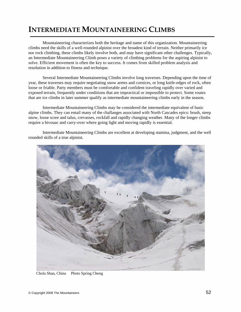
© Copyright 2008 The Mountaineers 52
INTERMEDIATE MOUNTAINEERING CLIMBS Mountaineering characterizes both the heritage and name of this organization. Mountaineering
climbs need the skills of a well-rounded alpinist over the broadest kind of terrain. Neither primarily ice nor rock climbing, these climbs likely involve both, and may have significant other challenges. Typically, an Intermediate Mountaineering Climb poses a variety of climbing problems for the aspiring alpinist to solve. Efficient movement is often the key to success. It comes from skilled problem analysis and resolution in addition to fitness and technique. Several Intermediate Mountaineering Climbs involve long traverses. Depending upon the time of year, these traverses may require negotiating snow aretes and cornices, or long knife-edges of rock, often loose or friable. Party members must be comfortable and confident traveling rapidly over varied and exposed terrain, frequently under conditions that are impractical or impossible to protect. Some routes that are ice climbs in later summer qualify as intermediate mountaineering climbs early in the season. Intermediate Mountaineering Climbs may be considered the intermediate equivalent of basic alpine climbs. They can entail many of the challanges associated with North Cascades epics: brush, steep snow, loose scree and talus, crevasses, rockfall and rapidly changing weather. Many of the longer climbs require a bivouac and carry-over where going light and moving rapidly is essential. Intermediate Mountaineering Climbs are excellent at developing stamina, judgment, and the well rounded skills of a true alpinist.
Chola Shan, China Photo Spring Cheng
© Copyright 2008 The Mountaineers 53
Brothers / Brothers Traverse 6,800’ (N) 6,866’ (S), Olympic Mtns Grade II , 4 Mountaineering Reference & Data • • • • Jurisdiction: Olympic National Forest • Ranger Station: Hoodsport Ranger Station / 360-877-5254
• Equipment: Ice axe, crampons, short picket, minimal rack. • USGS Maps: The Brothers
• Other Map: Olympic National Park • Other ref: Climber’s Guide to the Olympic Mountains, 3rd Edition, pp. 46-48. • Reference 3: 100 Hikes in Washington’s S Cascades and Olympics, pp. 176-177
Time Elevation gain/loss Mileage • Seattle to TH 2 hrs 685’ 58 • TH to Camp 4 hrs +2,400’ 7 • Camp to S Summit 8-9 hrs +3,800’ • S Summit to Cars 5-6 hrs -6,200’
Approach • • • • • • • • • • • Take ferry to Bremerton and drive via State 3 and State 106 to US 101 and turn right (or drive via
Tacoma Narrows Bridge or I-5 via Olympia). Drive US 101 N along Hood Canal. 13.5 mi. N of Hoodsport, turn left onto Hamma Hamma River Rd. No. 25. Drive 9.5 miles (0.5 mi. past Phantom Creek) to Lena Lakes Trailhead, 685’. Hike Lena Lakes trail to Lower Lena Lake (3 mi.), and around the lake clockwise to The Brothers climber’s trail. Follow this along E Fork of Lena Creek into Valley of Silent Men (see 100 Hikes map), crossing/recrossing creek. At 3.2 mi. Lena Creek will fork, with a branch entering from the W. Cross to W bank of E. Fork Lena Creek just upstream to reach Lena Forks camp, 3,000’, often crowded on weekends.
Climbing Route • • • • • The traverse can be done in either direction but most parties opt for a N Peak to S Peak traverse.
Locate the climbers path heading upstream W from Lena camp. Follow until the path becomes indistinct in a large meandering gully before reaching the base of South Brother’s S Couloir deposition fan. Snow may be present. Climb up the S Couloir to just before its cental constriction. Rocky slopes offer an exit right at ~5,000’ to an open rocky slope (known as Lunch Rock -- possible cairn) below a group of trees. From Lunch Rock, ascend broad, sparsely-treed tongue, initially paralleling the S Couloir (possible bivy sites), but gradually bear R and E to depart S Couloir climbing route. At ~5,700’, traverse E, skirting under a yellow-stained rock nose, identifiable from below, and into a small basin above the first major chute E of S Couloir. Above this basin, a narrow couloir leads to a notch in the E Ridge at ~6,000’ (possible cairn W of small tower splitting notch, not visible from basin itself). Pass through notch and descend into the Great Basin. Traverse to the North Brother, to where the ascent couloir faces SE to E and has a prominent rock prow splitting its lower aspect. The couloir emerges on the ridge, with summit close to the R. The ridge to South Brother is now visible with, in early season, much steep, exposed and sometimes corniced snow. A hundred or more feet of airy ridge lead to a rare gently-rounded section before descending steeply (some party members may want a belay) to a notch before a pinnacle. This gendarme’s E side can be passed where a flat spot below an outcrop is apparent, perhaps 100’ below its top. From the base of the outcrop, climb and traverse steeply up to regain the ridge. An exposed short drop in the ridge, followed by a traverse W around a block, gains the final notch. A steep rock step (caution advised if wet from snow melt above) accesses the remaining snow/rock crest of South Brother’s N Ridge.
Descent • • • • • • • • • • • Descend via the South Brother South Couloir route (see Basic Climbs Guide). Comments • • • • • • • • • Viewable from Seattle, this classic mountaineering climb is best done in early season (i.e., April or
May) due to dense brush encountered later in gullies. Loose rock abounds. The climb is long, strenuous, and exposed but not technically difficult. Start early. Identifying the correct notch to the Great Basin is the chief route-finding challenge. Leaders should consider restricting party size to 4.
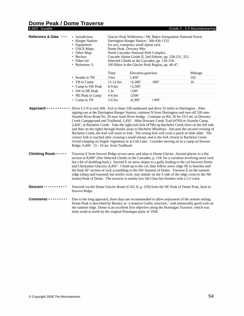
© Copyright 2008 The Mountaineers 54
Dome Peak / Dome Traverse 8,920’, Suiattle Grade II , 5.5 Mountaineering Reference & Data • • • • Jurisdiction: Glacier Peak Wilderness / Mt. Baker-Snoqualmie National Forest • Ranger Station: Darrington Ranger Station / 360-436-1155
• Equipment: Ice axe, crampons; small alpine rack. • USGS Maps: Dome Peak, Downey Mtn
• Other Map: North Cascades National Park Complex. • Beckey: Cascade Alpine Guide II, 2nd Edition, pp. 228-231, 352. • Other ref: Selected Climbs in the Cascades, pp. 116-118. • Reference 3: 100 Hikes in the Glacier Peak Region, pp. 46-47.
Time Elevation gain/loss Mileage • Seattle to TH 3 hrs 1,450’ 102 • TH to Camp 11-12 hrs +6,300’ -300’ 16 • Camp to SW Peak 6-9 hrs +2,500’ • SW to NE Peak 1 hr +100’ • NE Peak to Camp 4-6 hrs -2500’ • Camp to TH 5-6 hrs -6,300’ +300’
Approach • • • • • • • • • • • Drive I-5 N to exit 208. Exit to State 530 eastbound and drive 32 miles to Darrington. After
signing out at the Darrington Ranger Station, continue N from Darrington and turn off 530 onto Suiattle River Road No. 26 near Sauk River bridge. Continue on Rd. 26 for 19.5 mi. to Downey Creek Campground and Trailhead, 1,450’. Hike Downey Creek Trail (#783) to Sixmile Camp, 2,420’, at Bachelor Creek. Take the right trail fork (#796) up Bachelor Creek (first on the left side and then on the right) through brushy areas to Bachelor Meadows. Just past the second crossing of Bachelor Creek, the trail will seem to fork. The wrong fork will cross a patch of slide alder. The correct fork is reached after crossing a small stream, and is the fork closest to Bachelor Creek. Avoid camping on fragile vegetation or at Cub Lake. Consider moving on to a camp on Itswoot Ridge, 6,400’, 15 - 16 mi. from Trailhead.
Climbing Route • • • • • Traverse E from Itswoot Ridge across snow and talus to Dome Glacier. Ascend glacier to a flat
section at 8,000’ (See Selected Climbs in the Cascades, p. 118, for a variation involving more rock but a bit of doubling-back.) Ascend E on snow slopes to a gully leading to the col between Dome and Chickamin Glaciers, 8,450’. Climb up to the col, then follow snow ridge SE to benches and the final 50’ section of rock scrambling to the SW Summit of Dome. Traverse E on the summit ridge (sharp and exposed, but terrific rock; stay mainly on the S side of the ridge crest) to the NE (main) Peak of Dome. The traverse is mainly low 5th Class but finishes with a 5.5 crack.
Descent • • • • • • • • • • • Descend via the Dome Glacier Route (CAG II, p. 229) from the NE Peak of Dome Peak, back to
Itswoot Ridge. Comments • • • • • • • • • Due to the long approach, three days are recommended to allow enjoyment of the remote setting.
Dome Peak is described by Beckey as ‘a massive Gothic structure,’ with memorably good rock on the summit ridge. Dome is an excellent first objective along the Ptarmigan Traverse, which was done south to north by the original Ptarmigan party of 1938.
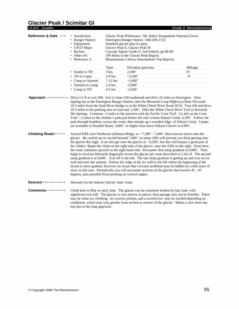
© Copyright 2008 The Mountaineers 55
Glacier Peak / Scimitar Gl 10,541’, Suiattle Grade II Mountaineering Reference & Data • • • • Jurisdiction: Glacier Peak Wilderness / Mt. Baker-Snoqualmie National Forest • Ranger Station: Darrington Ranger Station / 360-436-1155
• Equipment: Standard glacier plus ice gear. • USGS Maps: Glacier Peak E, Glacier Peak W
• Beckey: Cascade Alpine Guide II, 2nd Edition, pp 88-89. • Other ref: 100 Hikes in the Glacier Peak Region. • Reference 3: Mountaineers Library Intermediate Trip Reports.
Time Elevation gain/loss Mileage • Seattle to TH 3 hrs 2,300’ 97 • TH to Camp 5-8 hrs +3,200’ ~8 • Camp to Summit 7-12 hrs +5,000’ • Summit to Camp 2-4 hrs -5,000’ • Camp to TH 4-5 hrs -3,200’
Approach • • • • • • • • • • • Drive I-5 N to exit 208. Exit to State 530 eastbound and drive 32 miles to Darrington. After
signing out at the Darrington Ranger Station, take the Mountain Loop Highway (State 92) south 10.5 miles from the Sauk River bridge to to the White Chuck River Road (#23). Turn left and drive 10.5 miles to the parking area at road end, 2,300’. Hike the White Chuck River Trail to Kennedy Hot Springs. Continue ~2 miles to the junction with the Pacific Crest Trail. Go left on the Crest Trail ~.5 miles to the climber’s path just before the trail crosses Sitkum Creek, 4,100’. Follow the path through boulders, across the creek, then steeply up a wooded ridge of Sitkum Creek. Camps are available in Boulder Basin, 5,600’, or higher near lower Sitkum Glacier at 6,900’.
Climbing Route • • • • • Ascend ENE over Northwest (Sitkum) Ridge, to ~ 7,200’ - 7,400’, then traverse down onto the
glacier. Be careful not to ascend beyond 7,400’, as steep cliffs will prevent you from getting onto the glacier this high. (Can also get onto the glacier at ~ 8,200’, but this will bypass a good part of the climb.) Begin the climb on the right side of the glacier, near the cliffs on the right. From here, the route continues upward on the right hand side. Encounter first steep gradient at 8,000’. Then begin to traverse leftwards diagonally across the glacier per route described in CAG II. The second steep gradient is at 9,000’. Exit off to the left. The last steep gradient is getting up and over an ice wall and onto the summit. Follow the ridge of the ice wall to the left where the beginning of the ascent is more gradual, however, be aware that crevasse problems may be hidden by a thin layer of snow in this area. Periodically you will encounter sections of the glacier that involve 45 - 50 degrees, plus possible front pointing on vertical angles.
Descent • • • • • • • • • • • Descend via the Sitkum Glacier, basic route. Comments • • • • • • • • • Climb best in May or early June. The glacier can be extremely broken by late June, with
significant rock fall. The glacier is very narrow in places, thus passage may not be feasible. There may be some ice climbing. Ice screws, pickets, and a second tool may be needed depending on conditions, which may vary greatly from section to section of the glacier. Makes a nice three day trip due to the long approach.
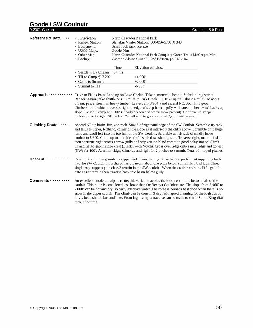
© Copyright 2008 The Mountaineers 56
Goode / SW Coulouir 9,200’, Chelan Grade II , 5.0 Rock Reference & Data • • • • Jurisdiction: North Cascades National Park • Ranger Station: Stehekin Visitor Station / 360-856-5700 X 340
• Equipment: Small rock rack, ice axe • USGS Maps: Goode Mtn.
• Other Map: North Cascades National Park Complex; Green Trails McGregor Mtn. • Beckey: Cascade Alpine Guide II, 2nd Edition, pp 315-316.
Time Elevation gain/loss • Seattle to Lk Chelan 3+ hrs • TH to Camp @ 7,200’ +4,900’ • Camp to Summit +2,000’ • Summit to TH -6,900’
Approach • • • • • • • • • • • Drive to Fields Point Landing on Lake Chelan. Take commercial boat to Stehekin; register at
Ranger Station; take shuttle bus 18 miles to Park Creek TH. Hike up trail about 4 miles, go about 0.1 mi. past a stream in heavy timber. Leave trail (3,960’) and ascend NE. Soon find good climbers’ trail, which traverses right, to edge of steep barren gully with stream, then switchbacks up slope. Passable camp at 6,500’ (if early season and water/snow present). Continue up steeper, rockier slope to right (SE) side of “small alp” to good camp at 7,200’ with water.
Climbing Route • • • • • Ascend NE up basin, firn, and rock. Stay S of righthand edge of the SW Couloir. Scramble up rock
and talus to upper, lefthand, corner of the slope as it intersects the cliffs above. Scramble onto huge ramp and stroll left into the top half of the SW Couloir. Scramble up left side of mildly loose couloir to 8,800. Climb up to left side of 40’-wide downsloping slab. Traverse right, on top of slab, then continue right across narrow gully and step around blind corner to good belay stance. Climb up and left to gap in ridge crest (Black Tooth Notch). Cross over ridge onto sandy ledge and go left (NW) for 100’. At minor ridge, climb up and right for 2 pitches to summit. Total of 4 roped pitches.
Descent • • • • • • • • • • • Descend the climbing route by rappel and downclimbing. It has been reported that rappelling back
into the SW Couloir via a sharp, narrow notch about one pitch below summit is a bad idea. Three single-rope rappels gain class 3 terrain in the SW couloir. When the couloir ends in cliffs, go left onto easier terrain then traverse back into basin below gully.
Comments • • • • • • • • • An excellent, moderate alpine route; this variation avoids the looseness of the bottom half of the
couloir. This route is considered less loose than the Bedayn Couloir route. The slope from 3,960’ to 7,000’ can be hot and dry, so carry adequate water. The route is perhaps best done when there is no snow in the upper couloir. The climb can be done in 3 days with good planning for the logistics of drive, boat, shuttle bus and hike. From high camp, a traverse can be made to climb Storm King (5.0 rock) if desired.
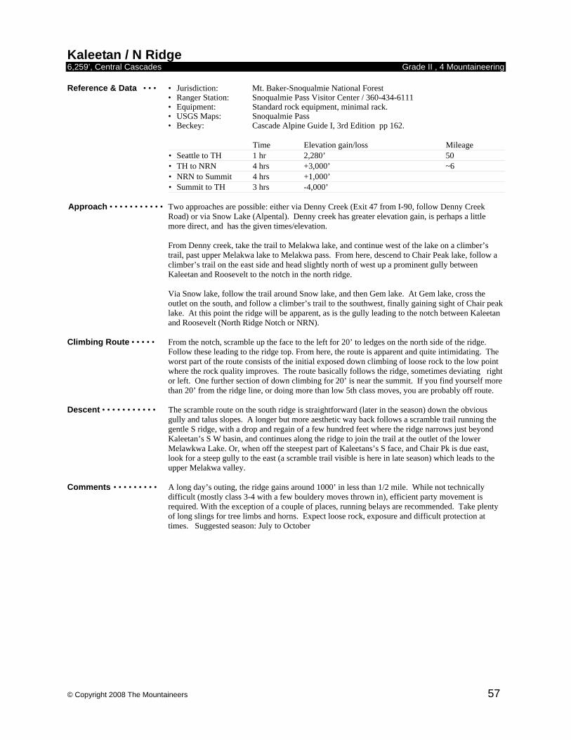
© Copyright 2008 The Mountaineers 57
Kaleetan / N Ridge 6,259’, Central Cascades Grade II , 4 Mountaineering Reference & Data • • • • Jurisdiction: Mt. Baker-Snoqualmie National Forest • Ranger Station: Snoqualmie Pass Visitor Center / 360-434-6111
• Equipment: Standard rock equipment, minimal rack. • USGS Maps: Snoqualmie Pass
• Beckey: Cascade Alpine Guide I, 3rd Edition pp 162.
Time Elevation gain/loss Mileage • Seattle to TH 1 hr 2,280’ 50 • TH to NRN 4 hrs +3,000’ ~6 • NRN to Summit 4 hrs +1,000’ • Summit to TH 3 hrs -4,000’
Approach • • • • • • • • • • • Two approaches are possible: either via Denny Creek (Exit 47 from I-90, follow Denny Creek
Road) or via Snow Lake (Alpental). Denny creek has greater elevation gain, is perhaps a little more direct, and has the given times/elevation. From Denny creek, take the trail to Melakwa lake, and continue west of the lake on a climber’s trail, past upper Melakwa lake to Melakwa pass. From here, descend to Chair Peak lake, follow a climber’s trail on the east side and head slightly north of west up a prominent gully between Kaleetan and Roosevelt to the notch in the north ridge. Via Snow lake, follow the trail around Snow lake, and then Gem lake. At Gem lake, cross the outlet on the south, and follow a climber’s trail to the southwest, finally gaining sight of Chair peak lake. At this point the ridge will be apparent, as is the gully leading to the notch between Kaleetan and Roosevelt (North Ridge Notch or NRN).
Climbing Route • • • • • From the notch, scramble up the face to the left for 20’ to ledges on the north side of the ridge.
Follow these leading to the ridge top. From here, the route is apparent and quite intimidating. The worst part of the route consists of the initial exposed down climbing of loose rock to the low point where the rock quality improves. The route basically follows the ridge, sometimes deviating right or left. One further section of down climbing for 20’ is near the summit. If you find yourself more than 20’ from the ridge line, or doing more than low 5th class moves, you are probably off route.
Descent • • • • • • • • • • • The scramble route on the south ridge is straightforward (later in the season) down the obvious
gully and talus slopes. A longer but more aesthetic way back follows a scramble trail running the gentle S ridge, with a drop and regain of a few hundred feet where the ridge narrows just beyond Kaleetan’s S W basin, and continues along the ridge to join the trail at the outlet of the lower Melawkwa Lake. Or, when off the steepest part of Kaleetans’s S face, and Chair Pk is due east, look for a steep gully to the east (a scramble trail visible is here in late season) which leads to the upper Melakwa valley.
Comments • • • • • • • • • A long day’s outing, the ridge gains around 1000’ in less than 1/2 mile. While not technically
difficult (mostly class 3-4 with a few bouldery moves thrown in), efficient party movement is required. With the exception of a couple of places, running belays are recommended. Take plenty of long slings for tree limbs and horns. Expect loose rock, exposure and difficult protection at times. Suggested season: July to October
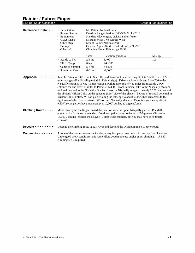
© Copyright 2008 The Mountaineers 58
Rainier / Fuhrer Finger 14,410’, South Cascades Grade II Mountaineering Reference & Data • • • • Jurisdiction: Mt. Rainier National Park • Ranger Station: Paradise Ranger Station / 360-569-2211 x2314
• Equipment: Standard Glacier gear, pickets and/or flukes. • USGS Maps: Mt Rainier East, Mt Rainier West
• Other Map: Mount Rainier National Park. • Beckey: Cascade Alpine Guide I, 3rd Edition, p. 98-99. • Other ref: Climbing Mount Rainier, pp 96-99.
Time Elevation gain/loss Mileage • Seattle to TH 2.5 hrs 5,400’ 100 • TH to Camp 6 hrs +4,100’ • Camp to Summit 5-7 hrs +4,900’ • Summit to Cars 6-8 hrs -9,000’
Approach • • • • • • • • • • • Take I-5 S to exit 142. Exit to State 161 and drive south until exiting at State 512W. Travel 2-3
miles and get off at Puyallup exit (Mt. Rainier sign). Drive via Eatonville and State 706 to the Nisqually entrance to Mt. Rainier National Park (approximately 80 miles from Seattle). Pay entrance fee and drive 19 miles to Paradise, 5,400’. From Paradise, hike to the Nisqually Moraine trail and descend to the Nisqually Glacier. Cross the Nisqually at approximately 6,200’ and ascend the obvious Wilson Gully on the opposite (west) side of the glacier. Beware of rockfall potential in Wilson Gully. Follow Wilson glacier along the left edge to about 9,000’, then cut across to the right towards the cleaver between Wilson and Nisqually glaciers. There is a good camp site at 9,500’, some parties have made camp at 10,000’ but had to dig platforms.
Climbing Route • • • • • Move directly up the finger toward the junction with the upper Nisqually glacier. Rockfall
potential, hard hats recommended. Continue up the slopes to the top of Wapowety Cleaver at 13,000’, staying left near the cleaver. Climb levels out here, but you may have to negotiate crevasses.
Descent • • • • • • • • • • • Descend the climbing route or carryover and descend the Disappointment Cleaver route. Comments • • • • • • • • • As one of the shortest routes on Rainier, a very fast party can climb it in one day from Paradise.
Under good snow conditions, this route offers good moderate-angles snow climbing. A $30 climbing fee is required.
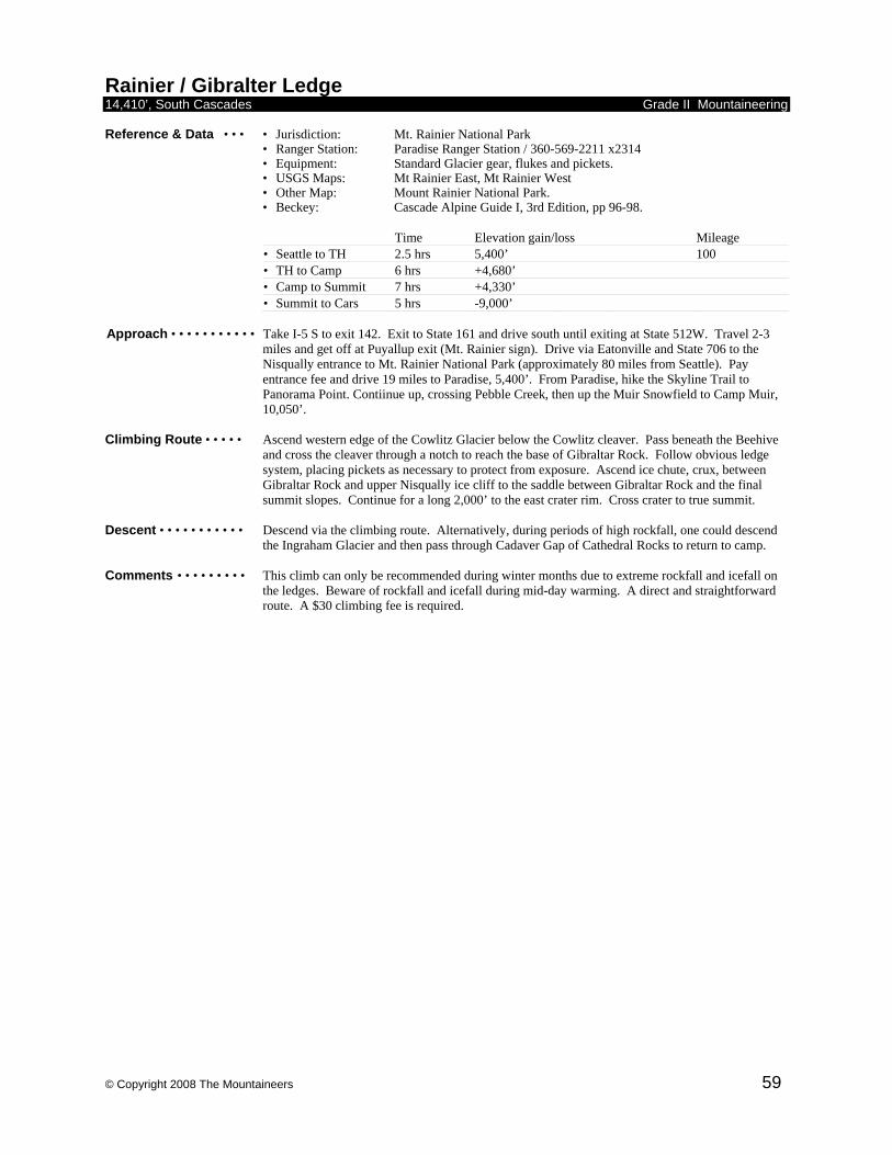
© Copyright 2008 The Mountaineers 59
Rainier / Gibralter Ledge 14,410’, South Cascades Grade II Mountaineering Reference & Data • • • • Jurisdiction: Mt. Rainier National Park • Ranger Station: Paradise Ranger Station / 360-569-2211 x2314
• Equipment: Standard Glacier gear, flukes and pickets. • USGS Maps: Mt Rainier East, Mt Rainier West
• Other Map: Mount Rainier National Park. • Beckey: Cascade Alpine Guide I, 3rd Edition, pp 96-98.
Time Elevation gain/loss Mileage • Seattle to TH 2.5 hrs 5,400’ 100 • TH to Camp 6 hrs +4,680’ • Camp to Summit 7 hrs +4,330’ • Summit to Cars 5 hrs -9,000’
Approach • • • • • • • • • • • Take I-5 S to exit 142. Exit to State 161 and drive south until exiting at State 512W. Travel 2-3
miles and get off at Puyallup exit (Mt. Rainier sign). Drive via Eatonville and State 706 to the Nisqually entrance to Mt. Rainier National Park (approximately 80 miles from Seattle). Pay entrance fee and drive 19 miles to Paradise, 5,400’. From Paradise, hike the Skyline Trail to Panorama Point. Contiinue up, crossing Pebble Creek, then up the Muir Snowfield to Camp Muir, 10,050’.
Climbing Route • • • • • Ascend western edge of the Cowlitz Glacier below the Cowlitz cleaver. Pass beneath the Beehive
and cross the cleaver through a notch to reach the base of Gibraltar Rock. Follow obvious ledge system, placing pickets as necessary to protect from exposure. Ascend ice chute, crux, between Gibraltar Rock and upper Nisqually ice cliff to the saddle between Gibraltar Rock and the final summit slopes. Continue for a long 2,000’ to the east crater rim. Cross crater to true summit.
Descent • • • • • • • • • • • Descend via the climbing route. Alternatively, during periods of high rockfall, one could descend
the Ingraham Glacier and then pass through Cadaver Gap of Cathedral Rocks to return to camp. Comments • • • • • • • • • This climb can only be recommended during winter months due to extreme rockfall and icefall on
the ledges. Beware of rockfall and icefall during mid-day warming. A direct and straightforward route. A $30 climbing fee is required.
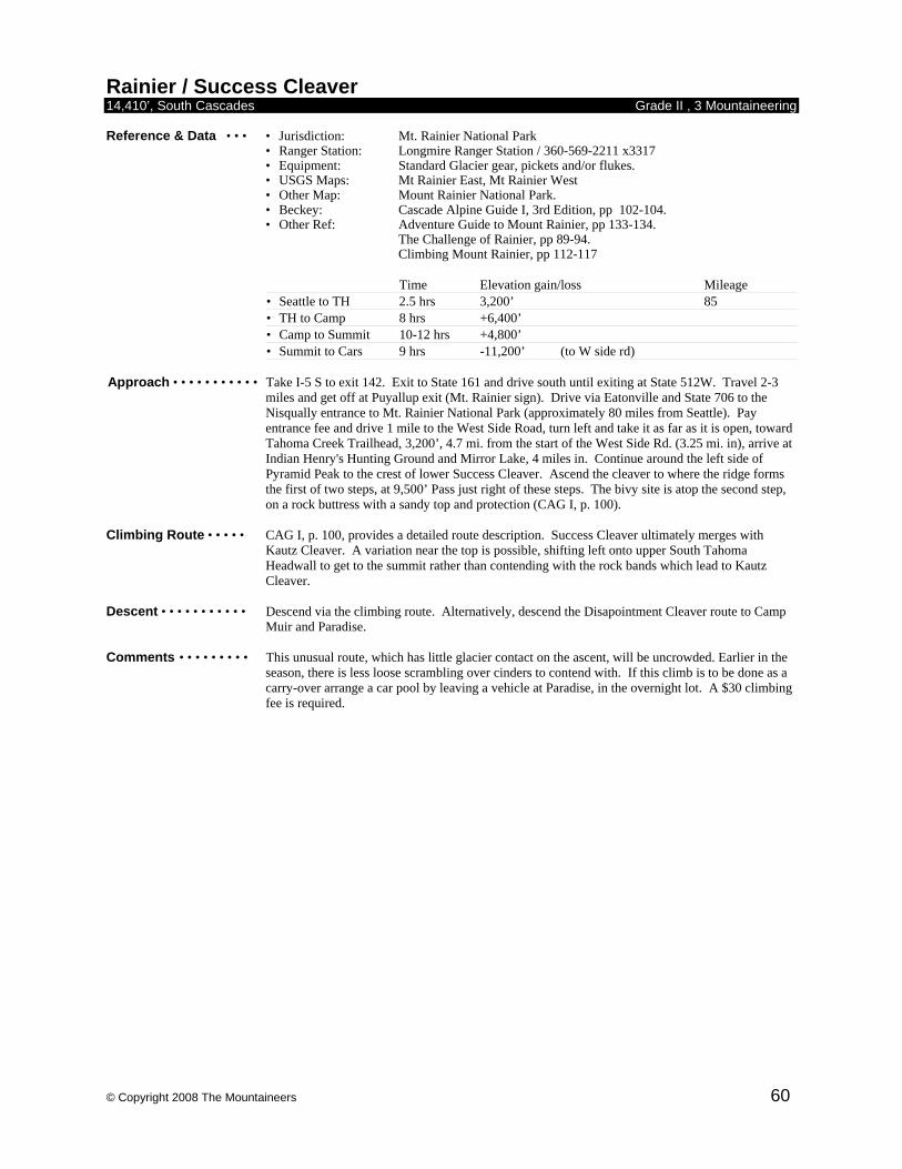
© Copyright 2008 The Mountaineers 60
Rainier / Success Cleaver 14,410’, South Cascades Grade II , 3 Mountaineering Reference & Data • • • • Jurisdiction: Mt. Rainier National Park • Ranger Station: Longmire Ranger Station / 360-569-2211 x3317
• Equipment: Standard Glacier gear, pickets and/or flukes. • USGS Maps: Mt Rainier East, Mt Rainier West
• Other Map: Mount Rainier National Park. • Beckey: Cascade Alpine Guide I, 3rd Edition, pp 102-104. • Other Ref: Adventure Guide to Mount Rainier, pp 133-134. The Challenge of Rainier, pp 89-94. Climbing Mount Rainier, pp 112-117
Time Elevation gain/loss Mileage • Seattle to TH 2.5 hrs 3,200’ 85 • TH to Camp 8 hrs +6,400’ • Camp to Summit 10-12 hrs +4,800’ • Summit to Cars 9 hrs -11,200’ (to W side rd)
Approach • • • • • • • • • • • Take I-5 S to exit 142. Exit to State 161 and drive south until exiting at State 512W. Travel 2-3
miles and get off at Puyallup exit (Mt. Rainier sign). Drive via Eatonville and State 706 to the Nisqually entrance to Mt. Rainier National Park (approximately 80 miles from Seattle). Pay entrance fee and drive 1 mile to the West Side Road, turn left and take it as far as it is open, toward Tahoma Creek Trailhead, 3,200’, 4.7 mi. from the start of the West Side Rd. (3.25 mi. in), arrive at Indian Henry's Hunting Ground and Mirror Lake, 4 miles in. Continue around the left side of Pyramid Peak to the crest of lower Success Cleaver. Ascend the cleaver to where the ridge forms the first of two steps, at 9,500’ Pass just right of these steps. The bivy site is atop the second step, on a rock buttress with a sandy top and protection (CAG I, p. 100).
Climbing Route • • • • • CAG I, p. 100, provides a detailed route description. Success Cleaver ultimately merges with
Kautz Cleaver. A variation near the top is possible, shifting left onto upper South Tahoma Headwall to get to the summit rather than contending with the rock bands which lead to Kautz Cleaver.
Descent • • • • • • • • • • • Descend via the climbing route. Alternatively, descend the Disapointment Cleaver route to Camp
Muir and Paradise. Comments • • • • • • • • • This unusual route, which has little glacier contact on the ascent, will be uncrowded. Earlier in the
season, there is less loose scrambling over cinders to contend with. If this climb is to be done as a carry-over arrange a car pool by leaving a vehicle at Paradise, in the overnight lot. A $30 climbing fee is required.
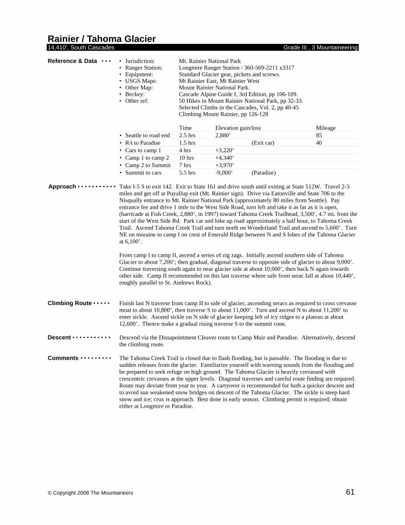
© Copyright 2008 The Mountaineers 61
Rainier / Tahoma Glacier 14,410’, South Cascades Grade III , 3 Mountaineering Reference & Data • • • • Jurisdiction: Mt. Rainier National Park • Ranger Station: Longmire Ranger Station / 360-569-2211 x3317
• Equipment: Standard Glacier gear, pickets and screws. • USGS Maps: Mt Rainier East, Mt Rainier West
• Other Map: Mount Rainier National Park. • Beckey: Cascade Alpine Guide I, 3rd Edition, pp 106-109. • Other ref: 50 Hikes in Mount Rainier National Park, pp 32-33. Selected Climbs in the Cascades, Vol. 2, pp 40-45 Climbing Mount Rainier, pp 126-128
Time Elevation gain/loss Mileage • Seattle to road end 2.5 hrs 2,880’ 85 • R/t to Paradise 1.5 hrs (Exit car) 40 • Cars to camp 1 4 hrs +3,220’ • Camp 1 to camp 2 10 hrs +4,340’ • Camp 2 to Summit 7 hrs +3,970’ • Summit to cars 5.5 hrs -9,000’ (Paradise)
Approach • • • • • • • • • • • Take I-5 S to exit 142. Exit to State 161 and drive south until exiting at State 512W. Travel 2-3
miles and get off at Puyallup exit (Mt. Rainier sign). Drive via Eatonville and State 706 to the Nisqually entrance to Mt. Rainier National Park (approximately 80 miles from Seattle). Pay entrance fee and drive 1 mile to the West Side Road, turn left and take it as far as it is open, (barricade at Fish Creek, 2,880’, in 1997) toward Tahoma Creek Trailhead, 3,500’, 4.7 mi. from the start of the West Side Rd. Park car and hike up road approximately a half hour, to Tahoma Creek Trail. Ascend Tahoma Creek Trail and turn north on Wonderland Trail and ascend to 5,600’. Turn NE on moraine to camp I on crest of Emerald Ridge between N and S lobes of the Tahoma Glacier at 6,100’. From camp I to camp II, ascend a series of zig zags. Initially ascend southern side of Tahoma Glacier to about 7,200’; then gradual, diagonal traverse to opposite side of glacier to about 9,000’. Continue traversing south again to near glacier side at about 10,000’, then back N again towards other side. Camp II recommended on this last traverse where safe from serac fall at about 10,440’, roughly parallel to St. Andrews Rock).
Climbing Route • • • • • Finish last N traverse from camp II to side of glacier, ascending seracs as required to cross crevasse
moat to about 10,800’, then traverse S to about 11,000’. Turn and ascend N to about 11,200’ to enter sickle. Ascend sickle on N side of glacier keeping left of icy ridges to a plateau at about 12,600’. Thence make a gradual rising traverse S to the summit cone.
Descent • • • • • • • • • • • Descend via the Dissapointment Cleaver route to Camp Muir and Paradise. Alternatively, descend
the climbing route. Comments • • • • • • • • • The Tahoma Creek Trail is closed due to flash flooding, but is passable. The flooding is due to
sudden releases from the glacier. Familiarize yourself with warning sounds from the flooding and be prepared to seek refuge on high ground. The Tahoma Glacier is heavily crevassed with crescentric crevasses at the upper levels. Diagonal traverses and careful route finding are required. Route may deviate from year to year. A carryover is recommended for both a quicker descent and to avoid sun weakened snow bridges on descent of the Tahoma Glacier. The sickle is steep hard snow and ice; crux is approach. Best done in early season. Climbing permit is required; obtain either at Longmire or Paradise.
© Copyright 2008 The Mountaineers 62
Twin Sisters / Traverse 6,570’, 6,932’, Nooksack Grade II , 3 Mountaineering Reference & Data • • • • Jurisdiction: Mt. Baker-Snoqualmie National Forest • Ranger Station: Sedro Wooley Ranger Station / 360-856-5700
• Equipment: Ice axe, crampons. Snow flukes in early season. Minimal rack. • USGS Maps: Twin Sisters Mtn, Cavanaugh Ck, Canyon Lake
• Beckey: Cascade Alpine Guide III, 2nd Edition, p. 39-45. • Other ref: Basic Climbs Guide.
Time Elevation gain/loss Mileage • Seattle to TH 2 hrs 3,420’ 85 • TH to NTS 2-4 hrs +3,150’ • NTS to STS 3 hrs +400’ • STS to cars 4 hrs -3,500’
Approach • • • • • • • • • • • Drive I-5 N to exit 232 (Cook Road) at Burlington. Turn east to Sedro Wooley and junction of
State Route 20. Turn left and continue to route 9. Go N on Route 9 to Acme. Route-finding from the Acme grocery store to the Trailhead, 12.5 miles away, is the biggest challenge. Turn right on Mosquito Lake Road, 0.2 - 0.3 mile past the store. and go 9 mi. to steel bridge. Go another 0.75 mi. to FS Road 38. Go right (S) on FS 38 for ~5 mi. Stay right at the 'Y'. Park at the gated bridge across the Nooksack even if the gate is open (1200'). Approach: Cross bridge and hike up the main logging road; do not take any logging roads branching to the left. The four logging roads branching to the right are as follows: 1st - yellow gate across road (.25 mi. from cars). 2nd - recently cut road. 3rd - heavily overgrown, abandoned road. 4th - abandoned, but not very overgrown (2,600', 2.5 mi. from cars). Take this 4th road. At about 0.5 mi. on this abandoned road, go over a tank trap and continue until you reach a fork in the road (3000'), and take the left branch. (The right branch trends downhill toward Dailey Prarie.) Continue until you come to another abandoned road off to the left. A large dead tree lies near the entrance to this road and a gravel diversion blocks its entrance. Follow this road, which will switchback to the trailhead around 4100'. Allow 2-3h.
Climbing Route • • • • • Follow North Twin Sister (NTS) West Ridge route described in Basic Climbs Guide to summit at
easternmost crest of NTS. Descend South Face of NTS, staying to sides of SE gully to minimize rockfall, to the col, (5,800’) between the Twin Sisters. Move S on the Sisters Glacier to the bergschrund (which may be problematic later in the season) and climb up, preferring snow to rock when presented with the choice) to the crest of North Ridge of South Twin Sister (STS) and on to STS summit.
Descent • • • • • • • • • • • Return to the col between the Twin Sisters, via either STS West Ridge or, in early season, the STS
North Face (steep snow; watch for avalanche hazard). The STS West Ridge can become technical (be prepared to rappel) if ridge crest proper is followed. 200 yards from STS false summit, move off ridge to the right; traverse back to ridge crest 500’ lower, then follow ridge crest via cairn route to left and down. Descend the cirque basin toward its right margin back to base trails (at level of clear-cut, traverse right) and spur roads.
Comments • • • • • • • • • This athletic one-day traverse climbs the marvelous rough olivine of the North Twin Sister (and the
somewhat crumbly South Twin). These peaks stand out to the W of the main Cascade Range and are seen prominently from the Mt Baker Highway. Avoid aggravation by scoping out the current road status ahead of time and reviewing recent trip reports. A 1995 report stated, ‘Roads have no signs; following boot tracks led us to the right place.’ Get an early start. A 1983 report noted, ‘For some extra fun, there is nice rock climbing on Arrowtip Tower on the lower part of North Ridge of STS’. Some parties never actually rope up.
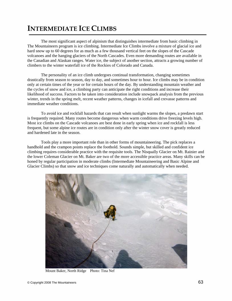
© Copyright 2008 The Mountaineers 63
INTERMEDIATE ICE CLIMBS
The most significant aspect of alpinism that distinguishes intermediate from basic climbing in The Mountaineers program is ice climbing. Intermediate Ice Climbs involve a mixture of glacial ice and hard snow up to 60 degrees for as much as a few thousand vertical feet on the slopes of the Cascade volcanoes and the hanging glaciers of the North Cascades. Even more demanding routes are available in the Canadian and Alaskan ranges. Water ice, the subject of another section, attracts a growing number of climbers to the winter waterfall ice of the Rockies of Colorado and Canada. The personality of an ice climb undergoes continual transformation, changing sometimes drastically from season to season, day to day, and sometimes hour to hour. Ice climbs may be in condition only at certain times of the year or for certain hours of the day. By understanding mountain weather and the cycles of snow and ice, a climbing party can anticipate the right conditions and increase their likelihood of success. Factors to be taken into consideration include snowpack analysis from the previous winter, trends in the spring melt, recent weather patterns, changes in icefall and crevasse patterns and immediate weather conditions. To avoid ice and rockfall hazards that can result when sunlight warms the slopes, a predawn start is frequently required. Many routes become dangerous when warm conditions drive freezing levels high. Most ice climbs on the Cascade volcanoes are best done in early spring when ice and rockfall is less frequent, but some alpine ice routes are in condition only after the winter snow cover is greatly reduced and hardened late in the season. Tools play a more important role than in other forms of mountaineering. The pick replaces a handhold and the crampon points replace the foothold. Sounds simple, but skilled and confident ice climbing requires considerable practice with the requisite tools. The Nisqually Glacier on Mt. Rainier and the lower Coleman Glacier on Mt. Baker are two of the more accessible practice areas. Many skills can be honed by regular participation in moderate climbs (Intermediate Mountaineering and Basic Alpine and Glacier Climbs) so that snow and ice techniques come naturally and automatically when needed.
Mount Baker, North Ridge Photo: Tina Nef
© Copyright 2008 The Mountaineers 64
Adams / Adams Glacier 12,276’, South Cascades Grade II Ice Reference & Data • • • • Jurisdiction: Mt. Adams Wilderness / Gifford Pinchot National Forest • Ranger Station: Trout Lake Ranger Station / 360-395-3400
• Equipment: Ice axe, crampons, possibly second tool, screws, flukes, pickets. • USGS Maps: Mt. Adams East and West.
• Beckey: Cascade Alpine Guides I, 3rd Edition, pp 62.. • Other ref: Selected Climbs in the Cascades, pp 26-27. Classic Climbs in the Northwest, pp 260-264.
Time Elevation gain/loss Mileage • Seattle to TH 3-4 hrs 4,584’ 148 • TH to Camp 3-4 hrs +2,400’ • Camp to Summit 7-9 hrs +5,300’ • Summit to Cars 5-8 hrs -7,900’
Approach • • • • • • • • • • • Three routes on Adams, N Face of NW Ridge, North Lyman Glacier and Adams Glacier, share the
same approach, although choice of camp may vary. Take I-5 S to exit 142. Exit to State 161 and drive south until exiting at State 512W. Travel 2-3 miles and get off at Puyallup exit (Mt. Rainier sign). Drive via Eatonville to State 7, S. Drive south 27 miles to Morton and turn left at State 12 and drive east 17 miles to Randle. After registration at Randle Ranger Station drive south on Road 23 for 32 miles. Turn left on Road 2329 for 5.7 miles to Killen Creek Trailhead, 4,584’, (approx. 3-4 miles from Taklakh Lake, also see CAG I, p. 312). Follow the trail past the Pacific Crest Trail (pay attention, do not follow the PCT) and towards high camp in the meadows at 6,900’. With heavy snow, getting lost finding camp is easy, so keep your bearings. Established camps have access to water and good views of the mountain and the route. A higher bivy on snow is possible, however this entails a detour on the descent. The start of route is about 1-2 hrs from camp. Beware of fragile meadows.
Climbing Route • • • • • Route goes up the Adams Glacier: exact choice of route will depend on conditions. Lately, most
parties have gone up on the right side of the glacier about 2/3 of the way, then worked left to avoid crevasses. Moderate angle snow/ice climbing, especially in early season. In July, negotiating crevasses may be tricky and some parties were unable to find route.
Descent • • • • • • • • • • • Descend the North Ridge down loose scree and boulders. This part of the climb is long, tedious,
sometimes dangerous, and universally described as the most unpleasant part of the climb by far. Consult Beckey’s N Ridge Route description for details.
Comments • • • • • • • • • A very popular intermediate route, and a good beginning ice climb. Check on road conditions, and
snowshoes may come in handy if there is a lot of snow. While a carryover and descent of the South Ridge is possible, a long car shuttle from Road 2329 to Cold Springs becomes necesary. Some parties are willing to go through a lot of trouble to avoid the infamous North Ridge. A snow finger on the NW Ridge has been suggested as an alternative descent. Hike down the North Ridge approximately 1/4 of the way down and work left down climbing on loose rock to snow finger. Be careful of rock fall down the North Ridge. Climbing fee and trail park pass required at trailhead. Ranger station closed weekends.
© Copyright 2008 The Mountaineers 65
Adams / N Face of NW Ridge 12,276’, South Cascades Grade II Ice Reference & Data • • • • Jurisdiction: Mt. Adams Wilderness / Gifford Pinchot National Forest • Ranger Station: Trout Lake Ranger Station / 360-395-3400
• Equipment: Two tools, pickets, ice screws in late season. • USGS Maps: Mt. Adams East and West.
• Beckey: Cascade Alpine Guides I, 3rd Edition, pp 62.
Time Elevation gain/loss Mileage • Seattle to TH 3-4 hrs 4,584’ 148 • TH to Camp 3-4 hrs +2,900’ • Camp to Summit 10-12 hrs +4,800’ • Summit to Cars 5-8 hrs -7,900’
Approach • • • • • • • • • • • Three routes on Adams, N Face of NW Ridge, North Lyman Glacier and Adams Glacier, share the
same approach, although choice of camp may vary. Take I-5 S to exit 142. Exit to State 161 and drive south until exiting at State 512W. Travel 2-3 miles and get off at Puyallup exit (Mt. Rainier sign). Drive via Eatonville to State 7, S. Drive south 27 miles to Morton and turn left at State 12 and drive east 17 miles to Randle. After registration at Randle Ranger Station drive south on Road 23 for 32 miles. Turn left on Road 2329 for 5.7 miles to Killen Creek Trailhead, 4,584’, (approx. 3-4 miles from Taklakh Lake, also see Beckey p. 312). Follow the trail past the Pacific Crest Trail (pay attention, do not follow the PCT) and up to meadows at 7,500’ and camp. Locate camp for return down from the north ridge. The ascent and descent are in view from the camp. Water is available. Beware of fragile meadows at camp.
Climbing Route • • • • • Climb to the base of the Adams Glacier. The North Face of the NW Ridge route is usually not
accessible at its base due to a large shrund. Ascend the Adams Glacier and traverse onto the North Face route after crossing crevasses on the west side of the Adams Glacier. The North Face route is 2,000 to 2,500’ of sustained 45 degree climbing. The route eases as it nears the false west summit. Traverse east onto the summit plateau and proceed to true summit. Route finding is not a problem.
Descent • • • • • • • • • • • Descend the North Ridge down loose scree and boulders. This part of the climb is long, tedious,
occasionally dangerous, and universally described as the most unpleasant part of the climb by far. Consult Beckey’s N Ridge Route description for details.
Comments • • • • • • • • • Climb is subject to rockfall in warmer conditions. In early season, a road approach from the
northeast to the trailhead may melt out sooner (consult Forest Service for latest conditions). Climbing fee and trail park pass required at trailhead. Ranger station closed weekends.
© Copyright 2008 The Mountaineers 66
Adams / N Lyman Glacier 12,276’, South Cascades Grade II Ice Reference & Data • • • • Jurisdiction: Mt. Adams Wilderness / Gifford Pinchot National Forest • Ranger Station: Trout Lake Ranger Station / 360-395-3400
• Equipment: Standard glacier gear, ice screws, pickets and second tool. • USGS Maps: Mt. Adams East and West.
• Beckey: Cascade Alpine Guides I, 3rd Edition, p 64, descent p 62
Time Elevation gain/loss Mileage • Seattle to TH 3-4 hrs 4,584’ 148 • TH to Camp 4+ hrs +3,724’ • Camp to Summit 8 hrs +4,276’ • Summit to Cars 5-8 hrs -7,900’
Approach • • • • • • • • • • • Three routes on Adams, N Face of NW Ridge, North Lyman Glacier and Adams Glacier, share the
same approach, although choice of camp may vary. Take I-5 S to exit 142. Exit to State 161 and drive south until exiting at State 512W. Travel 2-3 miles and get off at Puyallup exit (Mt. Rainier sign). Drive via Eatonville to State 7, S. Drive south 27 miles to Morton and turn left at State 12 and drive east 17 miles to Randle. After registration at Randle Ranger Station drive south on Road 23 for 32 miles. Turn left on Road 2329 for 5.7 miles to Killen Creek Trailhead, 4,584’, (approx. 3-4 miles from Taklakh Lake, also see Beckey p. 312). Follow the trail past the Pacific Crest Trail (pay attention, do not follow the PCT) and up to meadows then traverse to base of North Ridge at 8,000’ and camp.
Climbing Route • • • • • Traverse from camp across lava fields and across the Lava Glacier and around or over the toe of
Lava Ridge to the base of the Lyman Glacier, 8,000’. Climb up and diagonal left as route allows. Ascend through a chute at 10,000’ to gain access to upper mountain. Moderate open slopes and a few large crevasses and bergschrunds must be negotiated to reach summit plateau. The summit is a long walk to the Southwest.
Descent • • • • • • • • • • • Descend the North Ridge down loose scree and boulders. This part of the climb is long, tedious,
sometimes dangerous, and universally described as the most unpleasant part of the climb by far. Consult Beckey’s N Ridge Route description for details.
Comments • • • • • • • • • An early start is essential. The traverse from camp to the Lyman takes 1 hour. The crux chute at
10,000’ can vary between 45 and 65 degrees, for about 50’, depending on the year.

© Copyright 2008 The Mountaineers 67
Baker / N Ridge 10,778’, Nooksack Grade II Ice Reference & Data • • • • Jurisdiction: Mt. Baker Wilderness / Mt. Baker-Snoqualmie National Forest • Ranger Station: Glacier Visitor Center / 360-599-2714
• Equipment: Ice tools, pickets, and crampons. • USGS Maps: Mt. Baker
• Beckey: Cascade Alpine Guide III, 2nd Edition, pp 32-33. • Other ref: Selected Climbs in the Cascades, pp. 204-206. 100 Hikes in the North Cascades, Hike #1, Heliotrope Ridge. Classic Climbs in the Northwest, pp 92-95.
Time Elevation gain/loss Mileage • Seattle to TH 3 hrs 3,700’ 133 • TH to Camp 4-6 hrs +3,100’ • Camp to Summit 7-10 hrs +4,000’ • Summit to Cars 5 hrs -7,100’
Approach • • • • • • • • • • • Drive I-5 N to Bellingham exit 255. Drive Hwy 542 east 33 miles to the town of Glacier and get
permit at Glacier Ranger Station. One mile east of Glacier, turn south on Glacier Creek Road 39and drive 8 miles S to Mt. Baker Trailhead, 3,700’. Follow well-established trail to Heliotrope Ridge, then traverse Coleman Glacier to bivy campsite at 6,800’.
Climbing Route • • • • • From Coleman Glacier campsite, travel as directly to North Ridge as crevasses will allow. Avoid
passing directly beneath Roman Nose and Coleman Headwall. Gain North Ridge by ascending its west slope, then continue up ridge as it steepens below ice wall at 9,600’. This ice wall is the steepest, most technical part of the climb. Above ice wall, the ridge lays back to an easy gradient. Near the top, make a leftward traverse at the final ice formation to reach summit plateau.
Descent • • • • • • • • • • • Descend standard route via Roman Wall and Coleman Glacier. Comments • • • • • • • • • Climb is quite popular and bottlenecks sometimes occur on ice wall.
© Copyright 2008 The Mountaineers 68
Buckner / N Face 9,114’, Cascade Pass Grade II Ice Reference & Data • • • • Jurisdiction: North Cascades National Park • Ranger Station: Marblemount Ranger Station / 360-873-4500
• Equipment: 4 ice screws & 3 pickets per team, crampons, ice axe, 2nd tool • USGS Maps: Cascade Pass, Goode Mtn., Mt. Logan.
• Beckey: Cascade Alpine Guide II, 2nd Edition, pp 308-309. • Other ref: Selected Climbs in the Cascades, pp 130-134. Classic Climbs of the Northwest, pp 115-118
Time Elevation gain/loss Mileage • Seattle to TH 3 hrs 3,700’ 133 • TH to Camp 3-5 hrs +3,900’ • Camp to Climb 3-4 hrs +200’ (net) • On climb 3 hrs +1,300’ • Summit to TH 5-6 hrs - 6,000’ +700’
Approach • • • • • • • • • • • Drive I-5 N to exit 232 (Cook Road) at Burlington. Turn east to Sedro Wooley and junction of
State Route 20. Turn left and continue 47 miles to Marblemount for climb registration and trip permits at Park R.S. From Marblemount take the Cascade River Road (Forest Service 15) for 22.9 miles to the Cascade Pass Parking Area. Hike trail to Cascade Pass and then up Sahale Arm path to moraine flats, 7,600’. If not doing a carry-over, camp near the toe of Sahale Glacier in sight of Sahale Peak. An alternate approach via Boston Basin trail climbs to the Boston-Sahale Col via Quien Sabe Glacier. Ascend toward Sahale Peak up broad S facing glacier by bearing right on gentlest gradient to right side of upper slope. Work to the head of a shallow, steep, cruddy gully on right side of Sahale pyramid and climb over the summit and down to the Boston Sahale-Col. Follow ridge of loose rock toward Boston Peak over several rock humps until an easy ledge system leads to Boston Glacier. For a carry-over, camp on flats beneath Boston. After descending initial steep snow in direction of Buckner, a high line across glacier leads directly to base of face.
Climbing Route • • • • • Work left of any bergschrund, back right to center of lower face and straight up until upper rock
cliffs force several pitches leftward in a rising traverse. Within 200’ of summit go left around a craggy-looking outcrop at end of upper cliffs then back rightward to gain the summit.
Descent • • • • • • • • • • • Descend SW face (gullies, scree, snow) on fall line to about 7,200’. Taverse down and right to
cross cirque of Horshoe Basin on broad ledge system (the middle one) at 6,200-6,400’ (passing right near entrance to Davenport Mine) to a snow finger at same elevation. Ascend snow finger 100’ to gain rounded ridge above ridge toe. Scramble 40’ up steep rock steps then ascend 300’ on paths through heather and rock on ridge crest keeping Davenport Glacier in sight most of the time. When ridge steepens, traverse up and left on slabs and snow above glacier debris to moraine flats beneath Sahale.
Comments • • • • • • • • • This route can be done with a camp on the Sahale Moraine or as a carry-over with a camp on
Boston Glacier. With light packs, a carry-over will make for a much shorter second day. If camping on Boston Glacier, the Quien Sabe Glacier route to the Boston-Sahale col is more direct. Permits for the Sahale Moraine camp go very fast on summer weekends. The ranger will inspect the camp and give citations to parties camped there without appropriate permit ($140 in 1997).
© Copyright 2008 The Mountaineers 69
Castle Towers / NW Face 8,778’, British Columbia Grade III-IV Ice Reference & Data • • • • Jurisdiction: British Columbia
• Equipment: 4 ice screws & 3 pickets per team, crampons, ice axe, 2nd tool • Reference: Alpine Select, pp. 186-187.
Time Elevation gain/loss Mileage • TH to Camp 5-7 hrs +4,400 • Camp to summit 5-7 hrs • On climb 4-6 hrs • Summit to TH 5-6 hrs
Approach • • • • • • • • • • • Drive Highway 99N to Garibaldi Park. Trail hiking, then cross-country and glacier travel brings
you to Gentian Pass and bivy sites. Climbing Route • • • • • Traverse from bivy (1hr), then work around crevasses on steepening glacier. Cross bergschrund
(potentially problematic) to steep ice apron. Ascend apron in 5 - 6 pitches. Numerous variations possible on upper apron. May be mixed rock to summit.
Descent • • • • • • • • • • • Down “loose” gully w/ possible rappels back to bivy (1 - 2 hrs).
© Copyright 2008 The Mountaineers 70
Chair / N Face (winter) 6,120’, Snoqualmie Grade III Ice Reference & Data • • • • Jurisdiction: Alpine Lakes Wilderness / Mt. Baker-Snoqualmie National Forest • Ranger Station: Snoqualmie Pass Visitor Center / 360-434-6111
• Equipment: 2 tools, pickets, screws, crampons, include pitons & rock pro. • USGS Maps: Snoqualmie Pass
• Beckey: Cascade Alpine Guide I, 3rd Edition, pp 161-162. • Other ref: Selected Climbs in the Cascades, pp 44-46.
Time Elevation gain/loss Mileage • Seattle to TH 1 hr 3,100’ 54 • TH to Summit 6 hrs +3,000’ • Summit to Cars 3 hrs -3,000’
Approach • • • • • • • • • • • Drive I-90 East from Seattle to Exit 52, Snoqualmie Pass. Turn left and drive to the upper Alpental
parking lot, 3,100’. A cat track proceeds up the valley from the end of the lot, just left of the stream. Proceed up the valley towards Chair Peak, first encountering Source Lake. If snow conditions are stable, ascend up the open slopes at the valley head and make a rising traverse into the cirque under the east face of Chair, ending at the rock called the Thumb Tack. From here, the north face is to the right of the NE buttress, which is the right hand skyline of Chair Peak. Proceed north from this point, up a gully to the NE ridge (avoiding the direct NE approach to the ridge). This gully is avalanche prone (2 fatalities in 1996). Follow the ridge to the buttress, and inspect the route, which begins about half way across the north face up a prominent open-book.
Climbing Route • • • • • The first pitch is usually a mixture of steep snow and ice, up to 70 degrees, with a belay on a
shoulder where the angle eases a little. Second pitch can be combined with the third in simulclimbed steep snow, ending at a belay bush, off to the right. Fourth pitch has a little more steep ice, and a belay bush. Last pitch is up to the summit ridge, where a cornice may be encountered. From the summit ridge the true summit is up a short 20’ step.
Descent • • • • • • • • • • • From the summit, traverse over the false summit, and head east down the normal descent gully, to a
notch in the SE ridge, where rappel gullies descend to the E face basin. Downclimb or rappel according to conditions. This brings one down to the cirque under the east face and a return to the Thumb Tack.
Comments • • • • • • • • • Snow conditions are sine qua non for this climb. It should only be attempted in below freezing
conditions, ideally after a good thaw, yielding nicely consolidated ice and snow. Expect heavy traffic on weekends due to inclusion in Selected Climbs. Early season, this climb is often steep unconsolidated snow, with the amount of ice on the route increasing toward March. The season is considered from December to March.
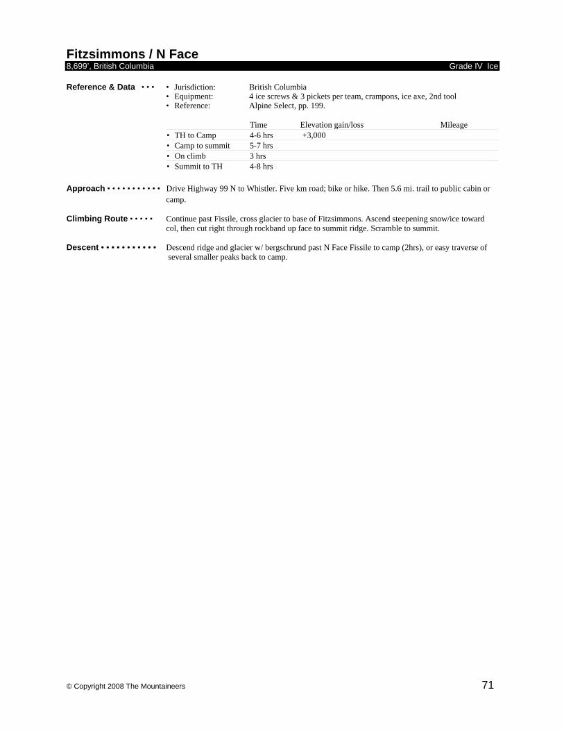
© Copyright 2008 The Mountaineers 71
Fitzsimmons / N Face 8,699’, British Columbia Grade IV Ice Reference & Data • • • • Jurisdiction: British Columbia
• Equipment: 4 ice screws & 3 pickets per team, crampons, ice axe, 2nd tool • Reference: Alpine Select, pp. 199.
Time Elevation gain/loss Mileage • TH to Camp 4-6 hrs +3,000 • Camp to summit 5-7 hrs • On climb 3 hrs • Summit to TH 4-8 hrs
Approach • • • • • • • • • • • Drive Highway 99 N to Whistler. Five km road; bike or hike. Then 5.6 mi. trail to public cabin or
camp. Climbing Route • • • • • Continue past Fissile, cross glacier to base of Fitzsimmons. Ascend steepening snow/ice toward
col, then cut right through rockband up face to summit ridge. Scramble to summit. Descent • • • • • • • • • • • Descend ridge and glacier w/ bergschrund past N Face Fissile to camp (2hrs), or easy traverse of
several smaller peaks back to camp.
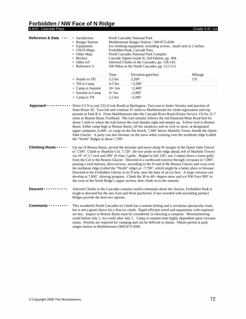
© Copyright 2008 The Mountaineers 72
Forbidden / NW Face of N Ridge 8,815’, Cascade Pass Grade II-III Ice Reference & Data • • • • Jurisdiction: North Cascades National Park • Ranger Station: Marblemount Ranger Station / 360-873-4500
• Equipment: Ice-climbing equipment, including screws, small rack to 2 inches. • USGS Maps: Forbidden Peak, Cascade Pass.
• Other Map: North Cascades National Park Complex • Beckey: Cascade Alpine Guide II, 2nd Edition, pp. 304. • Other ref: Selected Climbs in the Cascades, pp. 138-143. • Reference 3: 100 Hikes in the North Cascades, pp. 112-113.
Time Elevation gain/loss Mileage • Seattle to TH 3.5 hrs 3,200’ 131 • TH to Camp 4-5 hrs +3,200’ • Camp to Summit 10+ hrs +2,400’ • Summit to Camp 4+ hrs -2,400’ • Camp to TH 2.5 hrs -3,200’
Approach • • • • • • • • • • • Drive I-5 N to exit 232 (Cook Road) at Burlington. Turn east to Sedro Wooley and junction of
State Route 20. Turn left and continue 47 miles to Marblemount for climb registration and trip permits at Park R.S. From Marblemount take the Cascade River Road (Forest Service 15) for 21.7 miles to Boston Basin Trailhead. The trail initially follows the old Diamond Mine Road bed for about 1 mile to where the trail leaves the road sharply right and steeply up. Follow trail to Boston Basin. Either camp high in Boston Basin, off the meadows and on rock or snow, at designated upper campsites, 6,400’, or camp on the flat bench, 7,500’ below Sharkfin Tower, beside the Quien Sabe Glacier. A party can also bivouac on the snow when crossing over the northeast ridge (called the “North” Ridge) at about 7,700’.
Climbing Route • • • • • Up out of Boston Basin, ascend the moraine and move along W margin of the Quien Sabe Glacier
to 7,500’. Climb to Sharkfin Col, 7,720’, the low point on the ridge ahead, left of Sharkfin Tower) via 10’ of 5.7 rock and 200’ of class 3 gully. Rappel (a full 150’; use 2 ropes) down a loose gully from the Col to the Boston Glacier. Descend in a northward traverse through crevasses to 7,000’, passing a rock buttress, then traverse, ascending to the N end of the Boston Glacier and cross over the northeast ridge (called the “North” ridge) at ~7,700’, which might be a better place to bivouac. Descend to the Forbidden Glacier to its N arm, near the base of an ice face. A large crevasse can develop at 7,600’, slowing progress. Climb the 30 to 40+ degree snow and ice NW Face 900’ to the crest of the North Ridge’s upper section, then climb on to the summit.
Descent • • • • • • • • • • • Selected Climbs in the Cascades contains useful comments about the choices. Forbidden Peak is
tough to descend but the airy East and West (preferred, if not crowded with ascending parties) Ridges provide the best two options.
Comments • • • • • • • • • This wonderful North Cascades ice climb has a remote feeling and a circuitous spectacular route,
but is not a good choice for a first ice climb. Rapid efficient travel and equanimity with exposure are key. Impact in Boston Basin must be considered, in choosing a campsite. Mountaineering credit before July 1, Ice credit after July 1. Camp to summit time highly dependent upon crevasse status. Permits are required for camping and can be difficult to obtain. Obtain permit at park ranger station in Marblemount (360) 873-4500.
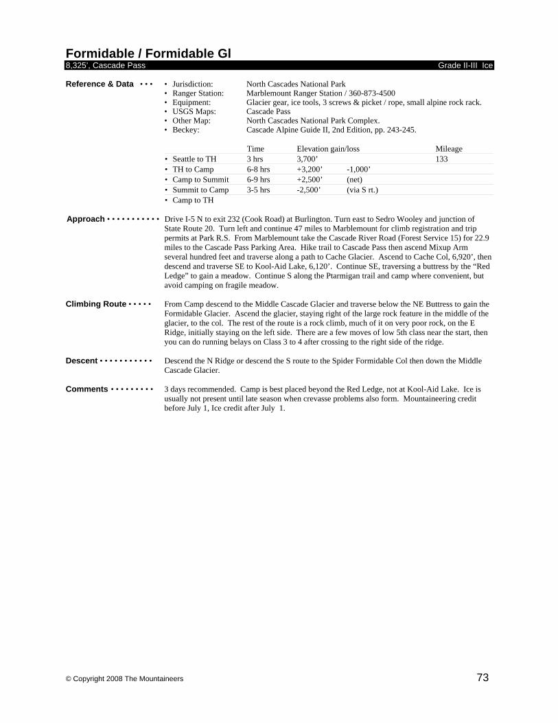
© Copyright 2008 The Mountaineers 73
Formidable / Formidable Gl 8,325’, Cascade Pass Grade II-III Ice Reference & Data • • • • Jurisdiction: North Cascades National Park • Ranger Station: Marblemount Ranger Station / 360-873-4500
• Equipment: Glacier gear, ice tools, 3 screws & picket / rope, small alpine rock rack. • USGS Maps: Cascade Pass
• Other Map: North Cascades National Park Complex. • Beckey: Cascade Alpine Guide II, 2nd Edition, pp. 243-245.
Time Elevation gain/loss Mileage • Seattle to TH 3 hrs 3,700’ 133 • TH to Camp 6-8 hrs +3,200’ -1,000’ • Camp to Summit 6-9 hrs +2,500’ (net) • Summit to Camp 3-5 hrs -2,500’ (via S rt.) • Camp to TH
Approach • • • • • • • • • • • Drive I-5 N to exit 232 (Cook Road) at Burlington. Turn east to Sedro Wooley and junction of
State Route 20. Turn left and continue 47 miles to Marblemount for climb registration and trip permits at Park R.S. From Marblemount take the Cascade River Road (Forest Service 15) for 22.9 miles to the Cascade Pass Parking Area. Hike trail to Cascade Pass then ascend Mixup Arm several hundred feet and traverse along a path to Cache Glacier. Ascend to Cache Col, 6,920’, then descend and traverse SE to Kool-Aid Lake, 6,120’. Continue SE, traversing a buttress by the “Red Ledge” to gain a meadow. Continue S along the Ptarmigan trail and camp where convenient, but avoid camping on fragile meadow.
Climbing Route • • • • • From Camp descend to the Middle Cascade Glacier and traverse below the NE Buttress to gain the
Formidable Glacier. Ascend the glacier, staying right of the large rock feature in the middle of the glacier, to the col. The rest of the route is a rock climb, much of it on very poor rock, on the E Ridge, initially staying on the left side. There are a few moves of low 5th class near the start, then you can do running belays on Class 3 to 4 after crossing to the right side of the ridge.
Descent • • • • • • • • • • • Descend the N Ridge or descend the S route to the Spider Formidable Col then down the Middle
Cascade Glacier. Comments • • • • • • • • • 3 days recommended. Camp is best placed beyond the Red Ledge, not at Kool-Aid Lake. Ice is
usually not present until late season when crevasse problems also form. Mountaineering credit before July 1, Ice credit after July 1.
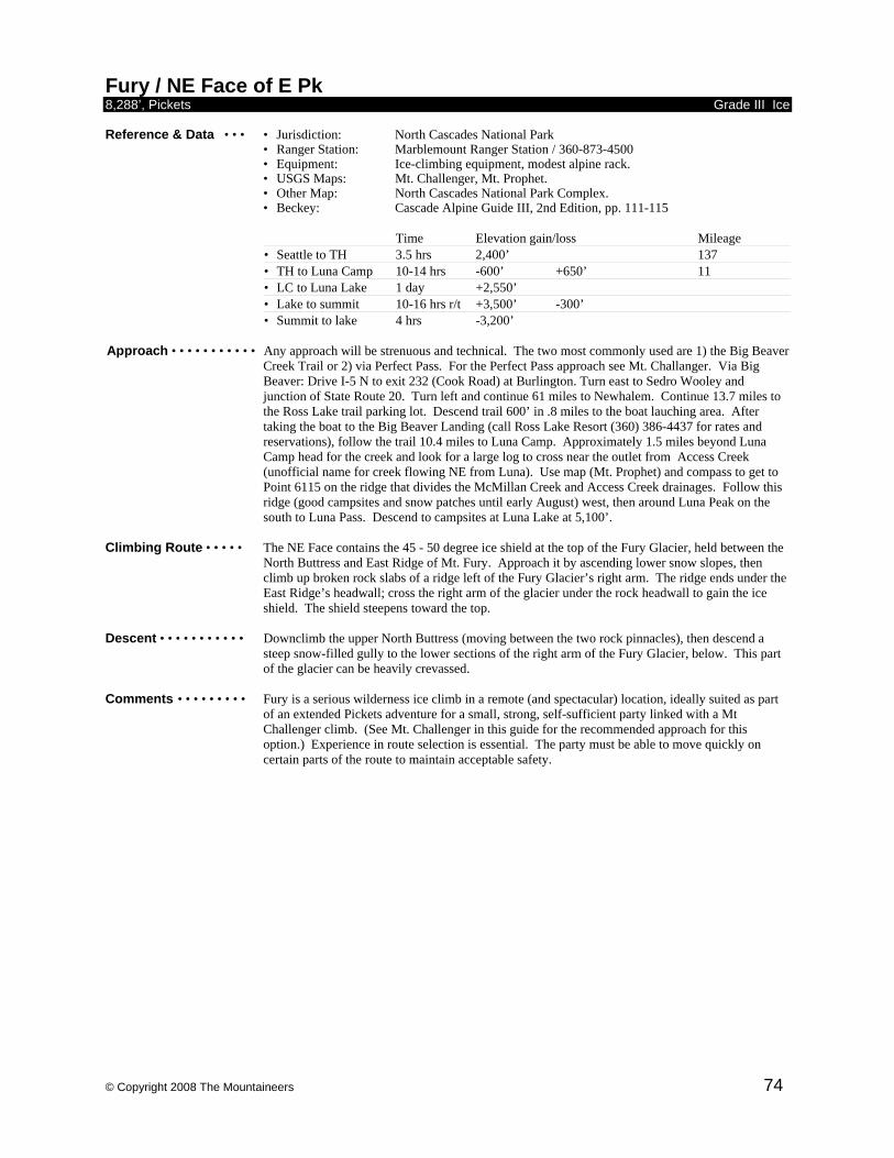
© Copyright 2008 The Mountaineers 74
Fury / NE Face of E Pk 8,288’, Pickets Grade III Ice Reference & Data • • • • Jurisdiction: North Cascades National Park • Ranger Station: Marblemount Ranger Station / 360-873-4500
• Equipment: Ice-climbing equipment, modest alpine rack. • USGS Maps: Mt. Challenger, Mt. Prophet.
• Other Map: North Cascades National Park Complex. • Beckey: Cascade Alpine Guide III, 2nd Edition, pp. 111-115
Time Elevation gain/loss Mileage • Seattle to TH 3.5 hrs 2,400’ 137 • TH to Luna Camp 10-14 hrs -600’ +650’ 11 • LC to Luna Lake 1 day +2,550’ • Lake to summit 10-16 hrs r/t +3,500’ -300’ • Summit to lake 4 hrs -3,200’
Approach • • • • • • • • • • • Any approach will be strenuous and technical. The two most commonly used are 1) the Big Beaver
Creek Trail or 2) via Perfect Pass. For the Perfect Pass approach see Mt. Challanger. Via Big Beaver: Drive I-5 N to exit 232 (Cook Road) at Burlington. Turn east to Sedro Wooley and junction of State Route 20. Turn left and continue 61 miles to Newhalem. Continue 13.7 miles to the Ross Lake trail parking lot. Descend trail 600’ in .8 miles to the boat lauching area. After taking the boat to the Big Beaver Landing (call Ross Lake Resort (360) 386-4437 for rates and reservations), follow the trail 10.4 miles to Luna Camp. Approximately 1.5 miles beyond Luna Camp head for the creek and look for a large log to cross near the outlet from Access Creek (unofficial name for creek flowing NE from Luna). Use map (Mt. Prophet) and compass to get to Point 6115 on the ridge that divides the McMillan Creek and Access Creek drainages. Follow this ridge (good campsites and snow patches until early August) west, then around Luna Peak on the south to Luna Pass. Descend to campsites at Luna Lake at 5,100’.
Climbing Route • • • • • The NE Face contains the 45 - 50 degree ice shield at the top of the Fury Glacier, held between the
North Buttress and East Ridge of Mt. Fury. Approach it by ascending lower snow slopes, then climb up broken rock slabs of a ridge left of the Fury Glacier’s right arm. The ridge ends under the East Ridge’s headwall; cross the right arm of the glacier under the rock headwall to gain the ice shield. The shield steepens toward the top.
Descent • • • • • • • • • • • Downclimb the upper North Buttress (moving between the two rock pinnacles), then descend a
steep snow-filled gully to the lower sections of the right arm of the Fury Glacier, below. This part of the glacier can be heavily crevassed.
Comments • • • • • • • • • Fury is a serious wilderness ice climb in a remote (and spectacular) location, ideally suited as part
of an extended Pickets adventure for a small, strong, self-sufficient party linked with a Mt Challenger climb. (See Mt. Challenger in this guide for the recommended approach for this option.) Experience in route selection is essential. The party must be able to move quickly on certain parts of the route to maintain acceptable safety.
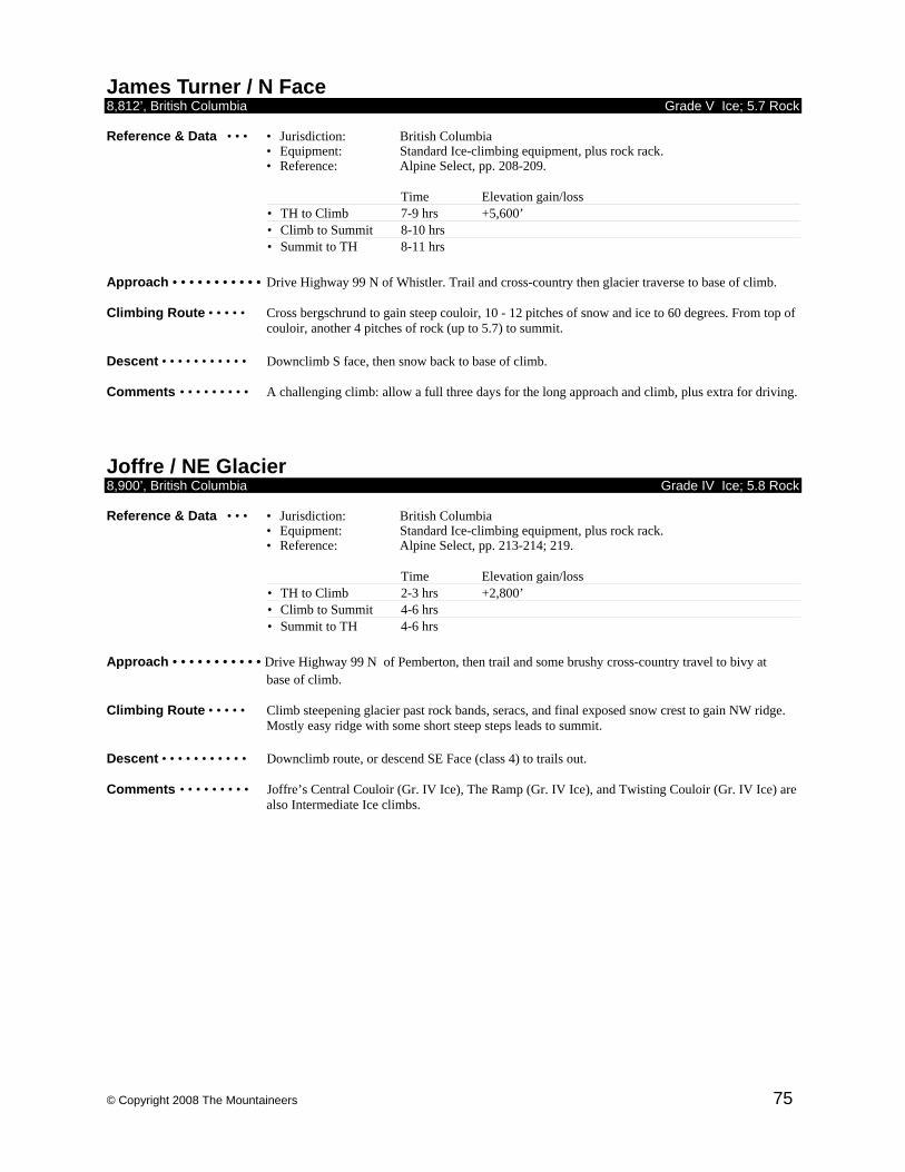
© Copyright 2008 The Mountaineers 75
James Turner / N Face 8,812’, British Columbia Grade V Ice; 5.7 Rock Reference & Data • • • • Jurisdiction: British Columbia
• Equipment: Standard Ice-climbing equipment, plus rock rack. • Reference: Alpine Select, pp. 208-209.
Time Elevation gain/loss • TH to Climb 7-9 hrs +5,600’ • Climb to Summit 8-10 hrs • Summit to TH 8-11 hrs
Approach • • • • • • • • • • • Drive Highway 99 N of Whistler. Trail and cross-country then glacier traverse to base of climb. Climbing Route • • • • • Cross bergschrund to gain steep couloir, 10 - 12 pitches of snow and ice to 60 degrees. From top of
couloir, another 4 pitches of rock (up to 5.7) to summit. Descent • • • • • • • • • • • Downclimb S face, then snow back to base of climb. Comments • • • • • • • • • A challenging climb: allow a full three days for the long approach and climb, plus extra for driving.
Joffre / NE Glacier 8,900’, British Columbia Grade IV Ice; 5.8 Rock Reference & Data • • • • Jurisdiction: British Columbia
• Equipment: Standard Ice-climbing equipment, plus rock rack. • Reference: Alpine Select, pp. 213-214; 219.
Time Elevation gain/loss • TH to Climb 2-3 hrs +2,800’ • Climb to Summit 4-6 hrs • Summit to TH 4-6 hrs
Approach • • • • • • • • • • • Drive Highway 99 N of Pemberton, then trail and some brushy cross-country travel to bivy at
base of climb. Climbing Route • • • • • Climb steepening glacier past rock bands, seracs, and final exposed snow crest to gain NW ridge.
Mostly easy ridge with some short steep steps leads to summit. Descent • • • • • • • • • • • Downclimb route, or descend SE Face (class 4) to trails out. Comments • • • • • • • • • Joffre’s Central Couloir (Gr. IV Ice), The Ramp (Gr. IV Ice), and Twisting Couloir (Gr. IV Ice) are
also Intermediate Ice climbs.
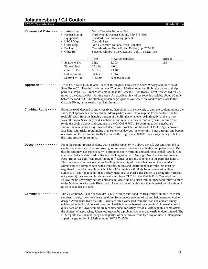
© Copyright 2008 The Mountaineers 76
Johannesburg / CJ Couloir 8,200’, Cascade Pass Grade III Ice Reference & Data • • • • Jurisdiction: North Cascades National Park • Ranger Station: Marblemount Ranger Station / 360-873-4500
• Equipment: Standard Ice-climbing equipment. • USGS Maps: Cascade Pass
• Other Map: North Cascades National Park Complex • Beckey: Cascade Alpine Guide II, 2nd Edition, pp. 252-257. • Other Ref: Selected Climbs in the Cascades, Vol. II, pp 129-136
Time Elevation gain/loss Mileage • Seattle to TH 3 hrs 3,700’ 133 • TH to Climb 25 min -400’ • Climb to Col 5-6 hrs +3,400’ • Col to Summit 3+ hrs +1,440’ • Summit to TH 5-12 hrs depends on exit
Approach • • • • • • • • • • • Drive I-5 N to exit 232 (Cook Road) at Burlington. Turn east to Sedro Wooley and junction of
State Route 20. Turn left and continue 47 miles to Marblemount for climb registration and trip permits at Park R.S. From Marblemount take the Cascade River Road (Forest Service 15) for 22.9 miles to the Cascade Pass Parking Area. An excellent view of the route is available about 1/2 mile before the road end. The climb approach begins just below, where the road comes close to the Cascade River, in the road’s final hairpin turn.
Climbing Route • • • • • From the road, descend to and cross river, then climb avalanche cone to gain the couloir, among the
shortest of approaches for any climb. Many parties move left to skip the lower couloir, due to rockfall/icefall from the hanging portion of the Sill glacier above. Additionally, at the narrow waist, the snow & ice may be discontinuous and require a rock detour to bypass. In this event, rejoin the couloir above and continue to the CJ Col, 6,760’. To continue to Johannesburg’s summit, several hours away: Ascend steep broken rock left of the crest of J’s E ridge, a broken face here, with tricky routefinding over somewhat devious junky terrain. Enter a trough and bypass one tower on the left to eventually top out on the ridge line at 8,000’. Pick a way on or just below the ridge crest to the summit.
Descent • • • • • • • • • • • From the summit retrace E ridge, with possible rappel or two above the col. Descent from the col
can be made via the CJ Couloir given good snow/ice conditions and highly competent party. But this descent may also subject party to afternoon snow warming and additional icefall hazard. One alternate choice is described in Beckey: the long traverse to Gunsight Notch and on to Cascade Pass. But it has significant routefinding difficulties, especially if no one in the party has done it. The traverse across meadow below the Triplets is straightforward, but around the shoulder of Mixup comes a complex face with steep ribs, gullies and intermittent headwalls that must be negotiated to reach Gunsight Notch. Class 4/5 climbing will likely be encountered, without evidence of any “goat paths” that Beckey mentions. A third, safer choice is a straightforward (but not pleasant) meadow and brush descent south from CJ Col to the Middle Fork Cascade River. Follow the brushy valley bottom until able to locate the little used trail in timber and follow 3 miles to the Middle Fork Cascade River road. A car can be left at this exit if anticipated, or hike about 5 miles of road back to cars.
Comments • • • • • • • • • The CJ Couloir/Sill Glacier provides 3,400’ of steep snow and ice frequently with blue ice in late
summer. Lately, low-snow years result in discontinuous patches of ice and heightened objective danger. Avalanches from the Sill Glacier are often witnessed from the road end and are amply evidenced in the broad cone of snow and ice debris at the base of the couloir. Cold weather and a quick pace on the lower couloir are recommended, for safety reasons. Although this climb offers the shortest of approaches, Johannesburg can be a problematic peak and easily underestimated. The NPS reports that Johannesburg bound parties often return overdue by a day or more. Obtain permit at park ranger station in Marblemount (360) 873-4500.
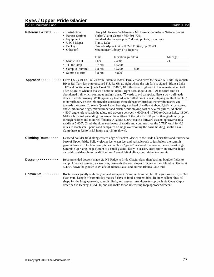
© Copyright 2008 The Mountaineers 77
Kyes / Upper Pride Glacier 7,280’, Mountain Loop Grade II Ice Reference & Data • • • • Jurisdiction: Henry M. Jackson Wilderness / Mt. Baker-Snoqualmie National Forest • Ranger Station: Verlot Visitor Center / 360-691-7791
• Equipment: Standard glacier gear plus 2nd tool, pickets, ice screws. • USGS Maps: Blanca Lake
• Beckey: Cascade Alpine Guide II, 2nd Edition, pp. 71-73. • Other ref: Mountaineer Library Trip Reports.
Time Elevation gain/loss Mileage • Seattle to TH 2 hrs 2,460’ 71 • TH to Camp 5-7 hrs +3,200’ • Camp to Summit 7-8 hrs +2,200’ -500’ • Summit to cars 7-8 hrs -4,800’
Approach • • • • • • • • • • • Drive US 2 east 13.3 miles from Sultan to Index. Turn left and drive the paved N. Fork Skykomish
River Rd. Turn left onto unpaved F.S. Rd 63; go right where the left fork is signed “Blanca Lake TH” and continue to Quartz Creek TH, 2,460’, 18 miles from Highway 2. Leave maintained trail after 3.5 miles where it makes a definite, uphill, right turn, about 3,700’. At this turn find an abondoned trail which continues straight ahead 75 yards to old campsite. Here a way trail leads down to creek crossing. Walk up-valley toward waterfall at creek’s head, staying south of creek. A minor tributary on the left provides a passage through heavier brush as the terrain pushes you towards the creek. To reach Quartz Lake, bear right at head of valley at about 3,960’, cross creek, and climb minor ridge, mixed timber and brush, while staying east of several gullies. At about 4,500’ angle left to reach the talus, and traverse between 4,6000 and 4,7800 to Quartz Lake, 4,800’. Make a leftward, ascending traverse at the outflow of the lake for 100 yards, then go directly up through heather and minor cliff bands. At about 5,200’ make a leftward ascending traverse to a saddle at 5,400’. Climb the ridge southwest of saddle and continue over the 5,779’ knoll for 0.3 miles to reach small ponds and campsites on ridge overlooking the basin holding Goblin Lake. Camp here at 5,640’. (5.5 hours up; 4.5 hrs down).
Climbing Route • • • • • Descend boulder field along eastern edge of Pocket Glacier to the Pride Glacier flats and traverse to
base of Upper Pride. Follow glacier ice, water ice, and variable rock to just below the summit pyramid massif. The final few pitches involve a “grand” eastward traverse to the northeast ridge. Scramble up rising ledge system to a small glacier. Early in season, steep snow on traverse ledge can add considerably to the difficulties. Ascend left skyline, south ridge, to summit.
Descent • • • • • • • • • • • Recommended descent made via NE Ridge to Pride Glacier flats, then back up boulder fields to
camp. Alternate descent, a carryover, descends the west slopes of Kyes to the Columbia Glacier at 5,400’, down the glacier to W side of Blanca Lake, and out via Blanca Lake trail.
Comments • • • • • • • • • Route varies greatly with the year and snowpack. Some sections can be 50 degree water ice, or 3rd
class mud. Length of summit day makes 3 days of food a prudent idea. Be in excellent physical shape for the long approach, summit climb, and descent. An alternate approach via Curry Gap is described in Beckey’s CAG II, and can make for an interesting loop approach/descent.
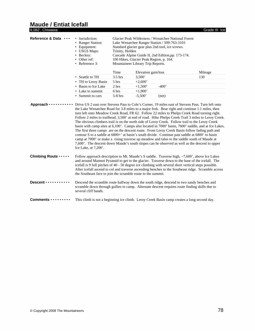
© Copyright 2008 The Mountaineers 78
Maude / Entiat Icefall 9,082’, Chiwawa Grade III Ice Reference & Data • • • • Jurisdiction: Glacier Peak Wilderness / Wenatchee National Forest • Ranger Station: Lake Wenatchee Ranger Station / 509-763-3103
• Equipment: Standard glacier gear plus 2nd tool, ice screws. • USGS Maps: Trinity, Holden
• Beckey: Cascade Alpine Guide II, 2nd Edition,pp. 173-174. • Other ref: 100 Hikes, Glacier Peak Region, p. 164. • Reference 3: Mountaineer Library Trip Reports.
Time Elevation gain/loss Mileage • Seattle to TH 3.5 hrs 3,500’ 130 • TH to Leroy Basin 5 hrs +2,600’ • Basin to Ice Lake 2 hrs +1,500’ -400’ • Lake to summit 6 hrs +1,900’ • Summit to cars 5-8 hrs -5,500’ (net)
Approach • • • • • • • • • • • Drive US 2 east over Stevens Pass to Cole’s Corner, 19 miles east of Stevens Pass. Turn left onto
the Lake Wenatchee Road for 3.8 miles to a major fork. Bear right and continue 1.1 miles, then turn left onto Meadow Creek Road, FR 62. Follow 22 miles to Phelps Creek Road turning right. Follow 2 miles to trailhead, 3,500’ at end of road. Hike Phelps Creek Trail 3 miles to Leroy Creek. The obvious climbers trail is on the north side of Leroy Creek. Follow trail to the Leroy Creek basin with camp sites at 6,100’. Camps also located in 7000’ basin, 7600’ saddle, and at Ice Lakes. The first three camps are on the descent route. From Leroy Creek Basin follow fading path and contour S to a saddle at 6800+’ at basin’s south divide. Continue past saddle at 6800’ to basin camp at 7000’ or make a rising traverse up meadow and talus to the saddle south of Maude at 7,600’. The descent down Maude’s south slopes can be observed as well as the descent to upper Ice Lake, at 7,200’.
Climbing Route • • • • • Follow approach description to Mt. Maude’s S saddle. Traverse high, ~7,600’, above Ice Lakes
and around Marmot Pyramid to get to the glacier. Traverse down to the base of the icefall. The icefall is 9 full pitches of 40 - 50 degree ice climbing with several short vertical steps possible. After icefall ascend to col and traverse ascending benches to the Southeast ridge. Scramble across the Southeast face to join the scramble route to the summit.
Descent • • • • • • • • • • • Descend the scramble route halfway down the south ridge, descend to two sandy benches and
scramble down through gullies to camp. Alternate descent requires route finding skills due to several cliff bands.
Comments • • • • • • • • • This climb is not a beginning ice climb. Leroy Creek Basin camp creates a long second day.
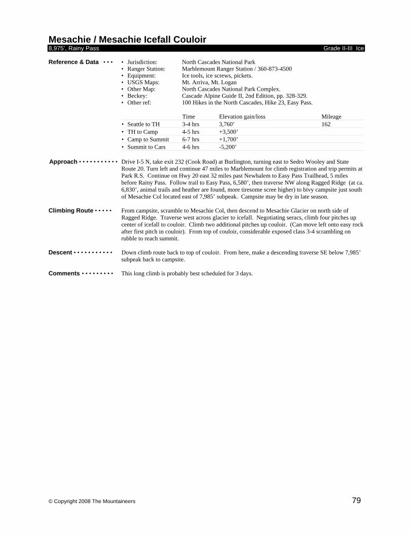
© Copyright 2008 The Mountaineers 79
Mesachie / Mesachie Icefall Couloir 8,975’, Rainy Pass Grade II-III Ice Reference & Data • • • • Jurisdiction: North Cascades National Park • Ranger Station: Marblemount Ranger Station / 360-873-4500
• Equipment: Ice tools, ice screws, pickets. • USGS Maps: Mt. Arriva, Mt. Logan
• Other Map: North Cascades National Park Complex. • Beckey: Cascade Alpine Guide II, 2nd Edition, pp. 328-329. • Other ref: 100 Hikes in the North Cascades, Hike 23, Easy Pass.
Time Elevation gain/loss Mileage • Seattle to TH 3-4 hrs 3,760’ 162 • TH to Camp 4-5 hrs +3,500’ • Camp to Summit 6-7 hrs +1,700’ • Summit to Cars 4-6 hrs -5,200’
Approach • • • • • • • • • • • Drive I-5 N, take exit 232 (Cook Road) at Burlington, turning east to Sedro Wooley and State Route 20. Turn left and continue 47 miles to Marblemount for climb registration and trip permits at Park R.S. Continue on Hwy 20 east 32 miles past Newhalem to Easy Pass Trailhead, 5 miles before Rainy Pass. Follow trail to Easy Pass, 6,580’, then traverse NW along Ragged Ridge (at ca. 6,830’, animal trails and heather are found, more tiresome scree higher) to bivy campsite just south of Mesachie Col located east of 7,985’ subpeak. Campsite may be dry in late season.
Climbing Route • • • • • From campsite, scramble to Mesachie Col, then descend to Mesachie Glacier on north side of
Ragged Ridge. Traverse west across glacier to icefall. Negotiating seracs, climb four pitches up center of icefall to couloir. Climb two additional pitches up couloir. (Can move left onto easy rock after first pitch in couloir). From top of couloir, considerable exposed class 3-4 scrambling on rubble to reach summit.
Descent • • • • • • • • • • • Down climb route back to top of couloir. From here, make a descending traverse SE below 7,985’
subpeak back to campsite. Comments • • • • • • • • • This long climb is probably best scheduled for 3 days.
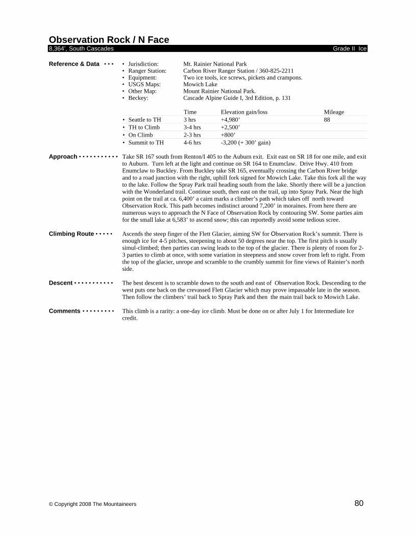
© Copyright 2008 The Mountaineers 80
Observation Rock / N Face 8,364’, South Cascades Grade II Ice Reference & Data • • • • Jurisdiction: Mt. Rainier National Park • Ranger Station: Carbon River Ranger Station / 360-825-2211
• Equipment: Two ice tools, ice screws, pickets and crampons. • USGS Maps: Mowich Lake
• Other Map: Mount Rainier National Park. • Beckey: Cascade Alpine Guide I, 3rd Edition, p. 131
Time Elevation gain/loss Mileage • Seattle to TH 3 hrs +4,980’ 88 • TH to Climb 3-4 hrs +2,500’ • On Climb 2-3 hrs +800’ • Summit to TH 4-6 hrs -3,200 (+ 300’ gain)
Approach • • • • • • • • • • • Take SR 167 south from Renton/I 405 to the Auburn exit. Exit east on SR 18 for one mile, and exit
to Auburn. Turn left at the light and continue on SR 164 to Enumclaw. Drive Hwy. 410 from Enumclaw to Buckley. From Buckley take SR 165, eventually crossing the Carbon River bridge and to a road junction with the right, uphill fork signed for Mowich Lake. Take this fork all the way to the lake. Follow the Spray Park trail heading south from the lake. Shortly there will be a junction with the Wonderland trail. Continue south, then east on the trail, up into Spray Park. Near the high point on the trail at ca. 6,400’ a cairn marks a climber’s path which takes off north toward Observation Rock. This path becomes indistinct around 7,200’ in moraines. From here there are numerous ways to approach the N Face of Observation Rock by contouring SW. Some parties aim for the small lake at 6,583’ to ascend snow; this can reportedly avoid some tedious scree.
Climbing Route • • • • • Ascends the steep finger of the Flett Glacier, aiming SW for Observation Rock’s summit. There is
enough ice for 4-5 pitches, steepening to about 50 degrees near the top. The first pitch is usually simul-climbed; then parties can swing leads to the top of the glacier. There is plenty of room for 2-3 parties to climb at once, with some variation in steepness and snow cover from left to right. From the top of the glacier, unrope and scramble to the crumbly summit for fine views of Rainier’s north side.
Descent • • • • • • • • • • • The best descent is to scramble down to the south and east of Observation Rock. Descending to the
west puts one back on the crevassed Flett Glacier which may prove impassable late in the season. Then follow the climbers’ trail back to Spray Park and then the main trail back to Mowich Lake.
Comments • • • • • • • • • This climb is a rarity: a one-day ice climb. Must be done on or after July 1 for Intermediate Ice
credit.
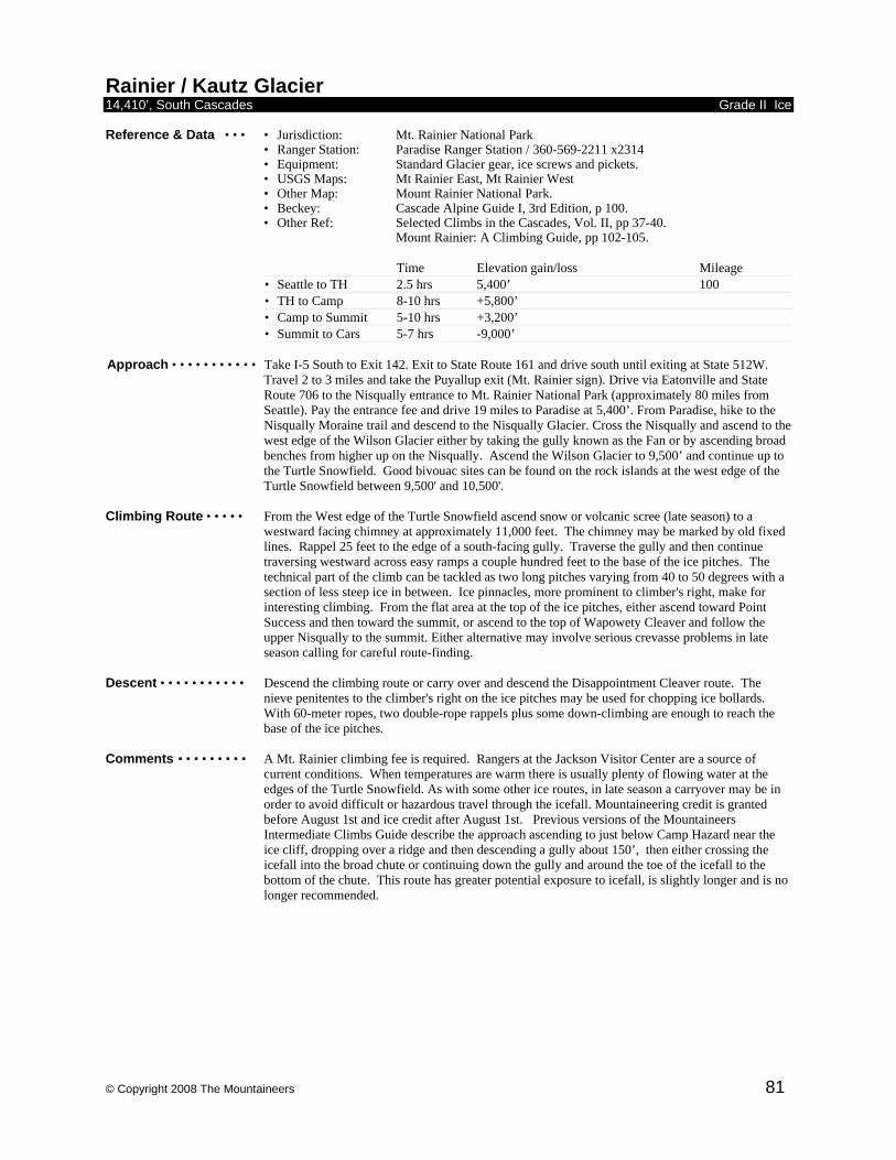
© Copyright 2008 The Mountaineers 81
Rainier / Kautz Glacier 14,410’, South Cascades Grade II Ice Reference & Data • • • • Jurisdiction: Mt. Rainier National Park • Ranger Station: Paradise Ranger Station / 360-569-2211 x2314
• Equipment: Standard Glacier gear, ice screws and pickets. • USGS Maps: Mt Rainier East, Mt Rainier West
• Other Map: Mount Rainier National Park. • Beckey: Cascade Alpine Guide I, 3rd Edition, p 100. • Other Ref: Selected Climbs in the Cascades, Vol. II, pp 37-40. Mount Rainier: A Climbing Guide, pp 102-105.
Time Elevation gain/loss Mileage • Seattle to TH 2.5 hrs 5,400’ 100 • TH to Camp 8-10 hrs +5,800’ • Camp to Summit 5-10 hrs +3,200’ • Summit to Cars 5-7 hrs -9,000’
Approach • • • • • • • • • • • Take I-5 South to Exit 142. Exit to State Route 161 and drive south until exiting at State 512W.
Travel 2 to 3 miles and take the Puyallup exit (Mt. Rainier sign). Drive via Eatonville and State Route 706 to the Nisqually entrance to Mt. Rainier National Park (approximately 80 miles from Seattle). Pay the entrance fee and drive 19 miles to Paradise at 5,400’. From Paradise, hike to the Nisqually Moraine trail and descend to the Nisqually Glacier. Cross the Nisqually and ascend to the west edge of the Wilson Glacier either by taking the gully known as the Fan or by ascending broad benches from higher up on the Nisqually. Ascend the Wilson Glacier to 9,500’ and continue up to the Turtle Snowfield. Good bivouac sites can be found on the rock islands at the west edge of the Turtle Snowfield between 9,500' and 10,500'.
Climbing Route • • • • • From the West edge of the Turtle Snowfield ascend snow or volcanic scree (late season) to a
westward facing chimney at approximately 11,000 feet. The chimney may be marked by old fixed lines. Rappel 25 feet to the edge of a south-facing gully. Traverse the gully and then continue traversing westward across easy ramps a couple hundred feet to the base of the ice pitches. The technical part of the climb can be tackled as two long pitches varying from 40 to 50 degrees with a section of less steep ice in between. Ice pinnacles, more prominent to climber's right, make for interesting climbing. From the flat area at the top of the ice pitches, either ascend toward Point Success and then toward the summit, or ascend to the top of Wapowety Cleaver and follow the upper Nisqually to the summit. Either alternative may involve serious crevasse problems in late season calling for careful route-finding.
Descent • • • • • • • • • • • Descend the climbing route or carry over and descend the Disappointment Cleaver route. The
nieve penitentes to the climber's right on the ice pitches may be used for chopping ice bollards. With 60-meter ropes, two double-rope rappels plus some down-climbing are enough to reach the base of the ice pitches.
Comments • • • • • • • • • A Mt. Rainier climbing fee is required. Rangers at the Jackson Visitor Center are a source of
current conditions. When temperatures are warm there is usually plenty of flowing water at the edges of the Turtle Snowfield. As with some other ice routes, in late season a carryover may be in order to avoid difficult or hazardous travel through the icefall. Mountaineering credit is granted before August 1st and ice credit after August 1st. Previous versions of the Mountaineers Intermediate Climbs Guide describe the approach ascending to just below Camp Hazard near the ice cliff, dropping over a ridge and then descending a gully about 150’, then either crossing the icefall into the broad chute or continuing down the gully and around the toe of the icefall to the bottom of the chute. This route has greater potential exposure to icefall, is slightly longer and is no longer recommended.
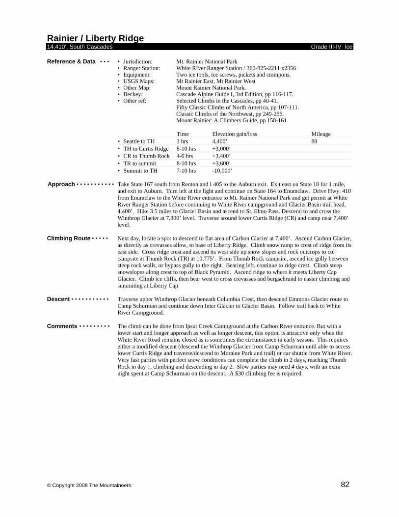
© Copyright 2008 The Mountaineers 82
Rainier / Liberty Ridge 14,410’, South Cascades Grade III-IV Ice Reference & Data • • • • Jurisdiction: Mt. Rainier National Park • Ranger Station: White RIver Ranger Station / 360-825-2211 x2356
• Equipment: Two ice tools, ice screws, pickets and crampons. • USGS Maps: Mt Rainier East, Mt Rainier West
• Other Map: Mount Rainier National Park. • Beckey: Cascade Alpine Guide I, 3rd Edition, pp 116-117. • Other ref: Selected Climbs in the Cascades, pp 40-41. Fifty Classic Climbs of North America, pp 107-111. Classic Climbs of the Northwest, pp 249-255. Mount Rainier: A Climbers Guide, pp 158-161
Time Elevation gain/loss Mileage • Seattle to TH 3 hrs 4,400’ 88 • TH to Curtis Ridge 8-10 hrs +3,000’ • CR to Thumb Rock 4-6 hrs +3,400’ • TR to summit 8-10 hrs +3,600’ • Summit to TH 7-10 hrs -10,000’
Approach • • • • • • • • • • • Take State 167 south from Renton and I 405 to the Auburn exit. Exit east on State 18 for 1 mile,
and exit to Auburn. Turn left at the light and continue on State 164 to Enumclaw. Drive Hwy. 410 from Enumclaw to the White River entrance to Mt. Rainier National Park and get permit at White River Ranger Station before continuing to White River campground and Glacier Basin trail head, 4,400’. Hike 3.5 miles to Glacier Basin and ascend to St. Elmo Pass. Descend to and cross the Winthrop Glacier at 7,300’ level. Traverse around lower Curtis Ridge (CR) and camp near 7,400’ level.
Climbing Route • • • • • Next day, locate a spot to descend to flat area of Carbon Glacier at 7,400’. Ascend Carbon Glacier,
as directly as crevasses allow, to base of Liberty Ridge. Climb snow ramp to crest of ridge from its east side. Cross ridge crest and ascend its west side up snow slopes and rock outcrops to col campsite at Thumb Rock (TR) at 10,775’. From Thumb Rock campsite, ascend ice gully between steep rock walls, or bypass gully to the right. Bearing left, continue to ridge crest. Climb steep snowslopes along crest to top of Black Pyramid. Ascend ridge to where it meets Liberty Cap Glacier. Climb ice cliffs, then bear west to cross crevasses and bergschrund to easier climbing and summiting at Liberty Cap.
Descent • • • • • • • • • • • Traverse upper Winthrop Glacier beneath Columbia Crest, then descend Emmons Glacier route to
Camp Schurman and continue down Inter Glacier to Glacier Basin. Follow trail back to White River Campground.
Comments • • • • • • • • • The climb can be done from Ipsut Creek Campground at the Carbon River entrance. But with a
lower start and longer approach as well as longer descent, this option is attractive only when the White River Road remains closed as is sometimes the circumstance in early season. This requires either a modified descent (descend the Winthrop Glacier from Camp Schurman until able to access lower Curtis Ridge and traverse/descend to Moraine Park and trail) or car shuttle from White River. Very fast parties with perfect snow conditions can complete the climb in 2 days, reaching Thumb Rock in day 1, climbing and descending in day 2. Slow parties may need 4 days, with an extra night spent at Camp Schurman on the descent. A $30 climbing fee is required.
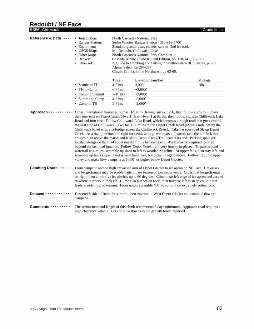
© Copyright 2008 The Mountaineers 83
Redoubt / NE Face 8,956’, Chilliwack Grade III Ice Reference & Data • • • • Jurisdiction: North Cascades National Park • Ranger Station: Sedro Wooley Ranger Station / 360-856-5700
• Equipment: Standard glacier gear, pickets, screws, 2nd ice tool. • USGS Maps: Mt. Redoubt, Chilliwack Lake
• Other Map: North Cascades National Park Complex • Beckey: Cascade Alpine Guide III, 2nd Edition, pp. 138-141, 392-393. • Other ref: A Guide to Climbing and Hiking in Southwestern BC, Fairley, p. 283. Alpine Select, pp 286-287. Classic Climbs in the Northwest, pp 62-65.
Time Elevation gain/loss Mileage • Seattle to TH 4-5 hrs 3,000’ 188 • TH to Camp 6-8 hrs +3,000’ • Camp to Summit 7-10 hrs +3,000’ • Summit to Camp 4-5 hrs -3,000’ • Camp to TH 5-7 hrs -3,000’
Approach • • • • • • • • • • • Cross International border at Sumas (I-5 N to Bellingham exit 256, then follow signs to Sumas)
then turn east on TransCanada Hwy 1. Exit Hwy. 1 at Sardis, then follow signs to Chilliwack Lake Road and turn east. Follow Chilliwack Lake Road, which becomes a rough road that goes around the east side of Chilliwack Lake, for 31.7 miles to the Depot Creek Road (about 1 mile before the Chilliwack Road ends at a bridge across the Chilliwack River). Take the spur road SE up Depot Creek. At a road junction, the right fork ends at large wet marsh. Instead, take the left fork that crosses high above the marsh and leads to Depot Creek Trailhead at its end. Parking spots are located alongside the road about one-half mile before its end. 4WD may be required to drive beyond the last road junction. Follow Depot Creek trail, very brushy in places. To pass around waterfall at 4 miles, scramble up slabs to left to wooded ridgeline. At upper falls, also stay left, and scramble up talus slope. Trail is very faint here, but picks up again above. Follow trail into upper valley and make bivy campsite at 6,000’ or higher below Depot Glacier.
Climbing Route • • • • • From campsite ascend high crevassed arm of Depot Glacier to ice apron on NE Face. Crevasses
and bergschrunds may be problematic in late season or low snow years. Cross first bergschrunds on right, then climb five ice pitches up to 60 degrees. Climb near left edge of ice apron and ascend to where it tapers to rock rib. Climb two pitches on rock, then traverse left to steep couloir that leads to notch SE of summit. From notch, scramble 400’ to summit on extremely rotten rock.
Descent • • • • • • • • • • • Descend S side of Redoubt summit, then traverse to West Depot Glacier and continue down to
campsite. Comments • • • • • • • • • The seriousness and length of this climb recommend 3 days minimum. Approach road requires a
high clearance vehicle. Lots of blow downs in old growth forest reported.

© Copyright 2008 The Mountaineers 84
Shuksan / N Face 9,127’, Nooksack Grade II-III Ice Reference & Data • • • • Jurisdiction: North Cascades National Park • Ranger Station: Glacier Visitor Center / 360-599-2714
• Equipment: Ice axe, crampons, ice screws, pickets. • USGS Maps: Mt Shuksan, Shuksan Arm
• Beckey: Cascade Alpine Guide III, 2nd Edition, pp 67-70. • Other ref: Selected Climbs in the Cascades, pp. 208-213. Alpine Select, pp 348-349
Time Elevation gain/loss Mileage • Seattle to TH 3.5 hrs 3,000’ 145 • TH to Camp 4 hrs + 2,500’ • Camp to Summit 6-8 hrs + 3,600’ • Summit to Cars 8-12 hrs - 6,100’
Approach • • • • • • • • • • • Drive N on I-5 to Bellingham exit 255. Take the Mt. Baker Highway 542 E 33.8 miles to Glacier
and obtain permit at Ranger Station. Continue 13 miles past Glacier to Nooksack River Bridge. Continue driving 5 miles to hairpin corner at 3,500’, two miles from Mt. Baker Ski Area. Turn left at hairpin corner onto spur logging road (White Salmon Road 3075, marked, not at its junction with the Mt Baker Highway, but at its last switchback/junction). Follow to its end above White Salmon Creek. Heavy brush encroaches on both sides of the road for the last mile or two, leaving scratchy vehicle sides. A faint path with some flagging continues through road bed brush for several hundred yards before dropping down faintly from the roadbed with sporadic flagging and making its way over to a more open swath and dropping down to White Salmon Creek. Hike up brushy valley, then ascend eastward up timbered slopes to open areas along ridge crest. Good bivy spots are located at 5,500’ where ridge meets North Face.
Climbing Route • • • • • From bivy, traverse left on hanging glacier above Price Lake and under upper hanging glacier
perched above first rock barrier. After 500’, climb to right up firn and ice finger west of upper hanging glacier. Especially in early season, do not go far left onto North Face where avalanches frequently occur. Continue steeply up North Face to shoulder NE of summit pyramid. After mid-season, route can be very broken and schrund at shoulder quite large. From top of shoulder, traverse ice plateau around east side of summit pyramid and finish climb by standard route to summit.
Descent • • • • • • • • • • • Descend via Fisher Chimneys and Lake Ann Trail to Mt. Baker Ski Area. Alternately, descend the
White Salmon Glacier for a return to the cars. Comments • • • • • • • • • Leaving a second vehicle at the Mt. Baker Ski Area shortens the descent. Some parties prefer to
camp a second night above Fisher Chimneys or at Lake Ann. Descent can also be made via White Salmon Glacier or Sulphide Glacier, although the latter requires a very long car shuttle.
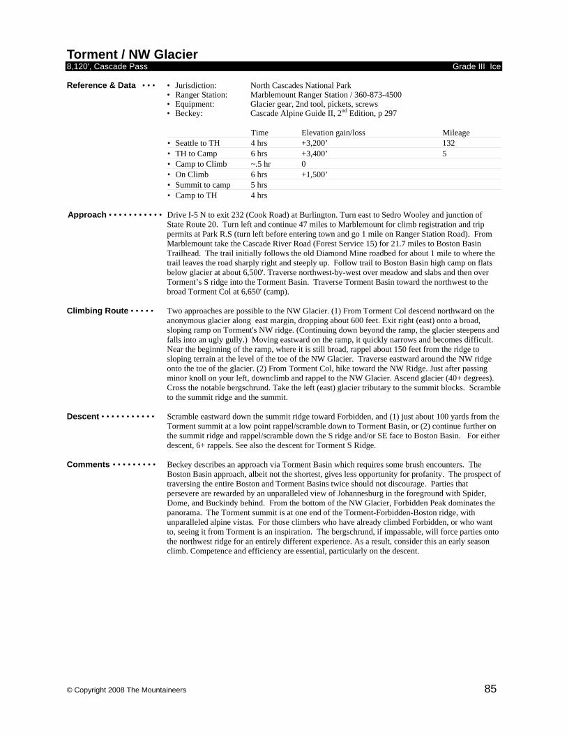
© Copyright 2008 The Mountaineers 85
Torment / NW Glacier 8,120', Cascade Pass Grade III Ice Reference & Data • • • • Jurisdiction: North Cascades National Park • Ranger Station: Marblemount Ranger Station / 360-873-4500
• Equipment: Glacier gear, 2nd tool, pickets, screws • Beckey: Cascade Alpine Guide II, 2nd Edition, p 297
Time Elevation gain/loss Mileage • Seattle to TH 4 hrs +3,200’ 132 • TH to Camp 6 hrs +3,400’ 5 • Camp to Climb ~.5 hr 0 • On Climb 6 hrs +1,500’ • Summit to camp 5 hrs • Camp to TH 4 hrs
Approach • • • • • • • • • • • Drive I-5 N to exit 232 (Cook Road) at Burlington. Turn east to Sedro Wooley and junction of
State Route 20. Turn left and continue 47 miles to Marblemount for climb registration and trip permits at Park R.S (turn left before entering town and go 1 mile on Ranger Station Road). From Marblemount take the Cascade River Road (Forest Service 15) for 21.7 miles to Boston Basin Trailhead. The trail initially follows the old Diamond Mine roadbed for about 1 mile to where the trail leaves the road sharply right and steeply up. Follow trail to Boston Basin high camp on flats below glacier at about 6,500'. Traverse northwest-by-west over meadow and slabs and then over Torment’s S ridge into the Torment Basin. Traverse Torment Basin toward the northwest to the broad Torment Col at 6,650' (camp).
Climbing Route • • • • • Two approaches are possible to the NW Glacier. (1) From Torment Col descend northward on the
anonymous glacier along east margin, dropping about 600 feet. Exit right (east) onto a broad, sloping ramp on Torment's NW ridge. (Continuing down beyond the ramp, the glacier steepens and falls into an ugly gully.) Moving eastward on the ramp, it quickly narrows and becomes difficult. Near the beginning of the ramp, where it is still broad, rappel about 150 feet from the ridge to sloping terrain at the level of the toe of the NW Glacier. Traverse eastward around the NW ridge onto the toe of the glacier. (2) From Torment Col, hike toward the NW Ridge. Just after passing minor knoll on your left, downclimb and rappel to the NW Glacier. Ascend glacier (40+ degrees). Cross the notable bergschrund. Take the left (east) glacier tributary to the summit blocks. Scramble to the summit ridge and the summit.
Descent • • • • • • • • • • • Scramble eastward down the summit ridge toward Forbidden, and (1) just about 100 yards from the
Torment summit at a low point rappel/scramble down to Torment Basin, or (2) continue further on the summit ridge and rappel/scramble down the S ridge and/or SE face to Boston Basin. For either descent, 6+ rappels. See also the descent for Torment S Ridge.
Comments • • • • • • • • • Beckey describes an approach via Torment Basin which requires some brush encounters. The
Boston Basin approach, albeit not the shortest, gives less opportunity for profanity. The prospect of traversing the entire Boston and Torment Basins twice should not discourage. Parties that persevere are rewarded by an unparalleled view of Johannesburg in the foreground with Spider, Dome, and Buckindy behind. From the bottom of the NW Glacier, Forbidden Peak dominates the panorama. The Torment summit is at one end of the Torment-Forbidden-Boston ridge, with unparalleled alpine vistas. For those climbers who have already climbed Forbidden, or who want to, seeing it from Torment is an inspiration. The bergschrund, if impassable, will force parties onto the northwest ridge for an entirely different experience. As a result, consider this an early season climb. Competence and efficiency are essential, particularly on the descent.
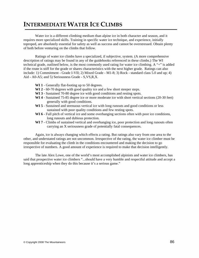
© Copyright 2008 The Mountaineers 86
INTERMEDIATE WATER ICE CLIMBS
Water ice is a different climbing medium than alpine ice in both character and season, and it requires more specialized skills. Training in specific water ice technique, and experience, initially toproped, are absolutely essential for safety as well as success and cannot be overstressed. Obtain plenty of both before venturing on the climbs that follow. Ratings of water ice climbs have a specialized, if subjective, system. (A more comprehensive description of ratings may be found in any of the guidebooks referenced in these climbs.) The WI technical grade, outlined below, is the most commonly used rating for water ice climbing. A “+” is added if the route is stiff for the grade or shares characteristics with the next higher grade. Ratings can also include: 1) Commitment - Grade I-VII; 2) Mixed Grade - M1-8; 3) Rock - standard class 5.0 and up; 4) Aid - A0-A5; and 5) Seriousness Grade - S,VS,R,X. WI 1 - Generally flat-footing up to 50 degrees. WI 2 - 60-70 degrees with good quality ice and a few short steeper steps. WI 3 - Sustained 70-80 degree ice with good conditions and resting spots. WI 4 - Sustained 75-85 degree ice or more moderate ice with short vertical sections (20-30 feet)
generally with good conditions. WI 5 - Sustained and strenuous vertical ice with long runouts and good conditions or less
sustained with poor quality conditions and few resting spots. WI 6 - Full pitch of vertical ice and some overhanging sections often with poor ice conditions,
long runouts and dubious protection. WI 7 - Climbs of sustained vertical and overhanging ice, poor protection and long runouts often
carrying an X seriousness grade of potentially fatal consequences. Again, ice is always changing which effects a rating. But ratings also vary from one area to the other, and understated ratings are not uncommon. Irrespective of the rating, the water ice climber must be responsible for evaluating the climb in the conditions encountered and making the decision to go irrespective of numbers. A good amount of experience is required to make that decision intelligently. The late Alex Lowe, one of the world’s most accomplished alpinists and water ice climbers, has said that prospective water ice climbers “...should have a very humble and respectful attitude and accept a long apprenticeship when they do this because it’s a serious game.”
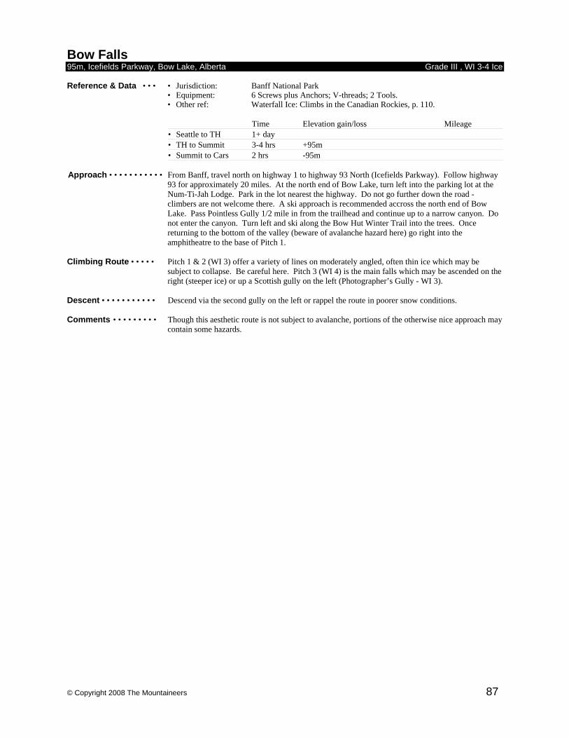
© Copyright 2008 The Mountaineers 87
Bow Falls 95m, Icefields Parkway, Bow Lake, Alberta Grade III , WI 3-4 Ice Reference & Data • • • • Jurisdiction: Banff National Park
• Equipment: 6 Screws plus Anchors; V-threads; 2 Tools. • Other ref: Waterfall Ice: Climbs in the Canadian Rockies, p. 110.
Time Elevation gain/loss Mileage • Seattle to TH 1+ day • TH to Summit 3-4 hrs +95m • Summit to Cars 2 hrs -95m
Approach • • • • • • • • • • • From Banff, travel north on highway 1 to highway 93 North (Icefields Parkway). Follow highway
93 for approximately 20 miles. At the north end of Bow Lake, turn left into the parking lot at the Num-Ti-Jah Lodge. Park in the lot nearest the highway. Do not go further down the road - climbers are not welcome there. A ski approach is recommended accross the north end of Bow Lake. Pass Pointless Gully 1/2 mile in from the trailhead and continue up to a narrow canyon. Do not enter the canyon. Turn left and ski along the Bow Hut Winter Trail into the trees. Once returning to the bottom of the valley (beware of avalanche hazard here) go right into the amphitheatre to the base of Pitch 1.
Climbing Route • • • • • Pitch 1 & 2 (WI 3) offer a variety of lines on moderately angled, often thin ice which may be
subject to collapse. Be careful here. Pitch 3 (WI 4) is the main falls which may be ascended on the right (steeper ice) or up a Scottish gully on the left (Photographer’s Gully - WI 3).
Descent • • • • • • • • • • • Descend via the second gully on the left or rappel the route in poorer snow conditions. Comments • • • • • • • • • Though this aesthetic route is not subject to avalanche, portions of the otherwise nice approach may
contain some hazards.
© Copyright 2008 The Mountaineers 88
Cascade Waterfall 300m, Banff, Alberta Grade III , WI 3 Ice Reference & Data • • • • Jurisdiction: Banff National Park
• Equipment: 6 Screws plus Anchors; V-threads; 2 Tools. • Other ref: Waterfall Ice: Climbs in the Canadian Rockies, p. 110.
Time Elevation gain/loss Mileage • Seattle to TH 1 day • TH to Summit 4 hrs +300m • Summit to Cars 1-2 hrs -300m
Approach • • • • • • • • • • • From highway 1 (Trans-Canada) take the Banff East exit. Go north on Lake Minnewanka Road.
Pass a cattle guard and continue approximately 50 meters to the pullout on the left. Do not block the gate to the airstrip. Park here and hike in for 15-20 minutes through light trees to the base of Pitch 1. The climb is located directly above the parking area.
Climbing Route • • • • • The initial pitches involve 250 meters of mixed snow and (WI 2) ice and are often soloed for
efficiency or bypassed entirely on either side. The final 2 pitches (WI 3) are full length pitches and may be thin. Belay on the right of each pitch at fixed bolts.
Descent • • • • • • • • • • • Rappel the upper pitches then downclimb the lower portion or bypass as on the ascent. Comments • • • • • • • • • This classic route is very popular; get on it first or go elsewhere if other teams are ahead. Icefall
occurs often and is unavoidable. This south facing route gets early morning sun which lasts all day. Additionally, a large avalanche basin lies directly above. As a result, extreme caution should be exercised when attempting this avalanche prone route and climbing after heavy snowfall should be absolutely avoided..
Night n’ Gale 300m, Lillooet, BC Grade II-III , WI 4+ Ice Reference & Data • • • • Jurisdiction: Lillooet, BC
• Equipment: 6 Screws plus Anchors; V-threads; 2 Tools. • Other ref: West Coast Ice, pp. 130-132. • Reference 3: Mountaineer Library Intermediate Trip Reports.
Time Elevation gain/loss Mileage • Seattle to TH 6-8 hrs 320 • TH to Summit 4-5 hrs +300m • Summit to TH 2 hrs -300m
Approach • • • • • • • • • • • From Lillooet town center travel north across the Bridge River and make a left on Hwy 40. Travel
several miles along Hwy 40 and park in a gravel pit on the right approximately .3 miles before the Terzaghi Dam. The route is visible from the road just west of the parking area. Bushwhack through brush and trees to reach the initial snow slopes leading to Pitch 1.
Climbing Route • • • • • The snow slopes leading to Pitch 1 may contain a significant amount of avalanche debris.
Assessing the snowpack along this slope is extremely important on approach. The slopes above are much more avalanche prone. Pitch 1 (WI 2-3) is a long but easy pitch which leads to a large wide gully. Unrope and ascend this gully cautiously, staying right on the approach to Pitch 2. Pitch 2 (WI 4+) is a full length pitch of increasing difficulty finishing with a 30’ section of vertical ice. It is a broad wall which has many more difficult lines available (WI 5-5+). Pitch 3 & 4 (WI 3-4) contain some very fine climbing and good protection.
Descent • • • • • • • • • • • Rappel & downclimb the gully to the right at top until meeting the original gully. Comments • • • • • • • • • This highly avalanche prone climb should absolutely be avoided in times of high hazard. Contact
local authorities before heading out on this climb. The frequently occuring low snow conditions are classic for climbing Night n’ Gale, one of the first to form and last to melt because of its high elevation and north facing slopes. Recommended as a good late winter (March) climb.
© Copyright 2008 The Mountaineers 89
Professor Falls 280m, Banff, Alberta Grade III , WI 4 Ice Reference & Data • • • • Jurisdiction: Banff National Park
• Equipment: 6 Screws plus Anchors; V-threads; 2 Tools. • Other ref: Waterfall Ice: Climbs in the Canadian Rockies, pp. 113-121. • Reference 3: Mountaineer Library Intermediate Trip Reports.
Time Elevation gain/loss Mileage • Seattle to TH 10-12 hrs 570 • TH to Summit 5-7 hrs +280m • Summit to Cars 2-3hrs -280m
Approach • • • • • • • • • • • From the town of Banff, drive to the Bow Falls parking lot near the Banff Springs Hotel and Golf
Course. Cross the Goat Creek Bridge and continue along the golf course for 1.5-2 miles to where the road splits. Park here and hike along the road that forks to the right through the gate. Even if this gate is open do not drive through; the open road is reserved for dog sled teams. Continue along this road for approximately 1.8 miles to the trail which takes off to the right leading to the Canmore Nordic Center. Continue for about another 1.8 miles along the Bow River past the Terminator area. A gully leads up to the right to the base of Pitch 1. The initial pitches are easily seen at the base of this gully.
Climbing Route • • • • • The route consists of 4-6 pitches. Pitch 1 (WI 3+) is a short, moderately steep pitch of usually good
quality climbing leading to a large basin for the belay. Pitch 2 & 3 (WI 3+) may be combined into one long pitch of the same technical difficulty and consistency. Pitch 4 (WI 3) is a relatively easier pitch which leads to another large basin. Pitch 5 (WI 3) is starts as a short, steep pillar and is usually runout for obvious reasons. This leads to a series of steps (WI 2) which are often soloed for time efficiency. Ascend the snow slope above to the base of the final crux pitch. Pitch 6 (WI 4-4+) is an exhilarating finish to this classic climb. It may be thin and chandeliered or fat and cauliflowered requiring a good eye for screw placements.
Descent • • • • • • • • • • • From the top of Pitch 6, continue ascending the snow slopes above and exit to the left. A trail leads
downwards through some small trees (avoid any rock slabs). This leads back to the route which may be rappelled from bolts and trees for 2-3 rappels. A trail takes off to the left (facing downhill) at the top of Pitch 3 which leads back to the base of the climb.
Comments • • • • • • • • • Another classic, this climb usually has good quality ice, is quite protectable and has good belay
ledges, but is not without some potential hazards, however. During periods of high avalanche hazard, the entire route is exposed. Avalanche debris has been reported all the way down to the Bow River. Ice fall hazard is also prevalent from several pitches above. An early start is recommended to beat the crowds to one of the most popular climbs in the region.
© Copyright 2008 The Mountaineers 90
Sinatra Falls 350m, Lake Louise Grade III , WI2 Ice Reference & Data • • • • Jurisdiction: Kananaskis
• Equipment: Two ice tools, ice screws, pickets • Other Map: 82J/14 Spray Lakes • Other ref: Waterfall Ice, Climbs in the Csnadian Rockies 3rd Ed, p 59
Time Elevation gain/loss Mileage • Seattle to TH 10-12 hrs 610 • TH to Climb 1.5 hrs 350 meters
Approach • • • • • • • • • • • From Lake Louise, drive east on the Trans-Canada Highway, turn south onto Highway 40. Park at
the Galatea Creek trailhead (on the west side of the highway, 3 1/4 miles south of the Evan-Thomas Creek parking lot). Driving time from Lake Louise, 90 minutes. From the parking lot, follow the trail down to the creek, cross the bridge, and bear right onto the Terrace Trail. In 20 minutes, cross a wide drainage (the Saddam's Insane gully). Take note of this drainage, if you descend the ridge, you will intersect the Terrace Trail at this point. Continue on the Terrace Trail until the climb is visible. At this point (40 minutes elapsed time) turn left (west). Ascend a bushy ridge, then drop down into the drainage. Ascend this drainage, taking a direct approach to the base of the climb. Time to base of climb: 1 hour, 20 minutes.
Climbing Route • • • • • Climb the obvious gully in 4 or 5 pitches of WI 2 ice. The first pitch is a scramble up low angled
ice. The second pitch ends mid-way up a snow ramp. You may wish to extend this lead up to an ice bulge. A small grove of trees is found above the last ice pitch. Ascend the low angled ramp, and continue up steep snow for several rope-lengths.
Descent • • • • • • • • • • • Exit left (south). Descend steep forested slopes toward a broad, gently sloping ridge. If you follow
the ridge crest, you will intersect the Terrace Trail at the Saddam's Insane drainage. Comments • • • • • • • • • This alpine climb is on good, nice, moderate ice. Caution, this route and its approach are in
avalanche prone terrain. The route ascends an obvious avalanche gully. This climb is best done in early season or in a "low" snow year. Plan to carryover (although it is possible to rappel the route). Get an early start. The gully is narrow, you will not want to be climbing below other parties. A 60 meter rope is advised.
© Copyright 2008 The Mountaineers 91
Synchronicity 600m, Lillooet, BC Grade III , WI 4 Ice Reference & Data • • • • Jurisdiction: Lillooet, BC
• Equipment: 6 Screws plus Anchors; V-threads; 2 Tools. • Other ref: West Coast Ice, pp. 130-132. • Reference 3: Mountaineer Library Intermediate Trip Reports.
Time Elevation gain/loss Mileage • Seattle to TH 5-7 hrs 320 • TH to Summit 6 hrs +600m • Summit to Cars 3 hrs -600m
Approach • • • • • • • • • • • From Lillooet town center, drive approximately 8 miles south along Route 99 to the Cayoosh river
bridge. Park here and enter the approach trail from the Lillooet side (northeast) of the bridge. Traverse the hillside along the Cayoosh river (30-40 min.) passing a railroad grade. In hard conditions crampons may be useful. Ascend a steep gully to the right (north) for about 30 minutes to the base of pitch 1. This gully may be avalanche prone.
Climbing Route • • • • • Pitch 1 (WI 2) is quite moderate and is often soloed for efficiency. It is a full 160 foot pitch. At
the basin above, ascend right to the base of pitch 2. The left line is called the Synchrotron and is often thin and difficult. Pitch 2 (WI 3) is short and easy. Pitches 3 & 4 (WI3+) are full pitches of outstanding quality. There is a good belay cave at the top left of Pitch 3. Pitches 5 & 6 (WI 4-4+ depending on conditions & line) are the crux pitches and are full rope length leads. Pitch 6 has a 20’ vertical section at the top. Pitch 7 is a surprise short pitch (40’) in the woods.
Descent • • • • • • • • • • • Rappel the route from trees and V-threads. Comments • • • • • • • • • This outstanding alpine style water ice climb requires a variety of skills to complete. The climb
increases in difficulty gradually through each pitch giving each member of the team an exhilarating lead. The route traditionally takes quite a bit longer than 9 hours round trip (don’t forget your headlamp). Because of potential icefall problems and the need for efficient movement, a team of 2 is recommended. This route is recommended for experienced water ice climbers only. A good view of the route occurs about a mile south of the Cayoosh River Bridge.
© Copyright 2008 The Mountaineers 92
PERMITS Permit specifics may (and probably will) change after preparation of this guide. It’s always best to check with the appropriate regulatory agency to be sure of the most current information. Trail Park Permits • • • A Trail Pass permit is required at essentially all trailheads we use for climbs within
National Forests. This permit, required within 1/4 mile of the trailhead, costs $5 per day or $30 for the year and is available at any ranger station, the Mountaineers store, most climbing shops or on line at: http://www.nwpubliclands.org/store_recreation-passes_1PASS/
Enchantments • • • • • • Call the Leavenworth Ranger Station, (509) 548-6977 ext. 202. Calling is advised
because closures have occurred in the past on short notice for salvage logging. From June 15 to October 15 an overnight user fee of $3 per night per person
applies to the “expanded Enchantment Permit Zone” which includes the upper and lower Enchantment Basins, and Colchuck, Stuart, Snow, Nada, Eightmile, and Caroline Lakes. In this area, a reservation system applies to 75 percent of the space available for camping. Reservation applications are accepted after February 21st by mail at the Leavenworth Ranger Station. However, every day at 7:45 am during the permit period, 25 percent of the permit allowance are given out by lottery to applicants in person at the ranger station. See http://www.fs.fed.us/r6/wenatchee/passes/enchantments/ for information.
For all other areas of the Wilderness, and for day-use in the “expanded zone,” permits are self-issued without fee at the trailhead or the ranger station.
Mt. Rainier • • • • • • • • • Climbers must register to go above 10,000 feet or to travel onto glaciers. Primary
registration locations are the Paradise Ranger Station, White River Wilderness Information Center, and the Wilkeson Ranger Station. The climbing fee is $30 per person per calendar year. The fee is payable when registering.
Olympic N.P. • • • • • • • Olympic National Park charges fees for all overnight trips into the park’s wilderness
backcountry. The Wilderness Fee program has two components -- a Permit Registration Fee and an Individual Nightly Fee. The Permit Registration Fee is $5 for a single permit good for up to 14 days and a maximum of 12 people. The Individual Nightly Fee is $2 per person per night for any overnight stay in the park backcountry. Persons 16 years old and younger are exempt from this fee.
A Frequent Hiker Pass will be available for $30 per person per year. This annual, non-transferable pass is good for twelve months from the date of issue. It covers all wilderness use fees for the pass holder. Additional Frequent Hiker Passes for members of the same household will cost $15.
Maximum fee amounts have been set at $50 for groups of one to six for up to 14 nights and $100 for groups of seven to twelve for up to 14 nights. (Without the fee cap, a 6-person group staying 14 nights would be charged $173.)
For more information, call the Wilderness Information Center at (360) 452-0300 or visit http://www.olympic.national-park.com/visit.htm
© Copyright 2008 The Mountaineers 93
WEBSITES, PHONE #S & OTHER INFORMATION Please check the Mountaineers Climbing Program website at www.mountaineers.org/climbing/Reference/Links.html for a list of more climbing-related info. Holden Village Bus (no phone)
Holden: Service from Lucerne meets the Lady of the Lake in summer and the Lady Express in winter. Reservations advised at least two weeks in advance.
Lake Chelan Boat Company (509) 682-2224
Stehekin/Lucerne: Service twice daily in summer, less often in winter, from Chelan, also stopping at trailheads along the lake by request (small extra charge for bicycles).
North Cascades NPS Bus (360) 856-5703
Stehekin Valley: From Stehekin to trailheads as far as High Bridge. Call for the schedule.
Ross Lake Water Taxi (206) 386-4437 Ross Lake trailheads: From Memorial Day weekend through the end of October, the water taxi can be used to access the northeast side of North Cascades NP and Pasayten Wilderness via Ross Lake. Advance reservations advised for round trip or one way pickup or drop off.
Weather Sites http://www.wrh.noaa.gov/Seattle/ National Weather Service http://www.nwac.noaa.gov/ NW Avalanche Center http://www.atmos.washington.edu/data/ UW Atmospheric Science http://www.wowweather.com/ Washington Online Weather http://www.intellicast.com/ Intellicast http://www.weather.com Weather Channel http://weather.unisys.com/ Unisys Weather http://www.atmos.washington.edu/maciver/roadview/i90/ I90 Traveler Information http://wsdot.wa.gov/traffic/camera/dotpages/Snoqualmiecam.htm Snoqualmie Pass Weather Cams http://wsdot.wa.gov/traffic/road/mnts/mntbas.htm Washington Pass Report General Avalanche / Mtn Weather ..................... 206-526-6677 Mountaineers Business ......................... 206-284-6310 Mountaineers Signup ............................ 206-284-8484 Mountaineers Signup toll free .............. 800-573-8484 Outdoor Information Center…………..206-470-4060 WA Pass Report ................................. 888-SNOINFO WA State Ferries ................................ 206-464-6400 WA State Ferries toll free ................... 800-843-3779 WA State Hwy Commuter Info .......... 206-368HIWY WA State Parks ................................... 206-586-0185 County Sheriffs Chelan County Sheriff .......................... 509-644-5260 Kittitas County Sheriff .......................... 509-925-8534 King County Sheriff ............................. 206-296-3311 Okanogan County Sheriff ..................... 509-422-7200 Pierce County Sheriff ........................... 800-562-9800 Skagit County Sheriff ........................... 360-336-9450 Snohomish County Sheriff ................... 206-258-2484 Whatcom County Sheriff ...................... 360-676-6650 Yakima County Sheriff ......................... 509-574-2500
Forest Service and Nat’l Park Info US Forest Service, Pacific Northwest Region www.fs.fed.us/r6/ Colville Natl Forest www.fs.fed.us/r6/colville/ 765 S Main St, Colville, WA 99114 509/684-7000 Gifford Pinchot National Forest www.fs.fed.us/gpnf/ 10600 NE 51 Circle Vancouver, WA 98682 360/891-5001 Mt. Adams Ranger District……………509-395-2501 Mt St Helens N.M……………………..360-750-3900 Packwood Ranger District…………….360-494-0600 Randle Ranger District ......................... 360-497-1100 Trout Lake Ranger Station.................... 509-395-3400 Wind River Ranger District …………..509-427-5645
© Copyright 2008 The Mountaineers 94
Mt Baker/Snoqualmie National Forest www.fs.fed.us/r6/mbs/ 21905 64th Ave W Mountlake Terrace, WA 98043 425/775-9702 Baker Ranger District ........................... 360-856-5700 Darrington Ranger District ................... 360-436-1155 Enumclaw Ranger Station .................... 360-825-8656 Glacier Ranger Station .......................... 360-599-2714 North Bend Ranger District .................. 425-888-1421 Snoqualmie Pass Visitor Center ........... 360-434-6111 Skykomish Ranger District ................... 360-677-2414 Verlot Visitor Center ............................ 360-691-7791 White River Ranger District ................. 360-825-6585 Okanogan Natl Forest www.fs.fed.us/r6/okanogan/ Okanogan, WA 98840 509/826-3275 Mazama Visitor Center ......................... 509-996-2534 Methow Valley Ranger District ............ 509-997-2131 N Cascades Smoke Jumper ................... 509-997-2031 Tonasket Ranger District ...................... 509-486-2186 Olympic Natl Forest www.fs.fed.us/r6/olympic/ 1835 Black Lake Blvd SW Olympia, WA 98502 360/956-2400 Elwa Ranger Station ............................. 360-452-9191 Forks Ranger Station ............................ 360-374-6522 Hood Canal Ranger District.................. 360-877-5254 Lake Crescent Ranger Station .............. 360-928-3380 Quilcine Ranger District ....................... 360-765-2200 Quinalt Ranger District ......................... 360-288-2525 Soleduck Ranger District ...................... 360-374-6522
Wenatchee Natl Forest www.fs.fed.us/r6/wenatchee/ 215 Melody Lane Wenatchee, WA 98801 509/662-4335 Chelan Ranger District ......................... 509-682-2576 Cle Elum Ranger District...................... 509-674-4411 Entiat Ranger District ........................... 509-784-1511 Lake Wenatchee Ranger District .......... 509-763-3103 Leavenworth Ranger District ................ 509-548-6977 Naches Ranger District ......................... 509-653-2205 National Park System www.nps.gov Mount Rainier National Park www.nps.gov/mora/ Headquarters (360) 569-2211 Headquarters (TDD) (360) 569-2177 Visitor information (360) 569-2211 x3314 Fax: (360) 569-2170 Email: [email protected] Olympic National Park www.nps.gov/olym/ Visitor information: (360) 565-3130 Recorded visitor information: (360) 565-3131 Visitor information (TDD): (360) 565-3016 Fax: (360) 565-3147 Email: [email protected] Hoh Ranger Station .............................. 360-374-6925 Staircase Ranger Station ....................... 360-877-5569 North Cascades National Park: www.nps.gov/noca/ Headquarters: (360) 856-5700 Visitor information: (360) 856-5700 Fax: (360) 856-1934 Email: [email protected] Chelan Ranger Station .......................... 509-682-2549 Marblemount Ranger Station ................ 360-873-4500