Embed Size (px)
Citation preview
TECHNICAL MEMORANDUM
1
TO: WWDC DATE: May 25, 2010 FROM: MWH REFERENCE: Wind-Bighorn Basin Plan SUBJECT: Task 6 – Future Water Use Project Opportunities and Program Strategies The purpose of this technical memorandum is to provide a summary of future water use opportunities and strategies that have been developed as part of the Wind-Bighorn Basin Plan Update (Basin Plan Update). The memorandum provides a brief review of information from the previous Wind-Bighorn Basin Plan (previous Basin Plan) and Framework Water Plan; a sub-basin review of water availability, shortage and future water use information that has been developed as part of the Basin Plan Update; a sub-basin review of project opportunities; and, a review of overall program strategies. The document fulfills a portion of the reporting requirements for Task 6 of the consultant scope of work for the Wind-Bighorn Basin Plan Update. The remaining reporting requirements for Task 6 are included in Technical Memorandums 6A through 6E, which discuss issues affecting future water use opportunities, water quality issues, climate, conservation and watershed planning. This technical memorandum contains the following sections:
Contents
Section 1 – Introduction ...................................................................................................................... 2
Summary of Previous Basin Plan.................................................................................................... 3
Summary of Framework Water Plan ............................................................................................... 4
Section 2 – Summary of Existing and Future Water Use .................................................................. 10
Yellowstone Basin ........................................................................................................................ 16
Clark’s Fork Basin ........................................................................................................................ 16
Wind River Basin .......................................................................................................................... 18
Bighorn Basin ............................................................................................................................... 27
Section 3 –Project Opportunities ...................................................................................................... 40
Development of Project Opportunities .......................................................................................... 40
Review and Comment by BAG ..................................................................................................... 41
Yellowstone Basin ........................................................................................................................ 48
Clark’s Fork Basin ........................................................................................................................ 48
Wind River Basin .......................................................................................................................... 48
Bighorn Basin ............................................................................................................................... 51
Non-Specific ................................................................................................................................. 54
Hydropower .................................................................................................................................. 56
Section 4 – Program Strategies ........................................................................................................ 58
Development of Strategies............................................................................................................ 58

2
BAG Program Strategies .............................................................................................................. 58
Framework Water Plan Recommendations ................................................................................... 65
Recommended Program Strategies .............................................................................................. 67
Section 5 – Summary ....................................................................................................................... 73
Section 6 – References .................................................................................................................... 73
Section 1 – Introduction Project opportunities and program strategies have been developed as part of the Basin Plan Update in an attempt to address existing and future water use issues in the Wind-Bighorn Basin (Basin) as developed by the Basin Advisory Group (BAG) and the basin planning team. Issues identified by the BAG are documented in Technical Memorandum 3G – Basin Advisory Group Issues and Strategies, while issues identified in the technical analyses performed by the basin planning team are documented in this technical memorandum. Technical Memorandum 7 - Approach to Developing Opportunities and Strategies describes an approach to developing project opportunities and program strategies. These terms are defined as follows:
Project Opportunities – Specific projects generally tied to specific areas or locations and identifiable on-the-ground activities. Examples include reservoirs, irrigation system improvements, water distribution system improvements, groundwater development, water transfers, and conjunctive use. Program Strategies – Generally state-level or regional-level approaches not tied to specific projects or locations; activities performed by the Wyoming Water Development Commission (WWDC) or other state/federal agencies; management approaches rather than project approaches. Examples include water planning, water administration, data collection, data management, water conservation, and future studies.
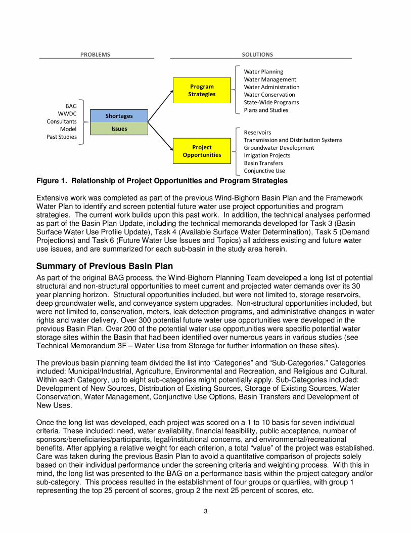
Project opportunities and program strategies are two categories of potential solutions to address water resources problems identified for the Wind-Bighorn Basin. They are generated based on known water supply shortages, potential future water shortages, issues identified in past studies, and issues identified in the Basin Plan Update process. Figure 1 shows that both approaches can be pursued in parallel, with project opportunities generally representing more structural approaches and program strategies generally representing more non-structural approaches.
3
Shortages
Issues
BAG
WWDC
Consultants
Model
Past Studies
Project
Opportunities
Program
Strategies
Water Planning
Water Administration
Water Conservation
State-Wide Programs
Plans and Studies
Water Management
Reservoirs
Groundwater Development
Irrigation Projects
Basin Transfers
Conjunctive Use
Transmission and Distribution Systems
PROBLEMS SOLUTIONS
Figure 1. Relationship of Project Opportunities and Program Strategies Extensive work was completed as part of the previous Wind-Bighorn Basin Plan and the Framework Water Plan to identify and screen potential future water use project opportunities and program strategies. The current work builds upon this past work. In addition, the technical analyses performed as part of the Basin Plan Update, including the technical memoranda developed for Task 3 (Basin Surface Water Use Profile Update), Task 4 (Available Surface Water Determination), Task 5 (Demand Projections) and Task 6 (Future Water Use Issues and Topics) all address existing and future water use issues, and are summarized for each sub-basin in the study area herein.
Summary of Previous Basin Plan
As part of the original BAG process, the Wind-Bighorn Planning Team developed a long list of potential structural and non-structural opportunities to meet current and projected water demands over its 30 year planning horizon. Structural opportunities included, but were not limited to, storage reservoirs, deep groundwater wells, and conveyance system upgrades. Non-structural opportunities included, but were not limited to, conservation, meters, leak detection programs, and administrative changes in water rights and water delivery. Over 300 potential future water use opportunities were developed in the previous Basin Plan. Over 200 of the potential water use opportunities were specific potential water storage sites within the Basin that had been identified over numerous years in various studies (see Technical Memorandum 3F – Water Use from Storage for further information on these sites). The previous basin planning team divided the list into “Categories” and “Sub-Categories.” Categories included: Municipal/Industrial, Agriculture, Environmental and Recreation, and Religious and Cultural. Within each Category, up to eight sub-categories might potentially apply. Sub-Categories included: Development of New Sources, Distribution of Existing Sources, Storage of Existing Sources, Water Conservation, Water Management, Conjunctive Use Options, Basin Transfers and Development of New Uses. Once the long list was developed, each project was scored on a 1 to 10 basis for seven individual criteria. These included: need, water availability, financial feasibility, public acceptance, number of sponsors/beneficiaries/participants, legal/institutional concerns, and environmental/recreational benefits. After applying a relative weight for each criterion, a total “value” of the project was established. Care was taken during the previous Basin Plan to avoid a quantitative comparison of projects solely based on their individual performance under the screening criteria and weighting process. With this in mind, the long list was presented to the BAG on a performance basis within the project category and/or sub-category. This process resulted in the establishment of four groups or quartiles, with group 1 representing the top 25 percent of scores, group 2 the next 25 percent of scores, etc.
4
The BAG was asked to review the long list and identify potential opportunities not included on the preliminary list as well as the relative merits of the individual projects. Comments and suggestions received from BAG members and additional research led to the development of the final long list and ultimately the short list. In the development of the short list, each project was assigned to a category: municipal, agriculture, environmental and religious and projects were rated within that category. For example, municipal projects were rated against other municipal projects and agricultural storage projects were rated against similar projects. Certain projects were eliminated from consideration for the short list. Reasons to eliminate projects included:
1) the project had already been constructed; 2) the location of the project facilities (i.e. within an environmentally sensitive or Wilderness Area),
presented major legal, institutional, and permitting constraints; 3) the original demand for the project no longer exists and is not expected to appear within the
planning period; 4) the project had no immediate or near term sponsor; or 5) the project feasibility was questionable or did not fall within the upper percentile of screening
criteria. Given the size, breadth and distribution of project needs within the Basin, an attempt was made to develop short list projects that might benefit different interests throughout the Basin. This included an attempted geographical distribution of projects throughout the Basin. The final grouping of short list projects is presented in Table 1.
Summary of Framework Water Plan
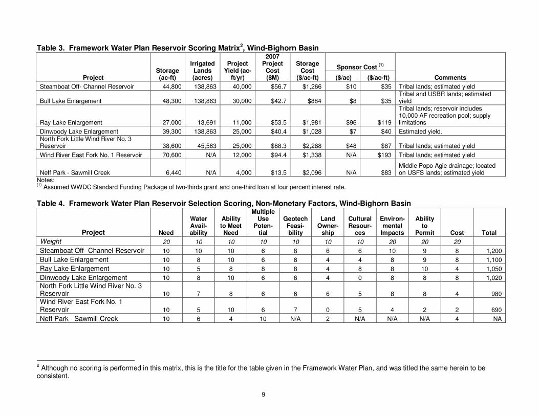
The WWDC Framework Water Plan (WWC, 2007) included the long list and short list of future water use opportunities developed in all previous basin planning studies. The Framework Water Plan then developed additional scoring and analysis of short-listed sites. The first step in the analysis conducted in the Framework Water Plan was to expand the list of short-listed sites developed in the previous Basin Plan. The primary source of this expansion were projects that have been identified in specific Level I and Level II basin planning studies since the previous Basin Plan was completed. A scoring matrix using six weighted criteria was developed “to present an overall picture of the favorability of a project or opportunity” (WWC, 2007). It should be noted that each basin plan used slightly different scoring methods. Therefore, the matrix scoring cannot be compared across basin plans. The scoring matrix as developed for the short-listed sites in the Wind-Bighorn Basin is presented in Table 2. The planning studies completed since the previous Basin Plan identified seven specific potential future reservoir opportunities within the study area, all located in the Wind River Basin. These seven sites were further evaluated in the Framework Water Plan based on a standardized scoring matrix for physical and monetary criteria and non-monetary criteria. The seven sites and the scoring matrices from the Framework Water Plan are presented in Table 3 and Table 4.
• Upper Wind - The four sites in the Upper and Lower Wind sub-basins (Steamboat Off- Channel Reservoir, Bull Lake Enlargement, Dinwoody Lake Enlargement) generally scored similarly in the evaluation – a Level II study was recommended for further analysis within the Basin.
• Little Wind - Two sites were evaluated in the Little Wind sub-basin: Ray Lake Enlargement and North Fork Little Wind River No. 3 Reservoir. Ray Lake Enlargement scored much better than the North Fork site, and relatively well in comparison with the Basin-wide sites. However, the Ray Lake Enlargement site would not meet all of the needs within the Little Wind sub-basin. Since the Framework Water Plan has been developed, WWDC and its planning team have
5
determined that Ray Lake will not be enlarged at this time – the dam will be rehabilitated at its current storage size (Pavlica, 2009).
• Popo Agie – The Neff Park – Sawmill Creek site was the only site evaluated in the Popo Agie sub-basin. This site was not completely scored in the Framework Water Plan due to lack of information.
No storage sites in the Bighorn or Clark’s Fork Basin were included in the detailed scoring and evaluation matrix. However, sites were identified in recent previous studies for these basins. Thus, the Framework Plan reviewed these reports and eventually added the Lake Creek site in the Clark’s Fork Basin as a potential site (WWC, 2007). In addition to storage sites, the Framework Plan discussed the opportunities for additional water development in specific aquifers within the Basin, including local alluvial aquifers, the Wind River aquifer, the Madison aquifer and Flathead Sandstone aquifer. Additional study is currently underway as part of the Basin Plan Update by the Wyoming State Geological Survey.
6
Table 1. Original Basin Plan Shortlist of Future Water Use Opportunities Type of Project Name of Project Description of Project Location of Project
I. MUNICIPAL
New Source Paleozoic Well Field Construct Deep Aquifer Supply Regionalization: Lander/Hudson/Riverton
Paleozoic Well Field Construct Deep Aquifer Supply Regionalization: W.R. Reservation-Ft. Washakie
Paleozoic Well Field Construct Deep Aquifer Supply Regionalization: Hot Springs County BHRJPB
Distribution/Storage Bighorn Regional Joint Powers Board Storage Tanks/Redundant Transmission Hot Springs/Washakie County
Opportunities Tensleep/Hyattville Storage Tanks/ Transmission Washakie County
Conjunctive Use Aquifer Storage and Retrieval Alluvial Aquifer Augmentation Upper Wind River/Riverton Area
Water Management Ground Water Control District Administration of Future Development Riverton Area
Ground Water Control District Administration of Future Development Paintrock Anticline and Hyattville
Water Conservation Leak Detection Municipal Survey and Repair of Leaks Basin-wide
Reuse of Grey/Non Potable Water Irrigation of Parks/Cemeteries Basin-wide
II. AGRICULTURAL
New Source None
Storage Opportunities Bull Lake Dam Enlargement Reservoir Enlargement Big Wind River
Dinwoody Lake Enlargement Reservoir Enlargement Big Wind River
Steamboat New Reservoir Big Wind River
Ray Lake Reservoir Enlargement Little Wind River
Little Popo Agie-Off Channel Site 5 New Reservoir Little Popo Agie
Pumpkin Draw New Reservoir Owl Creek
Neff Park (Popo Agie Study) New Reservoir Popo Agie
Lake Creek New Reservoir Clark’s Fork
Distribution Popo Agie River Master Plan Ditch Headgate/Diversion Improvements Popo Agie Basin
Kirby Creek Watershed Study Stock Reservoirs Kirby Creek Basin
New Lands Riverton East Construct New Diversions/Ditches Wind River Basin
Westside Construct New Diversions/Ditches Bighorn Basin
Water Conservation Midvale/LeClair/Riverton Valley Ditch Linings/Conveyance Improvements Wind River Basin
Wind River Irrigation Project Ditch Linings/Conveyance Improvements Wind River Basin
Basin Transfer Clark’s Fork to Greybull Drainage Storage and Pipeline Clark’s Fork to Bighorn Basin
III. ENVIRONMENTAL
Instream Flows Administration of Minimum Flows Wind and Bighorn Basin
Minimum Reservoir Pools Administration of Reservoir Releases Wind and Bighorn Basin
Watershed/Habitat Improvement Water Quality Impaired Streams Bighorn Basin
IV. CULTURAL/RELIGIOUS
Water Use by Tribes Coordinated Reservoir Releases Wind and Bighorn Basin
7
Table 2. Framework Water Plan Evaluated Short List: Wind-Bighorn Basin
Project Type Need
Water Availa-bility
Financial Feasibility
Public Accept-
ance
No. of Sponsor/
Beneficiaries
Legal/ Institut-
ional
Environ-mental
/Recreation Benefits
Total Score (Avg)
(1)
Framework Total Score
(2)
Weighting1 8 7 7 6 6 5 7
Municipal
Groundwater Development
Madison Aquifer (Lander) 6 7 6 7 10 5 5 6.6 301 Madison Aquifer (Southern Bighorn Basin) 5 7 8 8 10 7 5 7.1 323
Distribution/Storage Opportunities
Big Horn Regional Joint Powers Board 4 7 8 8 10 7 5 7.0 315
Town of Tensleep Regionalization 8 8 6 5 6 7 5 6.4 298
Conjunctive Use Recharge of Alluvial System Along Upper Wind River 7 8 5 5 4 4 7 5.7 270
Water Conservation
Leak Detection 7 8 5 5 5 9 5 6.3 287
Reclaimed Water for Irrigation 6 7 3 4 5 5 5 5.0 232
Agricultural
New Source (none) 0.0 0
Storage Opportunities Bull Lake Dam Enlargement - 48,000 AF (Bighorn) 5 7.3 10 3 10 3 6 6.3 296 Dinwoody Lake Enlargement - 82,580 AF (Bighorn) 5.5 4.3 9.7 3 10 3 6 5.9 277
Steamboat - 36,000 AF (Bighorn) 5 8.5 9.9 3 10 3 6 6.5 304 Wind River East Fork No. 1 - 103,000 AF 5.9 1.9 9.2 3 10 3 6 5.6 260
Little Wind River North Fork No. 3 9.1 4.7 8.4 3 0 3 6 4.9 240 Ray Lake Enlargement - 41,650 AF (Little Wind) 9.1 2.1 8.4 3 10 6 7 6.5 303 Moraine Creek No. 1 - 1,150 AF (Shell Cr) 5 10 8.4 3 0 6 7 5.6 266
Pumpkin Draw - 2,000 AF (Owl Cr) 5 10 8.4 3 4.7 6 7 6.3 294
Lake Creek - 5,100 AF (Clark’s Fork) 0 5.3 8.4 3 0 6 7 4.2 193
Distribution
1 Weighting as developed in the Framework Water Plan.
8
Project Type Need
Water Availa-bility
Financial Feasibility
Public Accept-
ance
No. of Sponsor/
Beneficiaries
Legal/ Institut-
ional
Environ-mental
/Recreation Benefits
Total Score (Avg)
(1)
Framework Total Score
(2)
Popo Agie River Master Plan 7 5 8 7 7 6 7 6.7 310
Kirby Creek Master Plan 7 5 5 7 5 7 8 6.3 289
New Lands
Westside Irrigation Project 8 6 6 7 9 5 5 6.6 304
Riverton East 8 5 6 7 9 5 5 6.4 297
Water Conservation
Line Ditches to Reduce Seepage Loss 8 8 5 8 5 5 4 6.1 286
Change from Open Ditch to Pipeline 8 8 5 8 5 5 4 6.1 286
Midvale Irrigation District 8 8 7 8 6 5 4 6.6 306
LeClair Laterals 8 8 7 8 6 5 4 6.6 306
Riverton Valley Crossings 8 8 6 8 6 5 4 6.4 299
More Efficient Irrigation Systems 8 8 5 8 5 5 4 6.1 286
Low Head Sprinklers 8 8 5 8 5 5 4 6.1 286
Basin Transfer
Clark’s Fork to Shoshone River Pipeline 2 10 4 5 6 6 5 5.4 245 Wood River to Gooseberry Cr Storage in Sunshine Reservoir and Pipeline 5 6 4 5 6 6 5 5.3 241 Wood River to Cottonwood/ Grass Cr Storage in Sunshine Reservoir and Pipeline 5 6 4 5 6 6 5 5.3 241
Environmental
Environmental/Recreation
Instream or Minimum Flows 7 3 8 7 10 7 8 7.1 326
Minimum Reservoir Pool 7 3 8 7 10 7 8 7.1 326
River Restoration/Habitat Improvement 6 9 6 7 4 7 7 6.6 303
Cultural/Religious
Cultural/Religious Management Coordinated Releases for Cultural Purposes 8 8 7 6 6 8 7 7.1 330 Coordinated Releases for Religious Purposes 8 8 7 6 6 8 7 7.1 330
Notes: (1)
Average is the unweighted average of individual scores. (2)
This value is the sum of individual scores multiplied by the weighting factors. This is unique to the Framework Water Plan and was calculated to create a more uniform scoring system among the basins.
9
Table 3. Framework Water Plan Reservoir Scoring Matrix2, Wind-Bighorn Basin
Project Storage (ac-ft)
Irrigated Lands (acres)
Project Yield (ac-
ft/yr)
2007 Project
Cost ($M)
Storage Cost
($/ac-ft)
Sponsor Cost (1)
Comments ($/ac) ($/ac-ft)
Steamboat Off- Channel Reservoir 44,800 138,863 40,000 $56.7 $1,266 $10 $35 Tribal lands; estimated yield
Bull Lake Enlargement 48,300 138,863 30,000 $42.7 $884 $8 $35 Tribal and USBR lands; estimated yield
Ray Lake Enlargement 27,000 13,691 11,000 $53.5 $1,981 $96 $119
Tribal lands; reservoir includes 10,000 AF recreation pool; supply limitations
Dinwoody Lake Enlargement 39,300 138,863 25,000 $40.4 $1,028 $7 $40 Estimated yield. North Fork Little Wind River No. 3 Reservoir 38,600 45,563 25,000 $88.3 $2,288 $48 $87 Tribal lands; estimated yield
Wind River East Fork No. 1 Reservoir 70,600 N/A 12,000 $94.4 $1,338 N/A $193 Tribal lands; estimated yield
Neff Park - Sawmill Creek 6,440 N/A 4,000 $13.5 $2,096 N/A $83 Middle Popo Agie drainage; located on USFS lands; estimated yield
Notes: (1)
Assumed WWDC Standard Funding Package of two-thirds grant and one-third loan at four percent interest rate.
Table 4. Framework Water Plan Reservoir Selection Scoring, Non-Monetary Factors, Wind-Bighorn Basin
Project Need
Water Avail-ability
Ability to Meet Need
Multiple Use
Poten-tial
Geotech Feasi-bility
Land Owner-
ship
Cultural Resour-
ces
Environ- mental
Impacts
Ability to
Permit Cost Total
Weight 20 10 10 10 10 10 10 20 20 20
Steamboat Off- Channel Reservoir 10 10 10 6 8 6 6 10 9 8 1,200
Bull Lake Enlargement 10 8 10 6 8 4 4 8 9 8 1,100
Ray Lake Enlargement 10 5 8 8 8 4 8 8 10 4 1,050
Dinwoody Lake Enlargement 10 8 10 6 6 4 0 8 8 8 1,020
North Fork Little Wind River No. 3 Reservoir 10 7 8 6 6 6 5 8 8 4 980
Wind River East Fork No. 1 Reservoir 10 5 10 6 7 0 5 4 2 2 690
Neff Park - Sawmill Creek 10 6 4 10 N/A 2 N/A N/A N/A 4 NA
2 Although no scoring is performed in this matrix, this is the title for the table given in the Framework Water Plan, and was titled the same herein to be
consistent.
10
Section 2 – Summary of Existing and Future Water Use This section presents a general summary existing water uses investigated in the Task 3 technical memoranda, modeling of available flow and shortages developed in Task 4 technical memoranda, and the future water uses discussed in the Task 5 technical memorandum. Information is presented in this section in order to define water needs and frame development of future water use opportunities that are discussed in Section 3 of this document. Full information on each of these analyses is presented in the specific memoranda developed for each subject. Summary information presented in this section includes:
• Available Surface Water - Available surface water flows are those flows that could be diverted or developed from reaches without injuring existing water uses including permitted instream flow rights, or compromising delivery of water required by the Yellowstone River Compact. Available surface water was calculated for dry, average and wet hydrologic conditions using the spreadsheet models. These calculations are presented in Technical Memorandum 4C – Available Surface Water Determination and Shortages.
• Shortages – Shortages are simulated for Full Supply water uses within the study area, including the Riverton East Futures Project but not the other Futures Projects (see below). Shortages were calculated for dry, average and wet hydrologic conditions using the spreadsheet models. These calculations are presented in Technical Memorandum 4C.
• State Permitted Instream Flows – State permitted instream flow reaches within the study area were identified in Technical Memorandum 3D/3E – Recreational and Environmental Water Use. For those reaches where target flows were defined by flow rate, simulated streamflow is compared for each hydrologic condition to minimum target streamflows.
• Whitewater Rafting Reaches – Active whitewater rafting reaches within the study area were identified in Technical Memorandum 3D/3E. For those reaches where target flows were defined by flow rate, simulated streamflow is compared for each hydrologic condition to minimum target streamflows. It should be noted that these whitewater rafting reaches do not have a water right, and cannot obtain a water right for instream recreational uses.
• Qualitative Summary of Municipal Water Use – Although municipal surface water uses within the study area are relatively small when compared with other water uses, they are an important water use within the study area and many have experienced shortages during the 2000’s drought conditions. Detailed quantitative information was discussed in Technical Memorandum 3B – Domestic and Municipal Water Use.
• Qualitative Summary of Industrial Water Use – Industrial water use and associated return flows
and discharges are an important water use in discussion of future water use opportunities. Detailed quantitative information was discussed in Technical Memorandum 3C – Industrial Water Use.
• Estimated Changes in Future Water Use – This information was developed based on socioeconomic growth patterns, and is discussed in Technical Memorandum 5 – Future Water Use. Most of this information is qualitative in nature.
Because the Full Supply with the Riverton East Futures Project is the “most likely” future water supply scenario, unless otherwise noted, all of the graphs within this section show flows resulting from this scenario. For all basins but the Wind River Basin, flows and shortages for the Riverton East scenario
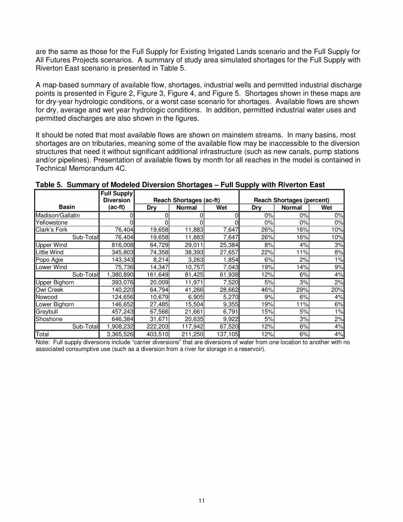
11
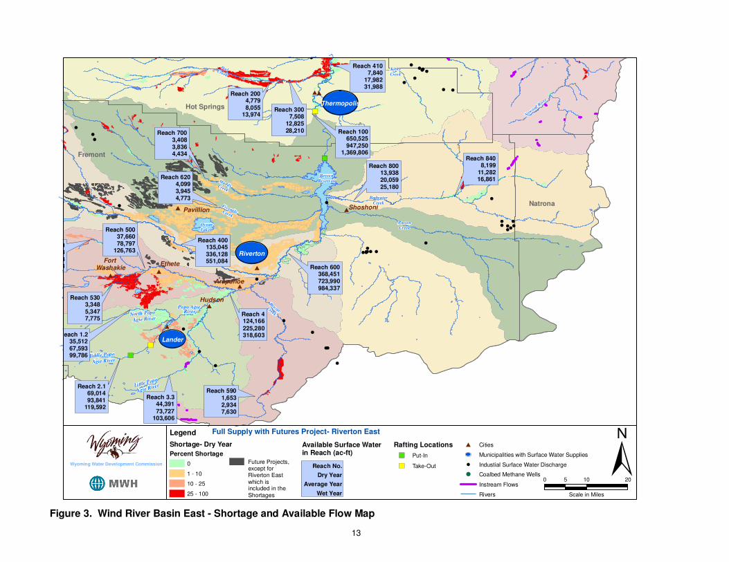
are the same as those for the Full Supply for Existing Irrigated Lands scenario and the Full Supply for All Futures Projects scenarios. A summary of study area simulated shortages for the Full Supply with Riverton East scenario is presented in Table 5. A map-based summary of available flow, shortages, industrial wells and permitted industrial discharge points is presented in Figure 2, Figure 3, Figure 4, and Figure 5. Shortages shown in these maps are for dry-year hydrologic conditions, or a worst case scenario for shortages. Available flows are shown for dry, average and wet year hydrologic conditions. In addition, permitted industrial water uses and permitted discharges are also shown in the figures. It should be noted that most available flows are shown on mainstem streams. In many basins, most shortages are on tributaries, meaning some of the available flow may be inaccessible to the diversion structures that need it without significant additional infrastructure (such as new canals, pump stations and/or pipelines). Presentation of available flows by month for all reaches in the model is contained in Technical Memorandum 4C. Table 5. Summary of Modeled Diversion Shortages – Full Supply with Riverton East
Basin
Full Supply Diversion
(ac-ft)
Reach Shortages (ac-ft)
Reach Shortages (percent)
Dry Normal Wet Dry Normal Wet
Madison/Gallatin 0 0 0 0 0% 0% 0% Yellowstone 0 0 0 0 0% 0% 0% Clark’s Fork 76,404 19,658 11,883 7,647 26% 16% 10%
Sub-Total 76,404 19,658 11,883 7,647 26% 16% 10%
Upper Wind 816,008 64,729 29,011 25,384 8% 4% 3% Little Wind 345,803 74,358 38,393 27,657 22% 11% 8%
Popo Agie 143,343 8,214 3,263 1,854 6% 2% 1%
Lower Wind 75,736 14,347 10,757 7,043 19% 14% 9%
Sub-Total 1,380,890 161,649 81,425 61,938 12% 6% 4%
Upper Bighorn 393,076 20,009 11,971 7,520 5% 3% 2%
Owl Creek 140,220 64,794 41,266 28,662 46% 29% 20% Nowood 124,656 10,679 6,905 5,270 9% 6% 4% Lower Bighorn 146,652 27,485 15,504 9,355 19% 11% 6% Greybull 457,243 67,566 21,661 6,791 15% 5% 1%
Shoshone 646,384 31,671 20,635 9,922 5% 3% 2%
Sub-Total 1,908,232 222,203 117,942 67,520 12% 6% 4%
Total 3,365,526 403,510 211,250 137,105 12% 6% 4%
Note: Full supply diversions include “carrier diversions” that are diversions of water from one location to another with no associated consumptive use (such as a diversion from a river for storage in a reservoir).

12
!(
!(
!(
!(
!(
!(
!(
!(
!(
!(
!(
�)
�)
�)
�)
�)
�)
�)
�)
#
#
##
#
#
#
#
Hudson
Dubois
��Riverton
Pavillion
��Lander
Ethete
Arapahoe
Fort Washakie
Ocean
Lake
Wind River
Bull
Lake
Bull Lake
Creek
East Fork
Wind River
Middle Popo
Agie River
Popo Agie River
FivemileCreek
MuddyCreek
OwlCreek
BeaverCreekNorth Popo
Agie River
Little Popo
Agie River
Fremont
Hot Springs Reach 300
Reach 50037,66078,797
126,763Reach 540
3,6236,788
10,033
Reach 1002,375
40,53862,375
Reach 400135,045336,128551,084
Reach 39016,414
120,412164,332
Reach 32012,56738,67456,009
Reach 5107,907
15,36231,930
Reach 2908,074
31,98553,418
Reach 2004,7798,055
13,974
Reach 5303,3485,3477,775
Reach 5901,6532,9347,630
Reach 6204,0993,9454,773
Reach 7003,4083,8364,434
Reach 30086,324
279,268488,431
Reach 1.235,51267,59399,786
Reach 2.169,01493,841
119,592
Reach 3.344,39173,727
103,606
Reach 4124,166225,280318,603
±0 10 205
Scale in Miles
Legend
Shortage- Dry Year
Percent Shortage
0
1 - 10
10 - 25
25 - 100
Rafting Locations
�) Put-In
�) Take-Out
# Cities
�� Municipalities with Surface Water Supplies
!( Industial Surface Water Discharge
!( Coalbed Methane Wells
Instream Flows
Rivers
Full Supply with Futures Project- Riverton East
Future Projects, except forRiverton Eastwhich isincluded in theShortages
Available Surface Waterin Reach (ac-ft)
Reach No.
Dry Year
Average Year
Wet Year
Wyoming Water Development Commission
Figure 2. Wind River Basin West - Shortage and Available Flow Map
13
!(
!(
!(
!(
!(
!(
!(
!(!(!(
!(
!(
!(
!(
!(!(!(
!(
!(
!(
!(!(
!(
!(
!(
!(
!(
!(
!(
!(!(!(
!(!( !(!(
!(!(
!(
!(
!(!(
!(
!(
!(
�)
�)
�)
�)
#
#
##
#
#
#
#
#
#
��
Hudson
Shoshoni
��Riverton
Pavillion
��Lander
Ethete
��Thermopolis
Arapahoe
Fort Washakie
Boysen
Reservoir
Ocean
Lake
Middle Popo
Agie River
Popo Agie River
FivemileCreek
MuddyCreek
OwlCreek
BeaverCreek
Kirby
Creek
Poison
Creek
Badwater
Creek
North Popo
Agie River
Little Popo
Agie River
Now
ood R
iver
Fremont
Hot Springs
Natrona
Reach 3007,508
12,82528,210
Reach 50037,66078,797
126,763Reach 540
3,6236,788
10,033
Reach 400135,045336,128551,084
Reach 80013,93820,05925,180
Reach 8408,199
11,28216,861
Reach 4107,840
17,98231,988
Reach 2004,7798,055
13,974
Reach 5303,3485,3477,775
Reach 5901,6532,9347,630
Reach 6204,0993,9454,773
Reach 7003,4083,8364,434
Reach 600368,451723,990984,337
Reach 100650,525947,250
1,369,806
Reach 1.235,51267,59399,786
Reach 2.169,01493,841
119,592
Reach 3.344,39173,727
103,606
Reach 4124,166225,280318,603
±0 10 205
Scale in Miles
Legend
Shortage- Dry Year
Percent Shortage
0
1 - 10
10 - 25
25 - 100
Rafting Locations
�) Put-In
�) Take-Out
# Cities
�� Municipalities with Surface Water Supplies
!( Industial Surface Water Discharge
!( Coalbed Methane Wells
Instream Flows
Rivers
Full Supply with Futures Project- Riverton East
Future Projects, except forRiverton Eastwhich isincluded in theShortages
Available Surface Waterin Reach (ac-ft)
Reach No.
Dry Year
Average Year
Wet Year
Wyoming Water Development Commission
Figure 3. Wind River Basin East - Shortage and Available Flow Map
14
!(
!(
!(
!(!(
!(
!(
!(
!(
�)
�)�)�)
�)
�)
�)
�)�)
�)
�)
�)
�)
�)
�) �)
�)
�)
�)
�)
#
��Cody
South Fork
Shoshone R
iver
Buffalo Bill
ReservoirNorth Fork
Shoshone River
Yellowstone
River
Yellowstone
Lake
Clarks Fork
Yellowstone River
CrandallCreek
Lamar
River
Madison
River
Sunlight
Creek
Gardner
River
Elk
Fo
rk
Ishawooa
Creek
Park
Teton
Reach 200268,983350,497430,247
Reach 58068,952
106,749146,675
Reach 400859,775
1,087,0631,333,160
Reach 100268,983350,497430,247
Reach 490238,088365,083501,338
Reach 200030,85855,47593,112
Reach 2100324,952476,366571,620
Reach 120046,43666,81182,381
Reach 110017,192 28,659 85,562
Reach 1900179,299292,339406,277
Reach 18007,760
11,72417,536
±0 10 205
Scale in Miles
Legend
Shortage- Dry Year
Percent Shortage
0
1 - 10
10 - 25
25 - 100
Rafting Locations
�) Put-In
�) Take-Out
# Cities
�� Municipalities with Surface Water Supplies
!( Industial Surface Water Discharge
!( Coalbed Methane Wells
Instream Flows
Rivers
Full Supply with Futures Project- Riverton East
Future Projects, except forRiverton Eastwhich isincluded in theShortages
Available Surface Waterin Reach (ac-ft)
Reach No.
Dry Year
Average Year
Wet Year
Wyoming Water Development Commission
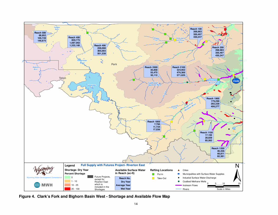
Figure 4. Clark’s Fork and Bighorn Basin West - Shortage and Available Flow Map
15
!(
!(
!(!(!(!(!(!(!(!(!(!(
!(!(
!(
!(
!(
!(!(
!(
!(
!(!(!(
!(
!(
!(
!(
!(
!(
!(!(
!(!(
!(
!(
!(
!(
!(
!(
!(
!(!(
!(
!(
!(
!(
!(
!(
!(
!(
!(
!(
(
!(
!(
!( !(
!( !(
!(!(!(
!(
!(
!(
!(!(
!(
!(
!(!(
!(
!(
!(!(
!(
!(
!(
!(
!(!(
!(!(
!(
!(!(
!(
�)�)
�)
�)
�)
�)
#
#
#
#
##
#
#
#
#
#
#
#
#
#
��Cody
��Kirby
��Byron
Basin
��Powell
Meeteetse
��Deaver
Worland
��Frannie
Greybull
Ten Sleep
Manderson
Burlington
Cowley
��Lovell
Shoshone River
Bighorn
Lake
Bighorn
River
Nowood
River
Greybull
River
Shell Creek
Dry Creek
Tensleep
Creek
PaintrockCreek
Owl
Fifteen MileCreek
Cottonwood
Creek
Gooseberry
Creek
Nowater
Creek
Kirby
Big Horn
Washakie
Reach 400659,028958,939
1,397,158
Reach 900802,761
1,172,5111,700,980
Reach 4605,060
12,27824,393
Reach 6005,8749,760
16,207
Reach 6901,8315,972
14,541
Reach 5404,5046,9076,138
Reach 800248,963316,886374,819
Reach 700157,247188,298214,570
Reach 500771,835
1,138,5611,663,246
Reach 4807,865
13,71620,179
Reach 2400468,301653,740749,983
Reach 2500568,919855,715
1,023,558
Reach 1700902,512
1,331,1421,886,436
Reach 160029,38247,36454,770
Reach 140031,25149,011
103,211Reach 1300
19,70938,59395,533
±0 10 205
Scale in Miles
Legend
Shortage- Dry Year
Percent Shortage
0
1 - 10
10 - 25
25 - 100
Rafting Locations
�) Put-In
�) Take-Out
# Cities
�� Municipalities with Surface Water Supplies
!( Industial Surface Water Discharge
!( Coalbed Methane Wells
Instream Flows
Rivers
Full Supply with Futures Project- Riverton East
Future Projects, except forRiverton Eastwhich isincluded in theShortages
Available Surface Waterin Reach (ac-ft)
Reach No.
Dry Year
Average Year
Wet Year
Wyoming Water Development Commission
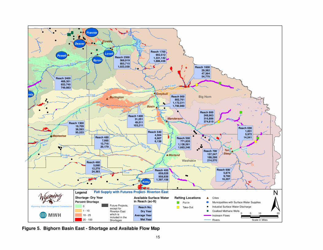
Figure 5. Bighorn Basin East - Shortage and Available Flow Map
16
The following provides available surface water, shortage and existing and future water use summary information for each basin and sub-basin. In some graphs, shortages appear during the same time periods of available flow. It is important to note that available flow represents flow on the mainstem and shortages may occur in locations where available flow is inaccessible, such as in the tributary regions.
Yellowstone Basin
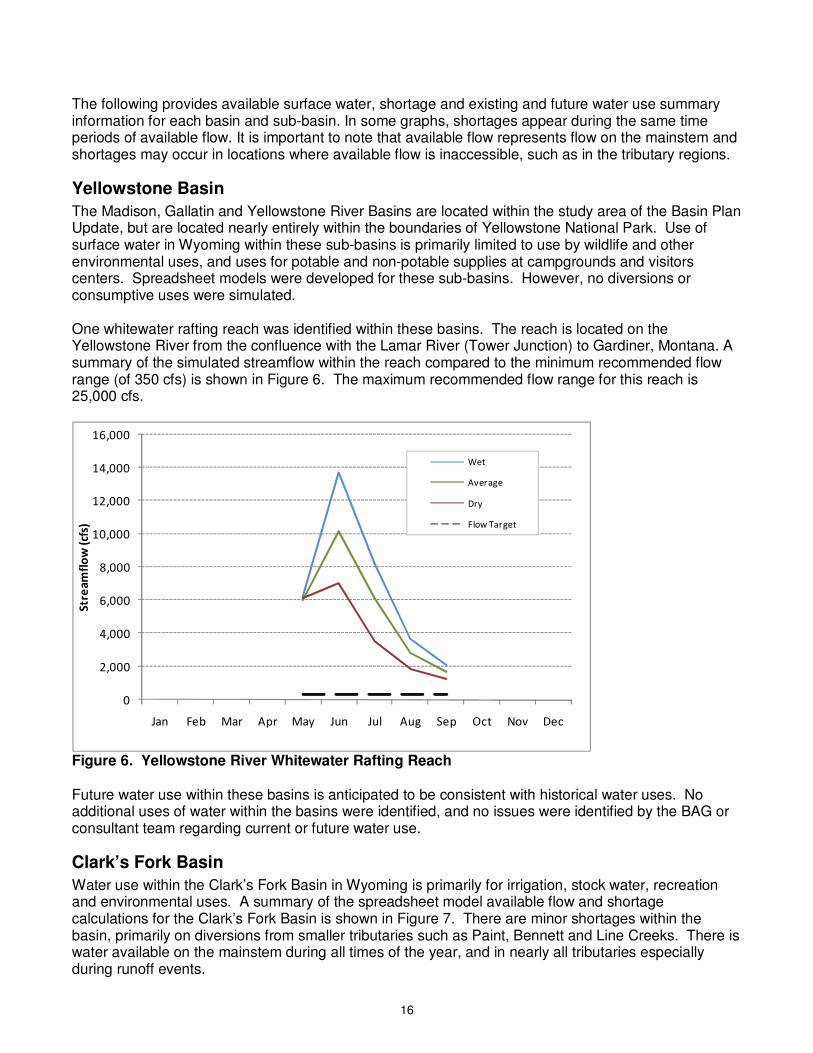
The Madison, Gallatin and Yellowstone River Basins are located within the study area of the Basin Plan Update, but are located nearly entirely within the boundaries of Yellowstone National Park. Use of surface water in Wyoming within these sub-basins is primarily limited to use by wildlife and other environmental uses, and uses for potable and non-potable supplies at campgrounds and visitors centers. Spreadsheet models were developed for these sub-basins. However, no diversions or consumptive uses were simulated. One whitewater rafting reach was identified within these basins. The reach is located on the Yellowstone River from the confluence with the Lamar River (Tower Junction) to Gardiner, Montana. A summary of the simulated streamflow within the reach compared to the minimum recommended flow range (of 350 cfs) is shown in Figure 6. The maximum recommended flow range for this reach is 25,000 cfs.
0
2,000
4,000
6,000
8,000
10,000
12,000
14,000
16,000
Jan Feb Mar Apr May Jun Jul Aug Sep Oct Nov Dec
Str
ea
mfl
ow
(cf
s)
Wet
Average
Dry
Flow Target
Figure 6. Yellowstone River Whitewater Rafting Reach Future water use within these basins is anticipated to be consistent with historical water uses. No additional uses of water within the basins were identified, and no issues were identified by the BAG or consultant team regarding current or future water use.
Clark’s Fork Basin
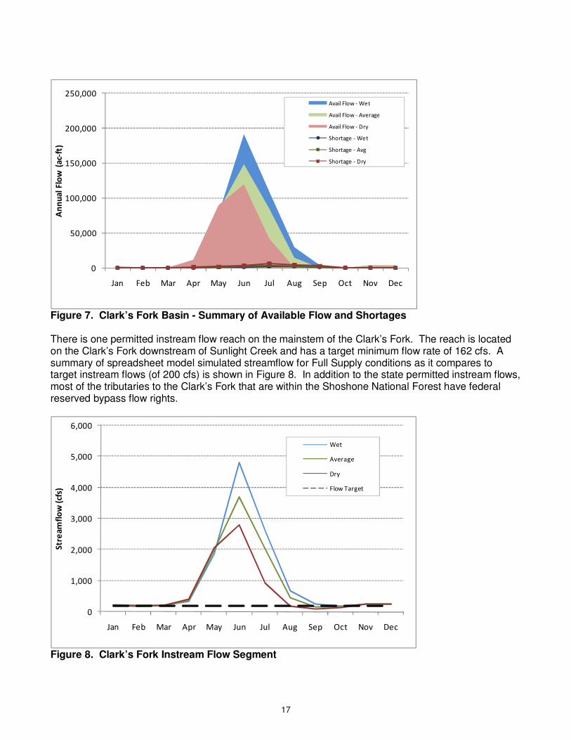
Water use within the Clark’s Fork Basin in Wyoming is primarily for irrigation, stock water, recreation and environmental uses. A summary of the spreadsheet model available flow and shortage calculations for the Clark’s Fork Basin is shown in Figure 7. There are minor shortages within the basin, primarily on diversions from smaller tributaries such as Paint, Bennett and Line Creeks. There is water available on the mainstem during all times of the year, and in nearly all tributaries especially during runoff events.
17
0
50,000
100,000
150,000
200,000
250,000
Jan Feb Mar Apr May Jun Jul Aug Sep Oct Nov Dec
An
nu
al
Flo
w (
ac-
ft)
Avail Flow - Wet
Avail Flow - Average
Avail Flow - Dry
Shortage - Wet
Shortage - Avg
Shortage - Dry
Figure 7. Clark’s Fork Basin - Summary of Available Flow and Shortages There is one permitted instream flow reach on the mainstem of the Clark’s Fork. The reach is located on the Clark’s Fork downstream of Sunlight Creek and has a target minimum flow rate of 162 cfs. A summary of spreadsheet model simulated streamflow for Full Supply conditions as it compares to target instream flows (of 200 cfs) is shown in Figure 8. In addition to the state permitted instream flows, most of the tributaries to the Clark’s Fork that are within the Shoshone National Forest have federal reserved bypass flow rights.
0
1,000
2,000
3,000
4,000
5,000
6,000
Jan Feb Mar Apr May Jun Jul Aug Sep Oct Nov Dec
Str
ea
mfl
ow
(cf
s)
Wet
Average
Dry
Flow Target
Figure 8. Clark’s Fork Instream Flow Segment

18
Five whitewater rafting reaches were identified on the Clark’s Fork, including the Upper, Honeymoon, The Box, Lower and the Styx and Stones segments. Spreadsheet model simulated streamflow for the Box segment, which is located downstream of Crandall Creek, is shown in Figure 9. Minimum recommended flows of 500 cfs are typically met through August, except for dry years, where flows are met through July. The maximum recommended flow of 1,200 cfs for this segment is exceeded for many months of the year. The four other whitewater rafting reaches on the Clark’s Fork have target flows that are not flow based (i.e. they are either based on stage or are not given), and thus not shown. It is expected that these target flows are met in a pattern similar to that shown for The Box. The Clark’s Fork is also a Blue Ribbon Stream Reach and has a National Wild and Scenic Designation from just upstream of the Crandall Creek confluence to the approximate eastern border of the Shoshone National Forest downstream of the Sunlight Creek confluence. There are also numerous designated public fishing access sites located throughout the basin, including more downstream reaches along both the mainstem and several tributaries.
0
500
1,000
1,500
2,000
2,500
3,000
3,500
4,000
4,500
Jan Feb Mar Apr May Jun Jul Aug Sep Oct Nov Dec
Str
ea
mfl
ow
(cf
s)
Wet
Average
Dry
Flow Target
Figure 9. Clark’s Fork Yellowstone (The Box) Whitewater Rafting Reach Future water use within the Clark’s Fork Basin in Wyoming is anticipated to be consistent with historical water uses. No additional uses of water within the basins were identified, and no issues were identified by the BAG or consultant team regarding current or future water use.
Wind River Basin
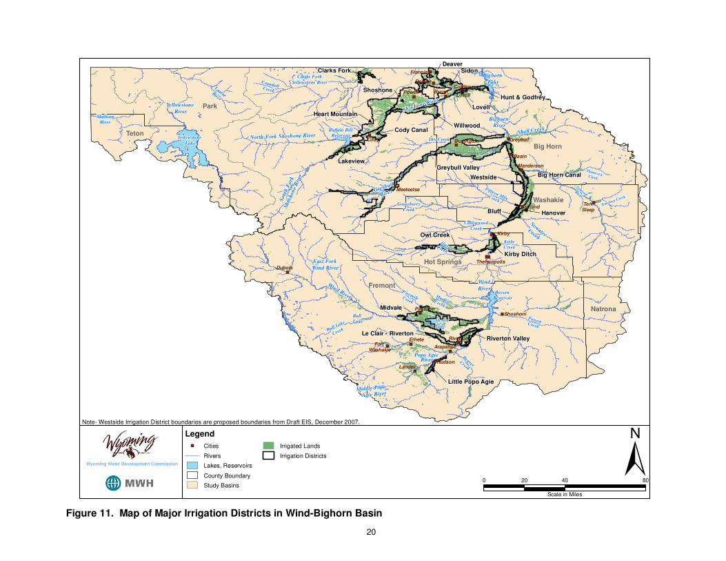
The Wind River Basin includes the Upper Wind, Little Wind, Popo Agie and Lower Wind sub-basins. Each of these sub-basins was simulated separately by the spreadsheet models. However, existing and future water uses within these sub-basins are interconnected, and thus the discussion that is presented for each sub-basin may have application to the other sub-basins within the Wind River Basin. Upper Wind The Upper Wind sub-basin includes diversions by the “Big 3” districts located near Riverton (Midvale, Riverton Valley and LeClair; see Figure 11), diversions for the Upper Wind, Johnstown and Lefthand Units of the Wind River Irrigation Project, and several other smaller ditches. A summary of the spreadsheet model available flow and shortage calculations for the Upper Wind sub-basin is shown in
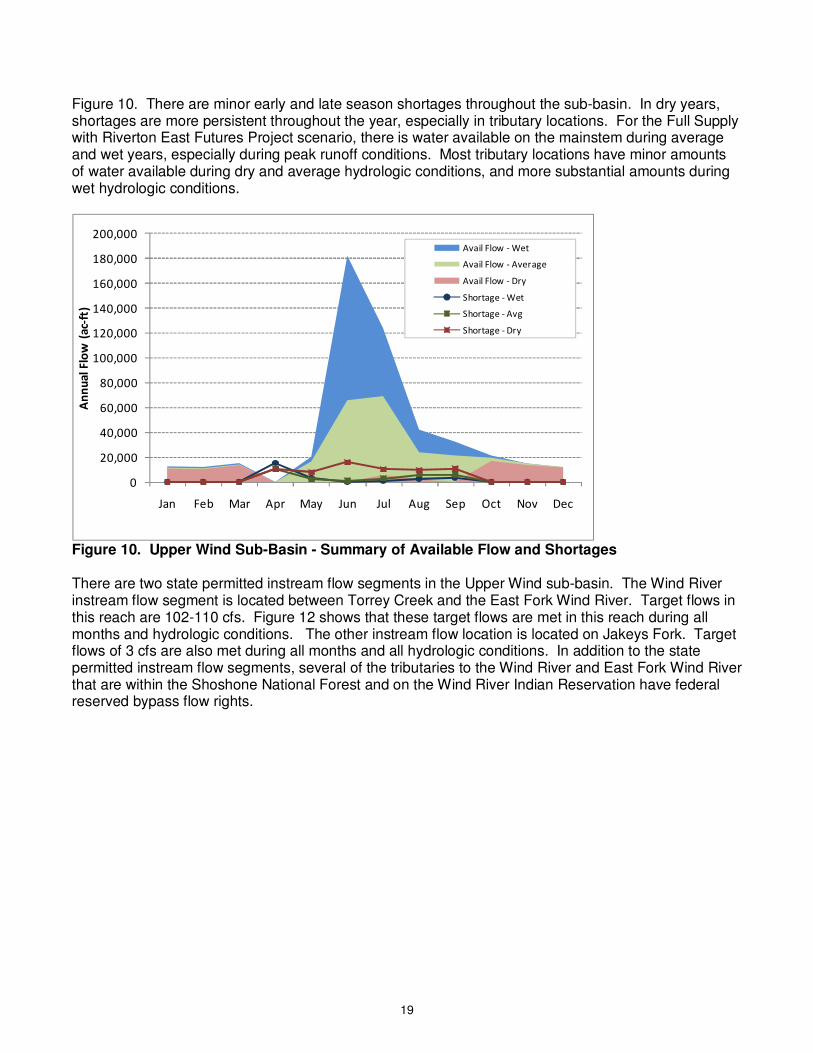
19
Figure 10. There are minor early and late season shortages throughout the sub-basin. In dry years, shortages are more persistent throughout the year, especially in tributary locations. For the Full Supply with Riverton East Futures Project scenario, there is water available on the mainstem during average and wet years, especially during peak runoff conditions. Most tributary locations have minor amounts of water available during dry and average hydrologic conditions, and more substantial amounts during wet hydrologic conditions.
0
20,000
40,000
60,000
80,000
100,000
120,000
140,000
160,000
180,000
200,000
Jan Feb Mar Apr May Jun Jul Aug Sep Oct Nov Dec
An
nu
al
Flo
w (
ac-
ft)
Avail Flow - Wet
Avail Flow - Average
Avail Flow - Dry
Shortage - Wet
Shortage - Avg
Shortage - Dry
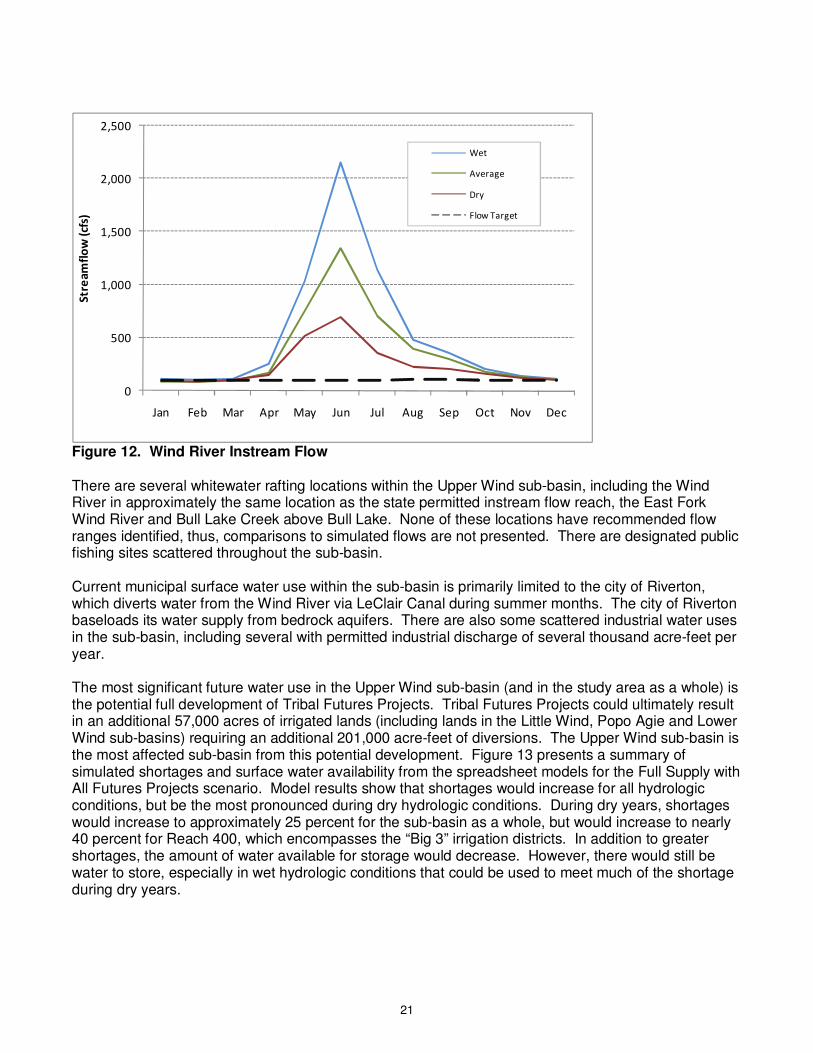
Figure 10. Upper Wind Sub-Basin - Summary of Available Flow and Shortages There are two state permitted instream flow segments in the Upper Wind sub-basin. The Wind River instream flow segment is located between Torrey Creek and the East Fork Wind River. Target flows in this reach are 102-110 cfs. Figure 12 shows that these target flows are met in this reach during all months and hydrologic conditions. The other instream flow location is located on Jakeys Fork. Target flows of 3 cfs are also met during all months and all hydrologic conditions. In addition to the state permitted instream flow segments, several of the tributaries to the Wind River and East Fork Wind River that are within the Shoshone National Forest and on the Wind River Indian Reservation have federal reserved bypass flow rights.
20
�
�
�
�
�
��
�
�
��
�
�
�
�
�
�
�
�
�
�
�
�
�
�
�
Cody
Kirby
Byron
Basin
Powell
LanderHudson
Dubois
Deaver
Worland
Frannie
Shoshoni
Riverton
Greybull
Ten Sleep
Pavillion
Meeteetse
Manderson
Ethete
Burlington
Thermopolis
Arapahoe Fort
Washakie
Cowley
Lovell
Shoshone River
Bighorn
Lake
Bighorn
River
Nowood River
Wind
RiverBoysen
Reservoir
Ocean
Lake
Wind River
Bull Lake
South
Fork
Sh
oshon
e R
iver
Buffalo Bill Reservoir
Greybull
River
North Fork Shoshone River
Yellowstone
River
Yellowstone
Lake
Shell Creek
Dry Creek
Tensleep Creek
PaintrockCreek
Bull Lake
Creek
East Fork
Wind River
Middle Popo
Agie River
Popo Agie River
Clarks Fork
Yellowstone RiverCrandallCreekLam
arR
iver
FivemileCreek
MuddyCreek
OwlCreek
Fifteen MileCreek
Cottonwood
Creek
BeaverCreek
Gooseberry
Creek
MadisonRiver
NowaterCreek
Kirby
Creek
PoisonCreek
Park
Fremont
Big Horn
Washakie
Hot Springs
Teton
Natrona
Greybull Valley
Shoshone
Heart Mountain
Midvale
Westside
DeaverSidon
Willwood
Big Horn Canal
Owl Creek
Cody Canal
Le Clair - Riverton
Hanover
Lakeview
Riverton Valley
Hunt & Godfrey
Kirby Ditch
Lovell
Bluff
Little Popo Agie
Clarks Fork
Note- Westside Irrigation District boundaries are proposed boundaries from Draft EIS, December 2007.
±0 40 8020
Scale in Miles
Legend
� Cities
Rivers
Lakes, Reservoirs
County Boundary
Study Basins
Irrigated Lands
Irrigation Districts
Wyoming Water Development Commission
Figure 11. Map of Major Irrigation Districts in Wind-Bighorn Basin
21
0
500
1,000
1,500
2,000
2,500
Jan Feb Mar Apr May Jun Jul Aug Sep Oct Nov Dec
Str
ea
mfl
ow
(cf
s)
Wet
Average
Dry
Flow Target
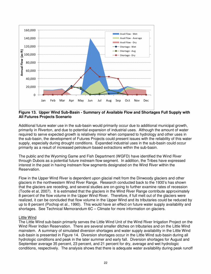
Figure 12. Wind River Instream Flow There are several whitewater rafting locations within the Upper Wind sub-basin, including the Wind River in approximately the same location as the state permitted instream flow reach, the East Fork Wind River and Bull Lake Creek above Bull Lake. None of these locations have recommended flow ranges identified, thus, comparisons to simulated flows are not presented. There are designated public fishing sites scattered throughout the sub-basin. Current municipal surface water use within the sub-basin is primarily limited to the city of Riverton, which diverts water from the Wind River via LeClair Canal during summer months. The city of Riverton baseloads its water supply from bedrock aquifers. There are also some scattered industrial water uses in the sub-basin, including several with permitted industrial discharge of several thousand acre-feet per year. The most significant future water use in the Upper Wind sub-basin (and in the study area as a whole) is the potential full development of Tribal Futures Projects. Tribal Futures Projects could ultimately result in an additional 57,000 acres of irrigated lands (including lands in the Little Wind, Popo Agie and Lower Wind sub-basins) requiring an additional 201,000 acre-feet of diversions. The Upper Wind sub-basin is the most affected sub-basin from this potential development. Figure 13 presents a summary of simulated shortages and surface water availability from the spreadsheet models for the Full Supply with All Futures Projects scenario. Model results show that shortages would increase for all hydrologic conditions, but be the most pronounced during dry hydrologic conditions. During dry years, shortages would increase to approximately 25 percent for the sub-basin as a whole, but would increase to nearly 40 percent for Reach 400, which encompasses the “Big 3” irrigation districts. In addition to greater shortages, the amount of water available for storage would decrease. However, there would still be water to store, especially in wet hydrologic conditions that could be used to meet much of the shortage during dry years.
22
0
20,000
40,000
60,000
80,000
100,000
120,000
140,000
160,000
Jan Feb Mar Apr May Jun Jul Aug Sep Oct Nov Dec
An
nu
al
Flo
w (
ac-
ft)
Avail Flow - Wet
Avail Flow - Average
Avail Flow - Dry
Shortage - Wet
Shortage - Avg
Shortage - Dry
Figure 13. Upper Wind Sub-Basin - Summary of Available Flow and Shortages Full Supply with All Futures Projects Scenario Additional future water use in the sub-basin would primarily occur due to additional municipal growth, primarily in Riverton, and due to potential expansion of industrial uses. Although the amount of water required to serve expected growth is relatively minor when compared to hydrology and other uses in the sub-basin, the development of Futures Projects could present issues with the reliability of this water supply, especially during drought conditions. Expanded industrial uses in the sub-basin could occur primarily as a result of increased petroleum based extractions within the sub-basin. The public and the Wyoming Game and Fish Department (WGFD) have identified the Wind River through Dubois as a potential future instream flow segment. In addition, the Tribes have expressed interest in the past in having instream flow segments designated on the Wind River within the Reservation. Flow in the Upper Wind River is dependent upon glacial melt from the Dinwoody glaciers and other glaciers in the northwestern Wind River Range. Research conducted back to the 1930’s has shown that the glaciers are receding, and several studies are on-going to further examine rates of recession (Tootle et al, 2007). It is estimated that the glaciers in the Wind River Range contribute approximately 8 percent of the flow volume in the Upper Wind River. Therefore, if full melt out of the glaciers were realized, it can be concluded that flow volume in the Upper Wind and its tributaries could be reduced by up to 8 percent (Pochop et al., 1990). This would have an effect on future water supply availability and shortages. See Technical Memorandum 6C – Climate for more information on glaciers. Little Wind The Little Wind sub-basin primarily serves the Little Wind Unit of the Wind River Irrigation Project on the Wind River Indian Reservation. There are several smaller ditches on tributaries and on the Little Wind mainstem. A summary of simulated diversion shortages and water supply availability in the Little Wind sub-basin is presented in Figure 14. Diversion shortages occur in the Little Wind sub-basin during all hydrologic conditions and peak in the later summer and early fall. Diversion shortages for August and September average 35 percent, 23 percent, and 21 percent for dry, average and wet hydrologic conditions, respectively. The analysis shows that there is adequate water availability during peak runoff
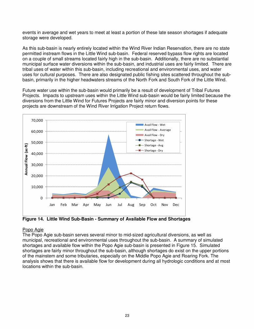
23
events in average and wet years to meet at least a portion of these late season shortages if adequate storage were developed. As this sub-basin is nearly entirely located within the Wind River Indian Reservation, there are no state permitted instream flows in the Little Wind sub-basin. Federal reserved bypass flow rights are located on a couple of small streams located fairly high in the sub-basin. Additionally, there are no substantial municipal surface water diversions within the sub-basin, and industrial uses are fairly limited. There are tribal uses of water within this sub-basin, including recreational and environmental uses, and water uses for cultural purposes. There are also designated public fishing sites scattered throughout the sub-basin, primarily in the higher headwaters streams of the North Fork and South Fork of the Little Wind. Future water use within the sub-basin would primarily be a result of development of Tribal Futures Projects. Impacts to upstream uses within the Little Wind sub-basin would be fairly limited because the diversions from the Little Wind for Futures Projects are fairly minor and diversion points for these projects are downstream of the Wind River Irrigation Project return flows.
0
10,000
20,000
30,000
40,000
50,000
60,000
70,000
Jan Feb Mar Apr May Jun Jul Aug Sep Oct Nov Dec
An
nu
al
Flo
w (
ac-
ft)
Avail Flow - Wet
Avail Flow - Average
Avail Flow - Dry
Shortage - Wet
Shortage - Avg
Shortage - Dry
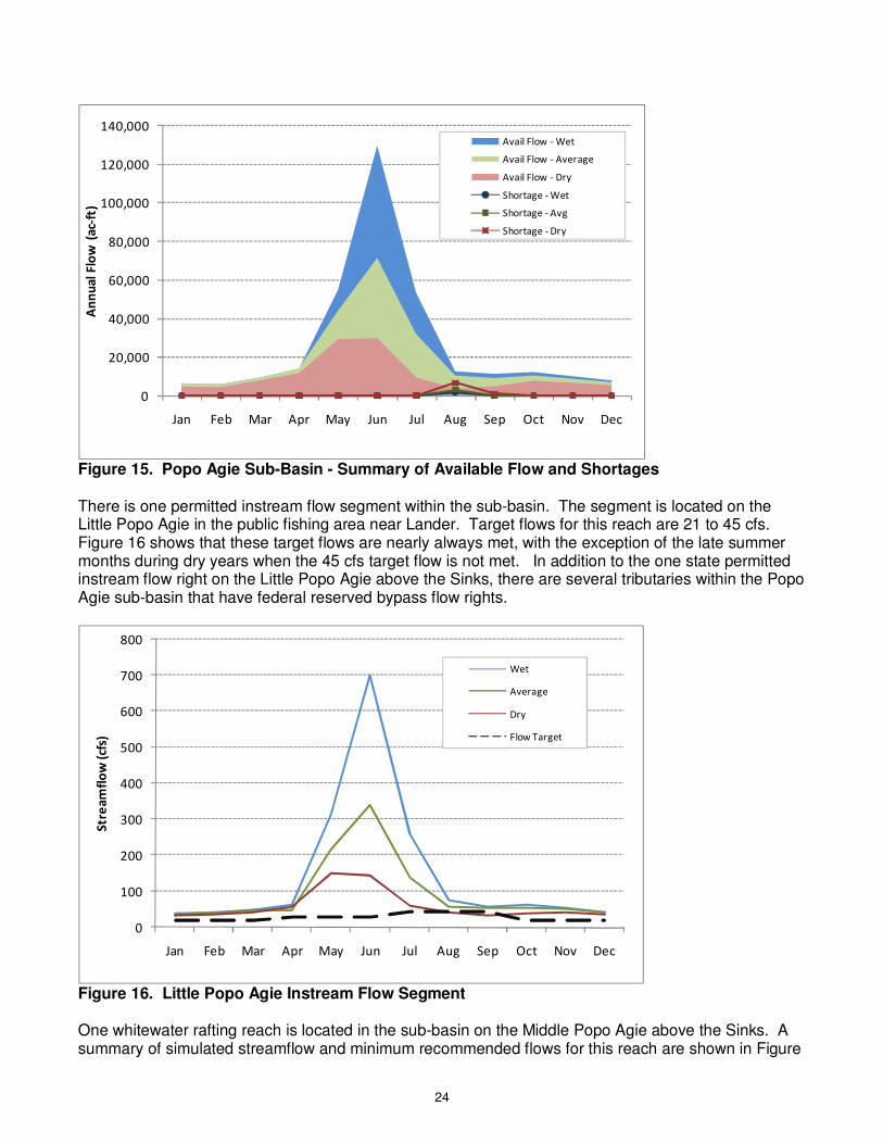
Figure 14. Little Wind Sub-Basin - Summary of Available Flow and Shortages Popo Agie The Popo Agie sub-basin serves several minor to mid-sized agricultural diversions, as well as municipal, recreational and environmental uses throughout the sub-basin. A summary of simulated shortages and available flow within the Popo Agie sub-basin is presented in Figure 15. Simulated shortages are fairly minor throughout the sub-basin, although shortages do exist on the upper portions of the mainstem and some tributaries, especially on the Middle Popo Agie and Roaring Fork. The analysis shows that there is available flow for development during all hydrologic conditions and at most locations within the sub-basin.
24
0
20,000
40,000
60,000
80,000
100,000
120,000
140,000
Jan Feb Mar Apr May Jun Jul Aug Sep Oct Nov Dec
An
nu
al
Flo
w (
ac-
ft)
Avail Flow - Wet
Avail Flow - Average
Avail Flow - Dry
Shortage - Wet
Shortage - Avg
Shortage - Dry
Figure 15. Popo Agie Sub-Basin - Summary of Available Flow and Shortages There is one permitted instream flow segment within the sub-basin. The segment is located on the Little Popo Agie in the public fishing area near Lander. Target flows for this reach are 21 to 45 cfs. Figure 16 shows that these target flows are nearly always met, with the exception of the late summer months during dry years when the 45 cfs target flow is not met. In addition to the one state permitted instream flow right on the Little Popo Agie above the Sinks, there are several tributaries within the Popo Agie sub-basin that have federal reserved bypass flow rights.
0
100
200
300
400
500
600
700
800
Jan Feb Mar Apr May Jun Jul Aug Sep Oct Nov Dec
Str
ea
mfl
ow
(cf
s)
Wet
Average
Dry
Flow Target
Figure 16. Little Popo Agie Instream Flow Segment One whitewater rafting reach is located in the sub-basin on the Middle Popo Agie above the Sinks. A summary of simulated streamflow and minimum recommended flows for this reach are shown in Figure

25
17. Minimum recommended flows of 200 cfs are met during the early summer months, but are not met during the later months of the summer. The maximum recommended flow is 1000 cfs, which is not exceeded on an average monthly basis, but may be exceeded on a daily basis. In addition to whitewater rafting opportunities, the North Fork of the Popo Agie River is classified as a Blue Ribbon fishery. There are designated public fishing sites scattered throughout the sub-basin.
0
100
200
300
400
500
600
700
800
Jan Feb Mar Apr May Jun Jul Aug Sep Oct Nov Dec
Str
ea
mfl
ow
(cf
s)
Wet
Average
Dry
Flow Target
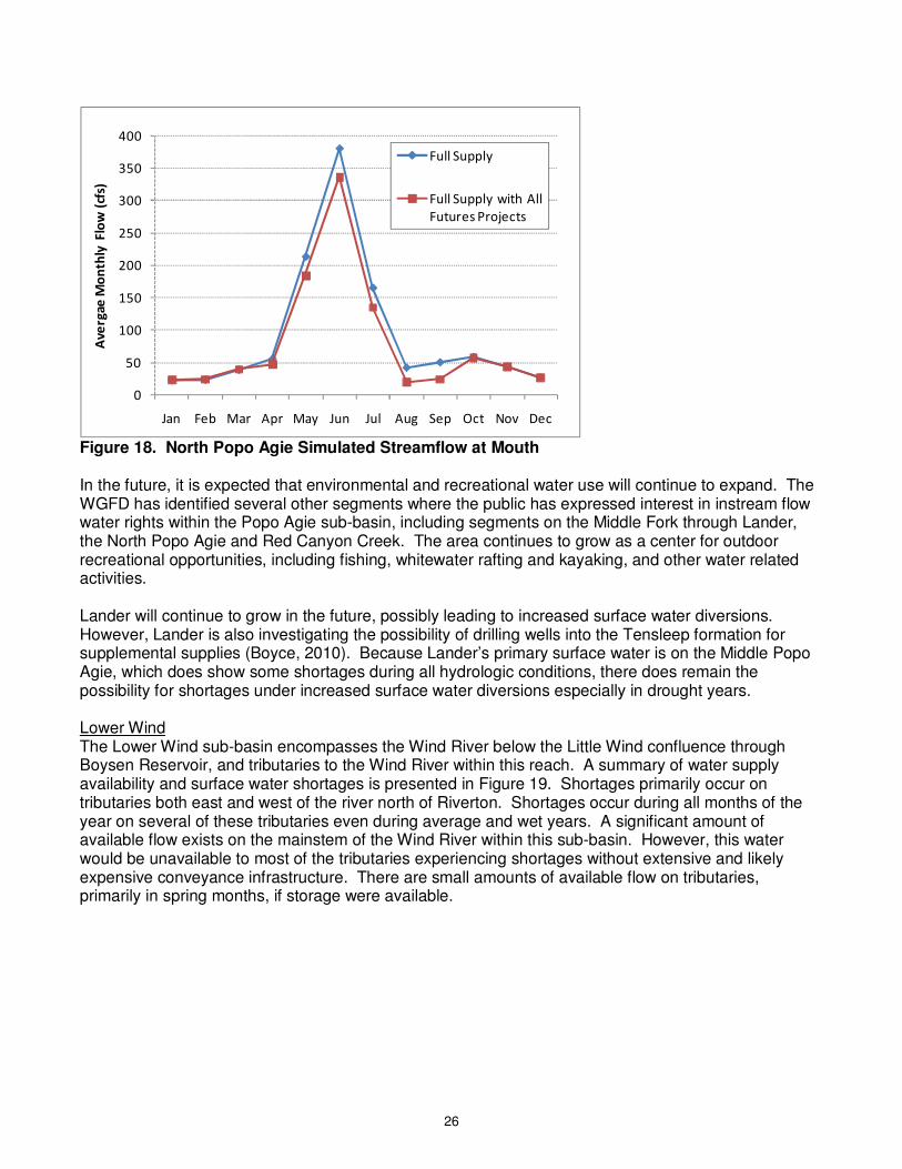
Figure 17. Middle Popo Agie Above Sinks Whitewater Rafting Reach The city of Lander diverts surface water for its municipal water supply. Diversions by Lander are relatively minor, and typically would not be affected by current or future water uses in the lower portion of the sub-basin. However, Lander did experience some water supply shortages during the 2000’s drought. Lander is currently investigating potential groundwater supplies to supplement its surface water diversions (Weston, 2007). The most substantial potential future consumptive water use in the sub-basin is the Arapaho Canal Futures Project. This project would divert water in the vicinity of the existing Sioux Ditch on the North Popo Agie. Diversions for this project would decrease flow in this reach below the point-of-diversion. Furthermore, most return flows for this project do not accrue back to the Popo Agie sub-basin, so this magnitude of flow decrease would occur down the North Popo Agie and mainstem to its confluence with the Little Wind River. A summary of simulated streamflow at the mouth of the North Popo Agie for the Full Supply scenario and the Full Supply with All Futures Projects scenario is presented in Figure 18. The most substantial effects are during late summer months when streamflows would decrease by approximately 50 percent.
26
0
50
100
150
200
250
300
350
400
Jan Feb Mar Apr May Jun Jul Aug Sep Oct Nov Dec
Ave
rgae
Mo
nth
ly F
low
(cf
s)
Full Supply
Full Supply with All
Futures Projects
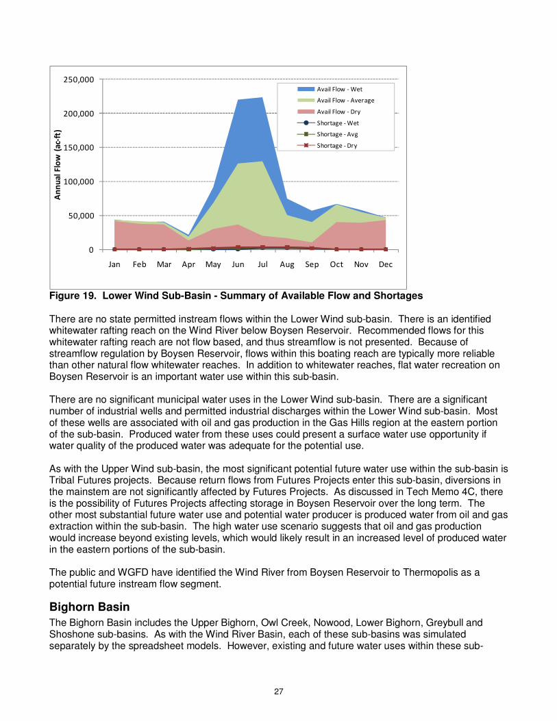
Figure 18. North Popo Agie Simulated Streamflow at Mouth In the future, it is expected that environmental and recreational water use will continue to expand. The WGFD has identified several other segments where the public has expressed interest in instream flow water rights within the Popo Agie sub-basin, including segments on the Middle Fork through Lander, the North Popo Agie and Red Canyon Creek. The area continues to grow as a center for outdoor recreational opportunities, including fishing, whitewater rafting and kayaking, and other water related activities. Lander will continue to grow in the future, possibly leading to increased surface water diversions. However, Lander is also investigating the possibility of drilling wells into the Tensleep formation for supplemental supplies (Boyce, 2010). Because Lander’s primary surface water is on the Middle Popo Agie, which does show some shortages during all hydrologic conditions, there does remain the possibility for shortages under increased surface water diversions especially in drought years. Lower Wind The Lower Wind sub-basin encompasses the Wind River below the Little Wind confluence through Boysen Reservoir, and tributaries to the Wind River within this reach. A summary of water supply availability and surface water shortages is presented in Figure 19. Shortages primarily occur on tributaries both east and west of the river north of Riverton. Shortages occur during all months of the year on several of these tributaries even during average and wet years. A significant amount of available flow exists on the mainstem of the Wind River within this sub-basin. However, this water would be unavailable to most of the tributaries experiencing shortages without extensive and likely expensive conveyance infrastructure. There are small amounts of available flow on tributaries, primarily in spring months, if storage were available.
27
0
50,000
100,000
150,000
200,000
250,000
Jan Feb Mar Apr May Jun Jul Aug Sep Oct Nov Dec
An
nu
al
Flo
w (
ac-
ft)
Avail Flow - Wet
Avail Flow - Average
Avail Flow - Dry
Shortage - Wet
Shortage - Avg
Shortage - Dry
Figure 19. Lower Wind Sub-Basin - Summary of Available Flow and Shortages There are no state permitted instream flows within the Lower Wind sub-basin. There is an identified whitewater rafting reach on the Wind River below Boysen Reservoir. Recommended flows for this whitewater rafting reach are not flow based, and thus streamflow is not presented. Because of streamflow regulation by Boysen Reservoir, flows within this boating reach are typically more reliable than other natural flow whitewater reaches. In addition to whitewater reaches, flat water recreation on Boysen Reservoir is an important water use within this sub-basin. There are no significant municipal water uses in the Lower Wind sub-basin. There are a significant number of industrial wells and permitted industrial discharges within the Lower Wind sub-basin. Most of these wells are associated with oil and gas production in the Gas Hills region at the eastern portion of the sub-basin. Produced water from these uses could present a surface water use opportunity if water quality of the produced water was adequate for the potential use. As with the Upper Wind sub-basin, the most significant potential future water use within the sub-basin is Tribal Futures projects. Because return flows from Futures Projects enter this sub-basin, diversions in the mainstem are not significantly affected by Futures Projects. As discussed in Tech Memo 4C, there is the possibility of Futures Projects affecting storage in Boysen Reservoir over the long term. The other most substantial future water use and potential water producer is produced water from oil and gas extraction within the sub-basin. The high water use scenario suggests that oil and gas production would increase beyond existing levels, which would likely result in an increased level of produced water in the eastern portions of the sub-basin. The public and WGFD have identified the Wind River from Boysen Reservoir to Thermopolis as a potential future instream flow segment.
Bighorn Basin
The Bighorn Basin includes the Upper Bighorn, Owl Creek, Nowood, Lower Bighorn, Greybull and Shoshone sub-basins. As with the Wind River Basin, each of these sub-basins was simulated separately by the spreadsheet models. However, existing and future water uses within these sub-

28
basins are interconnected, and thus the discussion presented for each sub-basin may have application to the other sub-basins within the Bighorn Basin. The spreadsheet models do not show any impacts of Futures Projects development downstream of Boysen Reservoir. As discussed in Technical Memorandum 4C, this is because Boysen Reservoir acts as a “buffer” between the Wind and Bighorn basins. More storage within the reservoir can be used to meet downstream demands. The spreadsheet models do not simulate carryover storage. Analysis of simulated storage contents for the Full Supply with All Futures Projects scenario show that the amount of storage in Boysen Reservoir could potentially be affected by Futures Projects development. More detailed carryover storage analysis is necessary to estimate effects of Futures Projects development in the Bighorn Basin. Upper Bighorn The Upper Bighorn sub-basin includes the Bighorn River downstream of the Wind River Canyon and associated tributaries except the Owl Creek sub-basin and the Nowood sub-basin. Major diversions on the mainstem include the Bighorn Canal, Upper and Lower Hanover Canals, and flows in the Bighorn River are highly regulated by Boysen Reservoir, which is operated to minimize shortages for several of the canals and smaller ditches on the mainstem within the sub-basin. A summary of simulated available flow and shortages within the sub-basin is presented in Figure 20. Shortages within the sub-basin exclusively occur on tributary streams, including Kirby Creek, Cottonwood Creek, Grass Creek and Gooseberry Creek. Shortages on some of these tributaries exceed 50 percent during dry years and 30 percent during average years. Flow is available within some of the major tributaries to meet most or all of the annual shortages if adequate storage facilities were in place.
0
50,000
100,000
150,000
200,000
250,000
300,000
Jan Feb Mar Apr May Jun Jul Aug Sep Oct Nov Dec
An
nu
al
Flo
w (
ac-
ft)
Avail Flow - Wet
Avail Flow - Average
Avail Flow - Dry
Shortage - Wet
Shortage - Avg
Shortage - Dry
Figure 20. Upper Bighorn Sub-Basin - Summary of Available Flow and Shortages There are no state permitted instream flows or federal reserved bypass flow rights within the Upper Bighorn sub-basin. Furthermore, there are no whitewater rafting reaches within this sub-basin. However, the Bighorn River is a designated Blue Ribbon Stream Reach from Wedding of the Waters to Black Mountain Road. There are also several designated public fishing sites along the Bighorn River within this Blue Ribbon Stream Reach.
29
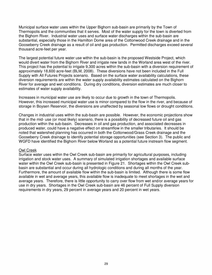
Municipal surface water uses within the Upper Bighorn sub-basin are primarily by the Town of Thermopolis and the communities that it serves. Most of the water supply for the town is diverted from the Bighorn River. Industrial water uses and surface water discharges within the sub-basin are substantial, especially those in the Hamilton Dome area of the Cottonwood Creek drainage and in the Gooseberry Creek drainage as a result of oil and gas production. Permitted discharges exceed several thousand acre-feet per year. The largest potential future water use within the sub-basin is the proposed Westside Project, which would divert water from the Bighorn River and irrigate new lands in the Worland area west of the river. This project has the potential to irrigate 9,300 acres within the sub-basin with a diversion requirement of approximately 18,600 acre-feet (BLM, 2008). These diversions have not been included in the Full Supply with All Futures Projects scenario. Based on the surface water availability calculations, these diversion requirements are within the water supply availability estimates calculated on the Bighorn River for average and wet conditions. During dry conditions, diversion estimates are much closer to estimates of water supply availability. Increases in municipal water use are likely to occur due to growth in the town of Thermopolis. However, this increased municipal water use is minor compared to the flow in the river, and because of storage in Boysen Reservoir, the diversions are unaffected by seasonal low flows or drought conditions. Changes in industrial uses within the sub-basin are possible. However, the economic projections show that in the mid- use (or most likely) scenario, there is a possibility of decreased future oil and gas production within the sub-basin. Decreases in oil and gas production, and associated decreases in produced water, could have a negative effect on streamflow in the smaller tributaries. It should be noted that watershed planning has occurred in both the Cottonwood/Grass Creek drainage and the Gooseberry Creek drainage to identify potential storage opportunities (see Section 3). The public and WGFD have identified the Bighorn River below Worland as a potential future instream flow segment. Owl Creek Surface water uses within the Owl Creek sub-basin are primarily for agricultural purposes, including irrigation and stock water uses. A summary of simulated irrigation shortages and available surface water within the Owl Creek sub-basin is presented in Figure 21. Shortages within the Owl Creek sub-basin are substantial and occur during all hydrologic conditions and during all months of the year. Furthermore, the amount of available flow within the sub-basin is limited. Although there is some flow available in wet and average years, this available flow is inadequate to meet shortages in the wet and average years. Therefore, there is little opportunity to carry over flow from wet and/or average years for use in dry years. Shortages in the Owl Creek sub-basin are 46 percent of Full Supply diversion requirements in dry years, 29 percent in average years and 20 percent in wet years.
30
0
2,000
4,000
6,000
8,000
10,000
12,000
14,000
16,000
18,000
20,000
Jan Feb Mar Apr May Jun Jul Aug Sep Oct Nov Dec
An
nu
al
Flo
w (
ac-
ft)
Avail Flow - Wet
Avail Flow - Average
Avail Flow - Dry
Shortage - Wet
Shortage - Avg
Shortage - Dry
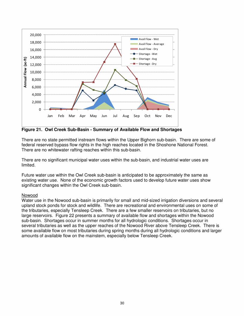
Figure 21. Owl Creek Sub-Basin - Summary of Available Flow and Shortages There are no state permitted instream flows within the Upper Bighorn sub-basin. There are some of federal reserved bypass flow rights in the high reaches located in the Shoshone National Forest. There are no whitewater rafting reaches within this sub-basin. There are no significant municipal water uses within the sub-basin, and industrial water uses are limited. Future water use within the Owl Creek sub-basin is anticipated to be approximately the same as existing water use. None of the economic growth factors used to develop future water uses show significant changes within the Owl Creek sub-basin. Nowood Water use in the Nowood sub-basin is primarily for small and mid-sized irrigation diversions and several upland stock ponds for stock and wildlife. There are recreational and environmental uses on some of the tributaries, especially Tensleep Creek. There are a few smaller reservoirs on tributaries, but no large reservoirs. Figure 22 presents a summary of available flow and shortages within the Nowood sub-basin. Shortages occur in summer months for all hydrologic conditions. Shortages occur in several tributaries as well as the upper reaches of the Nowood River above Tensleep Creek. There is some available flow on most tributaries during spring months during all hydrologic conditions and larger amounts of available flow on the mainstem, especially below Tensleep Creek.
31
0
10,000
20,000
30,000
40,000
50,000
60,000
Jan Feb Mar Apr May Jun Jul Aug Sep Oct Nov Dec
An
nu
al
Flo
w (
ac-
ft)
Avail Flow - Wet
Avail Flow - Average
Avail Flow - Dry
Shortage - Wet
Shortage - Avg
Shortage - Dry
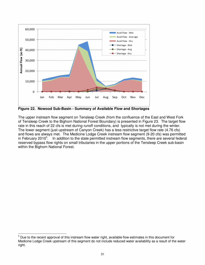
Figure 22. Nowood Sub-Basin - Summary of Available Flow and Shortages The upper instream flow segment on Tensleep Creek (from the confluence of the East and West Fork of Tensleep Creek to the Bighorn National Forest Boundary) is presented in Figure 23. The target flow rate in this reach of 22 cfs is met during runoff conditions, and typically is not met during the winter. The lower segment (just upstream of Canyon Creek) has a less restrictive target flow rate (4.76 cfs) and flows are always met. The Medicine Lodge Creek instream flow segment (9-20 cfs) was permitted in February 20103. In addition to the state permitted instream flow segments, there are several federal reserved bypass flow rights on small tributaries in the upper portions of the Tensleep Creek sub-basin within the Bighorn National Forest.
3 Due to the recent approval of this instream flow water right, available flow estimates in this document for
Medicine Lodge Creek upstream of this segment do not include reduced water availability as a result of the water right.

32
0
50
100
150
200
250
300
350
400
450
500
Jan Feb Mar Apr May Jun Jul Aug Sep Oct Nov Dec
Str
ea
mfl
ow
(cf
s)
Wet
Average
Dry
Flow Target
Figure 23. Tensleep Creek Upper Instream Flow Segment There is also a whitewater rafting reach identified in Tensleep Creek along Highway 16 to the bottom of the switchbacks. The minimum target flow for this reach is 250 cfs. As shown in Figure 24, this target flow is met during the early summer months during wet years, during June in average years and is not met during dry years. A whitewater rafting segment has also been identified on Paintrock Creek. However, its target flows are not based on flow rates, and thus it is not compared to model results. There are also several designated public fishing sites in the sub-basin, primarily located on Tensleep Creek, Paintrock Creek, and tributaries to Paintrock Creek.
0
50
100
150
200
250
300
350
400
450
500
Jan Feb Mar Apr May Jun Jul Aug Sep Oct Nov Dec
Str
ea
mfl
ow
(cf
s)
Wet
Average
Dry
Flow Target
Figure 24. Tensleep Creek Whitewater Rafting Segment
33
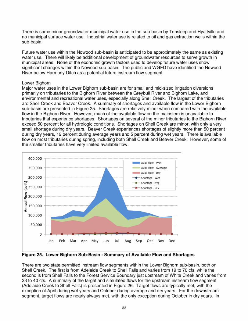
There is some minor groundwater municipal water use in the sub-basin by Tensleep and Hyattville and no municipal surface water use. Industrial water use is related to oil and gas extraction wells within the sub-basin. Future water use within the Nowood sub-basin is anticipated to be approximately the same as existing water use. There will likely be additional development of groundwater resources to serve growth in municipal areas. None of the economic growth factors used to develop future water uses show significant changes within the Nowood sub-basin. The public and WGFD have identified the Nowood River below Harmony Ditch as a potential future instream flow segment. Lower Bighorn Major water uses in the Lower Bighorn sub-basin are for small and mid-sized irrigation diversions primarily on tributaries to the Bighorn River between the Greybull River and Bighorn Lake, and environmental and recreational water uses, especially along Shell Creek. The largest of the tributaries are Shell Creek and Beaver Creek. A summary of shortages and available flow in the Lower Bighorn sub-basin are presented in Figure 25. Shortages are relatively minor when compared with the available flow in the Bighorn River. However, much of the available flow on the mainstem is unavailable to tributaries that experience shortages. Shortages on several of the minor tributaries to the Bighorn River exceed 50 percent for all hydrologic conditions. Shortages on Shell Creek are minor, with only a very small shortage during dry years. Beaver Creek experiences shortages of slightly more than 50 percent during dry years, 19 percent during average years and 5 percent during wet years. There is available flow on most tributaries during spring, including both Shell Creek and Beaver Creek. However, some of the smaller tributaries have very limited available flow.
0
50,000
100,000
150,000
200,000
250,000
300,000
350,000
400,000
Jan Feb Mar Apr May Jun Jul Aug Sep Oct Nov Dec
An
nu
al
Flo
w (
ac-
ft)
Avail Flow - Wet
Avail Flow - Average
Avail Flow - Dry
Shortage - Wet
Shortage - Avg
Shortage - Dry
Figure 25. Lower Bighorn Sub-Basin - Summary of Available Flow and Shortages There are two state permitted instream flow segments within the Lower Bighorn sub-basin, both on Shell Creek. The first is from Adelaide Creek to Shell Falls and varies from 19 to 70 cfs, while the second is from Shell Falls to the Forest Service Boundary just upstream of White Creek and varies from 23 to 40 cfs. A summary of the target and simulated flows for the upstream instream flow segment (Adelaide Creek to Shell Falls) is presented in Figure 26. Target flows are typically met, with the exception of April during wet years and October during average and dry years. For the downstream segment, target flows are nearly always met, with the only exception during October in dry years. In
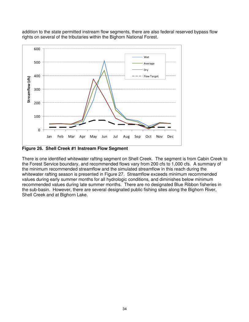
34
addition to the state permitted instream flow segments, there are also federal reserved bypass flow rights on several of the tributaries within the Bighorn National Forest.
0
100
200
300
400
500
600
Jan Feb Mar Apr May Jun Jul Aug Sep Oct Nov Dec
Str
ea
mfl
ow
(cf
s)
Wet
Average
Dry
Flow Target
Figure 26. Shell Creek #1 Instream Flow Segment There is one identified whitewater rafting segment on Shell Creek. The segment is from Cabin Creek to the Forest Service boundary, and recommended flows vary from 200 cfs to 1,000 cfs. A summary of the minimum recommended streamflow and the simulated streamflow in this reach during the whitewater rafting season is presented in Figure 27. Streamflow exceeds minimum recommended values during early summer months for all hydrologic conditions, and diminishes below minimum recommended values during late summer months. There are no designated Blue Ribbon fisheries in the sub-basin. However, there are several designated public fishing sites along the Bighorn River, Shell Creek and at Bighorn Lake.
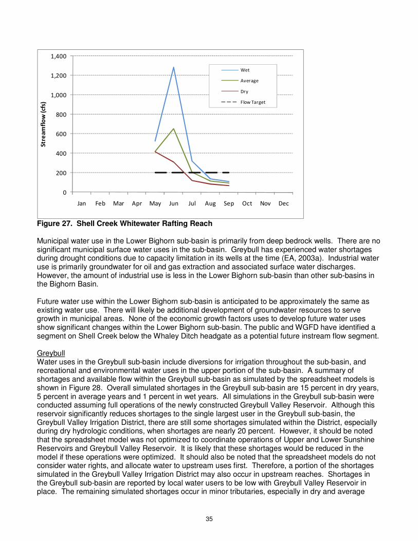
35
0
200
400
600
800
1,000
1,200
1,400
Jan Feb Mar Apr May Jun Jul Aug Sep Oct Nov Dec
Str
ea
mfl
ow
(cf
s)
Wet
Average
Dry
Flow Target
Figure 27. Shell Creek Whitewater Rafting Reach Municipal water use in the Lower Bighorn sub-basin is primarily from deep bedrock wells. There are no significant municipal surface water uses in the sub-basin. Greybull has experienced water shortages during drought conditions due to capacity limitation in its wells at the time (EA, 2003a). Industrial water use is primarily groundwater for oil and gas extraction and associated surface water discharges. However, the amount of industrial use is less in the Lower Bighorn sub-basin than other sub-basins in the Bighorn Basin. Future water use within the Lower Bighorn sub-basin is anticipated to be approximately the same as existing water use. There will likely be additional development of groundwater resources to serve growth in municipal areas. None of the economic growth factors uses to develop future water uses show significant changes within the Lower Bighorn sub-basin. The public and WGFD have identified a segment on Shell Creek below the Whaley Ditch headgate as a potential future instream flow segment. Greybull Water uses in the Greybull sub-basin include diversions for irrigation throughout the sub-basin, and recreational and environmental water uses in the upper portion of the sub-basin. A summary of shortages and available flow within the Greybull sub-basin as simulated by the spreadsheet models is shown in Figure 28. Overall simulated shortages in the Greybull sub-basin are 15 percent in dry years, 5 percent in average years and 1 percent in wet years. All simulations in the Greybull sub-basin were conducted assuming full operations of the newly constructed Greybull Valley Reservoir. Although this reservoir significantly reduces shortages to the single largest user in the Greybull sub-basin, the Greybull Valley Irrigation District, there are still some shortages simulated within the District, especially during dry hydrologic conditions, when shortages are nearly 20 percent. However, it should be noted that the spreadsheet model was not optimized to coordinate operations of Upper and Lower Sunshine Reservoirs and Greybull Valley Reservoir. It is likely that these shortages would be reduced in the model if these operations were optimized. It should also be noted that the spreadsheet models do not consider water rights, and allocate water to upstream uses first. Therefore, a portion of the shortages simulated in the Greybull Valley Irrigation District may also occur in upstream reaches. Shortages in the Greybull sub-basin are reported by local water users to be low with Greybull Valley Reservoir in place. The remaining simulated shortages occur in minor tributaries, especially in dry and average
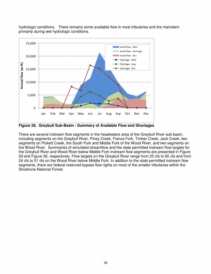
36
hydrologic conditions. There remains some available flow in most tributaries and the mainstem primarily during wet hydrologic conditions.
0
5,000
10,000
15,000
20,000
25,000
Jan Feb Mar Apr May Jun Jul Aug Sep Oct Nov Dec
An
nu
al
Flo
w (
ac-
ft)
Avail Flow - Wet
Avail Flow - Average
Avail Flow - Dry
Shortage - Wet
Shortage - Avg
Shortage - Dry
Figure 28. Greybull Sub-Basin - Summary of Available Flow and Shortages There are several instream flow segments in the headwaters area of the Greybull River sub-basin, including segments on the Greybull River, Piney Creek, Francs Fork, Timber Creek, Jack Creek, two segments on Pickett Creek, the South Fork and Middle Fork of the Wood River, and two segments on the Wood River. Summaries of simulated streamflow and the state permitted instream flow targets for the Greybull River and Wood River below Middle Fork instream flow segments are presented in Figure 29 and Figure 30, respectively. Flow targets on the Greybull River range from 25 cfs to 65 cfs and from 24 cfs to 51 cfs on the Wood River below Middle Fork. In addition to the state permitted instream flow segments, there are federal reserved bypass flow rights on most of the smaller tributaries within the Shoshone National Forest.
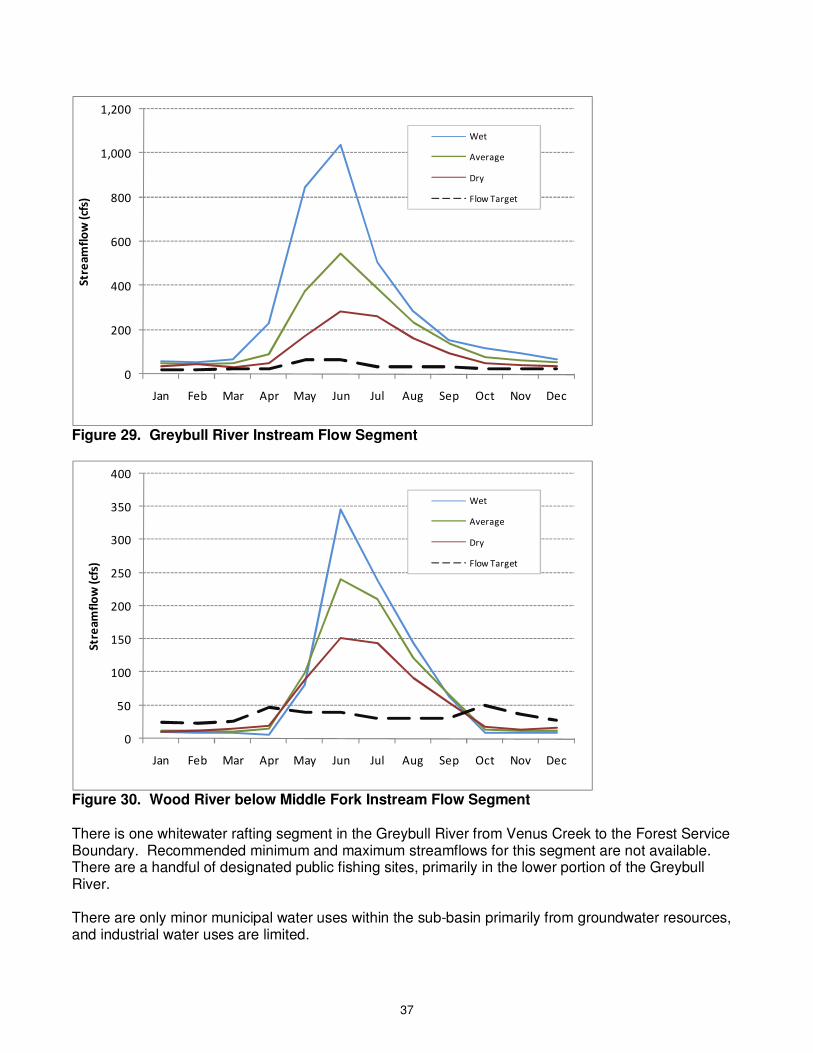
37
0
200
400
600
800
1,000
1,200
Jan Feb Mar Apr May Jun Jul Aug Sep Oct Nov Dec
Str
ea
mfl
ow
(cf
s)
Wet
Average
Dry
Flow Target
Figure 29. Greybull River Instream Flow Segment
0
50
100
150
200
250
300
350
400
Jan Feb Mar Apr May Jun Jul Aug Sep Oct Nov Dec
Str
ea
mfl
ow
(cf
s)
Wet
Average
Dry
Flow Target
Figure 30. Wood River below Middle Fork Instream Flow Segment There is one whitewater rafting segment in the Greybull River from Venus Creek to the Forest Service Boundary. Recommended minimum and maximum streamflows for this segment are not available. There are a handful of designated public fishing sites, primarily in the lower portion of the Greybull River. There are only minor municipal water uses within the sub-basin primarily from groundwater resources, and industrial water uses are limited.
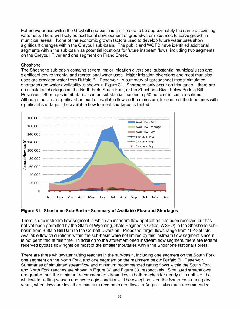
38
Future water use within the Greybull sub-basin is anticipated to be approximately the same as existing water use. There will likely be additional development of groundwater resources to serve growth in municipal areas. None of the economic growth factors used to develop future water uses show significant changes within the Greybull sub-basin. The public and WGFD have identified additional segments within the sub-basin as potential locations for future instream flows, including two segments on the Greybull River and one segment on Franc Creek. Shoshone The Shoshone sub-basin contains several major irrigation diversions, substantial municipal uses and significant environmental and recreational water uses. Major irrigation diversions and most municipal uses are provided water from Buffalo Bill Reservoir. A summary of spreadsheet model simulated shortages and water availability is shown in Figure 31. Shortages only occur on tributaries – there are no simulated shortages on the North Fork, South Fork, or the Shoshone River below Buffalo Bill Reservoir. Shortages in tributaries can be substantial, exceeding 60 percent in some locations. Although there is a significant amount of available flow on the mainstem, for some of the tributaries with significant shortages, the available flow to meet shortages is limited.
0
20,000
40,000
60,000
80,000
100,000
120,000
140,000
160,000
180,000
Jan Feb Mar Apr May Jun Jul Aug Sep Oct Nov Dec
An
nu
al
Flo
w (
ac-
ft)
Avail Flow - Wet
Avail Flow - Average
Avail Flow - Dry
Shortage - Wet
Shortage - Avg
Shortage - Dry
Figure 31. Shoshone Sub-Basin - Summary of Available Flow and Shortages There is one instream flow segment in which an instream flow application has been received but has not yet been permitted by the State of Wyoming, State Engineer’s Office, WSEO) in the Shoshone sub-basin from Buffalo Bill Dam to the Corbett Diversion. Proposed target flows range from 162-350 cfs. Available flow calculations within the sub-basin were not limited by this instream flow segment since it is not permitted at this time. In addition to the aforementioned instream flow segment, there are federal reserved bypass flow rights on most of the smaller tributaries within the Shoshone National Forest. There are three whitewater rafting reaches in the sub-basin, including one segment on the South Fork, one segment on the North Fork, and one segment on the mainstem below Buffalo Bill Reservoir. Summaries of simulated streamflow and minimum recommended rafting flows within the South Fork and North Fork reaches are shown in Figure 32 and Figure 33, respectively. Simulated streamflows are greater than the minimum recommended streamflow in both reaches for nearly all months of the whitewater rafting season and hydrologic conditions. The exception is on the South Fork during dry years, when flows are less than minimum recommended flows in August. Maximum recommended
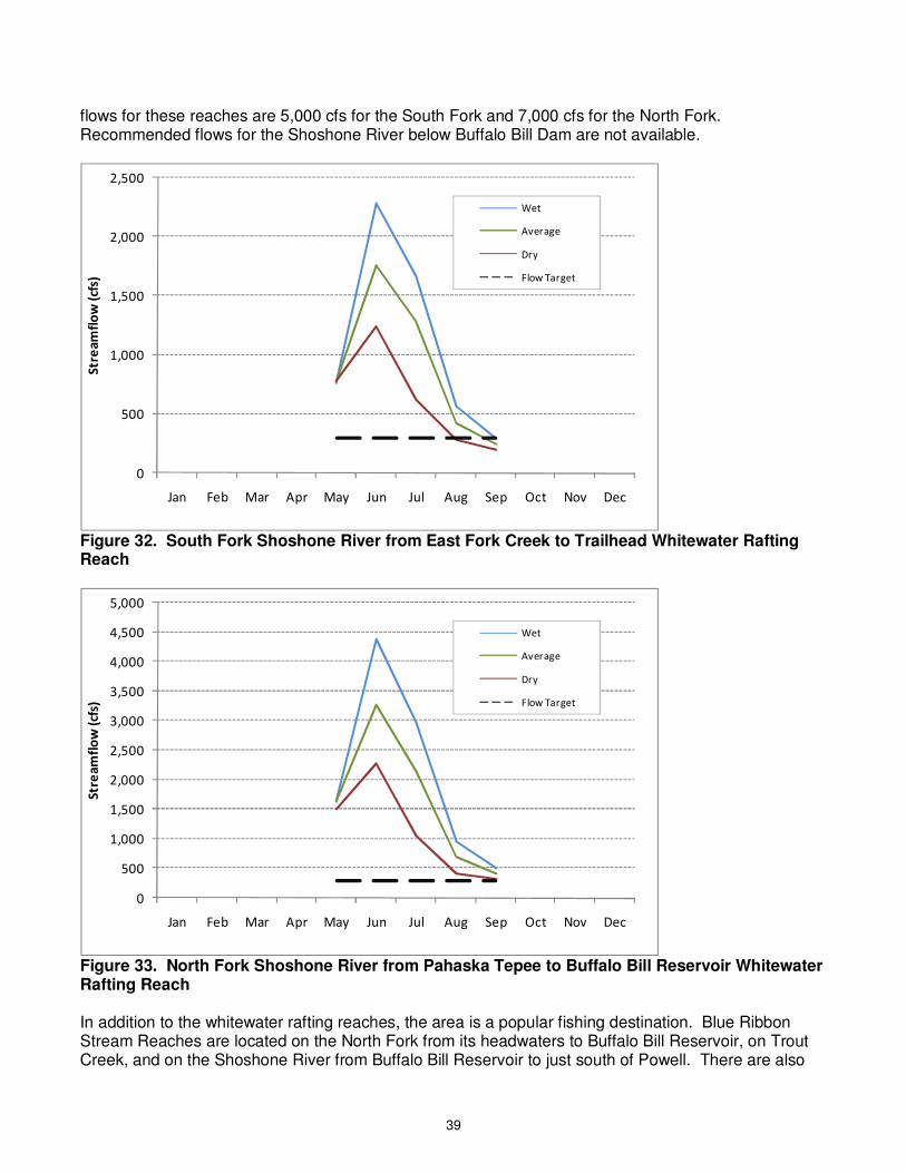
39
flows for these reaches are 5,000 cfs for the South Fork and 7,000 cfs for the North Fork. Recommended flows for the Shoshone River below Buffalo Bill Dam are not available.
0
500
1,000
1,500
2,000
2,500
Jan Feb Mar Apr May Jun Jul Aug Sep Oct Nov Dec
Str
ea
mfl
ow
(cf
s)
Wet
Average
Dry
Flow Target
Figure 32. South Fork Shoshone River from East Fork Creek to Trailhead Whitewater Rafting Reach
0
500
1,000
1,500
2,000
2,500
3,000
3,500
4,000
4,500
5,000
Jan Feb Mar Apr May Jun Jul Aug Sep Oct Nov Dec
Str
ea
mfl
ow
(cf
s)
Wet
Average
Dry
Flow Target
Figure 33. North Fork Shoshone River from Pahaska Tepee to Buffalo Bill Reservoir Whitewater Rafting Reach In addition to the whitewater rafting reaches, the area is a popular fishing destination. Blue Ribbon Stream Reaches are located on the North Fork from its headwaters to Buffalo Bill Reservoir, on Trout Creek, and on the Shoshone River from Buffalo Bill Reservoir to just south of Powell. There are also
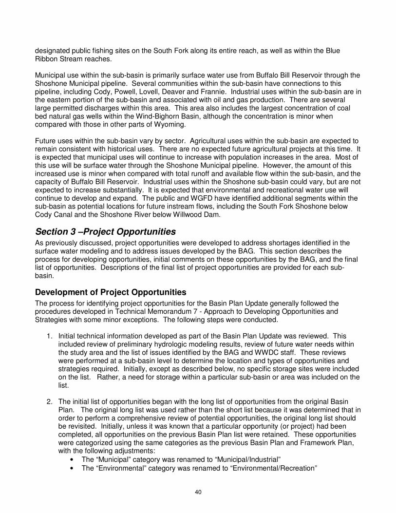
40
designated public fishing sites on the South Fork along its entire reach, as well as within the Blue Ribbon Stream reaches. Municipal use within the sub-basin is primarily surface water use from Buffalo Bill Reservoir through the Shoshone Municipal pipeline. Several communities within the sub-basin have connections to this pipeline, including Cody, Powell, Lovell, Deaver and Frannie. Industrial uses within the sub-basin are in the eastern portion of the sub-basin and associated with oil and gas production. There are several large permitted discharges within this area. This area also includes the largest concentration of coal bed natural gas wells within the Wind-Bighorn Basin, although the concentration is minor when compared with those in other parts of Wyoming. Future uses within the sub-basin vary by sector. Agricultural uses within the sub-basin are expected to remain consistent with historical uses. There are no expected future agricultural projects at this time. It is expected that municipal uses will continue to increase with population increases in the area. Most of this use will be surface water through the Shoshone Municipal pipeline. However, the amount of this increased use is minor when compared with total runoff and available flow within the sub-basin, and the capacity of Buffalo Bill Reservoir. Industrial uses within the Shoshone sub-basin could vary, but are not expected to increase substantially. It is expected that environmental and recreational water use will continue to develop and expand. The public and WGFD have identified additional segments within the sub-basin as potential locations for future instream flows, including the South Fork Shoshone below Cody Canal and the Shoshone River below Willwood Dam.
Section 3 –Project Opportunities As previously discussed, project opportunities were developed to address shortages identified in the surface water modeling and to address issues developed by the BAG. This section describes the process for developing opportunities, initial comments on these opportunities by the BAG, and the final list of opportunities. Descriptions of the final list of project opportunities are provided for each sub-basin.
Development of Project Opportunities
The process for identifying project opportunities for the Basin Plan Update generally followed the procedures developed in Technical Memorandum 7 - Approach to Developing Opportunities and Strategies with some minor exceptions. The following steps were conducted.
1. Initial technical information developed as part of the Basin Plan Update was reviewed. This included review of preliminary hydrologic modeling results, review of future water needs within the study area and the list of issues identified by the BAG and WWDC staff. These reviews were performed at a sub-basin level to determine the location and types of opportunities and strategies required. Initially, except as described below, no specific storage sites were included on the list. Rather, a need for storage within a particular sub-basin or area was included on the list.
2. The initial list of opportunities began with the long list of opportunities from the original Basin
Plan. The original long list was used rather than the short list because it was determined that in order to perform a comprehensive review of potential opportunities, the original long list should be revisited. Initially, unless it was known that a particular opportunity (or project) had been completed, all opportunities on the previous Basin Plan list were retained. These opportunities were categorized using the same categories as the previous Basin Plan and Framework Plan, with the following adjustments:
• The “Municipal” category was renamed to “Municipal/Industrial” • The “Environmental” category was renamed to “Environmental/Recreation”
41
• A “Water Planning and Management” category was added
In general, the same project type categories were used as the Framework Plan. However, in a few cases, the project type categories were renamed or additional categories were added to more accurately describe the project opportunities. Appropriate changes were also made to the project type for some project opportunities. The following adjustments were made to the project type category:
• Added a “Regionalization” project type for municipal regional projects • Modified “New Lands” to “New Uses” to expand the category to all new uses • Modified agricultural “Distribution” project type to “Irrigation Rehabilitation” and “Irrigation
Non-Structural” project types to more accurately describe proposed projects • Added “Administrative: WSEO” and “Administrative: USBR” project types to more
accurately describe proposed projects • Added “Watershed Improvements” project type to more accurately describe proposed
projects • Added “Environmental”, “Recreation and Tourism” and “Cultural” project types as these
projects previously did not have a project type assigned to them.
All project opportunities were assigned to specific sub-basins. If a specific sub-basin was not applicable, the sub-basin was assigned as “non-specific.”
3. The Framework Water Plan was reviewed. Short-listed reservoir sites and other opportunities
added to the short list since the previous Basin Plan were added to the list of opportunities. In addition, opportunities identified in recently completed watershed plans and planning studies within the study area were added to the list. Improvements to specific town or municipal water delivery systems that do not affect basin water resources are not included in the list.
4. No specific augmentation to the list was performed by the basin planning team prior to presentation to the BAG. However, several ideas were presented to the BAG during the November 12, 2009 meeting (BAG, 2009d), with a portion of these added or modified on the list.
5. The list of opportunities was presented to the BAG during the regularly scheduled November 12, 2009 meeting in Worland (BAG, 2009d). Several modifications to the list were suggested, and are described below.
6. The final list of project opportunities was developed based on these comments organized by sub-basin and water use category (e.g., municipal and industrial, agricultural, recreation). Where possible, project opportunities are specific to identified shortage areas or other water management issues. No ranking, prioritization or short-listing was performed. A column is included in the final list of opportunities indicating whether the opportunity was short-listed in the Framework Plan or added since the Framework Plan.
The preliminary list of opportunities (before edits by the BAG) contained a total of 118 opportunities.
Review and Comment by BAG
At the November 12, 2009 BAG meeting in Worland, the preliminary list of project opportunities was reviewed (BAG, 2009d). The BAG was supplied low, medium and high future water use estimates, preliminary surface water shortages, surface water availability (quantitatively and map-based), and the general concept of project opportunities and program strategies through presentations by the Basin Planning team. Following these presentations, the preliminary list of project opportunities was handed
42
out to attendees. The following was noted or suggested as modifications to the list of opportunities by the BAG:
• The following two reservoirs in the Upper Wind sub-basin should be added to the list as they have been studied extensively: Blue Holes and Wiggins Fork.
• Remove “(Bighorn)” from the reservoir descriptions – this term is not needed in this list because it only includes sites in the Wind-Bighorn Basin.
• Change the two Boysen Reservoir release items to “Establish Winter Operations Schedule for Boysen Reservoir”
• Add “Develop” to the beginning of the Flooded Uranium Mine Pits. Or, add the term “Put to Beneficial Use”
• Add the reference “Upper Wind Storage Study” to the Wind River storage sites source. • The BAG explained that the Riverton Valley/LeClair Irrigation District consolidation is to move
the Riverton Valley headgate off of the Reservation to avoid needing to negotiate access. No change is needed on the list.
• Most of the Bighorn Regional Joint Powers Board and Hyattville projects are completed. These should be removed from the list.
• The Tensleep improvements are completed in town. Some connections to sub-divisions outside of town are desired, but have not been completed.
• Manderson has a new wastewater treatment plant. There is no wastewater treatment plant in Hyattville.
• Kirby and Lucerne are involved in the Bighorn Regional Joint Powers Board. • A Level II study of Wales Reservoir is about done. Test pits have been completed. • The “Clark’s Fork to Shoshone Pipeline” should be deleted. This pipeline is not needed. • Transbasin diversions from Sunshine Reservoir should be clarified to say that a larger pipeline
would be needed from Wood River to more fully capture peak runoff. • Owl Creek gaging stations and flow management is complete. Delete from list. • Kirby Creek gaging station is not high on WSEO priority list. • The Hyattville Transmission Project is complete – delete from list. • The Burlington Water Tank is complete – delete from list. Check with Burlington on remainder
of Burlington items. • Delete “Town of Greybull” entry in table. • Dust abatement at Buffalo Bill Reservoir is complete – delete from list. • Work on Hot Springs State Park (HSSP) cooling ponds is complete. Check with HSSP on
remainder of items. • The Hyattville, Thermopolis and Southern Bighorn wells have been drilled. There is still water
available for development – leave on list. • Change the Willwood Irrigation District opportunities to “Install Measuring Devices” • Delete both proposed transbasin diversion projects (to North Platte and to Colorado River) –
these are not supported by BAG. • Delete “Unused Water Rights” • Specify group of opportunities that are for municipal water use. • Check list for repeats. • Recategorize list where appropriate.
In addition to modifications made based upon BAG input, the following information was modified by the Basin Planning team:
• Deleted repetitive entries • Added rehabilitation of the Wind River Irrigation Project in the Upper Wind River and Little Wind
sub-basins.
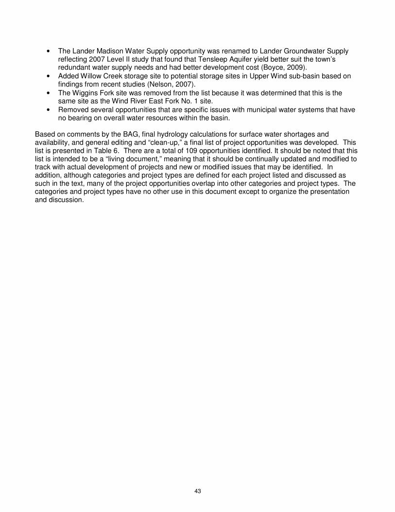
43
• The Lander Madison Water Supply opportunity was renamed to Lander Groundwater Supply reflecting 2007 Level II study that found that Tensleep Aquifer yield better suit the town’s redundant water supply needs and had better development cost (Boyce, 2009).
• Added Willow Creek storage site to potential storage sites in Upper Wind sub-basin based on findings from recent studies (Nelson, 2007).
• The Wiggins Fork site was removed from the list because it was determined that this is the same site as the Wind River East Fork No. 1 site.
• Removed several opportunities that are specific issues with municipal water systems that have no bearing on overall water resources within the basin.
Based on comments by the BAG, final hydrology calculations for surface water shortages and availability, and general editing and “clean-up,” a final list of project opportunities was developed. This list is presented in Table 6. There are a total of 109 opportunities identified. It should be noted that this list is intended to be a “living document,” meaning that it should be continually updated and modified to track with actual development of projects and new or modified issues that may be identified. In addition, although categories and project types are defined for each project listed and discussed as such in the text, many of the project opportunities overlap into other categories and project types. The categories and project types have no other use in this document except to organize the presentation and discussion.
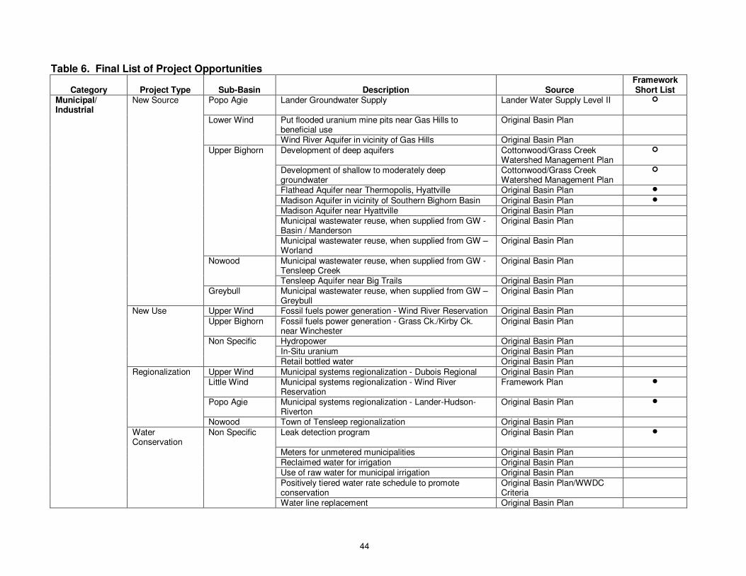
44
Table 6. Final List of Project Opportunities
Category Project Type Sub-Basin Description Source Framework Short List
Municipal/ Industrial
New Source Popo Agie Lander Groundwater Supply Lander Water Supply Level II �
Lower Wind Put flooded uranium mine pits near Gas Hills to beneficial use
Original Basin Plan
Wind River Aquifer in vicinity of Gas Hills Original Basin Plan
Upper Bighorn Development of deep aquifers Cottonwood/Grass Creek Watershed Management Plan
�
Development of shallow to moderately deep groundwater
Cottonwood/Grass Creek Watershed Management Plan
�
Flathead Aquifer near Thermopolis, Hyattville Original Basin Plan �
Madison Aquifer in vicinity of Southern Bighorn Basin Original Basin Plan �
Madison Aquifer near Hyattville Original Basin Plan
Municipal wastewater reuse, when supplied from GW - Basin / Manderson
Original Basin Plan
Municipal wastewater reuse, when supplied from GW – Worland
Original Basin Plan
Nowood Municipal wastewater reuse, when supplied from GW - Tensleep Creek
Original Basin Plan
Tensleep Aquifer near Big Trails Original Basin Plan
Greybull Municipal wastewater reuse, when supplied from GW – Greybull
Original Basin Plan
New Use Upper Wind Fossil fuels power generation - Wind River Reservation Original Basin Plan
Upper Bighorn Fossil fuels power generation - Grass Ck./Kirby Ck. near Winchester
Original Basin Plan
Non Specific Hydropower Original Basin Plan
In-Situ uranium Original Basin Plan
Retail bottled water Original Basin Plan
Regionalization Upper Wind Municipal systems regionalization - Dubois Regional Original Basin Plan
Little Wind Municipal systems regionalization - Wind River Reservation
Framework Plan �
Popo Agie Municipal systems regionalization - Lander-Hudson-Riverton
Original Basin Plan �
Nowood Town of Tensleep regionalization Original Basin Plan
Water Conservation
Non Specific Leak detection program Original Basin Plan �
Meters for unmetered municipalities Original Basin Plan
Reclaimed water for irrigation Original Basin Plan
Use of raw water for municipal irrigation Original Basin Plan
Positively tiered water rate schedule to promote conservation
Original Basin Plan/WWDC Criteria
Water line replacement Original Basin Plan
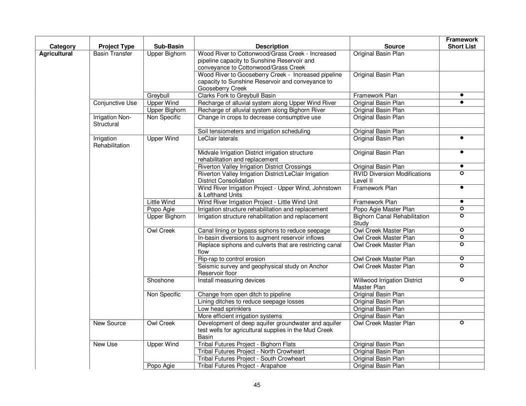
45
Category Project Type Sub-Basin Description Source Framework Short List
Agricultural Basin Transfer Upper Bighorn Wood River to Cottonwood/Grass Creek - Increased pipeline capacity to Sunshine Reservoir and conveyance to Cottonwood/Grass Creek
Original Basin Plan
Wood River to Gooseberry Creek - Increased pipeline capacity to Sunshine Reservoir and conveyance to Gooseberry Creek
Original Basin Plan
Greybull Clarks Fork to Greybull Basin Framework Plan �
Conjunctive Use Upper Wind Recharge of alluvial system along Upper Wind River Original Basin Plan �
Upper Bighorn Recharge of alluvial system along Bighorn River Original Basin Plan
Irrigation Non-Structural
Non Specific Change in crops to decrease consumptive use Original Basin Plan
Soil tensiometers and irrigation scheduling Original Basin Plan
Irrigation Rehabilitation
Upper Wind LeClair laterals Original Basin Plan �
Midvale Irrigation District irrigation structure rehabilitation and replacement
Original Basin Plan �
Riverton Valley Irrigation District Crossings Original Basin Plan �
Riverton Valley Irrigation District/LeClair Irrigation District Consolidation
RVID Diversion Modifications Level II
�
Wind River Irrigation Project - Upper Wind, Johnstown & Lefthand Units
Framework Plan �
Little Wind Wind River Irrigation Project - Little Wind Unit Framework Plan �
Popo Agie Irrigation structure rehabilitation and replacement Popo Agie Master Plan �
Upper Bighorn Irrigation structure rehabilitation and replacement Bighorn Canal Rehabilitation Study
�
Owl Creek Canal lining or bypass siphons to reduce seepage Owl Creek Master Plan �
In-basin diversions to augment reservoir inflows Owl Creek Master Plan �
Replace siphons and culverts that are restricting canal flow
Owl Creek Master Plan �
Rip-rap to control erosion Owl Creek Master Plan �
Seismic survey and geophysical study on Anchor Reservoir floor
Owl Creek Master Plan �
Shoshone Install measuring devices Willwood Irrigation District Master Plan
�
Non Specific Change from open ditch to pipeline Original Basin Plan
Lining ditches to reduce seepage losses Original Basin Plan
Low head sprinklers Original Basin Plan
More efficient irrigation systems Original Basin Plan
New Source Owl Creek Development of deep aquifer groundwater and aquifer test wells for agricultural supplies in the Mud Creek Basin
Owl Creek Master Plan �
New Use Upper Wind Tribal Futures Project - Bighorn Flats Original Basin Plan
Tribal Futures Project - North Crowheart Original Basin Plan
Tribal Futures Project - South Crowheart Original Basin Plan
Popo Agie Tribal Futures Project - Arapahoe Original Basin Plan
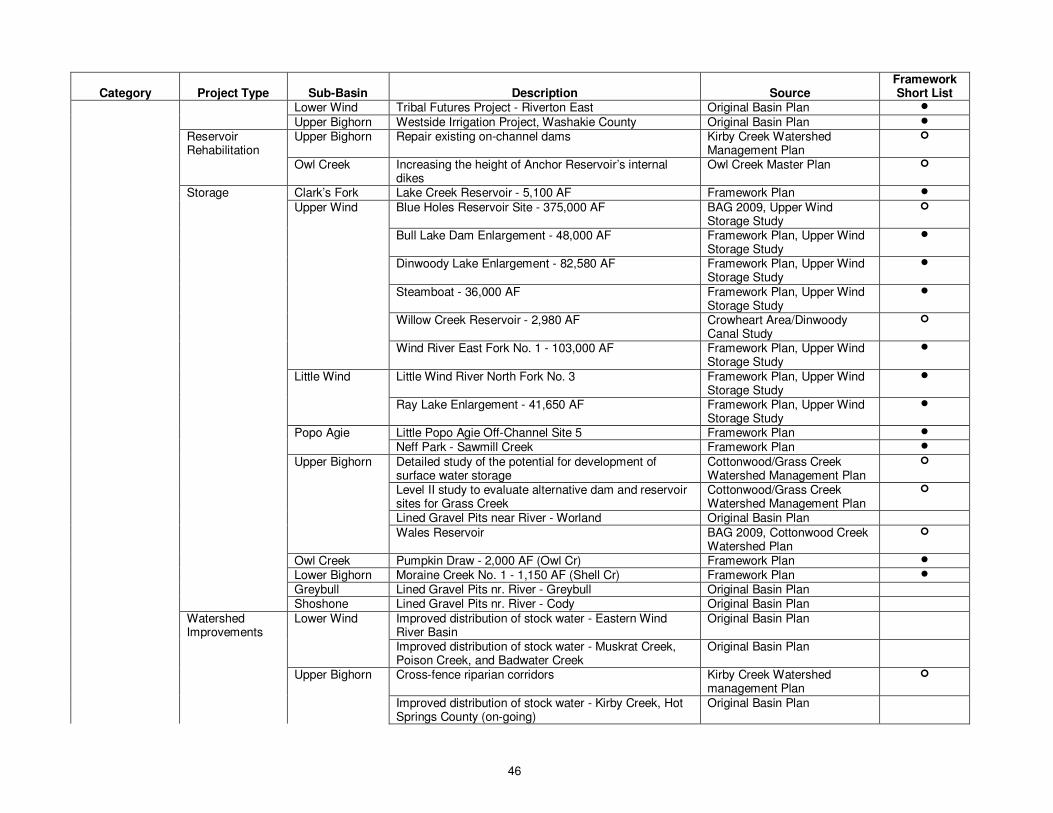
46
Category Project Type Sub-Basin Description Source Framework Short List
Lower Wind Tribal Futures Project - Riverton East Original Basin Plan �
Upper Bighorn Westside Irrigation Project, Washakie County Original Basin Plan �
Reservoir Rehabilitation
Upper Bighorn Repair existing on-channel dams Kirby Creek Watershed Management Plan
�
Owl Creek Increasing the height of Anchor Reservoir’s internal dikes
Owl Creek Master Plan �
Storage Clark’s Fork Lake Creek Reservoir - 5,100 AF Framework Plan �
Upper Wind Blue Holes Reservoir Site - 375,000 AF BAG 2009, Upper Wind Storage Study
�
Bull Lake Dam Enlargement - 48,000 AF Framework Plan, Upper Wind Storage Study
�
Dinwoody Lake Enlargement - 82,580 AF Framework Plan, Upper Wind Storage Study
�
Steamboat - 36,000 AF Framework Plan, Upper Wind Storage Study
�
Willow Creek Reservoir - 2,980 AF Crowheart Area/Dinwoody Canal Study
�
Wind River East Fork No. 1 - 103,000 AF Framework Plan, Upper Wind Storage Study
�
Little Wind Little Wind River North Fork No. 3 Framework Plan, Upper Wind Storage Study
�
Ray Lake Enlargement - 41,650 AF Framework Plan, Upper Wind Storage Study
�
Popo Agie Little Popo Agie Off-Channel Site 5 Framework Plan �
Neff Park - Sawmill Creek Framework Plan �
Upper Bighorn Detailed study of the potential for development of surface water storage
Cottonwood/Grass Creek Watershed Management Plan
�
Level II study to evaluate alternative dam and reservoir sites for Grass Creek
Cottonwood/Grass Creek Watershed Management Plan
�
Lined Gravel Pits near River - Worland Original Basin Plan
Wales Reservoir BAG 2009, Cottonwood Creek Watershed Plan
�
Owl Creek Pumpkin Draw - 2,000 AF (Owl Cr) Framework Plan �
Lower Bighorn Moraine Creek No. 1 - 1,150 AF (Shell Cr) Framework Plan �
Greybull Lined Gravel Pits nr. River - Greybull Original Basin Plan
Shoshone Lined Gravel Pits nr. River - Cody Original Basin Plan
Watershed Improvements
Lower Wind Improved distribution of stock water - Eastern Wind River Basin
Original Basin Plan
Improved distribution of stock water - Muskrat Creek, Poison Creek, and Badwater Creek
Original Basin Plan
Upper Bighorn Cross-fence riparian corridors Kirby Creek Watershed management Plan
�
Improved distribution of stock water - Kirby Creek, Hot Springs County (on-going)
Original Basin Plan
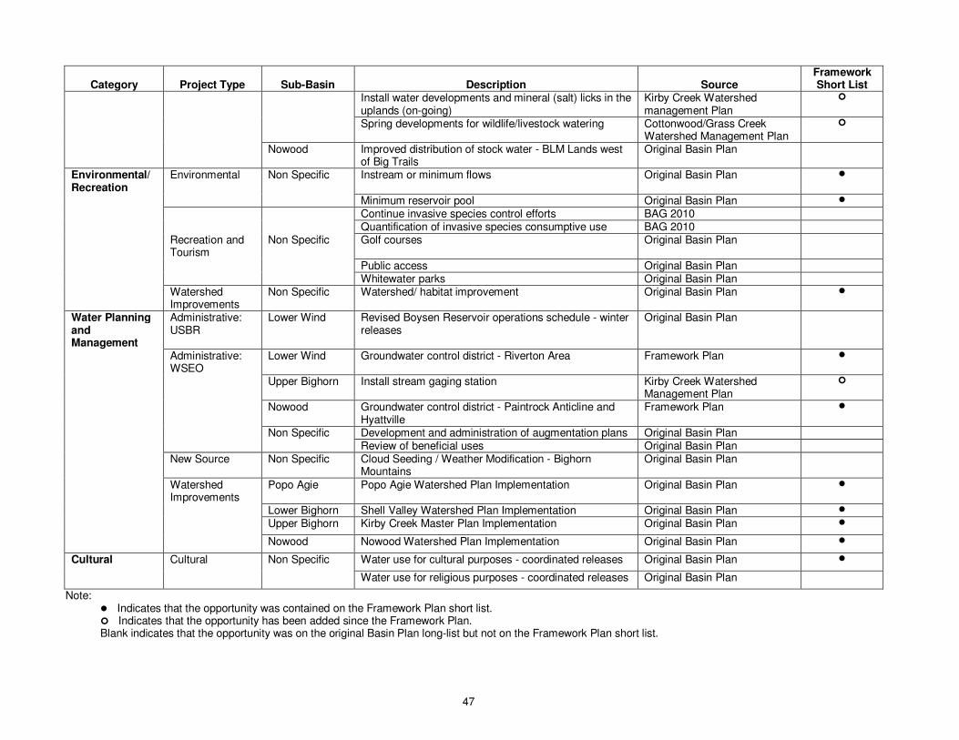
47
Category Project Type Sub-Basin Description Source Framework Short List
Install water developments and mineral (salt) licks in the uplands (on-going)
Kirby Creek Watershed management Plan
�
Spring developments for wildlife/livestock watering Cottonwood/Grass Creek Watershed Management Plan
�
Nowood Improved distribution of stock water - BLM Lands west of Big Trails
Original Basin Plan
Environmental/Recreation
Environmental Non Specific Instream or minimum flows Original Basin Plan �
Minimum reservoir pool Original Basin Plan �
Continue invasive species control efforts BAG 2010
Quantification of invasive species consumptive use BAG 2010
Recreation and Tourism
Non Specific Golf courses Original Basin Plan
Public access Original Basin Plan
Whitewater parks Original Basin Plan
Watershed Improvements
Non Specific Watershed/ habitat improvement Original Basin Plan �
Water Planning and Management
Administrative: USBR
Lower Wind Revised Boysen Reservoir operations schedule - winter releases
Original Basin Plan
Administrative: WSEO
Lower Wind Groundwater control district - Riverton Area Framework Plan �
Upper Bighorn Install stream gaging station Kirby Creek Watershed Management Plan
�
Nowood Groundwater control district - Paintrock Anticline and Hyattville
Framework Plan �
Non Specific Development and administration of augmentation plans Original Basin Plan
Review of beneficial uses Original Basin Plan
New Source Non Specific Cloud Seeding / Weather Modification - Bighorn Mountains
Original Basin Plan
Watershed Improvements
Popo Agie Popo Agie Watershed Plan Implementation Original Basin Plan �
Lower Bighorn Shell Valley Watershed Plan Implementation Original Basin Plan �
Upper Bighorn Kirby Creek Master Plan Implementation Original Basin Plan �
Nowood Nowood Watershed Plan Implementation Original Basin Plan �
Cultural Cultural Non Specific Water use for cultural purposes - coordinated releases Original Basin Plan �
Water use for religious purposes - coordinated releases Original Basin Plan
Note: � Indicates that the opportunity was contained on the Framework Plan short list. � Indicates that the opportunity has been added since the Framework Plan. Blank indicates that the opportunity was on the original Basin Plan long-list but not on the Framework Plan short list.
48
The following presents a summary of project opportunities for each sub-basin. Where additional information has been developed for a particular project opportunity recently (i.e. WWDC Level I or Level II studies), this information is noted. However, this document is not intended to be a comprehensive review of all WWDC studies in the study area.
Yellowstone Basin
No project opportunities were identified in the Yellowstone Basin in either the previous Basin Plan or in the Basin Plan Update.
Clark’s Fork Basin
One project opportunity was identified in the Clark’s Fork Basin. The original Basin Plan and the Framework Plan identified the Lake Creek Reservoir Project, which would store 5,100 acre-feet on Lake Creek, which is a tributary to the Clark’s Fork between Paint Creek and Pat O’Hare Creek. This project could address some of the shortages downstream of the reservoir. This creek is not simulated in the spreadsheet models, so the nature of water supply availability in this creek is unknown. It is possible that available water from either the Clark’s Fork or Little Rocky Creek could be diverted to the site.
Wind River Basin
Upper Wind Project opportunities in the Upper Wind sub-basin were identified in the Municipal/Industrial and Agricultural categories, including two municipal/industrial opportunities, six storage opportunities, five irrigation rehabilitation opportunities, three new use opportunities and one conjunctive use opportunity. Municipal/industrial opportunities include fossil fuels power generation, primarily low grade coal and natural gas power production on the Wind River Indian Reservation, and the Dubois municipal systems regionalization. Extension of the town’s water system was studied by the town of Dubois in the water system master plan (Stetson, 2004). It was found that potential stakeholders outside the town limits are not interested in a regional system at this time. However, this opportunity remains on the list for consideration in the future. Storage opportunities would address mainstem existing and potential future mainstem shortages on the Wind River. The following storage opportunities were identified in the Upper Wind sub-basin:
• Wind River East Fork No. 1 Reservoir (also known as the Wiggins Fork site) • Blue Holes Reservoir (Wind River just west of the Wind River Indian Reservation) • Bull Lake Dam enlargement (tributary to the Wind River on the Wind River Indian Reservation) • Dinwoody Lakes enlargement (tributary to the Wind River on the Wind River Indian Reservation) • Willow Creek Reservoir (tributary to the Wind River on the Wind River Indian Reservation) • Steamboat Reservoir (off-channel site located just above the Wyoming Canal diversion)
Water supplies are available for each of these sites, although it appears that the Dinwoody site may not have enough available water to fill the full potential reservoir size on an average annual basis. As discussed in the previous section, the Wind River East Fork No. 1 site, Bull Lake enlargement, Dinwoody Lakes enlargement and the Steamboat site were short-listed sites in the Framework Water plan, while the Blue Holes site was added by the BAG. A comprehensive analysis of storage sites completed in 2001 for the Upper Wind sub-basin that identified each of these sites from previous analyses and was used to develop the original opportunities and short-listed sites was completed in 2001 (SEH, 2001). One conjunctive use opportunity was identified in the Upper Wind sub-basin by the BAG during the original Basin Plan. This opportunity would involve recharge of alluvial aquifer systems along the Upper Wind River. Additional study would be required to identify how much capacity is available in the
49
aquifer, what type of system would be required to recharge the aquifer, and the economic benefits of the system. The three new use opportunities are development of the North Crowheart, South Crowheart and Bighorn Flats Tribal Futures Projects. These projects were discussed in previous sections of this report and in Technical Memorandums 3A and 4C. As previously discussed, development of Tribal Futures Projects would have impacts on existing diversions in the Wind River Basin, especially if new storage were not developed in the Upper Wind. The remaining agricultural opportunities involve several rehabilitation projects on the “Big 3” irrigation districts and on the Upper Wind Unit of the Wind River Irrigation Project. Previous studies have been conducted regarding the consolidation of the Riverton Valley diversion structure with the LeClair diversion structure to improve operations and improve access (Apex, 2003). Studies have also been performed regarding rehabilitation, storage, conservation and management within all of these systems (Apex, 2002; Inberg-Miller, 2002; States West, 2006). Several of these rehabilitation and conservation programs are on-going, and will likely continue in the future. In addition, rehabilitation of the Wind River Irrigation Project has been previously studied (NRCE, 1994; see Little Wind Section for further discussion). A recent study for Dinwoody Canal and Upper Wind system identified both Willow Creek Reservoir and canal rehabilitation projects for this system (Nelson, 2007). Little Wind Project opportunities identified in the Little Wind sub-basin include a potential municipal regionalization project and potential storage and irrigation system rehabilitation opportunities within the agricultural category. The municipal regionalization project included in the list involves the regionalization of municipal water utilities on the Wind River Indian Reservation. A study of municipal water supplies was recently conducted for the Shoshone Utility Organization (SUO), which serves the communities of Fort Washakie, Wind River, Boulder Flats and numerous rural users in the Fort Washakie Area (LA, 2008). The study evaluated both groundwater supply sources and proposed improvements within the storage and distribution system. Two storage sites were identified in the Little Wind sub-basin, including the Little Wind River North Fork No. 3 site and Ray Lake Enlargement to potentially store 41,650 acre-feet. The water availability analysis shows that there is available water for each of these sites, although it is questionable whether the Ray Lake site could be filled to its maximum level from the South Fork Little Wind alone. Additional diversions may be needed from the North Fork through the existing North Fork Canal to fill the reservoir. Each of these sites was short-listed in the Framework Water Plan. As previously discussed, since the Framework Water Plan was developed, WWDC and its planning team have determined that Ray Lake will not be enlarged at this time – the dam will be rehabilitated at its current storage size (Schroeder, 2009). Rehabilitation of the Wind River Irrigation Project (WRIP) has been studied for many years (NRCE, 1994). Plans have been developed ranging from simple rehabilitation of existing structures to a comprehensive replacement of open-channel laterals with closed conduits. The Tribes have indicated that plans are still in place for rehabilitation of the WRIP, and funding has been secured (BAG, 2009). Currently, approximately $6 million, half of which is from the Bureau of Indian Affairs and half from WWDC, is being used to rehabilitate major headgates on the WRIP. One purpose of this rehabilitation is to provide benefits to all water users in the basin by reducing diversion requirements for the WRIP, many of which have 1868 reserved water rights. Funding for additional irrigation rehabilitation appears promising at this time (Weed, 2010). Rehabilitation of the WRIP is included in the low water demand projection scenario.

50
Popo Agie Project opportunities in the Popo Agie sub-basin were developed in the municipal/industrial, agricultural and water planning and management categories. Potential regionalization of the Lander water system to include Hudson was identified as a potential municipal/industrial opportunity. Although this opportunity was not removed from the list of opportunities by the current BAG, the city of Lander determined during the Town of Hudson’s water supply study that it could not commit to serving Hudson from a regional pipeline (Gores, 2009). One storage site is included as an opportunity, the Neff Park-Sawmill Creek site. The available surface water analysis shows that water would be available to fill a proposed reservoir at this site. This site was short-listed by the Framework Water Plan and identified in the Popo Agie River Watershed Plan (ACE, 2003). The municipal new source project opportunity includes potential development of water supplies in the bedrock aquifers. Lander has recently completed water supply analyses of bedrock aquifers with the hopes of finding redundant groundwater supplies for Lander’s current surface water diversions from the Middle Popo Agie. These studies show that new wells in the Madison aquifer would not yield sufficient water to meet the water supply needs. However, the study found that a well in the Tensleep or Flathead aquifer could benefit the water supply system (Boyce, 2009). Development and implementation of the Popo Agie River Watershed Plan was identified in the original Basin Plan. The Plan was completed in 2003 (ACE, 2003), and contained several potential conclusions and recommendations that could be implemented, including irrigation system conservation and rehabilitation, stream channel condition and stability, new storage, on-farm improvements and water quality. The project opportunity included in the list involves continued implementation of these recommendations by the Popo Agie Conservancy District, the original sponsors of the plan, in addition to continued monitoring and refinement of the plan as time progresses and project opportunities are completed. Irrigation structure rehabilitation and replacement was added to the table as a separate entry in the agricultural category as it was a specific opportunity called out by the watershed plan. Several of the opportunities connected to the Popo Agie River Watershed Plan are currently being planned or implemented. Lower Wind In the Lower Wind sub-basin, project opportunities were identified in the municipal/industrial, agricultural, and water planning/management categories. Development of the flooded uranium mine pits near the Gas Hills and putting this water to beneficial use was identified as a potential new water supply in the eastern portion of the sub-basin. It is unknown whether there are any potential water users in the area or what types of uses the water quality in these pits would support. Additional study would be necessary to identify potential users and conceptualize plans to develop this water supply. In addition to potential new surface water supplies, development of groundwater from the Wind River aquifer was also identified as a potential project opportunity. Level I and Level II studies would be required to identify potential water uses in this area and determine whether adequate yields are possible from this aquifer to satisfy any potential water use. Currently, there are no defined winter release schedules for Boysen Reservoir. The U.S. Bureau of Reclamation (USBR) Wyoming Area Office “prepares an annual operating plan that identifies the projected winter released from Boysen Reservoir in early October. While the winter releases identified in the operating plan may vary slightly, they are generally adhered to for the winter months. Further, the operating plan is updated monthly throughout the year to reflect current conditions. The annual operating plan including monthly updates are provided to the State Engineer’s Office Division III Superintendent as well as made available to the public online at http://www.usbr.gov/gp/lakes_reservoirs/wareprts/expectedboy.pdf” (Lawson 2010). Establishment of a defined winter release schedule from Boysen Reservoir was identified by the BAG as a project

51
opportunity. The unknown nature of these releases on a year-to-year basis results in difficult management and administration. However, the Basin Advisory Group and the Division III superintendent have expressed interest in a more defined and predictable winter release schedule for Boysen Reservoir. As with the Upper Wind sub-basin, Tribal Futures Projects were identified as a potential new water use in the sub-basin. The Riverton East project, which would divert water from the Wind River just below its confluence with the Little Wind River, has been studied fairly continually since the original Bighorn Adjudication, and has been identified by the planning team as the most likely Futures Project. As discussed in previous sections of this technical memorandum, this project is included in the mid (or most likely) future water use scenario. Agricultural opportunities also include improved distribution of stock water in the eastern Wind River basin, Muskrat Creek, Poison Creek, and Badwater Creek.
Bighorn Basin
Upper Bighorn Project opportunities in the Upper Bighorn sub-basin were identified in the municipal/industrial, agricultural, and water planning/management categories for several different project types. Municipal/industrial opportunities include potential fossil fuels power generation in the Grass Creek and Kirby Creek drainages near Winchester, as well as municipal water reuse of bedrock aquifer source waters for Basin, Manderson and Worland. These project opportunities would require additional study to determine feasibility. South Thermopolis Water and Sewer District has recently completed a Level II study that identified potential system improvements (EA, 2009a). Studies regarding connections to the Thermopolis water system by Red Lane (report unavailable) and the Owl Creek Water District (EA, 2009b) have also recently been completed. These improvements are not included as project opportunities because they would not affect water use in the sub-basin. Several municipal groundwater opportunities were identified in the Upper Bighorn sub-basin. New supply opportunities were identified in the Flathead aquifer near Tensleep and Hyattville, the Madison aquifer near Hyattville, and the Madison aquifer in the vicinity of the Southern Bighorn Basin. Water supply investigations in these areas are on-going, and potential well yields will vary from location-to-location. In addition to new supply development, the potential for aquifer storage and retrieval and recharge of the alluvial system along the Bighorn River was identified as an opportunity. Additional study would be required to determine the available storage capacity and feasibility of this opportunity. The Bighorn Canal Rehabilitation Study (ACE, 2007) developed a rehabilitation plan that evaluated and prioritized rehabilitation of the Bighorn Canal. Included in the recommendations are replacement of a culvert that was installed in the canal in the 1980’s as an emergency repair, and installation of measuring structures. All of these suggested repairs are contained in a single entry in the opportunities table described as “irrigation structure rehabilitation and replacement.” Several project opportunities were identified in the Kirby Creek Watershed Plan (Sunrise, 2005). Most of these projects are watershed improvement projects for stock grazing and wildlife. These opportunities include repairing existing on-channel dams, installing stream gaging stations, installing water developments and mineral licks in the uplands, and cross-fencing riparian corridors. Several sites were evaluated as part of the Kirby Area Water Supply Level I study (ACE, 2005). However, this study “confirmed that there is a lack of need below Boysen Reservoir” (WWC, 2007). Thus, no storage sites were on the Framework Water Plan short list, and none are included as project opportunities. The Cottonwood Creek Watershed Study (SEH, 2007) also developed several project opportunities, with more of these opportunities related to potential water storage sites than the Kirby Creek plan.
52
Opportunities include: a detailed study of the potential for development of surface water storage; a Level II study to evaluate alternative dam and reservoir sites for Grass Creek Causeway, Putney Flat, Wales Reservoir Expansion, and Lake Creek Reservoir rehabilitation; development of deep aquifers; development of shallow to moderately deep groundwater; and, spring developments for wildlife/livestock watering. A Level II study is currently underway investigating potential expansion of Wales Reservoir. Two potential transbasin diversion projects were identified in the original Basin Plan to augment water supplies in the Upper Bighorn sub-basin using water in the Greybull sub-basin. Both opportunities involve the expansion of inlet facilities to Upper and Lower Sunshine Reservoirs, and diversion of excess water in these reservoirs to the Cottonwood/Grass Creek drainage and /or the Gooseberry Creek drainage. It should be noted that the shortage analysis developed in the Basin Plan Update determined that most water in Upper and Lower Sunshine Reservoir would be needed to satisfy diversions in the Greybull sub-basin (see Figure 28). Additional analysis of this opportunity would be required to determine whether additional water could be diverted from the Greybull sub-basin without injuring diversions in that sub-basin. In addition to the storage opportunities described above, potential storage opportunities were identified using gravel lakes (storage in existing or future gravel quarries) along the Bighorn River near Worland. The technical and economic feasibility of these types of projects would need to be studied. The Upper Bighorn sub-basin contains the only identified potential new lands for irrigation within the Bighorn Basin – the proposed Westside Irrigation Project. This project is currently conducting National Environmental Policy Act (NEPA) compliance (BLM, 2008), and has been included in the high future water use scenario. In addition to the watershed plans described above, a watershed study was conducted on Gooseberry Creek in an attempt to address several water shortage problems within the drainage (LA, 2007). After studying several different supplemental water supplies, including bedrock and alluvial aquifers, transbasin diversions, system improvements and small storage, it was concluded that the only viable alternative to increase water supplies is irrigation system improvements to increase efficiency and potential changes in cropping patterns. These specific improvements were not directly included in the list of project opportunities, but are included implicitly in the non-specific items. Projects were initially identified as a result of the Hot Springs State Park Master Plan (LA, 2003). These improvements have either been made or pertain to specific parts of the state park that are not of regional concern. Therefore, none of these improvements are on the list of project opportunities. Owl Creek Project opportunities in the Owl Creek sub-basin primarily involve those project opportunities identified in the Owl Creek Master Plan (Nelson, 2004). General irrigation system opportunities include canal lining, siphons to bypass seepage areas, in-basin diversions, installation of riprap, and replacing siphons and culverts that are restricting canal flow. The plan also recommended a seismic survey and geophysical study on the floor of Anchor Reservoir to continue investigations into storage efficiency at Anchor Reservoir (see Technical Memorandum 3F – Water Use From Storage for discussion of Anchor Reservoir issues). Development of deep aquifer groundwater supplies in the Mud Creek Basin was identified as a potential supplemental irrigation water supply in the sub-basin. Two of the opportunities identified in the Owl Creek Master Plan that involve the installation of streamflow gaging stations and flow measurement devices at diversions have already been completed.
53
Following the Owl Creek Master Plan, a Level II study was performed in which Anchor Reservoir and six other storage alternatives were analyzed (SEH, 2008). No solutions were identified that would return Anchor Reservoir to its original storage status (i.e. filling to full reservoir contents). The study identified two preferred sites, but recommended that additional studies be performed to further develop more detailed hydrologic, water rights and reservoir operations modeling to refine existing irrigation needs, available flows, and storage opportunities. It should be noted that the water supply availability and shortage analysis discussed in the previous section determined that it is unlikely that there is adequate available water within the Owl Creek sub-basin to fully meet diversion requirements in the sub-basin, even with adequate storage in place. It is likely that measures to reduce diversion requirements within the sub-basin will be required to provide additional reductions in shortages. These measures could include several of the non-specific opportunities described in Table 6, including lining or piping of canals to improve conveyance efficiencies, implementation of on-farm conservation measures to improve on-farm efficiencies, changes in cropping patterns, or reduction in the amount of irrigated land within the sub-basin. Nowood Opportunities in the Nowood sub-basin were identified in the municipal/industrial, agricultural and water planning/ management categories. Municipal/industrial opportunities include potential regionalization of the town of Tensleep water supply system. This regionalization would include service of outlying locations by Tensleep. The town of Tensleep recently conducted Level I and Level II water supply evaluations in which aquifer, storage and distribution systems were evaluated (LA, 2002; LA, 2004). The Level I analysis recommended regionalization to serve an area south of town. However, the Level II study did not investigate regionalization. New municipal sources include municipal wastewater reuse in Tensleep when water is supplied from bedrock aquifers (because return flows from deep bedrock aquifers are considered a new surface water supply) and potential new groundwater supplies in the Tensleep aquifer near Big Trails. This water would likely be used for agricultural purposes, as there are no substantial municipal or domestic water uses in this area. The lone agricultural opportunity identified in the Nowood sub-basin is improved distribution of stock water in the BLM lands west of Big Trails. Several municipal opportunities from the previous Basin Plan in Hyattville and Tensleep and documented in associated Level II studies (WWA, 2006; LA, 2003) were removed from the list of opportunities because the improvements have already been completed. The Nowood Watershed Plan is currently underway, and will develop a comprehensive list of project opportunities for the Nowood sub-basin. This was added to the list as a watershed improvements project type. Lower Bighorn Two opportunities were identified in the Lower Bighorn sub-basin. The first is the ongoing Shell Valley Watershed Management Plan. This plan includes an inventory and description of the watershed, basic hydrology and geomorphology, identification of potential reservoir sites, and an inventory, assessment and rehabilitation plan for various irrigation systems. This report is expected to be completed in 2009. The second opportunity is a storage reservoir at the Moraine Creek No. 1 site in the Shell Creek watershed. The proposed capacity of the reservoir is 1,150 acre-feet. Moraine Creek itself is not included in the spreadsheet model. However, Shell Creek is included in the spreadsheet model, and adequate water supply is available to fill the proposed reservoir.
54
Greybull The previous Basin Plan had identified two opportunities in the Greybull sub-basin. The first was municipal wastewater reuse of water supplied from deep bedrock aquifers in Greybull. The second was storage in lined gravel pits near Greybull. Both of these opportunities remain on the current list. These opportunities would require further study. Three opportunities were identified based upon the Burlington Master Plan (TST, 2007), including installation of a rate-of-flow control valve on the feed water line for the lagoon chlorination system, preservation and extension of the ditch water irrigation system in town, and replacement of the present well pumps when the town starts to experience water shortages due to lack of pump capacity. The master plan also identified the addition of a new water storage tank to the town’s system. All of these improvements have either been completed or are specific to the town’s system and were removed from the list of opportunities. Shoshone Two project opportunities were identified in the Shoshone sub-basin. The first is lined gravel pit storage near Cody. This opportunity was identified in the previous Basin Plan and remains on the current list. The second opportunity is the installation of measuring devices within the Willwood Irrigation District. This opportunity was identified as part of the Willwood Irrigation District Master Plan (Aqua, 2009). Rehabilitation plans have also been developed for the Deaver Irrigation District (EA, 2002) and the Heart Mountain Irrigation District (EA, 2007). Two opportunities were removed from the list in the Shoshone sub-basin. Dust abatement was on the original Basin Plan list, but was removed because this has largely been addressed with full storage levels in Buffalo Bill Reservoir. A pipeline from the Clark’s Fork to the Shoshone sub-basin was also on the original Basin Plan list, but was removed because there are generally adequate water supplies within the Shoshone sub-basin.
Non-Specific
A general set of potential project opportunities was developed in the previous Basin Plan and retained as part of the Basin Plan Update. The basin and sub-basin locations for these project opportunities were identified as “non-specific” because no specific location was identified when they were originally established and could potentially be implemented at numerous different locations within the Wind-Bighorn Basin. These project opportunities were categorized using the same categories as those opportunities that were identified for specific locations. Three municipal/industrial new use project opportunities were identified. Development of new bottled water facilities was identified in the original Basin Plan as a potential future water use. There are some existing bottled water uses in the Worland area. It should be noted that bottled water use would be a 100 percent consumptive use as it is likely that much of the water would be shipped to locations outside of the Basin. However, bottled water is a low consumptive use compared with available water supplies and other consumptive uses in the Basin, and would not have significant impact on water supply. In-situ uranium mining and hydropower were also identified by the BAG. Hydropower opportunities were identified in the previous Basin Plan and are discussed in the following sub-section of this document. It is unknown whether in-situ uranium mining is currently occurring within the Basin or if this type of water use will be pursued by mining companies within the area. It is likely that water supply for in-situ mining would be groundwater based. Several potential municipal/industrial water conservation measures, as well as irrigation rehabilitation and non-structural conservation measures, were included on the list. Many of the measures included in the list are already performed by these entities and documented in Level I and Level II studies throughout the Basin.
55
Environmental water use opportunities include additional minimum reservoir pools for aquatic habitat, river restoration and aquatic habitat improvement, and additional instream or minimum flows. A list of reaches throughout the Basin where the public and Wyoming Game and Fish Department have interest in minimum flows is presented in Technical Memorandum 3D/3E, and were summarized for each sub-basin within this document. Opportunities for river restoration and aquatic habitat improvement are typically developed through a watershed planning process. No specific opportunities for minimum reservoir pools have been defined. These opportunities could also be developed through a watershed planning process, which is also included as a general project opportunity. As discussed in Technical Memorandum 6E, no specific WWDC watershed planning opportunities were identified as part of the Basin Plan Update. Continued control and monitoring of invasive species such as salt cedar (tamarisk) and Russian olive was added to the list of project opportunities. Currently, the NRCS has a Memorandum of Understanding (MOU) in place with several Weed & Pest Districts and nine of the ten Conservation Districts that are within the Big Horn Basin Resource Conservation & Development (RC&D) Council Area. This MOU provides a framework of partnership between the Big Horn Basin RC&D Council, Conservation Districts, Weed & Pest Control Districts and potentially other partners on how to achieve greater success on priority invasive species control efforts on the ground (NRCS 2010). In addition, quantification of invasive species consumptive use along riparian corridors was identified as a project opportunity. Three opportunities were identified as recreation project types, including water use for golf courses, whitewater parks and general public access (see Technical Memorandum 3D/3E). In is anticipated that water use for golf courses will continue in the future, and will grow if and when additional golf courses are constructed. This water use could be either surface water or groundwater, and may be water that is diverted by the golf courses directly, or supplied by a municipality or other public water provider. Whitewater parks are typically constructed in or near communities to provide rafting and/or kayaking recreation. Whitewater parks would be non-consumptive water uses. The development of whitewater parks has increased in neighboring states (especially Colorado), but none have been developed within the Basin. Unlike Colorado, Wyoming water law does not recognize whitewater rafting as a beneficial use, so no water rights can be obtained. Public access to surface water bodies for recreation is provided in numerous locations within the Basin. However, there are certain locations within the Basin where the BAG has expressed interest in increased public access to surface water bodies for recreational purposes. Administrative opportunities primarily involve the WSEO continuing the development and administration of augmentation plans and review of beneficial uses. Although this work is part of the Division III superintendent’s normal duties, the BAG left these opportunities on the list to confirm that these duties are important to water users within the Basin. Cloud seeding and weather modification were included in the list as a potential new source in the water planning and management category. Weather modification is currently being conducted in other parts of the state, including the western slopes of the Wind River Basin. The Bighorn Mountains could be a prime candidate for a cloud seeding program. As described in Technical Memorandum 6C, weather modification has shown promising results when used to increase winter precipitation. Two opportunities were developed in the cultural category. These opportunities include coordinated reservoir releases for cultural purposes and religious purposes within the basin. Specific locations and reservoir releases were not defined, so additional studies identifying the locations, required releases and potential effects would be required for these opportunities.
56
Hydropower
Opportunities for hydropower production within the Basin are discussed separately from the list of project opportunities because of the differences in potential funding mechanisms for the projects and the stricter benefit/cost (B/C) analysis typically associated with these projects. Hydropower opportunities previously investigated include larger facilities generally constructed on-channel at reservoir sites, and smaller installations that are typically constructed in pipelines and drop structures on irrigation distribution systems. A comprehensive evaluation of potential hydropower opportunities was performed in the previous Basin Plan Power Study (MWH, 2003). Hydropower was evaluated at 11 potential reservoir sites, including each of Upper Wind and Little Wind sites short-listed in the Framework Plan (see previous section), and one site each on the Clarks Fork, Kirby Creek, Owl Creek and the Nowood River. Generation unit capacities ranged from 500 to 45,000 kilowatts (kW), while average annual hydropower generation ranged from 674 to 95,000 megawatt hours (MWh). A B/C analysis was performed using the power prices at the time of the study, which were $0.032 per kilowatt-hour (kWh). The Clark’s Fork, Kirby and Nowood sites (which are all “run-of-river” sites) all produced benefit-cost ratios greater than 1.0. Several of the other sites would require power prices greater than $0.064 per kWh to produce benefit-cost ratios greater than 1.0. A study was conducted for the Shoshone and Willwood Irrigation Districts in the Shoshone sub-basin (A&H, 2003). The potential for hydropower development was evaluated for Iron Creek, Willwood Diversion Dam, Deer Creek Drop, Willwood Chute and Peerless Chute. Proposed generator sizes ranged from 360 to 2000 kW, with costs ranging from $0.37 to $1.43 per kWh. A benefit-cost ratio analysis was produced, and found that energy purchase prices would need to be $0.02 to $0.08 per kWh for the projects to produce a positive B/C ratio. Purchase rates at the time of the study were $0.015 per kWh. Therefore, the study concluded that none of the proposed hydropower facilities were economically feasible under the power market conditions at the time of the study. A study was conducted for the Lovell Irrigation District to evaluate potential system improvements and to evaluate hydropower possibilities within the district (EA, 2003b). Hydropower was evaluated at the Pumpkin Center Drop, Brown Cascade Drop, a system that combines these drops, and the May Highline Ditch. Generator sizes ranging between 120 kW and 690 kW were evaluated. Installed costs ranged between $0.58 and $1.70 per kWh. Based on a B/C ratio analysis, it was found that energy prices needed to be between $0.04 and $0.09 per kWh in order for the projects to have a B/C ratio greater than 1. Prices at the time of the study ranged from $0.015 to $0.016 per kWh. Potential hydropower opportunities for reservoir related facilities in the Greybull Valley irrigation system were evaluated in a 2003 Level II study (ECI, 2003). Potential hydropower facilities were evaluated on Upper Sunshine Reservoir Outlet Works, Lower Sunshine Feeder Canal Drop, the Lower Sunshine Reservoir Outlet Works, Roach Gulch Reservoir Feeder Canal Drop and the Greybull Dam (Roach Gulch Reservoir) Outlet Works. Facility capacities ranged from 550 kW to 2.0 megawatts (MW), with an annual energy production ranging from 2,752 to 12,477 MWh with the facilities operational 7 months per year. An economic analysis was conducted for energy prices of $0.022 per kWh. Based on this analysis, the Lower Sunshine Outlet and Roach Gulch Dam Outlet sites were found to have a B/C ratio greater than one for capacity payments from $5 per kW to $8 per kW for both 7 and 12 month operations (capacity payments made by a utility to a developer in lieu of the utility building the unit). The Upper Sunshine Outlet and Roach Gulch Reservoir Feeder Canal drop had a B/C ratio slightly greater than one for capacity values of $8 per kW and 12 month operations. The Lower Sunshine Feeder Canal Drop did not produce B/C ratios greater than one for any of the scenarios investigated. Potential hydropower for the Purvis Drop irrigation structure in the Cody Canal Irrigation District was investigated in a Level II study (EA, 2008). The study evaluated a 1,700 kW generator with a capacity

57
of 175 cfs for an average annual power production of 1,300 kW, or 5.71 million kWh. Capital costs were estimated at $5.5 million. A financial analysis was conducted and considered purchase of power by Rocky Mountain Power. Avoided energy costs purchase prices range from $0.0514 in 2009 to $0.0700 in 2030. The study found that “guaranteeing firm power with an alternate financing plan was the only option for the project to be financially feasible” (EA, 2008). Alternate financing plans investigated both involved deferment of principal and/or interest to take advantage of increases in revenue after the first five years. The feasibility of any of the hydropower projects investigated depends on the contracted or spot market rates that are realized by the project. Trends in two publically available indices were investigated to determine whether current trends in energy prices would change the conclusions made regarding previous hydropower investigations. The first index is a summary of wholesale average annual energy prices provided by the Western Energy Coordinating Council (WECC), which coordinates bulk energy in the Western Interconnection. The second index is the Dow Jones SP15 Electricity Price index (SP15 Index), which is a volume weighted average of wholesale transactions in California, and generally represent “spot market” prices. Both datasets are available from the U.S. Energy Information Administration (EIA, 2009). A summary of the two datasets is provided in Figure 34.
$-
$0.020
$0.040
$0.060
$0.080
$0.100
$0.120
2001 2002 2003 2004 2005 2006 2007 2008 2009
Av
era
ge
Wh
ole
sale
Pri
ce (
$/k
Wh
)
WECC (average)
SP15 Index - California (market)
Figure 34. Summary of Power Spot Market Indices As expected, spot market energy prices represented by the SP15 Index typically exceed average prices because average prices include longer term contracted energy prices. Therefore, the WECC long-term data is more representative of expected contracts for hydropower projects. However, this data is only available through 2007. The SP15 Index spot market energy prices show an upward trend between 2002 and 2008, followed by a downward spike in 2009. It is unknown whether spot market energy prices will return to pre-2009 levels in the near future. It is also unknown at this time if the WECC average annual prices will see the same downward spike in 2009. However, assuming pre-2009 WECC energy prices of around $0.05 per kWh, conclusions in previous studies regarding the feasibility of hydropower projects generally would not change for the projects at the extremes, but could potentially result in some projects becoming more feasible. For the larger reservoir projects, hydropower at the Steamboat and Blue Holes Reservoir sites could become feasible. For the smaller irrigation district projects, some more reasonable projects could become feasible with the higher prices, including the Iron Creek, Willwood Diversion Dam, Deer Creek Drop, and Willwood Chute projects.
58
However, this would hinge on obtaining a contract with these prices, which may be more difficult with smaller, seasonal projects. Purchase price schedules presented in several of the reports for smaller sites showed purchase prices less than those shown in Figure 34, generally in the neighborhood of $0.020 to $0.030, while the market analysis conducted in the previous Basin Plan power study (MWH, 2003), which considered larger “run-of-river” projects showed prices approaching $0.04 could be reasonable, which would be similar to the average prices shown in Figure 34. It should be noted that this qualitative summary does not account for increases in capital costs of the projects since their original study.
Section 4 – Program Strategies Program strategies were developed to address issues identified by the BAG. This section describes the process for developing strategies and the final list of opportunities.
Development of Strategies
The process for identifying project strategies for the Basin Plan Update generally followed the procedures developed in Technical Memorandum 7 - Approach to Developing Opportunities and Strategies. The following steps were conducted:
1. A list of issues and proposed strategies for addressing these issues was developed in conjunction with the BAG during meetings held on March 3, 2009 (BAG, 2009a) and September 17, 2009 (BAG, 2009c). Summaries of these meetings are discussed in Technical Memorandum 3G – Basin Advisory Group Issues and Strategies.
2. The Framework Water Plan was reviewed for lists of issues, strategies and recommendations both within the Wind-Bighorn Basin and the basin planning process as a whole, and strategies were developed to address these issues and recommendations.
3. The lists of strategies from items (1) and (2) above were merged and strategies were combined where there was overlap.
4. A preliminary final list of strategies that includes all strategies from item (3) above, and defines the strategy itself, ownership of the strategy, and a timeline for implementing the strategy was developed and is included in this technical memorandum.
5. The list of strategies was reviewed with the BAG during the final BAG meeting (BAG 2010). 6. Based on information from the final presentation, a final list of Program Strategies that includes
the information prepared in item (4) above with modifications based on BAG input will be included in the final report. Rather than organizing these strategies by sub-basin and water use category, they were organized by activity and ownership, as most strategies apply to all sub-basins and water uses.
Two lists of issues, recommendations and strategies have been identified for the Wind-Bighorn Basin. The first list is a list of issues that were identified by the BAG, and strategies to address those issues developed by the BAG, WWDC staff and the consulting team. The second list of issues and recommendations is a result of information developed in the Framework Water Plan for the Wind-Bighorn Basin and the basin planning process in general. Each of these lists is discussed in the following sections. A final consolidated list of strategies is presented in the final sub-section of this section.
BAG Program Strategies
BAG issues and associated strategies to address those issues were identified in Technical Memorandum Task 3G – Basin Advisory Group Issues and Strategies. BAG issues are primarily basin-wide or specific issues that are a concern to residents and water users in the Basin regarding the ability to use existing water resources or to develop new water supplies. Some strategies are general and some are specific strategies developed by the BAG or WWDC staff to address these issues. In
59
addition, some strategies pertain to multiple issues or categories, while other strategies pertain to specific issues. A list of BAG issues and strategies is presented in Table 7. The following generally describes each of the strategies identified in the table, based upon the consultant team’s current understanding. The strategies are grouped, where possible, to describe multiple strategies involving the same general issues to be discussed together. It should be noted that information regarding many of these strategies has been included in the technical memoranda for Tasks 3, 4, 5 and 6 of this Basin Plan Update. Water and Economic Development
• Project future agricultural and municipal water system needs and compare to current and future water availability - This strategy was included in both the Water and Economic Development category and the Current and Future Water Uses” category. The purpose of the strategy is to provide technical information regarding the location of where water is needed under existing and future conditions and where water could be available for development under existing and future conditions. This strategy is one of the main focuses of technical activities in Tasks 3, 4 and 5 of the Basin Plan Update.
• Encourage water resource development to meet the current and future needs and demands in
the Basin - This strategy is related to the previous strategy, but further recommends development within critical areas. Key components of this strategy would be moving recommendations made as part of this plan to Level I and Level II studies conducted by WWDC and a sponsor.
• Identify opportunities for water conservation, re-use and recycling within the Basin - Water conservation, reuse and recycling pertains to all sectors of consumptive use, including agricultural, municipal, domestic and industrial uses. Municipal and agricultural water conservation is discussed in the strategies below. Re-use and recycling can take on many forms. Typically, at the most basic level, water could be re-used by diverting treated wastewater return flows for use on golf courses, cemeteries, or parks. With appropriate treatment, this could be expanded to include industrial uses. The benefits of reuse and recycling will vary based upon localized conditions. Because discharges of water such as treated wastewater are often diverted downstream by another user, reuse and recycling may not have a large-scale effect on Basin water supply as a whole because the downstream user would have to find another water supply. In addition, requirements within the water rights permitting system may limit some reuse and recycling for certain water sources (especially those that originate from surface water or alluvial groundwater). Reuse and recycling is most attractive for those water supplies that originate from bedrock aquifers.
• Assist in planning for future growth to properly manage and allocate water resources - This strategy encourages the involvement of municipal and county land use departments, and state agencies such as WWDC, in planning for future growth to ensure adequate future water supplies.
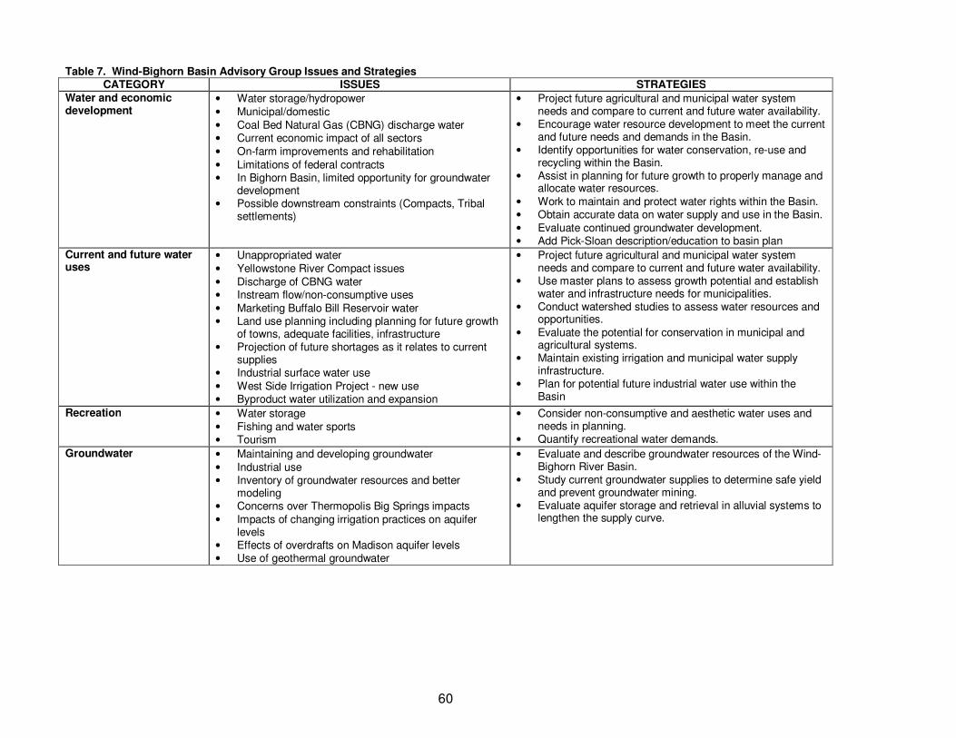
60
Table 7. Wind-Bighorn Basin Advisory Group Issues and Strategies CATEGORY ISSUES STRATEGIES
Water and economic development
• Water storage/hydropower • Municipal/domestic • Coal Bed Natural Gas (CBNG) discharge water • Current economic impact of all sectors • On-farm improvements and rehabilitation • Limitations of federal contracts • In Bighorn Basin, limited opportunity for groundwater
development • Possible downstream constraints (Compacts, Tribal
settlements)
• Project future agricultural and municipal water system needs and compare to current and future water availability.
• Encourage water resource development to meet the current and future needs and demands in the Basin.
• Identify opportunities for water conservation, re-use and recycling within the Basin.
• Assist in planning for future growth to properly manage and allocate water resources.
• Work to maintain and protect water rights within the Basin. • Obtain accurate data on water supply and use in the Basin. • Evaluate continued groundwater development. • Add Pick-Sloan description/education to basin plan
Current and future water uses
• Unappropriated water • Yellowstone River Compact issues • Discharge of CBNG water • Instream flow/non-consumptive uses • Marketing Buffalo Bill Reservoir water • Land use planning including planning for future growth
of towns, adequate facilities, infrastructure • Projection of future shortages as it relates to current
supplies • Industrial surface water use • West Side Irrigation Project - new use • Byproduct water utilization and expansion
• Project future agricultural and municipal water system needs and compare to current and future water availability.
• Use master plans to assess growth potential and establish water and infrastructure needs for municipalities.
• Conduct watershed studies to assess water resources and opportunities.
• Evaluate the potential for conservation in municipal and agricultural systems.
• Maintain existing irrigation and municipal water supply infrastructure.
• Plan for potential future industrial water use within the Basin
Recreation • Water storage • Fishing and water sports • Tourism
• Consider non-consumptive and aesthetic water uses and needs in planning.
• Quantify recreational water demands.
Groundwater • Maintaining and developing groundwater • Industrial use • Inventory of groundwater resources and better
modeling • Concerns over Thermopolis Big Springs impacts • Impacts of changing irrigation practices on aquifer
levels • Effects of overdrafts on Madison aquifer levels • Use of geothermal groundwater
• Evaluate and describe groundwater resources of the Wind-Bighorn River Basin.
• Study current groundwater supplies to determine safe yield and prevent groundwater mining.
• Evaluate aquifer storage and retrieval in alluvial systems to lengthen the supply curve.
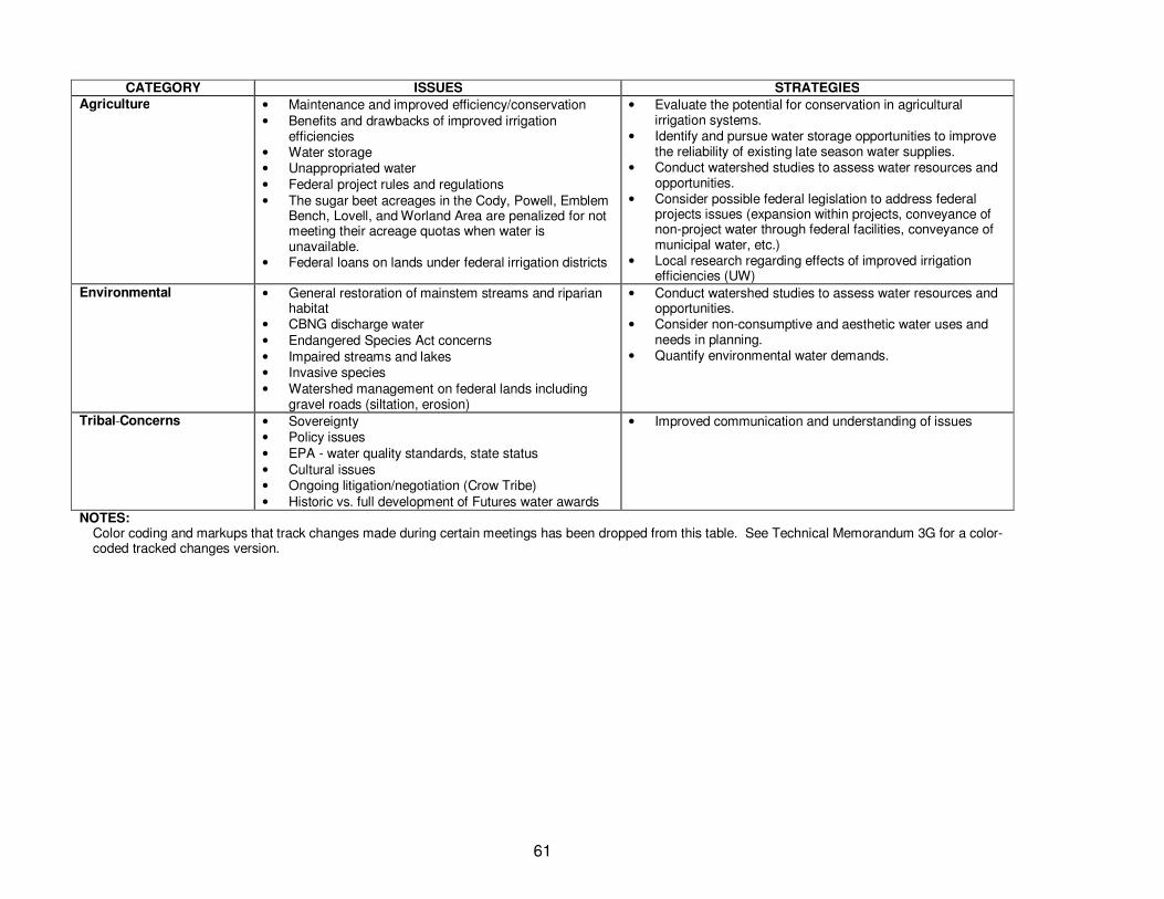
61
CATEGORY ISSUES STRATEGIES Agriculture • Maintenance and improved efficiency/conservation
• Benefits and drawbacks of improved irrigation efficiencies
• Water storage • Unappropriated water • Federal project rules and regulations • The sugar beet acreages in the Cody, Powell, Emblem
Bench, Lovell, and Worland Area are penalized for not meeting their acreage quotas when water is unavailable.
• Federal loans on lands under federal irrigation districts
• Evaluate the potential for conservation in agricultural irrigation systems.
• Identify and pursue water storage opportunities to improve the reliability of existing late season water supplies.
• Conduct watershed studies to assess water resources and opportunities.
• Consider possible federal legislation to address federal projects issues (expansion within projects, conveyance of non-project water through federal facilities, conveyance of municipal water, etc.)
• Local research regarding effects of improved irrigation efficiencies (UW)
Environmental
• General restoration of mainstem streams and riparian habitat
• CBNG discharge water • Endangered Species Act concerns • Impaired streams and lakes • Invasive species • Watershed management on federal lands including
gravel roads (siltation, erosion)
• Conduct watershed studies to assess water resources and opportunities.
• Consider non-consumptive and aesthetic water uses and needs in planning.
• Quantify environmental water demands.
Tribal Concerns
• Sovereignty • Policy issues • EPA - water quality standards, state status • Cultural issues • Ongoing litigation/negotiation (Crow Tribe) • Historic vs. full development of Futures water awards
• Improved communication and understanding of issues
NOTES: Color coding and markups that track changes made during certain meetings has been dropped from this table. See Technical Memorandum 3G for a color-coded tracked changes version.
62
• Work to maintain and protect water rights within the basin – This strategy encourages the
continued involvement of the WSEO to protect and administer existing water rights within the Basin, continue to protect Wyoming water right holders during negotiations and administration of interstate compacts, and continue to review and permit new water rights development for unapproriated water within the Basin.
• Obtain accurate data on water supply and use in the Basin – A fundamental requirement of basin planning activities is to work with accurate data regarding water supply and use within the Basin. This includes obtaining data from reliable sources, ground truthing data, and providing the data in a manner that is accessible to other users.
• Evaluate continued groundwater development – Groundwater development within the study area has been on-going for many years. However, there are reports within the Basin that groundwater pumping is causing reduced yields and well-head pressures for neighboring wells. This strategy would involve quantitative analyses on specific aquifers within the Basin to determine aquifer safe yields and be used to evaluate the effects of future groundwater development on existing wells.
• Add Pick-Sloan description/education to Basin Plan - Water operations in the Basin are constrained by contracting requirements for Bureau of Reclamation projects in the Pick-Sloan Program. There is currently a lack of understanding by the general public regarding this program. Increased levels of education would assist in alleviating perceived issues with water rights administration.
Current and Future Water Uses
• Project future agricultural and municipal water system needs and compare to current and future water availability – See description under Water and Economic Development
• Use master plans to assess growth potential and establish water and infrastructure needs for municipalities - The second strategy is more specific to the needs for municipalities to establish master plans for growth. Master plans are commonly used tools used by municipalities to plan for all utilities and services that are provided. Many master plans within the Basin already consider water resource requirements of growth activities. For actively growing communities that do not have a master plan or have a master plan that does not consider water resources, the plans should be developed or expanded to do so. The community may work with WWDC to complete these plans.
• Conduct watershed studies to assess water resources and opportunities – This strategy was
recommended for three different categories of issues, including Current and Future Water Uses, Agriculture, and Environmental. Watershed planning activities typically involve the evaluation of all water resource uses and water availability, land use and its effect on hydrology, and non-consumptive uses. Because watershed plans are conducted on a smaller scale than the larger basin planning activities, more focus and detail can be provided on the technical analysis. Furthermore, because the activities are on a localized basis, it provides a much easier means for local residents and stakeholders to become involved in the process.
• Evaluate the potential for conservation in municipal and agricultural systems – This strategy
suggests both municipal and agricultural conservation. Agricultural conservation is discussed in the following strategy. Municipal conservation can be initiated to either reduce the amount of water that is diverted or pumped and treated by the municipality, or to reduce consumptive use.
63
All typical forms of municipal conservation, such as low-flow fixtures, reduced lawn watering and other practices will reduce municipal diversion/pumping. However, reduction in consumptive use can be more difficult. Typically, lawn watering is the highest consumptive use within municipal systems. Therefore, reduction in the amount of lawn watered (i.e. removal of lawns) is the most effective means for municipal conservation. Other conservation measures can also result in lower consumptive use, but the incremental effects are smaller.
• Maintain existing irrigation and municipal water supply infrastructure – Maintenance of existing
facilities could potentially fit into several of the strategic areas, but was included in the conservation area because this type of maintenance was generally suggested to address conservation issues. Lack of, or poor maintenance of both irrigation and municipal water supply infrastructure typically results in less efficient systems due to leakage within the systems and more difficult or inefficient operations.
• Plan for potential future industrial water use within the Basin – Industrial uses, especially those related to oil and gas development and coal-bed natural gas (CBNG) development, should be included in future planning activities. Industrial uses include the diversion/pumping of water for consumptive or non-consumptive uses, and the return of water that is produced as a by-product of other activities like oil and gas and CBNG. Produced water has the potential to increase the overall water supply within the Basin. Coordination with the entities involved in these industrial activities and other water users in the Basin should be expanded, including participation in the BAG process by the industrial users.
Recreation
• Consider non-consumptive and aesthetic water uses and needs in planning (2 categories) - Currently, the basin planning tools rely heavily on determination of shortages and water availability based on consumptive needs only, such as municipal, agricultural and industrial water use. However, there are non-consumptive uses within the Basin that need to be considered in the planning process. Non-consumptive uses could include recreational, environmental, ceremonial and general aesthetic (in-channel) uses.
• Quantify recreational water demands – Recreation is an important economic activity within the basin. In addition, recreation has intrinsic, or non-economic value, to most residents of the state as recreational opportunities are an important aspect of living in the area. In order for recreational water uses to be considered in planning activities, these uses must first be identified and quantified. Recreational uses within the Basin could include fishing, river rafting and whitewater rafting, and flat water boating.
Groundwater
• Evaluate and describe groundwater resources of the Wind-Bighorn River Basin - This strategy
was identified by both the Basin Advisory Group and the Framework Water Plan. Key aspects of the groundwater resources is determining the location and extents of developable aquifers, estimating safe (renewable) yields from these aquifers, and quantifying existing and future water uses.
• Study current groundwater supplies to determine safe yield and prevent groundwater mining –
This strategy is very similar to the strategy “Evaluate continued groundwater development.” However, in this strategy, the BAG suggests that the WSEO consider regulatory action to establish safe yields within each of the aquifers and prevent groundwater development that results in exceedance of the safe yield.
64
• Evaluate aquifer storage and retrieval in alluvial systems to lengthen the supply curve - Aquifer
storage and retrieval (or recovery; ASR) involves the injection or infiltration of water available at the ground surface (typically surface water, but can include return flows from other groundwater supplies) into empty pore spaces within alluvial or bedrock aquifers. This water can then be recovered at a later time when needed using wells. Injection is usually done using injection wells, while infiltration is accomplished using ponds. Typically, this type of system can serve as a replacement for storage in municipal water systems. There can be technical hurdles to overcome, including location of suitable aquifers and treating injection water to appropriate water quality levels, but it can be economic and efficient for many municipal applications. Due to slow injection rates, this system is typically not used for agricultural storage. Infiltration ponds that take advantage of natural treatment processes that occur as water moves through the soil profile have fewer permitting issues than using injection wells. The strategy would involve identification of potential users that have suitable aquifers near the point of withdrawal.
Agriculture
• Evaluate the potential for conservation in agricultural irrigation systems –Typically, agricultural
irrigation conservation is implemented to address either delivery systems or on-farm systems. Conservation in delivery systems typically involves the replacement of open-channel ditches with concrete or fabric lined ditches or pipe. On-farm conservation typically involves increased use of sprinkler and/or drip irrigation systems. Due to the economics of conversion to these systems, it is likely that some type of public funding would be required, such as low interest loans or grants.
• Identify and pursue water storage opportunities to improve the reliability of late season water
supplies – Late season water supplies are critical to the maturation process and yields of most crops. Most of the streams within the study area are snowmelt fed, resulting in high peak flows during the runoff season, typically May and June. For basins without any storage or inadequate storage, this results in excess streamflow during the spring and early summer, and shortages during the later summer and early fall. Development of water storage projects, including new storage or rehabilitation/expansion of existing storage, provides a means to store runoff early in the year and release this water later in the year to meet crop needs.
• Conduct watershed studies to assess water resources and opportunities – See description
under Current and Future Water Uses.
• Consider possible federal legislation to address federal project issues (expansion within projects, conveyance of non-project water through federal facilities, conveyance of municipal water, etc.) - The BAG suggests that federal legislation be considered that would address certain issues with existing federal projects that are controversial or problematic within the basin, including expansion of use within the projects, the limitations in conveyance of non-project or non-federal water through federal facilities, and the conveyance of municipal water through federal facilities authorized for irrigation uses only.
• Local research regarding effects of improved irrigation efficiencies (University of Wyoming) -
Conservation has the potential to reduce the quantity of water diverted, and in some instances, consumptive use. However, due to the return flow component of water resources uses (i.e. the non-consumptive portion), care must be taken promoting conservation for those activities that could change return flow patterns or timing and cause unintended consequences at other times of the year. This strategy specifically suggests an evaluation of the effects of conservation,

65
which would include the benefits of conservation programs regarding reduced diversion requirements and consumptive use, and potential drawbacks such as changes in return flow patterns that could affect other water users. These studies should be conducted on a site specific basis within the Basin. It was suggested that this research be conducted by the University of Wyoming.
Environmental
• Conduct watershed studies to assess water resources and opportunities – See description
under Current and Future Water Uses
• Consider non-consumptive and aesthetic water uses and needs in planning – See description under Recreation.
• Quantify environmental water demands – Although included under the heading Non-
Consumptive Uses, environmental uses within the Basin include both consumptive and non-consumptive uses. Consumptive uses include the use of water by riparian vegetation, wetlands and wildlife, while non-consumptive uses include uses for instream flows and aquatic habitat. As with recreational uses, environmental uses must be identified and quantified to be considered in the basin planning and water availability analysis.
Tribal Concerns
• Improved communication and understanding of issues – Several issues identified in the Tribal Concerns category were interpreted by the BAG to result from inadequate communication between the Tribes and other Basin stakeholders. Improved communication could be in the form of increased participation in the BAG by Tribal officials and members, increased transparency in water resources planning activities, and improved understanding of important issues by both groups.
Framework Water Plan Recommendations
The previous section identified those strategies that are proposed to meet specific BAG concerns. In addition, the strategies in the previous section address those specific strategies that were identified for the Wind-Bighorn Basin in the Framework Water Plan. Additional strategies identified in this section address the more general strategic recommendations for all river basin plans. Outreach Plans
• Outreach plans should be continued and improved. - Basin plans should address how best to provide information to the public and how to involve the public in the planning process. The outreach plans should review the BAG process. The review should strive to adopt new ideas for maintaining the BAG’s diversity, viability and effectiveness.
Presentation in Electronic and Geographic Information System (GIS) Format
• Incorporate basin plan products into existing WRDS data storage system, including the development of GIS layers where necessary – The WRDS data storage system is an integral part of the basin plan process. It provides a common repository for basin plan information, makes this available to the public through the internet, makes information available in a GIS format, and maintains consistency between the various basin plans. Information should continue to be developed and delivered in a manner that is consistent with this process.
66
Coordination with Local, State and Federal Agencies and Incorporation of Agency Data • As part of river basin planning, coordinated with local, state and federal agencies should be
promoted, and agency involvement in BAGs should be encouraged – Coordination between all stakeholders in the Basin is critical to planning and moving potential project opportunities forward. Continued participation by these entities in the basin planning process is encouraged.
• River basin plans should incorporate data from a variety of agencies – Many local, state and
federal agencies are collecting data that can be used in the basin planning process. Typically, this data is housed in each entity’s unique database system. The river basin plans are encouraged to incorporate this data into the planning process. Additionally, tool development that can assimilate this data from different sources for use in the basin planning process is encouraged.
Modeling
• Transition spreadsheet models into more advanced water rights based time-series operations model. – The existing spreadsheet models are adequate to make planning level decisions on a basin-wide level regarding locations of water availability and potential shortages. However, they are limited in the analysis of carryover storage, long-term drought conditions, water rights, operational scenarios and future projects. New models would allow a much more comprehensive analysis of potential future projects and their ability to alleviate shortages.
Water Supply Period-of-Record
• Extend water supply study period in new model platform using historical hydrology – The Basin Plan Update has extended the model study period from 1973-2001 to 1973-2008. This provides a more comprehensive analysis of drought conditions that occurred in the early 2000s. However, typically, yield studies for project development, particularly storage projects, utilize a longer period of record. Furthermore, climate information within the Basin suggests that the 1950s drought conditions could be worse than the 2000s drought in certain areas, and should be included in the study period for any new modeling effort.
In addition to extending the historical study period of the models, consideration should be given for development of and use of stochastic hydrologic data (or artificial hydrologic data sets that are developed using a statistical analysis of historical data). Stochastic data sets can be used to analyze hydrologic conditions that are outside of historical conditions. Stochastic data sets can also be used to analyze paleohydrology and/or climate variability.
Focus on Problem Areas and Areas of Change
• Analyze Hydrologic Effects of 2000s Drought – This strategy is similar to the discussion on study period extension. As discussed, the 2000s drought was included in the updated study period, and its effects are reflected in the new estimates of available flow and shortages.
• Analyze Effects of Tribal Futures Projects – Potential development of Tribal Futures projects are
of particular concern in the Wind-Bighorn Basin. The spreadsheet models were developed to simulate Tribal Futures projects. However, these models are limited by their construction, and may not fully reflect expected impacts of the projects on other water users in the Basin. An expanded model as described in previous strategies could provide more detailed estimates of how development of Futures Projects would affect the Basin in general and particular water users and water rights, and guide the development of opportunities to mitigate these effects.
Basin Plan Update Recommendations
• Define and evaluate groundwater resources within the Wind-Bighorn Basin - At several levels during the Framework Water Plan development, it was found that the additional analysis of
67
groundwater resources within the basin plans was required. This includes the compilation of useful groundwater information and analysis of groundwater availability and use.
• Describe maintenance and improvement needs of agriculture and municipal systems - Maintenance and improvement of agricultural and municipal systems is important to continue meeting the needs of existing water users, and can be used to provide additional water to other users in the Basin. Although these are described in general in the current Basin Plan Update, and are included on the list of project opportunities list where deemed appropriate, more emphasis should be placed on maintenance and improvement needs in future basin plan updates. Existing and recent WWDC planning documents can be used to develop this discussion.
• Develop better socioeconomic forecasting methodologies - During development of the Framework Water Plan, it was determined that identification, description and quantification of non-consumptive water uses within the basin needed to be improved. In order to address this, the Framework Plan recommends that the socioeconomic forecasting methodologies used in basin planning account for tourism, recreation, and other non-consumptive water values and needs.
Recommended Program Strategies
This section describes the final list of strategies that was created following the merging and refinement of the two lists of strategies identified above. It should be noted that none of the strategies identified above were deleted or removed from the list. Rather, they were incorporated into other strategies. Furthermore, a portion of the strategies are already under development as part of the current basin planning process. In addition to merging and refining strategies, in order to move strategies from their current conceptual phase to implementation, further information was developed for each strategy. This included the ownership of the strategy, a time frame for implementing the strategy, and key strategy development activities. A summary of the strategies is presented in Table 8. A description of each strategy is presented below. Several of the descriptions are the same as those previously presented, especially if the strategy is a direct implementation of a previously defined strategy. Administrative Outreach plans should be continued and improved
Basin Plans should address how best to provide information to the public and how to involve the public in the planning process. The outreach plans should review the BAG process. The review should strive to adopt new ideas for maintaining the BAG’s diversity, viability and effectiveness.
Describe and continue maintenance of existing irrigation and municipal water supply infrastructure
This strategy is a combination of the strategy identified by the BAG to continue maintenance of existing facilities, and recommendations by the Framework Water Plan that basin plan updates should describe system improvement and maintenance needs of agriculture and municipalities within the basin.
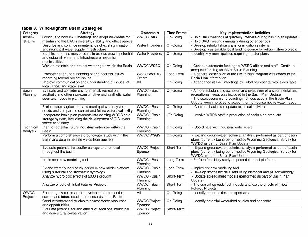
68
Table 8. Wind-Bighorn Basin Strategies Category Strategy Ownership Time Frame Key Implementation Activities Admin-istrative
Continue to hold BAG meetings and adopt new ideas for maintaining the BAG’s diversity, viability and effectiveness
WWDC/BAG On-Going - Hold BAG meetings at quarterly intervals during basin plan updates - Hold BAG meetings annually during other periods
Describe and continue maintenance of existing irrigation and municipal water supply infrastructure
Water Providers On-Going - Develop rehabilitation plans for irrigation systems - Develop sustainable local funding source for rehabilitation projects
Establish and use master plans to assess growth potential and establish water and infrastructure needs for municipalities
Water Providers On-Going - Identify key municipalities requiring master plans
Work to maintain and protect water rights within the Basin WWDC/WSEO On-Going - Continue adequate funding for WSEO offices and staff. Continue adequate funding for River Basin Planning.
Promote better understanding of and address issues regarding federal project issues
WSEO/WWDC/ Others
Long-Term - A general description of the Pick-Sloan Program was added to the Basin Plan information
Improve communication and understanding of issues at local, Tribal and state level
All On-Going - Attendance at BAG meetings by Tribal representatives is desirable
Basin Planning
Evaluate and consider environmental, recreation, aesthetic and other non-consumptive and aesthetic water uses and needs in planning
WWDC - Basin Planning
On-Going - A more substantial description and evaluation of environmental and recreational needs was included in the Basin Plan Update - The socioeconomic forecasting methods used in the Basin Plan Update were improved to account for non-consumptive water needs
Project future agricultural and municipal water system needs and compare to current and future water availability
WWDC - Basin Planning
On-Going - Continue basin plan update technical activities
Incorporate basin plan products into existing WRDS data storage system, including the development of GIS layers where necessary
WWDC - Basin Planning
On-Going - Involve WRDS staff in production of basin plan products
Technical Analysis
Plan for potential future industrial water use within the Basin
WWDC - Basin Planning
On-Going - Coordinate with industrial water users
Perform a comprehensive groundwater study within the Basin and determine safe yields from aquifers
WWDC/WSGS On-Going - Expand groundwater technical analysis performed as part of basin plans (currently being performed by Wyoming Geological Survey for WWDC as part of Basin Plan Update)
Evaluate potential for aquifer storage and retrieval throughout the basin
WWDC/Project Sponsor
Short-Term - Expand groundwater technical analysis performed as part of basin plans (currently being performed by Wyoming Geological Survey for WWDC as part of Basin Plan Update.
Implement new modeling tool WWDC - Basin Planning
Long-Term - Perform feasibility study on potential model platforms
Extend water supply study period in new model platform using historical and stochastic hydrology
WWDC - Basin Planning
Long-Term - Implement new modeling tool - Develop stochastic data sets using historical and paleohydrology
Analyze hydrologic effects of 2000’s drought WWDC - Basin Planning
Short-Term - Update spreadsheet models (performed as part of Basin Plan Update)
Analyze effects of Tribal Futures Projects WWDC - Basin Planning
Short-Term - The current spreadsheet models analyze the effects of Tribal Futures Projects
WWDC Projects
Encourage water resource development to meet the current and future needs and demands in the Basin
All On-Going - Identify opportunities and sponsors
Conduct watershed studies to assess water resources and opportunities.
WWDC/Project Sponsor
On-Going - Identify potential watershed studies and sponsors
Evaluate potential for and effects of additional municipal and agricultural conservation
WWDC/Project Sponsor
Short-Term

69
Establish and use master plans to assess growth potential and establish water and infrastructure needs for municipalities
The need for master plans and municipal planning for future water supply and infrastructure needs was identified by the BAG to address several issues within the basin. This strategy encourages the involvement of municipalities, county land-use departments, and state agencies such as WWDC, in planning for future growth to ensure adequate future water supplies. Master plans are commonly used tools used by municipalities to plan for all utilities and services that are provided. Many master plans within the Basin already consider water resources requirements of growth activities. For actively growing communities that do not have a master plan or have a master plan that does not consider water resources, the plans should be developed or expanded to do so. Ultimately, it is the decision of each municipality on whether a master plan is needed to address future growth.
Work to maintain and protect water rights with in the Basin
This is a direct implementation of the strategy proposed by the BAG. In general, this strategy was proposed by the BAG to support historical and continuing work by the WSEO to administer water rights within the Basin, including continuing to protect Wyoming water right holders during negotiations and administration of interstate compacts, and to continue to review and permit new water right development for unapproriated water within the Basin.
Promote better understanding of and address issues regarding federal project
The BAG identified the administration, restrictions and effects of federal projects as an issue within the Basin. Two more specific strategies prescribing additional description of the Pick-Sloan Program and development of federal legislation to address these issues were proposed. Very general information on the Pick-Sloan Program was included in the Basin Plan Update documentation. However, proposing federal legislation is a strategy that would require higher level support in the state. For purposes of the basin planning process, this strategy was generalized to include education of the public on these issues and working with others, including federal and state agencies and legislatures, in and outside of the Basin on these issues.
Improve communication and understanding of issues at local, Tribal and state level
The BAG had identified issues of communications with the Tribes as a key issue within the Basin. For the final list of strategies, this BAG strategy was expanded to include improved communication and understanding of issues at local, Tribal and state levels. As described in several other Framework strategies, improved communication is a key goal of basin planning. Increased participation in basin planning efforts would be one opportunity to improve this communication.
Basin Planning Evaluate and consider environmental, recreation, aesthetic and other non-consumptive water issues and needs in planning
Information regarding environmental and recreational uses within the Basin has been greatly expanded from the previous Basin Plan, including providing information showing the location of wetlands, instream flows, and key fishing locations, key rafting and whitewater rafting locations within the Basin. This information is contained in Technical Memorandum 3D – Recreation and Environmental Water Use.
70
Project future agricultural and municipal water system needs and compare to current and future water availability
This strategy is a direct implementation of strategies identified to address BAG concerns. The strategy was included in both the Water and Economic Development category and the “Current and Future Water Uses category. The purpose of the strategy is to provide technical information regarding the location of where water is needed under existing and future conditions and where water could be available for development under existing and future conditions. This strategy is one of the main focuses of technical activities in Tasks 3, 4 and 5 of the Basin Plan Update. This type of information should continue to be supplied and refined in future basin plan updates.
Incorporate Basin Plan products into existing WRDS data storage system, including the development of GIS layers where necessary
This strategy is a direct implementation of the strategy identified in the Framework Water Plan. The WRDS data storage system is an integral part of the basin planning process. It provides a common repository for basin plan information, makes this available to the public through the internet, makes information available in a GIS format, and maintains consistency between the various basin plans. Information should continue to be developed and delivered in a manner that is consistent with this process.
Plan for potential future industrial water use within the Basin
This strategy is a direct implementation of a strategy identified to address BAG issues. Industrial uses, especially those related to oil and gas development and CBNG development, should be included in future planning activities. Industrial uses include the diversion/pumping of water for consumptive or non-consumptive uses, and the return of water that is produced as a by-product of other activities like oil and gas and CBNG. Produced water has the potential to increase the overall water supply within the basin. Coordination with the entities involved in these industrial activities and other water users in the Basin should be expanded, including participation in the BAG process by the industrial users.
Technical Analysis Perform a comprehensive groundwater study within the Basin and determine safe yields from aquifers
The groundwater portion of the Basin Plan Update was expanded to more directly describe and analyze aquifers within the Basin. This information is being developed by the Wyoming State Geological Survey and will be submitted to WWDC under separate cover.
Evaluate potential for aquifer storage and retrieval throughout the Basin
Aquifer storage and recovery was identified by the BAG as a key strategy. Aquifer storage and retrieval (or recovery; ASR) involves the injection of water available at the ground surface (typically surface water, but can include return flows from other groundwater supplies) into empty pore spaces within alluvial or bedrock aquifers. This water can then be recovered at a later time when needed using wells. Typically, this type of system can serve as a replacement for storage in municipal water systems. There can be technical hurdles to overcome, including location of suitable aquifers and treating injection water to appropriate water quality levels, but can be economic and efficient for many municipal applications. Due to slow injection rates, this
71
system is typically not used for agricultural storage. The strategy would involve identification of potential users that have suitable aquifers near the point of withdrawal.
Implement new water rights based modeling tool
The Framework Water Plan recommended transitioning to more advanced models. WWDC staff and the consulting team concur with this recommendation for the Wind-Bighorn Basin. The existing spreadsheet models are adequate to make planning level decisions on a basin-wide level regarding locations of water availability and potential shortages. However, they are limited in the analysis of carryover storage, long-term drought conditions, water rights, operational scenarios and future projects. New models would allow a much more comprehensive analysis of potential future projects and their ability to alleviate shortages. The models would include time-series analyses that can use historical hydrology or stochastic (artificial) hydrologic data sets. The following activities are recommended by staff and the consulting team to make this transition.
o Investigate an acceptable modeling platform for the Basin - Selection of an appropriate modeling platform for the advanced models is critical for successful implementation of the tool. Selection of a model should be made based upon the ultimate needs and uses for the model, data availability, model flexibility, model support, cost and several other critical issues. A feasibility study is currently being performed by WWDC in the Green River Basin to investigate the different types of models available for this use, and determine which may best be suited in that basin. This study could be used to investigate expanded modeling opportunities in the Wind-Bighorn Basin.
o Implement common data storage tools – A basic necessity for any water-rights based
modeling platform will be data storage. A hydrologic database (the WindBighorn_Hydro database) was created as part of the Basin Plan Update to store, allow easy access to, and allow easy updates to hydrologic, diversion and demand calculations. This database also performs most of the pre-processing calculations required for the spreadsheet models, and was designed to allow easy transition to supplying data for more sophisticated time-series hydrologic models. The database is described in Technical Memorandum 4B – Database and Model Operations. Depending upon the tool ultimately selected, this tool may require refinement or porting into a new database platform as part of the update.
o Implement new modeling tool - Current basin modeling activities could be expanded to
include the effects of carryover storage. Carryover storage can be analyzed using a time-series analysis rather than individual dry, average and wet years. Time-series analyses can use historical hydrology or stochastic (artificial) hydrologic data sets. This type of analysis could be further expanded to include water rights, which would be helpful in analyzing effects of future water development activities in the Basin.
Extend water supply study period in new model platform using historical and stochastic hydrology; analyze hydrologic effects of 2000’s drought
This strategy is a combination of two separate strategies developed from Framework Water Plan recommendations. As part of new modeling efforts in the Basin, it is recommended that the hydrology study period be extended to include drought conditions in the 1950’s, and if adequate data exists, drought conditions in the 1930s. In addition to extending the historical

72
study period of the models, consideration should be given for development and use of stochastic hydrologic data. Stochastic data sets can be used to analyze hydrologic conditions that are outside of historical conditions. Stochastic data sets can also be used to analyze paleohydrology and/or climate variability.
Analyze effects of tribal futures projects
The BAG identified Tribal Futures projects and the technical analysis shows that implementation of Tribal Futures projects could have a significant effect on existing water users in the Basin. The spreadsheet models were developed to simulate Tribal Futures projects. However, these models are limited by their construction, and may not fully reflect expected impacts of the projects on other water users in the Basin. An expanded model as described in previous strategies could provide more detailed estimates of how development of Futures Projects would affect the Basin in general and particular water users and water rights, and guide the development of opportunities to mitigate these effects.
WWDC Projects Encourage water resource development to meet the current and future needs and demands in the Basin
This strategy uses the similar descriptions as strategies identified in the BAG process, but is essentially a combination of strategies identified by the BAG and strategies identified in the Framework Water Plan. This strategy promotes the development and use of water resources within the Basin to meet current and future water uses. Key components of this strategy would be moving recommendations made as part of this plan to Level I and Level II studies by WWDC. The strategy should also consider promoting funding and organizational opportunities within the Basin, without which projects are often prevented from being considered beyond initial planning phases.
Conduct watershed studies to assess water resources and opportunities
This strategy is a direct implementation of the strategies identified by the BAG. This strategy was recommended for three different categories of issues, including Current and Future Water Uses, Agriculture, and Environmental. Watershed planning activities typically involve the evaluation of all water resource uses and water availability, land use and its effect on hydrology, and non-consumptive uses. Because watershed plans are conducted on a smaller scale than the larger basin planning activities, more focus and detail can be provided on the technical analysis. Furthermore, because the activities are on a localized basis, it provides a much easier means for local residents and stakeholders to become involved in the process.
Evaluate potential for and effects of additional municipal and agricultural conservation
Several strategies identified by both the BAG and in the Framework Water Plan deal with the potential for municipal and agricultural conservation and the limitations and effects of conservation. This strategy is intended to address all of these strategies. Municipal conservation can be initiated to either reduce the amount of water that is diverted or pumped and treated by the municipality, or to reduce consumptive use. All typical forms of municipal conservation, such as low-flow fixtures, reduced lawn watering and other practices will reduce municipal diversion/pumping. However, reduction in consumptive use can be more difficult. Typically, lawn watering is the highest consumptive use within municipal systems. Therefore, reduction in the amount of lawn watered (i.e. removal of lawns) is the most effective
73
means for municipal conservation. Other conservation measures can also result in lower consumptive use, but the incremental effects are smaller. Typically, agricultural irrigation conservation is implemented to address either delivery systems or on-farm systems. Conservation in delivery systems typically involves the replacement of open-channel ditches with concrete or fabric lined ditches or pipe. On-farm conservation typically involves increased use of sprinkler and/or drip irrigation systems. Due to the economics of conversion to these systems, it is likely that some type of public funding would be required, such as low interest loans or grants. Large scale conservation efforts can have an effect on downstream water users. Conservation efforts that reduce the amount of water but do not reduce consumptive use will have an effect on the timing of return flows to streams and rivers. These return flows are often counted on by downstream users to provide water supplies later in the season. For instance, if early season diversions are reduced, absent storage facilities or with full storage facilities, this would flow downstream and not be available for downstream users. These effects would vary based upon basin and proposed practices. These conservation efforts should be evaluated before large-scale efforts are undertaken.
Section 5 – Summary This technical memorandum describes project opportunities and program strategies developed to address identified existing and future water use shortages within the Wind-Bighorn Basin and issues identified by the BAG and basin planning team. The procedure is an implementation of the recommended procedure identified in Technical Memorandum 7 - Approach to Developing Opportunities and Strategies. The technical memorandum presents a summary of water supply availability, shortages and flow conditions developed in the technical analysis. In general, the shortages identified in the current technical analysis were consistent with those in the previous Basin Plan. The 2000s drought conditions resulted in a slight decrease in shortages during dry hydrologic conditions and a slight increase in shortages during average and wet hydrologic conditions. Available surface water generally increased slightly during dry hydrologic conditions, and decreased slightly during average and wet years. Project opportunities were developed based on the opportunities identified in the previous Basin Plan and those identified as part of the Framework Water Plan. This list was supplemented by recommendations from watershed and Level I and II planning studies performed within the Basin since the previous Basin Plan. The list was presented to the BAG and modifications were made to reflect the current status of recently completed and on-going projects, and to reflect the BAGs current recommendation on future projects. A comprehensive list of program strategies was developed to help meet the needs of the Basin as they have been identified throughout the current Wind-Bighorn planning process and the statewide Framework Water Plan process. These strategies are a merging of specific strategies identified by the BAG, WWDC staff and the consultant team. Many of the strategies have a time-frame that help define and guide the Basin Plan Update process. Other strategies have short-term or long-term implementation schedules, and will rely on several state agencies and local stakeholders to implement.
Section 6 – References A&H Consulting (A&H). 2003. Irrigation Hydropower Study Level II. Prepared for the Wyoming Water Development Commission. Lovell, WY. May 1.
74
Anderson Consulting Engineers, Inc. (ACE). 2003. Popo Agie River Watershed Study, Level I. Prepared for the Wyoming Water Development Commission. Fort Collins, CO. July 9. Anderson Consulting Engineers, Inc. (ACE). 2005. Kirby Area Water Supply Level I Study. Prepared for the Wyoming Water Development Commission. Fort Collins, CO. September 30. Anderson Consulting Engineers, Inc. (ACE). 2007. Bighorn Canal Rehabilitation Study Level II Study. Prepared for Wyoming Water Development Commission. Fort Collins, CO. April 20. Apex Surveying, Inc. 2002. LeClair Irrigation District Laterals Rehabilitation Level II Study. Prepared for Wyoming Water Development Commission. November. Apex Surveying, Inc. 2003. Riverton Valley Diversion Modifications Level II Study. Prepared for Wyoming Water Development Commission. August. Aqua Engineering, Inc. 2009. Willwood Irrigation District Master Plan. Prepared for Wyoming Water Development Commission. Fort Collins, CO. May. BAG – see Wind-Bighorn Basin Advisory Group Boyce, Kevin. 2010. Personal communication with Jodie Pavlica. Project Manager, Wyoming Water Development Commission. January. Engineering Associates (EA). 2002. Deaver Irrigation Rehabilitation Project Level II Study. Prepared for Wyoming Water Development Commission. November 7. Engineering Associates (EA). 2003a. Level II Study Town of Greybull Raw Water Supply Project. Prepared for Wyoming Water Development Commission. May 15. Engineering Associates (EA). 2003b. Lovell ID Hydropower Study Level II. Prepared for Wyoming Water Development Commission. May 1 Engineering Associates (EA). 2007. Heart Mountain Screens Level II Study. Prepared for Wyoming Water Development Commission. April. Engineering Associates (EA). 2008. Cody Canal Irrigation District Purvis Drop Hydropower Level II - Phase II Study. Prepared for Wyoming Water Development Commission. Cody, WY. July 30. Engineering Associates (EA). 2009a. South Thermopolis Water and Sewer District Water Supply Project Level II Study. Submitted to Wyoming Water Development Commission. July 15. Engineering Associates (EA). 2009b. Owl Creek Rural Water Supply Level II Study. Submitted to Wyoming Water Development Commission. July 8. ECI. 2003. Greybull Hydropower Study Level II Project. Submitted to Wyoming Water Development Commission. Greenwood Village, CO. April. Inberg-Miller Engineers. Riverton Valley Rehabilitation No. 2, Level II, Phase II. Prepared for Wyoming Water Development Commission. 2002.
75
James Gores and Associates (Gores). 2009. Town of Hudson Water Supply Level II Study. Prepared for Wyoming Water Development Commission. March. Lawson, John H. 2010. Letter to Wyoming Water Development Office re: Wind/Bighorn River Basin Plan Update Comments. Area Manager, Wyoming Area Office, U.S. Bureau of Reclamation, Mills, WY. May 3. Lidstone and Associates, Inc. (LA). 2002. Town of Ten Sleep Water Supply Project Level I Master Plan Report. Prepared for Wyoming Water Development Commission. December 1. Lidstone and Associates, Inc. (LA). 2003. Hot Springs State Park Master Plan Level I. Prepared for Wyoming Water Development Commission. February 12. Lidstone and Associates, Inc. (LA). 2004. Town of Ten Sleep Water Supply Project Level II Report. Prepared for Wyoming Water Development Commission. January 12. Lidstone and Associates, Inc. (LA). 2007. Final Report Gooseberry Creek Storage Level II Study. Prepared for Wyoming Water Development Commission. February. Lidstone and Associates, Inc. (LA). 2008. Shoshone Ground Water Development Level II Report. Prepared for Wyoming Water Development Commission. November. MWH. 2003. Wind/Bighorn River Basin Plan Power Study. Prepared for Wyoming Water Development Commission. September. Natural Resources Consulting Engineers (NRCE). 1994. Wind River Irrigation Project Assessment and Plan. Prepared for the Eastern Shoshone and Northern Arapaho Tribes and Bureau of Indian Affairs – Wind River Agency. Fort Collins, CO. June 23. Nelson Engineering. 2004. Owl Creek Master Plan Level I. Prepared for Wyoming Water Development Commission. Jackson, WY. September. Nelson Engineering. 2007. Crowheart Area/Dinwoody Canal Level II Study. December. Pavlica, Jodie. 2009. E-mail to Gerald Gibbens, MWH, subject: Fwd: Re: Wind River Reservation and the Wind-Bighorn Basin Plan. Project Manager, Wyoming Water Development Commission. September 15. Pochop, L., Marston, R., Kerr, G., Veryzer, D., Varuska, M., and Jacobel, R. (1990) Glacial Icemelt in the Wind River Range, Wyoming. Watershed Planning and Analysis in Action Symposium Proceedings, Durango, CO: American Society of Civil Engineers, 118-124. Schroeder, Murray. 2009. Personal communication with Phil Ogle, Wyoming Water Development Commission. Branch Manager, WWC Engineering, Laramie. December. Short Elliott Hendrickson Inc. (SEH). 2001. Upper Wind River Storage Project Level I Study. Prepared for Wyoming Water Development Commission. November 30. Short Elliott Hendrickson Inc. (SEH). 2007. Cottonwood/Grass Creek Watershed Management Plan Level I Study. Prepared for Wyoming Water Development Commission. October 10.
76
Short Elliott Hendrickson Inc. (SEH). 2008. Owl Creek Irrigation District Storage, Level II Study. Prepared for Wyoming Water Development Commission. July 30. States West Water Resources Corporation. LeClair/Riverton Valley Irrigation Storage Project, Level II Study. Prepared for Wyoming Water Development Commission. October 2006. Stetson Engineering Inc. 2004. Town of Dubois Water Supply Level II Study. Prepared for the Town of Dubois and the Wyoming Water Development Commission. August. Sunrise Engineering, Inc. 2005. Kirby Creek Watershed Plan. Prepared for Wyoming Water Development Commission. September 12. Tootle, Glenn, Greg Kerr and Larry Pochop. 2007. Wind River Glacier Study 2007 Project Update. Submitted to the University of Wyoming Department of Civil and Architectural Engineering. November 30. TST Inc. of Denver (TST). 2007. Burlington Regional Water Master Plan Level II Study. Prepared for the Wyoming Water Development Commission. January. U.S. Bureau of Land Management (BLM). 2008. DRAFT Environmental Impact Statement for the Westside Land Conveyance Project. Wyoming State Office, Cheyenne. January. U.S. Energy Information System (EIA). 2009. Official Energy Statistics from the U.S. Government. http://www.eia.doe.gov/. Accessed November 24. Weed, Babtiste. 2009. Personal communication with Gerald Gibbens, MWH. Tribal Water Engineer, Eastern Shoshone and Northern Arapaho Tribes. January 22. Weston Engineering, Inc. Lander Level II Water Supply Project Exploration Well Deepening. Prepared for the Wyoming Water Development Commission. October 2007. Wester Wetstein & Associates (WWA). 2006. Hyattville Water Supply Level II Project. Prepared for Wyoming Water Development Commission. October. WWC Engineering, et al. 2007. Wyoming Framework Water Plan. Prepared for the Wyoming Water Development Commission. October. Wind-Bighorn River Basin Advisory Group Meeting (BAG). 2009a. Meeting Record. Thermopolis, WY. March 3. Wind-Bighorn River Basin Advisory Group Meeting (BAG). 2009b. Meeting Record. Lander, WY. June 18. Wind-Bighorn River Basin Advisory Group Meeting (BAG). 2009c. Meeting Record. Powell, WY. September 17. Wind-Bighorn River Basin Advisory Group Meeting (BAG). 2009d. Meeting Record. Worland, WY. November 11. Wind-Bighorn River Basin Advisory Group Meeting (BAG). 2010. Meeting Record. Worland, WY. March 11.