1
Naval Base Philadelphia Naval Hospital Philadelphia Defense Supply Center Philadelphia Penny Pack State Park Darby Crk Springton Reservoir Delaware Riv Schuylkill Riv Penn Central RR Penn Ce ntr al RR R eading RR Reading RR Reading RR Penn Central RR Csx Plymouth twp 61664 Springfield twp 73088 Springfield twp 73088 Tredyffrin twp 77344 Upper Merion twp 79136 Abington twp 00156 Abington twp 00156 Lower Merion twp 44976 Whitemarsh twp 84624 Cheltenham twp 12968 Upper Chichester twp 78776 Tinicum twp 76792 Ridley twp 64800 Upper Darby twp 79000 Upper Darby twp 79000 Springfield twp 73032 Springfield twp 73032 Nether Providence twp 53104 Upper Providence twp 79248 Radnor twp 63264 Darby twp 18160 Darby twp 18160 Marple twp 47616 Aston twp 03336 Newtown twp 54224 Chester twp 13212 Haverford twp 33144 Middletown twp 49136 4032 4049 4040.04 4015.01 4046 4033 4013.02 4019 4018 4044 4085 4037.02 4038 4036.01 4061 4095 4078.04 4011.01 4009 4026 4004.01 4031.04 4034.01 4081.03 4080.02 4076 4075.02 4062.01 4011.03 4030.01 4041.01 4012 4035.01 4036.02 4106.01 4087 4078.02 4092 4052 4093 4039.01 4079.02 4062.02 4096.02 4005 4068.02 4098.02 4003.02 4097.01 4027 4043 4071.01 4041.03 4029 4065 4099.02 4069.02 4080.01 4099.03 4072.02 4024 4072.01 4003.01 4099.04 4099.04 4071.02 4097.02 4107 4105 9800 4079.01 4034.02 4023 4054 4013.01 4016 4006 4017 4035.02 4088 4089 4021 4066 4098.03 4083 4064.02 4037.01 4014.01 4010 4025 4030.02 4039.02 4007 4022 4053 4086 4079.03 4040.03 4031.03 4078.03 4064.01 4074.04 4077 4028 4031.01 4008.02 4008.01 4078.05 4048 4050 4078.01 4084 4096.01 4081.01 4045 4075.01 4090 4074.01 4094 4015.02 4091 4047 4004.02 4081.02 4011.04 4108 4106.02 4063 4020 4078.06 4041.02 4051 4014.02 D ELA W ARE 045 MONT GOMERY 091 P H I L A D E L P H I A 1 01 D E L A W A R E 0 45 D ELAW A R E 045 CH ESTER 02 9 MONTGOMERY 091 MON TGOMERY 091 PHILADELPHIA 101 MONTGOMERY 091 PHILADELPHIA 101 P H I L A D ELPHI A 1 01 CHESTER 029 DELAWARE 045 P EN N S YLVAN I A 4 2 Bryn Mawr 09728 Penn Wynne 59312 King of Prussia 39736 Wyndmoor 86776 Ardmore 02896 Haverford College 33154 Village Green-Green Ridge 80218 Drexel Hill 19920 Broomall 09248 Folsom 26432 Woodlyn 86288 Rockledge° 65568 Narberth° 52664 West Conshohocken° 82736 Conshohocken° 15848 Philadelphia° 60000 Brookhaven° 09080 Chester° 13208 Marcus Hook° 47344 Norwood° 55664 Morton° 51176 Lansdowne° 41440 Glenolden° 29720 East Lansdowne° 21384 Media° 48480 Collingdale° 15232 Clifton Heights° 14264 Aldan° 00676 Upland° 78712 Swarthmore° 75648 Sharon Hill° 69752 Rutledge° 66928 Rose Valley° 66192 Ridley Park° 64832 Prospect Park° 62792 Parkside° 58176 Folcroft° 26408 Trainer° 77288 Yeadon° 86968 Millbourne° 49504 Eddystone° 22296 Darby° 18152 Colwyn° 15432 95 76 676 676 676 95 95 476 95 95 95 476 276 276 76 76 476 W Gl en Cir Godfrey R d Kirk Ln Plymouth Rd N ic k l aus D r Lori Ln J amestow n R d L e w i s R d N S p r o u l R d L i ndber gh A v e 1st Ave S p r i n g Val l ey Rd Yor k shi r e W ay Yal e S q Church Rd H arvard Ave E d ge h i l l R d Saville Ave N State R d Pinecrest R d Mo ore D r Pl u sh Mi l l R d Wo o d l a nds L n 2nd St A c re s D r H a res Ln M a r troy Rd L a r k i n L n Lorr ai ne D r Mapl ewood Ave Tri anon Ln Kell y L n W e l d o n L n En g l e Dr D e rm o nd R d 2nd Av e H i ll t o p R d Bu l l e n s Ln Uni on St P ark W ay R obert s R d B a r c l ay Ln Paddock Rd R i d gefi el d Rd Paper M i l l Rd T u r ne r Rd St Fran cis Dr H a r v e st L n Mi l l Rd K e r r L n Dill Rd Mar t i n s Ru n Bal dw i n Creek Whitely Rd E 2nd St B o n Air Rd E 4th St Crestvi ew D r Lancaster Ave City Ave Saw m i l l Rd N Mal i n Rd A rl i ngt o n A ve Hi l l s i de Ave Midland Ave North R d C ol l i ns D r Sh e f f i e l d Dr P a l m ers L n W Powhattan Ave Ches t e r Rd Dar by Rd N State Rd E 6th St M i l m ar Rd B r i arwood R d Access Rd Old L n Foxca t c h e r L n Hu e y Ave W Wayne Ave O l d M i l l Dr S e neca St L e e d o m Dr Fai rview Av e Berwind Rd M o r r i s L n J a m es R d Penn Ave Davis Ave Access Rd B o xwood Rd Clifton Ave Barclay R d 7th A ve Featherbed Ln T yson R d E 2 4 t h St H unt C l u b Ln Ha rv e y Rd E 9th St G ol f H o u s e R d D i ane Dr S Sellers Ave S a i n t D a vi ds A ve Indu s t r i a l Hwy R o bi n h o o d R d S emi nol e St Wi st a r Rd S pr o ul R d Abraha m s L n Access Rd L a wrenc e Rd D a m v i ew D r E Gol fvi ew Rd E 3 r d S t Bi rchwood Rd M e a d o w s L n M a rp l e W o o d s D r C l yde Cir Ca l c o n H o o k R d P a r k r i d g e Dr S State Rd Fildes L n H a nsel l Rd Charl es D r Radno r Va l l ey R d T u n b r i d g e R d Newtown Rd Rai d e r R d Wayne Av e Frank l i n Ave Owen Ave Crum C r ee k R d A roni mi nk Dr Hog I sl and R d Cal ey R d I nve r arara y R d C e d ar L n Cam e l ot L n A cces s R d A cce ss R d B ee chwo o d Dr Springfield Rd Furl ong Ave Stat e R d C hi p munk L n N I than Ave Buck Ln Arde n R d Pine Tree R d Airport Rd Hi l l t op D r W o o t o n R d L es l ey R d Medi a Byp I t h a n C re e k R d R oc kwo o d Rd H ar r i s o n L n Eagle Rd Industrial Hwy R i d ge Ln Martin Ave Baltimore Pi ke E Ashland Ave Hi ghland Ave Stev e n s Dr R o b in Ln Wi l l i amsbur g Dr Center Rd B rennan Dr Stoney Creek Rd Dogwood Ln A shwoo d Rd Seap o r t Dr S t a n fi el d Ave Access Rd Co un t r y C l ub Ln Aldwyn L n L o v e l l A v e P a l me r s M i l l R d S Martin Ln Parkes Run L n Park vi e w D r Lee C i r Ol d C edar Grove Rd O we n Ave N o r t hw o od Rd Commodore Barry Brg Le w i s L n Norri s St P a r k Av e A t ter b u r y Rd Saxer Ave S Roberts Rd W Rose Tree Rd 4 th Av e H orton R d S herma n R d N Rol l i ng R d Woodl awn Ave F a w nhi ll R d Manor R d H a r m i l R d W o o dcrest R d Vernon Rd A r r o w head Trl A b ra ha m s L n Fawn Ln Post Rd L ang s to o n Ln W 2nd St N o rt h Ave I nd u stri a l H w y H u n t R d Powell Rd W o o d crof t Rd Main St Vassar Ave 9thAve Kai s er Dr He a t her L n Green St I ndustri al Hwy Cemetery Rd Popl ar Ave Rogers Ln Exe t e r Rd F o x c r o f t Rd T i m b e r Ju m p L n Wi l l i a ms Rd J effre y L n Bl a k e l y R d Orchard Rd Girard A v e Abbo t t Dr 16th Ave B e r r y L n James Rd W i n c heste r Rd Q ui n c e Ln Fa r n u m Rd Pax o n H ol l ow R d B e verl y B l vd Gulph Creek Rd Wi ndsor Ave Rutgers A v e Cheyney R d S S p r i n g Mill Rd E Gl e n C i r W Rolling Rd Col t R d Penn St Mi ll i s o n Dr W 2nd St S K e n t R d Mi che l e Dr Dorman Ave S Roberts Rd Hus t o n R d L e e D r F orre s t Ln Ree d Rd T h o m a s A v e Cornell Ave Sunship Pri vate R d P a r k e Ln Hun t C l u b Ln Lincoln A v e Ri d g e Ln Hal c yon Dr E astburn Ave Josie Ln E l mwood A ve Co l o n y Rd S C e n t r a l B l vd Steel Rd Winter S t International Plz M i l l ri d g e Ch e r r y Hi l l Ln T i n ic u m Island Rd S O l d M i d d l e t o w n R d W Eagle Rd Fox Rd H i g hl an d Ln C h a n dl e r L n B e l r ose Ln Gal er D r Tayl o r A ve Tay l o r D r L e w i s R d Access Rd N Chester Rd Township Line Rd I ndustr i al Hw y Rh o a ds D r West A ve Ri dg e Av e Beech Rd E va ns R d Stevens Dr N Scott Ave E 4th St Laurel Rd L e s t e r Rd Earl es Ln W Front St HendersonB l vd Selwyn Dr Y al e Ave M a l i n R d H i l l dal e Rd B r e n t D r N o rthcroft Rd Acc e s s Rd Orchard W ay Camp w oods R d W Chester Pike Valley Rd Col l ege Ave M a l i n R d Beatty Rd Medi a Byp E K n ow l t o n R d Baltimore Pike O l d M a rpl e Rd Garrett Rd Shadel and Ave Damons Ln S Pr o v i d ence Rd S 69th St Marshall Rd B r o o ke R d Park Ave Kedron A v e County Line Rd S Bryn Mawr Ave E County Line Rd E l l i s Rd Baily Rd Me d i a L i n e R d M o r t on Ave Macdade Blvd W Chester Pi ke Ho ok R d Landover Rd Lawrence Rd Mill Rd E Marthart Ave C o ne stoga Rd Sproul Rd Gl e n d al e Rd Pearson Cir City Ave Putcan Ave D a r b y P a o l i R d Lancaster A v e W ood l a nd Ave Jansen Ave King o f P r u s s i a R d B r y n Mawr Ave Eagle Rd N Lynn B l vd Church Ln N E a gl e Rd Church Rd Ardmore Ave N Lemon S t S Oak A ve Beechwood Dr Pal me rs Mi l l Rd Iven A ve N e w t ow n S t reet R d Highland Ave E County Line Rd S Eagl e Rd Bet h el R d C e dar Gro ve Rd Powder Mill Ln Sproul Rd C o n c o r d R d Providence Rd S o uth A v e Kenwood Rd Upper Gulph Rd Lowrys Ln Bar ry D r Foulke Ln Eagle Rd Manchester A v e N Providence Rd M a r p l e Rd Michigan Ave A c c e s s R d Highland Ln W at ervi lle Rd Kerlin St W Chester Pike Barry Bridge Appr Matsonf o rd Rd 5th Ave E J ackson St El mwood Ave M ain St E County Line Rd E dgmont Ave M atson f or d R d W Cobbs Creek Pkwy Yale Ave S Manoa Rd Goshen R d N L ansdo wne Ave S I than A ve Coo pertow n Rd Edm onds Ave Radno r R d Tinicum Island Rd County Li n e Rd E 18th St State Rd Wanamaker Ave E Lea my Ave W Wo o d l an d A v e Mi l l Rd Del mar D r W 9th S t Front St Karakung Dr W Oak Ln Chester Pike E Woodl and Ave Baltimore Ave Darby R d D e l a war e E x py Pe nnsyl van i a Tpke S ch u yl ki l l E xp y S ch u y l k i l l Expy D e l a w are E x p y D e l aware Expy Schyulkill Expy V et eran s Memori al H w y Mid County Expy 3 291 3 3 23 352 3 252 309 352 3015 3003 291 291 352 291 320 532 611 320 291 611 420 611 611 23 23 611 73 73 2021 309 152 232 3 90 152 611 3 3 611 3 3 73 90 611 73 611 3 291 291 352 320 320 322 322 13 322 322 13 202 30 202 1 30 1 13 13 1 30 30 30 13 30 13 30 13 13 LEGEND SYMBOL DESCRIPTION SYMBOL LABEL STYLE Federal American Indian Reservation L'ANSE RES 1880 Off-Reservation Trust Land, Hawaiian Home Land T1880 Oklahoma Tribal Statistical Area, Alaska Native Village Statistical Area, Tribal Designated Statistical Area KAW OTSA 5340 State American Indian Reservation Tama Res 4125 State Designated Tribal Statistical Area Lumbee STSA 9815 Alaska Native Regional Corporation NANA ANRC 52120 State (or statistically equivalent entity) NEW YORK 36 County (or statistically equivalent entity) ERIE 029 Minor Civil Division (MCD) 1,2 Bristol town 07485 Consolidated City MILFORD 47500 Incorporated Place 1,3 Davis 18100 Census Designated Place (CDP) 3 Incline Village 35100 Census Tract 33.07 DESCRIPTION SYMBOL DESCRIPTION SYMBOL Interstate 3 U.S. Highway 2 State Highway 4 Other Road Marsh Ln 4WD Trail, Stairway, Alley, Walkway, or Ferry Raiload Southern RR Pipeline or Power Line Ridge or Fence Property Line Nonvisible Boundary or Feature Not Elsewhere Classified Water Body Pleasant Lake Swamp or Marsh Okefenokee Swamp Glacier Bering Glacier Military Fort Belvoir National or State Park, Forest, or Recreation Area Yosemite NP Inset Area A Outside Subject Area Where state, county, and/or MCD boundaries coincide, the map shows the boundary symbol for only the highest-ranking of these boundaries. 1 A ' ° ' following an MCD name denotes a false MCD. A ' ° ' following a place name indicates that a false MCD exists with the same name and FIPS code as the place; the false MCD label is not shown. 2 MCD boundaries are shown in the following states in which MCDs have functioning governments: Connecticut, Maine, Massachusetts, Michigan, Minnesota, New Hampshire, New Jersey, New York, Pennsylvania, Rhode Island, Vermont, and Wisconsin. 3 Place label color correlates to the place fill color. Key to Sheets 1 2 USCENSUSBUREAU Location of County within State 40.092190N 75.398892W 40.083397N 74.988061W 39.767824N 75.000417W 39.776577N 75.409322W All legal boundaries and names are as of January 1, 2010. The boundaries shown on this map are for Census Bureau statistical data collection and tabulation purposes only; their depiction and designation for statistical purposes does not constitute a determination of jurisdictional authority or rights of ownership or entitlement. U.S. DEPARTMENT OF COMMERCE Economics and Statistics Administration U.S. Census Bureau Geographic Vintage: 2010 Census (reference date: January 1, 2010) Data Source: U.S. Census Bureau's MAF/TIGER database (TAB10ST42) Map Created by Geography Division: December 15, 2010 ENTITY TYPE: County or statistically equivalent entity NAME: Delaware County (045) Projection: Albers Equal Area Conic Datum: NAD 83 Spheroid: GRS 80 1st Standard Parallel: 40 11 11 2nd Standard Parallel: 42 02 60 Central Meridian: -77 37 15 Latitude of Projection's Origin: 39 43 14 False Easting: 0 False Northing: 0 Total Sheets: 3 - Index Sheets: 1 - Parent Sheets: 2 - Inset Sheets: 0 ST: Pennsylvania (42) 0 1 2 3 4 5 Kilometers 5 Kilometers 0 0.8 1.6 2.4 3.2 4 Miles 4 Miles The plotted map scale is 1:48000 2010 CENSUS - CENSUS TRACT REFERENCE MAP: Delaware County, PA Sheet Location within Entity 2010 CENSUS TRACT REF MAP (PARENT) 205742045002 PARENT SHEET 2

2010 Census - Census Tract Reference Map...Media° 48480 Collingdale° ... Paddock R d R i d g e f i e l d R d P aper Mi l Rd T u r n e r R d St Fr an cis D r H a v e s L t n M il

  • Upload
    others

  • View
    3

  • Download
    0

Embed Size (px)

Citation preview

Naval Base Philadelphia

Naval Hospital Philadelphia

Defense Supply Center Philadelphia

Penny PackState Park

Darby Crk

SpringtonReservoir

Delaware Riv

SchuylkillRiv

Penn Central RR

Penn Centra

l RR

Reading RR

Reading RR

Reading

RR

Penn Central RR

Csx

Plymouth twp 61664 Springfieldtwp 73088Springfield twp 73088

Tredyffrintwp 77344

Upper Merion twp 79136

Abington twp 00156Abington

twp 00156

Lower Merion twp 44976

Whitemarsh twp 84624

Cheltenham twp 12968

Upper Chichester twp 78776

Tinicum twp 76792

Ridleytwp

64800

Upper Darby twp 79000

Upper Darbytwp 79000

Springfieldtwp 73032

Springfield twp 73032

NetherProvidencetwp 53104

UpperProvidencetwp 79248

Radnor twp 63264

Darby twp 18160

Darbytwp

18160

Marple twp 47616

Astontwp

03336

Newtowntwp

54224

Chestertwp

13212

Haverfordtwp 33144

Middletowntwp 49136

4032

4049

4040.04

4015.01

4046

4033

4013.02

4019

4018

4044

4085

4037.02

4038

4036.01

4061

4095

4078.04

4011.01

4009

4026

4004.01

4031.04

4034.01

4081.03

4080.02

4076

4075.02

4062.01

4011.03

4030.01

4041.01

4012

4035.01

4036.02

4106.01

4087

4078.02

4092

4052

4093

4039.01

4079.02

4062.02

4096.02

4005

4068.02

4098.02

4003.02

4097.01

4027

4043

40

71

.01

4041.03

4029

4065

4099.02

4069.02

4080.01

4099.03

4072.02

40244072.01

4003.01

4099.04

4099.04

4071.02

4097.02

4107

4105

9800

4079.01

4034.02

4023

4054

4013.01

4016

4006

4017

4035.02

4088

4089

4021

4066

4098.03

4083

4064.02

4037.01

4014.01

4010

4025

4030.02

4039.02

4007

4022

4053

4086

4079.03

4040.03

4031.03

4078.03

4064.01

4074.04

40774028

4031.01

4008.024008.01

4078.05

4048

4050

4078.01

4084

4096.01

4081.01

4045

4075.01

4090

4074.01

4094

4015.02

4091

4047

4004.02

4081.02

4011.04

4108

4106.02

4063

4020

4078.06

4041.02

4051

4014.02

DELA

WA

RE 045

MO

NTG

OM

ERY 091

PHILA

DELPHIA 101

DEL

AWARE 045

DELAWARE 045

CHESTER 029

MONTGOMERY 091

MONTGOMERY 091

PHILADELPHIA 101

MONTGOMERY 091

PHILADELPHIA 101

PH

ILAD

ELPHIA

101

CHESTER 029

DELAWARE 045

PENNSYLVANIA 42

BrynMawr09728

Penn Wynne 59312

King of Prussia 39736Wyndmoor 86776

Ardmore 02896

Haverford College 33154

Village Green-Green Ridge 80218

DrexelHill

19920

Broomall09248

Folsom26432

Woodlyn86288

Rockledge° 65568

Narberth° 52664

West Conshohocken° 82736

Conshohocken°15848

Philadelphia° 60000

Brookhaven° 09080

Chester° 13208

Marcus Hook° 47344

Norwood°55664

Morton°51176

Lansdowne°41440

Glenolden°29720

East Lansdowne° 21384

Media°48480

Collingdale°15232

CliftonHeights°

14264

Aldan°00676

Upland°78712

Swarthmore°75648

Sharon Hill° 69752

Rutledge° 66928

RoseValley°66192

RidleyPark°64832

ProspectPark°62792

Parkside° 58176

Folcroft° 26408

Trainer° 77288

Yeadon° 86968

Millbourne° 49504

Eddystone° 22296

Darby° 18152

Colwyn° 15432

95

76

676

676676

95

95

476

95

95

95

476

276276

76

76

476

W Glen

Cir

Godfrey

Rd

Kirk

Ln

Plymou

th Rd

Nic

klaus D

r

Lori Ln

JamestownRd

Le

wis Rd

N Sp

roul

Rd

Lindbe

rghAve

1st Ave

Sprin

g Valley Rd

Yor

kshir

e

Way

YaleSq

Church Rd

Harvard

Ave

Ed

gehill Rd

SavilleAve

N State Rd

PinecrestRd

Moore

Dr

Plush Mill Rd

Woodlands L n

2nd St

AcresDr

Hares

Ln

Martroy

Rd

Larkin

Ln

Lorrai

ne Dr

Maplewood

Ave

Trianon

Ln

Kelly L n

We

ldon Ln

EngleDr

DermondRd

2nd

Ave

Hilltop

Rd

BullensLn

Union S

t

Park

Way

RobertsRd

BarclayLn

Padd

ock Rd

Ridgefield Rd

Paper

Mill Rd

Turner Rd

St Francis Dr HarvestLn

Mill Rd

Kerr Ln

Dill Rd

Mar tins Run

BaldwinCreek

Whitely

Rd

E 2nd St

Bon Air Rd

E 4th

St

Crestvie

w Dr

Lancaster Ave

City Ave

Sawmill Rd

N MalinRd

ArlingtonAve

Hillside

Ave

MidlandAve

North Rd

Collins

Dr

Shef field

Dr

Palm

ers

Ln

W Powhattan Ave

Ches

ter

Rd

Darby R

d

N State Rd

E 6th

St

Milmar Rd

Briarwood Rd

Access Rd

OldLn

Foxca

tche

r Ln

Huey Ave

W Wayne Ave

Old MillDr

Seneca

St

Lee dom Dr

Fairview

Ave

BerwindRd

MorrisLn

Jam

es

Rd

Penn Ave

Davis

Ave

Access Rd

Boxwood Rd

Clifton Ave

Barclay Rd

7th

Ave

Featherbed Ln

Tyson Rd

E 24th

St

Hunt

C lub Ln

Ha

rvey R

d

E 9th St

Golf H

o use Rd

Diane Dr

S Sellers Ave

Sain t Davids Ave

Indus tr ial Hwy

Ro

binhoodRd

Seminole St

Wistar

Rd

Sproul Rd

Abrahams Ln

Acce

ssRd

Lawrence Rd

Dam

view

Dr

E Golfview Rd

E 3rd

St

Birchwood

Rd

Mea

do

ws Ln

Mar

pleW

oo

dsDr

ClydeCir

Calc o

n Ho

ok R

d

Par kr

idge

Dr

S State Rd

Filde

s Ln

Hans

ellRd

Charl

esDr

Radnor Valley Rd

Tunb

ridge

Rd

Newtown Rd

Raider Rd

Wayne Ave

FranklinAve

Owen Ave

Crum

Cree

kRd

A ronimink Dr

Hog Island R d

Caley

Rd

Inver

arar

ay R

d

Ceda

rLn

Camelot

Ln

Acces

s Rd

Access Rd

BeechwoodDr

SpringfieldRd

FurlongAve

StateRd

C hipmun

k

Ln

N Ithan

Ave

Buck Ln

Arden

Rd

Pine

Tree Rd

Airport

Rd

Hilltop D

r

Wooton R d

Lesley R

d

Media Byp

Ithan

Creek R

d

Rock

wood

Rd

Harr ison

Ln

Eagle Rd

Industrial Hwy

Ridg

eLn

Martin

Ave

Baltimore Pike

EAshland

Ave

Highland Ave

Stev

ens

Dr

Ro bin Ln

Williamsb

urg

Dr Center Rd

Brennan

Dr

StoneyCreek Rd

DogwoodLn

AshwoodRd

Seap

ort

Dr

Stanfield Ave

Access Rd

Coun

try C

lub Ln

Aldwyn Ln

Lovell

Ave

Palmers Mill Rd

S Martin Ln

Parkes

Run Ln

Parkview

Dr

Lee Cir

Old

Cedar

Grove

Rd

Owen

Ave

North

wood

Rd

Commodore

Barry Brg

Lewis

Ln

NorrisSt

Park

Ave

Atterbu ryRd

Saxer

Ave

S RobertsRd

WRo

seTre

e Rd

4th Ave

Horton Rd

Sherman Rd

NRo

lling

Rd

Woodlaw

n

Ave

Fa

wnhill

Rd

ManorR d

Harm

il

Rd

Woodcrest Rd

Verno

n Rd

Arrowhead Trl

Abrahams Ln

Fawn Ln

Post Rd

Langs to

on Ln

W 2nd St

North Ave

Industrial

Hwy

Hunt

Rd

Powell

Rd

W

oodcroft

Rd

Mai

n St

VassarAve

9thAve

Kaiser D

r

Heather

Ln

Green St

Industrial

Hwy

Cemetery Rd

Poplar Ave

Rogers

Ln

Exeter Rd

Foxc

roft

Rd

Timber

Jump Ln

Willia

ms Rd

Jeffrey

Ln

Blak

elyRd

Orchard

Rd

Girard

Ave

Abbott Dr

16th Ave

Berry

Ln

Jam

es

Rd

W

inchest

erRd

QuinceLn

Farnu

m Rd

Paxo

nHo

llow

Rd

BeverlyBlvd

Gulph Creek Rd

Windsor

Ave

Rutg

ers

Ave

Cheyney

Rd

S Sp

ring Mill R

d

E Glen Cir

W Rolling Rd

Colt

Rd

Penn

St

Millison

Dr

W 2nd

St

S Kent R d

Michele Dr

Dorman Ave

S Roberts

Rd

Huston

Rd

L ee

Dr

Forre

st

Ln

Reed Rd

ThomasAv

e

Corn

ell

Ave

Sunship Private Rd

Parke Ln

Hunt

Club Ln

Lincoln

Ave

Ri dgeLn

Halcy

on Dr

Eastburn

Ave

JosieLn

Elmwood

Ave

Co

lony

Rd

S Ce

ntral B

lvd

Steel Rd

Winter

St

Inte

rnat

iona

l Plz

Millridge

Che

rry

Hill L

n

T inicum Island Rd

S Ol

d M

iddlet

own

Rd

W Eagle

Rd

Fox R

d

HighlandLn

Chan

dler L

n

BelroseLn

Galer Dr

Taylor Ave

Taylor

Dr

Lewis Rd

AccessRd

N Ches

terRd

Township Line Rd

Industri

al Hwy

Rhoa

ds

Dr

West

Ave

RidgeAve

Beech Rd

Evans

Rd

Stevens Dr

N Scott

Ave

E 4th

St

Laurel

Rd

Lester Rd

Earle

sLn

W Front St

HendersonBlvd

Selwyn Dr

Yale

Ave

Malin Rd

H

illdaleRd

Bren

t Dr

Northc

roft R

d

Access Rd

Orchard

Way

Campwoods

Rd

W Chester Pike

Valley Rd

College

Ave

Malin Rd

Beat

ty Rd

Media Byp

E Kn

owlto

n Rd

Baltimore Pike

Old Marple Rd

Garrett Rd

Shadeland

Ave

Damons Ln

S Providence Rd

S 69thSt

Marshall Rd

Broo

ke R

d

ParkAve

Kedron Ave

County LineRd

S BrynMaw

r Ave

E County Line Rd

Ellis R

d

BailyRd

Medi

a Lin

e Rd

Morton Ave

Macdade Blvd

W ChesterPike

Hook Rd

Landover Rd

Lawren

ce

Rd

Mill Rd

E Marthart Ave

C onestoga Rd

Sproul Rd

Glendale

Rd

Pearson Cir

City Ave

Putcan Ave

Darby Paoli Rd

Lancaster Ave

Woodland Ave

Jansen Ave

King of PrussiaR

d

Bryn

Maw

r Ave

Eagle Rd

N Lynn Blvd

Church Ln

N Ea

gle

RdChurch

Rd

Ardmore

Ave

N Le

mon

St

SOak

Ave

Beechwood Dr

Palm

ers

Mill

Rd

Iven Ave

Newtown Street Rd

Highland Ave

ECounty Line Rd

S EagleRd

BethelRd

Cedar

Grove Rd

Powder Mill Ln

Sproul Rd

Concord Rd

Providence

Rd

South Ave

Kenwood Rd

Upper Gulph Rd

Lowrys Ln

Barry

Dr

Foulke Ln

Eagle

Rd

Man

ches

ter

Ave

N Providence Rd

Marple Rd

Michiga

n Ave

Access R d

Highland Ln

Wat erville Rd

Kerlin St

W Chester Pike

Barry Bridge Appr

Matsonf ord Rd

5thAve

E Jackson

St

Elmwood

Ave

Main St

E County Line Rd

Edgmont Ave

Matsonf

ord R

d

W Cobbs Creek Pkwy

Yale Av

e

S Manoa Rd

Goshen Rd

N Lansdowne Ave

S Ith

an A

ve

Coopertown

Rd

Edmonds Ave

RadnorRd

Tinicum

Island Rd

CountyLine

Rd

E 18thSt

State Rd

Wanam

aker

Ave

E Leamy Ave

W Woodland Ave

MillRd

Delmar

Dr

W 9th S

t

Front St

Karakung Dr

W OakLn

Chester

Pike

E Woodland

Ave

Baltimore Ave

Darby Rd

Delaw

are

Expy

Pennsylvania Tpke

Schu

ylkill

Expy

Schu

ylkill E

xpy

Delaware Expy

Delaware

Expy

Schyulkill Expy

Veterans Memorial Hwy

Mid County

Expy

3

291

3

3

23

352

3

252

309

352

30153003

291

291

352

291

320

532

611

320

291

611

420

611

611

23

23

611

73

73

2021

309

152

232

3

90

152

611

3

3

611

3

3

73

90

611

73

611

3

291291

352

320

320

322

322

13

322

322

13

202

30

202

1

30

1

13

13

1

30

30

30

1330

13

30

13

13

LEGEND

SYMBOL DESCRIPTION SYMBOL LABEL STYLE

Federal American IndianReservation L'ANSE RES 1880

Off-Reservation Trust Land,Hawaiian Home Land T1880

Oklahoma Tribal Statistical Area,Alaska Native Village Statistical Area,Tribal Designated Statistical Area

KAW OTSA 5340

State American IndianReservation Tama Res 4125

State Designated TribalStatistical Area Lumbee STSA 9815

Alaska Native RegionalCorporation NANA ANRC 52120

State (or statisticallyequivalent entity) NEW YORK 36

County (or statisticallyequivalent entity) ERIE 029

Minor Civil Division(MCD)1,2 Bristol town 07485

Consolidated City MILFORD 47500

Incorporated Place 1,3 Davis 18100Census Designated Place(CDP) 3 Incline Village 35100

Census Tract 33.07

DESCRIPTION SYMBOL DESCRIPTION SYMBOL

Interstate 3

U.S. Highway 2

State Highway 4

Other RoadMarsh Ln

4WD Trail, Stairway,

Alley, Walkway, or Ferry

RailoadSouthern RR

Pipeline orPower Line

Ridge or Fence

Property Line

Nonvisible Boundaryor Feature NotElsewhere Classified

Water Body Pleasant Lake

Swamp or Marsh Okefenokee Swamp

Glacier Bering Glacier

Military Fort Belvoir

National or State Park,

Forest, or Recreation AreaYosemite NP

Inset Area A

Outside Subject Area

Where state, county, and/or MCD boundaries coincide, the map shows the boundarysymbol for only the highest-ranking of these boundaries.

1 A ' ° ' following an MCD name denotes a false MCD. A ' ° ' following a place name indicates that a false MCD exists with the same name and FIPS code as the place; the false MCD label is not shown.

2 MCD boundaries are shown in the following states in which MCDs have functioning governments: Connecticut, Maine, Massachusetts, Michigan, Minnesota, New Hampshire, New Jersey, New York, Pennsylvania, Rhode Island, Vermont, and Wisconsin.

3 Place label color correlates to the place fill color.

Key to Sheets

1 2

U S C E N S U S B U R E A U

Location of County within State

40.092190N75.398892W

40.083397N74.988061W

39.767824N75.000417W

39.776577N75.409322W

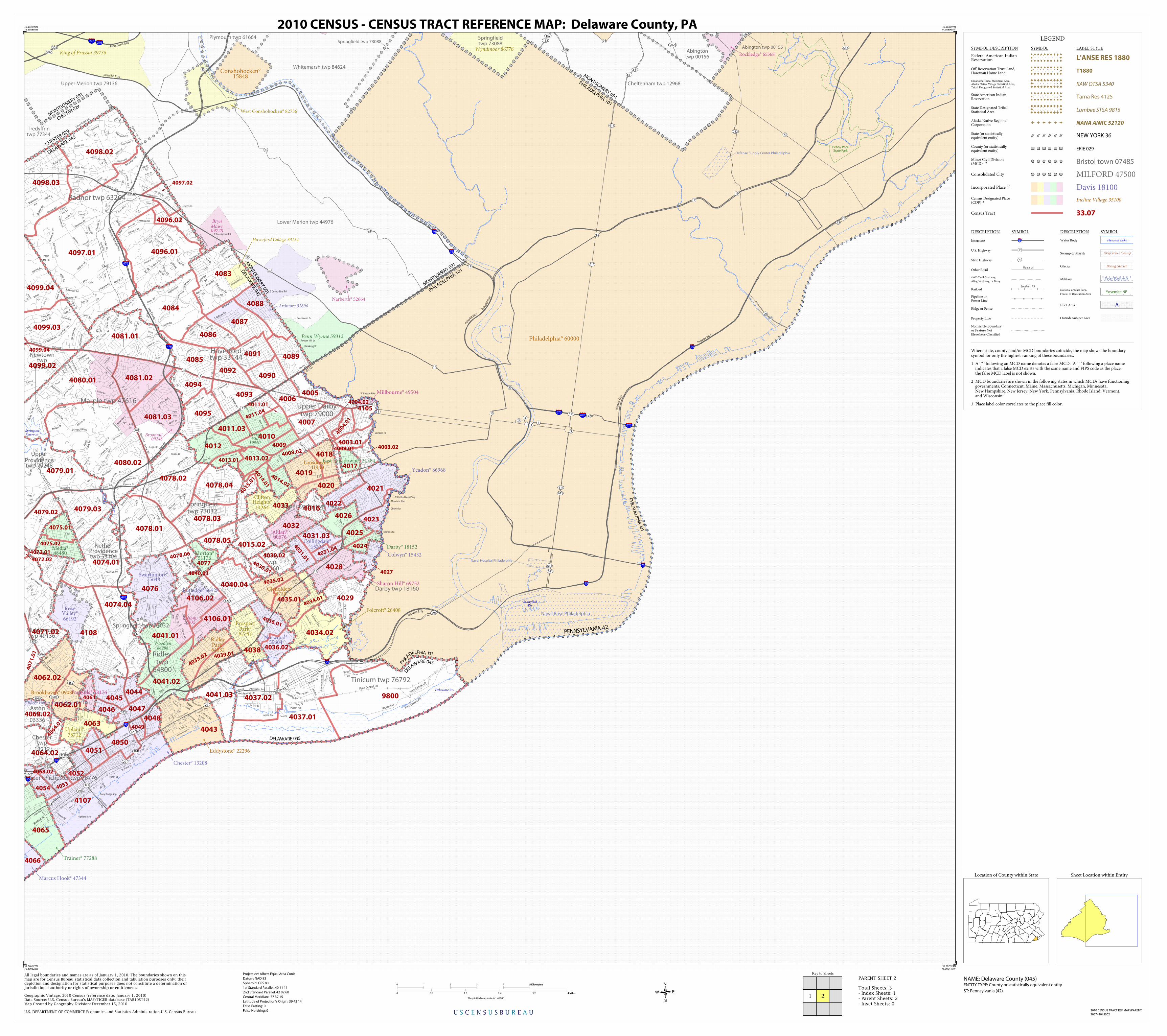
All legal boundaries and names are as of January 1, 2010. The boundaries shown on thismap are for Census Bureau statistical data collection and tabulation purposes only; theirdepiction and designation for statistical purposes does not constitute a determination ofjurisdictional authority or rights of ownership or entitlement.

U.S. DEPARTMENT OF COMMERCE Economics and Statistics Administration U.S. Census Bureau

Geographic Vintage: 2010 Census (reference date: January 1, 2010)Data Source: U.S. Census Bureau's MAF/TIGER database (TAB10ST42)Map Created by Geography Division: December 15, 2010

ENTITY TYPE: County or statistically equivalent entity

NAME: Delaware County (045) Projection: Albers Equal Area Conic

Datum: NAD 83

Spheroid: GRS 80

1st Standard Parallel: 40 11 11

2nd Standard Parallel: 42 02 60

Central Meridian: -77 37 15

Latitude of Projection's Origin: 39 43 14

False Easting: 0

False Northing: 0

Total Sheets: 3- Index Sheets: 1- Parent Sheets: 2- Inset Sheets: 0

ST: Pennsylvania (42)

0 1 2 3 4 5 Kilometers5 Kilometers

0 0.8 1.6 2.4 3.2 4 Miles4 Miles

The plotted map scale is 1:48000

2010 CENSUS - CENSUS TRACT REFERENCE MAP: Delaware County, PA

Sheet Location within Entity

2010 CENSUS TRACT REF MAP (PARENT)

205742045002

PARENT SHEET 2