Embed Size (px)
Citation preview

1 - Classification: Internal 2011-03-06
2011 Statoil Site Surveyand Soil Investigation ProgramApril Parsons, Alaska Lead Geoscientist
2 - Classification: Internal 2011-03-06
Statoil Acreage Position
Statoil (operator)/ENI Leases
Statoil /CPAI (operator) Leases

3 - Classification: Internal 2011-03-06
Site Survey Program
• Required by 30 CFR 250.201, 30 CFR 250.203, 30 CFR 250.204, 30 CFR 250.208, 30 CFR 250.214, 30 CFR 250.244, 30 CFR 250.414, CFR 250.901, 30 CFR 250.1007(a), 30 CFR 250.1010
• Required in a Drilling Plan and necessary to validate a safe location on the seafloor to situate a rig or provide for adequate anchoring of a moored drillship
• Identifies potentially hazardous conditions at or below the seafloor that are to be avoided in drilling operations

4 - Classification: Internal 2011-03-06
Federal Requirements Dictate these activities be performed:• Seafloor imagery - Bathymetry
• High resolution Seismic profiles
• Water column Anomaly Detection
• Side Scan Sonar
• Magnetometer
• Archaeological Survey
• Accurate Navigation
• Shallow Core Data

5 - Classification: Internal 2011-03-06
2011 Permit Activity Area
~106’ miles
~150’ miles
Barrow
Amundsen
Augustine

6 - Classification: Internal 2011-03-06
,
2011 Statoil Site Survey Program
Seafloor Surveying & Shallow Seismic:• Area: Amundsen and Augustine prospect areas (~2500 km)• Other Areas for facilities & regional understanding
Soil Sampling/Coring – 3-4 cores (10-50m) per site:• Statoil Operated Acreage
•Amundsen with 3 coring sites•Augustine with 2 coring sites•One or two facility sites
• Statoil’s partner operated leases (CPAI) •3 sites
•Other Areas for ice gouge & regional understanding

7 - Classification: Internal 2011-03-06
Contractor: CGGVeritasGardline Pte Ltd
Vessel: M/V Duke - former Polar Duke
1983/2007 built in Norway
‘DNV 1A1-EO-Sealer’(ice strengthened)
219 feet
11.5 knot cruising speed
Space for 50 persons
Statoil’s Site Survey Vessel

8 - Classification: Internal 2011-03-06
CGGVeritasGardline M/V Duke Equipment• Kongsberg SBP 3000 subbottom profiler • Simrad dual head EM2040 Multibeam echosounder • GeoAcoustics 160D Dual frequency side-scan sonar with a
piggybacked magnetometer• Single 10 cu. in. Mini-airgun with 150m GeoEel streamer at 1m tow
depth 3.125m group length• 12.5m group length solid streamer for main seismic utilizing a 4x10
cu. in. airgun array• May add a deep towed camera which can be run simultaneously with
other equipment for habitat mapping purposes.• May add a high quality shallow box coring unit to sample the seabed
for analysis of the micro-stratigraphy, geochemistry, micro fauna, etc. to assist in dating ice gouge

9 - Classification: Internal 2011-03-06
Contractor: Fugro
Vessel: M/V Fugro Synergy
2008 built Bergen, Norway
Ice strengthened
15 knot cruising speed
340 ft Dynamically Positioned multipurpose drilling,
geotechnical & soil investigation vessel
Moon Pool and automated drilling
Space for 70 persons
Statoil’s Soil Investigation Vessel
Kongsberg EA600 Echosounder and Kongsberg 500 high precision acoustic positioning system (HiPAP) for precise vessel positioning during coring

10 - Classification: Internal 2011-03-06
Additional Science Program
• Contingent upon funding and available time and weather window after leasehold data is acquired
• Seabed mapping to collect data on ice gouge, paleogeology, archaeology, benthic habitat and other data that will improve the overall understanding of the Chukchi benthos and allow for the assessment and planning of later stage activity including pipeline routes and design.
• ~2000 km of seabed mapping with similar acoustic sources as those described for the site survey activity but without airgun sources and to include up to 40 shallow cores (10m depth)

11 - Classification: Internal 2011-03-06
Schedule of Activity• July 15 – ships mobilize in Dutch Harbor for training and supplies• August 1st – arrive on location in Chukchi sea and deploy equipment for
site survey• August 15th – Soil sampling acquisition begins• Operations should be concluded by early October if ice and weather
conditions permit• Operations could continue through Mid-November if significant
weather downtime is experienced• Crew changes to occur via Nome midway through program• In case of emergency transit via Wainwright

12 - Classification: Internal 2011-03-06
Permits required:
• IHA: The Incidental Harassment Authorization of Marine Mammals (Whales, seals); National Marine Fisheries Service (NMFS)
• Ancillary Activities Notice (BOEMRE)
• LOA: Letter of Authorization (Polar Bears and Pacific Walrus); US Fish and Wildlife Services (US FWS)
• USACE Nationwide Permit #6: (US Army Corps of Engineers)
Environmental Analysis:
• Environmental Evaluation Document Statoil 2011 Statoil Site Surveys:
−Survey is 100+ miles offshore
−Not expected to conflict or interfere with the community’s subsistence harvest
−Marine Mammals; Whales, and other animals
• Chukchi 2011 Surveys Cumulative Effects Analysis included in EED
Statoil’s 2011 Survey - Preparations

13 - Classification: Internal 2011-03-06
Measures to Reduce Impact ,
~ -. J~ , . "1
r •
Statoil will prepare a polar bear interaction plan that addresses food and waste management. personnel training, and safety and communication regarding polar bears.
-r1 Survey Area
The survey area is located far offshore (>100 miles) and will not interfere with
i¥~ subsistence a§=-::---=- activities.
(
Ice Management
Ice conditions (radar,
satellite imagery) in the project area will be
monitored during the seismic survey in order
to minimize survey time and activity close to the ice edge.
Communication and Call Centers
Statoil will operate communication protocols through Wainwright for emergency situations & cooperation
with subsistence activities.
Marine Mammal Monitoring
Vessels operated by Statail will take every precaution to avoid harassment of marine mammals, including whales , seals, walruses or polar bears in the water when a vessel is operated near these animals.
Marine Mammal Observers (MMOs) will be employed on both vessels .
Scientific and Inupait MMOs
- 5 on site survey vessel until mid-August, then possibly 3 or 4
- 3 on soil sampling vessel
Mitigation Procedures
Establishment of safety radii through sound source verification measurements of airgun array.
In the established exclusion or safety zone, power down, shut down, and ramp-up procedures will be in place.
Environmental & Baseline Monitoring
Statoil is participating in environmental baseline monitoring with Shell and ConocoPhillips. This includes:
Seabed and water sampling and analysis over old drill sites
Fixed seabed acoustic recorders to monitor marine mammal activity in the Chukchi Sea.
Ecological studies of Chukchi fish populations.
"'.I. ~. Sialoil

14 - Classification: Internal 2011-03-06
•Marine Mammal Observers (MMO’s) will be employed on both vessels
•Biologist and Inupiat MMO’s for reporting of “takes”
•5 on Site Survey Vessel
•3 on Coring Vessel
•At least one Inupiat MMO on each vessel will also communicate with coastal communities and directly with whalers during whaling season
Vessel Based Marine Mammal Monitoring
15 - Classification: Internal 2011-03-06
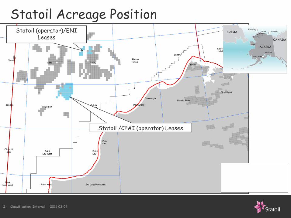
Procedures to mitigate impact
180 dB
190 dB
• Sound source characterization will be used to establish safety radii distances
• Observation of marine mammals in or approaching safety radii shall cause the survey to power down or shut down activity
• Modeled radii of 4x10 cu. in. airgun for mitigation measures:
− 190 dB radius for pinnipeds and polar bear(in water) – approx 50m
− 180 dB radius for cetaceans and walrus (in water) – approx 190m
− 160 dB radius for aggregations of ≥12 baleen whales – approx 2250m (1.4 mi.)
• Detailed data will be provided in the 90-day report following the end of the survey
16 - Classification: Internal 2011-03-06
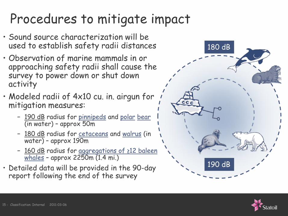
Estimated Distances of Harassment Thresholds
Sound Source Distance (km)
4x10 cu. in. Airgun Array
(>160 dB)2.25
10 cu. in. Airgun
(>160 dB)0.715
Coring Activity
(>120 dB)7.5

17 - Classification: Internal 2011-03-06
Activity
Estimated Number of Takes
Odontocetes Mysticetes Pinnipeds
Avg Max Avg Max Avg Max
Airgun 19 51 28 71 599 1002
Coring 80 163 118 244 2445 4068
Science Program (Coring)
39 89 57 130 1221 2036

18 - Classification: Internal 2011-03-06
Plan of Cooperation
• Meetings have been held with leaders of Barrow, Wainwright, Point Lay, Point Hope and Kotzebue regarding the 2011 program
− Beluga Committee Meeting – October 2010
− AEWC – December 2010
− North Slope Planning Commission – December 2010
− NSB Wildlife Department – December 2010
• A draft Plan of Cooperation is being developed based upon these discussions
• Public POC meetings will be held later this month in Barrow, Point Hope, Point Lay and Wainwright to obtain input from the communities and subsistence hunters

19 - Classification: Internal 2011-03-06
2011 Statoil Site Surveyand Soil Investigation Program
April ParsonsLead [email protected], tel: 713-579-9930www.statoil.com
Thank you