Embed Size (px)
Citation preview

MARCH 2012
SINOSTEEL MIDWEST CORPORATION LTD
WELD RANGE IRON ORE PROJECT
RARE FLORA MANAGEMENT PLAN


SINOSTEEL MIDWEST MANAGEMENT LTD
WELD RANGE IRON ORE PROJECT
RARE FLORA MANAGEMENT PLAN
Sinosteel Midwest Corporation Ltd Weld Range Rare Flora Management Plan
March 2012
i
Document Status
Approved for Issue Rev Author Reviewer/s Date
Name Distributed To Date
1 Renee Tuckett, Carol Macpherson
Carol Macpherson
08.03.11 Wayne Ennor Wayne Ennor 08.03.11
2 T McKenna Carol Macpherson
06.01.12 Wayne Ennor Wayne Ennor
3 T McKenna R Tuckett 23.01.12 Wayne Ennor OEPA 25.01..12
4 T McKenna R Tuckett 07.03.12 Wayne Ennor OEPA 08.03.12
ecologia Environment (2012). Reproduction of this report in whole or in part by electronic, mechanical or chemical means including photocopying, recording or by any information storage and retrieval system, in any language, is strictly prohibited without the express approval of Sinosteel Midwest Corporation Limited and/or ecologia Environment.
Restrictions on Use
This report has been prepared specifically for Sinosteel Midwest Corporation Limited. Neither the report nor its contents may be referred to or quoted in any statement, study, report, application, prospectus, loan, or other agreement document, without the express approval of Sinosteel Midwest Corporation Limited and/or ecologia Environment.
ecologia Environment
1025 Wellington Street
WEST PERTH WA 6005
Phone: 08 9322 1944
Fax: 08 9322 1599
Email: [email protected]

Sinosteel Midwest Corporation Ltd Weld Range Rare Flora Management Plan
March 2012
ii
TABLE OF CONTENTS
1 INTRODUCTION ................................................................................................................ 1
1.1 PROJECT BACKGROUND............................................................................................................1
1.2 DOCUMENT PURPOSE...............................................................................................................1
1.3 PROJECT PROPONENT...............................................................................................................2
2 METHODOLOGY................................................................................................................ 5
3 DESCRIPTION OF THE ENVIRONMENT ............................................................................... 7
3.1 BIOGEOGRAPHIC REGION .........................................................................................................7
3.2 CLIMATE ....................................................................................................................................8
3.3 GEOLOGY AND LAND SYSTEMS.................................................................................................9
3.4 HYDROGEOLOGY.....................................................................................................................14
4 PREVIOUS BIOLOGICAL SURVEYS .................................................................................... 15
5 FLORA OF CONSERVATION SIGNIFICANCE AT WELD RANGE ............................................ 17
5.1 FLORA SPECIES PROTECTED BY COMMONWEALTH AND STATE ACTS....................................17
5.2 PRIORITY FLORA ......................................................................................................................17
5.3 CHARACTERISTICS OF TAXA OF POTENTIAL CONSERVATION SIGNIFICANCE RECORDED AT WELD RANGE ..........................................................................................................................69
6 ASSESSMENT OF DIRECT IMPACT TO FLORA OF CONSERVATION SIGNIFICANCE .............. 71
7 POTENTIAL THREATS TO FLORA OF CONSERVATION SIGNIFICANCE................................. 73
7.1 DIRECT LOSS OF FLORA OF CONSERVATION SIGNIFICANCE ...................................................73
7.2 INDIRECT LOSS OF VEGETATION AND FLORA .........................................................................73
7.3 IMPACTS TO SPECIFIC FLORA OF CONSERVATION SIGNIFICANCE ..........................................75
8 REFERENCES.................................................................................................................... 85
TABLES
Table 3.1 – Summary of Land Systems Occurring within the Weld Range Project Area (From Curry et al. 1994). ............................................................................................................................12
Table 5.1 – Taxa of Conservation Significance Recorded by the DEC and ecologia at Weld Range.......18
Sinosteel Midwest Corporation Ltd Weld Range Rare Flora Management Plan
March 2012
iii
Table 6.1 – Assessment of Direct Impact to Flora of Conservation Significance ...................................71
Table 7.1 Specific threats for priority species. ......................................................................................76
Table A.1 – Definition of Declared Rare and Priority Flora Categories ..................................................88
FIGURES
Figure 1.1 – Location of the SMC Weld Range Iron Ore Project ..............................................................3
Figure 3.1 – The Interim Biogeographic Regionalisation for Western Australia (IBRA). ..........................8
Figure 3.2 – Summary of Climatic Data for Meekatharra Airport (BOM, 2011)......................................9
Figure 3.3 – The Three Major Landscape Units Comprising the Weld Land System (Curry et al., 1994).11
Figure 5.1 – Form (left), leaves and seed pod (right) of Acacia sp. Wilgie Mia (ecologia) .....................19
Figure 5.2 – Distribution of Acacia sp. Wilgie Mia within the Weld Range lease...................................20
Figure 5.3 – Leaves (left) and form (right) of Beyeria lapidicola (ecologia) –.........................................21
Figure 5.4 – Distribution of Beyeria lapidicola within the Weld Range lease– ......................................22
Figure 5.5 – Flower (left), leaves (centre) and form (right) of Euphorbia sarcostemmoides (ecologia) 23
Figure 5.6 – Distribution of Euphorbia sarcostemmoides within the Weld Range lease – ....................24
Figure 5.7 – Form (top left, top right and bottom left) and leaves (bottom right) of Sauropus sp. Woolgorong .......................................................................................................................25
Figure 5.8 – Distribution of Sauropus sp. Woolgorong within the Weld Range lease ...........................26
Figure 5.9 – Form of (left), stems (centre) and leaves (right) of Stenanthemum patens (ecologia) ......27
Figure 5.10 – Distribution of Stenanthemum patens within the Weld Range lease ..............................28
Figure 5.11 – Seed pods (top left), flower (top right), scanned specimen (bottom left) and form (bottom right) of Acacia burrowsiana (ecologia)...............................................................29
Figure 5.12 – Distribution of Acacia burrowsiana within the Weld Range lease ...................................30
Figure 5.13 – Form, leaves and flower (left‐ Western Australian Herbarium 2011) and scanned specimen (right‐ ecologia) of Eremophila arachnoides subsp. arachnoides......................31
Figure 5.14 – Distribution of Eremophila arachnoides subsp. arachnoides within the Weld Range lease32
Figure 5.15 – Scanned specimen (left) and growth habit and flower (right) of Goodenia lyrata (ecologia) ...........................................................................................................................33
Figure 5.16 – Distribution of Goodenia lyrata within the Weld Range lease .........................................34
Figure 5.17 – Form (left), flower (centre) and leaves (right) of Hemigenia tysonii (ecologia) ...............35
Figure 5.18 – Distribution of Hemigenia tysonii within the Weld Range lease ......................................36
Figure 5.19 – Form, leaves and flower (Western Australian Herbarium 2011) of Hemigenia virescens37
Figure 5.20 – Distribution of Hemigenia virescens within the Weld Range lease – ...............................38

Sinosteel Midwest Corporation Ltd Weld Range Rare Flora Management Plan
March 2012
iv
Figure 5.21 – Leaves and flower (left) and form (right) of Homalocalyx echinulatus (ecologia) ...........39
Figure 5.22 – Distribution of Homalocalyx echinulatus within the Weld Range lease...........................40
Figure 5.23 – Form and leaves of Indigofera gilesii subsp. gilesii (Western Australian Herbarium 2011, ecologia).............................................................................................................................41
Figure 5.24 – Distribution of Indigofera gilesii subsp. gilesii within the Weld Range lease...................42
Figure 5.25 – Form (left) and flower (centre and right) of Micromyrtus placoides (ecologia)...............43
Figure 5.26 – Distribution of Micromyrtus placoides within the Weld Range lease ..............................44
Figure 5.27 – Scanned specimen of Mirbelia stipitata (ecologia) ..........................................................45
Figure 5.28 – Distribution of Mirbelia stipitata within the Weld Range lease .......................................46
Figure 5.29 – Distribution of Phyllanthus baeckeoides within the Weld Range lease ...........................48
Figure 5.30 – Form (left), flower (centre) and scanned specimen (right) of Prostanthera ferricola (ecologia) ...........................................................................................................................49
Figure 5.31 – Distribution of Prostanthera ferricola within the Weld Range lease ...............................50
Figure 5.32 – Form (left), leaves and flower (centre) and fruits (right) of Prostanthera petrophila (ecologia) ...........................................................................................................................51
Figure 5.33 – Distribution of Prostanthera petrophila within the Weld Range lease ............................52
Figure 5.34 – Flower (left) and form (right) of Ptilotus beardii (ecologia) .............................................53
Figure 5.35 – Distribution of Ptilotus beardii within the Weld Range lease...........................................54
Figure 5.36 – Ptilotus luteolus growth habit (left) and close up of flowers (right) (ecologia)................55
Figure 5.37 – Distribution of Ptilotus luteolus within the Weld Range lease .........................................56
Figure 5.38 – Form, leaves and flower (left‐ Western Australian Herbarium 2011) and scanned specimen (right‐ ecologia) of Tecticornia cymbiformis......................................................57
Figure 5.39 – Distribution of Tecticornia cymbiformis within the Weld Range lease ............................58
Figure 5.40 – Flower (left) and form (right) of Verticordia jamiesonii (ecologia)...................................59
Figure 5.41 – Distribution of Verticordia jamiesonii within the Weld Range lease................................60
Figure 5.42 – Acacia speckii flower bud/leaf structure (left), fruit structure (centre) and growth habit (right) (ecologia) ................................................................................................................61
Figure 5.43 – Distribution of Acacia speckii within the Weld Range lease.............................................62
Figure 5.44 – Form (top right‐ ecologia, bottom left‐ Western Australian Herbarium 2011), leaves (bottom left) and fruit (top right (ecologia) of Dodonaea amplisemina ...........................63
Figure 5.45 – Distribution of Dodonaea amplisemina within the Weld Range lease.............................64
Figure 5.46 – Scanned specimens of Goodenia berringbinensis (ecologia)............................................65
Figure 5.47 – Distribution of Goodenia berringbinensis within the Weld Range lease..........................66

Sinosteel Midwest Corporation Ltd Weld Range Rare Flora Management Plan
March 2012
v
Figure 5.48 – Form (left), flower and leaves (centre) and seed pods (right) of Grevillea inconspicua (ecologia) ...........................................................................................................................67
Figure 5.49 – Distribution of Grevillea inconspicua within the Weld Range lease.................................68
Figure 5.50 – Distribution of Hemigenia sp. nov. (aff. exilis) within the Weld Range lease..................70
APPENDICES
Appendix A Criteria for DEC DRF and Priority Listing ...........................................................................87
Sinosteel Midwest Corporation Ltd Weld Range Rare Flora Management Plan
March 2012
vi
ACRONYMS
DEC Department of Environment and Conservation
DRF Declared Rare Flora
EIA Environmental Impact Assessment
EMP Environmental Management Plan
EPA Environmental Protection Authority
EPBC Environment Protection and Biodiversity Conservation Act 1950
GDE Groundwater Dependent Ecosystems
P1 Priority 1
P3 Priority 3
P4 Priority 4
PEC Public Environmental Review
SMC Sinosteel Midwest Corporation

Sinosteel Midwest Corporation Ltd Weld Range Rare Flora Management Plan
March 2012
vii
This page has been left blank intentionally

Sinosteel Midwest Corporation Ltd Weld Range Rare Flora Management Plan
March 2012
viii
EXECUTIVE SUMMARY
Sinosteel Midwest Corporation Ltd (SMC) proposes to develop an iron ore mine in Weld Range.
Twenty‐eight Priority taxa have previously been recorded within the SMC exploration leases at Weld Range (ecologia, 2011), however the conservation status of some of these taxa has subsequently been revised (Florabase, 2011). Twenty‐two of these taxa were recorded by ecologia during quadrat‐based surveys and an additional three during follow‐up threatened flora surveys (2006 – 2010). The DEC have recorded another two taxa. Further, an additional haul road survey undertaken by ecologia in March and April of 2011 located seven priority taxa, two of which have been removed from the Priority listings and all but one had previously been located within the Weld Range infrastructure area. To date, the total number of current Priority flora located within the Weld Range impact area is 25.
This current Rare Flora Management Plan for flora of conservation significance has been developed to effectively manage these species and facilitate the environmental legal approvals processes of Weld Range. Environmental information for the region is also included.
Species occuring within Weld Range with a priority conservation status were reviewed individually to provide a description of the plant form, diagnostic characteristics, preferred habitat types, distribution and associated photographs (if available). Key threats were identified and management strategies for priority species are provided.

Sinosteel Midwest Corporation Ltd Weld Range Rare Flora Management Plan
March 2012
ix
This page has been left blank intentionally

Sinosteel Midwest Corporation Ltd Weld Range Rare Flora Management Plan
March 2012
1
1 INTRODUCTION
1.1 PROJECT BACKGROUND
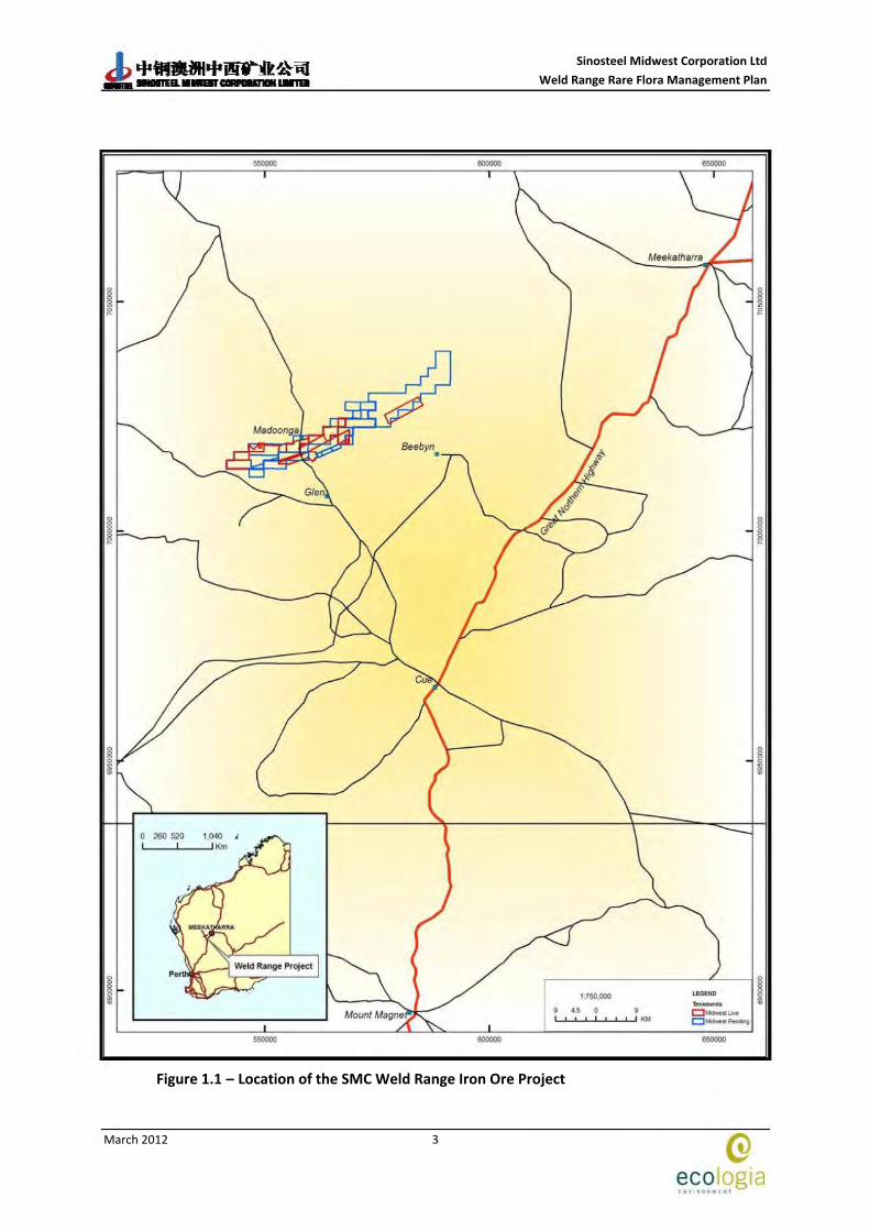
Sinosteel Midwest Corporation (SMC) is proposing to develop a new iron ore mine at Weld Range, located approximately 600 km north‐north‐east of Perth and 85 km southwest of Meekatharra (Figure 1.1). The tenements that form the basis for the Project cover a series of hills that rise approximately 250 m above the surrounding plains. The range is some 3 km wide, extends for up to 60 km in length from southwest to the northeast, and consists of a series of parallel ridges with deep incised valleys.
Twenty‐seven Priority taxa have previously been recorded within the SMC exploration leases at Weld Range (ecologia, 2011), however the conservation status of some of these taxa has subsequently been revised (Florabase, 2011). Twenty‐two of these taxa were recorded by ecologia during quadrat‐based surveys and an additional three during follow‐up threatened flora surveys (2006 – 2010). The DEC have recorded another two taxa. To date, the total number of current Priority flora located within the Weld Range impact area is 24.
Threatened species recovery plans were required to facilitate the environmental legal approvals process. The relatively large number of priority species recorded at Weld Range is considered to be a consequence of two factors:
• The sporadic and isolated history of collection and lodgement of specimens from the bioregion, resulting in incomplete knowledge of the distribution of many taxa and consequently a high proportion of the total taxa recorded not being listed; and
• The genuine rarity of some taxa due to their particular habitat requirements (combined with a rarity of those habitats) as well as variable biotic and abiotic factors, which have promoted speciation.
SMC commissioned ecologia Environment (ecologia) to develop Threatened species recovery plans for flora of Weld Range.
1.2 DOCUMENT PURPOSE
The SMC Threatened Species Environmental Management Plans (EMP) have been devised in order to manage and minimise potential impacts that may occur during the design, construction and life of the Project. This EMP will be submitted as part of the formal Public Environmental Review Assessment to the EPA in 2012.
The proposed areas affecting the populations of identified Threatened species will be managed in accordance with the EMP to ensure environmental impacts are mitigated and prevented where possible. This EMP will be subject to ongoing internal review by SMC and external review by the appropriate agencies as required.
The SMC development will be managed in relation to the following aspects of the terrestrial environment and will be considered in the context of the Environmental Quality Management Framework (ANZECC / ARMCANZ, (2000), EPA (2000), Government of WA (2004)).

Sinosteel Midwest Corporation Ltd Weld Range Rare Flora Management Plan
March 2012
2
1.3 PROJECT PROPONENT
Sinosteel Midwest Corporation Ltd
7 Rheola Street
WEST PERTH WA 6005
PO Box 529
WEST PERTH WA 6872
http://www.sinosteelmidwest.com.au/
ABN: 91 009 224 800
Key Contacts
Exploration Manager
Denis Kruger
(08) 9920 9730
Environment and Approvals Manager
Wayne Ennor
(08) 9429 4850
Sinosteel Midwest Corporation Ltd Weld Range Rare Flora Management Plan
March 2012
3
Figure 1.1 – Location of the SMC Weld Range Iron Ore Project
1:750.000
• 5 0 9 '-''-'-' -''1-1.' _ • .__..,_.__,, ""'
eooooo
G eco og1a • .. .,, •o~,.. "' 1

Sinosteel Midwest Corporation Ltd Weld Range Rare Flora Management Plan
March 2012
4
This page has been left blank intentionally
Sinosteel Midwest Corporation Ltd Weld Range Rare Flora Management Plan
March 2012
5
2 METHODOLOGY
Data for each species with a significant conservation value was obtained through reviewing available information from the DEC and previous information from vegetation surveys within Weld Range. A broad scale flora and vegetation survey of Weld Range was conducted over 3‐phases in November 2006 (spring), April 2007 (autumn) and May 2008 (winter) to encompass the full range of seasonal conditions when species are likely to be flowering/fruiting. Targeted threatened flora surveys were undertaken in addition to the quadrat‐based surveys. Documented voucher specimens of all flora of conservation significance have been lodged with the WA Herbarium.
Flora surveys undertaken as part of the Environmental Impact Assessment (EIA) process were compliant with the requirements of the Environmental Protection Agency’s (EPA) Position Statement No. 3: Terrestrial Biological Surveys as an Element of Biodiversity Protection and Guidance Statement No. 51: Terrestrial Flora and Vegetation Surveys for Environmental Impact Assessment in Western Australia.
In addition to information obtained through the vegetation surveys, species distributions were obtained from the DEC databases along with any additional information that may assist in identifying priority species and key habitat features.
Sinosteel Midwest Corporation Ltd Weld Range Rare Flora Management Plan
March 2012
6
This page has been left blank intentionally

Sinosteel Midwest Corporation Ltd Weld Range Rare Flora Management Plan
March 2012
7
3 DESCRIPTION OF THE ENVIRONMENT
3.1 BIOGEOGRAPHIC REGION
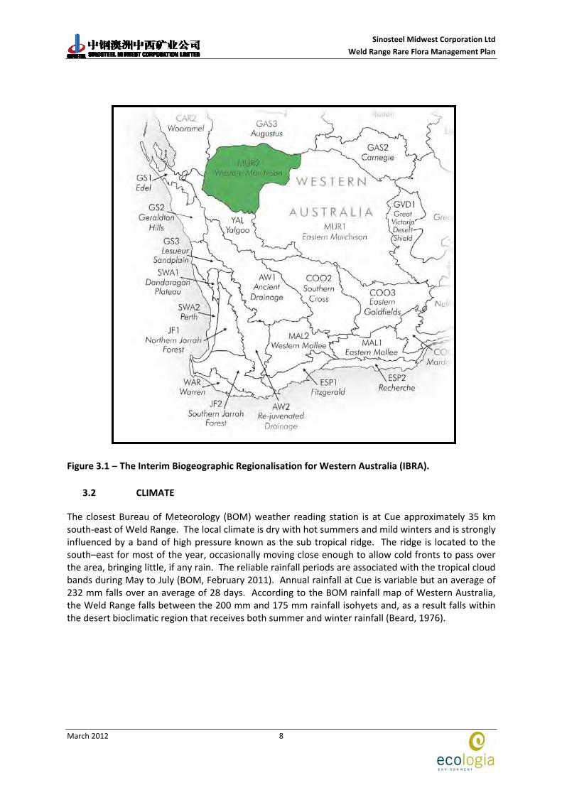
The Interim Biogeographic Regionalisation for Australia (IBRA) categorises the Australian continent into regions of similar geology, landform, vegetation, fauna and climate. The Weld Range lies within the Western Murchison sub‐region (MUR2) (Figure 3.1) in the Eremaean botanical province of the arid zone of Western Australia (Environment Australia, 2007). The MUR2 is described as:
“Mulga low woodlands, rich in ephemerals (usually with bunched grasses), on outcrop and fine‐textured Quaternary alluvial and eluvial surfaces. Quaternary alluvial and eluvial surfaces (extensive hardpan wash plains dominate and characterise the subregion) mantling granitic and greenstone rocks outcrops in the northern part of the Yilgarn Craton. Surfaces associated with the occluded drainage systems occur throughout with hummock grasslands on Quaternary sandplains, saltbush shrublands on calcareous soils and Halosarcia low shrublands on saline alluvia.” (Desmond et al., 2001).
Sinosteel Midwest Corporation Ltd Weld Range Rare Flora Management Plan
March 2012
8
Figure 3.1 – The Interim Biogeographic Regionalisation for Western Australia (IBRA).
3.2 CLIMATE
The closest Bureau of Meteorology (BOM) weather reading station is at Cue approximately 35 km south‐east of Weld Range. The local climate is dry with hot summers and mild winters and is strongly influenced by a band of high pressure known as the sub tropical ridge. The ridge is located to the south–east for most of the year, occasionally moving close enough to allow cold fronts to pass over the area, bringing little, if any rain. The reliable rainfall periods are associated with the tropical cloud bands during May to July (BOM, February 2011). Annual rainfall at Cue is variable but an average of 232 mm falls over an average of 28 days. According to the BOM rainfall map of Western Australia, the Weld Range falls between the 200 mm and 175 mm rainfall isohyets and, as a result falls within the desert bioclimatic region that receives both summer and winter rainfall (Beard, 1976).
Sinosteel Midwest Corporation Ltd Weld Range Rare Flora Management Plan
March 2012
9
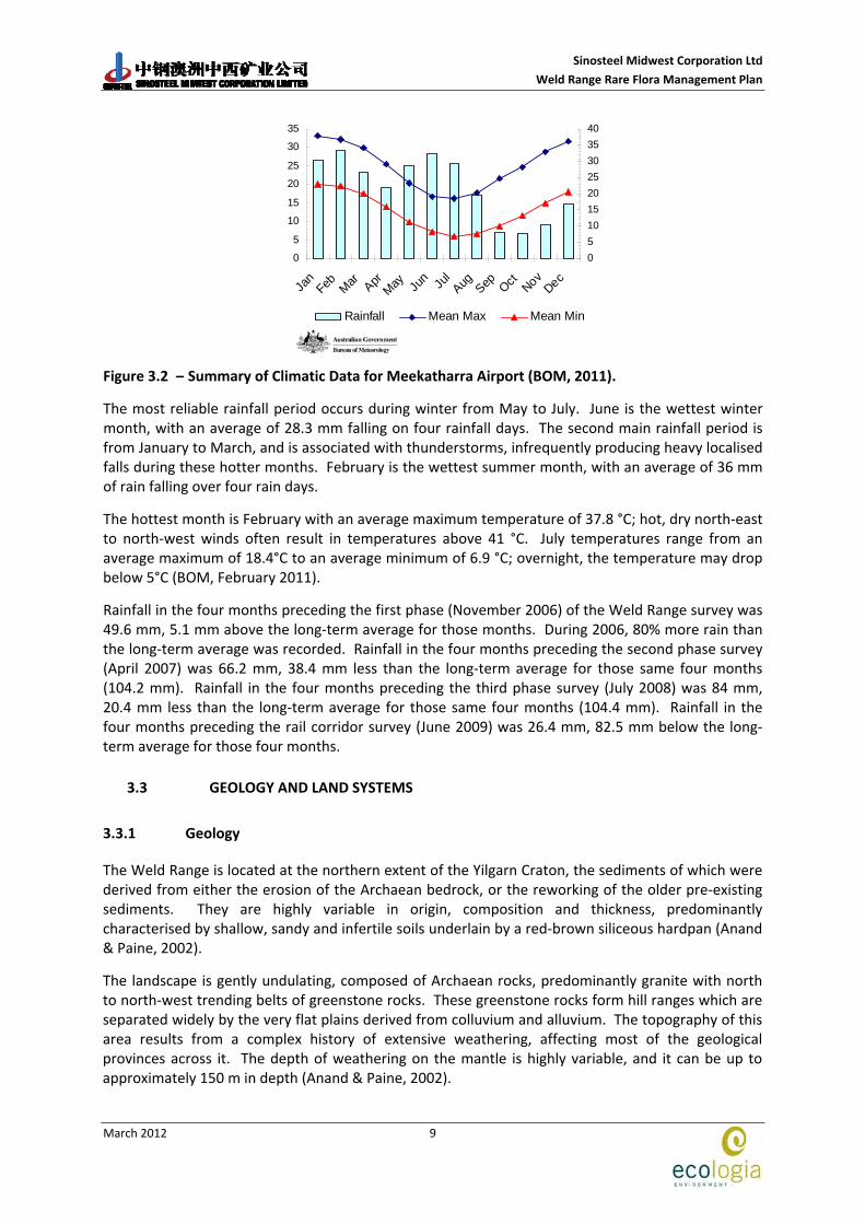
Figure 3.2 – Summary of Climatic Data for Meekatharra Airport (BOM, 2011).
The most reliable rainfall period occurs during winter from May to July. June is the wettest winter month, with an average of 28.3 mm falling on four rainfall days. The second main rainfall period is from January to March, and is associated with thunderstorms, infrequently producing heavy localised falls during these hotter months. February is the wettest summer month, with an average of 36 mm of rain falling over four rain days.
The hottest month is February with an average maximum temperature of 37.8 °C; hot, dry north‐east to north‐west winds often result in temperatures above 41 °C. July temperatures range from an average maximum of 18.4°C to an average minimum of 6.9 °C; overnight, the temperature may drop below 5°C (BOM, February 2011).
Rainfall in the four months preceding the first phase (November 2006) of the Weld Range survey was 49.6 mm, 5.1 mm above the long‐term average for those months. During 2006, 80% more rain than the long‐term average was recorded. Rainfall in the four months preceding the second phase survey (April 2007) was 66.2 mm, 38.4 mm less than the long‐term average for those same four months (104.2 mm). Rainfall in the four months preceding the third phase survey (July 2008) was 84 mm, 20.4 mm less than the long‐term average for those same four months (104.4 mm). Rainfall in the four months preceding the rail corridor survey (June 2009) was 26.4 mm, 82.5 mm below the long‐term average for those four months.
3.3 GEOLOGY AND LAND SYSTEMS
3.3.1 Geology
The Weld Range is located at the northern extent of the Yilgarn Craton, the sediments of which were derived from either the erosion of the Archaean bedrock, or the reworking of the older pre‐existing sediments. They are highly variable in origin, composition and thickness, predominantly characterised by shallow, sandy and infertile soils underlain by a red‐brown siliceous hardpan (Anand & Paine, 2002).
The landscape is gently undulating, composed of Archaean rocks, predominantly granite with north to north‐west trending belts of greenstone rocks. These greenstone rocks form hill ranges which are separated widely by the very flat plains derived from colluvium and alluvium. The topography of this area results from a complex history of extensive weathering, affecting most of the geological provinces across it. The depth of weathering on the mantle is highly variable, and it can be up to approximately 150 m in depth (Anand & Paine, 2002).
0
5
10
15
20
25
30
35
Jan
Feb Mar AprMay Ju
n Jul
Aug Sep Oct NovDec
0510152025303540
Rainfall Mean Max Mean Min
Sinosteel Midwest Corporation Ltd Weld Range Rare Flora Management Plan
March 2012
10
The greenstone belts of the Weld Range exhibit banded ironstone formations (BIF) over strike lengths of 40 – 50 km. BIF and related rocks are comprised of silica, hematite, magnetite and iron silicates, with the majority of BIF in the Weld Range being of the jaspilite type. Jaspilite consists of red chert bands in conjunction with white and/or black bands; fine hematite dust gives the red colouration. The informally named Madoonga, Lulworth and Wilgie Mia beds represent the three laterally persistent units of jaspilite at the Weld Range (from north to south). The Weld Range jaspilite has a grain size of 10 – 30 µm and contains 20 – 60 % magnetite (Elias, 1982).
Dolerite intrudes into the BIF with minimal disruption to bedding, and exists as multiple sheets which range from less than 50 m to exceeding 150 m in outcrop width. Approximately 90% of the thickness of the sequence at Weld Range is attributed to dolerite.
Large amounts of iron ore occur at Weld Range, formed by supergene enrichment of BIF during the Tertiary lateritization period. Ochre also exists in the jaspilites of the range (Elias, 1982).
3.3.2 Land Systems
Curry et al. (1994) undertook a regional inventory of the Murchison River catchment and surrounds to document the land systems present in the area and the condition of each. The survey area covered 88,360 km2, and spanned between Meekatharra and Mount Magnet in the east, to the catchments of the Greenough and Wooramel Rivers in the west.
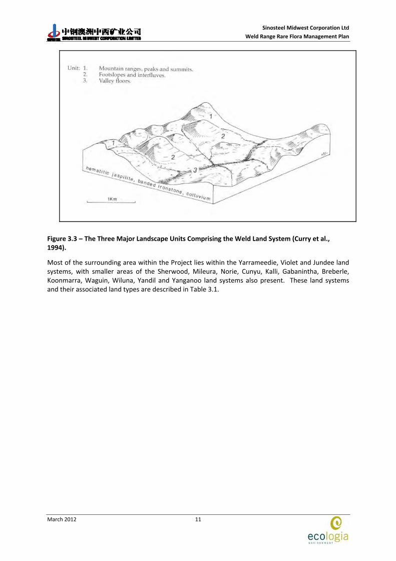
The Weld Range Project is primarily located on the Weld land system (350 km2), described as rugged ranges and ridges of mainly Archaean metamorphosed sedimentary rocks supporting Acacia species shrublands (Curry et al., 1994). It is made up of three major landscape units (Curry et al., 1994):
1. Mountain ranges, peaks and summits – characterised by ridges forming steep rocky outcrops of ironstone and jaspilite. These have soils described as skeletal lithosols confined to pockets of dark red loamy or clayey sands, with infrequent clay subsoils less than 50 cm deep, overlying parent material.
2. Footslopes and interfluves – characterised by broad concave inclines generally covered by dense quartz or ironstone mantles. The soils are described as reddish‐brown or dark red shallow earths less than 50 cm deep.
3. Valley floors – occurring between ridges with creek channels dissecting into the bedrock with soils described as red earthy sands overlying metamorphic rock fragments less than 50 cm deep (Curry et al., 1994).
Sinosteel Midwest Corporation Ltd Weld Range Rare Flora Management Plan
March 2012
11
Figure 3.3 – The Three Major Landscape Units Comprising the Weld Land System (Curry et al., 1994).
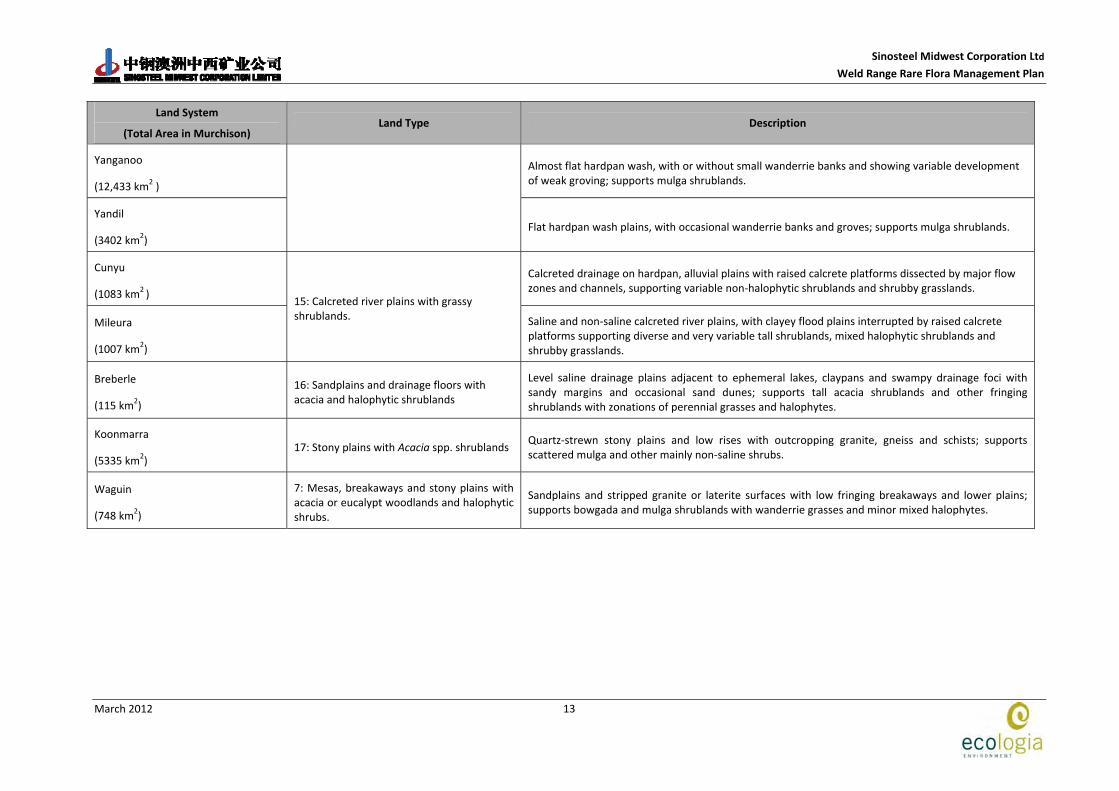
Most of the surrounding area within the Project lies within the Yarrameedie, Violet and Jundee land systems, with smaller areas of the Sherwood, Mileura, Norie, Cunyu, Kalli, Gabanintha, Breberle, Koonmarra, Waguin, Wiluna, Yandil and Yanganoo land systems also present. These land systems and their associated land types are described in Table 3.1.

Sinosteel Midwest Corporation Ltd
Weld Range Rare Flora Management Plan
March 2012
12
Table 3.1 – Summary of Land Systems Occurring within the Weld Range Project Area (From Curry et al. 1994).
Land System
(Total Area in Murchison) Land Type Description
Weld
(350 km2 )
Rugged ranges and ridges of mainly Archaean metamorphosed sedimentary rocks; supports Acacia species shrublands; major system of Weld Range and Jack Hills.
Norie
(1321 km2) Granite hills with exfoliating domes and extensive tor fields, supporting Acacia species shrublands.
Gabanintha
(962 km2)
1: Rough Hills with Acacia spp. shrublands
Ridges, hills and footslopes of various metamorphosed volcanic rocks (greenstones), supporting sparse Acacia species and other mainly non‐halophytic shrublands.
Wiluna
(1294 km2)
2: Hills and plains with mulga, snakewood‐halophytic shrublands
Low greenstone hills with occasional lateritic breakaways and broad stony slopes, lower saline stony plains and broad drainage tracts; supports sparse mulga shrublands with patches of halophytic shrubs.
Yarrameedie
(519 km2 )
3: Low hills and quartz strewn plains with mulga shrublands
Undulating stony interfluves, drainage floors and pediment (foothill) plains below major ranges of crystalline rocks (mainly Weld Land System) supporting sparse mulga shrublands.
Sherwood
(4839 km2 )
4: Breakaways, stony plains and sandy surfaced plains on granite with mulga and halophytic shrublands
Extensive, gently sloping stony and sandy plains on granite and gneiss below saline footslopes of lateritised breakaway and outcrops of weathered rock; mainly supports scattered mulga shrublands with understorey of non‐halophytic shrubs.
Violet
(1078 km2 )
7: Irregular plains on laterite and parent rock with mulga and halophytic shrublands
Gently undulating gravely plains on greenstone, laterite and hardpan, with low stony rises and minor saline plains; supports mulga and bowgada‐dominated shrublands, with dense mulga groves and patchy halophytic shrublands.
Kalli
(6097 km2 )
10: Sandplains and drainage floors with grassy and halophytic shrublands
Elevated, gently undulating red sandplains edged by stripped surfaces on laterite and granite; tall Acacia species shrublands and understorey of wanderrie grasses.
Jundee
(1346 km2 )
14: Wash plains on hardpan with mulga shrublands
Hardpan wash plains with variable dark gravely mantling and weakly groved vegetation; minor sandy banks; supports scattered mulga shrublands.
Sinosteel Midwest Corporation Ltd
Weld Range Rare Flora Management Plan
March 2012
13
Land System
(Total Area in Murchison) Land Type Description
Yanganoo
(12,433 km2 )
Almost flat hardpan wash, with or without small wanderrie banks and showing variable development of weak groving; supports mulga shrublands.
Yandil
(3402 km2) Flat hardpan wash plains, with occasional wanderrie banks and groves; supports mulga shrublands.
Cunyu
(1083 km2 )
Calcreted drainage on hardpan, alluvial plains with raised calcrete platforms dissected by major flow zones and channels, supporting variable non‐halophytic shrublands and shrubby grasslands.
Mileura
(1007 km2)
15: Calcreted river plains with grassy shrublands. Saline and non‐saline calcreted river plains, with clayey flood plains interrupted by raised calcrete
platforms supporting diverse and very variable tall shrublands, mixed halophytic shrublands and shrubby grasslands.
Breberle
(115 km2) 16: Sandplains and drainage floors with acacia and halophytic shrublands
Level saline drainage plains adjacent to ephemeral lakes, claypans and swampy drainage foci with sandy margins and occasional sand dunes; supports tall acacia shrublands and other fringing shrublands with zonations of perennial grasses and halophytes.
Koonmarra
(5335 km2) 17: Stony plains with Acacia spp. shrublands
Quartz‐strewn stony plains and low rises with outcropping granite, gneiss and schists; supports scattered mulga and other mainly non‐saline shrubs.
Waguin
(748 km2)
7: Mesas, breakaways and stony plains with acacia or eucalypt woodlands and halophytic shrubs.
Sandplains and stripped granite or laterite surfaces with low fringing breakaways and lower plains; supports bowgada and mulga shrublands with wanderrie grasses and minor mixed halophytes.

Sinosteel Midwest Corporation Ltd
Weld Range Rare Flora Management Plan
March 2012
14
3.4 HYDROGEOLOGY
Drainage in the project area occurs within the upper Murchison River Catchment, part of the drainage basin of the Murchison River. Water flows northwards and is ephemeral. Most of the drainage runs towards the Indian Ocean, with a small part draining inland towards the salt lakes of the area.
As the rainfall and associated surface water have erratic seasonal distributions the dominant land uses, mining and pastoralism, are dependent on the extensive shallow aquifers found in the area. The area contains a variety of Precambrian bedrock aquifers ranging from granite to metamorphic and sedimentary rocks, overlain by alluvium and calcrete.
Groundwater salinity decreases northwards towards the Gascoyne area and ranges from hypersaline in the upper parts of the Yarra Yarra and Murchison catchments, to fresh – brackish conditions in the Gascoyne catchment (Department of Fisheries, 2004).
The following aquifer types are found within the Murchison:
• Alluvium aquifer; alluvial sediments lie along the main river valleys of the Yilgarn Craton, overlying calcrete, palaeochannels and fractured rock. It is not known as a major aquifer source, but is utilised by wells and bores for stock and mining. Groundwater salinity ranges from fresh on the valley sides and increases towards the centre.
• Calcrete aquifer; calcrete is a chemically precipitated limestone contained by the alluvium, close to the centres of the valleys. Calcrete aquifers have the most potential for shallow, large supplies of brackish to saline groundwater in the Murchison catchment.
• Palaeochannel aquifer; palaeochannels are the basal infilling of ancient river valleys. One major palaeochannel aquifer occurs at Windimurra in the Murchison, and it is used for mining. The groundwater salinity is generally high.
• Fractured rock aquifer; this includes a variety of metamorphic and igneous rocks. Fractured rock aquifers are the main source of water for mining in the Murchison, with groundwater salinity ranging from brackish to hypersaline.

Sinosteel Midwest Corporation Ltd
Weld Range Rare Flora Management Plan
March 2012
15
4 PREVIOUS BIOLOGICAL SURVEYS
To date the vegetation of the Weld Range area has not been well documented. Beard mapped the vegetation communities of the area at a broad scale in 1976, describing the region as providing optimum conditions for the presence of mulga (Acacia aneura) woodlands.
A finer‐scale survey of the vegetation was undertaken by Curry et al. (1994) as part of their study of the Murchison River Catchment. They surveyed the vegetation communities of the greenstone ranges of Weld Range (the Weld land system) between 1985 and 1988. According to Curry et al. (1994) the vegetation types of the Weld land system are dominated by Acacia species and rocky hill mixed shrublands, stony mulga mixed shrublands, and creekline shrublands.
A survey of the vegetation communities and flora of the Weld Range was conducted by the DEC in late August 2005 (Markey & Dillon, 2008). Fifty‐two quadrats were established at the Range, and 239 taxa were collected. Of these taxa, eight were identified as priority flora and six were new records for the Weld Range.
The most detailed survey of the area to date occurred from July 2006 to November 2008 where ecologia carried out 26 flora surveys at Weld Range for various programme of works applications. To ensure that all floristic communities and habitats present within the survey area were represented in the data collected, sampling sites were selected using aerial photography, topographical features and field observations. The number of sites established was determined by the size and the heterogeneity of the study area. Two‐hundred and thirty‐nine quadrats were established during the three phase survey over the project area.
Surveys targeting taxa of conservation significance previously recorded during the quadrat‐based surveys were conducted between May 2008 and August 2009. In total 1053 transects over 94 person days were conducted inside and outside proposed areas of infrastructure. The transects were located such that the range of topography and vegetation types present within the proposed infrastructure areas were represented.
Sinosteel Midwest Corporation Ltd
Weld Range Rare Flora Management Plan
March 2012
16
This page has been left blank intentionally

Sinosteel Midwest Corporation Ltd
Weld Range Rare Flora Management Plan
March 2012
17
5 FLORA OF CONSERVATION SIGNIFICANCE AT WELD RANGE
5.1 FLORA SPECIES PROTECTED BY COMMONWEALTH AND STATE ACTS
5.1.1 Environment Protection and Biodiversity Conservation Act 1999
Flora species are protected at a national level under the Commonwealth EPBC Act. This Act protects species that are considered Critically Endangered, Endangered, Vulnerable, Conservation Dependent, Extinct or Extinct in the Wild (refer to Table I.3, Appendix I for category definitions). One species listed under this Act as Endangered, Conospermum toddii (Approved Conservation Advice for Conospermum toddii, 2008), is known from two collections in the Murchison region. Conospermum toddii was not recorded during the current survey.
5.1.2 Wildlife Conservation Act 1950
Under the Western Australian Wildlife Conservation (Rare Flora) Notice of the WC Act, the Minister for the Environment may declare species of protected flora to be Threatened flora (T) if they are considered to be in danger of extinction, rare or otherwise in need of special protection. These taxa are legally protected and removal or impact to their surroundings cannot be conducted without ministerial approval obtained specifically on each occasion for each population.
Currently, two Threatened taxa are protected by the WC Act and are listed as occurring in the Murchison, Conospermum toddii and Eremophila rostrata subsp. rostrata (Wildlife Conservation (Rare Flora) Notice 17 August 2010).
Neither Eremophila rostrata subsp. rostrata nor Conospermum toddii were recorded during the current survey.
5.2 PRIORITY FLORA
The DEC maintains a list of priority flora species, which may be rare or threatened but for which there are insufficient records to accurately determine the status, or which are regarded as rare but not currently threatened. These species are assigned to one of four priority categories (Atkins, 2010), as defined in Appendix B, Table B.1. Currently, 148 rare and priority flora taxa are listed as occurring in the Murchison (Western Australian Herbarium, February 2011).
To date, 24 flora taxa of conservation significance have been recorded during surveys carried out at the Weld Range by the DEC and ecologia (Table 5.1). The distribution of these taxa, their morphology, habitat preferences and distribution at Weld Range are summarised below with images displaying diagnostic features.
All 24 Priority taxa currently recorded at Weld Range have distributions extending over at least 100 km, consistent with the observation by Markey and Dillon (2008) that there do not appear to be any species that are endemic to the Weld Ranges.
Two previously undescribed taxa were also recorded during ecologia’s 2006‐2008 survey. Given their status as undescribed taxa, there is insufficient information available to determine their conservation status. These taxa may be listed as Priority species in the future. These species are also described below.

Sinosteel Midwest Corporation Ltd
Weld Range Rare Flora Management Plan
March 2012
18
Table 5.1 – Taxa of Conservation Significance Recorded by the DEC and ecologia at Weld Range.
Status Family Taxon Recorded by P1 Fabaceae Acacia sp. Wilgie Mia ecologia P1 Euphorbiaceae Beyeria lapidicola ecologia P1 Euphorbiaceae Euphorbia sarcostemmoides ecologia P1 Phyllanthaceae Sauropus sp. Woolgorong ecologia P1 Rhamnaceae Stenanthemum patens DEC, ecologia P3 Fabaceae Acacia burrowsiana ecologia P3 Scrophulariaceae Eremophila arachnoides subsp.
arachnoides ecologia
P3 Goodeniaceae Goodenia lyrata ecologia P3 Lamiaceae Hemigenia tysonii ecologia P3 Lamiaceae Hemigenia virescens P3 Myrtaceae Homalocalyx echinulatus ecologia P3 Fabaceae Indigofera gilesii subsp. gilesii ecologia P3 Myrtaceae Micromyrtus placoides DEC, ecologia P3 Fabaceae Mirbelia stipitata ecologia P3 Phyllanthaceae Phyllanthus baeckeoides DEC P3 Lamiaceae Prostanthera ferricola DEC, ecologia P3 Lamiaceae Prostanthera petrophila DEC, ecologia P3 Amaranthaceae Ptilotus beardii ecologia P3 Amaranthaceae Ptilotus luteolus ecologia P3 Chenopodiaceae Tecticornia cymbiformis ecologia P3 Myrtaceae Verticordia jamiesonii ecologia P4 Fabaceae Acacia speckii DEC, ecologia P4 Sapindaceae Dodonaea amplisemina DEC, ecologia P4 Goodeniaceae Goodenia berringbinensis ecologia P4 Proteaceae Grevillea inconspicua ecologia
Note: DEC = Markey & Dillon (2008).

Sinosteel Midwest Corporation Ltd
Weld Range Rare Flora Management Plan
March 2012
19
5.2.1 Acacia sp. Wilgie Mia (Fabaceae) – P1
Description
Acacia sp. Wilgie Mia is a low, multi‐stemmed shrub to 1.25 m and often >1 m wide (Figure 5.1). The main branches are smooth, charcoal grey, and branchlets are red, ending with a spine. The phyllodes are elliptic, 1 ‐ 6 mm long, usually steely blue with needle sharp apex off‐set from the mid vein. The inflorescence is globular, bright yellow; and flowers in September. The pods are sausage shaped and red‐brown with a faint waxy blue glaze.
Although it is yet to be subject to a rigorous taxonomic evaluation and has not been formally described, it is considered as “taxonomically distinct” (Bruce Maslin, personal communication). There has been insufficient searching for this species to accurately assess its distribution and abundance in the vicinity of Weld Range.
Habitat
Acacia sp. Wilgie Mia is found on the foot slopes and gullies of dolerite hills and as well as on the mid‐slopes of the range on red‐brown silty clay loam.
Distribution
This taxon is known from eight locations (ecologia and Western Australian Herbarium records), of which three are located within the impact area at Weld Range (Figure 5.2). It was recorded south of Madoonga Homestead in Weld Range and has also been recorded in Wilgie Mia Reserve just NE of the old iron ore mine.
The distribution within the SMC Weld Range leases at the time of publication is detailed in Figure 5.2. The location at which the largest number of plants (1498) was recorded lies within the Weld Range tenement but outside of the impact area. The population (216) just south of Madoonga pit and infrastructure area may be subject to the indirect effects from dust
Figure 5.1 – Form (left), leaves and seed pod (right) of Acacia sp. Wilgie Mia (ecologia)

!(
!(
!(
!(!(
!(
!(
!(
!(
!(!(!(!(!(!(!(!(!(
!(
550000 560000 570000 580000 59000070
2000
070
3000
070
4000
0 Legend Origin
!( WAHERB Records!( ecologia Records
Infrastructure Layout
Study Area
Coordinate SystemName: GDA 1994 MGA Zone 50Projection: Transverse MercatorDatum: GDA 1994 A4
Figure: 5.2Project ID: 1335
Drawn: RTDate: 15/02/2012
K0 3 6
Kilometres1:180,000Absolute Scale -
Unique Map ID: RT096
Acacia sp. Wilgie MiaDistribution Map

Sinosteel Midwest Corporation Ltd
Weld Range Rare Flora Management Plan
March 2012
21
5.2.2 Beyeria lapidicola (formerly sp. Murchison) (Euphorbiaceae) ‐ P1
Description
Beyeria lapidicola is a much branched shrub (Figure 5.3) growing to 1.6 m high. The stems and leaves are resinous and sticky and the branches are pale, yellow‐green becoming grey or black. The leaves of B. lapidicola are narrow oblong, have three ribs on the under surface, are hairy between the ribs, and have a tip that is a blunt callus. The leaves measure 5‐20 mm long and 1‐3 mm wide. The flowers are small and green.
Habitat
Beyeria lapidicola occurs in Callitris‐Acacia woodlands or mulga woodland in sandy loams or on banded ironstone hills.
The DEC records of B. lapidicola indicate that the preferred habitat of B. lapidicola is in brown‐yellow sands over banded ironstone on outcrop /breakaways/ ridgelines. It has also been recorded on rocky haematite, BIF outcrops and on scree with red‐brown soils and in a dry creek bed with red‐orange sandy clay and fine gravel.
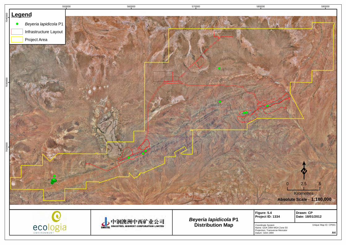
Distribution
Beyeria lapidicola’s scattered distribution is bounded by Meekatharra, Wiluna and Menzies. Nine B. lapidicola collection records are currently lodged at the WA Herbarium from locations including Ida Valley – Mt Forrest Conservation Park, Weld Range and Wiluna West Range.
The distribution within the SMC Weld Range leases at the time of publication is detailed in Figure 5.4.
Figure 5.3 – Leaves (left) and form (right) of Beyeria lapidicola (ecologia)
!(
!(
!(!(
!(!(
!(
!(
!(
!(!(!(!(!(!(!(!(!(!(!(!(!(!(!(!(!(!(!(!(!(!(!(!(!(!(!(!(!(!(!(!(!(!(!(!(!(!(!(!(!(!(!(!(!(!(!(!(!(!(!(!(!(!(!(!(!(!(!(!(!(!(!(!(!(!(!(!(!(!(!(!(!(!(!(!(!(!(!(!(!(!(!(!(!(!(!(!(!(!(!(!(!(!(!(!(!(!(!(!(!(!(!(!(!(!(!(!(!(!(!(!(!(!(!(!(!(!(!(!(!(!(!(!(!(!(!(!(!(!(!(!(!(!(!(!(!(!(!(!(!(!(!(!(!(!(!(!(!(!(!(!(!(!(!(!(!(!(!(!(!(!(!(!(!(!(!(!(!(!(!(!(!(!(!(!(!(!(!(!(!(!(!(!(!(!(!(!(!(!(!(!(!(
550000 560000 570000 580000 59000070
2000
070
3000
070
4000
0 Legend!( Beyeria lapidicola P1
Infrastructure Layout
Project Area
Coordinate SystemName: GDA 1994 MGA Zone 50Projection: Transverse MercatorDatum: GDA 1994 A4
Figure: 5.4Project ID: 1334
Drawn: CPDate: 18/01/2012
K0 2.5 5
Kilometres1:180,000Absolute Scale -
Unique Map ID: CP001
Beyeria lapidicola P1Distribution Map
Sinosteel Midwest Corporation Ltd
Weld Range Rare Flora Management Plan
March 2012
23
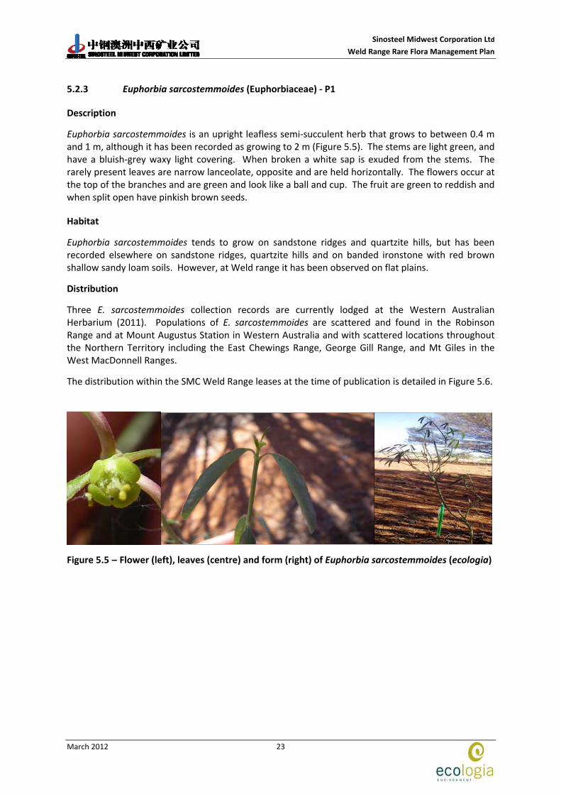
5.2.3 Euphorbia sarcostemmoides (Euphorbiaceae) ‐ P1
Description
Euphorbia sarcostemmoides is an upright leafless semi‐succulent herb that grows to between 0.4 m and 1 m, although it has been recorded as growing to 2 m (Figure 5.5). The stems are light green, and have a bluish‐grey waxy light covering. When broken a white sap is exuded from the stems. The rarely present leaves are narrow lanceolate, opposite and are held horizontally. The flowers occur at the top of the branches and are green and look like a ball and cup. The fruit are green to reddish and when split open have pinkish brown seeds.
Habitat
Euphorbia sarcostemmoides tends to grow on sandstone ridges and quartzite hills, but has been recorded elsewhere on sandstone ridges, quartzite hills and on banded ironstone with red brown shallow sandy loam soils. However, at Weld range it has been observed on flat plains.
Distribution
Three E. sarcostemmoides collection records are currently lodged at the Western Australian Herbarium (2011). Populations of E. sarcostemmoides are scattered and found in the Robinson Range and at Mount Augustus Station in Western Australia and with scattered locations throughout the Northern Territory including the East Chewings Range, George Gill Range, and Mt Giles in the West MacDonnell Ranges.
The distribution within the SMC Weld Range leases at the time of publication is detailed in Figure 5.6.
Figure 5.5 – Flower (left), leaves (centre) and form (right) of Euphorbia sarcostemmoides (ecologia)

!(!(
!(
!(
550000 560000 570000 580000 59000070
2000
070
3000
070
4000
0 Legend!( Euphorbia sarcostemmoides P1
Infrastructure Layout
Project Area
Coordinate SystemName: GDA 1994 MGA Zone 50Projection: Transverse MercatorDatum: GDA 1994 A4
Figure: 5.6Project ID: 1334
Drawn: CPDate: 18/01/2012
K0 2.5 5
Kilometres1:180,000Absolute Scale -
Unique Map ID: CP002
Euphorbia sarcostemmoides P1Distribution Map

Sinosteel Midwest Corporation Ltd
Weld Range Rare Flora Management Plan
March 2012
25
5.2.4 Sauropus sp. Woolgorong (M. Officer s.n. 10/8/94) (Phyllanthaceae) ‐ P1
Description
Sauropus sp. Woolgorong is a low shrub 0.2 ‐ 1 m high (Figure 5.7). The leaves are obovate with a notched tip and are a light to medium green in colour and ca. 0.5‐2 cm long and 0.2‐0.8 cm wide. It produces tiny yellow flowers in June.
Habitat
Sauropus sp. Woolgorong typically grows on red sand plains in open Acacia – Eremophila woodlands, but has been found on moderately rocky hill crests and slopes on the Weld Range.
Distribution
Sauropus sp. Woolgorong (M. Officer s.n. 10/8/94) is currently known to occur at Weld Range and Woolgorong Station. Seven Sauropus sp. Woolgorong (M. Officer s.n. 10/8/94) collection records are currently lodged at the WA Herbarium (2011) from locations including Weld Range, Woolgorong Homestead and Pinegrove Homestead.
The distribution within the SMC Weld Range leases at the time of publication is detailed in Figure 5.8.
Figure 5.7 – Form (top left, top right and bottom left) and leaves (bottom right) of Sauropus sp. Woolgorong

!(!(
!(!(!(!(
!(!(
!(!( !(!(!(
!(
!(!(!(!(!(!(
!(!(!(
550000 560000 570000 580000 59000070
2000
070
3000
070
4000
0 Legend!( Sauropus sp. Woolgorong P1
Infrastructure Layout
Project Area
Coordinate SystemName: GDA 1994 MGA Zone 50Projection: Transverse MercatorDatum: GDA 1994 A4
Figure: 5.8Project ID: 1334
Drawn: CPDate: 18/01/2012
K0 2.5 5
Kilometres1:180,000Absolute Scale -
Unique Map ID: CP003
Sauropus sp. Woolgorong P1Distribution Map

Sinosteel Midwest Corporation Ltd
Weld Range Rare Flora Management Plan
March 2012
27
5.2.5 Stenanthemum patens (Rhamnaceae) ‐ P1
Description
Stenanthemum patens is a small, widely spreading shrub with spiny branchlets to 0.6 m (Figure 5.9). Leaves are small, round to heart‐shaped with hairs either on upper or both surfaces. The flowers of S. patens are white, small, hairy tubular flowers primarily flowering in August – September.
This species is easily confused with the more common S. petraeum, which has hairs only on the under surface of the leaf.
Habitat
Stenanthemum patens occurs on rocky basalt and banded ironstone hillsides as well as on sandy loam and clay slopes.
Distribution
Currently 8 collection records are lodged at the WA Herbarium (2011) and S. petraeum has scattered locations within the Murchison. It is known to occur in Weld Range, at Marshall Pool, Mt. Clifford and around Leinster.
At Weld Range, S. patens has been recorded at Madoonga Station, approximately 60 km north‐west of Cue.
The distribution within the SMC Weld Range leases at the time of publication is detailed in Figure 5.10.
Figure 5.9 – Form of (left), stems (centre) and leaves (right) of Stenanthemum patens (ecologia)

Sinosteel Midwest Corporation Ltd
Weld Range Rare Flora Management Plan
March 2012
28
Figure 5.10 – Distribution of Stenanthemum patens within the Weld Range lease

Sinosteel Midwest Corporation Ltd
Weld Range Rare Flora Management Plan
March 2012
29
5.2.6 Acacia ?burrowsiana (Fabaceae) ‐ P3
Description
Acacia burrowsiana is a spreading shrub or tree to 5 m, with the main trunks and branches often slightly contorted (Figure 5.11). The bark is grey, fibrous and fissured with smooth upper branches. Phyllodes of A. burrowsiana are narrowly linear, linear oblanceolate or linear elliptic, narrowing towards base and are coarsely pungent. They are 7‐13 cm long, often held erect on the plant. The inflorescences are simple with interrupted spikes and they range from 10 – 20 mm. Fruiting material is required to confirm the identity of this species at Weld Range.
Habitat
Acacia burrowsiana occurs on red‐brown sandy loams with quartzite or ironstone rubble on the surface. It also occurs on flats adjacent to drainages, crests of low rises and breakaways.
Distribution
Currently 21 collections of A. burrowsiana are lodged at the WA Herbarium (2011). It is found in the Murchison with populations recorded in Lorna Glen Conservation Park, Cue, Sandstone and Mt. Magnet.The distribution within the SMC Weld Range leases at the time of publication is detailed in Figure 5.12.
Figure 5.11 – Seed pods (top left), flower (top right), scanned specimen (bottom left) and form (bottom right) of Acacia burrowsiana (ecologia)

Sinosteel Midwest Corporation Ltd
Weld Range Rare Flora Management Plan
March 2012
30
Figure 5.12 – Distribution of Acacia burrowsiana within the Weld Range lease
Sinosteel Midwest Corporation Ltd
Weld Range Rare Flora Management Plan
March 2012
31
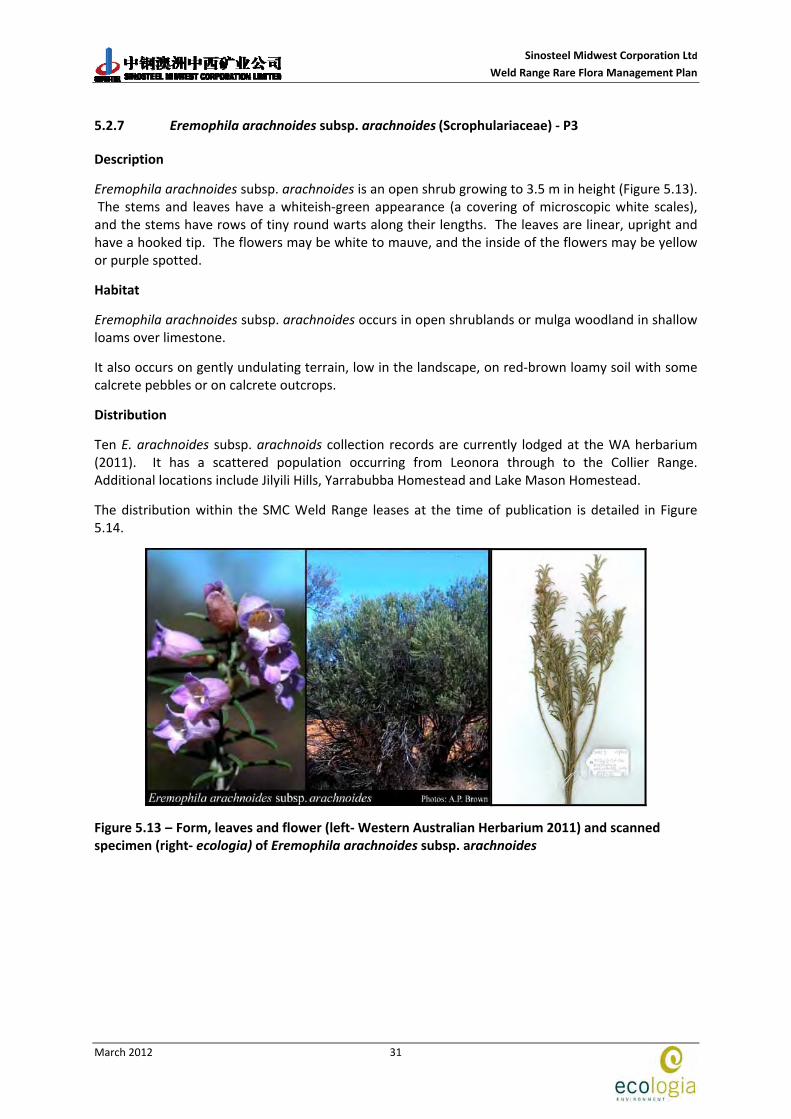
5.2.7 Eremophila arachnoides subsp. arachnoides (Scrophulariaceae) ‐ P3
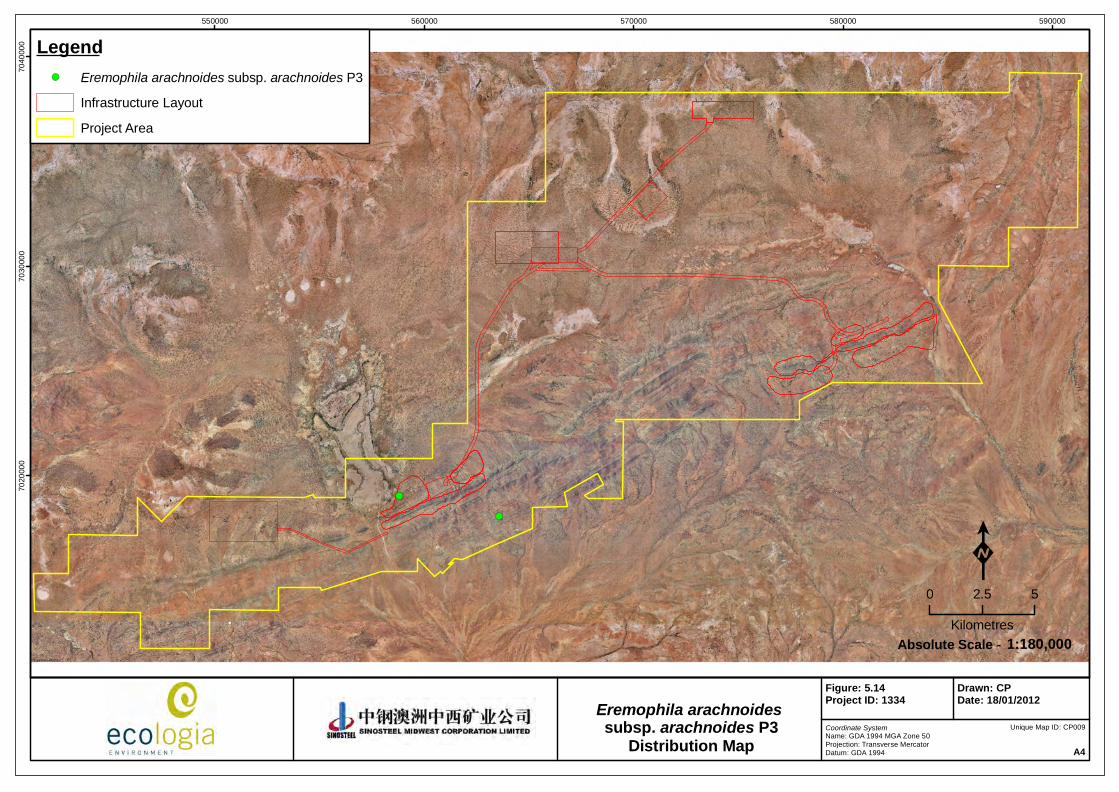
Description
Eremophila arachnoides subsp. arachnoides is an open shrub growing to 3.5 m in height (Figure 5.13). The stems and leaves have a whiteish‐green appearance (a covering of microscopic white scales), and the stems have rows of tiny round warts along their lengths. The leaves are linear, upright and have a hooked tip. The flowers may be white to mauve, and the inside of the flowers may be yellow or purple spotted.
Habitat
Eremophila arachnoides subsp. arachnoides occurs in open shrublands or mulga woodland in shallow loams over limestone.
It also occurs on gently undulating terrain, low in the landscape, on red‐brown loamy soil with some calcrete pebbles or on calcrete outcrops.
Distribution
Ten E. arachnoides subsp. arachnoids collection records are currently lodged at the WA herbarium (2011). It has a scattered population occurring from Leonora through to the Collier Range. Additional locations include Jilyili Hills, Yarrabubba Homestead and Lake Mason Homestead.
The distribution within the SMC Weld Range leases at the time of publication is detailed in Figure 5.14.
Figure 5.13 – Form, leaves and flower (left‐ Western Australian Herbarium 2011) and scanned specimen (right‐ ecologia) of Eremophila arachnoides subsp. arachnoides
!(
!(
550000 560000 570000 580000 59000070
2000
070
3000
070
4000
0 Legend!( Eremophila arachnoides subsp. arachnoides P3
Infrastructure Layout
Project Area
Coordinate SystemName: GDA 1994 MGA Zone 50Projection: Transverse MercatorDatum: GDA 1994 A4
Figure: 5.14Project ID: 1334
Drawn: CPDate: 18/01/2012
K0 2.5 5
Kilometres1:180,000Absolute Scale -
Unique Map ID: CP009
Eremophila arachnoides subsp. arachnoides P3
Distribution Map

Sinosteel Midwest Corporation Ltd
Weld Range Rare Flora Management Plan
March 2012
33
5.2.8 Goodenia lyrata (Goodeniaceae) – P3
Description
Goodenia lyrata is a prostrate herb that grows up to 0.5 m in length (Figure 5.15). The basal leaves are lyrate (triangular with one or two points at right angles to the leaf stalk) and up to 2.5 cm long; the stem leaves are always smaller than the basal leaves and similarly shaped. Yellow flowers occur in August.
Habitat
Goodenia lyrata occurs in Mulga woodlands on red sandy loam often in or near claypans.
Distribution
Currently, six G. lyrata collection records are lodged at the WA Herbarium (2011) with populations of G. lyrata are scattered throughout the Gibson, Murchison and Pilbara. Locations range from Newman and Laverton in the south through to West Angelas in the North.
The distribution within the SMC Weld Range leases at the time of publication is detailed in Figure 5.16.
Figure 5.15 – Scanned specimen (left) and growth habit and flower (right) of Goodenia lyrata (ecologia)

!(!(
!( !(
550000 560000 570000 580000 59000070
2000
070
3000
070
4000
0 Legend!( Goodenia lyrata P3
Infrastructure Layout
Project Area
Coordinate SystemName: GDA 1994 MGA Zone 50Projection: Transverse MercatorDatum: GDA 1994 A4
Figure: 5.16Project ID: 1334
Drawn: CPDate: 18/01/2012
K0 2.5 5
Kilometres1:180,000Absolute Scale -
Unique Map ID: CP005
Goodenia lyrata P3Distribution Map

Sinosteel Midwest Corporation Ltd
Weld Range Rare Flora Management Plan
March 2012
35
5.2.9 Hemigenia tysonii (Lamiaceae) ‐ P3
Description
Hemigenia tysonii is a dense, finely‐branched mint bush to 0.6 m (Figure 5.17). The leaves are a grey‐green colour and are stiff (4‐7 mm long and 1‐3 mm wide). They are arranged opposite one another or occasionally grouped on the stem. Hemigenia tysonii flowers from May – December and are purple/blue/light pink/or white, with white spots inside.
Habitat
Most commonly H. tysonii occurs on red sand, sandy clay and lateritic sand on flats, as well as on sand dunes and hills. It is also found on ridgelines with laterite, dolerite, conglomerate and chert.
Distribution
Currently, 15 H. tysonii collection records are lodged at the WA Herbarium (2011) and it occurs in the north‐western Murchison at Mt Hale, Noonie Hills and Muggon Station, between Murchison Roadhouse and Meekatharra.
The distribution within the SMC Weld Range leases at the time of publication is detailed in Figure 5.18.
Figure 5.17 – Form (left), flower (centre) and leaves (right) of Hemigenia tysonii (ecologia)

!(!( !(!(!(!(
!(!(!(!(
!(
!(
!(!(
!( !(!(!(!(
!(!(!( !(!(!( !(!(!(!(!( !( !(!( !(!(!(!(!( !(!(!(!( !( !(!(
!( !(!(!(!(!( !(!( !(!(!(!(!( !(!( !(!( !(!(!(
!(!(!(!(!(!(!(
!(!(!(!(!(!( !(!( !(!(!(!(!(
!(!(!( !(!(!(
!(!(!(!(!(!(
!(
!(!(
!(!(!(!(!(!(!(!( !(!( !(!( !(!(!( !(!(!( !(!(!(!(
!( !(
!(!(
!(!(!(!( !(!(!(!( !(!( !(!( !(!(!(!(!(!(!(
!(!(!(
!(!(!(!(!(!(!(!(!(!(!(!(!(!(!(!(!(!(!(!(!(!(!(!(!(!(!(!(!(!(!(!(!(!(!(!(!(!(!(!(!(!(!(!(
!(!(!(!(!(!(!(!(!(!(!(!(!(!(!(!(!(!(!(!(!(!(!(!(!(!(!(!(!(!(!(!(!(!(!(!(!(!(!(!(!(!(!(!(!(!(!(!(!(!(!(!(!(!(!(!(!(!(!(!(!(!(!(!(!(!(!(!(!(!(!(!(!(!(!(!(!(!(!(!(!(!(!(!(!(!(!(!(!(!(!(!(!(!(!(!(!(!(!(!(!(!(!(!(!(!(!(!(!(!(!(!(!(!(!(!(!(!(!(!(!(!(!(!(!(!(!(!(!(!(!(!(!(!(!(!(!(!(
550000 560000 570000 580000 59000070
2000
070
3000
070
4000
0 Legend!( Hemigenia tysonii P3
Infrastructure Layout
Project Area
Coordinate SystemName: GDA 1994 MGA Zone 50Projection: Transverse MercatorDatum: GDA 1994 A4
Figure: 5.18Project ID: 1334
Drawn: CPDate: 18/01/2012
K0 2.5 5
Kilometres1:180,000Absolute Scale -
Unique Map ID: CP007
Hemigenia tysonii P3Distribution Map

Sinosteel Midwest Corporation Ltd
Weld Range Rare Flora Management Plan
March 2012
37
5.2.10 Hemigenia virescens (Lamiaceae) – P3
Description
Hemigenia virescens is an erect, compact shrub growing up to 30 or 40 cm high and up to 60 cm wide (Figure 5.19). The flowers are white with a small yellow spot at the base of the central lower lobe, and three pink spots at the base of the two lateral lower lobes.
Habitat
Hemigenia virescens is known to occur on hillsides, in rangelands, in low and high shrublands and on sandy banks. Soil types are commonly yellow‐red sandy clay, brown ironstone gravel and brown rocky sand.
Distribution
Its distribution includes two populations, one in the Gascoyne and the second Murchison.
The distribution within the SMC Weld Range leases at the time of publication is detailed in Figure 5.20.
Figure 5.19 – Form, leaves and flower (Western Australian Herbarium 2011) of Hemigenia virescens

!(!(!(!(!(!(!(!(
!(!(!(!(!(!(!(!(!(!(!(!(!(!(!(!(!(!(
!(
!(
!(!(
!(!(!(!( !(!( !(!(!( !(!(!(!(!(!(!( !( !(!(!(!( !(!( !(!( !(!(!( !(!( !(!(!( !( !(!(!(!( !(!(!(!( !(!(!( !(!(!(!(!(!( !(!( !(!(!( !(!(!( !(!( !(!(!(!(!(!( !(!(!( !(!(!(!(!( !(!(!(!( !(!( !(!(!( !(!(!(!(!(!(!( !(!(!( !(!(!(!( !(!(!( !(!( !(!(!(!( !( !(!(!( !(!(!(!( !(!( !(!( !( !(!(!( !(!(!( !(!( !(!(!(!(!(!(!(!(!(!(!(!(!(!(!(!(!(!(!(!(!(!(!(!(!(!(!(!(!(!(!(!(!(!(!(!(!(!(!(!(!(!(!(!(!(!(!(!(!(
!(!(!(!(!(!(!(!(!(!(!(!(!(!(!(!(!(!(!(!(!(!(!(!(!(!(!(!(!(!(!(!(!(!(!(!(!(!(!(!(!(!(!(!(!(!(!(!(!(!(!(!(!(!(!(!(!(!(!(!(!(!(!(!(!(!(!(!(!(!(!(!(!(!(!(!(!(
550000 560000 570000 580000 59000070
2000
070
3000
070
4000
0 Legend!( Hemigenia virescens P3
Infrastructure Layout
Project Area
Coordinate SystemName: GDA 1994 MGA Zone 50Projection: Transverse MercatorDatum: GDA 1994 A4
Figure: 5.20Project ID: 1334
Drawn: CPDate: 18/01/2012
K0 2.5 5
Kilometres1:180,000Absolute Scale -
Unique Map ID: CP008
Hemigenia virescens P3Distribution Map
Sinosteel Midwest Corporation Ltd
Weld Range Rare Flora Management Plan
March 2012
39
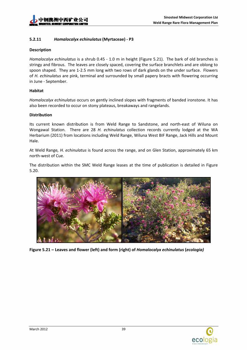
5.2.11 Homalocalyx echinulatus (Myrtaceae) ‐ P3
Description
Homalocalyx echinulatus is a shrub 0.45 ‐ 1.0 m in height (Figure 5.21). The bark of old branches is stringy and fibrous. The leaves are closely spaced, covering the surface branchlets and are oblong to spoon shaped. They are 1‐2.5 mm long with two rows of dark glands on the under surface. Flowers of H. echinulatus are pink, terminal and surrounded by small papery bracts with flowering occurring in June ‐ September.
Habitat
Homalocalyx echinulatus occurs on gently inclined slopes with fragments of banded ironstone. It has also been recorded to occur on stony plateaus, breakaways and rangelands.
Distribution
Its current known distribution is from Weld Range to Sandstone, and north‐east of Wiluna on Wongawal Station. There are 28 H. echinulatus collection records currently lodged at the WA Herbarium (2011) from locations including Weld Range, Wiluna West BIF Range, Jack Hills and Mount Hale.
At Weld Range, H. echinulatus is found across the range, and on Glen Station, approximately 65 km north‐west of Cue.
The distribution within the SMC Weld Range leases at the time of publication is detailed in Figure 5.20.
Figure 5.21 – Leaves and flower (left) and form (right) of Homalocalyx echinulatus (ecologia)

!(
!(!(
!(
!(!(
!( !(!(
!(
!(
!(!(
!(
!(
!(
550000 560000 570000 580000 59000070
2000
070
3000
070
4000
0 Legend!( Homalocalyx echinulatus P3
Infrastructure Layout
Project Area
Coordinate SystemName: GDA 1994 MGA Zone 50Projection: Transverse MercatorDatum: GDA 1994 A4
Figure: 5.22Project ID: 1334
Drawn: CPDate: 18/01/2012
K0 2.5 5
Kilometres1:180,000Absolute Scale -
Unique Map ID: CP010
Homalocalyx echinulatus P3Distribution Map

Sinosteel Midwest Corporation Ltd
Weld Range Rare Flora Management Plan
March 2012
41
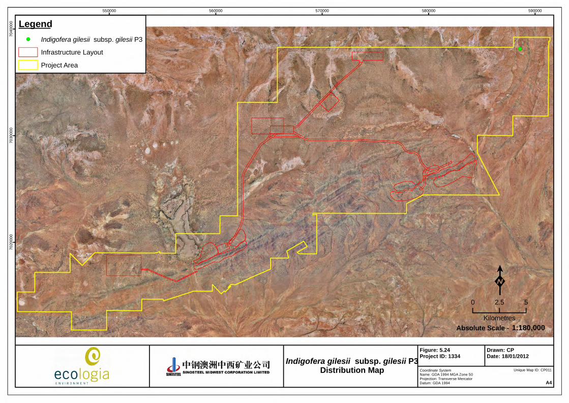
5.2.12 Indigofera gilesii subsp. gilesii (Fabaceae) ‐ P3
Description
Indigofera gilesii subsp. gilesii is an upright erect single stemmed shrub 1.5 m high with spreading branches (Figure 5.23). The bark is dull, grey and fairly smooth. Leaflets grey‐green above and below. Leaves and pods can be clustered towards the ends of branches. Flowers of Indigofera gilesii subsp. gilesii are purple/pink, the keel is a dull light red with white base and brown hairy tip. and flowing occurs in May‐ August.
Habitat
Indigofera gilesii subsp. gilesii occurs in a variety of habitats including pebbly loams and hill slopes amongst boulders & outcrops, banded iron hills, granite and sandstone, creeklines and sand plains. The substrate is often ironstone gravel amongst brown/red loam.
Distribution
Most records of I. gilesii subsp. gilesii occur in the southern Pilbara near Jinayri which is ca. 53 km NW of Newman and on the eastern end of the Hamersley Range. Currently there are 14 collection records lodged with the WA Herbarium (2011).
The distribution within the SMC Weld Range leases at the time of publication is detailed in Figure 5.24.
Figure 5.23 – Form and leaves of Indigofera gilesii subsp. gilesii (Western Australian Herbarium 2011, ecologia)
!(
550000 560000 570000 580000 59000070
2000
070
3000
070
4000
0 Legend!( Indigofera gilesii subsp. gilesii P3
Infrastructure Layout
Project Area
Coordinate SystemName: GDA 1994 MGA Zone 50Projection: Transverse MercatorDatum: GDA 1994 A4
Figure: 5.24Project ID: 1334
Drawn: CPDate: 18/01/2012
K0 2.5 5
Kilometres1:180,000Absolute Scale -
Unique Map ID: CP011
Indigofera gilesii subsp. gilesii P3Distribution Map

Sinosteel Midwest Corporation Ltd
Weld Range Rare Flora Management Plan
March 2012
43
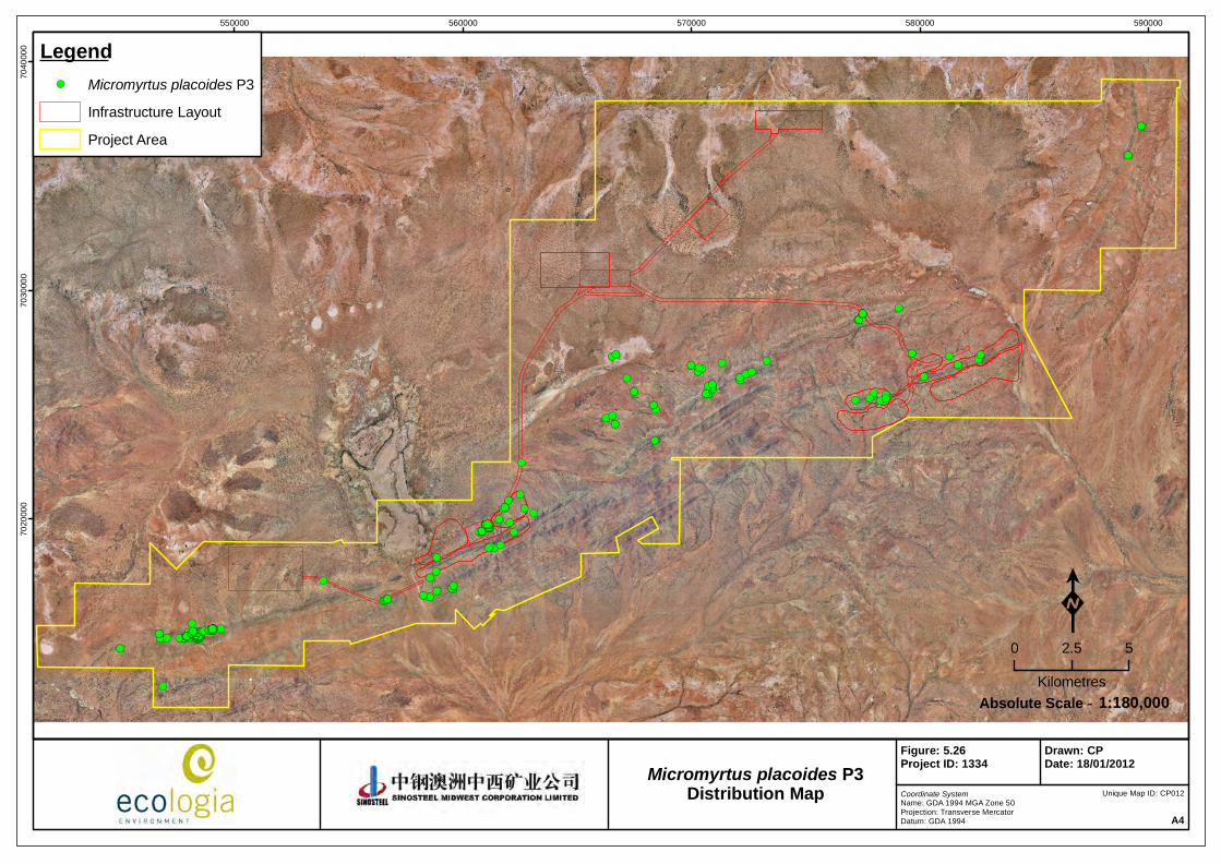
5.2.13 Micromyrtus placoides (Myrtaceae) ‐ P3
Description
Micromyrtus placoids is a rounded shrub 0.5 m ‐ 2.5 m which is sometimes widely spreading with several branches from the base (Figure 5.25). The leaves are broad obovate to almost circular and usually concentrated at the tips of branches. Flowers of M. placoids are white, often reflexed on stalks and flowering occurs in July‐September.
Habitat
Micromyrtus placoids occurs on a variety of substrates including red‐orange or orange‐yellow sandy clay, coarse gravel, banded ironstone, laterite, quartz and basalt. Landforms can be gently undulating plains, dry creek beds, hillcrests or ridges of brown loam, dolerite, ironstone or granite.
Distribution
Micromyrtus placoids occurs in the western Murchison and northern Yalgoo. Its distribution is from Cue in the east to Mount Narryer in the west. Twenty‐three M. placoids collection records are currently lodged at the WA Herbarium (2011) from locations including Weld Range, Tallering Peak, Mount Narryer and Cue.
At Weld Range it occurs at the eastern end of the range, on Beebyn Station, approximately 63 km north of Cue.
The distribution within the SMC Weld Range leases at the time of publication is detailed in Figure 5.26.
Figure 5.25 – Form (left) and flower (centre and right) of Micromyrtus placoides (ecologia)
!(!( !(
!(!(!(!( !(!(!(!(!(!(
!(
!(!(!(!(
!(!(!( !(
!(!(
!(
!(!(
!(!(!(!(
!(!(!(!(!(!(!(!(!(!( !(!(!( !(!(!(!(!(!(!(!(
!(!( !(!(!( !(!(!(!(!(!(!(!(
!(!( !(!( !( !(!(!( !(!(!(
!(
!(!(
!(!(
!(!(!(!(!(!(
!(
!(
!(!(
!(!(
!(!(
!(
!(
!(!(
!(
!(!(!(!(!(
!(!(!(!(!(!(!(!(!(!(!(!(!(!(!(!(!(!(!(!(!(!(!(!(!(!(!(!(!(!(!(!(!(!(!(!(!(!(!(!(!(!(!(!(!(!(!(!(!(!(!(!(!(!(!(!(!(!(!(!(!(!(!(!(!(!(!(!(!(!(!(!(!(!(!(!(!(!(!(!(!(!(!(!(!(!(!(
!(
!(!(!(
!(!(!(!(!(!(!(!(!(!(!(!(!(
!(!(!(!(!(!(!(!(!(!(!(!( !(!(!(!(!(!( !(!(!(!(!(!(!(!(!(!(!(!(!(!(!( !(!( !(!(!(!(!(!(!(!(!(!(!(!(!(!(!(!( !(!(!(!(!(!(!(!(!(!(!(!(!(!(!(!(!(!(!(!(!(!(!( !(!(!(!(!(!(!(!(!(!(!(!( !(!(!(!(!(!(!(!(!(!(!(!(!(!(!(!(!(!(!(!(!(!(!( !(!(!(!(!(!(!(!(!(!(!(!(!(!(!(!(!(!(!(!(!(!(!(!(!(!(!(!(!(!(!(!(!(!(!(!(!(!(!(!(!(!(!(!(!(!(!(!(!(!(!(!(!(!(!(!(!(!(!(!(!(!(!(!(!(!(!(!(!(!(!(!(!(!(!(!(!(!(!(!(!(
550000 560000 570000 580000 59000070
2000
070
3000
070
4000
0 Legend!( Micromyrtus placoides P3
Infrastructure Layout
Project Area
Coordinate SystemName: GDA 1994 MGA Zone 50Projection: Transverse MercatorDatum: GDA 1994 A4
Figure: 5.26Project ID: 1334
Drawn: CPDate: 18/01/2012
K0 2.5 5
Kilometres1:180,000Absolute Scale -
Unique Map ID: CP012
Micromyrtus placoides P3Distribution Map

Sinosteel Midwest Corporation Ltd
Weld Range Rare Flora Management Plan
March 2012
45
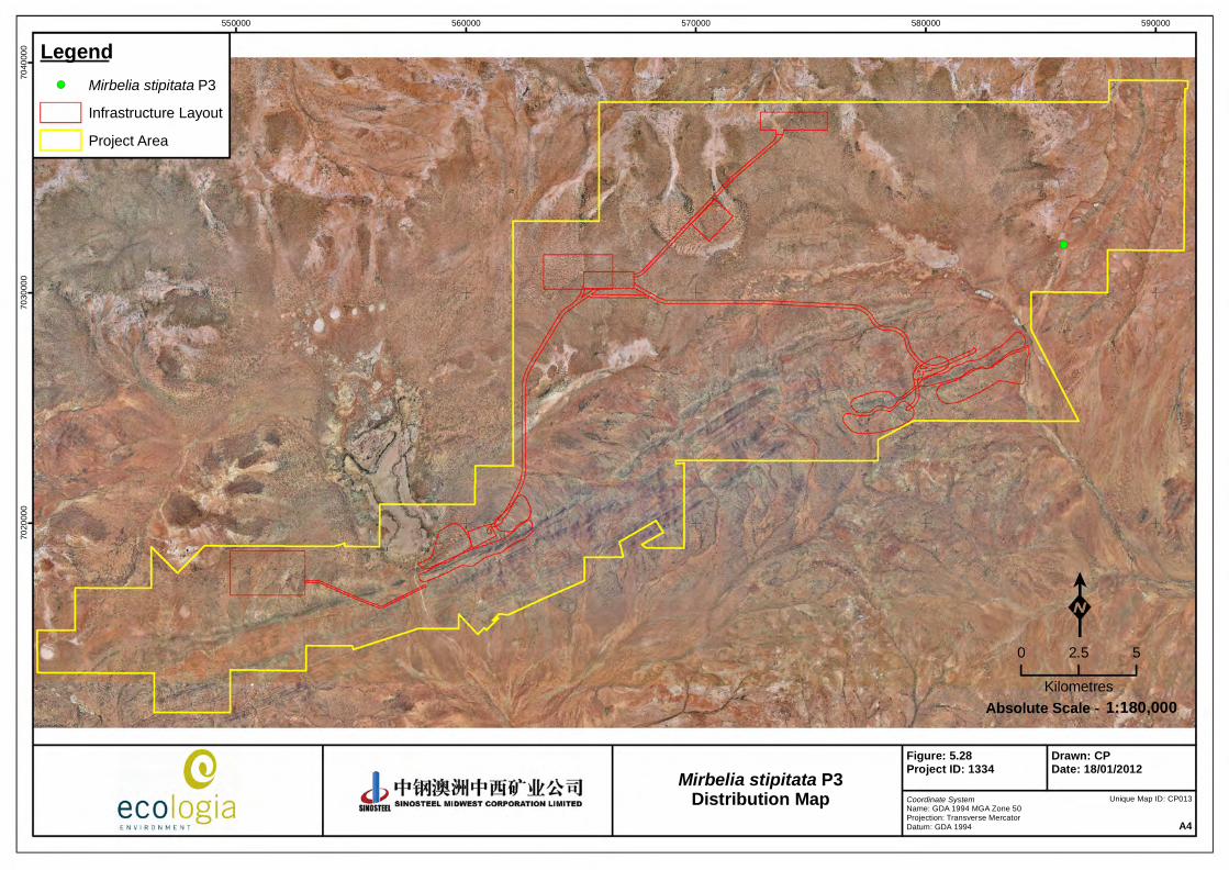
5.2.14 Mirbelia stipitata (Fabaceae) ‐ P3
Description
Mirbelia stipitata is a spiny shrub 0.5 ‐ 1 m (Figure 5.27). It is leafless with small brown bracts at the bases of the spinescent branchlets. Mirbelia stipitata flowers in August with pink pea flowers borne along the spiny branchlets.
Flowers are required to confirm the identity of this species at Weld Range.
Habitat
Mirbelia stipitata is found on plains on red sandy loam.
Distribution
Mirbelia stipitata has scattered populations in the Murchison in the Sandstone area. Three M. stipitata collection records are currently lodged at the WA Herbarium (2011) from Sandstone, Cue‐Sandstone Road and Bandya Homestead.
The distribution within the SMC Weld Range leases at the time of publication is detailed in Figure 5.28.
Figure 5.27 – Scanned specimen of Mirbelia stipitata (ecologia)
!(
550000 560000 570000 580000 59000070
2000
070
3000
070
4000
0 Legend!( Mirbelia stipitata P3
Infrastructure Layout
Project Area
Coordinate SystemName: GDA 1994 MGA Zone 50Projection: Transverse MercatorDatum: GDA 1994 A4
Figure: 5.28Project ID: 1334
Drawn: CPDate: 18/01/2012
K0 2.5 5
Kilometres1:180,000Absolute Scale -
Unique Map ID: CP013
Mirbelia stipitata P3Distribution Map

Sinosteel Midwest Corporation Ltd
Weld Range Rare Flora Management Plan
March 2012
47
5.2.15 Phyllanthus baeckeoides (Phyllanthaceae) ‐ P3
Description
Phyllanthus baeckeoides is a shrub 0.5‐1.7 m high. It flowers in March where flowers are small and white to cream.
Habitat
Phyllanthus baeckeoides is found on ironstone ridges/ breakaways with dry, orange sandy clay soils.
At Weld Range it has been recorded on gently inclined lower hillslopes to flats of banded ironstone with red brown soils.
Distribution
Currently 22 collection records of P. baeckeoides are lodged with the WA Herbarium (2011). It occurs in the southern half of the Pilbara and on the western extremity of the Great Victoria Desert. It is found at Sandstone, Laverton, Leinster, Windimurra Station and Weld Range.
The distribution within the SMC Weld Range leases at the time of publication is detailed in Figure 5.29.

!(
550000 560000 570000 580000 59000070
2000
070
3000
070
4000
0 Legend!( Phyllanthus baeckeoides P3
Infrastructure Layout
Project Area
Coordinate SystemName: GDA 1994 MGA Zone 50Projection: Transverse MercatorDatum: GDA 1994 A4
Figure: 5.29Project ID: 1334
Drawn: CPDate: 18/01/2012
K0 2.5 5
Kilometres1:180,000Absolute Scale -
Unique Map ID: CP014
Phyllanthus baeckeoides P3Distribution Map

Sinosteel Midwest Corporation Ltd
Weld Range Rare Flora Management Plan
March 2012
49
5.2.16 Prostanthera ferricola (Lamiaceae) ‐ P3
Description
Prostanthera ferricola is an erect, openly branched shrub 0.3 ‐ 1 m with densely hairy branches (Figure 5.30). The leaves are flat and are green to pale green in colour. They are often whorled around the stem and strongly aromatic when crushed. The flowers of P. ferricola are purple/mauve, hairy and flower in July – September.
Habitat
Prostranthera ferricola is found in sparse Acacia aneura shrublands on gently inclined upper slopes and crests of banded ironstone formations. It is occasionally found in gullies or on quartz.
Distribution
Prostanthera ferricola occurs in the southern Gascoyne and northern Murchison. Twenty‐two populations are currently lodged with the WA herbarium (2011) and are recorded for Robinson Ranges, Jack Hills, Wiluna West Range, Moolagool Station and Weld Range.
At Weld Range, populations are located, on Madoonga Station, approximately 60 km north‐west of Cue.
The distribution within the SMC Weld Range leases at the time of publication is detailed in Figure 5.31.
Figure 5.30 – Form (left), flower (centre) and scanned specimen (right) of Prostanthera ferricola (ecologia)

!(!(
550000 560000 570000 580000 59000070
2000
070
3000
070
4000
0 Legend!( Prostanthera ferricola P3
Infrastructure Layout
Project Area
Coordinate SystemName: GDA 1994 MGA Zone 50Projection: Transverse MercatorDatum: GDA 1994 A4
Figure: 5.31Project ID: 1334
Drawn: CPDate: 18/01/2012
K0 2.5 5
Kilometres1:180,000Absolute Scale -
Unique Map ID: CP015
Prostanthera ferricola P3Distribution Map

Sinosteel Midwest Corporation Ltd
Weld Range Rare Flora Management Plan
March 2012
51
5.2.17 Prostanthera petrophila (Lamiaceae) ‐ P3
Description
Prostanthera petrophila is a spreading shrub 0.6 ‐ 2 m (Figure 5.32). The young stems are covered in white‐grey hairs and the leaves of P. petrophila are opposite and elliptic in shape. The flowers are white with purple to violet striations and the plants flower in August.
Habitat
Prostranthera petrophila occurs on lateritic soils, ironstone slopes and foothills on red‐orange sandy clay with ferrous stones and boulders.
Distribution
Prostanthera petrophila is found in the western Murchison and northern Yalgoo. Currently, 40 collection records are lodged at the WA Herbarium (2011) at Weld Range, Woolgorong Homestead, Mt. Barloweerie and Cue.
Several populations have been recorded in Weld Range, including both eastern and western ends.
The distribution within the SMC Weld Range leases at the time of publication is detailed in Figure 5.33.
Figure 5.32 – Form (left), leaves and flower (centre) and fruits (right) of Prostanthera petrophila (ecologia)

!(!(!( !( !(
!(!(!(!(!(!(
!(
!( !(!(!( !(
!(!(!( !(!(!( !(!(!(!(!(!(!(!( !( !(!(!(
!( !(!( !(!(!(!(!(!(
!( !(!(!(
!( !(!(!(!(!(!( !(!(!(!( !( !(!( !(!(!(!(!(!(!(
!(!(!(!(!( !(!(!(!(!(!(
!(!(!(!( !(!(!(!(
!(!(!(!(!(
!(!(!(!(!(!( !(!(!(!(!(!(
!(!(
!(!(
!(!( !(!(!(!(!(!(!( !(!(!(!( !(!(!(!(!(!(!(!( !(!(!(!(
!(!(
!( !(!( !(!(!(!(!(!(!(!(!(!(!(!(!(!(
!(!(
!(
!(
!(!(
!(!(
!(!(
!(
!(
!(!(!(!(!(!(
!(
!(!(!(!( !(
!(!(
!(!(
!(!(!(!(!(!(!(!(!(
!(
550000 560000 570000 580000 59000070
2000
070
3000
070
4000
0 Legend!( Prostanthera petrophila P3
Infrastructure Layout
Project Area
Coordinate SystemName: GDA 1994 MGA Zone 50Projection: Transverse MercatorDatum: GDA 1994 A4
Figure: 5.33Project ID: 1334
Drawn: CPDate: 18/01/2012
K0 2.5 5
Kilometres1:180,000Absolute Scale -
Unique Map ID: CP016
Prostanthera petrophila P3Distribution Map

Sinosteel Midwest Corporation Ltd
Weld Range Rare Flora Management Plan
March 2012
53
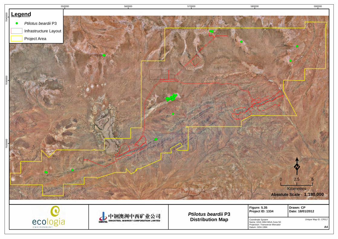
5.2.18 Ptilotus beardii (Amaranthaceae) ‐ P3
Description
Ptilotus beardii is a compact, many‐branched, rigid shrub 0.15‐ 0.5 m (Figure 5.34). Leaves are often clustered along the stem, small (2‐10 mm long, 0.5‐3 mm wide), linear and have acute tips. Flowers are pale pink/red, with inflorescences terminal forming open, spherical to cylindrical flower heads. Flowering occurs in August – October.
Habitat
Ptilotus beardii occurs on red/orange/brown sandy‐clayey soils, saline flats, flood plains and low breakaways.
Distribution
Ptilotus beardii is found in dense pockets of the western Murchison and in a couple of locations of northern Yalgoo.
Ptilotus beardii is distributed from Weld Range eastwards to the Murchison Roadhouse. Currently, 31 P. beardii collection records are lodged at the WA Herbarium (2009) from locations including Weld Range, Muggon Station, Crystal Hill and Mount Narryer Homestead.
The distribution within the SMC Weld Range leases at the time of publication is detailed in Figure 5.35.
Figure 5.34 – Flower (left) and form (right) of Ptilotus beardii (ecologia)
!(
!(!(!(!(
!(
!(!( !(!(!(!(!(!(!(!(!(!( !(!(!(!(!(!(!(!( !(!(!(!( !(!(!(!(!(!(!(!( !(!(!(!(!(!(!(!(!(!(!(
!(
!(
!(!(
!(!(!(
!(!(!(
!(!(
550000 560000 570000 580000 59000070
2000
070
3000
070
4000
0 Legend!( Ptilotus beardii P3
Infrastructure Layout
Project Area
Coordinate SystemName: GDA 1994 MGA Zone 50Projection: Transverse MercatorDatum: GDA 1994 A4
Figure: 5.35Project ID: 1334
Drawn: CPDate: 18/01/2012
K0 2.5 5
Kilometres1:180,000Absolute Scale -
Unique Map ID: CP017
Ptilotus beardii P3Distribution Map
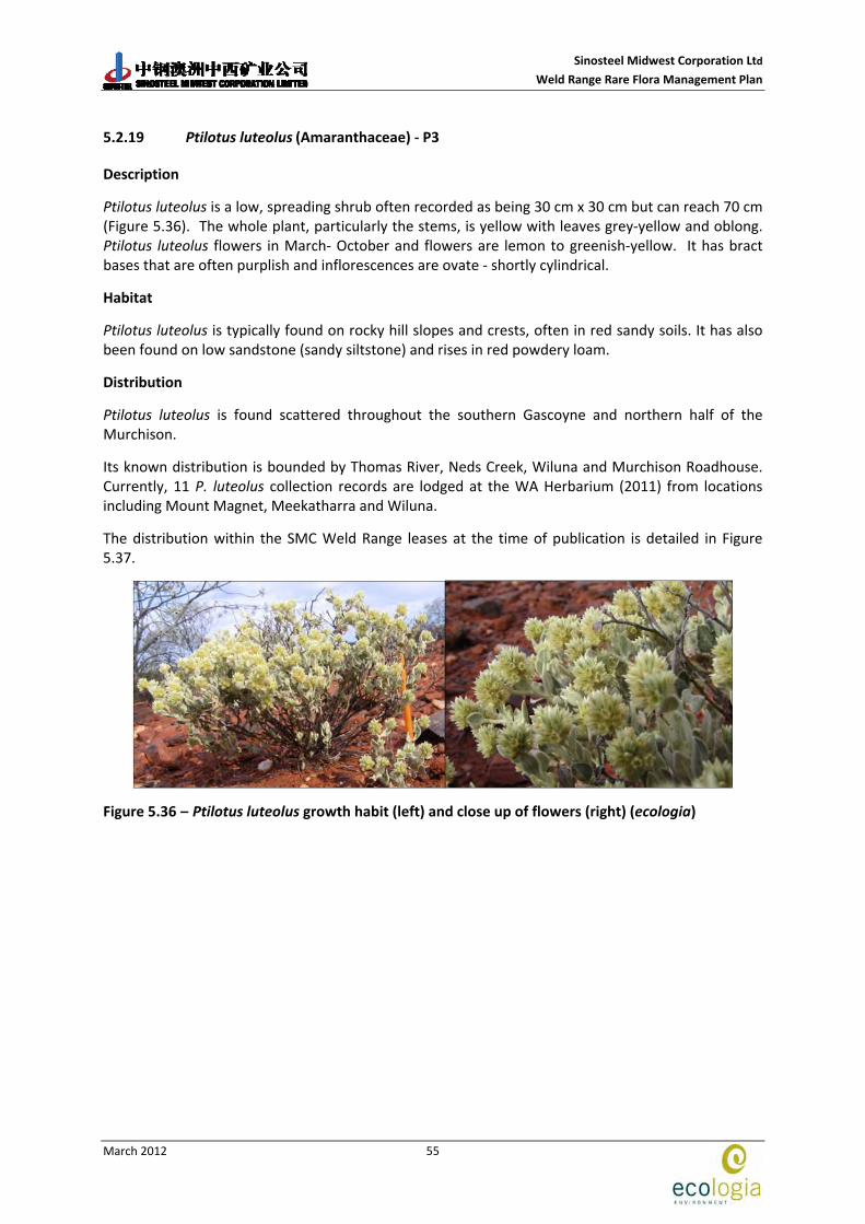
Sinosteel Midwest Corporation Ltd
Weld Range Rare Flora Management Plan
March 2012
55
5.2.19 Ptilotus luteolus (Amaranthaceae) ‐ P3
Description
Ptilotus luteolus is a low, spreading shrub often recorded as being 30 cm x 30 cm but can reach 70 cm (Figure 5.36). The whole plant, particularly the stems, is yellow with leaves grey‐yellow and oblong. Ptilotus luteolus flowers in March‐ October and flowers are lemon to greenish‐yellow. It has bract bases that are often purplish and inflorescences are ovate ‐ shortly cylindrical.
Habitat
Ptilotus luteolus is typically found on rocky hill slopes and crests, often in red sandy soils. It has also been found on low sandstone (sandy siltstone) and rises in red powdery loam.
Distribution
Ptilotus luteolus is found scattered throughout the southern Gascoyne and northern half of the Murchison.
Its known distribution is bounded by Thomas River, Neds Creek, Wiluna and Murchison Roadhouse. Currently, 11 P. luteolus collection records are lodged at the WA Herbarium (2011) from locations including Mount Magnet, Meekatharra and Wiluna.
The distribution within the SMC Weld Range leases at the time of publication is detailed in Figure 5.37.
Figure 5.36 – Ptilotus luteolus growth habit (left) and close up of flowers (right) (ecologia)

!(!(!(
!(!(
!(
!(
!(
550000 560000 570000 580000 59000070
2000
070
3000
070
4000
0 Legend!( Ptilotus luteolus P3
Infrastructure Layout
Project Area
Coordinate SystemName: GDA 1994 MGA Zone 50Projection: Transverse MercatorDatum: GDA 1994 A4
Figure: 5.37Project ID: 1334
Drawn: CPDate: 18/01/2012
K0 2.5 5
Kilometres1:180,000Absolute Scale -
Unique Map ID: CP018
Ptilotus luteolus P3Distribution Map

Sinosteel Midwest Corporation Ltd
Weld Range Rare Flora Management Plan
March 2012
57
5.2.20 Tecticornia cymbiformis (Chenopodiaceae) ‐ P3
Description
Tecticornia cymbiformis is a low, erect shrub to 0.5 m (Figure 5.38). It has a fleshy stem that is cylindrical, oval or circular in cross‐section and dull green, or dull to bright red in colour. The stems will often retain the fruits from previous years. Terminal, fertile tips have broad, boat shaped bracts with tips that flare outwards. Tecticornia cymbiformis flowers in March – May.
Habitat
Tecticornia cymbiformis is found in saline areas along floodplains, creeklines, lakes or sloping areas leading to saline habitats. It can be found on red‐brown sandy clays.
Distribution
Three populations of T. cymbiformis are currently known and are widely scattered in the Pilbara, Murchison and Yalgoo. Ten collection records have been lodged with the WA Herbarium (2011) with populations recorded at Lake Aneen, Yuin Homestead and Polelle Station.
The distribution within the SMC Weld Range leases at the time of publication is detailed in Figure 5.39.
Figure 5.38 – Form, leaves and flower (left‐ Western Australian Herbarium 2011) and scanned specimen (right‐ ecologia) of Tecticornia cymbiformis

!(!(
550000 560000 570000 580000 59000070
2000
070
3000
070
4000
0 Legend!( Tecticornia cymbiformis P3
Infrastructure Layout
Project Area
Coordinate SystemName: GDA 1994 MGA Zone 50Projection: Transverse MercatorDatum: GDA 1994 A4
Figure: 5.39Project ID: 1334
Drawn: CPDate: 18/01/2012
K0 2.5 5
Kilometres1:180,000Absolute Scale -
Unique Map ID: CP020
Tecticornia cymbiformis P3Distribution Map

Sinosteel Midwest Corporation Ltd
Weld Range Rare Flora Management Plan
March 2012
59
5.2.21 Verticordia jamiesonii (Myrtaceae) ‐ P3
Description
Verticordia jamiesonii is a small, irregularly branched, rounded shrub reaching 60 cm although more commonly recorded at 20 cm (Figure 5.40). The leaves are very small and crowded on short, lateral branchlets. Verticordia jamiesonii flowers are creamish‐white turning to pink with maturity and flower buds are shiny and pale to bright red. This species flowers in September‐ October.
Habitat
Verticordia jamiesonii is often found on quartzite or laterite breakaways, hill slopes, ridgelines, or on weathered granite within pockets of small sandy clay in depressions.
Distribution
Verticordia jamiesonii is widespread, with populations found in the Murchison, Pilbara and on the boarders between the Great Victorian Desert and the Gibson Desert.
Currently, 29 V. jamiesonii records are lodged at the Western Australian Herbarium (2011) from locations including Mt Hale, Noonie Hills, Cue, Yalgoo and South Warburton.
The distribution within the SMC Weld Range leases at the time of publication is detailed in Figure 5.41.
Figure 5.40 – Flower (left) and form (right) of Verticordia jamiesonii (ecologia)
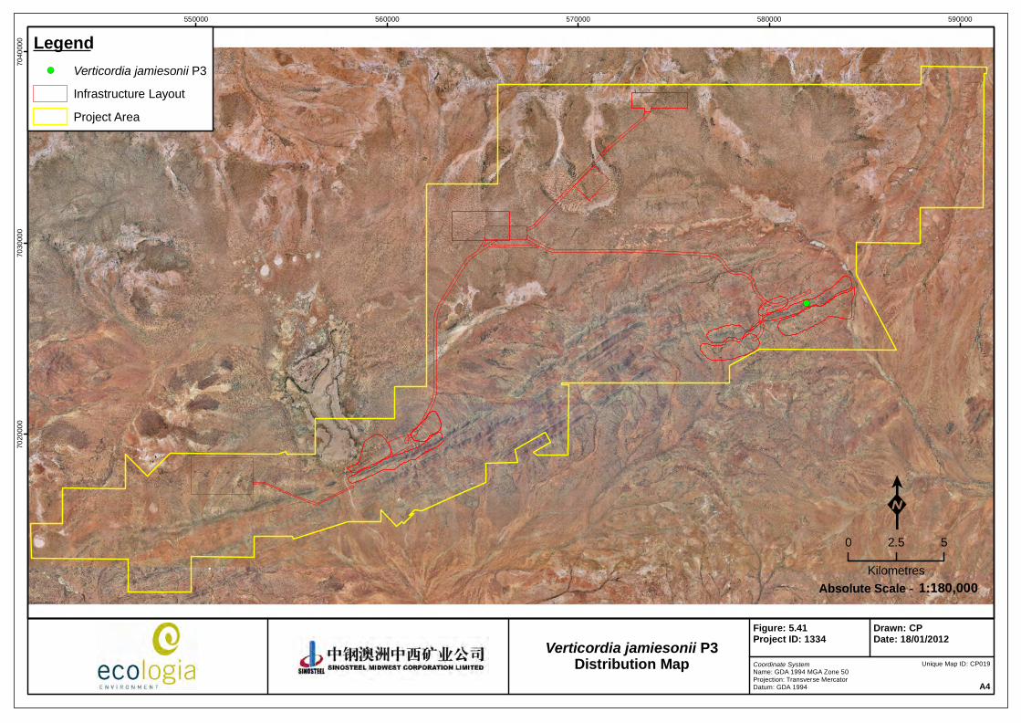
!(
550000 560000 570000 580000 59000070
2000
070
3000
070
4000
0 Legend!( Verticordia jamiesonii P3
Infrastructure Layout
Project Area
Coordinate SystemName: GDA 1994 MGA Zone 50Projection: Transverse MercatorDatum: GDA 1994 A4
Figure: 5.41Project ID: 1334
Drawn: CPDate: 18/01/2012
K0 2.5 5
Kilometres1:180,000Absolute Scale -
Unique Map ID: CP019
Verticordia jamiesonii P3Distribution Map

Sinosteel Midwest Corporation Ltd
Weld Range Rare Flora Management Plan
March 2012
61
5.2.22 Acacia speckii (Fabaceae) – P4
Description
Acacia speckii is a bushy, rounded shrub or gnarled tree, growing from 1.5 m‐ 3.0 m (Figure 5.42). The bark is grey and fissured on the main branches. The phyllodes are light green, rigid and erect, circular in cross‐section, with a hardened, brown tip. Pods are light brown, narrow and compressed between each seed. Flowers are yellow.
Habitat
Acacia speckii is found on rocky soils over granite, basalt or dolerite. It has been observed to occur across the mid‐sloped rocky hills and near drainage lines of Weld Range.
Distribution
Twenty‐eight A. speckii collection records are lodged at the WA Herbarium (2011). A. speckii is found across a NE band between Geraldton and Wiluna with populations in Weld Range, around Mt. Magnet, Meekatharra and Yalgoo.
In Weld Range, A. speckii is found, on Madoonga Station, approximately 60 km north‐west of Cue.
The distribution within the SMC Weld Range leases at the time of publication is detailed in Figure 5.43.
Figure 5.42 – Acacia speckii flower bud/leaf structure (left), fruit structure (centre) and growth habit (right) (ecologia)

!(
!(!(!(!(!(!(!(!(!(
!(!( !(
!(!(!( !(!(!(!(!(!(!(!(
!( !(!(!(
!(!( !(!(
!(!(!(!(!(!(
!(!(!(!(
!(!(!( !(!(!(!(!( !(!(!( !(!(!(!(!( !( !(!(!( !( !(!(!(!(!(!(!(
!( !(!(!( !(!(!(!(!(!(!(!( !(!(!(!(!(!( !(!( !(!(!(!( !(!(!( !(!(!(!(!(!(!(!(!( !(
!(!(!( !( !(!(!(!( !(!(!( !(!(!( !(!(!( !(!(
!(
!(!(!(!(!(
!(!(!(
!(
!(
!(
!(!(
!(
!(!(!(!(!(!(!(!(!(!( !(!(!(!( !(!(!(!( !(!(!(!( !(!(!(!(!(!(!(!(!(!(!(!(!(!(!(!(!(!(
!(!(
!(!(
!(
!(!(!(!(!(!(!( !(!(!(!(!(
!(!(!(!(!(!(!(!(
550000 560000 570000 580000 59000070
2000
070
3000
070
4000
0 Legend!( Acacia speckii P4
Infrastructure Layout
Project Area
Coordinate SystemName: GDA 1994 MGA Zone 50Projection: Transverse MercatorDatum: GDA 1994 A4
Figure: 5.43Project ID: 1334
Drawn: CPDate: 18/01/2012
K0 2.5 5
Kilometres1:180,000Absolute Scale -
Unique Map ID: CP021
Acacia speckii P4Distribution Map

Sinosteel Midwest Corporation Ltd
Weld Range Rare Flora Management Plan
March 2012
63
5.2.23 Dodonaea amplisemina (Sapindaceae) – P4
Description
Dodonaea amplisemina is a dioecious multi‐stemmed open shrub (0.3‐1 m) with branchlets that are sometimes spiny (Figure 5.44). Leaves are linear or narrow spear shaped with blunt tips, often clumped together. The flowers of D. amplisemina are inconspicuous but the mature fruits are pink‐brown with four incurving horns, occurring in August – October.
Habitat
Dodonaea amplisemina’s preferred habitat is open shrublands with Acacia, Eremophila and other low shrubs on redbrown sandy clay soils over basalt or banded ironstone. One population has been recorded on quartzite.
Distribution
Twenty‐eight collection records of D. amplisemina are currently lodged at the WA herbarium. Scattered populations of D. amplisemina occur on a general NE gradient between Geraldton and 200 km NW of Wiluna. Locations of populations occur in the Robinson Ranges, South Paynes Find, Mt Magnet, Weld Range, Cue and in the Buddadoo Range.
The distribution within the SMC Weld Range leases at the time of publication is detailed in Figure 5.45.
Figure 5.44 – Form (top right‐ ecologia, bottom left‐ Western Australian Herbarium 2011), leaves (bottom left) and fruit (top right (ecologia) of Dodonaea amplisemina

!(
!(!(!(!(
!(!(!(!(!(
!(!( !(!( !(!(!(
!(!(
!(!(
!(!(!(
!(!(
!(!(!(!(
!(!( !(!(!(!(!(!(!( !(!(
!(!( !(!(!(
!( !(!( !(!(!(!(!(!(!(!(!(
!(!(!(!(!( !(!(!(!(!( !(!(!( !(!( !(!(!(!(!(
!(!( !(!(!(!(
!(!(!(
!(
!(
!(
!(!(!(!(!(!(
!(
!(
!(
!(!(
!(
550000 560000 570000 580000 59000070
2000
070
3000
070
4000
0 Legend!( Dodonaea amplisemina P4
Infrastructure Layout
Project Area
Coordinate SystemName: GDA 1994 MGA Zone 50Projection: Transverse MercatorDatum: GDA 1994 A4
Figure: 5.45Project ID: 1334
Drawn: CPDate: 18/01/2012
K0 2.5 5
Kilometres1:180,000Absolute Scale -
Unique Map ID: CP022
Dodonaea amplisemina P4Distribution Map

Sinosteel Midwest Corporation Ltd
Weld Range Rare Flora Management Plan
March 2012
65
5.2.24 Goodenia berringbinensis (Goodeniaceae) ‐ P4
Description
Goodenia berringbinensis is a prostrate, decumbent, ascending annual herb to 0.3 m with a rosette of spathulate basal leaves to 6 cm (Figure 5.46). Its stem leaves are smaller and average 3 cm long. Goodenia berringbinensis produces yellow flowers in October.
Habitat
Goodenia berringbinensis occurs on red sandy loam along watercourses, lakes, drainage lines, dams and claypans.
Distribution
Goodenia berringinensis is widely scattered throughout the Murchison, Gascoyne and northern Yalgoo. Seventeen G. berringbinensis collection records are lodged at the WA Herbarium (2011) from locations including Noonie Hills, Killara Station, Nallan Lake and Belele Station.
The distribution within the SMC Weld Range leases at the time of publication is detailed in Figure 5.47.
Figure 5.46 – Scanned specimens of Goodenia berringbinensis (ecologia)

!(!(
550000 560000 570000 580000 59000070
2000
070
3000
070
4000
0 Legend!( Goodenia berringbinensis P4
Infrastructure Layout
Project Area
Coordinate SystemName: GDA 1994 MGA Zone 50Projection: Transverse MercatorDatum: GDA 1994 A4
Figure: 5.47Project ID: 1334
Drawn: CPDate: 18/01/2012
K0 2.5 5
Kilometres1:180,000Absolute Scale -
Unique Map ID: CP023
Goodenia berringbinensis P4Distribution Map

Sinosteel Midwest Corporation Ltd
Weld Range Rare Flora Management Plan
March 2012
67
5.2.25 Grevillea inconspicua (Proteaceae) ‐ P4
Description
Grevillea inconspicua is an intricately branched, untidy, spreading shrub that is 0.6 ‐ 2 m (Figure 5.48). Leaves are linear, deflexed, flat and silvery green with hardened tip. The branchlets of G. inconspicua are not glaucous and leaves are simple (10–45 mm x 0.5‐1.5 mm). The margins of the leaves are entire, revolute, enclosing the lower surface of the leaf blade, forming a single groove.
Grevillea inconspicua flowers in June – August and are white to pink in colour. Inflorescences are terminal in a raceme. The pedicel 3–5 mm long with a perianth 5–6 mm long. Grevillea inconspicua has four stamens and the pistil is 9–12 mm long and stipitate. The ovary is glabrous as are styles which are white or pink.
The fruits are ribbed, ridged or granulose, ellipsoidal or ovoid, glabrous, not viscid and 7.5–14 mm long.
Habitat
Grevillea inconspicua typically occurs along drainage lines and on rocky outcrops tending to favour loamy soils. It is also found to occur on moderately inclined midslopes with fragments of banded ironstone and chert.
Distribution
Grevillea inconspicua occurs widely throughout the Murchison, with populations at Weld Range, Sandstone, Cue, Wanjarie, Mt Magnet and Booylgoo Range. Currently 55 G. inconspicua collection records are lodged at the WA Herbarium (2011).
In Weld Range G. inconspicua is found on Glen Station, along a water course on red loam/clayey soils.
The distribution within the SMC Weld Range leases at the time of publication is detailed in Figure Figure 5.49.
Figure 5.48 – Form (left), flower and leaves (centre) and seed pods (right) of Grevillea inconspicua (ecologia)

!(
!(!(!(
!(!(
!(!(!(!(!(
!(!(!(!(
!(!(
!(!(!(!(!(
!(!(
!(
!(!( !(
!(
!(!(!(!(!(!(!(!(!(!(
!(
!(
!(!(
550000 560000 570000 580000 59000070
2000
070
3000
070
4000
0 Legend!( Grevillea inconspicua P4
Infrastructure Layout
Project Area
Coordinate SystemName: GDA 1994 MGA Zone 50Projection: Transverse MercatorDatum: GDA 1994 A4
Figure: 5.49Project ID: 1334
Drawn: CPDate: 18/01/2012
K0 2.5 5
Kilometres1:180,000Absolute Scale -
Unique Map ID: CP024
Grevillea inconspicua P4Distribution Map

Sinosteel Midwest Corporation Ltd
Weld Range Rare Flora Management Plan
March 2012
69
5.3 CHARACTERISTICS OF TAXA OF POTENTIAL CONSERVATION SIGNIFICANCE RECORDED AT WELD RANGE
5.3.1 Hemigenia sp. nov. (aff. exilis) (Lamiaceae)
Description
Hemigenia sp. nov. (aff. exilis) is an open spreading shrub growing to 1 m. The branches are almost at right angles to each other with leaves mainly at tips of branchlets. Leaves are opposite and linear‐elliptic. The flowers are pale mauve/white with pale purple markings, singly below the current season’s leaves. Hemigenia sp. nov. (aff. exilis) flowers in September.
The taxonomic status of this taxon has yet to be clarified as until recently no flowering material had been obtained. A recent survey obtained sufficient reproductive material to enable further resolution of the status of this taxon and it has been now been referred to a specialist taxonomist. It is related to Hemigenia exilis which occurs around Agnew, Sandstone and Leonora areas of the northern Goldfields.
Habitat
Hemigenia sp. nov. (aff. exilis) is found on the mid ‐ lower slopes, with a surface layer of stones, small boulders and gravel over granite and dolerite.
Distribution
To date Hemigenia sp. nov. (aff. exilis) has only been found at Weld Range. There are three records of this taxon, all of which are located to the south of the infrastructure. The proposed infrastructure should not directly impact the viability of this taxon, however, given the proximity of the western and eastern records to the proposed Madoonga pit and haul road respectively, the taxon may be vulnerable to indirect impacts from dust.
The distribution within the SMC Weld Range leases at the time of publication is detailed in Figure 5.50.
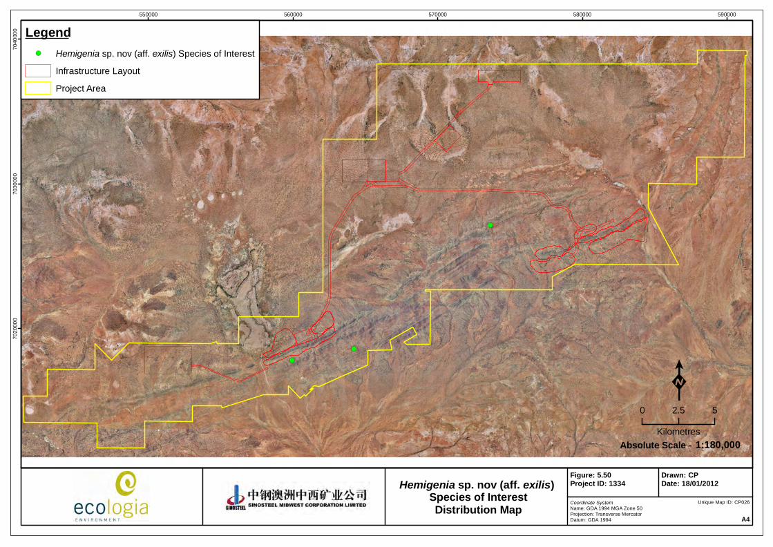
!(
!(
!(
550000 560000 570000 580000 59000070
2000
070
3000
070
4000
0 Legend!( Hemigenia sp. nov (aff. exilis) Species of Interest
Infrastructure Layout
Project Area
Coordinate SystemName: GDA 1994 MGA Zone 50Projection: Transverse MercatorDatum: GDA 1994 A4
Figure: 5.50Project ID: 1334
Drawn: CPDate: 18/01/2012
K0 2.5 5
Kilometres1:180,000Absolute Scale -
Unique Map ID: CP026
Hemigenia sp. nov (aff. exilis) Species of InterestDistribution Map
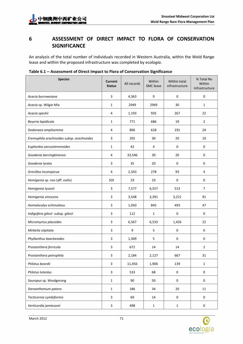
Sinosteel Midwest Corporation Ltd
Weld Range Rare Flora Management Plan
March 2012
71
6 ASSESSMENT OF DIRECT IMPACT TO FLORA OF CONSERVATION SIGNIFICANCE
An analysis of the total number of individuals recorded in Western Australia, within the Weld Range lease and within the proposed infrastructure was completed by ecologia.
Table 6.1 – Assessment of Direct Impact to Flora of Conservation Significance
Species Current Status
All records Within
SMC lease Within total infrastructure
% Total No Within
Infrastructure
Acacia burrowsiana 3 4,363 9 0 0
Acacia sp. Wilgie Mia 1 2949 2949 30 1
Acacia speckii 4 1,193 935 267 22
Beyeria lapidicola 1 771 686 19 2
Dodonaea amplisemina 4 806 618 191 24
Eremophila arachnoides subsp. arachnoides 3 205 30 20 10
Euphorbia sarcostemmoides 1 42 4 0 0
Goodenia berringbinensis 4 33,546 30 20 0
Goodenia lyrata 3 35 20 0 0
Grevillea inconspicua 4 2,343 278 93 4
Hemigenia sp. nov (aff. exilis) SOI 19 19 0 0
Hemigenia tysonii 3 7,577 6,557 513 7
Hemigenia virescens 3 3,548 3,391 3,221 91
Homalocalyx echinulatus 3 1,050 845 493 47
Indigofera gilesii subsp. gilesii 3 112 1 0 0
Micromyrtus placoides 3 6,567 6,533 1,426 22
Mirbelia stipitata 3 9 5 0 0
Phyllanthus baeckeoides 3 1,309 5 0 0
Prostanthera ferricola 3 672 14 14 2
Prostanthera petrophila 3 2,184 2,127 667 31
Ptilotus beardii 3 11,456 1,906 139 1
Ptilotus luteolus 3 533 68 0 0
Sauropus sp. Woolgorong 1 90 50 0 0
Stenanthemum patens 1 186 34 20 11
Tecticornia cymbiformis 3 69 14 0 0
Verticordia jamiesonii 3 498 1 1 0
Sinosteel Midwest Corporation Ltd
Weld Range Rare Flora Management Plan
March 2012
72
This page has been left blank intentionally

Sinosteel Midwest Corporation Ltd
Weld Range Rare Flora Management Plan
March 2012
73
7 POTENTIAL THREATS TO FLORA OF CONSERVATION SIGNIFICANCE
7.1 DIRECT LOSS OF FLORA OF CONSERVATION SIGNIFICANCE
Clearing of significant areas of vegetation is an unavoidable impact from the development of a mine and associated infrastructure that has the potential to impact the viability of rare flora. However, the impact can be minimised by considering the distribution of species of conservation significance during the design stage and locating infrastructure to avoid areas of higher significance whenever possible.
The distribution of each priority species relative to the infrastructure options are illustrated in Figures 5.2 to 5.50.
7.2 INDIRECT LOSS OF VEGETATION AND FLORA
Flora habitats can be impacted indirectly by increased activity in an area leading to increased dust, fire or the introduction and / or spread of weeds. Erosion and soil compaction can result from off road driving. The use of saline water in construction and ongoing operations, the disposal of water generally (both saline and fresh water), and alterations to surface water flow and groundwater levels can all result in alterations to vegetation composition and reduced viability for flora of conservation significance.
7.2.1 Dust
The use of vehicles/ machinery in earthworks operations will result in dust emissions. Examples of activities that will result in dust include (but are not limited to) heavy and light vehicle movements, excavation and loading activities, material dumping, wind blown dust generation from soil stockpiles and blasting.
Excessive dust can impact plants by clogging stomata, restricting respiration and transpiration and resulting in localised deaths. Excessive dust is most likely to occur at the edges of tracks and at the boundaries of pits and waste dumps. Dust suppression by watering tracks under dry conditions or periods of heavy traffic can reduce this impact, however the water used must not be excessively saline or incremental salinisation of the surrounding soil may occur.
7.2.2 Accidental Bushfires
Fires are a frequent occurrence in the arid zones of Australia. Ground truthing and examination of the aerial photography of the Weld Range area indicates that the area has been burnt infrequently in recent times. Spot fires are known to occur during the summer months, predominantly through lightning strikes. Although the native flora is adapted and in many instances dependent upon fire for activation of seed germination, too frequent or high intensity bushfires can result in detrimental changes to the composition and diversity of the vegetation causing local extinctions of vulnerable species.
7.2.3 Introduction of Weed Species
To date few weeds have been recorded at Weld Range. Six weed species were recorded during the surveys conducted by ecologia, all of which were in low numbers. Increased vehicle movements, combined with increased ground disturbance and disposal of water from drilling and dust

Sinosteel Midwest Corporation Ltd
Weld Range Rare Flora Management Plan
March 2012
74
suppression operations, will provide an opportunity for additional species to become established unless strict weed hygiene procedures are implemented. These species may out compete the local flora, including species of conservation significance.
7.2.4 Erosion and Compaction due to Off‐Road Driving
Many of the landforms at Weld Range are susceptible to damage from off‐road driving. The vegetation of the extensive sand plains and clay pans, which are flat and relatively sparsely vegetated, are conducive to off road driving. However soil compaction as a result can impede the re‐establish of plants in these areas. The risk of damage to the vegetation can be avoided by implementing and maintaining a strict ban on off‐road driving.
7.2.5 Effects of Saline Water used in Construction and Operation
The use of saline water in dust suppression along haul roads is common practice at mine sites across Western Australia. Salts in the water help to bind the soil and further reduce the dust particles released into the environment from vehicle movement.
Salts tend to accumulate on or near the soil surface in arid environments due to reduced annual rainfall regularly leeching the salts away (Bertuch et al, 2004). These concentrated salts can then be distributed into the environment during rainfall events and lead to localised impacts to vegetation adjacent to the haul road and access tracks. Drainage culverts and naturally occurring drainage lines along the access tracks distribute the saline water away and extend the range of the impact.
High concentrations of salts affect plants by reducing the amount of water taken up by the root system. This can lead to severe stress and eventually death. Localised plant deaths and changes in vegetation community structures could potentially occur with the use of saline water for dust suppression and salt tolerant and halophytic (salt loving) species could replace the less salt tolerant species.
Regional modelling of groundwater levels and sampling of the water at a number of bores at and in the vicinity of Weld Range suggests that regional groundwater is fresh (TDS<500 mg/L) to marginal (500 to 1,500 mg/L). However, the salinity at one borehole located in the proposed Madoonga pit area was very high, 46,000 mg/L (SRK, 2008). Discharge of saline water of this concentration into the surrounding environment would have detrimental effects on the vegetation.
7.2.6 Effects of Groundwater Discharge
Saline and fresh water produced by dewatering activities at Beebyn and Madoonga will be piped to lined evaporation ponds located to the north west of the Madoonga pit and dump. Salt produced as a result will be removed from site. This treatment should ensure that groundwater discharge does not impact flora of conservation significance, provided no breaches to the pond lining or bunds occur.
7.2.7 Effects from Altered Surface Water Flow
Most of the vegetation of the project area utilises surface water for all of its water needs. Mulga (Acacia aneura) has an extensive shallow root system which harvests surface water and hence is particularly affected by alterations to surface water flow. Flora of conservation significance could be directly impacted by localised changes to surface hydrology, either by water starvation or ponding. Significant changes to the vegetation structure (e.g. mulga deaths) would also indirectly affect the survival of flora of conservation significance, e.g. by a reduction in shade.

Sinosteel Midwest Corporation Ltd
Weld Range Rare Flora Management Plan
March 2012
75
7.2.8 Effects on Groundwater Dependent Ecosystems (GDEs)
Alterations to groundwater levels resulting from borefield pumping can affect the phreatophytic vegetation that occurs in these areas. Vegetation dependent on groundwater for all or part of the year can be adversely affected by lowered groundwater levels. The effects depend on the timing and modification of water abstraction, and the magnitude and rate of drawdown. Although none of the flora of conservation significance recorded at Weld Range are likely to be phreatophytic, changes to the vegetation structure may indirectly impact species.
7.3 IMPACTS TO SPECIFIC FLORA OF CONSERVATION SIGNIFICANCE
The potential impacts and recommendations to ameliorate the impact are listed below in Table 7.1 for each taxon of conservation significance known to occur within the SMC leases. This is provided within the context of their current distribution relative to proposed infrastructure.
Species that will have greater than 10 % of all known individuals impacted are highlighted in orange and those at risk of local extinction if populations are not carefully managed are highlighted in yellow.

Sinosteel Midwest Corporation Ltd
Weld Range Rare Flora Management Plan
March 2012
76
Table 7.1 Specific threats for priority species.
Species Status Threat Details Recommendation
Acacia sp. Wilgie Mia
P1 Vegetation Clearing
Just over one percent of all currently known locations of Acacia sp. Wilgie Mia are in the direct footprint of the haul road, pits and Madoonga waste dump. These individuals would be cleared upon the within the proposed infrastructure.
Seeds from plants within the alignment of the proposed infrastructure to be cleared should be collected and stored following the Australian Plant Germplasm Guidelines.
Alignment of roads should be positioned to minimise the number of plants impacted.
Given the impact of the proposed development on the current species a regional survey should be conducted to locate any additional individuals before development and approvals.
Boundaries of pits and waste dumps must be strictly adhered to so the area of impact is minimised.
Dust Some individuals of Beyeria lapidicola are near the alignment of the haul road. Upon and following construction these individuals will need to be monitored and managed for dust.
Dust suppression techniques such as watering tracks should be undertaken in dry conditions and at times of heavy vehicle use. The water used must not be excessively saline.
Populations should be monitored regularly and data on distribution, abundance, plant health should be recorded in threatened species register.
Beyeria lapidicola P1
Vegetation clearing
Individuals of Beyeria lapidicola occur on southern sections of the haul road as well as in some pits. These individuals will be cleared on construction/ development.
Seeds of the individual to be removed should be collected and stored following the Australian Plant Germplasm Guidelines.
Euphorbia sarcostemmoides
P1 Individuals of Euphorbia sarcostemmoides are away from the haul road and pits and should not be impacted by the development of indicated infrastructure.
Sauropus sp. Woolgrong
P1 Dust Several individuals of Sauropus sp. Woolgorong occur in close proximity of the haul road. Upon and following construction these individuals will need to be monitored and managed for dust.
Dust suppression techniques such as watering tracks should be undertaken in dry conditions and at times of heavy vehicle use. The water used must not be excessively saline.
Populations should be monitored regularly and data on distribution, abundance, plant health should be recorded in threatened species register.

Sinosteel Midwest Corporation Ltd
Weld Range Rare Flora Management Plan
March 2012
77
Species Status Threat Details Recommendation
Stenanthemum patens
P1 Vegetation clearing
Eleven percent of all known individuals of Stenanthemum patens occur within the proposed infrastructure at Weld Range and will be cleared upon construction.
Seeds from plants within the alignment of the proposed infrastructure to be cleared should be collected and stored following the Australian Plant Germplasm Guidelines.
Given the impact of the proposed development on the current species a regional survey should be conducted to locate any additional individuals before development and approvals.
Boundaries of pits and waste dumps must be strictly adhered to so the area of impact is minimised.
Acacia burrowsiana
P3 Individuals of Acacia burrowsiana are away from the haul road and pits and should not be impacted by the development of indicated infrastructure.
Goodenia lyrata P3 Dust/
Vegetation clearing
The populations of Goodenia lyrata at Weld Range are the only individuals within > 500 km. The locations within Weld Range are very close to the Madoonga waste dump and need to be monitored and managed for dust as well as ensuring that the boundary of the dump does not exceed planned boundaries. Disturbance to these individuals could lead to local extinction
Dust suppression techniques such as watering tracks should be undertaken in dry conditions and at times of heavy vehicle use. The water used must not be excessively saline.
Populations should be monitored regularly and data on distribution, abundance, plant health should be recorded in threatened species register.
Vegetation clearing
Some individuals of Hemigenia tysonii are in the direct footprint of the haul road, pits and Madoonga waste dump. These individuals would be cleared upon construction.
Any vegetation clearing must occur within clearly defined boundaries and these boundaries must not be exceeded. Alignment of roads should be positioned to minimise the number of plants impacted.
Hemigenia tysonii P3
Dust Some individuals of Hemigenia tysonii are close to the haul road, pits and Madoonga waste dump. Upon and following construction these individuals will need to be monitored and managed for dust.
Dust suppression techniques such as watering tracks should be undertaken in dry conditions and at times of heavy vehicle use. The water used must not be excessively saline.
Populations should be monitored regularly and data on distribution, abundance, plant health should be recorded in threatened species register.
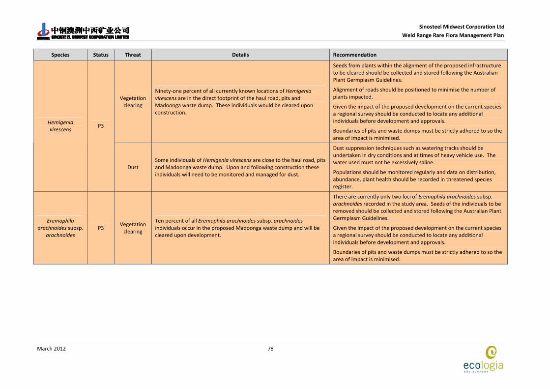
Sinosteel Midwest Corporation Ltd
Weld Range Rare Flora Management Plan
March 2012
78
Species Status Threat Details Recommendation
Vegetation clearing
Ninety‐one percent of all currently known locations of Hemigenia virescens are in the direct footprint of the haul road, pits and Madoonga waste dump. These individuals would be cleared upon construction.
Seeds from plants within the alignment of the proposed infrastructure to be cleared should be collected and stored following the Australian Plant Germplasm Guidelines.
Alignment of roads should be positioned to minimise the number of plants impacted.
Given the impact of the proposed development on the current species a regional survey should be conducted to locate any additional individuals before development and approvals.
Boundaries of pits and waste dumps must be strictly adhered to so the area of impact is minimised.
Hemigenia virescens
P3
Dust Some individuals of Hemigenia virescens are close to the haul road, pits and Madoonga waste dump. Upon and following construction these individuals will need to be monitored and managed for dust.
Dust suppression techniques such as watering tracks should be undertaken in dry conditions and at times of heavy vehicle use. The water used must not be excessively saline.
Populations should be monitored regularly and data on distribution, abundance, plant health should be recorded in threatened species register.
Eremophila arachnoides subsp.
arachnoides P3
Vegetation clearing
Ten percent of all Eremophila arachnoides subsp. arachnoides individuals occur in the proposed Madoonga waste dump and will be cleared upon development.
There are currently only two loci of Eremophila arachnoides subsp. arachnoides recorded in the study area. Seeds of the individuals to be removed should be collected and stored following the Australian Plant Germplasm Guidelines.
Given the impact of the proposed development on the current species a regional survey should be conducted to locate any additional individuals before development and approvals.
Boundaries of pits and waste dumps must be strictly adhered to so the area of impact is minimised.

Sinosteel Midwest Corporation Ltd
Weld Range Rare Flora Management Plan
March 2012
79
Species Status Threat Details Recommendation
Vegetation clearing
Forty‐seven percent of all known individuals of Homalocalyx echinulatus are in the direct path of the pits and Madoonga waste dump and would be cleared upon construction.
Seeds from plants within the alignment of the proposed infrastructure to be cleared should be collected and stored following the Australian Plant Germplasm Guidelines.
Alignment of roads should be positioned to minimise the number of plants impacted.
Given the impact of the proposed development on the current species a regional survey should be conducted to locate any additional individuals before development and approvals.
Boundaries of pits and waste dumps must be strictly adhered to so the area of impact is minimised.
Homalocalyx echinulatus
P3
Dust Some individuals of Homalocalyx echinulatus are located close to the haul road. Upon and following construction these individuals will need to be monitored and managed for dust.
Dust suppression techniques such as watering tracks should be undertaken in dry conditions and at times of heavy vehicle use. The water used must not be excessively saline.
Populations should be monitored regularly and data on distribution, abundance, plant health should be recorded in threatened species register.
Indigofera gilesii subsp. gilesii
P3 This record is away from the haul road and pits and should not be impacted by the development of indicated infrastructure.
Vegetation clearing
Twenty‐two percent of all known individuals of Micromyrtus placoides are in the direct footprint of the haul road, pits and Madoonga waste dump. These individuals will be cleared upon construction.
Seeds from plants within the alignment of the proposed infrastructure to be cleared should be collected and stored following the Australian Plant Germplasm Guidelines.
Alignment of roads should be positioned to minimise the number of plants impacted.
Given the impact of the proposed development on the current species a regional survey should be conducted to locate any additional individuals before development and approvals.
Boundaries of pits and waste dumps must be strictly adhered to so the area of impact is minimised.
Micromyrtus placoides
P3
Dust Some individuals of Micromyrtus placoides are close to the haul road, pits and Madoonga waste dump. Upon and following construction these individuals will need to be monitored and managed for dust.
Dust suppression techniques such as watering tracks should be undertaken in dry conditions and at times of heavy vehicle use. The water used must not be excessively saline.
Populations should be monitored regularly and data on distribution, abundance, plant health should be recorded in threatened species register.

Sinosteel Midwest Corporation Ltd
Weld Range Rare Flora Management Plan
March 2012
80
Species Status Threat Details Recommendation
Mirbelia stipitata P3 Individuals of Mirbelia stipitata away from the haul road and pits and should not be impacted by the development of indicated infrastructure.
Phyllanthus baeckeoides
P3 Individuals of Phyllanthus baeckeoides away from the haul road and pits and should not be impacted by the development of indicated infrastructure.
Prostanthera ferricola
P3 Vegetation clearing
Fourteen individuals of Prostanthera ferricola are located within the proposed infrastructure and will be cleared upon construction.
These are the only individuals recorded for 100 km and removal would lead to local extinction.
Seeds from plants within the alignment of the proposed infrastructure to be cleared should be collected and stored following the Australian Plant Germplasm Guidelines.
Vegetation clearing
Thirty‐one percent of the 2,184 individuals occur within the proposed infrastructure at Weld Range.
Several individuals of Prostanthera petrophila are located on the haul road, pits and Madoonga waste dump footprint and will be cleared upon construction.
Seeds from plants within the alignment of the proposed infrastructure to be cleared should be collected and stored following the Australian Plant Germplasm Guidelines.
Alignment of roads should be positioned to minimise the number of plants impacted.
Given the impact of the proposed development on the current species a regional survey should be conducted to locate any additional individuals before development and approvals.
Boundaries of pits and waste dumps must be strictly adhered to so the area of impact is minimised.
Prostanthera petrophila
P3
Dust
Several individuals of Prostanthera petrophila are located near the haul road, pits and Madoonga waste dump. Upon and following construction these individuals will need to be monitored and managed for dust.
Dust suppression techniques such as watering tracks should be undertaken in dry conditions and at times of heavy vehicle use. The water used must not be excessively saline.
Populations should be monitored regularly and data on distribution, abundance, plant health should be recorded in threatened species register.
Ptilotus beardii P3 Vegetation clearing
Some individuals of Ptilotus beardii are very close to the infrastructure in the North.
Individuals of Ptilotus beardii that occur very close infrastructure in the north will need to be carefully monitored to ensure they are not cleared in construction.

Sinosteel Midwest Corporation Ltd
Weld Range Rare Flora Management Plan
March 2012
81
Species Status Threat Details Recommendation
Dust Some individuals of Ptilotus beardii are close to some infrastructure in the north. Upon and following construction these individuals will need to be monitored and managed for dust.
Dust suppression techniques such as watering tracks should be undertaken in dry conditions and at times of heavy vehicle use. The water used must not be excessively saline.
Populations should be monitored regularly and data on distribution, abundance, plant health should be recorded in threatened species register.
Ptilotus luteolus P3 Individuals of Phyllanthus baeckeoides away from the haul road and pits and should not be impacted by the development of indicated infrastructure.
Tecticornia cymbiformis
P3 Dust
The 14 individuals of this species has to date only been recorded to the immediate north of the proposed Madoonga waste dump within Weld Range. Upon and following construction these individuals will need to be intensively monitored and managed for dust.
Dust suppression techniques such as watering tracks should be undertaken in dry conditions and at times of heavy vehicle use. The water used must not be excessively saline.
Populations should be monitored regularly and data on distribution, abundance, plant health should be recorded in threatened species register.
Verticordia jamiesonii
P3 Vegetation clearing
The only loci of Verticordia jamiesonii is in direct footprint of a pit and will be removed upon construction. This is the only individual in the study area.
There is currently only a single loci of Verticordia jamiesonii recorded in the study area. Seeds of the individuals to be removed should be collected and stored following the Australian Plant Germplasm Guidelines.
A regional search of the area should be conducted to determine the distribution of this species in the region and locate any further populations.
Acacia speckii P4 Vegetation clearing
Twenty‐two percent of the known 1193 individuals of Acacia speckii are within the alignment of the proposed infrastructure.
Seeds from plants within the alignment of the proposed infrastructure to be cleared should be collected and stored following the Australian Plant Germplasm Guidelines.
Alignment of roads should be positioned to minimise the number of plants impacted.
Given the impact of the proposed development on the current species a regional survey should be conducted to locate any additional individuals before development and approvals.
Boundaries of pits and waste dumps must be strictly adhered to so the area of impact is minimised.

Sinosteel Midwest Corporation Ltd
Weld Range Rare Flora Management Plan
March 2012
82
Species Status Threat Details Recommendation
Dust Many individuals are close to the alignment of the haul road. Upon and following construction these individuals will need to be monitored and managed for dust.
Dust suppression techniques such as watering tracks should be undertaken in dry conditions and at times of heavy vehicle use. The water used must not be excessively saline.
Populations should be monitored regularly and data on distribution, abundance, plant health should be recorded in threatened species register.
Vegetation clearing
Twenty four percent of the 806 known individuals of Dodonaea amplisemina occur within the alignment of the proposed infrastructure and would be cleared upon development.
Seeds from plants within the alignment of the proposed infrastructure to be cleared should be collected and stored following the Australian Plant Germplasm Guidelines.
Alignment of roads should be positioned to minimise the number of plants impacted.
Given the impact of the proposed development on the current species a regional survey should be conducted to locate any additional individuals before development and approvals.
Boundaries of pits and waste dumps must be strictly adhered to so the area of impact is minimised.
Dodonaea amplisemina
P4
Dust Many more are close to the alignment of the haul road. Upon and following construction these individuals will need to be monitored and managed for dust.
Dust suppression techniques such as watering tracks should be undertaken in dry conditions and at times of heavy vehicle use. The water used must not be excessively saline.
Populations should be monitored regularly and data on distribution, abundance, plant health should be recorded in threatened species register.
Vegetation clearing
Two loci of Goodenia berringbinensis occur on the boundary of the Madoonga waste dump and care will need to be taken to ensure the alignment of the dump does not exceed boundaries upon construction or during maintenance.
Any vegetation clearing must occur within clearly defined boundaries and these boundaries must not be exceeded.
Goodenia berringbinensis
P4
Dust Two loci of Goodenia berringbinensis occur on the boundary of the Madoonga waste dump. Upon and following construction these individuals will need to be monitored and managed for dust.
Dust suppression techniques such as watering tracks should be undertaken in dry conditions and at times of heavy vehicle use. The water used must not be excessively saline.
Populations should be monitored regularly and data on distribution, abundance, plant health should be recorded in threatened species register.

Sinosteel Midwest Corporation Ltd
Weld Range Rare Flora Management Plan
March 2012
83
Species Status Threat Details Recommendation
Dust Some individuals of Grevillea inconspicua are close to the haul road. Upon and following construction these individuals will need to be monitored and managed for dust.
Dust suppression techniques such as watering tracks should be undertaken in dry conditions and at times of heavy vehicle use. The water used must not be excessively saline.
Populations should be monitored regularly and data on distribution, abundance, plant health should be recorded in threatened species register.
Grevillea inconspicua
P4
Vegetation clearing
Some individuals of Grevillea inconspicua are in the direct path of the pits and Madoonga waste dump and will be cleared upon construction.
Any vegetation clearing must occur within clearly defined boundaries and these boundaries must not be exceeded.
Dust
The status of this taxon is at present indeterminate pending further taxonomic investigations. Should the collections be recognised as a new species listing as a Priority 1 would be consistent with its known distribution.
Some individuals of Hemigenia sp. nov aff. exilis are located close to the boundary of one of the southern pits. Upon and following construction these individuals will need to be monitored and managed for dust.
Dust suppression techniques such as watering tracks should be undertaken in dry conditions and at times of heavy vehicle use. The water used must not be excessively saline.
Populations should be monitored regularly and data on distribution, abundance, plant health should be recorded in threatened species register.
Hemigenia sp. nov. aff. exilis
N/A
Unknown distribution
The conservation significance of this taxon is currently unresolved pending further taxonomic definition but needs to be regarded as of significance. Hemigenia sp. nov. aff. exilis has only been found in Weld Range and it’s distributions are unknown.
Should further taxonomic resolution confirm its status as a new species, targeted searches should be completed for this species to determine its regional distribution and abundance.

Sinosteel Midwest Corporation Ltd
Weld Range Rare Flora Management Plan
March 2012
84
This page has been left blank intentionally

Sinosteel Midwest Corporation Ltd
Weld Range Rare Flora Management Plan
March 2012
85
8 REFERENCES
Anand, R.R & Paine, M. (2002). Regolith geology of the Yilgarn Craton, Western Australia; implications for exploration. Australian Journal of Earth Sciences. Vol. 49(1). Pg 3.
Approved Conservation Advice for Conospermum toddii (2008). s226B of the Environment Protection and Biodiversity Conservation Act 1999. Approved by the Minister/Delegate of the Minister on 16/12/2008.
Atkins, K.J. (2010). Declared Rare and Priority Flora List. Department of Environment and Conservation, Perth, Western Australia. October, 2010.
Beard, J.S. (1976). Vegetation Survey of Western Australia – Murchison. Explanatory Notes and Map Sheet 5, 1:1,000,000 series. Vegetation Survey of Western Australia. University of Western Australia Press, Nedlands.
Bertuch, M. & van Etten, E. (2004). Mulga (Acacia aneura) death adjacent to haul roads in the northern Goldfields, Western Australia. Proceedings of the Australian Rangeland Society 13th Biennial Conference “Living in the Outback”(pp. 99‐106). Alice Springs Australian Rangeland Society, Alice Springs.
Bureau of Meteorology (2011). Accessed from: http://www.bom.gov.au/climate. Accessed February 2011.
Curry, P. J., Payne, A. L., Leighton, K. A., Henning, P., & Blood, D. A. (1994). An inventory and condition survey of the Murchison River catchment, Western Australia, Technical Bulletin No.84. Department of Agriculture Western Australia.
Department of Fisheries (2004). Aquaculture Groundwater Resource Atlas ‐ Gascoyne – Murchison. www.fish.wa.gov.au.
Desmond, A., Cowan, M. & Chant, A. (2001). Murchison 2 (MUR2 – Western Murchison subregion). IN: A Biodiversity Audit of Western Australia's 53 Biogeographical Subregions in 2002. The Department of Conservation and Land Management.
Elias, M. (1982). Belele Western Australia 1:250 000 Geological Series – Explanatory Notes. Geological Survey of Western Australia . Department of Mines Western Australia. Perth Western Australia.
Environment Australia (2007). Interim Biogeographic Regionalisation for Australia (IBRA) Available at http://www.environment.gov.au/parks/nrs/ibra/index.html
Government of Western Australia (2007). Strategic Review of the Conservation and Resource Values of the Banded Iron Formation of the Yilgarn Craton. Department of Environment and Conservation and Department of Industry and Resources.
Markey, A. S. & Dillon, S. J. (2008). Flora and vegetation of the banded iron formations of the Yilgarn Craton: the Weld Range. Science Division: Department of Environment and Conservation, Wanneroo, Western Australia.

Sinosteel Midwest Corporation Ltd
Weld Range Rare Flora Management Plan
March 2012
86
Offord, C. A. & Meagher, P.F. (2009). Plant Germplasm Conservation in Australia. Strategies and Guidelines for developing, managing and utilising ex situ collections. Australian Network for Plant Conservation Inc. (ANPC).
SRK Consulting (2008). Pre‐Feasibility Study Weld Range Iron Ore Project Hydrogeological Investigation and Modelling. Unpublished report for Sinosteel Midwest Management Pty. Ltd. October 2008.
Western Australian Herbarium, (2011). FloraBase. Department of Conservation and Land Management. www.florabase.wa.gov.au Accessed February 2011.
Wildlife Conservation Act 1950. Wildlife Conservation (Rare Flora) Notice 2008(2), Western Australian Government Gazette, August 2008.

Sinosteel Midwest Corporation Ltd
Weld Range Rare Flora Management Plan
March 2012
87
Appendix A Criteria for DEC DRF and Priority Listing
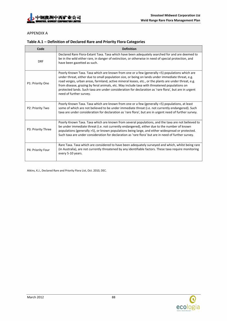
Sinosteel Midwest Corporation Ltd
Weld Range Rare Flora Management Plan
March 2012
88
APPENDIX A
Table A.1 – Definition of Declared Rare and Priority Flora Categories Code Definition
DRF
Declared Rare Flora‐Extant Taxa. Taxa which have been adequately searched for and are deemed to be in the wild either rare, in danger of extinction, or otherwise in need of special protection, and have been gazetted as such.
P1: Priority One
Poorly Known Taxa. Taxa which are known from one or a few (generally <5) populations which are under threat, either due to small population size, or being on lands under immediate threat, e.g. road verges, urban areas, farmland, active mineral leases, etc., or the plants are under threat, e.g. from disease, grazing by feral animals, etc. May include taxa with threatened populations on protected lands. Such taxa are under consideration for declaration as 'rare flora', but are in urgent need of further survey.
P2: Priority Two
Poorly Known Taxa. Taxa which are known from one or a few (generally <5) populations, at least some of which are not believed to be under immediate threat (i.e. not currently endangered). Such taxa are under consideration for declaration as 'rare flora', but are in urgent need of further survey.
P3: Priority Three
Poorly Known Taxa. Taxa which are known from several populations, and the taxa are not believed to be under immediate threat (i.e. not currently endangered), either due to the number of known populations (generally >5), or known populations being large, and either widespread or protected. Such taxa are under consideration for declaration as 'rare flora' but are in need of further survey.
P4: Priority Four
Rare Taxa. Taxa which are considered to have been adequately surveyed and which, whilst being rare (in Australia), are not currently threatened by any identifiable factors. These taxa require monitoring every 5‐10 years.
Atkins, K.J., Declared Rare and Priority Flora List, Oct. 2010, DEC.