Embed Size (px)
Citation preview
STUDY GUIDES 2013-2015
Master of Science Degree Course in Geo-information Science and Earth Observation for
Natural Resources Management
C13NRMMSc0116 September 2013 13 March 2015
University of Twente, Faculty ITC Bureau of Education and Research Services
COLOFON
UNIVERSITY OF TWENTE FACULTY OF GEO-INFORMATION SCIENCE AND EARTH OBSERVATIONBureau of Education and Research Services
DATE LAST MODIFIED22 April 2014
PUBLISHED VERSIONVersion 1.4
POSTAL ADDRESSPO Box 217 7500 AE Enschede
WEBSITEwww.itc.nl
COPYRIGHT© ITC, Faculty of GeoInformation Science and Earth Observation of the University ofTwente, The Netherlands.Text and numerical material from this publication may be reproduced in print, byphotocopying or by any other means with the permission of ITC if the source is mentioned.
PUBLISHED BYUniversity of TwenteFaculty of GeoInformation Science and Earth ObservationBureau of Education and Research Services
FOREWORD
DEAR PARTICIPANTS IN THE MSC PROGRAMME,
Welcome to the Faculty ITC of the University of Twente. Having left your family and country, you have come to ITC to further your education. We hope that the course you have selected, will fulfil your expectations.
Education in the Master of Science courses at ITC is characterised by: a mixture of theory and practice, often including participants' own experiences; a core curriculum for Remote Sensing (RS) and Geoinformation Systems (GIS), common for all MSc
students; deepening your knowledge in one of the domains; acquiring research skills; choice options according to individual (research) interests.
We are pleased to present you this study guide for the 2013/2014 Master of Science degree programme offered fulltime at the Faculty ITC in Enschede. This study guide gives you information on the MSc programme, an overview of the blocks and the detailed structure of content of the course modules. ITC offers the MSc programme in GeoInformation Science and Earth Observations in the following domains: Applied Earth Sciences (AES); Geoinformatics (GFM); Land Administration (LA); Natural Resources Management (NRM); Urban Planning and Management (UPM); Water Resources and Environmental Management (WREM).
But there is more to life at ITC than only education. You have arrived at a Faculty of the University of Twente with more than 300 students from over 70 countries. Furthermore, also ITC staff is originating from more than 25 countries: a truly international environment where you will be able to meet colleagues from all over the world. ITC is organising all sorts of social, cultural and sports activities. Wellknown are the International Sports Tournament, the International Food Festival and the International Cultural Event. We would like to encourage you to participate in many if not all of these events and to make new friends from around the world in the process.
We will do our best to provide you with the quality of education that you may expect from this Faculty of the University of Twente.
We wish you the best of success during your studies and a enjoyable stay at ITC and in the Netherlands.
Prof. Dr. Ir. A. VeldkampRector/Dean Faculty ITC

CONTENTS
INTRODUCTION .................................................................................................................................................................................1Course structure ..................................................................................................................................................................................3Teaching period ...................................................................................................................................................................................6Events, holidays and breaks ................................................................................................................................................................7Roles within the curriculum ..................................................................................................................................................................8Course objectives ..............................................................................................................................................................................10Teaching and learning approach .......................................................................................................................................................11Sources of information .......................................................................................................................................................................13
BLOCK 1: CORE MODULES ...........................................................................................................................................................15GI Science and Earth Observation: a process-based approach........................................................................................................17
BLOCK 2: COURSE MODULES ......................................................................................................................................................19Introduction to Natural Resources Management ...............................................................................................................................21System Analysis for NRM ..................................................................................................................................................................23Geo-information for NRM...................................................................................................................................................................25Mapping of Natural Resources ..........................................................................................................................................................27Monitoring of Natural Resources .......................................................................................................................................................29Causes and Impacts of Changing Resources ...................................................................................................................................31Societal Response and Reflection on NRM.......................................................................................................................................33
BLOCK 3: RESEARCH PROFILE ....................................................................................................................................................35Research Skills ..................................................................................................................................................................................37Advanced Topic(s) .............................................................................................................................................................................41Laser scanning ..................................................................................................................................................................................43Geostatistics ......................................................................................................................................................................................45Modelling natural resources degradation...........................................................................................................................................47Spatial data for disaster risk management ........................................................................................................................................49Applied geochemical and environmental monitoring .........................................................................................................................52Geophysics and 3D geo-visualization of the subsurface ...................................................................................................................54Geovisual analytics ............................................................................................................................................................................57Assessment of the effect of climate change on agro-ecological systems using optical and SAR remote sensing and GIS .............59Species Distribution Modeling (SDM) and climate change impact ....................................................................................................62RS/GIS analysis methods to support food and water security studies ..............................................................................................64Participatory mapping and GIS ..........................................................................................................................................................67Analysis of intra-urban, socio-spatial patterns ...................................................................................................................................69Advanced urban land use change and modeling...............................................................................................................................71Integrated assessment: Applying principles of cost benefit analysis and economics in spatial planning ..........................................74HYDROSAT: Observing the water cycle from space.........................................................................................................................77Design and implementation of spatial databases ..............................................................................................................................79Advanced Topic(s) .............................................................................................................................................................................813D Geo-information from imagery .....................................................................................................................................................83Advanced image analysis ..................................................................................................................................................................85Advanced geostatistics ......................................................................................................................................................................87Data analysis in earth, water and natural resources studies .............................................................................................................89Building infrastructures for geo-information sharing ..........................................................................................................................91Spatial-temporal analytics and modelling ..........................................................................................................................................93Strategic Environmental Assessment (SEA) and Environmental Impact Assessment (EIA) applying spatial decision support tools95Spatial-temporal models for food and water security studies ............................................................................................................97Land governance .............................................................................................................................................................................100
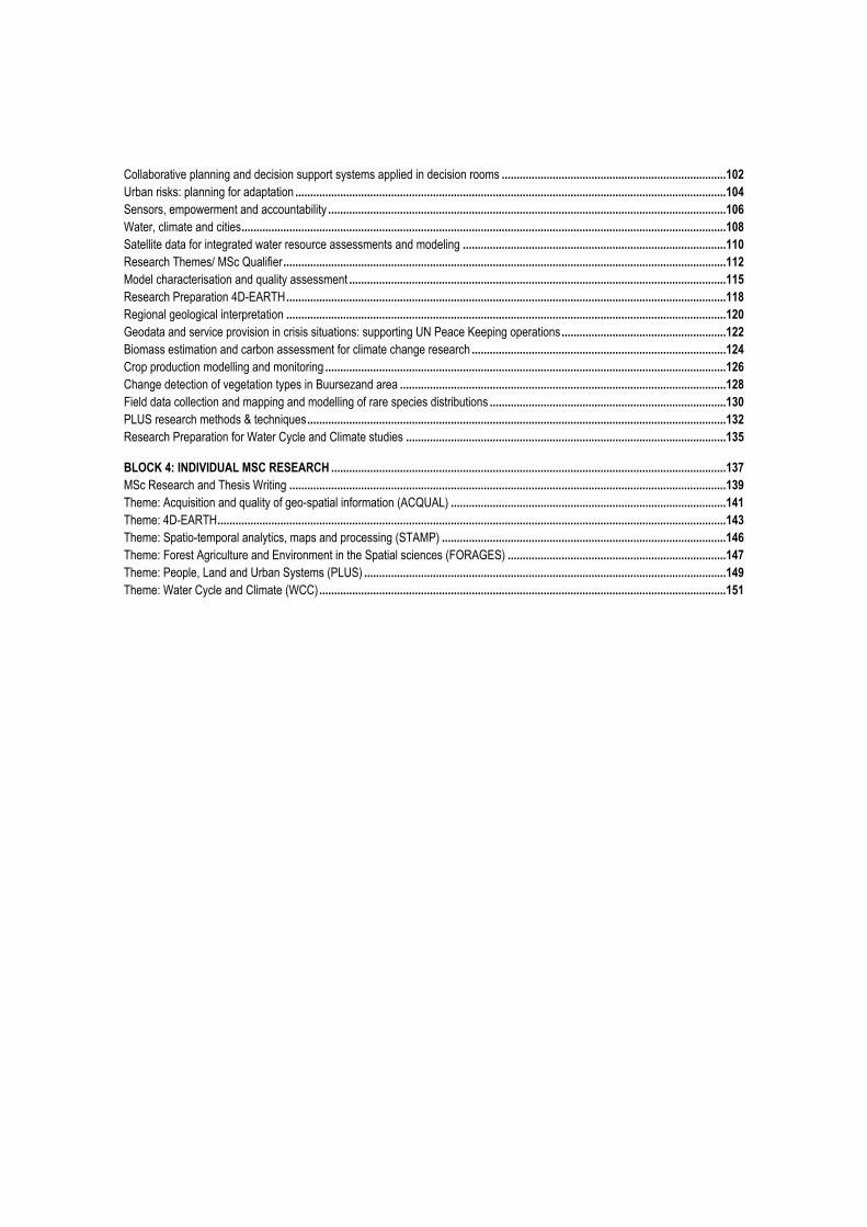
Collaborative planning and decision support systems applied in decision rooms ...........................................................................102Urban risks: planning for adaptation ................................................................................................................................................104Sensors, empowerment and accountability .....................................................................................................................................106Water, climate and cities..................................................................................................................................................................108Satellite data for integrated water resource assessments and modeling ........................................................................................110Research Themes/ MSc Qualifier ....................................................................................................................................................112Model characterisation and quality assessment ..............................................................................................................................115Research Preparation 4D-EARTH ...................................................................................................................................................118Regional geological interpretation ...................................................................................................................................................120Geodata and service provision in crisis situations: supporting UN Peace Keeping operations .......................................................122Biomass estimation and carbon assessment for climate change research .....................................................................................124Crop production modelling and monitoring ......................................................................................................................................126Change detection of vegetation types in Buursezand area .............................................................................................................128Field data collection and mapping and modelling of rare species distributions ...............................................................................130PLUS research methods & techniques ............................................................................................................................................132Research Preparation for Water Cycle and Climate studies ...........................................................................................................135
BLOCK 4: INDIVIDUAL MSC RESEARCH ....................................................................................................................................137MSc Research and Thesis Writing ..................................................................................................................................................139Theme: Acquisition and quality of geo-spatial information (ACQUAL) ............................................................................................141Theme: 4D-EARTH..........................................................................................................................................................................143Theme: Spatio-temporal analytics, maps and processing (STAMP) ...............................................................................................146Theme: Forest Agriculture and Environment in the Spatial sciences (FORAGES) .........................................................................147Theme: People, Land and Urban Systems (PLUS) .........................................................................................................................149Theme: Water Cycle and Climate (WCC) ........................................................................................................................................151


INTRODUCTION

INTRODUCTION
3
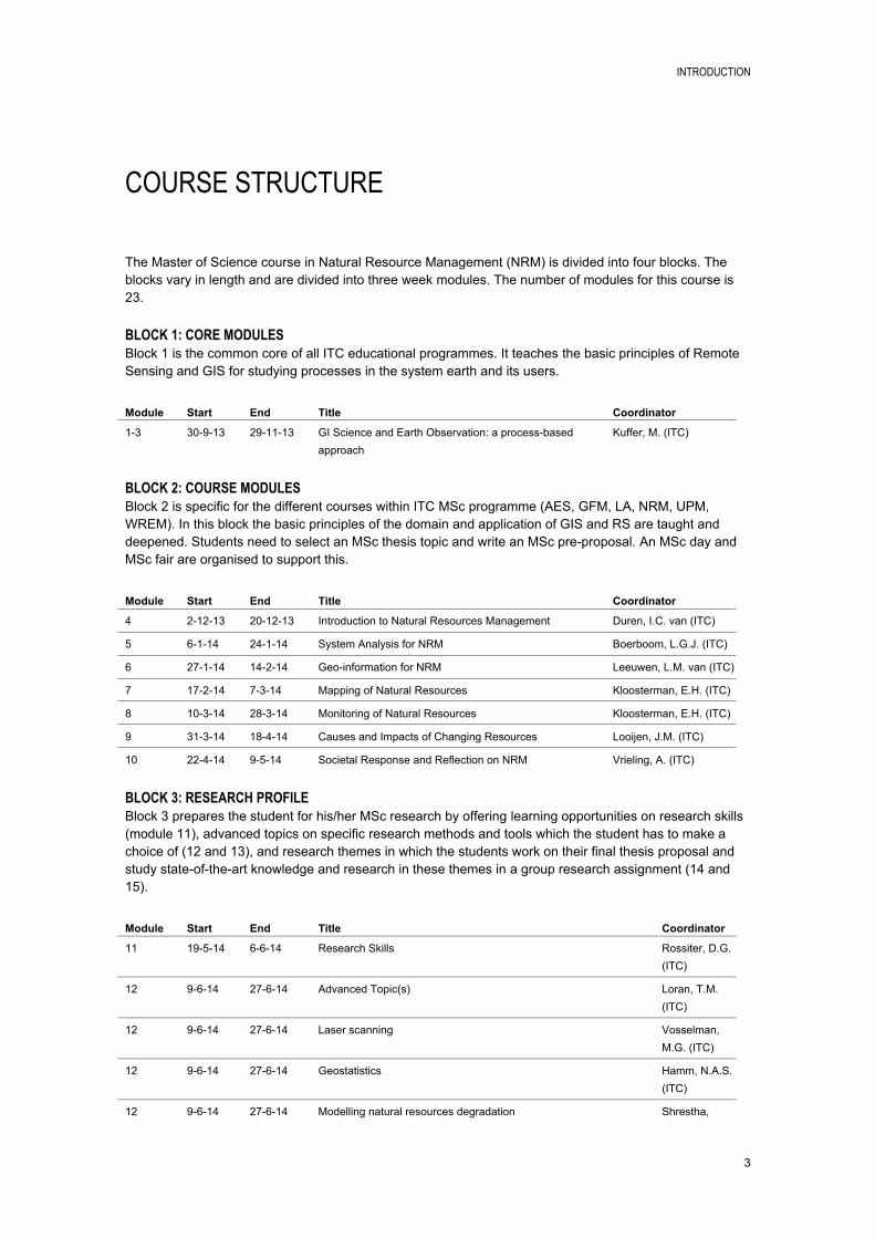
COURSE STRUCTURE
The Master of Science course in Natural Resource Management (NRM) is divided into four blocks. The blocks vary in length and are divided into three week modules. The number of modules for this course is 23.
BLOCK 1: CORE MODULESBlock 1 is the common core of all ITC educational programmes. It teaches the basic principles of Remote Sensing and GIS for studying processes in the system earth and its users.
Module Start End Title Coordinator
13 30913 291113 GI Science and Earth Observation: a processbased approach
Kuffer, M. (ITC)
BLOCK 2: COURSE MODULESBlock 2 is specific for the different courses within ITC MSc programme (AES, GFM, LA, NRM, UPM, WREM). In this block the basic principles of the domain and application of GIS and RS are taught and deepened. Students need to select an MSc thesis topic and write an MSc preproposal. An MSc day and MSc fair are organised to support this.
Module Start End Title Coordinator
4 21213 201213 Introduction to Natural Resources Management Duren, I.C. van (ITC)
5 6114 24114 System Analysis for NRM Boerboom, L.G.J. (ITC)
6 27114 14214 Geoinformation for NRM Leeuwen, L.M. van (ITC)
7 17214 7314 Mapping of Natural Resources Kloosterman, E.H. (ITC)
8 10314 28314 Monitoring of Natural Resources Kloosterman, E.H. (ITC)
9 31314 18414 Causes and Impacts of Changing Resources Looijen, J.M. (ITC)
10 22414 9514 Societal Response and Reflection on NRM Vrieling, A. (ITC)
BLOCK 3: RESEARCH PROFILEBlock 3 prepares the student for his/her MSc research by offering learning opportunities on research skills (module 11), advanced topics on specific research methods and tools which the student has to make a choice of (12 and 13), and research themes in which the students work on their final thesis proposal and study stateoftheart knowledge and research in these themes in a group research assignment (14 and 15).
Module Start End Title Coordinator
11 19514 6614 Research Skills Rossiter, D.G. (ITC)
12 9614 27614 Advanced Topic(s) Loran, T.M. (ITC)
12 9614 27614 Laser scanning Vosselman, M.G. (ITC)
12 9614 27614 Geostatistics Hamm, N.A.S. (ITC)
12 9614 27614 Modelling natural resources degradation Shrestha,
INTRODUCTION
4
D.B.P. (ITC)
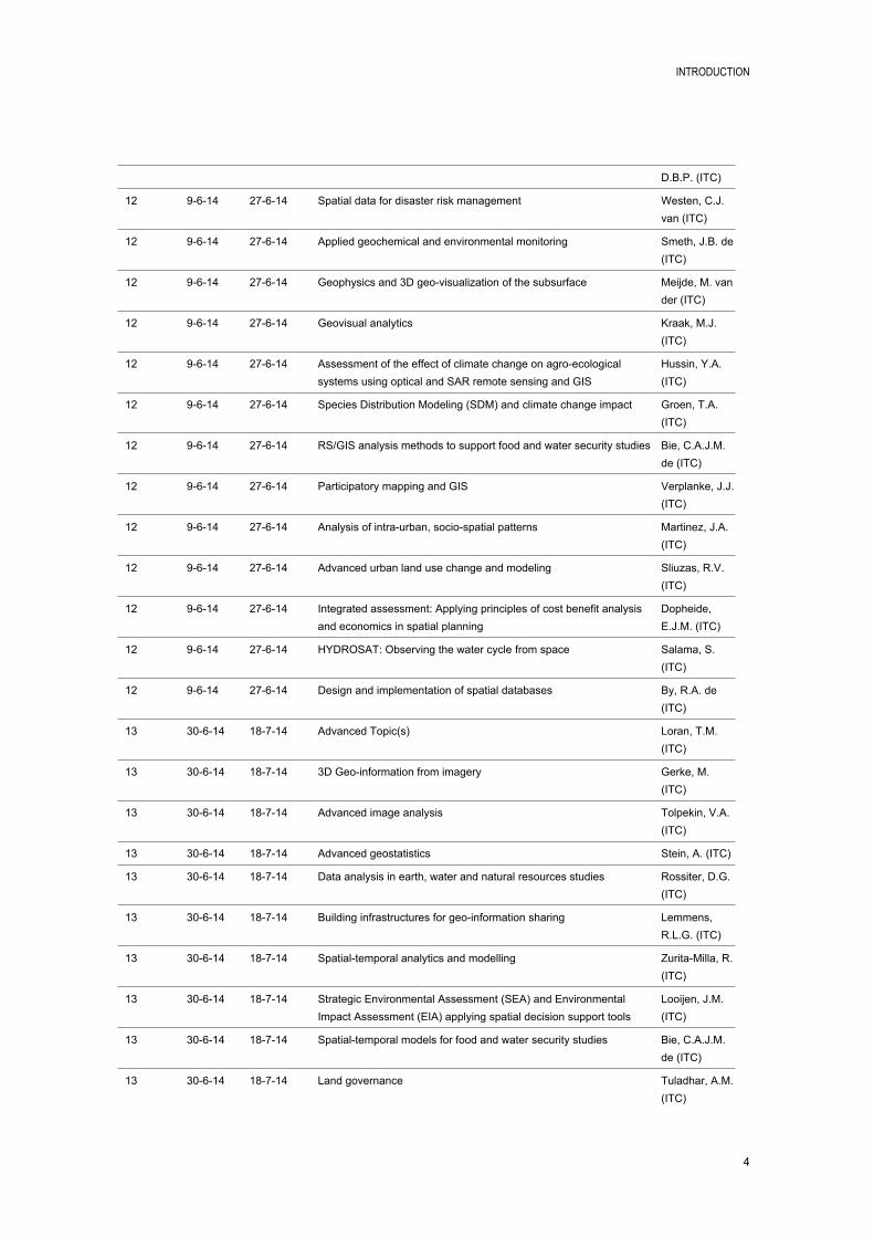
12 9614 27614 Spatial data for disaster risk management Westen, C.J. van (ITC)
12 9614 27614 Applied geochemical and environmental monitoring Smeth, J.B. de (ITC)
12 9614 27614 Geophysics and 3D geovisualization of the subsurface Meijde, M. van der (ITC)
12 9614 27614 Geovisual analytics Kraak, M.J. (ITC)
12 9614 27614 Assessment of the effect of climate change on agroecological systems using optical and SAR remote sensing and GIS
Hussin, Y.A. (ITC)
12 9614 27614 Species Distribution Modeling (SDM) and climate change impact Groen, T.A. (ITC)
12 9614 27614 RS/GIS analysis methods to support food and water security studies Bie, C.A.J.M. de (ITC)
12 9614 27614 Participatory mapping and GIS Verplanke, J.J. (ITC)
12 9614 27614 Analysis of intraurban, sociospatial patterns Martinez, J.A. (ITC)
12 9614 27614 Advanced urban land use change and modeling Sliuzas, R.V. (ITC)
12 9614 27614 Integrated assessment: Applying principles of cost benefit analysis and economics in spatial planning
Dopheide, E.J.M. (ITC)
12 9614 27614 HYDROSAT: Observing the water cycle from space Salama, S. (ITC)
12 9614 27614 Design and implementation of spatial databases By, R.A. de (ITC)
13 30614 18714 Advanced Topic(s) Loran, T.M. (ITC)
13 30614 18714 3D Geoinformation from imagery Gerke, M. (ITC)
13 30614 18714 Advanced image analysis Tolpekin, V.A. (ITC)
13 30614 18714 Advanced geostatistics Stein, A. (ITC)
13 30614 18714 Data analysis in earth, water and natural resources studies Rossiter, D.G. (ITC)
13 30614 18714 Building infrastructures for geoinformation sharing Lemmens, R.L.G. (ITC)
13 30614 18714 Spatialtemporal analytics and modelling ZuritaMilla, R. (ITC)
13 30614 18714 Strategic Environmental Assessment (SEA) and Environmental Impact Assessment (EIA) applying spatial decision support tools
Looijen, J.M. (ITC)
13 30614 18714 Spatialtemporal models for food and water security studies Bie, C.A.J.M. de (ITC)
13 30614 18714 Land governance Tuladhar, A.M. (ITC)

INTRODUCTION
5
13 30614 18714 Collaborative planning and decision support systems applied in decision rooms
Boerboom, L.G.J. (ITC)
13 30614 18714 Urban risks: planning for adaptation Flacke, J. (ITC)
13 30614 18714 Sensors, empowerment and accountability Georgiadou, P.Y. (ITC)
13 30614 18714 Water, climate and cities Timmermans, W.J. (ITC)
13 30614 18714 Satellite data for integrated water resource assessments and modeling
Rientjes, T.H.M. (ITC)
1415 28714 5914 Research Themes/ MSc Qualifier Loran, T.M. (ITC)
1415 28714 5914 Model characterisation and quality assessment Stein, A. (ITC)
1415 28714 5914 Research Preparation 4DEARTH Krol, B.G.C.M. (ITC)
1415 28714 5914 Regional geological interpretation Ruitenbeek, F.J.A. van (ITC)
1415 28714 5914 Geodata and service provision in crisis situations: supporting UN Peace Keeping operations
Ostermann, F.O. (ITC)
1415 28714 5914 Biomass estimation and carbon assessment for climate change research
Westinga, E. (ITC)
1415 28714 5914 Crop production modelling and monitoring Westinga, E. (ITC)
1415 28714 5914 Change detection of vegetation types in Buursezand area Westinga, E. (ITC)
1415 28714 5914 Field data collection and mapping and modelling of rare species distributions
Westinga, E. (ITC)
1415 28714 5914 PLUS research methods & techniques Groenendijk, E.M.C. (ITC)
1415 28714 5914 Research Preparation for Water Cycle and Climate studies Salama, S. (ITC)
BLOCK 4: INDIVIDUAL MSC RESEARCHIn Block 4 the student works individually on his/her MSc thesis. It is required to have an approved MSc research proposal before entering this block. Formal assessment will be given at the midterm presentation and at the final MSc exam.
Module Start End Title Coordinator
1623 8914 27215 MSc Research and Thesis Writing Loran, T.M. (ITC)
INTRODUCTION
6
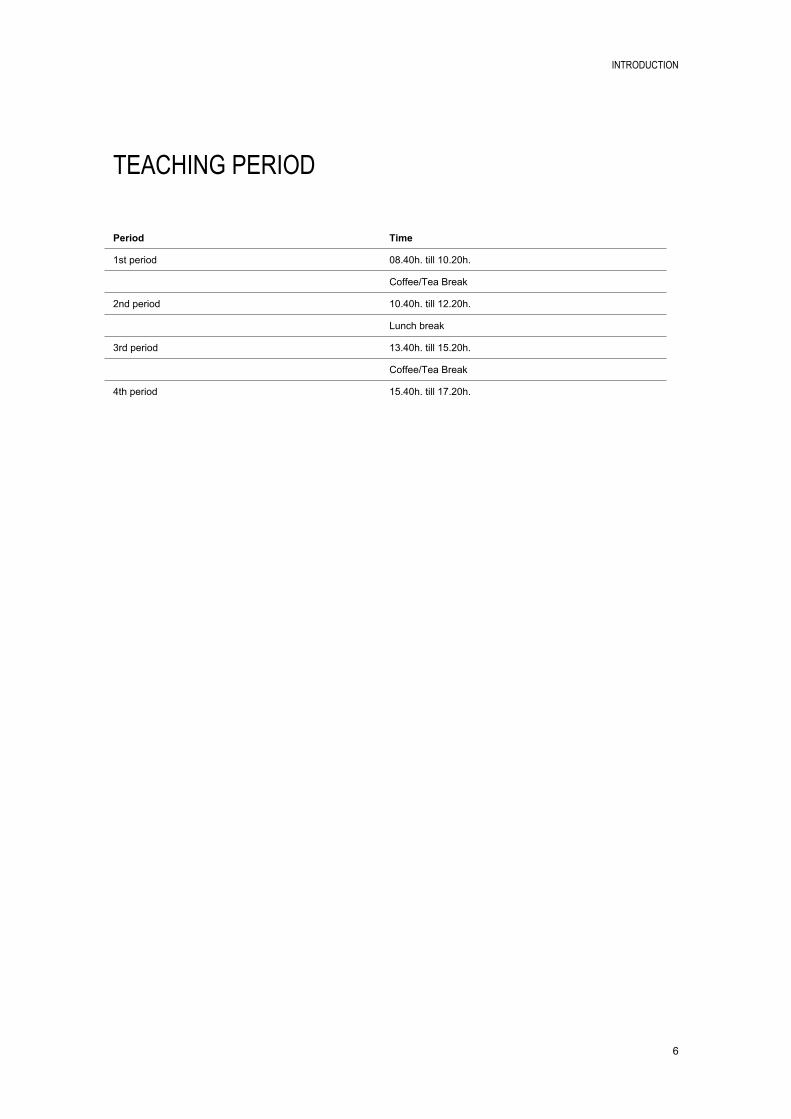
TEACHING PERIOD
Period Time
1st period 08.40h. till 10.20h.
Coffee/Tea Break
2nd period 10.40h. till 12.20h.
Lunch break
3rd period 13.40h. till 15.20h.
Coffee/Tea Break
4th period 15.40h. till 17.20h.
INTRODUCTION
7
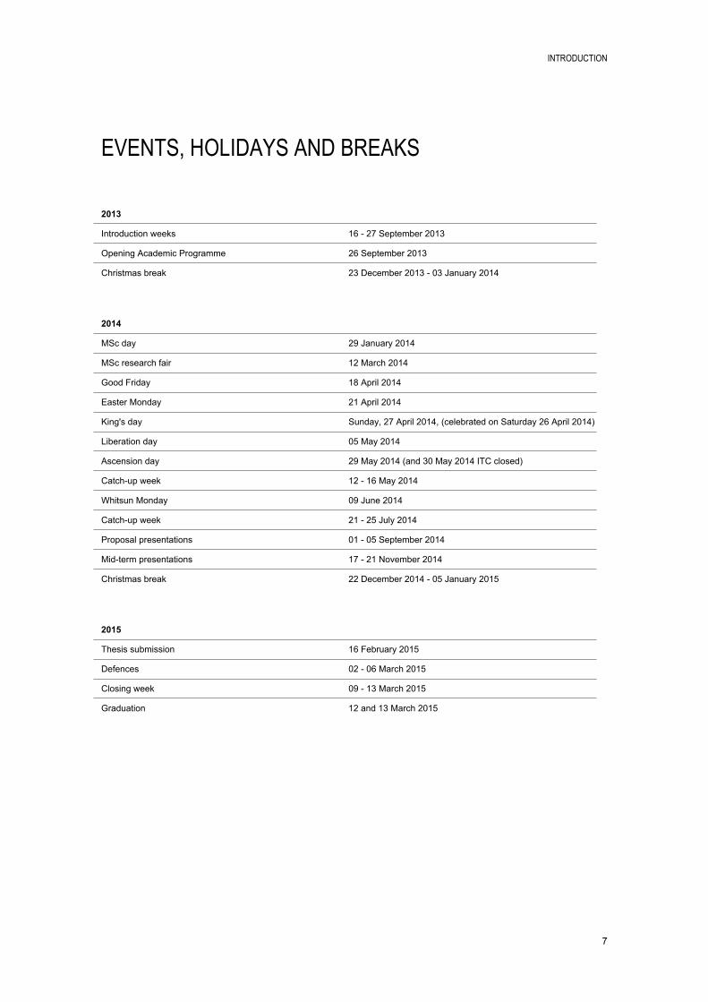
EVENTS, HOLIDAYS AND BREAKS
2013
Introduction weeks 16 27 September 2013
Opening Academic Programme 26 September 2013
Christmas break 23 December 2013 03 January 2014
2014
MSc day 29 January 2014
MSc research fair 12 March 2014
Good Friday 18 April 2014
Easter Monday 21 April 2014
King's day Sunday, 27 April 2014, (celebrated on Saturday 26 April 2014)
Liberation day 05 May 2014
Ascension day 29 May 2014 (and 30 May 2014 ITC closed)
Catchup week 12 16 May 2014
Whitsun Monday 09 June 2014
Catchup week 21 25 July 2014
Proposal presentations 01 05 September 2014
Midterm presentations 17 21 November 2014
Christmas break 22 December 2014 05 January 2015
2015
Thesis submission 16 February 2015
Defences 02 06 March 2015
Closing week 09 13 March 2015
Graduation 12 and 13 March 2015
INTRODUCTION
8
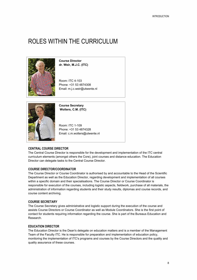
ROLES WITHIN THE CURRICULUM
Course Directordr. Weir, M.J.C. (ITC)
Room: ITC 4103Phone: +31 53 4874308Email: [email protected]
Course Secretary Wolters, C.M. (ITC)
Room: ITC 1109Phone: +31 53 4874328Email: [email protected]
CENTRAL COURSE DIRECTORThe Central Course Director is responsible for the development and implementation of the ITC central curriculum elements (amongst others the Core), joint courses and distance education. The Education Director can delegate tasks to the Central Course Director.
COURSE DIRECTOR/COORDINATORThe Course Director or Course Coordinator is authorised by and accountable to the Head of the Scientific Department as well as the Education Director, regarding development and implementation of all courses within a specific domain and their specialisations. The Course Director or Course Coordinator is responsible for execution of the courses, including logistic aspects, fieldwork, purchase of all materials, the administration of information regarding students and their study results, diplomas and course records, and course content archiving.
COURSE SECRETARYThe Course Secretary gives administrative and logistic support during the execution of the course and assists Course Directors or Course Coordinator as well as Module Coordinators. She is the first point of contact for students requiring information regarding the course. She is part of the Bureaus Education and Research.
EDUCATION DIRECTORThe Education Director is the Dean's delegate on education matters and is a member of the Management Team of the Faculty ITC. He is responsible for preparation and implementation of education policy, monitoring the implementation of ITC's programs and courses by the Course Directors and the quality and quality assurance of these courses.
INTRODUCTION
9
EXAMINATION BOARDThe Examination Board has to decide in an objective and professional manner whether a student has achieved all knowledge, skills and attitudes, as defined in the OER (Onderwijs en Examenregeling) to award a degree, diploma or certificate of a specific course. Therefore, the Examination Board monitors and is involved in all aspects of assessment; From policy on assessment (via appointment of assessors) to the decision about complaints related to assessment.
MODULE COORDINATOREach module is coordinated by a staff member of the Scientific departments. He or she is responsible for the organisation and execution of the entire module, and is first point of contact for staff when questions arise.
PROGRAM COMMITTEEThe Programme Committee advices the Dean and the Course Directors on any matter pertaining to ITC's Master level course and nondegree courses, implemented by the Course Directors. This includes advice on the curricula, quality assurance, education and assessment regulations and education policy.
PROPOSAL ASSESSMENT BOARDMSc students have to develop a research proposal for their thesis and defend this to the Proposal Assessment Board (PAB) at the end of Module 15 of the MSc programme. The PAB decides whether the research proposal is acceptable to ITC standards and complies with (inter)national standards. A positive decision of the PAB grants the MSc student entrance to Block 4, the research phase, of the MSc programme.
STUDENT ADVISOREach student is assigned a Student Advisor who can advice the student in studyrelated issues and can answer studyrelated questions. In many courses the Course Director or Course Coordinator has the role of Student Advisor.
SUPERVISOREach MSc student will be assigned to a Supervisor for the development of their research proposal and the execution of their thesis research.
THESIS ASSESSMENT BOARDThe Thesis Assessment Board is responsible for the assessment of the MSc thesis at the end of the MSc degree programme.
INTRODUCTION
10
COURSE OBJECTIVES
MASTER OF SCIENCE DEGREE PROGRAMMEAt successful completion of the Master of Science degree programme, the student is able to:1. Analyse problems encountered in professional practice and develop appropriate methods for studying
and/or solving these problems;2. Apply appropriate methods for collecting, acquiring and verifying spatial data;3. Use geoinformation science and earth observation to generate, integrate, analyse and display spatial
data;4. Evaluate and apply relevant and appropriate methods and models for data analysis and problem
solving;5. Apply research skills to formulate and carry out an independent research project;6. Communicate and defend findings of thesis work.
These objectives at programme level are worked out into objectives at course and module level.
NATURAL RESOURCES MANAGEMENTThe MSc course in Natural Resources Management (NRM) is designed for young and midcareer professionals who work in natural resources or environmental management and who wish to develop a critical understanding of, and competence in, modern methods of working with spatial data. The course aims to develop academic skills leading to independent research and the defence of an MSc thesis.
Sustainable development requires the implementation of policies for ecologically sound, economically viable and socially acceptable resource management. To achieve this, planners, managers and researchers must understand the complexity of factors involved in the management of natural resources. They must collect and interpret the required data and work together with specialists from other disciplines. A large amount of information is needed to make informed decisions about the planning and management of the use of land.
The MSc course in NRM not only emphasises the multidisciplinary aspects of natural resources management but also offers you the opportunity for indepth study in your particular field of interest, for example environmental science, spatial ecology, agriculture or forestry.
During the first block of the course, you will acquire knowledge and skills to enable you to apply geoinformation science and earth observation to natural resources management.
After this, in the second block, you will spend five months developing more indepth knowledge and technical skills in order to analyse problems and identify and structure relevant information in selected aspects of natural resources management. Following this period of indepth study you will continue to develop an understanding of the purpose and use of research in natural resources management and will study two advanced topics to support your planned research.
INTRODUCTION
11
TEACHING AND LEARNING APPROACH
The academic profile of the MSc programme puts strong emphasis on the scientific discipline, a scientific approach, basic intellectual skills, cooperation and communication and the temporal and social context of research. The emphasis on doing research and/or designing or developing new methods or techniques depends on the application domain.
Multidisciplinary research is an important focus for the MSc programme because (applied) research in practice seldom concerns one discipline but is more likely to be multidisciplinary. Students have to be prepared for that. Starting with a sound basis in their own domain they will be brought into learning situations in which students from different domains work together. It should be noted that most if not al research at ITC is already multidisciplinary in nature. This is evident in the wide scope of expertise within departments, and the common denominator to carry out applied research contributing towards development related issues as specified in ITC's mission.
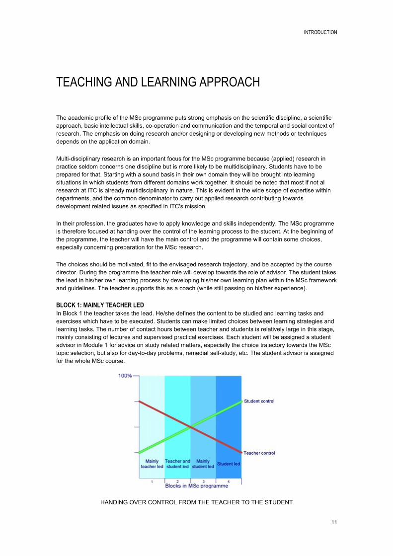
In their profession, the graduates have to apply knowledge and skills independently. The MSc programme is therefore focused at handing over the control of the learning process to the student. At the beginning of the programme, the teacher will have the main control and the programme will contain some choices, especially concerning preparation for the MSc research.
The choices should be motivated, fit to the envisaged research trajectory, and be accepted by the course director. During the programme the teacher role will develop towards the role of advisor. The student takes the lead in his/her own learning process by developing his/her own learning plan within the MSc framework and guidelines. The teacher supports this as a coach (while still passing on his/her experience).
BLOCK 1: MAINLY TEACHER LEDIn Block 1 the teacher takes the lead. He/she defines the content to be studied and learning tasks and exercises which have to be executed. Students can make limited choices between learning strategies and learning tasks. The number of contact hours between teacher and students is relatively large in this stage, mainly consisting of lectures and supervised practical exercises. Each student will be assigned a student advisor in Module 1 for advice on study related matters, especially the choice trajectory towards the MSc topic selection, but also for daytoday problems, remedial selfstudy, etc. The student advisor is assigned for the whole MSc course.
HANDING OVER CONTROL FROM THE TEACHER TO THE STUDENT
INTRODUCTION
12
BLOCK 2: TEACHER AND STUDENT LEDIn Block 2 both the teacher and the student take the lead. The teacher defines the framework in which the student can make his/her own choices about study tasks. The amount of choice options varies across the different courses (or streams). The student has to start thinking about his/her MSc research topic and consult staff about its feasibility. The number of contact hours between teacher and students is reduced in favour of group work and independent study and assignments.
DOMAIN MODULESIn the case of the MSc course in Natural Resources Management (NRM), the second block (modules 4 10) are taught in a multidisciplinary fashion to MSc and Postgraduate diploma participants together. Participants with particular interests (e.g. in spatial ecology, agriculture or forestry) will nevertheless be able to select from a number of practical exercises and assignments and choose the one most suited to their particular background and area of interest.
The teaching and learning in Block 2 is built loosely around the DPSIR framework (Driving ForcesPressuresStateImpactsResponses) for the assessment of environmental problems and the management of natural resources. Within this framework, modules 4 and 5 are closely related and examine the driving forces and pressures within the natural resources system. Modules 6, 7 and 8 are of a more technical nature and provide the knowledge and skills necessary to assess the state of the system. Modules 9 and 10 will examine techniques to infer causation from environmental data and to develop models to predict change in the state of the resource base in response to changes in the environment. At the conclusion of the block, participants focus on the potential and limitations, on the effectiveness of geoinformation in natural resources management and reflect on the role of the natural resources information specialist (i.e. as a typical ITC graduate) in the NRM process as a whole, and in a specific field such as spatial ecology, agriculture or forestry.
BLOCK 3: MAINLY STUDENT LEDIn Block 3 the student takes control by choosing advanced subjects and a research theme which fit within his/her MSc thesis topic. The student works on the final version of MSc research proposal and consults his student advisor and other specialised staff about its feasibility and quality. The final version of the MSc research proposal has to be presented and defended by the student for the Thesis Admission Committee. The number of contact hours between teacher and student is further reduced to make room for independent study by the student. Two MSc supervisors (first and second) are assigned for MSc supervision at the beginning of Block 3.
BLOCK 4: STUDENT LEDIn Block 4 the student works individually and independently on his/her MSc research project. This will be supported by meetings with the MSc supervisors and capita selecta meetings, organised by the research themes. The student is responsible for progress and quality of his/her own research project and its defence at the end. The number of contact hours between teacher and students is reduced to a minimum in this period. It is therefore wise to look for peer support and peer review opportunities in this phase, which is offered in the research theme where staff, PhD and MSc students are together.
INTRODUCTION
13
SOURCES OF INFORMATION
STUDY GUIDE IN DIGITAL FORMATwww.itc.nl/studyguide
ASSESSMENT REGULATIONSwww.itc.nl/assessmentregulations
ITCwww.itc.nl
UNIVERSITY OF TWENTEwww.utwente.nl/en

BLOCK 1: CORE MODULES

BLOCK 1: CORE MODULES
17
GI SCIENCE AND EARTH OBSERVATION: A PROCESS-BASED APPROACH
Module 1-3
Module code P13EDU111
Period 30 September 2013 29 November 2013
EC 15
Module coordinator MSc Kuffer, M. (ITC)
INTRODUCTIONThis block forms the basis of the MSc and PGD course at ITC. The concepts and techniques of Geographic Information Systems (GIS) and Earth Observation (EO) are addressed and put in context in relation to 'System Earth' and the user. As such the block consists of 4 interrelated parts: A theoretical part which focuses on the main principles of system theory, GIS, EO, data integration and
the role of the user; A practical part in which the knowledge gained can be applied and skills can be developed on
operation of industry standard software and tools; An application oriented part in which participants learn how to individually design and carry out
sequential data processing steps typical for the creation and use of basic GIS and EO methods; Introduction and development of academic skills.
The concepts and techniques introduced in this block will be further enhanced during subsequent modules within the course.
LEARNING OUTCOMESMain objective: Participants will be able to generate information from earth observation and data in Geo information Systems to support the study of processes in system earth and the role of individuals and organizations to manage these processes.
At the end of the block participants must be able to:1. Explain the main processes in system earth;2. Use earth observation by remote sensing to acquire geospatial data and produce information about
system earth;3. Process, generate, analyse and disseminate spatial data;4. Understand the use of process and observation models to describe earth processes;5. Describe the role of human beings as 'the users' at different levels of scale in the system earth;6. Have basic academic thinking, communication and learning skills.
CONTENTThe block covers a wide range of topics offered through lectures, practical exercises and guided discussions and cases. Theoretical knowledge is transferred in combination with the development of skills in software handling and applications.
PREREQUISITESAdmission to MSc/PGD or short course.
BLOCK 1: CORE MODULES
18
COMPULSORY TEXTBOOK(S)Stein et al (2011): GI Science and Earth Observation: a processbased approach, ITC, Enschede, The Netherlands. 2nd edition.
ALLOCATED TIME PER TEACHING AND LEARNING METHOD
Teaching / learning method Hours
Lectures 80
Supervised practicals 96
Unsupervised practicals 46
Individual assignment 0
Group assignment 40
Self study 155
Examination 15
Excursion 0
Fieldwork 0
Graduation project supervision
MSc thesis supervision
Development time
ASSESSMENTStudent performance evaluation during the core modules is done on the basis of a number of assignments and tests which will be combined into three overall assessments. Each of these overall assessments is assigned to one of the three modules as is shown in the table below. Module 1 will get the mark obtained from EO, and is composed of two assessment elements (one
graded assignment (30%) and one graded test (70%)); Module 2 will get the mark obtained from GI Science and modelling, and is composed of two
assessment elements (one graded assignment (30%) and one graded test (70%)); Module 3 will get the mark obtained from use and users, data integration, and the case study (one
graded assignment (30%) and one graded test(70%)).
Participation in the assessment elements is mandatory. A Fail or a mark of 0 will be assigned for those assessment elements which are not done.
The option to resit an assessment does not exist when the overall module mark is at least 60. If the overall module mark is below 60, a resit of a failed assignments and graded test is offered.
BLOCK 1: CORE MODULES
19
BLOCK 2: COURSE MODULES

BLOCK 2: COURSE MODULES
21
INTRODUCTION TO NATURAL RESOURCES MANAGEMENT
Module 4
Module code M13NRM117
Period 2 December 2013 20 December 2013
EC 5
Module coordinator dr. Duren, I.C. van (ITC)
INTRODUCTIONThis module has a multidisciplinary focus, which challenges the participants to develop a common basis for the assessment of the multiactor, multipurpose and multidisciplinary nature of Natural Resources Management (NRM), thus recognizing the complexity and conflicts involved in NRM issues. This is achieved through the sharing of the professional background of the participants and their functions in relation to the tasks and processes of NRM. The concepts derived from the individual experiences are then further developed into a more general framework.
Particular attention is given to highlighting the importance of geospatial data in the NRM processes. Participants are introduced to a selection of concepts, techniques and tools relevant to working with spatial information for natural resource management, both in the office and in the field. The module develops analytical reasoning and critical thinking when working with geographical data and products. This analytical reasoning and critical thinking will be further developed during Block 2 of the course.
LEARNING OUTCOMESUpon completion of the module, participants will be able to: Define NRM and explain their own professional contribution to it; Outline the complex nature of NRM and the major issues involved; Describe the role of sustainable development and NRM; Justify the need for multistakeholder approaches in NRM; Outline the principles/ approaches of collaborative NRM; Apply some relevant planning and management tools for NRM; Use basic descriptive statistics to analyse and describe data relating to natural resources; Describe geospatial information requirements in NRM.
Elements of the educational approach:The educational approach is based on the principles of experiencebased learning and adult education. This is done through reflecting upon the professional context of the participants` functions in relation to the tasks and processes of NRM. In line with the aim of the module, participants practice a multidisciplinary, teamwork, approach. The module is characterised by short presentations, individual and group exercises, "handson" learning, games and role play, video presentations, and field exercises. Participants are stimulated to contribute to an interactive learning environment.
CONTENTThe module covers the following topics: Natural resources and natural resources management; Actors and objectives in natural resources management; Conflicts and participation in NRM problem situations; Problem Structuring in NRM;
BLOCK 2: COURSE MODULES
22
Case of multisector NRM planning in the Netherlands; Introduction to disciplinary approaches and information requirements in NRM conflict situations; Introductory statistics.
PREREQUISITESModules 13 of the NRM MSc course.
COMPULSORY TEXTBOOK(S)Required : Users guide to the NRM module
ALLOCATED TIME PER TEACHING AND LEARNING METHOD
Teaching / learning method Hours
Lectures 10
Supervised practicals 20
Unsupervised practicals 20
Individual assignment 10
Group assignment 40
Self study 34
Examination 2
Excursion 0
Fieldwork 8
Graduation project supervision
MSc thesis supervision
Development time
ASSESSMENTParticipants will have to satisfactorily complete the various assignments given during the module and are required to demonstrate that they can perform satisfactorily in an interdisciplinary group work preparation, development of materials, and presentation.
In addition, the participant's understanding of statistics will be assessed by means of a written examination.
BLOCK 2: COURSE MODULES
23
SYSTEM ANALYSIS FOR NRM
Module 5
Module code M14NRM100
Period 6 January 2014 24 January 2014
EC 5
Module coordinator dr.ir. Boerboom, L.G.J. (ITC)
INTRODUCTIONThis module aims at introducing basic concepts and issues in Natural Resources Management (NRM). It provides the NRM context and a conceptual framework that will be emphasised throughout block 2. A systems approach to NRM will be applied.
LEARNING OUTCOMESAt the end of module 5, participants are able to: Describe, analyse and discuss the interaction between society, environment and production in relation
to NRM; Assess the organizational context within which the system is situated; Evaluate the potential of geoinformation and earth observation for management of ecological,
agricultural, and forest systems
And more specifically: Discuss the main concepts and issues in NRM; Adopt and adjust a framework for assessing NRM policies and interventions; Analyze a natural system in terms of cause and effect relations; Distinguish and apply approaches for scientific inference. Evaluate the potential of geoinformation and earth observation for the analysis of natural systems and
explicitly link this to the organization that uses or could use these technologies.
CONTENTMain concepts and issues in NRM, such as: Land use/ cover classification concepts, agroecological zoning; Biodiversity conventions and consequences; Landforms, major land resource areas, including soil and terrain characteristics; Global forest resource assessment; Food security issues and governance; Framework(s) for assessing NRM policies and interventions; Problem and systems analysis and application in a chosen field.
Application of geoinformation for the analysis of natural systems, such as: Problem analysis and problem structuring; System and situation analysis including organizational setting; Ecosystems analysis; Livelihood concept and analysis; Farming systems analysis; Natural resources degradation analysis; Introduction to basic statistical inference and its application; Introduction to scientific argumentation; Introduction to planning and decision support systems.
BLOCK 2: COURSE MODULES
24
PREREQUISITESModules 14 of the NRM MSc course.
ALLOCATED TIME PER TEACHING AND LEARNING METHOD
Teaching / learning method Hours
Lectures 44
Supervised practicals 28
Unsupervised practicals 28
Individual assignment 0
Group assignment 24
Self study 12
Examination 8
Excursion 0
Fieldwork 0
Graduation project supervision
MSc thesis supervision
Development time
ASSESSMENTWritten examination.
BLOCK 2: COURSE MODULES
25
GEO-INFORMATION FOR NRM
Module 6
Module code M14NRM101
Period 27 January 2014 14 February 2014
EC 5
Module coordinator ir. Leeuwen, L.M. van (ITC)
INTRODUCTIONSound management of natural resources requires adequate geoinformation about the spatial and temporal dimensions of the natural resource system, for example to assess the extent and condition of forest resources, to analyse ecological changes, to model food security scenarios and/ or to plan for intervention. Management of natural resources involves in most cases multiple stakeholders from various disciplines and institutions. This implies that sharing and exchange of data and information is crucial. To this effect, the internet plays an increasingly important role.
In this module, participants focus on the information and data requirements for analysis and management of a forestry, agricultural or ecological system. They learn to identify relevant stakeholders as potential data source and the information they may need from the information system. Participants identify and visualise data flows and critically assess the extent to which existing data meet the requirements. In a final case study they develop and implement a database for a particular management issue. This module expands upon proven methods and examines new approaches to database design and geoinformation handling for natural resources management.
LEARNING OUTCOMESOn completion of module 6, participants are able to specify information and data needs. They are able to design the structure of a geodatabase and implement this database to support management of forest resources, ecologically sensitive areas and food security. More specifically, participants can: Assess information requirements and translate these into specifications for spatial data and data
needs; Assess the suitability of existing spatial data to meet these needs; Search and explore data sources on the internet; Evaluate the quality of existing/ available data; Analyse data and information flows between stakeholders; Design a structure for a database for a forestry, agriculture or ecology case, implement this database
and demonstrate its applicability for a specific management problem; Demonstrate a scientific attitude towards geoinformation handling.
CONTENT Assessment of information requirements; Assessment of existing spatial databases; Data quality assessment and evaluation; Analysis of data flows and interactions between data users and producers; Interactive data dissemination and geoportals; Spatial database design.
PREREQUISITESModules 15 of the NRM MSc course.
BLOCK 2: COURSE MODULES
26
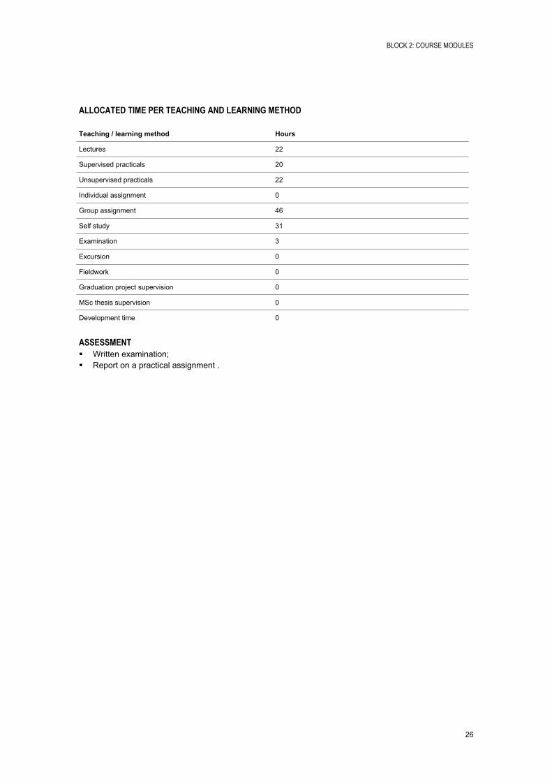
ALLOCATED TIME PER TEACHING AND LEARNING METHOD
Teaching / learning method Hours
Lectures 22
Supervised practicals 20
Unsupervised practicals 22
Individual assignment 0
Group assignment 46
Self study 31
Examination 3
Excursion 0
Fieldwork 0
Graduation project supervision 0
MSc thesis supervision 0
Development time 0
ASSESSMENT Written examination; Report on a practical assignment .
BLOCK 2: COURSE MODULES
27
MAPPING OF NATURAL RESOURCES
Module 7
Module code M14NRM102
Period 17 February 2014 7 March 2014
EC 5
Module coordinator drs. Kloosterman, E.H. (ITC)
INTRODUCTIONUnder the influence of driving forces, like population growth, economic growth and natural phenomena, human activities (e.g. industrial and agricultural activities) exercise pressure on the environment. This pressure results in a change, disturbance, or even degradation, of the state of our environment. Subsequently this change impacts the qualities and services of natural and cultural ecosystems (e.g. biological diversity, food supply and forest quality) on which we depend.
In order to warn for or model future situations and plan interventions a solid understanding of the distribution, interrelations and functioning in space and time of natural and cultural ecosystem is indispensible. This requires uptodate worldwide, regional and local data bases.
This module deals with the theory and practice of mapping the characteristics and spatial dimensions of natural and cultural eco(logical) systems using remote sensing and GIS and is structured around two different approaches to mapping the state of our environment, namely
i) a qualitative landscape guided approach, with emphasis on the interrelation between landscape properties and land cover/ land use and
ii) a physical based quantitative approach, where the focus lies on the relation between image characteristics (optical, laser, and microwave remote sensing) and image based indices (like NDVI) on the one hand and spatial object properties on the other. It includes field sampling design, field data collection and sampling statistics.
LEARNING OUTCOMESThis module prepares students to, based on a research question or project aim, identify and apply appropriate remote sensing and GIS techniques for mapping selected spatial characteristics of natural and cultural ecosystems, with special emphasis on agriculture, forestry or spatial ecology.
At the end of the module students will be able to: Select appropriate methods (qualitative empirical and/or quantitative physicalbased techniques) for
acquiring spatial data for the defined research question or project aim; Determine the required field data and design a (stratified) sampling scheme. Apply the selected methods of spatial data collection. Evaluate the quality / reliability of the acquired data; Demonstrate a scientific attitude towards using methods for earth observation and geoinformation
acquisition for mapping and monitoring of the environment.
CONTENT Regression analysis for RS based modeling of image characteristics and natural or cultural ecosystem
properties;
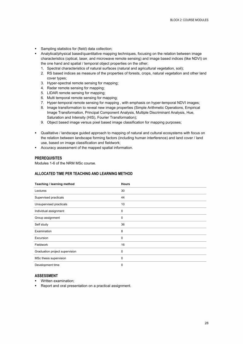
BLOCK 2: COURSE MODULES
28
Sampling statistics for (field) data collection; Analytical/physical based/quantitative mapping techniques, focusing on the relation between image
characteristics (optical, laser, and microwave remote sensing) and image based indices (like NDVI) on the one hand and spatial / temporal object properties on the other; 1. Spectral characteristics of natural surfaces (natural and agricultural vegetation, soil);2. RS based indices as measure of the properties of forests, crops, natural vegetation and other land
cover types;3. Hyperspectral remote sensing for mapping;4. Radar remote sensing for mapping;5. LIDAR remote sensing for mapping;6. Multi temporal remote sensing for mapping;7. Hypertemporal remote sensing for mapping , with emphasis on hypertemporal NDVI images;8. Image transformation to reveal new image properties (Simple Arithmetic Operations, Empirical
Image Transformation, Principal Component Analysis, Multiple Discriminant Analysis, Hue, Saturation and Intensity (HIS), Fourier Transformation);
9. Object based image versus pixel based image classification for mapping purposes;
Qualitative / landscape guided approach to mapping of natural and cultural ecosystems with focus on the relation between landscape forming factors (including human interference) and land cover / land use, based on image classification and fieldwork;
Accuracy assessment of the mapped spatial information.
PREREQUISITESModules 16 of the NRM MSc course.
ALLOCATED TIME PER TEACHING AND LEARNING METHOD
Teaching / learning method Hours
Lectures 30
Supervised practicals 44
Unsupervised practicals 10
Individual assignment 0
Group assignment 0
Self study 36
Examination 8
Excursion 0
Fieldwork 16
Graduation project supervision 0
MSc thesis supervision 0
Development time 0
ASSESSMENT Written examination; Report and oral presentation on a practical assignment.
BLOCK 2: COURSE MODULES
29
MONITORING OF NATURAL RESOURCES
Module 8
Module code M14NRM103
Period 10 March 2014 28 March 2014
EC 5
Module coordinator drs. Kloosterman, E.H. (ITC)
INTRODUCTIONUnder the influence of driving forces and in particular, population growth, economic growth and natural phenomena human activities (e.g. industrial and agricultural activities) exercise pressure on the environment. This pressure results in a change, disturbance, or even degradation, of the state of our environment. Subsequently this change impacts the qualities and services of natural and cultural ecosystems (e.g. biological diversity, food supply and forest quality) on which we depend. In order to warn for, or model future situations and plan interventions a solid understanding of the distribution, interrelations and functioning in space and time of natural and cultural ecosystem is indispensible. This requires uptodate worldwide, regional and local spatiotemporal data bases. This module deals with the theory and practice of monitoring the spatiotemporal characteristics of natural and cultural eco(logical) systems using remote sensing and GIS.
The first part of the module discusses the temporal characteristics of natural and cultural ecosystems, theory and practice of change detection including error propagation and how to analyze, map and interpret hyper temporal data. Module 8 further elaborates on the mapping approaches and techniques introduced in module 7.
The second part focuses on monitoring based on criteria selection and indicators of changes in the state of the environment as result of the pressure of human activities (impact) on natural and cultural ecosystems qualities and ecosystem services, within the context of project cycles and the Driving force Pressure State, Impact, Response model (DPSIR).
LEARNING OUTCOMESThis module prepares students to apply geoinformation and earth observation techniques (RS/GIS) for the monitoring of selected natural resources and their interrelationships, based on the selection of criteria and indicators. On completion of the module you will be able to: Apply the selected methods of spatiotemporal data collection for mapping temporal characteristics of
natural and cultural ecosystems and change detection; Evaluate the quality/ reliability of the acquired data; Understand the position of monitoring within the Driving force, Pressure State, Impact, Response
model (DPSIR) and project cycles; Identify and select criteria and indicators for monitoring; Demonstrate a scientific attitude towards using methods for earth observation and geoinformation
acquisition for mapping and monitoring of the environment.
CONTENTTemporal ecosystem characteristics Temporal aspects of spatial databases; Temporal characteristics of natural and agricultural ecosystems
Change in space and time (succession, modification and conversion); Time scales (long term, decades, seasonal, daily);
BLOCK 2: COURSE MODULES
30
Variability in ecosystems and change events (abrupt, gradual, categorical, continuum).
Mapping the temporal dimension Remote sensing and the temporal dimension (multi temporal images, hyper temporal imagery); Sequential mapping and change detection;
Radiometric, atmospheric and geometric correction; Land cover change detection (bi temporal vs. continuous time scale change detection, visual vs.
digital change detection, direct mathematical image differences, image regression, post classification change detection, change detection algorithms);
Sequential mapping and error propagation; Hypertemporal remote sensing (data preparation, interpretation and mapping), with emphasis on
hypertemporal NDVI images, cross correlation with existing maps and data mining for legend construction and NDVI classes for stratified field sampling.
Monitoring the impact of human activities on the environment Concepts and definitions; Monitoring in the context of DPSIR (Driving force, Pressure, State, Impact, Response model), Project
Cycles and LogFrames; Based on case studies identify, select and apply criteria and indicators for mapping and monitoring the
impact of human activities on the environment using the RS and GIS methods and techniques discussed previously.
PREREQUISITESModules 17 of the NRM MSc course.
ALLOCATED TIME PER TEACHING AND LEARNING METHOD
Teaching / learning method Hours
Lectures 30
Supervised practicals 56
Unsupervised practicals 14
Individual assignment 0
Group assignment 0
Self study 36
Examination 8
Excursion 0
Fieldwork 0
Graduation project supervision 0
MSc thesis supervision 0
Development time 0
ASSESSMENTWritten examination; Report and oral presentation on a practical assignment.
BLOCK 2: COURSE MODULES
31
CAUSES AND IMPACTS OF CHANGING RESOURCES
Module 9
Module code M14NRM104
Period 31 March 2014 18 April 2014
EC 5
Module coordinator drs. Looijen, J.M. (ITC)
INTRODUCTIONThe previous modules strengthened the ability to inventory natural resources and to detect and assess change such as human impacts on ecologically sensitive areas, deforestation and forest degradation and threats to food security due to decreased crop yields.
Addressing such negative changes requires understanding of the processes which degrade the environment. A mechanistic world view is the basis of commonly used methods to reverse resource degradation or alleviate its consequences.
Proper understanding of cause and effect in resource degradation is crucial to achieve this. Inference of causation, however, is a problem in environmental science because of the limited possibility of experimentation.
In this module, participants will study techniques to infer causation from environmental data and to develop models to predict change in the state of the resource base in response to changes in the environment.
LEARNING OUTCOMES The participants will develop an understanding of different classes of models of natural resources and
gain experience in their applicability and application; The participants focus more in depth on the use of methods and techniques in a particular modelling
context. This is done on the basis of 'guided choice'; Describe limitations of correlative statistics and select and apply appropriate techniques in
environmental science; Describe, select and apply various available techniques to predict impacts and consequences of
environmental change (dynamic modelling, scenario building); Apply these techniques in different case studies and critically assess the quality and uncertainty of the
resulting predictions.
CONTENTWhereas the preceding modules 7 and 8 placed emphasis on earth observation for mapping and monitoring, this module emphasizes the role of GIS as a tool for examining causes and impacts using models of natural resources. During the module, all participants study a range of generic approaches to infer causation from environmental data and to assess the possible impacts of change on the resource base. Throughout the module participants will be exposed to disciplinespecific examples.
1. Statistical techniques Correlation and simple, multiple and curvilinear regression analysis; Logistical regression; Collinearity.
BLOCK 2: COURSE MODULES
32
2. Predictive and dynamic process modellingA number of different models of natural resources will be presented, as well as specific issues related to working with these models. These models take different approaches to the description of the natural world, depending on the objectives of the model. These range from simple static models to dynamic process models. A discussion of elements of proper use is included, and special use cases such as Spatial Decision Support Systems are presented.
PREREQUISITESModules 18 of the NRM MSc course.
ALLOCATED TIME PER TEACHING AND LEARNING METHOD
Teaching / learning method Hours
Lectures 38
Supervised practicals 42
Unsupervised practicals 20
Individual assignment 15
Group assignment 0
Self study 26
Examination 3
Excursion 0
Fieldwork 0
Graduation project supervision 0
MSc thesis supervision
Development time
ASSESSMENT Written examination (statistics); Essay (comparison of two models).
BLOCK 2: COURSE MODULES
33
SOCIETAL RESPONSE AND REFLECTION ON NRM
Module 10
Module code M14NRM105
Period 22 April 2014 9 May 2014
EC 5
Module coordinator dr.ir. Vrieling, A. (ITC)
INTRODUCTIONPeople use natural resources. Conflicts can emerge when certain groups exploit resources in such a way that it causes adverse affects to others. Climate change, economic crises, or population dynamics can put sustainable exploitation systems further under stress. Societal groups respond to these changing threats in natural resource availability with initiatives, projects, policies (and sometimes wars). These can aim to prevent, reduce or mitigate pressures and negative impacts on desired states.
Following the DPSIR framework societal responses can be directed towards driving forces, pressures, state, or impact. Spatial information is needed to inform societal initiatives through mapping the natural resource availability, and monitoring of its changes. For example we need to know whether countries effectively avoid deforestation (which needs input from remote sensing) before being able to compensate countries for doing this (as under REDD+). Such information is needed from the local to the global scale.
This module marks the end of NRM block 2. The module starts with a short overview of the role of society in Natural Resource Management (NRM) at different spatial levels. During the remainder of the module participants will reflect on NRM through critical evaluation of methods and approaches that have been presented and discussed in block 2. This will be achieved through a small group project in which knowledge and skills gained so far are applied to a real NRM case. The main purpose is that participants reflect on the role of natural resources information specialists (i.e. as typical ITC NRM graduates) in the provision of spatial information to inform society, including local and globallevel decision makers. This should result in a critical attitude towards potential and limitations of earth observation and geoinformation in natural resources management.
LEARNING OUTCOMESBy the end of the module participants should be able to: Explain how spatial information and analysis informs society regarding changes in or threats to natural
resource availability; Identify real and potential societal responses to a specific NRM case following a DPSIR framework; Analyze the potential use of geoinformation and earth observation within the NRM case; Demonstrate an application of geoinformation and earth observation to the NRM case; Effectively organize group activities in producing a common end result; Write an individual concise and coherent summary report of the group activities carried out.
CONTENT Lectures on societal response and project work; 1day study trip as illustration to case studies and societal response in NRM in a Dutch setting; Project group work in which the content of former modules can be applied.
PREREQUISITESModules 19 of the NRM MSc course.
BLOCK 2: COURSE MODULES
34
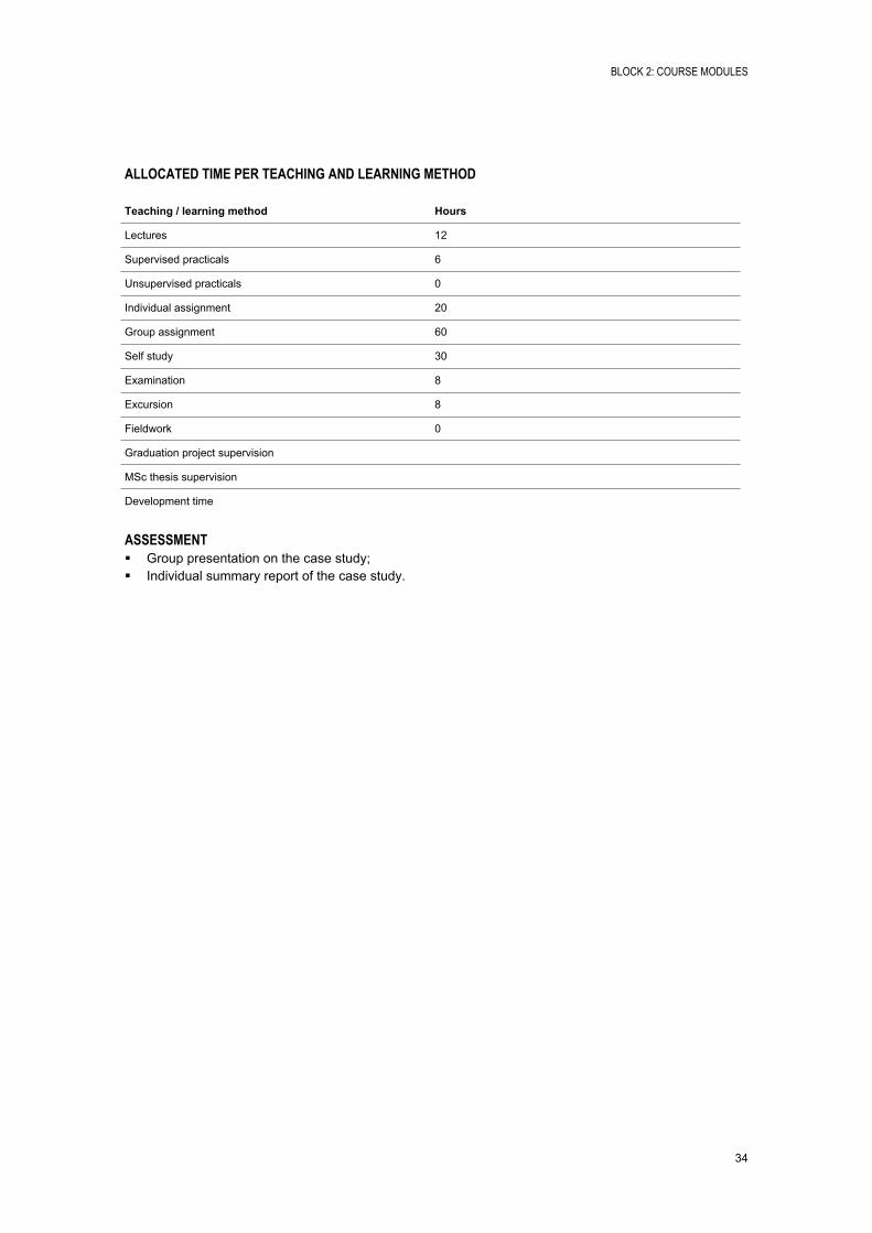
ALLOCATED TIME PER TEACHING AND LEARNING METHOD
Teaching / learning method Hours
Lectures 12
Supervised practicals 6
Unsupervised practicals 0
Individual assignment 20
Group assignment 60
Self study 30
Examination 8
Excursion 8
Fieldwork 0
Graduation project supervision
MSc thesis supervision
Development time
ASSESSMENT Group presentation on the case study; Individual summary report of the case study.

BLOCK 2: COURSE MODULES
35
BLOCK 3: RESEARCH PROFILE

BLOCK 3: RESEARCH PROFILE
37
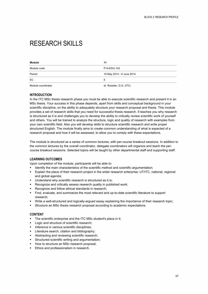
RESEARCH SKILLS
Module 11
Module code P14EDU103
Period 19 May 2014 6 June 2014
EC 5
Module coordinator dr. Rossiter, D.G. (ITC)
INTRODUCTIONIn the ITC MSc thesis research phase you must be able to execute scientific research and present it in an MSc thesis. Your success in this phase depends, apart from skills and conceptual background in your scientific discipline, on the ability to adequately structure your research proposal and thesis. This module provides a set of research skills that you need for successful thesis research. It teaches you why research is structured as it is and challenges you to develop the ability to critically review scientific work of yourself and others. You will be trained to analyze the structure, logic and quality of research with examples from your own scientific field. Also you will develop skills to structure scientific research and write proper structured English. The module finally aims to create common understanding of what is expected of a research proposal and how it will be assessed, to allow you to comply with these expectations.
The module is structured as a series of common lectures, with percourse breakout sessions. In addition to the common lectures by the overall coordinator, delegate coordinators will organize and teach the percourse breakout sessions. Selected topics will be taught by other departmental staff and supporting staff.
LEARNING OUTCOMESUpon completion of the module, participants will be able to: Identify the main characteristics of the scientific method and scientific argumentation; Explain the place of their research project in the wider research enterprise: UT/ITC, national, regional
and global agenda; Understand why scientific research is structured as it is; Recognize and critically assess research quality in published work; Recognize and follow ethical standards in research; Find, evaluate, and summarize the most relevant and uptodate scientific literature to support
research; Write a wellstructured and logicallyargued essay explaining the importance of their research topic; Structure an MSc thesis research proposal according to academic expectations.
CONTENT The scientific enterprise and the ITC MSc student's place in it; Logic and structure of scientific research; Inference in various scientific disciplines; Literature search, citation and bibliography; Abstracting and reviewing scientific research; Structured scientific writing and argumentation; How to structure an MSc research proposal; Ethics and professionalism in research.
BLOCK 3: RESEARCH PROFILE
38
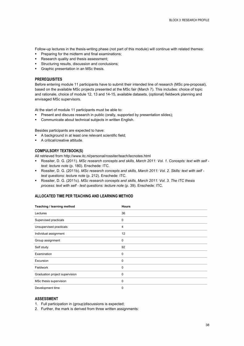
Followup lectures in the thesiswriting phase (not part of this module) will continue with related themes: Preparing for the midterm and final examinations; Research quality and thesis assessment; Structuring results, discussion and conclusions; Graphic presentation in an MSc thesis.
PREREQUISITESBefore entering module 11 participants have to submit their intended line of research (MSc preproposal), based on the available MSc projects presented at the MSc fair (March 7). This includes: choice of topic and rationale, choice of module 12, 13 and 1415, available datasets, (optional) fieldwork planning and envisaged MSc supervisors.
At the start of module 11 participants must be able to: Present and discuss research in public (orally, supported by presentation slides); Communicate about technical subjects in written English.
Besides participants are expected to have: A background in at least one relevant scientific field; A critical/creative attitude.
COMPULSORY TEXTBOOK(S)All retrieved from http://www.itc.nl/personal/rossiter/teach/lecnotes.html Rossiter, D. G. (2011). MSc research concepts and skills, March 2011: Vol. 1. Concepts: text with self -
test: lecture note (p. 180). Enschede: ITC. Rossiter, D. G. (2011b). MSc research concepts and skills, March 2011: Vol. 2. Skills: text with self -
test questions: lecture note (p. 212). Enschede: ITC. Rossiter, D. G. (2011c). MSc research concepts and skills, March 2011: Vol. 3. The ITC thesis
process: text with self - test questions: lecture note (p. 39). Enschede: ITC.
ALLOCATED TIME PER TEACHING AND LEARNING METHOD
Teaching / learning method Hours
Lectures 36
Supervised practicals 0
Unsupervised practicals 4
Individual assignment 12
Group assignment 0
Self study 92
Examination 0
Excursion 0
Fieldwork 0
Graduation project supervision 0
MSc thesis supervision 0
Development time 0
ASSESSMENT1. Full participation in (group)discussions is expected;2. Further, the mark is derived from three written assignments:

BLOCK 3: RESEARCH PROFILE
39
1. Literature skills: (i) Finding relevant literature from specified information resources, (ii) entering references to these in a bibliographic database, (iii) organizing the main points into a coherent paragraph, and (iv) formatting a reference list from the bibliographic database;
2. Critically reading and evaluating an important scientific paper in the research field of your course;3. Arguing a scientific position (importance of a research topic) in correct, compact and direct
structured technical English.

BLOCK 3: RESEARCH PROFILE
40
BLOCK 3: RESEARCH PROFILE
41
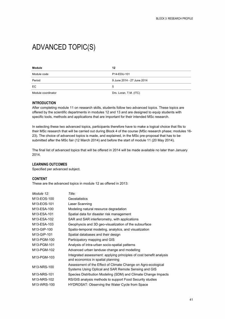
ADVANCED TOPIC(S)
Module 12
Module code P14EDU101
Period 9 June 2014 27 June 2014
EC 5
Module coordinator Drs. Loran, T.M. (ITC)
INTRODUCTIONAfter completing module 11 on research skills, students follow two advanced topics. These topics are offered by the scientific departments in modules 12 and 13 and are designed to equip students with specific tools, methods and applications that are important for their intended MSc research.
In selecting these two advanced topics, participants therefore have to make a logical choice that fits to their MSc research that will be carried out during Block 4 of the course (MSc research phase; modules 1623). The choice of advanced topics is made, and explained, in the MSc preproposal that has to be submitted after the MSc fair (12 March 2014) and before the start of module 11 (20 May 2014).
The final list of advanced topics that will be offered in 2014 will be made available no later than January 2014.
LEARNING OUTCOMESSpecified per advanced subject.
CONTENTThese are the advanced topics in module 12 as offered in 2013:
Module 12: Title:M13EOS100 GeostatisticsM13EOS101 Laser ScanningM13ESA100 Modeling natural resource degradationM13ESA101 Spatial data for disaster risk managementM13ESA102 SAR and SAR interferometry, with applicationsM13ESA103 Geophyscis and 3D geovisualization of the subsurfaceM13GIP100 Spatiotemporal modeling, analytics, and visualizationM13GIP101 Spatial databases and their designM13PGM100 Participatory mapping and GISM13PGM101 Analysis of intraurban sociospatial patternsM13PGM102 Advanced urban landuse change and modelling
M13PGM103Integrated assessment: applying principles of cost benefit analysis and economics in spatial planning
M13NRS100Assessment of the Effect of Climate Change on Agroecological Systems Using Optical and SAR Remote Sensing and GIS
M13NRS101 Species Distribution Modeling (SDM) and Climate Change ImpactsM13NRS102 RS/GIS analysis methods to support Food Security studiesM13WRS100 HYDROSAT: Observing the Water Cycle from Space
BLOCK 3: RESEARCH PROFILE
42
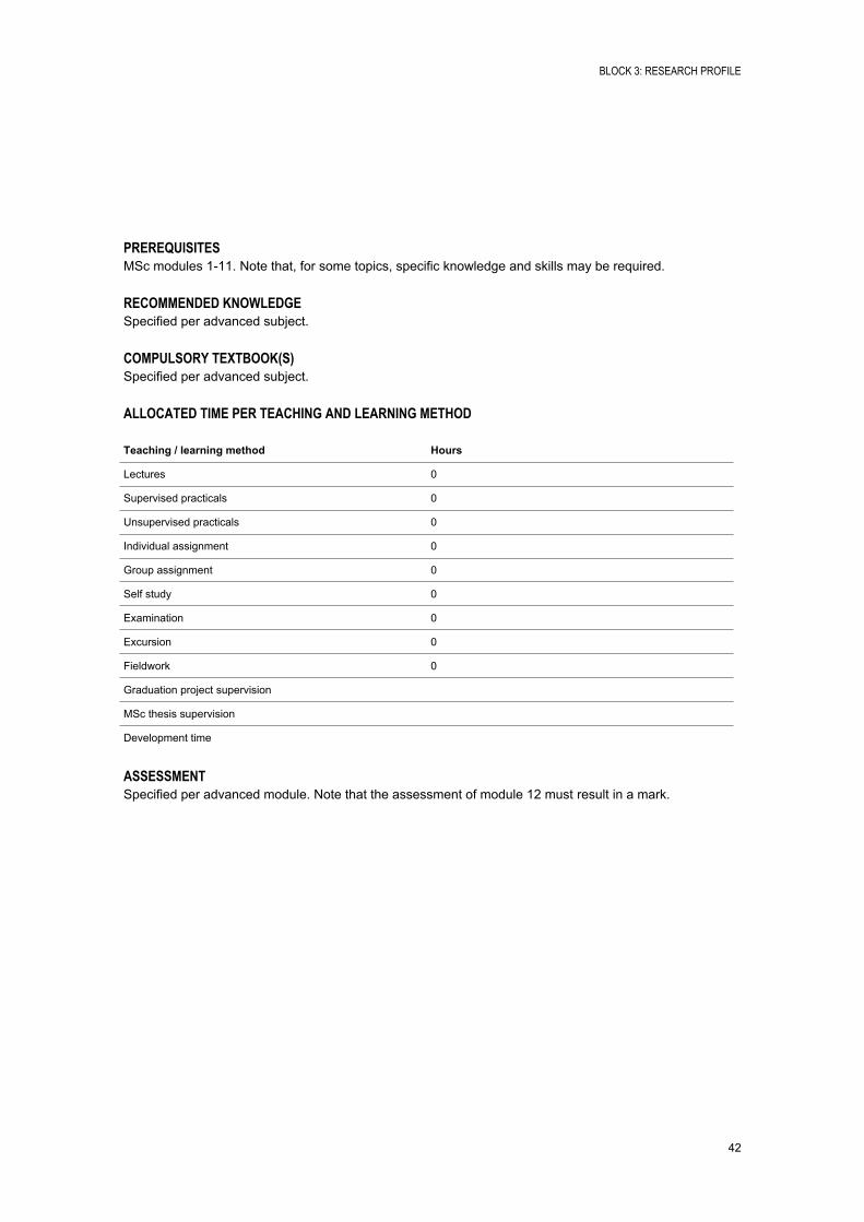
PREREQUISITESMSc modules 111. Note that, for some topics, specific knowledge and skills may be required.
RECOMMENDED KNOWLEDGESpecified per advanced subject.
COMPULSORY TEXTBOOK(S)Specified per advanced subject.
ALLOCATED TIME PER TEACHING AND LEARNING METHOD
Teaching / learning method Hours
Lectures 0
Supervised practicals 0
Unsupervised practicals 0
Individual assignment 0
Group assignment 0
Self study 0
Examination 0
Excursion 0
Fieldwork 0
Graduation project supervision
MSc thesis supervision
Development time
ASSESSMENTSpecified per advanced module. Note that the assessment of module 12 must result in a mark.
BLOCK 3: RESEARCH PROFILE
43
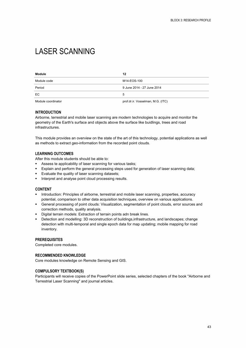
LASER SCANNING
Module 12
Module code M14EOS100
Period 9 June 2014 27 June 2014
EC 5
Module coordinator prof.dr.ir. Vosselman, M.G. (ITC)
INTRODUCTIONAirborne, terrestrial and mobile laser scanning are modern technologies to acquire and monitor the geometry of the Earth's surface and objects above the surface like buidlings, trees and road infrastructures.
This module provides an overview on the state of the art of this technology, potential applications as well as methods to extract geoinformation from the recorded point clouds.
LEARNING OUTCOMESAfter this module students should be able to: Assess te applicability of laser scanning for various tasks; Explain and perform the general processing steps used for generation of laser scanning data; Evaluate the quality of laser scanning datasets; Interpret and analyse point cloud processing results.
CONTENT Introduction: Principles of airborne, terrestrial and mobile laser scanning, properties, accuracy
potential, comparison to other data acquisition techniques, overview on various applications. General processing of point clouds: Visualization, segmentation of point clouds, error sources and
correction methods, quality analysis. Digital terrain models: Extraction of terrain points adn break lines. Detection and modelling: 3D reconstruction of buildings,infrastructure, and landscapes; change
detection with multitemporal and single epoch data for map updating; mobile mapping for road inventory.
PREREQUISITESCompleted core modules.
RECOMMENDED KNOWLEDGECore modules knowledge on Remote Sensing and GIS.
COMPULSORY TEXTBOOK(S)Participants will receive copies of the PowerPoint slide series, selected chapters of the book "Airborne and Terrestrial Laser Scanning" and journal articles.
BLOCK 3: RESEARCH PROFILE
44
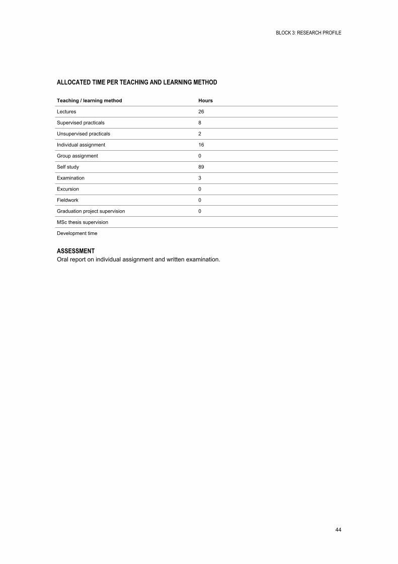
ALLOCATED TIME PER TEACHING AND LEARNING METHOD
Teaching / learning method Hours
Lectures 26
Supervised practicals 8
Unsupervised practicals 2
Individual assignment 16
Group assignment 0
Self study 89
Examination 3
Excursion 0
Fieldwork 0
Graduation project supervision 0
MSc thesis supervision
Development time
ASSESSMENTOral report on individual assignment and written examination.
BLOCK 3: RESEARCH PROFILE
45
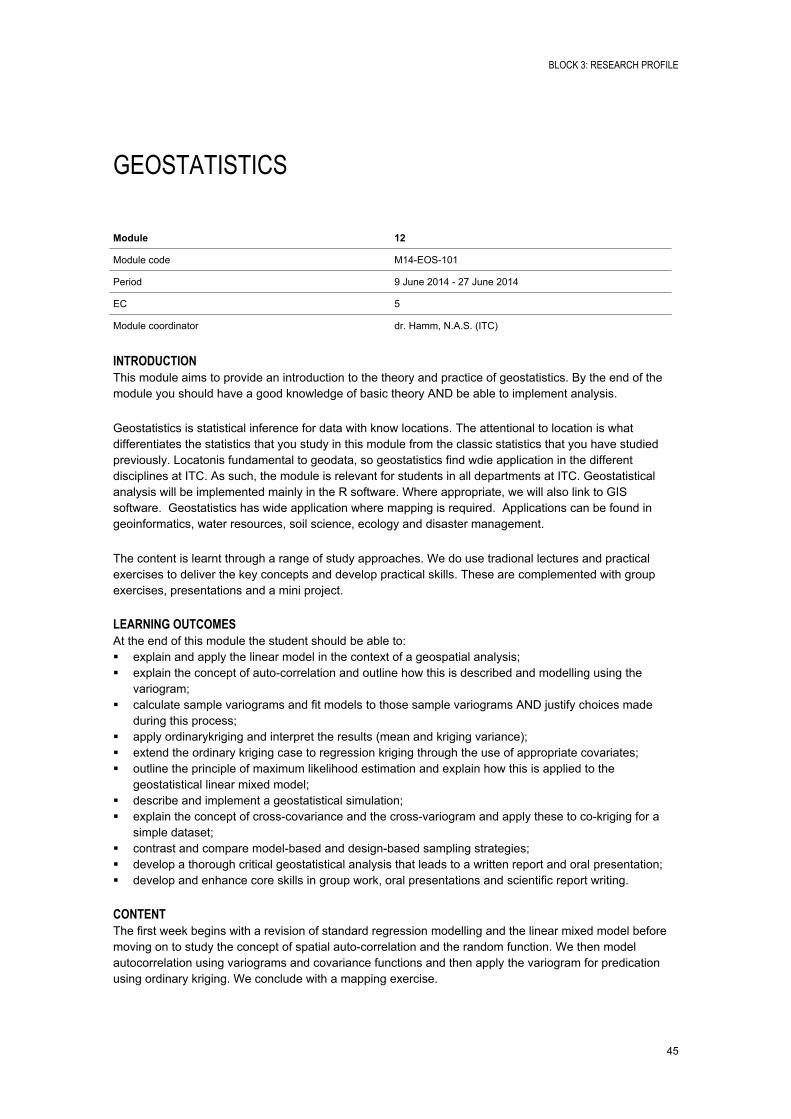
GEOSTATISTICS
Module 12
Module code M14EOS101
Period 9 June 2014 27 June 2014
EC 5
Module coordinator dr. Hamm, N.A.S. (ITC)
INTRODUCTIONThis module aims to provide an introduction to the theory and practice of geostatistics. By the end of the module you should have a good knowledge of basic theory AND be able to implement analysis.
Geostatistics is statistical inference for data with know locations. The attentional to location is what differentiates the statistics that you study in this module from the classic statistics that you have studied previously. Locatonis fundamental to geodata, so geostatistics find wdie application in the different disciplines at ITC. As such, the module is relevant for students in all departments at ITC. Geostatistical analysis will be implemented mainly in the R software. Where appropriate, we will also link to GIS software. Geostatistics has wide application where mapping is required. Applications can be found in geoinformatics, water resources, soil science, ecology and disaster management.
The content is learnt through a range of study approaches. We do use tradional lectures and practical exercises to deliver the key concepts and develop practical skills. These are complemented with group exercises, presentations and a mini project.
LEARNING OUTCOMESAt the end of this module the student should be able to: explain and apply the linear model in the context of a geospatial analysis; explain the concept of autocorrelation and outline how this is described and modelling using the
variogram; calculate sample variograms and fit models to those sample variograms AND justify choices made
during this process; apply ordinarykriging and interpret the results (mean and kriging variance); extend the ordinary kriging case to regression kriging through the use of appropriate covariates; outline the principle of maximum likelihood estimation and explain how this is applied to the
geostatistical linear mixed model; describe and implement a geostatistical simulation; explain the concept of crosscovariance and the crossvariogram and apply these to cokriging for a
simple dataset; contrast and compare modelbased and designbased sampling strategies; develop a thorough critical geostatistical analysis that leads to a written report and oral presentation; develop and enhance core skills in group work, oral presentations and scientific report writing.
CONTENTThe first week begins with a revision of standard regression modelling and the linear mixed model before moving on to study the concept of spatial autocorrelation and the random function. We then model autocorrelation using variograms and covariance functions and then apply the variogram for predication using ordinary kriging. We conclude with a mapping exercise.
BLOCK 3: RESEARCH PROFILE
46
We begin the second week by extending ordinary kriging to regression kriging before turning to modelbased geostatistics. We then return to the linear mix model and maximum likelihood estimation before introducing geostatistical simulation, cokriging and geostatistical sampling design.
The third week is an indvidual assignment/miniproject, where you conduct geostatistical analysis on a dataset of your choice.
PREREQUISITESModule 111 of the ITC MSc programme. Where this has not been followed, we will assess the suitability of candidates on a individual basis.
RECOMMENDED KNOWLEDGE Insight and experience with quantitative geodata (GIS, Remote Sensing); Basic knowledge of probability (distributions) and statistics (including ttests and linear
'regression'.
COMPULSORY TEXTBOOK(S)Compulsory reading material will be distributed or made availbable from the ITC library.
ALLOCATED TIME PER TEACHING AND LEARNING METHOD
Teaching / learning method Hours
Lectures 18
Supervised practicals 20
Unsupervised practicals 18
Individual assignment 40
Group assignment 16
Self study 26
Examination 6
Excursion 0
Fieldwork 0
Graduation project supervision 0
MSc thesis supervision 0
Development time 0
ASSESSMENTThe assessment is based primarily on the individual assignment in the final week (60%). In addition there is a short test (20%) and group assignment (20%) which are graded.
BLOCK 3: RESEARCH PROFILE
47
MODELLING NATURAL RESOURCES DEGRADATION
Module 12
Module code M14ESA100
Period 9 June 2014 27 June 2014
EC 5
Module coordinator dr. Shrestha, D.B.P. (ITC)
INTRODUCTIONSteadily increasing population pressure leads to scarcity of land causing deforestation and widespread changes in land cover/land use. This can have detrimental effects on fundamental processes within natural and manmade ecosystems. On the other hand intensive use of marginal lands without proper conservation measures can trigger wide scale degradation of natural resources such as vegetation and soils. In addition to this, excessive rain can have devastating effect by generating high surface runoff. It can cause not only erosion problem in the upland areas but also flash flood in the low lying areas damaging properties and causing inconvenient to people.
Analysis of degradation can be done for instance with analysis of multitemporal satellite data and modelling of surface runoff and its consequent effects on both upland as well as in the lowland areas. Knowledge on the one hand of the degradation processes/rates and on the other hand of conservation measures, can help quantify the problem and find suitable solutions for controlling degradation. Soil and water conservation techniques, both scientific and indigenous, have been amassed over the last 50 years but successful implementation can only be based on acceptance and support by stakeholders. Guidelines for this are given by the WOCAT system (www.wocat.net) and the DESIRE project (www.desireproject.eu).
LEARNING OUTCOMESAt the end of the course participants should be able to:
Analyze the influence of primary factors leading to natural resource degradation; Apply RS/GIS and spatial modelling tools for mapping and monitoring of degradation processes; Understand the spatial implications of conservation measures for watershed management and discuss
the methods developed to engage stakeholders, with examples from the DESIRE project (www.desireproject.eu);
Apply what you learn on a real life case study in semiarid (dry) or tropical area.
CONTENTThe course teaches to identify the primary factors leading to natural resource degradation and analyse their influence on degradation processes. It consists of two weeks of theoretical explanations with exercises and one week of real life case study work.
Theory and exercises (2 weeks): Factors, process mechanisms and consequences of natural resource degradation (e.g. loss of
biomass, disturbance of hydrological balance, land degradation); Remote sensing techniques for land cover/land use change analysis; Modelling surface runoff, soil loss and/or flash flood modelling; Mitigation measures and conservation planning for watershed management and discuss methods
developed to engage stakeholders.
BLOCK 3: RESEARCH PROFILE
48
Case studies using real life data (1 week): Land degradation assessment (Morocco); Land use change analysis and erosion modelling (Thailand/Indonesia); Flash flood modelling (Thailand); Soil and water conservation methods and analysis of their effect (any one of the areas above).
PREREQUISITES Basic understanding of the principles of remote sensing and geographic information system; Background knowledge in natural sciences (earth sciences, natural resources, agriculture, forestry,
hydrology, soil).
RECOMMENDED KNOWLEDGEBasic knowledge of modelling is recommended but not required to attend the course; the course takes learning by doing approach.
COMPULSORY TEXTBOOK(S)(Electronic) handouts, scientific literature, satellite images, digital databases and open source software etc.
ALLOCATED TIME PER TEACHING AND LEARNING METHOD
Teaching / learning method Hours
Lectures 44
Supervised practicals 34
Unsupervised practicals 22
Individual assignment 0
Group assignment 26
Self study 12
Examination 6
Excursion 0
Fieldwork 0
Graduation project supervision
MSc thesis supervision
Development time
ASSESSMENTIndividual assessment is based on: Written completion of exercises; Written exam (60%); Case study (40%).

BLOCK 3: RESEARCH PROFILE
49
SPATIAL DATA FOR DISASTER RISK MANAGEMENT
Module 12
Module code M14ESA101
Period 9 June 2014 27 June 2014
EC 5
Module coordinator dr. Westen, C.J. van (ITC)
INTRODUCTIONThe world has experienced an increasing impact of disasters in the past decades. Many regions are exposed to natural hazards, each with unique characteristics. The main causes for this increase can be attributed to a higher frequency of extreme hydro-meteorological events. The risk due to natural disaster is changing, due to changes in population, land use and climate.
To reduce disaster losses, more efforts should be applied towards Disaster Risk Management, with a focus on hazard assessment, elementsatrisk mapping, vulnerability and risk assessment, all of which have an important spatial component. Multihazard assessment involves the assessment of relationships between different hazards and especially for concatenated or cascading hazards.
The use of Earth Observation (EO) products and Geographic Information Systems (GIS) has become an integrated approach in disasterrisk management. Hazard and risk assessments are carried out at multiple scales, ranging from global to a community level. These levels have their own objectives and spatial data requirements for hazard inventories, environmental data, triggering or causal factors, and elementsatrisk.
This module provides an overview of various forms of spatial data, and examines the approaches used for hazard and risk assessment. Specifically, hazard examples include earthquakes, windstorms, drought, floods, volcanic eruptions, landslides and forest fires. Several approaches are also treated that have been developed to generate elementsatrisk databases with emphasis on population and building information, as these are the most used categories for loss estimation.
Vulnerability approaches are discussed, with emphasis on the methods used to define physical vulnerability of buildings and population, and indicatorbased approaches used for a holistic approach, also incorporating social, economic and environmental vulnerability, and capacity. The use of multihazard risk for disaster risk reduction is also treated within this module, and we will look at different structural and nonstructural measures for risk reduction, and also to the tools used for analysing optimal ones. Also risk governance and risk visualization are addressed.
LEARNING OUTCOMES This module shows you how spatial data is used in advanced methods for risk assessment, inlcuding
techniques for probabilistic risk assessment, the end users of such information and the Spatial Data Infrastructure required;
The module also gives the risk management framework and introduces you how spatial risk information is used to disaster risk management;
The integration of risk information with other relevant information into disaster risk management and environmental impact assessment;
Define how risk analysis results are used, by whom, in what way; Translate the results into an integrated planning/policy level.
BLOCK 3: RESEARCH PROFILE
50
CONTENTRisk Management framework, including aspects such as risk analysis, risk evaluation, risk perception and risk governance.
Users and providers of Risk Information. An analysis is given of the end users of risk information, their requirements, and the organizations that are involved in generating information for a risk assessment.
Spatial data requirements for Risk Management. Here we will look at the various sources of input data for hazards, elementsatrisk, and vulnerability data. We will look what types of data are required at different scales, and for different types of hazard. Also available data sources on the internet will be evaulated.
Multi-hazard risk assessment. A large case study is included dealing with a national multihazard risk assessment for the county of Georgia, using 10 hazard types, 7 types of elementsatrisk and 3 administrative levels (See also: http://drm.cenn.org). Also a small scale example of a multihazard risk assessment is shown for the Nocera area in South Italy.
Examples of international methods for loss estimation. In this component we will look at internationally developed software modules for risk assessment such as HAZUS (Multihazard risk methodology developed for the US by FEMA), and CAPRA (Comprehensive Assessment of Probabilistic Risk developed by the World bank).
The use of risk information for emergency prepardness. This includes a practical exercise dealing with a simulation case study for the use of spatial information in responding to a disaster event. Participants working in groups simulate the actions taken in an emergency center where information is generated in response to an emergency that is happening.
The use of risk information in a cost-benefit analysis for the design of risk reduction measures. the reducation in expected losses due to the implementation of certain risk reduction measures is evaluated against the investments needed for the implementation, over a certain period of time.
Use of risk information in spatial planning. This component gives to the link to the next modle, focusing on the incorporation of risk information in regulatory zoing and land use planning.
Analyzing the risk in a changing environment. How global changes, related to environmental and climate change as well as socioeconomic change, will affect the temporal and spatial patterns of hydrometeorological hazards and associated risks: how these changes can be assessed, modeled, and incorporated in sustainable risk management strategies, focusing on spatial planning, emergency prepardnesss and risk communication.
Remark: This module is also interesting for AES MSc students of the Natural Hazards and Disaster Risk Management specialization, as the components taught in this course are new with respect to the previous course components.
PREREQUISITESOpen to all MSc students.
RECOMMENDED KNOWLEDGEBasic skills in GIS and Remote Sensing.
BLOCK 3: RESEARCH PROFILE
51
COMPULSORY TEXTBOOK(S)Course folder with handouts, PowerPoint files, case study descriptions, background literature and examples of risk assessment studies and risk atlases will be provided.
ALLOCATED TIME PER TEACHING AND LEARNING METHOD
Teaching / learning method Hours
Lectures 45
Supervised practicals 45
Unsupervised practicals 0
Individual assignment 0
Group assignment 30
Self study 24
Examination 0
Excursion 0
Fieldwork 0
Graduation project supervision
MSc thesis supervision
Development time
ASSESSMENTThe assessment is made based on the submission of a number of assignments and presentations, and does not include an exam.
BLOCK 3: RESEARCH PROFILE
52
APPLIED GEOCHEMICAL AND ENVIRONMENTAL MONITORING
Module 12
Module code M14ESA102
Period 9 June 2014 27 June 2014
EC 5
Module coordinator drs. Smeth, J.B. de (ITC)
INTRODUCTIONEarth observation for the purpose of environmental monitoring, mineral & geothermal exploration, water quality analysis, hydrogeological modelling and soil analysis relies besides digital image processing and analysis on primary ground data for verification and calibration of ground truth. Today, using the newest sensor and environmental technologies, a large number of these data can be acquired relatively easily directly in the field or after sample collection in a laboratory. This module is dedicated to field and laboratory methods for acquiring and analysing ground data and will involve training in theoretical and practical aspects of the choices in field sampling methods and analytical laboratory data acquisition methods, instrumentation and quality control measures which play a role in the production of analytical data on geochemical samples such as, water, soil, sediment, rock and gas.
LEARNING OUTCOMES Understanding the design and execution of geo and hydrochemical data collection surveys for
environmental and exploration purposes through theory, practical field as well as laboratory training and demonstrations.
Upon completion of this module, the participant will be able to choose and apply the appropriate geochemical methodology and knows how to monitor the quality of data for his/her own MSc. research as well as how to present/report analytical date in the correct and clearest way.
CONTENTThe module will focus on: The choices in sampling methods and field procedures for soil, sediment, ground or surface water,
rock and gas in geochemical surveys and the subsequent choices in analytical methods and instrumentation in the preparation of representative geochemical data in field and regular or commercial laboratories,
Measuring techniques for chemical parameters with instruments in the field such as pHmeter, conductivity meter, portable XRF, radon gas analyser and field test kits. In ITC's GeoScience laboratory this will involve anion and cation analysis using colorimeter, discrete analyser, flame AAS , ICPOES, etc., It can also incorporate titration methods for total organic Carbon and methods for particle size analysis on sand, silt and clay fractions, bulk density determination and soil saturation tests.
General procedures and quality control measures used in the field as well as in chemical laboratories in order to obtain required accuracy & precision. This includes simple univariate, multivariate statistical data screening procedures, the use of AquaChem and m odelling in PHREEQC.
PREREQUISITESBackground in geology, hydrogeology, forestry or soilscience
BLOCK 3: RESEARCH PROFILE
53
RECOMMENDED KNOWLEDGEUnderstanding of basic principles of inorganic chemistry
COMPULSORY TEXTBOOK(S)Lecture and practical class notes.
Recommended books from ITC Library: Fetter C.W., Applied Hydrogeology, (Prentice Hall) 4th edition, 2001 Gill R., Modern Analytical Geochemistry (Addison Wesley Longman, 1997): Hale M. and Plant J., Drainage Geochemistry (Elsevier, 1994).
ALLOCATED TIME PER TEACHING AND LEARNING METHOD
Teaching / learning method Hours
Lectures 24
Supervised practicals 16
Unsupervised practicals 6
Individual assignment 0
Group assignment 18
Self study 10
Examination 3
Excursion 8
Fieldwork 4
Graduation project supervision
MSc thesis supervision
Development time
ASSESSMENTWritten examination on theory and probably a short assignment on data produced in the laboratory by the participant(s)
BLOCK 3: RESEARCH PROFILE
54
GEOPHYSICS AND 3D GEO-VISUALIZATION OF THE SUBSURFACE
Module 12
Module code M14ESA103
Period 9 June 2014 27 June 2014
EC 5
Module coordinator dr. Meijde, M. van der (ITC)
INTRODUCTIONThis course serves to deliver knowledge on tools for 3D subsurface characterization, visualization and modelling. The development of homogeneous 3D subsurface information systems is important for various fields such as for environmental monitoring, natural hazards, and earth resources. This is done on the basis of bore hole data,(field, airborne and satellite based) geophysical data sets that are used to generate volumes in 3D GIS environment. These volumes are linked to subsurface dynamic process models that are used to study dynamic phenomena such as pollution plumes, groundwater flow in aquifers etc. Many earth processes have a source or a component below the surface. Understanding of the spatial and temporal variation of physical parameters in the subsurface, therefore gives additional insight in these processes and their extent. This could be the extent of pollution plumes, water or mineral resources, or e.g. sliding planes of landslides, salinization patterns.
The module starts with an overview of modern concepts in subsurface characterization and (dynamic) modelling. Thereafter the following integrally linked components are addressed: An overview of field, airborne and spaceborne geophysical techniques; Hands on with field based geophysical techniques; Geophysical data inversion techniques; 3D representation of surface structures and objects; 3D visualization; 3D GIS modelling of subsurface structures from geophysical data and bore holes; Integration of 3D subsurface models with hydrological, geomorphological, environmental etc. models.
LEARNING OUTCOMESUpon completion of the module the student should be able to: create understanding of tools to study, model and visualize the subsurface in 2D/3D; provide an overview of possible application fields; assessment of the applicability of EO (geophysics) in 3D subsurface characterization for various
applications; study of the subsurface through GI/EO in a systematic way and decision support on the right tools and
techniques; (dynamic) modelling of subsurface parameters and processes; extract subsurface parameters from analysis, modeling and visualization of EO data; relate derived subsurface parameters to (sub) surface processes; set up and run field campaigns with geophysical instrumentation.
CONTENTThe module starts from the acquisition, processing and modeling of (satellite), airborne and fieldbased) geophysical data sets that serve as input to 3D GIS subsurface models along with bore hole data. The
BLOCK 3: RESEARCH PROFILE
55
module gives a theoretical basis for the various investigative tools and techniques. Geophysical techniques that will be covered include: Satellite gravity data (GRACE, GOCE) for mass (ground and surface water, lithosphere tectonics)
balances; Airborne geophysical data (gravity, magnetics, gamma ray) for shallow or deeper subsurface
characterization; Field geophysical methods.
Geo-electricsGeoelectrical methods are used to obtain information on the resistivity of the subsurface though potential differences between electrodes in the ground that occur due to an injected current. We have two different equipments available; STING resistivity imaging and an ABEM Terrameter. Both work on the same principle but the STING resistivity imaging is a multielectrode system and has the possibility to work in automatic mode. It is therefore ideal for 2D and 3D data acquisition. The ABEM Terrameter is predominantlyused for 1D survey.
ElectromagneticElectromagnetic methods are based on the inductance of currents in the subsurface which are an indication of the conductivity of the subsurface. We have two different types of equipment that are based on the same inductive principle but are different in their way of acquisition.
a) Frequency domainThis type of equipment measures the induced current in the subsurface due to a continuous signal that is send through a loop that is above the ground. Measurements are taken continuously. We have the following equipment available for study of the subsurface in different depth domains (mainly form GEONICS); EM16, EM321, EM34 and EM MaxMin.
b) Time domainThis type of equipment measures the induced current in the subsurface due to a signal that is sent out for a certain period of time. We have one piece of equipment available, the TEMFAST from AEMR that can provide information from the surface to a maximum of 200300 meters depth.
Gamma-ray spectrometryGammaray spectrometry provides information on the decay of natural gammaray radiation. Is predominantly used for geological mapping purposes but has application in almost any application field where soil alteration plays a role.
SeismicsSeismic methods can provide information on seismic velocities in the subsurface which are directly related to physical parameters as rigidity and density.
Participants will be handed a set of data inversion techniques that allow preprocessing of raw signal to physical units of measurement that can be linked to subsurface structures and materials. Various geophysical imaging and modelling techniques will be presented to allow 3D representation to be rendered.
The second part of the module deals with 3D Geovisualization and modeling of the subsurface. This starts from the concepts of subsurface elements, inputting drill hole and geophysical data. Based on these elements the most suitable visualization methods and techniques will be discussed. Subsequent steps include 3D triangulation and rendering and finally 3D volumetric estimates and construction of 3D objects.
The third part of the module deals with the integration of 3D subsurface information with dynamic process
BLOCK 3: RESEARCH PROFILE
56
response (hydrologic, plume) models. Through demos and field exercises, participants are familiarized with the technology relevant to an application area of their own interest. Through a series of lectures and a small project, relevant (sub)surface processes are linked to subsurface properties and the project will helpto further structure this in relation to a practical topic by which participants are also confronted with natural limitations of the various tools and techniques.
PREREQUISITESModules 111 in ITC, relevant background in earth sciences.
COMPULSORY TEXTBOOK(S) Book: Field Geophysics John Milsom; Lecture handouts, power point presentation.
ALLOCATED TIME PER TEACHING AND LEARNING METHOD
Teaching / learning method Hours
Lectures 14
Supervised practicals 0
Unsupervised practicals 0
Individual assignment 24
Group assignment 0
Self study 48
Examination 6
Excursion 0
Fieldwork 52
Graduation project supervision
MSc thesis supervision
Development time
ASSESSMENTAssessment of reports on field exercises and projects, and a written exam.
BLOCK 3: RESEARCH PROFILE
57
GEOVISUAL ANALYTICS
Module 12
Module code M14GIP100
Period 9 June 2014 27 June 2014
EC 5
Module coordinator prof.dr. Kraak, M.J. (ITC)
INTRODUCTIONThis course will cover basic aspects of geovisual analytics. It deals with the usercentred design of an integrated visual environment with interactive and dynamic cartographic displays and alternative visual representations of time to analyse relevant geographic (spatiotemporal) problems. The issue is that theory and tools to deal with the temporal component are less developed, despite the fact that time is a critical aspect of virtually all geoproblems. The module centers around a case study in which a geovisual analytical environment will be created with off the shelf (open source) software in order to be able to analyse larger spatiotemporal datasets as a means to address major global problems. As part of the usercentered design the usability of the case study outcome will be evaluated with prospective users.
LEARNING OUTCOMES Explain to peers the basics and usefulness of geovisual analytics in solving real world problems; Explain and justify to peers the selection of components of a geovisual working environment in the
context of a selected problem case; Follow a usercentered design approach in selecting and applying appropriate visual representations to
analyse a particular spatiotemporal problem (starting with a systematic requirement analysis); Select and apply appropriate user research methods and techniques to evaluate a geovisual analytics
environment.
CONTENTAfter overviews of the what and how of geovisual analytics and usercentered design of geoinformation tools the module will zoom in on a set of methods and techniques of geovisualization to deal with geospatial data which have a clear temporal component. Students are then expected to apply this knowledge in a particular application domain / case study using off the shelfe software tools and some scripting. The resulting prototype should be based on a solid requirement analysis and its usability will have to be investigated. A written report must be produced, describing, explaining and justifying the choices made in the usercentered design process, including the spatiotemporal problem which is addressed.
PREREQUISITESMSc Core Module and Modules 411;
The knowledge gained in GFM.2 Module 8 "Visualization and dissemination of geodata" is advantageous, but it is not strictly necessary. Therefore, students from other courses are explicitly invited to join this elective module as well.
RECOMMENDED KNOWLEDGEBasic programming skills are recommended. (scripting).
BLOCK 3: RESEARCH PROFILE
58
COMPULSORY TEXTBOOK(S)The book and papers will be available via Blackboard.
ALLOCATED TIME PER TEACHING AND LEARNING METHOD
Teaching / learning method Hours
Lectures 24
Supervised practicals 24
Unsupervised practicals 0
Individual assignment 72
Group assignment 0
Self study 24
Examination 0
Excursion 0
Fieldwork 0
Graduation project supervision
MSc thesis supervision
Development time
ASSESSMENTIn this module, students work individually. The assessment is based on three main items: A report describing, explaining and justifying the user centered design process; A prototype of a geovisual analytics environement related to the case study; The feedback provided on the work done by others.
BLOCK 3: RESEARCH PROFILE
59
ASSESSMENT OF THE EFFECT OF CLIMATE CHANGE ON AGRO-ECOLOGICAL SYSTEMS USING OPTICAL AND SAR REMOTE SENSING AND GIS
Module 12
Module code M14NRS100
Period 9 June 2014 27 June 2014
EC 5
Module coordinator dr. Hussin, Y.A. (ITC)
INTRODUCTIONThe greenhouse effects and the carbon cycle, in particular carbon emissions and carbon sequestration, are at the heart of climate change, one of the most pressing problems the earth is facing. Global instruments like the UNFCCC, Kyoto Protocol, CDM, and IPCC reports all address these, resulting in an explicit link with the International Environmental Agenda. The accurate quantification of the various components in the carbon cycle forms a core need for its assessment, monitoring, modeling, and the mitigation of adverse climate effects and, in the end, sustainability of livelihoods in many parts of the earth.
The latter requires identification, analysis and development of policy instruments in order to handle the impacts of the foreseeable changes in the carbon cycle. Within the carbon cycle, forestry in the broad sense forms the principal scientific area for research including both emissions (sources) and sequestration (sinks).
Afforestation, reforestation and deforestation are the current Kyoto focal areas, but sustainable forest management, including certification, and the assessment and prevention of forest degradation may well be considered in the socalled postKyoto period (see e.g., the REDD proposal).
Due to size, inaccessibility of the forest resources, and international requirements for a uniform methodology, quantification of the carbon cycle components in both space and time leans heavily on remote sensing, GIS modeling and related statistical tools.
LEARNING OUTCOMESAfter the module students should be able to: understand carbon cycle and effect on climate change; assess and estimate forest, agriculture crop, grass, shrubs and wetlands vegetation biomass; able to detect, monitor and model deforestation and forest degradation; able to model biomass from vegetation types of all agroecological system and consequently model
sequestrated carbon; able to model forest fire behavior and consequently carbon emission; understand how deforestation, forest degradation, carbon sequestration and carbon emission affected
climate change; understand the principles of SAR imaging system; interpret and analyze aircraft and satellite radar images; use radar images for modeling and mapping carbon and consequently model carbon.
BLOCK 3: RESEARCH PROFILE
60
CONTENTThe application of optical and SAR Remote Sensing and GIS is an advanced subject introduces the principles of optical sensor system and Synthetic Aperture Radar Imaging Systems. It introduces the Carbon Cycle, Climate Response and the rule and effects of Deforestation and Forest Degradation (DD) on carbon and climate change.
It discusses the new carbon strategy (REDD) Reducing Emission of Carbon from Deforestation and Forest Degradation accepted by UN countries as a continuation for its policy after Kyoto. It introduces the relationships between biophysical characteristics (e.g. biomass) of forest, agriculture crops and other vegetation types such as grass, shrubs and wetland and optical and radar (reflectance or backscatter).
It introduces the geoinformation applications in deforestation and forest degradation by detecting, monitoring and modeling deforestation and forest degradation using Remote Sensing and GIS.
Then it assess method of biomass assessment using field, Remote Sensing and GIS, which leads to the modeling and mapping biomass from all agroecological system (e.g. forest, agriculture, grass, shrubs and wetland vegetation). Consequently, it presents methods and techniques of modeling carbon sequestration (CS).
As far as carbon emission is concern the module is first introducing forest fire. Then deals with modeling forest fire behavior in order to presents methods and techniques of modeling carbon emission (CE) from forest fire. Finally the module will discuss how Climate Change can be modeled in response to DD, CS and CE.
As SAR data will be one of the remotely sensed most related to biomass, the module will go through all image preprocessing and processing techniques of radar data (e.g. enhancement, radiometric and geometric correction, etc.). The module explains how radar data can be fused with optical sensor system data and its applications in modelling carbon. The module will explain the techniques used to extract information from radar images. It will describe spatial, radiometric and temporal resolution of SAR Images.
PREREQUISITESMSc modules 111.
RECOMMENDED KNOWLEDGERemote Sensing and GIS background.
COMPULSORY TEXTBOOK(S) Reader: Principles and Application of Imaging Radar (Henderson and Lewis 1998) Reader: Measurements and Estimations of Forest Stands Parameters Using Remote Sensing
(Stllingwerf and Hussin, 1997).
BLOCK 3: RESEARCH PROFILE
61
ALLOCATED TIME PER TEACHING AND LEARNING METHOD
Teaching / learning method Hours
Lectures 20
Supervised practicals 20
Unsupervised practicals 0
Individual assignment 10
Group assignment 46
Self study 40
Examination 8
Excursion 0
Fieldwork 0
Graduation project supervision
MSc thesis supervision
Development time
ASSESSMENTSummative assessment (examination) theory and formative assessment of practical work.
BLOCK 3: RESEARCH PROFILE
62
SPECIES DISTRIBUTION MODELING (SDM) AND CLIMATE CHANGE IMPACT
Module 12
Module code M14NRS101
Period 9 June 2014 27 June 2014
EC 5
Module coordinator dr.ir. Groen, T.A. (ITC)
INTRODUCTIONAccurate spatial information about biological ecosystem properties is a requirement for developing policy and managing natural resources. Information about green biomass, species, assemblages and diversity serve a wide range of purposes in environmental management. Remote sensing may enable direct mapping of such biological properties.
Frequently however indirect approaches are used where environmental conditions are used to predict the distribution of the biological variable of interest. This module aims to strengthen skills in developing models to predict the distribution of species for purposes such as biological or environmental conservation, biodiversity assessment, species richness and species distribution. Climate change scenarios will give an indication in which direction the present distribution of species might change.
LEARNING OUTCOMESUpon completion of this module the student should be able to: select appropriate models for estimating species distribution and biodiversity, its relation to
environmental parameters; know where to find relevant data sources online for modelling understand basic climate model output apply these to real and future world situations.
CONTENT1. The module starts by introducing the Rpackage as a modelling environment and a number of
advanced modelling techniques, such as logistic regression models, boosted regression trees, maximum entropy and expert system models;
2. Available environmental predictor variables are described;3. Multicollinearity diagnostics and spatial autocorrelation;4. The techniques are applied to specific thematic application areas such as biodiversity modelling,
species distribution probabilities and habitat requirements;5. Trends and multi and hyper temporal analysis;6. The impact of Climate Change on the distribution of species;7. Model calibration, validation, data quality and model comparison.
PREREQUISITESBasic knowledge of ecology and statistics.
RECOMMENDED KNOWLEDGEExcel, ArcGIS, R, basic statistics.
BLOCK 3: RESEARCH PROFILE
63
COMPULSORY TEXTBOOK(S)PowerPoint presentations and handouts will be distributed.
ALLOCATED TIME PER TEACHING AND LEARNING METHOD
Teaching / learning method Hours
Lectures 20
Supervised practicals 30
Unsupervised practicals 30
Individual assignment 40
Group assignment 0
Self study 16
Examination 8
Excursion 0
Fieldwork 0
Graduation project supervision
MSc thesis supervision
Development time
ASSESSMENTPresentation of individual assignment where the student demonstrates her/his ability to apply a suitable model to an example case study (will be provided) with all of its associated analysis and evaluation (50%) and a written exam (50%).
BLOCK 3: RESEARCH PROFILE
64
RS/GIS ANALYSIS METHODS TO SUPPORT FOOD AND WATER SECURITY STUDIES
Module 12
Module code M14NRS102
Period 9 June 2014 27 June 2014
EC 5
Module coordinator dr.ir. Bie, C.A.J.M. de (ITC)
INTRODUCTIONRemote sensing and GIS are important tools to provide input to the spatial assessment of Food and Water Security. Such an assessmnet is important to both rainfed as irrigated agricultural systems and can be done at regional, national and continental scales. While a holistic study of food and water security requires many disciplinary inputs, at ITC's research and education three main fields are covered:
Mapping of agroecosystems: mapping and characterization of crop production systems and area estimation (inputs for monitoring, modeling and planning).
Monitoring agroecosystems: detecting past land cover and use changes, and assessing present land cover and crop conditions as for example affected by drought (early warning).
Modelling agroecosystems: early prediction, quantified estimation of moisture conditions, canopy cover, biomass and yield, plus estimation of future impacts by anticipated climate change.
This module will cover the first two bullet points through use of satellite imagery, analytical tools, with emphasis on the spacetime dimensions to map, monitor and estimate the systems conditions, behavior and performance. A subsequent module titled "Spatialtemporal models for food and water security studies" will focus on the remaining bullet point. The two modules gradually change focus from inventories (mapping) and capturing changes and qualitative performance, to the use of the prepared maps and monitoring products (indices) to quantify performance using agroecological models.
Research aspects that will be supported through this module concern (amongst others):
Use of hypertemporal RSimagery (SPOTVegetation, MODIS, ProbaV, etc.) to stratify (map) and characterize cropping systems territories at good accuracies and with essential legend details on agroecosystems present, plus the use of data mining methods, that rely on secondary field data and/or existing tabular statistics.
Use of indices (NDVI, LAI, NDWI, etc.). Mapping and monitoring gradual and abrupt land cover/use changes (probability algorithms). Assessment of season specific performance variability (intensities, timing of plantingharvesting,
droughts and other perils), as e.g. required to support indexbased microinsurance programs.
In practice, gained knowledge serves (amongst others) a wide range of specialized advisory work:
Preparation of actual inventories and land cover/use maps. Generation of spatial details of crop calendars and crop management, including production constraints
and perils (yield gaps). Quantified yield gap assessments for land use planning, specifications of advice for extension
services, work agenda specifications by research stations, and policymaking considerations.
BLOCK 3: RESEARCH PROFILE
65
LEARNING OUTCOMESAfter completing this module, participants should be able:
To generate and explain the relation between agroecosystem components and RSbased indices like LAI, fAPAR, NDVI, NDWI, RFE's, ETa, SWI, SoS, FVC, BM, CC, etc., (explain their use, obtain them, and assess their value).
To access (preprocess) and present required imagery and indices through the GeonetCast toolbox and/or Spirits (optionally: Timesat, etc.).
To utilize hypertemporal data for (agroenvironmental stratification using ISODATA clustering. To describe the strata through datamining techniques of (i) highresolution field maps, (ii) primary
survey data, (iii) agricultural statistics, (iv) literature on followed cropcalendars, and (v) data on socioeconomic conditions by livelihood zones, etc.,
To generate agroecosystem maps, crop masks, cropping intensity maps, land use system characterizations.
To link prepared maps to information on farming systems, livelihood situations (vulnerability and coping conditions), and impactresponse facts of past disasters, in order to support spatial Food Security issues and to support early response activities etc.
To use the timeseries of imagery for the detection of anomalies and land cover/use changes. To generate and depict (semi)quantitative seasonal performance estimates (yields).
CONTENTWeek 1: Day1 (Vrieling, Maathuis, de Bie, v.d.Tol): Intro to (i) Food and Water Security and to (ii) Early Warning: Present day issues, stateoftheart, knowledge/application gaps, etc.; "four visions".
Day2,3 (Maathuis, de Bie, Vrieling): Primers on: Contemporary indices in use to monitor agroecosystems: their purpose, basics and value. Timescales of indices versus the availability of (hypertemporal) imagery (SPOTVGT, MODIS, Meris,
MeteoSat (MSG), ProbaV, Sentinel, etc.) Monitoring Vegetation from Space (eLearning: http://www.eumetrain.org/data/3/36/index.htm) Discussion: value of RSbased measurements versus agroecological realities. Practical: Tools to display (also in 3D) timeseries data using Ilwis and nVis. Geonetcast 'primer', with references to 52North manuals and reference materials.
Day4,5 (Maathuis, Mannaerts): Use of GeonetCast to obtain, (pre)process, and display required timeseries of imagery and indices (toolskills), with advanced individual tasks for experienced users.
Week 2; Day6,7 (de Bie, Nieuwenhuis): Skills and critical expert decisions needed for optimal spatialtemporal clustering of hypertemporal data (ISODATA algorithm of Erdas). Advise/discussion on the small individual assignment (ref.day14,15).
Day8 (de Bie, v.d.Tol): Key webbased imagery sources and tools and tricks to download, (pre) process and import required timeseries of imagery, indices, and additional basic GISdata.
Day9,10 (de Bie): Making agroecological sense of prepared stratifications: mapcomparisons, data tabulations, surveying guide, datamining, and statistical tricks; guided exercises of selected approaches to prepare crop masks, crop intensity maps, land use characterization, etc.
Week 3: Day11 (Vrieling, v.d.Tol): anomaly detection methods (services) and interpretation issues with discussions on new developments (partly eLearning).
Day12: Guest Lecture by staff member MARSproject, JRC, Ispra: Semiquantified techniques to estimate seasonal crop performances (biomass, yields) for timely production and estimation plus problem areas identification; use and users of Early Warning bulletins (http://mars.jrc.ec.europa.eu/ )
BLOCK 3: RESEARCH PROFILE
66
Day13 Guest Lecture by staff member VITO: SPIRITS development team: Software for the Processing and Interpretation of Remotely sensed Image Time Series (http://spirits.jrc.ec.europa.eu/files/SpiritsTutorial.pdf )
Day14,15: Small individual assignment: implement, using required tools, a processing chain of selected spatialtemporal data to generate relevant Food and Water security information (to be submitted; graded exercise). Advise: initiate your project well in time.
PREREQUISITESSkills in Remote Sensing and GIS (e.g. core modules of ITC MSc curriculum).
RECOMMENDED KNOWLEDGEBackground in systems analysis for resources management.
COMPULSORY TEXTBOOK(S)None
ALLOCATED TIME PER TEACHING AND LEARNING METHOD
Teaching / learning method Hours
Lectures 29
Supervised practicals 40
Unsupervised practicals 25
Individual assignment 25
Group assignment 0
Self study 25
Examination 0
Excursion 0
Fieldwork 0
Graduation project supervision
MSc thesis supervision
Development time
ASSESSMENTSmall individual assgnment.
BLOCK 3: RESEARCH PROFILE
67
PARTICIPATORY MAPPING AND GIS
Module 12
Module code M14PGM100
Period 9 June 2014 27 June 2014
EC 5
Module coordinator drs. Verplanke, J.J. (ITC)
INTRODUCTIONParticipatory mapping and participatory GIS (PGIS) are established practices in participatory spatial planning and management. It includes actual spatial information techniques, tools, products and outputs that are appropriate to a participatory approach and are for use by mixed groups of professionals and nonprofessionals in a wide range of application domains.
Participatory mapping applies a variety of information acquisition, analysis and synthesistools, according to their utility for specific local needs. As the participatory approaches discussed in this module are suitable to a wide range of application domains the course is suitable for students in all applied fields of study. In this module participants therefore get the opportunity to develop individually (if applicable) a participatory research approach tailored for inclusion in their research proposals or which could be useful for their professional careers.
LEARNING OUTCOMESAfter completing this course, participants can: put geoinformation issues into the context of participatory spatial planning and management; understand the concepts and importance of local and indigenous spatial knowledge assess the use of Volunteered Geographic Information and User Generated Geograpic Content; analyse participatory spatial planning and communitybased management, stakeholder interests
(including problem and agenda setting) and (e)governance; prepare a strategy for participatory (locallevel) spatial data acquisition using participatory rural
appraisal tools and a full array of participatory mapping applications; describe how the role of participatory approaches in research suits both research objectives and
participatory ethics.
CONTENTIn the field of participatory mapping there are some exciting research issues, made more complex and challenging by the inseparability of theory and practice in participatory research topics. Whether the approaches will be discussed in terms of Urban Growth, Food Security, Land Administration, or Disaster Risk Management, this advanced course focuses on the following issues: Participatory sensing and data collection through social media and innovative tools; Investigating the ontologies of spatial knowledge in cognitive maps, especially of local or indigenous
spatial knowledge; Handling the complex ethical issues of participation in spatial planning; Exploring the new research fields of eparticipation and VGI (volunteered geographical information); Assessing institutional structures for using volunteered geographic information and crowdsourced
knowlegde in planning; Assessing the applicability of an array of new technologies such as mobile mapping and multimedia.
RECOMMENDED KNOWLEDGEAffinity with participatory approaches in a planning for development context.
BLOCK 3: RESEARCH PROFILE
68
COMPULSORY TEXTBOOK(S)Participatory Learning and Action 54: Mapping for Change: Practice, Technologies and Communication (IIED, 2005); available online: http://pubs.iied.org/pdfs/14507IIED.pdf
ALLOCATED TIME PER TEACHING AND LEARNING METHOD
Teaching / learning method Hours
Lectures 32
Supervised practicals 8
Unsupervised practicals 8
Individual assignment 36
Group assignment 36
Self study 24
Examination 0
Excursion 0
Fieldwork 0
Graduation project supervision
MSc thesis supervision
Development time
ASSESSMENT 60% portfolio of practical assignments; 40% individual final assignment.
BLOCK 3: RESEARCH PROFILE
69
ANALYSIS OF INTRA-URBAN, SOCIO-SPATIAL PATTERNS
Module 12
Module code M14PGM101
Period 9 June 2014 27 June 2014
EC 5
Module coordinator dr. Martinez, J.A. (ITC)
INTRODUCTIONThis module explores on issues of sociospatial diversity, differentiation and fragmentation that impact on the urban form and on the qualityoflife of urban dwellers. We concentrate on capturing and understanding intraurban variations and differentials in qualityoflife conditions and access to social infrastructure. A better understanding of the resulting sociospatial patterns is essential for targeting deprived areas and implementing areabased and regeneration policies.
This module presents several methods under a mixed methods approach. Through a combination of lectures, reading assignments, exercises, and a final group work participants learn to combine quantitatively derived patterns and measures with user generated data and perceptions.
LEARNING OUTCOMESUpon completion of this module the student should be able to: have an understanding of intraurban sociospatial patterns and the relation with current theoretical
and empirical debates in urban studies; have knowledge and understanding of the importance of intraurban patterns and inequality analysis in
planning; have the ability to apply a combination of statistical and GISbased spatial analytical methods to detect
and analyse intraurban variation patterns; Understand of the relevance of each method in the context of urban studies; have the capacity to reflect on the methodological choice and in the incorporation of both quantitative
and qualitative data analysis; have ability to interpret results and relate these both to theoretical debates as well as policy
implications.
CONTENTContext and application IntraUrban SocioSpatial Patterns in Urban Studies; Spatial Justice; Spatial Inequality; Quality of Life / WellBeing and Deprivation; Environmental Justice; Spatial Segregation; Targeting and Regeneration. AreaBased Policies.
Methods Data reduction, Factor Analysis; Geodemographics ["analysis of people by where they live"], neighborhood analysis and targeting.
Cluster analysis. Kmeans; Statistical and spatial measures of segregation and concentration;
BLOCK 3: RESEARCH PROFILE
70
Patterns and scale issues (MAUP); Spatial regression; Intraurban patterns and change; Patterns of user generated data and qualitative data. Qualitative GIS. Mixed methods approach.
"Objective" and "Subjective" measures; Spatial analysis of qualitative data. Geo / place quotation. ATLASti software geocoding.
PREREQUISITES MSc modules 111; Knowledge of GIS at level of core modules or higher; Ability to independently apply GIS software; Knowledge of basic statistics.
RECOMMENDED KNOWLEDGEArcGIS, SPSS software.
ALLOCATED TIME PER TEACHING AND LEARNING METHOD
Teaching / learning method Hours
Lectures 30
Supervised practicals 30
Unsupervised practicals 28
Individual assignment 0
Group assignment 38
Self study 14
Examination 4
Excursion 0
Fieldwork 0
Graduation project supervision
MSc thesis supervision
Development time
ASSESSMENT 10% participation in lectures and discussions; 20% portfolio of completed assignments; 70% individual reflection paper.
BLOCK 3: RESEARCH PROFILE
71
ADVANCED URBAN LAND USE CHANGE AND MODELING
Module 12
Module code M14PGM102
Period 9 June 2014 27 June 2014
EC 5
Module coordinator dr. Sliuzas, R.V. (ITC)
INTRODUCTIONThis module develops the participants' conceptual understanding of several advanced methods for modelling urban land use change and their ability to select, develop and apply these methods in an appropriate manner.
The module commences with introductory lectures, readings and discussions on the field of urban modelling, setting the stage for a series of short workshops in which specific methods and techniques are studied in depth and applied to case studies. The methods to be examined include spatial logistic regression for identifying drivers of urban land use change, Agent Based Models (Netlogo), Cellular Automata models (Metronamica) and system dynamics for urban land use change.
This module provides a solid foundation for module 13 on networks and spatial interaction models.
LEARNING OUTCOMESUpon completion of the module participants should be able to:1. explain the theoretic and modelling foundations of urban and regional land use change analysis;2. describe the strengths and limitations of GIS in modelling land use change;3. describe the functional requirements for a set of advanced modelling tools for urban and use change
models and analysis in GIS and Remote Sensing;4. select and apply several specific methods for modelling urban growth and land use change through
case studies, including techniques of visualizing dynamic spatial processes.
CONTENT Urban and regional modelling foundations stories, models and plans;; Urban land use change modelling
Key parameters for developing land use models and scenarios Spatial Logistic Regression (e.g. Change Analyst) CA modelling (e.g. Metronamica) ABM models (e.g. Netlogo) Spatial system dynamics (e.g. SIMILIE)
Measuring and modelling multifunctionality (e.g. spatial statistics to measure and model processes such as densification, intensification, multifunctionality, etc.);
Positioning land use modelling in spatial planning.
PREREQUISITES Knowledge of GIS and Remote Sensing at level of core modules or higher; Ability to independently apply GIS and Remote Sensing software; Knowledge of basic statistical methods and tests (e.g. regression analysis, etc).
BLOCK 3: RESEARCH PROFILE
72
RECOMMENDED KNOWLEDGEFamiliarity with spatial planning and land use analysis in an urban/regional context.
COMPULSORY TEXTBOOK(S)A readings including the following materials.
Urban modeling and urban growth models Guhathakurta, S. (2002). Urban modeling as storytelling: using simulation models as a narrative.
Environment and Planning B: Planning and Design, 29, 895 911. [17 pages]; Couclelis, H. (2005) Where has the future gone? Rethinking the role of integrated landuse models in
spatial planning. Environment and Planning A, 37(8), 1353 1371. [18 pages]; Verburg, P. H., Schot, P.P., Dijst, M.J., Veldkamp, A. (2004). Land use change modelling: current
practice and research priorities, GeoJournal, 61, 309324. [16 pages]; Z. Hu, C.P. Lo (2007). Modeling urban growth in Atlanta using logistic regression. Computers,
Environment and Urban Systems, 31, 667688. [22 pages]; Dubovyk, O., Sliuzas, R.V. and Flacke, J. (2011) Spatio temporal modelling of informal settlements
development in Sancaktepe district, Istanbul, Turkey. In: ISPRS journal of photogrammetry and remote sensing, 66, 2 pp. 235246. [11 pages].
Urban simulation (System dynamics, CA models and ABM) Guhathakurta, S. (2002). Urban modeling as storytelling: using simulation models as a narrative.
Environment and Planning B: Planning and Design, 29, 895 911. [17 pages]; Heckbert, S., Smajgl, A. (2005). Analysing Urban Systems using AgentBased Modelling. MSSANZ
International Congress on Modelling and Simulation, Melbourne, Australia [7 pages]; Van Delden, H., Luja, P. and Engelen, G. (2007). Integration of multiscale dynamic spatial models of
socioeconomic and physical processes for river basin management, Environmental Modelling and Software, 22 (2), 223238. [15 pages];
White, R. and Engelen, G. (2000). Highresolution integrated modeling of the spatial dynamics of urban and regional systems, Computers, Environment and Urban Systems, 24, 383400. [17 pages].
Voinov, A. Systems science and modeling for ecological economics : ebook. Amsterdam etc.: Elsevier. Ch 5 and parts Ch 2 and 3.http://ezproxy.itc.nl:2585/depp/reader/protected/external/AbstractView/S9780080886176
ALLOCATED TIME PER TEACHING AND LEARNING METHOD
Teaching / learning method Hours
Lectures 28
Supervised practicals 30
Unsupervised practicals 16
Individual assignment 24
Group assignment 0
Self study 46
Examination 0
Excursion 0
Fieldwork 0
Graduation project supervision
MSc thesis supervision
Development time
BLOCK 3: RESEARCH PROFILE
73
ASSESSMENT 10% participation in lectures and discussions; 20% portfolio of completed practical assignments; 70% individual reflection paper.
The reflection paper is well structured, clear and concise and should not be longer than about 3000 words including and proper referencing to the literature. The paper discusses the relation between:1. The literature (theoretical framework) about urban land use change and modelling;2. The methods and exercises themselves (software, methods and techniques, data, case study).
Your paper shows how you have been able to link the literature, context and practice. Apart from the compulsory literature you can use other recommended or any other relevant literature.
BLOCK 3: RESEARCH PROFILE
74
INTEGRATED ASSESSMENT: APPLYING PRINCIPLES OF COST BENEFIT ANALYSIS AND ECONOMICS IN SPATIAL PLANNING
Module 12
Module code M14PGM104
Period 9 June 2014 27 June 2014
EC 5
Module coordinator drs. Dopheide, E.J.M. (ITC)
INTRODUCTIONSpatial policy and planning projects (incl. the management of scarce resources as land and water) require the use of proper assessment methodologies. Cost benefit analysis is a widely used and recognized methodology that assists in the integrated assessment from the economic perspective. Other perspectives include the environmental and social perspective.
This advanced module is very suitable for those participants who want to apply principles of costs benefit analysis and economics as part of integrated assessment in their research project. Typical research projects are in the field of infrastructure and transport; disaster and risk management, including climate change; urban and rural land use development; environmental services; and water resource management. The module is also relevant for those who professionally have to formulate terms of reference to undertake a costbenefit analysis and/or critically review the results of a costbenefit analysis study.
At the end of the module, participants should feel more comfortable to apply costbenefit and economic valuation techniques in their research and to deal with costbenefit issues and economic principles in their professional work.
LEARNING OUTCOMESUpon completion of the module, the participants will be able to: Explain and apply the major principles of costbenefit analysis and economic valuation as part of
integrated assessment; Outline the role and limitations of costbenefit analysis in public decision making and spatial policy
making; Explain and apply a number of methods for the valuation of benefits and costs; Explore the use of GIS in economic valuation and cost benefit analysis Interpret and examine critically the results of a costbenefit analysis.
For their specific disciplinary domain of interest: Define data requirements for the application of costbenefit analysis and economic valuation; Discuss critically the potential and limitations of the use costbenefit analysis and economic valuation.
CONTENTThe module will start with a rigorous and comprehensive review and discussion of standard cost benefit theory and principles. The role and practice of costbenefit analyses in public decision making also in relation to other types of assessment like environmental assessment will be reviewed. Theory will be illustrated with the experience and challenges in the Netherlands with the use of a standard methodology of costbenefit analysis in spatial policy making and analysis.
BLOCK 3: RESEARCH PROFILE
75
Students are introduced to approaches, methods and tools to deal with issues like the valuation of nonmarket effects, the spatial and temporal dimensions of costsbenefit analysis, uncertainty, complexity and risk; and distributional effects. A number of valuation methods (e.g. hedonic pricing, opportunity costs; contingent valuation; production function approaches) will be reviewed in terms of relevance and applicability. The potential use of GIS in these methods will be explore and illustrated.
In the last part of the module, students will have the opportunity to work on the application of costbenefit analysis and economic valuation in their own field of interest. Students can make an individual choice among the following fields of application:
Infrastructure and transport; Disaster and Risk Management, including climate change; Urban and Rural Land Use development; Ecosystem Services and Biodiversity; Water Resource Management; Land Administration.
PREREQUISITESMSc modules 110.
RECOMMENDED KNOWLEDGENumeracy and ability to work with spreadsheets.
COMPULSORY TEXTBOOK(S) Pearce, D. Atkinson, G. and Morato, S (2006), CostBenefit Analysis and the Environment. Recent
Developments. OECD, Paris. Rouwendal, J. and J. W. van ver Straaten (2007), 'Measuring Welfare Effects Of Spatial Planning,
Tijdschrift voor Economische en Sociale Geografie 2007, Vol. 98, No. 2, pp. 276 283. Vickerman, R. (2007), Costbenefit analysis and largescale projects: state of the art and challenges,
in Environment and Planning B, vol. 34, pp.598610
Optional:
Baer, P. and C. Spash (2008), CostBenefit Analysis of Climate Change: Stern Revisited. CSIRO Working Paper Series, May 2008, Canberra
Bateman, I. et al. (2003), Applied environmental economics : a GIS approach to cost benefit analysis, Cambridge University press
Beukers, E., Bertolini, L., Te Brömmelstroet, M. (2012). Why Cost Benefit Analysis is perceived as a problematic tool for assessment of transport plans: A process perspective. Transportation Research Part A: Policy and Practice
BLOCK 3: RESEARCH PROFILE
76
ALLOCATED TIME PER TEACHING AND LEARNING METHOD
Teaching / learning method Hours
Lectures 36
Supervised practicals 40
Unsupervised practicals 30
Individual assignment 0
Group assignment 0
Self study 36
Examination 2
Excursion 0
Fieldwork 0
Graduation project supervision 0
MSc thesis supervision 0
Development time 16
ASSESSMENT 50% theory exam; 50% individual assignment on the application of costbenefit principles in an integrated assessment in
the domain of the students' own research cq. discipline.
BLOCK 3: RESEARCH PROFILE
77
HYDROSAT: OBSERVING THE WATER CYCLE FROM SPACE
Module 12
Module code M14WRS100
Period 9 June 2014 27 June 2014
EC 5
Module coordinator dr.ir. Salama, S. (ITC)
INTRODUCTIONThe lack of nearreal time hydrological data constrains the understanding of hydrological and ecological processes and their interaction with natural and anthropogenic forcings. The main objective of this course is to educate hydrologists to work with the state of the art satellite optical and microwave remote sensing algorithms for quantifying the hydrological cycle components.
The course is a continuation for the WREM block 2, however it will provide a broader perspective of remote sensing applications to hydrology and indepth knowledge on retrieval algorithms.
LEARNING OUTCOMESThe primary objective of the HydroSat course is to introduce hydrologists to remote sensing retrieval methods (observation models). The level of difficulty is generally greater than that for the previous WREM educational modules; also, there is a diverse set of training topics.
Obtain a broader perspective of remote sensing applications to hydrology; Provides indepth knowledge on remote sensing methods for the quantification of hydrological state
variables; introducing time series analysis; introducing programming concepts.
CONTENT1. Remote sensing of water quality;2. Radar/ microwave data for flood and drought monitoring;3. Data assimilation system (GLDAS);4. Ground water from space (gravity remote sensing);5. Time series analysis of satellite derived hydrology products;6. Wrap the knowledge gained during this module with an endmodule project.
Structure of the course
Week1 Day 1: 9:0010:30 Introduction to the module and the endmodule project (study area, objective,
learning outcome and expected results); 11:0017:00 some programming skilles ; Day 2: Water quality; Day 3: (half a day); Water quality Day 4: Ground water (GW) from gravity satellite, GRACE; Day 5: Data assimilation system (GLDAS);
BLOCK 3: RESEARCH PROFILE
78
Week 2 Day 12: Soil moisture (SM) quantification from microwave Remote Sensing; Day 3 : (half a day); Guest lecture; Day 45: staring with the endmodule project: deriving drought indicators / water balance using the time
series of ground water, soil moisture, precipitation and ET. e.g. the API index.
Week 3 Reserved to finish the endmodule project and the written exam. A questionhour session will be
organized before the written exam.
PREREQUISITES Deep understanding of hydrology or water engineering (hydraulics, hydrodynamic, hydrobiology,
environmental, fluid mechanics, atmospheric physics, soil physics, ground water, surface hydrology, oceanography, marine optics, water quality).
Basic knowledge in mathematical and statistical analysis and image processing.
RECOMMENDED KNOWLEDGE Basic Remote Sensing skills; Basic programming skills. Basic ENVIIDL skills.
COMPULSORY TEXTBOOK(S)Lectures will be provided and the students are expected to read, understand and apply published articles on the treated topics during the course.
ALLOCATED TIME PER TEACHING AND LEARNING METHOD
Teaching / learning method Hours
Lectures 10
Supervised practicals 15
Unsupervised practicals 40
Individual assignment 25
Group assignment 10
Self study 40
Examination 4
Excursion 0
Fieldwork 0
Graduation project supervision
MSc thesis supervision
Development time
ASSESSMENTThe assessment will be based on the evaluation of the endmodule project (delivered as a written report) and a written exam.
BLOCK 3: RESEARCH PROFILE
79
DESIGN AND IMPLEMENTATION OF SPATIAL DATABASES
Module 12
Module code M14GIP103
Period 9 June 2014 27 June 2014
EC 5
Module coordinator dr.ir. By, R.A. de (ITC)
INTRODUCTIONData management is key in a world that continues to generate large amounts of spatial data, whether coming off remote sensors, in situ sensors or ontheperson sensors, and whether raw original data, or highly processed data in half and endproducts. Spatial data has many disguises: we all know the raster and vector distinction, but need to admit that other formats are also becoming of interest, for instance genuine data that spatiotemporal in nature.
Data management comprises a number of activities: the design and preparation of the system to receive and hold large datasets, the design and realization of functions that operate over the stored data, and the execution of maintenance procedures that must ensure the data is secure and available, from a system that has performance characteristics that fit with the user needs.
Current spatial database technology has many facilities onboard, amongst others various ways to store spatial data, loads of spatial functions very comparable to fullfledged GIS, as well as a variety of programming environments with which the data can be operated on.
LEARNING OUTCOMESThe module aims to teach the students a number of skills, and aims to deepen their understanding of spatial data management. It also addresses the subsidiary skills of understanding technical manuals at appropriate operational levels. We also aim at the execution of a miniresearch project around spatial database technology within the module, conducted by a small team of students.
Pointwise the module has the following objectives: deep operational knowledge on spatial database programming, with spatial SQL as well as
aprogramming language that embeds SQL; deep understanding of spatial database design, from conceptual model all the way to realized system; proficiency in aborbing and digesting technical knowhow from support manuals and standards; experimental research project with database technology.
CONTENTWe will discuss architectural principles of spatial databases, standards for spatial data, database design theory, and execute a number of practical exercises in spatial database operation, extending spatial database functionality, GISlike spatial data analysis and mapping, and spatial database design.
The module involves reading exercises, puzzles, and presentations by students, as well as execution of a databse design project and a collaborative research project. We aim to conduct a highyl interactive module in which students' interests may be specificallty addressed.
BLOCK 3: RESEARCH PROFILE
80
PREREQUISITES Principles of GIS on spatial data, spatial reference systems, and genearlly GIS functions; Principles of Databases on the fundamentals of the relational model, and the operation of SQL; Programming Skills on the general understanding of algportihmics and algorithm development; Research skills on literature scanning and research project management.
RECOMMENDED KNOWLEDGEThe fundamentals of GIS, database querying, and some experience in programming or scripting.
COMPULSORY TEXTBOOK(S)None. The module does have a fairly large reader.
ALLOCATED TIME PER TEACHING AND LEARNING METHOD
Teaching / learning method Hours
Lectures 20
Supervised practicals 10
Unsupervised practicals 20
Individual assignment 12
Group assignment 30
Self study 50
Examination 2
Excursion 0
Fieldwork 0
Graduation project supervision
MSc thesis supervision
Development time
ASSESSMENTThe module is assessed in a number of ways, each giving a partial mark. Students will be grouped to prepare a presentation on the basis of a reading assignment. Their
presentation will be marked individually (20%); Students will be assessed on their participation in class in discussions throughout the module. This will
also be assessed individually (20%); There will be an exam that provides an individual mark (30%); A miniresearch project will be conducted also in a small group. This will give a group mark (30%).
BLOCK 3: RESEARCH PROFILE
81
ADVANCED TOPIC(S)
Module 13
Module code P14EDU102
Period 30 June 2014 18 July 2014
EC 5
Module coordinator Drs. Loran, T.M. (ITC)
INTRODUCTIONAfter completing module 11 on research skills, students follow two advanced topics. These topics are offered by the scientific departments in modules 12 and 13 and are designed to equip students with specific tools, methods and applications that are important for their intended MSc research.
In selecting these two advanced topics, participants therefore have to make a logical choice that fits to their MSc research that will be carried out during Block 4 of the course (MSc research phase; modules 1623). The choice of advanced topics is made, and explained, in the MSc preproposal that has to be submitted after the MSc fair (12 March 2014) and before the start of module 11 (20 May 2014).
The final list of advanced topics that will be offered in 2014 will be made available no later than January 2014.
LEARNING OUTCOMESSpecified per advanced subject.
CONTENT These are the advanced topics in module 13 as offered in 2013:
Module 13: Title:M13EOS102 Advanced image analysisM13EOS103 3D Geoinformation from imageryM13ESA104 Data analysis in earth, water and natural resources studiesM13GIP102 Use, users and usabilityM13GIP103 Design and implementation of Geoinformation Services for SDIM13PGM104 Land governance
M13PGM105Collaborative planning and decision support systems applied in decision rooms
M13PGM106 Networks and spatial interaction modellingM13PGM107 Sensors, empowerment and accountability
M13NRS103Strategic Environmental Assessment (SEA) and Environmental Impact Assessment (EIA) applying Spatial Decision Support tools
M13NRS104 Spatialtemporal models for Food Security studiesM13WRS101 Land Surface Modeling and Data Assimilation
M13WRS102Climate Change Impacts and Adaptation Analysis and Monitoring Techniques of Climate Change
BLOCK 3: RESEARCH PROFILE
82
PREREQUISITESMSc modules 111. Note that, for some topics, specific knowledge and skills may be required.
RECOMMENDED KNOWLEDGESpecified per advanced subject.
COMPULSORY TEXTBOOK(S)Specified per advanced subject.
ALLOCATED TIME PER TEACHING AND LEARNING METHOD
Teaching / learning method Hours
Lectures 0
Supervised practicals 0
Unsupervised practicals 0
Individual assignment 0
Group assignment 0
Self study 0
Examination 0
Excursion 0
Fieldwork 0
Graduation project supervision
MSc thesis supervision
Development time
ASSESSMENTSpecified per advanced module. Note that the assessment of module 13 must result in a mark.
BLOCK 3: RESEARCH PROFILE
83
3D GEO-INFORMATION FROM IMAGERY
Module 13
Module code M14EOS102
Period 30 June 2014 18 July 2014
EC 5
Module coordinator dr.ing. Gerke, M. (ITC)
INTRODUCTIONImagebased modelling (IBM) refers to techniques for acquiring 3D object information from two or more images. This includes traditional photogrammetric techniques for data acquisition from airborne or terrestrial images. Moreover, techniques developed in the computer vision community, like for example "Structure from Motion" (SfM), i.e. the derivation 3D point information from an image sequence, or dense matching techniques belong to the group of IBM approaches.
As far as the image capture platform is concerned, we can observe that for many applications so called UAVs (Unmanned Aerial Vehicles) are becoming interesting. UAVs can be remotely controlled helicopters, fixed wing airplanes or even parachutes and kites. UAVbased image acquisition is attractive, because it closes the socalled scalegap between terrestrial photography, where many details can be captured in a relatively small area, and traditional remote sensing, where we can capture large areas in less details. Many applications ranging from large scale building modeling to vegetation structure mapping can profit from those data acquisition techniques.
In this module the current IBM and 3D geoinformation processing techniques are reviewed. A practical part will allow the participants to actually apply IBM techniques, including image acquisition with a kite and/or a hexacopter (Aibotix X6, see www.aibotix.com). The participants will see how such a project is planned and executed. Several tools and software packages are available to facilitate both manual and semiautomatic approaches. Derived 3D point clouds can be compared to existing ground truth.
In a written report the applied techniques will be described and the results of the practical work will be evaluated.
LEARNING OUTCOMESUpon completion of the module, the participants will be able to: describe the acquisition of image data using a kite and/or a rotary wing multicopter; apply and evaluate IBM techniques; describe possible applications from various fields; present and discuss scientific results in a report and in front of an audience.
Moreover, the theoretical background in the key geoinformation processing topics will be strengthened.
CONTENTTopics are: Kitebased or/and rotarywing multicopter image acquisition; IBM approaches: Sift feature descriptor, Structure from motion, object modeling, dense matching; Application fields: disaster mapping, cultural heritage documentation
BLOCK 3: RESEARCH PROFILE
84
PREREQUISITESModules ITC MSc curriculum 111
RECOMMENDED KNOWLEDGEBasic understanding of the principles and techniques of photogrammetry.
COMPULSORY TEXTBOOK(S)Lecture notes and scientific papers, demo data.
ALLOCATED TIME PER TEACHING AND LEARNING METHOD
Teaching / learning method Hours
Lectures 20
Supervised practicals 12
Unsupervised practicals 10
Individual assignment 60
Group assignment 0
Self study 40
Examination 2
Excursion 0
Fieldwork 0
Graduation project supervision
MSc thesis supervision
Development time
ASSESSMENTStudents will prepare an individual, assessed, report that reflects on the usefulness of IBM techniques for a selected application. This report counts 50% for the entire course mark. The remaining 50% will be based on a written exam (1.5 hours).
BLOCK 3: RESEARCH PROFILE
85
ADVANCED IMAGE ANALYSIS
Module 13
Module code M14EOS103
Period 30 June 2014 18 July 2014
EC 5
Module coordinator dr. Tolpekin, V.A. (ITC)
INTRODUCTIONStandard image analysis methods such as pixel based crisp maximum likelihood classification do not take into account spatial correlations in images and therefore do not exploit information contained in images to full extent. In addition, such methods cannot treat mixed pixels, uncertain class definitions and data from various sources.
In this module we aim to treat more specialized image analysis methods, focusing on mathematical morphology, support vector machines, random sets and Markov random fields. These methods will be applied to analysis of images on pixel as well as subpixel level.
The methods introduced in this module will be applied on real case studies.
LEARNING OUTCOMESUpon completion of this module students should be able to: summarize advanced image analysis methods; apply these methods to case studies using available software and data; be able to draw relevant conclusions from an image analysis.
CONTENT Mathematical morphology; Support vector machines, segmentation, fuzzy logic; Markov Random Fields for classification on pixel and subpixel levels; Random sets.
PREREQUISITES External participants: background in Remote Sensing or image analysis Internal MSc students: modules 111; Basic programming skills(scripting level); Basic math skills.

BLOCK 3: RESEARCH PROFILE
86
ALLOCATED TIME PER TEACHING AND LEARNING METHOD
Teaching / learning method Hours
Lectures 32
Supervised practicals 22
Unsupervised practicals 16
Individual assignment 24
Group assignment 0
Self study 46
Examination 4
Excursion 0
Fieldwork 0
Graduation project supervision 0
MSc thesis supervision 0
Development time 0
ASSESSMENTIndividual assessment, mark based on practical assignement and on final exam.
BLOCK 3: RESEARCH PROFILE
87
ADVANCED GEOSTATISTICS
Module 13
Module code M14EOS104
Period 30 June 2014 18 July 2014
EC 5
Module coordinator prof.dr.ir. Stein, A. (ITC)
INTRODUCTIONSpatial statistics is a field that has come of age recently, and studies the modelling of spatial relations. Environmental data are usually collected by field samples, whereas a full coverage is required. Existing prior knowledge (like water and food security related knowledge) is most likely to be used in this context. Socioeconomic data, on the other hand, like the prevalence of aids and HIV data are usually aggregated data available within administrative units at various resolutions.
To model such variation, different techniques are available. Remote sensing data are available as a lattice, some with a positive support (e.g. equal to the resolution of an image) or basically as a point (like in lidar data). Drawing valid inference requires a skilful use of the best possible methods.
Also, several types of data are available as irregularly occurring points, such as fires in forests, earthquakes and disease outbreaks. In the topic 'Advanced geostatistics' we will deal with a broad and generic approach towards modeling and using spatial variation from different perspectives. We will both consider the spatial and the spatiotemporal issue. Random sets will be studied to also be able to consider aggregated data.
LEARNING OUTCOMESAt the end of the module the student has learned to deal with spatial data of various characteristics. S/he has learned to distinguish different data types, learned to draw the most out of the data in terms of spatial modeling and modeling of spatial dependence and to draw valid inferences.
CONTENTBayesian statistics What is different from ordinary statistics, how can we include prior knowledge?
Point patterns Intensities; the F, G, J and Kfunctions; point process modelling
Geostatistics Model based geostatistics; spatial simulations
Lattice data Techniques for clustering, spatial regression, SAR and CAR modeling
Object based issues Random sets
Space-time geostatistics Proprtional variogram modeling in time
BLOCK 3: RESEARCH PROFILE
88
Use will be made of public domain software packages such as R and GeoDA. Use will be made of several texts available from the internet. Data from a wide range of different studies will be applied throughout. Students are also encouraged to bring their own data
PREREQUISITESBasic knowledge of spatial variation; knowledge of statistical hypothesis testing, ordinary statistics (regression and correlation);
RECOMMENDED KNOWLEDGEIntroductory geostatistics, module 12.
ALLOCATED TIME PER TEACHING AND LEARNING METHOD
Teaching / learning method Hours
Lectures 0
Supervised practicals 0
Unsupervised practicals 92
Individual assignment 8
Group assignment 16
Self study 28
Examination 0
Excursion 0
Fieldwork 0
Graduation project supervision
MSc thesis supervision
Development time
ASSESSMENTAssessment is done by means of assignments during the module that are judged. No formal examination session is given.
BLOCK 3: RESEARCH PROFILE
89
DATA ANALYSIS IN EARTH, WATER AND NATURAL RESOURCES STUDIES
Module 13
Module code M14ESA105
Period 30 June 2014 18 July 2014
EC 5
Module coordinator dr. Rossiter, D.G. (ITC)
INTRODUCTIONMSc research in the earth, water, and natural resources includes a phase of data reporting and analysis, where the analyst must use appropriate descriptive and inferential statistical methods to answer research questions. This module is designed to give candidates a head start on the analysis they will need to do their research, by learning the principles of data analysis as well as specific techniques according to theirresearch topics. Because of the wide diversity of techniques, half of the module will be taught as directed selfstudy, from texts, primary literature and relevant computer programmes. The other half are common lectures/computer exercises using the R opensource statistical computing environment.
Most students in these sciences collect field data; this requires a sampling scheme that makes possible the chosen analytical techniques and provides sufficient power to answer the research questions.
Therefore this module includes principles of sample design. Students *must* work with a dataset relevant to their proposed study. This can be provided from previous work by the MSc supervisor, or can be an example dataset from an R package.
Note: This is not a module on statistical methods as such, rather, on approaches to statistical data analysis. Compare with Module 12 "Geostatistics'' and Module 13 "Advanced geostatistics".
LEARNING OUTCOMESStudents will be prepared to follow a proper sequence to document, describe, explore and analyze their field or lab data, and to design a sound sampling scheme. They will be able to use the R environment for statistical computing at a basic to intermediate level.
CONTENTCommon (1.5 weeks):
Statistical inference for research (review of topic from Research Skills); A data analysis strategy; The R environment for statistical computing; Review of descriptive statistics and exploratory data analysis; Linear modelling and extensions; Selecting appropriate analytical methods; learning techniques from literature (texts and papers); Basic nonspatial and spatial sampling theory, sample design.
Choice (1.5 weeks):Depending on thesis topic, student can choose a guided selfstudy in techniques covered by staff, including:
BLOCK 3: RESEARCH PROFILE
90
Geostatistics, modelling spatial structure, mapping by interpolation; Multivariate modeling including factor analysis, partial leastsquares regression; Logistic regression; Weightsofevidence; Timeseries analysis; Fragmentation statistics, pattern analysis; Nonlinear modelling, curve fitting.
This will be developed into and individual data analysis project, preferably using student's own data or similar provided by instructors.
PREREQUISITESITC MSc curriculum modules 111, an introductory universitylevel course in applied statistics.
RECOMMENDED KNOWLEDGESelected thesis topic, some idea of analytical approach to be taken, data set similar to field or lab data to be analyzed in the thesis.
COMPULSORY TEXTBOOK(S)Overheads (lectures), selfstudy exercises, journal articles, textbooks on library reserve.
ALLOCATED TIME PER TEACHING AND LEARNING METHOD
Teaching / learning method Hours
Lectures 24
Supervised practicals 24
Unsupervised practicals 20
Individual assignment 0
Group assignment 72
Self study 0
Examination 4
Excursion 0
Fieldwork 0
Graduation project supervision
MSc thesis supervision
Development time
ASSESSMENTSuccessful completion of set exercises 20%, Quiz on taught material: 30%, individual project: 50%.
BLOCK 3: RESEARCH PROFILE
91
BUILDING INFRASTRUCTURES FOR GEO-INFORMATION SHARING
Module 13
Module code M14GIP101
Period 30 June 2014 18 July 2014
EC 5
Module coordinator dr.ir. Lemmens, R.L.G. (ITC)
INTRODUCTIONThis course addresses the issues of how to design and implement collaborative geoinformation systems on the internet. These systems should be capable of handling standardsbased spatial data and spatial functions for the integration of geoinformation from spatial data infrastructures, remote and insitu sensing, crowdsourcing and volunteering, etc. Modern technologies support the creation of webbased infrastructures around a variety of formal information (e.g., from mapping agencies) and informal information (e.g., from social media).
LEARNING OUTCOMESAt the end of the module the student should be able to: explain the purpose of collaborative geoinformation systems on the internet and its components; provide examples of crowdsourcing applications; compare different applications and user scenarios for Spatial Data Infrstructures (SDIs); understand the concept of semantic modelling and explain its role in crowdsourcing and citizen
science; reason about user requirements and identify the minimal infrastructure for user types; design and create rich internet applications which perform like desktop applications but run in a
standard web browser; apply services to external geodata sources in which data and processing functionality are loosely
coupled; analyse a case study and reason what type of services are needed and how they should interact with
one another; identify current shortcomings of collaborative systems/SDI and web technology and be able to identify
future trends.
CONTENTYou will get handson experience with both basic and advanced geoservices for information discovery, retrieval, processing and visualization. This will also involve tutorials and selfstudy work on service integration and consumption, interoperability, semantic modelling and messaging techniques using XML, RDF, GEOJSON, REST, etc. In a group project the students will construct their own infrastructure components. We will embark upon different scenarios of crowdsourcing geoinformation.
PREREQUISITES ITC MSc curriculum modules 111; The knowledge gained in GFM.2 module 10: 'Web technology for GIS and mapping' is advantageous,
but is not strictly necessary.
Student from other courses are explicitly invited to join, but should be prepared to brush up their knowledge using one or two available tutorials.
BLOCK 3: RESEARCH PROFILE
92
RECOMMENDED KNOWLEDGEA working knowledge of geodata structures and on retrieving information from the web is recommended.
COMPULSORY TEXTBOOK(S) Reader with selfstudy materials; Various online documents in BB, including slides; Online manuals of the software that is used.
ALLOCATED TIME PER TEACHING AND LEARNING METHOD
Teaching / learning method Hours
Lectures 12
Supervised practicals 20
Unsupervised practicals 24
Individual assignment 16
Group assignment 24
Self study 40
Examination 8
Excursion 0
Fieldwork 0
Graduation project supervision 0
MSc thesis supervision 0
Development time 0
ASSESSMENTStudents execute the module both indivually and in groups: they study the materials together and conduct a group project. A written exam is also part of the assessment.
BLOCK 3: RESEARCH PROFILE
93
SPATIAL-TEMPORAL ANALYTICS AND MODELLING
Module 13
Module code M14GIP102
Period 30 June 2014 18 July 2014
EC 5
Module coordinator dr. ZuritaMilla, R. (ITC)
INTRODUCTIONThis module covers two fundamental and inter-related components of geoinformatics: spatio-temporal data analytics and modeling.
The first component is treated from a geocomputational perspective and deals with the use of data mining and machine learning methods and techniques to extract information from spatiotemporal datasets.
The second component first introduces systems analysis and systems thinking and then focuses on creating simulation models of dynamic spatial systems.
LEARNING OUTCOMESAt the end of this module the student should be able to: Discuss the main phases of data analysis; Explain to peers the fundaments and usefulness of the main geocomputational methods; Choose and apply appropriate geocomputational methods for a particular spatiotemporal problem; Explain to peers the fundamentals of systems theory and spatiotemporal modeling; Discuss different modeling paradigms Construct a conceptual model of a system, formalize it and implement it as a computer model; Organize and conduct the analysis and modeling phases required by a simple spatiotemporal project.
CONTENTThis is a projectbased module. This means that several reallife challenging problems will be offered to the students who will then explore the problems from a spatiotemporal perspective and will try to solve them. Each project will be handled by a group of 24 students. Along with the project work, students will be offered lectures on fundamentals of spatiotemporal analysis, and modeling and will get a chance to test both basic and advanced methods and techniques in their projects. For this, we will rely on GIS (e.g. ILWIS) and modeling (e.g. Netlogo) software as well as on the use of programming languages (e.g. R, Python, MATLAB). Project topics will be drawn from a variety of application areas, such as alternative energy production, farming, and/or global change (phenology, land markets). These topics have a strong social and scientific relevance.
The topics covered by the module include: The data analysis workflow; Spatiotemporal data mining and machine learning methods; Systems theory and systems thinking principles ; Spatiotemporal modeling paradigms and methods;
Research skills will also be put into practice in this module. Students will look for relevant literature, will identify their concrete research questions and will analyze and model spatiotemporal data. Students will
BLOCK 3: RESEARCH PROFILE
94
also report about their findings and will peer review the work of other groups. These aspects will be covered by means of group work, guided discussions, written reports and oral presentations.
PREREQUISITES MSc core module and modules 411; The knowledge gained in GFM.2 modules 7 "Spatial data modeling and processing" is advantageous,
but it is not strictly necessary. Therefore, students from other courses are explicitly invited to join this module
RECOMMENDED KNOWLEDGEBasic programming skills are recommended.
COMPULSORY TEXTBOOK(S)There is no compulsory textbook for this module. A reader and various online documents (including slides) will be provided via Blackboard.
ALLOCATED TIME PER TEACHING AND LEARNING METHOD
Teaching / learning method Hours
Lectures 36
Supervised practicals 22
Unsupervised practicals 8
Individual assignment 4
Group assignment 28
Self study 44
Examination 2
Excursion 0
Fieldwork 0
Graduation project supervision
MSc thesis supervision
Development time
ASSESSMENTIn this module, students will mostly work in groups. The assessment is based on two main deliverables: An analytical project report based on the group work performed during the case study (group); A technical peerreview of the work done by another group (individual).
BLOCK 3: RESEARCH PROFILE
95
STRATEGIC ENVIRONMENTAL ASSESSMENT (SEA) AND ENVIRONMENTAL IMPACT ASSESSMENT (EIA) APPLYING SPATIAL DECISION SUPPORT TOOLS
Module 13
Module code M14NRS103
Period 30 June 2014 18 July 2014
EC 5
Module coordinator drs. Looijen, J.M. (ITC)
INTRODUCTIONDecision making in a complex world: the request for (training in) SEA is growing rapidly worldwide and techniques to visually illustrate and assess the implications of spatial decisions are much in demand.
Ad hoc and often uncontrolled development initiatives can have undesired social, economic and ecological consequences. Rapid population growth, pollution, climate change, the exposure to hazards and disasters, and the loss of biodiversity and ecosystem services require effective assessment tools to assist sustainable planning and decision making. Environmental Impact Assessment (EIA) and Strategic Environmental Assessment (SEA) are basically procedures to support this process. EIA is a systematic procedure established to evaluate the impacts of proposed projects. Although by now EIA is acknowledged and legally embedded in most countries, practice has shown that EIA often occurs too late in the planning process. Since the nineties SEA for policies, plans and programmes evolved. The key principles of SEA and EIA are the involvement of relevant stakeholders, a transparent and adaptive planning process, consideration of alternatives, and using the best possible information for decision and policy making. EIA and SEA therefore improve both the (spatial) planning process and the information used in this process. In this course, you will explore how GIS and remote sensing, models and spatial decision support systems can be used to help to identify and structure the problem(s), generate and compare possible solutions, and monitor and evaluate the proposed activities. This course provides a unique opportunity to integrate a multidisciplinary assessment of spatial policies, plans and projects. Handson experience with real EIA and SEA projects will be a major part of the course.
LEARNING OUTCOMESIn this course you will work with a set of modern techniques and tools to provide geoinformation as a basis for environmental assessment of policies, plans or projects. You will learn the basic principles, procedures and steps in EIA and SEA and their interaction with the planning process. You will explore how GIS is applied in the environmental assessment process. You will acknowledge the importance of stakeholder involvement and value environmental assessment methods, including dynamic land use modelling and methods to assess and value ecosystem services. You will develop and assess alternatives and scenarios using indicators and metrics. You will apply spatial decision support tools for site selection, vulnerability and ecosystem based risk reduction.
CONTENT EIA and SEA: concepts, principles, process and interaction with the planning process; Stakeholder involvement: Participatory GIS and community based modelling; Alternatives: development and analysis of alternatives and scenarios; Environmental assessment methods and techniques: application of GIS, indicators and metrics;
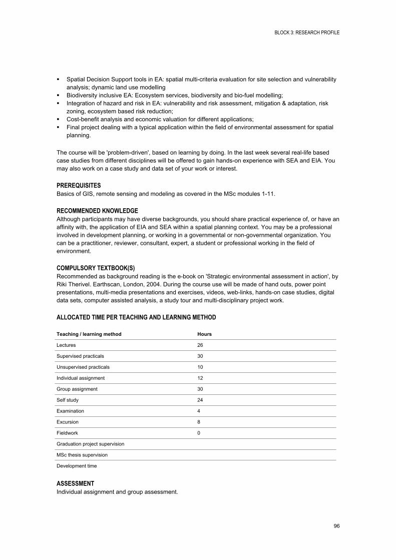
BLOCK 3: RESEARCH PROFILE
96
Spatial Decision Support tools in EA: spatial multicriteria evaluation for site selection and vulnerability analysis; dynamic land use modelling
Biodiversity inclusive EA: Ecosystem services, biodiversity and biofuel modelling; Integration of hazard and risk in EA: vulnerability and risk assessment, mitigation & adaptation, risk
zoning, ecosystem based risk reduction; Costbenefit analysis and economic valuation for different applications; Final project dealing with a typical application within the field of environmental assessment for spatial
planning.
The course will be 'problemdriven', based on learning by doing. In the last week several reallife based case studies from different disciplines will be offered to gain handson experience with SEA and EIA. You may also work on a case study and data set of your work or interest.
PREREQUISITESBasics of GIS, remote sensing and modeling as covered in the MSc modules 111.
RECOMMENDED KNOWLEDGEAlthough participants may have diverse backgrounds, you should share practical experience of, or have an affinity with, the application of EIA and SEA within a spatial planning context. You may be a professional involved in development planning, or working in a governmental or nongovernmental organization. You can be a practitioner, reviewer, consultant, expert, a student or professional working in the field of environment.
COMPULSORY TEXTBOOK(S)Recommended as background reading is the ebook on 'Strategic environmental assessment in action', by Riki Therivel. Earthscan, London, 2004. During the course use will be made of hand outs, power point presentations, multimedia presentations and exercises, videos, weblinks, handson case studies, digital data sets, computer assisted analysis, a study tour and multidisciplinary project work.
ALLOCATED TIME PER TEACHING AND LEARNING METHOD
Teaching / learning method Hours
Lectures 26
Supervised practicals 30
Unsupervised practicals 10
Individual assignment 12
Group assignment 30
Self study 24
Examination 4
Excursion 8
Fieldwork 0
Graduation project supervision
MSc thesis supervision
Development time
ASSESSMENTIndividual assignment and group assessment.
BLOCK 3: RESEARCH PROFILE
97
SPATIAL-TEMPORAL MODELS FOR FOOD AND WATER SECURITY STUDIES
Module 13
Module code M14NRS104
Period 30 June 2014 18 July 2014
EC 5
Module coordinator dr.ir. Bie, C.A.J.M. de (ITC)
INTRODUCTIONRemote sensing and GIS are important tools to provide input to the spatial assessment of Food and Water Security. Such an assessmnet is important to both rainfed as irrigated agricultural systems and can be done at regional, national and continental scales. While a holistic study of food and water security requires many disciplinary inputs, at ITC's research and education three main fields are covered:
Mapping of agroecosystems: mapping and characterization of crop production systems and area estimation (inputs for monitoring, modeling and planning).
Monitoring agroecosystems: detecting past land cover and use changes, and assessing present land cover and crop conditions as for example affected by drought (early warning).
Modelling agroecosystems: early prediction, quantified estimation of moisture conditions, canopy cover, biomass and yield, plus estimation of future impacts by anticipated climate change.
This module will cover the last bullet point and will present the most contemporary modelling approaches that source from satellite imagery to estimate quantitatively the performance of studied agroecosystems as future performances after anticipated climate change. Assessments range from seasonal to interannual and from point to spatial and temporal. An earlier module titled "RS/GIS analysis methods to support Food and Water Security studies" focuses on the first two bullet points. The two modules gradually change focus from characterization to the use of prepared maps for monitoring and finally modeling.
Future research aspects concern (amongst others):
Combined use of indices, generated by optical, radar and thermal sensors and crop growth models to directly and quantitatively assess crop growth, standing biomass and harvestable yield.
Impact of climate change on crop performance and yield stability for identification of crop management issues, needed modifications or alternatives.
In practice, gained knowledge serves (amongst others):
Operational use of satellite data and development of tailormade prediction systems for food security and stress monitoring, e.g. 'Improving/constructing Satellitebased Land and Ecosystem Monitoring Systems for an International Network for Food and Environmental Intelligence', and 'Promotion Programs on Satellitebased Earth Observation Technologies '.
Generate specific agricultural development support, like 'microinsurance schemes', where the use of RSbased indices to model/assess risks and loss probabilities for formulating insurance contracts are developed (lefttailed quantitative anomaly assessment).
BLOCK 3: RESEARCH PROFILE
98
LEARNING OUTCOMESThe participant will be able to use multi and hypertemporal imagery and indices, with exogenous (secondary data) and/or field survey data, plus prepared maps with legends, to: use simple to advanced (dynamic) crop growth models for yield estimation, change assessments, and
spatial suitability assessments (watershed level); assess impacts on performance (biomass, yields) due to anticipated climate changes (scenarios), and
to retrieve the required climate data and future scenarios (past, present, and future weather conditions);
use RSdata to "force" crop growth models and estimate improved (actual) crop yields; includes (i) SoilLeafCanopy (SLC; SCOPE) RSdata inversion techniques to estimate e.g. LAI as a forcing variable, and (ii) the heatbalance (ETa) "forcing" approach.
CONTENTWeek 1: Day1 (de Bie, Venus): Principles and types of empirical and dynamic Crop Growth Models(CGM), their relationship with RSdata, the state of the art of present day CGMapplications, early prediction logic, data requirements, accuracy, and scales. Intro to the small individual assignment.
Day2,3,4 (Ettema, Groen): weather data: sources, principles, use, predictions; present climate change scenarios (expectations); downscaling climate predictions.
Day5 (Timmermans, Ettema): Weather impact assessment at watershed level (area based) on the hydrological cycle.
Week 2: Day6,7 (de Bie): Aquacrop: quantitative yield and yield variability assessments, and assess impacts of climate change on crop productivity and variability (pointbased).
Day8,9,10 (Timmermans, Verhoef): SoilLeafCanopy (SLC; SCOPE) RSdata (Modis) inversion techniques (ProSail) to estimate timeseries of LAI; temporal LAIcleaning and interpolation through temperaturesum formulae.
Week 3: Day11 (Timmermans): instantaneous ETa assessment based on the surface heatbalance system (SEBS).
Day12,13 (Venus, de Bie): Forcing method to use daily LAI and Eta estimates in a CGM to estimate endof season yields or daily actual biomass.
Day14,15: Small individual assignment: implement, using required tools, a processing chain of selected spatialtemporal data to generate relevant Food and Water security information (to be submitted; graded exercise). Advise: initiate your project well in time.
PREREQUISITESSkills in RS and GIS (e.g. coremodules of ITC). Participation in Module 12 "RS/GIS analysis methods to support Food Security studies" is recommended but not essential.
RECOMMENDED KNOWLEDGEBackground in systems analysis for resources management.
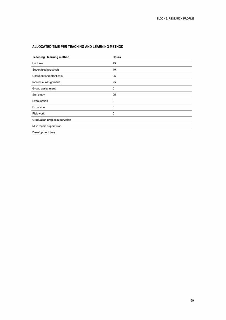
BLOCK 3: RESEARCH PROFILE
99
ALLOCATED TIME PER TEACHING AND LEARNING METHOD
Teaching / learning method Hours
Lectures 29
Supervised practicals 40
Unsupervised practicals 25
Individual assignment 25
Group assignment 0
Self study 25
Examination 0
Excursion 0
Fieldwork 0
Graduation project supervision
MSc thesis supervision
Development time
BLOCK 3: RESEARCH PROFILE
100
LAND GOVERNANCE
Module 13
Module code M14PGM105
Period 30 June 2014 18 July 2014
EC 5
Module coordinator dr. Tuladhar, A.M. (ITC)
INTRODUCTIONLand remains a highly complex issue, and often forms a cause for conflict at regional, national, local and personal level in view of its value as an economic resource in relation to social, political, cultural and often religious systems. The failure to adopt, at all levels, appropriate (urban and rural) land policies and land management practices remains a primary cause of inequity and poverty. The consequences often take the form of difficult access to land Information, unawareness of land policies and legal frameworks, ignorance about land transactions and prices, misallocation of land rights, land grabbing and abuse. Many of the general governance principles thus appear highly relevant to the management and administration of land. When in place, this in turn strengthens confidence in governments and public agencies, and has a positive economic impact, also on economic development.
The main aim of this advanced module is to provide the participants with the broad knowledge, tools and skills to strengthen land governance issues while implementing policy frameworks for sustainable development in developing and emerging countries. The main objectives are: to introduce governance issues related to land with adequate knowledge and tools required in building
transparent land management and administration systems; to describe various substantive issues and tools whereby land governance and transparency in land
management and administration are assessed with a view to preventing and / or fighting corruption; to demonstrate how ethical dilemmas are identified and how tools are applied to promote good
governance to address the problem situation and mitigate undesirable consequences.
LEARNING OUTCOMESAt the end of the module the student should be able to: understand various international initiatives and relevant tools for promoting good governance; explain the relation between land, human rights and governance; describe relevant land governance issues and apply them in land management and land administration
in building trust between public agencies and citizens; apply relevant tools for good governance to reduce corruption in the relevant case study environment
of Asian and African continents.
CONTENT The concept of governance and its principles, transparency, corruption and reflection on human rights
policies; International initiatives (such as UN, FAO, World Bank, UNHABITAT, FIG, UT/ITC, etc.), paradigm
and vision for land governance and transparency issues; various governance indicators; The broader ethical issues to deal with corruption and enhance transparency; exploring and situating
ethical dilemmas using real case studies in developing contexts; Key substantive issues and tools (i.e. assessment of transparency, access to land information, public
participation, professional ethics and integrity, and institutional reform) to promote good land governance in the management and administration of land;
BLOCK 3: RESEARCH PROFILE
101
Exploring possible entry points for the key substantive issues to address the problem situation and mitigate undesirable consequences using transparency tools in real case studies developed by the Asian and African land experts.
RECOMMENDED KNOWLEDGEBlock 1 and 2 the ITC MSc curriculum.
COMPULSORY TEXTBOOK(S) Presentation slides on various substantive issues and tools; Relevant scientific literatures, reports and policy papers; Real case studies developed by Asian and African land experts.
ALLOCATED TIME PER TEACHING AND LEARNING METHOD
Teaching / learning method Hours
Lectures 42
Supervised practicals 14
Unsupervised practicals 10
Individual assignment 20
Group assignment 24
Self study 6
Examination 8
Excursion 0
Fieldwork 0
Graduation project supervision
MSc thesis supervision
Development time 20
ASSESSMENT100% Presentation and Report.
BLOCK 3: RESEARCH PROFILE
102
COLLABORATIVE PLANNING AND DECISION SUPPORT SYSTEMS APPLIED IN DECISION ROOMS
Module 13
Module code M14PGM106
Period 30 June 2014 18 July 2014
EC 5
Module coordinator dr.ir. Boerboom, L.G.J. (ITC)
INTRODUCTIONCollaborative planning is today's planning practice. New tools and methodologies have been developed to improve the processes and enhance quality of outcomes. New developments in fields such as information technology brought new insights in this field.
This module develops the participants' conceptual and practical understanding of several advanced methods for collaborative planning and decision support and provides theoretical perspectives and underpinnings to prepare participants for: Development of collaborative planning and/or decision support methods, systems and serious games; Observation and learning about collaborative planning and decision making processes using methods,
systems, games, and decision rooms.
The first part of this course addresses spatial scenario development through spatial planning support systems. The second part addresses collaborative analysis and decision making regarding scenarios. The course makes use of the facilities available in the ITC group decision room.
LEARNING OUTCOMESUpon completion of the module participants should be able to: explain general approach to scenario development and analysis; explain the complexity of the collaborative planning environment; state the role of disciplinary models in the planning process; explain ways of handling uncertainty; explain the role of various stakeholders, and the way to consider their views in the planning process; develop and apply qualitative/quantitative techniques for policy formulation and scenario development; develop and evaluate policy and assess its impacts in various scenarios; apply qualitative decision rulebased models for scenario development and analysis; state the potentialities and limitations of qualitative methods for scenario development and analysis; explain the principles of decisionmaking process and use of decision support systems; distinguish between various phases of the decisionmaking process and their required types of
information and support systems; use multicriteria evaluation techniques in time and space to propose an appropriate solution to a
spatial problem in a single and group decisionmaking environment; perform uncertainty analysis and scenario analysis; assess and interpret the results of the collaborative multicriteria evaluation process; ability to conceptualize serious games.
CONTENT Planning and decision support systems (definition, components, architecture, and examples); Framework for planning and decision making, with examples of land and water resource issues;
BLOCK 3: RESEARCH PROFILE
103
Introduction to serious gaming; Dealing with data uncertainty, and future and various stakeholders; Scenario definition, concepts, development and analysis; Modelbased scenario development approaches; Quantitative and qualitative methods for scenario development; Integrated models for planning and policy formulation, scenario development, impact assessment and
analysis; Introduction to the decisionmaking process and decision support systems; Performance assessments, indicator selection, assessment and valuation; Theory and practice of collaborative spatial decision support (EAST); Application of spatial multicriteria evaluation in planning and decision making; Models of uncertainty and how to capture these in decision support systems; Collaborative decision making under uncertainty and incomplete information; Group decision making and the required information technology supports; Application of spatial multicriteria evaluation in group decision making; Application of the above techniques in case studies (participants can select the case according to their
background and interests).
RECOMMENDED KNOWLEDGEBasic GIS skills required.
COMPULSORY TEXTBOOK(S)Reader will be provided.
ALLOCATED TIME PER TEACHING AND LEARNING METHOD
Teaching / learning method Hours
Lectures 30
Supervised practicals 20
Unsupervised practicals 15
Individual assignment 0
Group assignment 15
Self study 42
Examination 22
Excursion 0
Fieldwork 0
Graduation project supervision
MSc thesis supervision
Development time
ASSESSMENTQuiz, Exam and Group presentation.
BLOCK 3: RESEARCH PROFILE
104
URBAN RISKS: PLANNING FOR ADAPTATION
Module 13
Module code M14PGM107
Period 30 June 2014 18 July 2014
EC 5
Module coordinator dr. Flacke, J. (ITC)
INTRODUCTIONThe world is becoming urban. Since 2008 more than half the world's population is living in cities and urbanized areas and this trend is continuing. It is expected that 60 percent of the world's population will live in cities by the year 2030 and 70 % by 2050. Moreover, also the number of large cities and the size of the world's largest cities are increasing. The number of cities in the world with populations greater than 1 million increased from 75 in 1950 to 447 in 2011.
At the same time cities and urbanized areas are much more often hit by natural hazards, such as floods, earthquakes, heat waves, landslides, etc. Worldwide the number of disasters has almost quadrupled during the past 30 years and there is a widespread consensus that urban disasters are increasing exponentially. The role of cities has changed from places of refuge and buffers against environmental changes to hotspots of disasters and risk.
As a consequence city authorities and planners are increasingly facing the challenge of finding ways to include risk reduction and adaptation strategies in their work. Both, risk reduction and climate change adaptation needs to be integrated into urban planning.
This module provides an overview of contemporary urban risk reduction and adaptation frameworks. Various forms and approaches of urban risk assessment are discussed and practiced making use of spatial data. Concepts of urban and climate change vulnerability are reviewed and the level vulnerability of groups in the society is assessed. Urban risk reduction and climate adaptation plans are reviewed and mainstreaming of risk into urban planning is discussed.
LEARNING OUTCOMES Understand key concepts and terms of urban disaster risk management, risk reduction and climate
change adaptation. Identify links and connections between various types of risks and climate change , risk reduction and
adaptation, and urban planning and management. Apply urban risk and vulnerability assessment approaches and methods. Understand communitybased risk management strategies and people's coping capacities. Develop suitable urban risk adaptation plans and measures.
CONTENT Frameworks and concepts of urban risk reduction and adaptation Urban risk assessment Disaster resilience Integrated flood risk management (IFM) Climate change adaptation planning Community based risk management Mainstreaming risk management into urban planning Urban vulnerability concepts
BLOCK 3: RESEARCH PROFILE
105
Sustainable urban risk governance Cumulative risk assessment
COMPULSORY TEXTBOOK(S)Reader will be provided.
ALLOCATED TIME PER TEACHING AND LEARNING METHOD
Teaching / learning method Hours
Lectures 34
Supervised practicals 20
Unsupervised practicals 15
Individual assignment 11
Group assignment 20
Self study 44
Examination 0
Excursion 0
Fieldwork 0
Graduation project supervision 0
MSc thesis supervision 0
Development time 0
ASSESSMENTAssessment is made based on the submission of a number of assignments and presentations, and does not include an exam.
BLOCK 3: RESEARCH PROFILE
106
SENSORS, EMPOWERMENT AND ACCOUNTABILITY
Module 13
Module code M14PGM108
Period 30 June 2014 18 July 2014
EC 5
Module coordinator prof.dr. Georgiadou, P.Y. (ITC)
INTRODUCTIONThe objective of this module is to analyse different types of applications on the geoweb in terms of technological design as well as organisational strategies, with particular emphasis on those applications that enable citizens to voice their concerns on the quality of public services to relevant government agencies.
First, basic concepts for sensor webs and for human sensors webs will be discussed and analysed. Second, applications related to collaborative mapping and citizen science will be examined from the points of view of technological and institutional design. Third, concepts and methods for (1) context modeling of a human sensor, for (2) understanding citizens' reporting behavior, and for (3) analyzing the response of government to citizens' reports will be explained and discussed.
The module is based on a NWOWotro research project (20122016) conducted by researchers at ITCUT and M&BUT together with researchers at the University Dar es Salaam, Tanzania (See https://sites.google.com/site/sematanzania/)
LEARNING OUTCOMESAt the end of the module the student should be able to: research the sensor web and differentiate between different sensor web services, including human
sensor webs; understand and discuss the principles of collaborative mapping and reason about choosing the
appropriate applications in specific situations; understand the concept of semantic modelling and explain the role of context in crowdsourcing and
citizen science; research and discuss a concept that has the potential to explain citizen reporting behaviour, as well as
a method to collect related data in the field; research and discuss a concept that has the potential to explain the response of government to
citizens' reports, as well as a method to collect related data in the field.
CONTENT Technological / architectural design of applications on the geoweb; Elements of semantic modeling; Organisational strategies for digital earth applications; Techniques, concepts, and theories related to citizengovernment relationship, with emphasis on open
government, transparency and accountability.
RECOMMENDED KNOWLEDGE Block 2 of the ITC MSc curriculum UPM; Basic knowledge on organizations and institutions.
BLOCK 3: RESEARCH PROFILE
107
COMPULSORY TEXTBOOK(S)Fung, A.K., Graham, M. D. Weil (2007) Full disclosure: the perils and promise of transparency Cambridge University Press, 9780511274268, 302 p. Also as ebook <http://www.itc.eblib.com/patron/FullRecord.aspx?p=288626 >
Georgiadou, et al. (2011) Sensors, empowerment and accountability : a digital earth view from East Africa : invited paper. In: International journal of digital earth, 4 (2011)4 pp. 285304. Available at: http://www.tandfonline.com/doi/abs/10.1080/17538947.2011.585184#.UwtUafl5Mg0
Raman, B., (2012) The Rhetoric of Transparency and its Reality: Transparent Territories, Opaque Power and Empowerment. The Journal of Community Informatics, North America, 8, April 2012. Available at: <http://cijournal.net/index.php/ciej/article/view/866 >.
ALLOCATED TIME PER TEACHING AND LEARNING METHOD
Teaching / learning method Hours
Lectures 15
Supervised practicals 15
Unsupervised practicals 0
Individual assignment 0
Group assignment 60
Self study 20
Examination 8
Excursion 8
Fieldwork 0
Graduation project supervision 0
MSc thesis supervision 10
Development time 8
ASSESSMENT100% presentation and report.
BLOCK 3: RESEARCH PROFILE
108
WATER, CLIMATE AND CITIES
Module 13
Module code M14WRS101
Period 30 June 2014 18 July 2014
EC 5
Module coordinator ir. Timmermans, W.J. (ITC)
INTRODUCTIONThis module will offer a set of methods and techniques for analysis and monitoring of climate and climate change, with applications in climate change impacts and adaptation.
LEARNING OUTCOMESUpon the completion of this module, the students will have: A better understanding of the physical processes (meteorology) determining the climate, and thus
climate change; A better understanding of the climate adaptation and response, with respect to water related issues
("climate change impact"); Handson experience with respect to (regional) modeling ("techniques"); Advanced knowledge about the implications of climate change and its implications for water resources
resulting from various climate change scenarios and climate change response options, including associated synergies.
Experimental knowledge on urban climate observations
CONTENTFreshwater is indispensable for all forms of life and is needed, in large quantities, in almost all human activities. Climate, freshwater, biophysical and socioeconomic systems are interconnected in complex ways, so a change in any one of these induces a change in another. Climate change adds a major pressure to nations that are already confronting the issue of sustainable freshwater use.
The challenges related to freshwater are: Having too much water; Having too little water, and Having too much pollution.
Each of these problems may be exacerbated by climate change. Freshwaterrelated issues play a pivotal role among the key regional and global vulnerabilities. Therefore, the relationship between climate change and freshwater resources is of primary concern and interest.
This module intends to introduce to students relevant processes and tools related to climate and climate change impacts for the spatial and temporal distribution of freshwater resources, at global as well as at regional scales.
PREREQUISITESMSc modules 111 in WREM, NRM, AES, GEM, relevant module 12.
BLOCK 3: RESEARCH PROFILE
109
RECOMMENDED KNOWLEDGEBasic knowledge in mathematical and statistical analysis, basic understanding in quantitative Earth Observation, programming skills and image processing skills.
COMPULSORY TEXTBOOK(S)1. Lecture Notes "Climate Change", WREM Course, July 2009;2. Selection of relevant scientific papers;3. Module PowerPoint's, as used during the lectures.
ALLOCATED TIME PER TEACHING AND LEARNING METHOD
Teaching / learning method Hours
Lectures 26
Supervised practicals 18
Unsupervised practicals 32
Individual assignment 12
Group assignment 10
Self study 38
Examination 4
Excursion 4
Fieldwork 0
Graduation project supervision
MSc thesis supervision
Development time
ASSESSMENTWritten exam will be held to assess the understanding of the theoretical aspects of this module, including those relevant in practicals and case studies.
Teams of students must present a case that demonstrates their understanding of the case studies and how they would apply the knowledge in a selected application domain.
BLOCK 3: RESEARCH PROFILE
110
SATELLITE DATA FOR INTEGRATED WATER RESOURCE ASSESSMENTS AND MODELING
Module 13
Module code M14WRS102
Period 30 June 2014 18 July 2014
EC 5
Module coordinator Dr. ing. Rientjes, T.H.M. (ITC)
INTRODUCTIONWater resource and hydrological assessments increasingly are becoming more complex and more data demanding. Traditionally insitu data is used in modelling but there is wide consensus that use of insitu data in modelling often lead to inferior assessments by poor system and process representation. For this reason the use of satellite data is more widely propagated and has become popular by availability of a wide range of satellite products. Integration, however, is not trivial and also assessments how modelling results change are not trivial. This module aims at a broader understanding on satellite datamodel integration but also aims at a basic understanding on constraints and strengths on the use and application of satellite data. Various aspects of model performance will be discussed as well as aspects of water balance closure when satellite data is used instead of insitu data.
LEARNING OUTCOMESAt the end of this module the participant is able: To understand constraints and strengths of data integration in modelling To integrate satellite data in modelling To evaluate model performance when satellite data is used is stead of insitu data To improve modelling skills To assess model performance for simulation and forecasting by use of satellite data To understand the various aspects involved to close the water balance at catchment scale
Various levels of data integration will be discussed and is part of the learning outcomes. A number of satellite applications such as precipitation, evapotranspiration, soil moisture and floods are discussed and also makes part of the learning outcomes.
CONTENTCurrent applications of integrated water resource and hydrological models for system simulation and forecasting often rely on insitu data. Alternative to such data is the use of satellite data for system and process representation in a distributed and coherent fashion. Satellite products are available for terrain and land use modelling, for rainfall, evapotranspiration and moisture representation and for observing floods. This module /addresses various aspects of use and integration of satellite data in integrated water resource assessments and hydrological models. Both urban and rural areas are addressed. Learning is by frontal teaching, practicals, assignments and selfstudy.
BLOCK 3: RESEARCH PROFILE
111
ALLOCATED TIME PER TEACHING AND LEARNING METHOD
Teaching / learning method Hours
Lectures 36
Supervised practicals 20
Unsupervised practicals 0
Individual assignment 34
Group assignment 0
Self study 50
Examination 4
Excursion 0
Fieldwork 0
Graduation project supervision
MSc thesis supervision
Development time
BLOCK 3: RESEARCH PROFILE
112
RESEARCH THEMES/ MSC QUALIFIER
Module 14-15
Module code P14EDU104
Period 28 July 2014 5 September 2014
EC 10
Module coordinator Drs. Loran, T.M. (ITC)
INTRODUCTIONThe research activities of the six scientific departments form the subject framework and organizational structure in which MSc students conduct their individual research. The purpose of Modules 14 and 15 is i) to deepen the knowledge and skills of students within the research activities of the department, and ii) to help the student to define his or her own MSc research proposal.
Each scientific department offers one or more projects during Modules 14 and 15. The duration of the project is two weeks. Although the general structure is the same, the content will be specific to the department's research. Departments are free to fill this in within the boundaries described in this module description. In some cases, the project work is interdisciplinary.
A further three weeks are spent on finalizing the MSc research proposal. At the end of Module 15, a Thesis Admission Committee decides whether or not the student is admitted to Block 4 of the MSc programme (modules 1623).
The student has to make a choice of his/her envisaged MSc thesis topic during Block 2 of the course. The choice is made, and explained, in the MSc preproposal. This preproposal has to be submitted after the MSc fair (12 March 2014) and before the start of module 11 (20 May 2014).
For more information about the content and scope of the ITC's research, please visit: http://www.itc.nl/researchthemes
LEARNING OUTCOMESUpon completion of these two modules, the student will be able to: Define ways to tackle a scientific problem and structure research; Place his/her research project in a wider scientific and societal context; Structure his/her proposed scientific research to the specifications of the scientific discipline; Meet quality standards and excellence in research; Present scientific information in written English at a standard acceptable to the scientific community; Write an MSc research proposal and defend this to the Thesis Admission Committee.
CONTENTTwo main activities run parallel in Modules 14 and 15: A group research project, Finalizing the research proposal for the individual MSc thesis.
BLOCK 3: RESEARCH PROFILE
113
Group Research Project:
The purpose of the group project is: To let the student place his/her own MSc research project and research interests in a wider scientific
context; To give the student an opportunity to practise under supervision of a tutor conducting a research
project before starting to work on his/her individual MSc research project; To give the student an opportunity to practise undertaking research in a team; To give student the opportunity to share knowledge and ideas in a multidisciplinary context.
These activities are considered an important preparation for conducting the individual MSc research in Block 4, as well as for the student's future professional academic working practice, in which projects are often conducted in (multidisciplinary) groups.
The projects are defined by the scientific departments with a view to catering for a variety of research approaches and interests, as well as the relevance of these to society. Projects are described with a title, a problem definition, and, if appropriate, the available dataset. The student group, consisting normally of a maximum of five students, is responsible for working this out into various activities according to an agreed plan. The student group has the freedom to make its own choices, supported by a tutor. The available projects will be made known early in 2012 in order to give the participants the opportunity to select a project that matches their research interest. The choice has to be submitted before the start of module 11 (May 14th 2012) and should be justified within the MSc preproposal.
In a plenary session at the start of module 14, the Principal Investigator of the research group will introduce the various MSc subjects and their interrelation in the framework of the research of his/her group, and introduce the research assignments. A tutor will be appointed to guide each student groupduring module 1415 . The tutors will convene plenary sessions (in principle per research group) to monitor the progress of all participating students and to exchange experiences in a discussion forum.
Finalizing Research Proposal:
The MSc research proposal is finalized by the student in mutual agreement with his/her MSc supervisors, appointed in Module 11. The research proposal should be a logical and ordered exposition of the envisaged research (as introduced in Module 11), including data availability, (fieldwork) methods, a flowchart, and time planning. In the last week of Module 15, the research proposal is presented before a Thesis Admission Committee (see MSc assessment regulations paragraphs 5.1 and 5.4).
When presenting the proposal, the student must also satisfy the Thesis Admission Committee that all the required data is available or, if not, that steps (including fieldwork if appropriate) will be taken to acquire these data in time. Likewise, requirements for hardware and/or software should be specified to ensure that these can be made available as required.
Acceptance of the proposal is a prerequisite for the start of the individual research (Modules 1623). The MSc student will draft a supervision plan in consultation with the two appointed MSc supervisors.
PREREQUISITESSuccessful completion of Modules 1 to 13 of the MSc curriculum.
To prepare an acceptable proposal and carry out the subsequent research work, it is necessary to have a sufficient level of knowledge in the chosen research field. Consequently, if a student wants to undertake research in which the focus differs from that of the domain modules followed in Block 2, he/she will have to provide satisfactory evidence that he/she has the relevant background, knowledge and skills.
BLOCK 3: RESEARCH PROFILE
114
RECOMMENDED KNOWLEDGETo be specified by the responsible scientific department.
ALLOCATED TIME PER TEACHING AND LEARNING METHOD
Teaching / learning method Hours
Lectures 0
Supervised practicals 0
Unsupervised practicals 0
Individual assignment 0
Group assignment 0
Self study 0
Examination 0
Excursion 0
Fieldwork 0
Graduation project supervision
MSc thesis supervision
Development time
ASSESSMENT Group report of the research project; Individual written reflection report on the group research project; Individual MSc research proposal (written and oral presentation).
BLOCK 3: RESEARCH PROFILE
115
MODEL CHARACTERISATION AND QUALITY ASSESSMENT
Module 14-15
Module code U14EOS103
Period 28 July 2014 5 September 2014
EC 10
Module coordinator prof.dr.ir. Stein, A. (ITC)
INTRODUCTIONThe description and allocated hours as indicated are provisional. For more details please contact the module coordinator.
Geographical Information Systems provide important tools to analyze environmental, urban or agricultural systems. Linking them to spatiotemporal models to use earth observation data can lead to important findings about system dynamics and provides new understanding for effective decision and policy making. Especially when using modeling and GIS for management and governance purposes we need to be well aware of the quality of the spatial data and analytical methods used. How reliable are our forecasts? How sensitive are they to errors in observations? How do errors propagate through the analysis chain? How can errors in data compound due to processing in the models that use them? Can satellite data replace field observations? Which model is better? What is the appropriate scale? These are important questions that we need to be ready to address.
This topic is provided in collaboration between the EOS and GIP departments. Research in EOS (Acqual) includes a strong component on earth observation and spatial data quality. This is focused on statistical approaches for defining and quantifying uncertainty in spatial data with a particular emphasis on remotely sensed data. Research in GIP (STAMP) focuses on spatial data infrastructure technology which includes systems modeling and model analysis. Analysis of model performance also includes uncertainty analysis and model quality assessment. This provides another perspective on spatial data quality.
The rationale for this project is to address a particular environmental, agricultural or urban system and to address relevant questions with a GIS. Central question is to which a GIS can represent such a system. Relations with deterministic models, with availability of data, issues of scale and spatial data quality will be addressed.
LEARNING OUTCOMESThe module has four aims. These are to:1. Consider systems in the broadest context: from nature to information systems;2. Foster interdisciplinary group research;3. Practice and develop your research skills;4. Simulate the MSc thesis process by undertaking a miniproposal and a deskbased research project.
The module has the following learning outcomes associated with the above aims: To consider systems in the broadest context. At the end, students should be able to:
1. Outline and critique the steps required to define, conceptualize, quantify, report and model an agricultural, urban or environmental system;
BLOCK 3: RESEARCH PROFILE
116
2. Obtain knowledge on systems theory and dynamic modeling;3. Evaluate and critique the quality of a GIS for representing the system and know how it can be
integrated with dynamic modeling tools;4. Evaluate the quality of integrated analytical tools (models and GIS) to represent the chosen system for
decided purposes of management or policy making.
To foster interdisciplinary group research. At the end, students should be able to:
1. Define ways to tackle a scientific problem and structure research;2. Place research projects in a wider scientific context;3. Work and share knowledge in a (multidisciplinary) research team.
To practice and develop your research skills. At the end, students should be able to:
1. Meet quality standards and excellence in research;2. Present scientific information in written English at a standard acceptable to the scientific community;3. To reflect critically on your personal role in the scientific process
To simulate the MSc thesis process by undertaking a mini-proposal and desk-based research project. At the end, students should be able to:
1. Structure scientific research to specifications of the scientific discipline;2. Write an MSc research proposal.
CONTENTThe group project will begin with a miniworkshop on systems and GIS. This will introduce the systems in a practical setting, like the way they were analyzed in MSc research in the past. This will be done before discussing GIS as a framework for modeling processes in the system, collecting data from the system, evaluating, reporting and controlling spatial data quality. The workshop will draw on expertise from the EOS and GIP departments.
Following the workshop, the students will be divided into project teams in which they will be required to undertake a group assignment. They will select one system of preference and will be provided with information on the system and a data set together with some documentation which provides information on the data and required information. They will be required to conduct an independent evaluation of the system to determine whether it can be incorporated in the GIS. In particular, the limits and opportunities of the GIS will be addressed. They will also be required to undertake basic analysis to quantify how to evaluate the quality of the analysis for the questions that are relevant within the system they analyze.
The students will be required to consider whether the specification is sufficient or whether further information needs to be incorporated. They will need to consider how the quality metadata will be reported and whether some information should remain unreported. Statistical methods required to quantify output from the parameters that is relevant for the system will be addressed. Issues of spatial and temporal variation, aspects of scale and availability and relevance of satellite data will be addressed, Progress through the project will be facilitated by the lecturing staff.
The module will conclude with a halfday mini workshop where the students will present their findings and discuss them with the lecturing staff.
PREREQUISITESThis module is open to all ITC MSc students.
BLOCK 3: RESEARCH PROFILE
117
RECOMMENDED KNOWLEDGESuccessful completion of modules 1 to 13. Some basic background in statistical analysis and systems theory is important. This might be obtained through module 5 of the GFM stream or through other relevant studies.
COMPULSORY TEXTBOOK(S)Not defined.
ALLOCATED TIME PER TEACHING AND LEARNING METHOD
Teaching / learning method Hours
Lectures 0
Supervised practicals 0
Unsupervised practicals 0
Individual assignment 0
Group assignment 0
Self study 288
Examination 0
Excursion 0
Fieldwork 0
Graduation project supervision
MSc thesis supervision
Development time
ASSESSMENTNot defined.
BLOCK 3: RESEARCH PROFILE
118
RESEARCH PREPARATION 4D-EARTH
Module 14-15
Module code U14ESA105
Period 28 July 2014 5 September 2014
EC 10
Module coordinator ir. Krol, B.G.C.M. (ITC)
INTRODUCTIONMSc students in the AES course specialisations 'Natural Hazards and Disaster Risk Management' and 'Engineering Geology' conduct their individual MSc research project in the framework of the 4DEARTH/DMAN research theme of ITC's ESA department.
In these modules 14 and 15 the DMAN research team intends to create a stimulating working environment for the students to develop a goodquality MSc proposal. While students will work on their MSc proposals they will also participate in a number of peer review sessions. These sessions provide the opportunity to discuss and improve their proposals with the support of their peers. In a series of presentations and handson sessions the students are challenged to critically consider a number of methodological choices that have to be made regarding (field) data collection and (pre)processing.
At the end of these modules 14 and 15 each student will present her/his MSc research proposal to a Proposal Assessment Board.
LEARNING OUTCOMESAt the end of this module, the participant is able to present and defend an MSc research proposal that meets the ITC standards for MSc proposal development.
In order to achieve this main objective the student is able to: Provide an overview of research approaches, techniques and tools relevant to the 4DEARTH/DMAN
research theme; Select and justify an appropriate research method and related techniques and tools for an MSc
research project within the 4DEARTH/DMAN research theme; Both give and receive constructive and critical feedback on elements of a draft MSc research proposal.
CONTENTProposal development and peer review sessions Individual proposal writing; Peer review sessions.
Research methods and (field) data collection issues: Presentations by research staff; Series of handson sessions (data collection and (pre)processing).
PREREQUISITES ITC's module 11: Research skills; An identified and accepted MSc research topic.
BLOCK 3: RESEARCH PROFILE
119
COMPULSORY TEXTBOOK(S)Reader.
ALLOCATED TIME PER TEACHING AND LEARNING METHOD
Teaching / learning method Hours
Lectures 18
Supervised practicals 20
Unsupervised practicals 0
Individual assignment 0
Group assignment 0
Self study 232
Examination 0
Excursion 0
Fieldwork 18
Graduation project supervision
MSc thesis supervision
Development time
ASSESSMENTThese modules 14 and 15 will be assessed as follows: Active participation during presentations and handson sessions (to be approved by lecturing staff); Active participation during peer review sessions (to be approved by facilitator); Preparation of peer review reports (each student has to prepare a review report per peer review
sessions for one of the fellow students; to be approved by lecturing staff); Preparation of an individual reflection report (each student writes a report of max. 2 pages in which
she/he reflects on what was learned from the peer review sessions, the presentations and the handson session as input for the proposal development).
Assessment on the basis of pass/fail.
BLOCK 3: RESEARCH PROFILE
120
REGIONAL GEOLOGICAL INTERPRETATION
Module 14-15
Module code U14ESA106
Period 28 July 2014 5 September 2014
EC 10
Module coordinator dr. Ruitenbeek, F.J.A. van (ITC)
INTRODUCTIONIn this threeweek module you will carry out a researchoriented project that focuses on the combined use of remote sensing imagery with field observations and measurements to make a geological interpretation of the Harz Mountains in Germany. In this geological remote sensing study a field work component is essential to investigate the geology on outcropscale and determine the relationships between the variations in the remotely sensed imagery and the geology on the ground. Field measurements will be acquired in the field during a field trip to the Harz Mountains in Germany and used to determine differences between various geological units and to validate and update geological interpretations that were based on remotely sensed data.
LEARNING OUTCOMESThe students will learn: To make preliminary geological interpretations from remotely sensed and geophysical imagery prior to
field checking; To collect geological field observations and to use field instruments to measure chemical, physical and
mineralogical parameters; To use field observations and measurements to validate and improve remotely sensed geological
interpretations.
CONTENTThis contains three phases:1. First a preliminary geological interpretation using airborne geophysical and remote sensing imagery of
the Harz Mountains in Germany will be made. This interpretation will be used as a bases for a field visit;
2. During a field visit to the Harz Mountains in Germany geological observations will be made from representative lithologies in the area as well as measurements with instruments such as a field spectrometer (reflectance spectra) and a gammaray spectrometer. Attention will be paid to the SEDEXtype PbZn potential of the Harz area;
3. In the last phase the data collected in the field will be used to validate and update the preliminary geological interpretation that resulted from the first phase.
PREREQUISITESThe students must have completed block 2 of the Earth Resources Exploration Stream.
RECOMMENDED KNOWLEDGEThe student must have a background in geology or mineral exploration. He/she must be familiar with the use of remote sensing and airborne geophysics for geological interpretations.
BLOCK 3: RESEARCH PROFILE
121
ALLOCATED TIME PER TEACHING AND LEARNING METHOD
Teaching / learning method Hours
Lectures 2
Supervised practicals 8
Unsupervised practicals 24
Individual assignment 0
Group assignment 24
Self study 6
Examination 0
Excursion 0
Fieldwork 32
Graduation project supervision
MSc thesis supervision
Development time
ASSESSMENTThe assessment is based on the individual contribution to a group report.
BLOCK 3: RESEARCH PROFILE
122
GEODATA AND SERVICE PROVISION IN CRISIS SITUATIONS: SUPPORTING UN PEACE KEEPING OPERATIONS
Module 14-15
Module code U14GIP104
Period 28 July 2014 5 September 2014
EC 10
Module coordinator dr. Ostermann, F.O. (ITC)
INTRODUCTIONThe description and allocated hours as indicated are provisional. For more details please contact the module coordinator.
The Cartographic Section of Department of Field Support of the United Nations (UN) whilst providing cartographic and geographic support to the UN Secretariat is also responsible for offering geographic information support to peace keeping and peace building missions around the world.
The module aims to introduce the participants with the main concepts of peacekeeping and peace building operations (hereafter UN Peace Operations) by the UN and also familiarize with operational overview and geographic support given to the different UN missions. Through the module, operational challenges in geographic information support faced in different deployment phases of the missions are discussed, thus participants will be exposed to every day challenges faced by peacekeepers and peace builders aroundthe globe.
LEARNING OUTCOMESUpon the completion of this module, participants will be able to meet the needs of the UN and the international community by developing the following skills: understand the organizational setup of UN and georelated activities occurring in UN Peace
Operations environment know the challenges in working in a datapoor environment in an UN Peace Operations environment practice how to plan and operate to support geoinformation needs of the UN and the international
community in one of the typical phases of UN deployment through a scenario setting develop one of the following skills through the scenario exercise:
1. Develop a strategic and operational plan at a particular deployment phase;2. Gather user requirements and the relevant geoinformation for operation;3. Design a system architecture which ensures efficient and effective geoinformation maintenance;4. Integrate relevant geoinformation for a specific tactical operation;5. Visualize relevant geoinformation for a specific client.
CONTENTThe module will introduce main normative concepts used in the area of UN Peace Operations and how geographic information can provide additional value to the mandates agreed upon by the international community.
BLOCK 3: RESEARCH PROFILE
123
The module will introduce participants with: Organizational set up of UN Peace Operations; Typical phases of deployment; Typical geographic support given in the different phases of deployment; Geographic information collection, integration, generation/production, visualization/dissemination and
maintenance issues; Geographic operational strategic planning.
PREREQUISITESOpen to all MSc students.
RECOMMENDED KNOWLEDGEBasic skills on GIS and Remote Sensing (Core modules).
COMPULSORY TEXTBOOK(S)Course folder with handouts, PowerPoint files.
ALLOCATED TIME PER TEACHING AND LEARNING METHOD
Teaching / learning method Hours
Lectures 20
Supervised practicals 0
Unsupervised practicals 0
Individual assignment 60
Group assignment 0
Self study 202
Examination 6
Excursion 0
Fieldwork 0
Graduation project supervision
MSc thesis supervision
Development time
ASSESSMENTIndividual reports and group presentations.
BLOCK 3: RESEARCH PROFILE
124
BIOMASS ESTIMATION AND CARBON ASSESSMENT FOR CLIMATE CHANGE RESEARCH
Module 14-15
Module code U14NRS103
Period 28 July 2014 5 September 2014
EC 10
Module coordinator drs. Westinga, E. (ITC)
INTRODUCTIONGroup Research Project:
The purpose of the group project is: To let the student place his/her own MSc research project and research interests in a wider scientific
context; To give the student an opportunity to practise under supervision of a tutor conducting a research
project before starting to work on his/her individual MSc research project; To give the student an opportunity to practise undertaking research in a team; To give student the opportunity to share knowledge and ideas in a multidisciplinary context.
These activities are considered an important preparation for conducting the individual MSc research in Block 4, as well as for the student's future professional academic working practice, in which projects are often conducted in (multidisciplinary) groups.
For the research topics offered by the Department of Natural Resources, we will start as a group together with the following research topics: Change detection of vegetation types in Buursezand area; Field data collection and mapping and modelling of rare species distributions; Crop production modelling and monitoring; Biomass estimation and carbon assessment for climate change research.
LEARNING OUTCOMESThe following can be expected from this particular "mini research" topic:
Students will vist the Haagsebos, a forest area 5km northeast of Enschede. They will collect data on: tree species, tree diameter at breast height (DBH), height, crown diameter and canopy cover percentage.
Working with high resolution satellite images of QuickBird, students will delineate the crown projection area CPA of a number of trees sampled in the forest during the fieldwork.Using allometric equations of different tree species they will estimate biomass of trees, thus enabling the carbon stock to be estimated. The relationships between DBH and CPA, CPA and biomass and CPA and carbon will be assessed in order to develop and validate a model with which carbon stock of each individual tree can be estimated using CPA. For this, the CPA of coniferous and broadleaved trees of the forest will be obtained by segmentation of the QuickBird image. Finally, the and model of the carbon stock and a resulting map of the carbon stock will provide the information that is required to estimate the total carbon stock of the Haagsebos Forest.
BLOCK 3: RESEARCH PROFILE
125
CONTENTThe first week will be spent on the individual research proposal. Students will be asked to perform a literature review and to develop a conceptual framework related to their own research. The rationale behind this first week of individual work is that the student has time to reflect on her/his own research.
Together with the conceptual framework, this reflection will enable the student and her/his supervisors to reach a wellreasoned decision on which fieldwork skills related to natural resources are needed for the individual research of the student. The second and third week will then be spend on acquiring relevant fieldwork skills and analyzing the fieldwork data in a mini research (group work) as outlined in the general introduction of module 14. The last weeks are then reserved for finalizing the research proposal and the proposal defence.
PREREQUISITESSuccessful completion of Modules 1 to 13 of the MSc curriculum.
To prepare an acceptable proposal and carry out the subsequent research work, it is necessary to have a sufficient level of knowledge in the chosen research field. Consequently, if a student wants to undertake research in which the focus differs from that of the domain modules followed in Block 2, he/she will have to provide satisfactory evidence that he/she has the relevant background, knowledge and skills.
ALLOCATED TIME PER TEACHING AND LEARNING METHOD
Teaching / learning method Hours
Lectures 4
Supervised practicals 4
Unsupervised practicals 4
Individual assignment 20
Group assignment 40
Self study 200
Examination 0
Excursion 0
Fieldwork 16
Graduation project supervision 0
MSc thesis supervision 0
Development time 0
ASSESSMENT1. Group report of the research project;2. Individual written reflection report on the group research project.
BLOCK 3: RESEARCH PROFILE
126
CROP PRODUCTION MODELLING AND MONITORING
Module 14-15
Module code U14NRS104
Period 28 July 2014 5 September 2014
EC 10
Module coordinator drs. Westinga, E. (ITC)
INTRODUCTIONGroup Research Project:
The purpose of the group project is: To let the student place his/her own MSc research project and research interests in a wider scientific
context; To give the student an opportunity to practise under supervision of a tutor conducting a research
project before starting to work on his/her individual MSc research project; To give the student an opportunity to practise undertaking research in a team; To give student the opportunity to share knowledge and ideas in a multidisciplinary context.
These activities are considered an important preparation for conducting the individual MSc research in Block 4, as well as for the student's future professional academic working practice, in which projects are often conducted in (multidisciplinary) groups.
For the research topics offered by the Department of Natural Resources, we will start as a group together with the following research topics: Change detection of vegetation types in Buursezand area; Field data collection and mapping and modelling of rare species distributions; Crop production modelling and monitoring; Biomass estimation and carbon assessment for climate change research.
LEARNING OUTCOMESThe following can be expected of this particular research project:
Students will visit the field to learn the use of instruments in measuring the optical aspects of agricultural landuse systems, varying from leaf/canopy chemical variables (spectral reflectance, chlorophyll concentration, water availability, etc.) to canopy structural variables (LAI, fAPAR, etc.).
CONTENTThe first week will be spent on the individual research proposal. Students will be asked to perform a literature review and to develop a conceptual framework related to their own research. The rationale behind this first week of individual work is that the student has time to reflect on her/his own research.
Together with the conceptual framework, this reflection will enable the student and her/his supervisors to reach a wellreasoned decision on which fieldwork skills related to natural resources are needed for the individual research of the student. The second and third week will then be spend on acquiring relevant fieldwork skills and analyzing the fieldwork data in a mini research (group work) as outlined in the general introduction of module 14. The last weeks are then reserved for finalizing the research proposal and the proposal defence.
BLOCK 3: RESEARCH PROFILE
127
PREREQUISITESSuccessful completion of Modules 1 to 13 of the MSc curriculum.
To prepare an acceptable proposal and carry out the subsequent research work, it is necessary to have a sufficient level of knowledge in the chosen research field. Consequently, if a student wants to undertake research in which the focus differs from that of the domain modules followed in Block 2, he/she will have to provide satisfactory evidence that he/she has the relevant background, knowledge and skills.
ALLOCATED TIME PER TEACHING AND LEARNING METHOD
Teaching / learning method Hours
Lectures 4
Supervised practicals 4
Unsupervised practicals 4
Individual assignment 20
Group assignment 40
Self study 200
Examination 0
Excursion 0
Fieldwork 16
Graduation project supervision 0
MSc thesis supervision 0
Development time 0
ASSESSMENT1. Group report of the research project;2. Individual written reflection report on the group research project.
BLOCK 3: RESEARCH PROFILE
128
CHANGE DETECTION OF VEGETATION TYPES IN BUURSEZAND AREA
Module 14-15
Module code U14NRS105
Period 28 July 2014 5 September 2014
EC 10
Module coordinator drs. Westinga, E. (ITC)
INTRODUCTIONGroup Research Project:
The purpose of the group project is: To let the student place his/her own MSc research project and research interests in a wider scientific
context; To give the student an opportunity to practise under supervision of a tutor conducting a research
project before starting to work on his/her individual MSc research project; To give the student an opportunity to practise undertaking research in a team; To give student the opportunity to share knowledge and ideas in a multidisciplinary context.
These activities are considered an important preparation for conducting the individual MSc research in Block 4, as well as for the student's future professional academic working practice, in which projects are often conducted in (multidisciplinary) groups.
For the research topics offered by the Department of Natural Resources, we will start as a group together with the following research topics: Change detection of vegetation types in Buursezand area; Field data collection and mapping and modelling of rare species distributions; Crop production modelling and monitoring; Biomass estimation and carbon assessment for climate change research.
LEARNING OUTCOMESAfter this module you are able to: make a preliminary legend based on image characteristics; make a photo interpretation and satellite classification; specify data requirements; develop a data recording sheet; make a sampling scheme; describe vegetation structure in the field; correlate image characteristics with vegetation in the field; make a final legend based on field observations; make a supervised classification of a satellite image; use sample data to verify classification; prepare vegetation maps; prepare a vegetation change map; understand basic principle of vegetation cover mapping methodology using satellite data.
BLOCK 3: RESEARCH PROFILE
129
CONTENTThe first week will be spent on the individual research proposal. Students will be asked to perform a literature review and to develop a conceptual framework related to their own research. The rationale behind this first week of individual work is that the student has time to reflect on her/his own research.
Together with the conceptual framework, this reflection will enable the student and her/his supervisors to reach a wellreasoned decision on which fieldwork skills related to natural resources are needed for the individual research of the student. The second and third week will then be spend on acquiring relevant fieldwork skills and analyzing the fieldwork data in a mini research (group work) as outlined in the general introduction of module 14. The last weeks are then reserved for finalizing the research proposal and the proposal defence.
The following can be expected of this particular research topic:Vegetation change will be mapped based on old aerial photographs and recent satellite images. The most recent remotely sensed data will be verified, based on ground observation. Vegetation cover measurement and estimation techniques will be explained and trained in the field.
PREREQUISITESSuccessful completion of Modules 1 to 13 of the MSc curriculum.
To prepare an acceptable proposal and carry out the subsequent research work, it is necessary to have a sufficient level of knowledge in the chosen research field. Consequently, if a student wants to undertake research in which the focus differs from that of the domain modules followed in Block 2, he/she will have to provide satisfactory evidence that he/she has the relevant background, knowledge and skills.
ALLOCATED TIME PER TEACHING AND LEARNING METHOD
Teaching / learning method Hours
Lectures 4
Supervised practicals 4
Unsupervised practicals 4
Individual assignment 20
Group assignment 40
Self study 200
Examination 0
Excursion 0
Fieldwork 16
Graduation project supervision 0
MSc thesis supervision 0
Development time 0
ASSESSMENT1. Group report of the research project;2. Individual written reflection report on the group research project.
BLOCK 3: RESEARCH PROFILE
130
FIELD DATA COLLECTION AND MAPPING AND MODELLING OF RARE SPECIES DISTRIBUTIONS
Module 14-15
Module code U14NRS106
Period 28 July 2014 5 September 2014
EC 10
Module coordinator drs. Westinga, E. (ITC)
INTRODUCTIONGroup Research Project:
The purpose of the group project is: To let the student place his/her own MSc research project and research interests in a wider scientific
context; To give the student an opportunity to practise under supervision of a tutor conducting a research
project before starting to work on his/her individual MSc research project; To give the student an opportunity to practise undertaking research in a team; To give student the opportunity to share knowledge and ideas in a multidisciplinary context.
These activities are considered an important preparation for conducting the individual MSc research in Block 4, as well as for the student's future professional academic working practice, in which projects are often conducted in (multidisciplinary) groups.
For the research topics offered by the Department of Natural Resources, we will start as a group together with the following research topics: Change detection of vegetation types in Buursezand area; Field data collection and mapping and modelling of rare species distributions; Crop production modelling and monitoring; Biomass estimation and carbon assessment for climate change research.
LEARNING OUTCOMESThe following can be expected of this particular research topic:
Students will study the geographic distribution and the environmental requirements of endangered species that occur on the Buursezand, a nature reserve located 10km southwest of Enschede. The following questions could be addressed when investigating these species: Where do they occur? How many of them are there? What environmental conditions do they require? What is the right management to protect the species?
To tackle these questions students will make inventories of the species using relevant sampling techniques. They will exercise how to handle a GPS device and create their own field work data sheets, and analyze the collected field data in the office using relevant statistical techniques.
BLOCK 3: RESEARCH PROFILE
131
CONTENTThe first week will be spent on the individual research proposal. Students will be asked to perform a literature review and to develop a conceptual framework related to their own research. The rationale behind this first week of individual work is that the student has time to reflect on her/his own research.
Together with the conceptual framework, this reflection will enable the student and her/his supervisors to reach a wellreasoned decision on which fieldwork skills related to natural resources are needed for the individual research of the student. The second and third week will then be spend on acquiring relevant fieldwork skills and analyzing the fieldwork data in a mini research (group work) as outlined in the general introduction of module 14. The last weeks are then reserved for finalizing the research proposal and the proposal defence.
PREREQUISITESSuccessful completion of Modules 1 to 13 of the MSc curriculum.
To prepare an acceptable proposal and carry out the subsequent research work, it is necessary to have a sufficient level of knowledge in the chosen research field. Consequently, if a student wants to undertake research in which the focus differs from that of the domain modules followed in Block 2, he/she will have to provide satisfactory evidence that he/she has the relevant background, knowledge and skills.
ALLOCATED TIME PER TEACHING AND LEARNING METHOD
Teaching / learning method Hours
Lectures 4
Supervised practicals 4
Unsupervised practicals 4
Individual assignment 20
Group assignment 40
Self study 200
Examination 0
Excursion 0
Fieldwork 16
Graduation project supervision 0
MSc thesis supervision 0
Development time 0
ASSESSMENT1. Group report of the research project;2. Individual written reflection report on the group research project.
BLOCK 3: RESEARCH PROFILE
132
PLUS RESEARCH METHODS & TECHNIQUES
Module 14-15
Module code U14PGM101
Period 28 July 2014 5 September 2014
EC 10
Module coordinator ir. Groenendijk, E.M.C. (ITC)
INTRODUCTIONThe research activities of PGM Department, People Land and Urban Systems (PLUS), form the subject framework and organizational structure in which MSc students from the PGM related courses, Land Administration (LA) and Urban Planning and Management (UPM), conduct their individual research.
With the Modules 14&15 PLUS Research Methods and Techniques, the PGD department intends to create an optimal environment for the students to develop a sound MSc Research Proposal. While students work individually on the development of their MSc Proposals, they also attend key lectures, presentations and handson sessions on PLUS methodologies, methods and techniques. In peer review sessions they have the opportunity to discuss and improve their proposals with the support of their peers. However, most of the time will be served for individual study and proposal development.
At the end of Module 14&15 PLUS Research Methods and Techniques the students present their research proposal for the Thesis Admission Committee (TAC). The TAC decides whether or not the student is admitted to the Block 4 of the MSc Program (modules 16 23). For more information on the PLUS research theme: http://www.itc.nl/PLUS
LEARNING OUTCOMESAt the end of module 14&15 PLUS the student is able to:
Present and defend an MSc Research Proposal according to the ITC standards for MSc Proposal Development.
In order to achieve this main objective for the Modules 14&15 PLUS the student is able to:
Describe the research methodologies, methods and techniques relevant for the PLUS Research domain;
Select the appropriate research method and related techniques and carry out coherent research in the PLUS Research domain;
Give and receive constructive and critical feedback on the different chapters of a draft MSc Research Proposal.
CONTENTKey lectures: At the start of week one and two; Key presentations by the PGM Professors & guest lecturers focusing on challenging issues for PLUS
Research.
BLOCK 3: RESEARCH PROFILE
133
PLUS Methods & Techniques:
Series of presentations and/or handon sessions; Particular research methods and techniques used in PGM research (PLUS); PGM Professors and lecturing staff.
Peer review and proposal development: Individual proposal writing; Peer Review Sessions (5).
PREREQUISITES Module 11 MSc Research Topic identified
COMPULSORY TEXTBOOK(S)Reader for PLUS 14&15.
ALLOCATED TIME PER TEACHING AND LEARNING METHOD
Teaching / learning method Hours
Lectures 36
Supervised practicals 20
Unsupervised practicals 0
Individual assignment 0
Group assignment 0
Self study 232
Examination 0
Excursion 0
Fieldwork 0
Graduation project supervision
MSc thesis supervision
Development time
ASSESSMENTModules 14&15 PLUS will be assessed in the following way:
Attendance lectures and handson sessions (You are required to attend a minimum 6 of the 8 presentations and/or handson sessions on PLUS Research Methods and Techniques)'
Peer review reports (You are required to submit the peer review reports you made for the review of one of your colleagues draft proposals during the various peerreview sessions)
Reflection report: PLUS 14&15 Research Methods and Techniques and my proposal (You are requested to write a small report of maximum 2 pages where you reflect on what you learned from the presentations, handson and peerreview sessions in relation to your proposal)
BLOCK 3: RESEARCH PROFILE
134
Assessment regulations overview:
Pass FailAttendance lectures and handson sessions
6 or more presentations/handson Less than 6 presentations/handson
Peer review reports All peer review reports submitted
and
Approved by staff Constructive feedback Indepth Critical
Not all peer review reports submitted or
Not approved by staff Negative feedback Superficial Sloppy
Reflection report Approved by staff Personal reflection Critical Related to proposal Clearly written
Not approved by staff Lacks personal reflection Not critical No relation to proposal Sloppy
Responsible for assessment:1. Attendance: respective lecturing staff and coursesecretariat;2. Peer review process: facilitator of the peer review group;3. Reflection report: Module 14&15 Team, pass/fail, including feedback.
BLOCK 3: RESEARCH PROFILE
135
RESEARCH PREPARATION FOR WATER CYCLE AND CLIMATE STUDIES
Module 14-15
Module code U14WRS111
Period 28 July 2014 5 September 2014
EC 10
Module coordinator dr.ir. Salama, S. (ITC)
LEARNING OUTCOMESProject definition phase:
What kind of data is needed to answer these questions? Locate data sources to be used. What method you will use to answer these questions? Specify the expected products of the research project.
Project implementation phase
Define the variables to be measured in each of the sampling site. Describe the measurement protocol and sampling strategy (including time schedule). Form groups of 34 to perform field measurements
Project analysis and finalization.
Describe the method and processing steps of the data. Perform the analysis. Discuss your results and draw conclusions.
CONTENTAssignment 1: Added value of the research project Define the objective of your research project. Motivate your objective and describe the added value of your research project.
First you need a literature review and then you could identify research questions to be answered during the project. What kind of data is needed to answer these questions? Locate data sources to be used. What method you will use to answer these questions? Specify the expected products of the research project.
Discussion, session1
Group Assignment 2: Planning field campaign Describe the study area. Why do you need field data? What you will use for? Characterize the sampling sites and the methodology used to locate them.
BLOCK 3: RESEARCH PROFILE
136
Define the variables to be measured in each of the sampling site. Identify the needed instruments and devices. Describe the measurement protocol and sampling strategy (including time schedule). Form groups of 34 to perform field measurements (subject to feasibility!)
Discussion: session 2
Assignment 3&4: Describing the method and performing the analysis: Results and discussion
Argument how the employed method will hep answering the research questions. Describe the method and processing steps of the data. Perform the analysis. Show importance of field data if any. Discuss your results and draw conclusions.
ALLOCATED TIME PER TEACHING AND LEARNING METHOD
Teaching / learning method Hours
Lectures 5
Supervised practicals 10
Unsupervised practicals 75
Individual assignment 75
Group assignment 18
Self study 100
Examination 5
Excursion 0
Fieldwork 0
Graduation project supervision
MSc thesis supervision
Development time

BLOCK 3: RESEARCH PROFILE
137
BLOCK 4: INDIVIDUAL MSC RESEARCH

BLOCK 4: INDIVIDUAL MSC RESEARCH
139
MSC RESEARCH AND THESIS WRITING
Module 16-23
Module code P14EDU105
Period 8 September 2014 27 February 2015
EC 40
Module coordinator Drs. Loran, T.M. (ITC)
INTRODUCTIONThe final stage of the MSc course is dedicated to the execution of an individual research project. Each student works independently on an approved research topic (see module 15) connected to one of the 15 research themes of ITC. In this final block of the course, the students further develop their research skills, interact with their fellow students, PhD researchers and staff members and, finally, demonstrate that they have achieved the course objectives for the Master of Science degree by research, on a satisfactory academic level.
LEARNING OUTCOMESThe student must be able to: Define, plan and execute a research project dealing with a problem related to the application of geo
information and earth observation in a domain that suits his/her background and course followed; Write a concise, logical and well structured thesis describing and discussing the key elements of the
research process, the findings and recommendations; Orally present and defend the work done before the Thesis Assessment Board.
CONTENTBased on the preproposal handed in before module 11, and the final accepted research proposal prepared in module 15, the student will carry out the planned activities. The students will be provided with guidelines for the thesis early in the course (specifically in module 11). Regular individual progress meetings with the supervisors will be held to monitor the progress on the research and thesis writing, and records of the progress will be kept. The supervisors keep the course director informed about the progress.
The activities normally include: Describe and define a problem statement and research topic and its research margins; Indepth literature review, including assessment of the usability of literature and previous research; Collection of relevant online and archived data; If appropriate, preparation and execution of fieldwork to collect primary data required for the research; Data processing and analysis and, if deemed necessary, adjustment of the research plan in
consultation with the supervisors (based on sound arguments); Active participation in seminars and capita selecta of the research theme under which the MSc
research resorts; Midterm presentation; Preparation of the final manuscript of the MSc thesis (=hardcopy thesis and CDROM with thesis,
appendices and full dataset including the original data and results); A critical review of the quality, use and usefulness of the data and results, as well as the learning
process; Oral presentation and defence of the MSc thesis before the Thesis Assessment Board, all in
accordance with the relevant paragraphs of the MSc regulations.
BLOCK 4: INDIVIDUAL MSC RESEARCH
140
PREREQUISITESSuccessful completion of MSc modules 115, and proven ability to undertake independent research (refer to section 5 of the MSc regulations).
RECOMMENDED KNOWLEDGEDuring the research phase, the students can specialise further in their own field of expertise.
ALLOCATED TIME PER TEACHING AND LEARNING METHOD
Teaching / learning method Hours
Lectures 0
Supervised practicals 0
Unsupervised practicals 0
Individual assignment 1136
Group assignment 0
Self study 0
Examination 16
Excursion 0
Fieldwork 0
Graduation project supervision
MSc thesis supervision
Development time
ASSESSMENTA Thesis Assessment Board (TAB) will assess the individual assessment based on the written thesis and a presentation plus oral defence. The assessed aspects are: Research skills; Contribution to the development of the scientific field; Ability to work independently; Critical and professional thinking; Scientific writing; Presentation and defence.
BLOCK 4: INDIVIDUAL MSC RESEARCH
141
THEME: ACQUISITION AND QUALITY OF GEO-SPATIAL INFORMATION (ACQUAL)
Module 16-23
Module code U14EOS104
Period 8 September 2014 27 February 2015
EC 40
Module coordinator prof.dr.ir. Vosselman, M.G. (ITC)
SUMMARYDevelopments in sensor and web technology have led to an increase in earth observation data from many sensors. Advanced methodology is needed to make the most out of the data and to integrate the large amounts of data such that they are easily and rapidly available for decision making. The users require high speed image analysis to almost continuously monitor global and local geospatial processes. We distinguish handling uncertainty in earth observation data and acquisition of topographic information from imagery and point clouds. Emphasis is on the development and applicability of methodology. The research is conducted in three overlapping fields focusing on geometric modelling, process modelling and semantics. Research group leaders: Mathematical and Statistical Methods for Geodata Prof. dr. ir. Alfred Stein Geoinformation Extraction with Sensor Systems Prof. dr. ir. George Vosselman Group memberships: The department of Earth Observation Science (EOS) is a member of the Twente Graduate School (TGS). Both prof. Stein and prof. Vosselman are member of the research school SENSE.
DESCRIPTIONSemantic modelling: Semantic modelling supplies users with reliable information extracted from sensor data for public or private decision making. Humans are very good in the interpretation of data by using knowledge about the size, shape, and colour of objects, the spatial relationships between objects, the typical behaviour of objects over time and the imaging process that determines how objects appear in the data. Computer algorithms like supervised image classification use a training set to learn the typical characteristics of classes to be discerned. A set of class characteristics is, however, insufficient to cope with 3D geometry as needed for point clouds and multi view image interpretation. Also, spatial distributions are needed for superresolution mapping, or class transitions over time. Research objectives/questions: Expand the use of Bayesian geostatistics; Develop the role of random sets, based on stochastic geometry concepts, to deal with spatial and temporal uncertainty, e.g. elements of scale; Examine formalistic and deterministic forms of expert knowledge; Study the use of simulation to present a state of the world or a process as it could be; Incorporate modelled knowledge into the classification of point clouds and multiple view image sets; Employ machine learning to derive knowledge from large datasets. Geometric modelling: Large scale geoinformation has been 2D information with terrain height information separately stored in rasters or TINs. In recent years one observes a growing use of 3D geoinformation in applications like urban planning, virtual tourism, and management of road and railroad infrastructure. Standard aerial photographs and land surveying are no longer the exclusive data sources for the extraction of geoinformation. They have been complemented by data acquired by airborne cameras, mobile and terrestrial laser scanners, and video and consumer cameras used from the ground or in low flying UAVs. These sensors provide very high resolution data which provides new opportunities for automation of geoinformation extraction. In the coming years the plans are to widen the focus to the modelling of all objects in the urban environment and road and rail road infrastructure. We also plan to make increasingly use of data acquired by low cost sensors. Research objectives/questions: Development of methods for registration of point clouds and images; Development of methods to fully capture objects in terms of a dense point cloud by either range or optical camera’s; Incorporate generic
BLOCK 4: INDIVIDUAL MSC RESEARCH
142
knowledge on building shapes and integrating features extracted from point clouds and images; Explore the potential of oblique images and (multitemporal) point clouds for change detection and change classification; Generalize procedures for roof shape recognition to identify the most common objects in road and rail road corridors. Process modelling: Processes concern the development of spatial phenomena in time like flooding, deforestation and the spread of diseases. Such processes have a specific period of interest, for example in time of rapid spreading, when a close monitoring by integrating remote sensing images, models and field data is important. The scale of change is critical and observation technology should be tuned to it. We may expect a further increase in the specific spatial resolutions, frequency of observations and spectral scale of optical sensors. The role of radar has been explored in InSar and related studies, whereas lidar is so far only partly addressed for monitoring purposes. A new and exciting field concerns the modelling of causal relations, and identification of causal factors within a natural or manmade process. It is often a critical question how to include the determining information to improve the descriptive model. Research objectives/questions: How to properly quantify (geo) statistical relations; Develop the use of Bayesian networks and other graphical models for causal relationships; Determine sensor systems that are optimal for monitoring of processes; Collect reliable information using multitemporal remote sensing; Identify appropriate solutions in space, frequencies in time and spectral ranges for an optimal process modelling. Applications: Applications are important drivers for new research and for developing research questions. They should serve two basic purposes: testing of existing methodology and inspiring in such a way that they lead to novel methodology, or at least to a significant change in methodology. The applications of our research are typically found in the overlaps between the three research fields. We plan to actively contribute to the umbrella theme by studying the processes of land change and modelling causal relations as observed from remote sensing imagery, interpreting the semantics from a complexity point of view, and contribute to geometric modelling of the latest sensors and systems.
BLOCK 4: INDIVIDUAL MSC RESEARCH
143
THEME: 4D-EARTH
Module 16-23
Module code U14ESA107
Period 8 September 2014 27 February 2015
EC 40
Module coordinator prof.dr. Jetten, V.G. (ITC)
SUMMARYEarth scientists at the Department of Earth Systems Analysis (ESA) strive at providing reliable earth science information that is used to understand earth dynamic processes in all three dimensions and variation over time, to manage resources (energy, economic and industrial minerals) and cope with environmental effects of exploitation of resources, and to minimize loss of life and property from natural and maninduced disasters, thus contributing to economic development and a sustainable future. Our departmental research is embedded in a programme called 4DEARTH. 4DEARTH aims at solving societal en environmental problems on related to earth resources management, exploration and exploitation, natural hazards and disaster risk management, by combining knowledge on earth surface and geological processes with relevant geoinformation. Dealing with such issues and problem areas requires that adequate spatial and temporal information on earth systems and processes is available and accessible. This requires a good understanding of the earth systems and processes, their dynamics in time and space, and their influence on society. Thus we combine competence in the earth sciences with relevant knowhow about state of the art remote sensing and GIS technology including spatiotemporal process modeling, predictive modeling, geostatistics, object oriented remote sensing and contextual filtering, hyperspectral remote sensing, airborne and spaceborne geophysics and geochemistry. Our research (see figure) is divided into two intimately linked themes: Geologic Remote Sensing theme (GRS), and Natural Hazards and Disaster Risk Management research theme (DMAN). The overlap between the chairs is both thematic and technical. The thematic overlap is in geophysics and geoengineering related to natural hazards such as earthquakes, volcanic activity, subsidence and slope instability. A more technical overlap can be found in spatial statistics, and contextual and spectral image analysis techniques, that are commonly developed and applicable in both fields in areas that involve change detection in space and time. Research group leaders: Geologic Remote Sensing theme (GRS), Chair: Earth Subsurface Systems Analysis Prof. dr. Freek van der Meer Natural Hazards and Disaster Risk Management research theme (DMAN), Chair: Earth Surface Systems Analysis Prof. dr. Victor Jetten Group memberships: The department of Earth Systems Analysis (ESA) is a member of the Twente Graduate School (TGS). Both prof. Van der Meer and prof. Jetten are member of the research school SENSE.
DESCRIPTIONGeologic remote sensing theme: This research theme in geologic remote sensing strives to develop algorithms for modelling earth observation data supported by field measurements and subsurface imaging to understand earth processes. In particular, the research theme aims at contributing to a better understanding of the application of earth observation data and geoinformation science to georesources management (exploration and exploitation), environmental geosciences and geodynamics. Hence a strong focus is on the use of stateoftheart earth observation using multi and hyperspectral sensors (in the optical and thermal windows), Synthetic Aperture radar (SAR) and Interferometric SAR, satellite gravity, airborne geophysical and hyperspectral measurements, in conjunction with field and laboratory measurements on outcrops (spectroscopic, geochemical, geological) and shallow subsurface measurements (e.g., geophysical techniques). Geochemical/physical and spectroscopic laboratory facilities are frequently used to validate earth observation model data. a) Georesources and renewable
BLOCK 4: INDIVIDUAL MSC RESEARCH
144
energy: In georesource exploration traditionally we worked on hydrothermal alteration systems trying to understand paleofluid flow through these systems and trying to use spectroscopy (SWIR and TIR) to quantify the chemical and mineralogical conditions as well as the pressuretemperature conditions in these systems as a proxy to mineral occurrences. Hyperspectral data, airborne geophysical data and ancillary geologic data are integrated to develop GIS predictive models of prospectivity. In geoenergy our emphasis has been on the detection and monitoring of onshore oil and gas seepage. Our MIDAC thermal range FTIR fieldspectrometer, ASD Fieldspec Pro and Fieldspec 3 are used for field calibration and validation of hyperspectral data while we operate a The Bruker Vertex 70 NIR and TIR spectrophotometer, and the GER 3700 spectrometer and the PimaII spectrometer for laboratory studies. We are expanding our activities in the realm of (1) geothermal energy exploration and (2) industrial minerals and their applications. b) Geoenvironmental engineering: In this domain we explore opportunities for the combination of earth observation and near surface geophysics to aid better understanding of environmental issues, distribution of toxic elements in the subsoil, in stream sediments and groundwater plumes related to mining waste, organic pollution from natural seeps and manmade leakages (of pipelines etc.). An area of expansion of research activities deals with the use of spectroscopic and geophysical data to quantify engineering parameters of soils as input to civil construction works as well as soil parameters as input to erosion models. c) Geodynamics: In this domain we combine seismological information with earth observation data (InSAR and ASTER derived ground motion data) to model surface deformation related to earthquakes. Associated with this we also focus on large scale tectonic studies using gravity mission data (GRACE, GOCE) and receiver functions. Natural Hazards and Disaster Risk Management theme Disasters directly threaten our society and affect the major development goals such as health and security, food production, water quantity and quality. Many natural processes on the earth surface become hazardous in areas of human activity or in valuable ecosystems. Not only the size and location of the hazard determines the severity of the disaster, but also the vulnerability of the society, and the level of preparedness and adaptation to the changing processes of the people in such areas. While disasters are often seen as unavoidable and caused by external ‘natural’ factors, it is clear that human activity is one of the main causes of disasters. On the one hand there are natural processes such as geophysical activity of the earth’s crust, and extreme weather conditions resulting in too little or too much water. On the other hand increasing urbanization in risk prone areas (coastal zone, river plains and sloping areas) as well as an increasing exploitation of natural resources and food production, increases the disaster. In Disaster Risk Management, both in the preparedness and in the response phases, spatial information from remote sensing is one of the main sources of information in LDCs, but a great deal of research is needed to turn raw data in to usable information in the Disaster Risk Management framework, from climate analysis related to hazards, to rapid damage assessment after a disaster. The strength of the DMAN theme lies in the combination of both hazard analysis based on process understanding, and the assessment of societal vulnerability and risk. The goal is predict the variability in space and time of natural hazards and their direct and indirect damaging effect on society. Drivers such as climate change and land use change play a major role as well as response, mitigation and adaptation. The DMAN theme offers many opportunities to cooperate with other disciplines, in water resources, natural resources and food security, urban planning and governance, and the more technical sides of geoinformation science and earth observation techniques. One can recognize clearly two types of disasters that are different in their causes, response and effect (see figure): rapid disasters such as earthquakes and extreme weather causing, floods and landslides, and land degradation that causes by a gradual decline of our environment until thresholds of sustainability are surpassed. Also the effect and response are different: rapid disasters are often most damaging in urban areas with direct damage and destruction, and indirect economic and social damage. 1. Hazard analysis: Hazard analysis remains a cornerstone of the DMAN theme. The spatial and temporal modelling of hazards, both empirical data driven and process based, is well established and has international recognition. Advances are made in analysis of drivers and environmental factors, combining understanding of processes on and in the earth surface, field information with remote sensing information on various scales, to calculate good hazard scenarios. New research directions in hazard analysis will focus on: Geophysics and disaster risk reduction in earthquake zones: combining the knowledge on geophysics in the earth crust, such as effect of structural geology and material properties on earthquake patterns and wave propagation, to vulnerability and damage assessment in disaster areas. Effect of climate variability in disasters: the frequencymagnitude analysis of climatic and hydrological hazards,
BLOCK 4: INDIVIDUAL MSC RESEARCH
145
needs an extra dimension in the spatial variability of extreme events in relation to disasters, especially in the tropics. A better use of meteorological information will improve both our understanding and the predictive quality of our assessment methods. Hazards are often stochastic in nature, given the scale on which we work and the level of spatial and temporal information that we have. Probabilistic analysis can lead to a better estimate of risk and potential damages. Change detection using series of satellite images is a focus point in the coming years. Mapping changes both directly of the hazards (such as e.g. landslides) as well as of influencing factors (such as land use changes) give us the needed time dimension in our research. This involves the use of special data sources such as LIDAR, and the use of advanced image analysis techniques such as Object Oriented Analysis and contextual analysis of images. Focus will be on a better integration of our hazard process knowledge to analyze the images and detect changes. 2. Multihazard risk analysis: One of the tools in disaster preparedness is multihazard risk analysis. Risk can be seen as the potential damage in a disaster, the overlap in time and space of vulnerability of a society and hazards. Risk assessment tools focusing on urban areas have been developed, refined and valorized in capacity building in the past years. Currently however, risk is mainly being assessed in a context of direct damage to housing and infrastructure, and attempts are being made to map potential number of victims and their variation in time and space. New research focuses on: Rural risk assessment: this is far less advanced than urban risk assessment and involves a different combination of hazards. While rapid hazards also cause damage in rural areas, the long term land degradation and drought related hazards may become irreversible trends. Rural risk is strongly tied to agriculture and food security. When these result in crop failure or decrease of livestock this is immediately felt, but the long term aspects of loss of ecosystem functions of the environment are not considered. Moreover, adaptation to changing circumstances and diversification of income gives a very different vulnerability in rural areas compared to urban areas. While techniques to mitigate the effects of disasters in rural areas are well known (soil and water conservation techniques are well developed for decades), the lack of a quantification of economic consequences, makes a cost benefit analysis impossible. Hence the large scale adoption of conservation measures remains problematic. Integrate direct risk and indirect economic consequences of hazards so that we get a better estimate of expected damages. This enables us to better have a cost benefit analysis of proposed measures and plans. A closer integration of risk analysis in planning, so it can play a larger role in urban development. This requires translation of the risk analysis to a form that is useful in urban planning. 3. High quality spatial information for disaster response: Providing high quality spatial information for disaster response is the third focus point of the DMAN theme. While the ITC does not engage in disaster response like aid agencies and NGOs, these often need trustworthy spatial information during and immediately after disaster. An International Charter exists that requires space agencies and information providers to supply free spatial information and satellite imagery as fast as possible, to assist in relief operations. Raw satellite information however is not of much use if you cannot interpret it. Furthermore the New research in this field focuses on: Rapid Damage assessment: OOA image analysis and change detection to get rapid estimates of disaster damage. In particular in LDCs and unplanned urban areas (such as slums) this is very difficult and needs further development of image analysis methods. Moreover new satellites with higher spatial and temporal resolution become increasingly available which trigger new method development. On the ground information in Disaster Relief is of paramount information. Increasingly, so called “crowd sourcing” and the rapid use of “grey” information combined with imagery and mapping is becoming a very relevant source of information in disasters. Combined with other expertise at ITC we can advance this theme considerably.
BLOCK 4: INDIVIDUAL MSC RESEARCH
146
THEME: SPATIO-TEMPORAL ANALYTICS, MAPS AND PROCESSING (STAMP)
Module 16-23
Module code U14GIP105
Period 8 September 2014 27 February 2015
EC 40
Module coordinator prof.dr. Kraak, M.J. (ITC)
SUMMARYThe research is concerned with the following question: How to process spatiotemporal data through cycles of analysis and visualization into valuable and accessible geoinformation that can be used to improve our understanding of complex and dynamic processes to support decisionmaking at a variety of scales and of use and user contexts? Research group leaders: Geovisualization Prof.dr. M.J. Kraak SpatioTemporal Information Processing and Services Development Vacancy Group memberships: SENSE, TGS
DESCRIPTIONProfessionals as well as the public need information about objects and phenomena and about processes driving change in their environment. Nowadays the data is collected on an ad hoc basis, or even ‘by accident’, at such a high frequency and volume, by both physical and human sensors that data availability is no longer an issue. In this respect, two main interconnected focal areas have been specified for the two academic chairs of the GIP department; and for each chair, these focal areas have been specified in sub themes. SpatioTemporal Information Processing and Services Development (STIP): How to represent our spatial environment and processes in that environment by spatiotemporal data in information systems? How to design systems for the processing and management of spatiotemporal information and for services to access and use this information in spatial data infrastructure environments? Operational research questions: What are the most suitable data and process models? Space/time models Volunteered data and uncertainty Object identification What is the most suitable system realization? How are requirements guaranteed? How do uncertainty, quality, trust, security, privacy work out? Does it work? User community acceptance System reliability System maintainability GeoVisual Analytics and Cartography (GVAC): How to offer a diversity of visual representations that support the user during any phase of the spatiotemporal data handling process? How can these visualizations help to understand the information displayed, improve insight, and support reasoning and decision making? Operational research questions: What is the most suitable graphic representation? Design Geocomputational support Reasoning based on graphics What is the best working environment? Functionality /visualization strategy Webbased Multi resolution data integration Does it work? Efficiency Effectiveness Satisfaction The true challenges ahead for professional and nonprofessional users of spatial information are in picking just those spatial data sets that best fit the purpose, i.e. service, at hand. This means that the following issues will be important for STAMP research: Smarter systems and applications built from semantically annotated data and computational resources. Questions such as fitnessforuse, qualityofservice of both the data and the computational resources. Methods of design and realization of systems The accommodation of new data sources New modes and models of user interaction to support in visual decisionmaking Novel analytics to work on new data sources and data types Novel graphic data representations ITbased information processing and human interaction through visualization are two tightly connected aspects.
BLOCK 4: INDIVIDUAL MSC RESEARCH
147
THEME: FOREST AGRICULTURE AND ENVIRONMENT IN THE SPATIAL SCIENCES (FORAGES)
Module 16-23
Module code U14NRS107
Period 8 September 2014 27 February 2015
EC 40
Module coordinator prof.dr. Skidmore, A.K. (ITC)
SUMMARYThe Department of Natural Resources comprises three knowledge clusters: Agriculture; Environment and Forestry with a focus on biodiversity, food security and forest biomass. The mission is the sustainable management and meeting of societal needs from the green cover (biosphere) by applying and developing geoinformation, earth observation and spatiotemporal analytical tools. Spatial information is used to assess, monitor, plan and manage natural resources. Crosscutting topics include human impacts as well as technology applications including hyperspectral remote sensing, physical modeling, infrastructure (cloud computing, wireless etc.) as well as sensor networks. NRS is active in spatial environmental health as well as natural resource security. Departmental Professors: Spatial Environmental Resource Dynamics Prof. dr. Andrew Skidmore Sustainable Agriculture Prof. dr. ir. Eric Smaling (0appointment) Spatial Environmental Quality Prof. dr. ir. Tom Veldkamp (PM; dean/rector) Group Memberships: PE&RC, SENSE, TGS, LifeWatch
DESCRIPTIONThe research of the Department of Natural Resources centers on: The sustainable management and meeting of societal needs from the green cover (biosphere) by applying and developing geoinformation, earth observation and spatiotemporal analytical tools. The Department uses earth observation data and spatial information in combination with systems modeling, geoinformation science (GIS) and remote sensing for the assessment, monitoring, planning and management of natural resources, for their sustainable use, development and restoration under global change. Global change, caused by growing population densities and rising economic production levels, is increasingly placing pressure on scarce land resources. Especially in developing countries local and global disturbance do not always contribute to sustainable development. Consequently, in the Department’s activities, there is an implicit focus on the role of people in the landscape. Adequate solutions to environmental problems such as biodiversity loss, deforestation, overgrazing, landscape fragmentation, climate change, and the depletion and contamination of land and water resources depend on integrated insight and improved management. Planners, managers, policy makers and researchers need to understand the complexity of the factors involved and to be able to collaborate across disciplines. Geoinformation science (GIS) and remote sensing play a central role in the search for clear analyses and viable policies. Skills in this field continue to be in demand by industry, government and NGOs. The NRS Department develops new methods in GIS and RS in order to disentangle complex relationships in the natural world. In particular we focus on: the innovative use of remote sensing (emphasizing imagery from new sensors including radar, hyperspectral, LIDAR, hypertemporal and high spatial resolution imagery and where appropriate, ‘historical’ data sets), innovative algorithms for mapping and monitoring land cover (hyperspectral, hypertemporal, Bayesian, time and space analysis (wavelet, Fourier), radiative transfer models, crop production modeling), modeling the physical environment and human interactions, in support of decision making. For example, Food security issues, droughts, migration issues (mainly at the species level), adaptation mechanisms/options (how do systems cope with changes?), mitigation and adaptation mechanisms/options (including for example REDD [Reducing Emissions from Deforestation and Degradation] and CBD [Convention on Biological
BLOCK 4: INDIVIDUAL MSC RESEARCH
148
Diversity] are the main focus. In other words, the NRS department focuses on the understanding, and projecting, of land surface processes using a systems approach. Topics with a special interest include: monitoring and modeling of biodiversity and ecosystems, monitoring and modeling of crop conditions, biogeophysical parameters, carbon accounting, forest monitoring, environmental health, and strategic environmental assessment and environmental impact assessment. The Department of Natural Resources comprises three knowledge clusters: Forestry; Agriculture; and Environment. Crosscutting topics include the adaptation and mitigation of impacts caused by increasing human pressure and economic production, as well as ‘high technology’ applications including hyperspectral remote sensing, physical modeling, geoinfrastructure (cloud computing, wireless etc.) as well as wildlife tracking and sensor networks. NRS complements these activities with initiatives in in spatial environmental health as well as security and forensics in natural resource management. Scientific activities in the Department are centered on remote sensing and geographic information. NRS research will tackle the issue of integrating data from different sensors (or derived products) into various processbased environmental, forest, and agricultural models, in order to monitor attributes and processes such as biodiversity, food production and biomass. In turn these fused data sets will be linked to physically based models, to allow us to generalize results in space and time, and not be tied to empirical data with its inherent challenges. The NRS department works on temporal analyses in the framework of global change research. A major challenge is to meet the demands (food and other consumption) of a growing population while conserving the ecological functions and biodiversity of the world’s ecosystem. To understand the current status and trends in the earth system, analyses that look back in time are of major importance in this respect. Such analyses are also required within international agreements, such as REDD (Reducing Emissions from Deforestation and Degradation) and CBD (Convention on Biological Diversity). To boost the impact of our research and find most appropriate applications for the methods and models that we develop we will continue to focus on various issues related to environmental assessment (Strategic Environmental Assessment, Environmental Impact Assessment, Sustainability Assessment) as a framework to communicate with decision and policy makers and to improve the application of spatial and modeling tools with various stakeholders and experts.
BLOCK 4: INDIVIDUAL MSC RESEARCH
149
THEME: PEOPLE, LAND AND URBAN SYSTEMS (PLUS)
Module 16-23
Module code U14PGM102
Period 8 September 2014 27 February 2015
EC 40
Module coordinator prof.dr.ir. Maarseveen,M.F.A.M. van (ITC)
SUMMARYPeople, either as government planners, decision makers, policy makers or citizens are the primary users and participants in PLUS research. PLUS is concerned with providing government and citizens with appropriate information, participatory tools and land & urban information systems to manage and develop urban regions and natural resources sustainably. Spatial, environmental, economic, and social sustainability and participation are central concepts in the PLUS research theme. Research group leaders: Chair: Management of Urban Regional Dynamics Prof.Dr.Ir. M.F.A.M. (Martin) van Maarseveen Chair: Geoinformation for Governance Prof.Dr.Ing. P.Y. (Yola) Georgiadou Chair: Land Administration Systems Prof.Dr. J.A. (Jaap) Zevenbergen Chair: Governance and Spatial Integrated Assessment Prof.Dr. A. (Anne) van der Veen Chair: Land Administration and Cadastre Prof.Ir. P. (Paul) van der Molen Group memberships: SENSE, AESOP, FIG
DESCRIPTIONMotivation: Urban systems everywhere are facing interrelated challenges of high population growth, changes in local economic prospects, and the localized impacts of global climate change. Particularly in developing countries, the demographic impact is compounded by the rapid increase in new rural inmigrants which creates fertile conditions for many cultural and sociopolitical conflicts in the urban spaces. Local economic prospects vary from place to place, and both winners and losers can be observed with the consequent effects on overall prospects for citizen’s quality of life. The climate change impacts are compounded by the vulnerability of the many great cities which are coastal, thus facing significant inevitable sealevel rise which already brings land use change conflicts. Land and environmental policies without adequate spatially integrated information and knowledge will fail to distribute land and natural resources efficiently, equitably and transparently. Rapid urbanization can have disruptive consequences on the urban regions (cities and their surroundings)—in the form of excessive inmigration, lack of infrastructure and services, air and noise pollution, disruption of social and family networks—often at the expense of poor citizens. Nowadays, citizen participation in decision and policy making, beyond the essential valueadded of citizens proven deeply localized information, including local spatial knowledge (LSK) is widely proven, under the appropriate conditions, to improve the governance of urban regions and their natural resources. The provision of appropriate information to government, civil society, and individual citizens via (participatory) land and urban geoinformation systems, as well as the provision of policy solutions for complex environmental, land and urban problems, and the communication of the findings to decision makers are a step towards better governance, because of the closer understanding of needs and priorities, improved feedback, and the potential for innovative solutions from the citizenry. Better governance follows from targeted responses to spatiallyspecific problems. The challenge for urban governance is how to reconcile this demand for high resolution spatial specificity with the scale economies of broaderbased analysis and planning responses that are grounded in the notion of sustainable development. Aims: We aim to provide government and other major stakeholders with disaggregated data for better targeting of poverty alleviation interventions; a better understanding of the nature of urban development and its relationship with infrastructures & services; tools for better understanding of transport
BLOCK 4: INDIVIDUAL MSC RESEARCH
150
induced urban space and vice versa; collaborative approaches and participatory methods for environmental planning and urban disaster risk management. Overall this implies the provision of new integrated spatial knowledge over a range of relevant disciplines about how complex realworld urbanregional systems might behave and respond to policy interventions. We aim to provide policy makers and citizens with transparent land administration systems for better land policy design and implementation and experiment with participatory sociotechnical platforms (e.g. human sensor webs) for increased citizen participation in gamechanging information provision, and decision and policy making. We aim to provide researchers with better, focused, targeted, relevant information to use in analyses of urban governance – in allocation of space, transport, risk management, poverty alleviation, environmental improvements, etc. and with methods to produce and analyze and apply such information. Interdisciplinarily & methods: We combine expertise in geography, GIScience, transport & infrastructure planning, environmental planning analysis and spatial planning, economics and law, as well as public administration and sociology. We employ a wide palette of methods, ranging from spatial analysis and modeling and information system design to environmental evaluation, and participatory social research methods, case studies and ethnography. We use a combination of sophisticated technologies and appropriate tools, some innovative, and some wellrehearsed, depending on the specific context.
BLOCK 4: INDIVIDUAL MSC RESEARCH
151
THEME: WATER CYCLE AND CLIMATE (WCC)
Module 16-23
Module code U14WRS112
Period 8 September 2014 27 February 2015
EC 40
Module coordinator Prof. dr. Su, Z. (ITC)
SUMMARYWater, food and energy security and environmental safety are key challenges to our societies. “Information on water quantity and quality and their variation is urgently needed for national policies and management strategies, as well as for UN conventions on climate and sustainable development, and the achievement of the Millennium Goals” [1]. Better water resources management requires fundamental understanding of the water cycle, water climate and water ecosystem interactions and impacts of human activities in the Earth’s climate system. Quantitative earth observation, hydrological modelling and data assimilation provide a powerful combination to quantify hydroclimatic variables for effectively addressing water management issues. Research group leaders: Spatial Hydrology and Water Resource Management Prof. dr. Bob Su Advanced Earth Observation for Water Resources Applications Prof. dr. ing. Wouter Verhoef Group memberships: SENSE, TGS Water, TGS Space, Twente Water Centre for Water Engineering and Governance, Boussinesq Centre for Hydrology, Netherlands Water Partnership, National Ground Water Association, the International Association of Hydrogeologists
DESCRIPTIONIn support of the Netherlands policy in development cooperation [2], we are actively engaged in research and education in applications of earth observation technologies to monitor water availability and food security in terms of water quantity and quality, and water disasters in terms of floods, droughts and water pollutions, particularly in developing countries where an insitu monitoring network is often missing. Our research activities are organized in four clusters. Retrieval of surface parameters: Retrieval of surface parameters addresses the question which physical quantities can we actually observe with remote sensing instruments, in particular with sensors operating in a broad range of the electromagnetic spectrum, from the visible, through the near and shortwave infrared, the thermal domain, up to and including the microwave region. In trying to answer this question, radiative transfer models are applied. Observations from satellites always take place across several media, so the coupling and mixing of models involving different components of the system is very important. With coupled models that include the atmosphere it is possible to study quantitative relationships between object properties on the ground and topofatmosphere observations by a satellite. From these quantitative relationships one can derive methods and algorithms to retrieve surface parameters from observed remote sensing data. Hydrogeology and Ecohydrology: Water scarcity in water limited environments, mainly attributed to declining groundwater resources, is one of the main problems of the 21st century. At the interface between hydrogeology and ecohydrology, the impacts of ecosystems, land cover and climate change on the groundwater balance is compared to those of other components. Here we will focus on spatiotemporal assessment of subsurface fluxes with an emphasis on groundwater fluxes and interactions between plants and groundwater. If based on reliable data, coupled, saturatedunsaturated models are very powerful tools, not only in water and natural resources management, but also in studies on the impact of land cover and climate changes on groundwater resources. The recent technological advances in earth observation, i.e. in remote sensing, geophysics and automated field monitoring, create unique opportunities to improve the reliability of such models. Water quality and environmental security: Water security can be defined as the ability to access sufficient quantities of clean water to maintain adequate standards for food and goods production, sanitation and health. It is of vital importance, because the world is already facing severe water shortages,
BLOCK 4: INDIVIDUAL MSC RESEARCH
152
due to climate and/or human impacts in many parts of the world. Aquatic and coastal ecosystems face similar security threats from climate and weather variations, combined with human influences. In order to evaluate security risks, one must work towards an improved quantitative understanding of the complex relations between the impacts of climate on river discharges, sediment budgets, nutrients and chemical contaminant flows and morphology. Improved understanding of system behaviour can be obtained using Earth Observation together with experimental in situ data and integrated modelling approaches applied to the various processes. An emphasis is put on assessment and monitoring of water quality and biogeochemical variables, being prime indicators of water and environmental system behaviour. Water cycle and climate change: The role of the terrestrial hydrosphere in the Earth’s climate system can be described by climaterelated variables, such as radiation, precipitation, evapotranspiration, soil moisture, clouds, water vapour, surface water and runoff, etc. Measurements of these quantities are required to better understand the global climate and its variability, both spatially and temporally, and to help advance our understanding of the coupling between the terrestrial and atmospheric branches of the water cycle, and how this coupling may influence climate variability and predictability. In order to enhance the prediction of global water cycle variations, understanding of hydrological processes and its close linkage with the energy cycle is fundamental. Here, a number of key questions are addressed: How can we quantify the water cycle processes (storages and fluxes, as well as landatmosphere, surfacegroundwater, waterecosystem and landoceans interactions?) What tools can be further developed/improved to predict the water cycle components (to measure, simulate and predict water cycle quantity and quality in space and time)? How can we assess the impacts of and the vulnerabilities to future climate change in water resources and what is the potential to adaptation in water resources management? Observations from space and in situ of water cycle components and their interactions with ecosystems, climate and human activities provide opportunities to address most of the above questions.

UNIVERSITY OF TWENTEFACULTY OF GEO-INFORMATION SCIENCE AND EARTH OBSERVATION (ITC)PO Box 2177500 AE ENSCHEDEThe NetherlandsT: +31 (0)53 487 4444F: +31 (0)53 487 4400E: [email protected]: www.itc.nl
Study guides are also published on ITC’s website, see
www.itc.nl/study