Embed Size (px)
DESCRIPTION
A broad group of water practitioners from across Alberta, Canada and the world have participated in developing this paper and have identified specific actions that can be taken to mitigate, manage and control the impacts of extreme weather events resulting in floods and the inevitable opposite condition of severe drought.
Citation preview
July 16, 2013
WaterSMART Solutions Ltd.#200, 3512 - 33 Street NWCalgary, Alberta T2L 2A6www.albertawatersmart.com

Executive Summary
June 2013 will be remembered across Alberta as the month of the Great Flood, resulting in the loss of four lives, displacing thousands from their homes, disrupting hundreds of businesses, and causing significant damage to private and public property and infrastructure. The immediate response of municipal, provincial and federal governments and particularly the people of Alberta, to help those impacted by these flood events have been exemplary. However, as the recovery efforts begin to wind-down, the daunting task of rebuilding our communities looms large on the horizon. The rebuilding program must be based on a solid understanding of the confluence of events that caused the flood, the likelihood of recurrence, the efficacy of the proposed mitigation strategies, and the impact of these strategies on the entire river basin.
While we cannot prevent another flood from occurring, we believe that actions can be taken to reduce the likelihood of such large-scale destruction resulting from future extreme weather events. There is a series of logical, science-based proactive actions that can be taken to strengthen our capacity to respond to these types of natural disasters. The purpose of this paper is to outline these specific actions to inform the policy discussions currently underway in committee rooms across the Province. A broad group of water practitioners from across Alberta, Canada and the world have participated in developing this paper and have identified specific actions that can be taken to mitigate, manage and control the impacts of extreme weather events resulting in floods and the inevitable opposite condition of severe drought. These are summarized into six recommendations:
1. Anticipate and plan for more extreme weather events, including both flood and drought.2. Improve our operational capacity to deal with a variety of potential extreme weather scenarios
through better modeling and data management. 3. Investigate the cost/benefit balance of investing in physical infrastructure such as on and off-
stream storage, diversions, and natural infrastructure such as wetlands. 4. Consider flood risks in municipal planning and strengthen building codes for new development
in flood plains.5. Evaluate options for overland flood insurance.6. Manage our water resources collaboratively, following the examples of the Bow River
Consortium and the Cooperative Stormwater Management Initiative, and ensure WPACs across the province have proper authority and funding.
2
Introduction
June 2013 will be remembered across Alberta as the month of the Great Flood. In early June, a major rain event caused the Clearwater and Hangingstone Rivers to overflow their banks, inundating communities in the Fort McMurray area, and causing major damage and disruption. In late June, a major rain event caused massive flooding in the Bow River basin, affecting tens of thousands of families from Canmore to Medicine Hat, resulting in the loss of four lives, displacing thousands from their homes, disrupting hundreds of businesses, and causing significant damage to private and public property and infrastructure.
The immediate response of the municipal, provincial and federal governments and particularly the people of Alberta to help those impacted by these flood events have been exemplary. In the City of Calgary, where 26 communities were affected, the excellent cooperation and collaboration between the City officials, business, and the public prevented many possible deaths (only one person died in Calgary) and disruption in services was minimal. The Government of Alberta (GoA) responded by pledging $1 billion in disaster recovery assistance. The stories of heroism and sacrifice are abundant.
However, as the immediate response and recovery efforts begin to wind-down, the daunting task of rebuilding our communities looms large on the horizon. Decisions on priorities for investment must be made by individual home and business owners, the councils of the affected municipalities and counties, the Province and the Federal Government. The estimates of the bill range from three to five billion dollars.
The rebuilding program must be based on a solid understanding of the confluence of events that caused the flood, the likelihood of recurrence, the efficacy of the proposed mitigation strategies, and the impact of these strategies on the entire river basin. Our analysis shows that Albertans from all parts of the Province can expect to experience more frequent and severe weather events, including floods and droughts. Due to the urgent need for action, our recommendations focus on the South Saskatchewan and Bow River basins. However the conclusions from our work have implications for Alberta and more broadly across the Prairies and the rest of Canada.
While we cannot prevent another flood from occurring, we believe that actions can be taken to reduce the likelihood of such large-scale destruction resulting from future extreme weather events. There is a series of logical, science-based proactive actions that can be taken to strengthen our capacity to respond to these types of natural disasters. The purpose of this paper is to outline these specific actions to inform the policy discussions currently underway in committee rooms across the Province. Our goal is to engage as many thought leaders as possible in this important discussion, resulting in clear, consistent, implementable and fundable solutions.
3
Background
The idea for this White Paper arose from a discussion group at the Canadian Water Summit held in Calgary on June 27, 2013. The discussion was hosted by IBM, and was designed and conducted by Alberta WaterSMART. Twenty-five water experts from across Canada and around the world were involved. The first draft of the White Paper was distributed to the discussion group participants, the Western Irrigation District (WID) executive, the Bow River Basin Council (BRBC) executive, the South East Alberta Watershed Alliance (SEAWA) Director, the Scientific Director of Alberta Innovates – Energy and Environment Solutions (AIEES), a small number of Alberta government staff members, the Executive Director of the Alberta Professional Engineers and Geoscientists of Alberta (APEGA), members of the Canadian Academy of Engineering (CAE), the directors of WADE and CETAC-West, the Hydrologics modelling team , and the Alberta WaterSMART team and board. In addition, the summary recommendations were posted on the Alberta WaterPortal for input and comments. All of the comments received have been incorporated in this draft. The contributors to this paper to date are included in Appendix A. This list is expected to expand significantly over the next two weeks as this next draft is distributed widely for additional comment and input.
Summary of Recommendations
There are actions that can be taken to mitigate, manage and control the impacts of extreme weather events resulting in floods and the inevitable opposite condition of severe drought. These are summarized into six recommendations:
1. Anticipate and plan for more extreme weather events, including both flood and drought.2. Improve our operational capacity to deal with a variety of potential extreme weather scenarios
through better modeling and data management. 3. Investigate the cost/benefit balance of investing in physical infrastructure such as on and off-
stream storage, diversions, and natural infrastructure such as wetlands. 4. Consider flood risks in municipal planning and strengthen building codes for new development
in flood plains.5. Evaluate options for overland flood insurance.6. Manage our water resources collaboratively, following the examples of the Bow River
Consortium and the Cooperative Stormwater Management Initiative, and ensure WPACs across the province have proper authority and funding.
This White Paper expands on these recommendations, and provides a summary of short-term actions that can be taken immediately to begin implementing these recommendations.
4
1. Anticipate and plan for more extreme weather events.
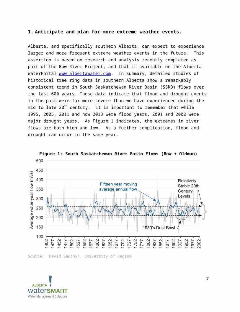
Alberta, and specifically southern Alberta, can expect to experience larger and more frequent extreme weather events in the future. This assertion is based on research and analysis recently completed as part of the Bow River Project, and that is available on the Alberta WaterPortal www.albertawater.com. In summary, detailed studies of historical tree ring data in southern Alberta show a remarkably consistent trend in South Saskatchewan River Basin (SSRB) flows over the last 600 years. These data indicate that flood and drought events in the past were far more severe than we have experienced during the mid to late 20th century. It is important to remember that while 1995, 2005, 2011 and now 2013 were flood years, 2001 and 2002 were major drought years. As Figure 1 indicates, the extremes in river flows are both high and low. As a further complication, flood and drought can occur in the same year.
Figure 1: South Saskatchewan River Basin Flows (Bow + Oldman)
Source: David Sauchyn, University of Regina
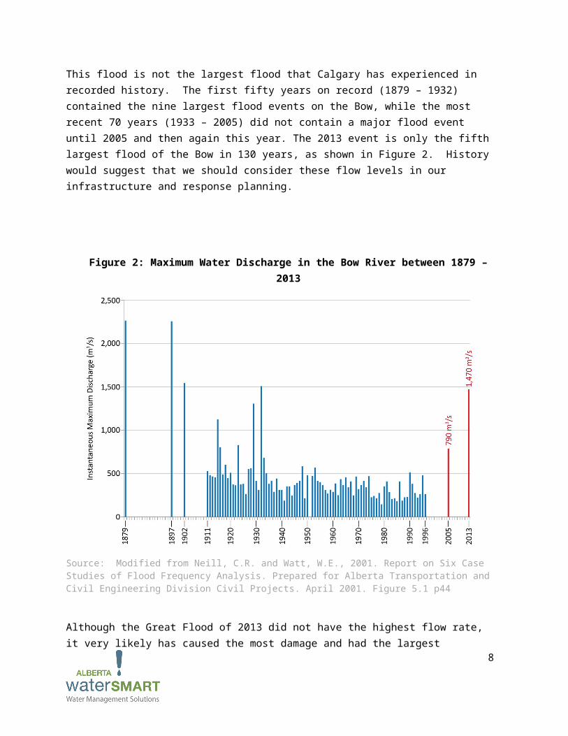
This flood is not the largest flood that Calgary has experienced in recorded history. The first fifty years on record (1879 – 1932) contained the nine largest flood events on the Bow, while the most recent 70 years (1933 – 2005) did not contain a major flood event until 2005 and then again this year. The 2013 event is only the fifth largest flood of the Bow in 130 years, as shown in Figure 2. History would suggest that we should consider these flow levels in our infrastructure and response planning.
5
Figure 2: Maximum Water Discharge in the Bow River between 1879 – 2013
Source: Modified from Neill, C.R. and Watt, W.E., 2001. Report on Six Case Studies of Flood Frequency Analysis. Prepared for Alberta Transportation and Civil Engineering Division Civil Projects. April 2001. Figure 5.1 p44
Although the Great Flood of 2013 did not have the highest flow rate, it very likely has caused the most damage and had the largest economic impact of any extreme weather event in Canada to date. According to the Insurance Bureau of Canada (IBC), other than the ice storm of January 1998 in Ontario and Quebec which totalled $1.9 billion, the largest five insurance payouts over the last 22 years have all been in Alberta. It is anticipated that the costs of this flood event will surpass the ice storm event. Alberta should be planning for even more extreme weather events - both in frequency and in cost.
The population of southern Alberta is currently projected to double over the next thirty years. If development continues according to the same patterns as has occurred over the last thirty years, it is likely that damage from another major flood incident would be even more significant than in 2013.
Understanding the relationships between weather, river flows, population growth, and potential economic impacts is essential to planning for the future. Therefore, we make the following recommendations to better understand and plan for more extreme weather events.
6
Conduct a study to analyze the confluence of events that resulted in the 2013 flood. As noted above, this flood event looks more like the pre-1933 flood events. There are several theories why the maximum water discharge in the Bow River remained so low from 1933 until 2005. One theory is that there were severe forest fires in the foothills and mountains in the late 1800s and early 1900s, which could have resulted in more rapid runoff, ultimately resulting in high peak water flows. Another theory is that as the TransAlta hydro reservoirs have come on-stream, they have increasingly blunted the flood flows. However, neither of these theories explains the 2005 and 2013 rain events. Some work has already been done by Sauchyn et al to explain changes in Bow River flows based on climate variations, including the Pacific Decadal Oscillation. More work needs to be done to understand any other factors that are influencing the weather, resulting in more extreme events. This analysis can then be used to signal how frequently we can expect these events in the future and their potential magnitude, allowing for better planning. The modelling work done as part of the Bow River Project is an excellent starting point and can be used to assess the impacts of flood flows, land cover, changing weather patterns as well as the effects of various mitigation options.
Overlay potential development scenarios on the weather scenarios. Land use in the South Saskatchewan watershed will change over the next thirty years as the population increases. Models such as the ALCES tool can be used to understand how development will alter the landscape, which has a major impact on storm water management. This is a major factor in flood response and potential damage to property and infrastructure. This type of analysis is being incorporated in the current AI-EES-funded study on river management in the South Saskatchewan River Basin and the Red Deer River basin, and could be extended to incorporate this work.
Determine the magnitude of potential economic loss from another flood event. As the 2013 flood has demonstrated, floods are extremely costly. An analysis of the physical and economic losses incurred in this flood, as well as other recent floods, would provide a baseline for assessing the magnitude of losses from potential future events. This type of analysis is being considered by the IBC, and they would be an excellent resource for this work. The results of this analysis would support and justify the necessary investments in planning and infrastructure that are needed to reduce the impacts of another extreme weather event.
2. Improve our operational capacity to deal with a variety of potential extreme weather scenarios through better modeling and data management.
Improving our operational capacity is integral to ensuring that the best flood mitigation strategies have been thought through and put in place, long before the next flood occurs. Increasing modelling efforts and ensuring that drought and flood planning receive equal attention from policy-makers will help us be better prepared for increased weather variability. This modelling
7
should be based on the best data available. Efforts to collect more water-related data such as snowpack, precipitation, fluctuations in groundwater levels, evapotranspiration and sublimation and their effects on streamflow should be a high priority. Funding data collection can be much less expensive than the economic impact and clean-up costs associated with a major flood. Considerable work is already underway in this area, but can be accelerated and improved through the following actions:
Improve predictive capacity through increased modelling and data management. Models that run a variety of scenarios, using in some cases well over 80 years of gauge data, can help decision-makers understand the possible outcomes and impacts of a flood event. Decision-makers should increase their use of modelling capacity to ensure that a variety of extreme weather scenarios have been taken into account in policy planning, and so that specific mitigation measures and plans can be identified, properly analyzed and put into place. Publicly available models have already been developed for some parts of Alberta (e.g. the OASIS model has been developed by the University of Lethbridge and Hydrologics and is being applied by Alberta WaterSMART in the South Saskatchewan River Basin). Increased use of modeling will result in better informed flood mitigation strategies, and overall water management. Improved operational capacity can be achieved by:
o Developing flood potential forecasts. Hydrometeorlogic data can be used to investigate the nature and extent of flood risk. The magnitude and frequency of major floods can be estimated in order to identify where funding should be allocated to fund mitigation measures. As an example, the Red River basin managers have developed these kinds of tools and we could adapt some of their work.
o Increasing flood risk mapping. Publicly available and user friendly tools can be developed to help engage and educate the public with respect to high flood risk areas. These tools could show the high water level mark associated with a given flooding event and see which communities would be affected by flooding at different flow rates. Mitigation and damage reduction options can then be designed to meet each specific risk profile.
o Increasing basin-specific modeling. Current models should continue to be upgraded, such as the Bow River Operational Model (BROM), incorporating land cover and use, water quality, wetland and riparian habitat data into the models.
o Using BROM as an operational support mode. Hourly data from reservoirs is needed in order to determine what operators should do in the case of a flood. BROM should be used by water managers and reservoir operators in training exercises to help them prepare for a variety of flood scenarios.
Recognize that flood and drought planning are interconnected, and that both should receive an equal amount of attention. In the South Saskatchewan River Basin the majority of water management strategies have been drought-related over the last decade. Flood-related water management strategies should receive an equal amount of attention. Droughts and flood
8
mitigation strategies can be used to benefit each other; for example, implementing the Bow River Project recommendations including flexible, collaborative management can improve environmental conditions under normal circumstances, and respond adaptively to either drought or flood conditions. Decision-making supported by a collaborative governance structure can provide the flexibility to adapt to rapidly changing circumstances as they unfold.
Develop a better understanding of the relationship between flooding and groundwater. Investigations should be conducted in order to better understand the effects of flooding on groundwater, and vice versa. Some work has been done in this area specifically by Alberta Environment and Sustainable Resource Development (ESRD), and this work should be leveraged and the data made available publicly. More specifically:
o In the City of Calgary, there should be a detailed review of the alluvial aquifer around the Bow and Elbow Rivers to map the groundwater levels and the sensitivity to rises in river levels. This work is essential to understanding the risks to building offices and condominiums close to the rivers, and to determine appropriate building standards. If this work has been done, then it should be made publicly available and easily accessible.
o On a more regional scale, the hydrological cycle in its entirety should be well understood with respect to the Bow River Basin. This includes a detailed understanding of the interactions and relationships between groundwater, surface water, precipitation, snow pack and related factors such as sublimation and evapotranspiration, snowmelt, aquifer recharge/discharge and variations in climate. There are academic studies of many of these elements that could support a larger integrated study. The current AIEES-funded study of The Future of Water in Alberta could perhaps use the Bow River Basin as a case study for its integrative work on water issues in Alberta.
Re-evaluate the potential for slumps and mudslides during flooding events. Numerous communities in Calgary are situated near the edge of steep slopes that were formed by river erosion (e.g. Wildwood in southwest Calgary, the Varsity bluffs in northwest Calgary, and Pinebrook Estates along the Elbow River in west Calgary). Steep slopes that consist of large quantities of glacial and lake sediments become unstable and may fail when materials are removed from the base of these slopes or when the ground becomes saturated. Although major slumping and mudslides did not occur in Calgary, they occurred in Canmore and other areas. The potential for these to occur in the future should not be overlooked.
Ensure that data is available and easily accessible so that it can be used in modelling and planning. Researchers and planners should link to the new provincial monitoring agency to ensure consistency in data. Historical data should be used to better understand the long-term trends referred to above. The Government of Alberta (GoA) has data that should be made available either through the monitoring agency or through public websites to allow this modelling and planning to
9
continue. In particular, increased data on groundwater is required for flood potential forecasts. Monitoring and research that is funded by the province (e.g. snowpack monitoring) should continue.
Build upon work that has already been conducted. Current and future policy should build upon work that has already been conducted, such as the 2006 Groeneveld Provincial Flood Mitigation Report. The report was not released until 2012. Although the report is now out of date, the basic tenets and recommendations hold true, and should be updated, analyzed for effectiveness using the latest data and modelling techniques and implemented where needed most. Other work currently underway has been identified elsewhere in this paper, including the IBC reports, the SSRB projects, and projects underway at the Universities of Alberta (Goss et al), Regina (Sauchyn et al) and Saskatchewan (Pomeroy et al).
3. Investigate the cost/benefit balance of investing in physical and natural infrastructure.
Extreme weather events often catalyze discussion on the resiliency and adequacy of water infrastructure such as dams, canals, diversions, reservoirs and natural features such as wetlands. A conversation about water infrastructure opportunities in Alberta is needed now. Billions of dollars will be spent on flood recovery and rebuilding efforts and some of this money should be invested in infrastructure to mitigate the impacts of future extreme weather events.
Conduct cost-benefit and risk analyses to assess the best use of capital funds to support infrastructure spending decisions. Obviously public funds are scarce and must be directed to the use which maximizes the benefits to society. Over recent years, new expert tools have been developed to assess risk more broadly for public infrastructure. Tools like the Public Infrastructure Engineering Vulnerability Committee (PIEVC) infrastructure vulnerability protocol, developed by Engineers Canada and Natural Resources Canada and used across Canada and internationally, provides a proven approach to understanding the risks and vulnerabilities of existing infrastructures to the threats of extreme climate events. The standards and practices developed by the PIEVC have already been tested in Alberta and could inform investment decisions as the GoA considers new infrastructure plans.
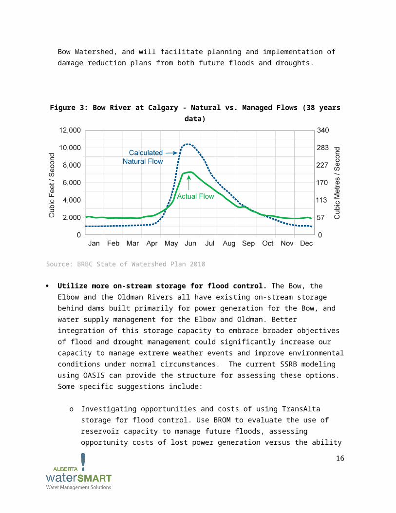
After recovery from the current events, preventative physical and natural infrastructure initiatives should be identified, evaluated, and where justified, planned and implemented. An excellent example of how infrastructure is already being utilized to manage water flows is the management of the Bow River through the City of Calgary by the TransAlta hydro dam infrastructure during normal times, as is shown in Figure 3, and by the Glenmore Dam on the Elbow River, operated by the City of Calgary. Other opportunities have been explored, and some new ideas are noted in this section..
10
Implement the recommendations of the Bow River Project. Over the last four years, the major water license holders on the Bow River have collaborated on developing a water management plan for the Bow River that incorporates many of the recommendations included in this White Paper. The GoA should work together with the Bow River Consortium and TransAlta to flexibly implement these recommendations. This agreement on future water management is an essential first step toward on-going, systematic improvement to the Bow Watershed, and will facilitate planning and implementation of damage reduction plans from both future floods and droughts.
Figure 3: Bow River at Calgary - Natural vs. Managed Flows (38 years data)
Source: BRBC State of Watershed Plan 2010
Utilize more on-stream storage for flood control. The Bow, the Elbow and the Oldman Rivers all have existing on-stream storage behind dams built primarily for power generation for the Bow, and water supply management for the Elbow and Oldman. Better integration of this storage capacity to embrace broader objectives of flood and drought management could significantly increase our capacity to manage extreme weather events and improve environmental conditions under normal circumstances. The current SSRB modeling using OASIS can provide the structure for assessing these options. Some specific suggestions include:
o Investigating opportunities and costs of using TransAlta storage for flood control. Use BROM to evaluate the use of reservoir capacity to manage future floods, assessing opportunity costs of lost power generation versus the ability to reduce peak flood flow by what amount over what period of time and with known levels of flood inundation damage from flood flow mapping. This modelling exercise must include the downside risk of
11
lowering reservoir levels if the expected rain/flood event does not occur or at a lower than forecast amount. Key to improved risk management for flood and drought is some agreement on risk sharing and risk management among water users, taking into account environmental conditions.
o Developing a flow/flood damage relationship for Banff, Canmore, Stoney Reserve, Cochrane, Calgary, Carseland, Siksika, Medicine Hat and other important sites. This information would be based on water flow rates, and would demonstrate the amount of land that could be covered by water and potential economic damage at various peak flow rates. A hydrodynamic flood model should be developed and used to test flood operating strategies and trade-offs between location of empty storage and damages. These flood maps should be made available by the GoA so analysis can proceed.
o Evaluating multi-purpose storage and operations on the Highwood/Sheep Rivers. Some work has already been done to model the Highwood/Sheep system, and this could be the basis for assessing storage options.
o Evaluating increased storage for flood control at the Glenmore Reservoir and upstream of the Elbow River for storage and power generation.
Increase the volume of off-stream storage. The irrigation districts have made use of man-made lakes for water storage for decades. Watershed management can be made more resilient by diversifying off-stream storage options, whether greater volumes of altered operating conditions. The Western, Bow River and Eastern Irrigation Districts should be engaged in a discussion as to how they can utilize their infrastructure to help mitigate flood risks, while ensuring a robust response to drought conditions.
Incorporate natural infrastructure such as wetlands, riparian areas, natural storage conditions and land cover into flood and drought mitigation planning. The provincial wetlands strategy is needed to help guide the effective use of wetlands. In addition, the BRBC recently published the Bow Basin Management Plan (2012), which addresses wetlands, riparian areas, land use and headwaters protection. This document is in the process of being endorsed by a large number of Bow Basin stakeholders. Natural infrastructure opportunities such as gravel bed storage, wetlands, and aquifer storage and recovery should be examined.
Investigate uninhabited areas that could be potentially flooded with the least economic and environmental impact. This measure would most likely be relevant to rural areas where there are large, unoccupied pieces of land. Intentional flooding has occurred in other jurisdictions, and while there are still flood impacts, they are often not as serious as they would have been if the flood waters reached more populated areas. A specific example is the Portage Diversion where channel banks (dikes) were intentionally breached in the 2011 Manitoba flood event in order to increase the capacity of the diversion channel, thus protecting the weir. This protected the urban areas by sacrificing two farms (see Manitoba 2011 Flood Review Task Force Report).
12
4. Consider flood risks in municipal planning and strengthen building codes for new development in flood plains.
The recent flood event revealed several weaknesses in current development practises in the urban areas in southern Alberta. Some of these practises can be addressed reasonably quickly, while others will take more time. However, all are possible within the current municipal planning structure.
Municipal development in potentially flood-prone areas must be reconsidered. It is recommended that increased flood plain mapping occur to best inform decision-makers on whether building should go ahead in flood plain areas. This mapping should include groundwater mapping as well as surface water. Much of this mapping has been done, but not all is available or widely known. New development should be discouraged in flood-prone areas. However, in order to change the land use habits of urban developers, incentives and disincentives will need to be provided. Examples of disincentives are higher property taxes or a requirement to have overland flood insurance for those choosing to build in a flood-prone area.
Land use planning should be connected to hydrology. Flood plain development is primarily an urban issue. The broader issue of land use must also be considered, in particular, rural municipalities and the effect this has on flooding. It is important to model what land cover changes would result from threats of pine bark beetle or forest fires reducing water retention, and what improvements to water retention might result from enhanced riparian or wetlands functions.
Refine our zoning and building codes. A review of best zoning and building code practises in North America should be undertaken. In many new office towers and condominiums, electrical and mechanical systems are located in the lowest parking or basement levels and there are no back-up generators. In this major flood, many of the parking structures and basements were flooded after the power was cut, which disabled the sump pumps. The flooding damaged or destroyed electrical and mechanical systems located at the lowest levels. Some basic redesign and relocation of these systems and addition of back-up generators should result in less flood damage and faster recovery. Buildings where manufacturing occurs should also be included. The location of critical information infrastructure should also be based on a clear understanding of possible water penetration during a major flood event. This should include the elevator systems, many of which will be off line for several weeks, limiting the ability of tenants to reoccupy their homes on the higher levels of the apartment and condo buildings. One specific recommendation is that each of the multi-story buildings (commercial and residential) impacted by the flood should be required to test their sump pumps to ensure that these pumps are adequately sized to remove the water that penetrated their parking structures. These sump pumps should also be place on a separate circuit from the electrical system of the remainder of the building, and linked to a backup generator that will allow
13
the sump pumps to keep working in the event of a power shut-down. Another recommendation is that building codes should be changed to allow flood-prone residences to relocate basement density to a third floor.
Encourage APEGA to revise and update their practice standards to include consideration of risks in a flood event. A tangible action item for APEGA consideration would be to ask their Practice Standards Committee to look at either updating the 2006 Risk Management document to include substantially greater emphasis on risk management for natural disasters, floods in particular, or perhaps, better yet, to develop an additional document that focuses risk management for natural disasters. APEGA would welcome constructive suggestions about how best to harness the large volunteer professional capacity and experience which APEGA can access to make a meaningful contribution.
Make a variety of tools widely available to all Albertans to inform them about a future flood. The majority of communication on the 2013 flood was carried out through social media. Many people got their information from Twitter, and the City of Calgary, Mayor Nenshi, AESRD, and many others, provided constant updates. It would be worthwhile for the GoA to consider how it may use social media as well as traditional avenues of communication as an effective public communications tool in the event of another flood – both leading up to and during the natural disaster.
5. Evaluate our insurance options.
Historically, when overland flood damage occurred, the government stepped in to provide assistance for rebuilding. However in this flood, many of the damaged homes in Calgary were right beside the Bow or Elbow Rivers, or in their immediate flood plain. There is less desire by the taxpayers to provide subsidies to the owners of these properties through relief payments. One idea that has been stated repeatedly over the last three weeks is assessing the merits of offering overland flood insurance for the areas in the flood plain. For this reason, the GoA should evaluate whether overland flood insurance should be brought into Alberta. Some steps to consider include the following:
Give homeowners an option. It might be helpful for homeowners to have an option – perhaps accepting the GoA’s financial assistance now with the understanding that if they rebuild in the flood plain they might not get future help. Another option could be that additional monies would be provided to relocate outside of the flood plain.
Start investigating whether overland flood insurance should be brought into Alberta. In 2010, a study was conducted by the Institute for Catastrophic Loss Reduction and Swiss Re that concluded that overland flood is insurable for Canadian homeowners, and provided a proposal to put this insurance into place. The GoA should consider whether overland flood insurance should be
14
brought into the province. This is an area that is outside our area of expertise, and more investigation needs to be done to determine if this is a concept worth pursuing.
6. Manage our water resources collaboratively.
There are a variety of players involved in water management in Alberta, including the federal, provincial and municipal governments, as well as local watershed groups, irrigation districts, hydro power companies, non-government organizations, and others. Each has a valuable role to play in water management. Improved collaboration and information sharing between these groups is required to improve flood mitigation measures, and the following recommendations support these points.
Support WPACs to work with their memberships to assess flood risk, consequences, and mitigation strategies, and to provide advice to GoA. Watershed Planning and Advisory Councils (WPACs), including the Bow River Basin Council (BRBC), the Oldman Watershed Council (OWC), and the South East Alberta Watershed Alliance (SEAWA), can and should take a leadership role in analyzing, evaluating, and advising on mitigation strategies to address future flood and drought circumstances. These organizations have the balanced membership and the neutral forum to convene and enable collaborative assessment of the data, to identify an array of mitigation options, and to provide leadership and advice on future water management in the Bow, Oldman and South Saskatchewan River systems. Under the Water for Life strategy, the WPACs have been given a specific role to play in managing water in the watershed.
Consider creating a Provincial Water Authority. In 2011, the Premier’s Council for Economic Strategy recommended that an Alberta Water Authority be created. The driver behind this recommendation was the acknowledged risk that “within our thirty-year horizon, Alberta’s current water management structure will be unable to effectively manage our water resources…”. Not only is improved water management required to meet the water demands of Albertans, but it also required to mitigate, manage and control future flood and drought events. If an Authority was created as originally planned, it would be responsible for:
o Water Information. The Authority would create and maintain a fully integrated and accessible water information system to support planning and decision-making. The need for more easily accessible data for modeling and planning purposes could be met through this central entity.
o Water Infrastructure. The Authority would develop a long-term infrastructure plan to support effective water management, which would include on and off-stream storage facilities. The need for a review of infrastructure needs that are appropriate for both flood and drought management could be met through the Authority.
15
Support and provide increased capacity to smaller municipalities to respond to natural disasters. The City of Calgary was well equipped and ready to respond to the flood. However, smaller municipalities have less capacity to respond to natural disasters. The GoA should work with these small communities to coordinate emergency response plans and to determine where capacity gaps exist prior to the next natural disaster.
16
The Short-Term Response to the 2013 Great Floods of Alberta
Over the next six months, significant progress could be made on several of the recommendations noted above. These actions can provide evidence of tangible progress toward mitigating, managing and controlling future floods. There has already been a significant amount of work and money invested in certain initiatives over the years, such as the BROM. This work should continue.
Open the doors to the data rooms so that all relevant data is easily accessible, allowing our best and brightest to use it for modelling and planning.
Engage one of the research teams currently working on understanding weather impacts on stream flows to analyze weather patterns and trends to propose a workable theory for the occurrence of the flood. Translate this work into specific guidance that can inform weather warning systems.
Engage existing models such as BROM to understand the specific impacts and streamflow rates generated by specific flood events.
Implement the recommendations of the Bow River Project, including engaging TransAlta in the project through an economic arrangement with GoA.
Support Watershed Planning and Advisory Councils (WPACs) to assess flood risk, consequences and mitigation strategies.
Engage one of the research teams currently working on groundwater mapping to map the alluvial aquifers around the Bow and Elbow Rivers to provide information on the interaction between the rivers and the aquifers. This will provide some guidance on the extent of the flood plain for various flood levels.
Fund a project to review and summarize best zoning and building code practises in North America related to flooding and how those can be applied to Alberta.
Place a moratorium on new development in potentially flood-prone areas until the analyses outlined above are completed.
Consider the consolidation of water-related functions (e.g. fish, energy, irrigation) into Watershed-based Authorities to support implementation of the various Regional Land Use Plans.
Provide increased capacity and support to smaller municipalities to deal with natural disasters. Encourage APEGA to revise and update their practice standards to include consideration of risks in
a flood event. Encourage other professional associations (e.g. architects, planners) to do the same. Investigate the use of risk management tools such as PIEVC to incorporate flood risks into
investment decisions on infrastructure. Investigate the potential for overland insurance to deal with those property owners who wish to
build or rebuild in the flood plain.
17
References
Alberta WaterPortal www.albertawater.com. Contains full reports on the Bow River Project
Bow River Basin Council. 2010. “Bow River Basin State of the Watershed Summary 2010.”
Government of Manitoba. 2013. “Manitoba 2011 Flood Review Task Force Report: Report to the Minister of Infrastructure and Transportation.” Government of Manitoba.
Insurance Bureau of Canada. 2012. “Telling the Weather Story.” Prepared by the Institute for Catastrophic Loss Reduction for the Insurance Bureau of Canada.
Kovacs, Paul and Sharon Ludlow. 2010. “Flood of Options.” Canadian Underwriter December 2010.
Neill, C.R. and W.E. Watt. 2001. “Report on Case Studies of Flood Frequency Analyses.” Prepared for Alberta Transportation, Transportation and Civil Engineering Division, Civil Projects Branch.
Premier’s Council for Economic Strategy. 2011. “Shaping Alberta’s Future.” Government of Alberta.
Warkentin, A.A. 1999. “Red River at Winnipeg: Hydrometeorologic Parameter Generated Floods for Design Purposes.” Water Resources Branch, Manitoba Department of Natural Resources.
World Meteorological Organization. 2013. “The Global Climate 2001-2012: A Decade of Climate Extremes.” Accessed online at: http://library.wmo.int/opac/index.php?lvl=notice_display&id=15112
18
APPENDIX A
LIST OF CONTRIBUTORS TO WHITE PAPER AS OF JULY 18, 2013
Canadian Water Summit Discussion GroupLorne Taylor, Special Advisor, Alberta WaterSMARTMike Kelly, Special Advisor, Alberta WaterSMARTLarissa Sommerfeld, Policy Specialist, Alberta WaterSMARTMike Nemeth, Environmental Specialist, Alberta WaterSMARTJon Sweetman, Manager, Water Resources, Alberta Innovates – Energy and Environment SolutionsMichael Rausch, Senior Business Officer, Western Economic Diversification CanadaJoppe Cramwinckel, Director, Water, World Business Council on Sustainable DevelopmentEdwin Piñero, Executive Vice President and Chief Sustainability Officer, Veolia Water North AmericaAnthony Watanabe, President & CEO, InnovolveTony Maas, Director, Freshwater Program, World Wildlife FundKerry Freek, Editor, Water CanadaSteven Renzetti, Professor of Economics, Brock UniversityKaren Kun, Executive Director and Co-founder, WaterlutionJessica Yarnell, Community Investment Advisor, Cenovus EnergyLee Malleau, Vice President, Business & Trade Development, Calgary Economic DevelopmentBrian Doucette, Director, Environmental Excellence, Suncor EnergyGeoff Riggs, Global Business Services - Smarter Planet Project Manager, Business Development, IBMTom Olver, Marketing Manager – Natural Resources, IBMIan Young, Canadian Energy Sector, Territory Manager, IBMCan Dafoe, Associate Partner, IBMMaja Veljkovic, Natural Resources Executive and Research Liaison, IBMJohn Van Ham, Manager, Environment, ConocoPhillips CanadaLisa Downes, North America Regional Initiative Coordinator, Alliance for Water StewardshipBob Brawn, Board Member, Alberta Water FoundationJohn Brogly, Director, Water, COSIAErwin Braun, General Manger, Western Irrigation DistrictDan Shute, Chair Western Irrigation DistrictDoug Tenney, Vice President, Hydro Development, ATCO PowerPreston McEachern, Director, Research and Development, Tervita
19
Calgary Working GroupAlexander Zehnder, Scientific Director, Alberta Innovates – Energy and Environment SolutionsMark Bennett, Executive Director, Bow River Basin CouncilMike Kelly, Chair, Bow River Basin CouncilBob Phillips, Executive Director, South East Alberta Watershed AllianceDan Sheer, Founder & President, HydrologicsKeith Minnich, Special Advisor, Alberta WaterSMARTLauren Eden, Researcher, Alberta WaterSMARTRyan Bjornsen, Hydrogeologist, Alberta WaterSMARTLarissa Sommerfeld, Policy Specialist, Alberta WaterSMART
Engineering Working GroupDave Chalcroft, P.Eng. FCAE, Past APEGA PresidentSteve E. Hrudey, FRSC, FSRA, IWAF, PhD, DSc(Eng), P.Eng., APEGA Councilor and Professor
Emeritus, Analytical & Environmental Toxicology Division, Faculty of Medicine & Dentistry, University of Alberta
Darrel Danyluk P.Eng. FCAE, Vice President of the World Federation of Engineering Organizations (WFEO) and Chair of the WFEO Committee on Engineering and Environment, and Past President of APEGA.
Kim Sturgess, P.Eng. FCAE, Past President Canadian Academy of Engineering, Past APEGA CouncillorMark Flint, P.Eng. CEO of APEGA
Advisory GroupWill Bridge, Vice President, Business Development, ATCO Power CanadaMargaret Kelly, Vice President, Canadian Environmental Technology Advancement CorporationBryan Walsh, Senior Vice President, CBRE LimitedAnouk Kendall, President, WADE CanadaRoger Saint-Ford, Chair & Environmental Chemist, Department of Environmental Science, Mount Royal
UniversityMichael Quinn, Professor and Talisman Research Chair, Director, Institute for Environmental
Sustainability, Mount Royal UniversityJim Campbell, Director of Development, Mount Royal University
Alberta WaterSMART TeamKim SturgessAngela AlambetsRyan BjornsenSusan Davis SchuetzLauren EdenSean Gifford
20
Dave GuichonSteve HermanMike KellyKeith MinnichMike NemethVictoria PleavinFrank PudduGary ReavieSharon ShaneLarissa SommerfeldLorne TaylorMegan Van HamJana Vander KloetAngela Widmer
Stella ThompsonNancy BlairAndy MacRaeLarry StaplesDarrell Toma
21