Embed Size (px)
Citation preview
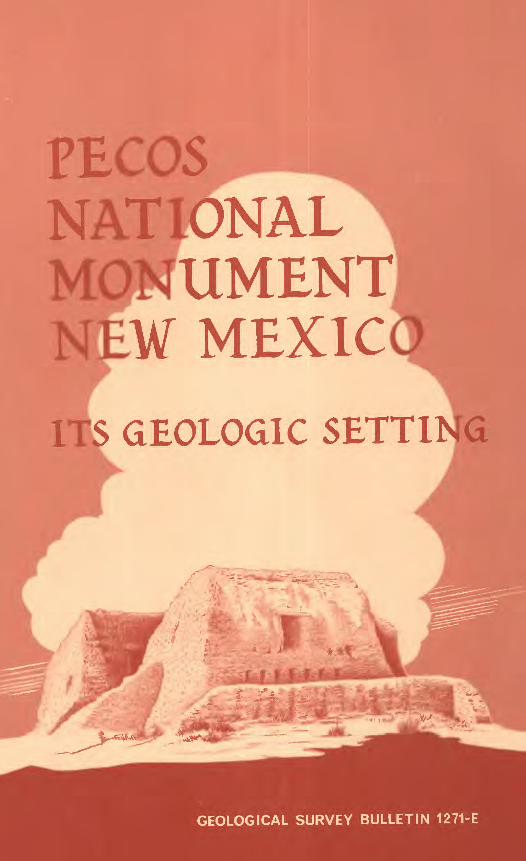
PECOSNATIONAL MONUMENT NEW MEXICOITS GEOLOGIC SETTING
GEOLOGICAL SURVEY BULLETIN 1271-E

PECOSNATIQNAL MONUMENT NEW ^MEXICOITS GEOIJOGIC SETTING
By ROSS B. JOHNSON
A description of rocks and landscapes and their effect on man
CONTRIBUTIONS TO GENERAL GEOLOGY
GEOLOGICAL SURVEY BULLETIN 1271-E
UNITED STATES DEPARTMENT OF THE INTERIOR
WALTER J. HICXEL, Secretary
GEOLOGICAL SURVEY
William T. Pecora, Director
_____U.S. GOVERNMENT PRINTING OFFICE. WASHINGTON : 1969_____
For sale by the Superintendent of Documents, U.S. Government Printing Office Washington, D.C. 20402
CONTENTS
Page
Introduction _____________________ ElRocks near the monument _ ____________ 2Geographic extent of the formations of Glorieta
Mesa _________________________ 7 Sources of rock fragments and environments of
deposition __________________ 9Relation of Glorieta Mesa to the mountains ___ 9 Use of rock products by the Indians and Spanish
priests ________________________ 10 References cited __________________ 11
PLATE
1. Geology and topography of Glorieta Mesa andPecos National Monument, N. Mex ____In pocket
FIGURES
Page
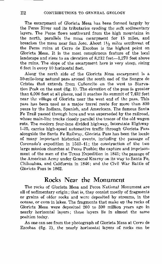
1. Map showing location of Glorieta Mesa andPecos National Monument __________ E3
2. Photograph showing rock sequence on GlorietaMesa at Cerro de Escobas _ _ _ __ _ _ _ _ 4
3. Columnar section of generalized geologic se quence of rock units on Glorieta Mesa at Cerro de Escobas near Pecos National Monu ment ______________________ 5
in

CONTRIBUTIONS TO GENERAL GEOLOGY
PECOS NATIONAL MONUMENT NEW MEXICO
ITS GEOLOGIC SETTINGBy Ross B. Johnson
The scenographical arrangement of the surrounding country is remarkably picturesque; the view of Pecos, as it now lies, without the least addition, would form a beautiful picture, and more than a picture, for every cloud, every degree that the sun moves, gives such varied effects to the landscape, that one has a thousand pic tures; but their effects are so fleeting, that although they last long enough to delight the spectator, it would yet perplex the artist to catch these changes. [Abert 1848.]
IntroductionThe ruins of the pueblos and missions of Pecos lie on the east
bank of Glorieta Creek near its junction with the Pecos River at the south end of the Sangre de Cristo Mountains in north-central New Mexico. Here the Pecos River and Glorieta Creek have formed a broad rolling valley in which the red adobe walls of the mission church stand as a striking monument to a historic past.
This is beautiful country; the bright hues of red rocks are complemented by the varied greens of the junipers, pinons, and ponderosa pines. Northward the Sangre de Cristo Mountains stretch for miles in a blue mist toward the Truchas Peaks and forests of the Pecos Wilderness. A few miles south of the ruins the steep high escarpment of Glorieta Mesa marks, in a general way, the southern termination of the Rocky Mountain System, which here is represented by the Sangre de Cristos.
El
E2 CONTRIBUTIONS TO GENERAL GEOLOGY
The escarpment of Glorieta Mesa has been formed largely by the Pecos River and its tributaries eroding the soft sedimentary layers. The Pecos flows southward from the high mountains in the north, parallels the mesa escarpment for 15 miles, and breaches the mesa near San Jose. About IVs miles southwest of the Pecos ruins at Cerro de Escobas is the highest point on Glorieta Mesa. It is the most conspicuous feature of the local landscape and rises to an elevation of 8,212 feet 1,270 feet above the ruins. The slope of the escarpment here is very steep, rising 6 feet in every 10 horizontal feet.
Along the north side of the Glorieta Mesa escarpment is a 30-mile-long natural pass around the south end of the Sangre de Cristos that extends from Cafioncito on the west to Starva tion Peak on the east (fig. 1). The elevation of the pass is greater than 6,000 feet at all places, and it reaches its summit of 7,432 feet near the village of Glorieta near the west end of the pass. This pass has been used as a major travel route for more than 800 years by the Indians, Spanish, and Americans. The famous Santa Fe Trail passed through here and was superseded by the railroad, whose main-line tracks closely parallel the traces of the old wagon ruts. The modern four-lane divided highway, Interstate Highway 1-25, carries high-speed automotive traffic through Glorieta Pass alongside the Santa Fe Railway. Glorieta Pass has been the locale of many important historical events, including the passage of Coronado's expedition in 1540-41; the construction of the two large mission churches at Pecos Pueblo; the capture and imprison ment of the men of the Texas Expedition in 1841; the passage of the American Army under General Kearny on its way to Santa Fe, Chihuahua, and California in 1846; and the Civil War Battle of Glorieta Pass in 1862.
Rocks Near the MonumentThe rocks of Glorieta Mesa and Pecos National Monument are
all of sedimentary origin; that is, they consist mostly of fragments or grains of older rocks and were deposited by streams, in the oceans, or even in lakes. The fragments that make up the rocks of Glorieta Mesa were deposited 200 to 300 million years ago in nearly horizontal layers; these layers lie in almost the same position today.
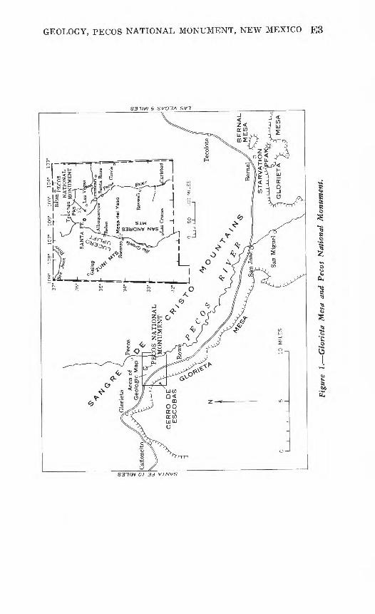
As one can see from the photograph of Glorieta Mesa at Cerro de Escobas (fig. 2), the nearly horizontal layers of rocks can be
GEOLOGY, PECOS NATIONAL MONUMENT, NEW MEXICO E3
60
S37/W O/ 3J VJ.NVS
E4 CONTRIBUTIONS TO GENERAL GEOLOGY
Santa Rosa Sandstone
Figure 2. Rock sequence on Glorieta Mesa at Cerro de Escobas; six rock units viewed southwest from Pecos National Monument.
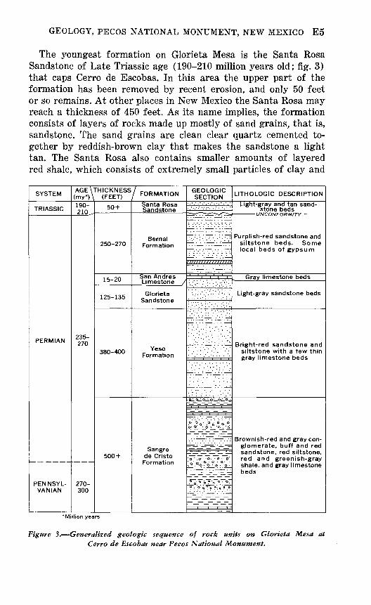
grouped readily into several units of similar rocks. The six units of rocks that have been separately named by geologists are shown in figure 2. Such units are called formations when the rocks can be separated in this way and traced in the manner shown on the geologic map (pi. 1). A sedimentary formation may be mostly one kind of rock fragment, or alternating layers of at least two kinds of rock fragments either deposited under the same environment or having similar physical characteristics, such as color and thick ness of the layers.
The six units exposed on the escarpment of Glorieta Mesa have been named and mapped throughout New Mexico and one even into south-central Colorado. Each name was formally assigned to a rock unit in a scientific publication by the geologist first describ ing and mapping the unit. Each name is reserved for its particular unit, and it may not be used again for any other rock unit in the United States. The names of these six formations have been used and recognized in geologic literature for many years. A formation is named usually for a geographic feature near which it was first described or mapped. These formations were named for two moun tain ranges, three mesas, and a city. They are all familiar names in New Mexico and without exception show the influence of the Southwest's Spanish heritage on the names of its geographic features.
GEOLOGY, PECOS NATIONAL MONUMENT, NEW MEXICO E5
The youngest formation on Glorieta Mesa is the Santa Rosa Sandstone of Late Triassic age (190-210 million years old; fig. 3) that caps Cerro de Escobas. In this area the upper part of the formation has been removed by recent erosion, and only 50 feet or so remains. At other places in New Mexico the Santa Rosa may reach a thickness of 450 feet. As its name implies, the formation consists of layers of rocks made up mostly of sand grains, that is, sandstone. The sand grains are clean clear quartz cemented to gether by reddish-brown clay that makes the sandstone a light tan. The Santa Rosa also contains smaller amounts of layered red shale, which consists of extremely small particles of clay and
SYSTEM
TRIASSIC
PERMIAN
PENNSYL-
AGE\"
(my*) \
210^
235- 270
270- j\j\j
rmcKNEss(FEET)
50 +
250-270
15-20
125-135
380-400
500 +
/ FORMATION
Sandstone
Bernal Formation
San Andres
Glorieta
Yeso Formation
de Cristo
GEOLOGIC SECTION
li^^X^ . . . . -
F~v ' "~~~ ' ' '
!-^l ':'ll .
-4:^:^
' ::' ' , :::^:
ai o-LO O Q^_°,;
-z-. -^ -^- _
.« "»o- "i °o °. £' ° i_o ° '6
t^i^HC^'^l?
lrTif^7^i~~~ir.q.°-o°o?o ,°o.
^I^^Ir
LITHOLOGIC DESCRIPTION
stone beds UNCONFORMITY
siltstone beds. Some local beds of gypsum
^ Gray limestone beds
Light-gray sandstone beds
siltstone with a few thin
glomerate, buff and red
red and greenish-grayshale, and gray limestone beds
'Million years
Figure 3. Generalized geologic sequence of rock units on Glorieta Mesa at Cerro de Escobas near Pecos National Monument.
E6 CONTRIBUTIONS TO GENERAL GEOLOGY
other minerals; the red is due to oxidation, or rusting, of iron- bearing mineral fragments in the shale.
The Bernal Formation of Permian, probably Late Permian, age (about 235 million years old) underlies the Santa Rosa Formation. The units are not quite parallel to each other, and thus a rela tionship known as an unconformity exists between the two units. Rocks of Early Triassic age are missing on Glorieta Mesa, and it is deduced that Early Triassic time was an age when no sediments were deposited in northern New Mexico and when the older rocks of the Bernal Formation were slightly eroded. Here on Glorieta Mesa the Bernal consists of purplish-red sandstone and siltstone. Near the village of Bernal the formation contains some thin beds of gypsum.
Beneath, and older than, the rocks of the Bernal Formation are the gray limestone beds of the San Andres Limestone, also of Permian age. Here there is no unconformity between the two units, for deposition of sediments was continuous and uninter rupted from the San Andres into the Bernal. The limestones of the San Andres are dense and earthy and contain a few sandy layers.
The Glorieta Sandstone is the most conspicuous formation on Glorieta Mesa because of its contrasting light-gray to white color and because it caps the mesa at most places. The Glorieta is also of Permian age, and grades upward into the younger San Andres Limestone without interruption. The clean quartz sand grains of the Glorieta are cemented together so well that the rock is extremely hard and consequently strongly resists the chemical and physical attacks of weathering agents. Throughout its ex posures in northern New Mexico, it stands out as a steep cliff face and usually forms the caprock of mesas.
Underlying the Glorieta Sandstone are the bright-red sandstone and siltstone layers of the Yeso Formation of Permian age. Although the change upward from the bright-red sandstone of the Yeso to the light-gray sandstone of the Glorieta is striking, sedi mentation was continuous; and changes in thickness of layers and in kinds and sizes of fragments are gradual. The Yeso also contains some thin beds of red shale and a few local beds of limestone. In some areas it also contains beds of gypsum. In the vicinity of Glorieta Mesa, however, conditions were not suitable for the deposition of gypsum.
The Sangre de Cristo Formation underlies the Yeso Forma tion without a break in sedimentation. The Sangre de Cristo
GEOLOGY, PECOS NATIONAL MONUMENT, NEW MEXICO E7
Formation is the oldest formation exposed on Glorieta Mesa and is the oldest Permian formation in the region. The lower part is still older of Pennsylvanian age. The upper part is about 270 million years old, but the lowermost part may be as old as 300 million years. The upper 100 feet or so of the Sangre de Cristo is very well exposed on the lower face of the Glorieta escarpment. However, in the broad valley formed by the Pecos River and Glorieta Creek, the lower four-fifths of the formation is covered at most places by a mantle of thick red soil derived from the weathering and decomposition of the formation itself. The forma tion consists of layers of varying thickness of brownish-red and gray conglomerate, buff and red sandstone, red siltstone, red and greenish-gray shale, and gray limestone beds.
Older rocks underlie those of the Sangre de Cristo Formation in the area of Pecos National Monument, but are not at the surface anywhere in the vicinity. These older rocks may be seen along the Pecos River north of the village of Pecos. They consist generally of limestone, shale, sandstone, and conglomerate of Pennsylvanian, Mississippian, and perhaps Devonian age (350-400 million years old) and ancient crystalline rocks of Precambrian age (more than 600 million years old).
Geographic Extent of the Formations of Glorieta Mesa
The six formations as delineated and mapped on Glorieta Mesa extend over many thousands of square miles. They appear to be coextensive from the limited viewpoint at Pecos National Monu ment, but beyond that view they are not. Locally, throughout New Mexico and southern Colorado, several, one, or none of these formations may be present.
The Santa Rosa Sandstone was named for exposures near the city of Santa Rosa, N. Mex. The Santa Rosa crops out along the canyons of the Canadian and Pecos Rivers of northeastern and east-central New Mexico. At most places on Glorieta Mesa, the upper rocks of the formation have been eroded. However, the complete unit is present along the east flank of the Sangre de Cristo Mountains and extends at least as far north as Ocate Creek, 50 miles north of Las Vegas where it is covered by lava flows of much younger age.
Bernal Mesa east of the village of Bernal near Starvation Peak is the locality where the Bernal Formation was first named and
E8 CONTRIBUTIONS TO GENERAL GEOLOGY
described. It is a local unit, crops out only on Glorieta Mesa, and caps low mesas a short distance south and southeast of Starvation Peak. It also extends along the east flank of the Sangre de Cristo Mountains, at least as far north as Ocate Creek. To the south, rocks equivalent to this unit are known by another name.
The San Andres Limestone was named for exposures in the San Andres Mountains of south-central New Mexico. Of all the rock units occurring on Glorieta Mesa, the San Andres probably covers the surface over more square miles than any other unit. The San Andres Limestone crops out in large separated areas across southern New Mexico into trans-Pecos Texas. The formation has also been mapped in the Zuni Mountains and the Lucero uplift west of Belen, N. Mex. North of Glorieta Mesa the limestone thins to a point where it can no longer be distinguished as a unit.
The name for the Glorieta Sandstone was derived from exposures on Glorieta Mesa just 2!/2 miles south of Cerro de Escobas. Because the Glorieta forms the main caprock of Glorieta Mesa, it is beauti fully and conspicuously exposed for many miles; and thus the mesa very appropriately gives its name to the formation. The Glorieta Sandstone crops out in large separated areas that cover many thousands of square miles of New Mexico. It extends north ward along the east flank of the Sangre de Cristo Mountains at least as far as Ocate Creek. The Glorieta Sandstone has been mapped in the Zuni Mountains of west-central New Mexico, the Lucero uplift west of Belen, and much of central New Mexico.
The Yeso Formation was named from Mesa del Yeso, 12 miles northeast of Socorro, N. Mex. A thick bed of gypsum, or yeso, crops out on the slopes of Mesa del Yeso, and therefore furnishes the name for both the geologic formation and the mesa. From Glorieta Mesa, rocks of the Yeso Formation extend southward and westward and form the surface rocks over large parts of west- central, central, and south-central New Mexico. North from Glorieta Mesa the sandstones and siltstones of the Yeso Formation grade into rocks typical of the Sangre de Cristo Formation and thus are included as part of the Sangre de Cristo Formation in northern New Mexico and southern Colorado.
Although the Sangre de Cristo Mountains occupy a large part of northern New Mexico, the Sangre de Cristo Formation was first named and described not in New Mexico but in Colorado. The name was first used in 1899 for rocks of this formation on the east slopes of the Sangre de Cristo Mountains northwest of the Spanish Peaks 130 miles north of Pecos National Monument. The forma tion is appropriately named, for its outcrops are confined almost
GEOLOGY, PECOS NATIONAL MONUMENT, NEW MEXICO E9
entirely to the Sangre de Cristo Mountains of northeastern New Mexico and south-central Colorado.
Sources of Rock Fragments and Environments of Deposition
Geologists can tell the environment in which the sedimentary rocks were deposited by studying various features in the rocks, such as fossils, kinds of fragments and minerals, shapes of the individual units, and depositional structures within the layers. The geologists sometimes can also tell the source of the fragments that make up the sedimentary rocks if they have a complete knowledge of the older rocks in the region.
From data such as these, geologists have concluded that the sands that make up the Santa Rosa Sandstone and the Glorieta Sandstone were deposited just offshore on the beaches of seas that were advancing over the land. The sand grains were derived from the winnowing action of waves on the sediments of the underlying formations the Bernal and Yeso Formations.
The sediments that formed the rocks of the Bernal and Yeso Formations appear to be of shallow-water marine origin. Perhaps they were laid down on a broad, flat coastal plain. The San Andres Limestone is a marine limestone and probably was deposited during the wide advance of the Permian sea over the coastal plain after the deposition of the beach sands of the Glorieta Sandstone.
In contrast to these water-laid deposits, the Sangre de Cristo Formation consists mainly of terrestrial or land-laid sediments deposited by streams as alluvial fans, flood plains, deltas, and channel fills. Thin layers of limestone occur throughout the forma tion and contain fossils that indicate that the limestone layers are of both fresh-water and marine origin. Therefore, from time to time, lakes and ponds or ocean bays covered large parts of the region. Most of the fragments of the conglomerates, sandstones, siltstones, and shales of the Sangre de Cristo Formation are derived from the ancient Precambrian crystalline rocks that form the core of the high mountains a few miles to the north. From the unweathered appearance of the coarser fragments, it is evident that the source of these fragments was not very far away.
Relation of Glorieta Mesa to the MountainsThe sedimentary rock layers of Glorieta Mesa slope gently south
from the Sangre de Cristo Mountains. The slope is so gentle at
E10 CONTRIBUTIONS TO GENERAL GEOLOGY
some places that it cannot be discerned with the eye. North from the mesa and Pecos National Monument, the slopes of the sedi mentary layers become steeper and steeper toward the central crystalline core of the high mountains.
Along the south end of the Sangre de Cristos, there are no large faults (fractures along which rocks have moved) or steep folds in the rocks, except near the west and east margins of the moun tains near Canoncito and Bernal. Also, there are neither volcanic lava flows on the surface nor similar rocks formed by the injection of molten rock material into the sedimentary rocks below the sur face. These rocks derived from molten material are typical of the Sangre de Cristo Mountains and surrounding regions elsewhere in northern New Mexico and southern Colorado. In spite of the cataclysmic mountain building that took place just a few miles north of Glorieta Mesa and Pecos National Monument about 30-50 million years ago, there are no features to show the effects of the volcanoes and earthquakes that must have accompanied or followed the uplift of the mountains instead, the sedimentary rock layers are just tilted gently, almost imperceptibly, away from the uplifted mountain area.
Use of Rock Products by the Indians and Spanish Priests
The building stones used for the construction of the pueblos by the Indians of Pecos were obtained directly from the sandstones and conglomerates of the Sangre de Cristo Formation, which underlie most of the area in the vicinity of the national monument. These rocks split naturally into convenient sizes and shapes for building stones, and consequently very little, if any, trimming was necessary. Locally, flagstone that was quarried from the Sangre de Cristo Formation could be easily adapted for use in walkways, steps, and shelves by the Spanish priests.
Although soil was used to chink the stone used in the pueblo buildings, adobe brick as such was not used by the Indians. The technique of adobe brickmaking was introduced by the Spanish and was often used by the missionaries in construction. The brick was undoubtedly made from the deep red soil in the valley of the Pecos River and Glorieta Creek. Selenite was used as panes in a few windows and served the purpose very well. Selenite is a crystalline variety of gypsum (calcium sulfate) that can be split into very thin transparent plates. Here, the plates were very large and could be used as windowpanes. The selenite crystals were
GEOLOGY, PECOS NATIONAL MONUMENT, NEW MEXICO Ell
probably found in some large gypsum deposits not very far away southwest of Canoncito. Isinglass, which is a white mica that can be split into thin transparent sheets, was also probably used for windowpanes. The mica was found in large booklike crystals in the ancient Precambrian rocks of the mountains to the north.
Gypsum, from nearby small deposits or from large deposits southwest of Canoncito, was probably used as plaster of paris to cover the interior walls of the mission and some of the convent rooms.
New Mexico affords many interesting geological productions, of which the most useful to the natives is yeso or gypsum, which abounds in many places. Being found in foliated blocks, composed of laminae, which are easily separated with a knife into sheets from the thickness of paper to that of window-glass, and almost as transparent as the latter, it is used to a great extent in the ranches and villages for window-lights, for which indeed it is a tolerable substitute. [Gregg, 1844.]
References CitedAbert, J. W., 1848, Report on examination of New Mexico in the years
1846-47: Rept. Secretary War, U.S. 30th Cong., 1st sess., S. Ex. Doc. 23, p. 3-130; H. Ex. Doc. 41, p. 417-546.
Gregg, Josiah, 1844, Commerce of the prairies [Moorhead, Max, ed., 1954]: Norman, Oklahoma Univ. Press, p. 469.
U. S. GOVERNMENT PRINTING OFFICE : 1969 O - 331-542


![U.S. General Services Administration GSA Federal Planner Toolbox [Date] U.S. General Services Administration. Federal Acquisition Service. GSA Federal](https://img.pdfslide.net/doc/110x75/56649d145503460f949e9886/us-general-services-administration-gsa-federal-planner-toolbox-date-us.jpg)