Embed Size (px)
Citation preview
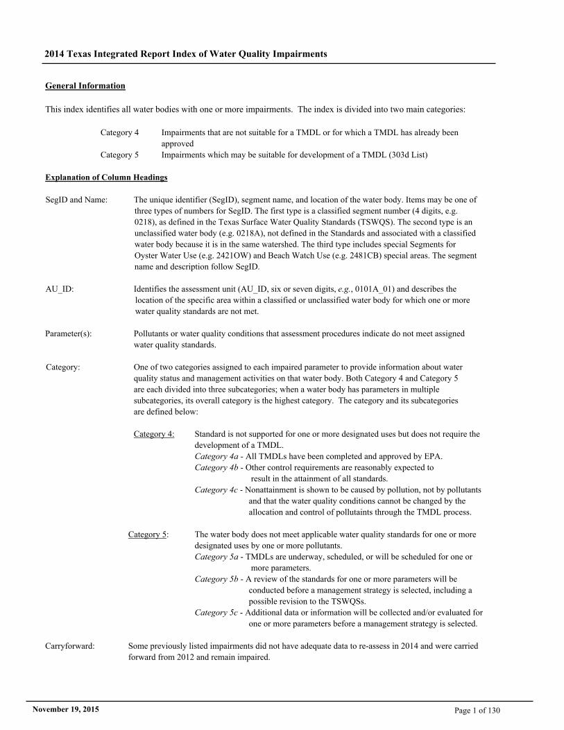
General Information
This index identifies all water bodies with one or more impairments. The index is divided into two main categories:
Category 4 Impairments that are not suitable for a TMDL or for which a TMDL has already been
approved
Category 5 Impairments which may be suitable for development of a TMDL (303d List)
Explanation of Column Headings
SegID and Name: The unique identifier (SegID), segment name, and location of the water body. Items may be one of
three types of numbers for SegID. The first type is a classified segment number (4 digits, e.g.
0218), as defined in the Texas Surface Water Quality Standards (TSWQS). The second type is an
unclassified water body (e.g. 0218A), not defined in the Standards and associated with a classified
water body because it is in the same watershed. The third type includes special Segments for
Oyster Water Use (e.g. 2421OW) and Beach Watch Use (e.g. 2481CB) special areas. The segment
name and description follow SegID.
AU_ID: Identifies the assessment unit (AU_ID, six or seven digits, e.g., 0101A_01) and describes the
location of the specific area within a classified or unclassified water body for which one or more
water quality standards are not met.
Parameter(s): Pollutants or water quality conditions that assessment procedures indicate do not meet assigned
water quality standards.
Category: One of two categories assigned to each impaired parameter to provide information about water
quality status and management activities on that water body. Both Category 4 and Category 5
are each divided into three subcategories; when a water body has parameters in multiple
subcategories, its overall category is the highest category. The category and its subcategories
are defined below:
Category 4: Standard is not supported for one or more designated uses but does not require the
development of a TMDL.
Category 4a - All TMDLs have been completed and approved by EPA.
Category 4b - Other control requirements are reasonably expected to
result in the attainment of all standards.
Category 4c - Nonattainment is shown to be caused by pollution, not by pollutants
and that the water quality conditions cannot be changed by the
allocation and control of pollutaints through the TMDL process.
Category 5: The water body does not meet applicable water quality standards for one or more
designated uses by one or more pollutants.
Category 5a - TMDLs are underway, scheduled, or will be scheduled for one or
more parameters.
Category 5b - A review of the standards for one or more parameters will be
conducted before a management strategy is selected, including a
possible revision to the TSWQSs.
Category 5c - Additional data or information will be collected and/or evaluated for
one or more parameters before a management strategy is selected.
Carryforward: Some previously listed impairments did not have adequate data to re-assess in 2014 and were carried
forward from 2012 and remain impaired.
2014 Texas Integrated Report Index of Water Quality Impairments
Page 1 of 130November 19, 2015
2014 Texas Integrated Report Index of Water Quality Impairments
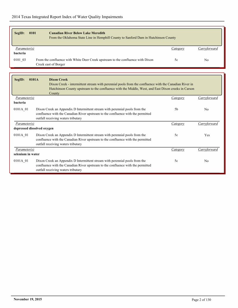
SegID: 0101 Canadian River Below Lake Meredith
From the Oklahoma State Line in Hemphill County to Sanford Dam in Hutchinson County
CarryforwardCategoryParameter(s)
bacteria
0101_03 From the confluence with White Deer Creek upstream to the confluence with Dixon
Creek east of Borger
5c No
SegID: 0101A Dixon Creek
Dixon Creek - intermittent stream with perennial pools from the confluence with the Canadian River in
Hutchinson County upstream to the confluence with the Middle, West, and East Dixon creeks in Carson
County
CarryforwardCategoryParameter(s)
bacteria
0101A_01 Dixon Creek an Appendix D Intermittent stream with perennial pools from the
confluence with the Canadian River upstream to the confluence with the permitted
outfall receiving waters tributary
5b No
CarryforwardCategoryParameter(s)
depressed dissolved oxygen
0101A_01 Dixon Creek an Appendix D Intermittent stream with perennial pools from the
confluence with the Canadian River upstream to the confluence with the permitted
outfall receiving waters tributary
5c Yes
CarryforwardCategoryParameter(s)
selenium in water
0101A_01 Dixon Creek an Appendix D Intermittent stream with perennial pools from the
confluence with the Canadian River upstream to the confluence with the permitted
outfall receiving waters tributary
5c No
Page 2 of 130November 19, 2015
2014 Texas Integrated Report Index of Water Quality Impairments
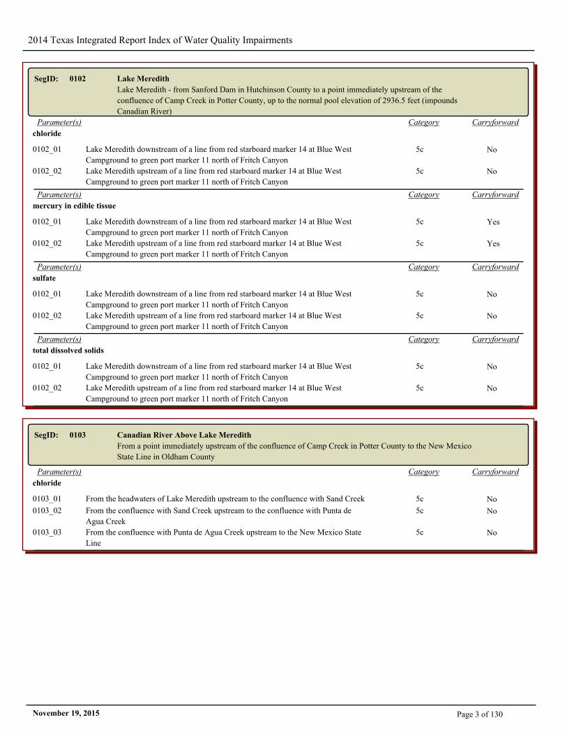
SegID: 0102 Lake Meredith
Lake Meredith - from Sanford Dam in Hutchinson County to a point immediately upstream of the
confluence of Camp Creek in Potter County, up to the normal pool elevation of 2936.5 feet (impounds
Canadian River)
CarryforwardCategoryParameter(s)
chloride
0102_01 Lake Meredith downstream of a line from red starboard marker 14 at Blue West
Campground to green port marker 11 north of Fritch Canyon
5c No
0102_02 Lake Meredith upstream of a line from red starboard marker 14 at Blue West
Campground to green port marker 11 north of Fritch Canyon
5c No
CarryforwardCategoryParameter(s)
mercury in edible tissue
0102_01 Lake Meredith downstream of a line from red starboard marker 14 at Blue West
Campground to green port marker 11 north of Fritch Canyon
5c Yes
0102_02 Lake Meredith upstream of a line from red starboard marker 14 at Blue West
Campground to green port marker 11 north of Fritch Canyon
5c Yes
CarryforwardCategoryParameter(s)
sulfate
0102_01 Lake Meredith downstream of a line from red starboard marker 14 at Blue West
Campground to green port marker 11 north of Fritch Canyon
5c No
0102_02 Lake Meredith upstream of a line from red starboard marker 14 at Blue West
Campground to green port marker 11 north of Fritch Canyon
5c No
CarryforwardCategoryParameter(s)
total dissolved solids
0102_01 Lake Meredith downstream of a line from red starboard marker 14 at Blue West
Campground to green port marker 11 north of Fritch Canyon
5c No
0102_02 Lake Meredith upstream of a line from red starboard marker 14 at Blue West
Campground to green port marker 11 north of Fritch Canyon
5c No
SegID: 0103 Canadian River Above Lake Meredith
From a point immediately upstream of the confluence of Camp Creek in Potter County to the New Mexico
State Line in Oldham County
CarryforwardCategoryParameter(s)
chloride
0103_01 From the headwaters of Lake Meredith upstream to the confluence with Sand Creek 5c No
0103_02 From the confluence with Sand Creek upstream to the confluence with Punta de
Agua Creek
5c No
0103_03 From the confluence with Punta de Agua Creek upstream to the New Mexico State
Line
5c No
Page 3 of 130November 19, 2015
2014 Texas Integrated Report Index of Water Quality Impairments
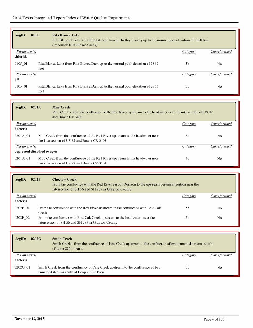
SegID: 0105 Rita Blanca Lake
Rita Blanca Lake - from Rita Blanca Dam in Hartley County up to the normal pool elevation of 3860 feet
(impounds Rita Blanca Creek)
CarryforwardCategoryParameter(s)
chloride
0105_01 Rita Blanca Lake from Rita Blanca Dam up to the normal pool elevation of 3860
feet
5b No
CarryforwardCategoryParameter(s)
pH
0105_01 Rita Blanca Lake from Rita Blanca Dam up to the normal pool elevation of 3860
feet
5b No
SegID: 0201A Mud Creek
Mud Creek - from the confluence of the Red River upstream to the headwater near the intersection of US 82
and Bowie CR 3403
CarryforwardCategoryParameter(s)
bacteria
0201A_01 Mud Creek from the confluence of the Red River upstream to the headwater near
the intersection of US 82 and Bowie CR 3403
5c No
CarryforwardCategoryParameter(s)
depressed dissolved oxygen
0201A_01 Mud Creek from the confluence of the Red River upstream to the headwater near
the intersection of US 82 and Bowie CR 3403
5c No
SegID: 0202F Choctaw Creek
From the confluence with the Red River east of Denison to the upstream perennial portion near the
intersection of SH 56 and SH 289 in Grayson County
CarryforwardCategoryParameter(s)
bacteria
0202F_01 From the confluence with the Red River upstream to the confluence with Post Oak
Creek
5b No
0202F_02 From the confluence with Post Oak Creek upstream to the headwaters near the
intersection of SH 56 and SH 289 in Grayson County
5b No
SegID: 0202G Smith Creek
Smith Creek - from the confluence of Pine Creek upstream to the confluence of two unnamed streams south
of Loop 286 in Paris
CarryforwardCategoryParameter(s)
bacteria
0202G_01 Smith Creek from the confluence of Pine Creek upstream to the confluence of two
unnamed streams south of Loop 286 in Paris
5b No
Page 4 of 130November 19, 2015
2014 Texas Integrated Report Index of Water Quality Impairments
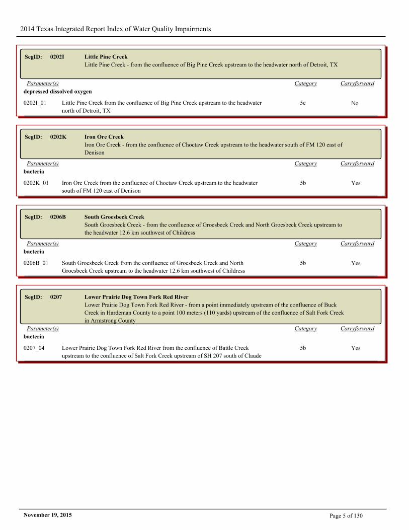
SegID: 0202I Little Pine Creek
Little Pine Creek - from the confluence of Big Pine Creek upstream to the headwater north of Detroit, TX
CarryforwardCategoryParameter(s)
depressed dissolved oxygen
0202I_01 Little Pine Creek from the confluence of Big Pine Creek upstream to the headwater
north of Detroit, TX
5c No
SegID: 0202K Iron Ore Creek
Iron Ore Creek - from the confluence of Choctaw Creek upstream to the headwater south of FM 120 east of
Denison
CarryforwardCategoryParameter(s)
bacteria
0202K_01 Iron Ore Creek from the confluence of Choctaw Creek upstream to the headwater
south of FM 120 east of Denison
5b Yes
SegID: 0206B South Groesbeck Creek
South Groesbeck Creek - from the confluence of Groesbeck Creek and North Groesbeck Creek upstream to
the headwater 12.6 km southwest of Childress
CarryforwardCategoryParameter(s)
bacteria
0206B_01 South Groesbeck Creek from the confluence of Groesbeck Creek and North
Groesbeck Creek upstream to the headwater 12.6 km southwest of Childress
5b Yes
SegID: 0207 Lower Prairie Dog Town Fork Red River
Lower Prairie Dog Town Fork Red River - from a point immediately upstream of the confluence of Buck
Creek in Hardeman County to a point 100 meters (110 yards) upstream of the confluence of Salt Fork Creek
in Armstrong County
CarryforwardCategoryParameter(s)
bacteria
0207_04 Lower Prairie Dog Town Fork Red River from the confluence of Battle Creek
upstream to the confluence of Salt Fork Creek upstream of SH 207 south of Claude
5b Yes
Page 5 of 130November 19, 2015
2014 Texas Integrated Report Index of Water Quality Impairments
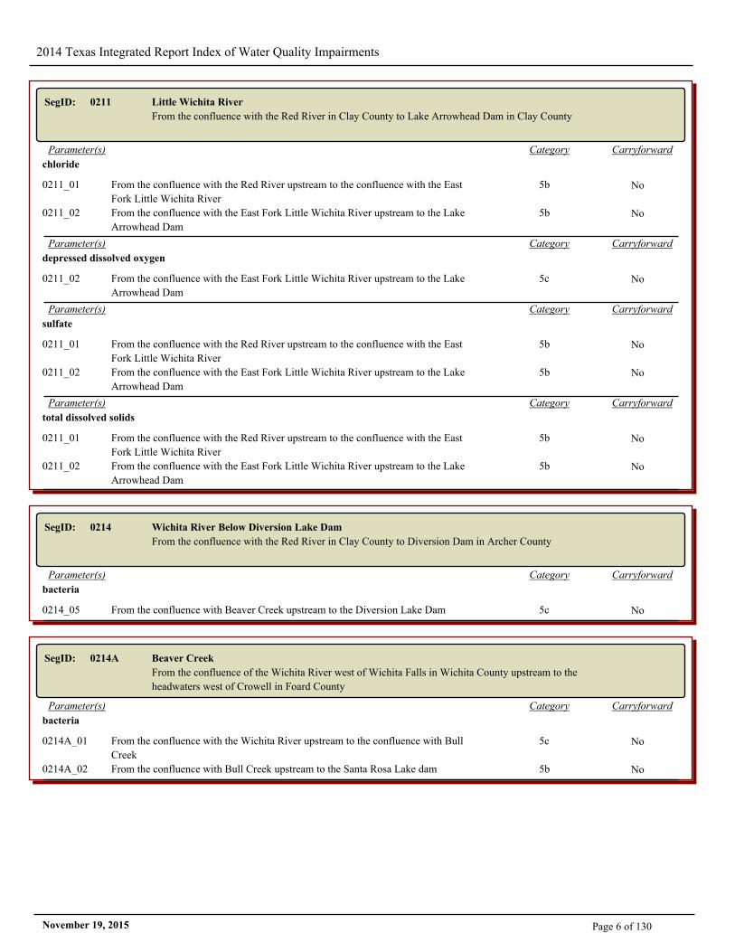
SegID: 0211 Little Wichita River
From the confluence with the Red River in Clay County to Lake Arrowhead Dam in Clay County
CarryforwardCategoryParameter(s)
chloride
0211_01 From the confluence with the Red River upstream to the confluence with the East
Fork Little Wichita River
5b No
0211_02 From the confluence with the East Fork Little Wichita River upstream to the Lake
Arrowhead Dam
5b No
CarryforwardCategoryParameter(s)
depressed dissolved oxygen
0211_02 From the confluence with the East Fork Little Wichita River upstream to the Lake
Arrowhead Dam
5c No
CarryforwardCategoryParameter(s)
sulfate
0211_01 From the confluence with the Red River upstream to the confluence with the East
Fork Little Wichita River
5b No
0211_02 From the confluence with the East Fork Little Wichita River upstream to the Lake
Arrowhead Dam
5b No
CarryforwardCategoryParameter(s)
total dissolved solids
0211_01 From the confluence with the Red River upstream to the confluence with the East
Fork Little Wichita River
5b No
0211_02 From the confluence with the East Fork Little Wichita River upstream to the Lake
Arrowhead Dam
5b No
SegID: 0214 Wichita River Below Diversion Lake Dam
From the confluence with the Red River in Clay County to Diversion Dam in Archer County
CarryforwardCategoryParameter(s)
bacteria
0214_05 From the confluence with Beaver Creek upstream to the Diversion Lake Dam 5c No
SegID: 0214A Beaver Creek
From the confluence of the Wichita River west of Wichita Falls in Wichita County upstream to the
headwaters west of Crowell in Foard County
CarryforwardCategoryParameter(s)
bacteria
0214A_01 From the confluence with the Wichita River upstream to the confluence with Bull
Creek
5c No
0214A_02 From the confluence with Bull Creek upstream to the Santa Rosa Lake dam 5b No
Page 6 of 130November 19, 2015
2014 Texas Integrated Report Index of Water Quality Impairments
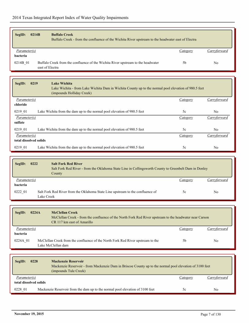
SegID: 0214B Buffalo Creek
Buffalo Creek - from the confluence of the Wichita River upstream to the headwater east of Electra
CarryforwardCategoryParameter(s)
bacteria
0214B_01 Buffalo Creek from the confluence of the Wichita River upstream to the headwater
east of Electra
5b No
SegID: 0219 Lake Wichita
Lake Wichita - from Lake Wichita Dam in Wichita County up to the normal pool elevation of 980.5 feet
(impounds Holliday Creek)
CarryforwardCategoryParameter(s)
chloride
0219_01 Lake Wichita from the dam up to the normal pool elevation of 980.5 feet 5c No
CarryforwardCategoryParameter(s)
sulfate
0219_01 Lake Wichita from the dam up to the normal pool elevation of 980.5 feet 5c No
CarryforwardCategoryParameter(s)
total dissolved solids
0219_01 Lake Wichita from the dam up to the normal pool elevation of 980.5 feet 5c No
SegID: 0222 Salt Fork Red River
Salt Fork Red River - from the Oklahoma State Line in Collingsworth County to Greenbelt Dam in Donley
County
CarryforwardCategoryParameter(s)
bacteria
0222_01 Salt Fork Red River from the Oklahoma State Line upstream to the confluence of
Lake Creek
5c No
SegID: 0224A McClellan Creek
McClellan Creek - from the confluence of the North Fork Red River upstream to the headwater near Carson
CR 117 km east of Amarillo
CarryforwardCategoryParameter(s)
bacteria
0224A_01 McClellan Creek from the confluence of the North Fork Red River upstream to the
Lake McClellan dam
5b No
SegID: 0228 Mackenzie Reservoir
Mackenzie Reservoir - from Mackenzie Dam in Briscoe County up to the normal pool elevation of 3100 feet
(impounds Tule Creek)
CarryforwardCategoryParameter(s)
total dissolved solids
0228_01 Mackenzie Reservoir from the dam up to the normal pool elevation of 3100 feet 5c No
Page 7 of 130November 19, 2015
2014 Texas Integrated Report Index of Water Quality Impairments
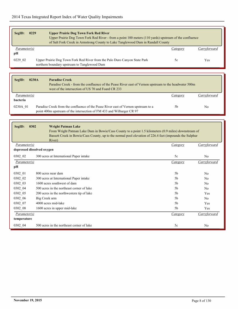
SegID: 0229 Upper Prairie Dog Town Fork Red River
Upper Prairie Dog Town Fork Red River - from a point 100 meters (110 yards) upstream of the confluence
of Salt Fork Creek in Armstrong County to Lake Tanglewood Dam in Randall County
CarryforwardCategoryParameter(s)
pH
0229_02 Upper Prairie Dog Town Fork Red River from the Palo Duro Canyon State Park
northern boundary upstream to Tanglewood Dam
5c Yes
SegID: 0230A Paradise Creek
Paradise Creek - from the confluence of the Pease River east of Vernon upstream to the headwater 500m
west of the intersection of US 70 and Foard CR 233
CarryforwardCategoryParameter(s)
bacteria
0230A_01 Paradise Creek from the confluence of the Pease River east of Vernon upstream to a
point 400m upstream of the intersection of FM 433 and Wilbarger CR 97
5b No
SegID: 0302 Wright Patman Lake
From Wright Patman Lake Dam in Bowie/Cass County to a point 1.5 kilometers (0.9 miles) downstream of
Bassett Creek in Bowie/Cass County, up to the normal pool elevation of 226.4 feet (impounds the Sulphur
River)
CarryforwardCategoryParameter(s)
depressed dissolved oxygen
0302_02 300 acres at International Paper intake 5c No
CarryforwardCategoryParameter(s)
pH
0302_01 800 acres near dam 5b No
0302_02 300 acres at International Paper intake 5b No
0302_03 1600 acres southwest of dam 5b No
0302_04 500 acres in the northeast corner of lake 5b No
0302_05 200 acres in the northwestern tip of lake 5b Yes
0302_06 Big Creek arm 5b No
0302_07 4000 acres mid-lake 5b Yes
0302_08 1600 acres in upper mid-lake 5b Yes
CarryforwardCategoryParameter(s)
temperature
0302_04 500 acres in the northeast corner of lake 5c No
Page 8 of 130November 19, 2015
2014 Texas Integrated Report Index of Water Quality Impairments
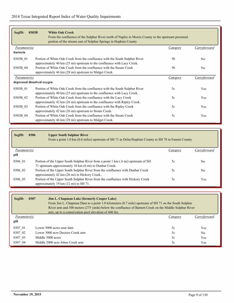
SegID: 0303B White Oak Creek
From the confluence of the Sulphur River north of Naples in Morris County to the upstream perennial
portion of the stream east of Sulphur Springs in Hopkins County
CarryforwardCategoryParameter(s)
bacteria
0303B_01 Portion of White Oak Creek from the confluence with the South Sulphur River
approximately 40 km (25 mi) upstream to the confluence with Lacy Creek.
5b No
0303B_04 Portion of White Oak Creek from the confluence with the Stouts Creek
approximately 46 km (28 mi) upstream to Midget Creek.
5b No
CarryforwardCategoryParameter(s)
depressed dissolved oxygen
0303B_01 Portion of White Oak Creek from the confluence with the South Sulphur River
approximately 40 km (25 mi) upstream to the confluence with Lacy Creek.
5c Yes
0303B_02 Portion of White Oak Creek from the confluence with the Lacy Creek
approximately 42 km (26 mi) upstream to the confluence with Ripley Creek.
5c Yes
0303B_03 Portion of White Oak Creek from the confluence with the Ripley Creek
approximately 42 km (26 mi) upstream to Stouts Creek.
5c Yes
0303B_04 Portion of White Oak Creek from the confluence with the Stouts Creek
approximately 46 km (28 mi) upstream to Midget Creek.
5c Yes
SegID: 0306 Upper South Sulphur River
From a point 1.0 km (0.6 miles) upstream of SH 71 in Delta/Hopkins County to SH 78 in Fannin County
CarryforwardCategoryParameter(s)
pH
0306_01 Portion of the Upper South Sulphur River from a point 1 km (.6 mi) upstream of SH
71 upstream approximately 10 km (6 mi) to Dunbar Creek.
5c No
0306_02 Portion of the Upper South Sulphur River from the confluence with Dunbar Creek
approximately 42 km (26 mi) to Hickory Creek..
5c No
0306_03 Portion of the Upper South Sulphur River from the confluence with Hickory Creek
approximately 19 km (12 mi) to SH 71.
5c Yes
SegID: 0307 Jim L. Chapman Lake (formerly Cooper Lake)
From Jim L. Chapman Dam to a point 1.0 kilometers (0.7 mile) upstream of SH 71 on the South Sulphur
River arm and 300 meters (275 yards) below the confluence of Barnett Creek on the Middle Sulphur River
arm, up to a conservation pool elevation of 440 fee
CarryforwardCategoryParameter(s)
pH
0307_01 Lower 5000 acres near dam 5c Yes
0307_02 Lower 3000 acre Doctors Creek arm 5c No
0307_03 Middle 5000 acres 5c Yes
0307_04 Middle 2000 acre Johns Creek arm 5c Yes
Page 9 of 130November 19, 2015
2014 Texas Integrated Report Index of Water Quality Impairments
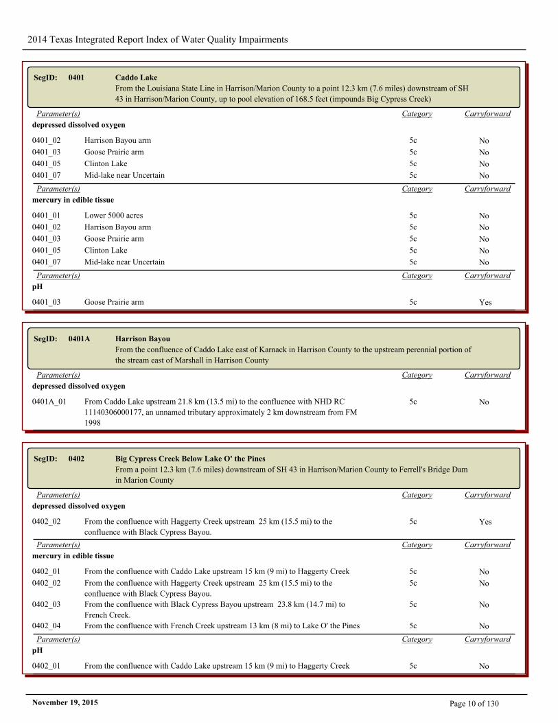
SegID: 0401 Caddo Lake
From the Louisiana State Line in Harrison/Marion County to a point 12.3 km (7.6 miles) downstream of SH
43 in Harrison/Marion County, up to pool elevation of 168.5 feet (impounds Big Cypress Creek)
CarryforwardCategoryParameter(s)
depressed dissolved oxygen
0401_02 Harrison Bayou arm 5c No
0401_03 Goose Prairie arm 5c No
0401_05 Clinton Lake 5c No
0401_07 Mid-lake near Uncertain 5c No
CarryforwardCategoryParameter(s)
mercury in edible tissue
0401_01 Lower 5000 acres 5c No
0401_02 Harrison Bayou arm 5c No
0401_03 Goose Prairie arm 5c No
0401_05 Clinton Lake 5c No
0401_07 Mid-lake near Uncertain 5c No
CarryforwardCategoryParameter(s)
pH
0401_03 Goose Prairie arm 5c Yes
SegID: 0401A Harrison Bayou
From the confluence of Caddo Lake east of Karnack in Harrison County to the upstream perennial portion of
the stream east of Marshall in Harrison County
CarryforwardCategoryParameter(s)
depressed dissolved oxygen
0401A_01 From Caddo Lake upstream 21.8 km (13.5 mi) to the confluence with NHD RC
11140306000177, an unnamed tributary approximately 2 km downstream from FM
1998
5c No
SegID: 0402 Big Cypress Creek Below Lake O' the Pines
From a point 12.3 km (7.6 miles) downstream of SH 43 in Harrison/Marion County to Ferrell's Bridge Dam
in Marion County
CarryforwardCategoryParameter(s)
depressed dissolved oxygen
0402_02 From the confluence with Haggerty Creek upstream 25 km (15.5 mi) to the
confluence with Black Cypress Bayou.
5c Yes
CarryforwardCategoryParameter(s)
mercury in edible tissue
0402_01 From the confluence with Caddo Lake upstream 15 km (9 mi) to Haggerty Creek 5c No
0402_02 From the confluence with Haggerty Creek upstream 25 km (15.5 mi) to the
confluence with Black Cypress Bayou.
5c No
0402_03 From the confluence with Black Cypress Bayou upstream 23.8 km (14.7 mi) to
French Creek.
5c No
0402_04 From the confluence with French Creek upstream 13 km (8 mi) to Lake O' the Pines 5c No
CarryforwardCategoryParameter(s)
pH
0402_01 From the confluence with Caddo Lake upstream 15 km (9 mi) to Haggerty Creek 5c No
Page 10 of 130November 19, 2015
2014 Texas Integrated Report Index of Water Quality Impairments
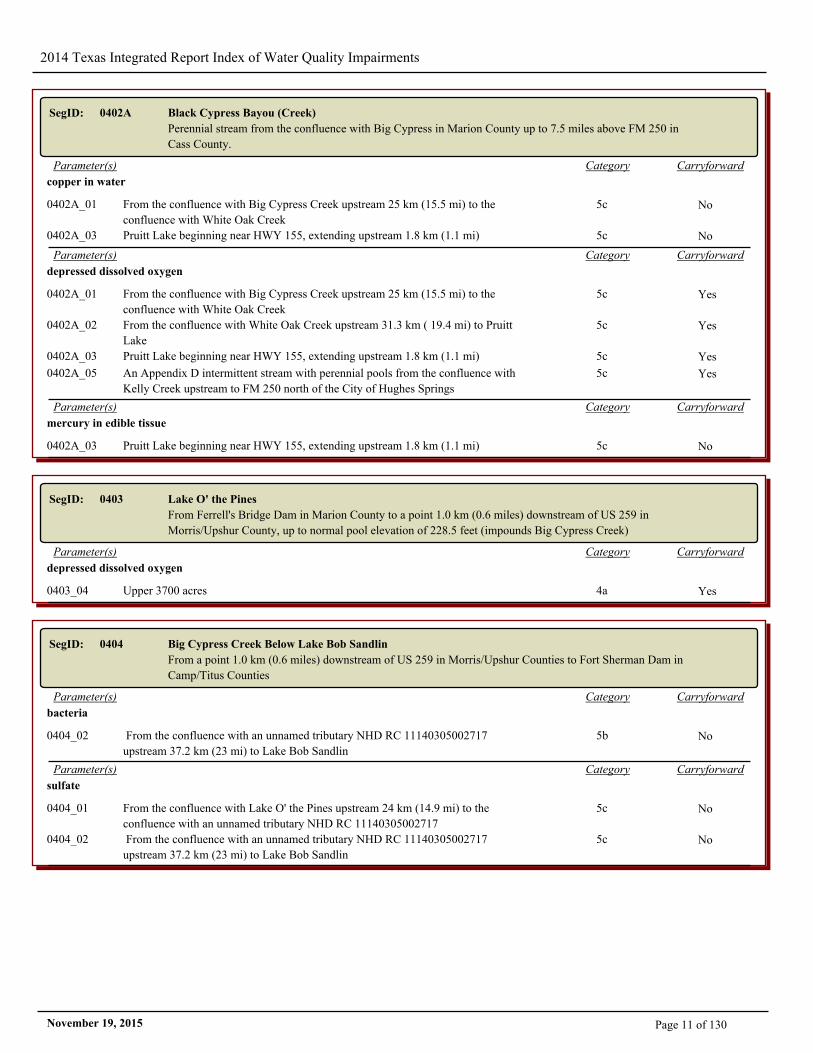
SegID: 0402A Black Cypress Bayou (Creek)
Perennial stream from the confluence with Big Cypress in Marion County up to 7.5 miles above FM 250 in
Cass County.
CarryforwardCategoryParameter(s)
copper in water
0402A_01 From the confluence with Big Cypress Creek upstream 25 km (15.5 mi) to the
confluence with White Oak Creek
5c No
0402A_03 Pruitt Lake beginning near HWY 155, extending upstream 1.8 km (1.1 mi) 5c No
CarryforwardCategoryParameter(s)
depressed dissolved oxygen
0402A_01 From the confluence with Big Cypress Creek upstream 25 km (15.5 mi) to the
confluence with White Oak Creek
5c Yes
0402A_02 From the confluence with White Oak Creek upstream 31.3 km ( 19.4 mi) to Pruitt
Lake
5c Yes
0402A_03 Pruitt Lake beginning near HWY 155, extending upstream 1.8 km (1.1 mi) 5c Yes
0402A_05 An Appendix D intermittent stream with perennial pools from the confluence with
Kelly Creek upstream to FM 250 north of the City of Hughes Springs
5c Yes
CarryforwardCategoryParameter(s)
mercury in edible tissue
0402A_03 Pruitt Lake beginning near HWY 155, extending upstream 1.8 km (1.1 mi) 5c No
SegID: 0403 Lake O' the Pines
From Ferrell's Bridge Dam in Marion County to a point 1.0 km (0.6 miles) downstream of US 259 in
Morris/Upshur County, up to normal pool elevation of 228.5 feet (impounds Big Cypress Creek)
CarryforwardCategoryParameter(s)
depressed dissolved oxygen
0403_04 Upper 3700 acres 4a Yes
SegID: 0404 Big Cypress Creek Below Lake Bob Sandlin
From a point 1.0 km (0.6 miles) downstream of US 259 in Morris/Upshur Counties to Fort Sherman Dam in
Camp/Titus Counties
CarryforwardCategoryParameter(s)
bacteria
0404_02 From the confluence with an unnamed tributary NHD RC 11140305002717
upstream 37.2 km (23 mi) to Lake Bob Sandlin
5b No
CarryforwardCategoryParameter(s)
sulfate
0404_01 From the confluence with Lake O' the Pines upstream 24 km (14.9 mi) to the
confluence with an unnamed tributary NHD RC 11140305002717
5c No
0404_02 From the confluence with an unnamed tributary NHD RC 11140305002717
upstream 37.2 km (23 mi) to Lake Bob Sandlin
5c No
Page 11 of 130November 19, 2015
2014 Texas Integrated Report Index of Water Quality Impairments
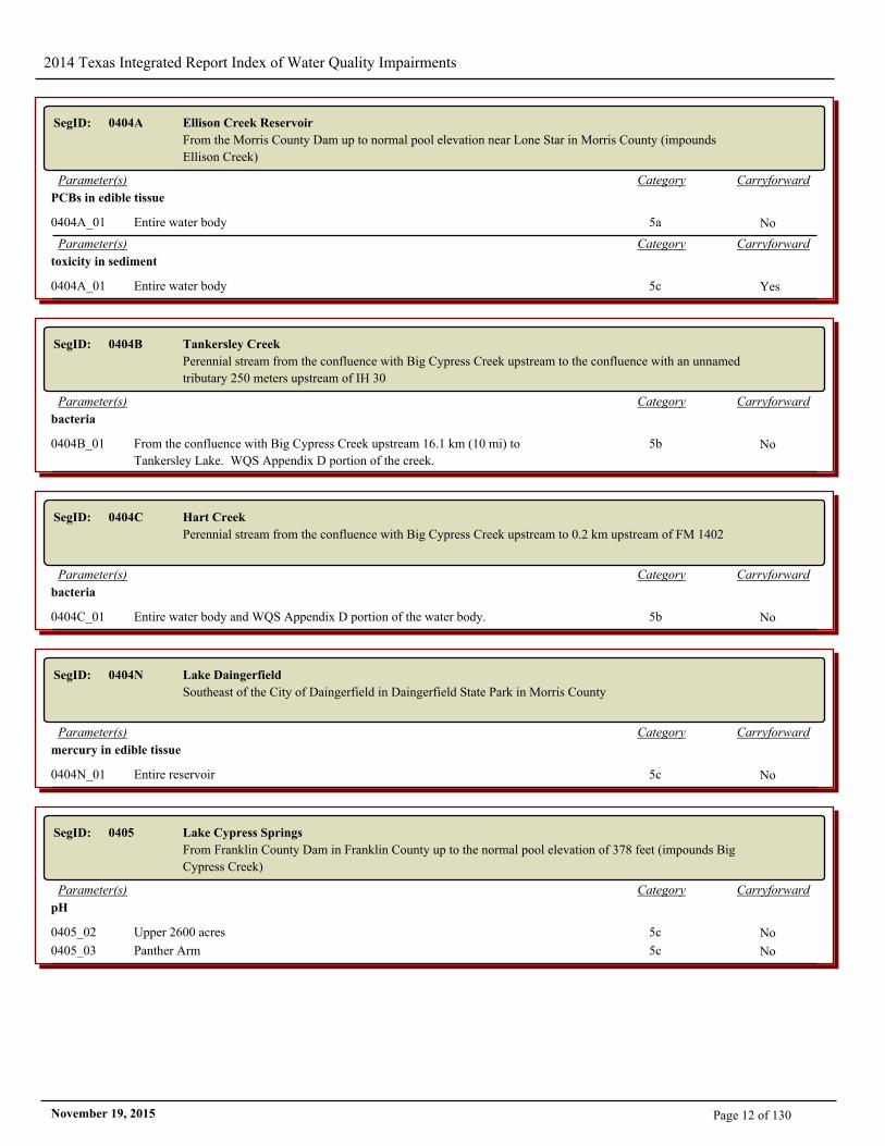
SegID: 0404A Ellison Creek Reservoir
From the Morris County Dam up to normal pool elevation near Lone Star in Morris County (impounds
Ellison Creek)
CarryforwardCategoryParameter(s)
PCBs in edible tissue
0404A_01 Entire water body 5a No
CarryforwardCategoryParameter(s)
toxicity in sediment
0404A_01 Entire water body 5c Yes
SegID: 0404B Tankersley Creek
Perennial stream from the confluence with Big Cypress Creek upstream to the confluence with an unnamed
tributary 250 meters upstream of IH 30
CarryforwardCategoryParameter(s)
bacteria
0404B_01 From the confluence with Big Cypress Creek upstream 16.1 km (10 mi) to
Tankersley Lake. WQS Appendix D portion of the creek.
5b No
SegID: 0404C Hart Creek
Perennial stream from the confluence with Big Cypress Creek upstream to 0.2 km upstream of FM 1402
CarryforwardCategoryParameter(s)
bacteria
0404C_01 Entire water body and WQS Appendix D portion of the water body. 5b No
SegID: 0404N Lake Daingerfield
Southeast of the City of Daingerfield in Daingerfield State Park in Morris County
CarryforwardCategoryParameter(s)
mercury in edible tissue
0404N_01 Entire reservoir 5c No
SegID: 0405 Lake Cypress Springs
From Franklin County Dam in Franklin County up to the normal pool elevation of 378 feet (impounds Big
Cypress Creek)
CarryforwardCategoryParameter(s)
pH
0405_02 Upper 2600 acres 5c No
0405_03 Panther Arm 5c No
Page 12 of 130November 19, 2015
2014 Texas Integrated Report Index of Water Quality Impairments
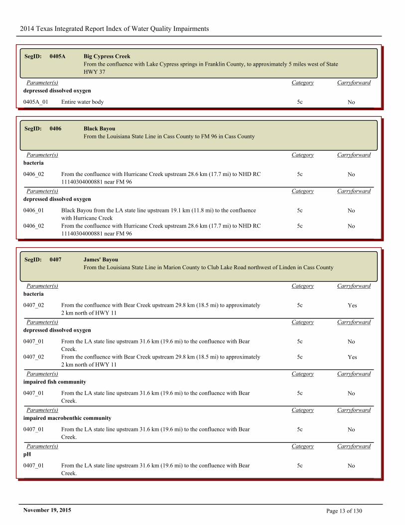
SegID: 0405A Big Cypress Creek
From the confluence with Lake Cypress springs in Franklin County, to approximately 5 miles west of State
HWY 37
CarryforwardCategoryParameter(s)
depressed dissolved oxygen
0405A_01 Entire water body 5c No
SegID: 0406 Black Bayou
From the Louisiana State Line in Cass County to FM 96 in Cass County
CarryforwardCategoryParameter(s)
bacteria
0406_02 From the confluence with Hurricane Creek upstream 28.6 km (17.7 mi) to NHD RC
11140304000881 near FM 96
5c No
CarryforwardCategoryParameter(s)
depressed dissolved oxygen
0406_01 Black Bayou from the LA state line upstream 19.1 km (11.8 mi) to the confluence
with Hurricane Creek
5c No
0406_02 From the confluence with Hurricane Creek upstream 28.6 km (17.7 mi) to NHD RC
11140304000881 near FM 96
5c No
SegID: 0407 James' Bayou
From the Louisiana State Line in Marion County to Club Lake Road northwest of Linden in Cass County
CarryforwardCategoryParameter(s)
bacteria
0407_02 From the confluence with Bear Creek upstream 29.8 km (18.5 mi) to approximately
2 km north of HWY 11
5c Yes
CarryforwardCategoryParameter(s)
depressed dissolved oxygen
0407_01 From the LA state line upstream 31.6 km (19.6 mi) to the confluence with Bear
Creek.
5c No
0407_02 From the confluence with Bear Creek upstream 29.8 km (18.5 mi) to approximately
2 km north of HWY 11
5c Yes
CarryforwardCategoryParameter(s)
impaired fish community
0407_01 From the LA state line upstream 31.6 km (19.6 mi) to the confluence with Bear
Creek.
5c No
CarryforwardCategoryParameter(s)
impaired macrobenthic community
0407_01 From the LA state line upstream 31.6 km (19.6 mi) to the confluence with Bear
Creek.
5c No
CarryforwardCategoryParameter(s)
pH
0407_01 From the LA state line upstream 31.6 km (19.6 mi) to the confluence with Bear
Creek.
5c No
Page 13 of 130November 19, 2015
2014 Texas Integrated Report Index of Water Quality Impairments
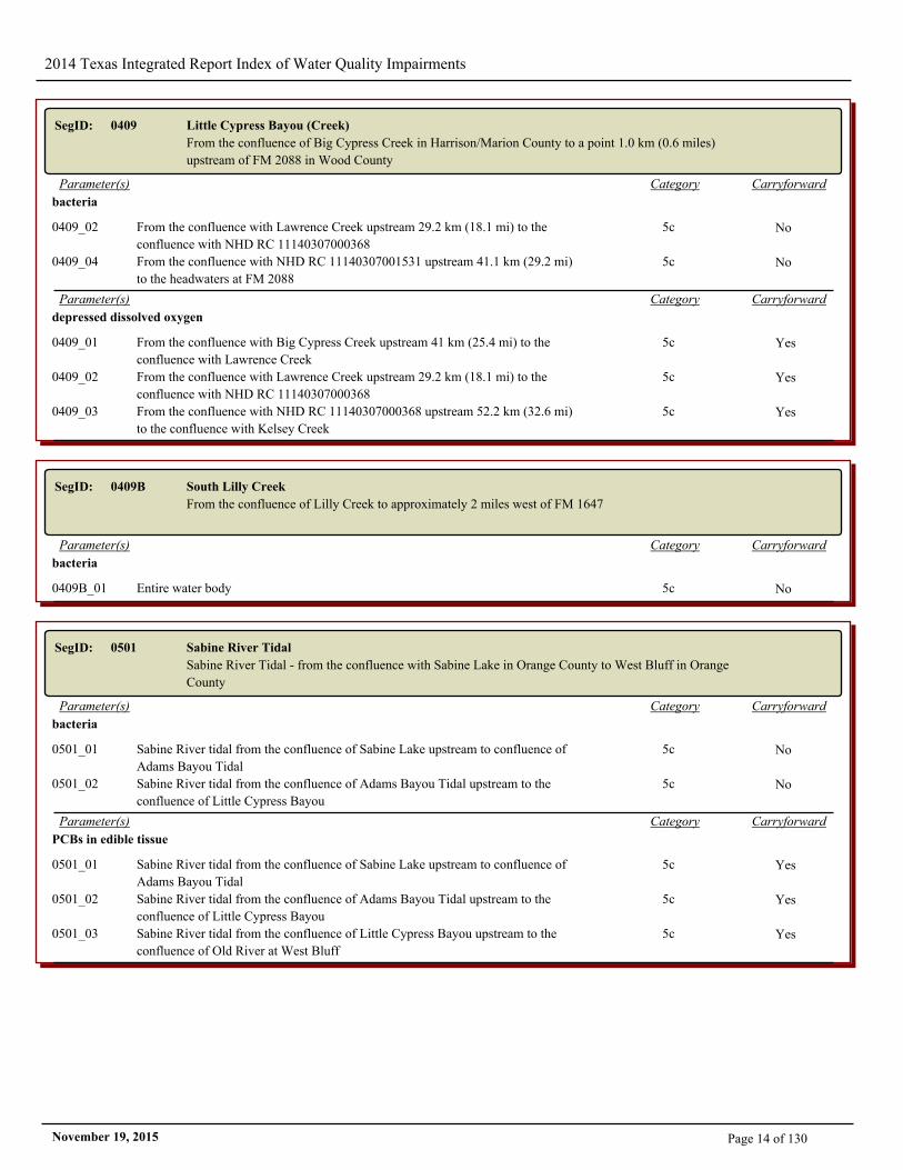
SegID: 0409 Little Cypress Bayou (Creek)
From the confluence of Big Cypress Creek in Harrison/Marion County to a point 1.0 km (0.6 miles)
upstream of FM 2088 in Wood County
CarryforwardCategoryParameter(s)
bacteria
0409_02 From the confluence with Lawrence Creek upstream 29.2 km (18.1 mi) to the
confluence with NHD RC 11140307000368
5c No
0409_04 From the confluence with NHD RC 11140307001531 upstream 41.1 km (29.2 mi)
to the headwaters at FM 2088
5c No
CarryforwardCategoryParameter(s)
depressed dissolved oxygen
0409_01 From the confluence with Big Cypress Creek upstream 41 km (25.4 mi) to the
confluence with Lawrence Creek
5c Yes
0409_02 From the confluence with Lawrence Creek upstream 29.2 km (18.1 mi) to the
confluence with NHD RC 11140307000368
5c Yes
0409_03 From the confluence with NHD RC 11140307000368 upstream 52.2 km (32.6 mi)
to the confluence with Kelsey Creek
5c Yes
SegID: 0409B South Lilly Creek
From the confluence of Lilly Creek to approximately 2 miles west of FM 1647
CarryforwardCategoryParameter(s)
bacteria
0409B_01 Entire water body 5c No
SegID: 0501 Sabine River Tidal
Sabine River Tidal - from the confluence with Sabine Lake in Orange County to West Bluff in Orange
County
CarryforwardCategoryParameter(s)
bacteria
0501_01 Sabine River tidal from the confluence of Sabine Lake upstream to confluence of
Adams Bayou Tidal
5c No
0501_02 Sabine River tidal from the confluence of Adams Bayou Tidal upstream to the
confluence of Little Cypress Bayou
5c No
CarryforwardCategoryParameter(s)
PCBs in edible tissue
0501_01 Sabine River tidal from the confluence of Sabine Lake upstream to confluence of
Adams Bayou Tidal
5c Yes
0501_02 Sabine River tidal from the confluence of Adams Bayou Tidal upstream to the
confluence of Little Cypress Bayou
5c Yes
0501_03 Sabine River tidal from the confluence of Little Cypress Bayou upstream to the
confluence of Old River at West Bluff
5c Yes
Page 14 of 130November 19, 2015
2014 Texas Integrated Report Index of Water Quality Impairments
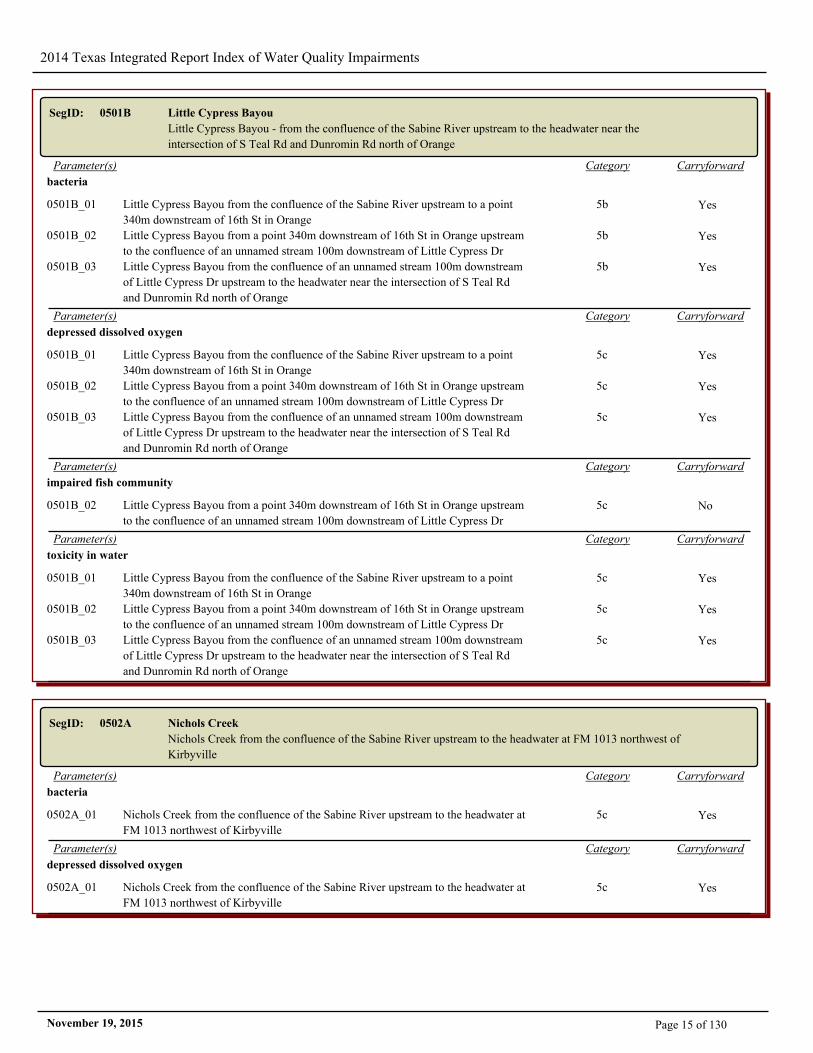
SegID: 0501B Little Cypress Bayou
Little Cypress Bayou - from the confluence of the Sabine River upstream to the headwater near the
intersection of S Teal Rd and Dunromin Rd north of Orange
CarryforwardCategoryParameter(s)
bacteria
0501B_01 Little Cypress Bayou from the confluence of the Sabine River upstream to a point
340m downstream of 16th St in Orange
5b Yes
0501B_02 Little Cypress Bayou from a point 340m downstream of 16th St in Orange upstream
to the confluence of an unnamed stream 100m downstream of Little Cypress Dr
5b Yes
0501B_03 Little Cypress Bayou from the confluence of an unnamed stream 100m downstream
of Little Cypress Dr upstream to the headwater near the intersection of S Teal Rd
and Dunromin Rd north of Orange
5b Yes
CarryforwardCategoryParameter(s)
depressed dissolved oxygen
0501B_01 Little Cypress Bayou from the confluence of the Sabine River upstream to a point
340m downstream of 16th St in Orange
5c Yes
0501B_02 Little Cypress Bayou from a point 340m downstream of 16th St in Orange upstream
to the confluence of an unnamed stream 100m downstream of Little Cypress Dr
5c Yes
0501B_03 Little Cypress Bayou from the confluence of an unnamed stream 100m downstream
of Little Cypress Dr upstream to the headwater near the intersection of S Teal Rd
and Dunromin Rd north of Orange
5c Yes
CarryforwardCategoryParameter(s)
impaired fish community
0501B_02 Little Cypress Bayou from a point 340m downstream of 16th St in Orange upstream
to the confluence of an unnamed stream 100m downstream of Little Cypress Dr
5c No
CarryforwardCategoryParameter(s)
toxicity in water
0501B_01 Little Cypress Bayou from the confluence of the Sabine River upstream to a point
340m downstream of 16th St in Orange
5c Yes
0501B_02 Little Cypress Bayou from a point 340m downstream of 16th St in Orange upstream
to the confluence of an unnamed stream 100m downstream of Little Cypress Dr
5c Yes
0501B_03 Little Cypress Bayou from the confluence of an unnamed stream 100m downstream
of Little Cypress Dr upstream to the headwater near the intersection of S Teal Rd
and Dunromin Rd north of Orange
5c Yes
SegID: 0502A Nichols Creek
Nichols Creek from the confluence of the Sabine River upstream to the headwater at FM 1013 northwest of
Kirbyville
CarryforwardCategoryParameter(s)
bacteria
0502A_01 Nichols Creek from the confluence of the Sabine River upstream to the headwater at
FM 1013 northwest of Kirbyville
5c Yes
CarryforwardCategoryParameter(s)
depressed dissolved oxygen
0502A_01 Nichols Creek from the confluence of the Sabine River upstream to the headwater at
FM 1013 northwest of Kirbyville
5c Yes
Page 15 of 130November 19, 2015
2014 Texas Integrated Report Index of Water Quality Impairments
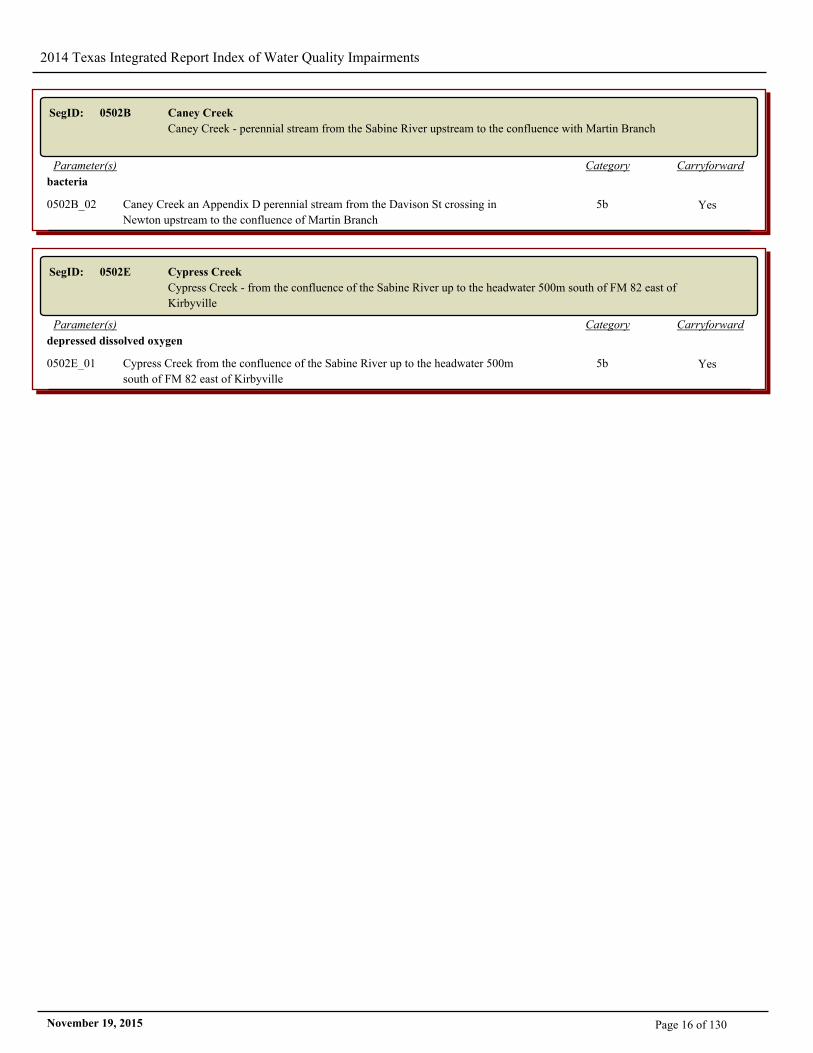
SegID: 0502B Caney Creek
Caney Creek - perennial stream from the Sabine River upstream to the confluence with Martin Branch
CarryforwardCategoryParameter(s)
bacteria
0502B_02 Caney Creek an Appendix D perennial stream from the Davison St crossing in
Newton upstream to the confluence of Martin Branch
5b Yes
SegID: 0502E Cypress Creek
Cypress Creek - from the confluence of the Sabine River up to the headwater 500m south of FM 82 east of
Kirbyville
CarryforwardCategoryParameter(s)
depressed dissolved oxygen
0502E_01 Cypress Creek from the confluence of the Sabine River up to the headwater 500m
south of FM 82 east of Kirbyville
5b Yes
Page 16 of 130November 19, 2015
2014 Texas Integrated Report Index of Water Quality Impairments
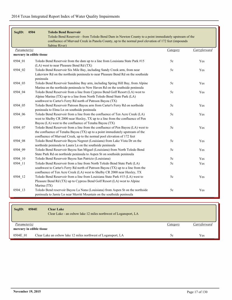
SegID: 0504 Toledo Bend Reservoir
Toledo Bend Reservoir - from Toledo Bend Dam in Newton County to a point immediately upstream of the
confluence of Murvaul Creek in Panola County, up to the normal pool elevation of 172 feet (impounds
Sabine River)
CarryforwardCategoryParameter(s)
mercury in edible tissue
0504_01 Toledo Bend Reservoir from the dam up to a line from Louisiana State Park #15
(LA) west to near Pleasure Bend Rd (TX)
5c Yes
0504_02 Toledo Bend Reservoir Six Mile Bay, including Sandy Creek arm, from near
Lakeview Rd on the northside peninsula to near Pleasure Bend Rd on the southside
peninsula
5c Yes
0504_03 Toledo Bend Reservoir Sunshine Bay arm, including Spring Hill Bay, from Alpine
Marina on the northside peninsula to New Haven Rd on the southside peninsula
5c Yes
0504_04 Toledo Bend Reservoir from a line from Cypress Bend Golf Resort (LA) west to
Alpine Marina (TX) up to a line from North Toledo Bend State Park (LA)
southwest to Carter's Ferry Rd north of Patroon Bayou (TX)
5c Yes
0504_05 Toledo Bend Reservoir Patroon Bayou arm from Carter's Ferry Rd on northside
peninsula to Elma Ln on southside peninsula
5c Yes
0504_06 Toledo Bend Reservoir from a line from the confluence of Ten Acre Creek (LA)
west to Shelby CR 2000 near Huxley, TX up to a line from the confluence of Pen
Bayou (LA) west to the confluence of Tenaha Bayou (TX)
5c Yes
0504_07 Toledo Bend Reservoir from a line from the confluence of Pen Bayou (LA) west to
the confluence of Tenaha Bayou (TX) up to a point immediately upstream of the
confluence of Murvaul Creek, up to the normal pool elevation of 172 feet
5c Yes
0504_08 Toledo Bend Reservoir Bayou Negreet (Louisiana) from Lake Vista Dr on the
northside peninsula to Laura Ln on the southside peninsula
5c Yes
0504_09 Toledo Bend Reservoir Bayou San Miguel (Louisiana) from North Toledo Bend
State Park Rd on northside peninsula to Aspen St on southside peninsula
5c Yes
0504_10 Toledo Bend Reservoir Bayou San Patricio (Louisiana) 5c Yes
0504_11 Toledo Bend Reservoir from a line from North Toledo Bend State Park (LA)
southwest to Carter's Ferry Rd north of Patroon Bayou (TX) up to a line from the
confluence of Ten Acre Creek (LA) west to Shelby CR 2000 near Huxley, TX
5c Yes
0504_12 Toledo Bend Reservoir from a line from Louisiana State Park #15 (LA) west to
Pleasure Bend Rd (TX) up to Cypress Bend Golf Resort (LA) west to Alpine
Marina (TX)
5c Yes
0504_13 Toledo Bend reservoir Bayou La Nana (Louisiana) from Aspen St on the northside
peninsula to Jamie Ln near Merritt Mountain on the southside peninsula
5c Yes
SegID: 0504E Clear Lake
Clear Lake - an oxbow lake 12 miles northwest of Logansport, LA
CarryforwardCategoryParameter(s)
mercury in edible tissue
0504E_01 Clear Lake an oxbow lake 12 miles northwest of Logansport, LA 5c Yes
Page 17 of 130November 19, 2015
2014 Texas Integrated Report Index of Water Quality Impairments
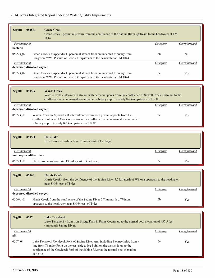
SegID: 0505B Grace Creek
Grace Creek - perennial stream from the confluence of the Sabine River upstream to the headwater at FM
1844
CarryforwardCategoryParameter(s)
bacteria
0505B_02 Grace Creek an Appendix D perennial stream from an unnamed tributary from
Longview WWTP south of Loop 281 upstream to the headwater at FM 1844
5b No
CarryforwardCategoryParameter(s)
depressed dissolved oxygen
0505B_02 Grace Creek an Appendix D perennial stream from an unnamed tributary from
Longview WWTP south of Loop 281 upstream to the headwater at FM 1844
5c Yes
SegID: 0505G Wards Creek
Wards Creek - intermittent stream with perennial pools from the confluence of Sewell Creek upstream to the
confluence of an unnamed second order tributary approximately 0.6 km upstream of US 80
CarryforwardCategoryParameter(s)
depressed dissolved oxygen
0505G_01 Wards Creek an Appendix D intermittent stream with perennial pools from the
confluence of Sewell Creek upstream to the confluence of an unnamed second order
tributary approximately 0.6 km upstream of US 80
5c Yes
SegID: 0505O Hills Lake
Hills Lake - an oxbow lake 13 miles east of Carthage
CarryforwardCategoryParameter(s)
mercury in edible tissue
0505O_01 Hills Lake an oxbow lake 13 miles east of Carthage 5c Yes
SegID: 0506A Harris Creek
Harris Creek - from the confluence of the Sabine River 5.7 km north of Winona upstream to the headwater
near SH 64 east of Tyler
CarryforwardCategoryParameter(s)
depressed dissolved oxygen
0506A_01 Harris Creek from the confluence of the Sabine River 5.7 km north of Winona
upstream to the headwater near SH 64 east of Tyler
5b Yes
SegID: 0507 Lake Tawakoni
Lake Tawakoni - from Iron Bridge Dam in Rains County up to the normal pool elevation of 437.5 feet
(impounds Sabine River)
CarryforwardCategoryParameter(s)
pH
0507_04 Lake Tawakoni Cowleech Fork of Sabine River arm, including Pawnee Inlet, from a
line from Thunder Point on the east side to Ice Point on the west side up to the
confluence of the Cowleech Fork of the Sabine River at the normal pool elevation
of 437.5
5c Yes
Page 18 of 130November 19, 2015
2014 Texas Integrated Report Index of Water Quality Impairments
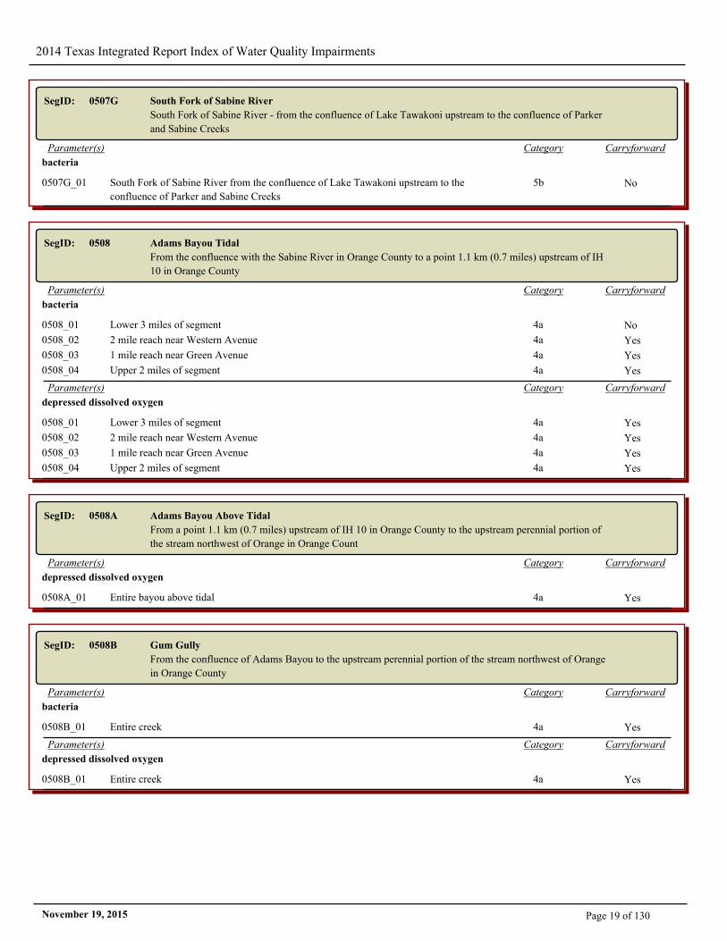
SegID: 0507G South Fork of Sabine River
South Fork of Sabine River - from the confluence of Lake Tawakoni upstream to the confluence of Parker
and Sabine Creeks
CarryforwardCategoryParameter(s)
bacteria
0507G_01 South Fork of Sabine River from the confluence of Lake Tawakoni upstream to the
confluence of Parker and Sabine Creeks
5b No
SegID: 0508 Adams Bayou Tidal
From the confluence with the Sabine River in Orange County to a point 1.1 km (0.7 miles) upstream of IH
10 in Orange County
CarryforwardCategoryParameter(s)
bacteria
0508_01 Lower 3 miles of segment 4a No
0508_02 2 mile reach near Western Avenue 4a Yes
0508_03 1 mile reach near Green Avenue 4a Yes
0508_04 Upper 2 miles of segment 4a Yes
CarryforwardCategoryParameter(s)
depressed dissolved oxygen
0508_01 Lower 3 miles of segment 4a Yes
0508_02 2 mile reach near Western Avenue 4a Yes
0508_03 1 mile reach near Green Avenue 4a Yes
0508_04 Upper 2 miles of segment 4a Yes
SegID: 0508A Adams Bayou Above Tidal
From a point 1.1 km (0.7 miles) upstream of IH 10 in Orange County to the upstream perennial portion of
the stream northwest of Orange in Orange Count
CarryforwardCategoryParameter(s)
depressed dissolved oxygen
0508A_01 Entire bayou above tidal 4a Yes
SegID: 0508B Gum Gully
From the confluence of Adams Bayou to the upstream perennial portion of the stream northwest of Orange
in Orange County
CarryforwardCategoryParameter(s)
bacteria
0508B_01 Entire creek 4a Yes
CarryforwardCategoryParameter(s)
depressed dissolved oxygen
0508B_01 Entire creek 4a Yes
Page 19 of 130November 19, 2015
2014 Texas Integrated Report Index of Water Quality Impairments
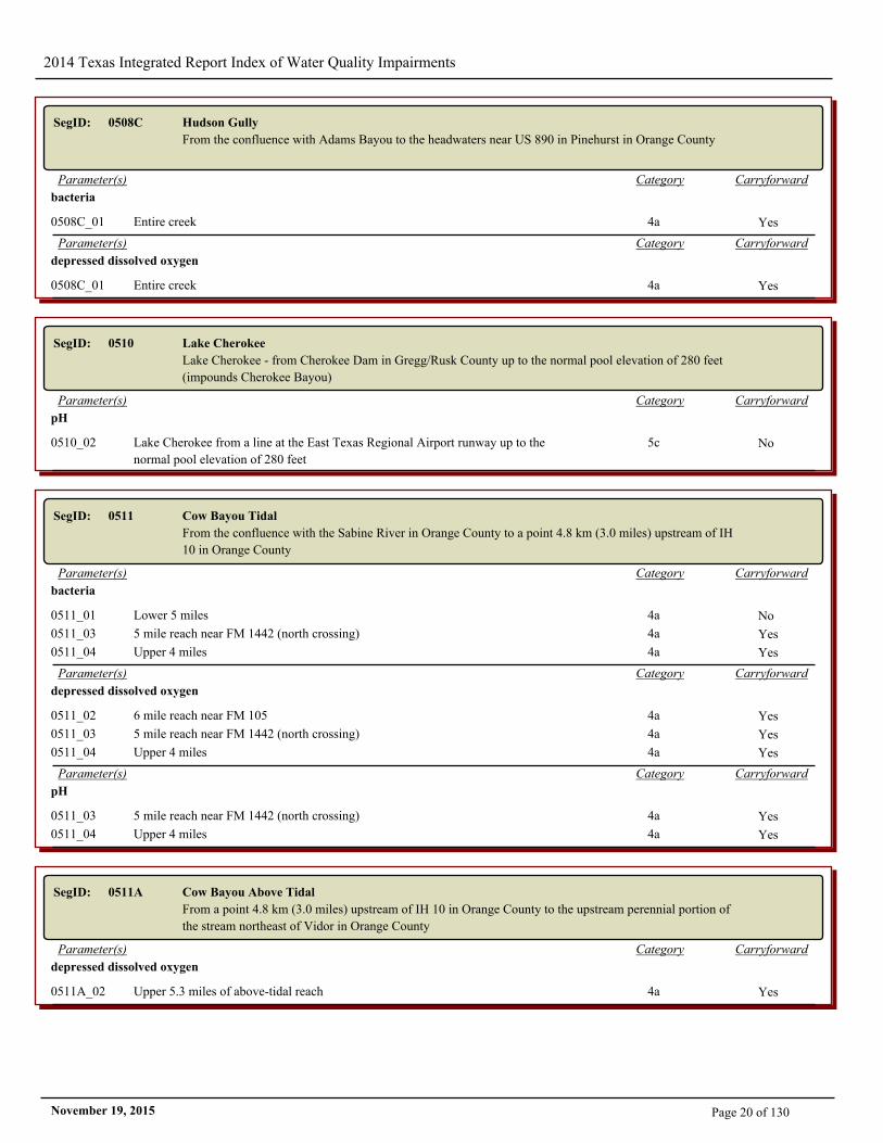
SegID: 0508C Hudson Gully
From the confluence with Adams Bayou to the headwaters near US 890 in Pinehurst in Orange County
CarryforwardCategoryParameter(s)
bacteria
0508C_01 Entire creek 4a Yes
CarryforwardCategoryParameter(s)
depressed dissolved oxygen
0508C_01 Entire creek 4a Yes
SegID: 0510 Lake Cherokee
Lake Cherokee - from Cherokee Dam in Gregg/Rusk County up to the normal pool elevation of 280 feet
(impounds Cherokee Bayou)
CarryforwardCategoryParameter(s)
pH
0510_02 Lake Cherokee from a line at the East Texas Regional Airport runway up to the
normal pool elevation of 280 feet
5c No
SegID: 0511 Cow Bayou Tidal
From the confluence with the Sabine River in Orange County to a point 4.8 km (3.0 miles) upstream of IH
10 in Orange County
CarryforwardCategoryParameter(s)
bacteria
0511_01 Lower 5 miles 4a No
0511_03 5 mile reach near FM 1442 (north crossing) 4a Yes
0511_04 Upper 4 miles 4a Yes
CarryforwardCategoryParameter(s)
depressed dissolved oxygen
0511_02 6 mile reach near FM 105 4a Yes
0511_03 5 mile reach near FM 1442 (north crossing) 4a Yes
0511_04 Upper 4 miles 4a Yes
CarryforwardCategoryParameter(s)
pH
0511_03 5 mile reach near FM 1442 (north crossing) 4a Yes
0511_04 Upper 4 miles 4a Yes
SegID: 0511A Cow Bayou Above Tidal
From a point 4.8 km (3.0 miles) upstream of IH 10 in Orange County to the upstream perennial portion of
the stream northeast of Vidor in Orange County
CarryforwardCategoryParameter(s)
depressed dissolved oxygen
0511A_02 Upper 5.3 miles of above-tidal reach 4a Yes
Page 20 of 130November 19, 2015
2014 Texas Integrated Report Index of Water Quality Impairments
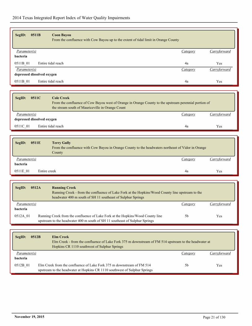
SegID: 0511B Coon Bayou
From the confluence with Cow Bayou up to the extent of tidal limit in Orange County
CarryforwardCategoryParameter(s)
bacteria
0511B_01 Entire tidal reach 4a Yes
CarryforwardCategoryParameter(s)
depressed dissolved oxygen
0511B_01 Entire tidal reach 4a Yes
SegID: 0511C Cole Creek
From the confluence of Cow Bayou west of Orange in Orange County to the upstream perennial portion of
the stream south of Mauriceville in Orange Count
CarryforwardCategoryParameter(s)
depressed dissolved oxygen
0511C_01 Entire tidal reach 4a Yes
SegID: 0511E Terry Gully
From the confluence with Cow Bayou in Orange County to the headwaters northeast of Vidor in Orange
County
CarryforwardCategoryParameter(s)
bacteria
0511E_01 Entire creek 4a Yes
SegID: 0512A Running Creek
Running Creek - from the confluence of Lake Fork at the Hopkins/Wood County line upstream to the
headwater 400 m south of SH 11 southeast of Sulphur Springs
CarryforwardCategoryParameter(s)
bacteria
0512A_01 Running Creek from the confluence of Lake Fork at the Hopkins/Wood County line
upstream to the headwater 400 m south of SH 11 southeast of Sulphur Springs
5b Yes
SegID: 0512B Elm Creek
Elm Creek - from the confluence of Lake Fork 375 m downstream of FM 514 upstream to the headwater at
Hopkins CR 1110 southwest of Sulphur Springs
CarryforwardCategoryParameter(s)
bacteria
0512B_01 Elm Creek from the confluence of Lake Fork 375 m downstream of FM 514
upstream to the headwater at Hopkins CR 1110 southwest of Sulphur Springs
5b Yes
Page 21 of 130November 19, 2015
2014 Texas Integrated Report Index of Water Quality Impairments
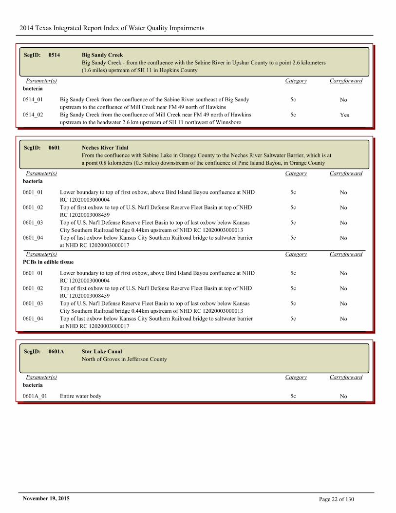
SegID: 0514 Big Sandy Creek
Big Sandy Creek - from the confluence with the Sabine River in Upshur County to a point 2.6 kilometers
(1.6 miles) upstream of SH 11 in Hopkins County
CarryforwardCategoryParameter(s)
bacteria
0514_01 Big Sandy Creek from the confluence of the Sabine River southeast of Big Sandy
upstream to the confluence of Mill Creek near FM 49 north of Hawkins
5c No
0514_02 Big Sandy Creek from the confluence of Mill Creek near FM 49 north of Hawkins
upstream to the headwater 2.6 km upstream of SH 11 northwest of Winnsboro
5c Yes
SegID: 0601 Neches River Tidal
From the confluence with Sabine Lake in Orange County to the Neches River Saltwater Barrier, which is at
a point 0.8 kilometers (0.5 miles) downstream of the confluence of Pine Island Bayou, in Orange County
CarryforwardCategoryParameter(s)
bacteria
0601_01 Lower boundary to top of first oxbow, above Bird Island Bayou confluence at NHD
RC 12020003000004
5c No
0601_02 Top of first oxbow to top of U.S. Nat'l Defense Reserve Fleet Basin at top of NHD
RC 12020003008459
5c No
0601_03 Top of U.S. Nat'l Defense Reserve Fleet Basin to top of last oxbow below Kansas
City Southern Railroad bridge 0.44km upstream of NHD RC 12020003000013
5c No
0601_04 Top of last oxbow below Kansas City Southern Railroad bridge to saltwater barrier
at NHD RC 12020003000017
5c No
CarryforwardCategoryParameter(s)
PCBs in edible tissue
0601_01 Lower boundary to top of first oxbow, above Bird Island Bayou confluence at NHD
RC 12020003000004
5c No
0601_02 Top of first oxbow to top of U.S. Nat'l Defense Reserve Fleet Basin at top of NHD
RC 12020003008459
5c No
0601_03 Top of U.S. Nat'l Defense Reserve Fleet Basin to top of last oxbow below Kansas
City Southern Railroad bridge 0.44km upstream of NHD RC 12020003000013
5c No
0601_04 Top of last oxbow below Kansas City Southern Railroad bridge to saltwater barrier
at NHD RC 12020003000017
5c No
SegID: 0601A Star Lake Canal
North of Groves in Jefferson County
CarryforwardCategoryParameter(s)
bacteria
0601A_01 Entire water body 5c No
Page 22 of 130November 19, 2015
2014 Texas Integrated Report Index of Water Quality Impairments
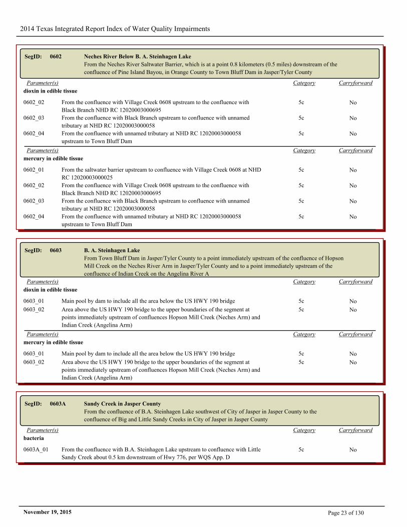
SegID: 0602 Neches River Below B. A. Steinhagen Lake
From the Neches River Saltwater Barrier, which is at a point 0.8 kilometers (0.5 miles) downstream of the
confluence of Pine Island Bayou, in Orange County to Town Bluff Dam in Jasper/Tyler County
CarryforwardCategoryParameter(s)
dioxin in edible tissue
0602_02 From the confluence with Village Creek 0608 upstream to the confluence with
Black Branch NHD RC 12020003000695
5c No
0602_03 From the confluence with Black Branch upstream to confluence with unnamed
tributary at NHD RC 12020003000058
5c No
0602_04 From the confluence with unnamed tributary at NHD RC 12020003000058
upstream to Town Bluff Dam
5c No
CarryforwardCategoryParameter(s)
mercury in edible tissue
0602_01 From the saltwater barrier upstream to confluence with Village Creek 0608 at NHD
RC 12020003000025
5c No
0602_02 From the confluence with Village Creek 0608 upstream to the confluence with
Black Branch NHD RC 12020003000695
5c No
0602_03 From the confluence with Black Branch upstream to confluence with unnamed
tributary at NHD RC 12020003000058
5c No
0602_04 From the confluence with unnamed tributary at NHD RC 12020003000058
upstream to Town Bluff Dam
5c No
SegID: 0603 B. A. Steinhagen Lake
From Town Bluff Dam in Jasper/Tyler County to a point immediately upstream of the confluence of Hopson
Mill Creek on the Neches River Arm in Jasper/Tyler County and to a point immediately upstream of the
confluence of Indian Creek on the Angelina River A
CarryforwardCategoryParameter(s)
dioxin in edible tissue
0603_01 Main pool by dam to include all the area below the US HWY 190 bridge 5c No
0603_02 Area above the US HWY 190 bridge to the upper boundaries of the segment at
points immediately upstream of confluences Hopson Mill Creek (Neches Arm) and
Indian Creek (Angelina Arm)
5c No
CarryforwardCategoryParameter(s)
mercury in edible tissue
0603_01 Main pool by dam to include all the area below the US HWY 190 bridge 5c No
0603_02 Area above the US HWY 190 bridge to the upper boundaries of the segment at
points immediately upstream of confluences Hopson Mill Creek (Neches Arm) and
Indian Creek (Angelina Arm)
5c No
SegID: 0603A Sandy Creek in Jasper County
From the confluence of B.A. Steinhagen Lake southwest of City of Jasper in Jasper County to the
confluence of Big and Little Sandy Creeks in City of Jasper in Jasper County
CarryforwardCategoryParameter(s)
bacteria
0603A_01 From the confluence with B.A. Steinhagen Lake upstream to confluence with Little
Sandy Creek about 0.5 km downstream of Hwy 776, per WQS App. D
5c No
Page 23 of 130November 19, 2015
2014 Texas Integrated Report Index of Water Quality Impairments
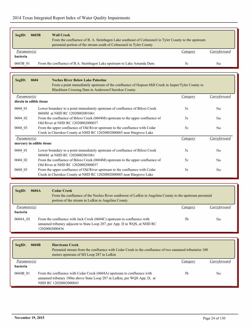
SegID: 0603B Wolf Creek
From the confluence of B. A. Steinhagen Lake southeast of Colmesneil in Tyler County to the upstream
perennial portion of the stream south of Colmesneil in Tyler County
CarryforwardCategoryParameter(s)
bacteria
0603B_01 From the confluence of B.A. Steinhagen Lake upstream to Lake Amanda Dam. 5c No
SegID: 0604 Neches River Below Lake Palestine
From a point immediately upstream of the confluence of Hopson Mill Creek in Jasper/Tyler County to
Blackburn Crossing Dam in Anderson/Cherokee County
CarryforwardCategoryParameter(s)
dioxin in edible tissue
0604_01 Lower boundary to a point immediately upstream of confluence of Biloxi Creek
0604M at NHD RC 12020002001061
5c No
0604_02 From the confluence of Biloxi Creek (0604M) upstream to the upper confluence of
Old River at NHD RC 12020002000037
5c No
0604_03 From the upper confluence of Old River upstream to the confluence with Cedar
Creek in Cherokee County at NHD RC 12020002000085 near Hargrove Lake
5c No
CarryforwardCategoryParameter(s)
mercury in edible tissue
0604_01 Lower boundary to a point immediately upstream of confluence of Biloxi Creek
0604M at NHD RC 12020002001061
5c No
0604_02 From the confluence of Biloxi Creek (0604M) upstream to the upper confluence of
Old River at NHD RC 12020002000037
5c No
0604_03 From the upper confluence of Old River upstream to the confluence with Cedar
Creek in Cherokee County at NHD RC 12020002000085 near Hargrove Lake
5c No
SegID: 0604A Cedar Creek
From the confluence of the Neches River southwest of Lufkin in Angelina County to the upstream perennial
portion of the stream in Lufkin in Angelina County
CarryforwardCategoryParameter(s)
bacteria
0604A_02 From the confluence with Jack Creek (0604C) upstream to confluence with
unnamed tributary adjacent to State Loop 287, per App. D in WQS, at NHD RC
12020002000436
5b No
SegID: 0604B Hurricane Creek
Perennial stream from the confluence with Cedar Creek to the confluence of two unnamed tributaries 100
meters upstream of SH Loop 287 in Lufkin
CarryforwardCategoryParameter(s)
bacteria
0604B_01 From the confluence with Cedar Creek (0604A) upstream to confluence with
unnamed tributary 100m above State Loop 287 in Lufkin, per WQS App. D, at
NHD RC 12020002000043
5b No
Page 24 of 130November 19, 2015

2014 Texas Integrated Report Index of Water Quality Impairments
SegID: 0604D Piney Creek
From the confluence of the Neches River at the Polk/Tyler/Angelina County lines east of Corrigan to the
upstream perennial portion of the stream east of Crockett in Houston County
CarryforwardCategoryParameter(s)
depressed dissolved oxygen
0604D_01 Middle portion of the stream from the confluence with Bear Creek (0604L) in Polk
County upstream to the confluence with Caney Creek (0604O) in Trinity County at
NHD RC 12020002000163.
5c No
SegID: 0604M Biloxi Creek
From the confluence with the Neches River southeast of Diboll to FM 325 east of Lufkin in Angelina
County
CarryforwardCategoryParameter(s)
bacteria
0604M_03 From the confluence with One Eye Creek in Angelina County SE of Lufkin
upstream to FM 325 east of Lufkin
5b No
CarryforwardCategoryParameter(s)
depressed dissolved oxygen
0604M_03 From the confluence with One Eye Creek in Angelina County SE of Lufkin
upstream to FM 325 east of Lufkin
5c Yes
SegID: 0604T Lake Ratcliff
Lake in Houston County 3.4 miles northeast of Kennard
CarryforwardCategoryParameter(s)
mercury in edible tissue
0604T_01 Entire lake 5c No
SegID: 0605 Lake Palestine
From Blackburn Crossing Dam in Anderson/Cherokee County to a point 6.7km (4.2 miles) downstream of
FM 279 in Henderson/Smith County, up to normal pool elevation of 345 feet (impounds Neches River)
CarryforwardCategoryParameter(s)
pH
0605_03 Upper mid-lake including Tyler Public Water Supply intake 5a No
0605_09 Flat Creek Arm 5a No
0605_10 Upper Lake 5a No
0605_11 From the SH 155 Bridge crossing to the Flat Creek Arm and across the main portion
of the lake at the Flat Creek Arm
5a No
Page 25 of 130November 19, 2015
2014 Texas Integrated Report Index of Water Quality Impairments
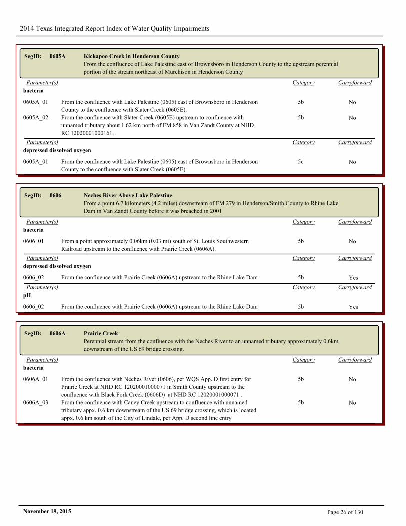
SegID: 0605A Kickapoo Creek in Henderson County
From the confluence of Lake Palestine east of Brownsboro in Henderson County to the upstream perennial
portion of the stream northeast of Murchison in Henderson County
CarryforwardCategoryParameter(s)
bacteria
0605A_01 From the confluence with Lake Palestine (0605) east of Brownsboro in Henderson
County to the confluence with Slater Creek (0605E).
5b No
0605A_02 From the confluence with Slater Creek (0605E) upstream to confluence with
unnamed tributary about 1.62 km north of FM 858 in Van Zandt County at NHD
RC 12020001000161.
5b No
CarryforwardCategoryParameter(s)
depressed dissolved oxygen
0605A_01 From the confluence with Lake Palestine (0605) east of Brownsboro in Henderson
County to the confluence with Slater Creek (0605E).
5c No
SegID: 0606 Neches River Above Lake Palestine
From a point 6.7 kilometers (4.2 miles) downstream of FM 279 in Henderson/Smith County to Rhine Lake
Dam in Van Zandt County before it was breached in 2001
CarryforwardCategoryParameter(s)
bacteria
0606_01 From a point approximately 0.06km (0.03 mi) south of St. Louis Southwestern
Railroad upstream to the confluence with Prairie Creek (0606A).
5b No
CarryforwardCategoryParameter(s)
depressed dissolved oxygen
0606_02 From the confluence with Prairie Creek (0606A) upstream to the Rhine Lake Dam 5b Yes
CarryforwardCategoryParameter(s)
pH
0606_02 From the confluence with Prairie Creek (0606A) upstream to the Rhine Lake Dam 5b Yes
SegID: 0606A Prairie Creek
Perennial stream from the confluence with the Neches River to an unnamed tributary approximately 0.6km
downstream of the US 69 bridge crossing.
CarryforwardCategoryParameter(s)
bacteria
0606A_01 From the confluence with Neches River (0606), per WQS App. D first entry for
Prairie Creek at NHD RC 12020001000071 in Smith County upstream to the
confluence with Black Fork Creek (0606D) at NHD RC 12020001000071 .
5b No
0606A_03 From the confluence with Caney Creek upstream to confluence with unnamed
tributary appx. 0.6 km downstream of the US 69 bridge crossing, which is located
appx. 0.6 km south of the City of Lindale, per App. D second line entry
5b No
Page 26 of 130November 19, 2015
2014 Texas Integrated Report Index of Water Quality Impairments
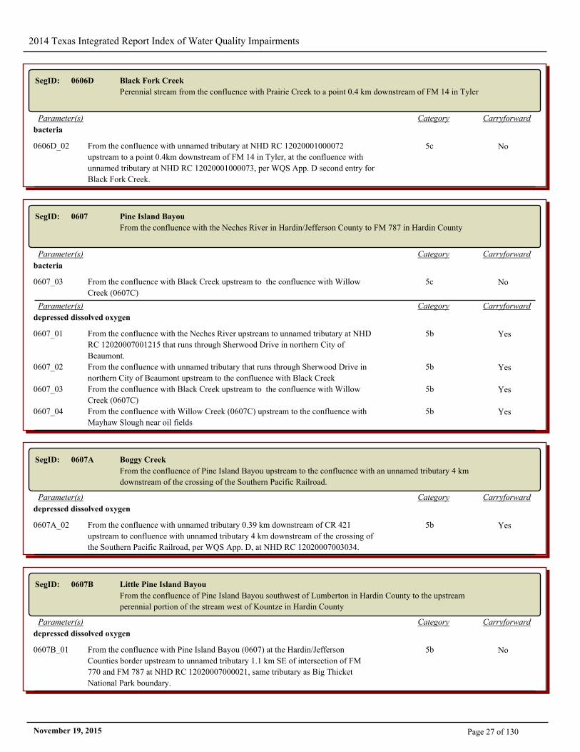
SegID: 0606D Black Fork Creek
Perennial stream from the confluence with Prairie Creek to a point 0.4 km downstream of FM 14 in Tyler
CarryforwardCategoryParameter(s)
bacteria
0606D_02 From the confluence with unnamed tributary at NHD RC 12020001000072
upstream to a point 0.4km downstream of FM 14 in Tyler, at the confluence with
unnamed tributary at NHD RC 12020001000073, per WQS App. D second entry for
Black Fork Creek.
5c No
SegID: 0607 Pine Island Bayou
From the confluence with the Neches River in Hardin/Jefferson County to FM 787 in Hardin County
CarryforwardCategoryParameter(s)
bacteria
0607_03 From the confluence with Black Creek upstream to the confluence with Willow
Creek (0607C)
5c No
CarryforwardCategoryParameter(s)
depressed dissolved oxygen
0607_01 From the confluence with the Neches River upstream to unnamed tributary at NHD
RC 12020007001215 that runs through Sherwood Drive in northern City of
Beaumont.
5b Yes
0607_02 From the confluence with unnamed tributary that runs through Sherwood Drive in
northern City of Beaumont upstream to the confluence with Black Creek
5b Yes
0607_03 From the confluence with Black Creek upstream to the confluence with Willow
Creek (0607C)
5b Yes
0607_04 From the confluence with Willow Creek (0607C) upstream to the confluence with
Mayhaw Slough near oil fields
5b Yes
SegID: 0607A Boggy Creek
From the confluence of Pine Island Bayou upstream to the confluence with an unnamed tributary 4 km
downstream of the crossing of the Southern Pacific Railroad.
CarryforwardCategoryParameter(s)
depressed dissolved oxygen
0607A_02 From the confluence with unnamed tributary 0.39 km downstream of CR 421
upstream to confluence with unnamed tributary 4 km downstream of the crossing of
the Southern Pacific Railroad, per WQS App. D, at NHD RC 12020007003034.
5b Yes
SegID: 0607B Little Pine Island Bayou
From the confluence of Pine Island Bayou southwest of Lumberton in Hardin County to the upstream
perennial portion of the stream west of Kountze in Hardin County
CarryforwardCategoryParameter(s)
depressed dissolved oxygen
0607B_01 From the confluence with Pine Island Bayou (0607) at the Hardin/Jefferson
Counties border upstream to unnamed tributary 1.1 km SE of intersection of FM
770 and FM 787 at NHD RC 12020007000021, same tributary as Big Thicket
National Park boundary.
5b No
Page 27 of 130November 19, 2015
2014 Texas Integrated Report Index of Water Quality Impairments
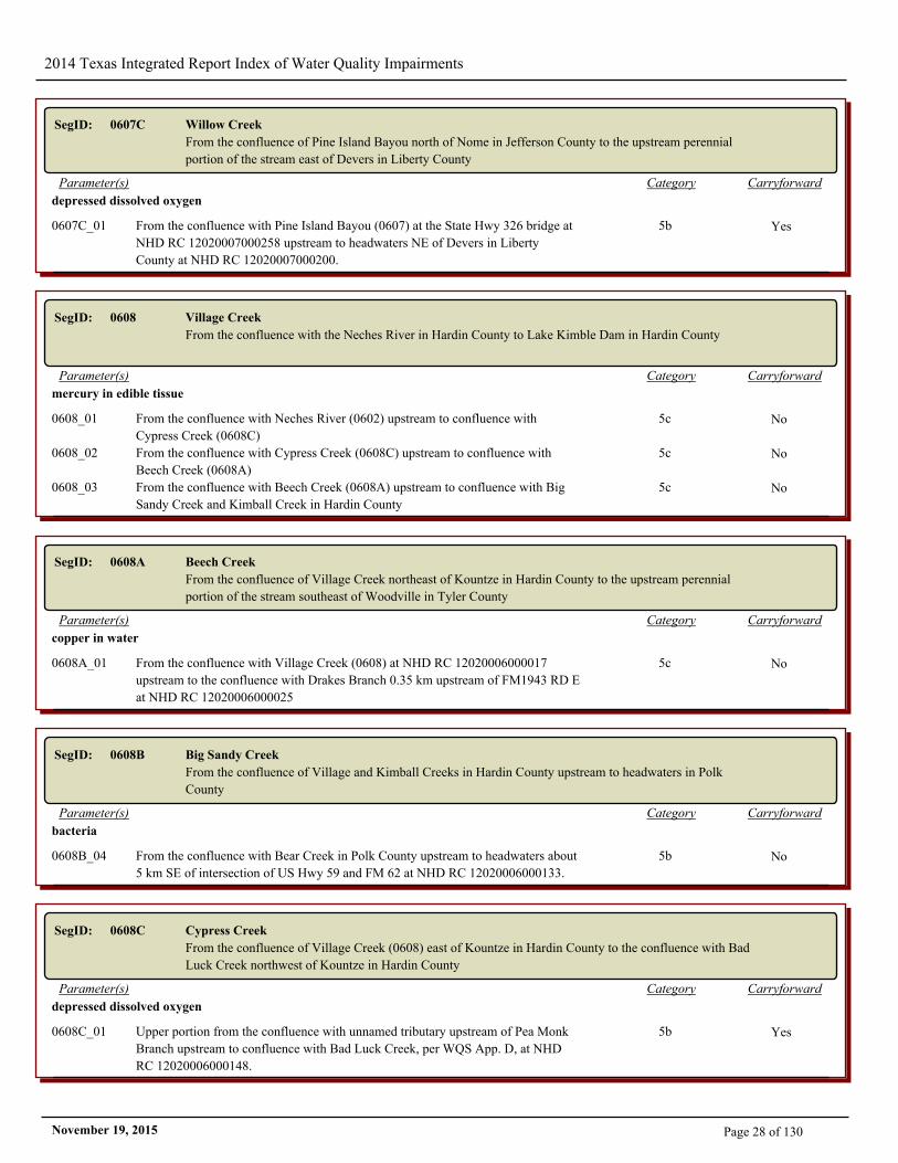
SegID: 0607C Willow Creek
From the confluence of Pine Island Bayou north of Nome in Jefferson County to the upstream perennial
portion of the stream east of Devers in Liberty County
CarryforwardCategoryParameter(s)
depressed dissolved oxygen
0607C_01 From the confluence with Pine Island Bayou (0607) at the State Hwy 326 bridge at
NHD RC 12020007000258 upstream to headwaters NE of Devers in Liberty
County at NHD RC 12020007000200.
5b Yes
SegID: 0608 Village Creek
From the confluence with the Neches River in Hardin County to Lake Kimble Dam in Hardin County
CarryforwardCategoryParameter(s)
mercury in edible tissue
0608_01 From the confluence with Neches River (0602) upstream to confluence with
Cypress Creek (0608C)
5c No
0608_02 From the confluence with Cypress Creek (0608C) upstream to confluence with
Beech Creek (0608A)
5c No
0608_03 From the confluence with Beech Creek (0608A) upstream to confluence with Big
Sandy Creek and Kimball Creek in Hardin County
5c No
SegID: 0608A Beech Creek
From the confluence of Village Creek northeast of Kountze in Hardin County to the upstream perennial
portion of the stream southeast of Woodville in Tyler County
CarryforwardCategoryParameter(s)
copper in water
0608A_01 From the confluence with Village Creek (0608) at NHD RC 12020006000017
upstream to the confluence with Drakes Branch 0.35 km upstream of FM1943 RD E
at NHD RC 12020006000025
5c No
SegID: 0608B Big Sandy Creek
From the confluence of Village and Kimball Creeks in Hardin County upstream to headwaters in Polk
County
CarryforwardCategoryParameter(s)
bacteria
0608B_04 From the confluence with Bear Creek in Polk County upstream to headwaters about
5 km SE of intersection of US Hwy 59 and FM 62 at NHD RC 12020006000133.
5b No
SegID: 0608C Cypress Creek
From the confluence of Village Creek (0608) east of Kountze in Hardin County to the confluence with Bad
Luck Creek northwest of Kountze in Hardin County
CarryforwardCategoryParameter(s)
depressed dissolved oxygen
0608C_01 Upper portion from the confluence with unnamed tributary upstream of Pea Monk
Branch upstream to confluence with Bad Luck Creek, per WQS App. D, at NHD
RC 12020006000148.
5b Yes
Page 28 of 130November 19, 2015
2014 Texas Integrated Report Index of Water Quality Impairments
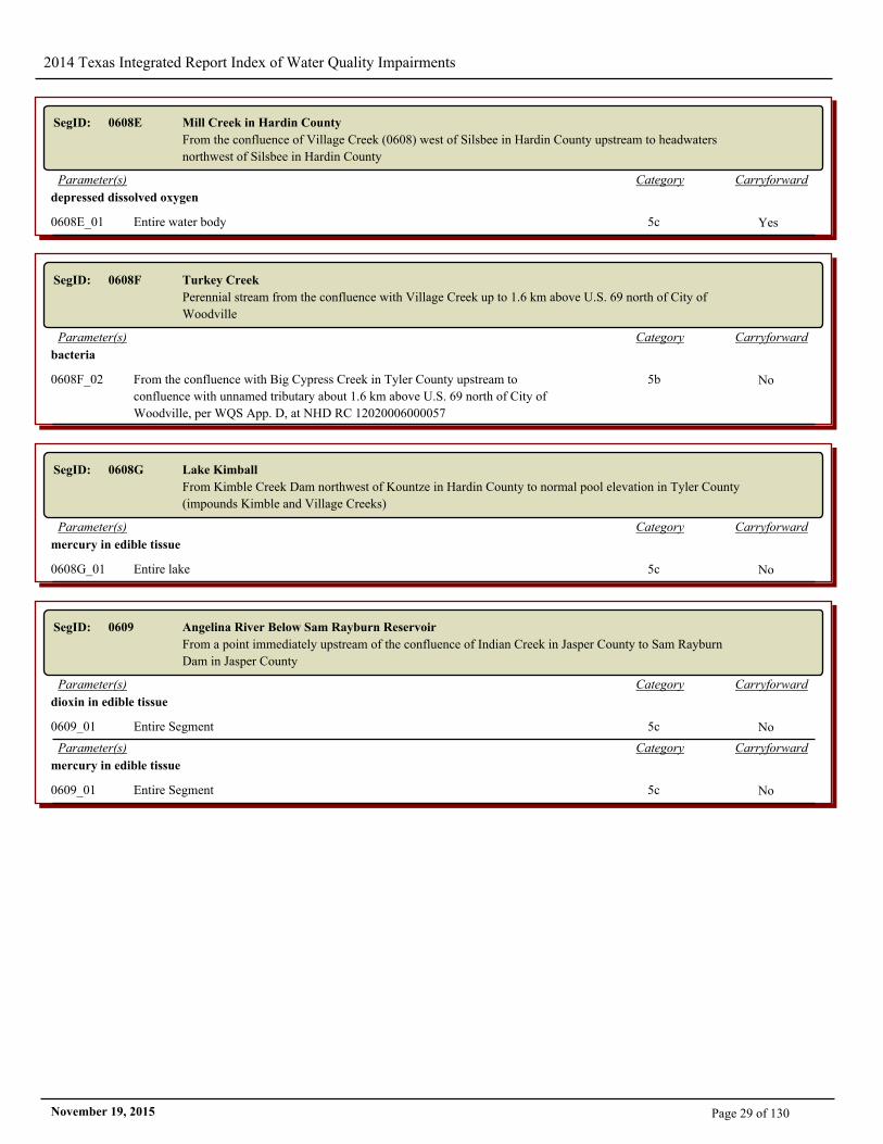
SegID: 0608E Mill Creek in Hardin County
From the confluence of Village Creek (0608) west of Silsbee in Hardin County upstream to headwaters
northwest of Silsbee in Hardin County
CarryforwardCategoryParameter(s)
depressed dissolved oxygen
0608E_01 Entire water body 5c Yes
SegID: 0608F Turkey Creek
Perennial stream from the confluence with Village Creek up to 1.6 km above U.S. 69 north of City of
Woodville
CarryforwardCategoryParameter(s)
bacteria
0608F_02 From the confluence with Big Cypress Creek in Tyler County upstream to
confluence with unnamed tributary about 1.6 km above U.S. 69 north of City of
Woodville, per WQS App. D, at NHD RC 12020006000057
5b No
SegID: 0608G Lake Kimball
From Kimble Creek Dam northwest of Kountze in Hardin County to normal pool elevation in Tyler County
(impounds Kimble and Village Creeks)
CarryforwardCategoryParameter(s)
mercury in edible tissue
0608G_01 Entire lake 5c No
SegID: 0609 Angelina River Below Sam Rayburn Reservoir
From a point immediately upstream of the confluence of Indian Creek in Jasper County to Sam Rayburn
Dam in Jasper County
CarryforwardCategoryParameter(s)
dioxin in edible tissue
0609_01 Entire Segment 5c No
CarryforwardCategoryParameter(s)
mercury in edible tissue
0609_01 Entire Segment 5c No
Page 29 of 130November 19, 2015
2014 Texas Integrated Report Index of Water Quality Impairments
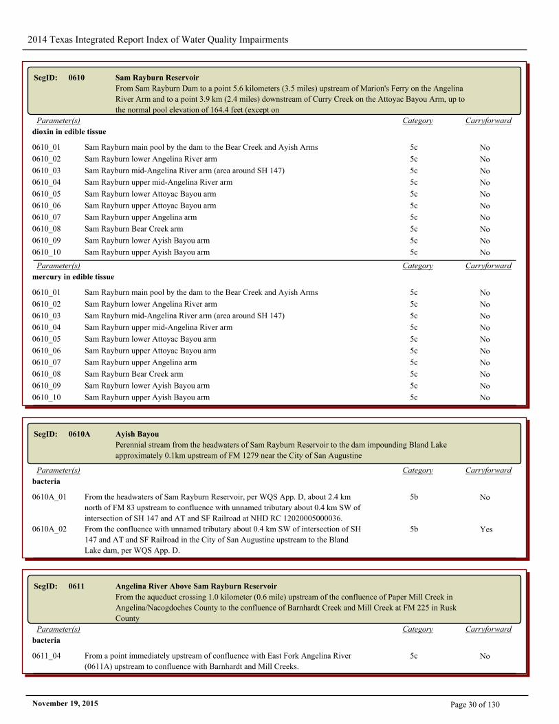
SegID: 0610 Sam Rayburn Reservoir
From Sam Rayburn Dam to a point 5.6 kilometers (3.5 miles) upstream of Marion's Ferry on the Angelina
River Arm and to a point 3.9 km (2.4 miles) downstream of Curry Creek on the Attoyac Bayou Arm, up to
the normal pool elevation of 164.4 feet (except on
CarryforwardCategoryParameter(s)
dioxin in edible tissue
0610_01 Sam Rayburn main pool by the dam to the Bear Creek and Ayish Arms 5c No
0610_02 Sam Rayburn lower Angelina River arm 5c No
0610_03 Sam Rayburn mid-Angelina River arm (area around SH 147) 5c No
0610_04 Sam Rayburn upper mid-Angelina River arm 5c No
0610_05 Sam Rayburn lower Attoyac Bayou arm 5c No
0610_06 Sam Rayburn upper Attoyac Bayou arm 5c No
0610_07 Sam Rayburn upper Angelina arm 5c No
0610_08 Sam Rayburn Bear Creek arm 5c No
0610_09 Sam Rayburn lower Ayish Bayou arm 5c No
0610_10 Sam Rayburn upper Ayish Bayou arm 5c No
CarryforwardCategoryParameter(s)
mercury in edible tissue
0610_01 Sam Rayburn main pool by the dam to the Bear Creek and Ayish Arms 5c No
0610_02 Sam Rayburn lower Angelina River arm 5c No
0610_03 Sam Rayburn mid-Angelina River arm (area around SH 147) 5c No
0610_04 Sam Rayburn upper mid-Angelina River arm 5c No
0610_05 Sam Rayburn lower Attoyac Bayou arm 5c No
0610_06 Sam Rayburn upper Attoyac Bayou arm 5c No
0610_07 Sam Rayburn upper Angelina arm 5c No
0610_08 Sam Rayburn Bear Creek arm 5c No
0610_09 Sam Rayburn lower Ayish Bayou arm 5c No
0610_10 Sam Rayburn upper Ayish Bayou arm 5c No
SegID: 0610A Ayish Bayou
Perennial stream from the headwaters of Sam Rayburn Reservoir to the dam impounding Bland Lake
approximately 0.1km upstream of FM 1279 near the City of San Augustine
CarryforwardCategoryParameter(s)
bacteria
0610A_01 From the headwaters of Sam Rayburn Reservoir, per WQS App. D, about 2.4 km
north of FM 83 upstream to confluence with unnamed tributary about 0.4 km SW of
intersection of SH 147 and AT and SF Railroad at NHD RC 12020005000036.
5b No
0610A_02 From the confluence with unnamed tributary about 0.4 km SW of intersection of SH
147 and AT and SF Railroad in the City of San Augustine upstream to the Bland
Lake dam, per WQS App. D.
5b Yes
SegID: 0611 Angelina River Above Sam Rayburn Reservoir
From the aqueduct crossing 1.0 kilometer (0.6 mile) upstream of the confluence of Paper Mill Creek in
Angelina/Nacogdoches County to the confluence of Barnhardt Creek and Mill Creek at FM 225 in Rusk
County
CarryforwardCategoryParameter(s)
bacteria
0611_04 From a point immediately upstream of confluence with East Fork Angelina River
(0611A) upstream to confluence with Barnhardt and Mill Creeks.
5c No
Page 30 of 130November 19, 2015
2014 Texas Integrated Report Index of Water Quality Impairments
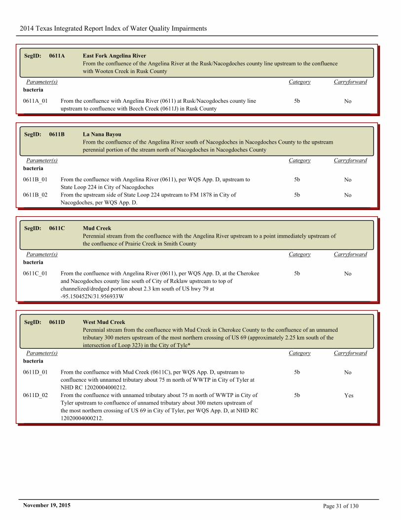
SegID: 0611A East Fork Angelina River
From the confluence of the Angelina River at the Rusk/Nacogdoches county line upstream to the confluence
with Wooten Creek in Rusk County
CarryforwardCategoryParameter(s)
bacteria
0611A_01 From the confluence with Angelina River (0611) at Rusk/Nacogdoches county line
upstream to confluence with Beech Creek (0611J) in Rusk County
5b No
SegID: 0611B La Nana Bayou
From the confluence of the Angelina River south of Nacogdoches in Nacogdoches County to the upstream
perennial portion of the stream north of Nacogdoches in Nacogdoches County
CarryforwardCategoryParameter(s)
bacteria
0611B_01 From the confluence with Angelina River (0611), per WQS App. D, upstream to
State Loop 224 in City of Nacogdoches
5b No
0611B_02 From the upstream side of State Loop 224 upstream to FM 1878 in City of
Nacogdoches, per WQS App. D.
5b No
SegID: 0611C Mud Creek
Perennial stream from the confluence with the Angelina River upstream to a point immediately upstream of
the confluence of Prairie Creek in Smith County
CarryforwardCategoryParameter(s)
bacteria
0611C_01 From the confluence with Angelina River (0611), per WQS App. D, at the Cherokee
and Nacogdoches county line south of City of Reklaw upstream to top of
channelized/dredged portion about 2.3 km south of US hwy 79 at
-95.150452N/31.956933W
5b No
SegID: 0611D West Mud Creek
Perennial stream from the confluence with Mud Creek in Cherokee County to the confluence of an unnamed
tributary 300 meters upstream of the most northern crossing of US 69 (approximately 2.25 km south of the
intersection of Loop 323) in the City of Tyle*
CarryforwardCategoryParameter(s)
bacteria
0611D_01 From the confluence with Mud Creek (0611C), per WQS App. D, upstream to
confluence with unnamed tributary about 75 m north of WWTP in City of Tyler at
NHD RC 12020004000212.
5b No
0611D_02 From the confluence with unnamed tributary about 75 m north of WWTP in City of
Tyler upstream to confluence of unnamed tributary about 300 meters upstream of
the most northern crossing of US 69 in City of Tyler, per WQS App. D, at NHD RC
12020004000212.
5b Yes
Page 31 of 130November 19, 2015
2014 Texas Integrated Report Index of Water Quality Impairments
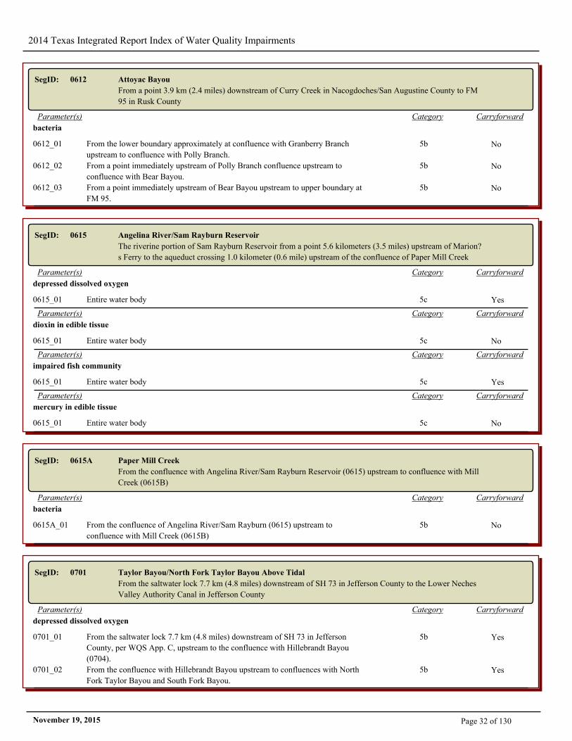
SegID: 0612 Attoyac Bayou
From a point 3.9 km (2.4 miles) downstream of Curry Creek in Nacogdoches/San Augustine County to FM
95 in Rusk County
CarryforwardCategoryParameter(s)
bacteria
0612_01 From the lower boundary approximately at confluence with Granberry Branch
upstream to confluence with Polly Branch.
5b No
0612_02 From a point immediately upstream of Polly Branch confluence upstream to
confluence with Bear Bayou.
5b No
0612_03 From a point immediately upstream of Bear Bayou upstream to upper boundary at
FM 95.
5b No
SegID: 0615 Angelina River/Sam Rayburn Reservoir
The riverine portion of Sam Rayburn Reservoir from a point 5.6 kilometers (3.5 miles) upstream of Marion?
s Ferry to the aqueduct crossing 1.0 kilometer (0.6 mile) upstream of the confluence of Paper Mill Creek
CarryforwardCategoryParameter(s)
depressed dissolved oxygen
0615_01 Entire water body 5c Yes
CarryforwardCategoryParameter(s)
dioxin in edible tissue
0615_01 Entire water body 5c No
CarryforwardCategoryParameter(s)
impaired fish community
0615_01 Entire water body 5c Yes
CarryforwardCategoryParameter(s)
mercury in edible tissue
0615_01 Entire water body 5c No
SegID: 0615A Paper Mill Creek
From the confluence with Angelina River/Sam Rayburn Reservoir (0615) upstream to confluence with Mill
Creek (0615B)
CarryforwardCategoryParameter(s)
bacteria
0615A_01 From the confluence of Angelina River/Sam Rayburn (0615) upstream to
confluence with Mill Creek (0615B)
5b No
SegID: 0701 Taylor Bayou/North Fork Taylor Bayou Above Tidal
From the saltwater lock 7.7 km (4.8 miles) downstream of SH 73 in Jefferson County to the Lower Neches
Valley Authority Canal in Jefferson County
CarryforwardCategoryParameter(s)
depressed dissolved oxygen
0701_01 From the saltwater lock 7.7 km (4.8 miles) downstream of SH 73 in Jefferson
County, per WQS App. C, upstream to the confluence with Hillebrandt Bayou
(0704).
5b Yes
0701_02 From the confluence with Hillebrandt Bayou upstream to confluences with North
Fork Taylor Bayou and South Fork Bayou.
5b Yes
Page 32 of 130November 19, 2015
2014 Texas Integrated Report Index of Water Quality Impairments
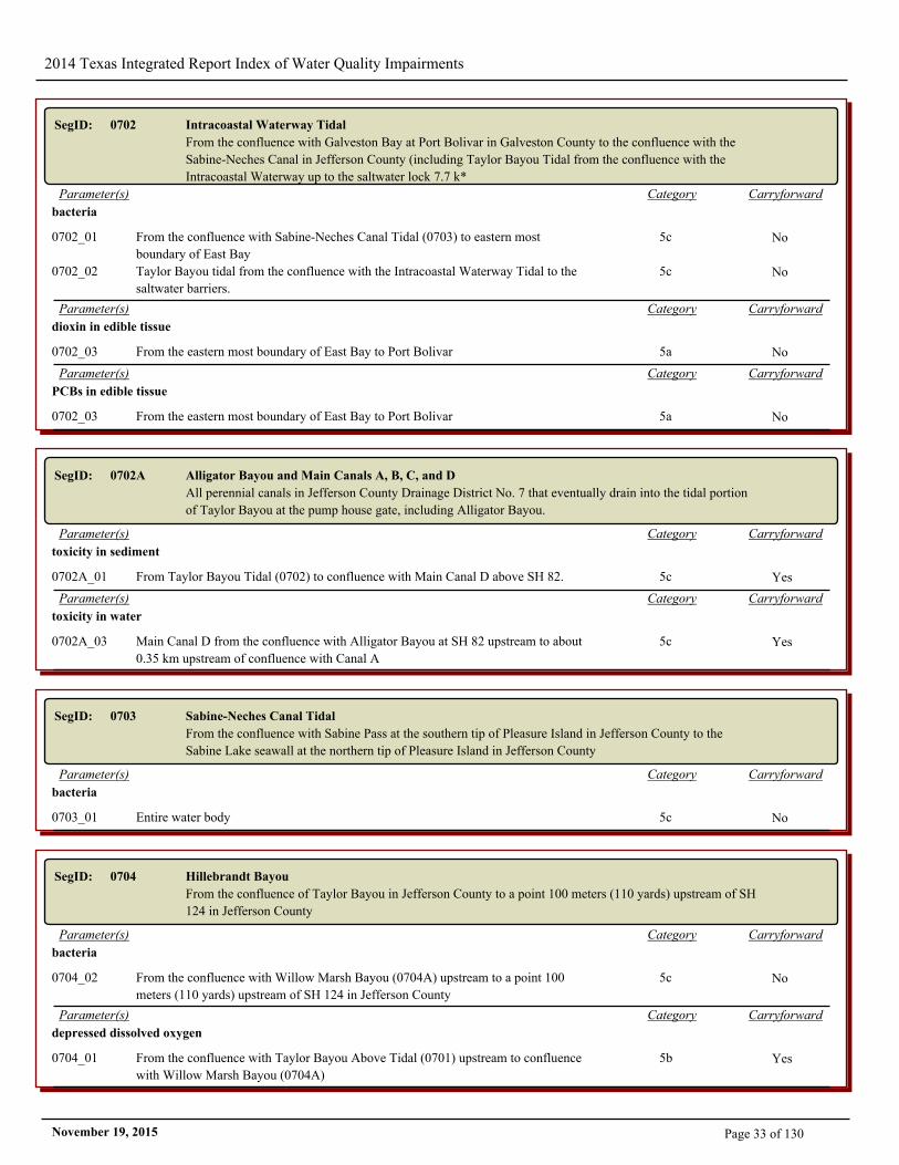
SegID: 0702 Intracoastal Waterway Tidal
From the confluence with Galveston Bay at Port Bolivar in Galveston County to the confluence with the
Sabine-Neches Canal in Jefferson County (including Taylor Bayou Tidal from the confluence with the
Intracoastal Waterway up to the saltwater lock 7.7 k*
CarryforwardCategoryParameter(s)
bacteria
0702_01 From the confluence with Sabine-Neches Canal Tidal (0703) to eastern most
boundary of East Bay
5c No
0702_02 Taylor Bayou tidal from the confluence with the Intracoastal Waterway Tidal to the
saltwater barriers.
5c No
CarryforwardCategoryParameter(s)
dioxin in edible tissue
0702_03 From the eastern most boundary of East Bay to Port Bolivar 5a No
CarryforwardCategoryParameter(s)
PCBs in edible tissue
0702_03 From the eastern most boundary of East Bay to Port Bolivar 5a No
SegID: 0702A Alligator Bayou and Main Canals A, B, C, and D
All perennial canals in Jefferson County Drainage District No. 7 that eventually drain into the tidal portion
of Taylor Bayou at the pump house gate, including Alligator Bayou.
CarryforwardCategoryParameter(s)
toxicity in sediment
0702A_01 From Taylor Bayou Tidal (0702) to confluence with Main Canal D above SH 82. 5c Yes
CarryforwardCategoryParameter(s)
toxicity in water
0702A_03 Main Canal D from the confluence with Alligator Bayou at SH 82 upstream to about
0.35 km upstream of confluence with Canal A
5c Yes
SegID: 0703 Sabine-Neches Canal Tidal
From the confluence with Sabine Pass at the southern tip of Pleasure Island in Jefferson County to the
Sabine Lake seawall at the northern tip of Pleasure Island in Jefferson County
CarryforwardCategoryParameter(s)
bacteria
0703_01 Entire water body 5c No
SegID: 0704 Hillebrandt Bayou
From the confluence of Taylor Bayou in Jefferson County to a point 100 meters (110 yards) upstream of SH
124 in Jefferson County
CarryforwardCategoryParameter(s)
bacteria
0704_02 From the confluence with Willow Marsh Bayou (0704A) upstream to a point 100
meters (110 yards) upstream of SH 124 in Jefferson County
5c No
CarryforwardCategoryParameter(s)
depressed dissolved oxygen
0704_01 From the confluence with Taylor Bayou Above Tidal (0701) upstream to confluence
with Willow Marsh Bayou (0704A)
5b Yes
Page 33 of 130November 19, 2015
2014 Texas Integrated Report Index of Water Quality Impairments
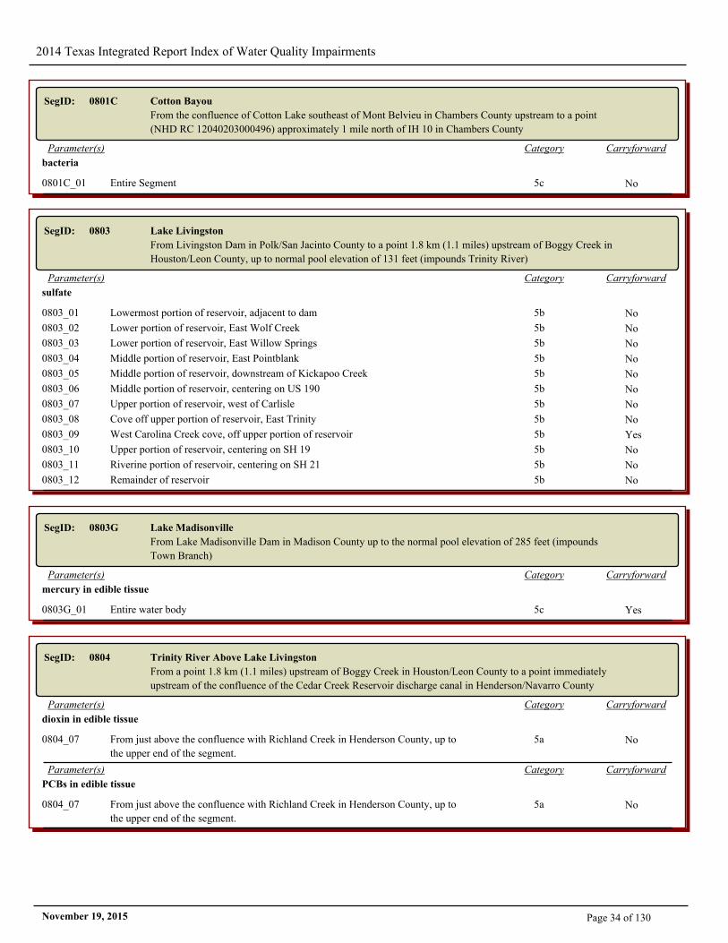
SegID: 0801C Cotton Bayou
From the confluence of Cotton Lake southeast of Mont Belvieu in Chambers County upstream to a point
(NHD RC 12040203000496) approximately 1 mile north of IH 10 in Chambers County
CarryforwardCategoryParameter(s)
bacteria
0801C_01 Entire Segment 5c No
SegID: 0803 Lake Livingston
From Livingston Dam in Polk/San Jacinto County to a point 1.8 km (1.1 miles) upstream of Boggy Creek in
Houston/Leon County, up to normal pool elevation of 131 feet (impounds Trinity River)
CarryforwardCategoryParameter(s)
sulfate
0803_01 Lowermost portion of reservoir, adjacent to dam 5b No
0803_02 Lower portion of reservoir, East Wolf Creek 5b No
0803_03 Lower portion of reservoir, East Willow Springs 5b No
0803_04 Middle portion of reservoir, East Pointblank 5b No
0803_05 Middle portion of reservoir, downstream of Kickapoo Creek 5b No
0803_06 Middle portion of reservoir, centering on US 190 5b No
0803_07 Upper portion of reservoir, west of Carlisle 5b No
0803_08 Cove off upper portion of reservoir, East Trinity 5b No
0803_09 West Carolina Creek cove, off upper portion of reservoir 5b Yes
0803_10 Upper portion of reservoir, centering on SH 19 5b No
0803_11 Riverine portion of reservoir, centering on SH 21 5b No
0803_12 Remainder of reservoir 5b No
SegID: 0803G Lake Madisonville
From Lake Madisonville Dam in Madison County up to the normal pool elevation of 285 feet (impounds
Town Branch)
CarryforwardCategoryParameter(s)
mercury in edible tissue
0803G_01 Entire water body 5c Yes
SegID: 0804 Trinity River Above Lake Livingston
From a point 1.8 km (1.1 miles) upstream of Boggy Creek in Houston/Leon County to a point immediately
upstream of the confluence of the Cedar Creek Reservoir discharge canal in Henderson/Navarro County
CarryforwardCategoryParameter(s)
dioxin in edible tissue
0804_07 From just above the confluence with Richland Creek in Henderson County, up to
the upper end of the segment.
5a No
CarryforwardCategoryParameter(s)
PCBs in edible tissue
0804_07 From just above the confluence with Richland Creek in Henderson County, up to
the upper end of the segment.
5a No
Page 34 of 130November 19, 2015
2014 Texas Integrated Report Index of Water Quality Impairments
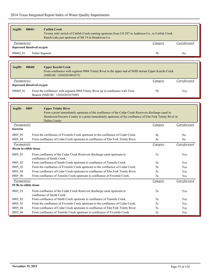
SegID: 0804G Catfish Creek
Twenty mile stretch of Catfish Creek running upstream from US 287 in Anderson Co., to Catfish Creek
Ranch Lake just upstream of SH 19 in Henderson Co.
CarryforwardCategoryParameter(s)
depressed dissolved oxygen
0804G_01 Entire Segment 5b No
SegID: 0804H Upper Keechi Creek
From confluence with segment 0804 Trinity River to the upper end of NHD stream Upper Keechi Creek
(NHD RC 12030201001075)
CarryforwardCategoryParameter(s)
depressed dissolved oxygen
0804H_01 From the confluence with segment 0804 Trinity River up to confluence with Twin
Branch (NHD RC 12030201027099)
5b Yes
SegID: 0805 Upper Trinity River
From a point immediately upstream of the confluence of the Cedar Creek Reservoir discharge canal in
Henderson/Navarro County to a point immediately upstream of the confluence of Elm Fork Trinity River in
Dallas County
CarryforwardCategoryParameter(s)
bacteria
0805_03 From the confluence of Fivemile Creek upstream to the confluence of Cedar Creek. 4a No
0805_04 From confluence of Cedar Creek upstream to confluence of Elm Fork Trinity River 4a No
CarryforwardCategoryParameter(s)
dioxin in edible tissue
0805_01 From confluence of the Cedar Creek Reservoir discharge canal upstream to
confluence of Smith Creek.
5a Yes
0805_02 From confluence of Smith Creek upstream to confluence of Tenmile Creek. 5a Yes
0805_03 From the confluence of Fivemile Creek upstream to the confluence of Cedar Creek. 5a Yes
0805_04 From confluence of Cedar Creek upstream to confluence of Elm Fork Trinity River 5a Yes
0805_06 From confluence of Tenmile Creek upstream to confluence of Fivemile Creek 5a Yes
CarryforwardCategoryParameter(s)
PCBs in edible tissue
0805_01 From confluence of the Cedar Creek Reservoir discharge canal upstream to
confluence of Smith Creek.
5a Yes
0805_02 From confluence of Smith Creek upstream to confluence of Tenmile Creek. 5a Yes
0805_03 From the confluence of Fivemile Creek upstream to the confluence of Cedar Creek. 5a Yes
0805_04 From confluence of Cedar Creek upstream to confluence of Elm Fork Trinity River 5a Yes
0805_06 From confluence of Tenmile Creek upstream to confluence of Fivemile Creek 5a Yes
Page 35 of 130November 19, 2015
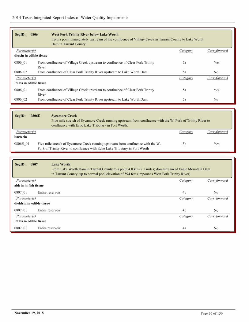
2014 Texas Integrated Report Index of Water Quality Impairments
SegID: 0806 West Fork Trinity River below Lake Worth
from a point immediately upstream of the confluence of Village Creek in Tarrant County to Lake Worth
Dam in Tarrant County
CarryforwardCategoryParameter(s)
dioxin in edible tissue
0806_01 From confluence of Village Creek upstream to confluence of Clear Fork Trinity
River
5a Yes
0806_02 From confluence of Clear Fork Trinity River upstream to Lake Worth Dam 5a No
CarryforwardCategoryParameter(s)
PCBs in edible tissue
0806_01 From confluence of Village Creek upstream to confluence of Clear Fork Trinity
River
5a Yes
0806_02 From confluence of Clear Fork Trinity River upstream to Lake Worth Dam 5a No
SegID: 0806E Sycamore Creek
Five mile stretch of Sycamore Creek running upstream from confluence with the W. Fork of Trinity River to
confluence with Echo Lake Tributary in Fort Worth.
CarryforwardCategoryParameter(s)
bacteria
0806E_01 Five mile stretch of Sycamore Creek running upstream from confluence with the W.
Fork of Trinity River to confluence with Echo Lake Tributary in Fort Worth
5b Yes
SegID: 0807 Lake Worth
From Lake Worth Dam in Tarrant County to a point 4.0 km (2.5 miles) downstream of Eagle Mountain Dam
in Tarrant County, up to normal pool elevation of 594 feet (impounds West Fork Trinity River)
CarryforwardCategoryParameter(s)
aldrin in fish tissue
0807_01 Entire reservoir 4b No
CarryforwardCategoryParameter(s)
dieldrin in edible tissue
0807_01 Entire reservoir 4b No
CarryforwardCategoryParameter(s)
PCBs in edible tissue
0807_01 Entire reservoir 4a No
Page 36 of 130November 19, 2015
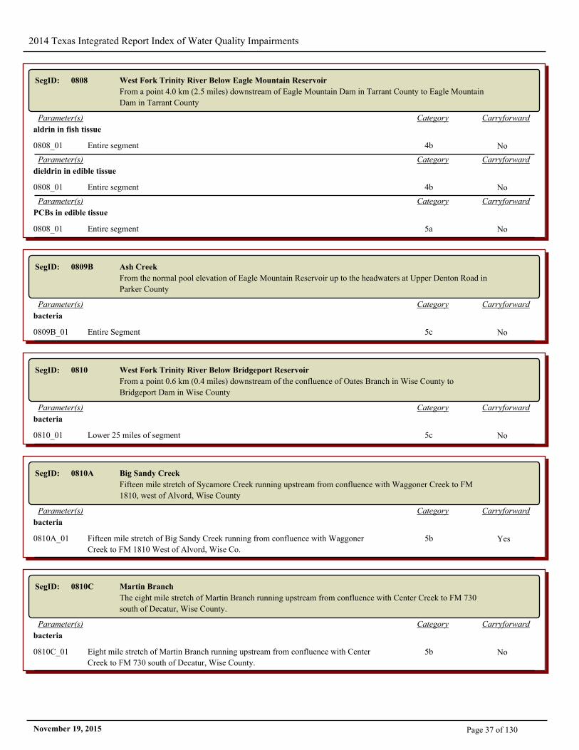
2014 Texas Integrated Report Index of Water Quality Impairments
SegID: 0808 West Fork Trinity River Below Eagle Mountain Reservoir
From a point 4.0 km (2.5 miles) downstream of Eagle Mountain Dam in Tarrant County to Eagle Mountain
Dam in Tarrant County
CarryforwardCategoryParameter(s)
aldrin in fish tissue
0808_01 Entire segment 4b No
CarryforwardCategoryParameter(s)
dieldrin in edible tissue
0808_01 Entire segment 4b No
CarryforwardCategoryParameter(s)
PCBs in edible tissue
0808_01 Entire segment 5a No
SegID: 0809B Ash Creek
From the normal pool elevation of Eagle Mountain Reservoir up to the headwaters at Upper Denton Road in
Parker County
CarryforwardCategoryParameter(s)
bacteria
0809B_01 Entire Segment 5c No
SegID: 0810 West Fork Trinity River Below Bridgeport Reservoir
From a point 0.6 km (0.4 miles) downstream of the confluence of Oates Branch in Wise County to
Bridgeport Dam in Wise County
CarryforwardCategoryParameter(s)
bacteria
0810_01 Lower 25 miles of segment 5c No
SegID: 0810A Big Sandy Creek
Fifteen mile stretch of Sycamore Creek running upstream from confluence with Waggoner Creek to FM
1810, west of Alvord, Wise County
CarryforwardCategoryParameter(s)
bacteria
0810A_01 Fifteen mile stretch of Big Sandy Creek running from confluence with Waggoner
Creek to FM 1810 West of Alvord, Wise Co.
5b Yes
SegID: 0810C Martin Branch
The eight mile stretch of Martin Branch running upstream from confluence with Center Creek to FM 730
south of Decatur, Wise County.
CarryforwardCategoryParameter(s)
bacteria
0810C_01 Eight mile stretch of Martin Branch running upstream from confluence with Center
Creek to FM 730 south of Decatur, Wise County.
5b No
Page 37 of 130November 19, 2015
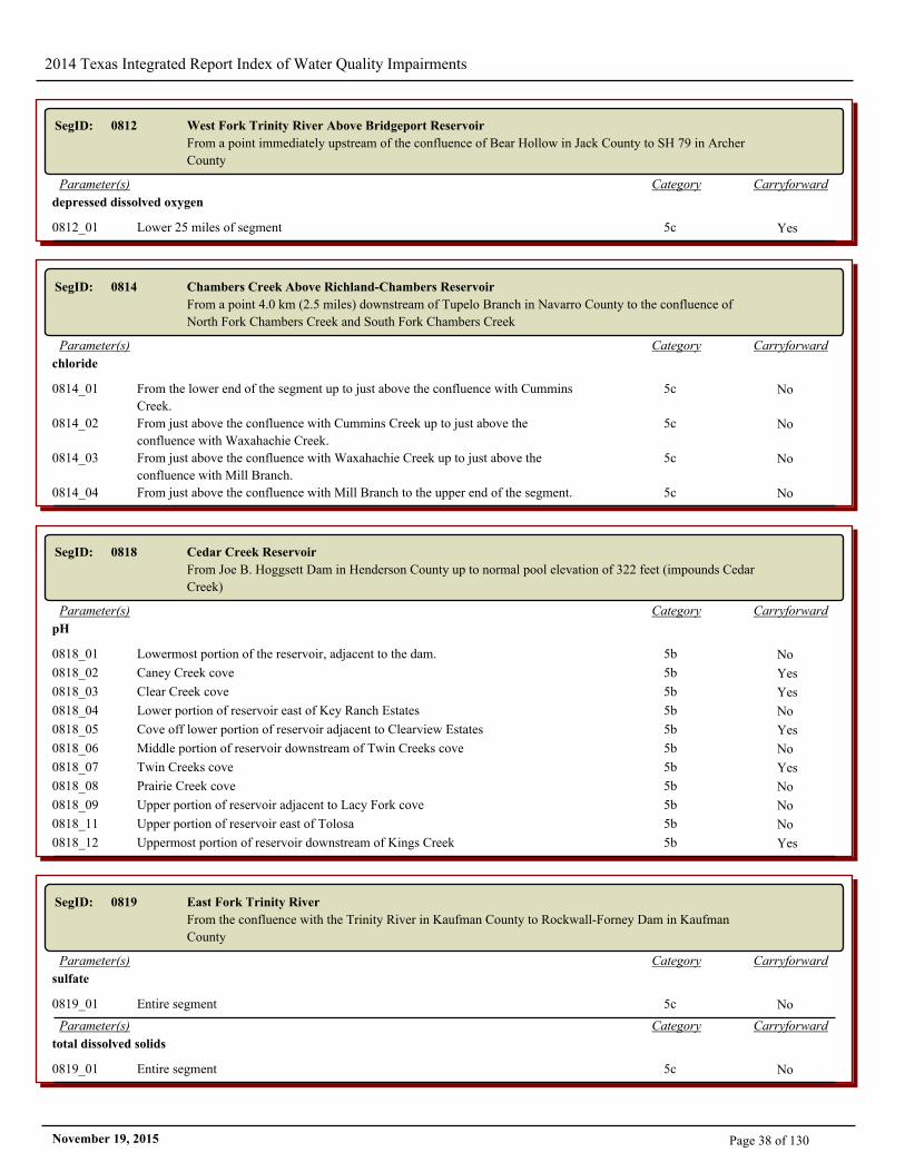
2014 Texas Integrated Report Index of Water Quality Impairments
SegID: 0812 West Fork Trinity River Above Bridgeport Reservoir
From a point immediately upstream of the confluence of Bear Hollow in Jack County to SH 79 in Archer
County
CarryforwardCategoryParameter(s)
depressed dissolved oxygen
0812_01 Lower 25 miles of segment 5c Yes
SegID: 0814 Chambers Creek Above Richland-Chambers Reservoir
From a point 4.0 km (2.5 miles) downstream of Tupelo Branch in Navarro County to the confluence of
North Fork Chambers Creek and South Fork Chambers Creek
CarryforwardCategoryParameter(s)
chloride
0814_01 From the lower end of the segment up to just above the confluence with Cummins
Creek.
5c No
0814_02 From just above the confluence with Cummins Creek up to just above the
confluence with Waxahachie Creek.
5c No
0814_03 From just above the confluence with Waxahachie Creek up to just above the
confluence with Mill Branch.
5c No
0814_04 From just above the confluence with Mill Branch to the upper end of the segment. 5c No
SegID: 0818 Cedar Creek Reservoir
From Joe B. Hoggsett Dam in Henderson County up to normal pool elevation of 322 feet (impounds Cedar
Creek)
CarryforwardCategoryParameter(s)
pH
0818_01 Lowermost portion of the reservoir, adjacent to the dam. 5b No
0818_02 Caney Creek cove 5b Yes
0818_03 Clear Creek cove 5b Yes
0818_04 Lower portion of reservoir east of Key Ranch Estates 5b No
0818_05 Cove off lower portion of reservoir adjacent to Clearview Estates 5b Yes
0818_06 Middle portion of reservoir downstream of Twin Creeks cove 5b No
0818_07 Twin Creeks cove 5b Yes
0818_08 Prairie Creek cove 5b No
0818_09 Upper portion of reservoir adjacent to Lacy Fork cove 5b No
0818_11 Upper portion of reservoir east of Tolosa 5b No
0818_12 Uppermost portion of reservoir downstream of Kings Creek 5b Yes
SegID: 0819 East Fork Trinity River
From the confluence with the Trinity River in Kaufman County to Rockwall-Forney Dam in Kaufman
County
CarryforwardCategoryParameter(s)
sulfate
0819_01 Entire segment 5c No
CarryforwardCategoryParameter(s)
total dissolved solids
0819_01 Entire segment 5c No
Page 38 of 130November 19, 2015
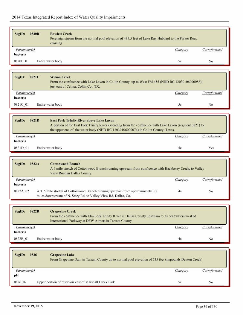
2014 Texas Integrated Report Index of Water Quality Impairments
SegID: 0820B Rowlett Creek
Perennial stream from the normal pool elevation of 435.5 feet of Lake Ray Hubbard to the Parker Road
crossing
CarryforwardCategoryParameter(s)
bacteria
0820B_01 Entire water body 5c No
SegID: 0821C Wilson Creek
From the confluence with Lake Lavon in Collin County up to West FM 455 (NHD RC 12030106000086),
just east of Celina, Collin Co., TX.
CarryforwardCategoryParameter(s)
bacteria
0821C_01 Entire water body 5c No
SegID: 0821D East Fork Trinity River above Lake Lavon
A portion of the East Fork Trinity River extending from the confluence with Lake Lavon (segment 0821) to
the upper end of the water body (NHD RC 12030106000074) in Collin County, Texas.
CarryforwardCategoryParameter(s)
bacteria
0821D_01 Entire water body 5c Yes
SegID: 0822A Cottonwood Branch
A 6 mile stretch of Cottonwood Branch running upstream from confluence with Hackberry Creek, to Valley
View Road in Dallas County.
CarryforwardCategoryParameter(s)
bacteria
0822A_02 A 3. 5 mile stretch of Cottonwood Branch running upstream from approximately 0.5
miles downstream of N. Story Rd. to Valley View Rd, Dallas, Co.
4a No
SegID: 0822B Grapevine Creek
From the confluence with Elm Fork Trinity River in Dallas County upstream to its headwaters west of
International Parkway at DFW Airport in Tarrant County
CarryforwardCategoryParameter(s)
bacteria
0822B_01 Entire water body 4a No
SegID: 0826 Grapevine Lake
From Grapevine Dam in Tarrant County up to normal pool elevation of 535 feet (impounds Denton Creek)
CarryforwardCategoryParameter(s)
pH
0826_07 Upper portion of reservoir east of Marshall Creek Park 5c No
Page 39 of 130November 19, 2015
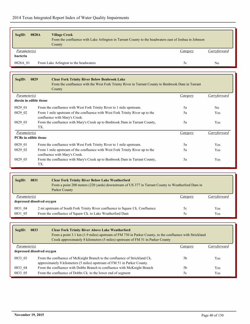
2014 Texas Integrated Report Index of Water Quality Impairments
SegID: 0828A Village Creek
From the confluence with Lake Arlington in Tarrant County to the headwaters east of Joshua in Johnson
County
CarryforwardCategoryParameter(s)
bacteria
0828A_01 From Lake Arlington to the headwaters 5c No
SegID: 0829 Clear Fork Trinity River Below Benbrook Lake
From the confluence with the West Fork Trinity River in Tarrant County to Benbrook Dam in Tarrant
County
CarryforwardCategoryParameter(s)
dioxin in edible tissue
0829_01 From the confluence with West Fork Trinity River to 1 mile upstream. 5a No
0829_02 From 1 mile upstream of the confluence with West Fork Trinity River up to the
confluence with Mary's Creek.
5a Yes
0829_03 From the confluence with Mary's Creek up to Benbrook Dam in Tarrant County,
TX.
5a Yes
CarryforwardCategoryParameter(s)
PCBs in edible tissue
0829_01 From the confluence with West Fork Trinity River to 1 mile upstream. 5a Yes
0829_02 From 1 mile upstream of the confluence with West Fork Trinity River up to the
confluence with Mary's Creek.
5a Yes
0829_03 From the confluence with Mary's Creek up to Benbrook Dam in Tarrant County,
TX.
5a Yes
SegID: 0831 Clear Fork Trinity River Below Lake Weatherford
From a point 200 meters (220 yards) downstream of US 377 in Tarrant County to Weatherford Dam in
Parker County
CarryforwardCategoryParameter(s)
depressed dissolved oxygen
0831_04 2 mi upstream of South Fork Trinity River confluence to Squaw Ck. Confluence 5c Yes
0831_05 From the confluence of Squaw Ck. to Lake Weatherford Dam 5c Yes
SegID: 0833 Clear Fork Trinity River Above Lake Weatherford
From a point 3.1 km (1.9 miles) upstream of FM 730 in Parker County, to the confluence with Strickland
Creek approximately 8 kilometers (5 miles) upstream of FM 51 in Parker County
CarryforwardCategoryParameter(s)
depressed dissolved oxygen
0833_03 From the confluence of McKnight Branch to the confluence of Strickland Ck.
approximately 8 kilometers (5 miles) upstream of FM 51 in Parker County.
5b Yes
0833_04 From the confluence with Dobbs Branch to confluence with McKnight Branch 5b Yes
0833_05 From the confluence of Dobbs Ck. to the lower end of segment 5c Yes
Page 40 of 130November 19, 2015
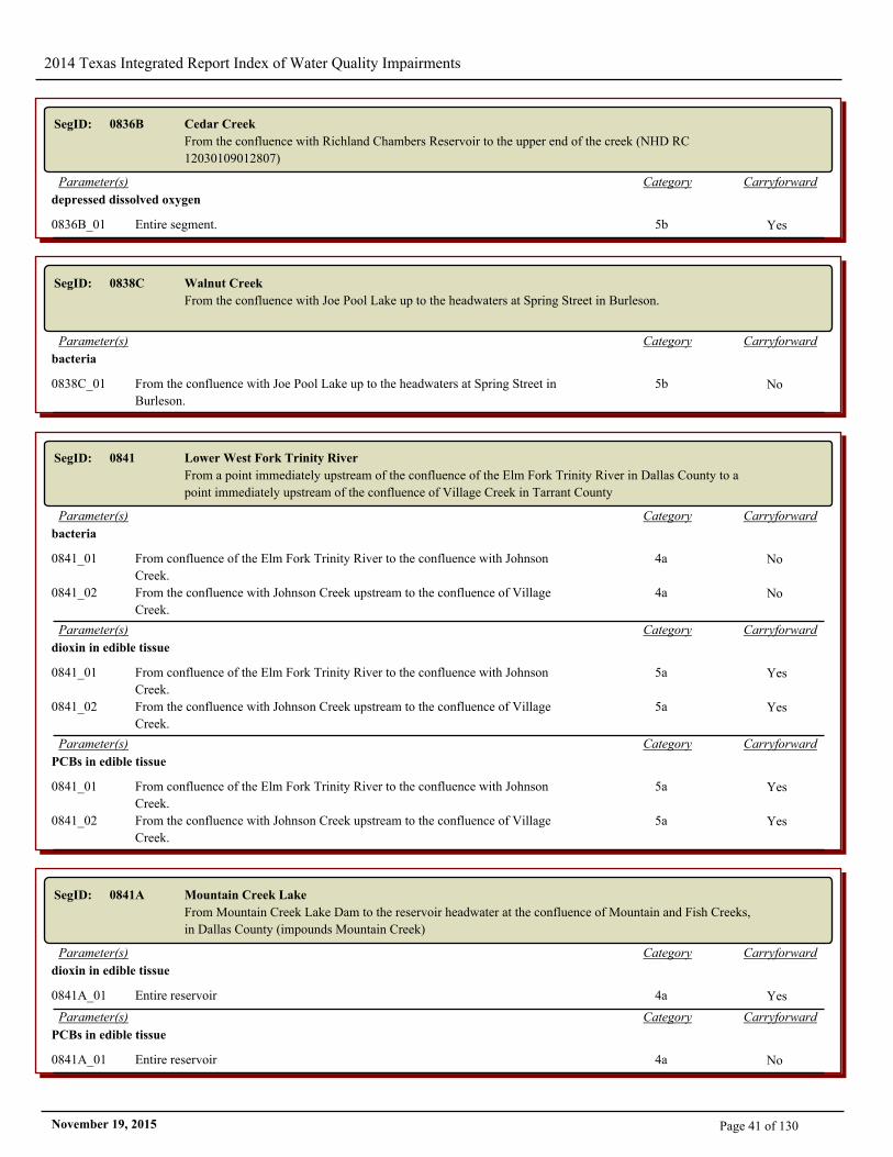
2014 Texas Integrated Report Index of Water Quality Impairments
SegID: 0836B Cedar Creek
From the confluence with Richland Chambers Reservoir to the upper end of the creek (NHD RC
12030109012807)
CarryforwardCategoryParameter(s)
depressed dissolved oxygen
0836B_01 Entire segment. 5b Yes
SegID: 0838C Walnut Creek
From the confluence with Joe Pool Lake up to the headwaters at Spring Street in Burleson.
CarryforwardCategoryParameter(s)
bacteria
0838C_01 From the confluence with Joe Pool Lake up to the headwaters at Spring Street in
Burleson.
5b No
SegID: 0841 Lower West Fork Trinity River
From a point immediately upstream of the confluence of the Elm Fork Trinity River in Dallas County to a
point immediately upstream of the confluence of Village Creek in Tarrant County
CarryforwardCategoryParameter(s)
bacteria
0841_01 From confluence of the Elm Fork Trinity River to the confluence with Johnson
Creek.
4a No
0841_02 From the confluence with Johnson Creek upstream to the confluence of Village
Creek.
4a No
CarryforwardCategoryParameter(s)
dioxin in edible tissue
0841_01 From confluence of the Elm Fork Trinity River to the confluence with Johnson
Creek.
5a Yes
0841_02 From the confluence with Johnson Creek upstream to the confluence of Village
Creek.
5a Yes
CarryforwardCategoryParameter(s)
PCBs in edible tissue
0841_01 From confluence of the Elm Fork Trinity River to the confluence with Johnson
Creek.
5a Yes
0841_02 From the confluence with Johnson Creek upstream to the confluence of Village
Creek.
5a Yes
SegID: 0841A Mountain Creek Lake
From Mountain Creek Lake Dam to the reservoir headwater at the confluence of Mountain and Fish Creeks,
in Dallas County (impounds Mountain Creek)
CarryforwardCategoryParameter(s)
dioxin in edible tissue
0841A_01 Entire reservoir 4a Yes
CarryforwardCategoryParameter(s)
PCBs in edible tissue
0841A_01 Entire reservoir 4a No
Page 41 of 130November 19, 2015
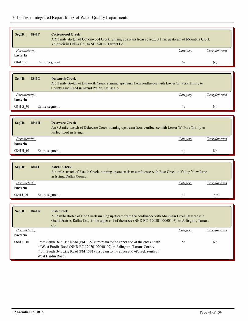
2014 Texas Integrated Report Index of Water Quality Impairments
SegID: 0841F Cottonwood Creek
A 6.5 mile stretch of Cottonwood Creek running upstream from approx. 0.1 mi. upstream of Mountain Creek
Reservoir in Dallas Co., to SH 360 in, Tarrant Co.
CarryforwardCategoryParameter(s)
bacteria
0841F_01 Entire Segment. 5a No
SegID: 0841G Dalworth Creek
A 2.2 mile stretch of Dalworth Creek running upstream from confluence with Lower W. Fork Trinity to
County Line Road in Grand Prairie, Dallas Co.
CarryforwardCategoryParameter(s)
bacteria
0841G_01 Entire segment. 4a No
SegID: 0841H Delaware Creek
An 8.5 mile stretch of Delaware Creek running upstream from confluence with Lower W. Fork Trinity to
Finley Road in Irving.
CarryforwardCategoryParameter(s)
bacteria
0841H_01 Entire segment. 4a No
SegID: 0841J Estelle Creek
A 4 mile stretch of Estelle Creek running upstream from confluence with Bear Creek to Valley View Lane
in Irving, Dallas County.
CarryforwardCategoryParameter(s)
bacteria
0841J_01 Entire segment. 4a Yes
SegID: 0841K Fish Creek
A 15 mile stretch of Fish Creek running upstream from the confluence with Mountain Creek Reservoir in
Grand Prairie, Dallas Co., to the upper end of the creek (NHD RC 12030102000107) in Arlington, Tarrant
Co.
CarryforwardCategoryParameter(s)
bacteria
0841K_01 From South Belt Line Road (FM 1382) upstream to the upper end of the creek south
of West Bardin Road (NHD RC 12030102000107) in Arlington, Tarrant County.
From South Belt Line Road (FM 1382) upstream to the upper end of creek south of
West Bardin Road.
5b No
Page 42 of 130November 19, 2015
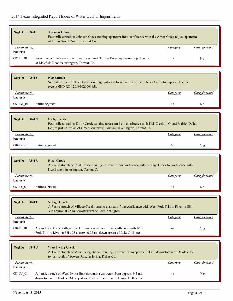
2014 Texas Integrated Report Index of Water Quality Impairments
SegID: 0841L Johnson Creek
Four mile stretch of Johnson Creek running upstream from confluence with the Arbor Creek to just upstream
of I30 in Grand Prairie, Tarrant Co.
CarryforwardCategoryParameter(s)
bacteria
0841L_01 From the confluence wit the Lower West Fork Trinity River, upstream to just south
of Mayfield Road in Arlington, Tarrant, Co..
4a No
SegID: 0841M Kee Branch
Six mile stretch of Kee Branch running upstream from confluence with Rush Creek to upper end of the
creek (NHD RC 12030102000165).
CarryforwardCategoryParameter(s)
bacteria
0841M_01 Entire Segment. 4a No
SegID: 0841N Kirby Creek
Four mile stretch of Kirby Creek running upstream from confluence with Fish Creek in Grand Prairie, Dallas
Co., to just upstream of Great Southwest Parkway in Arlington, Tarrant Co.
CarryforwardCategoryParameter(s)
bacteria
0841N_01 Entire segment 5b Yes
SegID: 0841R Rush Creek
A 5 mile stretch of Rush Creek running upstream from confluence with Village Creek to confluence with
Kee Branch in Arlington, Tarrant Co.
CarryforwardCategoryParameter(s)
bacteria
0841R_01 Entire segment. 4a No
SegID: 0841T Village Creek
A 7 mile stretch of Village Creek running upstream from confluence with West Fork Trinity River to SH
303 approx. 0.75 mi. downstream of Lake Arlington.
CarryforwardCategoryParameter(s)
bacteria
0841T_01 A 7 mile stretch of Village Creek running upstream from confluence with West
Fork Trinity River to SH 303 approx. 0.75 mi. downstream of Lake Arlington.
4a Yes
SegID: 0841U West Irving Creek
A 4 mile stretch of West Irving Branch running upstream from approx. 0.4 mi. downstream of Oakdale Rd.
to just south of Sowers Road in Irving, Dallas Co.
CarryforwardCategoryParameter(s)
bacteria
0841U_01 A 4 mile stretch of West Irving Branch running upstream from approx. 0.4 mi.
downstream of Oakdale Rd. to just south of Sowers Road in Irving, Dallas Co.
4a Yes
Page 43 of 130November 19, 2015
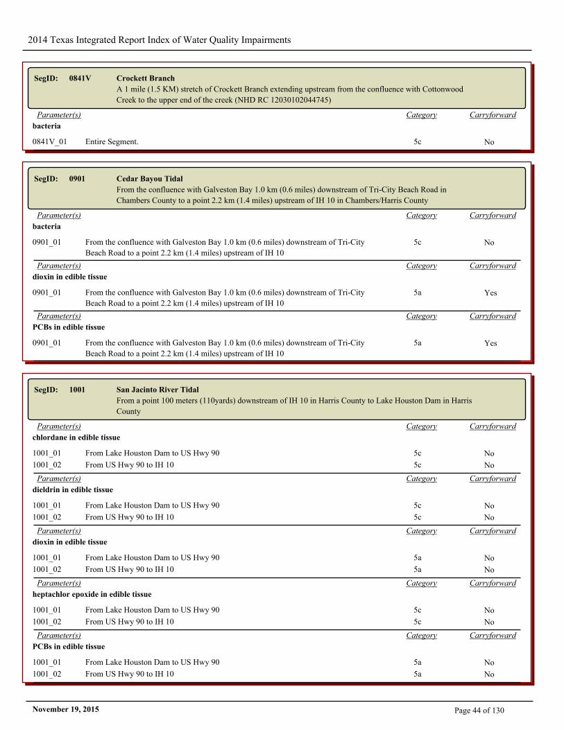
2014 Texas Integrated Report Index of Water Quality Impairments
SegID: 0841V Crockett Branch
A 1 mile (1.5 KM) stretch of Crockett Branch extending upstream from the confluence with Cottonwood
Creek to the upper end of the creek (NHD RC 12030102044745)
CarryforwardCategoryParameter(s)
bacteria
0841V_01 Entire Segment. 5c No
SegID: 0901 Cedar Bayou Tidal
From the confluence with Galveston Bay 1.0 km (0.6 miles) downstream of Tri-City Beach Road in
Chambers County to a point 2.2 km (1.4 miles) upstream of IH 10 in Chambers/Harris County
CarryforwardCategoryParameter(s)
bacteria
0901_01 From the confluence with Galveston Bay 1.0 km (0.6 miles) downstream of Tri-City
Beach Road to a point 2.2 km (1.4 miles) upstream of IH 10
5c No
CarryforwardCategoryParameter(s)
dioxin in edible tissue
0901_01 From the confluence with Galveston Bay 1.0 km (0.6 miles) downstream of Tri-City
Beach Road to a point 2.2 km (1.4 miles) upstream of IH 10
5a Yes
CarryforwardCategoryParameter(s)
PCBs in edible tissue
0901_01 From the confluence with Galveston Bay 1.0 km (0.6 miles) downstream of Tri-City
Beach Road to a point 2.2 km (1.4 miles) upstream of IH 10
5a Yes
SegID: 1001 San Jacinto River Tidal
From a point 100 meters (110yards) downstream of IH 10 in Harris County to Lake Houston Dam in Harris
County
CarryforwardCategoryParameter(s)
chlordane in edible tissue
1001_01 From Lake Houston Dam to US Hwy 90 5c No
1001_02 From US Hwy 90 to IH 10 5c No
CarryforwardCategoryParameter(s)
dieldrin in edible tissue
1001_01 From Lake Houston Dam to US Hwy 90 5c No
1001_02 From US Hwy 90 to IH 10 5c No
CarryforwardCategoryParameter(s)
dioxin in edible tissue
1001_01 From Lake Houston Dam to US Hwy 90 5a No
1001_02 From US Hwy 90 to IH 10 5a No
CarryforwardCategoryParameter(s)
heptachlor epoxide in edible tissue
1001_01 From Lake Houston Dam to US Hwy 90 5c No
1001_02 From US Hwy 90 to IH 10 5c No
CarryforwardCategoryParameter(s)
PCBs in edible tissue
1001_01 From Lake Houston Dam to US Hwy 90 5a No
1001_02 From US Hwy 90 to IH 10 5a No
Page 44 of 130November 19, 2015
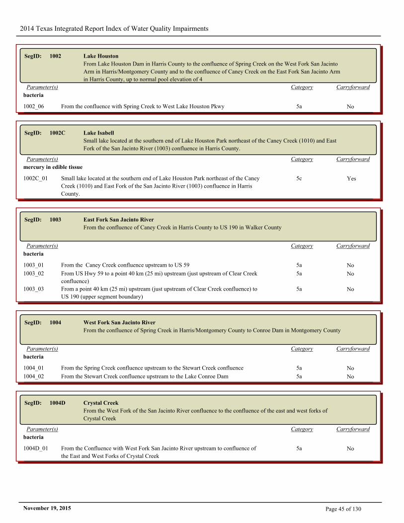
2014 Texas Integrated Report Index of Water Quality Impairments
SegID: 1002 Lake Houston
From Lake Houston Dam in Harris County to the confluence of Spring Creek on the West Fork San Jacinto
Arm in Harris/Montgomery County and to the confluence of Caney Creek on the East Fork San Jacinto Arm
in Harris County, up to normal pool elevation of 4
CarryforwardCategoryParameter(s)
bacteria
1002_06 From the confluence with Spring Creek to West Lake Houston Pkwy 5a No
SegID: 1002C Lake Isabell
Small lake located at the southern end of Lake Houston Park northeast of the Caney Creek (1010) and East
Fork of the San Jacinto River (1003) confluence in Harris County.
CarryforwardCategoryParameter(s)
mercury in edible tissue
1002C_01 Small lake located at the southern end of Lake Houston Park northeast of the Caney
Creek (1010) and East Fork of the San Jacinto River (1003) confluence in Harris
County.
5c Yes
SegID: 1003 East Fork San Jacinto River
From the confluence of Caney Creek in Harris County to US 190 in Walker County
CarryforwardCategoryParameter(s)
bacteria
1003_01 From the Caney Creek confluence upstream to US 59 5a No
1003_02 From US Hwy 59 to a point 40 km (25 mi) upstream (just upstream of Clear Creek
confluence)
5a No
1003_03 From a point 40 km (25 mi) upstream (just upstream of Clear Creek confluence) to
US 190 (upper segment boundary)
5a No
SegID: 1004 West Fork San Jacinto River
From the confluence of Spring Creek in Harris/Montgomery County to Conroe Dam in Montgomery County
CarryforwardCategoryParameter(s)
bacteria
1004_01 From the Spring Creek confluence upstream to the Stewart Creek confluence 5a No
1004_02 From the Stewart Creek confluence upstream to the Lake Conroe Dam 5a No
SegID: 1004D Crystal Creek
From the West Fork of the San Jacinto River confluence to the confluence of the east and west forks of
Crystal Creek
CarryforwardCategoryParameter(s)
bacteria
1004D_01 From the Confluence with West Fork San Jacinto River upstream to confluence of
the East and West Forks of Crystal Creek
5a No
Page 45 of 130November 19, 2015
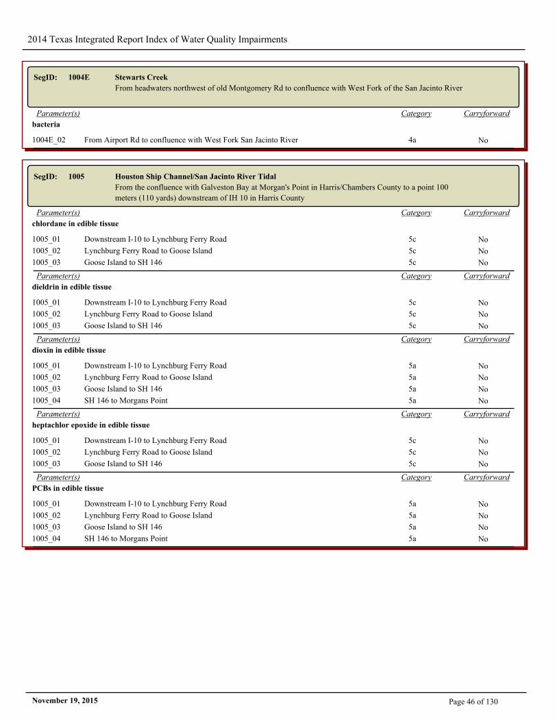
2014 Texas Integrated Report Index of Water Quality Impairments
SegID: 1004E Stewarts Creek
From headwaters northwest of old Montgomery Rd to confluence with West Fork of the San Jacinto River
CarryforwardCategoryParameter(s)
bacteria
1004E_02 From Airport Rd to confluence with West Fork San Jacinto River 4a No
SegID: 1005 Houston Ship Channel/San Jacinto River Tidal
From the confluence with Galveston Bay at Morgan's Point in Harris/Chambers County to a point 100
meters (110 yards) downstream of IH 10 in Harris County
CarryforwardCategoryParameter(s)
chlordane in edible tissue
1005_01 Downstream I-10 to Lynchburg Ferry Road 5c No
1005_02 Lynchburg Ferry Road to Goose Island 5c No
1005_03 Goose Island to SH 146 5c No
CarryforwardCategoryParameter(s)
dieldrin in edible tissue
1005_01 Downstream I-10 to Lynchburg Ferry Road 5c No
1005_02 Lynchburg Ferry Road to Goose Island 5c No
1005_03 Goose Island to SH 146 5c No
CarryforwardCategoryParameter(s)
dioxin in edible tissue
1005_01 Downstream I-10 to Lynchburg Ferry Road 5a No
1005_02 Lynchburg Ferry Road to Goose Island 5a No
1005_03 Goose Island to SH 146 5a No
1005_04 SH 146 to Morgans Point 5a No
CarryforwardCategoryParameter(s)
heptachlor epoxide in edible tissue
1005_01 Downstream I-10 to Lynchburg Ferry Road 5c No
1005_02 Lynchburg Ferry Road to Goose Island 5c No
1005_03 Goose Island to SH 146 5c No
CarryforwardCategoryParameter(s)
PCBs in edible tissue
1005_01 Downstream I-10 to Lynchburg Ferry Road 5a No
1005_02 Lynchburg Ferry Road to Goose Island 5a No
1005_03 Goose Island to SH 146 5a No
1005_04 SH 146 to Morgans Point 5a No
Page 46 of 130November 19, 2015
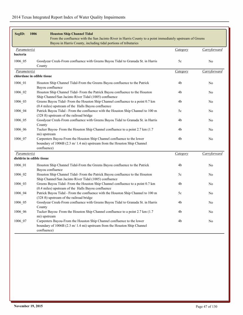
2014 Texas Integrated Report Index of Water Quality Impairments
SegID: 1006 Houston Ship Channel Tidal
From the confluence with the San Jacinto River in Harris County to a point immediately upstream of Greens
Bayou in Harris County, including tidal portions of tributaries
CarryforwardCategoryParameter(s)
bacteria
1006_05 Goodyear Creek-From confluence with Greens Bayou Tidal to Granada St. in Harris
County
5c No
CarryforwardCategoryParameter(s)
chlordane in edible tissue
1006_01 Houston Ship Channel Tidal-From the Greens Bayou confluence to the Patrick
Bayou confluence
4b No
1006_02 Houston Ship Channel Tidal- From the Patrick Bayou confluence to the Houston
Ship Channel/San Jacinto River Tidal (1005) confluence
4b No
1006_03 Greens Bayou Tidal- From the Houston Ship Channel confluence to a point 0.7 km
(0.4 miles) upstream of the Halls Bayou confluence
4b No
1006_04 Patrick Bayou Tidal - From the confluence with the Houston Ship Channel to 100 m
(328 ft) upstream of the railroad bridge
5c No
1006_05 Goodyear Creek-From confluence with Greens Bayou Tidal to Granada St. in Harris
County
4b No
1006_06 Tucker Bayou- From the Houston Ship Channel confluence to a point 2.7 km (1.7
mi) upstream
4b No
1006_07 Carpenters Bayou-From the Houston Ship Channel confluence to the lower
boundary of 1006B (2.3 m/ 1.4 mi) upstream from the Houston Ship Channel
confluence)
4b No
CarryforwardCategoryParameter(s)
dieldrin in edible tissue
1006_01 Houston Ship Channel Tidal-From the Greens Bayou confluence to the Patrick
Bayou confluence
4b No
1006_02 Houston Ship Channel Tidal- From the Patrick Bayou confluence to the Houston
Ship Channel/San Jacinto River Tidal (1005) confluence
5c No
1006_03 Greens Bayou Tidal- From the Houston Ship Channel confluence to a point 0.7 km
(0.4 miles) upstream of the Halls Bayou confluence
4b No
1006_04 Patrick Bayou Tidal - From the confluence with the Houston Ship Channel to 100 m
(328 ft) upstream of the railroad bridge
5c No
1006_05 Goodyear Creek-From confluence with Greens Bayou Tidal to Granada St. in Harris
County
4b No
1006_06 Tucker Bayou- From the Houston Ship Channel confluence to a point 2.7 km (1.7
mi) upstream
4b No
1006_07 Carpenters Bayou-From the Houston Ship Channel confluence to the lower
boundary of 1006B (2.3 m/ 1.4 mi) upstream from the Houston Ship Channel
confluence)
4b No
Page 47 of 130November 19, 2015
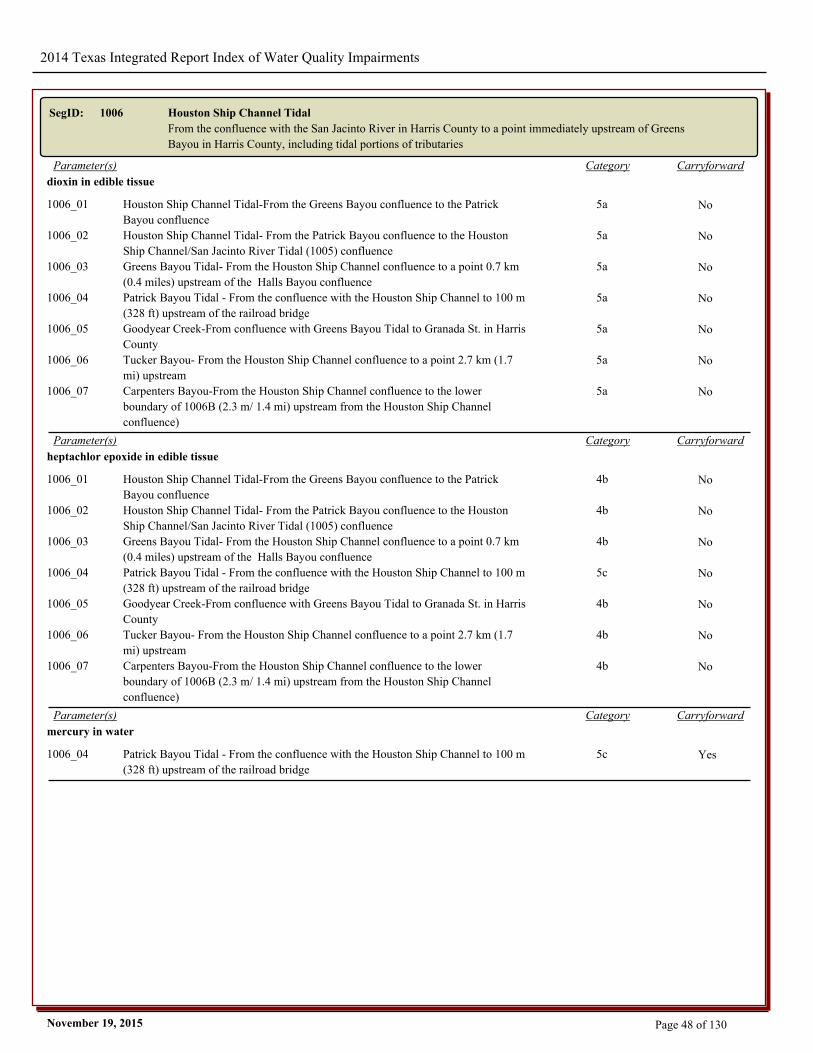
2014 Texas Integrated Report Index of Water Quality Impairments
SegID: 1006 Houston Ship Channel Tidal
From the confluence with the San Jacinto River in Harris County to a point immediately upstream of Greens
Bayou in Harris County, including tidal portions of tributaries
CarryforwardCategoryParameter(s)
dioxin in edible tissue
1006_01 Houston Ship Channel Tidal-From the Greens Bayou confluence to the Patrick
Bayou confluence
5a No
1006_02 Houston Ship Channel Tidal- From the Patrick Bayou confluence to the Houston
Ship Channel/San Jacinto River Tidal (1005) confluence
5a No
1006_03 Greens Bayou Tidal- From the Houston Ship Channel confluence to a point 0.7 km
(0.4 miles) upstream of the Halls Bayou confluence
5a No
1006_04 Patrick Bayou Tidal - From the confluence with the Houston Ship Channel to 100 m
(328 ft) upstream of the railroad bridge
5a No
1006_05 Goodyear Creek-From confluence with Greens Bayou Tidal to Granada St. in Harris
County
5a No
1006_06 Tucker Bayou- From the Houston Ship Channel confluence to a point 2.7 km (1.7
mi) upstream
5a No
1006_07 Carpenters Bayou-From the Houston Ship Channel confluence to the lower
boundary of 1006B (2.3 m/ 1.4 mi) upstream from the Houston Ship Channel
confluence)
5a No
CarryforwardCategoryParameter(s)
heptachlor epoxide in edible tissue
1006_01 Houston Ship Channel Tidal-From the Greens Bayou confluence to the Patrick
Bayou confluence
4b No
1006_02 Houston Ship Channel Tidal- From the Patrick Bayou confluence to the Houston
Ship Channel/San Jacinto River Tidal (1005) confluence
4b No
1006_03 Greens Bayou Tidal- From the Houston Ship Channel confluence to a point 0.7 km
(0.4 miles) upstream of the Halls Bayou confluence
4b No
1006_04 Patrick Bayou Tidal - From the confluence with the Houston Ship Channel to 100 m
(328 ft) upstream of the railroad bridge
5c No
1006_05 Goodyear Creek-From confluence with Greens Bayou Tidal to Granada St. in Harris
County
4b No
1006_06 Tucker Bayou- From the Houston Ship Channel confluence to a point 2.7 km (1.7
mi) upstream
4b No
1006_07 Carpenters Bayou-From the Houston Ship Channel confluence to the lower
boundary of 1006B (2.3 m/ 1.4 mi) upstream from the Houston Ship Channel
confluence)
4b No
CarryforwardCategoryParameter(s)
mercury in water
1006_04 Patrick Bayou Tidal - From the confluence with the Houston Ship Channel to 100 m
(328 ft) upstream of the railroad bridge
5c Yes
Page 48 of 130November 19, 2015
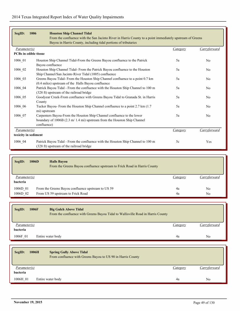
2014 Texas Integrated Report Index of Water Quality Impairments
SegID: 1006 Houston Ship Channel Tidal
From the confluence with the San Jacinto River in Harris County to a point immediately upstream of Greens
Bayou in Harris County, including tidal portions of tributaries
CarryforwardCategoryParameter(s)
PCBs in edible tissue
1006_01 Houston Ship Channel Tidal-From the Greens Bayou confluence to the Patrick
Bayou confluence
5a No
1006_02 Houston Ship Channel Tidal- From the Patrick Bayou confluence to the Houston
Ship Channel/San Jacinto River Tidal (1005) confluence
5a No
1006_03 Greens Bayou Tidal- From the Houston Ship Channel confluence to a point 0.7 km
(0.4 miles) upstream of the Halls Bayou confluence
5a No
1006_04 Patrick Bayou Tidal - From the confluence with the Houston Ship Channel to 100 m
(328 ft) upstream of the railroad bridge
5a No
1006_05 Goodyear Creek-From confluence with Greens Bayou Tidal to Granada St. in Harris
County
5a No
1006_06 Tucker Bayou- From the Houston Ship Channel confluence to a point 2.7 km (1.7
mi) upstream
5a No
1006_07 Carpenters Bayou-From the Houston Ship Channel confluence to the lower
boundary of 1006B (2.3 m/ 1.4 mi) upstream from the Houston Ship Channel
confluence)
5a No
CarryforwardCategoryParameter(s)
toxicity in sediment
1006_04 Patrick Bayou Tidal - From the confluence with the Houston Ship Channel to 100 m
(328 ft) upstream of the railroad bridge
5c Yes
SegID: 1006D Halls Bayou
From the Greens Bayou confluence upstream to Frick Road in Harris County
CarryforwardCategoryParameter(s)
bacteria
1006D_01 From the Greens Bayou confluence upstream to US 59 4a No
1006D_02 From US 59 upstream to Frick Road 4a No
SegID: 1006F Big Gulch Above Tidal
From the confluence with Greens Bayou Tidal to Wallisville Road in Harris County
CarryforwardCategoryParameter(s)
bacteria
1006F_01 Entire water body 4a No
SegID: 1006H Spring Gully Above Tidal
From confluence with Greens Bayou to US 90 in Harris County
CarryforwardCategoryParameter(s)
bacteria
1006H_01 Entire water body 4a No
Page 49 of 130November 19, 2015
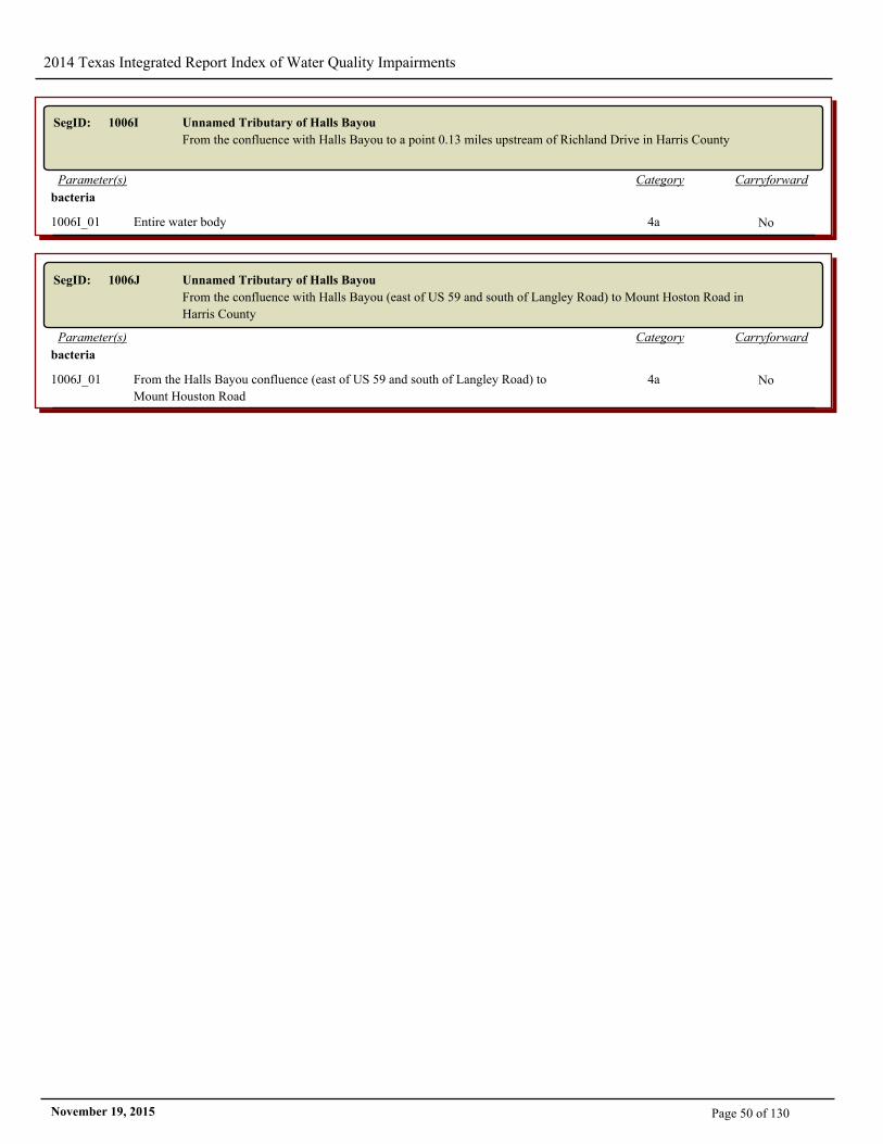
2014 Texas Integrated Report Index of Water Quality Impairments
SegID: 1006I Unnamed Tributary of Halls Bayou
From the confluence with Halls Bayou to a point 0.13 miles upstream of Richland Drive in Harris County
CarryforwardCategoryParameter(s)
bacteria
1006I_01 Entire water body 4a No
SegID: 1006J Unnamed Tributary of Halls Bayou
From the confluence with Halls Bayou (east of US 59 and south of Langley Road) to Mount Hoston Road in
Harris County
CarryforwardCategoryParameter(s)
bacteria
1006J_01 From the Halls Bayou confluence (east of US 59 and south of Langley Road) to
Mount Houston Road
4a No
Page 50 of 130November 19, 2015

2014 Texas Integrated Report Index of Water Quality Impairments
SegID: 1007 Houston Ship Channel/Buffalo Bayou Tidal
From a point immediately upstream of Greens Bayou in Harris County to a point 100 meters (110 yards)
upstream of US 59 in Harris County, including tidal portion of tributaries
CarryforwardCategoryParameter(s)
bacteria
1007_05 Vince Bayou Tidal - From the Houston Ship Channel confluence to SH 225 5a No
CarryforwardCategoryParameter(s)
chlordane in edible tissue
1007_01 Houston Ship Channel - From a point immediately upstream of Greens Bayou Tidal
to immediately upstream of the 69th Street WWTP outfall
4b No
1007_02 Sims Bayou Tidal - From the Houston Ship Channel confluence to a point 11 km
(6.8 mi) upstream
4b No
1007_03 Hunting Bayou Tidal - From the Houston Ship Channel confluence to IH-10 4b No
1007_04 Brays Bayou Tidal - From the Houston Ship Channel confluence to downstream of
IH-45
4b No
1007_05 Vince Bayou Tidal - From the Houston Ship Channel confluence to SH 225 4b No
1007_06 Berry Bayou - From the Houston Ship Channel confluence to a point 2.4 km (1.5
mi) upstream of the Sims Bayou confluence
4b No
1007_07 Buffalo Bayou - From immediately upstream of 69th Street WWTP outfall to US 59 4b No
1007_08 Little Vince Bayou Tidal - From the Vince Bayou confluence to SH 225 4b No
CarryforwardCategoryParameter(s)
dieldrin in edible tissue
1007_01 Houston Ship Channel - From a point immediately upstream of Greens Bayou Tidal
to immediately upstream of the 69th Street WWTP outfall
4b No
1007_02 Sims Bayou Tidal - From the Houston Ship Channel confluence to a point 11 km
(6.8 mi) upstream
4b No
1007_03 Hunting Bayou Tidal - From the Houston Ship Channel confluence to IH-10 4b No
1007_04 Brays Bayou Tidal - From the Houston Ship Channel confluence to downstream of
IH-45
4b No
1007_05 Vince Bayou Tidal - From the Houston Ship Channel confluence to SH 225 4b No
1007_06 Berry Bayou - From the Houston Ship Channel confluence to a point 2.4 km (1.5
mi) upstream of the Sims Bayou confluence
4b No
1007_07 Buffalo Bayou - From immediately upstream of 69th Street WWTP outfall to US 59 4b No
1007_08 Little Vince Bayou Tidal - From the Vince Bayou confluence to SH 225 4b No
CarryforwardCategoryParameter(s)
dioxin in edible tissue
1007_01 Houston Ship Channel - From a point immediately upstream of Greens Bayou Tidal
to immediately upstream of the 69th Street WWTP outfall
5a No
1007_02 Sims Bayou Tidal - From the Houston Ship Channel confluence to a point 11 km
(6.8 mi) upstream
5a No
1007_03 Hunting Bayou Tidal - From the Houston Ship Channel confluence to IH-10 5a No
1007_04 Brays Bayou Tidal - From the Houston Ship Channel confluence to downstream of
IH-45
5a No
1007_05 Vince Bayou Tidal - From the Houston Ship Channel confluence to SH 225 5a No
1007_06 Berry Bayou - From the Houston Ship Channel confluence to a point 2.4 km (1.5
mi) upstream of the Sims Bayou confluence
5a No
1007_07 Buffalo Bayou - From immediately upstream of 69th Street WWTP outfall to US 59 5a No
1007_08 Little Vince Bayou Tidal - From the Vince Bayou confluence to SH 225 5a No
Page 51 of 130November 19, 2015
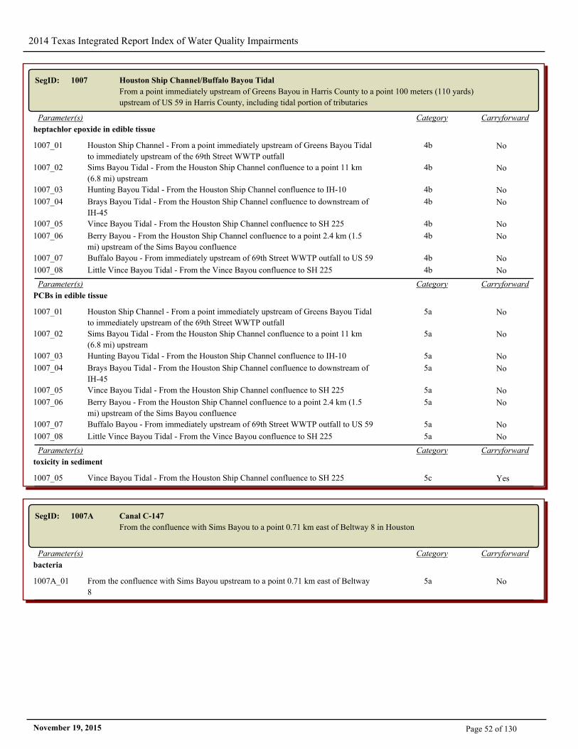
2014 Texas Integrated Report Index of Water Quality Impairments
SegID: 1007 Houston Ship Channel/Buffalo Bayou Tidal
From a point immediately upstream of Greens Bayou in Harris County to a point 100 meters (110 yards)
upstream of US 59 in Harris County, including tidal portion of tributaries
CarryforwardCategoryParameter(s)
heptachlor epoxide in edible tissue
1007_01 Houston Ship Channel - From a point immediately upstream of Greens Bayou Tidal
to immediately upstream of the 69th Street WWTP outfall
4b No
1007_02 Sims Bayou Tidal - From the Houston Ship Channel confluence to a point 11 km
(6.8 mi) upstream
4b No
1007_03 Hunting Bayou Tidal - From the Houston Ship Channel confluence to IH-10 4b No
1007_04 Brays Bayou Tidal - From the Houston Ship Channel confluence to downstream of
IH-45
4b No
1007_05 Vince Bayou Tidal - From the Houston Ship Channel confluence to SH 225 4b No
1007_06 Berry Bayou - From the Houston Ship Channel confluence to a point 2.4 km (1.5
mi) upstream of the Sims Bayou confluence
4b No
1007_07 Buffalo Bayou - From immediately upstream of 69th Street WWTP outfall to US 59 4b No
1007_08 Little Vince Bayou Tidal - From the Vince Bayou confluence to SH 225 4b No
CarryforwardCategoryParameter(s)
PCBs in edible tissue
1007_01 Houston Ship Channel - From a point immediately upstream of Greens Bayou Tidal
to immediately upstream of the 69th Street WWTP outfall
5a No
1007_02 Sims Bayou Tidal - From the Houston Ship Channel confluence to a point 11 km
(6.8 mi) upstream
5a No
1007_03 Hunting Bayou Tidal - From the Houston Ship Channel confluence to IH-10 5a No
1007_04 Brays Bayou Tidal - From the Houston Ship Channel confluence to downstream of
IH-45
5a No
1007_05 Vince Bayou Tidal - From the Houston Ship Channel confluence to SH 225 5a No
1007_06 Berry Bayou - From the Houston Ship Channel confluence to a point 2.4 km (1.5
mi) upstream of the Sims Bayou confluence
5a No
1007_07 Buffalo Bayou - From immediately upstream of 69th Street WWTP outfall to US 59 5a No
1007_08 Little Vince Bayou Tidal - From the Vince Bayou confluence to SH 225 5a No
CarryforwardCategoryParameter(s)
toxicity in sediment
1007_05 Vince Bayou Tidal - From the Houston Ship Channel confluence to SH 225 5c Yes
SegID: 1007A Canal C-147
From the confluence with Sims Bayou to a point 0.71 km east of Beltway 8 in Houston
CarryforwardCategoryParameter(s)
bacteria
1007A_01 From the confluence with Sims Bayou upstream to a point 0.71 km east of Beltway
8
5a No
Page 52 of 130November 19, 2015
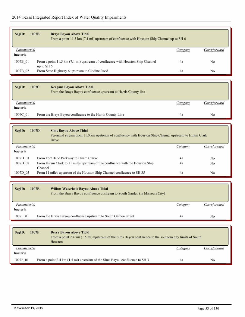
2014 Texas Integrated Report Index of Water Quality Impairments
SegID: 1007B Brays Bayou Above Tidal
From a point 11.5 km (7.1 mi) upstream of confluence with Houston Ship Channel up to SH 6
CarryforwardCategoryParameter(s)
bacteria
1007B_01 From a point 11.5 km (7.1 mi) upstream of confluence with Houston Ship Channel
up to SH 6
4a No
1007B_02 From State Highway 6 upstream to Clodine Road 4a No
SegID: 1007C Keegans Bayou Above Tidal
From the Brays Bayou confluence upstream to Harris County line
CarryforwardCategoryParameter(s)
bacteria
1007C_01 From the Brays Bayou confluence to the Harris County Line 4a No
SegID: 1007D Sims Bayou Above Tidal
Perennial stream from 11.0 km upstream of confluence with Houston Ship Channel upstream to Hiram Clark
Drive
CarryforwardCategoryParameter(s)
bacteria
1007D_01 From Fort Bend Parkway to Hiram Clarke 4a No
1007D_02 From Hiram Clark to 11 miles upstream of the confluence with the Houston Ship
Channel
4a No
1007D_03 From 11 miles upstream of the Houston Ship Channel confluence to SH 35 4a No
SegID: 1007E Willow Waterhole Bayou Above Tidal
From the Brays Bayou confluence upstream to South Garden (in Missouri City)
CarryforwardCategoryParameter(s)
bacteria
1007E_01 From the Brays Bayou confluence upstream to South Garden Street 4a No
SegID: 1007F Berry Bayou Above Tidal
From a point 2.4 km (1.5 mi) upstream of the Sims Bayou confluence to the southern city limits of South
Houston
CarryforwardCategoryParameter(s)
bacteria
1007F_01 From a point 2.4 km (1.5 mi) upstream of the Sims Bayou confluence to SH 3 4a No
Page 53 of 130November 19, 2015

2014 Texas Integrated Report Index of Water Quality Impairments
SegID: 1007G Kuhlman Gully Above Tidal
From Brays Bayou confluence to Atchison, Topeka and Santa Fe Railroad tracks in Harris County
CarryforwardCategoryParameter(s)
bacteria
1007G_01 From Brays Bayou confluence to Atchison, Topeka and Santa Fe Railroad tracks 4a No
SegID: 1007H Pine Gully Above Tidal
From the Sims Bayou confluence to 0.11 km (0.07 mi) east of Broadway Street in Harris County
CarryforwardCategoryParameter(s)
bacteria
1007H_01 From the Sims Bayou confluence to 0.11 km (0.07 mi) east of Broadway Street 4a No
CarryforwardCategoryParameter(s)
depressed dissolved oxygen
1007H_01 From the Sims Bayou confluence to 0.11 km (0.07 mi) east of Broadway Street 5c No
SegID: 1007I Plum Creek Above Tidal
From the Sims Bayou confluence to Telephone Road in Harris County
CarryforwardCategoryParameter(s)
bacteria
1007I_01 From the Sims Bayou confluence to Telephone Road in Harris County 4a No
CarryforwardCategoryParameter(s)
depressed dissolved oxygen
1007I_01 From the Sims Bayou confluence to Telephone Road in Harris County 5c No
SegID: 1007K Country Club Bayou Above Tidal
From just downstream of South Lockwood Drive to the confluence with Brays Bayou to approximately 0.5
miles upstream of North Wayside Drive in Harris County
CarryforwardCategoryParameter(s)
bacteria
1007K_01 From just downstream of South Lockwood Drive to the confluence with Brays
Bayou
4a No
CarryforwardCategoryParameter(s)
depressed dissolved oxygen
1007K_01 From just downstream of South Lockwood Drive to the confluence with Brays
Bayou
5c No
Page 54 of 130November 19, 2015
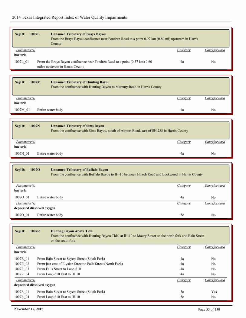
2014 Texas Integrated Report Index of Water Quality Impairments
SegID: 1007L Unnamed Tributary of Brays Bayou
From the Brays Bayou confluence near Fondren Road to a point 0.97 km (0.60 mi) upstream in Harris
County
CarryforwardCategoryParameter(s)
bacteria
1007L_01 From the Brays Bayou confluence near Fondren Road to a point (0.37 km) 0.60
miles upstream in Harris County
4a No
SegID: 1007M Unnamed Tributary of Hunting Bayou
From the confluence with Hunting Bayou to Mercury Road in Harris County
CarryforwardCategoryParameter(s)
bacteria
1007M_01 Entire water body 4a No
SegID: 1007N Unnamed Tributary of Sims Bayou
From the confluence with Sims Bayou, south of Airport Road, east of SH 288 in Harris County
CarryforwardCategoryParameter(s)
bacteria
1007N_01 Entire water body 4a No
SegID: 1007O Unnamed Tributary of Buffalo Bayou
From the confluence with Buffalo Bayou to IH-10 between Hirsch Road and Lockwood in Harris County
CarryforwardCategoryParameter(s)
bacteria
1007O_01 Entire water body 4a No
CarryforwardCategoryParameter(s)
depressed dissolved oxygen
1007O_01 Entire water body 5c No
SegID: 1007R Hunting Bayou Above Tidal
From the confluence with Hunting Bayou Tidal at IH-10 to Maury Street on the north fork and Bain Street
on the south fork
CarryforwardCategoryParameter(s)
bacteria
1007R_01 From Bain Street to Sayers Street (South Fork) 4a No
1007R_02 From just east of Elysian Street to Falls Street (North Fork) 4a No
1007R_03 From Falls Street to Loop 610 4a No
1007R_04 From Loop 610 East to IH 10 4a No
CarryforwardCategoryParameter(s)
depressed dissolved oxygen
1007R_01 From Bain Street to Sayers Street (South Fork) 5c Yes
1007R_04 From Loop 610 East to IH 10 5c No
Page 55 of 130November 19, 2015
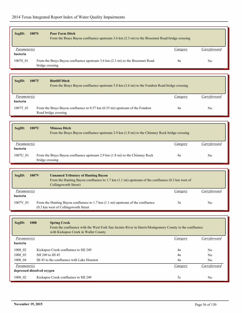
2014 Texas Integrated Report Index of Water Quality Impairments
SegID: 1007S Poor Farm Ditch
From the Brays Bayou confluence upstream 3.6 km (2.3 mi) to the Bissonnet Road bridge crossing
CarryforwardCategoryParameter(s)
bacteria
1007S_01 From the Brays Bayou confluence upstream 3.6 km (2.3 mi) to the Bissonnet Road
bridge crossing
4a No
SegID: 1007T Bintliff Ditch
From the Brays Bayou confluence upstream 5.8 km (3.6 mi) to the Fondren Road bridge crossing
CarryforwardCategoryParameter(s)
bacteria
1007T_01 From the Brays Bayou confluence to 0.57 km (0.35 mi) upstream of the Fondren
Road bridge crossing
4a No
SegID: 1007U Mimosa Ditch
From the Brays Bayou confluence upstream 2.9 km (1.8 mi) to the Chimney Rock bridge crossing
CarryforwardCategoryParameter(s)
bacteria
1007U_01 From the Brays Bayou confluence upstream 2.9 km (1.8 mi) to the Chimney Rock
bridge crossing
4a No
SegID: 1007V Unnamed Tributary of Hunting Bayou
From the Hunting Bayou confluence to 1.7 km (1.1 mi) upstream of the confluence (0.3 km west of
Collingsworth Street)
CarryforwardCategoryParameter(s)
bacteria
1007V_01 From the Hunting Bayou confluence to 1.7 km (1.1 mi) upstream of the confluence
(0.3 km west of Collingsworth Street
5a No
SegID: 1008 Spring Creek
From the confluence with the West Fork San Jacinto River in Harris/Montgomery County to the confluence
with Kickapoo Creek in Waller County
CarryforwardCategoryParameter(s)
bacteria
1008_02 Kickapoo Creek confluence to SH 249 4a No
1008_03 SH 249 to IH 45 4a No
1008_04 IH 45 to the confluence with Lake Houston 4a No
CarryforwardCategoryParameter(s)
depressed dissolved oxygen
1008_02 Kickapoo Creek confluence to SH 249 5c No
Page 56 of 130November 19, 2015
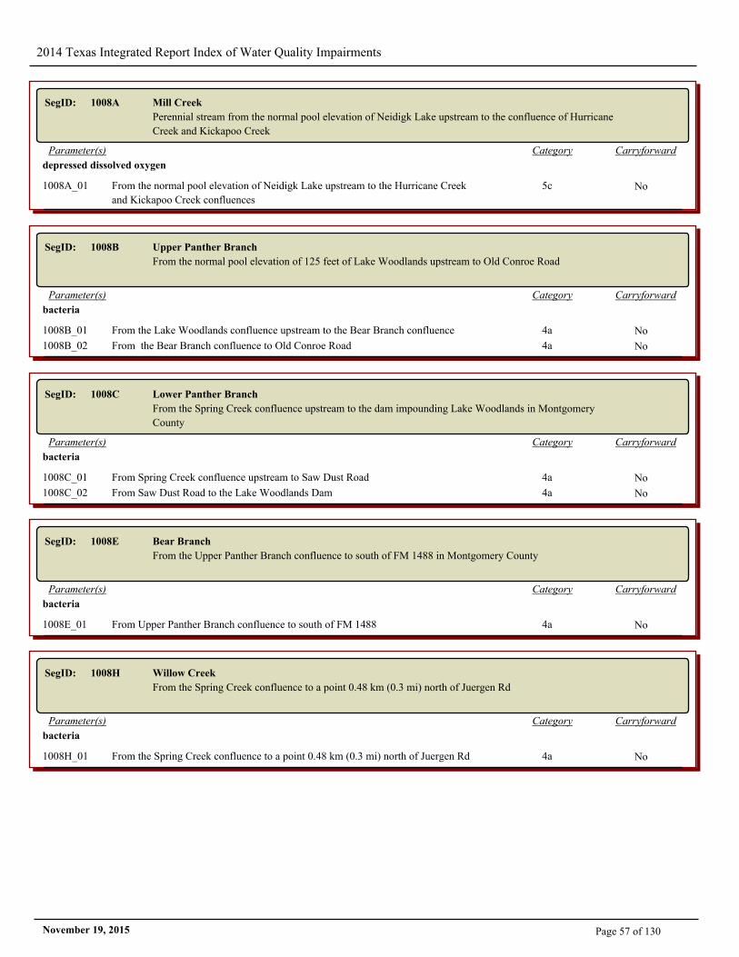
2014 Texas Integrated Report Index of Water Quality Impairments
SegID: 1008A Mill Creek
Perennial stream from the normal pool elevation of Neidigk Lake upstream to the confluence of Hurricane
Creek and Kickapoo Creek
CarryforwardCategoryParameter(s)
depressed dissolved oxygen
1008A_01 From the normal pool elevation of Neidigk Lake upstream to the Hurricane Creek
and Kickapoo Creek confluences
5c No
SegID: 1008B Upper Panther Branch
From the normal pool elevation of 125 feet of Lake Woodlands upstream to Old Conroe Road
CarryforwardCategoryParameter(s)
bacteria
1008B_01 From the Lake Woodlands confluence upstream to the Bear Branch confluence 4a No
1008B_02 From the Bear Branch confluence to Old Conroe Road 4a No
SegID: 1008C Lower Panther Branch
From the Spring Creek confluence upstream to the dam impounding Lake Woodlands in Montgomery
County
CarryforwardCategoryParameter(s)
bacteria
1008C_01 From Spring Creek confluence upstream to Saw Dust Road 4a No
1008C_02 From Saw Dust Road to the Lake Woodlands Dam 4a No
SegID: 1008E Bear Branch
From the Upper Panther Branch confluence to south of FM 1488 in Montgomery County
CarryforwardCategoryParameter(s)
bacteria
1008E_01 From Upper Panther Branch confluence to south of FM 1488 4a No
SegID: 1008H Willow Creek
From the Spring Creek confluence to a point 0.48 km (0.3 mi) north of Juergen Rd
CarryforwardCategoryParameter(s)
bacteria
1008H_01 From the Spring Creek confluence to a point 0.48 km (0.3 mi) north of Juergen Rd 4a No
Page 57 of 130November 19, 2015
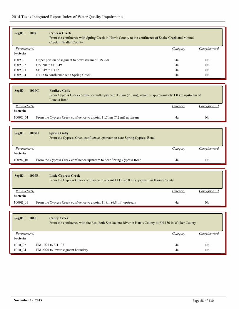
2014 Texas Integrated Report Index of Water Quality Impairments
SegID: 1009 Cypress Creek
From the confluence with Spring Creek in Harris County to the confluence of Snake Creek and Mound
Creek in Waller County
CarryforwardCategoryParameter(s)
bacteria
1009_01 Upper portion of segment to downstream of US 290 4a No
1009_02 US 290 to SH 249 4a No
1009_03 SH 249 to IH 45 4a No
1009_04 IH 45 to confluence with Spring Creek 4a No
SegID: 1009C Faulkey Gully
From Cypress Creek confluence with upstream 3.2 km (2.0 mi), which is approximately 1.0 km upstream of
Louetta Road
CarryforwardCategoryParameter(s)
bacteria
1009C_01 From the Cypress Creek confluence to a point 11.7 km (7.2 mi) upstream 4a No
SegID: 1009D Spring Gully
From the Cypress Creek confluence upstream to near Spring Cypress Road
CarryforwardCategoryParameter(s)
bacteria
1009D_01 From the Cypress Creek confluence upstream to near Spring Cypress Road 4a No
SegID: 1009E Little Cypress Creek
From the Cypress Creek confluence to a point 11 km (6.8 mi) upstream in Harris County
CarryforwardCategoryParameter(s)
bacteria
1009E_01 From the Cypress Creek confluence to a point 11 km (6.8 mi) upstream 4a No
SegID: 1010 Caney Creek
From the confluence with the East Fork San Jacinto River in Harris County to SH 150 in Walker County
CarryforwardCategoryParameter(s)
bacteria
1010_02 FM 1097 to SH 105 4a No
1010_04 FM 2090 to lower segment boundary 4a No
Page 58 of 130November 19, 2015
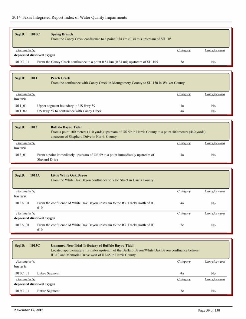
2014 Texas Integrated Report Index of Water Quality Impairments
SegID: 1010C Spring Branch
From the Caney Creek confluence to a point 0.54 km (0.34 mi) upstream of SH 105
CarryforwardCategoryParameter(s)
depressed dissolved oxygen
1010C_01 From the Caney Creek confluence to a point 0.54 km (0.34 mi) upstream of SH 105 5c No
SegID: 1011 Peach Creek
From the confluence with Caney Creek in Montgomery County to SH 150 in Walker County
CarryforwardCategoryParameter(s)
bacteria
1011_01 Upper segment boundary to US Hwy 59 4a No
1011_02 US Hwy 59 to confluence with Caney Creek 4a No
SegID: 1013 Buffalo Bayou Tidal
From a point 100 meters (110 yards) upstream of US 59 in Harris County to a point 400 meters (440 yards)
upstream of Shepherd Drive in Harris County
CarryforwardCategoryParameter(s)
bacteria
1013_01 From a point immediately upstream of US 59 to a point immediately upstream of
Shepard Drive
4a No
SegID: 1013A Little White Oak Bayou
From the White Oak Bayou confluence to Yale Street in Harris County
CarryforwardCategoryParameter(s)
bacteria
1013A_01 From the confluence of White Oak Bayou upstream to the RR Tracks north of IH
610
4a No
CarryforwardCategoryParameter(s)
depressed dissolved oxygen
1013A_01 From the confluence of White Oak Bayou upstream to the RR Tracks north of IH
610
5c No
SegID: 1013C Unnamed Non-Tidal Tributary of Buffalo Bayou Tidal
Located approximately 1.8 miles upstream of the Buffalo Bayou/White Oak Bayou confluence between
IH-10 and Memorial Drive west of IH-45 in Harris County
CarryforwardCategoryParameter(s)
bacteria
1013C_01 Entire Segment 4a No
CarryforwardCategoryParameter(s)
depressed dissolved oxygen
1013C_01 Entire Segment 5c No
Page 59 of 130November 19, 2015
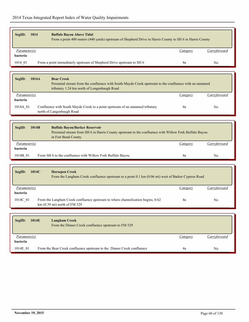
2014 Texas Integrated Report Index of Water Quality Impairments
SegID: 1014 Buffalo Bayou Above Tidal
From a point 400 meters (440 yards) upstream of Shepherd Drive in Harris County to SH 6 in Harris County
CarryforwardCategoryParameter(s)
bacteria
1014_01 From a point immediately upstream of Shepherd Drive upstream to SH 6 4a No
SegID: 1014A Bear Creek
Perennial stream from the confluence with South Mayde Creek upstream to the confluence with an unnamed
tributary 1.24 km north of Longenbaugh Road
CarryforwardCategoryParameter(s)
bacteria
1014A_01 Confluence with South Mayde Creek to a point upstream of an unnamed tributary
north of Langenbaugh Road
4a No
SegID: 1014B Buffalo Bayou/Barker Reservoir
Perennial stream from SH 6 in Harris County upstream to the confluence with Willow Fork Buffalo Bayou
in Fort Bend County
CarryforwardCategoryParameter(s)
bacteria
1014B_01 From SH 6 to the confluence with Willow Fork Buffalo Bayou 4a No
SegID: 1014C Horsepen Creek
From the Langham Creek confluence upstream to a point 0.1 km (0.06 mi) west of Barker Cypress Road
CarryforwardCategoryParameter(s)
bacteria
1014C_01 From the Langham Creek confluence upstream to where channelization begins, 0.62
km (0.39 mi) north of FM 529
4a No
SegID: 1014E Langham Creek
From the Dinner Creek confluence upstream to FM 529
CarryforwardCategoryParameter(s)
bacteria
1014E_01 From the Bear Creek confluence upstream to the Dinner Creek confluence 4a No
Page 60 of 130November 19, 2015
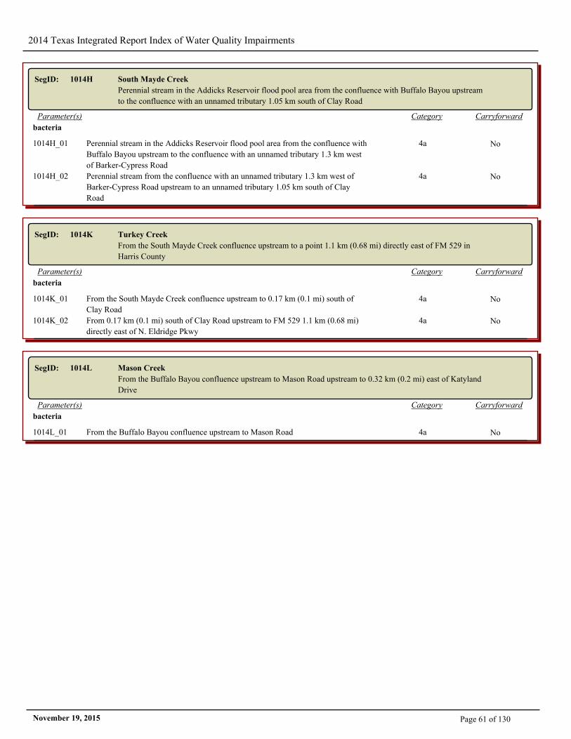
2014 Texas Integrated Report Index of Water Quality Impairments
SegID: 1014H South Mayde Creek
Perennial stream in the Addicks Reservoir flood pool area from the confluence with Buffalo Bayou upstream
to the confluence with an unnamed tributary 1.05 km south of Clay Road
CarryforwardCategoryParameter(s)
bacteria
1014H_01 Perennial stream in the Addicks Reservoir flood pool area from the confluence with
Buffalo Bayou upstream to the confluence with an unnamed tributary 1.3 km west
of Barker-Cypress Road
4a No
1014H_02 Perennial stream from the confluence with an unnamed tributary 1.3 km west of
Barker-Cypress Road upstream to an unnamed tributary 1.05 km south of Clay
Road
4a No
SegID: 1014K Turkey Creek
From the South Mayde Creek confluence upstream to a point 1.1 km (0.68 mi) directly east of FM 529 in
Harris County
CarryforwardCategoryParameter(s)
bacteria
1014K_01 From the South Mayde Creek confluence upstream to 0.17 km (0.1 mi) south of
Clay Road
4a No
1014K_02 From 0.17 km (0.1 mi) south of Clay Road upstream to FM 529 1.1 km (0.68 mi)
directly east of N. Eldridge Pkwy
4a No
SegID: 1014L Mason Creek
From the Buffalo Bayou confluence upstream to Mason Road upstream to 0.32 km (0.2 mi) east of Katyland
Drive
CarryforwardCategoryParameter(s)
bacteria
1014L_01 From the Buffalo Bayou confluence upstream to Mason Road 4a No
Page 61 of 130November 19, 2015
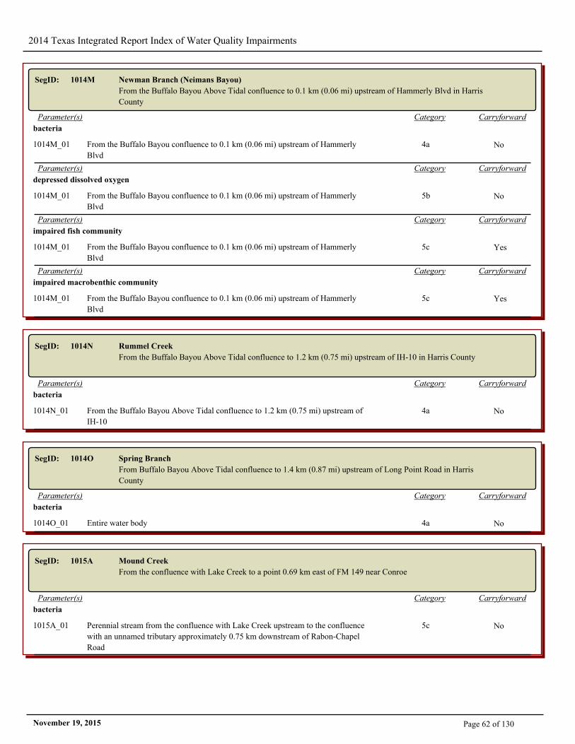
2014 Texas Integrated Report Index of Water Quality Impairments
SegID: 1014M Newman Branch (Neimans Bayou)
From the Buffalo Bayou Above Tidal confluence to 0.1 km (0.06 mi) upstream of Hammerly Blvd in Harris
County
CarryforwardCategoryParameter(s)
bacteria
1014M_01 From the Buffalo Bayou confluence to 0.1 km (0.06 mi) upstream of Hammerly
Blvd
4a No
CarryforwardCategoryParameter(s)
depressed dissolved oxygen
1014M_01 From the Buffalo Bayou confluence to 0.1 km (0.06 mi) upstream of Hammerly
Blvd
5b No
CarryforwardCategoryParameter(s)
impaired fish community
1014M_01 From the Buffalo Bayou confluence to 0.1 km (0.06 mi) upstream of Hammerly
Blvd
5c Yes
CarryforwardCategoryParameter(s)
impaired macrobenthic community
1014M_01 From the Buffalo Bayou confluence to 0.1 km (0.06 mi) upstream of Hammerly
Blvd
5c Yes
SegID: 1014N Rummel Creek
From the Buffalo Bayou Above Tidal confluence to 1.2 km (0.75 mi) upstream of IH-10 in Harris County
CarryforwardCategoryParameter(s)
bacteria
1014N_01 From the Buffalo Bayou Above Tidal confluence to 1.2 km (0.75 mi) upstream of
IH-10
4a No
SegID: 1014O Spring Branch
From Buffalo Bayou Above Tidal confluence to 1.4 km (0.87 mi) upstream of Long Point Road in Harris
County
CarryforwardCategoryParameter(s)
bacteria
1014O_01 Entire water body 4a No
SegID: 1015A Mound Creek
From the confluence with Lake Creek to a point 0.69 km east of FM 149 near Conroe
CarryforwardCategoryParameter(s)
bacteria
1015A_01 Perennial stream from the confluence with Lake Creek upstream to the confluence
with an unnamed tributary approximately 0.75 km downstream of Rabon-Chapel
Road
5c No
Page 62 of 130November 19, 2015
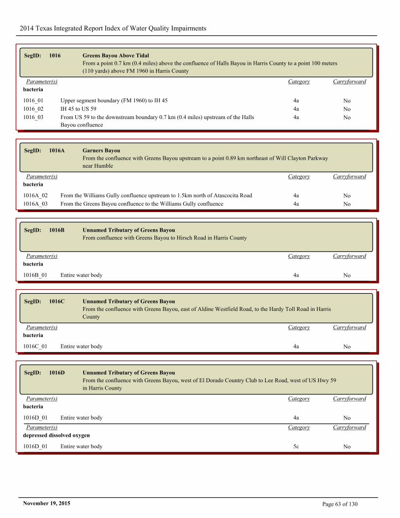
2014 Texas Integrated Report Index of Water Quality Impairments
SegID: 1016 Greens Bayou Above Tidal
From a point 0.7 km (0.4 miles) above the confluence of Halls Bayou in Harris County to a point 100 meters
(110 yards) above FM 1960 in Harris County
CarryforwardCategoryParameter(s)
bacteria
1016_01 Upper segment boundary (FM 1960) to IH 45 4a No
1016_02 IH 45 to US 59 4a No
1016_03 From US 59 to the downstream boundary 0.7 km (0.4 miles) upstream of the Halls
Bayou confluence
4a No
SegID: 1016A Garners Bayou
From the confluence with Greens Bayou upstream to a point 0.89 km northeast of Will Clayton Parkway
near Humble
CarryforwardCategoryParameter(s)
bacteria
1016A_02 From the Williams Gully confluence upstream to 1.5km north of Atascocita Road 4a No
1016A_03 From the Greens Bayou confluence to the Williams Gully confluence 4a No
SegID: 1016B Unnamed Tributary of Greens Bayou
From confluence with Greens Bayou to Hirsch Road in Harris County
CarryforwardCategoryParameter(s)
bacteria
1016B_01 Entire water body 4a No
SegID: 1016C Unnamed Tributary of Greens Bayou
From the confluence with Greens Bayou, east of Aldine Westfield Road, to the Hardy Toll Road in Harris
County
CarryforwardCategoryParameter(s)
bacteria
1016C_01 Entire water body 4a No
SegID: 1016D Unnamed Tributary of Greens Bayou
From the confluence with Greens Bayou, west of El Dorado Country Club to Lee Road, west of US Hwy 59
in Harris County
CarryforwardCategoryParameter(s)
bacteria
1016D_01 Entire water body 4a No
CarryforwardCategoryParameter(s)
depressed dissolved oxygen
1016D_01 Entire water body 5c No
Page 63 of 130November 19, 2015

2014 Texas Integrated Report Index of Water Quality Impairments
SegID: 1017 Whiteoak Bayou Above Tidal
From a point immediately upstream of the confluence of Little White Oak Bayou in Harris County to a point
3.0 km (1.9 miles) upstream of FM 1960 in Harris County
CarryforwardCategoryParameter(s)
bacteria
1017_01 Huffmeister Rd to the confluence with Vogel Creek 4a No
1017_02 Vogel Creek to the Cole Creek confluence 4a No
1017_03 Cole Creek confluence to the Brickhouse Gully confluence 4a No
1017_04 From Brickhouse Gully confluence to a point immediately upstream of the
confluence of Little White Oak Bayou in Harris Co. (lower segment boundary).
4a No
SegID: 1017A Brickhouse Gully/Bayou
Perennial stream from the confluence with Whiteoak Bayou up to Gessner Road
CarryforwardCategoryParameter(s)
bacteria
1017A_01 Entire water body 4a No
SegID: 1017B Cole Creek
Perennial stream from the confluence with White Oak Bayou up to south of Beltway 8
CarryforwardCategoryParameter(s)
bacteria
1017B_02 From Flintlock Street to confluence with White Oak Bayou 4a No
SegID: 1017C Vogel Creek
From the White Oak Bayou Above Tidal confluence to a point 3.2 km (2.0 mi) upstream of the White Oak
Bayou confluence to just south of State Hwy 249 in Harris County
CarryforwardCategoryParameter(s)
bacteria
1017C_01 From the White Oak Bayou confluence to a point 3.2 km (2.0 mi) upstream 4a No
SegID: 1017D Unnamed Tributary of Whiteoak Bayou
From the confluence with White Oak Bayou downstream of TC Jester, to Hempstead Hwy, north of US
Hwy 290 in Harris County
CarryforwardCategoryParameter(s)
bacteria
1017D_01 Entire water body 4a No
CarryforwardCategoryParameter(s)
depressed dissolved oxygen
1017D_01 Entire water body 5c Yes
Page 64 of 130November 19, 2015
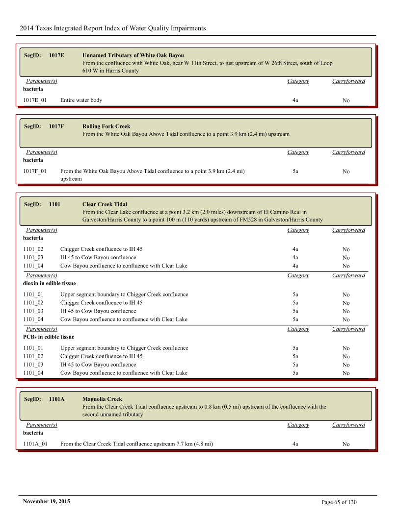
2014 Texas Integrated Report Index of Water Quality Impairments
SegID: 1017E Unnamed Tributary of White Oak Bayou
From the confluence with White Oak, near W 11th Street, to just upstream of W 26th Street, south of Loop
610 W in Harris County
CarryforwardCategoryParameter(s)
bacteria
1017E_01 Entire water body 4a No
SegID: 1017F Rolling Fork Creek
From the White Oak Bayou Above Tidal confluence to a point 3.9 km (2.4 mi) upstream
CarryforwardCategoryParameter(s)
bacteria
1017F_01 From the White Oak Bayou Above Tidal confluence to a point 3.9 km (2.4 mi)
upstream
5a No
SegID: 1101 Clear Creek Tidal
From the Clear Lake confluence at a point 3.2 km (2.0 miles) downstream of El Camino Real in
Galveston/Harris County to a point 100 m (110 yards) upstream of FM528 in Galveston/Harris County
CarryforwardCategoryParameter(s)
bacteria
1101_02 Chigger Creek confluence to IH 45 4a No
1101_03 IH 45 to Cow Bayou confluence 4a No
1101_04 Cow Bayou confluence to confluence with Clear Lake 4a No
CarryforwardCategoryParameter(s)
dioxin in edible tissue
1101_01 Upper segment boundary to Chigger Creek confluence 5a No
1101_02 Chigger Creek confluence to IH 45 5a No
1101_03 IH 45 to Cow Bayou confluence 5a No
1101_04 Cow Bayou confluence to confluence with Clear Lake 5a No
CarryforwardCategoryParameter(s)
PCBs in edible tissue
1101_01 Upper segment boundary to Chigger Creek confluence 5a No
1101_02 Chigger Creek confluence to IH 45 5a No
1101_03 IH 45 to Cow Bayou confluence 5a No
1101_04 Cow Bayou confluence to confluence with Clear Lake 5a No
SegID: 1101A Magnolia Creek
From the Clear Creek Tidal confluence upstream to 0.8 km (0.5 mi) upstream of the confluence with the
second unnamed tributary
CarryforwardCategoryParameter(s)
bacteria
1101A_01 From the Clear Creek Tidal confluence upstream 7.7 km (4.8 mi) 4a No
Page 65 of 130November 19, 2015
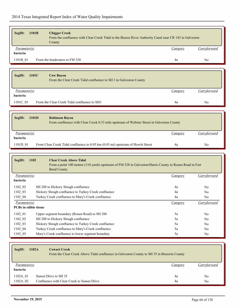
2014 Texas Integrated Report Index of Water Quality Impairments
SegID: 1101B Chigger Creek
From the confluence with Clear Creek Tidal to the Brazos River Authority Canal near CR 143 in Galveston
County
CarryforwardCategoryParameter(s)
bacteria
1101B_01 From the headwaters to FM 528 4a No
SegID: 1101C Cow Bayou
From the Clear Creek Tidal confluence to SH 3 in Galveston County
CarryforwardCategoryParameter(s)
bacteria
1101C_01 From the Clear Creek Tidal confluence to SH3 4a No
SegID: 1101D Robinson Bayou
From confluence with Clear Creek 0.33 mile upstream of Webster Street in Galveston County
CarryforwardCategoryParameter(s)
bacteria
1101D_01 From Clear Creek Tidal confluence to 0.05 km (0.03 mi) upstream of Hewitt Street 4a No
SegID: 1102 Clear Creek Above Tidal
From a point 100 meters (110 yards) upstream of FM 528 in Galveston/Harris County to Rouen Road in Fort
Bend County
CarryforwardCategoryParameter(s)
bacteria
1102_02 SH 288 to Hickory Slough confluence 4a No
1102_03 Hickory Slough confluence to Turkey Creek confluence 4a No
1102_04 Turkey Creek confluence to Mary's Creek confluence 4a No
CarryforwardCategoryParameter(s)
PCBs in edible tissue
1102_01 Upper segment boundary (Rouen Road) to SH 288 5a No
1102_02 SH 288 to Hickory Slough confluence 5a No
1102_03 Hickory Slough confluence to Turkey Creek confluence 5a No
1102_04 Turkey Creek confluence to Mary's Creek confluence 5a No
1102_05 Mary's Creek confluence to lower segment boundary 5a No
SegID: 1102A Cowart Creek
From the Clear Creek Above Tidal confluence in Galveston County to SH 35 in Brazoria County
CarryforwardCategoryParameter(s)
bacteria
1102A_01 Sunset Drive to SH 35 4a No
1102A_02 Confluence with Clear Creek to Sunset Drive 4a No
Page 66 of 130November 19, 2015
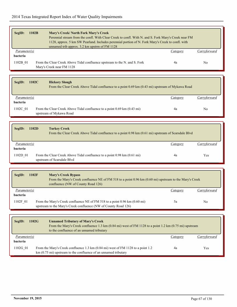
2014 Texas Integrated Report Index of Water Quality Impairments
SegID: 1102B Mary's Creek/ North Fork Mary's Creek
Perennial stream from the confl. With Clear Creek to confl. With N. and S. Fork Mary's Creek near FM
1128, approx. 5 km SW Pearland. Includes perennial portion of N. Fork Mary's Creek to confl. with
unnamed trib approx. 3.2 km upstrm of FM 1128
CarryforwardCategoryParameter(s)
bacteria
1102B_01 From the Clear Creek Above Tidal confluence upstream to the N. and S. Fork
Mary's Creek near FM 1128
4a No
SegID: 1102C Hickory Slough
From the Clear Creek Above Tidal confluence to a point 0.69 km (0.43 mi) upstream of Mykawa Road
CarryforwardCategoryParameter(s)
bacteria
1102C_01 From the Clear Creek Above Tidal confluence to a point 0.69 km (0.43 mi)
upstream of Mykawa Road
4a No
SegID: 1102D Turkey Creek
From the Clear Creek Above Tidal confluence to a point 0.98 km (0.61 mi) upstream of Scarsdale Blvd
CarryforwardCategoryParameter(s)
bacteria
1102D_01 From the Clear Creek Above Tidal confluence to a point 0.98 km (0.61 mi)
upstream of Scarsdale Blvd
4a Yes
SegID: 1102F Mary's Creek Bypass
From the Mary's Creek confluence NE of FM 518 to a point 0.96 km (0.60 mi) upstream to the Mary's Creek
confluence (NW of County Road 126)
CarryforwardCategoryParameter(s)
bacteria
1102F_01 From the Mary's Creek confluence NE of FM 518 to a point 0.96 km (0.60 mi)
upstream to the Mary's Creek confluence (NW of County Road 126)
5a No
SegID: 1102G Unnamed Tributary of Mary's Creek
From the Mary's Creek confluence 1.3 km (0.84 mi) west of FM 1128 to a point 1.2 km (0.75 mi) upstream
to the confluence of an unnamed tributary
CarryforwardCategoryParameter(s)
bacteria
1102G_01 From the Mary's Creek confluence 1.3 km (0.84 mi) west of FM 1128 to a point 1.2
km (0.75 mi) upstream to the confluence of an unnamed tributary
4a Yes
Page 67 of 130November 19, 2015
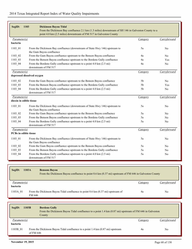
2014 Texas Integrated Report Index of Water Quality Impairments
SegID: 1103 Dickinson Bayou Tidal
From the Dickinson Bay confluence 2.1 km (1.3 miles) downstream of SH 146 in Galveston County to a
point 4.0 km (2.5 miles) downstream of FM 517 in Galveston County
CarryforwardCategoryParameter(s)
bacteria
1103_01 From the Dickinson Bay confluence (downstream of State Hwy 146) upstream to
the Gum Bayou confluence
5a No
1103_02 From the Gum Bayou confluence upstream to the Benson Bayou confluence 4a No
1103_03 From the Benson Bayou confluence upstream to the Bordens Gully confluence 4a Yes
1103_04 From the Bordens Gully confluence upstream to a point 4.0 km (2.5 mi)
downstream of FM 517
4a No
CarryforwardCategoryParameter(s)
depressed dissolved oxygen
1103_02 From the Gum Bayou confluence upstream to the Benson Bayou confluence 5b No
1103_03 From the Benson Bayou confluence upstream to the Bordens Gully confluence 5b Yes
1103_04 From the Bordens Gully confluence upstream to a point 4.0 km (2.5 mi)
downstream of FM 517
5b No
CarryforwardCategoryParameter(s)
dioxin in edible tissue
1103_01 From the Dickinson Bay confluence (downstream of State Hwy 146) upstream to
the Gum Bayou confluence
5a No
1103_02 From the Gum Bayou confluence upstream to the Benson Bayou confluence 5a No
1103_03 From the Benson Bayou confluence upstream to the Bordens Gully confluence 5a No
1103_04 From the Bordens Gully confluence upstream to a point 4.0 km (2.5 mi)
downstream of FM 517
5a No
CarryforwardCategoryParameter(s)
PCBs in edible tissue
1103_01 From the Dickinson Bay confluence (downstream of State Hwy 146) upstream to
the Gum Bayou confluence
5a No
1103_02 From the Gum Bayou confluence upstream to the Benson Bayou confluence 5a No
1103_03 From the Benson Bayou confluence upstream to the Bordens Gully confluence 5a No
1103_04 From the Bordens Gully confluence upstream to a point 4.0 km (2.5 mi)
downstream of FM 517
5a No
SegID: 1103A Bensons Bayou
From the Dickinson Bayou confluence to point 0.6 km (0.37 mi) upstream of FM 646 in Galveston County
CarryforwardCategoryParameter(s)
bacteria
1103A_01 From the Dickinson Bayou Tidal confluence to point 0.6 km (0.37 mi) upstream of
FM 646
4a No
SegID: 1103B Bordens Gully
From the Dickinson Bayou Tidal confluence to a point 1.4 km (0.87 mi) upstream of FM 646 in Galveston
County
CarryforwardCategoryParameter(s)
bacteria
1103B_01 From the Dickinson Bayou Tidal confluence to a point 1.4 km (0.87 mi) upstream
of FM 646
4a No
Page 68 of 130November 19, 2015
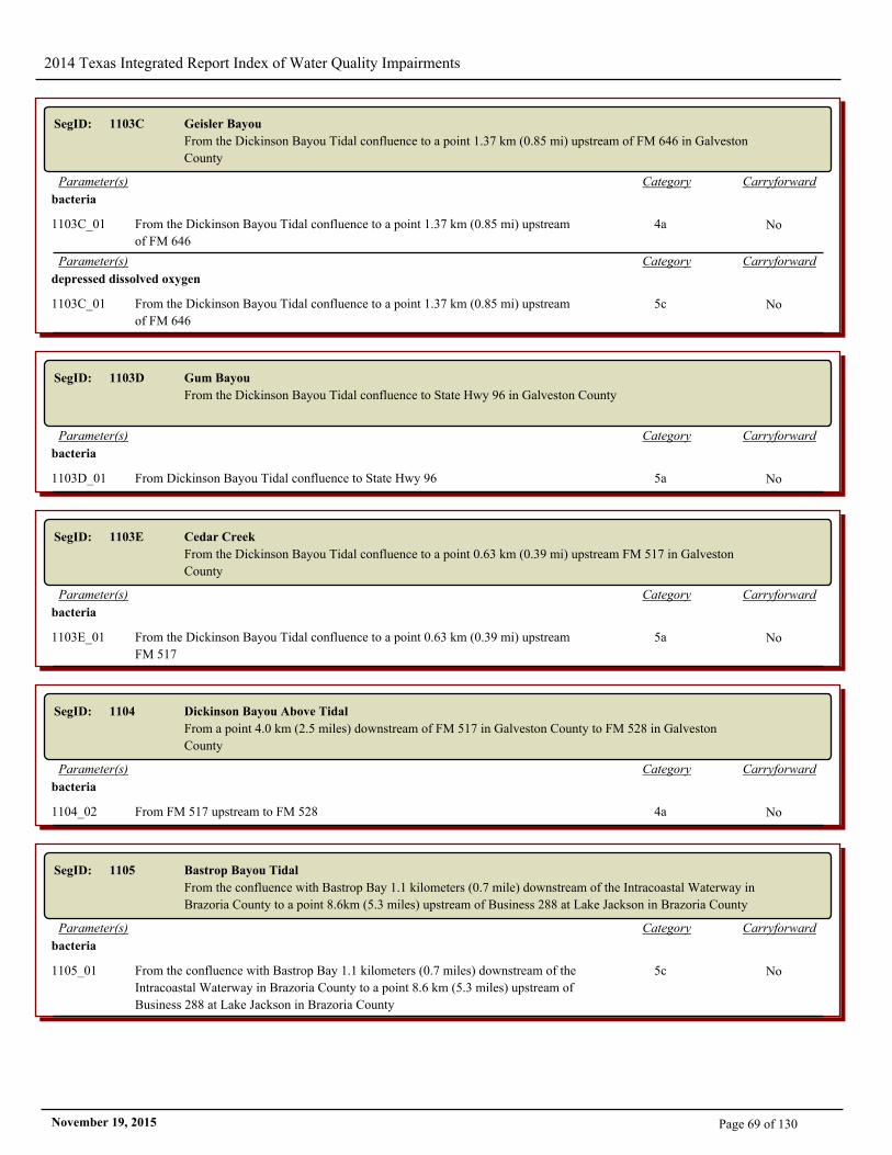
2014 Texas Integrated Report Index of Water Quality Impairments
SegID: 1103C Geisler Bayou
From the Dickinson Bayou Tidal confluence to a point 1.37 km (0.85 mi) upstream of FM 646 in Galveston
County
CarryforwardCategoryParameter(s)
bacteria
1103C_01 From the Dickinson Bayou Tidal confluence to a point 1.37 km (0.85 mi) upstream
of FM 646
4a No
CarryforwardCategoryParameter(s)
depressed dissolved oxygen
1103C_01 From the Dickinson Bayou Tidal confluence to a point 1.37 km (0.85 mi) upstream
of FM 646
5c No
SegID: 1103D Gum Bayou
From the Dickinson Bayou Tidal confluence to State Hwy 96 in Galveston County
CarryforwardCategoryParameter(s)
bacteria
1103D_01 From Dickinson Bayou Tidal confluence to State Hwy 96 5a No
SegID: 1103E Cedar Creek
From the Dickinson Bayou Tidal confluence to a point 0.63 km (0.39 mi) upstream FM 517 in Galveston
County
CarryforwardCategoryParameter(s)
bacteria
1103E_01 From the Dickinson Bayou Tidal confluence to a point 0.63 km (0.39 mi) upstream
FM 517
5a No
SegID: 1104 Dickinson Bayou Above Tidal
From a point 4.0 km (2.5 miles) downstream of FM 517 in Galveston County to FM 528 in Galveston
County
CarryforwardCategoryParameter(s)
bacteria
1104_02 From FM 517 upstream to FM 528 4a No
SegID: 1105 Bastrop Bayou Tidal
From the confluence with Bastrop Bay 1.1 kilometers (0.7 mile) downstream of the Intracoastal Waterway in
Brazoria County to a point 8.6km (5.3 miles) upstream of Business 288 at Lake Jackson in Brazoria County
CarryforwardCategoryParameter(s)
bacteria
1105_01 From the confluence with Bastrop Bay 1.1 kilometers (0.7 miles) downstream of the
Intracoastal Waterway in Brazoria County to a point 8.6 km (5.3 miles) upstream of
Business 288 at Lake Jackson in Brazoria County
5c No
Page 69 of 130November 19, 2015
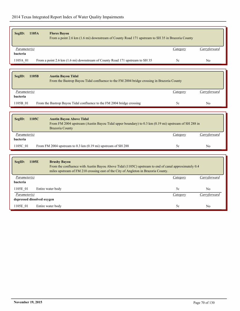
2014 Texas Integrated Report Index of Water Quality Impairments
SegID: 1105A Flores Bayou
From a point 2.6 km (1.6 mi) downstream of County Road 171 upstream to SH 35 in Brazoria County
CarryforwardCategoryParameter(s)
bacteria
1105A_01 From a point 2.6 km (1.6 mi) downstream of County Road 171 upstream to SH 35 5c No
SegID: 1105B Austin Bayou Tidal
From the Bastrop Bayou Tidal confluence to the FM 2004 bridge crossing in Brazoria County
CarryforwardCategoryParameter(s)
bacteria
1105B_01 From the Bastrop Bayou Tidal confluence to the FM 2004 bridge crossing 5c No
SegID: 1105C Austin Bayou Above Tidal
From FM 2004 upstream (Austin Bayou Tidal upper boundary) to 0.3 km (0.19 mi) upstream of SH 288 in
Brazoria County
CarryforwardCategoryParameter(s)
bacteria
1105C_01 From FM 2004 upstream to 0.3 km (0.19 mi) upstream of SH 288 5c No
SegID: 1105E Brushy Bayou
From the confluence with Austin Bayou Above Tidal (1105C) upstream to end of canal approximately 0.4
miles upstream of FM 210 crossing east of the City of Angleton in Brazoria County.
CarryforwardCategoryParameter(s)
bacteria
1105E_01 Entire water body 5c No
CarryforwardCategoryParameter(s)
depressed dissolved oxygen
1105E_01 Entire water body 5c No
Page 70 of 130November 19, 2015
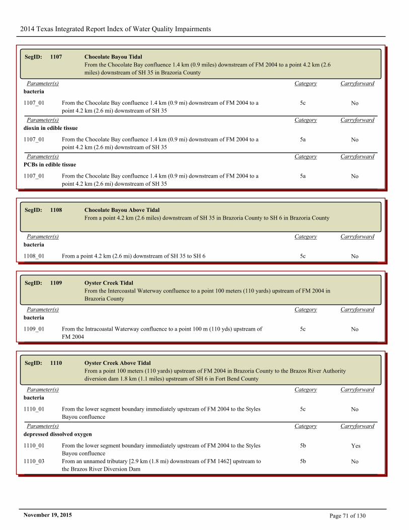
2014 Texas Integrated Report Index of Water Quality Impairments
SegID: 1107 Chocolate Bayou Tidal
From the Chocolate Bay confluence 1.4 km (0.9 miles) downstream of FM 2004 to a point 4.2 km (2.6
miles) downstream of SH 35 in Brazoria County
CarryforwardCategoryParameter(s)
bacteria
1107_01 From the Chocolate Bay confluence 1.4 km (0.9 mi) downstream of FM 2004 to a
point 4.2 km (2.6 mi) downstream of SH 35
5c No
CarryforwardCategoryParameter(s)
dioxin in edible tissue
1107_01 From the Chocolate Bay confluence 1.4 km (0.9 mi) downstream of FM 2004 to a
point 4.2 km (2.6 mi) downstream of SH 35
5a No
CarryforwardCategoryParameter(s)
PCBs in edible tissue
1107_01 From the Chocolate Bay confluence 1.4 km (0.9 mi) downstream of FM 2004 to a
point 4.2 km (2.6 mi) downstream of SH 35
5a No
SegID: 1108 Chocolate Bayou Above Tidal
From a point 4.2 km (2.6 miles) downstream of SH 35 in Brazoria County to SH 6 in Brazoria County
CarryforwardCategoryParameter(s)
bacteria
1108_01 From a point 4.2 km (2.6 mi) downstream of SH 35 to SH 6 5c No
SegID: 1109 Oyster Creek Tidal
From the Intercoastal Waterway confluence to a point 100 meters (110 yards) upstream of FM 2004 in
Brazoria County
CarryforwardCategoryParameter(s)
bacteria
1109_01 From the Intracoastal Waterway confluence to a point 100 m (110 yds) upstream of
FM 2004
5c No
SegID: 1110 Oyster Creek Above Tidal
From a point 100 meters (110 yards) upstream of FM 2004 in Brazoria County to the Brazos River Authority
diversion dam 1.8 km (1.1 miles) upstream of SH 6 in Fort Bend County
CarryforwardCategoryParameter(s)
bacteria
1110_01 From the lower segment boundary immediately upstream of FM 2004 to the Styles
Bayou confluence
5c No
CarryforwardCategoryParameter(s)
depressed dissolved oxygen
1110_01 From the lower segment boundary immediately upstream of FM 2004 to the Styles
Bayou confluence
5b Yes
1110_03 From an unnamed tributary [2.9 km (1.8 mi) downstream of FM 1462] upstream to
the Brazos River Diversion Dam
5b No
Page 71 of 130November 19, 2015
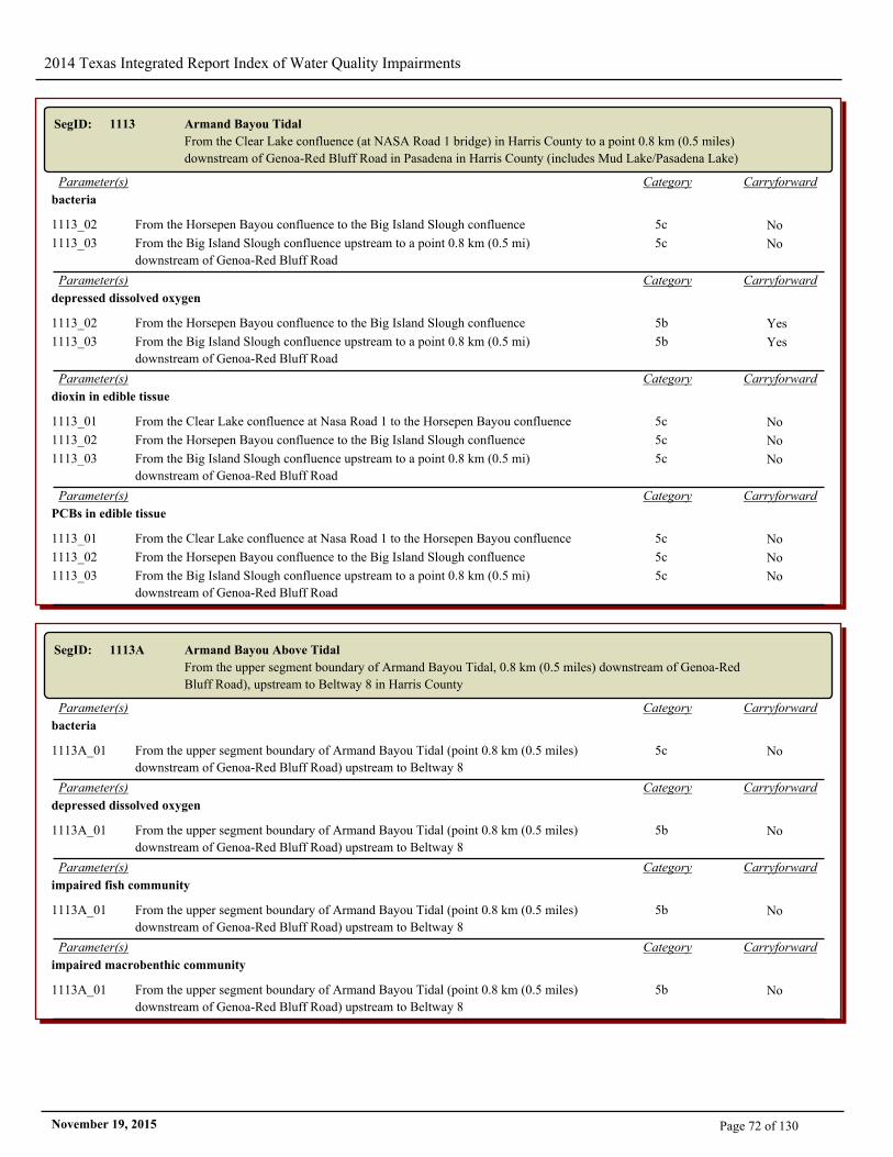
2014 Texas Integrated Report Index of Water Quality Impairments
SegID: 1113 Armand Bayou Tidal
From the Clear Lake confluence (at NASA Road 1 bridge) in Harris County to a point 0.8 km (0.5 miles)
downstream of Genoa-Red Bluff Road in Pasadena in Harris County (includes Mud Lake/Pasadena Lake)
CarryforwardCategoryParameter(s)
bacteria
1113_02 From the Horsepen Bayou confluence to the Big Island Slough confluence 5c No
1113_03 From the Big Island Slough confluence upstream to a point 0.8 km (0.5 mi)
downstream of Genoa-Red Bluff Road
5c No
CarryforwardCategoryParameter(s)
depressed dissolved oxygen
1113_02 From the Horsepen Bayou confluence to the Big Island Slough confluence 5b Yes
1113_03 From the Big Island Slough confluence upstream to a point 0.8 km (0.5 mi)
downstream of Genoa-Red Bluff Road
5b Yes
CarryforwardCategoryParameter(s)
dioxin in edible tissue
1113_01 From the Clear Lake confluence at Nasa Road 1 to the Horsepen Bayou confluence 5c No
1113_02 From the Horsepen Bayou confluence to the Big Island Slough confluence 5c No
1113_03 From the Big Island Slough confluence upstream to a point 0.8 km (0.5 mi)
downstream of Genoa-Red Bluff Road
5c No
CarryforwardCategoryParameter(s)
PCBs in edible tissue
1113_01 From the Clear Lake confluence at Nasa Road 1 to the Horsepen Bayou confluence 5c No
1113_02 From the Horsepen Bayou confluence to the Big Island Slough confluence 5c No
1113_03 From the Big Island Slough confluence upstream to a point 0.8 km (0.5 mi)
downstream of Genoa-Red Bluff Road
5c No
SegID: 1113A Armand Bayou Above Tidal
From the upper segment boundary of Armand Bayou Tidal, 0.8 km (0.5 miles) downstream of Genoa-Red
Bluff Road), upstream to Beltway 8 in Harris County
CarryforwardCategoryParameter(s)
bacteria
1113A_01 From the upper segment boundary of Armand Bayou Tidal (point 0.8 km (0.5 miles)
downstream of Genoa-Red Bluff Road) upstream to Beltway 8
5c No
CarryforwardCategoryParameter(s)
depressed dissolved oxygen
1113A_01 From the upper segment boundary of Armand Bayou Tidal (point 0.8 km (0.5 miles)
downstream of Genoa-Red Bluff Road) upstream to Beltway 8
5b No
CarryforwardCategoryParameter(s)
impaired fish community
1113A_01 From the upper segment boundary of Armand Bayou Tidal (point 0.8 km (0.5 miles)
downstream of Genoa-Red Bluff Road) upstream to Beltway 8
5b No
CarryforwardCategoryParameter(s)
impaired macrobenthic community
1113A_01 From the upper segment boundary of Armand Bayou Tidal (point 0.8 km (0.5 miles)
downstream of Genoa-Red Bluff Road) upstream to Beltway 8
5b No
Page 72 of 130November 19, 2015
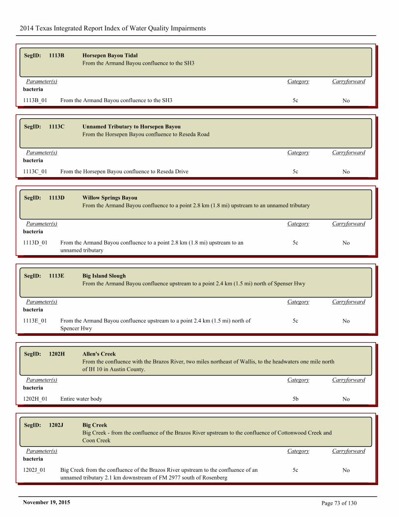
2014 Texas Integrated Report Index of Water Quality Impairments
SegID: 1113B Horsepen Bayou Tidal
From the Armand Bayou confluence to the SH3
CarryforwardCategoryParameter(s)
bacteria
1113B_01 From the Armand Bayou confluence to the SH3 5c No
SegID: 1113C Unnamed Tributary to Horsepen Bayou
From the Horsepen Bayou confluence to Reseda Road
CarryforwardCategoryParameter(s)
bacteria
1113C_01 From the Horsepen Bayou confluence to Reseda Drive 5c No
SegID: 1113D Willow Springs Bayou
From the Armand Bayou confluence to a point 2.8 km (1.8 mi) upstream to an unnamed tributary
CarryforwardCategoryParameter(s)
bacteria
1113D_01 From the Armand Bayou confluence to a point 2.8 km (1.8 mi) upstream to an
unnamed tributary
5c No
SegID: 1113E Big Island Slough
From the Armand Bayou confluence upstream to a point 2.4 km (1.5 mi) north of Spenser Hwy
CarryforwardCategoryParameter(s)
bacteria
1113E_01 From the Armand Bayou confluence upstream to a point 2.4 km (1.5 mi) north of
Spencer Hwy
5c No
SegID: 1202H Allen's Creek
From the confluence with the Brazos River, two miles northeast of Wallis, to the headwaters one mile north
of IH 10 in Austin County.
CarryforwardCategoryParameter(s)
bacteria
1202H_01 Entire water body 5b No
SegID: 1202J Big Creek
Big Creek - from the confluence of the Brazos River upstream to the confluence of Cottonwood Creek and
Coon Creek
CarryforwardCategoryParameter(s)
bacteria
1202J_01 Big Creek from the confluence of the Brazos River upstream to the confluence of an
unnamed tributary 2.1 km downstream of FM 2977 south of Rosenberg
5c No
Page 73 of 130November 19, 2015
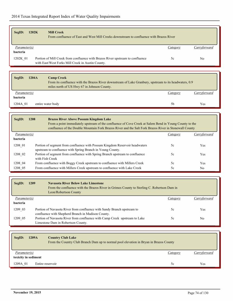
2014 Texas Integrated Report Index of Water Quality Impairments
SegID: 1202K Mill Creek
From confluence of East and West Mill Creeks downstream to confluence with Brazos River
CarryforwardCategoryParameter(s)
bacteria
1202K_01 Portion of Mill Creek from confluence with Brazos River upstream to confluence
with East/West Forks Mill Creek in Austin County.
5c No
SegID: 1204A Camp Creek
From its confluence with the Brazos River downstream of Lake Granbury, upstream to its headwaters, 0.9
miles north of US Hwy 67 in Johnson County.
CarryforwardCategoryParameter(s)
bacteria
1204A_01 entire water body 5b Yes
SegID: 1208 Brazos River Above Possum Kingdom Lake
From a point immediately upstream of the confluence of Cove Creek at Salem Bend in Young County to the
confluence of the Double Mountain Fork Brazos River and the Salt Fork Brazos River in Stonewall County
CarryforwardCategoryParameter(s)
bacteria
1208_01 Portion of segment from confluence with Possum Kingdom Reservoir headwaters
upstream to confluence with Spring Branch in Young County.
5c Yes
1208_02 Portion of segment from confluence with Spring Branch upstream to confluence
with Fish Creek
5c Yes
1208_04 From confluence with Boggy Creek upstream to confluence with Millers Creek 5c Yes
1208_05 From confluence with Millers Creek upstream to confluence with Lake Creek 5c No
SegID: 1209 Navasota River Below Lake Limestone
From the confluence with the Brazos River in Grimes County to Sterling C. Robertson Dam in
Leon/Robertson County
CarryforwardCategoryParameter(s)
bacteria
1209_03 Portion of Navasota River from confluence with Sandy Branch upstream to
confluence with Shepherd Branch in Madison County.
5c Yes
1209_05 Portion of Navasota River from confluence with Camp Creek upstream to Lake
Limestone Dam in Robertson County.
5c No
SegID: 1209A Country Club Lake
From the Country Club Branch Dam up to normal pool elevation in Bryan in Brazos County
CarryforwardCategoryParameter(s)
toxicity in sediment
1209A_01 Entire reservoir 5c Yes
Page 74 of 130November 19, 2015
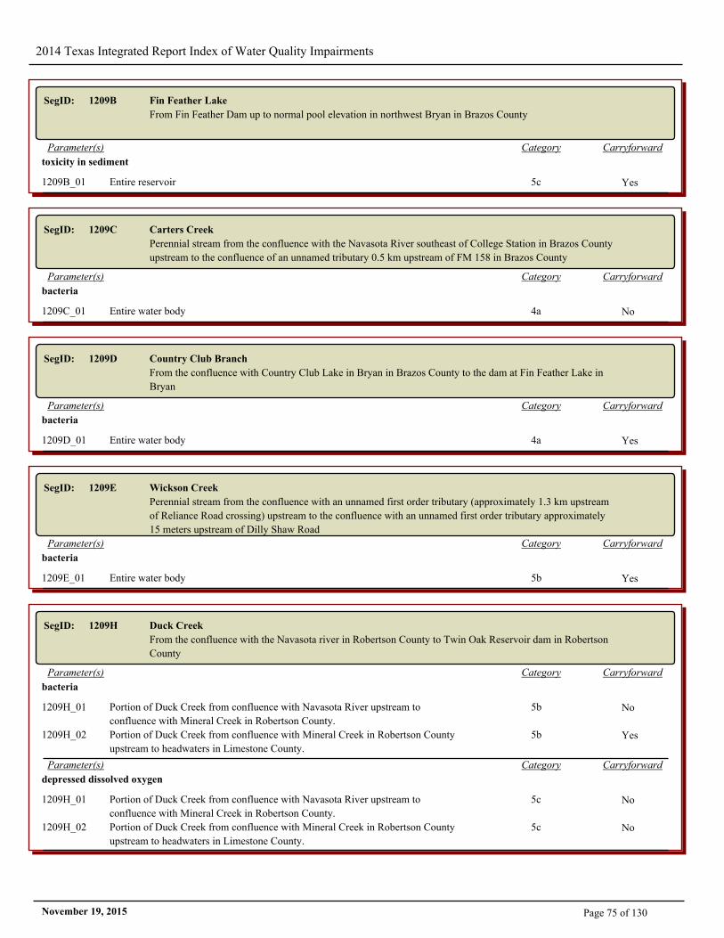
2014 Texas Integrated Report Index of Water Quality Impairments
SegID: 1209B Fin Feather Lake
From Fin Feather Dam up to normal pool elevation in northwest Bryan in Brazos County
CarryforwardCategoryParameter(s)
toxicity in sediment
1209B_01 Entire reservoir 5c Yes
SegID: 1209C Carters Creek
Perennial stream from the confluence with the Navasota River southeast of College Station in Brazos County
upstream to the confluence of an unnamed tributary 0.5 km upstream of FM 158 in Brazos County
CarryforwardCategoryParameter(s)
bacteria
1209C_01 Entire water body 4a No
SegID: 1209D Country Club Branch
From the confluence with Country Club Lake in Bryan in Brazos County to the dam at Fin Feather Lake in
Bryan
CarryforwardCategoryParameter(s)
bacteria
1209D_01 Entire water body 4a Yes
SegID: 1209E Wickson Creek
Perennial stream from the confluence with an unnamed first order tributary (approximately 1.3 km upstream
of Reliance Road crossing) upstream to the confluence with an unnamed first order tributary approximately
15 meters upstream of Dilly Shaw Road
CarryforwardCategoryParameter(s)
bacteria
1209E_01 Entire water body 5b Yes
SegID: 1209H Duck Creek
From the confluence with the Navasota river in Robertson County to Twin Oak Reservoir dam in Robertson
County
CarryforwardCategoryParameter(s)
bacteria
1209H_01 Portion of Duck Creek from confluence with Navasota River upstream to
confluence with Mineral Creek in Robertson County.
5b No
1209H_02 Portion of Duck Creek from confluence with Mineral Creek in Robertson County
upstream to headwaters in Limestone County.
5b Yes
CarryforwardCategoryParameter(s)
depressed dissolved oxygen
1209H_01 Portion of Duck Creek from confluence with Navasota River upstream to
confluence with Mineral Creek in Robertson County.
5c No
1209H_02 Portion of Duck Creek from confluence with Mineral Creek in Robertson County
upstream to headwaters in Limestone County.
5c No
Page 75 of 130November 19, 2015
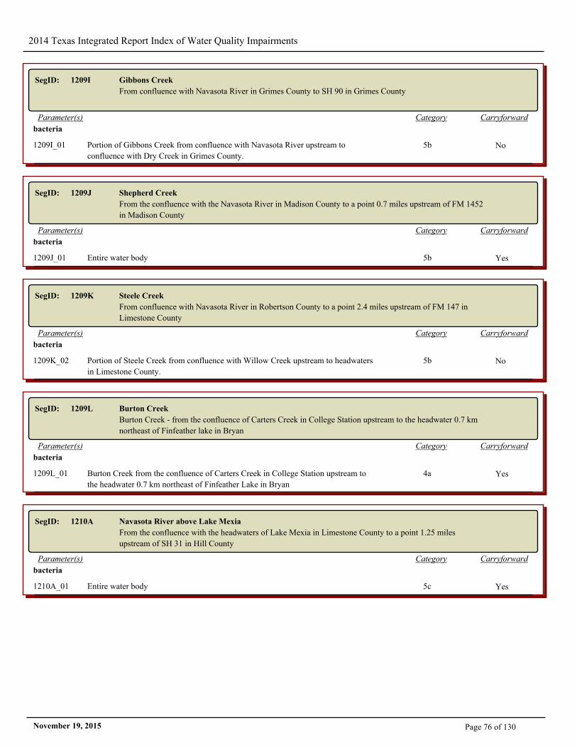
2014 Texas Integrated Report Index of Water Quality Impairments
SegID: 1209I Gibbons Creek
From confluence with Navasota River in Grimes County to SH 90 in Grimes County
CarryforwardCategoryParameter(s)
bacteria
1209I_01 Portion of Gibbons Creek from confluence with Navasota River upstream to
confluence with Dry Creek in Grimes County.
5b No
SegID: 1209J Shepherd Creek
From the confluence with the Navasota River in Madison County to a point 0.7 miles upstream of FM 1452
in Madison County
CarryforwardCategoryParameter(s)
bacteria
1209J_01 Entire water body 5b Yes
SegID: 1209K Steele Creek
From confluence with Navasota River in Robertson County to a point 2.4 miles upstream of FM 147 in
Limestone County
CarryforwardCategoryParameter(s)
bacteria
1209K_02 Portion of Steele Creek from confluence with Willow Creek upstream to headwaters
in Limestone County.
5b No
SegID: 1209L Burton Creek
Burton Creek - from the confluence of Carters Creek in College Station upstream to the headwater 0.7 km
northeast of Finfeather lake in Bryan
CarryforwardCategoryParameter(s)
bacteria
1209L_01 Burton Creek from the confluence of Carters Creek in College Station upstream to
the headwater 0.7 km northeast of Finfeather Lake in Bryan
4a Yes
SegID: 1210A Navasota River above Lake Mexia
From the confluence with the headwaters of Lake Mexia in Limestone County to a point 1.25 miles
upstream of SH 31 in Hill County
CarryforwardCategoryParameter(s)
bacteria
1210A_01 Entire water body 5c Yes
Page 76 of 130November 19, 2015
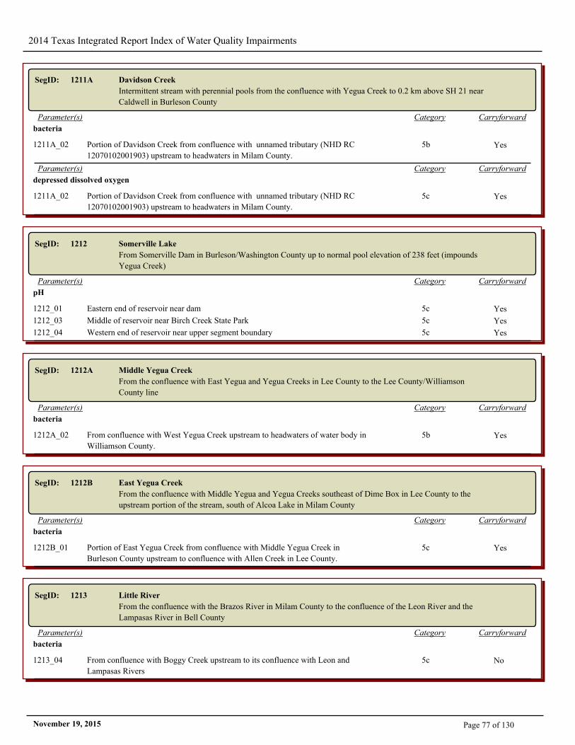
2014 Texas Integrated Report Index of Water Quality Impairments
SegID: 1211A Davidson Creek
Intermittent stream with perennial pools from the confluence with Yegua Creek to 0.2 km above SH 21 near
Caldwell in Burleson County
CarryforwardCategoryParameter(s)
bacteria
1211A_02 Portion of Davidson Creek from confluence with unnamed tributary (NHD RC
12070102001903) upstream to headwaters in Milam County.
5b Yes
CarryforwardCategoryParameter(s)
depressed dissolved oxygen
1211A_02 Portion of Davidson Creek from confluence with unnamed tributary (NHD RC
12070102001903) upstream to headwaters in Milam County.
5c Yes
SegID: 1212 Somerville Lake
From Somerville Dam in Burleson/Washington County up to normal pool elevation of 238 feet (impounds
Yegua Creek)
CarryforwardCategoryParameter(s)
pH
1212_01 Eastern end of reservoir near dam 5c Yes
1212_03 Middle of reservoir near Birch Creek State Park 5c Yes
1212_04 Western end of reservoir near upper segment boundary 5c Yes
SegID: 1212A Middle Yegua Creek
From the confluence with East Yegua and Yegua Creeks in Lee County to the Lee County/Williamson
County line
CarryforwardCategoryParameter(s)
bacteria
1212A_02 From confluence with West Yegua Creek upstream to headwaters of water body in
Williamson County.
5b Yes
SegID: 1212B East Yegua Creek
From the confluence with Middle Yegua and Yegua Creeks southeast of Dime Box in Lee County to the
upstream portion of the stream, south of Alcoa Lake in Milam County
CarryforwardCategoryParameter(s)
bacteria
1212B_01 Portion of East Yegua Creek from confluence with Middle Yegua Creek in
Burleson County upstream to confluence with Allen Creek in Lee County.
5c Yes
SegID: 1213 Little River
From the confluence with the Brazos River in Milam County to the confluence of the Leon River and the
Lampasas River in Bell County
CarryforwardCategoryParameter(s)
bacteria
1213_04 From confluence with Boggy Creek upstream to its confluence with Leon and
Lampasas Rivers
5c No
Page 77 of 130November 19, 2015
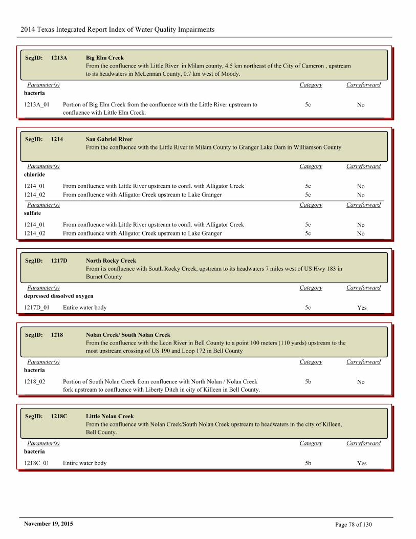
2014 Texas Integrated Report Index of Water Quality Impairments
SegID: 1213A Big Elm Creek
From the confluence with Little River in Milam county, 4.5 km northeast of the City of Cameron , upstream
to its headwaters in McLennan County, 0.7 km west of Moody.
CarryforwardCategoryParameter(s)
bacteria
1213A_01 Portion of Big Elm Creek from the confluence with the Little River upstream to
confluence with Little Elm Creek.
5c No
SegID: 1214 San Gabriel River
From the confluence with the Little River in Milam County to Granger Lake Dam in Williamson County
CarryforwardCategoryParameter(s)
chloride
1214_01 From confluence with Little River upstream to confl. with Alligator Creek 5c No
1214_02 From confluence with Alligator Creek upstream to Lake Granger 5c No
CarryforwardCategoryParameter(s)
sulfate
1214_01 From confluence with Little River upstream to confl. with Alligator Creek 5c No
1214_02 From confluence with Alligator Creek upstream to Lake Granger 5c No
SegID: 1217D North Rocky Creek
From its confluence with South Rocky Creek, upstream to its headwaters 7 miles west of US Hwy 183 in
Burnet County
CarryforwardCategoryParameter(s)
depressed dissolved oxygen
1217D_01 Entire water body 5c Yes
SegID: 1218 Nolan Creek/ South Nolan Creek
From the confluence with the Leon River in Bell County to a point 100 meters (110 yards) upstream to the
most upstream crossing of US 190 and Loop 172 in Bell County
CarryforwardCategoryParameter(s)
bacteria
1218_02 Portion of South Nolan Creek from confluence with North Nolan / Nolan Creek
fork upstream to confluence with Liberty Ditch in city of Killeen in Bell County.
5b No
SegID: 1218C Little Nolan Creek
From the confluence with Nolan Creek/South Nolan Creek upstream to headwaters in the city of Killeen,
Bell County.
CarryforwardCategoryParameter(s)
bacteria
1218C_01 Entire water body 5b Yes
Page 78 of 130November 19, 2015
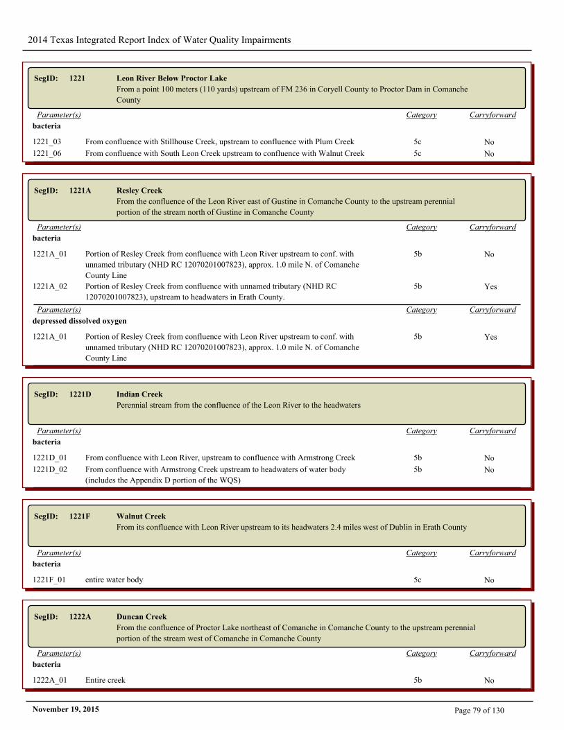
2014 Texas Integrated Report Index of Water Quality Impairments
SegID: 1221 Leon River Below Proctor Lake
From a point 100 meters (110 yards) upstream of FM 236 in Coryell County to Proctor Dam in Comanche
County
CarryforwardCategoryParameter(s)
bacteria
1221_03 From confluence with Stillhouse Creek, upstream to confluence with Plum Creek 5c No
1221_06 From confluence with South Leon Creek upstream to confluence with Walnut Creek 5c No
SegID: 1221A Resley Creek
From the confluence of the Leon River east of Gustine in Comanche County to the upstream perennial
portion of the stream north of Gustine in Comanche County
CarryforwardCategoryParameter(s)
bacteria
1221A_01 Portion of Resley Creek from confluence with Leon River upstream to conf. with
unnamed tributary (NHD RC 12070201007823), approx. 1.0 mile N. of Comanche
County Line
5b No
1221A_02 Portion of Resley Creek from confluence with unnamed tributary (NHD RC
12070201007823), upstream to headwaters in Erath County.
5b Yes
CarryforwardCategoryParameter(s)
depressed dissolved oxygen
1221A_01 Portion of Resley Creek from confluence with Leon River upstream to conf. with
unnamed tributary (NHD RC 12070201007823), approx. 1.0 mile N. of Comanche
County Line
5b Yes
SegID: 1221D Indian Creek
Perennial stream from the confluence of the Leon River to the headwaters
CarryforwardCategoryParameter(s)
bacteria
1221D_01 From confluence with Leon River, upstream to confluence with Armstrong Creek 5b No
1221D_02 From confluence with Armstrong Creek upstream to headwaters of water body
(includes the Appendix D portion of the WQS)
5b No
SegID: 1221F Walnut Creek
From its confluence with Leon River upstream to its headwaters 2.4 miles west of Dublin in Erath County
CarryforwardCategoryParameter(s)
bacteria
1221F_01 entire water body 5c No
SegID: 1222A Duncan Creek
From the confluence of Proctor Lake northeast of Comanche in Comanche County to the upstream perennial
portion of the stream west of Comanche in Comanche County
CarryforwardCategoryParameter(s)
bacteria
1222A_01 Entire creek 5b No
Page 79 of 130November 19, 2015
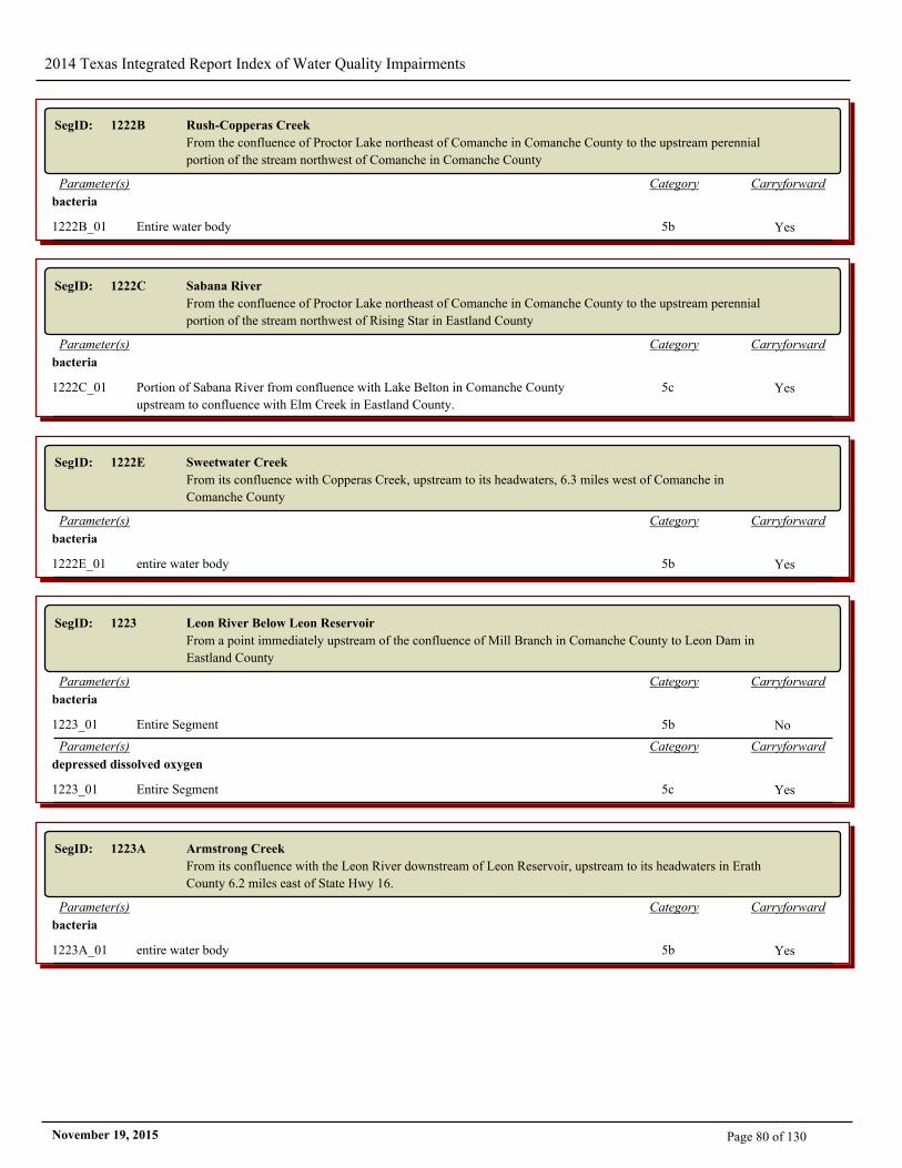
2014 Texas Integrated Report Index of Water Quality Impairments
SegID: 1222B Rush-Copperas Creek
From the confluence of Proctor Lake northeast of Comanche in Comanche County to the upstream perennial
portion of the stream northwest of Comanche in Comanche County
CarryforwardCategoryParameter(s)
bacteria
1222B_01 Entire water body 5b Yes
SegID: 1222C Sabana River
From the confluence of Proctor Lake northeast of Comanche in Comanche County to the upstream perennial
portion of the stream northwest of Rising Star in Eastland County
CarryforwardCategoryParameter(s)
bacteria
1222C_01 Portion of Sabana River from confluence with Lake Belton in Comanche County
upstream to confluence with Elm Creek in Eastland County.
5c Yes
SegID: 1222E Sweetwater Creek
From its confluence with Copperas Creek, upstream to its headwaters, 6.3 miles west of Comanche in
Comanche County
CarryforwardCategoryParameter(s)
bacteria
1222E_01 entire water body 5b Yes
SegID: 1223 Leon River Below Leon Reservoir
From a point immediately upstream of the confluence of Mill Branch in Comanche County to Leon Dam in
Eastland County
CarryforwardCategoryParameter(s)
bacteria
1223_01 Entire Segment 5b No
CarryforwardCategoryParameter(s)
depressed dissolved oxygen
1223_01 Entire Segment 5c Yes
SegID: 1223A Armstrong Creek
From its confluence with the Leon River downstream of Leon Reservoir, upstream to its headwaters in Erath
County 6.2 miles east of State Hwy 16.
CarryforwardCategoryParameter(s)
bacteria
1223A_01 entire water body 5b Yes
Page 80 of 130November 19, 2015
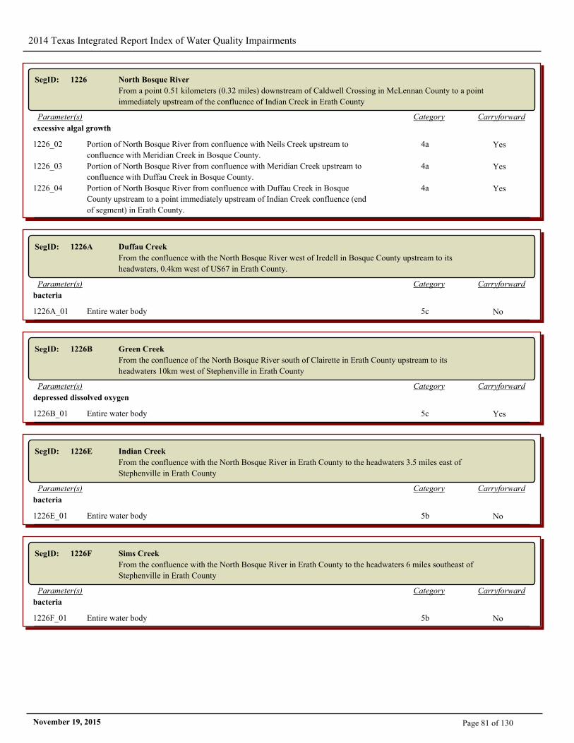
2014 Texas Integrated Report Index of Water Quality Impairments
SegID: 1226 North Bosque River
From a point 0.51 kilometers (0.32 miles) downstream of Caldwell Crossing in McLennan County to a point
immediately upstream of the confluence of Indian Creek in Erath County
CarryforwardCategoryParameter(s)
excessive algal growth
1226_02 Portion of North Bosque River from confluence with Neils Creek upstream to
confluence with Meridian Creek in Bosque County.
4a Yes
1226_03 Portion of North Bosque River from confluence with Meridian Creek upstream to
confluence with Duffau Creek in Bosque County.
4a Yes
1226_04 Portion of North Bosque River from confluence with Duffau Creek in Bosque
County upstream to a point immediately upstream of Indian Creek confluence (end
of segment) in Erath County.
4a Yes
SegID: 1226A Duffau Creek
From the confluence with the North Bosque River west of Iredell in Bosque County upstream to its
headwaters, 0.4km west of US67 in Erath County.
CarryforwardCategoryParameter(s)
bacteria
1226A_01 Entire water body 5c No
SegID: 1226B Green Creek
From the confluence of the North Bosque River south of Clairette in Erath County upstream to its
headwaters 10km west of Stephenville in Erath County
CarryforwardCategoryParameter(s)
depressed dissolved oxygen
1226B_01 Entire water body 5c Yes
SegID: 1226E Indian Creek
From the confluence with the North Bosque River in Erath County to the headwaters 3.5 miles east of
Stephenville in Erath County
CarryforwardCategoryParameter(s)
bacteria
1226E_01 Entire water body 5b No
SegID: 1226F Sims Creek
From the confluence with the North Bosque River in Erath County to the headwaters 6 miles southeast of
Stephenville in Erath County
CarryforwardCategoryParameter(s)
bacteria
1226F_01 Entire water body 5b No
Page 81 of 130November 19, 2015
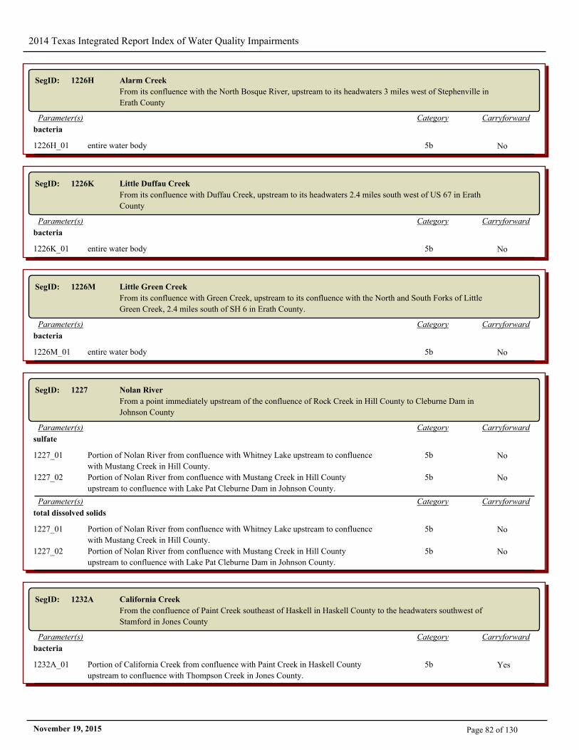
2014 Texas Integrated Report Index of Water Quality Impairments
SegID: 1226H Alarm Creek
From its confluence with the North Bosque River, upstream to its headwaters 3 miles west of Stephenville in
Erath County
CarryforwardCategoryParameter(s)
bacteria
1226H_01 entire water body 5b No
SegID: 1226K Little Duffau Creek
From its confluence with Duffau Creek, upstream to its headwaters 2.4 miles south west of US 67 in Erath
County
CarryforwardCategoryParameter(s)
bacteria
1226K_01 entire water body 5b No
SegID: 1226M Little Green Creek
From its confluence with Green Creek, upstream to its confluence with the North and South Forks of Little
Green Creek, 2.4 miles south of SH 6 in Erath County.
CarryforwardCategoryParameter(s)
bacteria
1226M_01 entire water body 5b No
SegID: 1227 Nolan River
From a point immediately upstream of the confluence of Rock Creek in Hill County to Cleburne Dam in
Johnson County
CarryforwardCategoryParameter(s)
sulfate
1227_01 Portion of Nolan River from confluence with Whitney Lake upstream to confluence
with Mustang Creek in Hill County.
5b No
1227_02 Portion of Nolan River from confluence with Mustang Creek in Hill County
upstream to confluence with Lake Pat Cleburne Dam in Johnson County.
5b No
CarryforwardCategoryParameter(s)
total dissolved solids
1227_01 Portion of Nolan River from confluence with Whitney Lake upstream to confluence
with Mustang Creek in Hill County.
5b No
1227_02 Portion of Nolan River from confluence with Mustang Creek in Hill County
upstream to confluence with Lake Pat Cleburne Dam in Johnson County.
5b No
SegID: 1232A California Creek
From the confluence of Paint Creek southeast of Haskell in Haskell County to the headwaters southwest of
Stamford in Jones County
CarryforwardCategoryParameter(s)
bacteria
1232A_01 Portion of California Creek from confluence with Paint Creek in Haskell County
upstream to confluence with Thompson Creek in Jones County.
5b Yes
Page 82 of 130November 19, 2015
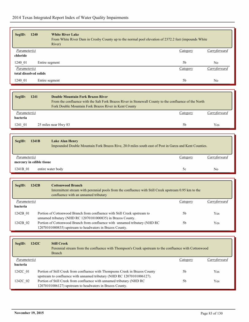
2014 Texas Integrated Report Index of Water Quality Impairments
SegID: 1240 White River Lake
From White River Dam in Crosby County up to the normal pool elevation of 2372.2 feet (impounds White
River)
CarryforwardCategoryParameter(s)
chloride
1240_01 Entire segment 5b No
CarryforwardCategoryParameter(s)
total dissolved solids
1240_01 Entire segment 5b No
SegID: 1241 Double Mountain Fork Brazos River
From the confluence with the Salt Fork Brazos River in Stonewall County to the confluence of the North
Fork Double Mountain Fork Brazos River in Kent County
CarryforwardCategoryParameter(s)
bacteria
1241_01 25 miles near Hwy 83 5b Yes
SegID: 1241B Lake Alan Henry
Impounded Double Mountain Fork Brazos Rive, 20.0 miles south east of Post in Garza and Kent Counties.
CarryforwardCategoryParameter(s)
mercury in edible tissue
1241B_01 entire water body 5c No
SegID: 1242B Cottonwood Branch
Intermittent stream with perennial pools from the confluence with Still Creek upstream 0.95 km to the
confluence with an unnamed tributary
CarryforwardCategoryParameter(s)
bacteria
1242B_01 Portion of Cottonwood Branch from confluence with Still Creek upstream to
unnamed tributary (NHD RC 12070101000835) in Brazos County.
5b Yes
1242B_02 Portion of Cottonwood Branch from confluence with unnamed tributary (NHD RC
12070101000835) upstream to headwaters in Brazos County.
5b Yes
SegID: 1242C Still Creek
Perennial stream from the confluence with Thompson's Creek upstream to the confluence with Cottonwood
Branch
CarryforwardCategoryParameter(s)
bacteria
1242C_01 Portion of Still Creek from confluence with Thompsons Creek in Brazos County
upstream to confluence with unnamed tributary (NHD RC 12070101006127).
5b Yes
1242C_02 Portion of Still Creek from confluence with unnamed tributary (NHD RC
12070101006127) upstream to headwaters in Brazos County.
5b Yes
Page 83 of 130November 19, 2015
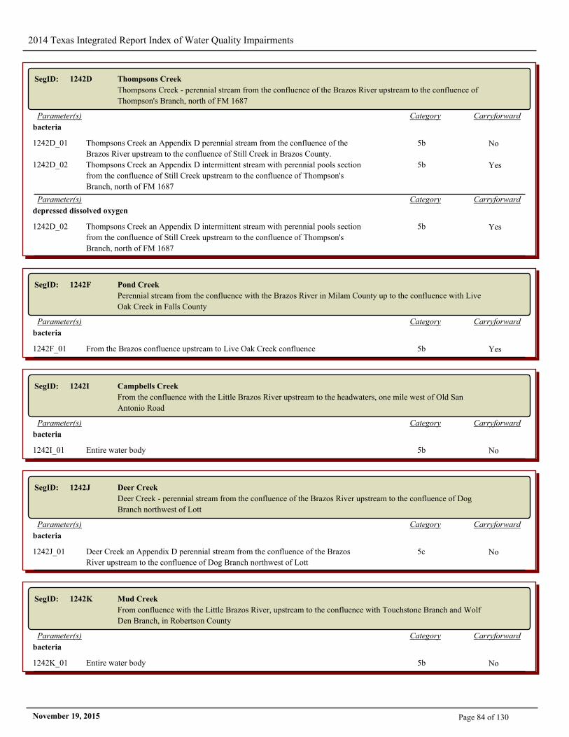
2014 Texas Integrated Report Index of Water Quality Impairments
SegID: 1242D Thompsons Creek
Thompsons Creek - perennial stream from the confluence of the Brazos River upstream to the confluence of
Thompson's Branch, north of FM 1687
CarryforwardCategoryParameter(s)
bacteria
1242D_01 Thompsons Creek an Appendix D perennial stream from the confluence of the
Brazos River upstream to the confluence of Still Creek in Brazos County.
5b No
1242D_02 Thompsons Creek an Appendix D intermittent stream with perennial pools section
from the confluence of Still Creek upstream to the confluence of Thompson's
Branch, north of FM 1687
5b Yes
CarryforwardCategoryParameter(s)
depressed dissolved oxygen
1242D_02 Thompsons Creek an Appendix D intermittent stream with perennial pools section
from the confluence of Still Creek upstream to the confluence of Thompson's
Branch, north of FM 1687
5b Yes
SegID: 1242F Pond Creek
Perennial stream from the confluence with the Brazos River in Milam County up to the confluence with Live
Oak Creek in Falls County
CarryforwardCategoryParameter(s)
bacteria
1242F_01 From the Brazos confluence upstream to Live Oak Creek confluence 5b Yes
SegID: 1242I Campbells Creek
From the confluence with the Little Brazos River upstream to the headwaters, one mile west of Old San
Antonio Road
CarryforwardCategoryParameter(s)
bacteria
1242I_01 Entire water body 5b No
SegID: 1242J Deer Creek
Deer Creek - perennial stream from the confluence of the Brazos River upstream to the confluence of Dog
Branch northwest of Lott
CarryforwardCategoryParameter(s)
bacteria
1242J_01 Deer Creek an Appendix D perennial stream from the confluence of the Brazos
River upstream to the confluence of Dog Branch northwest of Lott
5c No
SegID: 1242K Mud Creek
From confluence with the Little Brazos River, upstream to the confluence with Touchstone Branch and Wolf
Den Branch, in Robertson County
CarryforwardCategoryParameter(s)
bacteria
1242K_01 Entire water body 5b No
Page 84 of 130November 19, 2015
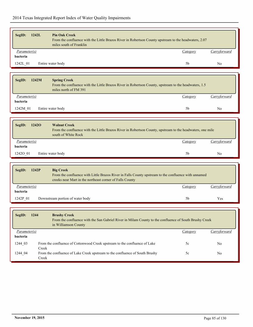
2014 Texas Integrated Report Index of Water Quality Impairments
SegID: 1242L Pin Oak Creek
From the confluence with the Little Brazos River in Robertson County upstream to the headwaters, 2.07
miles south of Franklin
CarryforwardCategoryParameter(s)
bacteria
1242L_01 Entire water body 5b No
SegID: 1242M Spring Creek
From the confluence with the Little Brazos River in Robertson County, upstream to the headwaters, 1.5
miles north of FM 391
CarryforwardCategoryParameter(s)
bacteria
1242M_01 Entire water body 5b No
SegID: 1242O Walnut Creek
From the confluence with the Little Brazos River in Robertson County, upstream to the headwaters, one mile
south of White Rock
CarryforwardCategoryParameter(s)
bacteria
1242O_01 Entire water body 5b No
SegID: 1242P Big Creek
From the confluence with Little Brazos River in Falls County upstream to the confluence with unnamed
creeks near Mart in the northeast corner of Falls County
CarryforwardCategoryParameter(s)
bacteria
1242P_01 Downstream portion of water body 5b Yes
SegID: 1244 Brushy Creek
From the confluence with the San Gabriel River in Milam County to the confluence of South Brushy Creek
in Williamson County
CarryforwardCategoryParameter(s)
bacteria
1244_03 From the confluence of Cottonwood Creek upstream to the confluence of Lake
Creek
5c No
1244_04 From the confluence of Lake Creek upstream to the confluence of South Brushy
Creek
5c No
Page 85 of 130November 19, 2015
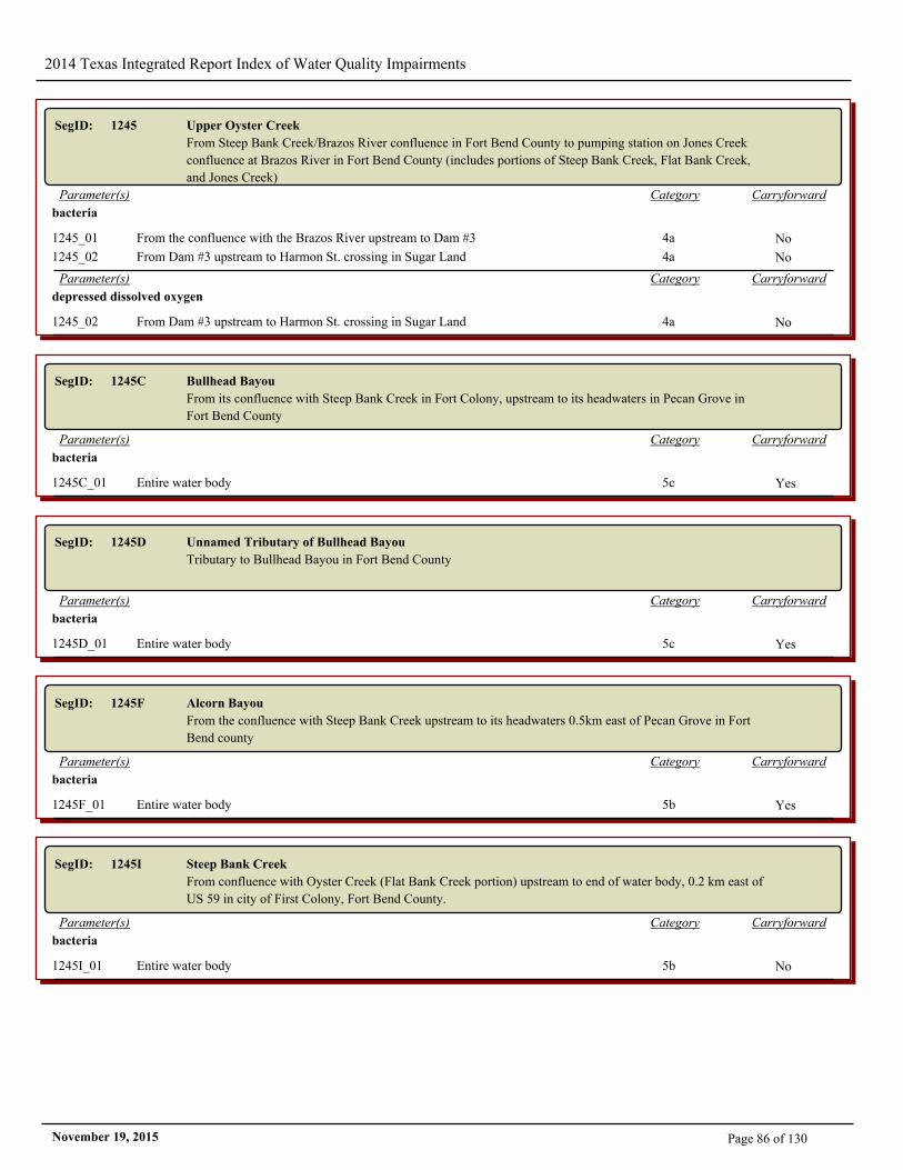
2014 Texas Integrated Report Index of Water Quality Impairments
SegID: 1245 Upper Oyster Creek
From Steep Bank Creek/Brazos River confluence in Fort Bend County to pumping station on Jones Creek
confluence at Brazos River in Fort Bend County (includes portions of Steep Bank Creek, Flat Bank Creek,
and Jones Creek)
CarryforwardCategoryParameter(s)
bacteria
1245_01 From the confluence with the Brazos River upstream to Dam #3 4a No
1245_02 From Dam #3 upstream to Harmon St. crossing in Sugar Land 4a No
CarryforwardCategoryParameter(s)
depressed dissolved oxygen
1245_02 From Dam #3 upstream to Harmon St. crossing in Sugar Land 4a No
SegID: 1245C Bullhead Bayou
From its confluence with Steep Bank Creek in Fort Colony, upstream to its headwaters in Pecan Grove in
Fort Bend County
CarryforwardCategoryParameter(s)
bacteria
1245C_01 Entire water body 5c Yes
SegID: 1245D Unnamed Tributary of Bullhead Bayou
Tributary to Bullhead Bayou in Fort Bend County
CarryforwardCategoryParameter(s)
bacteria
1245D_01 Entire water body 5c Yes
SegID: 1245F Alcorn Bayou
From the confluence with Steep Bank Creek upstream to its headwaters 0.5km east of Pecan Grove in Fort
Bend county
CarryforwardCategoryParameter(s)
bacteria
1245F_01 Entire water body 5b Yes
SegID: 1245I Steep Bank Creek
From confluence with Oyster Creek (Flat Bank Creek portion) upstream to end of water body, 0.2 km east of
US 59 in city of First Colony, Fort Bend County.
CarryforwardCategoryParameter(s)
bacteria
1245I_01 Entire water body 5b No
Page 86 of 130November 19, 2015
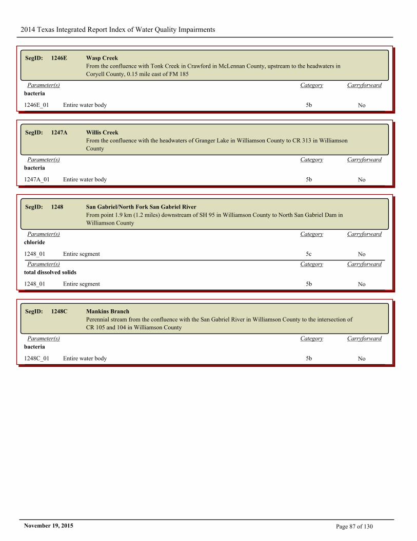
2014 Texas Integrated Report Index of Water Quality Impairments
SegID: 1246E Wasp Creek
From the confluence with Tonk Creek in Crawford in McLennan County, upstream to the headwaters in
Coryell County, 0.15 mile east of FM 185
CarryforwardCategoryParameter(s)
bacteria
1246E_01 Entire water body 5b No
SegID: 1247A Willis Creek
From the confluence with the headwaters of Granger Lake in Williamson County to CR 313 in Williamson
County
CarryforwardCategoryParameter(s)
bacteria
1247A_01 Entire water body 5b No
SegID: 1248 San Gabriel/North Fork San Gabriel River
From point 1.9 km (1.2 miles) downstream of SH 95 in Williamson County to North San Gabriel Dam in
Williamson County
CarryforwardCategoryParameter(s)
chloride
1248_01 Entire segment 5c No
CarryforwardCategoryParameter(s)
total dissolved solids
1248_01 Entire segment 5b No
SegID: 1248C Mankins Branch
Perennial stream from the confluence with the San Gabriel River in Williamson County to the intersection of
CR 105 and 104 in Williamson County
CarryforwardCategoryParameter(s)
bacteria
1248C_01 Entire water body 5b No
Page 87 of 130November 19, 2015
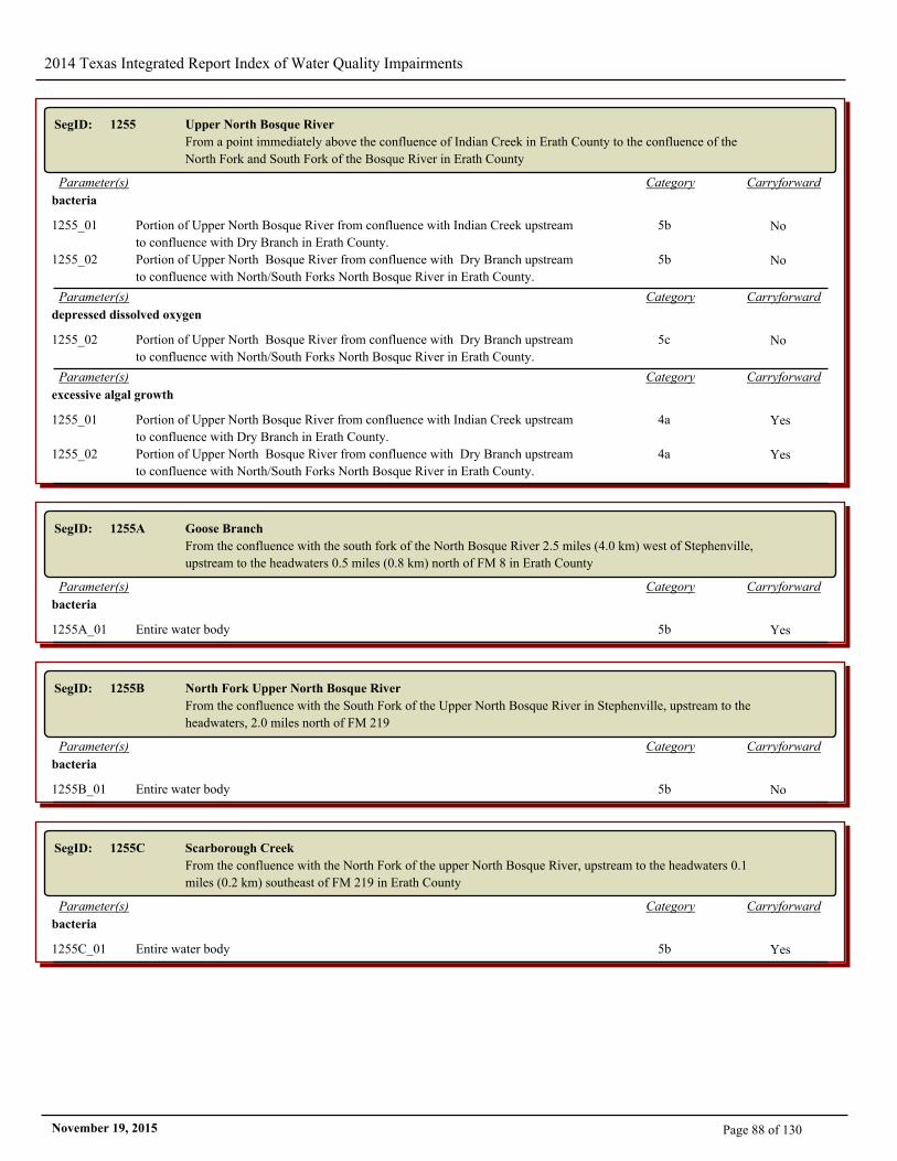
2014 Texas Integrated Report Index of Water Quality Impairments
SegID: 1255 Upper North Bosque River
From a point immediately above the confluence of Indian Creek in Erath County to the confluence of the
North Fork and South Fork of the Bosque River in Erath County
CarryforwardCategoryParameter(s)
bacteria
1255_01 Portion of Upper North Bosque River from confluence with Indian Creek upstream
to confluence with Dry Branch in Erath County.
5b No
1255_02 Portion of Upper North Bosque River from confluence with Dry Branch upstream
to confluence with North/South Forks North Bosque River in Erath County.
5b No
CarryforwardCategoryParameter(s)
depressed dissolved oxygen
1255_02 Portion of Upper North Bosque River from confluence with Dry Branch upstream
to confluence with North/South Forks North Bosque River in Erath County.
5c No
CarryforwardCategoryParameter(s)
excessive algal growth
1255_01 Portion of Upper North Bosque River from confluence with Indian Creek upstream
to confluence with Dry Branch in Erath County.
4a Yes
1255_02 Portion of Upper North Bosque River from confluence with Dry Branch upstream
to confluence with North/South Forks North Bosque River in Erath County.
4a Yes
SegID: 1255A Goose Branch
From the confluence with the south fork of the North Bosque River 2.5 miles (4.0 km) west of Stephenville,
upstream to the headwaters 0.5 miles (0.8 km) north of FM 8 in Erath County
CarryforwardCategoryParameter(s)
bacteria
1255A_01 Entire water body 5b Yes
SegID: 1255B North Fork Upper North Bosque River
From the confluence with the South Fork of the Upper North Bosque River in Stephenville, upstream to the
headwaters, 2.0 miles north of FM 219
CarryforwardCategoryParameter(s)
bacteria
1255B_01 Entire water body 5b No
SegID: 1255C Scarborough Creek
From the confluence with the North Fork of the upper North Bosque River, upstream to the headwaters 0.1
miles (0.2 km) southeast of FM 219 in Erath County
CarryforwardCategoryParameter(s)
bacteria
1255C_01 Entire water body 5b Yes
Page 88 of 130November 19, 2015
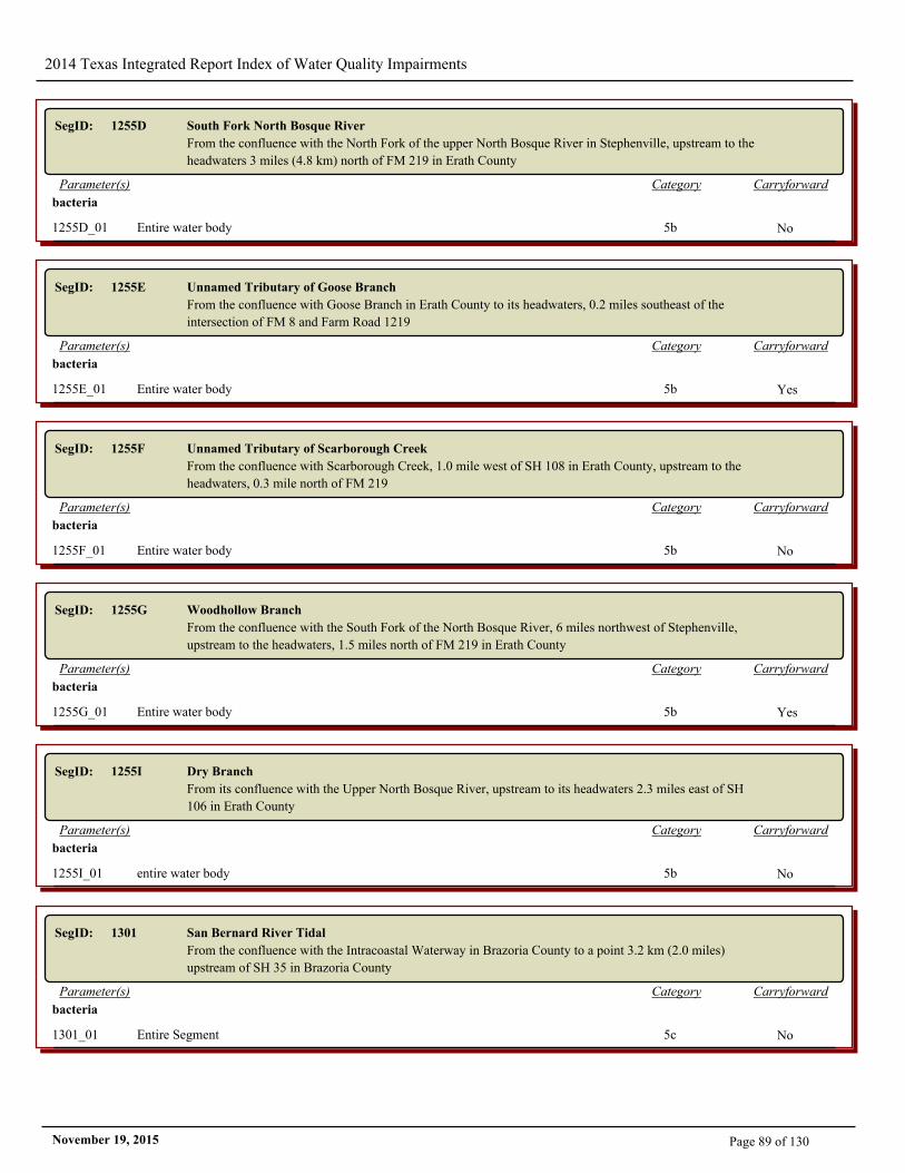
2014 Texas Integrated Report Index of Water Quality Impairments
SegID: 1255D South Fork North Bosque River
From the confluence with the North Fork of the upper North Bosque River in Stephenville, upstream to the
headwaters 3 miles (4.8 km) north of FM 219 in Erath County
CarryforwardCategoryParameter(s)
bacteria
1255D_01 Entire water body 5b No
SegID: 1255E Unnamed Tributary of Goose Branch
From the confluence with Goose Branch in Erath County to its headwaters, 0.2 miles southeast of the
intersection of FM 8 and Farm Road 1219
CarryforwardCategoryParameter(s)
bacteria
1255E_01 Entire water body 5b Yes
SegID: 1255F Unnamed Tributary of Scarborough Creek
From the confluence with Scarborough Creek, 1.0 mile west of SH 108 in Erath County, upstream to the
headwaters, 0.3 mile north of FM 219
CarryforwardCategoryParameter(s)
bacteria
1255F_01 Entire water body 5b No
SegID: 1255G Woodhollow Branch
From the confluence with the South Fork of the North Bosque River, 6 miles northwest of Stephenville,
upstream to the headwaters, 1.5 miles north of FM 219 in Erath County
CarryforwardCategoryParameter(s)
bacteria
1255G_01 Entire water body 5b Yes
SegID: 1255I Dry Branch
From its confluence with the Upper North Bosque River, upstream to its headwaters 2.3 miles east of SH
106 in Erath County
CarryforwardCategoryParameter(s)
bacteria
1255I_01 entire water body 5b No
SegID: 1301 San Bernard River Tidal
From the confluence with the Intracoastal Waterway in Brazoria County to a point 3.2 km (2.0 miles)
upstream of SH 35 in Brazoria County
CarryforwardCategoryParameter(s)
bacteria
1301_01 Entire Segment 5c No
Page 89 of 130November 19, 2015
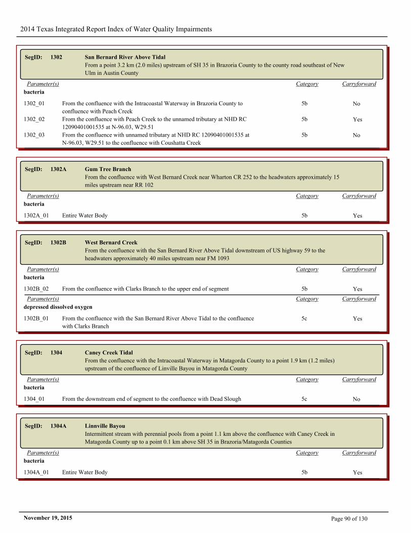
2014 Texas Integrated Report Index of Water Quality Impairments
SegID: 1302 San Bernard River Above Tidal
From a point 3.2 km (2.0 miles) upstream of SH 35 in Brazoria County to the county road southeast of New
Ulm in Austin County
CarryforwardCategoryParameter(s)
bacteria
1302_01 From the confluence with the Intracoastal Waterway in Brazoria County to
confluence with Peach Creek
5b No
1302_02 From the confluence with Peach Creek to the unnamed tributary at NHD RC
12090401001535 at N-96.03, W29.51
5b Yes
1302_03 From the confluence with unnamed tributary at NHD RC 12090401001535 at
N-96.03, W29.51 to the confluence with Coushatta Creek
5b No
SegID: 1302A Gum Tree Branch
From the confluence with West Bernard Creek near Wharton CR 252 to the headwaters approximately 15
miles upstream near RR 102
CarryforwardCategoryParameter(s)
bacteria
1302A_01 Entire Water Body 5b Yes
SegID: 1302B West Bernard Creek
From the confluence with the San Bernard River Above Tidal downstream of US highway 59 to the
headwaters approximately 40 miles upstream near FM 1093
CarryforwardCategoryParameter(s)
bacteria
1302B_02 From the confluence with Clarks Branch to the upper end of segment 5b Yes
CarryforwardCategoryParameter(s)
depressed dissolved oxygen
1302B_01 From the confluence with the San Bernard River Above Tidal to the confluence
with Clarks Branch
5c Yes
SegID: 1304 Caney Creek Tidal
From the confluence with the Intracoastal Waterway in Matagorda County to a point 1.9 km (1.2 miles)
upstream of the confluence of Linville Bayou in Matagorda County
CarryforwardCategoryParameter(s)
bacteria
1304_01 From the downstream end of segment to the confluence with Dead Slough 5c No
SegID: 1304A Linnville Bayou
Intermittent stream with perennial pools from a point 1.1 km above the confluence with Caney Creek in
Matagorda County up to a point 0.1 km above SH 35 in Brazoria/Matagorda Counties
CarryforwardCategoryParameter(s)
bacteria
1304A_01 Entire Water Body 5b Yes
Page 90 of 130November 19, 2015
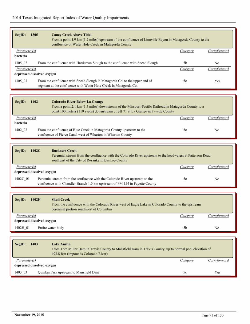
2014 Texas Integrated Report Index of Water Quality Impairments
SegID: 1305 Caney Creek Above Tidal
From a point 1.9 km (1.2 miles) upstream of the confluence of Linnville Bayou in Matagorda County to the
confluence of Water Hole Creek in Matagorda County
CarryforwardCategoryParameter(s)
bacteria
1305_02 From the confluence with Hardeman Slough to the confluence with Snead Slough 5b No
CarryforwardCategoryParameter(s)
depressed dissolved oxygen
1305_03 From the confluence with Snead Slough in Matagorda Co. to the upper end of
segment at the confluence with Water Hole Creek in Matagorda Co.
5c Yes
SegID: 1402 Colorado River Below La Grange
From a point 2.1 km (1.3 miles) downstream of the Missouri-Pacific Railroad in Matagorda County to a
point 100 meters (110 yards) downstream of SH 71 at La Grange in Fayette County
CarryforwardCategoryParameter(s)
bacteria
1402_02 From the confluence of Blue Creek in Matagorda County upstream to the
confluence of Pierce Canal west of Wharton in Wharton County
5c No
SegID: 1402C Buckners Creek
Perennial stream from the confluence with the Colorado River upstream to the headwaters at Patterson Road
southeast of the City of Rosanky in Bastrop County
CarryforwardCategoryParameter(s)
depressed dissolved oxygen
1402C_01 Perennial stream from the confluence with the Colorado River upstream to the
confluence with Chandler Branch 1.6 km upstream of FM 154 in Fayette County
5c No
SegID: 1402H Skull Creek
From the confluence with the Colorado River west of Eagle Lake in Colorado County to the upstream
perennial portion southwest of Columbus
CarryforwardCategoryParameter(s)
depressed dissolved oxygen
1402H_01 Entire water body 5b No
SegID: 1403 Lake Austin
From Tom Miller Dam in Travis County to Mansfield Dam in Travis County, up to normal pool elevation of
492.8 feet (impounds Colorado River)
CarryforwardCategoryParameter(s)
depressed dissolved oxygen
1403_03 Quinlan Park upstream to Mansfield Dam 5c Yes
Page 91 of 130November 19, 2015
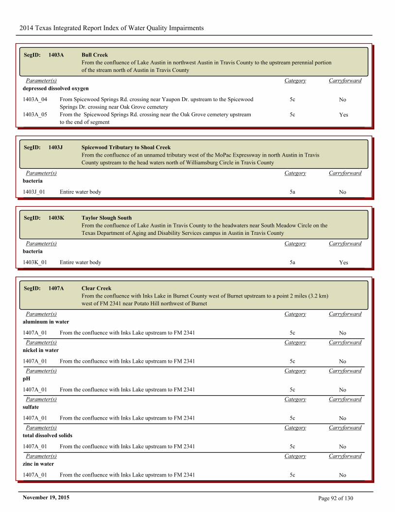
2014 Texas Integrated Report Index of Water Quality Impairments
SegID: 1403A Bull Creek
From the confluence of Lake Austin in northwest Austin in Travis County to the upstream perennial portion
of the stream north of Austin in Travis County
CarryforwardCategoryParameter(s)
depressed dissolved oxygen
1403A_04 From Spicewood Springs Rd. crossing near Yaupon Dr. upstream to the Spicewood
Springs Dr. crossing near Oak Grove cemetery
5c No
1403A_05 From the Spicewood Springs Rd. crossing near the Oak Grove cemetery upstream
to the end of segment
5c Yes
SegID: 1403J Spicewood Tributary to Shoal Creek
From the confluence of an unnamed tributary west of the MoPac Expressway in north Austin in Travis
County upstream to the head waters north of Williamsburg Circle in Travis County
CarryforwardCategoryParameter(s)
bacteria
1403J_01 Entire water body 5a No
SegID: 1403K Taylor Slough South
From the confluence of Lake Austin in Travis County to the headwaters near South Meadow Circle on the
Texas Department of Aging and Disability Services campus in Austin in Travis County
CarryforwardCategoryParameter(s)
bacteria
1403K_01 Entire water body 5a Yes
SegID: 1407A Clear Creek
From the confluence with Inks Lake in Burnet County west of Burnet upstream to a point 2 miles (3.2 km)
west of FM 2341 near Potato Hill northwest of Burnet
CarryforwardCategoryParameter(s)
aluminum in water
1407A_01 From the confluence with Inks Lake upstream to FM 2341 5c No
CarryforwardCategoryParameter(s)
nickel in water
1407A_01 From the confluence with Inks Lake upstream to FM 2341 5c No
CarryforwardCategoryParameter(s)
pH
1407A_01 From the confluence with Inks Lake upstream to FM 2341 5c No
CarryforwardCategoryParameter(s)
sulfate
1407A_01 From the confluence with Inks Lake upstream to FM 2341 5c No
CarryforwardCategoryParameter(s)
total dissolved solids
1407A_01 From the confluence with Inks Lake upstream to FM 2341 5c No
CarryforwardCategoryParameter(s)
zinc in water
1407A_01 From the confluence with Inks Lake upstream to FM 2341 5c No
Page 92 of 130November 19, 2015
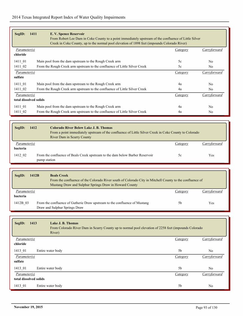
2014 Texas Integrated Report Index of Water Quality Impairments
SegID: 1411 E. V. Spence Reservoir
From Robert Lee Dam in Coke County to a point immediately upstream of the confluence of Little Silver
Creek in Coke County, up to the normal pool elevation of 1898 feet (impounds Colorado River)
CarryforwardCategoryParameter(s)
chloride
1411_01 Main pool from the dam upstream to the Rough Creek arm 5c No
1411_02 From the Rough Creek arm upstream to the confluence of Little Silver Creek 5c No
CarryforwardCategoryParameter(s)
sulfate
1411_01 Main pool from the dam upstream to the Rough Creek arm 4a No
1411_02 From the Rough Creek arm upstream to the confluence of Little Silver Creek 4a No
CarryforwardCategoryParameter(s)
total dissolved solids
1411_01 Main pool from the dam upstream to the Rough Creek arm 4a No
1411_02 From the Rough Creek arm upstream to the confluence of Little Silver Creek 4a No
SegID: 1412 Colorado River Below Lake J. B. Thomas
From a point immediately upstream of the confluence of Little Silver Creek in Coke County to Colorado
River Dam in Scurry County
CarryforwardCategoryParameter(s)
bacteria
1412_02 From the confluence of Beals Creek upstream to the dam below Barber Reservoir
pump station
5c Yes
SegID: 1412B Beals Creek
From the confluence of the Colorado River south of Colorado City in Mitchell County to the confluence of
Mustang Draw and Sulphur Springs Draw in Howard County
CarryforwardCategoryParameter(s)
bacteria
1412B_03 From the confluence of Gutherie Draw upstream to the confluence of Mustang
Draw and Sulphur Springs Draw
5b Yes
SegID: 1413 Lake J. B. Thomas
From Colorado River Dam in Scurry County up to normal pool elevation of 2258 feet (impounds Colorado
River)
CarryforwardCategoryParameter(s)
chloride
1413_01 Entire water body 5b No
CarryforwardCategoryParameter(s)
sulfate
1413_01 Entire water body 5b No
CarryforwardCategoryParameter(s)
total dissolved solids
1413_01 Entire water body 5b No
Page 93 of 130November 19, 2015
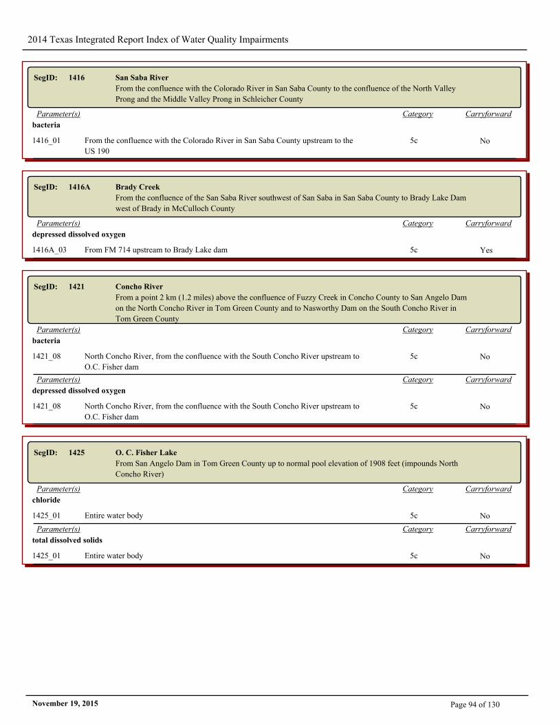
2014 Texas Integrated Report Index of Water Quality Impairments
SegID: 1416 San Saba River
From the confluence with the Colorado River in San Saba County to the confluence of the North Valley
Prong and the Middle Valley Prong in Schleicher County
CarryforwardCategoryParameter(s)
bacteria
1416_01 From the confluence with the Colorado River in San Saba County upstream to the
US 190
5c No
SegID: 1416A Brady Creek
From the confluence of the San Saba River southwest of San Saba in San Saba County to Brady Lake Dam
west of Brady in McCulloch County
CarryforwardCategoryParameter(s)
depressed dissolved oxygen
1416A_03 From FM 714 upstream to Brady Lake dam 5c Yes
SegID: 1421 Concho River
From a point 2 km (1.2 miles) above the confluence of Fuzzy Creek in Concho County to San Angelo Dam
on the North Concho River in Tom Green County and to Nasworthy Dam on the South Concho River in
Tom Green County
CarryforwardCategoryParameter(s)
bacteria
1421_08 North Concho River, from the confluence with the South Concho River upstream to
O.C. Fisher dam
5c No
CarryforwardCategoryParameter(s)
depressed dissolved oxygen
1421_08 North Concho River, from the confluence with the South Concho River upstream to
O.C. Fisher dam
5c No
SegID: 1425 O. C. Fisher Lake
From San Angelo Dam in Tom Green County up to normal pool elevation of 1908 feet (impounds North
Concho River)
CarryforwardCategoryParameter(s)
chloride
1425_01 Entire water body 5c No
CarryforwardCategoryParameter(s)
total dissolved solids
1425_01 Entire water body 5c No
Page 94 of 130November 19, 2015
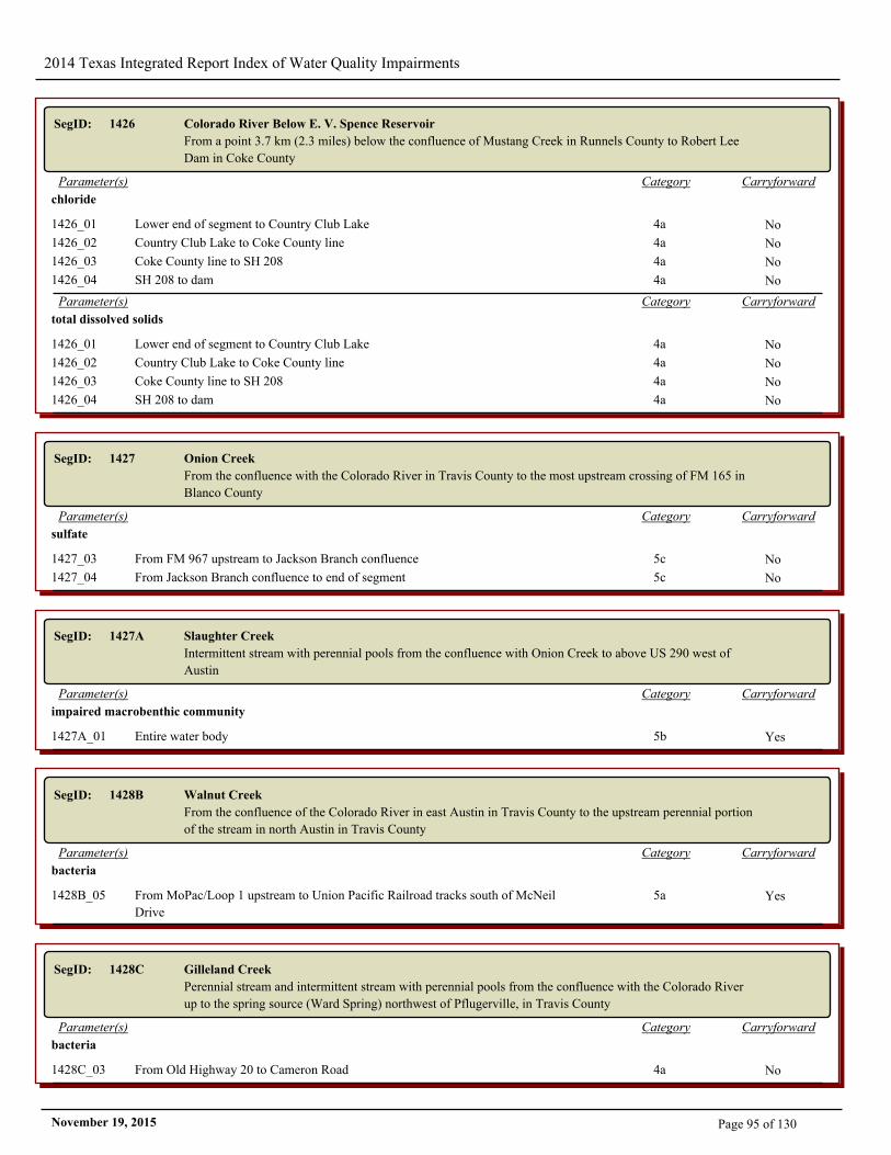
2014 Texas Integrated Report Index of Water Quality Impairments
SegID: 1426 Colorado River Below E. V. Spence Reservoir
From a point 3.7 km (2.3 miles) below the confluence of Mustang Creek in Runnels County to Robert Lee
Dam in Coke County
CarryforwardCategoryParameter(s)
chloride
1426_01 Lower end of segment to Country Club Lake 4a No
1426_02 Country Club Lake to Coke County line 4a No
1426_03 Coke County line to SH 208 4a No
1426_04 SH 208 to dam 4a No
CarryforwardCategoryParameter(s)
total dissolved solids
1426_01 Lower end of segment to Country Club Lake 4a No
1426_02 Country Club Lake to Coke County line 4a No
1426_03 Coke County line to SH 208 4a No
1426_04 SH 208 to dam 4a No
SegID: 1427 Onion Creek
From the confluence with the Colorado River in Travis County to the most upstream crossing of FM 165 in
Blanco County
CarryforwardCategoryParameter(s)
sulfate
1427_03 From FM 967 upstream to Jackson Branch confluence 5c No
1427_04 From Jackson Branch confluence to end of segment 5c No
SegID: 1427A Slaughter Creek
Intermittent stream with perennial pools from the confluence with Onion Creek to above US 290 west of
Austin
CarryforwardCategoryParameter(s)
impaired macrobenthic community
1427A_01 Entire water body 5b Yes
SegID: 1428B Walnut Creek
From the confluence of the Colorado River in east Austin in Travis County to the upstream perennial portion
of the stream in north Austin in Travis County
CarryforwardCategoryParameter(s)
bacteria
1428B_05 From MoPac/Loop 1 upstream to Union Pacific Railroad tracks south of McNeil
Drive
5a Yes
SegID: 1428C Gilleland Creek
Perennial stream and intermittent stream with perennial pools from the confluence with the Colorado River
up to the spring source (Ward Spring) northwest of Pflugerville, in Travis County
CarryforwardCategoryParameter(s)
bacteria
1428C_03 From Old Highway 20 to Cameron Road 4a No
Page 95 of 130November 19, 2015
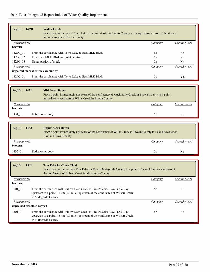
2014 Texas Integrated Report Index of Water Quality Impairments
SegID: 1429C Waller Creek
From the confluence of Town Lake in central Austin in Travis County to the upstream portion of the stream
in north Austin in Travis County
CarryforwardCategoryParameter(s)
bacteria
1429C_01 From the confluence with Town Lake to East MLK Blvd. 5a No
1429C_02 From East MLK Blvd. to East 41st Street 5a No
1429C_03 Upper portion of creek 5a No
CarryforwardCategoryParameter(s)
impaired macrobenthic community
1429C_01 From the confluence with Town Lake to East MLK Blvd. 5c Yes
SegID: 1431 Mid Pecan Bayou
From a point immediately upstream of the confluence of Mackinally Creek in Brown County to a point
immediately upstream of Willis Creek in Brown County
CarryforwardCategoryParameter(s)
bacteria
1431_01 Entire water body 5b No
SegID: 1432 Upper Pecan Bayou
From a point immediately upstream of the confluence of Willis Creek in Brown County to Lake Brownwood
Dam in Brown County
CarryforwardCategoryParameter(s)
bacteria
1432_01 Entire water body 5c No
SegID: 1501 Tres Palacios Creek Tidal
From the confluence with Tres Palacios Bay in Matagorda County to a point 1.6 km (1.0 mile) upstream of
the confluence of Wilson Creek in Matagorda County
CarryforwardCategoryParameter(s)
bacteria
1501_01 From the confluence with Willow Dam Creek at Tres Palacios Bay/Turtle Bay
upstream to a point 1.6 km (1.0 mile) upstream of the confluence of Wilson Creek
in Matagorda County
5c No
CarryforwardCategoryParameter(s)
depressed dissolved oxygen
1501_01 From the confluence with Willow Dam Creek at Tres Palacios Bay/Turtle Bay
upstream to a point 1.6 km (1.0 mile) upstream of the confluence of Wilson Creek
in Matagorda County
5b No
Page 96 of 130November 19, 2015
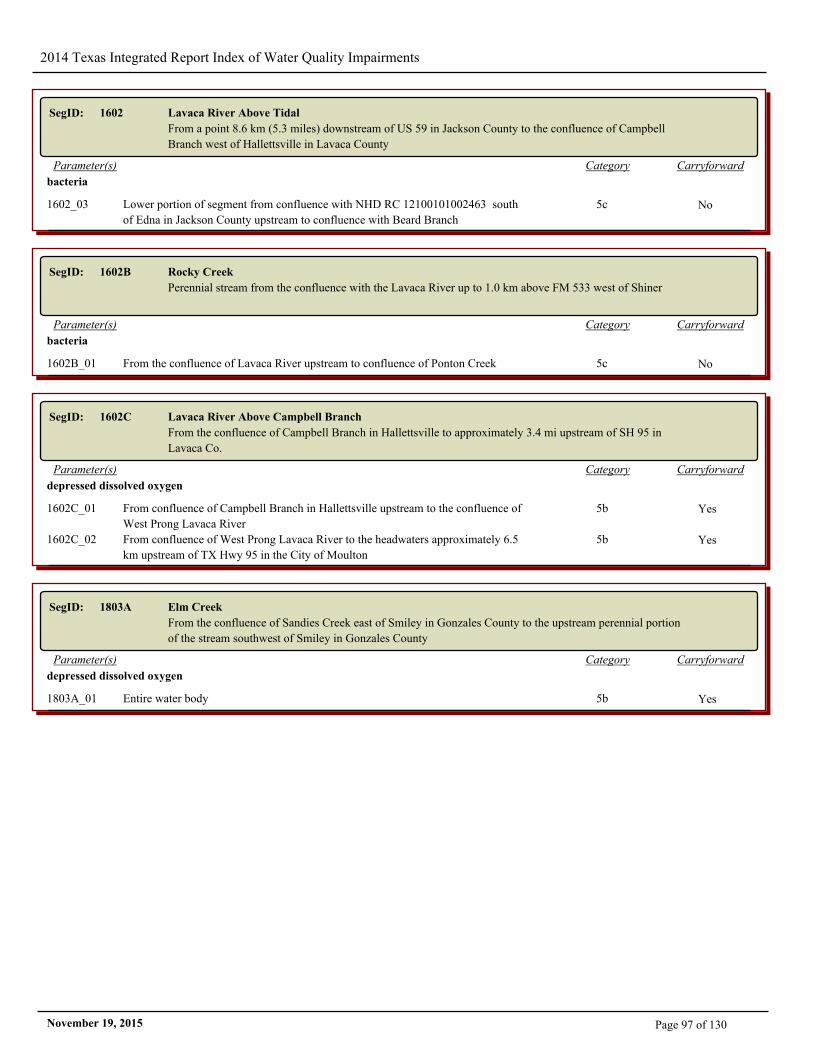
2014 Texas Integrated Report Index of Water Quality Impairments
SegID: 1602 Lavaca River Above Tidal
From a point 8.6 km (5.3 miles) downstream of US 59 in Jackson County to the confluence of Campbell
Branch west of Hallettsville in Lavaca County
CarryforwardCategoryParameter(s)
bacteria
1602_03 Lower portion of segment from confluence with NHD RC 12100101002463 south
of Edna in Jackson County upstream to confluence with Beard Branch
5c No
SegID: 1602B Rocky Creek
Perennial stream from the confluence with the Lavaca River up to 1.0 km above FM 533 west of Shiner
CarryforwardCategoryParameter(s)
bacteria
1602B_01 From the confluence of Lavaca River upstream to confluence of Ponton Creek 5c No
SegID: 1602C Lavaca River Above Campbell Branch
From the confluence of Campbell Branch in Hallettsville to approximately 3.4 mi upstream of SH 95 in
Lavaca Co.
CarryforwardCategoryParameter(s)
depressed dissolved oxygen
1602C_01 From confluence of Campbell Branch in Hallettsville upstream to the confluence of
West Prong Lavaca River
5b Yes
1602C_02 From confluence of West Prong Lavaca River to the headwaters approximately 6.5
km upstream of TX Hwy 95 in the City of Moulton
5b Yes
SegID: 1803A Elm Creek
From the confluence of Sandies Creek east of Smiley in Gonzales County to the upstream perennial portion
of the stream southwest of Smiley in Gonzales County
CarryforwardCategoryParameter(s)
depressed dissolved oxygen
1803A_01 Entire water body 5b Yes
Page 97 of 130November 19, 2015
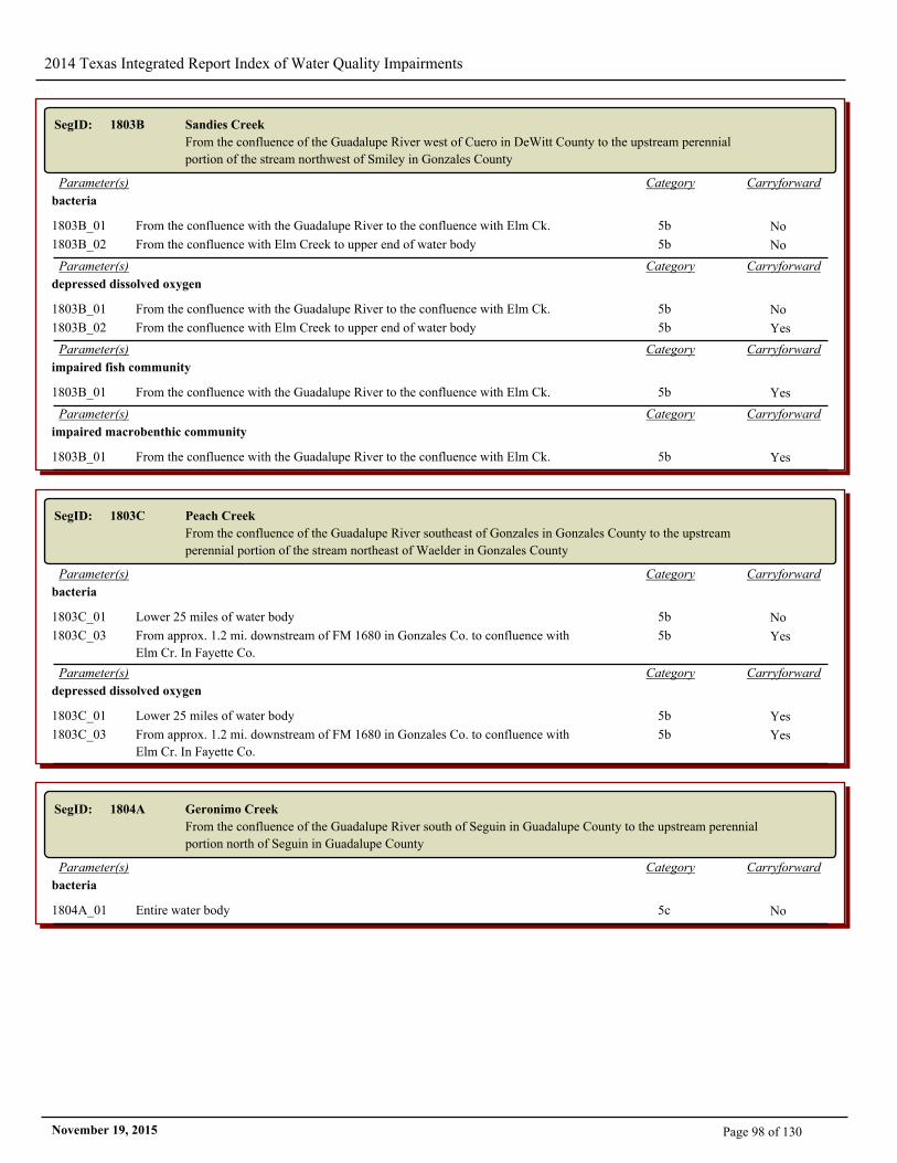
2014 Texas Integrated Report Index of Water Quality Impairments
SegID: 1803B Sandies Creek
From the confluence of the Guadalupe River west of Cuero in DeWitt County to the upstream perennial
portion of the stream northwest of Smiley in Gonzales County
CarryforwardCategoryParameter(s)
bacteria
1803B_01 From the confluence with the Guadalupe River to the confluence with Elm Ck. 5b No
1803B_02 From the confluence with Elm Creek to upper end of water body 5b No
CarryforwardCategoryParameter(s)
depressed dissolved oxygen
1803B_01 From the confluence with the Guadalupe River to the confluence with Elm Ck. 5b No
1803B_02 From the confluence with Elm Creek to upper end of water body 5b Yes
CarryforwardCategoryParameter(s)
impaired fish community
1803B_01 From the confluence with the Guadalupe River to the confluence with Elm Ck. 5b Yes
CarryforwardCategoryParameter(s)
impaired macrobenthic community
1803B_01 From the confluence with the Guadalupe River to the confluence with Elm Ck. 5b Yes
SegID: 1803C Peach Creek
From the confluence of the Guadalupe River southeast of Gonzales in Gonzales County to the upstream
perennial portion of the stream northeast of Waelder in Gonzales County
CarryforwardCategoryParameter(s)
bacteria
1803C_01 Lower 25 miles of water body 5b No
1803C_03 From approx. 1.2 mi. downstream of FM 1680 in Gonzales Co. to confluence with
Elm Cr. In Fayette Co.
5b Yes
CarryforwardCategoryParameter(s)
depressed dissolved oxygen
1803C_01 Lower 25 miles of water body 5b Yes
1803C_03 From approx. 1.2 mi. downstream of FM 1680 in Gonzales Co. to confluence with
Elm Cr. In Fayette Co.
5b Yes
SegID: 1804A Geronimo Creek
From the confluence of the Guadalupe River south of Seguin in Guadalupe County to the upstream perennial
portion north of Seguin in Guadalupe County
CarryforwardCategoryParameter(s)
bacteria
1804A_01 Entire water body 5c No
Page 98 of 130November 19, 2015
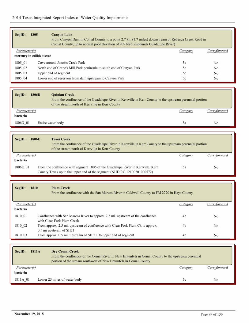
2014 Texas Integrated Report Index of Water Quality Impairments
SegID: 1805 Canyon Lake
From Canyon Dam in Comal County to a point 2.7 km (1.7 miles) downstream of Rebecca Creek Road in
Comal County, up to normal pool elevation of 909 feet (impounds Guadalupe River)
CarryforwardCategoryParameter(s)
mercury in edible tissue
1805_01 Cove around Jacob's Creek Park 5c No
1805_02 North end of Crane's Mill Park peninsula to south end of Canyon Park 5c No
1805_03 Upper end of segment 5c No
1805_04 Lower end of reservoir from dam upstream to Canyon Park 5c No
SegID: 1806D Quinlan Creek
From the confluence of the Guadalupe River in Kerrville in Kerr County to the upstream perennial portion
of the stream north of Kerrville in Kerr County
CarryforwardCategoryParameter(s)
bacteria
1806D_01 Entire water body 5a No
SegID: 1806E Town Creek
From the confluence of the Guadalupe River in Kerrville in Kerr County to the upstream perennial portion
of the stream north of Kerrville in Kerr County
CarryforwardCategoryParameter(s)
bacteria
1806E_01 From the confluence with segment 1806 of the Guadalupe River in Kerrville, Kerr
County Texas up to the upper end of the segment (NHD RC 12100201000572)
5a No
SegID: 1810 Plum Creek
From the confluence with the San Marcos River in Caldwell County to FM 2770 in Hays County
CarryforwardCategoryParameter(s)
bacteria
1810_01 Confluence with San Marcos River to approx. 2.5 mi. upstream of the confluence
with Clear Fork Plum Creek
4b No
1810_02 From approx. 2.5 mi. upstream of confluence with Clear Fork Plum Ck to approx.
0.5 mi upstream of SH21
4b No
1810_03 From approx. 0.5 mi. upstream of SH 21 to upper end of segment 4b No
SegID: 1811A Dry Comal Creek
From the confluence of the Comal River in New Braunfels in Comal County to the upstream perennial
portion of the stream southwest of New Braunfels in Comal County
CarryforwardCategoryParameter(s)
bacteria
1811A_01 Lower 25 miles of water body 5c No
Page 99 of 130November 19, 2015
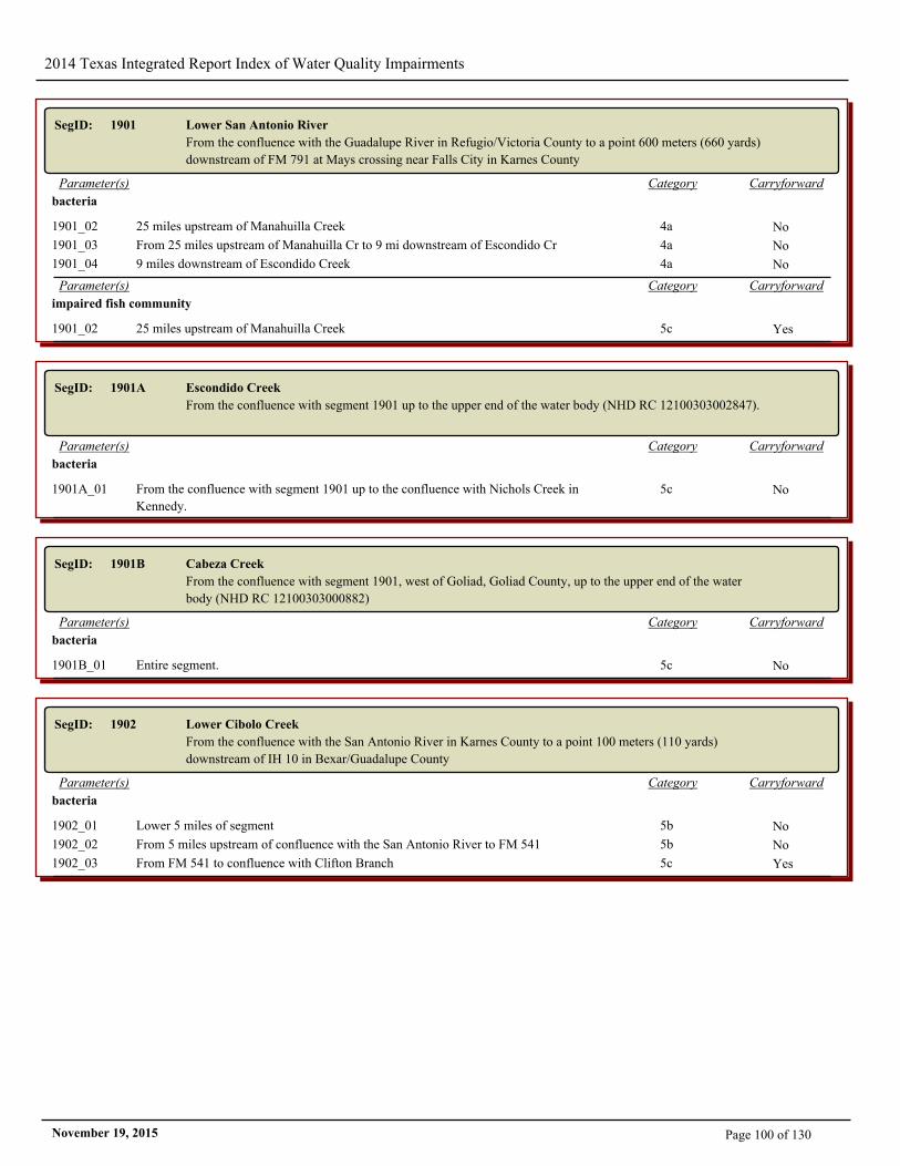
2014 Texas Integrated Report Index of Water Quality Impairments
SegID: 1901 Lower San Antonio River
From the confluence with the Guadalupe River in Refugio/Victoria County to a point 600 meters (660 yards)
downstream of FM 791 at Mays crossing near Falls City in Karnes County
CarryforwardCategoryParameter(s)
bacteria
1901_02 25 miles upstream of Manahuilla Creek 4a No
1901_03 From 25 miles upstream of Manahuilla Cr to 9 mi downstream of Escondido Cr 4a No
1901_04 9 miles downstream of Escondido Creek 4a No
CarryforwardCategoryParameter(s)
impaired fish community
1901_02 25 miles upstream of Manahuilla Creek 5c Yes
SegID: 1901A Escondido Creek
From the confluence with segment 1901 up to the upper end of the water body (NHD RC 12100303002847).
CarryforwardCategoryParameter(s)
bacteria
1901A_01 From the confluence with segment 1901 up to the confluence with Nichols Creek in
Kennedy.
5c No
SegID: 1901B Cabeza Creek
From the confluence with segment 1901, west of Goliad, Goliad County, up to the upper end of the water
body (NHD RC 12100303000882)
CarryforwardCategoryParameter(s)
bacteria
1901B_01 Entire segment. 5c No
SegID: 1902 Lower Cibolo Creek
From the confluence with the San Antonio River in Karnes County to a point 100 meters (110 yards)
downstream of IH 10 in Bexar/Guadalupe County
CarryforwardCategoryParameter(s)
bacteria
1902_01 Lower 5 miles of segment 5b No
1902_02 From 5 miles upstream of confluence with the San Antonio River to FM 541 5b No
1902_03 From FM 541 to confluence with Clifton Branch 5c Yes
Page 100 of 130November 19, 2015
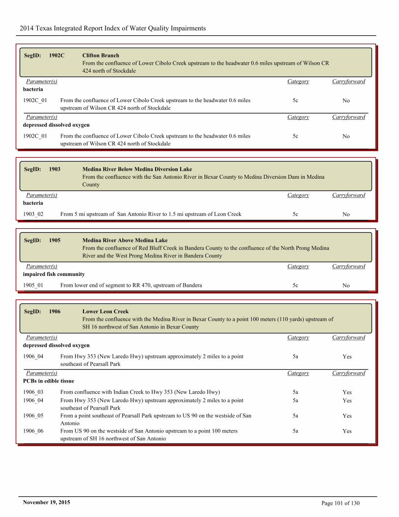
2014 Texas Integrated Report Index of Water Quality Impairments
SegID: 1902C Clifton Branch
From the confluence of Lower Cibolo Creek upstream to the headwater 0.6 miles upstream of Wilson CR
424 north of Stockdale
CarryforwardCategoryParameter(s)
bacteria
1902C_01 From the confluence of Lower Cibolo Creek upstream to the headwater 0.6 miles
upstream of Wilson CR 424 north of Stockdale
5c No
CarryforwardCategoryParameter(s)
depressed dissolved oxygen
1902C_01 From the confluence of Lower Cibolo Creek upstream to the headwater 0.6 miles
upstream of Wilson CR 424 north of Stockdale
5c No
SegID: 1903 Medina River Below Medina Diversion Lake
From the confluence with the San Antonio River in Bexar County to Medina Diversion Dam in Medina
County
CarryforwardCategoryParameter(s)
bacteria
1903_02 From 5 mi upstream of San Antonio River to 1.5 mi upstream of Leon Creek 5c No
SegID: 1905 Medina River Above Medina Lake
From the confluence of Red Bluff Creek in Bandera County to the confluence of the North Prong Medina
River and the West Prong Medina River in Bandera County
CarryforwardCategoryParameter(s)
impaired fish community
1905_01 From lower end of segment to RR 470, upstream of Bandera 5c No
SegID: 1906 Lower Leon Creek
From the confluence with the Medina River in Bexar County to a point 100 meters (110 yards) upstream of
SH 16 northwest of San Antonio in Bexar County
CarryforwardCategoryParameter(s)
depressed dissolved oxygen
1906_04 From Hwy 353 (New Laredo Hwy) upstream approximately 2 miles to a point
southeast of Pearsall Park
5a Yes
CarryforwardCategoryParameter(s)
PCBs in edible tissue
1906_03 From confluence with Indian Creek to Hwy 353 (New Laredo Hwy) 5a Yes
1906_04 From Hwy 353 (New Laredo Hwy) upstream approximately 2 miles to a point
southeast of Pearsall Park
5a Yes
1906_05 From a point southeast of Pearsall Park upstream to US 90 on the westside of San
Antonio
5a Yes
1906_06 From US 90 on the westside of San Antonio upstream to a point 100 meters
upstream of SH 16 northwest of San Antonio
5a Yes
Page 101 of 130November 19, 2015
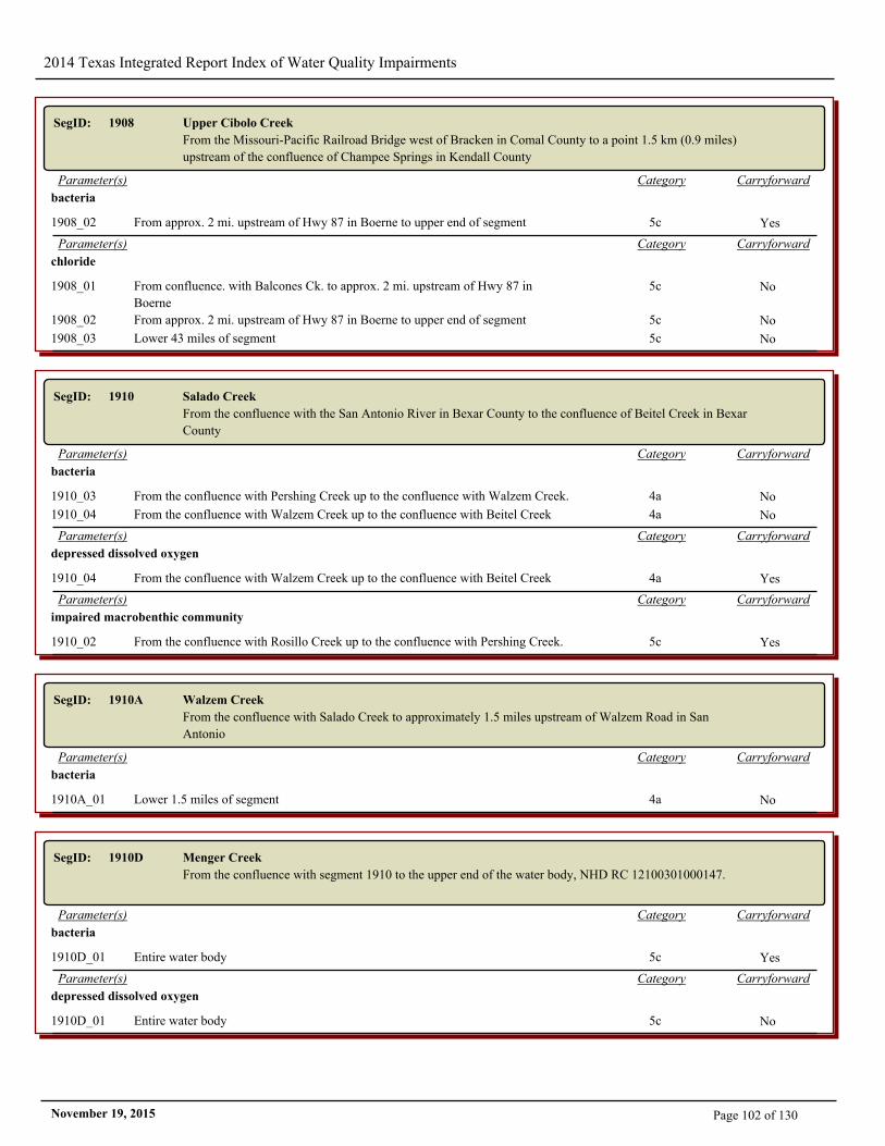
2014 Texas Integrated Report Index of Water Quality Impairments
SegID: 1908 Upper Cibolo Creek
From the Missouri-Pacific Railroad Bridge west of Bracken in Comal County to a point 1.5 km (0.9 miles)
upstream of the confluence of Champee Springs in Kendall County
CarryforwardCategoryParameter(s)
bacteria
1908_02 From approx. 2 mi. upstream of Hwy 87 in Boerne to upper end of segment 5c Yes
CarryforwardCategoryParameter(s)
chloride
1908_01 From confluence. with Balcones Ck. to approx. 2 mi. upstream of Hwy 87 in
Boerne
5c No
1908_02 From approx. 2 mi. upstream of Hwy 87 in Boerne to upper end of segment 5c No
1908_03 Lower 43 miles of segment 5c No
SegID: 1910 Salado Creek
From the confluence with the San Antonio River in Bexar County to the confluence of Beitel Creek in Bexar
County
CarryforwardCategoryParameter(s)
bacteria
1910_03 From the confluence with Pershing Creek up to the confluence with Walzem Creek. 4a No
1910_04 From the confluence with Walzem Creek up to the confluence with Beitel Creek 4a No
CarryforwardCategoryParameter(s)
depressed dissolved oxygen
1910_04 From the confluence with Walzem Creek up to the confluence with Beitel Creek 4a Yes
CarryforwardCategoryParameter(s)
impaired macrobenthic community
1910_02 From the confluence with Rosillo Creek up to the confluence with Pershing Creek. 5c Yes
SegID: 1910A Walzem Creek
From the confluence with Salado Creek to approximately 1.5 miles upstream of Walzem Road in San
Antonio
CarryforwardCategoryParameter(s)
bacteria
1910A_01 Lower 1.5 miles of segment 4a No
SegID: 1910D Menger Creek
From the confluence with segment 1910 to the upper end of the water body, NHD RC 12100301000147.
CarryforwardCategoryParameter(s)
bacteria
1910D_01 Entire water body 5c Yes
CarryforwardCategoryParameter(s)
depressed dissolved oxygen
1910D_01 Entire water body 5c No
Page 102 of 130November 19, 2015
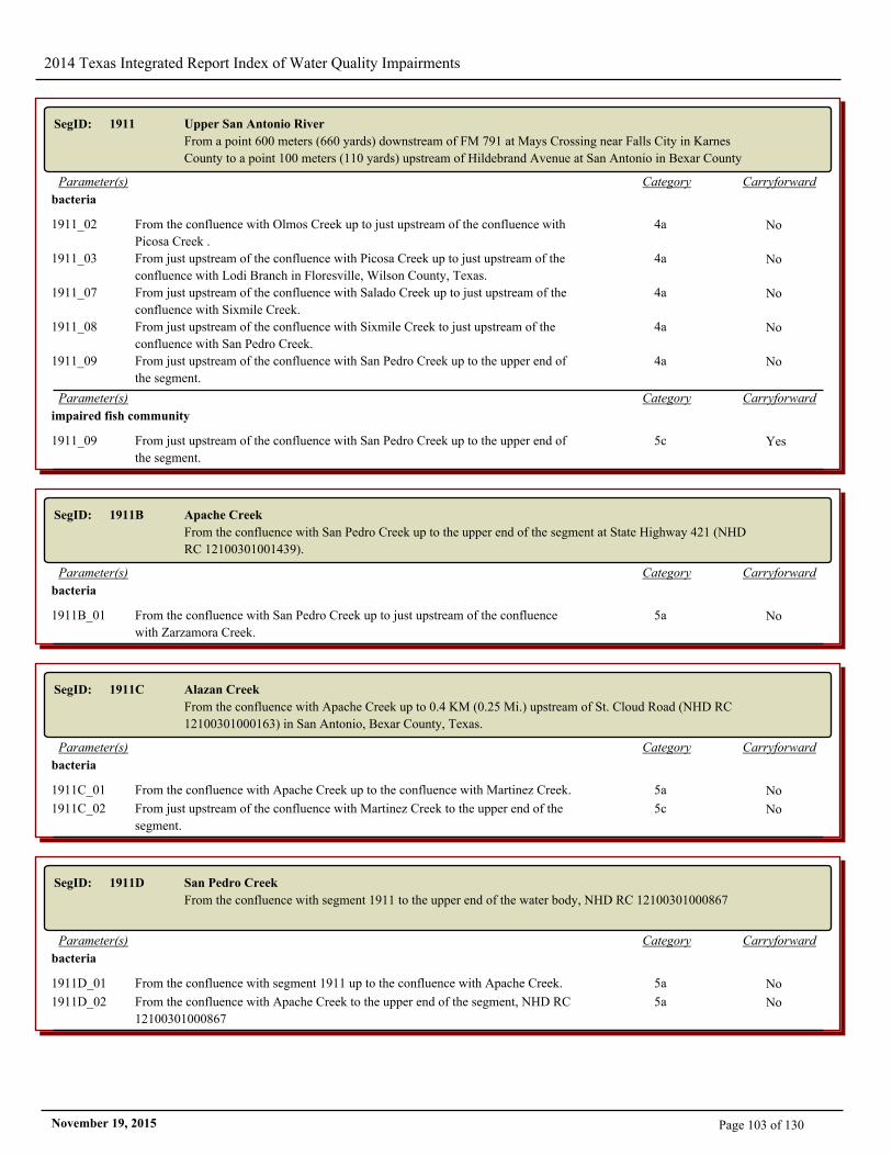
2014 Texas Integrated Report Index of Water Quality Impairments
SegID: 1911 Upper San Antonio River
From a point 600 meters (660 yards) downstream of FM 791 at Mays Crossing near Falls City in Karnes
County to a point 100 meters (110 yards) upstream of Hildebrand Avenue at San Antonio in Bexar County
CarryforwardCategoryParameter(s)
bacteria
1911_02 From the confluence with Olmos Creek up to just upstream of the confluence with
Picosa Creek .
4a No
1911_03 From just upstream of the confluence with Picosa Creek up to just upstream of the
confluence with Lodi Branch in Floresville, Wilson County, Texas.
4a No
1911_07 From just upstream of the confluence with Salado Creek up to just upstream of the
confluence with Sixmile Creek.
4a No
1911_08 From just upstream of the confluence with Sixmile Creek to just upstream of the
confluence with San Pedro Creek.
4a No
1911_09 From just upstream of the confluence with San Pedro Creek up to the upper end of
the segment.
4a No
CarryforwardCategoryParameter(s)
impaired fish community
1911_09 From just upstream of the confluence with San Pedro Creek up to the upper end of
the segment.
5c Yes
SegID: 1911B Apache Creek
From the confluence with San Pedro Creek up to the upper end of the segment at State Highway 421 (NHD
RC 12100301001439).
CarryforwardCategoryParameter(s)
bacteria
1911B_01 From the confluence with San Pedro Creek up to just upstream of the confluence
with Zarzamora Creek.
5a No
SegID: 1911C Alazan Creek
From the confluence with Apache Creek up to 0.4 KM (0.25 Mi.) upstream of St. Cloud Road (NHD RC
12100301000163) in San Antonio, Bexar County, Texas.
CarryforwardCategoryParameter(s)
bacteria
1911C_01 From the confluence with Apache Creek up to the confluence with Martinez Creek. 5a No
1911C_02 From just upstream of the confluence with Martinez Creek to the upper end of the
segment.
5c No
SegID: 1911D San Pedro Creek
From the confluence with segment 1911 to the upper end of the water body, NHD RC 12100301000867
CarryforwardCategoryParameter(s)
bacteria
1911D_01 From the confluence with segment 1911 up to the confluence with Apache Creek. 5a No
1911D_02 From the confluence with Apache Creek to the upper end of the segment, NHD RC
12100301000867
5a No
Page 103 of 130November 19, 2015
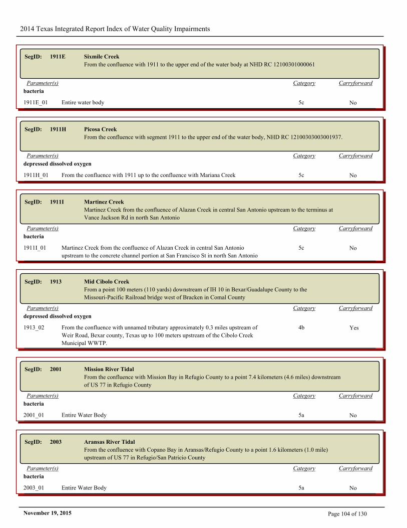
2014 Texas Integrated Report Index of Water Quality Impairments
SegID: 1911E Sixmile Creek
From the confluence with 1911 to the upper end of the water body at NHD RC 12100301000061
CarryforwardCategoryParameter(s)
bacteria
1911E_01 Entire water body 5c No
SegID: 1911H Picosa Creek
From the confluence with segment 1911 to the upper end of the water body, NHD RC 12100303003001937.
CarryforwardCategoryParameter(s)
depressed dissolved oxygen
1911H_01 From the confluence with 1911 up to the confluence with Mariana Creek 5c No
SegID: 1911I Martinez Creek
Martinez Creek from the confluence of Alazan Creek in central San Antonio upstream to the terminus at
Vance Jackson Rd in north San Antonio
CarryforwardCategoryParameter(s)
bacteria
1911I_01 Martinez Creek from the confluence of Alazan Creek in central San Antonio
upstream to the concrete channel portion at San Francisco St in north San Antonio
5c No
SegID: 1913 Mid Cibolo Creek
From a point 100 meters (110 yards) downstream of IH 10 in Bexar/Guadalupe County to the
Missouri-Pacific Railroad bridge west of Bracken in Comal County
CarryforwardCategoryParameter(s)
depressed dissolved oxygen
1913_02 From the confluence with unnamed tributary approximately 0.3 miles upstream of
Weir Road, Bexar county, Texas up to 100 meters upstream of the Cibolo Creek
Municipal WWTP.
4b Yes
SegID: 2001 Mission River Tidal
From the confluence with Mission Bay in Refugio County to a point 7.4 kilometers (4.6 miles) downstream
of US 77 in Refugio County
CarryforwardCategoryParameter(s)
bacteria
2001_01 Entire Water Body 5a No
SegID: 2003 Aransas River Tidal
From the confluence with Copano Bay in Aransas/Refugio County to a point 1.6 kilometers (1.0 mile)
upstream of US 77 in Refugio/San Patricio County
CarryforwardCategoryParameter(s)
bacteria
2003_01 Entire Water Body 5a No
Page 104 of 130November 19, 2015
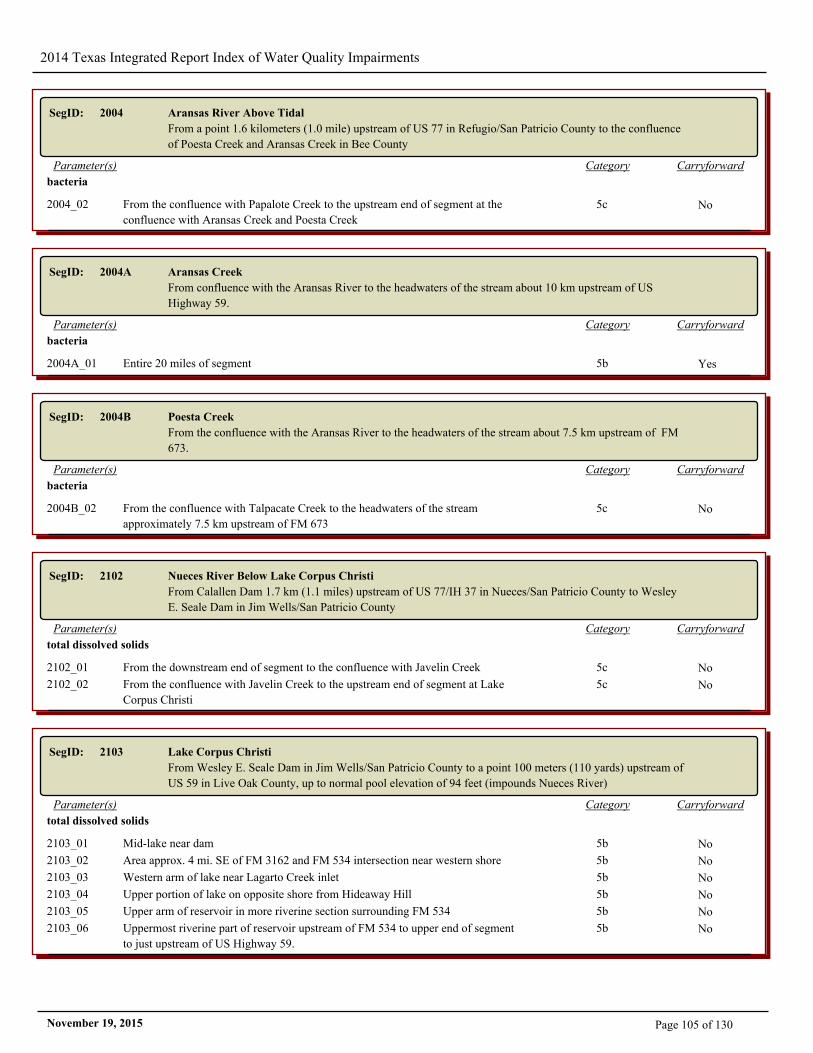
2014 Texas Integrated Report Index of Water Quality Impairments
SegID: 2004 Aransas River Above Tidal
From a point 1.6 kilometers (1.0 mile) upstream of US 77 in Refugio/San Patricio County to the confluence
of Poesta Creek and Aransas Creek in Bee County
CarryforwardCategoryParameter(s)
bacteria
2004_02 From the confluence with Papalote Creek to the upstream end of segment at the
confluence with Aransas Creek and Poesta Creek
5c No
SegID: 2004A Aransas Creek
From confluence with the Aransas River to the headwaters of the stream about 10 km upstream of US
Highway 59.
CarryforwardCategoryParameter(s)
bacteria
2004A_01 Entire 20 miles of segment 5b Yes
SegID: 2004B Poesta Creek
From the confluence with the Aransas River to the headwaters of the stream about 7.5 km upstream of FM
673.
CarryforwardCategoryParameter(s)
bacteria
2004B_02 From the confluence with Talpacate Creek to the headwaters of the stream
approximately 7.5 km upstream of FM 673
5c No
SegID: 2102 Nueces River Below Lake Corpus Christi
From Calallen Dam 1.7 km (1.1 miles) upstream of US 77/IH 37 in Nueces/San Patricio County to Wesley
E. Seale Dam in Jim Wells/San Patricio County
CarryforwardCategoryParameter(s)
total dissolved solids
2102_01 From the downstream end of segment to the confluence with Javelin Creek 5c No
2102_02 From the confluence with Javelin Creek to the upstream end of segment at Lake
Corpus Christi
5c No
SegID: 2103 Lake Corpus Christi
From Wesley E. Seale Dam in Jim Wells/San Patricio County to a point 100 meters (110 yards) upstream of
US 59 in Live Oak County, up to normal pool elevation of 94 feet (impounds Nueces River)
CarryforwardCategoryParameter(s)
total dissolved solids
2103_01 Mid-lake near dam 5b No
2103_02 Area approx. 4 mi. SE of FM 3162 and FM 534 intersection near western shore 5b No
2103_03 Western arm of lake near Lagarto Creek inlet 5b No
2103_04 Upper portion of lake on opposite shore from Hideaway Hill 5b No
2103_05 Upper arm of reservoir in more riverine section surrounding FM 534 5b No
2103_06 Uppermost riverine part of reservoir upstream of FM 534 to upper end of segment
to just upstream of US Highway 59.
5b No
Page 105 of 130November 19, 2015
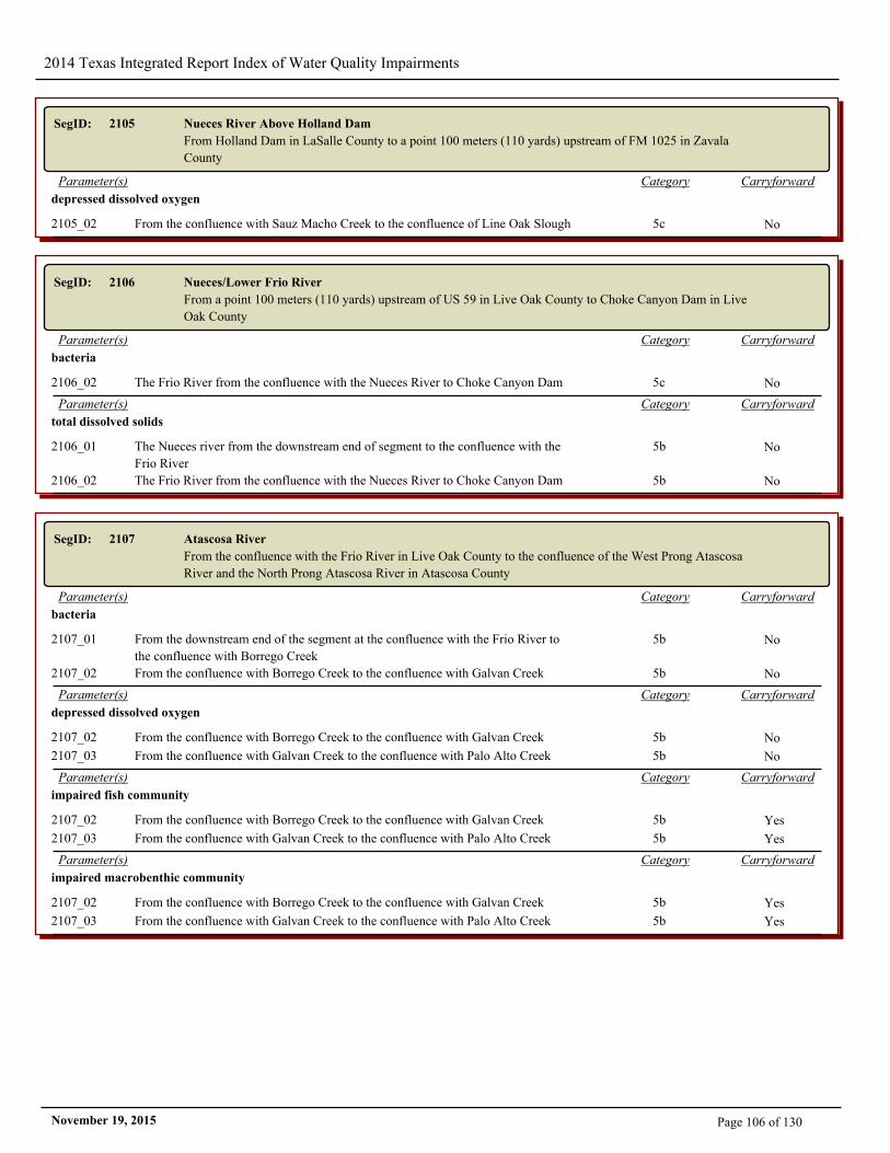
2014 Texas Integrated Report Index of Water Quality Impairments
SegID: 2105 Nueces River Above Holland Dam
From Holland Dam in LaSalle County to a point 100 meters (110 yards) upstream of FM 1025 in Zavala
County
CarryforwardCategoryParameter(s)
depressed dissolved oxygen
2105_02 From the confluence with Sauz Macho Creek to the confluence of Line Oak Slough 5c No
SegID: 2106 Nueces/Lower Frio River
From a point 100 meters (110 yards) upstream of US 59 in Live Oak County to Choke Canyon Dam in Live
Oak County
CarryforwardCategoryParameter(s)
bacteria
2106_02 The Frio River from the confluence with the Nueces River to Choke Canyon Dam 5c No
CarryforwardCategoryParameter(s)
total dissolved solids
2106_01 The Nueces river from the downstream end of segment to the confluence with the
Frio River
5b No
2106_02 The Frio River from the confluence with the Nueces River to Choke Canyon Dam 5b No
SegID: 2107 Atascosa River
From the confluence with the Frio River in Live Oak County to the confluence of the West Prong Atascosa
River and the North Prong Atascosa River in Atascosa County
CarryforwardCategoryParameter(s)
bacteria
2107_01 From the downstream end of the segment at the confluence with the Frio River to
the confluence with Borrego Creek
5b No
2107_02 From the confluence with Borrego Creek to the confluence with Galvan Creek 5b No
CarryforwardCategoryParameter(s)
depressed dissolved oxygen
2107_02 From the confluence with Borrego Creek to the confluence with Galvan Creek 5b No
2107_03 From the confluence with Galvan Creek to the confluence with Palo Alto Creek 5b No
CarryforwardCategoryParameter(s)
impaired fish community
2107_02 From the confluence with Borrego Creek to the confluence with Galvan Creek 5b Yes
2107_03 From the confluence with Galvan Creek to the confluence with Palo Alto Creek 5b Yes
CarryforwardCategoryParameter(s)
impaired macrobenthic community
2107_02 From the confluence with Borrego Creek to the confluence with Galvan Creek 5b Yes
2107_03 From the confluence with Galvan Creek to the confluence with Palo Alto Creek 5b Yes
Page 106 of 130November 19, 2015
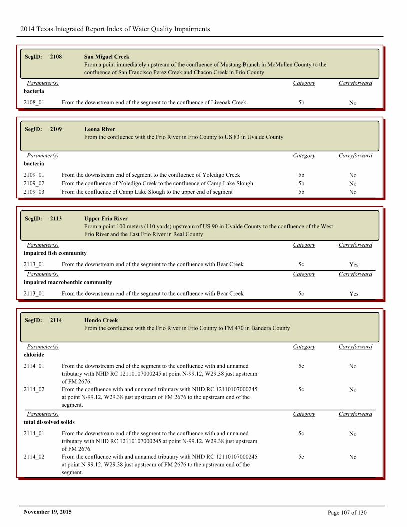
2014 Texas Integrated Report Index of Water Quality Impairments
SegID: 2108 San Miguel Creek
From a point immediately upstream of the confluence of Mustang Branch in McMullen County to the
confluence of San Francisco Perez Creek and Chacon Creek in Frio County
CarryforwardCategoryParameter(s)
bacteria
2108_01 From the downstream end of the segment to the confluence of Liveoak Creek 5b No
SegID: 2109 Leona River
From the confluence with the Frio River in Frio County to US 83 in Uvalde County
CarryforwardCategoryParameter(s)
bacteria
2109_01 From the downstream end of segment to the confluence of Yoledigo Creek 5b No
2109_02 From the confluence of Yoledigo Creek to the confluence of Camp Lake Slough 5b No
2109_03 From the confluence of Camp Lake Slough to the upper end of segment 5b No
SegID: 2113 Upper Frio River
From a point 100 meters (110 yards) upstream of US 90 in Uvalde County to the confluence of the West
Frio River and the East Frio River in Real County
CarryforwardCategoryParameter(s)
impaired fish community
2113_01 From the downstream end of the segment to the confluence with Bear Creek 5c Yes
CarryforwardCategoryParameter(s)
impaired macrobenthic community
2113_01 From the downstream end of the segment to the confluence with Bear Creek 5c Yes
SegID: 2114 Hondo Creek
From the confluence with the Frio River in Frio County to FM 470 in Bandera County
CarryforwardCategoryParameter(s)
chloride
2114_01 From the downstream end of the segment to the confluence with and unnamed
tributary with NHD RC 12110107000245 at point N-99.12, W29.38 just upstream
of FM 2676.
5c No
2114_02 From the confluence with and unnamed tributary with NHD RC 12110107000245
at point N-99.12, W29.38 just upstream of FM 2676 to the upstream end of the
segment.
5c No
CarryforwardCategoryParameter(s)
total dissolved solids
2114_01 From the downstream end of the segment to the confluence with and unnamed
tributary with NHD RC 12110107000245 at point N-99.12, W29.38 just upstream
of FM 2676.
5c No
2114_02 From the confluence with and unnamed tributary with NHD RC 12110107000245
at point N-99.12, W29.38 just upstream of FM 2676 to the upstream end of the
segment.
5c No
Page 107 of 130November 19, 2015
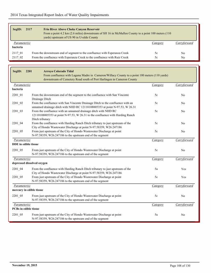
2014 Texas Integrated Report Index of Water Quality Impairments
SegID: 2117 Frio River Above Choke Canyon Reservoir
From a point 4.2 km (2.6 miles) downstream of SH 16 in McMullen County to a point 100 meters (110
yards) upstream of US 90 in Uvalde County
CarryforwardCategoryParameter(s)
bacteria
2117_01 From the downstream end of segment to the confluence with Esperanza Creek 5c No
2117_02 From the confluence with Esperanza Creek to the confluence with Ruiz Creek 5c No
SegID: 2201 Arroyo Colorado Tidal
From confluence with Laguna Madre in Cameron/Willacy County to a point 100 meters (110 yards)
downstream of Cemetery Road south of Port Harlingen in Cameron County
CarryforwardCategoryParameter(s)
bacteria
2201_01 From the downstream end of the segment to the confluence with San Vincente
Drainage Ditch
5c No
2201_02 From the confluence with San Vincente Drainage Ditch to the confluence with an
unnamed drainage ditch with NHD RC 12110108005353 at point N-97.53, W 26.31
5c No
2201_03 From the confluence with an unnamed drainage ditch with NHD RC
12110108005353 at point N-97.53, W 26.31 to the confluence with Harding Ranch
Ditch tributary
5c No
2201_04 From the confluence with Harding Ranch Ditch tributary to just upstream of the
City of Hondo Wastewater Discharge at point N-97.58359, W26.247186
5c No
2201_05 From just upstream of the City of Hondo Wastewater Discharge at point
N-97.58359, W26.247186 to the upstream end of the segment
5c No
CarryforwardCategoryParameter(s)
DDE in edible tissue
2201_05 From just upstream of the City of Hondo Wastewater Discharge at point
N-97.58359, W26.247186 to the upstream end of the segment
5c No
CarryforwardCategoryParameter(s)
depressed dissolved oxygen
2201_04 From the confluence with Harding Ranch Ditch tributary to just upstream of the
City of Hondo Wastewater Discharge at point N-97.58359, W26.247186
5a Yes
2201_05 From just upstream of the City of Hondo Wastewater Discharge at point
N-97.58359, W26.247186 to the upstream end of the segment
5c Yes
CarryforwardCategoryParameter(s)
mercury in edible tissue
2201_05 From just upstream of the City of Hondo Wastewater Discharge at point
N-97.58359, W26.247186 to the upstream end of the segment
5c No
CarryforwardCategoryParameter(s)
PCBs in edible tissue
2201_05 From just upstream of the City of Hondo Wastewater Discharge at point
N-97.58359, W26.247186 to the upstream end of the segment
5a No
Page 108 of 130November 19, 2015
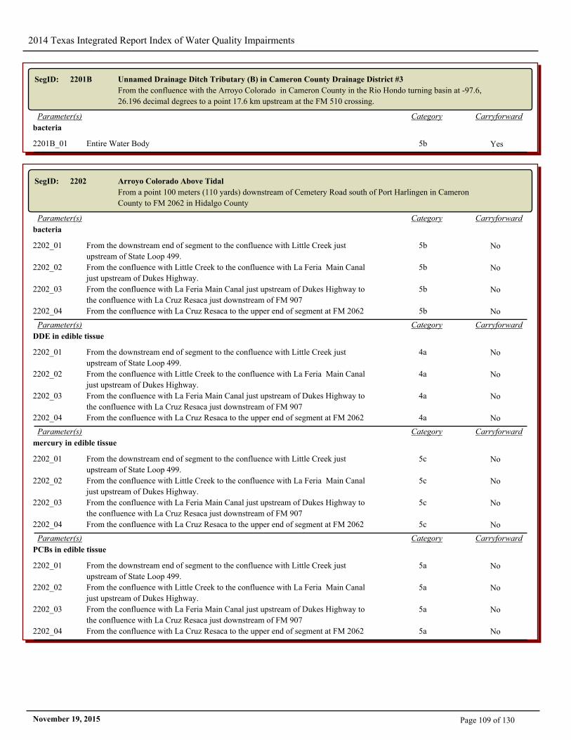
2014 Texas Integrated Report Index of Water Quality Impairments
SegID: 2201B Unnamed Drainage Ditch Tributary (B) in Cameron County Drainage District #3
From the confluence with the Arroyo Colorado in Cameron County in the Rio Hondo turning basin at -97.6,
26.196 decimal degrees to a point 17.6 km upstream at the FM 510 crossing.
CarryforwardCategoryParameter(s)
bacteria
2201B_01 Entire Water Body 5b Yes
SegID: 2202 Arroyo Colorado Above Tidal
From a point 100 meters (110 yards) downstream of Cemetery Road south of Port Harlingen in Cameron
County to FM 2062 in Hidalgo County
CarryforwardCategoryParameter(s)
bacteria
2202_01 From the downstream end of segment to the confluence with Little Creek just
upstream of State Loop 499.
5b No
2202_02 From the confluence with Little Creek to the confluence with La Feria Main Canal
just upstream of Dukes Highway.
5b No
2202_03 From the confluence with La Feria Main Canal just upstream of Dukes Highway to
the confluence with La Cruz Resaca just downstream of FM 907
5b No
2202_04 From the confluence with La Cruz Resaca to the upper end of segment at FM 2062 5b No
CarryforwardCategoryParameter(s)
DDE in edible tissue
2202_01 From the downstream end of segment to the confluence with Little Creek just
upstream of State Loop 499.
4a No
2202_02 From the confluence with Little Creek to the confluence with La Feria Main Canal
just upstream of Dukes Highway.
4a No
2202_03 From the confluence with La Feria Main Canal just upstream of Dukes Highway to
the confluence with La Cruz Resaca just downstream of FM 907
4a No
2202_04 From the confluence with La Cruz Resaca to the upper end of segment at FM 2062 4a No
CarryforwardCategoryParameter(s)
mercury in edible tissue
2202_01 From the downstream end of segment to the confluence with Little Creek just
upstream of State Loop 499.
5c No
2202_02 From the confluence with Little Creek to the confluence with La Feria Main Canal
just upstream of Dukes Highway.
5c No
2202_03 From the confluence with La Feria Main Canal just upstream of Dukes Highway to
the confluence with La Cruz Resaca just downstream of FM 907
5c No
2202_04 From the confluence with La Cruz Resaca to the upper end of segment at FM 2062 5c No
CarryforwardCategoryParameter(s)
PCBs in edible tissue
2202_01 From the downstream end of segment to the confluence with Little Creek just
upstream of State Loop 499.
5a No
2202_02 From the confluence with Little Creek to the confluence with La Feria Main Canal
just upstream of Dukes Highway.
5a No
2202_03 From the confluence with La Feria Main Canal just upstream of Dukes Highway to
the confluence with La Cruz Resaca just downstream of FM 907
5a No
2202_04 From the confluence with La Cruz Resaca to the upper end of segment at FM 2062 5a No
Page 109 of 130November 19, 2015
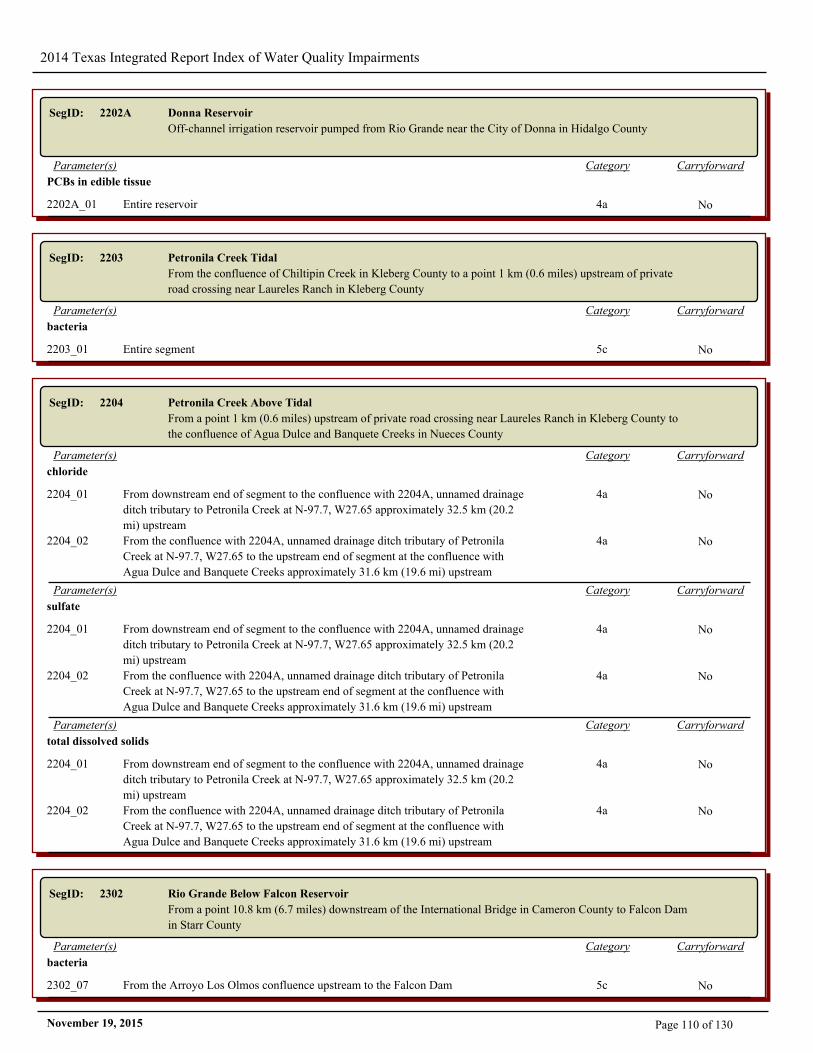
2014 Texas Integrated Report Index of Water Quality Impairments
SegID: 2202A Donna Reservoir
Off-channel irrigation reservoir pumped from Rio Grande near the City of Donna in Hidalgo County
CarryforwardCategoryParameter(s)
PCBs in edible tissue
2202A_01 Entire reservoir 4a No
SegID: 2203 Petronila Creek Tidal
From the confluence of Chiltipin Creek in Kleberg County to a point 1 km (0.6 miles) upstream of private
road crossing near Laureles Ranch in Kleberg County
CarryforwardCategoryParameter(s)
bacteria
2203_01 Entire segment 5c No
SegID: 2204 Petronila Creek Above Tidal
From a point 1 km (0.6 miles) upstream of private road crossing near Laureles Ranch in Kleberg County to
the confluence of Agua Dulce and Banquete Creeks in Nueces County
CarryforwardCategoryParameter(s)
chloride
2204_01 From downstream end of segment to the confluence with 2204A, unnamed drainage
ditch tributary to Petronila Creek at N-97.7, W27.65 approximately 32.5 km (20.2
mi) upstream
4a No
2204_02 From the confluence with 2204A, unnamed drainage ditch tributary of Petronila
Creek at N-97.7, W27.65 to the upstream end of segment at the confluence with
Agua Dulce and Banquete Creeks approximately 31.6 km (19.6 mi) upstream
4a No
CarryforwardCategoryParameter(s)
sulfate
2204_01 From downstream end of segment to the confluence with 2204A, unnamed drainage
ditch tributary to Petronila Creek at N-97.7, W27.65 approximately 32.5 km (20.2
mi) upstream
4a No
2204_02 From the confluence with 2204A, unnamed drainage ditch tributary of Petronila
Creek at N-97.7, W27.65 to the upstream end of segment at the confluence with
Agua Dulce and Banquete Creeks approximately 31.6 km (19.6 mi) upstream
4a No
CarryforwardCategoryParameter(s)
total dissolved solids
2204_01 From downstream end of segment to the confluence with 2204A, unnamed drainage
ditch tributary to Petronila Creek at N-97.7, W27.65 approximately 32.5 km (20.2
mi) upstream
4a No
2204_02 From the confluence with 2204A, unnamed drainage ditch tributary of Petronila
Creek at N-97.7, W27.65 to the upstream end of segment at the confluence with
Agua Dulce and Banquete Creeks approximately 31.6 km (19.6 mi) upstream
4a No
SegID: 2302 Rio Grande Below Falcon Reservoir
From a point 10.8 km (6.7 miles) downstream of the International Bridge in Cameron County to Falcon Dam
in Starr County
CarryforwardCategoryParameter(s)
bacteria
2302_07 From the Arroyo Los Olmos confluence upstream to the Falcon Dam 5c No
Page 110 of 130November 19, 2015
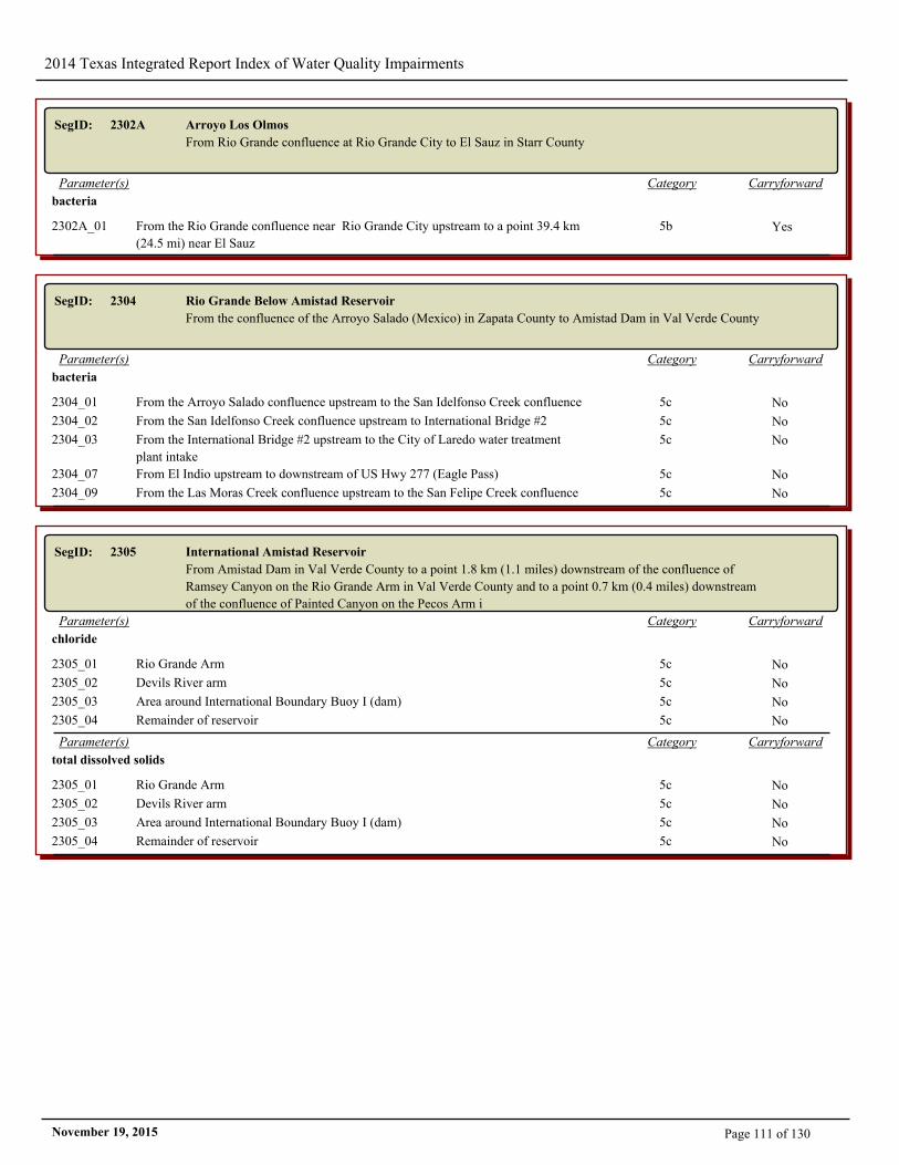
2014 Texas Integrated Report Index of Water Quality Impairments
SegID: 2302A Arroyo Los Olmos
From Rio Grande confluence at Rio Grande City to El Sauz in Starr County
CarryforwardCategoryParameter(s)
bacteria
2302A_01 From the Rio Grande confluence near Rio Grande City upstream to a point 39.4 km
(24.5 mi) near El Sauz
5b Yes
SegID: 2304 Rio Grande Below Amistad Reservoir
From the confluence of the Arroyo Salado (Mexico) in Zapata County to Amistad Dam in Val Verde County
CarryforwardCategoryParameter(s)
bacteria
2304_01 From the Arroyo Salado confluence upstream to the San Idelfonso Creek confluence 5c No
2304_02 From the San Idelfonso Creek confluence upstream to International Bridge #2 5c No
2304_03 From the International Bridge #2 upstream to the City of Laredo water treatment
plant intake
5c No
2304_07 From El Indio upstream to downstream of US Hwy 277 (Eagle Pass) 5c No
2304_09 From the Las Moras Creek confluence upstream to the San Felipe Creek confluence 5c No
SegID: 2305 International Amistad Reservoir
From Amistad Dam in Val Verde County to a point 1.8 km (1.1 miles) downstream of the confluence of
Ramsey Canyon on the Rio Grande Arm in Val Verde County and to a point 0.7 km (0.4 miles) downstream
of the confluence of Painted Canyon on the Pecos Arm i
CarryforwardCategoryParameter(s)
chloride
2305_01 Rio Grande Arm 5c No
2305_02 Devils River arm 5c No
2305_03 Area around International Boundary Buoy I (dam) 5c No
2305_04 Remainder of reservoir 5c No
CarryforwardCategoryParameter(s)
total dissolved solids
2305_01 Rio Grande Arm 5c No
2305_02 Devils River arm 5c No
2305_03 Area around International Boundary Buoy I (dam) 5c No
2305_04 Remainder of reservoir 5c No
Page 111 of 130November 19, 2015
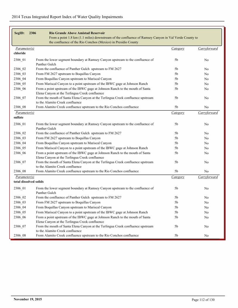
2014 Texas Integrated Report Index of Water Quality Impairments
SegID: 2306 Rio Grande Above Amistad Reservoir
From a point 1.8 km (1.1 miles) downstream of the confluence of Ramsey Canyon in Val Verde County to
the confluence of the Rio Conchos (Mexico) in Presidio County
CarryforwardCategoryParameter(s)
chloride
2306_01 From the lower segment boundary at Ramsey Canyon upstream to the confluence of
Panther Gulch
5b No
2306_02 From the confluence of Panther Gulch upstream to FM 2627 5b No
2306_03 From FM 2627 upstream to Boquillas Canyon 5b No
2306_04 From Boquillas Canyon upstream to Mariscal Canyon 5b No
2306_05 From Mariscal Canyon to a point upstream of the IBWC gage at Johnson Ranch 5b No
2306_06 From a point upstream of the IBWC gage at Johnson Ranch to the mouth of Santa
Elena Canyon at the Terlingua Creek confluence
5b No
2306_07 From the mouth of Santa Elena Canyon at the Terlingua Creek confluence upstream
to the Alamito Creek confluence
5b No
2306_08 From Alamito Creek confluence upstream to the Rio Conchos confluence 5b No
CarryforwardCategoryParameter(s)
sulfate
2306_01 From the lower segment boundary at Ramsey Canyon upstream to the confluence of
Panther Gulch
5b No
2306_02 From the confluence of Panther Gulch upstream to FM 2627 5b No
2306_03 From FM 2627 upstream to Boquillas Canyon 5b No
2306_04 From Boquillas Canyon upstream to Mariscal Canyon 5b No
2306_05 From Mariscal Canyon to a point upstream of the IBWC gage at Johnson Ranch 5b No
2306_06 From a point upstream of the IBWC gage at Johnson Ranch to the mouth of Santa
Elena Canyon at the Terlingua Creek confluence
5b No
2306_07 From the mouth of Santa Elena Canyon at the Terlingua Creek confluence upstream
to the Alamito Creek confluence
5b No
2306_08 From Alamito Creek confluence upstream to the Rio Conchos confluence 5b No
CarryforwardCategoryParameter(s)
total dissolved solids
2306_01 From the lower segment boundary at Ramsey Canyon upstream to the confluence of
Panther Gulch
5b No
2306_02 From the confluence of Panther Gulch upstream to FM 2627 5b No
2306_03 From FM 2627 upstream to Boquillas Canyon 5b No
2306_04 From Boquillas Canyon upstream to Mariscal Canyon 5b No
2306_05 From Mariscal Canyon to a point upstream of the IBWC gage at Johnson Ranch 5b No
2306_06 From a point upstream of the IBWC gage at Johnson Ranch to the mouth of Santa
Elena Canyon at the Terlingua Creek confluence
5b No
2306_07 From the mouth of Santa Elena Canyon at the Terlingua Creek confluence upstream
to the Alamito Creek confluence
5b No
2306_08 From Alamito Creek confluence upstream to the Rio Conchos confluence 5b No
Page 112 of 130November 19, 2015
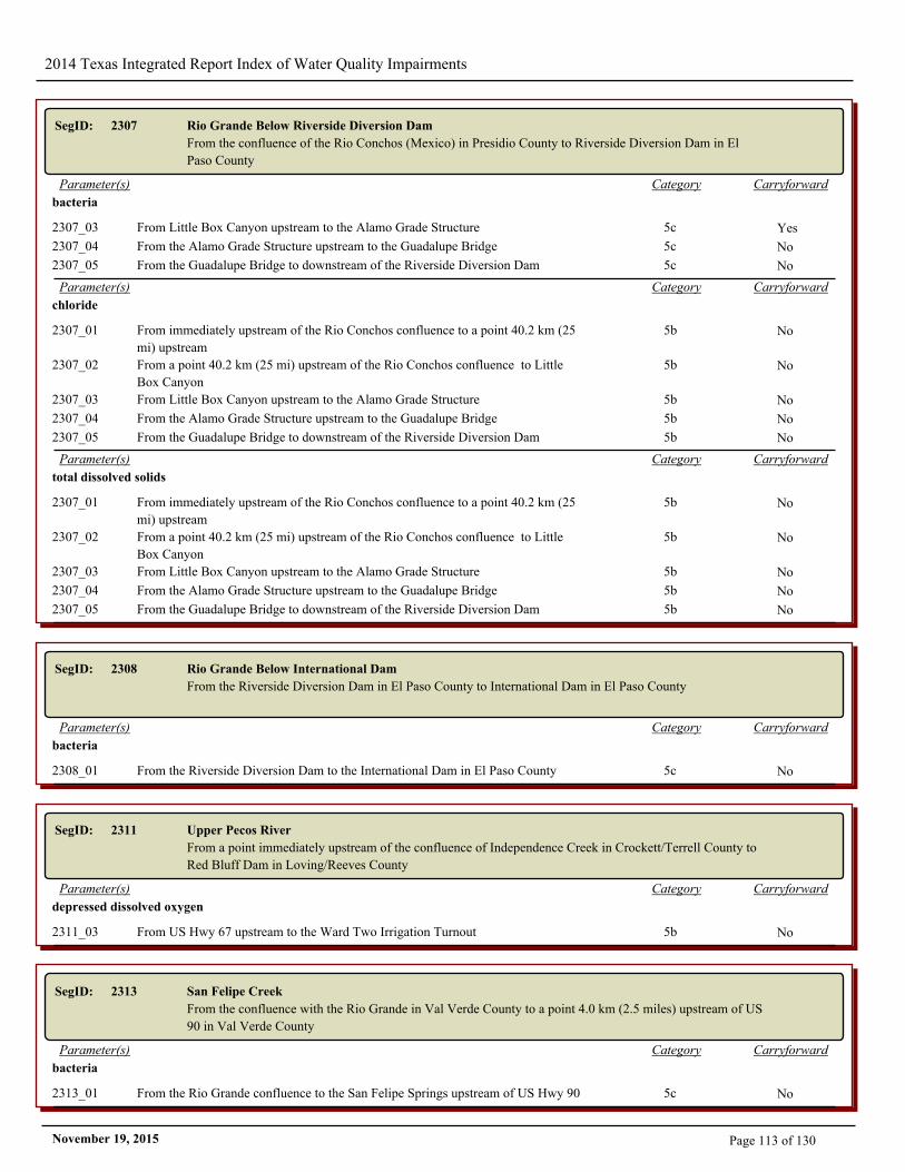
2014 Texas Integrated Report Index of Water Quality Impairments
SegID: 2307 Rio Grande Below Riverside Diversion Dam
From the confluence of the Rio Conchos (Mexico) in Presidio County to Riverside Diversion Dam in El
Paso County
CarryforwardCategoryParameter(s)
bacteria
2307_03 From Little Box Canyon upstream to the Alamo Grade Structure 5c Yes
2307_04 From the Alamo Grade Structure upstream to the Guadalupe Bridge 5c No
2307_05 From the Guadalupe Bridge to downstream of the Riverside Diversion Dam 5c No
CarryforwardCategoryParameter(s)
chloride
2307_01 From immediately upstream of the Rio Conchos confluence to a point 40.2 km (25
mi) upstream
5b No
2307_02 From a point 40.2 km (25 mi) upstream of the Rio Conchos confluence to Little
Box Canyon
5b No
2307_03 From Little Box Canyon upstream to the Alamo Grade Structure 5b No
2307_04 From the Alamo Grade Structure upstream to the Guadalupe Bridge 5b No
2307_05 From the Guadalupe Bridge to downstream of the Riverside Diversion Dam 5b No
CarryforwardCategoryParameter(s)
total dissolved solids
2307_01 From immediately upstream of the Rio Conchos confluence to a point 40.2 km (25
mi) upstream
5b No
2307_02 From a point 40.2 km (25 mi) upstream of the Rio Conchos confluence to Little
Box Canyon
5b No
2307_03 From Little Box Canyon upstream to the Alamo Grade Structure 5b No
2307_04 From the Alamo Grade Structure upstream to the Guadalupe Bridge 5b No
2307_05 From the Guadalupe Bridge to downstream of the Riverside Diversion Dam 5b No
SegID: 2308 Rio Grande Below International Dam
From the Riverside Diversion Dam in El Paso County to International Dam in El Paso County
CarryforwardCategoryParameter(s)
bacteria
2308_01 From the Riverside Diversion Dam to the International Dam in El Paso County 5c No
SegID: 2311 Upper Pecos River
From a point immediately upstream of the confluence of Independence Creek in Crockett/Terrell County to
Red Bluff Dam in Loving/Reeves County
CarryforwardCategoryParameter(s)
depressed dissolved oxygen
2311_03 From US Hwy 67 upstream to the Ward Two Irrigation Turnout 5b No
SegID: 2313 San Felipe Creek
From the confluence with the Rio Grande in Val Verde County to a point 4.0 km (2.5 miles) upstream of US
90 in Val Verde County
CarryforwardCategoryParameter(s)
bacteria
2313_01 From the Rio Grande confluence to the San Felipe Springs upstream of US Hwy 90 5c No
Page 113 of 130November 19, 2015

2014 Texas Integrated Report Index of Water Quality Impairments
SegID: 2314 Rio Grande Above International Dam
From International Dam in El Paso County to the New Mexico State Line in El Paso County
CarryforwardCategoryParameter(s)
bacteria
2314_01 From the International Dam upstream to the Anthony Drain confluence 5c No
SegID: 2411 Sabine Pass
From the end of jetties at the Gulf of Mexico to SH 82
CarryforwardCategoryParameter(s)
bacteria
2411_01 From the end of jetties at the Gulf of Mexico to SH 82 5c No
CarryforwardCategoryParameter(s)
PCBs in edible tissue
2411_01 From the end of jetties at the Gulf of Mexico to SH 82 5a Yes
SegID: 2412 Sabine Lake
Sabine Lake
CarryforwardCategoryParameter(s)
PCBs in edible tissue
2412_01 Entire segment 5a Yes
SegID: 2421 Upper Galveston Bay
From the Lower Galveston Bay confluence to SH 146
CarryforwardCategoryParameter(s)
dioxin in edible tissue
2421_01 Red Bluff to Five Mile Cut to Houston Point to Morgans Point 5a No
2421_02 Western portion of the bay 5a No
2421_03 Eastern portion of the bay 5a No
CarryforwardCategoryParameter(s)
PCBs in edible tissue
2421_01 Red Bluff to Five Mile Cut to Houston Point to Morgans Point 5a No
2421_02 Western portion of the bay 5a No
2421_03 Eastern portion of the bay 5a No
Page 114 of 130November 19, 2015
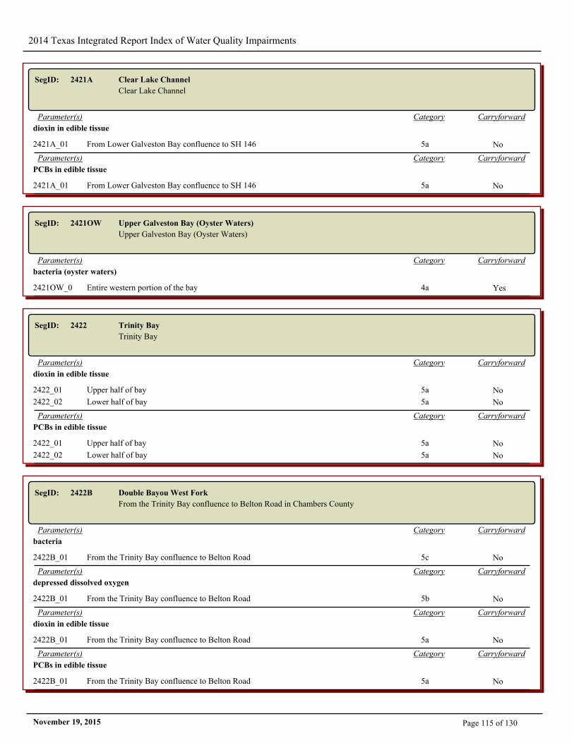
2014 Texas Integrated Report Index of Water Quality Impairments
SegID: 2421A Clear Lake Channel
Clear Lake Channel
CarryforwardCategoryParameter(s)
dioxin in edible tissue
2421A_01 From Lower Galveston Bay confluence to SH 146 5a No
CarryforwardCategoryParameter(s)
PCBs in edible tissue
2421A_01 From Lower Galveston Bay confluence to SH 146 5a No
SegID: 2421OW Upper Galveston Bay (Oyster Waters)
Upper Galveston Bay (Oyster Waters)
CarryforwardCategoryParameter(s)
bacteria (oyster waters)
2421OW_01 Entire western portion of the bay 4a Yes
SegID: 2422 Trinity Bay
Trinity Bay
CarryforwardCategoryParameter(s)
dioxin in edible tissue
2422_01 Upper half of bay 5a No
2422_02 Lower half of bay 5a No
CarryforwardCategoryParameter(s)
PCBs in edible tissue
2422_01 Upper half of bay 5a No
2422_02 Lower half of bay 5a No
SegID: 2422B Double Bayou West Fork
From the Trinity Bay confluence to Belton Road in Chambers County
CarryforwardCategoryParameter(s)
bacteria
2422B_01 From the Trinity Bay confluence to Belton Road 5c No
CarryforwardCategoryParameter(s)
depressed dissolved oxygen
2422B_01 From the Trinity Bay confluence to Belton Road 5b No
CarryforwardCategoryParameter(s)
dioxin in edible tissue
2422B_01 From the Trinity Bay confluence to Belton Road 5a No
CarryforwardCategoryParameter(s)
PCBs in edible tissue
2422B_01 From the Trinity Bay confluence to Belton Road 5a No
Page 115 of 130November 19, 2015

2014 Texas Integrated Report Index of Water Quality Impairments
SegID: 2422D Double Bayou East Fork
From the Trinity Bay confluence to a point 2.6 km (1.6 mi) upstream of SH 65
CarryforwardCategoryParameter(s)
bacteria
2422D_01 From the Trinity Bay confluence to a point 2.6 km (1.6 mi) upstream of SH 65 5c No
CarryforwardCategoryParameter(s)
dioxin in edible tissue
2422D_01 From the Trinity Bay confluence to a point 2.6 km (1.6 mi) upstream of SH 65 5a No
CarryforwardCategoryParameter(s)
PCBs in edible tissue
2422D_01 From the Trinity Bay confluence to a point 2.6 km (1.6 mi) upstream of SH 65 5a No
SegID: 2422OW Trinity Bay (Oyster Waters)
Trinity Bay (Oyster Waters)
CarryforwardCategoryParameter(s)
bacteria (oyster waters)
2422OW_01 Upper portion of the bay 4a Yes
SegID: 2423 East Bay
East Bay
CarryforwardCategoryParameter(s)
dioxin in edible tissue
2423_01 Area adjacent to the ICWW (Segment 0702) 5a No
2423_02 Remainder of segment 5a No
CarryforwardCategoryParameter(s)
PCBs in edible tissue
2423_01 Area adjacent to the ICWW (Segment 0702) 5a No
2423_02 Remainder of segment 5a No
SegID: 2423A Oyster Bayou
From the East Bay confluence to a point 2.2 km (1.4 mi) upstream from SH 65 in Chambers County
CarryforwardCategoryParameter(s)
bacteria
2423A_01 From the East Bay confluence to a point 2.2 km (1.4 mi) upstream from SH 65 5c No
CarryforwardCategoryParameter(s)
dioxin in edible tissue
2423A_01 From the East Bay confluence to a point 2.2 km (1.4 mi) upstream from SH 65 5a No
CarryforwardCategoryParameter(s)
PCBs in edible tissue
2423A_01 From the East Bay confluence to a point 2.2 km (1.4 mi) upstream from SH 65 5a No
Page 116 of 130November 19, 2015
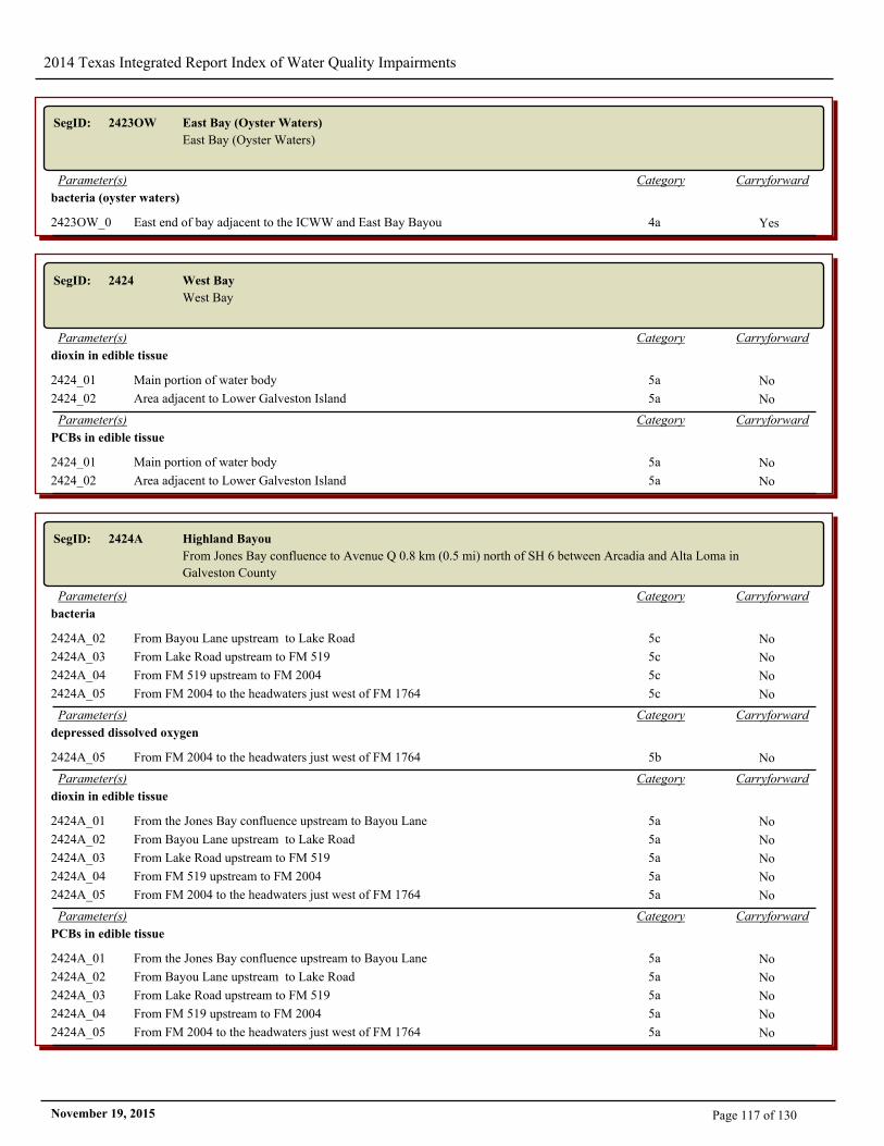
2014 Texas Integrated Report Index of Water Quality Impairments
SegID: 2423OW East Bay (Oyster Waters)
East Bay (Oyster Waters)
CarryforwardCategoryParameter(s)
bacteria (oyster waters)
2423OW_01 East end of bay adjacent to the ICWW and East Bay Bayou 4a Yes
SegID: 2424 West Bay
West Bay
CarryforwardCategoryParameter(s)
dioxin in edible tissue
2424_01 Main portion of water body 5a No
2424_02 Area adjacent to Lower Galveston Island 5a No
CarryforwardCategoryParameter(s)
PCBs in edible tissue
2424_01 Main portion of water body 5a No
2424_02 Area adjacent to Lower Galveston Island 5a No
SegID: 2424A Highland Bayou
From Jones Bay confluence to Avenue Q 0.8 km (0.5 mi) north of SH 6 between Arcadia and Alta Loma in
Galveston County
CarryforwardCategoryParameter(s)
bacteria
2424A_02 From Bayou Lane upstream to Lake Road 5c No
2424A_03 From Lake Road upstream to FM 519 5c No
2424A_04 From FM 519 upstream to FM 2004 5c No
2424A_05 From FM 2004 to the headwaters just west of FM 1764 5c No
CarryforwardCategoryParameter(s)
depressed dissolved oxygen
2424A_05 From FM 2004 to the headwaters just west of FM 1764 5b No
CarryforwardCategoryParameter(s)
dioxin in edible tissue
2424A_01 From the Jones Bay confluence upstream to Bayou Lane 5a No
2424A_02 From Bayou Lane upstream to Lake Road 5a No
2424A_03 From Lake Road upstream to FM 519 5a No
2424A_04 From FM 519 upstream to FM 2004 5a No
2424A_05 From FM 2004 to the headwaters just west of FM 1764 5a No
CarryforwardCategoryParameter(s)
PCBs in edible tissue
2424A_01 From the Jones Bay confluence upstream to Bayou Lane 5a No
2424A_02 From Bayou Lane upstream to Lake Road 5a No
2424A_03 From Lake Road upstream to FM 519 5a No
2424A_04 From FM 519 upstream to FM 2004 5a No
2424A_05 From FM 2004 to the headwaters just west of FM 1764 5a No
Page 117 of 130November 19, 2015
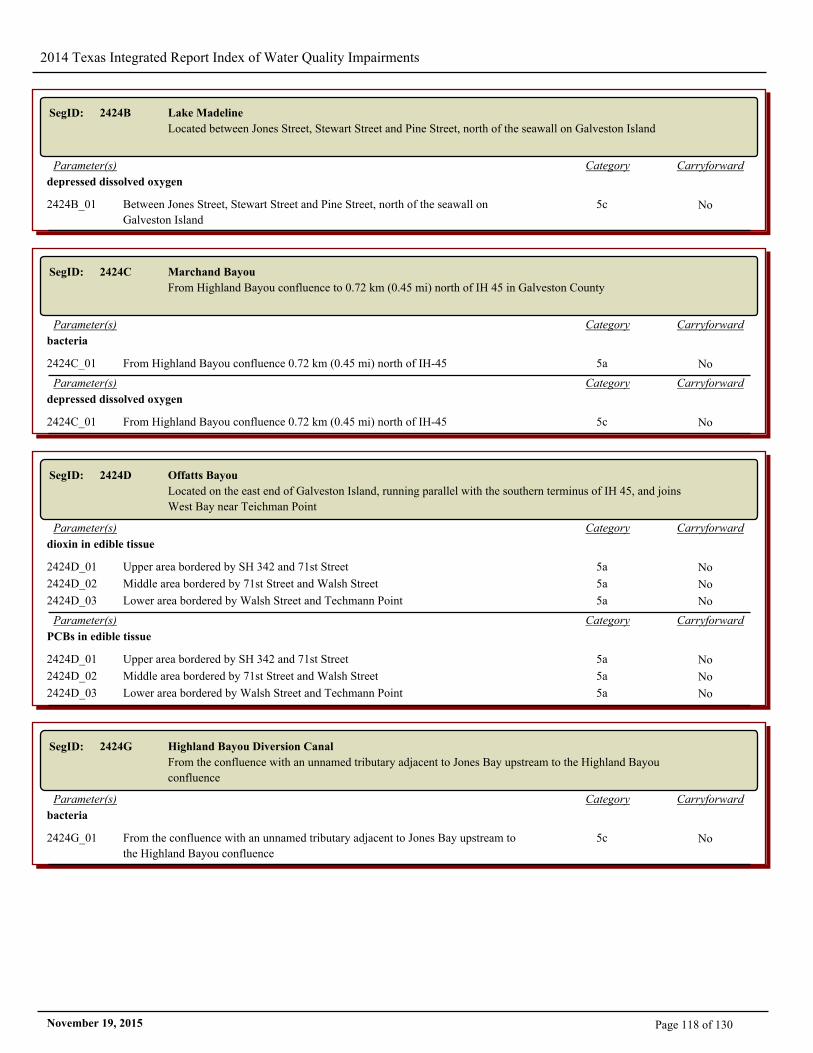
2014 Texas Integrated Report Index of Water Quality Impairments
SegID: 2424B Lake Madeline
Located between Jones Street, Stewart Street and Pine Street, north of the seawall on Galveston Island
CarryforwardCategoryParameter(s)
depressed dissolved oxygen
2424B_01 Between Jones Street, Stewart Street and Pine Street, north of the seawall on
Galveston Island
5c No
SegID: 2424C Marchand Bayou
From Highland Bayou confluence to 0.72 km (0.45 mi) north of IH 45 in Galveston County
CarryforwardCategoryParameter(s)
bacteria
2424C_01 From Highland Bayou confluence 0.72 km (0.45 mi) north of IH-45 5a No
CarryforwardCategoryParameter(s)
depressed dissolved oxygen
2424C_01 From Highland Bayou confluence 0.72 km (0.45 mi) north of IH-45 5c No
SegID: 2424D Offatts Bayou
Located on the east end of Galveston Island, running parallel with the southern terminus of IH 45, and joins
West Bay near Teichman Point
CarryforwardCategoryParameter(s)
dioxin in edible tissue
2424D_01 Upper area bordered by SH 342 and 71st Street 5a No
2424D_02 Middle area bordered by 71st Street and Walsh Street 5a No
2424D_03 Lower area bordered by Walsh Street and Techmann Point 5a No
CarryforwardCategoryParameter(s)
PCBs in edible tissue
2424D_01 Upper area bordered by SH 342 and 71st Street 5a No
2424D_02 Middle area bordered by 71st Street and Walsh Street 5a No
2424D_03 Lower area bordered by Walsh Street and Techmann Point 5a No
SegID: 2424G Highland Bayou Diversion Canal
From the confluence with an unnamed tributary adjacent to Jones Bay upstream to the Highland Bayou
confluence
CarryforwardCategoryParameter(s)
bacteria
2424G_01 From the confluence with an unnamed tributary adjacent to Jones Bay upstream to
the Highland Bayou confluence
5c No
Page 118 of 130November 19, 2015
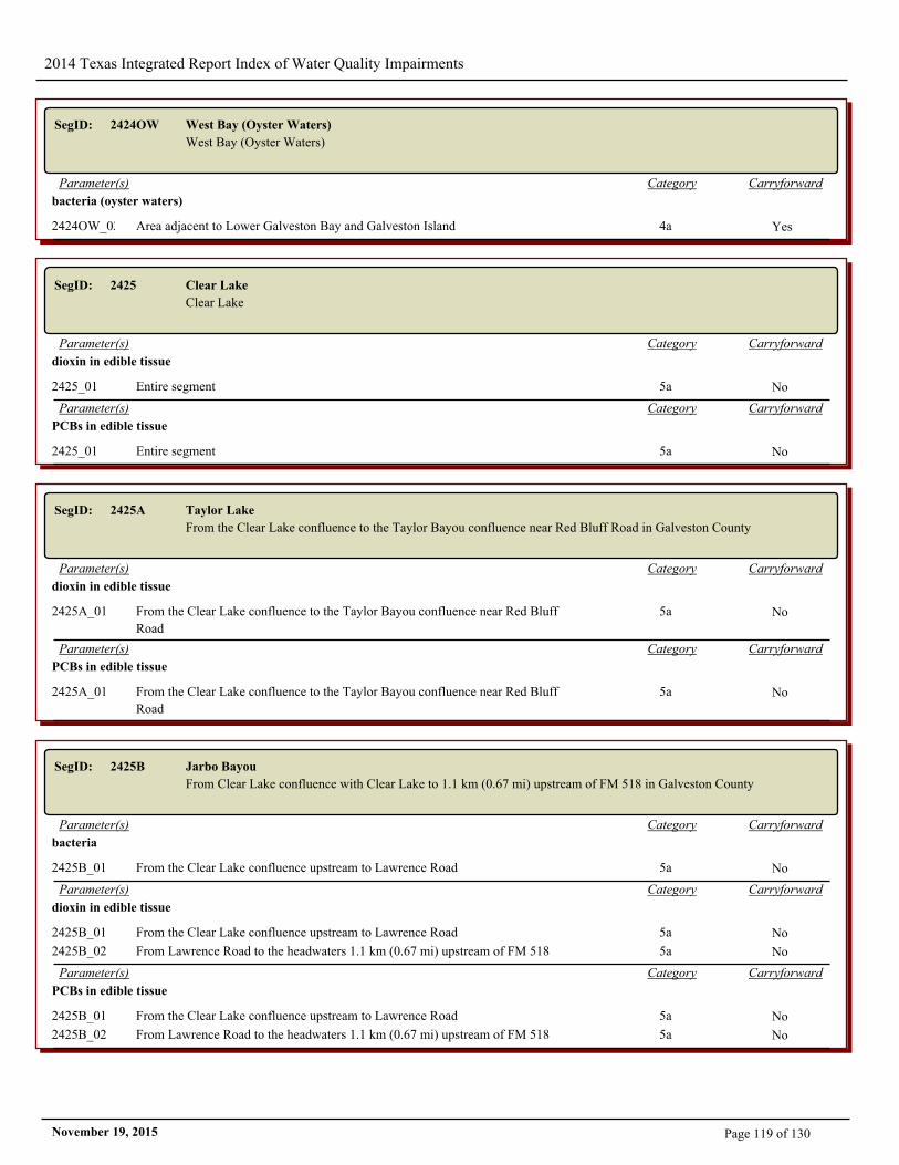
2014 Texas Integrated Report Index of Water Quality Impairments
SegID: 2424OW West Bay (Oyster Waters)
West Bay (Oyster Waters)
CarryforwardCategoryParameter(s)
bacteria (oyster waters)
2424OW_02 Area adjacent to Lower Galveston Bay and Galveston Island 4a Yes
SegID: 2425 Clear Lake
Clear Lake
CarryforwardCategoryParameter(s)
dioxin in edible tissue
2425_01 Entire segment 5a No
CarryforwardCategoryParameter(s)
PCBs in edible tissue
2425_01 Entire segment 5a No
SegID: 2425A Taylor Lake
From the Clear Lake confluence to the Taylor Bayou confluence near Red Bluff Road in Galveston County
CarryforwardCategoryParameter(s)
dioxin in edible tissue
2425A_01 From the Clear Lake confluence to the Taylor Bayou confluence near Red Bluff
Road
5a No
CarryforwardCategoryParameter(s)
PCBs in edible tissue
2425A_01 From the Clear Lake confluence to the Taylor Bayou confluence near Red Bluff
Road
5a No
SegID: 2425B Jarbo Bayou
From Clear Lake confluence with Clear Lake to 1.1 km (0.67 mi) upstream of FM 518 in Galveston County
CarryforwardCategoryParameter(s)
bacteria
2425B_01 From the Clear Lake confluence upstream to Lawrence Road 5a No
CarryforwardCategoryParameter(s)
dioxin in edible tissue
2425B_01 From the Clear Lake confluence upstream to Lawrence Road 5a No
2425B_02 From Lawrence Road to the headwaters 1.1 km (0.67 mi) upstream of FM 518 5a No
CarryforwardCategoryParameter(s)
PCBs in edible tissue
2425B_01 From the Clear Lake confluence upstream to Lawrence Road 5a No
2425B_02 From Lawrence Road to the headwaters 1.1 km (0.67 mi) upstream of FM 518 5a No
Page 119 of 130November 19, 2015
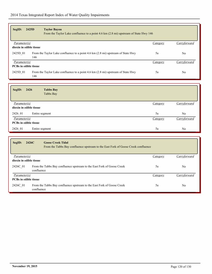
2014 Texas Integrated Report Index of Water Quality Impairments
SegID: 2425D Taylor Bayou
From the Taylor Lake confluence to a point 4.6 km (2.8 mi) upstream of State Hwy 146
CarryforwardCategoryParameter(s)
dioxin in edible tissue
2425D_01 From the Taylor Lake confluence to a point 4.6 km (2.8 mi) upstream of State Hwy
146
5a No
CarryforwardCategoryParameter(s)
PCBs in edible tissue
2425D_01 From the Taylor Lake confluence to a point 4.6 km (2.8 mi) upstream of State Hwy
146
5a No
SegID: 2426 Tabbs Bay
Tabbs Bay
CarryforwardCategoryParameter(s)
dioxin in edible tissue
2426_01 Entire segment 5a No
CarryforwardCategoryParameter(s)
PCBs in edible tissue
2426_01 Entire segment 5a No
SegID: 2426C Goose Creek Tidal
From the Tabbs Bay confluence upstream to the East Fork of Goose Creek confluence
CarryforwardCategoryParameter(s)
dioxin in edible tissue
2426C_01 From the Tabbs Bay confluence upstream to the East Fork of Goose Creek
confluence
5a No
CarryforwardCategoryParameter(s)
PCBs in edible tissue
2426C_01 From the Tabbs Bay confluence upstream to the East Fork of Goose Creek
confluence
5a No
Page 120 of 130November 19, 2015
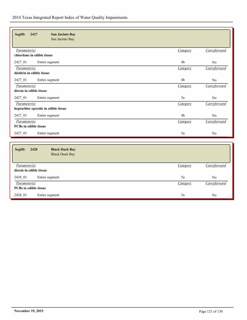
2014 Texas Integrated Report Index of Water Quality Impairments
SegID: 2427 San Jacinto Bay
San Jacinto Bay
CarryforwardCategoryParameter(s)
chlordane in edible tissue
2427_01 Entire segment 4b No
CarryforwardCategoryParameter(s)
dieldrin in edible tissue
2427_01 Entire segment 4b No
CarryforwardCategoryParameter(s)
dioxin in edible tissue
2427_01 Entire segment 5a No
CarryforwardCategoryParameter(s)
heptachlor epoxide in edible tissue
2427_01 Entire segment 4b No
CarryforwardCategoryParameter(s)
PCBs in edible tissue
2427_01 Entire segment 5a No
SegID: 2428 Black Duck Bay
Black Duck Bay
CarryforwardCategoryParameter(s)
dioxin in edible tissue
2428_01 Entire segment 5a No
CarryforwardCategoryParameter(s)
PCBs in edible tissue
2428_01 Entire segment 5a No
Page 121 of 130November 19, 2015
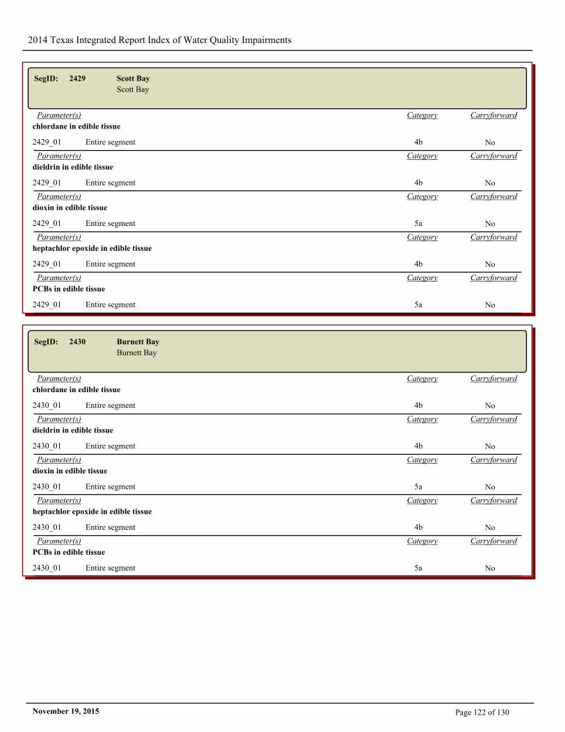
2014 Texas Integrated Report Index of Water Quality Impairments
SegID: 2429 Scott Bay
Scott Bay
CarryforwardCategoryParameter(s)
chlordane in edible tissue
2429_01 Entire segment 4b No
CarryforwardCategoryParameter(s)
dieldrin in edible tissue
2429_01 Entire segment 4b No
CarryforwardCategoryParameter(s)
dioxin in edible tissue
2429_01 Entire segment 5a No
CarryforwardCategoryParameter(s)
heptachlor epoxide in edible tissue
2429_01 Entire segment 4b No
CarryforwardCategoryParameter(s)
PCBs in edible tissue
2429_01 Entire segment 5a No
SegID: 2430 Burnett Bay
Burnett Bay
CarryforwardCategoryParameter(s)
chlordane in edible tissue
2430_01 Entire segment 4b No
CarryforwardCategoryParameter(s)
dieldrin in edible tissue
2430_01 Entire segment 4b No
CarryforwardCategoryParameter(s)
dioxin in edible tissue
2430_01 Entire segment 5a No
CarryforwardCategoryParameter(s)
heptachlor epoxide in edible tissue
2430_01 Entire segment 4b No
CarryforwardCategoryParameter(s)
PCBs in edible tissue
2430_01 Entire segment 5a No
Page 122 of 130November 19, 2015
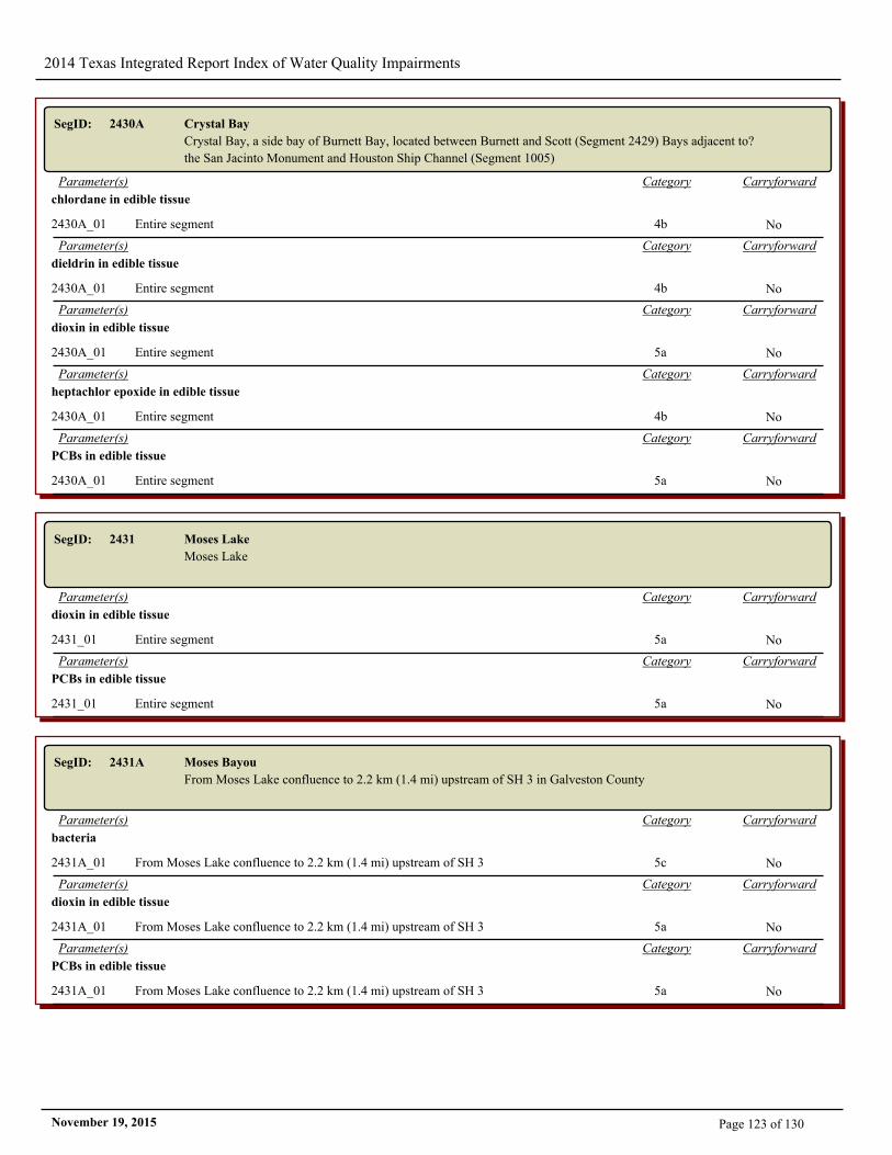
2014 Texas Integrated Report Index of Water Quality Impairments
SegID: 2430A Crystal Bay
Crystal Bay, a side bay of Burnett Bay, located between Burnett and Scott (Segment 2429) Bays adjacent to?
the San Jacinto Monument and Houston Ship Channel (Segment 1005)
CarryforwardCategoryParameter(s)
chlordane in edible tissue
2430A_01 Entire segment 4b No
CarryforwardCategoryParameter(s)
dieldrin in edible tissue
2430A_01 Entire segment 4b No
CarryforwardCategoryParameter(s)
dioxin in edible tissue
2430A_01 Entire segment 5a No
CarryforwardCategoryParameter(s)
heptachlor epoxide in edible tissue
2430A_01 Entire segment 4b No
CarryforwardCategoryParameter(s)
PCBs in edible tissue
2430A_01 Entire segment 5a No
SegID: 2431 Moses Lake
Moses Lake
CarryforwardCategoryParameter(s)
dioxin in edible tissue
2431_01 Entire segment 5a No
CarryforwardCategoryParameter(s)
PCBs in edible tissue
2431_01 Entire segment 5a No
SegID: 2431A Moses Bayou
From Moses Lake confluence to 2.2 km (1.4 mi) upstream of SH 3 in Galveston County
CarryforwardCategoryParameter(s)
bacteria
2431A_01 From Moses Lake confluence to 2.2 km (1.4 mi) upstream of SH 3 5c No
CarryforwardCategoryParameter(s)
dioxin in edible tissue
2431A_01 From Moses Lake confluence to 2.2 km (1.4 mi) upstream of SH 3 5a No
CarryforwardCategoryParameter(s)
PCBs in edible tissue
2431A_01 From Moses Lake confluence to 2.2 km (1.4 mi) upstream of SH 3 5a No
Page 123 of 130November 19, 2015
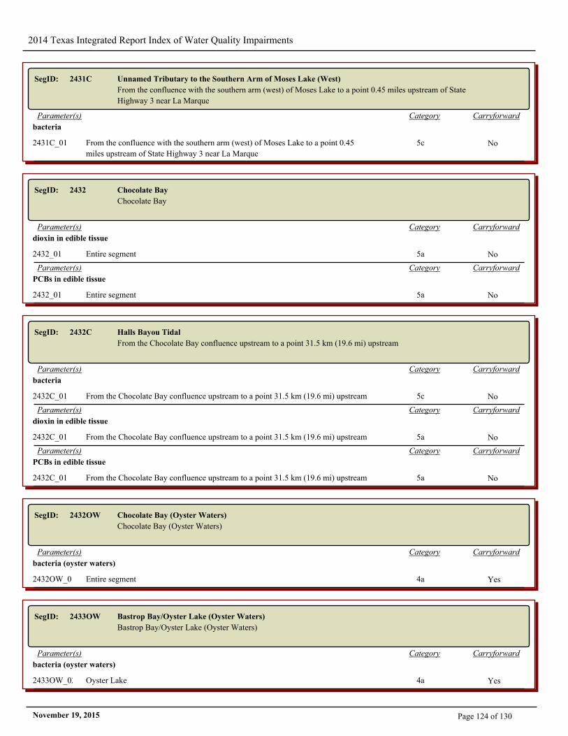
2014 Texas Integrated Report Index of Water Quality Impairments
SegID: 2431C Unnamed Tributary to the Southern Arm of Moses Lake (West)
From the confluence with the southern arm (west) of Moses Lake to a point 0.45 miles upstream of State
Highway 3 near La Marque
CarryforwardCategoryParameter(s)
bacteria
2431C_01 From the confluence with the southern arm (west) of Moses Lake to a point 0.45
miles upstream of State Highway 3 near La Marque
5c No
SegID: 2432 Chocolate Bay
Chocolate Bay
CarryforwardCategoryParameter(s)
dioxin in edible tissue
2432_01 Entire segment 5a No
CarryforwardCategoryParameter(s)
PCBs in edible tissue
2432_01 Entire segment 5a No
SegID: 2432C Halls Bayou Tidal
From the Chocolate Bay confluence upstream to a point 31.5 km (19.6 mi) upstream
CarryforwardCategoryParameter(s)
bacteria
2432C_01 From the Chocolate Bay confluence upstream to a point 31.5 km (19.6 mi) upstream 5c No
CarryforwardCategoryParameter(s)
dioxin in edible tissue
2432C_01 From the Chocolate Bay confluence upstream to a point 31.5 km (19.6 mi) upstream 5a No
CarryforwardCategoryParameter(s)
PCBs in edible tissue
2432C_01 From the Chocolate Bay confluence upstream to a point 31.5 km (19.6 mi) upstream 5a No
SegID: 2432OW Chocolate Bay (Oyster Waters)
Chocolate Bay (Oyster Waters)
CarryforwardCategoryParameter(s)
bacteria (oyster waters)
2432OW_01 Entire segment 4a Yes
SegID: 2433OW Bastrop Bay/Oyster Lake (Oyster Waters)
Bastrop Bay/Oyster Lake (Oyster Waters)
CarryforwardCategoryParameter(s)
bacteria (oyster waters)
2433OW_02 Oyster Lake 4a Yes
Page 124 of 130November 19, 2015
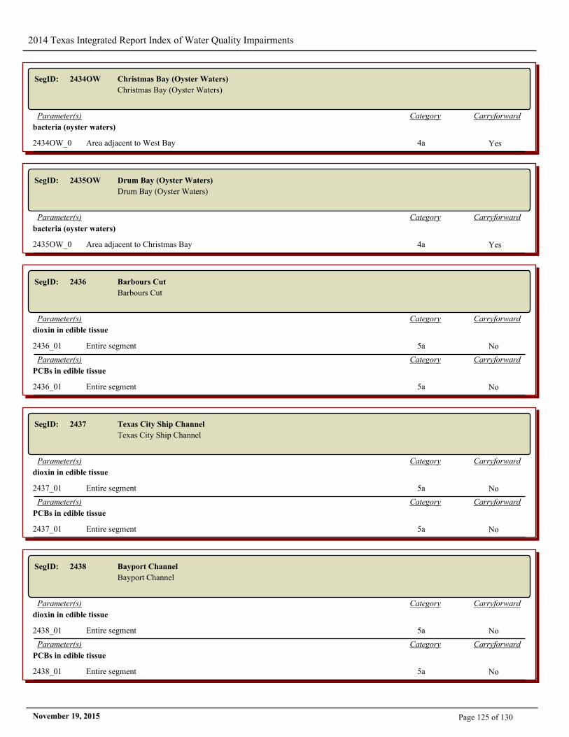
2014 Texas Integrated Report Index of Water Quality Impairments
SegID: 2434OW Christmas Bay (Oyster Waters)
Christmas Bay (Oyster Waters)
CarryforwardCategoryParameter(s)
bacteria (oyster waters)
2434OW_01 Area adjacent to West Bay 4a Yes
SegID: 2435OW Drum Bay (Oyster Waters)
Drum Bay (Oyster Waters)
CarryforwardCategoryParameter(s)
bacteria (oyster waters)
2435OW_01 Area adjacent to Christmas Bay 4a Yes
SegID: 2436 Barbours Cut
Barbours Cut
CarryforwardCategoryParameter(s)
dioxin in edible tissue
2436_01 Entire segment 5a No
CarryforwardCategoryParameter(s)
PCBs in edible tissue
2436_01 Entire segment 5a No
SegID: 2437 Texas City Ship Channel
Texas City Ship Channel
CarryforwardCategoryParameter(s)
dioxin in edible tissue
2437_01 Entire segment 5a No
CarryforwardCategoryParameter(s)
PCBs in edible tissue
2437_01 Entire segment 5a No
SegID: 2438 Bayport Channel
Bayport Channel
CarryforwardCategoryParameter(s)
dioxin in edible tissue
2438_01 Entire segment 5a No
CarryforwardCategoryParameter(s)
PCBs in edible tissue
2438_01 Entire segment 5a No
Page 125 of 130November 19, 2015
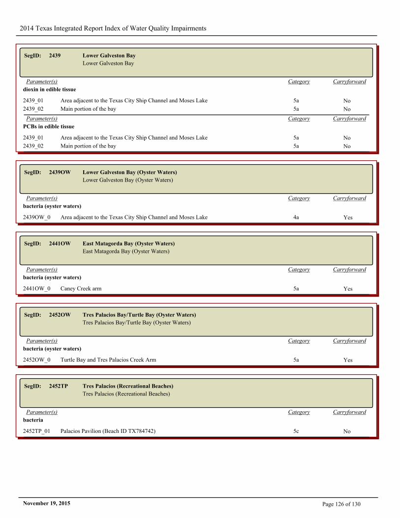
2014 Texas Integrated Report Index of Water Quality Impairments
SegID: 2439 Lower Galveston Bay
Lower Galveston Bay
CarryforwardCategoryParameter(s)
dioxin in edible tissue
2439_01 Area adjacent to the Texas City Ship Channel and Moses Lake 5a No
2439_02 Main portion of the bay 5a No
CarryforwardCategoryParameter(s)
PCBs in edible tissue
2439_01 Area adjacent to the Texas City Ship Channel and Moses Lake 5a No
2439_02 Main portion of the bay 5a No
SegID: 2439OW Lower Galveston Bay (Oyster Waters)
Lower Galveston Bay (Oyster Waters)
CarryforwardCategoryParameter(s)
bacteria (oyster waters)
2439OW_01 Area adjacent to the Texas City Ship Channel and Moses Lake 4a Yes
SegID: 2441OW East Matagorda Bay (Oyster Waters)
East Matagorda Bay (Oyster Waters)
CarryforwardCategoryParameter(s)
bacteria (oyster waters)
2441OW_01 Caney Creek arm 5a Yes
SegID: 2452OW Tres Palacios Bay/Turtle Bay (Oyster Waters)
Tres Palacios Bay/Turtle Bay (Oyster Waters)
CarryforwardCategoryParameter(s)
bacteria (oyster waters)
2452OW_01 Turtle Bay and Tres Palacios Creek Arm 5a Yes
SegID: 2452TP Tres Palacios (Recreational Beaches)
Tres Palacios (Recreational Beaches)
CarryforwardCategoryParameter(s)
bacteria
2452TP_01 Palacios Pavilion (Beach ID TX784742) 5c No
Page 126 of 130November 19, 2015
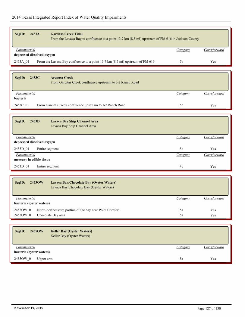
2014 Texas Integrated Report Index of Water Quality Impairments
SegID: 2453A Garcitas Creek Tidal
From the Lavaca Bayou confluence to a point 13.7 km (8.5 mi) upstream of FM 616 in Jackson County
CarryforwardCategoryParameter(s)
depressed dissolved oxygen
2453A_01 From the Lavaca Bay confluence to a point 13.7 km (8.5 mi) upstream of FM 616 5b Yes
SegID: 2453C Arenosa Creek
From Garcitas Creek confluence upstream to J-2 Ranch Road
CarryforwardCategoryParameter(s)
bacteria
2453C_01 From Garcitas Creek confluence upstream to J-2 Ranch Road 5b Yes
SegID: 2453D Lavaca Bay Ship Channel Area
Lavaca Bay Ship Channel Area
CarryforwardCategoryParameter(s)
depressed dissolved oxygen
2453D_01 Entire segment 5c Yes
CarryforwardCategoryParameter(s)
mercury in edible tissue
2453D_01 Entire segment 4b Yes
SegID: 2453OW Lavaca Bay/Chocolate Bay (Oyster Waters)
Lavaca Bay/Chocolate Bay (Oyster Waters)
CarryforwardCategoryParameter(s)
bacteria (oyster waters)
2453OW_02 North-northeastern portion of the bay near Point Comfort 5a Yes
2453OW_03 Chocolate Bay area 5a Yes
SegID: 2455OW Keller Bay (Oyster Waters)
Keller Bay (Oyster Waters)
CarryforwardCategoryParameter(s)
bacteria (oyster waters)
2455OW_01 Upper arm 5a Yes
Page 127 of 130November 19, 2015
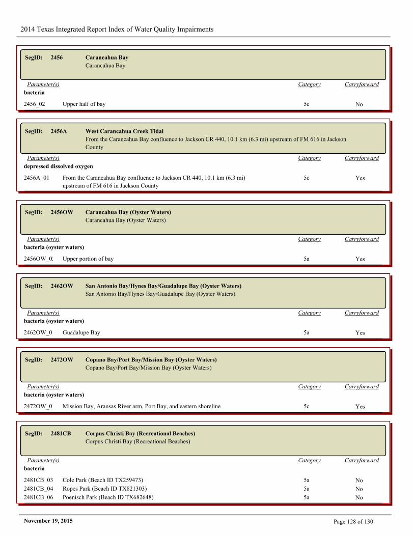
2014 Texas Integrated Report Index of Water Quality Impairments
SegID: 2456 Carancahua Bay
Carancahua Bay
CarryforwardCategoryParameter(s)
bacteria
2456_02 Upper half of bay 5c No
SegID: 2456A West Carancahua Creek Tidal
From the Carancahua Bay confluence to Jackson CR 440, 10.1 km (6.3 mi) upstream of FM 616 in Jackson
County
CarryforwardCategoryParameter(s)
depressed dissolved oxygen
2456A_01 From the Carancahua Bay confluence to Jackson CR 440, 10.1 km (6.3 mi)
upstream of FM 616 in Jackson County
5c Yes
SegID: 2456OW Carancahua Bay (Oyster Waters)
Carancahua Bay (Oyster Waters)
CarryforwardCategoryParameter(s)
bacteria (oyster waters)
2456OW_02 Upper portion of bay 5a Yes
SegID: 2462OW San Antonio Bay/Hynes Bay/Guadalupe Bay (Oyster Waters)
San Antonio Bay/Hynes Bay/Guadalupe Bay (Oyster Waters)
CarryforwardCategoryParameter(s)
bacteria (oyster waters)
2462OW_01 Guadalupe Bay 5a Yes
SegID: 2472OW Copano Bay/Port Bay/Mission Bay (Oyster Waters)
Copano Bay/Port Bay/Mission Bay (Oyster Waters)
CarryforwardCategoryParameter(s)
bacteria (oyster waters)
2472OW_01 Mission Bay, Aransas River arm, Port Bay, and eastern shoreline 5c Yes
SegID: 2481CB Corpus Christi Bay (Recreational Beaches)
Corpus Christi Bay (Recreational Beaches)
CarryforwardCategoryParameter(s)
bacteria
2481CB_03 Cole Park (Beach ID TX259473) 5a No
2481CB_04 Ropes Park (Beach ID TX821303) 5a No
2481CB_06 Poenisch Park (Beach ID TX682648) 5a No
Page 128 of 130November 19, 2015
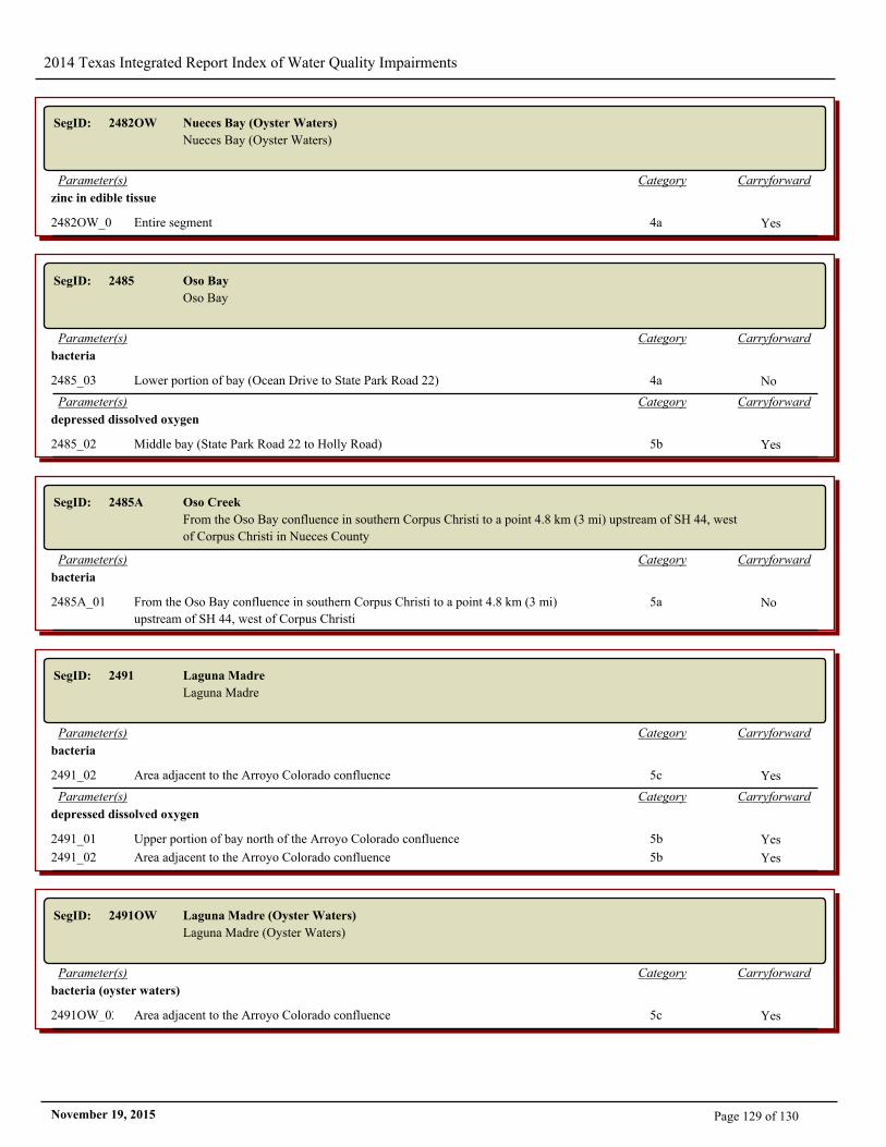
2014 Texas Integrated Report Index of Water Quality Impairments
SegID: 2482OW Nueces Bay (Oyster Waters)
Nueces Bay (Oyster Waters)
CarryforwardCategoryParameter(s)
zinc in edible tissue
2482OW_01 Entire segment 4a Yes
SegID: 2485 Oso Bay
Oso Bay
CarryforwardCategoryParameter(s)
bacteria
2485_03 Lower portion of bay (Ocean Drive to State Park Road 22) 4a No
CarryforwardCategoryParameter(s)
depressed dissolved oxygen
2485_02 Middle bay (State Park Road 22 to Holly Road) 5b Yes
SegID: 2485A Oso Creek
From the Oso Bay confluence in southern Corpus Christi to a point 4.8 km (3 mi) upstream of SH 44, west
of Corpus Christi in Nueces County
CarryforwardCategoryParameter(s)
bacteria
2485A_01 From the Oso Bay confluence in southern Corpus Christi to a point 4.8 km (3 mi)
upstream of SH 44, west of Corpus Christi
5a No
SegID: 2491 Laguna Madre
Laguna Madre
CarryforwardCategoryParameter(s)
bacteria
2491_02 Area adjacent to the Arroyo Colorado confluence 5c Yes
CarryforwardCategoryParameter(s)
depressed dissolved oxygen
2491_01 Upper portion of bay north of the Arroyo Colorado confluence 5b Yes
2491_02 Area adjacent to the Arroyo Colorado confluence 5b Yes
SegID: 2491OW Laguna Madre (Oyster Waters)
Laguna Madre (Oyster Waters)
CarryforwardCategoryParameter(s)
bacteria (oyster waters)
2491OW_02 Area adjacent to the Arroyo Colorado confluence 5c Yes
Page 129 of 130November 19, 2015
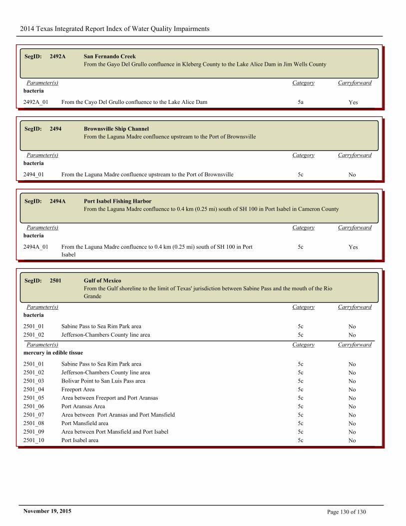
2014 Texas Integrated Report Index of Water Quality Impairments
SegID: 2492A San Fernando Creek
From the Gayo Del Grullo confluence in Kleberg County to the Lake Alice Dam in Jim Wells County
CarryforwardCategoryParameter(s)
bacteria
2492A_01 From the Cayo Del Grullo confluence to the Lake Alice Dam 5a Yes
SegID: 2494 Brownsville Ship Channel
From the Laguna Madre confluence upstream to the Port of Brownsville
CarryforwardCategoryParameter(s)
bacteria
2494_01 From the Laguna Madre confluence upstream to the Port of Brownsville 5c No
SegID: 2494A Port Isabel Fishing Harbor
From the Laguna Madre confluence to 0.4 km (0.25 mi) south of SH 100 in Port Isabel in Cameron County
CarryforwardCategoryParameter(s)
bacteria
2494A_01 From the Laguna Madre confluence to 0.4 km (0.25 mi) south of SH 100 in Port
Isabel
5c Yes
SegID: 2501 Gulf of Mexico
From the Gulf shoreline to the limit of Texas' jurisdiction between Sabine Pass and the mouth of the Rio
Grande
CarryforwardCategoryParameter(s)
bacteria
2501_01 Sabine Pass to Sea Rim Park area 5c No
2501_02 Jefferson-Chambers County line area 5c No
CarryforwardCategoryParameter(s)
mercury in edible tissue
2501_01 Sabine Pass to Sea Rim Park area 5c No
2501_02 Jefferson-Chambers County line area 5c No
2501_03 Bolivar Point to San Luis Pass area 5c No
2501_04 Freeport Area 5c No
2501_05 Area between Freeport and Port Aransas 5c No
2501_06 Port Aransas Area 5c No
2501_07 Area between Port Aransas and Port Mansfield 5c No
2501_08 Port Mansfield area 5c No
2501_09 Area between Port Mansfield and Port Isabel 5c No
2501_10 Port Isabel area 5c No
Page 130 of 130November 19, 2015