Embed Size (px)
Citation preview

TIGER/Line® Shapefiles 2016
Technical Documentation

1-0
SUGGESTED CITATION
FILES:
2016 TIGER/Line Shapefiles (machine-
readable data files) / prepared by the
U.S. Census Bureau, 2016
TECHNICAL DOCUMENTATION:
2016 TIGER/Line Shapefiles Technical
Documentation / prepared by the U.S.
Census Bureau, 2016
U.S. Department of Commerce
Penny Pritzker, Secretary
U.S. Census Bureau
John H. Thompson, Lisa Blumerman,
Director Associate Director for Decennial Census
Programs
Nancy A. Potok
Deputy Director and Chief
Operating Officer
GEOGRAPHY DIVISION
Deirdre Dalpiaz Bishop, Chief
Andrea G. Johnson,
Assistant Division Chief for
Geographic Operations
Ama A. Danso,
Assistant Division Chief for
Address Software
Vacant,
Assistant Division Chief for
Geographic Program Management
Laura Waggoner,
Assistant Division Chief for
Geographic Partnerships, Data
Collection and Products
Michael R. Ratcliffe,
Assistant Division Chief for
Geographic Standards, Criteria, Research, and
Quality
Gregory F. Hanks, Jr.,
Deputy Division Chief
Economic and Statistics
Administration
Mark Doms,
Under Secretary for Economic Affairs

Table of Contents
1. Introduction ......................................................................................................................................... 1-1
1.1 What is a Shapefile? ............................................................................................................................................................. 1-1
1.2 What are TIGER/Line Shapefiles? ................................................................................................................................. 1-1
1.3 Relationship of the TIGER/Line Shapefiles to Census Statistical Data................................................. 1-1
1.4 History and Sources of TIGER/Line Files and Shapefiles .............................................................................. 1-1
1.5 TIGER/Line Shapefile Legal Disclaimers ................................................................................................................. 1-2
1.6 Contact and Citation Information ................................................................................................................................ 1-2
2. About the 2016 TIGER/Line Shapefiles ............................................................................................. 2-3
2.1 What is in the 2016 TIGER/Line Shapefiles ........................................................................................................... 2-3
Table 1: 2016 Shapefile availability .................................................................... 2-5
Table 2: 2016 Relationship file availability ......................................................... 2-6
2.2 Structure and Format .......................................................................................................................................................... 2-6
2.2.1 Structure ...................................................................................................................................................................... 2-6
2.2.2 File Naming Conventions .................................................................................................................................. 2-6
2.2.3 Datum (GCS NAD 83) ............................................................................................................................................ 2-7
2.2.4 Metadata ...................................................................................................................................................................... 2-7
2.2.5 Spatial Accuracy of Linear Features ............................................................................................................ 2-8
2.2.6 Coordinates ................................................................................................................................................................ 2-8
2.2.7 Codes for Geographic Entities ....................................................................................................................... 2-8
2.3 File Changes and Updates for the 2016 TIGER/Line Shapefiles ............................................................... 2-9
2.3.1 List of files .................................................................................................................................................................. 2-9
2.3.2 Boundary Changes ................................................................................................................................................. 2-9
3. Geographic Shapefile Concepts Overview ...................................................................................... 3-10
3.1 American Indian / Alaska Native / Native Hawaiian (AIANNH) Areas ............................................... 3-10
3.1.1 Alaska Native Regional Corporations (ANRCs) ................................................................................. 3-10
3.1.1.1 Alaska Native Regional Corporation (ANRC) Shapefile Record Layout (Current) 3-10
3.1.2 American Indian/Alaska Native/Native Hawaiian (AIANNH) Areas ...................................... 3-11
Table 3: Census codes for each AIANNH area ................................................ 3-14
Table 4: Component types for AIANNH areas .................................................. 3-15
3.1.2.1 American Indian / Alaska Native / Native Hawaiian (AIANNH) Area National
Shapefile Record Layout (Current) ................................................................................................................... 3-15
3.1.3 American Indian Tribal Subdivisions ...................................................................................................... 3-16
3.1.3.1 American Indian Tribal Subdivision (AITS) National Shapefile Record Layout ..... 3-16
3.1.4 Tribal Census Tract ............................................................................................................................................ 3-17
3.1.4.1 Tribal Census Tract National Shapefile (Current) ................................................................... 3-18
3.1.5 Tribal Block Group .............................................................................................................................................. 3-19
3.1.5.1 Tribal Block Group National Shapefile (Current) ..................................................................... 3-20

3.2 Blocks (Census Block) ...................................................................................................................................................... 3-20
Figure 1: Geographic Relationships - Small Area Statistical Entities; County-Census Tract-Block Group-Block ...................................................................... 3-21
Figure 2: Geographic Relationships - Legal and Statistical Entities; County-County Subdivision-Place-Block ....................................................................... 3-22
3.2.1 Block State-based Shapefile Record Layout (2010 Geography) .......................................... 3-23
3.3 Block Groups.......................................................................................................................................................................... 3-23
3.3.1 Block Group State-based Shapefile Record Layout (Current) ............................................... 3-24
3.4 Census Tracts ....................................................................................................................................................................... 3-25
3.4.1 Census Tract State-based Shapefile Record Layout (Current) ............................................. 3-26
3.5 Congressional Districts .................................................................................................................................................. 3-27
3.5.1 115th Congressional District National Shapefile Record Layout ...................................... 3-27
3.6 Consolidated Cities ........................................................................................................................................................... 3-28
3.6.1 Consolidated City Shapefile Record Layout (Current) .............................................................. 3-28
3.7 Counties and Equivalent Entities .............................................................................................................................. 3-29
3.7.1 County and Equivalent Entity National Shapefile Record Layout (Current) ................ 3-30
3.8 County Subdivisions ......................................................................................................................................................... 3-31
3.8.1 County Subdivision State-based Shapefile Record Layout (Current) .............................. 3-32
3.9 Estates 3-33
3.9.1 Estate Shapefile (U.S. Virgin Islands Only) Record Layout (Current) ............................... 3-34
3.10 Hydrography (Area and Linear) ............................................................................................................................... 3-34
3.10.1 Area Hydrography County-based Shapefile Record Layout ............................................... 3-35
3.10.2 Linear Hydrography County-based Shapefile Record Layout ........................................... 3-35
3.11 Landmarks (Area and Point) ...................................................................................................................................... 3-36
3.11.1 Area Landmark State-based Shapefile Record Layout ........................................................... 3-36
3.11.2 Point Landmark State-based Shapefile Record Layout .......................................................... 3-37
3.12 Linear Features .................................................................................................................................................................. 3-37
3.12.1 All Lines .................................................................................................................................................................. 3-38
3.12.1.1 All Lines County-based Shapefile Record Layout ................................................................. 3-38
3.12.2 Coastline ................................................................................................................................................................ 3-40
3.12.2.1 Coastline National Shapefile Record Layout ........................................................................... 3-40
3.12.3 Roads 3-41
3.12.3.1 Primary Roads National Shapefile Record Layout ................................................................ 3-41
3.12.3.2 Primary and Secondary Roads State-based Shapefile Record Layout ...................... 3-42
3.12.3.3 All Roads County-based Shapefile Record Layout ............................................................... 3-42
3.12.4 Address Ranges ................................................................................................................................................. 3-42
3.12.4.1 Address Range Feature County-based Shapefile Record Layout ................................ 3-43
3.12.5 Railroads ................................................................................................................................................................ 3-44
3.12.5.1 Railroads National Shapefile Record Layout ........................................................................... 3-45

3.13 Metropolitan and Micropolitan Statistical Areas and Related Statistical Areas ........................ 3-45
3.13.1 Combined New England City and Town Area (CNECTA) National Shapefile Record
Layout (Current) ........................................................................................................................................................... 3-47
3.13.2 Combined Statistical Area (CSA) National Shapefile Record Layout (Current) ....... 3-47
3.13.3 Metropolitan Division National Shapefile Record Layout (Current) .............................. 3-48
3.13.4 Metropolitan Statistical Area/Micropolitan Statistical Area (CBSA) National
Shapefile Record Layout (Current) ................................................................................................................... 3-49
3.13.5 New England City and Town Area (NECTA) National Shapefile Record Layout
(Current) ........................................................................................................................................................................... 3-50
3.13.6 New England City and Town Area (NECTA) Division National Shapefile Record
Layout (Current) ........................................................................................................................................................... 3-50
3.14 Military Installations ...................................................................................................................................................... 3-51
3.14.1 Military Installation National Shapefile Record Layout ........................................................ 3-51
3.15 Places 3-52
Figure 3: Geographic Corridors – Overview ..................................................... 3-54
Figure 4: Geographic Corridors Address Ranges............................................. 3-55
3.15.1 Place State-based Shapefile Record Layout (Current) ............................................................ 3-56
3.16 Public Use Microdata Areas (PUMAs) ................................................................................................................... 3-57
3.16.1 Public Use Microdata Area (PUMA) State-based Shapefile Record Layout (2010
Census) .............................................................................................................................................................................. 3-57
3.17 School Districts (Elementary, Secondary, and Unified) ............................................................................. 3-58
3.17.1 Elementary School District State-based Shapefile Record Layout (Current) ............ 3-60
3.17.2 Secondary School District State-based Shapefile Record Layout (Current) .............. 3-60
3.17.3 Unified School District State-based Shapefile Record Layout (Current) ..................... 3-61
3.18 States and State Equivalent Entities ..................................................................................................................... 3-62
3.18.1 State and Equivalent Entity National Shapefile Record Layout (Current) .................. 3-62
3.19 State Legislative Districts (Upper and Lower) ................................................................................................ 3-63
3.19.1 State Legislative District Lower Chambers (SLDL) State-based Shapefile Record
Layout (Current) ........................................................................................................................................................... 3-64
3.19.2 State Legislative District Upper Chambers (SLDU) State-based Shapefile Record
Layout (Current) ........................................................................................................................................................... 3-65
3.20 Subbarrio (Subminor Civil Division) ..................................................................................................................... 3-65
3.20.1 Subbarrio (Subminor Civil Division) State-based Shapefile Record Layout (Current)
................................................................................................................................................................................................ 3-66
3.21 Topological Faces (Polygons with All Geocodes) ......................................................................................... 3-67
3.21.1 Topological Faces (Polygons with All Geocodes) County-based Shapefile Record
Layout (Current) ........................................................................................................................................................... 3-67
3.22 Urban Areas ......................................................................................................................................................................... 3-69
3.22.1 Urban Area (UA) National Shapefile Record Layout (2010 Census) .............................. 3-70
3.23 ZIP Code Tabulation Areas (5-digit) ..................................................................................................................... 3-71
3.23.1 5-Digit ZIP Code Tabulation Area (ZCTA) National Shapefile Record Layout (2010
Census) .............................................................................................................................................................................. 3-71

4. Relationship File Concept Overview ................................................................................................ 4-73
4.1 Address Ranges ................................................................................................................................................................... 4-73
Figure 5: TIGER/Line Shapefiles Address Range Basics ................................. 4-74
Table 6: Address range product comparison table ........................................... 4-74
Figure 6: TIGER/Line Shapefile Address Range Imputes - Before Split ........... 4-77
Figure 7: TIGER/Line Shapefile Address Range Imputes - After Split .............. 4-77
4.1.1 Address Ranges County-based Relationship File Record Layout (Current) ................ 4-78
4.2 Address Range-Feature Name Relationships..................................................................................................... 4-78
4.2.1 Address Range-Feature Name County-based Relationship File Record Layout
(Current) ........................................................................................................................................................................... 4-78
4.3 Feature Names ...................................................................................................................................................................... 4-79
4.3.1 Feature Names County-based Relationship File Record Layout (Current) ................... 4-79
4.4 Topological Faces-Area Landmark Relationships ........................................................................................... 4-80
4.4.1 Topological Faces-Area Landmark County-based Relationship File Record Layout
(Current) ........................................................................................................................................................................... 4-80
4.5 Topological Faces-Area Hydrography Relationships .................................................................................... 4-80
4.5.1 Topological Faces-Area Hydrography County-based Relationship File Record Layout
(Current) ........................................................................................................................................................................... 4-81
4.6 Topological Faces-Military Installation Relationships ................................................................................. 4-81
4.6.1 Topological Faces-Military Installation National Relationship File Record Layout
(Current) ........................................................................................................................................................................... 4-81
5. Instructions for Downloading the TIGER/Line Shapefiles ................................................................ 5-82
5.1 Getting Started ..................................................................................................................................................................... 5-82
5.2 Website Interface ............................................................................................................................................................... 5-82
Figure 8: Click the appropriate tab and then click on download to access the web interface ............................................................................................................ 5-82
Figure 9: An example of the menus available in the web interface ................... 5-83
5.3. Direct from FTP Site ........................................................................................................................................................ 5-83
Figure 10: An example of the directory structure within the FTP site. ............... 5-84
Table 7: 2016 TIGER/Line Shapefile file name definitions ............................... 5-84
5.4 Connect via FTP Client ..................................................................................................................................................... 5-86
5.5 Data.gov .................................................................................................................................................................................. 5-86
6. Useful Links ...................................................................................................................................... 6-87
6.1 User Notes ............................................................................................................................................................................... 6-87
6.2 Help Documents ................................................................................................................................................................. 6-87
6.2.1 How to Guides ....................................................................................................................................................... 6-87
6.2.2 Definitions .............................................................................................................................................................. 6-87
6.3 Additional TIGER Products for use in a GIS ...................................................................................................... 6-88
6.3.1 TIGER Geodatabases ........................................................................................................................................ 6-88

6.3.2 TIGER/Line Shapefiles and Geodatabases with Demographic Data ................................... 6-88
6.3.3 Cartographic Boundary Files ...................................................................................................................... 6-88
Appendix A. Pseudo-School Districts ........................................................................................................ 89
Appendix B. Feature Name Directionals .................................................................................................... 94
Appendix C. Feature Name Qualifiers ....................................................................................................... 95
Appendix D. Feature Name Types ............................................................... Error! Bookmark not defined.

1-1
1. Introduction
1.1 What is a Shapefile? A shapefile is a geospatial data format for use in geographic information system (GIS) software.
Shapefiles spatially describe vector data such as points, lines, and polygons, representing, for instance,
landmarks, roads, and lakes. The Environmental Systems Research Institute (Esri) created the format for
use in their software, but the shapefile format works in additional Geographic Information System (GIS)
software as well.
1.2 What are TIGER/Line Shapefiles? The TIGER/Line Shapefiles are the fully supported, core geographic product from the U.S. Census
Bureau. They are extracts of selected geographic and cartographic information from the U.S. Census
Bureau's Master Address File/Topologically Integrated Geographic Encoding and Referencing
(MAF/TIGER) database. The shapefiles include information for the fifty states, the District of Columbia,
Puerto Rico, and the Island areas (American Samoa, the Commonwealth of the Northern Mariana
Islands, Guam, and the United States Virgin Islands). The shapefiles include polygon boundaries of
geographic areas and features, linear features including roads and hydrography, and point features. They
do not contain any sensitive data.
1.3 Relationship of the TIGER/Line Shapefiles to Census Statistical Data The TIGER/Line Shapefiles contain a standard geographic identifier for each entity that links to the
geographic identifier in the data from censuses and surveys. They do not include demographic data from
surveys and censuses, such as the Decennial Census, Economic Census, American Community Survey,
and the Population Estimates Program. Other, non-census, data often has this standard geographic
identifier as well. Data from many of the Census Bureau’s surveys and censuses, including the
geographic codes needed to join to the TIGER/Line Shapefiles, is available in American FactFinder
(http://factfinder2.census.gov). For more information regarding the geographic entity codes, please refer
to Section 2.2.7 Codes for Geographic Entities. For guides on using data from American FactFinder with
the TIGER/Line Shapefiles, please see our help documents:
http://www.census.gov/geo/education/howtos.html.
In addition to the TIGER/Line Shapefiles, the Census Bureau creates additional shapefiles and
geodatabases that include demographic data. These are an as-is products and are created by Census
Bureau staff as time permits. All shapefiles and geodatabases that have been pre-joined to demographic
data are available at:
http://www.census.gov/geo/maps-data/data/tiger-data.html.
1.4 History and Sources of TIGER/Line Files and Shapefiles The first release of the TIGER/Line Files was in 1989. These files provided the first nationwide street
centerline coverage of the United States, Puerto Rico, and the Island Areas in a series of ASCII format
fixed tables or record types. Initially, the Census Bureau used the U.S. Geological Survey (USGS)
1:100,000-scale Digital Line Graph (DLG), USGS 1:24,000-scale quadrangles, the Census Bureau’s 1980
geographic base files (GBF/DIME Files), and a variety of miscellaneous maps for selected areas outside
the contiguous 48 states to create the TIGER database (predecessor to the current MAF/TIGER
database). The Census Bureau released versions of the TIGER/Line Files periodically throughout the
1990s and 2000s in ASCII format. Beginning with the 2007 version, the format of the TIGER/Line Files
changed from the ASCII file format to shapefile.

1-2
The Census Bureau continually makes additions and corrections to its database, mainly through partner
supplied data, the use of aerial imagery, and fieldwork. The Census Bureau has numerous partner
programs where federal, state, and local government partners’ supply updates to boundaries, features,
and addresses. In the 2000’s, the Census Bureau underwent a major realignment of the TIGER database
to improve the spatial accuracy of the road network. Since this realignment, the Census Bureau has
added quality standards for data sources used to update the MAF/TIGER database.
1.5 TIGER/Line Shapefile Legal Disclaimers No warranty, expressed or implied, is made with regard to the accuracy of the data in the TIGER/Line
Shapefiles, and no liability is assumed by the United States Government in general, or the Census
Bureau specifically, as to the positional or attribute accuracy of the data. The boundary information in the
TIGER/Line Shapefiles is for statistical data collection and tabulation purposes only. Their depiction and
designation for statistical purposes does not constitute a determination of jurisdictional authority or rights
of ownership or entitlement and they are not legal land descriptions.
TIGER/Line® is a registered trademark of the Census Bureau. TIGER/Line cannot be used as or within
the proprietary product names of any commercial product including or otherwise relevant to Census
Bureau data and may only be used to refer to the nature of such a product. The Census Bureau requests
that any repackaging of the TIGER/Line Shapefile data, documentation, and other files accompanying it
for distribution include a conspicuously placed statement to this effect on the product's cover, the first
page of the website, or elsewhere of comparable visibility. Further, Census Bureau trademarks, when
used in reference to the nature of the product, should be accompanied by the ® (registered) symbol or ™
symbol, where convenient.
1.6 Contact and Citation Information Questions about TIGER/Line Shapefiles obtained from the Census Bureau can be directed to the
Geographic Products Branch, Geography Division, U.S. Census Bureau. The TIGER/Line Shapefiles are
offered to the public free of charge through the Census Bureau’s website. If you obtain the TIGER/Line
Shapefiles from a third party, we recommend you contact that vendor for assistance as it is possible that
they made changes to the files that we are unaware of or unable to support.
Spatial Data Collection and Products Branch
Geography Division, U.S. Census Bureau
4600 Silver Hill Road
Washington, DC 20233-7400
Office: (301) 763-1128
E-mail: [email protected]
Copyright protection is not available for any work of the United States Government (Title 17 U.S.C.,
Section 105). Thus, you are free to reproduce census materials as you see fit. We would ask, however,
that you cite the Census Bureau as the source.

2-3
2. About the 2016 TIGER/Line Shapefiles
2.1 What is in the 2016 TIGER/Line Shapefiles The 2016 TIGER/Line Shapefiles contain current geography for the United States, the District of
Columbia, Puerto Rico, and the Island areas. Current geography in the 2016 TIGER/Line Shapefiles
generally reflects the boundaries of governmental units in effect as of January 1, 2016, and other legal
and statistical area boundaries that have been adjusted and/or corrected since the 2010 Census. This
vintage includes boundaries of governmental units that match the data from the surveys that use 2016
geography, such as the 2016 Population Estimates and the 2016 American Community Survey.
The 2016 TIGER/Line Shapefiles contain the geographic extent and boundaries of both legal and
statistical entities. A legal entity is a geographic entity whose boundaries, name, origin, and area
description result from charters, laws, treaties, or other administrative or governmental action. A statistical
entity is any geographic entity or combination of entities identified and defined solely for the tabulation
and presentation of data. Statistical entity boundaries are not legally defined and the entities have no
governmental standing.
In addition to geographic boundaries, the 2016 TIGER/Line Shapefiles also include geographic feature
shapefiles and relationship files. Feature shapefiles represents the point, line and polygon features in the
MAF/TIGER database, like roads and rivers. Relationship files are database files that contain additional
attribute information that can be joined to the shapefiles. In this release, both the feature shapefiles and
relationship files reflect updates made in the database through May 2016.
To see how the geographic entities relate to one another, please see our geographic hierarchy diagrams
here:
http://www.census.gov/geo/reference/hierarchy.html.
The legal entities included in these shapefiles are:
American Indian off-reservation trust lands
American Indian reservations (both federally and state-recognized)
American Indian tribal subdivisions (within legal American Indian areas)
Alaska Native Regional Corporations
Congressional districts – 115th Congress
Consolidated cities
Counties and equivalent entities (except census areas in Alaska)
Estates (U.S. Virgin Islands only)
Hawaiian home lands
Incorporated places
Minor civil divisions (MCDs, such as towns and townships in the Northeast and Midwest)
School districts (elementary, secondary, and unified)
States and equivalent entities
State legislative districts (upper and lower chambers)
Subbarrios (Subminor civil divisions) (Puerto Rico only)
The statistical entities included in these shapefiles are:
Alaska Native village statistical areas
American Indian/Alaska Native statistical areas

2-4
American Indian tribal subdivisions (within Oklahoma tribal statistical areas)
Block groups
Census areas (statistical county equivalents in Alaska)
Census blocks
Census county divisions (CCDs), census subareas (in Alaska), and unorganized territories (statistical
county subdivisions)
Census designated places (CDPs)
Census tracts
Combined New England city and town areas
Combined statistical areas
Metropolitan and micropolitan statistical areas and related statistical areas
Metropolitan divisions
New England city and town areas
New England city and town area divisions
Oklahoma tribal statistical areas
Public use microdata areas (PUMAs)
State designated tribal statistical areas
Tribal designated statistical areas
Urban areas
ZIP Code tabulation areas (ZCTAs)
The feature shapefiles and relationship files are:
Address range-feature
Address range-feature name relationship file
Address ranges
All lines (called Edges)
All roads
Area hydrography
Area landmark
Coastline
Feature names relationship file
Linear hydrography
Point landmark
Primary and secondary roads
Primary roads
Topological faces (polygons with all geocodes)
Topological faces – area landmark relationship file
Topological faces – area hydrography relationship file
Topological faces – military installations relationship file
For the 2016 TIGER/Line Shapefiles, the geographic entities and features available in nation-, state-, or
county-based files can be found in Table 1.

2-5
Table 1: 2016 Shapefile availability
Layer Nation-
Based File
State-
Based File
County-
Based File
Address Range-Feature X
Alaska Native Regional Corporation X
All Lines (Edges) X
All Roads X
American Indian Tribal Subdivision X
American Indian/Alaska Native/Native Hawaiian Areas X
Area Hydrography X
Area Landmark X
Block X
Block Group X
Census Tract X
Coastline X
Combined New England City and Town Area X
Combined Statistical Area X
Congressional District – 115th Congress X
Consolidated City X
Core Based Statistical Areas X
County and Equivalent X
County Subdivision X
Elementary School District X
Estates X
Linear Hydrography X
Metropolitan Divisions X
Military Installation X
New England City and Town Area X
New England City and Town Division X
Place X
Point Landmark X
Primary and Secondary Roads X
Primary Roads X
Public Use Microdata Area X
Rails X
Secondary School District X
State and Equivalent X
State Legislative District – Lower Chamber X
State Legislative District – Upper Chamber X
Subbarrio X
Topological Faces (Polygons with All Geocodes) X
Tribal Block Group X
Tribal Census Tract X
Unified School District X
Urban Areas X
ZIP Code Tabulation Area X

2-6
For the 2016 TIGER/Line Shapefiles, the relationship files available in nation-, state-, or county-based
files can be found in Table 2.
Table 2: 2016 Relationship file availability
Layer Nation-
Based File
State-
Based File
County-
Based File
Address Range-Feature Name X
Address Ranges X
Feature Names X
Topological Faces – Area Landmark X
Topological Faces – Area Hydrography X
Topological Faces – Military Installations X
2.2 Structure and Format
2.2.1 Structure The Census Bureau provides 2016 TIGER/Line Shapefiles and associated relationship in a compressed
format. One zipped file is available for each layer, with a file extension of .zip. Each zipped shapefile
consists of the following seven files:
.shp – the feature geometry
.shx – the index of the feature geometry
.dbf – the tabular attribute information
.prj – the coordinate system information
.shp.xml – the Federal Geographic Data Committee (FGDC) metadata
.shp.iso.xml - the International Organization for Standardization (ISO 191) metadata
.shp.ea.iso.xml - the ISO 191 (entity and attribute) metadata
Each zipped relationship file consists of the following four files:
.dbf – the tabular attribute information
.dbf.xml – the Federal Geographic Data Committee (FGDC) metadata
.dbf.iso.xml - the International Organization for Standardization (ISO 191) metadata
.dbf.ea.iso.xml - the ISO 191 (entity and attribute) metadata
2.2.2 File Naming Conventions The name of each file is:
tl_2016_<extent>_<layer>.<ext>
Where:
tl = TIGER/Line
2016 = the version of the files

2-7
<extent> = parent geography entity ID code (variable length of two to five characters)
The entity ID code identifies the geographic extent by specific entity for which the file contains
data. It is of variable length depending on the type of file:
Nation-based: 2-character abbreviation – “us”
State-based: 2-character numeric state FIPS code
County-based: 5-character numeric county FIPS code
<layer> = layer tag of variable length
The layer tag specifies the type of geography or feature the file contains.
<ext> = the file extension
Examples:
Nation-based shapefile: County and Equivalent shapefile
File Name: tl_2016_us_county.shp
State-based shapefile: State and Equivalent shapefile for Maryland
File Name: tl_2016_24_state.shp
County-based shapefile: All Lines shapefile for Cayuga County, New York
File Name: tl_2016_36011_edges.shp
2.2.3 Datum (GCS NAD 83) Each shapefile contains a .prj file that contains the GIS industry standard well-known text (WKT) format to
describe the coordinate system/projection/datum information for each shapefile. All Census Bureau
generated shapefiles are in Global Coordinate System North American Datum of 1983 (GCS NAD83).
Each .prj file contains the following:
GEOGCS["GCS_North_American_1983",DATUM["D_North_American_1983",SPHEROID["GRS_1980",6
378137,298.257222101]],PRIMEM["Greenwich",0],UNIT["Degree",0.017453292519943295]]
2.2.4 Metadata Metadata are organized data files used to capture the basic descriptive characteristics about the data.
For example, metadata will describe the quality, purpose, spatial extent, and history of a particular
dataset. The metadata files are compatible with a text editor, web browser, or Esri’s ArcCatalog. The
TIGER/Line Shapefiles metadata provide a detailed description of the TIGER/Line Shapefiles and
relationship files. This includes publication date, contact information, and all of the valid attribute values
and descriptions. Users should refer to the metadata files for extensive documentation about the contents
of the shapefiles and relationship files. The All Lines metadata also contains a Spatial Metadata Identifier
(SMID), which identifies the source of the coordinates for each edge and the horizontal spatial accuracy
information for a particular line. Please note that the horizontal spatial accuracy refers only to those edges
identified as matched to the source with that accuracy. It is not the spatial accuracy of the All Lines
shapefile as a whole. For more information regarding the All Lines Shapefile, please refer to Section 3.12,
Linear Features.
The Census Bureau provides metadata in two formats for each shapefile and relationship file in
Extensible Markup Language (XML) format.

2-8
Federal Geographic Data Committee (FGDC) Content Standard for Digital Geospatial Metadata
(CSDGM)*
o shp.xml
o dbf.xml
International Organization for Standardization (ISO 191) Content Standard for Digital Geospatial
Metadata
o .shp.iso.xml and .shp.ea.iso.xml
o .dbf.iso.xml and .dbf.ea.iso.xml
* Please note that in order to see the entire metadata element values, the FGDC CSDGM stylesheet must
be specified when using Esri's ArcCatalog.
2.2.5 Spatial Accuracy of Linear Features In order to maintain a current geographic database from which to extract the TIGER/Line Shapefiles, the
Census Bureau uses various internal and external processes to update the MAF/TIGER database. While
it has made a reasonable and systematic attempt to gather the most recent information available about
the features each file portrays, the Census Bureau cautions users that the files are no more complete
than the source documents used in their compilation, the vintage of those source documents, and the
translation of the information on those source documents.
2.2.6 Coordinates Coordinates in the TIGER/Line Shapefiles have six decimal places, but the positional accuracy of these
coordinates may not be as great as the six decimal places suggest. The spatial accuracy varies with the
source materials used. The Census Bureau cannot specify the spatial accuracy of features changed or
added by its field staff or through local updates, features derived from the GBF/DIME Files (TIGER’s
predecessor in 1970 and 1980), or other map or digital sources. Thus, the level of spatial accuracy in the
TIGER/Line Shapefiles makes them unsuitable for high-precision measurement applications such as
engineering problems, property transfers, or other uses that might require highly accurate measurements
of the earth’s surface. No warranty, expressed or implied, is made with regard to the accuracy of these
data, and no liability is assumed by the U.S. Government in general or the Census Bureau specifically, as
to the spatial or attributes accuracy of the data.
2.2.7 Codes for Geographic Entities
The 2016 TIGER/Line Shapefiles include the American National Standards Institute (ANSI) codes to
identify both legal and statistical entities. The ANSI codes are a standardized set of numeric or alphabetic
codes issued by the American National Standards Institute (ANSI) to ensure uniform identification of
geographic entities through all federal government agencies.
The ANSI publications include both the Federal Information Processing Series (FIPS) codes and the
United States Geological Survey’s Geographic Names Information System (GNIS) codes. The FIPS
codes appear in the 2016 TIGER/Line Shapefiles in fields such as “STATEFP”, where “FP” indicates that
the field contains a FIPS code. The GNIS codes are a permanent numeric identifier of up to eight digits.
The GNIS codes appear in fields such as “STATENS”, where “NS” (National Standard) indicates that the
field contains a GNIS code. The Census Bureau stores the GNIS code as a fixed-width string; the official
code is a numeric value without leading zeroes. The GNIS code is available beginning in the 2010
TIGER/Line Shapefiles. For geographic entities not covered by ANSI, the Census Bureau assigns a code
and these appear in fields such as “TRACTCE”, where “CE” stands for Census. Finally, state-submitted
codes end in “ST”, such as “SLDLST”, and local education agency codes end in “LEA”, as in “ELSDLEA”.

2-9
For more information about ANSI codes, please visit:
http://www.census.gov/geo/reference/ansi.html.
2.3 File Changes and Updates for the 2016 TIGER/Line Shapefiles
2.3.1 List of files The 2016 TIGER/Line Shapefiles includes the following updates:
The following shapefiles may have boundary updates:
o County and equivalents
o Places
o County subdivisions
2.3.2 Boundary Changes Most of the boundaries of federally recognized American Indian Reservations and off-reservation trust
lands, tribal subdivisions, states and equivalent entities, counties and equivalent entities, minor civil
divisions (MCDs), consolidated cities, and incorporated places generally are those that were legally in
effect as of January 1, 2016. The Boundary and Annexation Survey (BAS) collects boundaries of legal
areas.
For more information about the BAS, please visit:
http://www.census.gov/geo/partnerships/bas.html.
For more information about specific boundary changes, please visit:
http://www.census.gov/geo/partnerships/bas/bas_newannex.html.
For nearly all statistical areas, the boundaries shown are those in effect at the time of the 2010 Census.
However, there are a few exceptions. Current geography may differ from 2010 Census geography due to
feature updates that cause boundary shifts. For example, if a street feature that acts as a census tract
boundary is moved, then the census tract boundary will move as well. In addition, census tract
boundaries may change to maintain comparability with related geographies, such as incorporated places.
If a census tract boundary is based on an incorporated place boundary, and the place boundary changes,
the census tract boundary may change if the population affected in the census tract is low. Census
designated places (CDPs) may also change throughout the decade. As time permits, new CDPs are
added to our database. In addition, because unorganized territories and CDPs occupy the same level of
geography as legal MCDs and incorporated places, updates to the legal boundaries may affect the
current boundaries for some of these entities, including the elimination of some of the statistical entities.

3-10
3. Geographic Shapefile Concepts Overview The following sections describe the geographic entity type displayed in each shapefile, as well as the
record layout for each file. Each entity type is listed in alphabetical order. A listing of all available
shapefiles, including vintage and geographic level (state, county, and national), precedes the description
of the entity type.
3.1 American Indian / Alaska Native / Native Hawaiian (AIANNH) Areas
3.1.1 Alaska Native Regional Corporations (ANRCs) Alaska Native Regional Corporations geography and attributes are available for Alaska in the following
shapefile:
Alaska Native Regional Corporation (ANRC) State Shapefile (Current)
ANRCs are corporations created according to the Alaska Native Claims Settlement Act (Pub. L. 92–203,
85 Stat. 688 (1971); 43 U.S.C. 1602 et seq. (2000)). They are organized under the laws of the State of
Alaska as “Regional Corporations,” to conduct both the for-profit and non-profit affairs of Alaska Natives
within defined regions of Alaska. The Census Bureau treats ANRCs as legal geographic entities. Twelve
ANRCs cover the entire State of Alaska except for the area within the Annette Island Reserve (an
American Indian Reservation under the governmental authority of the Metlakatla Indian Community).
There is a thirteenth ANRC that represents the eligible Alaska Natives living outside of Alaska that are not
members of any of the twelve ANRCs within the State of Alaska. Because it has no defined geographic
extent, this thirteenth ANRC does not appear in the TIGER/Line Shapefiles and the Census Bureau does
not provide data for it. The Census Bureau offers representatives of the twelve ANRCs the opportunity to
review and update the ANRC boundaries. ANRCs are represented by a 5-character FIPS code unique
within Alaska and a nationally unique 8-character National Standard (GNIS) code.
3.1.1.1 Alaska Native Regional Corporation (ANRC) Shapefile Record Layout (Current)
File Name: tl_2016_02_anrc.shp
Field Length Type Description
STATEFP 2 String Current state FIPS code
ANRCFP 5 String Current Alaska Native Regional Corporation FIPS code
ANRCNS 8 String Current Alaska Native Regional Corporation GNIS code
GEOID 7 String
Alaska Native Regional Corporation identifier; a
concatenation of Current state FIPS code and Alaska
Native Regional Corporation code
NAME 100 String Current Alaska Native Regional Corporation name
NAMELSAD 100 String Current name and the translated legal/statistical area
description for Alaska Native Regional Corporation
3-11
Field Length Type Description
LSAD 2 String Current legal/statistical area description code for Alaska
Native Regional Corporation
CLASSFP 2 String Current FIPS class code
MTFCC 5 String MAF/TIGER feature class code (G2200)
FUNCSTAT 1 String Current functional status
ALAND 14 Number Current land area
AWATER 14 Number Current water area
INTPTLAT 11 String Current latitude of the internal point
INTPTLON 12 String Current longitude of the internal point
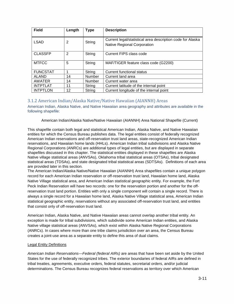
3.1.2 American Indian/Alaska Native/Native Hawaiian (AIANNH) Areas
American Indian, Alaska Native, and Native Hawaiian area geography and attributes are available in the
following shapefile:
American Indian/Alaska Native/Native Hawaiian (AIANNH) Area National Shapefile (Current)
This shapefile contain both legal and statistical American Indian, Alaska Native, and Native Hawaiian
entities for which the Census Bureau publishes data. The legal entities consist of federally recognized
American Indian reservations and off-reservation trust land areas, state-recognized American Indian
reservations, and Hawaiian home lands (HHLs). American Indian tribal subdivisions and Alaska Native
Regional Corporations (ANRCs) are additional types of legal entities, but are displayed in separate
shapefiles discussed in this chapter. The statistical entities displayed in these shapefiles are Alaska
Native village statistical areas (ANVSAs), Oklahoma tribal statistical areas (OTSAs), tribal designated
statistical areas (TDSAs), and state designated tribal statistical areas (SDTSAs). Definitions of each area
are provided later in this section. The American Indian/Alaska Native/Native Hawaiian (AIANNH) Area shapefiles contain a unique polygon
record for each American Indian reservation or off-reservation trust land, Hawaiian home land, Alaska
Native Village statistical area, and American Indian statistical geographic entity. For example, the Fort
Peck Indian Reservation will have two records: one for the reservation portion and another for the off-
reservation trust land portion. Entities with only a single component will contain a single record. There is
always a single record for a Hawaiian home land, Alaska Native Village statistical area, American Indian
statistical geographic entity, reservations without any associated off-reservation trust land, and entities
that consist only of off-reservation trust land.
American Indian, Alaska Native, and Native Hawaiian areas cannot overlap another tribal entity. An
exception is made for tribal subdivisions, which subdivide some American Indian entities, and Alaska
Native village statistical areas (ANVSAs), which exist within Alaska Native Regional Corporations
(ANRCs). In cases where more than one tribe claims jurisdiction over an area, the Census Bureau
creates a joint-use area as a separate entity to define this area of dual claims.
Legal Entity Definitions
American Indian Reservations—Federal (federal AIRs) are areas that have been set aside by the United
States for the use of federally recognized tribes. The exterior boundaries of federal AIRs are defined in
tribal treaties, agreements, executive orders, federal statutes, secretarial orders, and/or judicial
determinations. The Census Bureau recognizes federal reservations as territory over which American

3-12
Indian tribes have governmental authority. These entities are known as colonies, communities, Indian
colonies, Indian communities, Indian Rancherias, Indian Reservations, Indian villages, pueblos,
rancherias, ranches, reservations, reserves, settlements, villages, or other descriptions. The Bureau of
Indian Affairs within the U.S. Department of Interior maintains a list of federally recognized tribal
governments that is published regularly in the Federal Register. The Census Bureau contacts
representatives of these federally recognized American Indian tribal governments to identify the
boundaries for federal reservations. Federal reservations may cross state, county, county subdivision,
and/or place boundaries.
To obtain the list of federally recognized tribal governments and for more detailed information regarding
tribal governments, please visit the Bureau of Indian Affairs website at:
http://www.bia.gov/.
Each federal AIR and reservation equivalent joint-use area is assigned a nationally unique 4-character
census code ranging from 0001 through 4999. These census codes are assigned in alphabetical order of
AIR names nationwide, except that joint-use areas appear at the end of the code range (4900 to 4999).
Federal AIRs and reservation equivalent joint-use areas are also assigned a nationally unique 8-character
National Standard (GNIS) code.
American Indian Reservations—State (state AIRs) are established by some state governments for tribes
recognized by the state. A governor-appointed state liaison provides the names and boundaries for state-
recognized American Indian reservations to the Census Bureau. State reservations may cross county,
county subdivision, and/or place boundaries.
Each state American Indian reservation is assigned a nationally unique 4-character census code ranging
from 9000 through 9499. Each state AIR also is assigned a nationally unique 8-character National
Standard (GNIS) code.
American Indian Trust Lands are areas for which the United States holds title in trust for the benefit of a
tribe (tribal trust land) or for an individual American Indian tribal member (individual trust land or
allotment). Trust lands may be located on (on-reservation) or off an American Indian reservation (off-
reservation). The Census Bureau recognizes and tabulates data for reservations and off-reservation trust
lands (ORTLs) because American Indian tribes have governmental authority over these lands. Tribal
governmental authority generally is not attached to lands located off the reservation until the lands are
placed in trust status. In Census Bureau data tabulations, ORTLs are always associated with a specific
federally recognized reservation and/or tribal government. A tribal government appointed liaison provides
the name and boundaries of their ORTLs. The Census Bureau does not identify on-reservation trust land,
fee land (or land in fee simple status), or restricted fee lands as specific geographic categories and they
are not identified as such in the TIGER/Line Shapefiles.
Hawaiian Home Lands (HHLs) are areas held in trust for Native Hawaiians by the State of Hawaii,
according to the Hawaiian Homes Commission Act of 1920, as amended. Based on a compact between
the federal government and the new State of Hawaii in 1959, the Hawaii Admission Act vested land title
and responsibility for the program with the State. An HHL is not a governmental unit; rather, a home land
is a tract of land with a legally defined boundary that is owned by the state, which, as authorized by the
Act, may lease to one or more Native Hawaiians for residential, agricultural, commercial, industrial,
pastoral, and/or any other activities authorized by state law. The Census Bureau obtains the names and
boundaries for Hawaiian home lands from State officials. The names of the home lands are based on the
traditional ahupua'a names of the Crown and government lands of the Kingdom of Hawaii from which the
lands were designated or from the local name for an area.

3-13
Being lands held in trust, Hawaiian home lands are treated as equivalent to off-reservation trust land
areas with an AIANNH area trust land indicator coded as “T”. Each Hawaiian home land area is assigned
a nationally unique 4-character census code ranging from 5000 through 5499 based on the alphabetical
sequence of each HHL name. Each Hawaiian home land is also assigned a 5-character FIPS code in
alphabetical order within the State of Hawaii and a nationally unique 8-character National Standard
(GNIS) code.
Joint-Use Areas means an area that is administered jointly and/or claimed by two or more federally
recognized American Indian tribes. The Census Bureau designates both legal and statistical joint-use
areas as unique geographic entities for presenting statistical data. Joint-use areas only apply to
overlapping federally recognized American Indian reservations and/or off-reservation trust lands.
Each is assigned a nationally unique 4-character census code ranging from 4800 through 4999 and a
nationally unique 8-character National Standard (GNIS) code.
Statistical Entity Definitions
Alaska Native Village Statistical Areas (ANVSAs) are a statistical geographic entity that represents the
residences, permanent and/or seasonal, for Alaska Natives who are members of or are primarily receiving
governmental services from the defining Alaska Native village (ANV) and that are located within the
region and vicinity of the ANV’s historic and/or traditional location. ANVSAs are intended to represent the
relatively densely settled portion of each ANV and ideally should include only an area where Alaska
Natives, especially members of the defining ANV, represent a significant proportion of the population
during at least one season of the year (at least three consecutive months). ANVSAs are delineated or
reviewed by officials of the ANV or, if no ANV official chose to participate in the delineation process,
officials of the non-profit Alaska Native Regional Corporation (ANRC) in which the ANV is located. In
some cases, if neither the ANV nor ANRC official chose to participate in the delineation process, the
Census Bureau reviewed and delineated the ANVSA. An ANVSA may not overlap the boundary of
another ANVSA or an American Indian reservation.
Each ANVSA is assigned a nationally unique 4-character census code ranging from 6000 to 7999 based
on the alphabetical sequence of each ANVSA’s name. Each ANVSA is also assigned a nationally unique
8-character National Standard (GNIS) code.
Joint-Use Areas means an area is administered jointly and/or claimed by two or more American Indian
tribes. The Census Bureau designates both legal and statistical joint-use areas as unique geographic
entities for presenting statistical data. Statistical joint-use areas only apply to overlapping Oklahoma tribal
statistical areas.
Oklahoma Tribal Statistical Areas (OTSAs) are statistical entities identified and delineated by the Census
Bureau in consultation with federally recognized American Indian tribes that formerly had a reservation in
Oklahoma. The boundary of an OTSA is generally that of the former reservation in Oklahoma, except
where modified by agreements with neighboring federally recognized tribes that are eligible to delineate
an OTSA. Tribal subdivisions can exist within the statistical Oklahoma tribal statistical areas. Each OTSA
is assigned a nationally unique 4-character census code ranging from 5500 through 5999 based on the
alphabetical sequence of each OTSA’s name, except that the joint-use areas appear at the end of the
code range. Each OTSA also is assigned a nationally unique 8-character National Standard (GNIS) code.
State Designated Tribal Statistical Areas (SDTSAs) are statistical entities for state-recognized American
Indian tribes that do not have a state-recognized reservation. SDTSAs are identified and delineated for

3-14
the Census Bureau by a state liaison identified by the governor's office in each state. SDTSAs are
generally a compact and contiguous area that contains a concentration of people who identify with a
state-recognized American Indian tribe and in which there is structured or organized tribal activity. An
SDTSA may not be located in more than one state unless the tribe is recognized by both states and it
may not include area within any other AIANNH areas. Note that for Census 2000 these areas were
termed State Designated American Indian Statistical Areas (SDAISAs); the term was changed to bring
consistency to tribal statistical area terms.
Each SDTSA is assigned a nationally unique 4-character census code ranging from 9500 through 9998 in
alphabetical sequence of SDTSA names nationwide. Each SDTSA also is assigned a nationally unique 8-
character National Standard (GNIS) code.
Tribal Designated Statistical Areas (TDSAs) are statistical entities identified and delineated for the
Census Bureau by federally recognized American Indian tribes that do not currently have a reservation or
off-reservation trust land. A TDSA is intended to be comparable to the AIRs within the same state and/or
region, especially those for tribes that are of similar size. A TDSA is generally a compact and contiguous
area that contains a concentration of individuals who identify with the delineating federally recognized
American Indian tribe and in which there is structured or organized tribal activity. A TDSA may be located
in more than one state, but it may not include area within any other AIANNH areas. Each TDSA is
assigned a nationally unique 4-character census code ranging from 8000 through 8999 in alphabetical
sequence of TDSA names nationwide. Each TDSA is also assigned a nationally unique 8-character
National Standard (GNIS) code.
AIANNH Area Codes—the American Indian, Alaska Native, and Native Hawaiian (AIANNH) areas are
represented in the TIGER/Line Shapefiles by a 4-character census code field, and a single alphabetic
character AIANNH area reservation/statistical area or off-reservation trust land (ORTL) indicator field,
shown as COMPTYP (component type). The census codes are assigned in alphabetical order in
assigned ranges by AIANNH area type nationwide, except that joint-use areas appear at the end of their
applicable code range. ORTLs are assigned the same code as the reservation with which they are
associated. ORTLs associated with tribes that do not have a reservation are assigned codes based on
their tribal name. There is one record created for each unique combination of AIANNH code and
component type. Each AIANNH area also is assigned a nationally unique 8-character National Standard
(GNIS) code.
The type of AIANNH area can be identified either by its census code (AIANNHCE), its MAF/TIGER
feature class code (MTFCC), or by its FIPS class code (CLASSFP). The range of census codes allocated
to each AIANNH area and the valid FIPS class code(s) associated with each are in Table 3.
Table 3: Census codes for each AIANNH area
Type Census Code Range Valid FIPS Class Codes MTFCCs
Federal AIR or ORTL 0001 to 4899 **D2, **D3, **D5, **D8 *G2101, *G2102
Federal AIR/ORTL joint-use area 4900 to 4999 D0 G2170
Hawaiian home land 5000 to 5499 F1 G2120
OTSA 5500 to 5899 D6 G2140
OTSA joint-use area 5900 to 5999 D0 G2170
ANVSA 6000 to 7999 E1 G2130
TDSA 8000 to 8999 D6 G2160
State AIR 9000 to 9499 D4 G2101
SDTSA 9500 to 9998 D9 G2150

3-15
Notes:
G2101 can represent both federally and state-recognized areas; the recognition level can be
determined using the federal/state recognition flag (AIANNHR) field where “F” is federally
recognized and “S” is state-recognized.
Joint-use areas are identified uniquely by MTFCC G2170. An “A” in the functional status
(FUNCSTAT) field identifies federal AIR/ORTL joint-use areas, while an “S” in the field represents
joint-use OTSAs.
*G2101: Reservation or AIAN statistical entity
*G2102: American Indian ORTL or Hawaiian home land
**D2: Legal federally recognized American Indian area consisting of reservation only; D3: Legal federally
recognized American Indian area consisting of off-reservation trust land only; D5: The legal off-
reservation trust land portion of a federally recognized American Indian area with both a reservation and
trust land; D8: The legal reservation portion of a federally recognized American Indian entity with both a
reservation and trust land.
Table 4: Component types for AIANNH areas
Type Component Type (COMPTYP)
American Indian Trust Land T
Reservation or Statistical Entity R
3.1.2.1 American Indian / Alaska Native / Native Hawaiian (AIANNH) Area National Shapefile Record
Layout (Current)
File Name: tl_2016_us_aiannh.shp
Field Length Type Description
AIANNHCE 4 String Current American Indian/Alaska Native/Native Hawaiian
area census code
AIANNHNS 8 String Current American Indian/Alaska Native/Native Hawaiian
area GNIS code
GEOID 5 String
American Indian/Alaska Native/Native Hawaiian area
identifier; a concatenation of Current American
Indian/Alaska Native/Native Hawaiian area census code
and reservation/statistical area or off-reservation trust
land Hawaiian home land indicator
NAME 100 String Current American Indian/Alaska Native/Native Hawaiian
area name
NAMELSAD 100 String
Current name and the translated legal/statistical area
description for American Indian/Alaska Native/Native
Hawaiian area

3-16
Field Length Type Description
LSAD 2 String Current legal/statistical area description code for
American Indian/Alaska Native/Native Hawaiian area
CLASSFP 2 String Current FIPS class code
COMPTYP 1 String
Current American Indian/Alaska Native/Native Hawaiian
area reservation/statistical area or off-reservation trust
land Hawaiian home land indicator
AIANNHR 1 String Current American Indian/Alaska Native/Native Hawaiian
area federal/state recognition flag
MTFCC 5 String MAF/TIGER feature class code
FUNCSTAT 1 String Current functional status
ALAND 14 Number Current land area
AWATER 14 Number Current water area
INTPTLAT 11 String Current latitude of the internal point
INTPTLON 12 String Current longitude of the internal point
3.1.3 American Indian Tribal Subdivisions American Indian Tribal Subdivision geography and attributes are available in the following shapefile:
American Indian Tribal Subdivision (AITS) National Shapefile (Current)
American Indian Tribal Subdivisions (AITS) are legally defined administrative subdivisions of federally
recognized American Indian reservations and/or off-reservation trust lands or Oklahoma tribal statistical
areas (OTSAs). Tribal subdivisions are known as additions, administrative areas, areas, chapters, county
districts, districts, or segments. These entities are internal units of self-government or administration that
serve social, cultural, and/or economic purposes for the American Indians on the reservations, off-
reservation trust lands, or OTSAs. The Census Bureau obtains the boundary and name information for
tribal subdivisions from the federally recognized tribal governments.
American Indian Tribal Subdivision Codes are represented in the TIGER/Line Shapefiles by a 3-character
census code. The Census Bureau assigns the 3-character American Indian tribal subdivision code
alphabetically in order and uniquely within each American Indian reservation and/or associated off-
reservation trust land or Oklahoma tribal statistical area (OTSA). Each AITS is also assigned a nationally
unique 8-character National Standard (GNIS) code.
3.1.3.1 American Indian Tribal Subdivision (AITS) National Shapefile Record Layout
File Name: tl_2016_us_aitsn.shp
Field Length Type Description

3-17
Field Length Type Description
AIANNHCE 4 String Current American Indian/Alaska Native/Native Hawaiian area
census code
TRSUBCE 3 String Current American Indian tribal subdivision census code
TRSUBNS 8 String Current American Indian tribal subdivision GNIS code
GEOID 7 String
American Indian tribal subdivision identifier; a concatenation
of Current American Indian/Alaska Native/Native Hawaiian
area census code and American Indian tribal subdivision
census code
NAME 100 String Current American Indian tribal subdivision name
NAMELSAD 100 String Current name and the translated legal/statistical area
description for American Indian tribal subdivision
LSAD 2 String Current legal/statistical area description code for American
Indian tribal subdivision
CLASSFP 2 String Current FIPS class code
MTFCC 5 String MAF/TIGER feature class code (G2300)
FUNCSTAT 1 String Current functional status
ALAND 14 Number Current land area
AWATER 14 Number Current water area
INTPTLAT 11 String Current latitude of the internal point
INTPTLON 12 String Current longitude of the internal point
3.1.4 Tribal Census Tract Tribal census tract geography and attributes are available in the following shapefile:
Tribal Census Tract National Shapefile (Current)
Tribal census tracts are relatively small statistical subdivisions of an American Indian reservation and/or
off-reservation trust land (ORTL) and were defined by federally recognized tribal government officials in
the Census Bureau’s Tribal Statistical Areas Program (TSAP) for the 2010 Census. If a tribal government
declined to participate in TSAP, the Census Bureau delineated tribal census tracts on the American
Indian reservation and/or ORTL. Tribal census tracts are conceptually similar and equivalent to standard
census tracts. Unlike standard census tracts, however, tribal census tracts may cross state, county, and
standard census tract boundaries.

3-18
Tribal census tracts generally have at least 1,200 persons or 480 housing units, and no more than 8,000
persons or 3,200 housing units, with an optimal size of 4,000 persons or 1,600 housing units. Many
American Indian reservations and/or off-reservation trust lands have less than 2,400 persons and/or 960
housing units; in those cases, one tribal census tract was delineated that covers the entire American
Indian reservation and/or off-reservation trust land, since the area did not have enough population or
housing units to meet the minimum population and housing requirements for more than one tribal census
tract.
A tribal census tract usually covers a contiguous area but in some cases may consist of more than one
discrete area. Tribal census tracts nest within individually federally recognized American Indian
reservations and/or ORTLs. In some cases, an American Indian reservations and/or ORTL might be
discontiguous, so the tribal census tracts will be as well.
Tribal Census Tracts Codes—Tribal census tracts have a 4-character basic name/code plus a 2-character
suffix, which may be utilized if the tribal census tract is split in the future. (Because 2010 is the first
Census for which this coding scheme was used, no tribal census tracts currently have suffixes, in other
words they all have a suffix of “00.”) Tribal census tract codes all begin with the letter “T” and are
followed by three digits and the 2-character suffix, for example T00200. Tribal census tracts codes have
an implied decimal between the basic code and the suffix, and they are unique within an American Indian
reservation and/or ORTL. The code can be found in the TTRACTCE field.
Tribal Census Tract Names—the tribal census tract code also acts as its name, with the suffix only
appended if required. While, the TTRACTCE field contains the 6-character code format (including the
suffix), the NAME field contains the tribal census tract name as displayed in Census Bureau printed
reports and on mapping products. The name will consist of the first four characters (“T” followed by three
digits, including any leading or trailing zeroes) and a decimal point followed by the 2-character suffix if the
suffix is something other than “00.” When the suffix is only zeroes, the decimal point and suffix in the
tribal tract are omitted from the name. For example, tribal census tract code “T01000” has a tribal census
tract name of “T010”. The NAMELSAD field includes both the translated legal/statistical area description
and the tribal tract name, as in “Tribal census tract T010”.
For more information on the TSAP, please visit:
http://www.census.gov/geo/partnerships/tsap2010_overview.html.
3.1.4.1 Tribal Census Tract National Shapefile (Current)
File Name: tl_2016_us_ttract.shp
Field Length Type Description
AIANNHCE 4 String Current American Indian/Alaska Native/Native Hawaiian
area census code
TTRACTCE 6 String Current tribal census tract code
GEOID 10 String
Tribal census tract identifier; a concatenation of the
American Indian Area census code and tribal census tract
code

3-19
Field Length Type Description
NAME 7 String
Current tribal census tract name, including the decimal
point and decimal digits if a non-zero census tract suffix
exists
NAMELSAD 27 String Current translated legal/statistical area description and the
tribal census tract name
MTFCC 5 String MAF/TIGER feature class code (G2400)
ALAND 14 Number Current land area
AWATER 14 Number Current water area
INTPTLAT 11 String Current latitude of the internal point
INTPTLON 12 String Current longitude of the internal point
3.1.5 Tribal Block Group Tribal block group geography and attributes are available in the following shapefile:
Tribal Block Group National Shapefile (Current)
Tribal block groups are subdivisions of a tribal census tract. Tribal block groups were defined by federally
recognized tribal government officials in the Census Bureau’s Tribal Statistical Areas Program (TSAP) for
the 2010 Census. If a tribal government declined to participate in TSAP, the Census Bureau delineated
tribal block groups on the American Indian reservation and/or off-reservation trust land (ORTL). Tribal
block groups are intended to generally contain between 600 and 3,000 persons or between 240 and
1,200 housing units. Many American Indian reservations and ORTLs have less than the minimum
population thresholds for more than one tribal block group and in those cases one tribal block group was
delineated that covers the entire American Indian reservation and/or ORTL. Unlike standard block
groups, the cluster of blocks that comprises each tribal block group will not necessarily begin with the
same first number of their 4-character census block number, but may contain blocks from several different
standard census block groups.
A tribal block group usually covers a contiguous area but in some cases may consist of more than one
discrete area. Tribal block groups nest within tribal census tracts and within individual federally
recognized American Indian reservations and/or ORTLs. In some cases, an American Indian reservation
and/or ORTLs might be discontiguous, so the tribal block groups are as well. In addition, tribal block
group boundaries may cross standard census tract, standard block group, county, and/or state
boundaries.
Tribal block groups are uniquely named within tribal tracts. Tribal block group names and codes are
identical and are a single capital letter character from “A” to “K” (except for the letter “I”). There is no
relationship between the tribal block group identifier and the numbering of the census blocks that form the
tribal block group. A tribal block group will always be identified in conjunction with the tribal census tract
within which it is contained, for example T00100A.

3-20
For more information on the TSAP, please visit:
http://www.census.gov/geo/partnerships/tsap2010_overview.html.
3.1.5.1 Tribal Block Group National Shapefile (Current)
File Name: tl_2016_us_tbg.shp
Field Length Type Description
AIANNHCE 4 String Current Census American Indian/Alaska Native/Native
Hawaiian area census code
TTRACTCE 6 String Current tribal census tract code
TBLKGPCE 1 String Current tribal block group letter
GEOID 11 String
Tribal block group identifier; a concatenation of the
Current American Indian/Alaska Native/Native Hawaiian
area census code, tribal census tract code, and tribal
block group letter
NAMELSAD 20 String Current translated legal/statistical area description and the
tribal block group letter
MTFCC 5 String MAF/TIGER feature class code (G2410)
ALAND 14 Number Current land area
AWATER 14 Number Current water area
INTPTLAT 11 String Current latitude of the internal point
INTPTLON 12 String Current longitude of the internal point
3.2 Blocks (Census Block) Block geography and attributes are available in the following shapefile:
Block State-based Shapefile (2010 Geography)
Census blocks are statistical areas bounded on all sides by visible features, such as streets, roads,
streams, and railroad tracks, and by non-visible boundaries such as city, town, township, and county
limits, and short line-of-sight extensions of streets and roads. Generally, census blocks are small in area;
for example, a block in a city. Census blocks in suburban and rural areas may be large, irregular and
bounded by a variety of features, such as roads, streams, and/or transmission line rights-of-way. In
remote areas, census blocks may encompass hundreds of square miles. Census blocks cover all territory
in the United States, Puerto Rico, and the Island areas. Blocks do not cross the boundaries of any entity
for which the Census Bureau tabulates data. (See Figures 1 and 2).
Census Block Numbers (2010 Geography)—Census 2010 blocks are numbered uniquely within the 2010
boundaries of each state/county/census tract with a 4-character census block number. The first character
of the tabulation block number identifies the block group. A block number can only be unique by using

3-21
the decennial census state, county, census tract, and block or STATEFP10 + COUNTYFP10 +
TRACTCE10 + BLOCKCE10. There is no consistency in block numbers from census to census.
Figure 1: Geographic Relationships - Small Area Statistical Entities; County-Census Tract-Block Group-Block

3-22
Figure 2: Geographic Relationships - Legal and Statistical Entities; County-County Subdivision-Place-Block
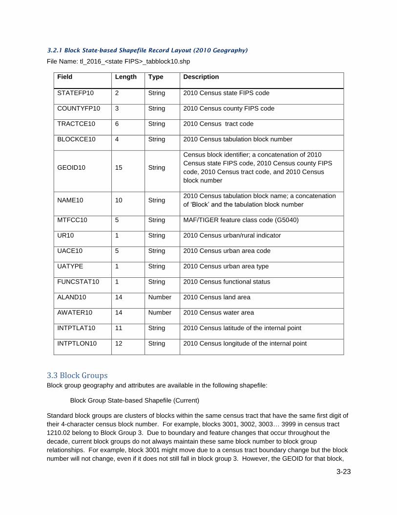
3-23
3.2.1 Block State-based Shapefile Record Layout (2010 Geography)
File Name: tl_2016_<state FIPS>_tabblock10.shp
Field Length Type Description
STATEFP10 2 String 2010 Census state FIPS code
COUNTYFP10 3 String 2010 Census county FIPS code
TRACTCE10 6 String 2010 Census tract code
BLOCKCE10 4 String 2010 Census tabulation block number
GEOID10 15 String
Census block identifier; a concatenation of 2010
Census state FIPS code, 2010 Census county FIPS
code, 2010 Census tract code, and 2010 Census
block number
NAME10 10 String 2010 Census tabulation block name; a concatenation
of ‘Block’ and the tabulation block number
MTFCC10 5 String MAF/TIGER feature class code (G5040)
UR10 1 String 2010 Census urban/rural indicator
UACE10 5 String 2010 Census urban area code
UATYPE 1 String 2010 Census urban area type
FUNCSTAT10 1 String 2010 Census functional status
ALAND10 14 Number 2010 Census land area
AWATER10 14 Number 2010 Census water area
INTPTLAT10 11 String 2010 Census latitude of the internal point
INTPTLON10 12 String 2010 Census longitude of the internal point
3.3 Block Groups Block group geography and attributes are available in the following shapefile:
Block Group State-based Shapefile (Current)
Standard block groups are clusters of blocks within the same census tract that have the same first digit of
their 4-character census block number. For example, blocks 3001, 3002, 3003… 3999 in census tract
1210.02 belong to Block Group 3. Due to boundary and feature changes that occur throughout the
decade, current block groups do not always maintain these same block number to block group
relationships. For example, block 3001 might move due to a census tract boundary change but the block
number will not change, even if it does not still fall in block group 3. However, the GEOID for that block,

3-24
identifying block group 3, would remain the same in the attribute information in the TIGER/Line Shapefiles
because block GEOIDs are always built using the decennial geographic codes.
Block groups delineated for the 2010 Census generally contain between 600 and 3,000 people. Most
block groups were delineated by local participants in the Census Bureau's Participant Statistical Areas
Program (PSAP). The Census Bureau delineated block groups only where a local or tribal government
declined to participate or where the Census Bureau could not identify a potential local participant.
A block group usually covers a contiguous area. Each census tract contains at least one block group and
block groups are uniquely numbered within census tract. Within the standard census geographic
hierarchy, block groups never cross county or census tract boundaries, but may cross the boundaries of
county subdivisions, places, urban areas, voting districts, congressional districts, and American Indian,
Alaska Native, and Native Hawaiian areas.
Block groups have a valid range of 0 through 9. Block groups beginning with a zero generally are in
coastal and Great Lakes water and territorial seas. Rather than extending a census tract boundary into
the Great Lakes or out to the 3-mile territorial sea limit, the Census Bureau delineated some census tract
boundaries along the shoreline or just offshore.
For more information about the PSAP, please visit:
http://www.census.gov/geo/partnerships/psap_overview.html.
3.3.1 Block Group State-based Shapefile Record Layout (Current)
File Name: tl_2016_<state FIPS>_bg.shp
Field Length Type Description
STATEFP 2 String Current state FIPS code
COUNTYFP 3 String Current county FIPS code
TRACTCE 6 String Current census tract code
BLKGRPCE 1 String Current block group number
GEOID 12 String
Census block group identifier; a concatenation of the
current state FIPS code, county FIPS code, census
tract code, and block group number.
NAMELSAD 13 String Current translated legal/statistical area description and
the block group number
MTFCC 5 String MAF/TIGER feature class code (G5030)
FUNCSTAT 1 String Current functional status
ALAND 14 Number Current land area
AWATER 14 Number Current water area
INTPTLAT 11 String Current latitude of the internal point

3-25
Field Length Type Description
INTPTLON 12 String Current longitude of the internal point
3.4 Census Tracts Census tract geography and attributes are available in the following shapefile:
Census Tract State-based Shapefile (Current)
Census tracts are small, relatively permanent statistical subdivisions of a county or equivalent entity, and
are reviewed and updated by local participants prior to each decennial census as part of the Census
Bureau’s Participant Statistical Areas Program (PSAP). The Census Bureau updates census tracts in
situations where no local participant existed or where local or tribal governments declined to participate.
The primary purpose of census tracts is to provide a stable set of geographic units for the presentation of
decennial census data.
Census tracts generally have a population size between 1,200 and 8,000 people with an optimum size of
4,000 people. The spatial size of census tracts varies widely depending on the density of settlement.
Census tracts are delineated with the intention of being maintained over a long time so that statistical
comparisons can be made from census to census. However, physical changes in street patterns caused
by highway construction, new development, and so forth, may require boundary revisions. In addition,
census tracts occasionally are split due to population growth or combined as a result of substantial
population decline.
Census tract boundaries generally follow visible and identifiable features. They may follow legal
boundaries such as minor civil division (MCD) or incorporated place boundaries in some states to allow
for census tract-to-governmental unit relationships where the governmental boundaries tend to remain
unchanged between censuses. State and county boundaries always are census tract boundaries in the
standard census geographic hierarchy.
In a few rare instances, a census tract may consist of discontiguous areas. These discontiguous areas
may occur where the census tracts are coextensive with all or parts of legal entities that are themselves
discontiguous.
Census Tract Codes and Numbers—Census tract numbers have up to a 4-character basic number and
may have an optional 2-character suffix; for example, 1457.02. The census tract numbers (used as
names) eliminate any leading zeroes and append a suffix only if required. The 6-character numeric
census tract codes, however, include leading zeroes and have an implied decimal point for the suffix.
Census tract codes range from 000100 to 998999 and are unique within a county or equivalent area.
The Census Bureau assigned a census tract code of 9900 to represent census tracts delineated to cover
large bodies of water. In addition, census tract codes in the 9400s represent American Indian Areas and
codes in the 9800s represent special land use areas.
The Census Bureau uses suffixes to help identify census tract changes for comparison purposes. Local
participants have an opportunity to review the existing census tracts before each census. If local
participants split a census tract, the split parts usually retain the basic number, but receive different
suffixes. In a few counties, local participants request major changes to, and renumbering of, the census

3-26
tracts. Changes to individual census tract boundaries usually do not result in census tract numbering
changes.
Relationship to Other Geographic Entities—Within the standard census geographic hierarchy, census
tracts never cross state or county boundaries, but may cross the boundaries of county subdivisions,
places, urban areas, voting districts, congressional districts, and American Indian, Alaska Native, and
Native Hawaiian areas.
Census Tract Numbers and Codes:
000100 to 989900—Basic number range for census tracts
990000 to 990099—Basic number for census tracts in water areas
990100 to 998900—Basic number range for census tracts
3.4.1 Census Tract State-based Shapefile Record Layout (Current)
File Name: tl_2016_<state FIPS>_tract.shp
Field Length Type Description
STATEFP 2 String Current state FIPS code
COUNTYFP 3 String Current county FIPS code
TRACTCE 6 String Current census tract code
GEOID 11 String
Census tract identifier; a concatenation of Current
state FIPS code, county FIPS code, and census tract
code
NAME 7 String
Current census tract name, this is the census tract
code converted to an integer or integer plus 2-
character decimal if the last two characters of the
code are not both zeros.
NAMELSAD 20 String Current translated legal/statistical area description
and the census tract name
MTFCC 5 String MAF/TIGER feature class code (G5020)
FUNCSTAT 1 String Current functional status
ALAND 14 Number Current land area
AWATER 14 Number Current water area
INTPTLAT 11 String Current latitude of the internal point
INTPTLON 12 String Current longitude of the internal point

3-27
3.5 Congressional Districts Congressional district geography and attributes are available in the following shapefile:
115th Congressional District National Shapefile
Congressional districts are the 435 areas from which people are elected to the U.S. House of
Representatives and the five areas with nonvoting delegates from state equivalents. After the
apportionment of congressional seats among the states based on decennial census population counts,
each state is responsible for establishing the boundaries of the congressional districts for the purpose of
electing representatives. Each congressional district is to be as equal in population to all other
congressional districts in a state as practicable.
The 2016 TIGER/Line Shapefiles contain the 115th Congressional Districts. All congressional districts
appearing in the 2016 TIGER/Line Shapefiles reflect the information provided to the Census Bureau by
the states by May 1, 2016. The 115th Congressional District shapefile contains the areas in effect from
January 2017 to 2019.
The following state had changes for the 115th Congress:
Florida
Minnesota
North Carolina
Virginia
Each state has a minimum of one representative in the U.S. House of Representatives. The District of
Columbia, Puerto Rico, American Samoa, Guam, and the U.S. Virgin Islands have a non-voting delegate
in the Congress.
Congressional District Codes—Congressional districts are identified by a 2-character numeric FIPS code.
Congressional districts are numbered uniquely within state. The District of Columbia, Puerto Rico and the
Island areas have the code of 98, which identifies their status with respect to representation in Congress:
01 to 53—Congressional district codes
00—At large (single district for state)
98—Nonvoting delegate
3.5.1 115th Congressional District National Shapefile Record Layout
File Name: tl_2016_us_cd115.shp
Field Length Type Description
STATEFP 2 String Current state FIPS code
CD115FP 2 String 115th congressional district FIPS code
GEOID 4 String
115th congressional district identifier; a concatenation of
current state FIPS code and the 115th congressional
district FIPS code
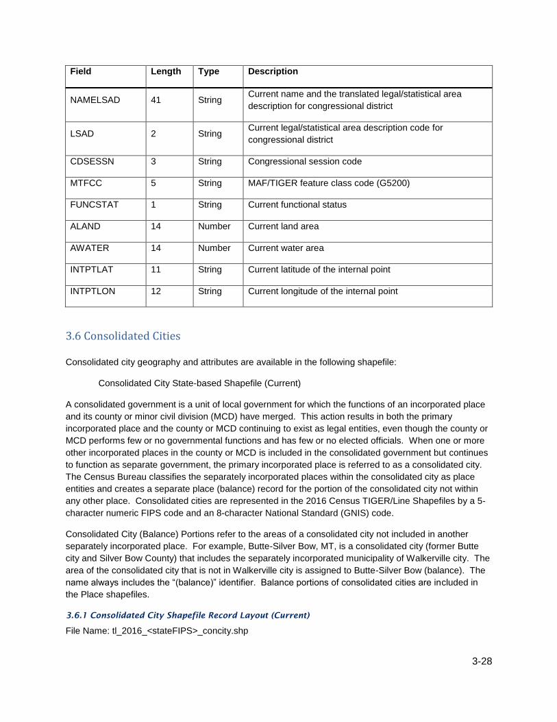
3-28
Field Length Type Description
NAMELSAD 41 String Current name and the translated legal/statistical area
description for congressional district
LSAD 2 String Current legal/statistical area description code for
congressional district
CDSESSN 3 String Congressional session code
MTFCC 5 String MAF/TIGER feature class code (G5200)
FUNCSTAT 1 String Current functional status
ALAND 14 Number Current land area
AWATER 14 Number Current water area
INTPTLAT 11 String Current latitude of the internal point
INTPTLON 12 String Current longitude of the internal point
3.6 Consolidated Cities
Consolidated city geography and attributes are available in the following shapefile:
Consolidated City State-based Shapefile (Current)
A consolidated government is a unit of local government for which the functions of an incorporated place
and its county or minor civil division (MCD) have merged. This action results in both the primary
incorporated place and the county or MCD continuing to exist as legal entities, even though the county or
MCD performs few or no governmental functions and has few or no elected officials. When one or more
other incorporated places in the county or MCD is included in the consolidated government but continues
to function as separate government, the primary incorporated place is referred to as a consolidated city.
The Census Bureau classifies the separately incorporated places within the consolidated city as place
entities and creates a separate place (balance) record for the portion of the consolidated city not within
any other place. Consolidated cities are represented in the 2016 Census TIGER/Line Shapefiles by a 5-
character numeric FIPS code and an 8-character National Standard (GNIS) code.
Consolidated City (Balance) Portions refer to the areas of a consolidated city not included in another
separately incorporated place. For example, Butte-Silver Bow, MT, is a consolidated city (former Butte
city and Silver Bow County) that includes the separately incorporated municipality of Walkerville city. The
area of the consolidated city that is not in Walkerville city is assigned to Butte-Silver Bow (balance). The
name always includes the “(balance)” identifier. Balance portions of consolidated cities are included in
the Place shapefiles.
3.6.1 Consolidated City Shapefile Record Layout (Current)
File Name: tl_2016_<stateFIPS>_concity.shp

3-29
Field Length Type Description
STATEFP 2 String Current state FIPS code
CONCTYFP 5 String Current consolidated city FIPS code
CONCTYNS 8 String Current consolidated city GNIS code
GEOID 7 String Consolidated city identifier; a concatenation of current
state FIPS code and consolidated city FIPS code
NAME 100 String Current consolidated city name
NAMELSAD 100 String Current name and the translated legal/statistical area
description for consolidated city
LSAD 2 String Current legal/statistical area description code for
consolidated city
CLASSFP 2 String Current FIPS class code
MTFCC 5 String MAF/TIGER feature class code (G4120)
FUNCSTAT 1 String Current functional status
ALAND 14 Number Current land area
AWATER 14 Number Current water area
INTPTLAT 11 String Current latitude of the internal point
INTPTLON 12 String Current longitude of the internal point
3.7 Counties and Equivalent Entities County and equivalent entity geography and attributes are available in the following shapefile:
County and Equivalent Entity National Shapefile (Current)
Counties and equivalent entities are primary legal divisions of states. In most states, these entities are
termed “counties.” In Louisiana, these divisions are known as “parishes.” In Alaska, the equivalent
entities are the organized boroughs, city and boroughs, and municipalities, and for the unorganized
areas, census areas. The census areas are delineated cooperatively for statistical purposes by the State
of Alaska and the Census Bureau. In four states (Maryland, Missouri, Nevada, and Virginia), there are
one or more incorporated places that are independent of any county organization and thus constitute
primary divisions of their states. These incorporated places are known as independent cities and are
treated as county equivalent entities for purposes of data presentation. The District of Columbia and
Guam have no primary divisions and each area is considered a county equivalent entity for purposes of
data presentation. The Census Bureau treats the following entities as equivalents of counties for
purposes of data presentation: municipios in Puerto Rico, districts and islands in America Samoa,
municipalities in the Commonwealth of the Northern Mariana Islands, and islands in the U.S. Virgin

3-30
Islands. Each county or statistically equivalent entity is assigned a 3-character FIPS code that is unique
within a state, as well as an 8-character National Standard (GNIS) code.
The 2016 TIGER/Line Shapefiles are based on available governmental unit boundaries of the counties
and equivalent entities as of January 1, 2016. Detailed information about changes in the inventory and
codes for county and equivalent areas can be found at:
http://www.census.gov/geo/partnerships/bas/bas_newannex.html.
Core-based Statistical Area (CBSA) Codes – The 2016 county and equivalent entity shapefiles also
contain fields with codes for combined statistical area, metropolitan or micropolitan statistical area, and
metropolitan division. Counties form the building blocks for CBSAs, thus county records can be merged
to form these areas without having to acquire the individual CBSA shapefiles.
3.7.1 County and Equivalent Entity National Shapefile Record Layout (Current)
File Name: tl_2016_us_county.shp
Field Length Type Description
STATEFP 2 String Current state FIPS code
COUNTYFP 3 String Current county FIPS code
COUNTYNS 8 String Current county GNIS code
GEOID 5 String County identifier; a concatenation of Current state FIPS
code and county FIPS code
NAME 100 String Current county name
NAMELSAD 100 String Current name and the translated legal/statistical area
description for county
LSAD 2 String Current legal/statistical area description code for county
CLASSFP 2 String Current FIPS class code
MTFCC 5 String MAF/TIGER feature class code (G4020)
CSAFP 3 String Current combined statistical area code
CBSAFP 5 String Current metropolitan statistical area/micropolitan
statistical area code
METDIVFP 5 String Current metropolitan division code
FUNCSTAT 1 String Current functional status
ALAND 14 Number Current land area
AWATER 14 Number Current water area
INTPTLAT 11 String Current latitude of the internal point

3-31
Field Length Type Description
INTPTLON 12 String Current longitude of the internal point
3.8 County Subdivisions County subdivision geography and attributes are available in the following shapefile:
County Subdivision State-based Shapefile (Current)
County subdivisions are the primary divisions of counties and their equivalent entities for the reporting of
decennial census data. They include census county divisions, census subareas, minor civil divisions, and
unorganized territories. They may represent legal or statistical entities. The 2016 TIGER/Line Shapefiles
contain a 5-character FIPS code field for county subdivisions and an 8-character National Standards
(GNIS) code.
Legal Entity Definition
Minor Civil Divisions (MCDs) are the primary governmental or administrative divisions of a county in many
states. MCDs represent many different kinds of legal entities with a wide variety of governmental and/or
administrative functions. MCDs include areas designated as American Indian reservations, assessment
districts, barrios, barrios-pueblo, boroughs, census subdistricts, charter townships, commissioner districts,
counties, election districts, election precincts, gores, grants, locations, magisterial districts, parish
governing authority districts, plantations, precincts, purchases, supervisor's districts, towns, and
townships. The Census Bureau recognizes MCDs in 29 states, Puerto Rico, and the Island areas. The
District of Columbia has no primary divisions and the incorporated place of Washington is treated as an
equivalent to an MCD for statistical purposes. In 23 states, all or some incorporated places are not part
of any MCD. These places also serve as primary legal county subdivisions and have a FIPS MCD code
that is the same as the FIPS place code. The GNIS codes also match for those entities. In other states,
incorporated places are part of the MCDs in which they are located or the pattern is mixed—some
incorporated places are independent of MCDs and others are included within one or more MCDs. The
MCDs in 12 states (Connecticut, Maine, Massachusetts, Michigan, Minnesota, New Hampshire, New
Jersey, New York, Pennsylvania, Rhode Island, Vermont, and Wisconsin) also serve as general-purpose
local governments that generally can perform the same governmental functions as incorporated places.
The Census Bureau presents data for these MCDs in all data products for which place data are provided.
In New York and Maine, American Indian reservations (AIRs) exist outside the jurisdiction of any town
(MCD) and thus serve as the equivalent of MCDs for purposes of data presentation.
Statistical Entity Definitions
Census County Divisions (CCDs) are areas delineated by the Census Bureau in cooperation with state
and local officials for statistical purposes. CCDs are not governmental units and have no legal functions.
CCD boundaries usually follow visible features and, in most cases, coincide with census tract boundaries.
The name of each CCD is based on a place, county, or well-known local name that identifies its location.
CCDs exist where:
There are no legally established minor civil divisions (MCDs)
The legally established MCDs do not have governmental or administrative purposes
The boundaries of the MCDs change frequently

3-32
The MCDs are not generally known to the public
CCDs have been established for the following 20 states:
Alabama Arizona California Colorado Delaware Florida
Georgia Hawaii Idaho Kentucky Montana Nevada
New Mexico Oklahoma Oregon South Carolina Texas Utah
Washington Wyoming
Census Subareas are statistical subdivisions of boroughs, city and boroughs, municipalities, and census
areas, the latter of which are the statistical equivalent entities for counties in Alaska. The state of Alaska
and the Census Bureau cooperatively delineate the census subareas to serve as the statistical
equivalents of MCDs.
Unorganized Territories (UTs) have been defined by the Census Bureau in 9 minor civil division (MCD)
states and American Samoa where portions of counties or equivalent entities are not included in any
legally established MCD or incorporated place. The Census Bureau recognizes such separate pieces of
territory as one or more separate county subdivisions for census purposes. It assigns each unorganized
territory a descriptive name, followed by the designation “unorganized territory” and county subdivision
FIPS and GNIS codes. Unorganized territories are recognized in the following states and equivalent
areas:
Arkansas Indiana Iowa Maine Minnesota New York
North Carolina North Dakota South Dakota
Undefined County Subdivisions—in water bodies, primarily Great Lakes waters and territorial sea, legal
county subdivisions do not extend to cover the entire county. For these areas, the Census Bureau
created a county subdivision with a FIPS code of 00000 and GNIS code of 00000000 named “county
subdivision not defined.” The following states and equivalent areas have these county subdivisions:
Connecticut Illinois Indiana Maine Massachusetts Michigan
Minnesota New Hampshire New Jersey New York Ohio Pennsylvania
Rhode Island Wisconsin Puerto Rico
New England City and Town Area (NECTA) Codes — The 2016 county subdivision shapefiles also
contain fields with codes for Combined New England city and town area, New England city and town
area, and New England city and town area division. The NECTAs are delineated by whole county
subdivision in New England only, thus county subdivision records can be merged to form these areas
without having to acquire the individual NECTA shapefiles.
3.8.1 County Subdivision State-based Shapefile Record Layout (Current)
File Name: tl_2016_<stateFIPS>_cousub.shp
Field Length Type Description
STATEFP 2 String Current state FIPS code
COUNTYFP 3 String Current county FIPS code
COUSUBFP 5 String Current county subdivision FIPS code
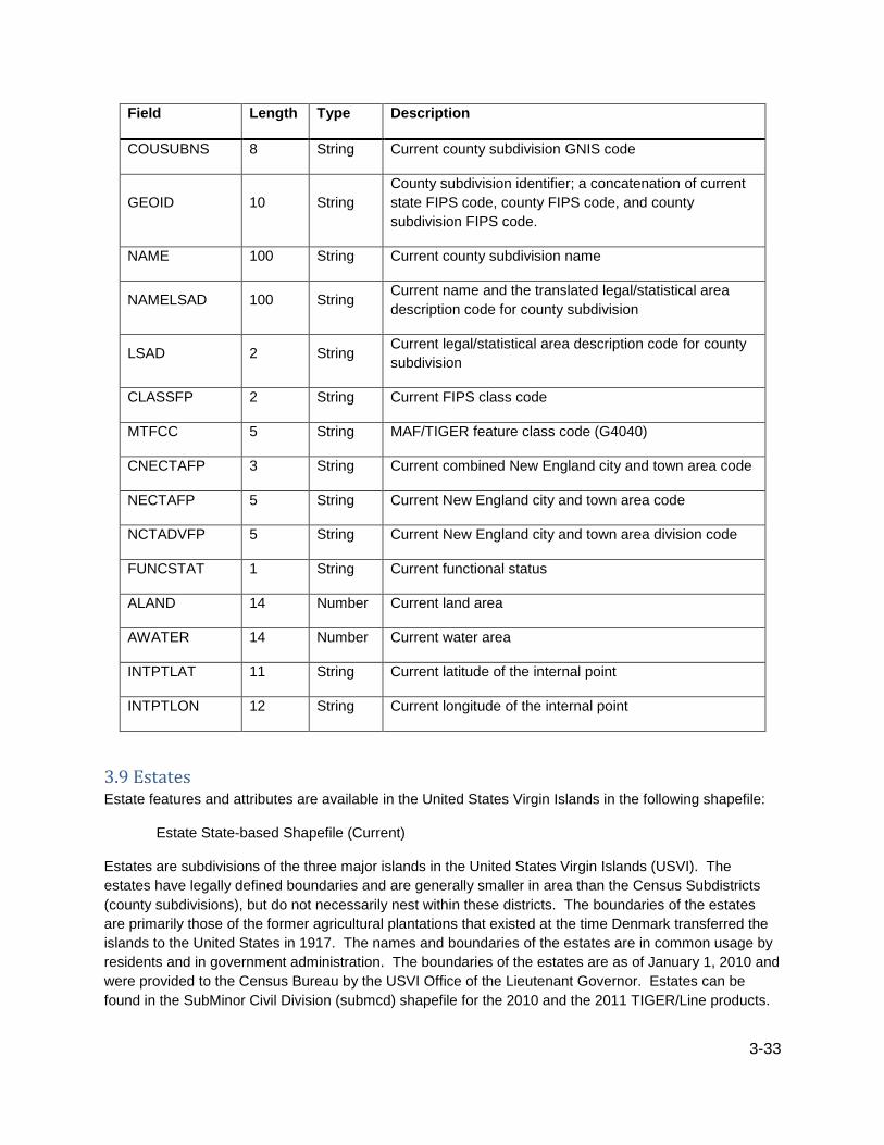
3-33
Field Length Type Description
COUSUBNS 8 String Current county subdivision GNIS code
GEOID 10 String
County subdivision identifier; a concatenation of current
state FIPS code, county FIPS code, and county
subdivision FIPS code.
NAME 100 String Current county subdivision name
NAMELSAD 100 String Current name and the translated legal/statistical area
description code for county subdivision
LSAD 2 String Current legal/statistical area description code for county
subdivision
CLASSFP 2 String Current FIPS class code
MTFCC 5 String MAF/TIGER feature class code (G4040)
CNECTAFP 3 String Current combined New England city and town area code
NECTAFP 5 String Current New England city and town area code
NCTADVFP 5 String Current New England city and town area division code
FUNCSTAT 1 String Current functional status
ALAND 14 Number Current land area
AWATER 14 Number Current water area
INTPTLAT 11 String Current latitude of the internal point
INTPTLON 12 String Current longitude of the internal point
3.9 Estates Estate features and attributes are available in the United States Virgin Islands in the following shapefile:
Estate State-based Shapefile (Current)
Estates are subdivisions of the three major islands in the United States Virgin Islands (USVI). The
estates have legally defined boundaries and are generally smaller in area than the Census Subdistricts
(county subdivisions), but do not necessarily nest within these districts. The boundaries of the estates
are primarily those of the former agricultural plantations that existed at the time Denmark transferred the
islands to the United States in 1917. The names and boundaries of the estates are in common usage by
residents and in government administration. The boundaries of the estates are as of January 1, 2010 and
were provided to the Census Bureau by the USVI Office of the Lieutenant Governor. Estates can be
found in the SubMinor Civil Division (submcd) shapefile for the 2010 and the 2011 TIGER/Line products.

3-34
3.9.1 Estate Shapefile (U.S. Virgin Islands Only) Record Layout (Current)
File Name: tl_2016_78_estate.shp
Field Length Type Description
STATEFP 2 String Current state FIPS code
COUNTYFP 3 String Current county FIPS code
ESTATEFP 5 String Current estate FIPS code
ESTATENS 8 String Current estate GNIS code
GEOID 10 String Estate identifier; a concatenation of current state FIPS
code, county FIPS code, and estate FIPS code
NAME 100 String Current estate name
NAMELSAD 100 String Current name and the translated legal/statistical area
description for estate
LSAD 2 String Current legal/statistical area description code for estate
CLASSFP 2 String Current FIPS class code
MTFCC 5 String MAF/TIGER feature class code (G4050)
FUNCSTAT 1 String Current functional status
ALAND 14 Number Current land area
AWATER 14 Number Current water area
INTPTLAT 11 String Current latitude of the internal point
INTPTLON 12 String Current longitude of the internal point
3.10 Hydrography (Area and Linear) Hydrography features and attributes are available in the following shapefiles:
Area Hydrography County-based Shapefile
Linear Hydrography County-based Shapefile
The area hydrography shapefile contains the geometry and attributes of both perennial and intermittent
area hydrography features, including ponds, lakes, oceans, swamps, glaciers, and the area covered by
large streams represented as double-line drainage. Single-line drainage water features can be found in
the all lines shapefile and linear hydrography shapefile.
The linear hydrography shapefile contains all linear features with “H” (Hydrography) type MTFCCs in the
MAF/TIGER database by county. The shapefiles are provided at a county geographic extent and in linear
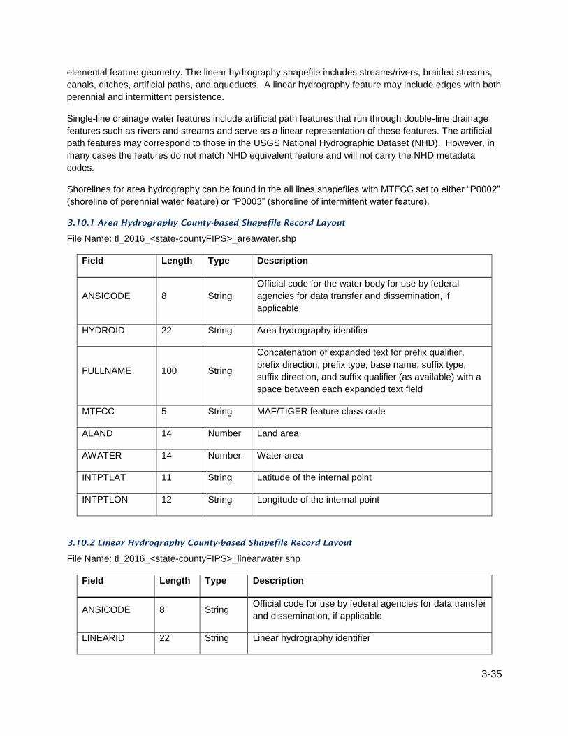
3-35
elemental feature geometry. The linear hydrography shapefile includes streams/rivers, braided streams,
canals, ditches, artificial paths, and aqueducts. A linear hydrography feature may include edges with both
perennial and intermittent persistence.
Single-line drainage water features include artificial path features that run through double-line drainage
features such as rivers and streams and serve as a linear representation of these features. The artificial
path features may correspond to those in the USGS National Hydrographic Dataset (NHD). However, in
many cases the features do not match NHD equivalent feature and will not carry the NHD metadata
codes.
Shorelines for area hydrography can be found in the all lines shapefiles with MTFCC set to either “P0002”
(shoreline of perennial water feature) or “P0003” (shoreline of intermittent water feature).
3.10.1 Area Hydrography County-based Shapefile Record Layout
File Name: tl_2016_<state-countyFIPS>_areawater.shp
Field Length Type Description
ANSICODE 8 String
Official code for the water body for use by federal
agencies for data transfer and dissemination, if
applicable
HYDROID 22 String Area hydrography identifier
FULLNAME 100 String
Concatenation of expanded text for prefix qualifier,
prefix direction, prefix type, base name, suffix type,
suffix direction, and suffix qualifier (as available) with a
space between each expanded text field
MTFCC 5 String MAF/TIGER feature class code
ALAND 14 Number Land area
AWATER 14 Number Water area
INTPTLAT 11 String Latitude of the internal point
INTPTLON 12 String Longitude of the internal point
3.10.2 Linear Hydrography County-based Shapefile Record Layout
File Name: tl_2016_<state-countyFIPS>_linearwater.shp
Field Length Type Description
ANSICODE 8 String Official code for use by federal agencies for data transfer
and dissemination, if applicable
LINEARID 22 String Linear hydrography identifier

3-36
Field Length Type Description
FULLNAME 100 String
Concatenation of expanded text for prefix qualifier, prefix
direction, prefix type, base name, suffix type, suffix
direction, and suffix qualifier (as available) with a space
between each expanded text field
ARTPATH 1 String Artificial path flag
MTFCC 5 String MAF/TIGER feature class code
3.11 Landmarks (Area and Point) Landmark features and attributes are available in the following shapefiles:
Area Landmark State-based Shapefile
Point Landmark State-based Shapefile
The Census Bureau includes landmarks in the MAF/TIGER database (MTDB) for locating special features
and to help enumerators during field operations. Some of the more common landmark types include area
landmarks such as airports, cemeteries, parks, and educational facilities and point landmarks such as
schools and churches.
The Census Bureau adds landmark features to the database on an as-needed basis and makes no
attempt to ensure that all instances of a particular feature were included. The absence of a landmark
such as a hospital or prison does not mean that the living quarters associated with that landmark were
excluded from the 2010 Census enumeration. The landmarks were not used as the basis for building or
maintaining the address list used to conduct the 2010 Census.
Area landmark and area water features can overlap; for example, a park or other special land-use feature
may include a lake or pond. In this case, the polygon covered by the lake or pond belongs to a water
feature and a park landmark feature. Other kinds of landmarks can overlap as well. Area landmarks can
contain point landmarks, but these features are not linked in the TIGER/Line Shapefiles.
Landmarks may be identified by a MAF/TIGER feature class code only and may not have a name. Each
landmark has a unique area landmark identifier (AREAID) or point landmark identifier (POINTID) value.
3.11.1 Area Landmark State-based Shapefile Record Layout
File Name: tl_2016_<stateFIPS>_arealm.shp
Field Length Type Description
STATEFP 2 String State FIPS code
ANSICODE 8 String Official code for the landmark for use by federal
agencies for data transfer and dissemination
AREAID 22 String Area landmark identifier

3-37
Field Length Type Description
FULLNAME 100 String
Concatenation of expanded text for prefix qualifier,
prefix direction, prefix type, base name, suffix type,
suffix direction, and suffix qualifier with a space between
each expanded text field
MTFCC 5 String MAF/TIGER feature class code
ALAND 14 Number Land area
AWATER 14 Number Water area
INTPTLAT 11 String Latitude of the internal point
INTPTLON 12 String Longitude of the internal point
PARTFLG 1 String Part Flag identifying if all or part of the entity is within
the file
3.11.2 Point Landmark State-based Shapefile Record Layout
File Name: tl_2016_<stateFIPS>_pointlm.shp
Field Length Type Description
STATEFP 2 String State FIPS code
ANSICODE 8 String Official code for the point landmark for use by federal
agencies for data transfer and dissemination, if applicable
POINTID 22 String Point landmark identifier
FULLNAME 100 String
Concatenation of expanded text for prefix type, base name,
and suffix type with a space between each expanded text
field
MTFCC 5 String MAF/TIGER feature class code
3.12 Linear Features Linear elemental features are the spatial representation of 1-dimensional roads, hydrography, railroads,
and other miscellaneous features in the MAF/TIGER database. A linear elemental feature can span one
edge or multiple connecting edges that share a common name and feature classification (MTFCC).
More than one linear elemental feature can share the same edge or group of connected edges. For
example, an edge may be associated with a linear feature called Oak Street. This same edge may be
one of several edges also associated with another linear feature called State Highway 57. The edge in
question has two names: Oak Street and State Highway 57. One of these names will be designated as

3-38
primary and the others as alternate names. Usually the common street name (Oak Street) will be
primary.
The MAF/TIGER database breaks/ends linear elemental features when the feature name changes. All
spelling differences are represented by a new feature. Features will also break at county boundaries,
changes in primary/alternate designation, MTFCC, and gaps in the geometry.
Linear features and attributes are available in the following shapefiles.
3.12.1 All Lines Each all lines shapefile describes the universe of edges that either bound or are included within a county
or equivalent entity. The shapefile describes the geometry of each edge along with descriptive attributes
and unique identification numbers. These identification numbers provide the means for linking the edges
to alternate features such as their names, address ranges, and adjacent faces.
The all lines features and attributes are in the following shapefile:
All Lines County-based Shapefile
The all lines shapefile contains visible linear feature edges such as roads, railroads, and hydrography, as
well as non-feature edges and non-visible boundaries. Additional attribute data associated with the
edges are available in relationship files that users must download separately.
The all lines shapefile contains the geometry and attributes of each topological primitive edge. Each
edge has a unique TLID (permanent edge identifier) value. The edge’s left and right faces can be
identified by the TFIDL (permanent face identifier on the left side of the edge) and TFIDR (permanent
face identifier on the right side of the edge) attributes which link to the TFID attribute in the Topological
Faces shapefile.
The left and right side of an edge is determined by the order of the points that form the edge. An edge is
oriented from the start node to the end node. If one is standing on an edge at the start node facing the
end node, data listed in the fields carrying a right qualifier would be found to the right of the edge. Data
users can employ GIS software to plot the edges as directional vectors with arrows showing the
orientation of edges.
In the MAF/TIGER database, edges may represent several types of features. The series of indicator flags
(HYDROFLG, ROADFLG, RAILFLG, and OLFFLG) indicate the classes of features that share the edge.
For example, a road may have embedded railroad tracks; the corresponding edge will have both the
ROADFLG (road feature indicator) and RAILFLG (rail feature indicator) set. Generally, certain feature
types appear together on the same edge:
Road and Rail—roads with adjacent tracks, tracks embedded in roadways or tracks located in the median
Rail and Other Linear Feature—rail features located on dams and levees
Road and Other Linear Feature—road features located on dams and levees
The MAF/TIGER feature class code (MTFCC) identifies the specific code for the primary feature on the
edge. For edges that represent roads in combination with other features, the MTFCC in the all lines
shapefile will reflect the road feature.
3.12.1.1 All Lines County-based Shapefile Record Layout
File Name: tl_2016_<state-county>_edges.shp

3-39
Field Length Type Description
STATEFP 2 String State FIPS code
COUNTYFP 3 String County FIPS code
TLID 10 Integer Permanent edge ID
TFIDL 10 Integer Permanent face ID on the left of the edge
TFIDR 10 Integer Permanent face ID on the right of the edge
MTFCC 5 String MAF/TIGER feature class code of the primary
feature for the edge
FULLNAME 100 String
Concatenation of expanded text for prefix qualifier,
prefix direction, prefix type, base name, suffix type,
suffix direction, and suffix qualifier with a space
between each expanded text field (as available)
SMID 22 String Spatial metadata identifier
LFROMADD 12 String From house number associated with the most
inclusive address range on the left side of the edge
LTOADD 12 String To house number associated with the most inclusive
address range on the left side of the edge
RFROMADD 12 String From house number associated with the most
inclusive address range on the right side of the edge
RTOADD 12 String To house number associated with the most inclusive
address range on the right side of the edge
ZIPL 5 String ZIP code associated with the most inclusive address
range on the left side
ZIPR 5 String ZIP code associated with the most inclusive address
range on the right side
FEATCAT 1 String General feature classification category
HYDROFLG 1 String Hydrography feature indicator
RAILFLG 1 String Rail feature indicator
ROADFLG 1 String Road feature indicator
OLFFLG 1 String Other linear feature indicator
PASSFLG 1 String Special passage flag

3-40
Field Length Type Description
DIVROAD 1 String Divided road flag
EXTTYP 1 String Extension type
TTYP 1 String Track type
DECKEDROAD 1 String Decked road indicator
ARTPATH 1 String Artificial path indicator
PERSIST 1 String Hydrographic persistence flag
GCSEFLG 1 String Short lines flag for geographic corridors
OFFSETL 1 String Left offset flag
OFFSETR 1 String Right offset flag
TNIDF 10 Integer From TIGER node identifier
TNIDT 10 Integer To TIGER node identifier
3.12.2 Coastline The coastline boundary is available in the following shapefile:
Coastline National Shapefile
The coastline shapefile includes all features within the MTDB class "Coastline," distinguished by the
MAF/TIGER feature classification code (MTFCC) L4150. The coastline included in this shapefile was
delineated by the Census Bureau in the MAF/TIGER database based on water measurement class for
display of statistical information only; its depiction and designation for statistical purposes does not
constitute a determination of jurisdictional authority or rights of ownership or entitlement and it is not a
legal land description. The name assigned to each coastline feature is a short form of the name of the
large body of water bordered by this coastline feature.
3.12.2.1 Coastline National Shapefile Record Layout
File Name: tl_2016_us_coastline.shp
Field Length Type Description
NAME 100 String Coastline Name
MTFCC 5 String MAF/TIGER Feature Class Code of the primary
feature for the edge

3-41
3.12.3 Roads Linear road features and attributes are available in the following shapefiles:
Primary Roads National Shapefile
Primary and Secondary Roads State-based Shapefile
All Roads County-based Shapefile
Primary roads are generally divided, limited-access highways within the Federal interstate highway
system or under state management. These highways are distinguished by the presence of interchanges
and are accessible by ramps and may include some toll highways. The Primary Roads shapefile contains
all linear street features with a MTFCC of “S1100” in the MAF/TIGER database. The shapefiles are
provided at a national geographic extent and in linear elemental feature geometry.
The primary and secondary roads shapefile contains all linear street features with MTFCCs of “S1100” or
“S1200” in the MAF/TIGER database. The shapefiles are provided at a state geographic extent and in
linear elemental feature geometry. Secondary roads are main arteries, usually in the U.S. highway, state
highway, or county highway system. These roads have one or more lanes of traffic in each direction, may
or may not be divided, and usually have at-grade intersections with many other roads and driveways.
They often have both a local name and a route number.
The content of the all roads shapefile includes primary roads, secondary roads, local neighborhood roads,
rural roads, city streets, vehicular trails (4WD), ramps, service drives, walkways, stairways, alleys, and
private roads. The all roads shapefile contains all linear street features with “S” (Street) type MTFCCs in
the MAF/TIGER database. The shapefiles are provided at a county geographic extent and in linear
elemental feature geometry.
The Census Bureau works continuously to improve the accuracy of the features in the MAF/TIGER
database, including a recent focus on highway review. However, some street features may have a
misclassified MTFCC. This means that there could be gaps in features in the primary roads or the
primary and secondary roads shapefiles, if a segment of the feature was misclassified as an S1400,(a
local neighborhood road, rural road, or city street) instead of an S1100 or S1200.
Note that the LINEARID can be used to link the linear features back to the Featnames table and from
there the TLID can relate the feature back to the edges shapefile.
3.12.3.1 Primary Roads National Shapefile Record Layout
File Name: tl_2016_us_primaryroads.shp
Field Length Type Description
LINEARID 22 String Linear feature identifier
FULLNAME 100 String
Concatenation of expanded text for prefix qualifier, prefix
direction, prefix type, base name, suffix type, suffix
direction, and suffix qualifier (as available) with a space
between each expanded text field; display name.
RTTYP 1 String Route type code
MTFCC 5 String MAF/TIGER feature class code

3-42
3.12.3.2 Primary and Secondary Roads State-based Shapefile Record Layout
File Name: tl_2016_<stateFIPS>_prisecroads.shp
Field Length Type Description
LINEARID 22 String Linear feature identifier
FULLNAME 100 String
Concatenation of expanded text for prefix qualifier, prefix
direction, prefix type, base name, suffix type, suffix direction,
and suffix qualifier (as available) with a space between each
expanded text field
RTTYP 1 String Route type code
MTFCC 5 String MAF/TIGER feature class code
3.12.3.3 All Roads County-based Shapefile Record Layout
File Name: tl_2016_<state-countyFIPS>_roads.shp
Field Length Type Description
LINEARID 22 String Linear feature identifier
FULLNAME 100 String
Concatenation of expanded text for prefix qualifier, prefix
direction, prefix type, base name, suffix type, suffix direction,
and suffix qualifier (as available) with a space between each
expanded text field
RTTYP 1 String Route type code
MTFCC 5 String MAF/TIGER feature class code
3.12.4 Address Ranges Linear address range features and attributes are available in the following layer:
Address Range Feature County-based Shapefile
The address range feature shapefile contains the geospatial edge geometry and attributes of all
unsuppressed address ranges for a county or county equivalent area. The term "address range" refers to
the collection of all possible structure house numbers, from the first structure house number to the last
structure house number of a specified parity along an edge side relative to the direction in which the edge
is coded. All of the TIGER/Line address range files contain potential address ranges, not individual
addresses. Potential ranges include the full range of possible structure numbers even though the actual
structures may not exist. Single-address address ranges are suppressed to maintain the confidentiality of
the addresses they describe.

3-43
The address range feature shapefile contains all of the address range to street name relationships in the
address range feature name relationship file. The address range feature shapefile also contains all
possible relationships between the address range relationship table and the all lines shapefile. Including
all of this data results in better geocoding match rates compared with using the all lines shapefile for
geocoding. The all lines shapefile only contains the most inclusive address range associated with each
side of a street edge and the primary street name assigned to the edge.
3.12.4.1 Address Range Feature County-based Shapefile Record Layout
File Name: tl_2016_<state-countyFIPS>_addrfeat.shp
Field Length Type Description
TLID 10 Integer permanent edge ID
TFIDL 10 Integer Permanent face ID on the left of the edge
TFIDR 10 Integer Permanent face ID on the right of the edge
ARIDL 22 String Left side Address range identifier
ARIDR 22 String Right side Address range identifier
LINEARID 22 String Linear feature identifier
FULLNAME 100 String
Concatenation of expanded text for prefix qualifier, prefix
direction, prefix type, base name, suffix type, suffix
direction, and suffix qualifier (as available) with a space
between each expanded text field
LFROMHN 12 String From House Number associated with the address range on
the left side of the edge; SIDE=L
LTOHN 12 String To House Number associated with the address range on
the left side of the edge; SIDE=L
RFROMHN 12 String From House Number associated with the address range on
the right side of the edge; SIDE=R
RTOHN 12 String To House Number associated with the address range on
the right side of the edge; SIDE=R
ZIPL 5 String ZIP code associated with the left address range
ZIPR 5 String ZIP code associated with the right address range
EDGE_MTFCC 5 String Primary MAF/TIGER feature class code of related edge
record
ROAD_MTFCC 5 String MAF/TIGER feature class code of related linear feature
record

3-44
Field Length Type Description
PARITYL 1 String Left side Address Range Parity
PARITYR 1 String Right side Address Range Parity
PLUS4L 4 String Left side ZIP+4 Code
PLUS4R 4 String Right side ZIP+4 Code
LFROMTYP 1 String
Left side From address range end type. This field will only
be populated if the value is ‘I’ and the address range is an
imputed value calculated by the Census Bureau at a split
point. If the value is anything other than ‘I’, the field shall
be left blank.
LTOTYP 1 String
Left side To address range end type. This field will only be
populated if the value is ‘I’ and the address range is an
imputed value calculated by the Census Bureau at a split
point. If the value is anything other than ‘I’, the field shall
be left blank.
RFROMTYP 1 String
Right side From address range end type. This field will only
be populated if the value is ‘I’ and the address range is an
imputed value calculated by the Census Bureau at a split
point. If the value is anything other than ‘I’, the field shall
be left blank.
RTOTYP 1 String
Right side To address range end type. This field will only
be populated if the value is ‘I’ and the address range is an
imputed value calculated by the Census Bureau at a split
point. If the value is anything other than ‘I’, the field shall
be left blank.
OFFSETL 1 String Flag to designate if left side address range is on offset edge
OFFSETR 1 String Flag to designate if right side address range is on offset
edge
3.12.5 Railroads Linear railroad features and attributes are available in the following layer:
Railroads National Shapefile
The railroad shapefile includes spur lines and rail yards, mass transit rail lines such as carlines, streetcar
track, monorail or other mass transit rail, and special purpose rail lines such as cog rail lines, incline rail
lines, and trams. The railroad shapefile contains all linear rail features with “R” (Rail) type MTFCCs in the
MAF/TIGER database. The shapefiles are provided at a national geographic extent and in a linear
elemental feature geometry.

3-45
3.12.5.1 Railroads National Shapefile Record Layout
File Name: tl_2016_us_rails.shp
Field Length Type Description
LINEARID 22 String Linear feature identifier
FULLNAME 100 String
Concatenation of expanded text for prefix qualifier, prefix
direction, prefix type, base name, suffix type, suffix
direction, and suffix qualifier (as available) with a space
between each expanded text field
MTFCC 5 String MAF/TIGER feature class code
3.13 Metropolitan and Micropolitan Statistical Areas and Related Statistical Areas Metropolitan and micropolitan statistical area and related statistical area geography and attributes are
available in the following shapefiles:
Combined New England City and Town Area (CNECTA) National Shapefile (Current)
Combined Statistical Area (CSA) National Shapefile (Current)
Metropolitan Division National Shapefile (Current)
Core Based Statistical Areas (CBSAs) National Shapefile (Metropolitan and Micropolitan
Statistical Areas) (Current)
New England City and Town Area (NECTA) National Shapefile (Current)
New England City and Town Area (NECTA) Division National Shapefile (Current)
On February 28, 2013, the U.S. Office of Management and Budget (OMB) announced the definition of
metropolitan statistical areas and micropolitan statistical areas based on the official standards that were
published in the Federal Register on June 28, 2010. These standards were developed by the interagency
Metropolitan Area Standards Review Committee to provide a nationally consistent set of geographic
entities for the United States and Puerto Rico. No metropolitan or micropolitan areas are defined in the
Island areas.
The concept of a metropolitan or micropolitan statistical area defines a core area containing a substantial
population nucleus, together with adjacent communities having a high degree of economic and social
integration with that core. The term “core based statistical area” (CBSA) became effective in 2000 and
refers collectively to metropolitan statistical areas and micropolitan statistical areas.
Each metropolitan statistical area must have at least one urbanized area of 50,000 or more inhabitants.
Each micropolitan statistical area must have at least one urban cluster of at least 10,000 but less than
50,000 inhabitants. The categorization of CBSAs as either a metropolitan statistical area or a
micropolitan statistical area is based on the population in the most populous (or dominant) core, not the
total CBSA population or the total population of all (multiple) cores within the CBSA.
Counties or equivalent entities form the building blocks for metropolitan and micropolitan statistical areas.
Under the standards, the counties or equivalent entities in which at least 50 percent of the population
resides within urban areas of 10,000 or more population, or that contain at least 5,000 people residing
within a single urban area of 10,000 or more population, are identified as a central counties. Additional

3-46
outlying counties are included in the CBSA if they meet specified requirements of commuting to or from
the central counties.
In New England (Connecticut, Maine, Massachusetts, New Hampshire, Rhode Island, and Vermont), the
OMB has defined an alternative county subdivision (generally city and town) based definition of CBSAs
known as New England city and town areas (NECTAs). NECTAs are defined using the same criteria as
metropolitan and micropolitan statistical areas and are identified as either metropolitan or micropolitan,
based, respectively, on the presence of either an urbanized area of 50,000 or more inhabitants or an
urban cluster of at least 10,000 and less than 50,000 inhabitants.
Combined Statistical Areas (CSAs) consist of two or more adjacent CBSAs that have significant
employment interchanges. The CBSAs that combine to create a CSA retain separate identities within the
larger CSAs. Because CSAs represent groupings of metropolitan and micropolitan statistical areas, they
should not be ranked or compared with individual metropolitan and micropolitan statistical areas.
Combined New England City and Town Areas (CNECTAs) consist of two or more adjacent NECTAs that
have significant employment interchanges. The NECTAs that combine to create a CNECTA retain
separate identities within the larger combined statistical areas. Because CNECTAs represent groupings
of NECTAs they should not be ranked or compared with individual NECTAs.
Metropolitan Divisions are created when a metropolitan statistical area containing a single core with a
population of at least 2.5 million is subdivided to form smaller groupings of counties or equivalent entities.
Not all metropolitan statistical areas with urbanized areas of this size will contain metropolitan divisions.
A metropolitan division consists of one or more main counties that represent an employment center or
centers, plus adjacent counties associated with the main county or counties through commuting ties.
Because metropolitan divisions represent subdivisions of larger metropolitan statistical areas, it is not
appropriate to rank or compare metropolitan divisions with metropolitan and micropolitan statistical areas.
It would be appropriate to rank and compare metropolitan divisions.
New England City and Town Area (NECTA) Divisions are created when a NECTA containing a single
core with a population of at least 2.5 million is subdivided to form smaller groupings of cities and towns. A
NECTA division consists of a main city or town that represents an employment center, plus adjacent cities
and towns associated with the main city or town through commuting ties. Each NECTA division must
contain a total population of 100,000 or more. Because NECTA divisions represent subdivisions of larger
NECTAs, it is not appropriate to rank or compare NECTA divisions with NECTAs. It would be appropriate
to rank and compare NECTA divisions.
OMB designates one or more principal cities within each metropolitan statistical area, micropolitan
statistical area, and NECTA. Principal cities can be either incorporated places or census designated
places (CDPs). In addition to identifying the more significant places in each metropolitan and
micropolitan statistical area or NECTA in terms of population and employment, principal cities are also
used in titling metropolitan and micropolitan statistical areas, metropolitan divisions, CSAs, NECTAs,
NECTA divisions, and combined NECTAs. A principal city may be only a part of a place if a portion of
that place is outside of the metropolitan statistical area, micropolitan statistical area, or NECTA.
Core Based Statistical Area Codes—the metropolitan statistical areas, micropolitan statistical areas,
NECTAs, metropolitan divisions, and NECTA divisions are identified using a 5-character code. The
codes for metropolitan and micropolitan statistical areas and metropolitan divisions are assigned in
alphabetical order by area title and fall within the 10000 to 59999 range. Metropolitan divisions are
distinguished by a code ending in "4". NECTA and NECTA division codes fall within the 70000 to 79999

3-47
range and are assigned in alphabetical order by area title. NECTA divisions are distinguished by a code
ending in "4". The combined statistical areas and combined NECTAs are identified using a 3-character
code. Combined statistical area codes fall within the 100 to 599 range. Combined NECTA codes fall
within the 700 to 799 range. Since CBSA codes are defined nationally, no additional codes are required
to provide a unique entity identifier. Since lower level divisions nest within CBSA and CBSAs nest within
combined areas, the higher level codes exist in the record layouts for the subordinate entity types.
The metropolitan and micropolitan statistical area and related statistical area boundaries, names, and
codes appearing in the 2016 TIGER/Line Shapefiles are those defined as of February 2013 by the OMB.
For more information, please visit:
http://www.census.gov/population/metro/.
3.13.1 Combined New England City and Town Area (CNECTA) National Shapefile Record Layout
(Current)
File Name: tl_2016_us_cnecta.shp
Field Length Type Description
CNECTAFP 3 String Current combined New England city and town area code
GEOID 3 String Current New England city and town area identifier;
combined New England city and town area code
NAME 100 String Current combined New England city and town area
name
NAMELSAD 100 String
Current name and the translated legal/statistical area
description for combined New England city and town
area
LSAD 2 String Current legal/statistical area description code for
combined New England city and town area
MTFCC 5 String MAF/TIGER feature class code (G3200)
ALAND 14 Number Current land area
AWATER 14 Number Current water area
INTPTLAT 11 String Current latitude of the internal point
INTPTLON 12 String Current longitude of the internal point
3.13.2 Combined Statistical Area (CSA) National Shapefile Record Layout (Current)
File Name: tl_2016_us_csa.shp
Field Length Type Description

3-48
Field Length Type Description
CSAFP 3 String Current combined statistical area code
GEOID 3 String Combined statistical area identifier, combined statistical
area code
NAME 100 String Current combined statistical area name
NAMELSAD 100 String Current name and the translated legal/statistical area
description for combined statistical area
LSAD 2 String Current legal/statistical area description code for
combined statistical area
MTFCC 5 String MAF/TIGER feature class code (G3100)
ALAND 14 Number Current land area
AWATER 14 Number Current water area
INTPTLAT 11 String Current latitude of the internal point
INTPTLON 12 String Current longitude of the internal point
3.13.3 Metropolitan Division National Shapefile Record Layout (Current)
File Name: tl_2016_us_metdiv.shp
Field Length Type Description
CSAFP 3 String Current combined statistical area code
CBSAFP 5 String Current metropolitan statistical area/micropolitan
statistical area code
METDIVFP 5 String Current metropolitan division code
GEOID 10 String
Metropolitan division identifier; a concatenation of
metropolitan statistical area/micropolitan statistical area
code and metropolitan division code
NAME 100 String Current metropolitan division name
NAMELSAD 100 String Current name and the translated legal/statistical area
description for metropolitan division
LSAD 2 String Current legal/statistical area description code for
metropolitan division

3-49
Field Length Type Description
MTFCC 5 String MAF/TIGER feature class code (G3120)
ALAND 14 Number Current land area
AWATER 14 Number Current water area
INTPTLAT 11 String Current latitude of the internal point
INTPTLON 12 String Current longitude of the internal point
3.13.4 Metropolitan Statistical Area/Micropolitan Statistical Area (CBSA) National Shapefile Record
Layout (Current)
File Name: tl_2016_us_cbsa.shp
Field Length Type Description
CSAFP 3 String Current combined statistical area code, if applicable
CBSAFP 5 String Current metropolitan statistical area/micropolitan
statistical area code
GEOID 5 String
Metropolitan statistical area/micropolitan statistical area
identifier, metropolitan statistical area/micropolitan
statistical area code
NAME 100 String Current metropolitan statistical area/micropolitan
statistical area name
NAMELSAD 100 String
Current name and the translated legal/statistical area
description for metropolitan statistical area/micropolitan
statistical area
LSAD 2 String Current legal/statistical area description code for
metropolitan statistical area/micropolitan statistical area
MEMI 1 String Current metropolitan/micropolitan status indicator
MTFCC 5 String MAF/TIGER feature class code (G3110)
ALAND 14 Number Current land area
AWATER 14 Number Current water area
INTPTLAT 11 String Current latitude of the internal point
INTPTLON 12 String Current longitude of the internal point

3-50
3.13.5 New England City and Town Area (NECTA) National Shapefile Record Layout (Current)
File Name: tl_2016_us_necta.shp
Field Length Type Description
CNECTAFP 3 String Current combined New England city and town area
code, if applicable
NECTAFP 5 String Current New England city and town area code
GEOID 5 String New England city and town area identifier, New England
city and town area code
NAME 100 String Current New England city and town area name
NAMELSAD 100 String Current name and the translated legal/statistical area
description for New England city and town area
LSAD 2 String Current legal/statistical area description code for New
England city and town area
NMEMI 1 String Current New England city and town area
metropolitan/micropolitan status indicator
MTFCC 5 String MAF/TIGER feature class code (G3210)
ALAND 14 Number Current land area
AWATER 14 Number Current water area
INTPTLAT 11 String Current latitude of the internal point
INTPTLON 12 String Current longitude of the internal point
3.13.6 New England City and Town Area (NECTA) Division National Shapefile Record Layout
(Current)
File Name: tl_2016_us_nectadiv.shp
Field Length Type Description
CNECTAFP 3 String Current combined New England city and town area
code, if applicable
NECTAFP 5 String Current New England city and town area code
NCTADVFP 5 String Current New England city and town area division code

3-51
Field Length Type Description
GEOID 10 String
New England city and town area division identifier; a
concatenation of New England city and town area code
and New England city and town area division code
NAME 100 String Current New England city and town area division name
NAMELSAD 100 String Current name and the translated legal/statistical area
description for New England city and town area division
LSAD 2 String Current legal/statistical area description code for New
England city and town area division
MTFCC 5 String MAF/TIGER feature class code (G3220)
ALAND 14 Number Current land area
AWATER 14 Number Current water area
INTPTLAT 11 String Current latitude of the internal point
INTPTLON 12 String Current longitude of the internal point
3.14 Military Installations Military installation geography and attributes are available in the following shapefile:
Military Installation National Shapefile
The Census Bureau includes landmarks such as military installations in the MAF/TIGER database for
locating special features and to help enumerators during field operations. The Census Bureau adds
landmark features to the database on an as-needed basis and does not attempt to ensure that all
instances of a particular feature are included. For additional information about area landmarks, please
see Section 3.11, Landmarks (Area and Point).
This file does not include the three point landmarks identified as military installation features in the
MAF/TIGER database. These point landmarks are included in the point landmark shapefile.
Although almost all military installations have assigned 8-character National Standard (GNIS) codes, the
Census Bureau has not loaded most of this data into the MAF/TIGER database. The 2016 military
shapefiles contain few values in the ANSICODE field.
3.14.1 Military Installation National Shapefile Record Layout
File Name: tl_2016_us_mil.shp
Field Length Type Description
ANSICODE 8 String Official code for the landmark for use by federal agencies
for data transfer and dissemination

3-52
Field Length Type Description
AREAID 22 String Area landmark identifier
FULLNAME 100 String
Concatenation of expanded text for prefix qualifier, prefix
direction, prefix type, base name, suffix type, suffix
direction, and suffix qualifier (as available) with a space
between each expanded text field
MTFCC 5 String MAF/TIGER feature class code
ALAND 14 Number Land area
AWATER 14 Number Water area
INTPTLAT 11 String Latitude of the internal point
INTPTLON 12 String Longitude of the internal point
3.15 Places Place geography and attributes are available in the following shapefile:
Place State-based Shapefile (Current)
The 2016 TIGER/Line Shapefiles include both incorporated places (legal entities) and census designated
places (statistical entities).
Incorporated Places are those reported to the Census Bureau as legally in existence as of January 1,
2016, under the laws of their respective states. An incorporated place is established to provide
governmental functions for a concentration of people as opposed to a minor civil division (MCD), which
generally is created to provide services or administer an area without regard, necessarily, to population.
Places may extend across county and county subdivision boundaries, but never across state boundaries.
An incorporated place usually is a city, town, village, or borough, but can have other legal descriptions.
For census purposes, incorporated places exclude:
The boroughs in Alaska (treated as equivalents of counties)
Towns in the New England states, New York, and Wisconsin (treated as MCDs)
The boroughs in New York (treated as MCDs)
Census Designated Places (CDPs) are the statistical counterparts of incorporated places. CDPs are
delineated to provide data for settled concentrations of population that are identifiable by name, but are
not legally incorporated under the laws of the state in which they are located. The boundaries usually are
defined in cooperation with local partners as part of the Census Bureau’s Participant Statistical Areas
Program or in cooperation with tribal officials as part of the Tribal Statistical Areas Program. The
boundaries of CDPs, which usually coincide with visible features or the boundary of an adjacent
incorporated place or another legal entity boundary, have no legal status, nor do these places have
officials elected to serve traditional municipal functions. CDP boundaries may change from one decennial
census to the next with changes in the settlement pattern; a CDP with the same name as in an earlier
census does not necessarily have the same boundary. There are no population size requirements for

3-53
CDPs. In the nine states of the Northeast (Connecticut, Maine, Massachusetts, New Hampshire, New
Jersey, New York, Pennsylvania, Rhode Island, and Vermont) as well as Michigan, Minnesota, and
Wisconsin, a CDP may represent a densely settled concentration of population within a town or township;
in other instances, an entire town or township may be defined as a CDP.
Hawaii is the only state that has no incorporated places recognized by the Census Bureau. All places
shown in data products for Hawaii are CDPs. By agreement with the State of Hawaii, the Census Bureau
does not show data separately for the city of Honolulu, which is coextensive with Honolulu County. In
Puerto Rico, which also does not have incorporated places, the Census Bureau recognizes only CDPs.
The CDPs in Puerto Rico are called comunidades or zonas urbanas. Guam and the Commonwealth of
the Northern Mariana Islands also have only CDP's.
Place Codes—the FIPS place code uniquely identifies a place within a state. If place names are
duplicated within a state and they represent distinctly different areas, a separate code is assigned to each
place name alphabetically by the primary county in which each place is located or, if both places are in
the same county, alphabetically by their legal descriptions (for example, "city" before "village"). All places
also have an 8-character National Standard (GNIS) code.
Dependent and Independent Places—Depending on the state, incorporated places are either dependent
within, or independent of, county subdivisions or there is a mixture of dependent and independent places
in the state. Dependent places are part of the county subdivision; the county subdivision code of the
place is the same as that of the underlying county subdivision(s), but is different from the FIPS place
code. Independent places are not part of any minor civil division (MCD) and serve as primary county
subdivisions. The independent place FIPS code usually is the same as that used for the MCD for the
place. The only exception is if the place is independent of the MCDs in a state in which the FIPS MCD
codes are in the 90000 range. Then, the FIPS MCD and FIPS place codes will differ. CDPs are always
dependent within county subdivisions and all places are dependent within statistical county subdivisions.
Independent Cities- Baltimore city, MD; St. Louis city, MO; Carson city, NV; and all 38 cities in Virginia are
not part of any surrounding county and are treated as both equivalent to a county and an MCD (in MCD
states). The FIPS code for St. Louis city is the same as the FIPS county subdivision code. All the others
have differing FIPS place and county subdivision codes. At the county level, independent cities have a 3-
character county code of 500 or higher.
Geographic Corridors and Offset Geographic Boundaries—A geographic corridor (formerly called
corporate corridor) is a narrow, linear part of an incorporated place (or in a very few instances, another
type of legal entity). The geographic corridor includes the street and/or right-of-way or a portion of the
street and/or right-of-way within the incorporated place. It excludes from the incorporated place those
structures such as houses, apartments, or businesses that front along the street or road.
A geographic limit offset boundary (formerly called corporate limit offset boundary) exists where the
incorporated place lies on only one side of the street and may include all or part of the street and/or the
right-of-way. It does not include the houses or land that adjoins the side of the street with the geographic
limit offset boundary. It is possible to have two or more geographic limit offset boundaries in the same
street or right-of-way. Geographic limit offset boundaries use the same map symbology as non-offset
boundaries. Figures 3 and 4 depict geographic corridors and geographic offset limits.

3-54
Figure 3: Geographic Corridors – Overview
This diagram, using symbology typical of a census map, shows a geographic corridor linking the two
larger areas of Place 38520 (shading has been added to highlight the actual area within the corporate
limits). Part of the geographic limit along Orange St. is an offset boundary. A geographic limit offset
covers only one side of the street or right-of-way, not the entire street or right-of-way, as is the case with a
geographic corridor.
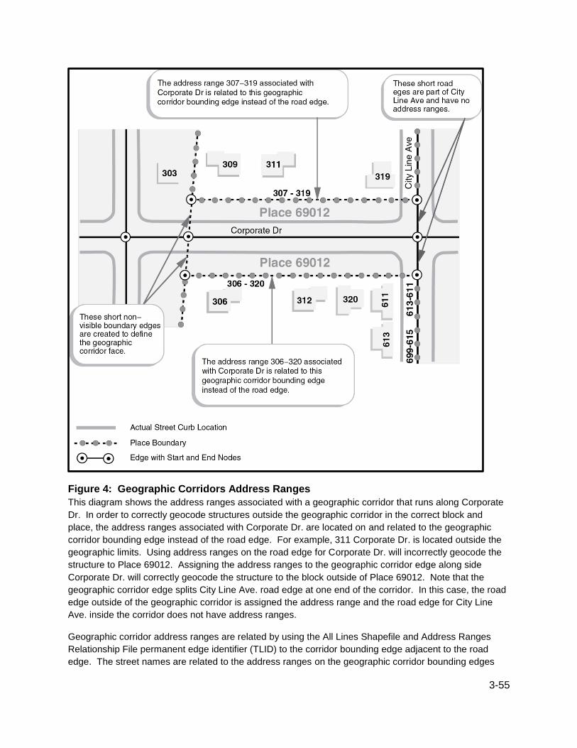
3-55
Figure 4: Geographic Corridors Address Ranges
This diagram shows the address ranges associated with a geographic corridor that runs along Corporate
Dr. In order to correctly geocode structures outside the geographic corridor in the correct block and
place, the address ranges associated with Corporate Dr. are located on and related to the geographic
corridor bounding edge instead of the road edge. For example, 311 Corporate Dr. is located outside the
geographic limits. Using address ranges on the road edge for Corporate Dr. will incorrectly geocode the
structure to Place 69012. Assigning the address ranges to the geographic corridor edge along side
Corporate Dr. will correctly geocode the structure to the block outside of Place 69012. Note that the
geographic corridor edge splits City Line Ave. road edge at one end of the corridor. In this case, the road
edge outside of the geographic corridor is assigned the address range and the road edge for City Line
Ave. inside the corridor does not have address ranges.
Geographic corridor address ranges are related by using the All Lines Shapefile and Address Ranges
Relationship File permanent edge identifier (TLID) to the corridor bounding edge adjacent to the road
edge. The street names are related to the address ranges on the geographic corridor bounding edges

3-56
through the Address Range-Feature Name Relationship File. By assigning the address range to the
geographic corridor edge rather than the road edge, structures will geocode correctly outside of the
geographic corridor.
Consolidated City (Balance) Portions refer to the areas of a consolidated city not included in another
separately incorporated place. For example, Butte-Silver Bow, MT, is a consolidated city (former Butte
city and Silver Bow County) that includes the separately incorporated municipality of Walkerville city. The
area of the consolidated city that is not in Walkerville city is assigned to Butte-Silver Bow (balance). The
name always includes the “(balance)” identifier. Balance portions of consolidated cities are included in
the place shapefiles.
3.15.1 Place State-based Shapefile Record Layout (Current)
File Name: tl_2016_<stateFIPS>_place.shp
Field Length Type Description
STATEFP 2 String Current state FIPS code
PLACEFP 5 String Current place FIPS code
PLACENS 8 String Current place GNIS code
GEOID 7 String Place identifier; a concatenation of the current state
FIPS code and place FIPS code
NAME 100 String Current place name
NAMELSAD 100 String Current name and the translated legal/statistical area
description for place
LSAD 2 String Current legal/statistical area description code for place
CLASSFP 2 String Current FIPS class code
PCICBSA 1 String Current metropolitan or micropolitan statistical area
principal city indicator
PCINECTA 1 String Current New England city and town area principal city
indicator
MTFCC 5 String G4110 (incorporated place) and G4210 (census
designated place)
FUNCSTAT 1 String Current functional status
ALAND 14 Number Current land area
AWATER 14 Number Current water area
INTPTLAT 11 String Current latitude of the internal point

3-57
Field Length Type Description
INTPTLON 12 String Current longitude of the internal point
3.16 Public Use Microdata Areas (PUMAs) Public use microdata area geography and attributes are available in the following shapefile:
Public Use Microdata Area (PUMA) State-based Shapefile (2010 Census)
Public use microdata areas (PUMAs) are decennial census areas that have been defined for the
tabulation and dissemination of Public Use Microdata Sample (PUMS) data, American Community Survey
(ACS) data, and ACS period estimates.
For the 2010 Census, the State Data Centers (SDCs) in each state, the District of Columbia, and the
Commonwealth of Puerto Rico were given the opportunity to delineate PUMAs within their state or
statistically equivalent entity. All PUMAs must nest within states and have a minimum population
threshold of 100,000 persons. 2010 PUMAs were built on census tracts and cover the entirety of the
United States, Puerto Rico, Guam, and the U.S. Virgin Islands. Because they do not meet the minimum
population requirement, the Commonwealth of the Northern Mariana Islands and American Samoa do not
contain any 2010 PUMAs.
For more detailed information about PUMAs, please visit the Public Use Microdata Areas (PUMAs)
website at:
http://www.census.gov/geo/reference/puma.html.
3.16.1 Public Use Microdata Area (PUMA) State-based Shapefile Record Layout (2010 Census)
File Name: tl_2016_<stateFIPS>_puma10.shp
Field Length Type Description
STATEFP10 2 String 2010 Census state FIPS code
PUMACE10 5 String 2010 Census Public Use Microdata Area code
GEOID10 7 String
2010 Census nation-based Public Use Microdata Area
code; a concatenation of 2010 Census state FIPS code
and Public Use Microdata Area code
NAMELSAD10 100 String 2010 Census translated legal/statistical area description
code and Public Use Microdata Area name
MTFCC10 5 String MAF/TIGER feature class code
FUNCSTAT10 1 String 2010 Census functional status
ALAND10 14 Number 2010 Census land area
AWATER10 14 Number 2010 Census water area

3-58
Field Length Type Description
INTPTLAT10 11 String 2010 Census latitude of the internal point
INTPTLON10 12 String 2010 Census longitude of the internal point
3.17 School Districts (Elementary, Secondary, and Unified) School district geography and attributes are available in the following shapefiles:
Elementary School District State-based Shapefile (Current)
Secondary School District State-based Shapefile (Current)
Unified School District State-based Shapefile (Current)
School Districts are single-purpose administrative units within which local officials provide public
educational services for the area's residents. The Census Bureau obtains school district boundaries,
names, local education agency codes, grade ranges, and school district levels biennially from state
education officials. The Census Bureau collects this information for the primary purpose of providing the
U.S. Department of Education with annual estimates of the number of children in poverty within each
school district, county, and state. This information serves as the basis for the Department of Education to
determine the annual allocation of Title I funding to states and school districts.
The 2016 TIGER/Line Shapefiles include separate shapefiles for elementary, secondary, and unified
school districts. The 2016 shapefiles contain information from the 2015-2016 school year, i.e. districts in
operation as of January 1, 2016.
The elementary school districts provide education to the lower grade/age levels and the secondary school
districts provide education to the upper grade/age levels. The unified school districts are districts that
provide education to children of all school ages. In general, where there is a unified school district, no
elementary or secondary school district exists (see exceptions described below) and where there is an
elementary school district, the secondary school district may or may not exist (see explanation below). In
addition to regular functioning school districts, the TIGER/Line Shapefiles contain pseudo-school districts
(see description below).
The Census Bureau’s representation of school districts is based on the grade ranges for which the school
district is financially responsible, which may or may not be the grade ranges that a school district
operates. (The grade range that reflects financial responsibility is important for the allocation of Title I
funds.) A typical example would be a school district that operates schools for children in grades
Kindergarten (KG)-8 and pays a neighboring school district to educate children in grades 9–12. The first
school district is operationally responsible for grades K-8, but financially responsible for grades KG-12.
Therefore, the Census Bureau would define the grade range for that school district as KG-12. If an
elementary school district is financially responsible for grades KG-12 or Pre-Kindergarten (PK)–12, there
will be no secondary school district represented for that area. In cases, where an elementary school
district is financially responsible for only lower grades, there is generally a secondary school district that is
financially responsible for providing educational services for the upper grades.
The following are exceptions to the above information:
The Census Bureau depicts the State of Hawaii as one unified school district and the five counties that
represent the five boroughs of New York City as one unified school district.

3-59
Pseudo-elementary school districts
In the school district shapefiles, Vermont contains a pseudo-elementary school district that represents a
regular unified school district in an area where the unified school district shares financial responsibility
service with the secondary school district. The Census Bureau created a pseudo-elementary school
district and linked it to the unified school district in order to allocate the elementary school aged children
to the unified school district. The Census Bureau could not assign an official unified school district code,
but had to create a pseudo-school district code to represent the service area where the unified school
district is financially responsible for less than the entire KG-12 grade range. In this area, there was no
regular functioning elementary school district serving the area and the secondary school district in this
area was not paying tuition to the unified school district (that is, the secondary school districts’ financial
responsibilities did not extend to kindergarten).
Pseudo-secondary school districts
In the school district shapefiles, California, Georgia, Illinois, Kentucky, Massachusetts, Minnesota,
Oklahoma, South Carolina, Tennessee, Texas, and Vermont contain pseudo-secondary school districts
that represent regular unified school districts in areas where the unified school districts share financial
responsibility service with elementary school districts. These pseudo-secondary school districts were
created and linked to real unified school districts in order for the Census Bureau to allocate the high
school aged children to the unified school districts. The Census Bureau could not assign the official
unified school district codes, but had to create pseudo-school district codes to represent a service area
where the unified school district is financially responsible for less than the entire KG-12 grade range. In
these areas, there were no regular functioning secondary school districts serving the area and the
elementary school districts in these areas were not paying tuition to the unified school districts (that is, the
elementary school districts’ financial responsibilities did not extend to grade 12).
Pseudo-unified school districts
In the school district shapefiles, New Jersey contains a pseudo-unified school district that represents a
regular unified school district, a regular secondary school district, and a regular elementary school district
in an area where the unified, secondary, and elementary school districts share financial responsibility
service. The Census Bureau created a pseudo-unified school district and linked it to the regular unified,
secondary, and elementary school districts in order to allocate the elementary and secondary school
aged children to the unified, secondary and elementary school districts. The Census Bureau could not
assign an official unified, secondary, or elementary school district code, but had to create a pseudo-
school district code to represent the service area where the unified, secondary, and elementary school
districts share financially responsibility for the entire KG-12 grade range.
A list of these pseudo-elementary, pseudo-secondary, and pseudo-unified school districts and their codes
appears in Appendix A.
School District Codes—the 2016 TIGER/Line Shapefiles contain 5-character school district codes. The
value 99997 is the school district code assigned to water or land where no official school district is defined

3-60
by a state. The school district codes are the local education agency codes used by the U.S. Department
of Education and are unique within a state.
School District Names— the names of school districts include their description and no other field
(NAMELSAD) is required.
3.17.1 Elementary School District State-based Shapefile Record Layout (Current)
File Name: tl_2016_<stateFIPS>_elsd.shp
Field Length Type Description
STATEFP 2 String Current state FIPS code
ELSDLEA 5 String Current elementary school district local education
agency code
GEOID 7 String
School district identifier; a concatenation of the current
state FIPS code and elementary school district local
education agency code
NAME 100 String Current elementary school district name
LSAD 2 String Current legal/statistical area description code for
elementary school district
LOGRADE 2 String Current lowest grade covered by school district
HIGRADE 2 String Current highest grade covered by school district
MTFCC 5 String MAF/TIGER feature class code (G5400)
SDTYP 1 String Current school district type
FUNCSTAT 1 String Current functional status
ALAND 14 Number Current land area
AWATER 14 Number Current water area
INTPTLAT 11 String Current latitude of the internal point
INTPTLON 12 String Current longitude of the internal point
3.17.2 Secondary School District State-based Shapefile Record Layout (Current)
File Name: tl_2016_<stateFIPS>_scsd.shp
Field Length Type Description
STATEFP 2 String Current state FIPS code
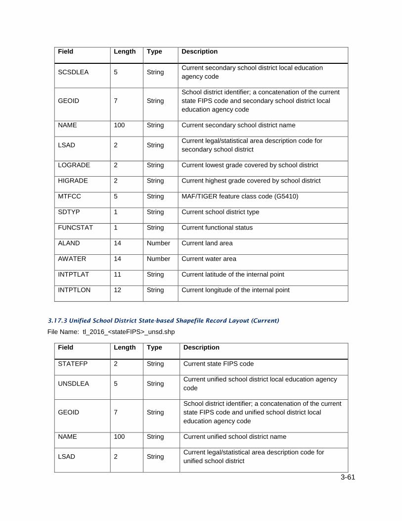
3-61
Field Length Type Description
SCSDLEA 5 String Current secondary school district local education
agency code
GEOID 7 String
School district identifier; a concatenation of the current
state FIPS code and secondary school district local
education agency code
NAME 100 String Current secondary school district name
LSAD 2 String Current legal/statistical area description code for
secondary school district
LOGRADE 2 String Current lowest grade covered by school district
HIGRADE 2 String Current highest grade covered by school district
MTFCC 5 String MAF/TIGER feature class code (G5410)
SDTYP 1 String Current school district type
FUNCSTAT 1 String Current functional status
ALAND 14 Number Current land area
AWATER 14 Number Current water area
INTPTLAT 11 String Current latitude of the internal point
INTPTLON 12 String Current longitude of the internal point
3.17.3 Unified School District State-based Shapefile Record Layout (Current)
File Name: tl_2016_<stateFIPS>_unsd.shp
Field Length Type Description
STATEFP 2 String Current state FIPS code
UNSDLEA 5 String Current unified school district local education agency
code
GEOID 7 String
School district identifier; a concatenation of the current
state FIPS code and unified school district local
education agency code
NAME 100 String Current unified school district name
LSAD 2 String Current legal/statistical area description code for
unified school district

3-62
Field Length Type Description
LOGRADE 2 String Current lowest grade covered by school district
HIGRADE 2 String Current highest grade covered by school district
MTFCC 5 String MAF/TIGER feature class code (G5420)
SDTYP 1 String Current school district type
FUNCSTAT 1 String Current functional status
ALAND 14 Number Current land area
AWATER 14 Number Current water area
INTPTLAT 11 String Current latitude of the internal point
INTPTLON 12 String Current longitude of the internal point
3.18 States and State Equivalent Entities State and equivalent entity geography and attributes are available in the following shapefile:
State and Equivalent Entity National Shapefile (Current)
States and equivalent entities are the primary governmental divisions of the United States. In addition to
the fifty states, the Census Bureau treats the District of Columbia, Puerto Rico, and the Island areas
(American Samoa, the Commonwealth of the Northern Mariana Islands, Guam, and the U.S. Virgin
Islands) as the statistical equivalents of states for the purpose of data presentation. Census regions and
divisions consist of groupings of states and equivalent entities. The codes for these areas are included in
the state shapefiles and the state records can be merged to form those areas.
3.18.1 State and Equivalent Entity National Shapefile Record Layout (Current)
File Name: tl_2016_us_state.shp
Field Length Type Description
REGION 2 String Current region code
DIVISION 2 String Current division code
STATEFP 2 String Current state FIPS code
STATENS 8 String Current state GNIS code
GEOID 2 String State identifier; state FIPS code
STUSPS 2 String Current United States Postal Service state abbreviation
NAME 100 String Current state name

3-63
Field Length Type Description
LSAD 2 String Current legal/statistical area description code for state
MTFCC 5 String MAF/TIGER feature class code (G4000)
FUNCSTAT 1 String Current functional status
ALAND 14 Number Current land area
AWATER 14 Number Current water area
INTPTLAT 11 String Current latitude of the internal point
INTPTLON 12 String Current longitude of the internal point
3.19 State Legislative Districts (Upper and Lower) State legislative district geography and attributes are available in the following shapefiles:
State Legislative District Lower Chamber (SLDL) State-based Shapefile (Current)
State Legislative District Upper Chamber (SLDU) State-based Shapefile (Current)
State legislative districts are the areas from which members are elected to state or equivalent entity
legislatures. The state legislative district embodies the upper (senate—SLDU) and lower (house—SLDL)
chambers of the state legislature. The Census Bureau first reported data for state legislative districts as
part of the 2000 Public Law (P.L.) 94-171 Redistricting Data File for the states that chose to submit them.
Starting with the collection of legislative districts for the 2010 Census in 2006, the boundaries are updated
every two years.
State Legislative Districts (2016 Election Year) - All 50 states, plus the District of Columbia and Puerto
Rico, participated in Phase 4 of the Census Redistricting Program, as part of P.L. 94-171. They
voluntarily provided the Census Bureau with the 2016 election cycle boundaries, codes, and in some
cases names for their state legislative districts. States provided updates for their boundaries used in the
November 2016 elections for the session that began in January 2016.
The following states or equivalents had changes to their state legislative districts for 2016:
Florida (upper house only) Minnesota
Maryland (lower house only)
Georgia (lower house only)
Nebraska has a unicameral legislature and the District of Columbia has a single council, both of which the
Census Bureau treats as upper-chamber legislative areas for the purpose of data presentation.
Therefore, there are no data by the lower house of the state legislative districts for either Nebraska or the
District of Columbia.
State Legislative District Codes - A unique 3-character census code, identified by state participants, is
assigned to each state legislative district upper (senate) and lower (house) within a state. In Connecticut,
Illinois, Louisiana, Maine, Maryland, Massachusetts, Michigan, Ohio, and Puerto Rico, the state
participant did not assign the current state legislative districts to cover all of the state or equivalent area.

3-64
The code “ZZZ” has been assigned to areas with no state legislative districts defined (usually large water
bodies). These unassigned areas are treated within state as a single state legislative district for purposes
of data presentation.
Other Notes on State Legislative Districts
The state of Ohio generated their state legislative plans using custom geography from the state’s
Ohio Common and Unified Redistricting Database produced by Cleveland State University.
These shapefiles approximate those plans using Census Bureau geography.
The states of Maryland and New York adjusted the 2010 Census P.L. [94-171] redistricting data
for their respective states by reallocating state prisoner populations to their last known residence.
Information on these adjustments is available by visiting each state’s website: MD
http://www.mdp.state.md.us/redistricting/; NY http://www.latfor.state.ny.us/.
The state of Hawaii adjusted the 2010 Census P.L. [94-171] redistricting data to remove non-
resident military personnel and non-resident students. Information on this adjustment is available
at http://hawaii.gov/elections/reapportionment.
The state of Kansas adjusted the 2010 Census P.L. [94-171] redistricting data to exclude non-
resident students and non-resident military personnel and to include resident students and
members of the military at the place of their permanent residence for state legislative redistricting.
Information on this adjustment is available at http://redistricting.ks.gov/index.html.
The state of New Hampshire uses floterial districts in their lower-chamber (SLDL) plan. Floterial
districts are overlay districts made up of two or more discrete districts. These discrete or
component districts are those represented in the New Hampshire SLDL shapefile. A listing of the
floterial districts and their component districts is available as a report (pdf) at
https://www.census.gov/rdo/pdf/NH_2012_Floterial_List.pdf
3.19.1 State Legislative District Lower Chambers (SLDL) State-based Shapefile Record Layout
(Current)
File Name: tl_2016_<stateFIPS>_sldl.shp
Field Length Type Description
STATEFP 2 String Current state FIPS code
SLDLST 3 String Current state legislative district lower chamber code
GEOID 5 String
State legislative district lower chamber identifier; a
concatenation of the current state FIPS code and state
legislative district lower chamber code
NAMELSAD 100 String Current name and the translated legal/statistical area
description for state legislative district lower chamber
LSAD 2 String Current legal/statistical area description code for state
legislative district lower chamber
LSY 4 String Legislative session year
MTFCC 5 String MAF/TIGER feature class code (G5220)

3-65
Field Length Type Description
FUNCSTAT 1 String Current functional status
ALAND 14 Number Current land area
AWATER 14 Number Current water area
INTPTLAT 11 String Current latitude of the internal point
INTPTLON 12 String Current longitude of the internal point
3.19.2 State Legislative District Upper Chambers (SLDU) State-based Shapefile Record Layout
(Current)
File Name: tl_2016_<stateFIPS>_sldu.shp
Field Length Type Description
STATEFP 2 String Current state FIPS code
SLDUST 3 String Current state legislative district upper chamber code
GEOID 5 String
State legislative district upper chamber identifier; a
concatenation of the current state FIPS code and state
legislative district upper chamber code
NAMELSAD 100 String Current name and the translated legal/statistical area
description for state legislative district upper chamber
LSAD 2 String Current legal/statistical area description code for state
legislative district upper chamber
LSY 4 String Legislative session year
MTFCC 5 String MAF/TIGER feature class code (G5210)
FUNCSTAT 1 String Current functional status
ALAND 14 Number Current land area
AWATER 14 Number Current water area
INTPTLAT 11 String Current latitude of the internal point
INTPTLON 12 String Current longitude of the internal point
3.20 Subbarrio (Subminor Civil Division) Subbarrio (Subminor civil division - sub-MCD) geography and attributes are available in Puerto Rico in
the following shapefile:

3-66
Subbarrio (SubMinor Civil Division) State-based Shapefile (Current)
Subbarrios, located in Puerto Rico, are legally defined subdivisions of minor civil divisions (MCDs) named
barrios-pueblo and barrios. Subbarrios do not exist within every MCD in Puerto Rico nor do they
necessarily cover the entire area of an MCD where they do exist. The Puerto Rico Planning Board
through the Boundary and Annexation Survey provided the boundaries of the subbarrios to the Census
Bureau. The subbarrio boundaries are as of January 1, 2016. For more information, please visit:
http://www.census.gov/geo/partnerships/bas.html.
The 2016 TIGER/Line Shapefiles contain the 5-character FIPS codes for subbarrios as well as 8-
character National Standard (GNIS) codes.
3.20.1 Subbarrio (Subminor Civil Division) State-based Shapefile Record Layout (Current)
File Name: tl_2016_72_subbarrio.shp
Field Length Type Description
STATEFP 2 String Current state FIPS code
COUNTYFP 3 String Current county FIPS code
COUSUBFP 5 String Current county subdivision FIPS code
SUBMCDFP 5 String Current subminor civil division FIPS code
SUBMCDNS 8 String Current subminor civil division GNIS code
GEOID 15 String
Subminor civil division identifier; a concatenation of
current state FIPS code, county FIPS code, county
subdivision FIPS code, and subminor civil division FIPS
code
NAME 100 String Current subbarrio name
NAMELSAD 100 String Current name and the translated legal/statistical area
description for subbarrio
LSAD 2 String Current legal/statistical area description code for
subbarrio
CLASSFP 2 String Current FIPS class code
MTFCC 5 String MAF/TIGER feature class code (G4060)
FUNCSTAT 1 String Current functional status
ALAND 14 Number Current land area
AWATER 14 Number Current water area
INTPTLAT 11 String Current latitude of the internal point

3-67
Field Length Type Description
INTPTLON 12 String Current longitude of the internal point
3.21 Topological Faces (Polygons with All Geocodes) Topological face information is available in the following shapefile:
Topological Faces (Polygons with All Geocodes) County-based Shapefile (Current)
The Topological Faces shapefile contains the attributes of each topological primitive face. The attributes
associated with each face in this shapefile contain both current census block and the 2010 census block
information. The Census Bureau created a set of census blocks for the 2010 Census, which are
identified by a 4-character number, with the first number representing the block group they are in.
Throughout the decade, changes to the census blocks occur due to boundary changes, such as changes
in incorporated places, legislative districts, and census tracts and the block may be split into more than
one piece. If a split occurs, the original census block number is kept and an alpha character suffix is
added (e.g. block 1001A and 1001B). In a few cases, especially with census tract and block group
changes, the first digit in the census block number may no longer represent the block group it falls in.
Due to potential updates to the codes, it is important not to mix 2010 Census geographic codes with
current geographic codes. A block can only be unique by using the decennial census state, county, tract,
and block group, or STATEFP10 + COUNTYFP10 + TRACTCE10 + BLKGRPCE10, to get the correct
block group corresponding to the BLOCKCE or BLOCKCE10. (Note that BLOCKCE10 and BLCOCKCE
are always identical.) Replacing any of these decennial codes with current codes can lead to false
duplicate and/or noncontiguous blocks, as well as state, county, tract, and/or block group changes.
3.21.1 Topological Faces (Polygons with All Geocodes) County-based Shapefile Record Layout
(Current)
File Name: tl_2016_<state-countyFIPS>_faces.shp
Field Length Type Description
TFID 10 Integer Permanent face ID
STATEFP10 2 String 2010 Census state FIPS code
COUNTYFP10 3 String 2010 Census county FIPS code
TRACTCE10 6 String 2010 Census census tract code
BLKGRPCE10 1 String 2010 Census block group number
BLOCKCE10 4 String 2010 Census tabulation block number
SUFFIX1CE 1 String Current Census block suffix 1
ZCTA5CE10 5 String 2010 Census 5-digit ZCTA code
UACE10 5 String 2010 Census urban area code

3-68
Field Length Type Description
PUMACE10 5 String 2010 Census public use microdata area code
STATEFP 2 String Current state FIPS code
COUNTYFP 3 String Current county FIPS code
TRACTCE 6 String Current census tract code
BLKGRPCE 1 String Current block group number
COUSUBFP 5 String Current county subdivision FIPS code
SUBMCDFP 5 String Current subminor civil division FIPS code
ESTATEFP 5 String Current estate FIPS code
CONCTYFP 5 String Current consolidated city FIPS code
PLACEFP 5 String Current place FIPS code
AIANNHFP 5 Number Current American Indian/Alaska Native/Native
Hawaiian area FIPS code
AIANNHCE 4 String Current American Indian/Alaska Native/Native
Hawaiian area census code
COMPTYP 1 String
Current American Indian/Alaska Native/Native
Hawaiian area reservation/statistical area or off-
reservation trust land Hawaiian home land indicator
TRSUBFP 5 Number Current American Indian tribal subdivision FIPS code
TRSUBCE 3 String Current American Indian tribal subdivision code
ANRCFP 5 String Current Alaska Native Regional Corporation FIPS
code
TTRACTCE 6 String Current tribal census tract code
TBLKGPCE 1 String Current tribal block group letter
ELSDLEA 5 String Current elementary school district local education
agency code
SCSDLEA 5 String Current secondary school district local education
agency code
UNSDLEA 5 String Current unified school district local education agency
code

3-69
Field Length Type Description
CD115FP 2 String 115th congressional district FIPS code
SLDUST 3 String Current state legislative district upper chamber code
SLDLST 3 String Current state legislative district lower chamber code
CSAFP 3 String Current combined statistical area code
CBSAFP 5 String Current metropolitan statistical area/micropolitan
statistical area code
METDIVFP 5 String Current Metropolitan division code
CNECTAFP 3 String Current combined New England city and town area
code (New England states only)
NECTAFP 5 String Current New England city and town area code (New
England states only)
NCTADVFP 5 String Current New England city and town area division code
(New England states only)
LWFLAG 1 String Land/water flag
OFFSET 1 String Geographic corridor/offset flag
ATOTAL 14 Number Total area
INTPTLAT 11 String Latitude of the internal point
INTPTLON 12 String Longitude of the internal point
3.22 Urban Areas Urban area geography and attributes are available in the following shapefile:
Urban Area National Shapefile (2010 Census)
For the 2010 Census, the Census Bureau classified all territory, population, and housing units located
within urbanized areas (UAs) and urban clusters (UCs) as urban. The Census Bureau delineates UA and
UC boundaries to represent densely developed territory, encompassing residential, commercial, and
other non-residential urban land uses. In general, this territory consists of areas of high population density
and urban land use resulting in a representation of the “urban footprint.” Territory, population, and
housing units located outside of UAs and UCs is considered rural.
For the 2010 Census the urban and rural classification was applied to the 50 states, the District of
Columbia and Puerto Rico. Per agreements with the Island Areas, minor modifications to the
classification were implemented when applied to American Samoa, Guam, the Commonwealth of the
Northern Mariana Islands, and the U.S. Virgin Islands.

3-70
Urbanized Areas (UAs)—an urbanized area consists of densely developed territory that contains 50,000
or more people. The Census Bureau delineates UAs to provide a better separation of urban and rural
territory, population, and housing in the vicinity of large places. The Census Bureau first introduced the
urbanized area concept for the 1950 Census.
Urban Clusters (UCs)—an urban cluster consists of densely developed territory that has at least 2,500
but fewer than 50,000 people. The Census Bureau first introduced the UC concept for Census 2000 to
provide a more consistent and accurate measure of urban population, housing, and territory throughout
the United States, Puerto Rico, and the Island Areas. Based on agreements with Guam, the
Commonwealth of the Northern Mariana Islands, and the U.S. Virgin Islands, all qualifying urban areas
are identified as urban clusters regardless of their final population counts. Thus, urban clusters may
exceed 50,000 people in these areas.
Urban Area Titles and Codes—The title of each UA and UC may contain up to three incorporated place or
census designated place (CDP) names, and will include the 2-letter U.S. Postal Service abbreviation for
each state or statistically equivalent entity into which the UA or UC extends. However, if the UA or UC
does not contain an incorporated place or CDP, the urban area title will include the single name of a
minor civil division or populated place recognized by the U.S. Geological Survey’s Geographic Names
Information System (GNIS).
Each UC and UA is assigned a 5-character code, based on a national alphabetical sequence of all urban
area names. A separate flag is included in data tabulation files to differentiate between UAs and UCs. In
printed reports, this differentiation is included in the name.
Relationship to Other Geographic Entities— Urban Areas are delineated at the block level. Urban Areas
may cross the boundaries of all other geographic areas for which the Census Bureau presents data,
which means that all areas, other than blocks, may include a both urban and rural areas. For more
information, visit:
http://www.census.gov/geo/reference/urban-rural.html.
3.22.1 Urban Area (UA) National Shapefile Record Layout (2010 Census)
File Name: tl_2016_us_uac10.shp
Field Length Type Description
UACE10 5 String 2010 Census urban area code
GEOID10 5 String 2010 Census urban area identifier; 2010 Census urban
area code
NAME10 100 String 2010 Census urban area name
NAMELSAD10 100 String 2010 Census name and the translated legal/statistical
area description for urban area
LSAD10 2 String 2010 Census legal/statistical area description code for
urban area
MTFCC10 5 String MAF/TIGER feature class code (G3500)

3-71
Field Length Type Description
UATYP10 1 String 2010 Census urban area type
FUNCSTAT10 1 String 2010 Census functional status
ALAND10 14 Number 2010 Census land area
AWATER10 14 Number 2010 Census water area
INTPTLAT10 11 String 2010 Census latitude of the internal point
INTPTLON10 12 String 2010 Census longitude of the internal point
3.23 ZIP Code Tabulation Areas (5-digit) ZIP Code tabulation area geography and attributes are available in the following shapefile:
5-Digit ZIP Code Tabulation Area (ZCTA5) National Shapefile (2010 Census)
ZIP Code tabulation areas (ZCTAs) are approximate area representations of U.S. Postal Service (USPS)
5-digit ZIP Code service areas that the Census Bureau creates using census blocks to present statistical
data from censuses and surveys. The Census Bureau defines ZCTAs by allocating each block that
contains addresses to a single ZIP Code tabulation area, usually to the ZCTA that reflects the most
frequently occurring ZIP Code for the addresses within that block. Blocks that do not contain addresses
but are completely surrounded by a single ZIP Code tabulation area (enclaves) are assigned to the
surrounding ZCTA; those surrounded by multiple ZCTAs will be added to a single ZCTA based on the
longest shared border. The Census Bureau identifies 5-digit ZIP Code tabulation areas using a 5-
character numeric code that represents the most frequently occurring USPS ZIP Code within that ZCTA
and this code may contain leading zeros.
Data users should not use ZCTAs to identify the official USPS ZIP Code for mail delivery. The USPS
makes periodic changes to ZIP Codes to support more efficient mail delivery. The ZCTA delineation
process used primarily residential addresses and was biased towards ZIP Codes used for city-style mail
delivery, thus there may be ZIP Codes that cover primarily nonresidential or post office box addresses
that may not have a corresponding ZCTA.
ZIP Code Tabulation Area Codes—The Census Bureau identifies 5-digit ZCTAs using a 5-digit code. For
more information, visit:
http://www.census.gov/geo/reference/zctas.html.
3.23.1 5-Digit ZIP Code Tabulation Area (ZCTA) National Shapefile Record Layout (2010 Census)
File Name: tl_2016_us_zcta510.shp
Field Length Type Description
ZCTA5CE10 5 String 2010 Census 5-digit ZIP Code Tabulation Area code

3-72
Field Length Type Description
GEOID10 5 String 2010 Census 5-digit ZIP Code Tabulation Area identifier,
2010 Census 5-digit ZIP Code Tabulation Area code
CLASSFP10 2 String 2010 Census FIPS 55 class code
MTFCC10 5 String MAF/TIGER feature class code (G6350)
FUNCSTAT10 1 String 2010 Census functional status
ALAND10 14 Number 2010 Census land area
AWATER10 14 Number 2010 Census water area
INTPTLAT10 11 String 2010 Census latitude of the internal point
INTPTLON10 12 String 2010 Census longitude of the internal point
4-73
4. Relationship File Concept Overview Relationships files are database files that provide additional attribute information that users can join to the
TIGER/Line Shapefiles. The following sections describe the geographic entity type displayed in each
relationship file, as well as the record layout for each file. Each entity type is listed in alphabetical order.
4.1 Address Ranges Address range information is available in the following relationship file:
Address Ranges County-based Relationship File
The term “address range” refers to the collection of all possible structure numbers from the first structure
number to the last structure number and all numbers of a specified parity in between. Address ranges fall
along an edge side relative to the direction in which the edge is coded. The 2016 TIGER/Line Shapefiles
contain potential address ranges, not individual addresses. Potential ranges include the full range of
possible structure numbers even though the actual structures might not exist (see Figure 5).
The address ranges relationship file contains the attributes of each address range. Each address range
applies to a single edge side and has a unique address range identifier (ARID) value. The edge to which
an address range applies can be determined by linking the address range to the All Lines shapefile using
the permanent edge identifier (TLID) attribute. Multiple address ranges can apply to the same edge
because addresses with different number sequences (e.g., 101, 103, 1622, 1624…) or non-numeric
characters (e.g., N101, N103, S099, S97) can appear along that edge. Note that the most inclusive
address range associated with each side of a street edge appears in the All Lines shapefile.
The most inclusive address range has the largest range of potential house number values of all address
ranges associated with the side of an edge. It is not a composite of the available address ranges. The
Census Bureau provides the most inclusive address ranges for data users looking for data comparable to
the address ranges supplied in the Record Type 1 (RT1) of the TIGER/Line data files.
ZIP Codes and Address Ranges
The address numbers used to create the address ranges are commonly known as house number-street
name style addresses (or city-style addresses). A house number-street name style address minimally
consists of a structure number, street name, and a 5-digit ZIP Code; for example, 213 Main Street 90210.
In the 2016 TIGER/Line Shapefiles, ZIP Codes are only associated to address ranges.
The ZIP Code is an attribute of the address ranges. The Address Ranges Relationship File has a 5-digit
ZIP Code field containing a numeric code that may have leading zeroes. Both sides of a street typically
have the same ZIP Code, but this is not always true. Different ZIP Codes may serve different sides of a
street or cover addresses at each end of a street. Nearly all address ranges will have a ZIP Code, but
there are a few instances where the ZIP Code is not known and the ZIP Code will have a null/blank value.
The 2016 TIGER/Line Shapefiles may not contain all street delivery ZIP Codes and may contain some
non-delivery ZIP Codes. In some cases, P.O. Box delivery ZIP Codes may be associated with house
number-street name style addresses that are not used for mail delivery (see below). The distribution of
ZIP Codes in the TIGER/Line Shapefiles may not reflect the exact USPS ZIP Code service area.
Likewise, the address range ZIP Codes may not match the ZIP Code Tabulation Area (ZCTA) for the
area.

4-74
Figure 5: TIGER/Line Shapefiles Address Range Basics
The TIGER/Line Shapefiles contain potential address ranges for city-style addresses. The edge
(between the start node and the end node) in the diagram above has two address ranges; the left side
has odd-numbered addresses and the right side has the complementary even-numbered addresses.
Potential address ranges along an edge have values that encompass the addresses of existing
structures, as well as those not yet built.
Note: The most inclusive address range has the largest range of potential house number values of all
address ranges associated with the side on an edge. It is not a composite of the available address
ranges.
Table 5: Address range product comparison table
Layer Name Filename Spatial
Data
Address Ranges Geocoding Usability
All Lines Shapefile edge.shp Yes Most inclusive address
ranges Limited geocoding
Address Range Feature
Shapefile addrfeat.shp Yes All address ranges
Best source for
geocoding
Address Range Table addr.dbf No All address ranges No geocoding
Address Range to Feature
Name Relationship Table addrfn.dbf No No address ranges No geocoding

4-75
Some basic characteristics of address ranges are as follows:
The 2016 TIGER/Line Shapefiles generally contain address ranges with only house number-
street name style addresses. They do not show rural route and post office box addresses. They
may contain structure numbers assigned in select areas for use by local emergency services, but
not for mail delivery. The 2016 TIGER/Line Shapefiles do include address ranges and ZIP Codes
in some small places where the USPS provides only post office box service. These address
ranges represent the structure numbers collected during the 2000 and 2010 census field
operations, supplemented with addresses provided through local participant programs and
intercensal Census Bureau activities and updates. These structure-number addresses may have
ZIP Codes associated only with post office box addresses. The USPS does not recognize these
street addresses as valid mailing addresses and does not assign a ZIP+4 Code to them or
include them in the ZIP+4 file. The address ranges may be used to geocode a structure to the
census block, but care should be used because of potential conflicts with similar or duplicate
mailing street addresses.
Gaps may exist between multiple ranges for a single edge. A gap may be significant because
any numbers missing from one edge may actually appear on another edge. This situation occurs
in cases where there are address anomalies such as out-of-parity or out-of-sequence addresses.
The Census Bureau does not provide any single address-address ranges in the 2016 TIGER/Line
Shapefiles, including out-of-parity and out-of-sequence address ranges that cover a single house
number. For example, address 709 Main Street is in the middle of the even-side of the 700 block
of Main Street and will be suppressed because it is a single address-address range. The
following address ranges for the 700 block of Main Street will appear in the 2016 TIGER/Line
Shapefiles: 700-798 Main Street, 701-707 Main Street, and 711- 799 Main Street. Based on the
information provided, data users cannot tell where 709 Main Street is located. Suppression of
single address-address ranges is to protect the confidentiality of individual addresses as specified
by Title 13 of the U.S. Code.
Address ranges can include numbers with alphabetic characters. These characters help uniquely
identify addresses within a county. For instance, certain unincorporated areas of Genesee
County, Michigan, add a letter G prefix to the address number. The characters are consistently
placed within the address range field; for example, the letter G maintains a consistent column
placement in the range G1 to G99.
Some address systems use a hyphen to separate avenue numbers, private road designators, and
grid cell numbers from the structure numbers; for example, 10-01 Reynolds St. uses a hyphen to
separate the avenue number (i.e. Tenth Avenue) from the structure number. Depending on the
locality, the hyphen may be unnecessary for address matching.
Address ranges exist only for street features, and in some cases, geographic corridor and
geographic offset boundary features adjacent to street features. When these boundaries exist,
the address ranges moved from the street centerline to the boundary to ensure that addresses
will geocode to the correct entity.
Address ranges (consisting of a unique combination of structure number, ZIP Code, feature
name, feature type, and directional) should not overlap; addresses should belong to only one
address range. The Census Bureau edits the address ranges to locate possible overlaps, but
cannot guarantee that all possible overlap situations have been identified and resolved.
Address ranges in the 2016 TIGER/Line Shapefiles may be associated with one or more of the
street names that belong to an edge. Caution: Address range overlap conflicts may occur if the
address ranges are associated with some street names or route numbers that were not intended
4-76
for use in locating addresses. A route number may traverse several streets with similar house
numbers but different common names that are used for mail delivery.
Imputed Address Ranges
Imputed address ranges occur during the process of updating the MAF/TIGER database when a new
edge intersects an existing edge with address ranges. The intersection splits the existing edge and
produces two new edges connected by a new node located at the intersection point. The update program
divides the old address ranges between the two new edges and imputes the address range ends at the
new node.
The impute process allocates either all or part of each original address range to each of the new edges in
proportion to their lengths (see Figures 6 and 7). For each side of the original edge, the process
considers all address ranges appearing on the side and determines the overall low and high addresses.
The process assumes the addresses are evenly distributed along the length of the edge and applies the
proportion of edge lengths to the overall address range to calculate a split-point address for each side.
Address ranges that fall entirely above or below the split-point address are moved intact to one of the new
edges. The process divides any address ranges that contain the split-point address and allocates each
part to one of the new edges. The new address range ends created from the split are imputed values and
have the from address range type (FROMTYP) or to address range type (TOTYP) set to imputed value.
Some intermediate address range ends also may carry the impute flag. These address range ends fall
between the overall high and low address for edge sides that have more than one address range. In
current practice, the imputation process will assign the entire address range to one of the edges if the
other is very small and would receive only a single address using the proportional division of address
ranges.
Geocoding
To get the best geocoding match results in ArcGIS, the Census Bureau advises data users to use the
Address Range Feature Shapefile (ADDRFEAT.shp) to geo-reference/geocode addresses. Address
ranges in the MAF/TIGER database may be separated into multiple address ranges on the same edge
because of ZIP Code differences or to establish gaps created by address anomalies located elsewhere.
Some address ranges may also include embedded alphanumeric characters or hyphens that make them
distinct from the other address ranges on the same edge side. The ADDRFEAT.shp contains all of the
address range to edge and street name relationships for a county to increase the number of potential
geocoding matches. In comparison, the most inclusive address range in the All Line shapefile
(EDGES.shp) can also be used for geocoding but a single pair of left- and right-side address ranges and
the primary street name on the edge may not always provide complete address range coverage.
Limitations
Users of the address ranges in the 2016 TIGER/Line Shapefiles should be aware that address range
overlaps, gaps, odd/even reversals, and low-high orientation reversals may exist in the data. With the
exception of overlaps, these may be valid. While the Census Bureau continues to edit for and correct for
data errors, it is possible that some still exist. The U.S. Census Bureau defines address ranges on a
county-by-county basis. It is possible that a street crosses a county boundary may have overlapping
address ranges. Checks are being implemented to identify and correct these issues. When using a
geocoder, often the address range is returned as being located in the first county, alphabetically.

4-77
Figure 6: TIGER/Line Shapefile Address Range Imputes - Before Split
The MAF/TIGER database uses impute flags to indicate that the one or both ends of an address range
are based on calculations rather than known values. Imputed address situations generally occur when an
edge with existing address ranges becomes split by a new edge. The illustration above shows the
address ranges on Chestnut Ave. before a split.
Figure 7: TIGER/Line Shapefile Address Range Imputes - After Split
In the diagram above, Mail Rd. has split the edge into two parts. Each part is assigned a new
TIGER/Line identification number (TLID) and the old number is deleted. The overall address range for
each edge side (1649 to 201 on the left side and 298 to 200 on the right side) and the split points for each
of these address ranges (approximately 1088 on the left side and 261 of the right side) are determined by
the MAF/TIGER database. Address ranges that fall entirely above or below the split point belong to one
of the two new edges and do not get an impute flag. The MAF/TIGER database divides those address
ranges that contain the split point and assigns a part to each of the edges.

4-78
4.1.1 Address Ranges County-based Relationship File Record Layout (Current)
File Name: tl_2016_<state-county FIPS>_addr.dbf
Field Length Type Description
TLID 10 Integer permanent edge ID
FROMHN 12 String From house number
TOHN 12 String To house number
SIDE 1 String side indicator flag
ZIP 5 String 5-digit ZIP code
PLUS4 4 String ZIP+4 code
FROMTYP 1 String From address range end type
TOTYP 1 String To address range end type
ARID 22 String Address range identifier
MTFCC 5 String MAF/TIGER feature class code
4.2 Address Range-Feature Name Relationships Address range-to-feature name relationship information is available in the following relationship file:
Address Range-Feature Name County-based Relationship File
The address range-feature name relationship file contains a record for each address range-linear feature
name relationship. The purpose of this relationship file is to identify all street names associated with each
address range. An edge can have several feature names and an address range located on an edge can
be associated with multiple feature names. The address range is identified by the address range
identifier (ARID) attribute, which can be used to link to the Address Ranges Relationship File. The linear
feature name is identified by the linear feature identifier (LINEARID) attribute that relates the address
range back to the Feature Names Relationship File.
4.2.1 Address Range-Feature Name County-based Relationship File Record Layout (Current)
File Name: tl_2016_<state-county FIPS>_addrfn.dbf
Field Length Type Description
ARID 22 String Address range identifier
LINEARID 22 String Linear feature identifier

4-79
4.3 Feature Names Feature name information is available in the following relationship file:
Feature Names County-based Relationship File
The Feature Names Relationship File contains a record for each feature name-edge combination and
includes the feature name attributes. The edge to which a Feature Names Relationship File record
applies can be determined by linking to the All Lines shapefile using the permanent edge identifier (TLID)
attribute. Multiple Feature Names relationship table records can link to the same edge. For example, a
road edge could link to U.S. Hwy 22 and Rathburn Road. The linear feature to which the feature name
applies is identified by the linear feature identifier (LINEARID) attribute. Multiple feature names may exist
for the same edge. Linear features are not included in the data set, but could be constructed using the All
Lines shapefile and the relationship tables.
Note that the MTFCC in this relationship file refers to the specific MAF/TIGER feature class code
associated with this linear feature and feature name. If the edge is both a road and a rail feature, the
name associated with the rail feature will carry a rail feature MTFCC. If there are any address ranges on
the edge, they apply only to the designated street features.
Appendices B, C, and D of this document include additional information about feature name components.
4.3.1 Feature Names County-based Relationship File Record Layout (Current)
File Name: tl_2016_<state-county FIPS>_featnames.dbf
Field Length Type Description
TLID 10 Integer permanent edge ID
FULLNAME 100 String
Concatenation of expanded text for prefix qualifier, prefix
direction, prefix type, base name, suffix type, suffix
direction, and suffix qualifier (as available) with a space
between each expanded text field
NAME 100 String Base name portion of the standardized name
PREDIRABRV 15 String Prefix direction description component of the feature
name
PRETYPABRV 50 String Prefix type description component of the feature name
PREQUALABR 15 String Prefix qualifier description component of the feature
name
SUFDIRABRV 15 String Suffix direction description component of the feature
name
SUFTYPABRV 50 String Suffix type description component of the feature name
SUFQUALABR 15 String Suffix qualifier description component of the feature
name

4-80
Field Length Type Description
PREDIR 2 String prefix direction code component of the feature name
PRETYP 3 String prefix type code description component of the feature
name
PREQUAL 2 String prefix qualifier code component of the feature name
SUFDIR 2 String suffix direction code component of the feature name
SUFTYP 3 String suffix type code description component of the feature
name
SUFQUAL 2 String suffix qualifier code component of the feature name
LINEARID 22 String Linear feature identifier
MTFCC 5 String MAF/TIGER feature class code
PAFLAG 1 String primary/alternate flag
4.4 Topological Faces-Area Landmark Relationships Topological faces-to-area landmark relationship information is available in the following relationship file:
Topological Faces-Area Landmark State-based Relationship File
The Topological Faces-Area Landmark Relationship file contains a record for each face-area landmark
relationship. The face to which a Topological Faces-Area Landmark Relationship File record applies can
be determined by linking to the Topological Faces (Polygons with All Geocodes) Shapefile using the
permanent face identifier (TFID) attribute. The area landmark to which a Topological Faces-Area
Landmark relationship table record applies can be determined by linking to the Area Landmark shapefile
using the area landmark identifier (AREAID) attribute. A face may be part of multiple area landmarks. An
area landmark may consist of multiple faces.
4.4.1 Topological Faces-Area Landmark County-based Relationship File Record Layout (Current)
File Name: tl_2016_<state FIPS>_facesal.dbf
Field Length Type Description
TFID 10 Integer permanent face ID
AREAID 22 String Area landmark identifier
4.5 Topological Faces-Area Hydrography Relationships Topological faces-to-area hydrography relationship information is available in the following relationship
file:

4-81
Topological Faces-Area Hydrography County-based Relationship File
The Topological Faces-Area Hydrography Relationship File contains a record for each face-area
hydrography feature relationship. The face to which a Topological Faces-Area Hydrography Relationship
File record applies can be determined by linking to the Topological Faces (Polygons with All Geocodes)
using the permanent face identifier (TFID) attribute. The area hydrography feature to which a Topological
Faces-Area Hydrography Relationship File record applies can be determined by linking to the Area
Hydrography shapefile using the area hydrography identifier (HYDROID) attribute. A face may be part of
multiple area water features. An area water feature may consist of multiple faces.
4.5.1 Topological Faces-Area Hydrography County-based Relationship File Record Layout (Current)
File Name: tl_2016_<state-county FIPS>_facesah.dbf
Field Length Type Description
TFID 10 Integer permanent face ID
HYDROID 22 String Area hydrography identifier
4.6 Topological Faces-Military Installation Relationships Topological faces-to-military installation relationship information is available in the following relationship
file:
Topological Faces-Military Installation National Relationship File
The Topological Faces-Military Installation Relationship File contains a record for each face-military
installation relationship. To find out more information about the face the military installation relates to, use
the permanent face identifier (TFID) in the Topological Faces (Polygons with All Geocodes) Shapefile. To
determine the military installation the record applies to use the area id (AREAID) attribute found in the
Military Installations Shapefile. A military installation feature may consist of multiple faces.
4.6.1 Topological Faces-Military Installation National Relationship File Record Layout (Current)
File name: tl_2016_us_facesmil.dbf
Field Length Type Description
TFID 10 Integer Permanent face ID
AREAID 22 String Area landmark identifier

5-82
5. Instructions for Downloading the TIGER/Line Shapefiles
5.1 Getting Started There are four methods for downloading TIGER/Line Shapefiles from the U.S. Census Bureau:
Website Interface
Direct from FTP Site
Connect via FTP Client
Direct from Data.gov
To download the shapefiles you need an Internet Browser or an FTP client, as well as a utility that can
unzip files. The files downloaded are zipped to save space and ensure you download all of the necessary
files. Most systems have an unzipping utility built-in to the operation system. However, there are several
free or low cost unzipping utilities such as WinZIP.
The examples below are from the 2013 version of the TIGER/Line Shapefiles but can be used for all
recent TIGER/Line Shapefile versions.
5.2 Website Interface The website interface download method requires the least amount of technical knowledge. Start at the
U.S. Census Bureau’s TIGER website:
http://www.census.gov/geo/maps-data/data/tiger-line.html
Select the tab for the version of TIGER/Line Shapefiles (e.g. 2013).
Click on Download.
Choose Web interface. (see Figure 8 below)
Figure 8: Click the appropriate tab and then click on download to access the web interface
Select the geographic entity from the drop down menu you would like to download (e.g. census
tracts) and click Submit. (see Figure 9 below)
Choose the state and click Download. (see Figure 9 below) For a county-based file, you also
need to choose the county on the following screen.

5-83
Save the file to your computer or open the zip file.
Repeat as necessary.
Figure 9: An example of the menus available in the web interface
5.3. Direct from FTP Site Another option is to go directly to the Census Bureau’s FTP site through a web browser. The address for
the TIGER/Line Shapefiles is:
ftp://ftp2.census.gov/geo/tiger/ or http://www2.census.gov/geo/tiger/
Navigate to the version of the TIGER/Line Shapefiles to download (e.g. TIGER2013).
Navigate to the geographic entity to download (e.g. TRACT). (see Figure 10 below) Refer to
Table 7 for the shapefile naming convention.
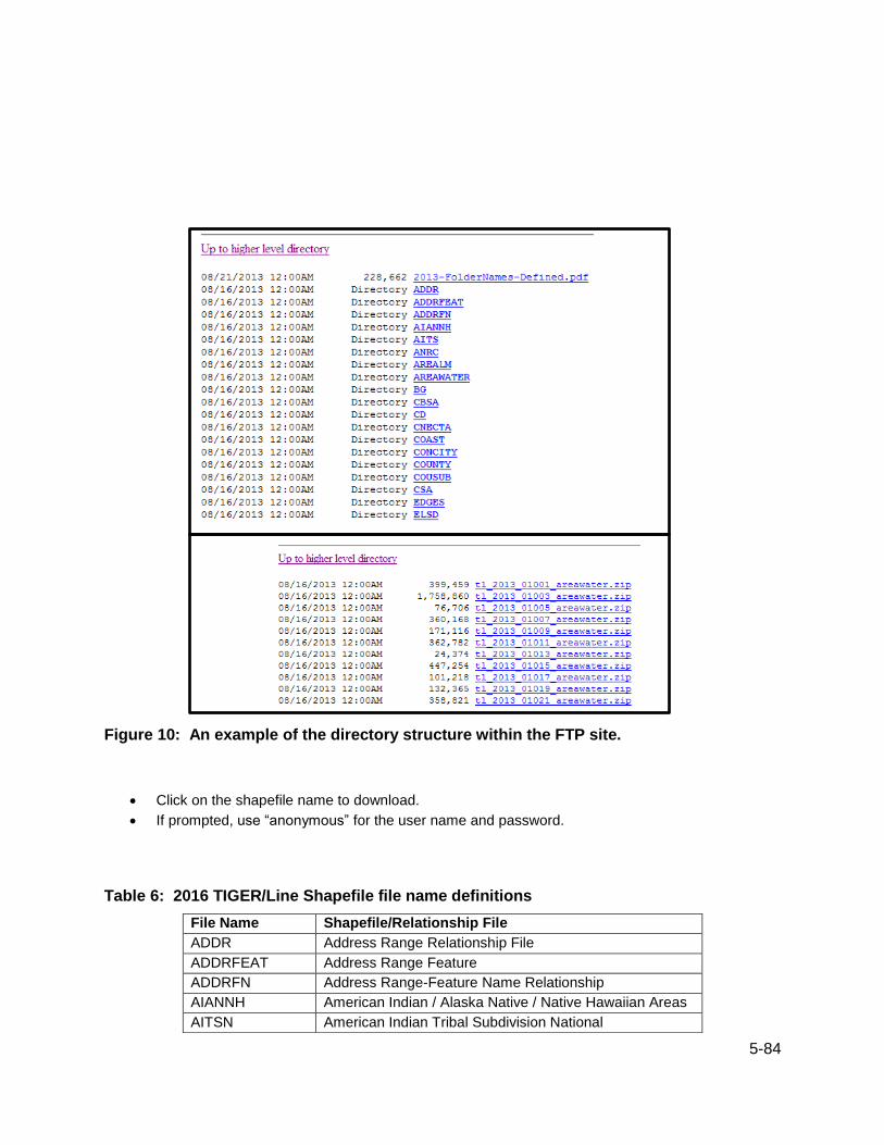
5-84
Figure 10: An example of the directory structure within the FTP site.
Click on the shapefile name to download.
If prompted, use “anonymous” for the user name and password.
Table 6: 2016 TIGER/Line Shapefile file name definitions
File Name Shapefile/Relationship File
ADDR Address Range Relationship File
ADDRFEAT Address Range Feature
ADDRFN Address Range-Feature Name Relationship
AIANNH American Indian / Alaska Native / Native Hawaiian Areas
AITSN American Indian Tribal Subdivision National

5-85
ANRC Alaska Native Regional Corporation
AREALM Area Landmark
AREAWATER Area Hydrography
BG Block Group
CBSA Metropolitan Statistical Area / Micropolitan Statistical Area
CD Congressional District
CNECTA Combined New England City and Town Area
COASTLINE Coastline
CONCITY Consolidated City
COUNTY County
COUSUB County Subdivision
CSA Combined Statistical Area
EDGES All Lines
ELSD Elementary School District
ESTATE Estate
FACES Topological Faces (Polygons with All Geocodes)
FACESAH Topological Faces-Area Hydrography Relationship File
FACESAL Topological Faces-Area Landmark Relationship File
FACESMIL Topological Faces-Military Installation Relationship File
FEATNAMES Feature Names Relationship File
LINEARWATER Linear Hydrography
METDIV Metropolitan Division
MIL Military Installation
NECTA New England City and Town Area
NECTADIV New England City and Town Area Division
PLACE Place
POINTLM Point Landmark
PRIMARYROADS Primary Roads
PRISECROADS Primary and Secondary Roads
PUMA Public Use Microdata Area
RAILS Rails
ROADS All Roads
SCSD Secondary School Districts
SLDL State Legislative District – Lower Chamber
SLDU State Legislative District – Upper Chamber
STATE State and Equivalent
SUBBARRIO SubMinor Civil Division (Subbarios in Puerto Rico)
TABBLOCK Tabulation (Census) Block
TBG Tribal Block Group
TRACT Census Tract
TTRACT Tribal Census Tract
UAC Urban Area/Urban Cluster
UNSD Unified School District
ZCTA5 5-Digit ZIP Code Tabulation Area

5-86
The files are named tl_2016_<geographic area>_<filename>.zip. For national files, the geographic area
is represented as “us.” For state and county-based files, the geographic area is represented with the
state or county Federal Information Processing Series (FIPS) codes. The state codes are 2-character
number and the county codes are 5-character numbers that include the 2-character state code and a 3-
character county code. Lists of state and county FIPS codes can be found here:
http://www.census.gov/geo/reference/ansi.html.
Web browsers also have the option to display FTP pages in a “windows explorer” type format. Entire
directories (folders) can be copied at a time using copy and paste or drag and drop.
5.4 Connect via FTP Client To access a large number of files the best option is use an FTP client software to connect to the Census
Bureau’s FTP site. There are many free FTP clients. The host name must be the Census Bureau’s main
FTP site:
ftp2.census.gov.
Use “anonymous” for the user name and password. Then, navigate to the GEO, then TIGER folders.
5.5 Data.gov The TIGER/Line Shapefiles are also available through the following website:
http://www.data.gov/
Search by keyword and/or agency to find the individual shapefiles.
As new TIGER/Line Shapefiles become available, they will be added to Data.gov. Refer to Table 7 for
the shapefile naming conventions.

6-87
6. Useful Links
6.1 User Notes User notes contain additional information about a geographic entity’s shapefile that is not available in this
technical documentation. In addition, if errors are found in the TIGER/Line Shapefiles, such as duplicate
records or missing attribute information, user notes are created to explain the errors and the corrections
made.
User notes can be found from the main TIGER/Line Shapefile webpage:
http://www.census.gov/geo/maps-data/data/tiger-line.html.
User notes are unique to each release of TIGER/Line Shapefiles and can be found by clicking on the
appropriate year’s tab.
6.2 Help Documents
6.2.1 How to Guides How to Guides provide a short overview on how to access and use the TIGER/Line Shapefiles, as well as
joining data from the U.S. Census Bureau to the TIGER/Line Shapefiles. The guides are available here:
http://www.census.gov/geo/education/howtos.html.
6.2.2 Definitions Additional information about each geographic entity, available as a TIGER/Line Shapefile, can be found in
several formats. For basic definitions, visit the Geographic Terms and Concepts page:
http://www.census.gov/geo/reference/terms.html.
This site provides definitions of geographic terms and concepts for geographic entities found in the
TIGER/Line Shapefiles and other U.S. Census Bureau data products.
For more in depth information, blog posts and brochures offer a more detailed look at some of the
geographic entities available in shapefile format. Blog posts can be found here:
http://www.census.gov/geo/education/blogs.html.
Brochures can be found here:
http://www.census.gov/geo/education/brochures.html.
For specific information about each state’s geographic entities, history, rankings, and more, you can read
the Guide to State and Local Census Geography pages here:
http://www.census.gov/geo/reference/geoguide.html.
The definitions for several of the codes found in the attributes of the TIGER/Line Shapefiles can be found
at the following links:
MAF/TIGER Feature Classifications Codes (MTFCC):
http://www.census.gov/geo/reference/mtfcc.html
Legal/Statistical Area Description (LSAD) Codes:
http://www.census.gov/geo/reference/lsad.html

6-88
Class (CLASSFP) Codes:
http://www.census.gov/geo/reference/class.html
Functional Status (FUNCSTAT) Codes:
http://www.census.gov/geo/reference/funcstat.html
Route Type (RTTYP) Codes:
http://www.census.gov/geo/reference/rttyp.html
6.3 Additional TIGER Products for use in a GIS
6.3.1 TIGER Geodatabases TIGER Geodatabases are spatial extracts from the U.S. Census Bureau’s MAF/TIGER database for use
with Esri’s ArcGIS. The geodatabases contain both national and state coverage for boundaries and
features. These files provide a way for data users to access larger amounts of geographic data with one
download, however, the files are large. Technical documentation for the TIGER Geodatabases is
available. These files are available here:
http://www.census.gov/geo/maps-data/data/tiger-geodatabases.html.
6.3.2 TIGER/Line Shapefiles and Geodatabases with Demographic Data A limited set of TIGER/Line Shapefiles and TIGER Geodatabases are available with demographic data,
including the 2010 Census and the American Community Survey. These files attempt to make GIS
analysis and thematic mapmaking easier because they provide the data user with the geography and
demographic data in one download. Each file also contains a metadata file to provide additional
information about the demographic data included. Access these files here:
http://www.census.gov/geo/maps-data/data/tiger-data.html.
6.3.3 Cartographic Boundary Files The cartographic boundary files are simplified representations of selected geographic areas from the
Census Bureau’s MAF/TIGER database. These boundary files are specifically designed for small-scale,
thematic mapping. In addition, these generalized files are clipped to the shoreline to show a simplified
version of the U.S. outline. Cartographic boundary files are available in shapefile format for the 2010
Census, Census 2000, and selected geographies for other years. In addition, they are available in
shapefile and KML format beginning in 2013 and updates will be released annually one year after their
corresponding TIGER/Line Shapefile release. KML stands for keyhole markup language and is a file
format used to display geographic data in a tool such as Google Earth and Google Maps. The
cartographic boundary files have less attribute information than the TIGER/Line Shapefiles and are not
available for all the same geographic entities as the TIGER/Line Shapefiles. They can be downloaded
from the following webpage:
http://www.census.gov/geo/maps-data/data/tiger-cart-boundary.html.

Appendix A. Pseudo-School Districts 2015 – 2016 School District Review Program Pseudo-School Districts (stored as Unified School Districts)
Column headers:
STATEFP16 2016 ACS state FIPS code
SDLEA16 2016 ACS unified school district local education agency code
NAME16 2016 ACS unfied school district name
STATEFP16 SDLEA16 NAME16
34 34001 Joint Base McGuire-Dix-Lakehurst
2015 – 2016 School District Review Program Pseudo-School Districts (stored as Elementary School
Districts)
Column headers:
STATEFP16 2016 ACS state FIPS code
SDLEA16 2016 ACS elementary school district local education agency code
NAME16 2016 ACS elementary school district name
STATEFP16 SDLEA16 NAME16
50 50004 Chittenden Central Supervisory Union in Essex Junction (PK-8)
2015 – 2016 School District Review Program Pseudo-School Districts (stored as Secondary School
Districts)
Column headers:
STATEFP16 2016 ACS state FIPS code
SDLEA16 2016 ACS secondary school district local education agency code
NAME16 2016 ACS secondary school district name
STATEFP16 SDLEA16 NAME16
06 06001 Yosemite Unified School District in Bass Lake
06 06002 Yosemite Unified School District in Raymond-Knowles
06 06003 Twin Rivers Unified School District in Elverta
06 06004 Twin Rivers Unified School District in Robla
06 06005 Scott Valley Unified School District in Forks of Salmon

06 06006 Trinity Alps Unified School District in Burnt Ranch
06 06007 Trinity Alps Unified School District in Coffee Creek
06 06009 Trinity Alps Unified School District in Douglas City
06 06010 Trinity Alps Unified School District in Junction City
06 06011 Trinity Alps Unified School District in Lewiston
06 06012 Trinity Alps Unified School District in Trinity Center
06 06013 Turlock Unified School District in Chatom Union
06 06014 Turlock Unified School District in Keyes Union
06 06015 Santa Cruz City High School District (9-12) in Soquel
06 06016 Dinuba Unified (9-12) in Kings River Union
06 06017 Dinuba Unified (9-12) in Monson-Sultana Joint Union
06 06018 Washington Unified School District (9-12)
06 06019 Santa Barbara Unified School District (7-12)
06 06020 Lammersville Joint Unified School District (9-12)
06 06021 Bishop Unified School District in Round Valley (9-12)
06 06022 Santa Paula Unified (9-12) in Briggs
06 06023 Santa Paula Unified (9-12) in Mupu
06 06024 Santa Paula Unified (9-12) in Santa Clara
06 06025 Hamilton Unified School District in Capay (9-12)
06 06026 Woodlake Unified School District (9-12) in Stone Corral
06 06027 Woodlake Unified School District (9-12) in Three Rivers Union
06 06028 Exeter Unified School District (9-12) in Sequoia Union
06 06029 Exeter Unified School District (9-12) in Outside Creek
06 06031 Tracy Unified School District (9-12) in Banta

06 06032 Tracy Unified School District (9-12) in Jefferson
06 06033 Tracy Unified School District (9-12) in New Jerusalem
06 06034 Perris Union High School District in Menifee (9-12)
06 06035 Perris Union High School District in Nuview (9-12)
06 06036 Perris Union High School District in Romoland (9-12)
06 06037 Alhambra Unified (9-12) School District
06 06038 Healdsburg Unified (7-12) in Alexander Valley Union
06 06039 Healdsburg Unified (9-12) in West Side Union
06 06053 Gonzales Unified (9-12) School District
06 06107 Porterville Unified (9-12) School District
13 13053 Chattahoochee County for Fort Benning
13 13215 Muscogee County for Fort Benning
17 17901 Flanagan-Cornell District 74 in Cornell
17 17902 Flanagan-Cornell District 74 in Pontiac
17 17903 Flanagan-Cornell District 74 in Rooks Creek
21 21001 Laurel County School District for East Bernstadt ISD
21 21002 Pulaski County School District for Science Hill ISD
21 21003 Elizabethtown Independent School District for West Point ISD
21 21004 Jefferson County School District in Anchorage ISD
21 21005 Campbell County School District in Southgate ISD
25 22222 Mohawk Trail Regional School District in Hawley and Charlemont
towns
25 25002 North Adams School District in Clarksburg (9-12)
25 25003 Gill-Montague School District in Erving (7-12)
25 25005 Swampscott School District in Nahant (7-12)
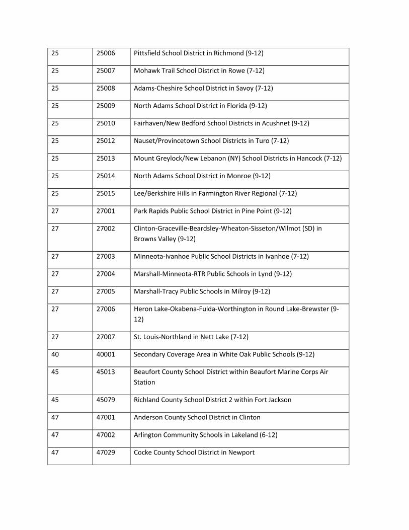
25 25006 Pittsfield School District in Richmond (9-12)
25 25007 Mohawk Trail School District in Rowe (7-12)
25 25008 Adams-Cheshire School District in Savoy (7-12)
25 25009 North Adams School District in Florida (9-12)
25 25010 Fairhaven/New Bedford School Districts in Acushnet (9-12)
25 25012 Nauset/Provincetown School Districts in Turo (7-12)
25 25013 Mount Greylock/New Lebanon (NY) School Districts in Hancock (7-12)
25 25014 North Adams School District in Monroe (9-12)
25 25015 Lee/Berkshire Hills in Farmington River Regional (7-12)
27 27001 Park Rapids Public School District in Pine Point (9-12)
27 27002 Clinton-Graceville-Beardsley-Wheaton-Sisseton/Wilmot (SD) in
Browns Valley (9-12)
27 27003 Minneota-Ivanhoe Public School Districts in Ivanhoe (7-12)
27 27004 Marshall-Minneota-RTR Public Schools in Lynd (9-12)
27 27005 Marshall-Tracy Public Schools in Milroy (9-12)
27 27006 Heron Lake-Okabena-Fulda-Worthington in Round Lake-Brewster (9-
12)
27 27007 St. Louis-Northland in Nett Lake (7-12)
40 40001 Secondary Coverage Area in White Oak Public Schools (9-12)
45 45013 Beaufort County School District within Beaufort Marine Corps Air
Station
45 45079 Richland County School District 2 within Fort Jackson
47 47001 Anderson County School District in Clinton
47 47002 Arlington Community Schools in Lakeland (6-12)
47 47029 Cocke County School District in Newport

47 47031 Coffee County School District in Manchester
47 47033 Crockett County School District in Alamo
47 47034 Crockett County School District in Bells
47 47073 Hawkins County School District in Rogersville
47 47077 Henderson County School District in Lexington
47 47079 Henry County School District in Paris
47 47107 McMinn County School District in Athens
47 47108 McMinn County School District in Etowah
47 47123 Monroe County School District in Sweetwater
47 47143 Rhea County School District in Dayton
47 47149 Rutherford County School District in Murfreesboro
47 47187 Williamson County School District in Franklin
47 47189 Wilson County School District in Lebanon
48 48021 Elgin/Giddings Independent School Districts (9-12) in McDade
48 48143 Stephenville Independent School District (9-12) in Bluff Dale
48 48285 Hallettsville Independent School District (9-12) in Vysehrad
48 48449 Mount Pleasant Independent School District (9-12) in Winfield
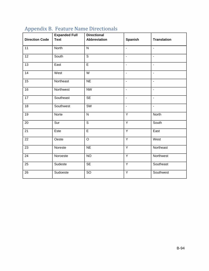
B-94
Appendix B. Feature Name Directionals
Direction Code
Expanded Full
Text
Directional
Abbreviation Spanish Translation
11 North N - -
12 South S - -
13 East E - -
14 West W - -
15 Northeast NE - -
16 Northwest NW - -
17 Southeast SE - -
18 Southwest SW - -
19 Norte N Y North
20 Sur S Y South
21 Este E Y East
22 Oeste O Y West
23 Noreste NE Y Northeast
24 Noroeste NO Y Northwest
25 Sudeste SE Y Southeast
26 Sudoeste SO Y Southwest

C-95
Appendix C. Feature Name Qualifiers
Qualifier Code
Expanded Full
Text
Display Name
Abbreviation Prefix Qualifier Suffix Qualifier
11 Access Acc N Y
12 Alternate Alt Y Y
13 Business Bus Y Y
14 Bypass Byp Y Y
15 Connector Con N Y
16 Extended Exd Y Y
17 Extension Exn N Y
18 Historic Hst Y N
19 Loop Lp Y Y
20 Old Old Y N
21 Private Pvt Y Y
22 Public Pub Y Y
23 Scenic Scn N Y
24 Spur Spr Y Y
25 Ramp Rmp N Y
26 Underpass Unp N Y
27 Overpass Ovp N Y

D-96
Appendix D. Feature Name Types
Type
Code Expanded Full Text Display Name abbreviation Spanish Translation Prefix Type
Suffix
Type
103 Academy Acdmy Y Y
104 Acueducto Acueducto Yes Aqueduct Y N
105 Aeropuerto Aero Yes Airport Y N
106 Air Force Base AFB N Y
107 Airfield Airfield N Y
108 Airpark Airpark N Y
109 Airport Arprt N Y
110 Airstrip Airstrip N Y
112 Alley Aly N Y
115 Apartment Building Apt Bldg N Y
116 Apartment Complex Apt Complex N Y
117 Apartments Apts N Y
118 Aqueduct Aqueduct N Y
119 Arcade Arc Y Y
121 Arroyo Arroyo Yes Stream Y N
122 Assisted Living Center Asstd Liv Ctr N Y
694 Assisted Living Facility Asstd Liv Fac N Y
123 Autopista Autopista Yes Expressway/Freeway Y N
124 Avenida Ave Yes Avenue Y N
125 Avenue Ave Y Y

D-97
Type
Code Expanded Full Text Display Name abbreviation Spanish Translation Prefix Type
Suffix
Type
126 Bahia Bahía Yes Bay Y N
127 Bank Bk Y Y
704 Base Base N Y
128 Basin Basin N Y
129 Bay Bay Y Y
130 Bayou Byu Y Y
131 Beach Bch N Y
132 Bed and Breakfast B and B N Y
136 Beltway Beltway N Y
137 Bend Bnd N Y
138 Bluff Blf N Y
139 Boarding House Brdng Hse N Y
140 Bog Bog N Y
141 Bosque Bosque Yes Forest Y N
142 Boulevard Blvd Y Y
143 Boundary Boundary N Y
146 Branch Br Y Y
147 Bridge Brg N Y
148 Brook Brk N Y
149 Building Bldg Y Y
150 Bulevar Bulevar Yes Boulevard Y N
151 Bureau of Indian Affairs Highway BIA Hwy Y N
152 Bureau of Indian Affairs Road BIA Rd Y N
153 Bureau of Indian Affairs Route BIA Rte Y N
154 Bureau of Land Management Road BLM Rd Y N
696 Bypass Byp Y Y
156 Calle Cll Yes Street Y N
157 Calleja Calleja Yes Narrow Street Y N
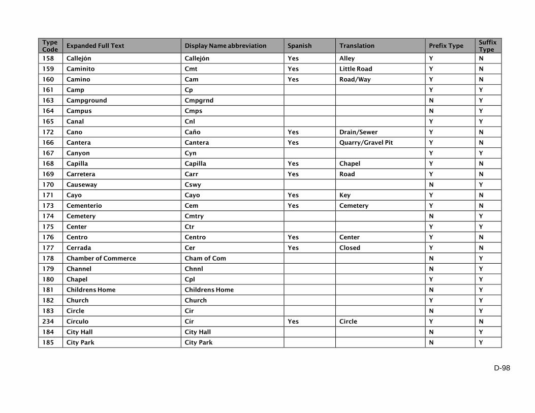
D-98
Type
Code Expanded Full Text Display Name abbreviation Spanish Translation Prefix Type
Suffix
Type
158 Callejón Callejón Yes Alley Y N
159 Caminito Cmt Yes Little Road Y N
160 Camino Cam Yes Road/Way Y N
161 Camp Cp Y Y
163 Campground Cmpgrnd N Y
164 Campus Cmps N Y
165 Canal Cnl Y Y
172 Cano Caño Yes Drain/Sewer Y N
166 Cantera Cantera Yes Quarry/Gravel Pit Y N
167 Canyon Cyn Y Y
168 Capilla Capilla Yes Chapel Y N
169 Carretera Carr Yes Road Y N
170 Causeway Cswy N Y
171 Cayo Cayo Yes Key Y N
173 Cementerio Cem Yes Cemetery Y N
174 Cemetery Cmtry N Y
175 Center Ctr Y Y
176 Centro Centro Yes Center Y N
177 Cerrada Cer Yes Closed Y N
178 Chamber of Commerce Cham of Com N Y
179 Channel Chnnl N Y
180 Chapel Cpl Y Y
181 Childrens Home Childrens Home N Y
182 Church Church Y Y
183 Circle Cir N Y
234 Círculo Cír Yes Circle Y N
184 City Hall City Hall N Y
185 City Park City Park N Y

D-99
Type
Code Expanded Full Text Display Name abbreviation Spanish Translation Prefix Type
Suffix
Type
186 Cliff Clf N Y
187 Club Clb Y Y
188 Colegio Colegio Yes School Y N
189 College Colg Y Y
190 Common Cmn N Y
191 Commons Cmns Y Y
192 Community Center Community Ctr N Y
193 Community College Community Colg Y Y
194 Community Park Community Park Y Y
195 Complex Complx N Y
197 Condominios Condios Yes Condominiums Y N
198 Condominium Condo Y Y
199 Condominiums Condos N Y
201 Convent Cnvnt Y Y
202 Convention Center Convention Ctr Y Y
203 Corners Cors N Y
204 Correctional Facility Corr Faclty N Y
205 Correctional Institute Corr Inst N Y
207 Corte Corte Yes Court Y N
679 Cottage Cottage N Y
208 Coulee Coulee N Y
209 Country Club Country Club Y Y
210 County Highway Co Hwy Y N
211 County Home Co Home Y Y
212 County Lane Co Ln Y N
213 County Park Co Park N Y
214 County Road Co Rd Y N
215 County Route Co Rte Y N
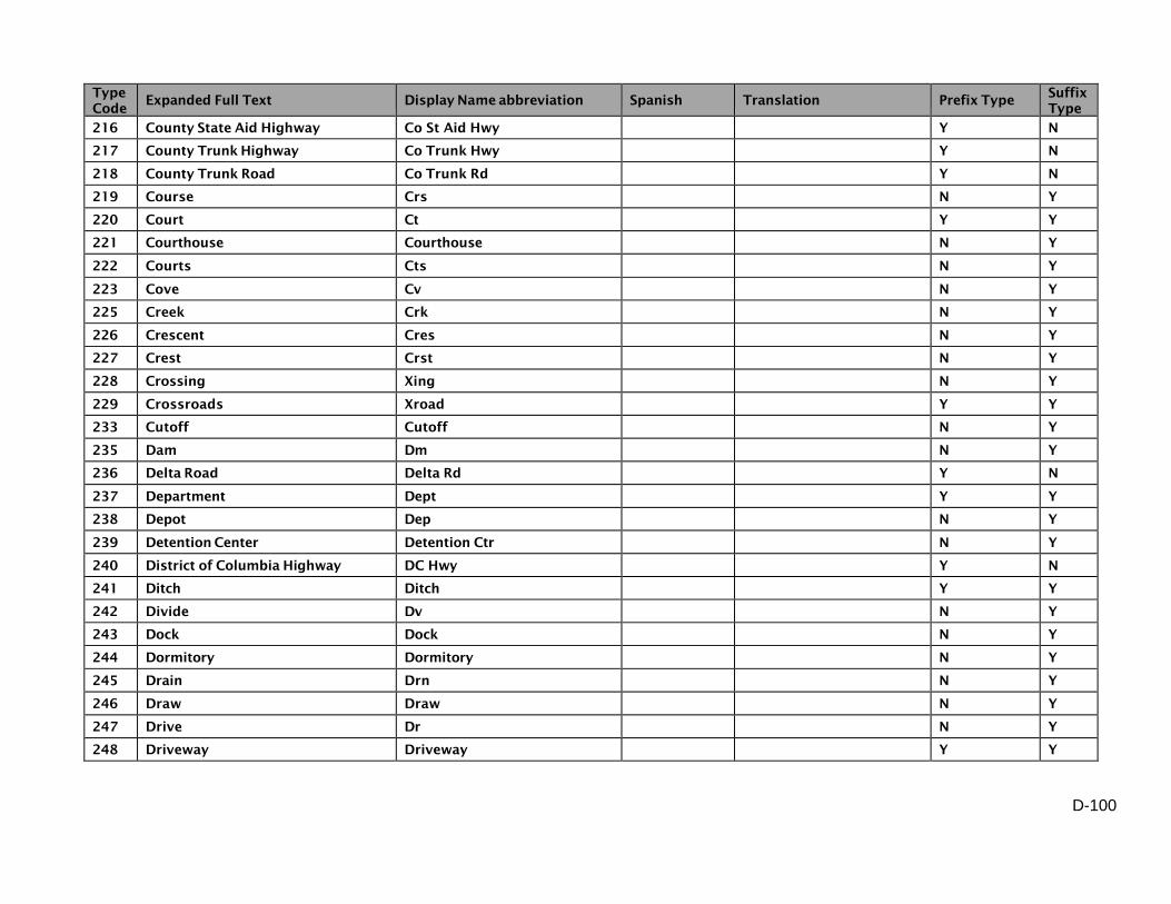
D-100
Type
Code Expanded Full Text Display Name abbreviation Spanish Translation Prefix Type
Suffix
Type
216 County State Aid Highway Co St Aid Hwy Y N
217 County Trunk Highway Co Trunk Hwy Y N
218 County Trunk Road Co Trunk Rd Y N
219 Course Crs N Y
220 Court Ct Y Y
221 Courthouse Courthouse N Y
222 Courts Cts N Y
223 Cove Cv N Y
225 Creek Crk N Y
226 Crescent Cres N Y
227 Crest Crst N Y
228 Crossing Xing N Y
229 Crossroads Xroad Y Y
233 Cutoff Cutoff N Y
235 Dam Dm N Y
236 Delta Road Delta Rd Y N
237 Department Dept Y Y
238 Depot Dep N Y
239 Detention Center Detention Ctr N Y
240 District of Columbia Highway DC Hwy Y N
241 Ditch Ditch Y Y
242 Divide Dv N Y
243 Dock Dock N Y
244 Dormitory Dormitory N Y
245 Drain Drn N Y
246 Draw Draw N Y
247 Drive Dr N Y
248 Driveway Driveway Y Y

D-101
Type
Code Expanded Full Text Display Name abbreviation Spanish Translation Prefix Type
Suffix
Type
249 Dump Dump N Y
251 Edificio Edif Yes Building Y N
252 Elementary School Elem School N Y
253 Ensenada Ensenada Yes Cove Y N
254 Entrada Ent Yes Entrance Y N
256 Escuela Escuela Yes School Y N
680 Esplanade Esplanade Yes Esplanade Y Y
257 Estates Ests N Y
260 Estuary Estuary N Y
261 Expreso Expreso Yes Expressway Y N
262 Expressway Expy Y Y
263 Extension Ext Y Y
264 Facility Faclty N Y
265 Fairgrounds Fairgrounds N Y
266 Falls Fls Y Y
267 Farm Frm N Y
268 Farm Road Farm Rd Y N
269 Farm-to-Market Road FM Y N
275 Fence Line Fence Line N Y
276 Ferry Crossing Ferry Crossing Y Y
277 Field Fld N Y
278 Fire Control Road Fire Cntrl Rd Y N
279 Fire Department Fire Dept N Y
280 Fire District Road Fire Dist Rd Y N
281 Fire Lane Fire Ln Y N
282 Fire Road Fire Rd Y N
283 Fire Route Fire Rte Y N
284 Fire Station Fire Sta Y Y

D-102
Type
Code Expanded Full Text Display Name abbreviation Spanish Translation Prefix Type
Suffix
Type
285 Fire Trail Fire Trl Y N
286 Flowage Flowage N Y
287 Flume Flume N Y
288 Forest Frst N Y
289 Forest Highway Forest Hwy Y Y
290 Forest Road Forest Rd Y N
291 Forest Route Forest Rte Y N
292 Forest Service Road FS Rd Y N
293 Fork Frk N Y
294 Fort Ft Y N
295 Four-Wheel Drive Trail 4WD Trl Y Y
296 Fraternity Frtrnty N Y
297 Freeway Fwy N Y
298 Garage Grge N Y
299 Gardens Gdns N Y
303 Glacier Glacier N Y
304 Glen Gln N Y
305 Golf Club Golf Club Y Y
306 Golf Course Golf Course Y Y
307 Grade Grade N Y
309 Green Grn N Y
310 Group Home Group Home N Y
311 Gulch Gulch N Y
312 Gulf Gulf Y Y
313 Gully Gully N Y
314 Halfway House Halfway House N Y
315 Hall Hall N Y
316 Harbor Hbr N Y

D-103
Type
Code Expanded Full Text Display Name abbreviation Spanish Translation Prefix Type
Suffix
Type
317 Heights Hts N Y
321 High School High School N Y
322 Highway Hwy Y Y
323 Hill Hl N Y
324 Hollow Holw N Y
325 Home Home Y Y
326 Hospital Hosp Y Y
327 Hostel Hostel N Y
328 Hotel Hotel Y Y
329 House Hse Y Y
330 Housing Hsng Y Y
332 Iglesia Iglesia Yes Church Y N
333 Indian Route Indian Rte Y N
334 Indian Service Route Indian Svc Rte Y N
336 Industrial Park Indl Park N Y
337 Inlet Inlt N Y
338 Inn Inn Y Y
339 Institute Inst Y Y
340 Institution Instn N Y
341 Instituto Instituto Yes Institute Y N
342 Intermediate School Inter School N Y
344 Interstate Highway I- Y N
345 Isla Isla Yes Island Y N
346 Island Is N Y
347 Islands Iss Y Y
348 Isle Isle Y Y
349 Jail Jail N Y
351 Jeep Trail Jeep Trl Y Y

D-104
Type
Code Expanded Full Text Display Name abbreviation Spanish Translation Prefix Type
Suffix
Type
352 Junction Junction N Y
353 Junior High School Jr HS N Y
356 Kill Kill Y Y
357 Lago Lago Yes Lake Y N
358 Lagoon Lagoon N Y
360 Laguna Laguna Yes Lagoon Y N
361 Lake Lk Y Y
362 Lakes Lks N Y
363 Landfill Lndfll N Y
364 Landing Lndg N Y
365 Landing Area Landing Area Y Y
366 Landing Field Landing Fld Y Y
367 Landing Strip Landing Strp Y Y
368 Lane Ln Y Y
369 Lateral Lateral Y Y
370 Levee Levee Y Y
371 Library Lbry Y Y
372 Lift Lift Y Y
373 Lighthouse Lighthouse N Y
374 Line Line Y Y
376 Lodge Ldg N Y
377 Logging Road Logging Rd Y Y
378 Loop Loop Y Y
379 Mall Mall Y Y
380 Manor Mnr N Y
381 Mar Mar Yes Sea Y N
382 Marginal Marginal Yes Service Road Y N
383 Marina Mrna N Y
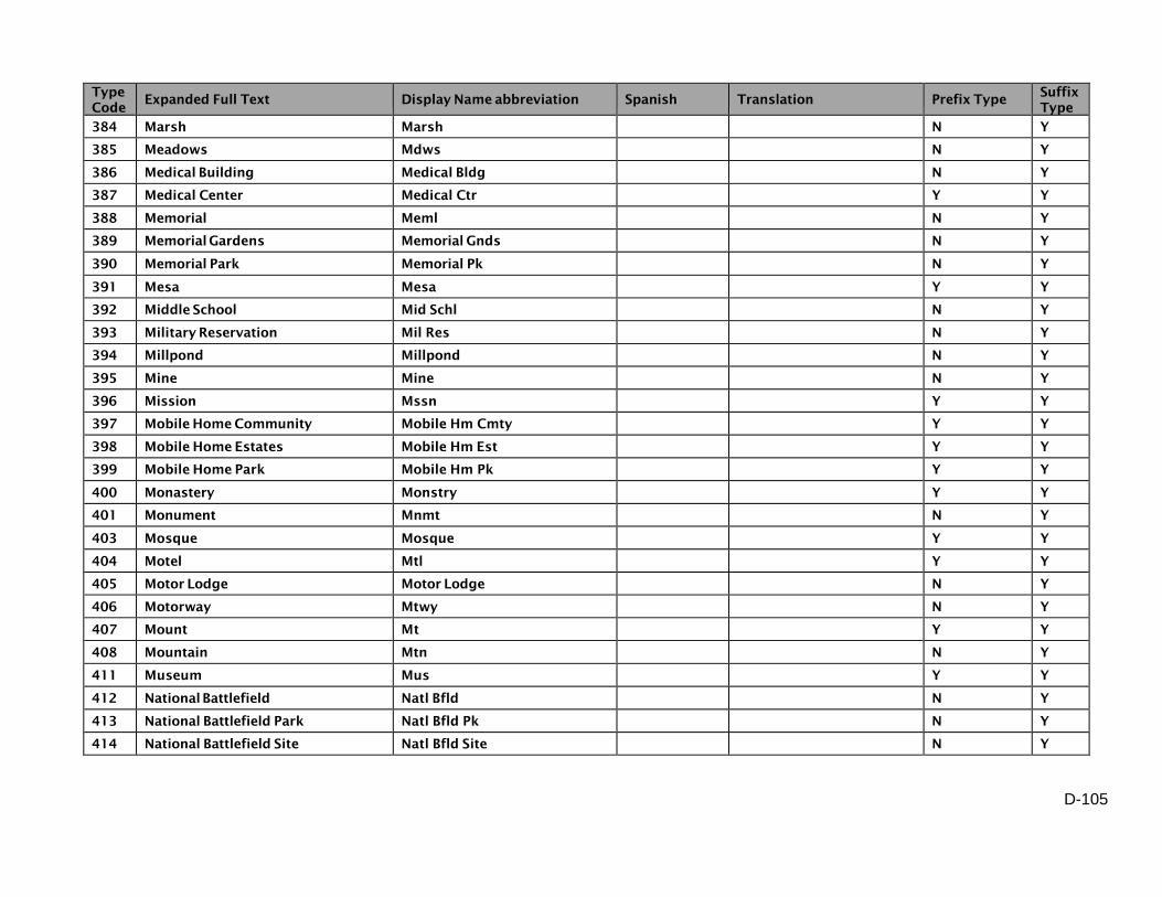
D-105
Type
Code Expanded Full Text Display Name abbreviation Spanish Translation Prefix Type
Suffix
Type
384 Marsh Marsh N Y
385 Meadows Mdws N Y
386 Medical Building Medical Bldg N Y
387 Medical Center Medical Ctr Y Y
388 Memorial Meml N Y
389 Memorial Gardens Memorial Gnds N Y
390 Memorial Park Memorial Pk N Y
391 Mesa Mesa Y Y
392 Middle School Mid Schl N Y
393 Military Reservation Mil Res N Y
394 Millpond Millpond N Y
395 Mine Mine N Y
396 Mission Mssn Y Y
397 Mobile Home Community Mobile Hm Cmty Y Y
398 Mobile Home Estates Mobile Hm Est Y Y
399 Mobile Home Park Mobile Hm Pk Y Y
400 Monastery Monstry Y Y
401 Monument Mnmt N Y
403 Mosque Mosque Y Y
404 Motel Mtl Y Y
405 Motor Lodge Motor Lodge N Y
406 Motorway Mtwy N Y
407 Mount Mt Y Y
408 Mountain Mtn N Y
411 Museum Mus Y Y
412 National Battlefield Natl Bfld N Y
413 National Battlefield Park Natl Bfld Pk N Y
414 National Battlefield Site Natl Bfld Site N Y

D-106
Type
Code Expanded Full Text Display Name abbreviation Spanish Translation Prefix Type
Suffix
Type
415 National Conservation Area Natl Cnsv Area N Y
416 National Forest Natl Forest N Y
417 National Forest Development Road Nat For Dev Rd Y N
419 National Grasslands Natl Grsslnds N Y
420 National Historic Site Natl Hist Site N Y
421 National Historical Park Natl Hist Pk N Y
422 National Lakeshore Natl Lkshr N Y
423 National Memorial Natl Meml N Y
424 National Military Park Natl Mil Pk N Y
425 National Monument Natl Mnmt N Y
426 National Park Natl Pk N Y
427 National Preserve Natl Prsv N Y
428 National Recreation Area Natl Rec Area N Y
429 National Recreational River Natl Rec Riv N Y
430 National Reserve Natl Resv N Y
431 National River Natl Riv N Y
432 National Scenic Area Natl Sc Area N Y
433 National Scenic River Natl Sc Riv N Y
435 National Scenic Riverways Natl Sc Rvrwys N Y
436 National Scenic Trail Natl Sc Trl N Y
437 National Seashore Natl Shr N Y
438 National Wildlife Refuge Natl Wld Rfg N Y
439 Navajo Service Route Navajo Svc Rte Y N
440 Naval Air Station Naval Air Sta N Y
442 Nursing Home Nurse Home N Y
444 Ocean Ocean N Y
445 Oceano Océano Yes Ocean Y N
446 Office Ofc Y Y

D-107
Type
Code Expanded Full Text Display Name abbreviation Spanish Translation Prefix Type
Suffix
Type
447 Office Building Office Bldg N Y
449 Office Park Office Park N Y
698 Orchard Orchard N Y
451 Orchards Orchrds N Y
452 Orphanage Orphanage N Y
453 Outlet Outlet N Y
454 Oval Oval N Y
455 Overpass Opas N Y
456 Parish Road Parish Rd Y N
457 Park Park N Y
458 Park and Ride Park and Ride N Y
460 Parkway Pkwy N Y
706 Parq Parq Yes Park Y N
461 Parque Parque Yes Park Y N
462 Pasaje Pasaje Yes Passage Y N
463 Paseo Pso Yes Path Y N
464 Pass Pass Y Y
465 Passage Psge Y Y
466 Path Path N Y
682 Pavilion Pavilion N Y
467 Peak Peak N Y
705 Penitentiary Penitentiary N Y
468 Pier Pier Y Y
469 Pike Pike N Y
470 Pipeline Pipeline N Y
472 Place Pl N Y
473 Placita Pla Yes Little Plaza Y N
474 Plant Plnt N Y

D-108
Type
Code Expanded Full Text Display Name abbreviation Spanish Translation Prefix Type
Suffix
Type
683 Plantation Plantation N Y
475 Playa Playa Yes Beach Y N
476 Playground Playground N Y
477 Plaza Plz Y Y
478 Point Pt Y Y
479 Pointe Pointe N Y
480 Police Department Police Dept Y Y
481 Police Station Police Station Y Y
482 Pond Pond Y Y
483 Ponds Ponds N Y
485 Port Prt Y Y
486 Post Office Post Office N Y
487 Power Line Power Line N Y
691 Power Plant Power Plant N Y
488 Prairie Pr N Y
489 Preserve Preserve N Y
491 Prison Prison N Y
690 Prison Farm Prison Farm N Y
685 Promenade Promenade N Y
492 Prong Prong N Y
494 Puente Puente Yes Bridge Y N
495 Quadrangle Quadrangle N Y
496 Quarry Quar N Y
686 Quarters Quarters N Y
497 Quebrada Qbda Yes Creek Y N
499 Race Race N Y
501 Rail Rail N Y
502 Rail Link Rail Link Y Y

D-109
Type
Code Expanded Full Text Display Name abbreviation Spanish Translation Prefix Type
Suffix
Type
504 Railnet Railnet N Y
505 Railroad RR N Y
506 Railway Rlwy N Y
507 Ramal Ramal Yes Short Street Y N
508 Ramp Ramp N Y
510 Ranch Road Ranch Rd Y N
511 Ranch to Market Road RM Y N
512 Rancho Rch Yes Ranch/Farm Y N
513 Ravine Ravine N Y
514 Recreation Area Rec Area N Y
515 Reformatory Reformatory N Y
516 Refuge Refuge N Y
518 Regional Park Regional Pk N Y
519 Reservation Reservation N Y
520 Reservation Highway Resvn Hwy Y N
521 Reserve Resv N Y
522 Reservoir Reservoir Y Y
524 Residence Hall Res Hall N Y
525 Residencial Residencial Yes Public Housing Project Y N
526 Resort Resrt N Y
688 Rest Home Rest Home N Y
527 Retirement Home Retirement Hme N Y
528 Retirement Village Retirement Vlg N Y
529 Ridge Rdg N Y
543 Rio Río Yes River Y N
530 River Riv N Y
531 Road Rd Y Y
533 Roadway Roadway N Y

D-110
Type
Code Expanded Full Text Display Name abbreviation Spanish Translation Prefix Type
Suffix
Type
535 Rock Rock Y Y
536 Rooming House Rooming Hse N Y
537 Route Rte Y Y
538 Row Row Y Y
539 Rue Rue Y Y
540 Run Run N Y
541 Runway Runway Y Y
542 Ruta Ruta Yes Route Y N
498 RV Park RV Park N Y
545 Sanitarium Sanitarium N Y
546 School Schl Y Y
549 Sea Sea Y Y
550 Seashore Seashore N Y
552 Sector Sec Yes Sector Y N
553 Seminary Smry Y Y
554 Sendero Sendero Yes Foot Path Y N
555 Service Road Svc Rd Y Y
556 Shelter Shelter N Y
558 Shop Shop N Y
699 Shopping Center Shopping Ctr N Y
560 Shopping Mall Shopping Mall N Y
700 Shopping Plaza Shopping Plz N Y
703 Site Site N Y
564 Skyway Skwy Y Y
565 Slough Slough N Y
566 Sonda Sonda Yes Sound Y N
567 Sorority Sorority Y Y
568 Sound Snd Y N

D-111
Type
Code Expanded Full Text Display Name abbreviation Spanish Translation Prefix Type
Suffix
Type
569 Spa Spa Y Y
570 Speedway Speedway Y Y
571 Spring Spg N Y
572 Spur Spur Y Y
573 Square Sq Y Y
575 State Beach State Beach N Y
577 State Forest State Forest N Y
578 State Forest Service Road St FS Rd Y N
579 State Highway State Hwy Y N
580 State Hospital State Hospital Y Y
581 State Loop State Loop Y N
582 State Park State Park N Y
584 State Prison State Prison N Y
585 State Road State Rd Y N
586 State Route State Rte Y N
588 State Spur State Spur Y N
589 State Trunk Highway St Trunk Hwy Y N
591 Station Sta N Y
592 Strait Strait Y Y
593 Stravenue Stra N Y
594 Stream Strm N Y
595 Street St N Y
596 Strip Strip Y Y
599 Swamp Swamp N Y
600 Synagogue Synagogue Y Y
601 Tank Tank N Y
603 Temple Tmpl Y Y
604 Terminal Trmnl N Y

D-112
Type
Code Expanded Full Text Display Name abbreviation Spanish Translation Prefix Type
Suffix
Type
605 Terrace Ter Y Y
687 Thoroughfare Thoroughfare N Y
607 Toll Booth Toll Booth Y Y
701 Toll Road Toll Rd N Y
610 Tollway Tollway N Y
611 Tower Twr Y Y
612 Town Center Town Ctr Y Y
613 Town Hall Town Hall N Y
614 Town Highway Town Hwy Y N
615 Town Road Town Rd Y N
616 Towne Center Towne Ctr Y Y
617 Township Highway Twp Hwy Y N
618 Township Road Twp Rd Y N
619 Trace Trce N Y
620 Track Trak Y Y
621 Trafficway Trfy N Y
622 Trail Trl Y Y
623 Trailer Court Trailer Ct N Y
624 Trailer Park Trailer Pk N Y
628 Transmission Line Trans Ln N Y
702 Treatment Plant Trmt Plant Y Y
630 Tribal Road Tribal Rd Y N
632 Trolley Trolley Y Y
633 Truck Trail Truck Trl Y Y
636 Túnel Túnel Yes Tunnel Y N
634 Tunnel Tunl Y Y
635 Turnpike Tpke N Y
637 Underpass Upas Y Y

D-113
Type
Code Expanded Full Text Display Name abbreviation Spanish Translation Prefix Type
Suffix
Type
642 Universidad Universidad Yes University/College Y N
643 University Univ Y Y
638 US Forest Service Highway USFS Hwy Y N
639 US Forest Service Road USFS Rd Y N
640 US Highway US Hwy Y N
641 US Route US Rte Y N
644 Valley Vly N Y
645 Vereda Ver Yes Path Y N
655 Via Via Yes Way Y N
646 Viaduct Viaduct N Y
647 View Vw N Y
648 Villa Villa Y Y
649 Village Vlg Y Y
650 Village Center Village Ctr Y Y
697 Vineyard Vineyard N Y
652 Vineyards Vineyards N Y
654 Vista Vis Yes View Y Y
656 Walk Walk N Y
657 Walkway Walkway N Y
659 Wash Wash N Y
660 Waterway Waterway N Y
661 Way Way N Y
663 Wharf Wharf N Y
665 Wild and Scenic River Wld n Snc Riv N Y
664 Wild River Wild River N Y
666 Wilderness Wilderness N Y
667 Wilderness Park Wilderenss Pk N Y
668 Wildlife Management Area Wldlf Mgt Area N Y

D-114
Type
Code Expanded Full Text Display Name abbreviation Spanish Translation Prefix Type
Suffix
Type
669 Winery Winery Y Y
672 Yard Yard N Y
673 Yards Yards Y Y
670 YMCA YMCA Y Y
671 YWCA YWCA Y Y
675 Zanja Zanja Yes Ditch Y N
676 Zoo Zoo Y Y