Embed Size (px)
Citation preview
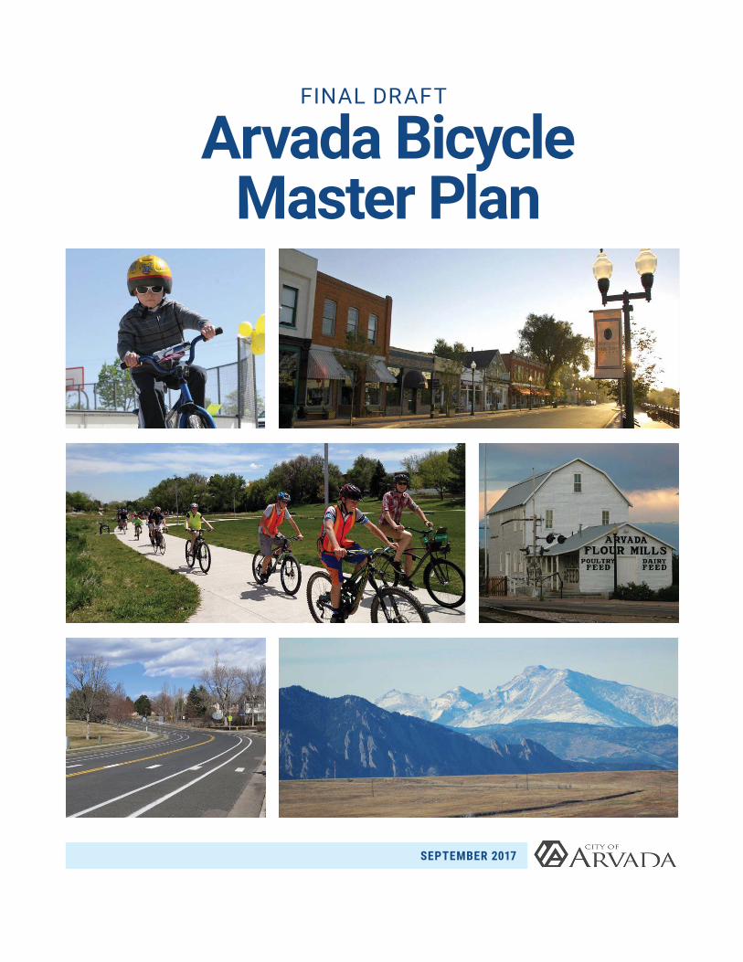
FINAL DRAFT
Arvada Bicycle Master Plan
SEPTEMBER 2017
ARVADA BICYCLE MASTER PLAN
i
THIS PAGE INTENTIONALLY LEFT BLANK
ARVADA BICYCLE MASTER PLAN
Acknowledgments
Mayor Marc Williams
Arvada City Council Nancy Ford, District 1
Mark McGoff, District 2
John Marriott, District 3
David Jones, District 4
Don Allard, At-Large
Bob Fifer, Mayor Pro Tem and At-Large
Internal Advisory TeamWesley Dismore – Engineering/Project Manager
Loretta Daniel – Community Development
Jake Nitchals – Community Development
Sarah Washburn – Parks and Urban Design
Michael McDonnell – Parks Maintenance
Christopher Yaney – Streets
Yelena Onnen – Jefferson County Transportation and Engineering
In collaboration with the citizens of Arvada, and:
External Advisory TeamBob Matter, Assisted Cycling Tours
Cyndi Stovall, Arvada Transportation Committee
Karlyn Armstrong, Arvada Sustainability Advisory Committee (ASAC)
Charlie Myers, Bike Jeffco & Wheat Ridge Active Transportation Advisory Team
Peter McNutt, Arvada Bicycle Advisory Committee (ABAC)
Gene Palumbo, US Warriors Outdoors/MS Society
Edward Rothschild, ABAC
Ellis Barker, ABAC
Donald Chung, ASAC
Olde Town StakeholdersKaren Miller, Interim BID President
Jane Schnabel, Gold Line Advisory Committee
Jason Dirgo, La Dolce Vita
Mike Higgins, Klein’s Beer Hall/The Arvada Tavern
Lee Cryer, RTD
City Committees and CommissionsTransportation Advisory Committee
Planning Commission
Consultant TeamToole Design Group
Jessica Fields
Bill Schultheiss
Ashley Haire
Geneva Hooten
Jessica Zdeb
Galen Omerso
Spencer Gardner
Felsburg Holt & UllevigCady Dawson
Kelly Leadbetter
Jenny Young
ii

ARVADA BICYCLE MASTER PLAN
THIS PAGE INTENTIONALLY LEFT BLANK
iii
ARVADA BICYCLE MASTER PLAN
ContentsChapter 1: Introduction ....................................................................................................................................... 1
Goals and Targets ........................................................................................................................................... 3
Planning Approach .......................................................................................................................................... 4
Reasons to Act ................................................................................................................................................ 5
Plan Development ........................................................................................................................................... 7
Plan Organization .......................................................................................................................................... 10
Chapter 2: Bicycle Programs and Policies ...................................................................................................... 12
Education ....................................................................................................................................................... 14
Encouragement ............................................................................................................................................. 15
Evaluation....................................................................................................................................................... 17
Enforcement .................................................................................................................................................. 18
Bicycle Policies ............................................................................................................................................. 19
Summary of Proposed Actions ....................................................................................................................21
Chapter 3: Bicycle Network .............................................................................................................................. 22
Low-Stress Network Development ..............................................................................................................23
Bicycle Facility Toolbox ................................................................................................................................30
Proposed Bicycle Network ...........................................................................................................................32
Summary of Proposed Actions ....................................................................................................................37
Chapter 4: Olde Town Arvada Bicycle Plan .....................................................................................................38
Recommended Programs ............................................................................................................................ 41
Bicycle Network Recommendations ...........................................................................................................43
Summary of Proposed Actions ....................................................................................................................46
Chapter 5: Implementation Strategy ...............................................................................................................48
Implementation Approach ...........................................................................................................................49
Recommended Projects ...............................................................................................................................49
Investment .....................................................................................................................................................54
Funding Opportunities ..................................................................................................................................54
Summary and Next Steps .............................................................................................................................56
iv
ARVADA BICYCLE MASTER PLAN
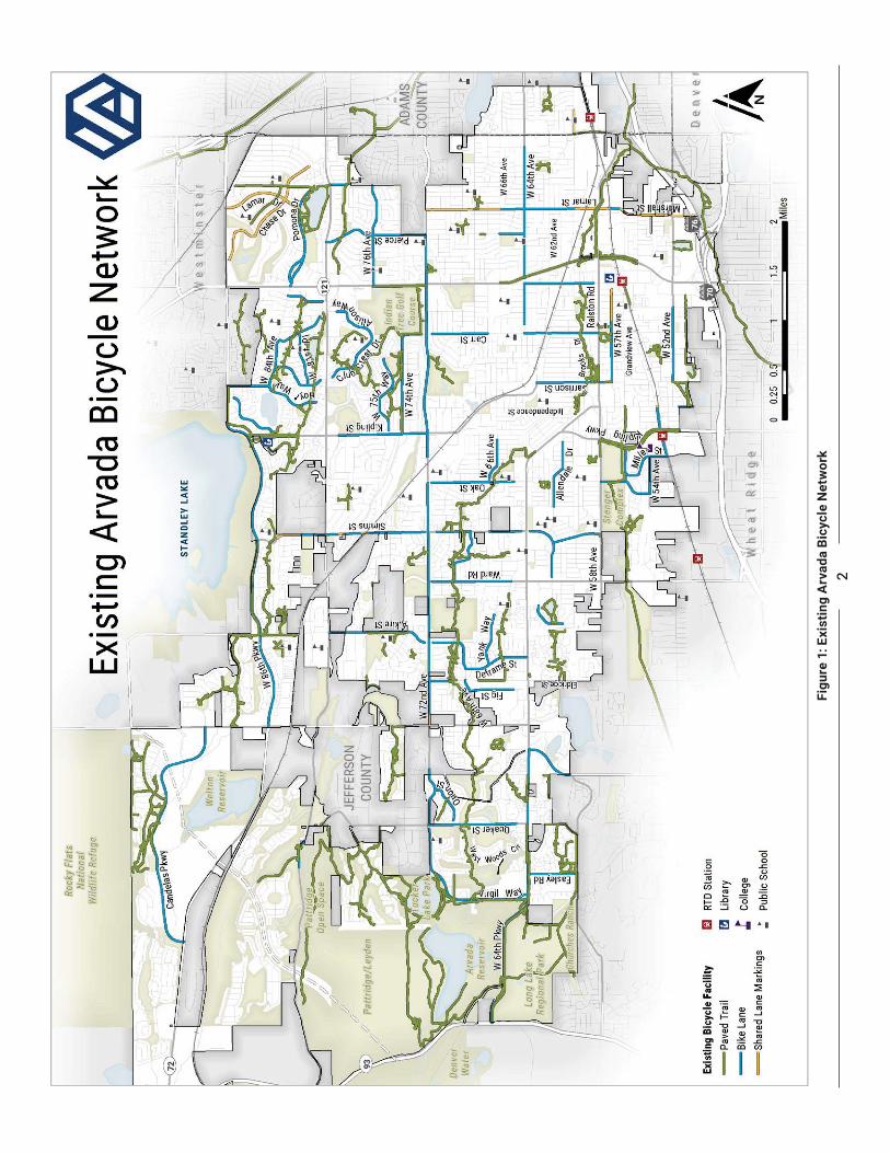
Figures Figure 1: Existing Arvada Bicycle Network ....................................................................................................... 2
Figure 2: Barriers to Biking in Arvada ................................................................................................................ 6
.....................................................................................................................25
...........................................................................................27
Figure 5: Routing Analysis Using All Road ......................................................................................................28
Figure 6: Proposed Arvada Bicycle Network s ...............................................................................................33
FIgure 7: Olde Town Proposed Bicycle Network ............................................................................................44
Figure 8: Recommended Bicycle Projects ......................................................................................................50
Figure 9: Top 10 In-House and Top 10 Capital Projects ................................................................................53
TablesTable 1: Education Recommendations ............................................................................................................ 14
Table 2: Encouragement Recommendations ................................................................................................. 17
Table 3: Evaluation Recommendations ........................................................................................................... 19
Table 4: Enforcement Recommendations .......................................................................................................20
Table 5: Policy Recommendations ..................................................................................................................21
Table 6: Summary of Proposed Actions..........................................................................................................23
...............................................................26
Table 8: Proposed Actions Summary for Bicycle Network Development ....................................................37
Table 9: Olde Town Program Recommendations ........................................................................................... 41
Table 10: Proposed Actions Summary for Olde Town ...................................................................................46
Table 11: Top 10 In-House Projects .................................................................................................................51
Table 12: Top 10 Capital Projects ....................................................................................................................52
Appendices Appendix A: Summary of Public Engagement
Appendix B: Prioritization Process for Recommended Facilities
Appendix C: State of Bicycling in Arvada
v

INTRODUCTION
CHAPTER 1
ARVADA BICYCLE MASTER PLAN
1
Chapter 1: Introduction
We envision a city where bicycling is a safe,
1 U.S. Census Bureau. American Community Survey, 2008-2012; City of Arvada. Arvada Citizen Survey. Accessed August 24, 2016. http://arvada.org/city-hall/transparency/citizens-survey.
Arvada is a livable community with good access to the outdoors, recreation, entertainment, transit, and the major employment center of Denver. The city’s status
an ongoing commitment to investing in bicycling infrastructure, education, and encouragement. Arvada’s over 110,000 residents enjoy access to 54 miles of on-road bicycle facilities and 93 miles of paved trails. In Arvada’s schools, more than half of the students have access to educational materials about safe bicycling. In addition, organizations such as the Arvada Bike Advisory Committee (ABAC) provide support to the City and host numerous events, group rides, and activities to encourage people to ride. The City has strategically used local plans and policies—such as the 2014 Comprehensive Plan and the 2016 Trails, Parks and Open Space Master Plan—to guide the development of the bicycle network, which has grown along with the expansion of the city and region itself.
While Arvada has many elements of a bicycle friendly community, the bicycle commute mode share is less than one percent, and only 22 percent of residents
1 The existing on-street facilities consist of bike lanes located on mostly collectors and arterials, a context that does not appeal to most potential bicycle riders. Additionally, the City wants to enhance bicycle access to local destinations, adjacent communities, recreation, and transit including the Regional Transportation District (RTD) G Line stations scheduled to open in 2017. The 2017 Bicycle Master Plan (Plan) seeks to create a safer and more inviting bicycling environment in Arvada where people of all ages and bicycling abilities can safely and comfortably ride a bike. This Plan provides the framework to create a connected network of low-stress bicycle facilities and supporting programs that will encourage the untapped potential for bicycling in Arvada, making bicycling for transportation as easy and comfortable as recreational riding.
2Fi
gure
1: E
xist
ing
Arv
ada
Bicy
cle
Net
wor
k
ARVADA BICYCLE MASTER PLAN
3
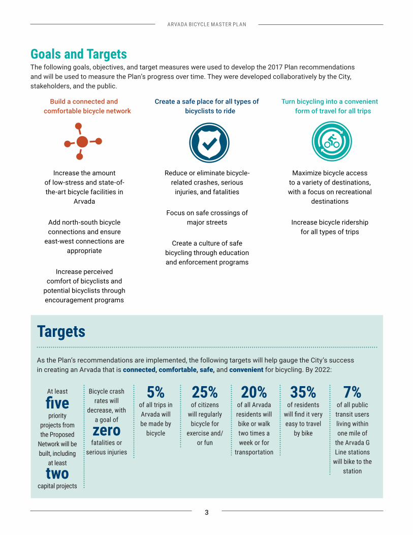
Goals and TargetsThe following goals, objectives, and target measures were used to develop the 2017 Plan recommendations and will be used to measure the Plan’s progress over time. They were developed collaboratively by the City, stakeholders, and the public.
Increase the amount of low-stress and state-of-the-art bicycle facilities in
Arvada
Add north-south bicycle connections and ensure
east-west connections are appropriate
Increase perceived comfort of bicyclists and
potential bicyclists through encouragement programs
Reduce or eliminate bicycle-related crashes, serious
injuries, and fatalities
Focus on safe crossings of major streets
Create a culture of safe bicycling through education and enforcement programs
Maximize bicycle access to a variety of destinations, with a focus on recreational
destinations
Increase bicycle ridership for all types of trips
TargetsAs the Plan’s recommendations are implemented, the following targets will help gauge the City’s success in creating an Arvada that is connected, comfortable, safe, and convenient for bicycling. By 2022:
At least
priority
projects from the Proposed
Network will be built, including
at least
two capital projects
Bicycle crash rates will
decrease, with a goal of
zero fatalities or
serious injuries
5% of all trips in Arvada will be made by
bicycle
25% of citizens
will regularly bicycle for
exercise and/or fun
20% of all Arvada residents will bike or walk two times a week or for
transportation
35% of residents
easy to travel by bike
7% of all public transit users living within one mile of
the Arvada G Line stations
will bike to the station
Build a connected and comfortable bicycle network
Create a safe place for all types of bicyclists to ride
Turn bicycling into a convenient form of travel for all trips
4
ARVADA BICYCLE MASTER PLAN
Planning Approach
2 City of Arvada. Arvada Citizen Survey. Accessed August 24, 2016. http://arvada.org/city-hall/transparency/citizens-survey
3 Studies show that approximately one third of the population is not currently interested in bicycling or able to bicycle.
The Vision for the Plan includes making bicycling a viable transportation option for a broad segment of the population and serving existing and future generations. Arvada’s trail network, climate, and burgeoning bicycle culture have contributed to a focus on recreational ridership that continues today. The 2015 Arvada
of residents ride a bike for fun or for exercise at least twice a week.2 However, apart from these riders and for other trip purposes, most residents do not ride today.
Low ridership is related to many factors, but a large one is rider comfort and safety. Bicycle planning professionals accept that there is a large percentage of the American population that is interested in bicycling for transportation, but does not currently do so because they feel unsafe. Several studies have shown that a bicyclist’s perception of their personal safety
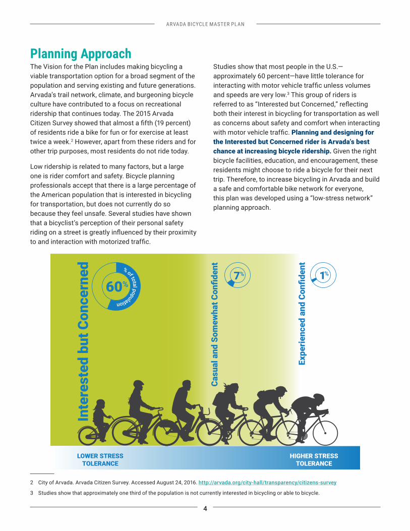
Studies show that most people in the U.S.—approximately 60 percent—have little tolerance for
and speeds are very low.3 This group of riders is
both their interest in bicycling for transportation as well as concerns about safety and comfort when interacting
Planning and designing for the Interested but Concerned rider is Arvada’s best chance at increasing bicycle ridership. Given the right bicycle facilities, education, and encouragement, these residents might choose to ride a bicycle for their next trip. Therefore, to increase bicycling in Arvada and build a safe and comfortable bike network for everyone, this plan was developed using a “low-stress network” planning approach.
este
d bu
t Con
cern
ed o
60%7% 1%
Inte
r
LOWER STRESSTOLERANCE
% of ttal population
HIGHER STRESSTOLERANCE
ARVADA BICYCLE MASTER PLAN
5
Reasons to ActLimited Facilities and Connections Arvada residents enjoy a high quality of life in part because of the city’s location along Colorado’s Front
city’s western and northern edges, while 123 miles of paved and unpaved trails provide green spaces throughout the city. Arvada’s neighbors—Wheat Ridge to the south, Westminster to the northeast, and Denver to the southwest—provide additional job centers and recreational opportunities. However, there
substantial barriers including I-70, US 36, railroads, and unincorporated areas of Jefferson County where infrastructure development lags.
Bicycling within Arvada today is sometimes challenging and often disconnected. Only 11 percent of Arvada’s 500-mile network of local, collector, and arterial streets have bicycle facilities. Of that, most of the on-street bike network is composed of collectors and arterials—
facilities that, without enhanced treatments, are not suited for riders of all ages and skill levels. Though most of the 93-mile paved trail network provides a low-stress bicycling experience, there are sizable gaps in the trail network and few comfortable on-street bikeways to connect neighborhoods.
Arvada also lacks a strong network of north-south bikeways, as noted in the 2016 Trails, Parks and Open Space Master Plan, in part due to jurisdictional boundaries. More long-distance, directional connectivity would make it more convenient for people to bicycle.
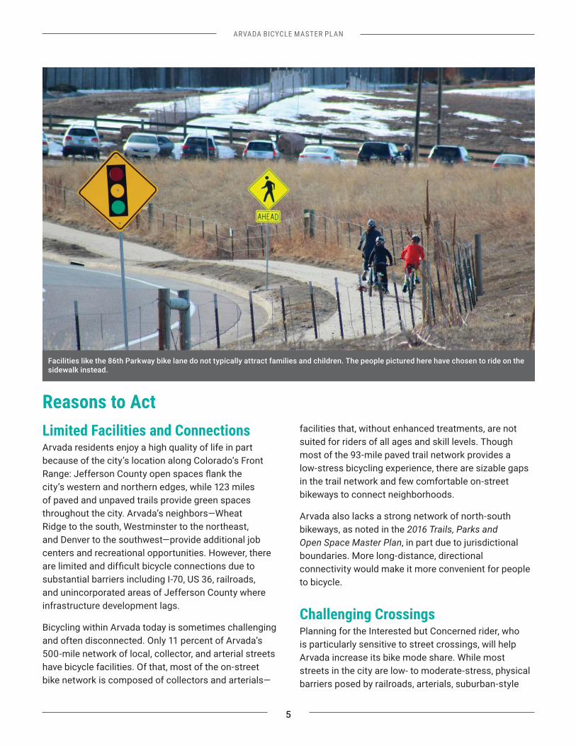
Challenging Crossings Planning for the Interested but Concerned rider, who is particularly sensitive to street crossings, will help Arvada increase its bike mode share. While most streets in the city are low- to moderate-stress, physical barriers posed by railroads, arterials, suburban-style
Facilities like the 86th Parkway bike lane do not typically attract families and children. The people pictured here have chosen to ride on the sidewalk instead.
6
ARVADA BICYCLE MASTER PLAN
development, and offset intersections detract from citywide connectivity.
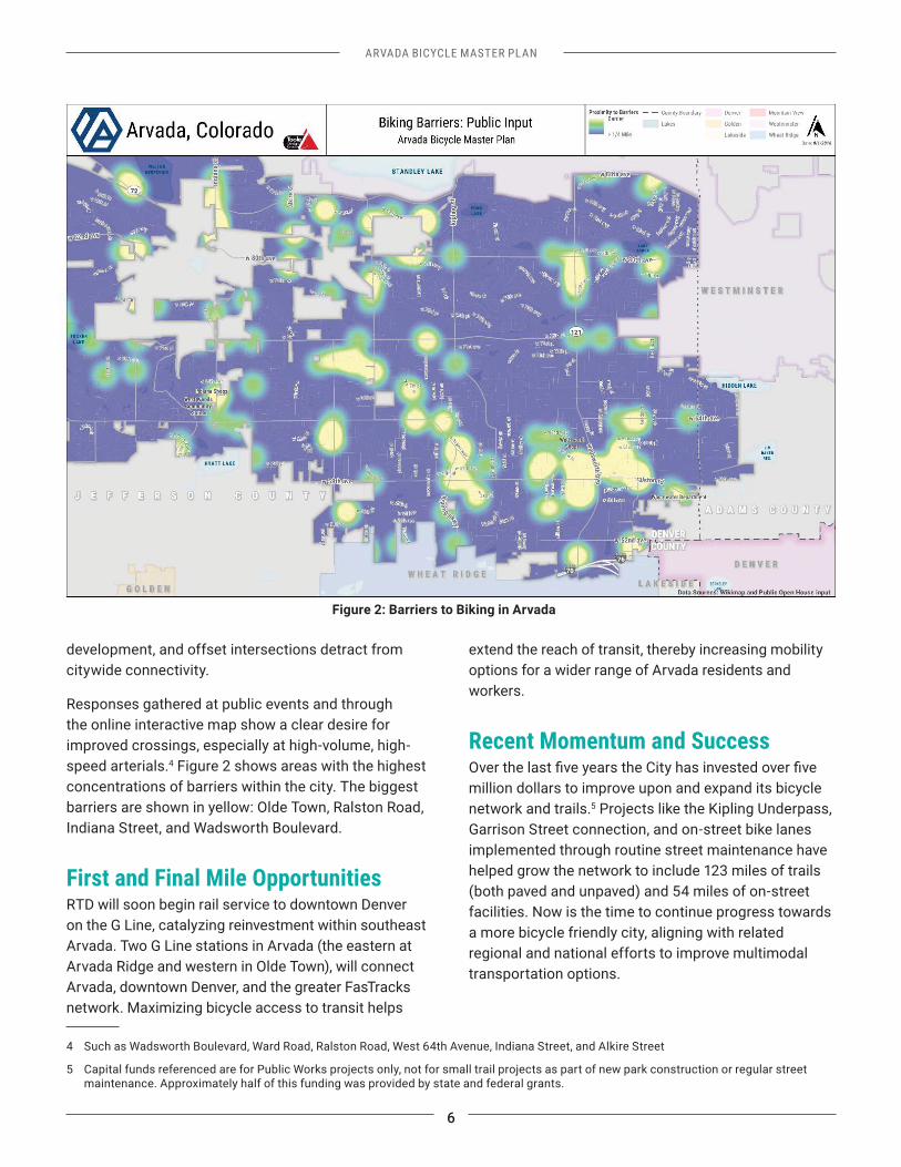
Responses gathered at public events and through the online interactive map show a clear desire for improved crossings, especially at high-volume, high-speed arterials.4 Figure 2 shows areas with the highest concentrations of barriers within the city. The biggest barriers are shown in yellow: Olde Town, Ralston Road, Indiana Street, and Wadsworth Boulevard.
First and Final Mile OpportunitiesRTD will soon begin rail service to downtown Denver on the G Line, catalyzing reinvestment within southeast Arvada. Two G Line stations in Arvada (the eastern at Arvada Ridge and western in Olde Town), will connect Arvada, downtown Denver, and the greater FasTracks network. Maximizing bicycle access to transit helps
4 Such as Wadsworth Boulevard, Ward Road, Ralston Road, West 64th Avenue, Indiana Street, and Alkire Street
5 Capital funds referenced are for Public Works projects only, not for small trail projects as part of new park construction or regular street maintenance. Approximately half of this funding was provided by state and federal grants.
extend the reach of transit, thereby increasing mobility options for a wider range of Arvada residents and workers.
Recent Momentum and Success
million dollars to improve upon and expand its bicycle network and trails.5 Projects like the Kipling Underpass, Garrison Street connection, and on-street bike lanes implemented through routine street maintenance have helped grow the network to include 123 miles of trails (both paved and unpaved) and 54 miles of on-street facilities. Now is the time to continue progress towards a more bicycle friendly city, aligning with related regional and national efforts to improve multimodal transportation options.
Figure 2: Barriers to Biking in Arvada
ARVADA BICYCLE MASTER PLAN
7
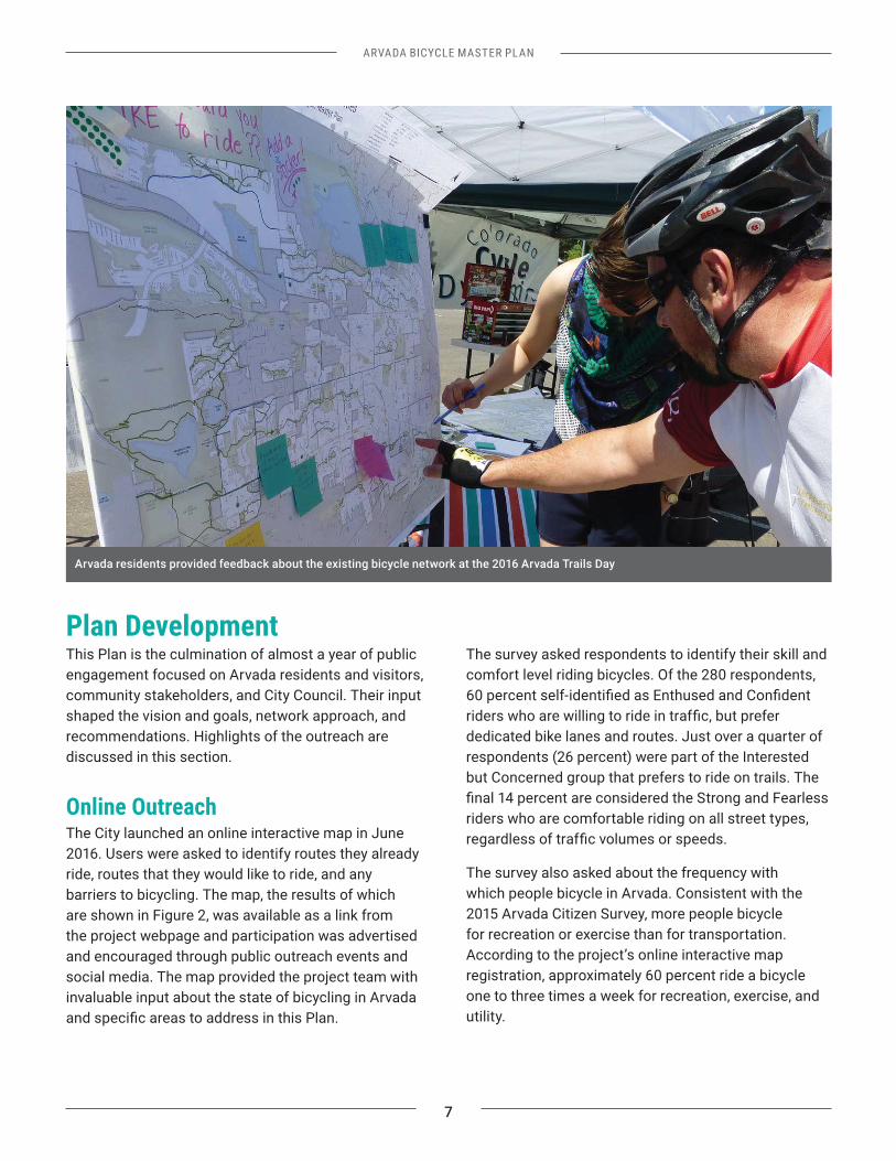
Plan Development This Plan is the culmination of almost a year of public engagement focused on Arvada residents and visitors, community stakeholders, and City Council. Their input shaped the vision and goals, network approach, and recommendations. Highlights of the outreach are discussed in this section.
Online Outreach The City launched an online interactive map in June 2016. Users were asked to identify routes they already ride, routes that they would like to ride, and any barriers to bicycling. The map, the results of which are shown in Figure 2, was available as a link from the project webpage and participation was advertised and encouraged through public outreach events and social media. The map provided the project team with invaluable input about the state of bicycling in Arvada
The survey asked respondents to identify their skill and comfort level riding bicycles. Of the 280 respondents,
dedicated bike lanes and routes. Just over a quarter of respondents (26 percent) were part of the Interested but Concerned group that prefers to ride on trails. The
riders who are comfortable riding on all street types,
The survey also asked about the frequency with which people bicycle in Arvada. Consistent with the 2015 Arvada Citizen Survey, more people bicycle for recreation or exercise than for transportation. According to the project’s online interactive map registration, approximately 60 percent ride a bicycle one to three times a week for recreation, exercise, and utility.
Arvada residents provided feedback about the existing bicycle network at the 2016 Arvada Trails Day
8
ARVADA BICYCLE MASTER PLAN
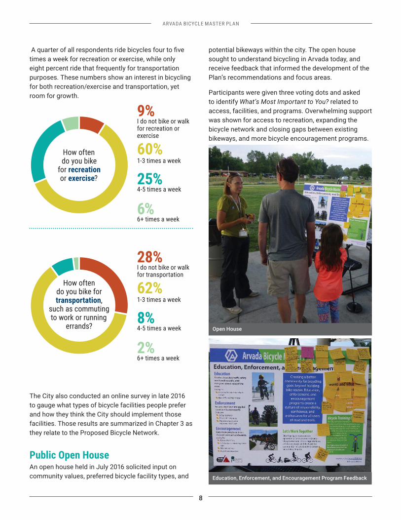
times a week for recreation or exercise, while only eight percent ride that frequently for transportation purposes. These numbers show an interest in bicycling for both recreation/exercise and transportation, yet room for growth.
The City also conducted an online survey in late 2016 to gauge what types of bicycle facilities people prefer and how they think the City should implement those facilities. Those results are summarized in Chapter 3 as they relate to the Proposed Bicycle Network.
Public Open HouseAn open house held in July 2016 solicited input on community values, preferred bicycle facility types, and
potential bikeways within the city. The open house sought to understand bicycling in Arvada today, and receive feedback that informed the development of the Plan’s recommendations and focus areas.
Participants were given three voting dots and asked to identify What’s Most Important to You? related to access, facilities, and programs. Overwhelming support was shown for access to recreation, expanding the bicycle network and closing gaps between existing bikeways, and more bicycle encouragement programs.
How often do you bike
for recreation or exercise?
9%I do not bike or walk for recreation or exercise
60%1-3 times a week
25%4-5 times a week
6%6+ times a week
How often do you bike for transportation,
such as commuting to work or running
errands?
28%I do not bike or walk for transportation
62%1-3 times a week
8%4-5 times a week
2%6+ times a week
Education, Enforcement, and Encouragement Program Feedback
Open House
ARVADA BICYCLE MASTER PLAN
9
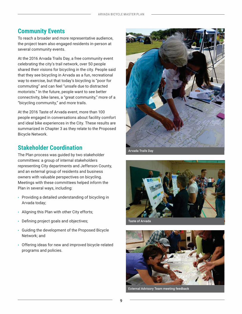
Community EventsTo reach a broader and more representative audience, the project team also engaged residents in-person at several community events.
At the 2016 Arvada Trails Day, a free community event celebrating the city’s trail network, over 50 people shared their visions for bicycling in the city. People said that they see bicycling in Arvada as a fun, recreational way to exercise, but that today’s bicycling is “poor for commuting” and can feel “unsafe due to distracted motorists.” In the future, people want to see better connectivity, bike lanes, a “great community,” more of a “bicycling community,” and more trails.
At the 2016 Taste of Arvada event, more than 100 people engaged in conversations about facility comfort and ideal bike experiences in the City. These results are summarized in Chapter 3 as they relate to the Proposed Bicycle Network.
Stakeholder CoordinationThe Plan process was guided by two stakeholder committees: a group of internal stakeholders representing City departments and Jefferson County, and an external group of residents and business owners with valuable perspectives on bicycling. Meetings with these committees helped inform the Plan in several ways, including:
• Providing a detailed understanding of bicycling in Arvada today;
• Aligning this Plan with other City efforts;
•
• Guiding the development of the Proposed Bicycle Network; and
• Offering ideas for new and improved bicycle-related programs and policies.
Arvada Trails Day
External Advisory Team meeting feedback
Taste of Arvada
10
ARVADA BICYCLE MASTER PLAN
Plan Organization
Chapter 1 introduces the Plan including the goals, the planning approach, and reasons to act.
Chapter 2 provides recommendations for programs and polices related to bicycling.
Chapter 3 presents and describes the Proposed Bicycle Network.
Chapter 4 focuses on in-depth network and program recommendations for Olde Town.
Chapter 5 provides an implementation strategy for the Plan recommendations.
Appendix A includes a summary of the public and stakeholder engagement that shaped the Plan.
Appendix B includes details of the bikeway project prioritization process.
Appendix C includes the State of Bicycling in Arvada report, which summarizes existing bicycling conditions in the city.
THIS PAGE INTENTIONALLY LEFT BLANK
11
ARVADA BICYCLE MASTER PLAN
AND POLICIES
CHAPTER 2
ARVADA BICYCLE MASTER PLAN
13
Chapter 2: Bicycle Programs and PoliciesCommunity programs and City policies are key ingredients to creating a place where bicycling is connected, safe, and convenient. Generally, policies are set by City government, while programs are led by external organizations such as advocacy organizations. Along with infrastructure such as bike lanes and trails, these elements will help Arvada realize the Plan goals outlined in Chapter 1.
Arvada already has a number of education, encouragement, and enforcement programs related to bicycling. The existing bicycle programs are part of why Arvada earned a Silver Bicycle Friendly Community designation by the League of American of Bicyclists (LAB) in 2014.
As the City looks to increase bicycling, the 2017 Plan recommends the expansion of some programs as well as creating new, impactful programs. Community partners may be well positioned to implement and support many of these efforts. This chapter summarizes those recommendations by each programmatic category—Education, Encouragement, Enforcement, and Evaluation. It then summarizes recommendations for new or revised City policies.
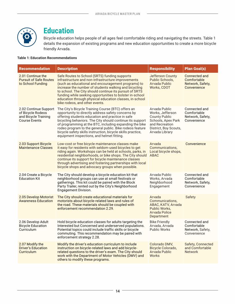
Bicycle Training CourseIn May 2016, the City opened the Bicycle Training Course (BTC), a half-acre imitation streetscape that includes some of the same street elements found in Arvada: bike lanes, street signs, crosswalks, and railroad crossings. The BTC also includes additional obstacles for skills training, such as the Rock Dodge and Slalom, typically used as part of a Bike Rodeo curriculum. The BTC directly addresses safety concerns by offering students education in bicycle safety, as well as an opportunity to practice safe pedestrian behaviors on the way to and from the facility.
The League of American Bicyclists categorizes non-engineering aspects of a bicycle friendly community as follows:
Education: Gives people of all ages and ability levels the skills
Encouragement: Creates a strong bike culture that welcomes and celebrates bicycling
Enforcement: Ensures safe roads for all users
Evaluation and Planning: Plans for bicycling as a safe and viable transportation option
Bike Training Course Group Ride
14
ARVADA BICYCLE MASTER PLAN
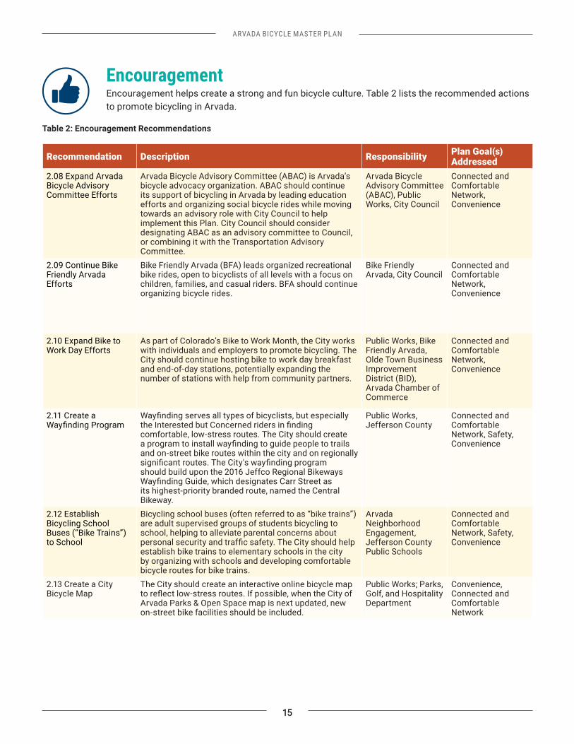
Education Bicycle education helps people of all ages feel comfortable riding and navigating the streets. Table 1 details the expansion of existing programs and new education opportunities to create a more bicycle friendly Arvada.
Table 1: Education Recommendations
Recommendation Description Responsibility Plan Goal(s)
2.01 Continue the Pursuit of Safe Routes to School Funding
Safe Routes to School (SRTS) funding supports infrastructure and non-infrastructure improvements (such as educational and encouragement programs) to increase the number of students walking and bicycling to school. The City should continue its pursuit of SRTS funding while seeking opportunities to bolster in-school education through physical education classes, in-school bike rodeos, and other events.
Jefferson County Public Schools, Arvada Public Works, CDOT
Connected and Comfortable Network, Safety, Convenience
2.02 Continue Support of Bicycle Rodeos and Bicycle Training Course Events
The City’s Bicycle Training Course (BTC) offers an opportunity to directly address safety concerns by offering students education and practice in safe bicycling behaviors. The City should continue its support of programming at the BTC, including expanding the bike rodeo program to the general public. Bike rodeos feature bicycle safety skills instruction, bicycle skills practice,
Arvada Public Works, Jefferson County Public Schools, Apex Park and Recreation District, Boy Scouts, Arvada Library
Connected and Comfortable Network, Safety, Convenience
2.03 Support Bicycle Maintenance Classes
Low-cost or free bicycle maintenance classes make it easy for residents with seldom-used bicycles to get riding again. Workshops can be held at schools, parks, in residential neighborhoods, or bike shops. The City should continue its support for bicycle maintenance classes through advertising and fostering partnerships with local bicycle shops and advocacy groups when possible.
ArvadaCommunications, Local bicycle shops, ABAC
Convenience
2.04 Create a Bicycle Education Kit
The City should develop a bicycle education kit that neighborhood groups can use at small festivals or gatherings. This kit could be paired with the Block Party Trailer, rented out by the City’s Neighborhood Engagement Division.
Arvada Public Works, Arvada Neighborhood Engagement
Connected and Comfortable Network, Safety, Convenience
2.05 Develop Motorist Awareness Education
The City should create educational materials for motorists about bicycle-related laws and rules of the road. These materials should be coupled with enforcement recommendation 2.29.
Arvada Communications, ABAC, KATV, Arvada Public Works, Arvada Police Department
2.06 Develop Adult Bicycle Education Curriculum
Hold bicycle education classes for adults targeting the Interested but Concerned and underserved populations.
commuting. This recommendation may be paired with enforcement strategy 2.28.
Bike Friendly Arvada, Arvada Public Works
Connected and Comfortable Network, Safety, Convenience
2.07 Modify the Driver’s Education Curriculum
Modify the driver’s education curriculum to include instruction on bicycle-related laws and add bicycle-related questions to the driver’s exam. The City should work with the Department of Motor Vehicles (DMV) and others to modify these programs.
Colorado DMV, Bicycle Colorado, Arvada Public Works
Safety, Connected and Comfortable Network
ARVADA BICYCLE MASTER PLAN
15
Encouragement Encouragement helps create a strong and fun bicycle culture. Table 2 lists the recommended actions to promote bicycling in Arvada.
Table 2: Encouragement Recommendations
Recommendation Description Responsibility Plan Goal(s) Addressed
2.08 Expand Arvada Bicycle Advisory Committee Efforts
Arvada Bicycle Advisory Committee (ABAC) is Arvada’s bicycle advocacy organization. ABAC should continue its support of bicycling in Arvada by leading education efforts and organizing social bicycle rides while moving towards an advisory role with City Council to help implement this Plan. City Council should consider designating ABAC as an advisory committee to Council, or combining it with the Transportation Advisory Committee.
Arvada Bicycle Advisory Committee (ABAC), Public Works, City Council
Connected and Comfortable Network, Convenience
2.09 Continue Bike Friendly Arvada Efforts
Bike Friendly Arvada (BFA) leads organized recreational bike rides, open to bicyclists of all levels with a focus on children, families, and casual riders. BFA should continue organizing bicycle rides.
Bike Friendly Arvada, City Council
Connected and Comfortable Network, Convenience
2.10 Expand Bike to Work Day Efforts
As part of Colorado’s Bike to Work Month, the City works with individuals and employers to promote bicycling. The City should continue hosting bike to work day breakfast and end-of-day stations, potentially expanding the number of stations with help from community partners.
Public Works, Bike Friendly Arvada, Olde Town Business Improvement District (BID), Arvada Chamber of Commerce
Connected and Comfortable Network, Convenience
2.11 Create a
comfortable, low-stress routes. The City should create
and on-street bike routes within the city and on regionally
should build upon the 2016 Jeffco Regional Bikeways
its highest-priority branded route, named the Central Bikeway.
Public Works, Jefferson County
Connected and Comfortable Network, Safety, Convenience
2.12 Establish Bicycling School Buses (“Bike Trains”) to School
Bicycling school buses (often referred to as “bike trains”) are adult supervised groups of students bicycling to school, helping to alleviate parental concerns about
establish bike trains to elementary schools in the city by organizing with schools and developing comfortable bicycle routes for bike trains.
Arvada Neighborhood Engagement, Jefferson County Public Schools
Connected and Comfortable Network, Safety, Convenience
2.13 Create a City Bicycle Map
The City should create an interactive online bicycle map
Arvada Parks & Open Space map is next updated, new on-street bike facilities should be included.
Public Works; Parks, Golf, and Hospitality Department
Convenience, Connected and Comfortable Network
16
ARVADA BICYCLE MASTER PLAN
Recommendation Description Responsibility Plan Goal(s) Addressed
2.14 Establish a Bicycle Friendly Business Program
Bicycle friendly businesses help to encourage bicycling by providing bicycle parking, support for riding, and rewards. The City should develop a bicycle friendly business program to support businesses that encourage bicycling by their employees and customers.
ABAC, Chamber of Commerce, Olde Town BID, Arvada Sustainability Advisory Committee
Convenience, Connected and Comfortable Network
2.15 Enhance End-of-Trip Facilities and Develop a Comprehensive Bicycle Parking Plan
Improving bicycle parking will encourage more people to ride to errands, events, work, and school by bike. The City should develop a comprehensive bicycle parking plan to address bicycle parking needs and other end-of-trip facility needs around the city.
City Manager’s
Outreach, BIDs, Chamber of Commerce
Convenience
2.16 Give Away Helmets and Bicycle Lights
The City should give away helmets and lights at events Police Department Safety
2.17 Support Earn-a-Bike Programs
Earn-a-bike programs provide opportunities for children to learn bicycle maintenance and leadership skills while earning bikes to keep. These programs rely on donated bicycles and either volunteers or paid staff who teach bicycle maintenance. The City should promote awareness of earn-a-bike programs related to Arvada.
ABAC, City
(Communication)
Convenience
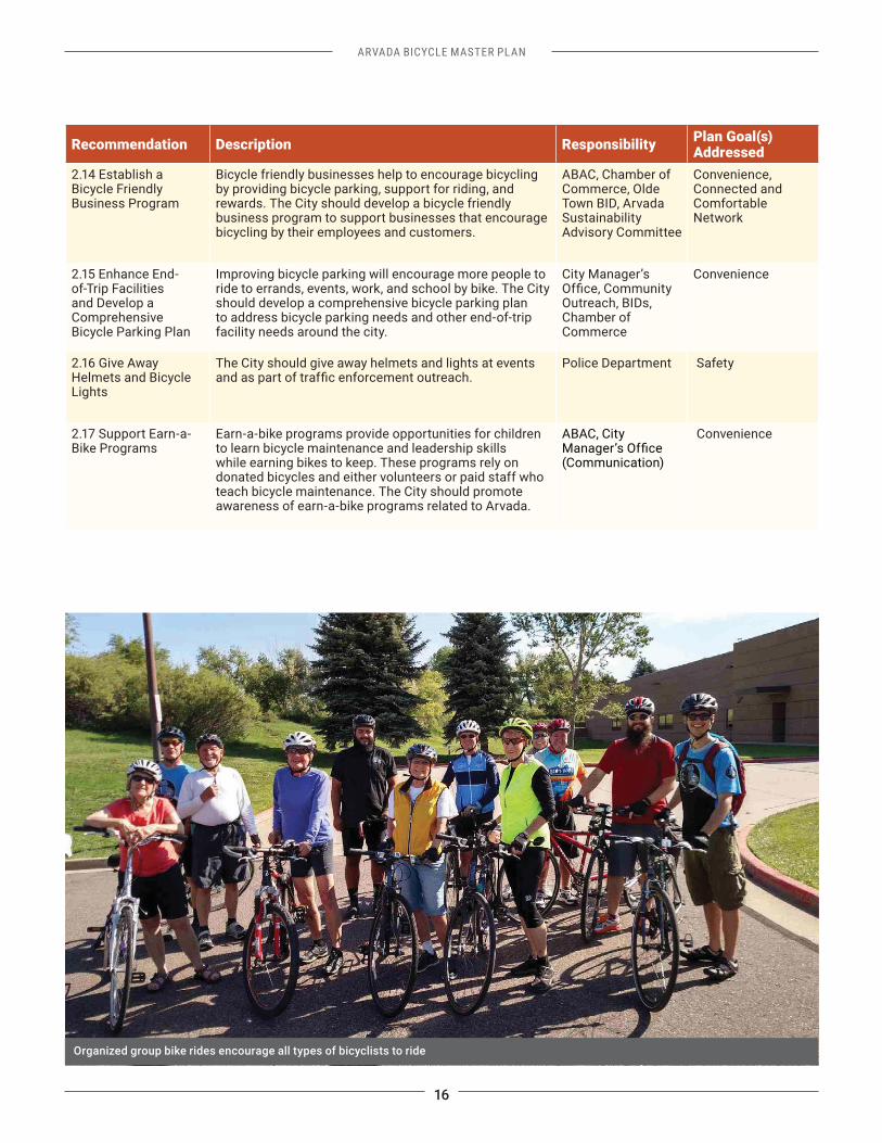
Organized group bike rides encourage all types of bicyclists to ride
ARVADA BICYCLE MASTER PLAN
17
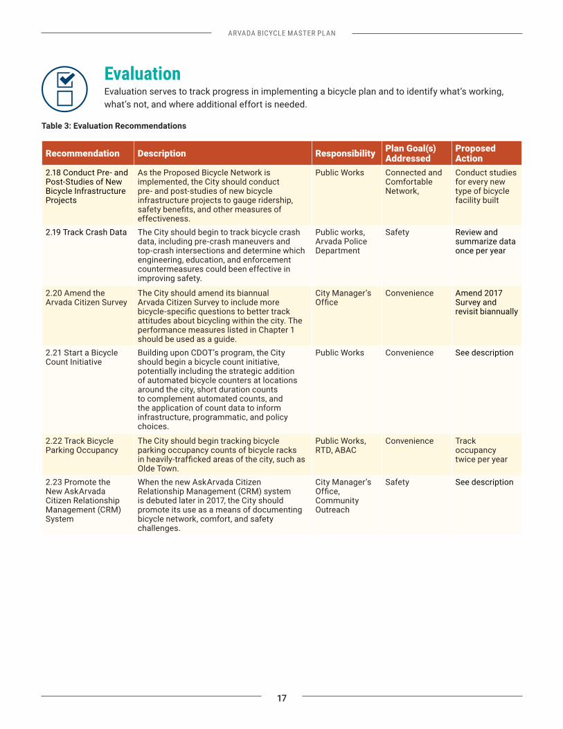
Evaluation Evaluation serves to track progress in implementing a bicycle plan and to identify what’s working, what’s not, and where additional effort is needed.
Table 3: Evaluation Recommendations
Recommendation Description Responsibility Plan Goal(s) Addressed
Proposed Action
2.18 Conduct Pre- and Post-Studies of New Bicycle Infrastructure Projects
As the Proposed Bicycle Network is implemented, the City should conduct pre- and post-studies of new bicycle infrastructure projects to gauge ridership,
effectiveness.
Public Works Connected and Comfortable Network,
Conduct studies for every new type of bicycle facility built
2.19 Track Crash Data The City should begin to track bicycle crash data, including pre-crash maneuvers and top-crash intersections and determine which engineering, education, and enforcement countermeasures could been effective in improving safety.
Public works, Arvada Police Department
Safety Review and summarize data once per year
2.20 Amend the Arvada Citizen Survey
The City should amend its biannual Arvada Citizen Survey to include more
attitudes about bicycling within the city. The performance measures listed in Chapter 1 should be used as a guide.
City Manager’s Convenience Amend 2017 Survey and revisit biannually
2.21 Start a Bicycle Count Initiative
Building upon CDOT’s program, the City should begin a bicycle count initiative, potentially including the strategic addition of automated bicycle counters at locations around the city, short duration counts to complement automated counts, and the application of count data to inform infrastructure, programmatic, and policy choices.
Public Works Convenience See description
2.22 Track Bicycle Parking Occupancy
The City should begin tracking bicycle parking occupancy counts of bicycle racks
Olde Town.
Public Works, RTD, ABAC
Convenience Track occupancy twice per year
2.23 Promote the New AskArvada Citizen Relationship Management (CRM) System
When the new AskArvada Citizen Relationship Management (CRM) system is debuted later in 2017, the City should promote its use as a means of documenting bicycle network, comfort, and safety challenges.
City Manager’s
Community Outreach
Safety See description
18
ARVADA BICYCLE MASTER PLAN
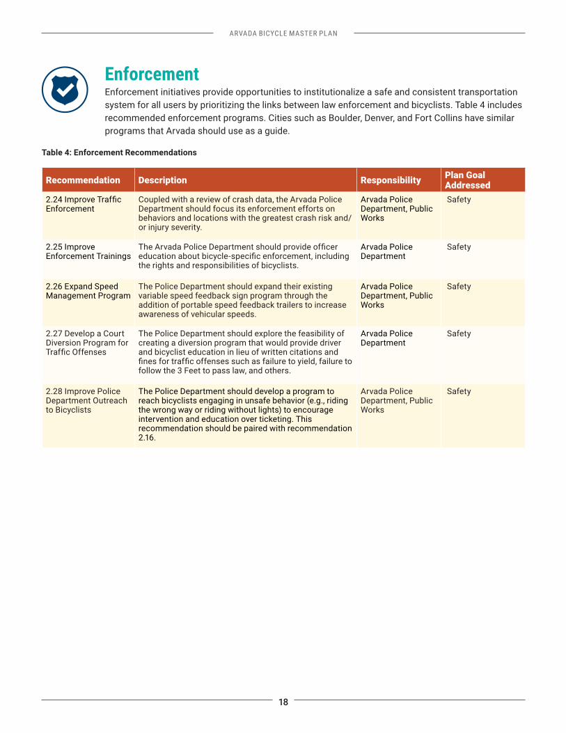
Enforcement Enforcement initiatives provide opportunities to institutionalize a safe and consistent transportation system for all users by prioritizing the links between law enforcement and bicyclists. Table 4 includes recommended enforcement programs. Cities such as Boulder, Denver, and Fort Collins have similar programs that Arvada should use as a guide.
Table 4: Enforcement Recommendations
Recommendation Description Responsibility Plan Goal Addressed
EnforcementCoupled with a review of crash data, the Arvada Police Department should focus its enforcement efforts on behaviors and locations with the greatest crash risk and/or injury severity.
Arvada Police Department, Public Works
Safety
2.25 Improve Enforcement Trainings
the rights and responsibilities of bicyclists.
Arvada Police Department
Safety
2.26 Expand Speed Management Program
The Police Department should expand their existing variable speed feedback sign program through the addition of portable speed feedback trailers to increase awareness of vehicular speeds.
Arvada Police Department, Public Works
Safety
2.27 Develop a Court Diversion Program for
The Police Department should explore the feasibility of creating a diversion program that would provide driver and bicyclist education in lieu of written citations and
follow the 3 Feet to pass law, and others.
Arvada Police Department
Safety
2.28 Improve Police Department Outreach to Bicyclists
The Police Department should develop a program to reach bicyclists engaging in unsafe behavior (e.g., riding the wrong way or riding without lights) to encourage intervention and education over ticketing. This recommendation should be paired with recommendation 2.16.
Arvada Police Department, Public Works
Safety
ARVADA BICYCLE MASTER PLAN
19
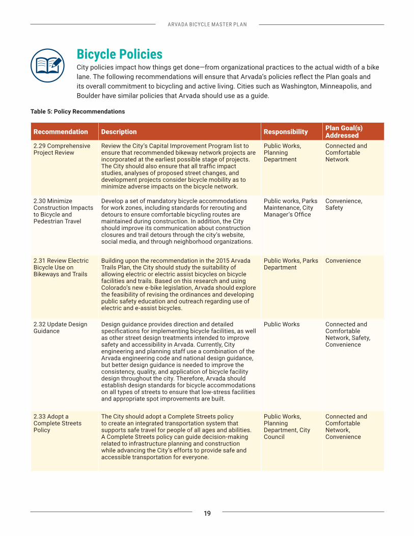
Bicycle PoliciesCity policies impact how things get done—from organizational practices to the actual width of a bike
its overall commitment to bicycling and active living. Cities such as Washington, Minneapolis, and Boulder have similar policies that Arvada should use as a guide.
Table 5: Policy Recommendations
Recommendation Description Responsibility Plan Goal(s) Addressed
2.29 Comprehensive Project Review
Review the City’s Capital Improvement Program list to ensure that recommended bikeway network projects are incorporated at the earliest possible stage of projects.
studies, analyses of proposed street changes, and development projects consider bicycle mobility as to minimize adverse impacts on the bicycle network.
Public Works, Planning Department
Connected and Comfortable Network
2.30 Minimize Construction Impacts to Bicycle and Pedestrian Travel
Develop a set of mandatory bicycle accommodations for work zones, including standards for rerouting and detours to ensure comfortable bicycling routes are maintained during construction. In addition, the City should improve its communication about construction closures and trail detours through the city’s website, social media, and through neighborhood organizations.
Public works, Parks Maintenance, City
Convenience, Safety
2.31 Review Electric Bicycle Use on Bikeways and Trails
Building upon the recommendation in the 2015 Arvada Trails Plan, the City should study the suitability of allowing electric or electric assist bicycles on bicycle facilities and trails. Based on this research and using Colorado’s new e-bike legislation, Arvada should explore the feasibility of revising the ordinances and developing public safety education and outreach regarding use of electric and e-assist bicycles.
Public Works, Parks Department
Convenience
2.32 Update Design Guidance
Design guidance provides direction and detailed
as other street design treatments intended to improve safety and accessibility in Arvada. Currently, City engineering and planning staff use a combination of the Arvada engineering code and national design guidance, but better design guidance is needed to improve the consistency, quality, and application of bicycle facility design throughout the city. Therefore, Arvada should establish design standards for bicycle accommodations on all types of streets to ensure that low-stress facilities and appropriate spot improvements are built.
Public Works Connected and Comfortable Network, Safety, Convenience
2.33 Adopt a Complete Streets Policy
The City should adopt a Complete Streets policy to create an integrated transportation system that supports safe travel for people of all ages and abilities. A Complete Streets policy can guide decision-making related to infrastructure planning and construction while advancing the City’s efforts to provide safe and accessible transportation for everyone.
Public Works, Planning Department, City Council
Connected and Comfortable Network, Convenience
20
ARVADA BICYCLE MASTER PLAN
Recommendation Description Responsibility Plan Goal(s) Addressed
2.34 Identify Maintenance Standards and Procedures for Bicycle Facilities
The City should establish minimum maintenance standards for bicycle facilities throughout the city. Maintenance efforts should focus on sweeping, snow removal, and repaving: Sweeping: The City operates street sweeping crews between April and November. Each street in the City is swept once every six to eight weeks, depending on the
routes more frequently, so the City should establish a policy to clear bikeways and trails soon after heavy rains or wind storms, when debris are likely to impede travel. Snow Control and Removal: After a snow event, the City plows streets on collector and arterial streets in priority
proximity to schools, and connectivity to residential neighborhoods. Collectors, minor collectors, and local streets with steep hills or a history of chronic icing are plowed at a lower priority and most local streets are not plowed unless the City Manager declares a snow emergency. Snow is plowed and removed from Olde Town and some parts of Ralston Road. While many of the priority snow plow routes have bike facilities, bike facilities are not explicitly designated as high-priority plow routes. Therefore, the City should improve snow management (e.g., plowing, removal) on bicycle routes, as well.
Repaving: Today, street resurfacing is planned three years in advance. The City should incorporate higher standards and shorter timetables for the resurfacing of high-priority bicycle routes to ensure a more comfortable ride.
Public Works, Streets Maintenance, Parks Maintenance
Connected and Comfortable Network, Convenience
2.35 Improve Trail Lighting for trail users. The City should determine appropriate
lighting standards for trails and work to implement improved lighting throughout the trail system.
Public Works, Parks Maintenance
Safety, Convenience
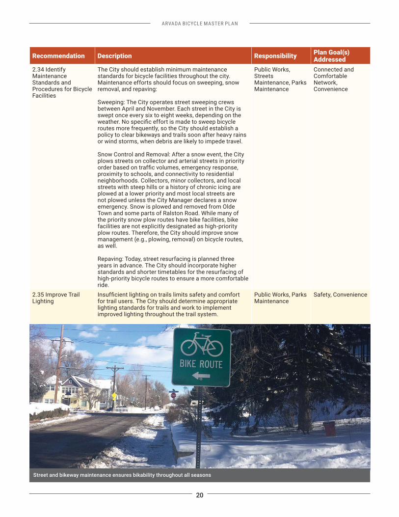
Street and bikeway maintenance ensures bikability throughout all seasons
ARVADA BICYCLE MASTER PLAN
21
Summary of Proposed ActionsThe following table summarizes the key actions that Arvada will need to take to accomplish Plan goals related to bicycle programs and policies.
Table 6: Summary of Proposed Actions
Category Proposed ActionEducation
2.01 Continue the Pursuit of Safe Routes to School Funding 2.02 Continue Support of Bicycle Rodeos and Bicycle Training Course Events2.03 Support Bicycle Maintenance Classes2.04 Create a Bicycle Education Kit2.05 Develop Motorist Awareness Education2.06 Develop Adult Bicycle Education Curriculum 2.07 Modify the Driver’s Education Curriculum
Encouragement2.08 Expand Arvada Bicycle Advisory Committee Efforts2.09 Continue Bike Friendly Arvada Efforts2.10 Expand Bike to Work Day Efforts
2.12 Establish Bicycling School Buses (“Bike Trains”) to School2.13 Create an Online City Bicycle Map2.14 Establish a Bicycle Friendly Business Program2.15 Enhance End-of-Trip Facilities and Develop a Comprehensive Bicycle Parking Plan2.16 Give Away Helmets and Bicycle Lights 2.17 Support Earn-a-Bike Programs
Evaluation2.18 Conduct Pre- and Post-Studies of New Bicycle Infrastructure Projects2.19 Track Crash Data2.20 Amend the Arvada Citizen Survey2.21 Start a Bicycle Count Initiative2.22 Track Bicycle Parking Occupancy 2.23 Promote the New AskArvada Citizen Relationship Management (CRM) System
Enforcement
2.25 Improve Enforcement Trainings2.26 Expand Speed Management Program
2.28 Improve Police Department Outreach to Bicyclists
Bicycle Policies2.29 Comprehensive Project Review2.30 Minimize Construction Impacts to Bicycle and Pedestrian Travel2.31 Review Electric Bicycle Use on Bikeways and Trails2.32 Update Design Guidance2.33 Adopt a Complete Streets Policy2.34 Identify Maintenance Standards and Procedures for Bike Facilities2.35 Improve Trail Lighting
BICYCLE NETWORK
CHAPTER 3
ARVADA BICYCLE MASTER PLAN
23
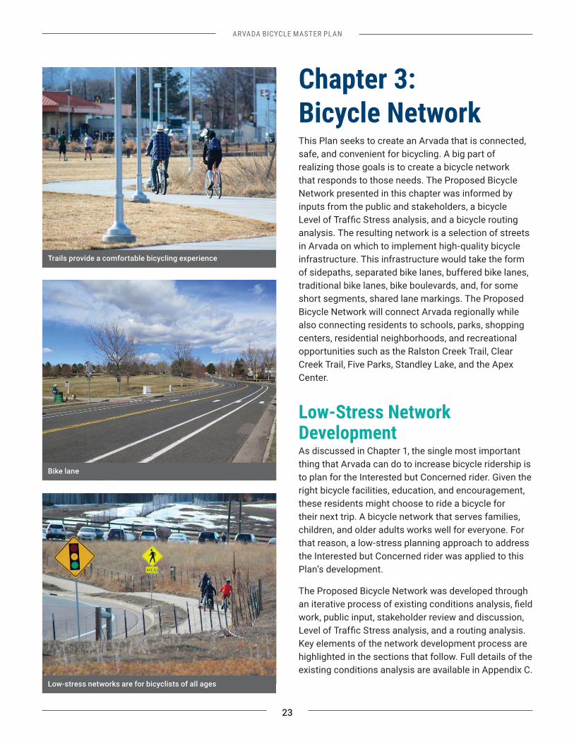
Chapter 3: Bicycle Network This Plan seeks to create an Arvada that is connected, safe, and convenient for bicycling. A big part of realizing those goals is to create a bicycle network that responds to those needs. The Proposed Bicycle Network presented in this chapter was informed by inputs from the public and stakeholders, a bicycle
analysis. The resulting network is a selection of streets in Arvada on which to implement high-quality bicycle infrastructure. This infrastructure would take the form of sidepaths, separated bike lanes, buffered bike lanes, traditional bike lanes, bike boulevards, and, for some short segments, shared lane markings. The Proposed Bicycle Network will connect Arvada regionally while also connecting residents to schools, parks, shopping centers, residential neighborhoods, and recreational opportunities such as the Ralston Creek Trail, Clear Creek Trail, Five Parks, Standley Lake, and the Apex Center.
Low-Stress Network DevelopmentAs discussed in Chapter 1, the single most important thing that Arvada can do to increase bicycle ridership is to plan for the Interested but Concerned rider. Given the right bicycle facilities, education, and encouragement, these residents might choose to ride a bicycle for their next trip. A bicycle network that serves families, children, and older adults works well for everyone. For that reason, a low-stress planning approach to address the Interested but Concerned rider was applied to this Plan’s development.
The Proposed Bicycle Network was developed through
work, public input, stakeholder review and discussion,
Key elements of the network development process are highlighted in the sections that follow. Full details of the existing conditions analysis are available in Appendix C.
Trails provide a comfortable bicycling experience
Bike lane
Low-stress networks are for bicyclists of all ages
24
ARVADA BICYCLE MASTER PLAN
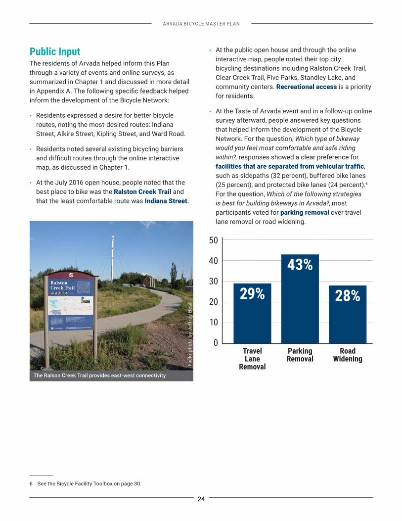
Public InputThe residents of Arvada helped inform this Plan through a variety of events and online surveys, as summarized in Chapter 1 and discussed in more detail
inform the development of the Bicycle Network:
• Residents expressed a desire for better bicycle routes, noting the most-desired routes: Indiana Street, Alkire Street, Kipling Street, and Ward Road.
• Residents noted several existing bicycling barriers
map, as discussed in Chapter 1.
• At the July 2016 open house, people noted that the best place to bike was the Ralston Creek Trail and that the least comfortable route was Indiana Street.
6 See the Bicycle Facility Toolbox on page 30.
• At the public open house and through the online interactive map, people noted their top city bicycling destinations including Ralston Creek Trail, Clear Creek Trail, Five Parks, Standley Lake, and community centers. Recreational access is a priority for residents.
• At the Taste of Arvada event and in a follow-up online survey afterward, people answered key questions that helped inform the development of the Bicycle Network. For the question, Which type of bikeway would you feel most comfortable and safe riding within?, responses showed a clear preference for
, such as sidepaths (32 percent), buffered bike lanes (25 percent), and protected bike lanes (24 percent).6 For the question, Which of the following strategies is best for building bikeways in Arvada?, most participants voted for parking removal over travel lane removal or road widening.
50
40
30
20
10
0
29%
43%
28%
Travel Lane
Removal
Parking Removal
Road Widening
The Ralson Creek Trail provides east-west connectivity
Flic
kr p
hoto
by
Jeff
rey
Beal
l
ARVADA BICYCLE MASTER PLAN
25
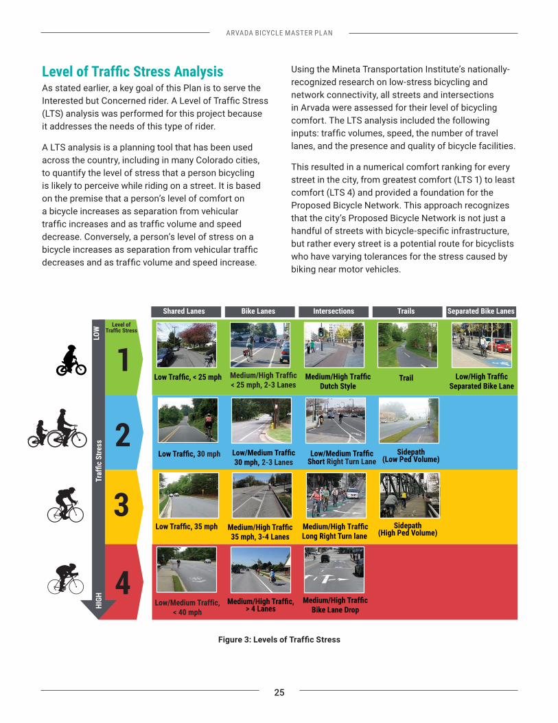
As stated earlier, a key goal of this Plan is to serve the
(LTS) analysis was performed for this project because it addresses the needs of this type of rider.
A LTS analysis is a planning tool that has been used across the country, including in many Colorado cities, to quantify the level of stress that a person bicycling is likely to perceive while riding on a street. It is based on the premise that a person’s level of comfort on a bicycle increases as separation from vehicular
decrease. Conversely, a person’s level of stress on a
Using the Mineta Transportation Institute’s nationally-recognized research on low-stress bicycling and network connectivity, all streets and intersections in Arvada were assessed for their level of bicycling comfort. The LTS analysis included the following
lanes, and the presence and quality of bicycle facilities.
This resulted in a numerical comfort ranking for every street in the city, from greatest comfort (LTS 1) to least comfort (LTS 4) and provided a foundation for the Proposed Bicycle Network. This approach recognizes that the city’s Proposed Bicycle Network is not just a
but rather every street is a potential route for bicyclists who have varying tolerances for the stress caused by biking near motor vehicles.
Level of
HIGH
LOW
Shared Lanes Bike Lanes Separated Bike LanesIntersections Trails
Separated Bike LaneTrail
Sidepath (Low Ped Volume)
Sidepath (High Ped Volume)
Dutch Style
Low/MeShort Right Turn Lane
Long Right Turn lane
Bike Lane Drop
0 mph
> 4 Lanes
2-3 Lanes
26
ARVADA BICYCLE MASTER PLAN
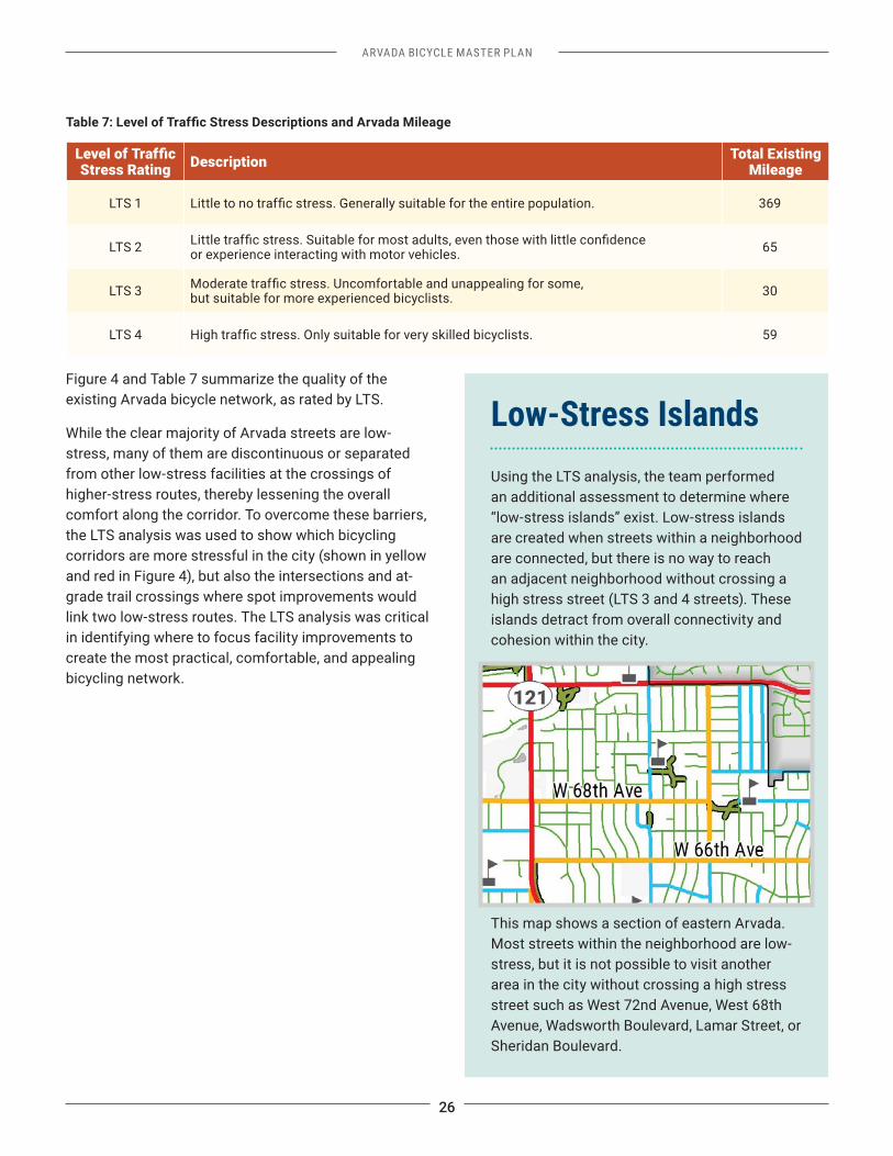
Stress Rating Description Total Existing Mileage
LTS 1 369
LTS 2 or experience interacting with motor vehicles. 65
LTS 3 but suitable for more experienced bicyclists. 30
LTS 4 59
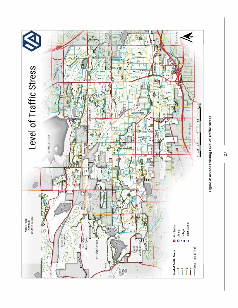
Figure 4 and Table 7 summarize the quality of the existing Arvada bicycle network, as rated by LTS.
While the clear majority of Arvada streets are low-stress, many of them are discontinuous or separated from other low-stress facilities at the crossings of higher-stress routes, thereby lessening the overall comfort along the corridor. To overcome these barriers, the LTS analysis was used to show which bicycling corridors are more stressful in the city (shown in yellow and red in Figure 4), but also the intersections and at-grade trail crossings where spot improvements would link two low-stress routes. The LTS analysis was critical in identifying where to focus facility improvements to create the most practical, comfortable, and appealing bicycling network.
Low-Stress Islands Using the LTS analysis, the team performed an additional assessment to determine where “low-stress islands” exist. Low-stress islands are created when streets within a neighborhood are connected, but there is no way to reach an adjacent neighborhood without crossing a high stress street (LTS 3 and 4 streets). These islands detract from overall connectivity and cohesion within the city.
This map shows a section of eastern Arvada. Most streets within the neighborhood are low-stress, but it is not possible to visit another area in the city without crossing a high stress street such as West 72nd Avenue, West 68th Avenue, Wadsworth Boulevard, Lamar Street, or Sheridan Boulevard.
27
28
ARVADA BICYCLE MASTER PLAN
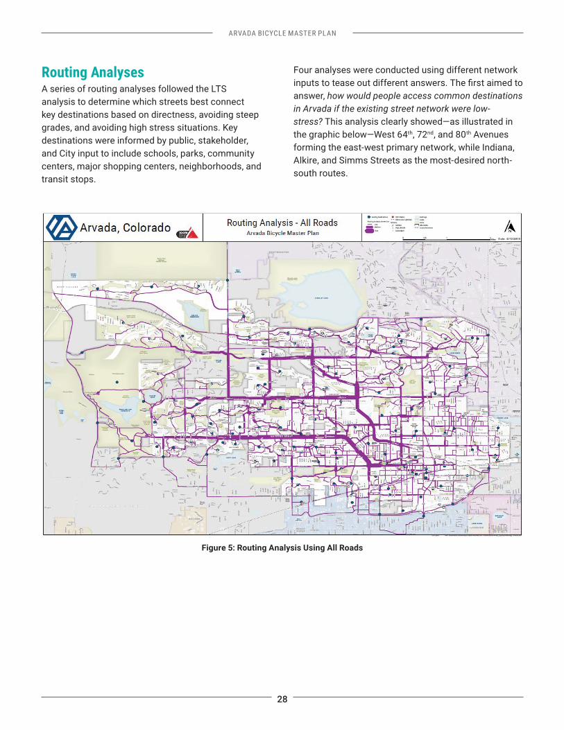
Routing Analyses A series of routing analyses followed the LTS analysis to determine which streets best connect key destinations based on directness, avoiding steep grades, and avoiding high stress situations. Key destinations were informed by public, stakeholder, and City input to include schools, parks, community centers, major shopping centers, neighborhoods, and transit stops.
Four analyses were conducted using different network
answer, how would people access common destinations in Arvada if the existing street network were low-stress? This analysis clearly showed—as illustrated in the graphic below—West 64th, 72nd, and 80th Avenues forming the east-west primary network, while Indiana, Alkire, and Simms Streets as the most-desired north-south routes.
Figure 5: Routing Analysis Using All Roads
ARVADA BICYCLE MASTER PLAN
29
Three subsequent iterations of the routing analysis were conducted to answer the following questions: 1. How do street grades affect route choice?
from occurring or induce a rider to seek an alternative route?
An analysis was performed that used all streets in Arvada but considered grades, such that steep inclines would either eliminate a trip from occurring or induce a rider to seek an alternative route. This analysis showed that a steep incline is unlikely to eliminate a trip from occurring, but it will encourage riders to choose a close, alternative route. The routing map from this analysis was very similar to the overall analysis (see Figure 5), where we see a similar preference for the Ralston Creek Trail and West 64th Avenue. However, the street grade analysis showed a higher preference for local streets that
the Proposed Network by providing bicycle facilities on local streets as an alternative for riders who are sensitive to steep grades.
2. How can bicyclists navigate the city using only existing low-stress streets (LTS 1 and 2)?
Using only low-stress streets constrains riders by reducing the effective bicycle network within the city. The greatest access is focused around the Ralston Creek Trail and through northeastern Arvada. This shows that even with an improvement to the high-stress intersections (see Spot Improvement Recommendations on page 35), the city would need a comprehensive bicycle network to attract the Interested but Concerned riders across the city.
3. How can bicyclists navigate the city using
passing through high-stress intersections?
Bicyclists will have very few options for accessing destinations across the city under these constraints. While the Ralston Creek Trail provides low-stress connections between many destinations in Arvada, connectivity hinges upon the availability of low-stress crossings. For instance, neighborhoods south of Standley Lake can more easily connect to
that affords bicyclists a low-stress crossing of 72nd Avenue. Just to the east, the offset crossing of Quail Street and Pierson Street prevents bicyclists from the Harvest neighborhood having access to the trail.
The combination of these inputs—existing conditions analysis, already-planned facilities such as trails, public and stakeholder feedback, LTS analysis, and the routing analyses—helped create a bicycle facility study network for which facility recommendations were developed.
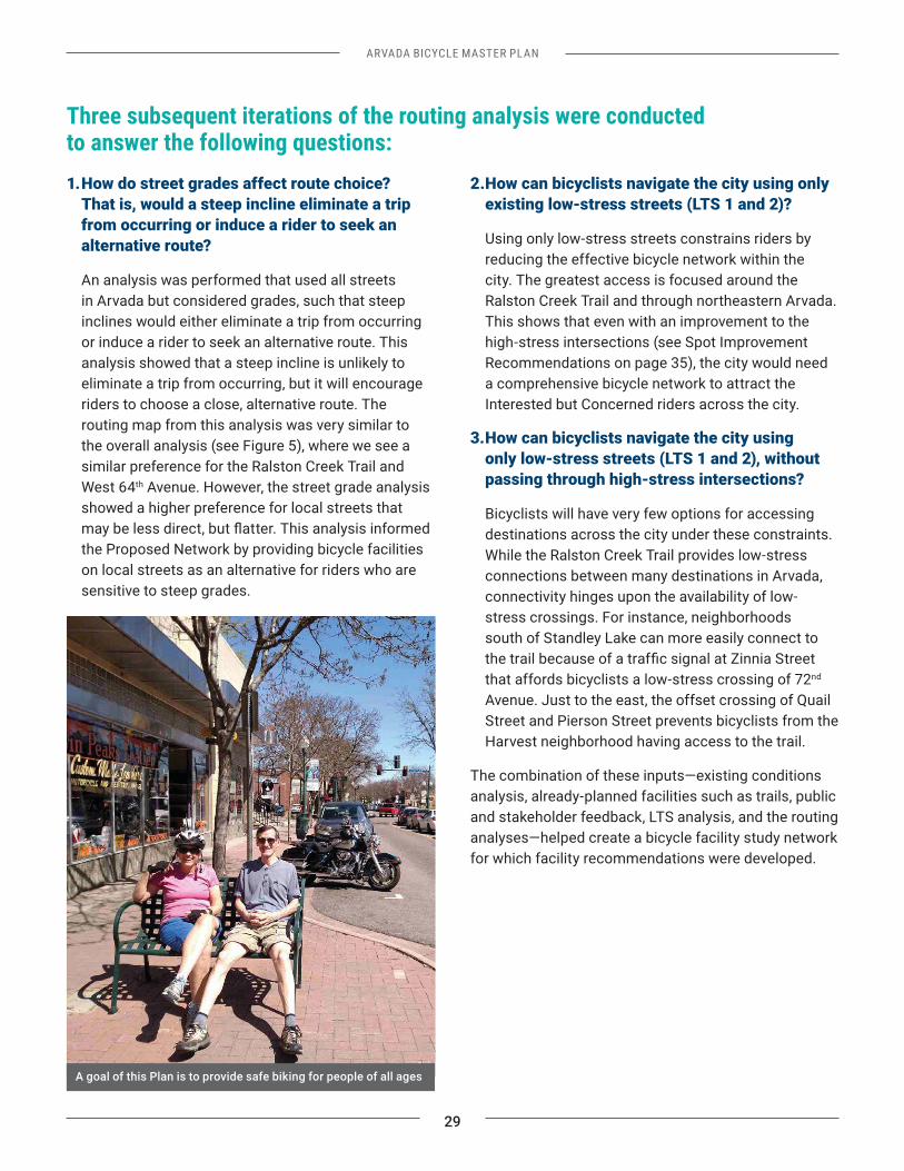
A goal of this Plan is to provide safe biking for people of all ages
30
ARVADA BICYCLE MASTER PLAN
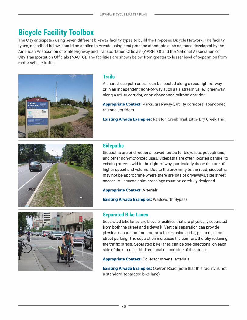
Bicycle Facility ToolboxThe City anticipates using seven different bikeway facility types to build the Proposed Bicycle Network. The facility types, described below, should be applied in Arvada using best practice standards such as those developed by the
SidepathsSidepaths are bi-directional paved routes for bicyclists, pedestrians, and other non-motorized uses. Sidepaths are often located parallel to existing streets within the right-of-way, particularly those that are of higher speed and volume. Due to the proximity to the road, sidepaths may not be appropriate where there are lots of driveways/side street access. All access point crossings must be carefully designed.
Appropriate Context: Arterials
Existing Arvada Examples: Wadsworth Bypass
Separated Bike LanesSeparated bike lanes are bicycle facilities that are physically separated from both the street and sidewalk. Vertical separation can provide physical separation from motor vehicles using curbs, planters, or on-street parking. The separation increases the comfort, thereby reducing
side of the street, or bi-directional on one side of the street.
Appropriate Context: Collector streets, arterials
Existing Arvada Examples: Oberon Road (note that this facility is not a standard separated bike lane)
TrailsA shared-use path or trail can be located along a road right-of-way or in an independent right-of-way such as a stream valley, greenway, along a utility corridor, or an abandoned railroad corridor.
Appropriate Context: Parks, greenways, utility corridors, abandoned railroad corridors
Existing Arvada Examples: Ralston Creek Trail, Little Dry Creek Trail
ARVADA BICYCLE MASTER PLAN
31
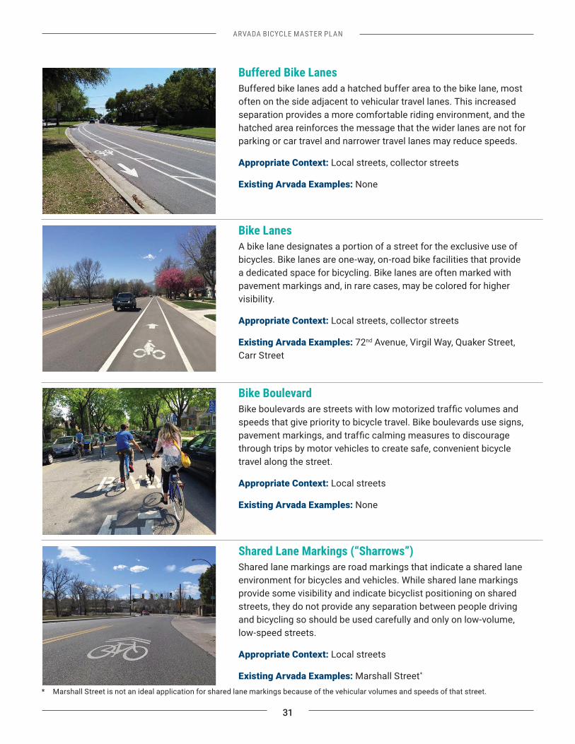
Bike LanesA bike lane designates a portion of a street for the exclusive use of bicycles. Bike lanes are one-way, on-road bike facilities that provide a dedicated space for bicycling. Bike lanes are often marked with pavement markings and, in rare cases, may be colored for higher visibility.
Appropriate Context: Local streets, collector streets
Existing Arvada Examples: 72nd Avenue, Virgil Way, Quaker Street, Carr Street
Bike Boulevard
speeds that give priority to bicycle travel. Bike boulevards use signs,
through trips by motor vehicles to create safe, convenient bicycle travel along the street.
Appropriate Context: Local streets
Existing Arvada Examples: None
Shared Lane Markings (“Sharrows”)Shared lane markings are road markings that indicate a shared lane environment for bicycles and vehicles. While shared lane markings provide some visibility and indicate bicyclist positioning on shared streets, they do not provide any separation between people driving and bicycling so should be used carefully and only on low-volume, low-speed streets.
Appropriate Context: Local streets
Existing Arvada Examples: Marshall Street*
Buffered Bike LanesBuffered bike lanes add a hatched buffer area to the bike lane, most often on the side adjacent to vehicular travel lanes. This increased separation provides a more comfortable riding environment, and the hatched area reinforces the message that the wider lanes are not for parking or car travel and narrower travel lanes may reduce speeds.
Appropriate Context: Local streets, collector streets
Existing Arvada Examples: None
* Marshall Street is not an ideal application for shared lane markings because of the vehicular volumes and speeds of that street.
32
ARVADA BICYCLE MASTER PLAN
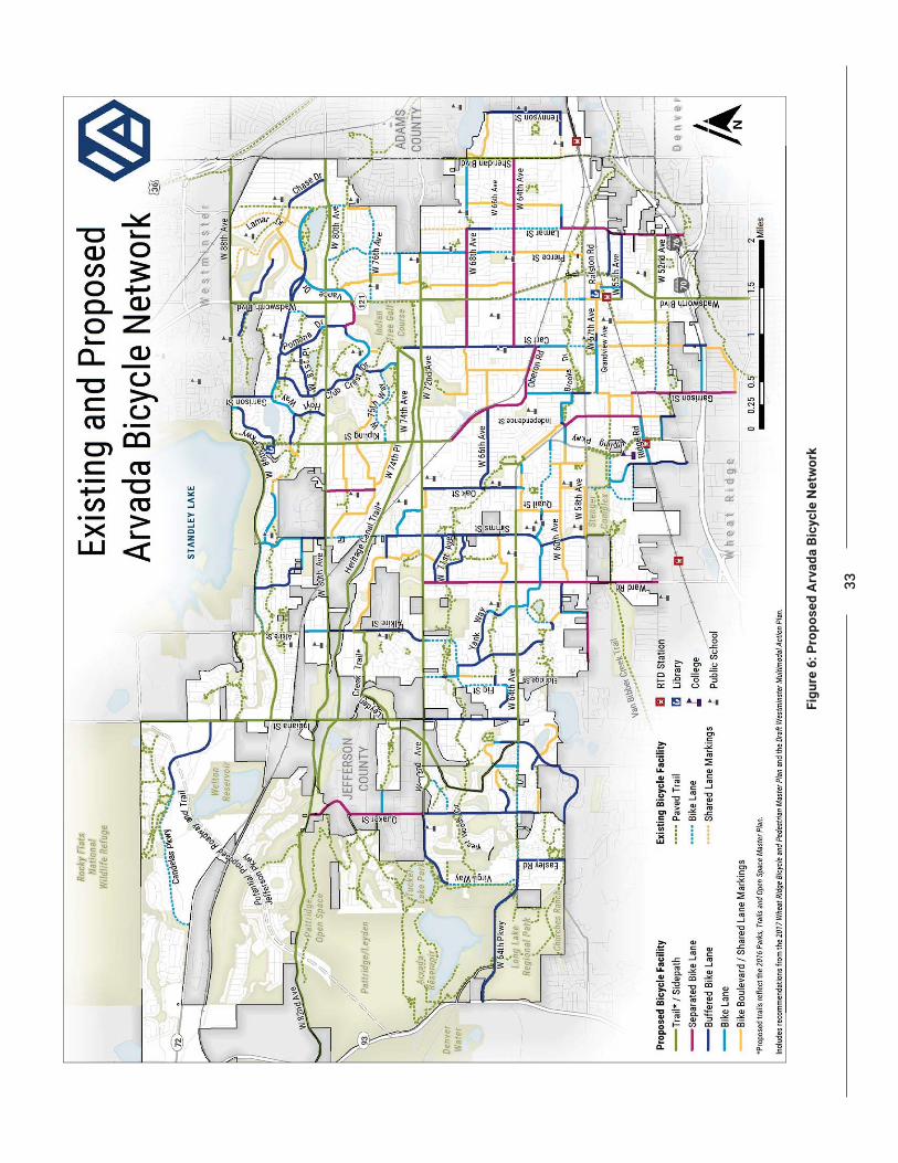
Proposed Bicycle NetworkThe Proposed Arvada Bicycle Network is a 271-mile network consisting of 170 miles of on-street facilities, 102 miles of paved trails, and 30 miles of unpaved trails. This network capitalizes on existing and planned trails, and includes local streets, collector streets, and select arterial streets. The construction of these facilities will create a comprehensive, connected, and comfortable bicycle system in Arvada to link trails, schools, transit, neighborhoods including Olde Town, and adjacent jurisdictions. The Proposed Bicycle Network includes the following:
• Sidepaths or separated bike lanes on many of the arterials in Arvada, with an emphasis on connecting major destinations
• Buffered bike lanes and conventional bike lanes on local, collector, and lower-speed arterial streets
•
that are already bicycle friendly, and shared lane markings for short low-speed segments where a connection is needed
• Intersection improvements to be implemented through best practice design
The following actions are recommended to build the Proposed Bicycle Network in Arvada:
3.01 Implement the Proposed Trail NetworkThe 2016 Trails, Parks and Open Space Master Plan
network of paved trails. This trail system—both existing and proposed—provides the most loved and lowest-stress bicycle routes in Arvada. The City should continue to construct this network, looking for ways to coordinate projects between the trails plan and the Proposed Bicycle Network.
3.02 Implement Better North-South ConnectionsThe proposed network recommends low-stress bicycle facilities on key north-south routes such as Indiana Street, Ward Road, Garrison Street, Carr Street, Simms Street, Wadsworth Boulevard, Harlan Street, and Marshall St, among others. These routes establish on- and off-street connections to the trail network and park system while also providing low-stress links between neighborhoods. Without these pillars of low-stress bicycling in Arvada, bicycling will remain disconnected and inaccessible for people of all ages and riding abilities.
3.03 Implement Separated FacilitiesSome of the most direct routes in Arvada follow arterial streets. Applying low-stress design principles and acknowledging Arvada citizens’ preference for riding on a facility with separation from motor vehicles, this Plan proposes 33 miles of sidepaths and 13 miles of separated bike lanes on key corridors throughout the city. These corridors include Indiana Street, Kipling Street, Lamar Street, Sheridan Boulevard, West 64th Avenue, West 72nd Avenue, West 80th Avenue, and West 86th Parkway. The design of these facilities will vary from street to street. Depending on the existing street
than separated bike lanes, typically not requiring street
separated bike lanes and sidepaths, the City should pay special attention to intersection design to ensure
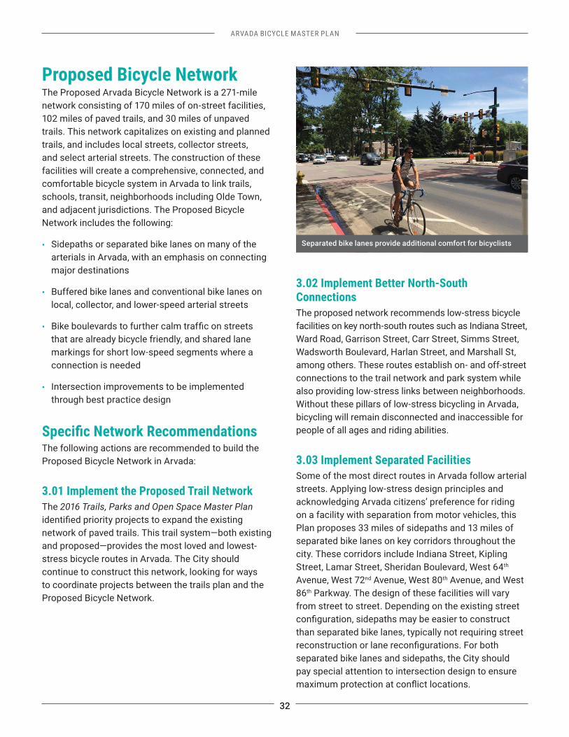
Separated bike lanes provide additional comfort for bicyclists
33
Fig
ure
6: P
ropo
sed
Arv
ada
Bicy
cle
Net
wor
k
34
ARVADA BICYCLE MASTER PLAN
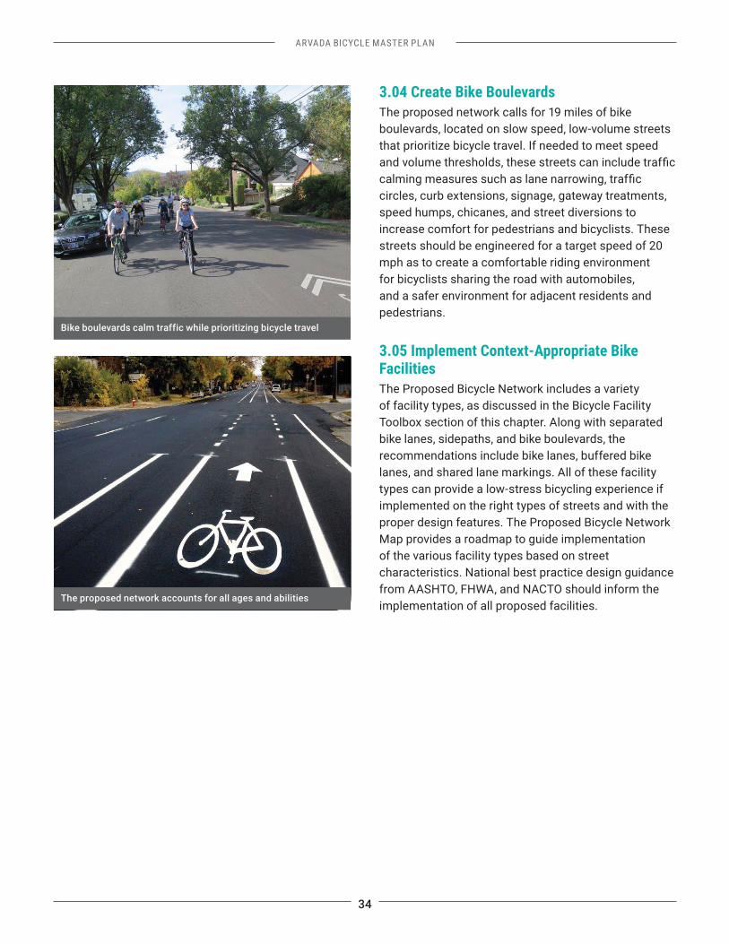
3.04 Create Bike BoulevardsThe proposed network calls for 19 miles of bike boulevards, located on slow speed, low-volume streets that prioritize bicycle travel. If needed to meet speed
circles, curb extensions, signage, gateway treatments, speed humps, chicanes, and street diversions to increase comfort for pedestrians and bicyclists. These streets should be engineered for a target speed of 20 mph as to create a comfortable riding environment for bicyclists sharing the road with automobiles, and a safer environment for adjacent residents and pedestrians.
3.05 Implement Context-Appropriate Bike FacilitiesThe Proposed Bicycle Network includes a variety of facility types, as discussed in the Bicycle Facility Toolbox section of this chapter. Along with separated bike lanes, sidepaths, and bike boulevards, the recommendations include bike lanes, buffered bike lanes, and shared lane markings. All of these facility types can provide a low-stress bicycling experience if implemented on the right types of streets and with the proper design features. The Proposed Bicycle Network Map provides a roadmap to guide implementation of the various facility types based on street characteristics. National best practice design guidance from AASHTO, FHWA, and NACTO should inform the implementation of all proposed facilities.
The proposed network accounts for all ages and abilities
Bike boulevards calm traffic while prioritizing bicycle travel
ARVADA BICYCLE MASTER PLAN
35
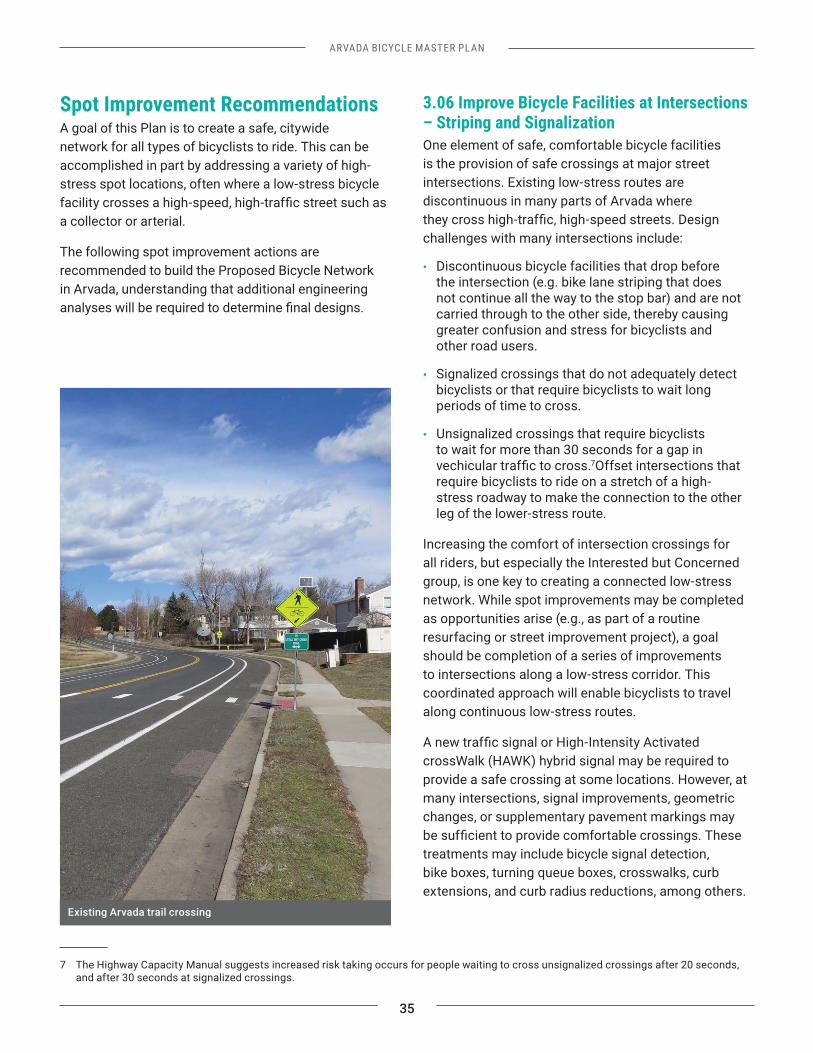
Spot Improvement Recommendations A goal of this Plan is to create a safe, citywide network for all types of bicyclists to ride. This can be accomplished in part by addressing a variety of high-stress spot locations, often where a low-stress bicycle
a collector or arterial.
The following spot improvement actions are recommended to build the Proposed Bicycle Network in Arvada, understanding that additional engineering
7 The Highway Capacity Manual suggests increased risk taking occurs for people waiting to cross unsignalized crossings after 20 seconds, and after 30 seconds at signalized crossings.
3.06 Improve Bicycle Facilities at Intersections – Striping and SignalizationOne element of safe, comfortable bicycle facilities is the provision of safe crossings at major street intersections. Existing low-stress routes are discontinuous in many parts of Arvada where
challenges with many intersections include:
• Discontinuous bicycle facilities that drop before the intersection (e.g. bike lane striping that does not continue all the way to the stop bar) and are not carried through to the other side, thereby causing greater confusion and stress for bicyclists and other road users.
• Signalized crossings that do not adequately detect bicyclists or that require bicyclists to wait long periods of time to cross.
• Unsignalized crossings that require bicyclists to wait for more than 30 seconds for a gap in
7Offset intersections that require bicyclists to ride on a stretch of a high-stress roadway to make the connection to the other leg of the lower-stress route.
Increasing the comfort of intersection crossings for all riders, but especially the Interested but Concerned group, is one key to creating a connected low-stress network. While spot improvements may be completed as opportunities arise (e.g., as part of a routine resurfacing or street improvement project), a goal should be completion of a series of improvements to intersections along a low-stress corridor. This coordinated approach will enable bicyclists to travel along continuous low-stress routes.
crossWalk (HAWK) hybrid signal may be required to provide a safe crossing at some locations. However, at many intersections, signal improvements, geometric changes, or supplementary pavement markings may
treatments may include bicycle signal detection, bike boxes, turning queue boxes, crosswalks, curb extensions, and curb radius reductions, among others.
Existing Arvada trail crossing
36
ARVADA BICYCLE MASTER PLAN
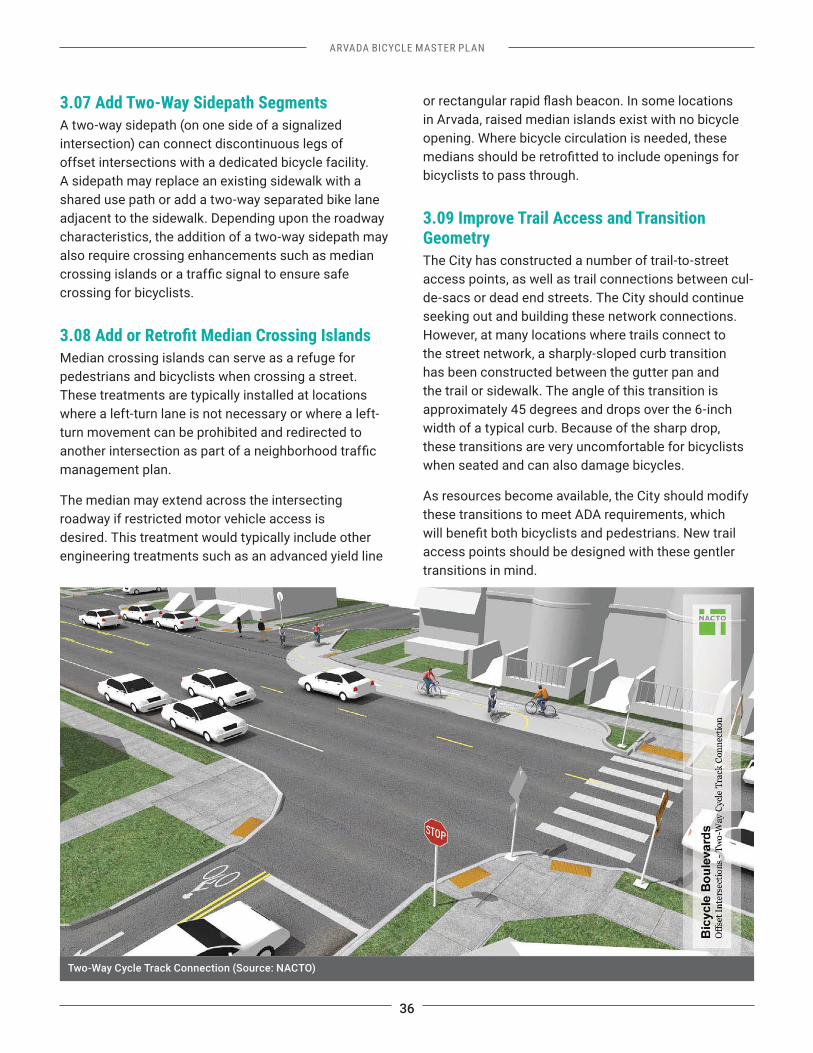
3.07 Add Two-Way Sidepath SegmentsA two-way sidepath (on one side of a signalized intersection) can connect discontinuous legs of offset intersections with a dedicated bicycle facility. A sidepath may replace an existing sidewalk with a shared use path or add a two-way separated bike lane adjacent to the sidewalk. Depending upon the roadway characteristics, the addition of a two-way sidepath may also require crossing enhancements such as median
crossing for bicyclists.
Median crossing islands can serve as a refuge for pedestrians and bicyclists when crossing a street. These treatments are typically installed at locations where a left-turn lane is not necessary or where a left-turn movement can be prohibited and redirected to
management plan.
The median may extend across the intersecting roadway if restricted motor vehicle access is desired. This treatment would typically include other engineering treatments such as an advanced yield line
in Arvada, raised median islands exist with no bicycle opening. Where bicycle circulation is needed, these
bicyclists to pass through.
3.09 Improve Trail Access and Transition GeometryThe City has constructed a number of trail-to-street access points, as well as trail connections between cul-de-sacs or dead end streets. The City should continue seeking out and building these network connections.However, at many locations where trails connect to the street network, a sharply-sloped curb transition has been constructed between the gutter pan and the trail or sidewalk. The angle of this transition is approximately 45 degrees and drops over the 6-inch width of a typical curb. Because of the sharp drop, these transitions are very uncomfortable for bicyclists when seated and can also damage bicycles.
As resources become available, the City should modify these transitions to meet ADA requirements, which
access points should be designed with these gentler transitions in mind.
Two-Way Cycle Track Connection (Source: NACTO)
ARVADA BICYCLE MASTER PLAN
37
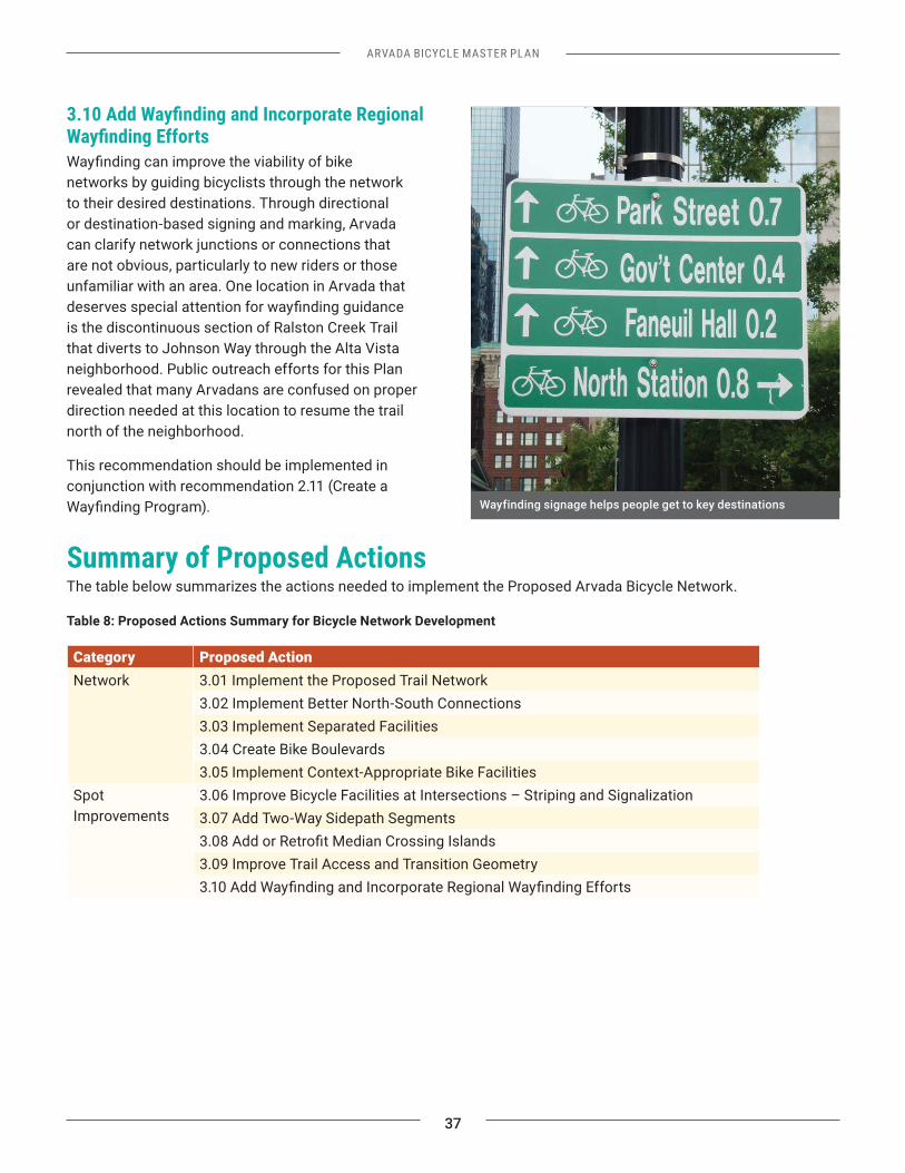
networks by guiding bicyclists through the network to their desired destinations. Through directional or destination-based signing and marking, Arvada can clarify network junctions or connections that are not obvious, particularly to new riders or those unfamiliar with an area. One location in Arvada that
is the discontinuous section of Ralston Creek Trail that diverts to Johnson Way through the Alta Vista neighborhood. Public outreach efforts for this Plan revealed that many Arvadans are confused on proper direction needed at this location to resume the trail north of the neighborhood.
This recommendation should be implemented in conjunction with recommendation 2.11 (Create a
Summary of Proposed ActionsThe table below summarizes the actions needed to implement the Proposed Arvada Bicycle Network.
Table 8: Proposed Actions Summary for Bicycle Network Development
Category Proposed ActionNetwork 3.01 Implement the Proposed Trail Network
3.02 Implement Better North-South Connections3.03 Implement Separated Facilities3.04 Create Bike Boulevards3.05 Implement Context-Appropriate Bike Facilities
Spot Improvements
3.06 Improve Bicycle Facilities at Intersections – Striping and Signalization3.07 Add Two-Way Sidepath Segments
3.09 Improve Trail Access and Transition Geometry
Wayfinding signage helps people get to key destinations
OLDE TOWN ARVADA BICYCLE PLAN
CHAPTER 4
ARVADA BICYCLE MASTER PLAN
39
Chapter 4: Olde Town Arvada Bicycle Plan
8 City of Arvada City Council Agenda. June 2016. Accessed Apr. 11, 2017.
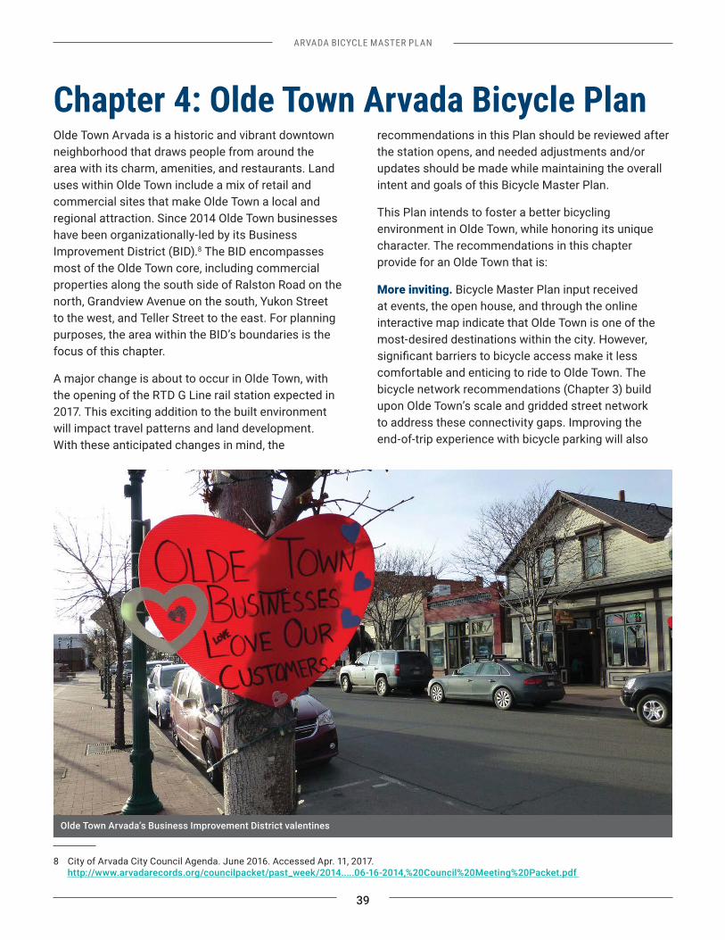
Olde Town Arvada is a historic and vibrant downtown neighborhood that draws people from around the area with its charm, amenities, and restaurants. Land uses within Olde Town include a mix of retail and commercial sites that make Olde Town a local and regional attraction. Since 2014 Olde Town businesses have been organizationally-led by its Business Improvement District (BID).8 The BID encompasses most of the Olde Town core, including commercial properties along the south side of Ralston Road on the north, Grandview Avenue on the south, Yukon Street to the west, and Teller Street to the east. For planning purposes, the area within the BID’s boundaries is the focus of this chapter.
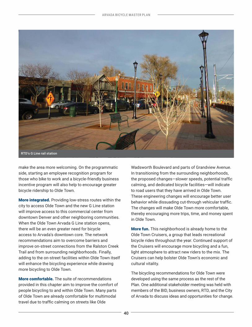
A major change is about to occur in Olde Town, with the opening of the RTD G Line rail station expected in 2017. This exciting addition to the built environment will impact travel patterns and land development. With these anticipated changes in mind, the
recommendations in this Plan should be reviewed after the station opens, and needed adjustments and/or updates should be made while maintaining the overall intent and goals of this Bicycle Master Plan.
This Plan intends to foster a better bicycling environment in Olde Town, while honoring its unique character. The recommendations in this chapter provide for an Olde Town that is:
More inviting. Bicycle Master Plan input received at events, the open house, and through the online interactive map indicate that Olde Town is one of the most-desired destinations within the city. However,
comfortable and enticing to ride to Olde Town. The bicycle network recommendations (Chapter 3) build upon Olde Town’s scale and gridded street network to address these connectivity gaps. Improving the end-of-trip experience with bicycle parking will also
Olde Town Arvada’s Business Improvement District valentines
40
ARVADA BICYCLE MASTER PLAN
make the area more welcoming. On the programmatic side, starting an employee recognition program for those who bike to work and a bicycle-friendly business incentive program will also help to encourage greater bicycle ridership to Olde Town.
More integrated. Providing low-stress routes within the city to access Olde Town and the new G Line station will improve access to this commercial center from downtown Denver and other neighboring communities. When the Olde Town Arvada G Line station opens, there will be an even greater need for bicycle access to Arvada’s downtown core. The network recommendations aim to overcome barriers and improve on-street connections from the Ralston Creek Trail and from surrounding neighborhoods. Finally, adding to the on-street facilities within Olde Town itself will enhance the bicycling experience while drawing more bicycling to Olde Town.
More comfortable. The suite of recommendations provided in this chapter aim to improve the comfort of people bicycling to and within Olde Town. Many parts of Olde Town are already comfortable for multimodal
Wadsworth Boulevard and parts of Grandview Avenue. In transitioning from the surrounding neighborhoods,
calming, and dedicated bicycle facilities—will indicate to road users that they have arrived in Olde Town. These engineering changes will encourage better user
The changes will make Olde Town more comfortable, thereby encouraging more trips, time, and money spent in Olde Town.
More fun. This neighborhood is already home to the Olde Town Cruisers, a group that leads recreational bicycle rides throughout the year. Continued support of the Cruisers will encourage more bicycling and a fun, light atmosphere to attract new riders to the mix. The Cruisers can help bolster Olde Town’s economic and cultural vitality.
The bicycling recommendations for Olde Town were developed using the same process as the rest of the Plan. One additional stakeholder meeting was held with members of the BID, business owners, RTD, and the City of Arvada to discuss ideas and opportunities for change.
RTD’s G Line rail station
ARVADA BICYCLE MASTER PLAN
41
Recommended Programs Building upon the recommendations presented in Chapter 2, the following programmatic recommendations are tailored to Olde Town to encourage greater bicycling to and within the area. These programs will maximize bicycle access, making it more convenient to bicycle to Olde Town, while building a more connected and comfortable bicycle network.9
Table 9: Olde Town Program Recommendations
Recommendation Description Responsibility Plan Goal(s) Addressed
4.01 Improve Bicycle Parking
Olde Town’s existing bicycle parking is well used in the summer and the BID has used the City’s bike corral for some of their events. The City should work more closely with the BID to review bike parking provisions of event applications to ensure that bike parking is provided. In addition, there should be greater education and awareness about the existing bike parking available in Olde Town. For example, the BID could develop simple stickers and signs
for bike parking. Additionally, the City should look for opportunities to add on-street bicycle corrals to convenient and visible locations on the edge of Olde Town, with visible signage, to encourage walking within Olde Town.
Public Works, Olde Town BID
Convenience
4.02 Continue Support of Olde Town Cruisers
The Olde Town Cruisers host recreational rides that begin and end in Olde Town with some business sponsorship, discounted drink and food specials, and in-kind support. The Olde Town businesses and BID should continue supporting the Cruisers to encourage greater participation.
Olde Town BID Convenience
4.03 Expand the Olde Town Bike to Work Day Station
The 2016 Bike to Work Day (BTWD) station was located near the Arvada Library. There, bike shop employees volunteered to hand out snacks and information about bicycling. The City and BID should continue their BTWD support, potentially expanding the number of stations in the area.
Olde Town BID, ABAC
Connected and Comfortable Network
4.04 Launch a Bicycle-Friendly Business Program
Bicycle-friendly businesses help to encourage more bicycling by providing bike parking, supporting riding, and offering rewards. Bicycle-friendly business programs offer opportunities to establish partnerships with local business to promote bicycle-friendly workplaces. The BID should explore the feasibility of creating a bicycle-friendly business program to support businesses that encourage bicycling by their employees and customers.
Olde Town BID, Arvada Chamber of Commerce
Connected and Comfortable Network
4.05 Develop an Employee Recognition Program
With 1,200 employees within the BID, an employee recognition program to incentivize and reward people who commute by foot, bike, or transit would reward active commutes while potentially alleviating some of the vehicular parking concerns in Olde Town.
Olde Town BID Connected and Comfortable Network
9 The City should look to cities like Denver, Seattle, Fort Collins, and Portland, Oregon for similar example programs.
42
ARVADA BICYCLE MASTER PLAN
Recommendation Description Responsibility Plan Goal(s) Addressed
4.06 Conduct Bicycle Parking Occupancy Counts
During warm months of the year when greater bicycle ridership is expected, Olde Town parking enforcement staff should complete bicycle rack occupancy counts to track bicycle parking usage and needs over time.
Public Works, potentially with ABAC, Olde Town BID
Convenience
4.07 Enhance Enforcement in Olde Town, potentially during peak times, to reinforce
modes of travel.
Police Department
Safety
4.08 Pursue Temporary Street Interventions
Temporary street interventions, also called tactical urbanism, can be a low-cost and low-commitment way to introduce new street design types to a community. They can also change people’s understanding of how street space is used. The Olde Town BID, ABAC, and other interested parties should pursue such interventions, such as parklets or pop-up demonstrations of bicycle or pedestrian treatments, and use these temporary events to promote this Plan’s recommendations.
Olde Town BID, ABAC
Connected and Comfortable Network
Seattle’s Bike Friendly Business Network Seattle’s Bike Friendly Business Network #SEAbikebiz includes businesses that support people who arrive by bicycle. The Business Network’s website includes an interactive map with every business that has made a commitment to their employees or customers. Bicycle route directions are included to each location, as well as an overview of their work in making the city better for bicycling. Businesses are encouraged to join for greater recognition, exposure, connection, and educational opportunities.
Source: commuteseattle.com
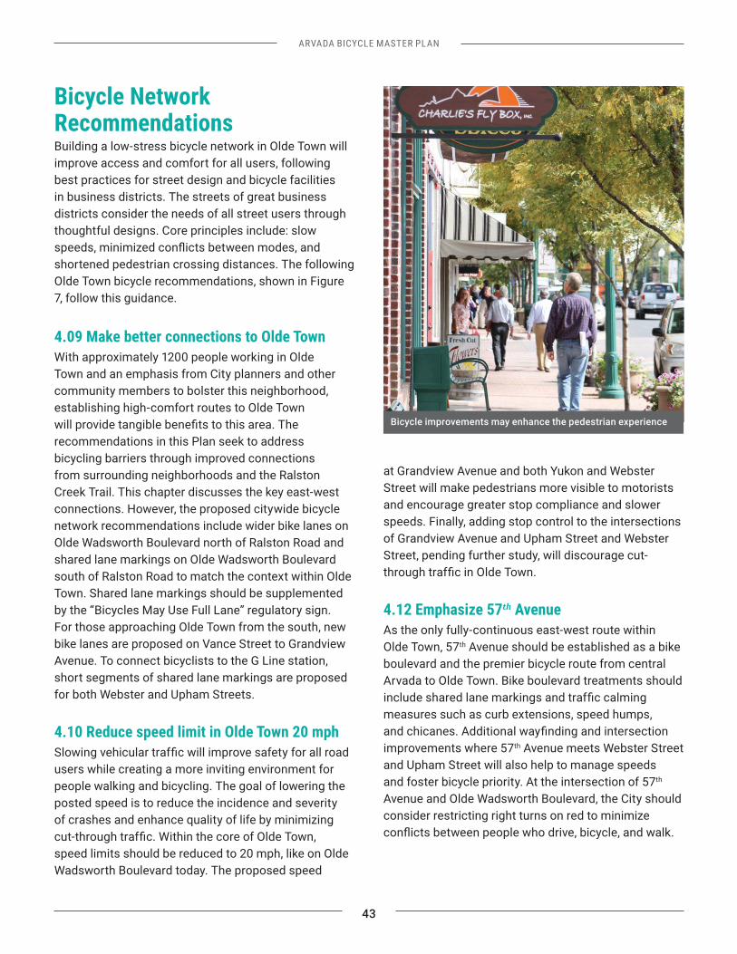
ARVADA BICYCLE MASTER PLAN
43
Bicycle Network RecommendationsBuilding a low-stress bicycle network in Olde Town will improve access and comfort for all users, following best practices for street design and bicycle facilities in business districts. The streets of great business districts consider the needs of all street users through thoughtful designs. Core principles include: slow
shortened pedestrian crossing distances. The following Olde Town bicycle recommendations, shown in Figure 7, follow this guidance.
4.09 Make better connections to Olde TownWith approximately 1200 people working in Olde Town and an emphasis from City planners and other community members to bolster this neighborhood, establishing high-comfort routes to Olde Town
recommendations in this Plan seek to address bicycling barriers through improved connections from surrounding neighborhoods and the Ralston Creek Trail. This chapter discusses the key east-west connections. However, the proposed citywide bicycle network recommendations include wider bike lanes on Olde Wadsworth Boulevard north of Ralston Road and shared lane markings on Olde Wadsworth Boulevard south of Ralston Road to match the context within Olde Town. Shared lane markings should be supplemented by the “Bicycles May Use Full Lane” regulatory sign. For those approaching Olde Town from the south, new bike lanes are proposed on Vance Street to Grandview Avenue. To connect bicyclists to the G Line station, short segments of shared lane markings are proposed for both Webster and Upham Streets.
4.10 Reduce speed limit in Olde Town 20 mph
users while creating a more inviting environment for people walking and bicycling. The goal of lowering the posted speed is to reduce the incidence and severity of crashes and enhance quality of life by minimizing
speed limits should be reduced to 20 mph, like on Olde Wadsworth Boulevard today. The proposed speed
limit is already supported by existing street designs. Finally, by posting additional speed limit signs, the City will communicate to those traveling in and through Olde Town that it is a unique place where safe travel behavior is expected.
to Grandview AvenueGrandview Avenue’s name hails from the clear view of the Rocky Mountains available along it. The new G Line station located on the south side of the Grandview Avenue anchors the street, while commercial and retail shops line the north side. The proposed treatments
Proposed shared lane markings will help achieve this end while adding pedestrian-focused treatments to the crossings of Grandview Avenue will also improve comfort along this key Olde Town street. For example, visibility enhancements, including raised intersections
at Grandview Avenue and both Yukon and Webster Street will make pedestrians more visible to motorists and encourage greater stop compliance and slower speeds. Finally, adding stop control to the intersections of Grandview Avenue and Upham Street and Webster Street, pending further study, will discourage cut-
4.12 Emphasize 57th AvenueAs the only fully-continuous east-west route within Olde Town, 57th Avenue should be established as a bike boulevard and the premier bicycle route from central Arvada to Olde Town. Bike boulevard treatments should
measures such as curb extensions, speed humps,
improvements where 57th Avenue meets Webster Street and Upham Street will also help to manage speeds and foster bicycle priority. At the intersection of 57th Avenue and Olde Wadsworth Boulevard, the City should consider restricting right turns on red to minimize
Bicycle improvements may enhance the pedestrian experience
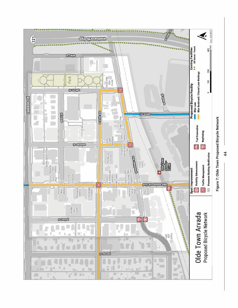
44
Figu
re 7
: Old
e To
wn
Prop
osed
Bic
ycle
Net
wor
k
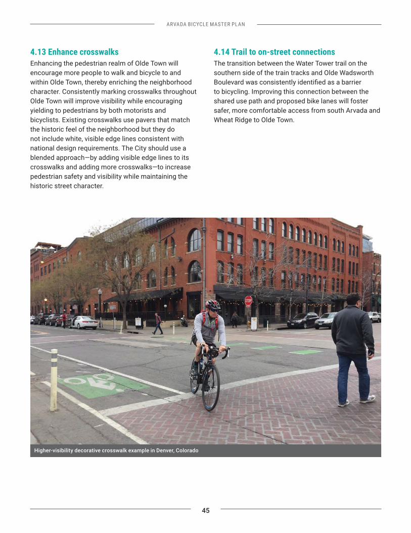
ARVADA BICYCLE MASTER PLAN
45
4.13 Enhance crosswalksEnhancing the pedestrian realm of Olde Town will encourage more people to walk and bicycle to and within Olde Town, thereby enriching the neighborhood character. Consistently marking crosswalks throughout Olde Town will improve visibility while encouraging yielding to pedestrians by both motorists and bicyclists. Existing crosswalks use pavers that match the historic feel of the neighborhood but they do not include white, visible edge lines consistent with national design requirements. The City should use a blended approach—by adding visible edge lines to its crosswalks and adding more crosswalks—to increase pedestrian safety and visibility while maintaining the historic street character.
4.14 Trail to on-street connectionsThe transition between the Water Tower trail on the southern side of the train tracks and Olde Wadsworth
to bicycling. Improving this connection between the shared use path and proposed bike lanes will foster safer, more comfortable access from south Arvada and Wheat Ridge to Olde Town.
Higher-visibility decorative crosswalk example in Denver, Colorado
46
ARVADA BICYCLE MASTER PLAN
Summary of Proposed ActionsTable 10 summarizes the actions needed to implement the programmatic and bicycle network recommendations for Olde Town.
Table 10: Proposed Actions Summary for Olde Town
Category Proposed ActionPrograms 4.01 Improve Bicycle Parking
4.02 Continue Support of Olde Town Cruisers4.03 Expand the Olde Town Bike to Work Day Station4.04 Launch a Bicycle-Friendly Business Program4.05 Develop an Employee Recognition Program4.06 Conduct Bicycle Parking Occupancy Counts4.07 Enhance Enforcement4.08 Pursue Temporary Street Interventions
Network and Spot Improvements
4.09 Make better connections to Olde Town4.10 Reduce speed limit in Olde Town to 20 mph
4.12 Emphasize 57th Avenue4.13 Enhance crosswalks4.14 Trail to on-street connections
THIS PAGE INTENTIONALLY LEFT BLANK
47
ARVADA BICYCLE MASTER PLAN
STRATEGY
CHAPTER 5
ARVADA BICYCLE MASTER PLAN
49
Chapter 5: Implementation Strategy
10 The ActiveTrans Priority Tool was developed by the National Cooperative Highway Research Program to help planners and engineers
process includes the selection of factors (e.g., safety, demand), factor weights, variables (e.g., speed, volume), and an assessment of existing data. This information is added to the prioritization tool to create a ranked list of projects.
The program, policy, and infrastructure recommendations in Chapters 2-4 provide strategies and actions that will help Arvada become a better place to bicycle. The implementation of these actions will necessarily occur over time commensurate with available resources and related opportunities. This chapter summarizes the implementation strategies to realize the City’s vision for a citywide bicycle network.
Implementation ApproachThe implementation approach for the Proposed Bicycle Network should be pragmatic, opportunistic, and consistent with the goals of this Bicycle Master Plan. To help focus the City’s resources, the Proposed Bicycle Network (presented in Chapter 3 and Figure 6) was further analyzed to develop priority project lists for the City as it completes in-house projects or pursues funding for larger projects. The implementation strategy was developed in three main steps:
1. The Proposed Bicycle Network was divided into discrete projects for implementation;
2. The projects were analyzed and evaluated using the NCHRP ActiveTrans Priority Tool10 and factors that are directly related to the Plan goals; and
3. The top 10 in-house and capital projects were summarized separately, and planning-level cost estimates were developed for each.
The implementation approach recognizes that on-street bicycle projects will be implemented in one of three primary ways:
1. signs, pavement markings, and potentially removing or consolidating on-street parking, especially moving all parking to one side of the street.
2. sidepath.
3. Reconstruction of a street.
Adopting this Plan does not commit the City to implementing the recommendations per the proposed prioritization, summarized in the following section. The approach to expanding Arvada’s bicycle network considers what is realistic given historic and anticipated funding, while also providing the
opportunities that may arise.
Recommended ProjectsThe Proposed Bicycle Network presented in Chapter 3 was divided into discrete, reasonable projects. This process resulted in 128 bicycle projects, shown in Figure 8. These projects were divided into two categories based on the project’s complexity: in-house projects and capital projects. Planning-level cost estimates were developed for these projects, as described in more detail later in this chapter. Additional details regarding project partitioning and prioritization, as well as a full list of projects, can be found in Appendix B.
50
Figu
re 8
: Rec
omm
ende
d Bi
cycl
e Pr
ojec
ts
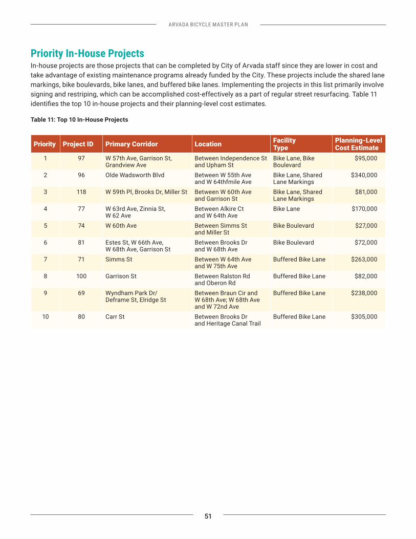
ARVADA BICYCLE MASTER PLAN
51
Priority In-House ProjectsIn-house projects are those projects that can be completed by City of Arvada staff since they are lower in cost and take advantage of existing maintenance programs already funded by the City. These projects include the shared lane markings, bike boulevards, bike lanes, and buffered bike lanes. Implementing the projects in this list primarily involve signing and restriping, which can be accomplished cost-effectively as a part of regular street resurfacing. Table 11
Table 11: Top 10 In-House Projects
Priority Project ID Primary Corridor Location Facility Type
Planning-Level Cost Estimate
1 97 W 57th Ave, Garrison St, Grandview Ave
Between Independence St and Upham St
Bike Lane, Bike Boulevard
$95,000
2 96 Olde Wadsworth Blvd Between W 55th Ave and W 64thfmile Ave
Bike Lane, Shared Lane Markings
$340,000
3 118 W 59th Pl, Brooks Dr, Miller St Between W 60th Ave and Garrison St
Bike Lane, Shared Lane Markings
$81,000
4 77 W 63rd Ave, Zinnia St, W 62 Ave
Between Alkire Ct Bike Lane $170,000
5 74 W 60th Ave Between Simms St and Miller St
Bike Boulevard $27,000
6 81 Estes St, W 66th Ave, Between Brooks Dr and W 68th Ave
Bike Boulevard $72,000
7 71 Simms St Between W 64th Ave and W 75th Ave
Buffered Bike Lane $263,000
8 100 Garrison St Between Ralston Rd and Oberon Rd
Buffered Bike Lane $82,000
9 69 Wyndham Park Dr/ Deframe St, Elridge St
Between Braun Cir and
and W 72nd Ave
Buffered Bike Lane $238,000
10 80 Carr St Between Brooks Dr and Heritage Canal Trail
Buffered Bike Lane $305,000
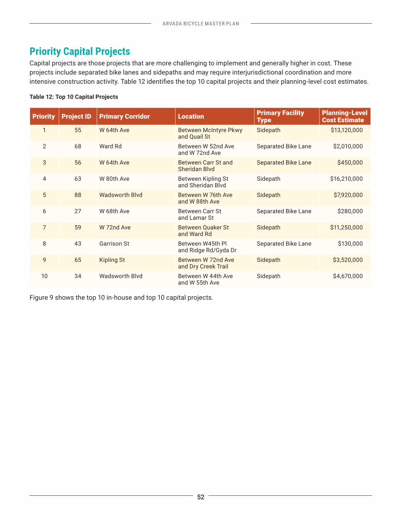
52
ARVADA BICYCLE MASTER PLAN
Priority Capital ProjectsCapital projects are those projects that are more challenging to implement and generally higher in cost. These projects include separated bike lanes and sidepaths and may require interjurisdictional coordination and more
Table 12: Top 10 Capital Projects
Priority Project ID Primary Corridor Location Primary Facility Type
Planning-Level Cost Estimate
1 55 W 64th Ave Between McIntyre Pkwy and Quail St
Sidepath $13,120,000
2 68 Ward Rd Between W 52nd Ave and W 72nd Ave
Separated Bike Lane $2,010,000
3 56 W 64th Ave Between Carr St and Sheridan Blvd
Separated Bike Lane $450,000
4 63 W 80th Ave Between Kipling St and Sheridan Blvd
Sidepath $16,210,000
5 88 Wadsworth Blvd Between W 76th Ave and W 88th Ave
Sidepath $7,920,000
6 27 W 68th Ave Between Carr St and Lamar St
Separated Bike Lane $280,000
7 59 W 72nd Ave Between Quaker St and Ward Rd
Sidepath $11,250,000
8 43 Garrison St Between W45th Pl and Ridge Rd/Gyda Dr
Separated Bike Lane $130,000
9 65 Kipling St Between W 72nd Ave and Dry Creek Trail
Sidepath $3,520,000
10 34 Wadsworth Blvd Between W 44th Ave and W 55th Ave
Sidepath $4,670,000
Figure 9 shows the top 10 in-house and top 10 capital projects.
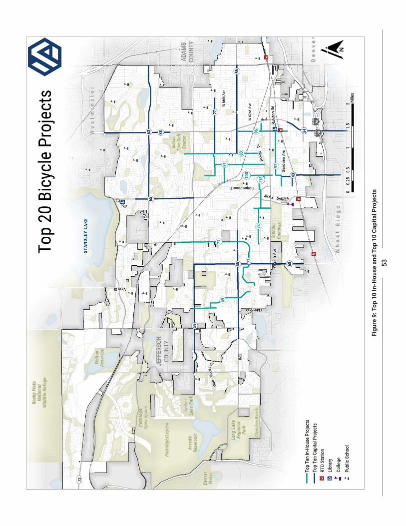
53Fi
gure
9: T
op 1
0 In
-Hou
se a
nd T
op 1
0 C
apita
l Pro
ject
s
54
ARVADA BICYCLE MASTER PLAN
InvestmentThe planning-level estimated cost for each of the priority projects is shown in Tables 11 and 12. The cost to build bicycle transportation projects can vary greatly depending on the type of facility and the existing conditions in the project area. For example, shared lane pavement markings and signing are relatively easy to install because existing infrastructure is generally not impacted; however, facilities that require relocating existing curb lines or pavement edges can impact the removal and replacement of curb and gutter, drainage infrastructure, utilities, and landscaping, thereby substantially increasing the cost of a project. Additional details on the development of the planning-level cost estimates can be found in Appendix B.
Funding OpportunitiesThe City has implemented the existing on-street bicycle network using street maintenance resources and dedicated funding granted by City Council. Similarly,
capital investment, sustained commitment from City Council, and the pursuit of other funding opportunities.
To implement the proposed bicycle network and recommended programs, Arvada should continue using its general fund to implement the proposed bicycle network. Where possible, general funds can be used to leverage regional, state, and federal funding. The City should also continue leveraging development-driven projects to implement portions of the bicycle network and/or ensure that end-of-trip facilities, such as bike parking, are available.
Arvada’s funding needs:
Bond Financing
provide funds for capital projects. Bond measures are
through the legislative process.
Impact Fees Impact fees are paid by property developers to fund a fraction of the improvements that are required because of the new growth. Impact fees can be instituted to fund bicycle projects, such as trails. Because fees are typically tied to trip generation rates and vehicular
establishing a clear nexus between the impact fee and the project’s impacts is critical. Impact fees may be considered at a citywide scale or for new developments within the city.
Stakeholders will be integral in implementing this Plan
ARVADA BICYCLE MASTER PLAN
55
Safe Routes to Schools (SRTS) This program provides funding for education, enforcement, evaluations, and infrastructure improvements near elementary and middle schools that promote students walking and bicycling to school. Currently, the SRTS program is administered by CDOT. The City and its partners can apply for infrastructure and non-infrastructure projects through a competitive application process.
Congestion Mitigation and Air Quality Improvement (CMAQ) Program The CMAQ program supports surface transportation projects, including active transportation projects, due to their linkage to air quality improvements. Because Arvada is within the larger Nonattainment and Maintenance Areas that are not in compliance with the National Ambient Air Quality Standards, projects that can improve air quality via incorporation of active transportation modes could be eligible for CMAQ funding.
Highway Safety Improvement Program (HSIP) HSIP is a state-run program with funds available for
and serious injuries. Bike lanes, roadway shoulders, crosswalks, intersection improvements, underpasses, and signs are examples of eligible projects. Projects in high-crash locations are most likely to receive funding.
Emphasis Areas and is therefore more likely to fund bicycle safety projects.
Colorado Parks and Wildlife (CPW) Trails Program CPW receives four types of grant funds which are distributed annually to successful trail grant applicants: Great Outdoors Colorado (GOCO) local government matching grants, GOCO state park matching grants, federal Recreational Trails Program (RTP) funds, and federal Land and Water Conservation Funds (LWCF). This is a state-run program.
Surface Transportation Block Grant (STBG) Program
municipalities for projects to preserve and improve the conditions and performance on a variety of projects. Related to bicycle transportation, the STBG fund can be used on bridge and tunnel projects on any public road and pedestrian and bicycle infrastructure. Eligibility includes bicycle transportation, recreational trails, and any activity eligible under the Set-Aside program (see below). In the Denver Region, DRCOG and CDOT control a share of the funds to distribute locally through a competitive process.
Surface Transportation Block Grant Program Set-Aside Funding through the Set-Aside can be used for the construction of sidewalks, walkways or curb ramps;
calming; off-road trails; bike and pedestrian bridges and underpasses; ADA compliance; acquisition of railroad rights-of-way; and planning, design and construction of multiuse trails and rail-with-trail projects. In the Denver Region, DRCOG controls a share of the funds to distribute locally through a competitive process.
The Kresge Foundation The Kresge Foundation provides grants for projects that improve health at the community level. The goal of these grants is to create a comprehensive system that improves health outcomes, promotes health equity, reduces per-capita health costs, removes barriers to health, and offers the greatest promise for adoption on a larger scale. Active transportation facilities may be competitive for this funding.
The Conservation FundThe Conservation Fund provides loans for land acquisition to support the creation of bicycle and
assistance to organizations aiming to protect key properties in their communities.
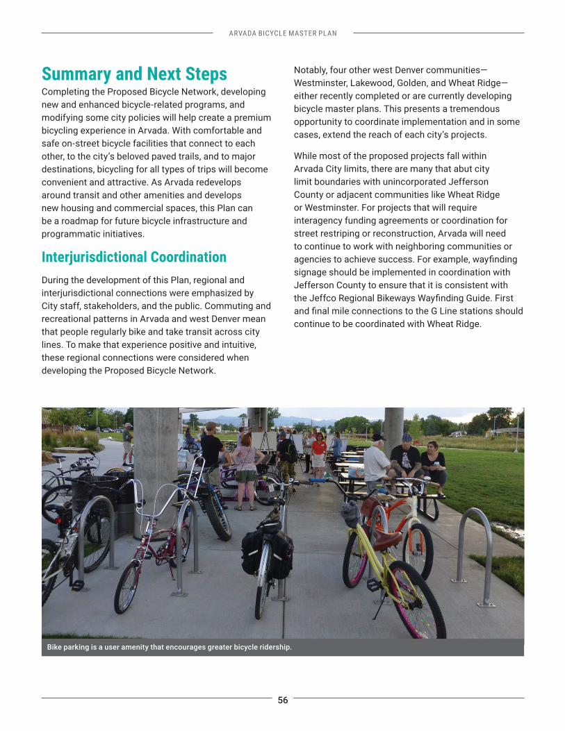
56
ARVADA BICYCLE MASTER PLAN
Summary and Next StepsCompleting the Proposed Bicycle Network, developing new and enhanced bicycle-related programs, and modifying some city policies will help create a premium bicycling experience in Arvada. With comfortable and safe on-street bicycle facilities that connect to each other, to the city’s beloved paved trails, and to major destinations, bicycling for all types of trips will become convenient and attractive. As Arvada redevelops around transit and other amenities and develops new housing and commercial spaces, this Plan can be a roadmap for future bicycle infrastructure and programmatic initiatives.
Interjurisdictional CoordinationDuring the development of this Plan, regional and interjurisdictional connections were emphasized by City staff, stakeholders, and the public. Commuting and recreational patterns in Arvada and west Denver mean that people regularly bike and take transit across city lines. To make that experience positive and intuitive, these regional connections were considered when developing the Proposed Bicycle Network.
Notably, four other west Denver communities—Westminster, Lakewood, Golden, and Wheat Ridge—either recently completed or are currently developing bicycle master plans. This presents a tremendous opportunity to coordinate implementation and in some cases, extend the reach of each city’s projects.
While most of the proposed projects fall within Arvada City limits, there are many that abut city limit boundaries with unincorporated Jefferson County or adjacent communities like Wheat Ridge or Westminster. For projects that will require interagency funding agreements or coordination for street restriping or reconstruction, Arvada will need to continue to work with neighboring communities or
signage should be implemented in coordination with Jefferson County to ensure that it is consistent with
continue to be coordinated with Wheat Ridge.
Bike parking is a user amenity that encourages greater bicycle ridership.

FINAL DRAFT