Embed Size (px)
Citation preview

DATS
If you are unable to attend this meeting please contact me. Liila Bagby, MPO Planner (217) 431-3453.
Announcement of a Meeting for the
DATS Technical Committee Danville Area Transportation Study
DATE: Thursday, June 2, 2016 TIME: 10:30 AM PLACE: Robert E. Jones Municipal Building (Danville City Hall)
Lower Level Council Chambers 17 W. Main St. Danville, IL 61832
AGENDA
I. Call to Order & Roll Call II. Approval of Agenda III. Approval of Minutes
a. Approval of Minutes from May 5, 2016 meeting IV. Public Comment Period V. New Business
a. Items of Information: i. Northern Illinois University Bike Map Update ii. FY 2016 Budget Line Item Transfers
b. Discussion & Vote: i. Wayfinding & Signage Plan Approval ii. Fiscal Year 2017 UPWP Approval iii. Fiscal Year 2017-2020 TIP Approval
VI. Old Business
a. Agency Reports i. Danville Mass Transit ii. City of Danville iii. Vermilion County iv. Townships (Danville, Newell, Georgetown, Catlin) v. Towns (Tilton, Georgetown, Westville, Catlin, Belgium) vi. CRIS vii. Vermilion Regional Airport viii. IDOT ix. FHWA/FTA
VII. Adjournment

DATS TECHNICAL COMMITTEE MINUTES May 5, 2016
A meeting of the Danville Area Transportation Study (DATS) Technical Committee was held on Thursday, May 5, 2016 at Danville City Hall, 17 W. Main St., Danville, IL. DATS Technical Committee Chairman Doug Staske called the meeting to order at 10:35 AM. I. Roll Call: MEMBERS IN ATTENDANCE: Doug Staske, Vermilion County Highway Robert Nelson, IDOT District 5 David Schnelle, City of Danville Proxy, Mitch Lankford Amy Marchant, CRIS Proxy, Les Woodrum Janet Payonk, Vermilion County Highway MEMBERS NOT PRESENT: Lisa Beith, DMT Mike Potter, Vermilion Regional Airport Jim Wilson, Newell Township Villages Representative
OTHERS IN ATTENDANCE: Jaclyn Vinson, DATS Director Liila Bagby, DATS Brian Trygg, IDOT District 5 Tom Caldwell, IDOT OP &P Betsy Tracy, FHWA II. Approval of Agenda Motion to approve the agenda made by Robert Nelson and
seconded by Janet Payonk. a. Voice vote: Yea 5 Nay 0 Absent 4 Abstain 0
III. Approval of Minutes from Technical Committee Meeting of April 7, 2016. Motion to
approve the meeting minutes made by David Schnelle and seconded by Janet Payonk. a. Voice vote: Yea 5 Nay 0 Absent 4 Abstain 0
IV. Public Comment Period
No public present. V. New Business
a. Items of information: i. Wayfinding and Signage Study Update- Liila Bagby updated the Committee
on the Wayfinding Project. The Consultant, Corbin Design visited in March, during which time we held the first public review of the proposed design concepts. Additionally, during their site visit Corbin toured the Danville area and mapped out specific locations for each sign type. The project is moving ahead on schedule; we should have a final design and master plan document by May 31, 2016.
ii. Review of NIU Bicycle Map Draft- MPO staff has been working with cartographers from NIU over the last year on updating the Regional Bicycle

2
Map. MPO Staff presented the draft map for review by the Technical Committee. The back of the map will be reconfigured to highlight the link between the bicycle system and the mass transit system. The terminus of the Kickapoo Rail Trail is included on the map; however, MPO Staff will talk with the KRT team to see how they would like their information presented.
iii. MPO Update: 1. Director Vinson contacted other MPO Directors to inquire about protocol
surrounding requests for increases in STU funding. 3 MPO’s responded, with a consistency in bringing the project back to the committee’s for vote on the requests.
2. TIP and UPWP are currently out on their 30-day public review period. 3. This will be Director Vinson’s final meeting with the MPO.
b. Discussion and Vote: i. Support for CRIS grant submission for Section 5339 funding
1. The Section 5339 funds will be requested to purchase 5 new buses. It is a very competitive funding process, and CRIS requested that the MPO formally vote on the Letter of Support. These funds will cover transit that begins in the urban area and continues out throughout the county.
2. A motion was made by Janet Payonk to approve the MPO’s support for the Section 5339 Grant and seconded by Robert Nelson.
3. Voice Vote: Yea 5 Nay 0 Absent 4 Abstain 0 VI. Old Business
a. Agency Reports i. Danville Mass Transit
1. No report. ii. City of Danville
1. No report. iii. Vermilion County
1. Will be having a busy construction season in 2016. iv. Townships (Danville, Newell, Georgetown, Catlin) –
1. No report. v. Towns (Tilton, Georgetown, Westville, Catlin, Belgium)- No report vi. CRIS
1. Quite busy around the office. vii. IDOT
1. I-74 shoulder work began on May 2, 2016. 2. US 136 east to Lick Creek is set to begin on May 10, 2016 3. 1200 North Road surface treatment will be on the June letting 4. CUUATS has been working with IDOT to develop an app to trace
bicyclist routes and rides within the State. BikeMovesIllinois. viii. Airport
1. No report. ix. FHWA-
1. No report
VII. Adjournment
a. Motion to adjourn made by Doug Staske and seconded by Janet Payonk.

3
b. Meeting adjourned by DATS Technical Committee Chairman Doug Staske at 11:15 am.

Fiscal Year 16- Budget before Line Item Transfers
A. Revenues:
FUND AMOUNT FUND SOURCE
$149,372 PL
$26,310 FTA
$43,920 STATE METRO
$0 LOCAL
$219,602 TOTAL
B. Expenses
PERSONNEL TOTAL COST FUND SOURCE AMOUNTREQUIRED MATCH MATCH SOURCE
MPO Staff $135,297 PL $81,930 $20,482.50 STATE METRO / LOCAL
Director (80%) $52,692 FTA $26,310 $6,578 STATE METRO / LOCAL
Planner 1 (55%) $32,236
Support Staff $50,369
Oversight $20,052
GIS (25%) $17,302
Financial (10%) $5,015
Professional Intern(s) $8,000
CONTRACTUAL TOTAL COST FUND SOURCE AMOUNTREQUIRED MATCH MATCH SOURCE
Advertising $400 PL $320 $80 STATE METRO / LOCAL
Professional Services $61,530 PL $49,224 $12,306 STATE METRO / LOCAL
Dues $500 PL $400 $100 STATE METRO / LOCAL
Training $2,500 PL $2,000 $500 STATE METRO / LOCAL
Computer Services & Support $11,500 PL $9,200 $2,300 STATE METRO / LOCAL
Postage $275 PL $220 $55 STATE METRO / LOCAL
Other Contractual $1,000 PL $800 $200 STATE METRO / LOCAL
COMMODITIES TOTAL COST FUND SOURCE AMOUNTREQUIRED MATCH MATCH SOURCE
Publications $100 PL $80 $20 STATE METRO / LOCAL
Office Supplies $1,000 PL $800 $200 STATE METRO / LOCAL
Telephone $500 PL $400 $100 STATE METRO / LOCAL
CAPITAL OUTLAYS TOTAL COST FUND SOURCE AMOUNTREQUIRED MATCH MATCH SOURCE
Technology Upgrades $5,000 PL $4,000 $1,000 STATE METRO / LOCAL
EXHIBIT III: Line-Item Budget
Total Budget
$219,602
Personnel amounts reflect direct and non-direct expenses.
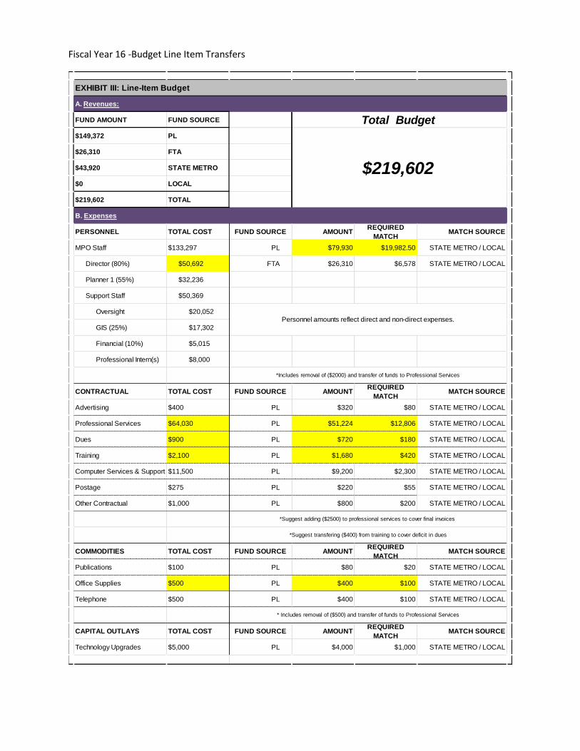
Fiscal Year 16 -Budget Line Item Transfers
A. Revenues:
FUND AMOUNT FUND SOURCE
$149,372 PL
$26,310 FTA
$43,920 STATE METRO
$0 LOCAL
$219,602 TOTAL
B. Expenses
PERSONNEL TOTAL COST FUND SOURCE AMOUNTREQUIRED
MATCHMATCH SOURCE
MPO Staff $133,297 PL $79,930 $19,982.50 STATE METRO / LOCAL
Director (80%) $50,692 FTA $26,310 $6,578 STATE METRO / LOCAL
Planner 1 (55%) $32,236
Support Staff $50,369
Oversight $20,052
GIS (25%) $17,302
Financial (10%) $5,015
Professional Intern(s) $8,000
CONTRACTUAL TOTAL COST FUND SOURCE AMOUNTREQUIRED
MATCHMATCH SOURCE
Advertising $400 PL $320 $80 STATE METRO / LOCAL
Professional Services $64,030 PL $51,224 $12,806 STATE METRO / LOCAL
Dues $900 PL $720 $180 STATE METRO / LOCAL
Training $2,100 PL $1,680 $420 STATE METRO / LOCAL
Computer Services & Support $11,500 PL $9,200 $2,300 STATE METRO / LOCAL
Postage $275 PL $220 $55 STATE METRO / LOCAL
Other Contractual $1,000 PL $800 $200 STATE METRO / LOCAL
COMMODITIES TOTAL COST FUND SOURCE AMOUNTREQUIRED
MATCHMATCH SOURCE
Publications $100 PL $80 $20 STATE METRO / LOCAL
Office Supplies $500 PL $400 $100 STATE METRO / LOCAL
Telephone $500 PL $400 $100 STATE METRO / LOCAL
CAPITAL OUTLAYS TOTAL COST FUND SOURCE AMOUNTREQUIRED
MATCHMATCH SOURCE
Technology Upgrades $5,000 PL $4,000 $1,000 STATE METRO / LOCAL
*Includes removal of ($2000) and transfer of funds to Professional Services
*Suggest adding ($2500) to professional services to cover final invoices
*Suggest transfering ($400) from training to cover deficit in dues
* Includes removal of ($500) and transfer of funds to Professional Services
EXHIBIT III: Line-Item Budget
Total Budget
$219,602
Personnel amounts reflect direct and non-direct expenses.

I L L I N O I SWAYFINDING TEAM
Corbin Design109 E. Front StreetTraverse City, MI 49684(P) 231.947.1236(F) 231.947.1477www.corbindesign.com
Jeff Frank, Senior [email protected]
Moira O'Polka, Project [email protected]
Margaret Paxhia-Poppaw, Junior [email protected]
City of DanvilleDanville, Illinois
WAYFINDING AND SIGNAGE PLAN
05/26/16 FINAL DOCUMENT

I L L I N O I S
Analysis and Recommendations 3
Graphics Standards 5
Sign Type Array 6
I-1 Main Gateway 7
I-2 Secondary Gateway 8
G-1 Large Vehicular Guide 9
G-2 Large Vehicular Trailblazer 10
G-3 Vehicular Guide, Non-district 11
G-3a, G-3b and G-3c Vehicular Guide, District Identification 12
G-4 Vehicular Trailblazer, Non-district 13
G-4a Vehicular Trailblazer, District Identification 14
G-5 Pedestrian Guide 15
G-5a Pedestrian Trailblazer 16
K-1a, K-1b and K-1c Pedestrian District Kiosk 17
District Identification Banners 18
P-1 Parking Identification 19
P-2 Parking Guide 20
I-3 Municipal Guide 21
I-4 Municipal Identification, Large 22
I-5 Municipal Identification, Medium 23
I-6 Municipal Identification, Small 24
Replacement IDOT Attractions Sign 25
Regional Sign Location Plan 26
Near Downtown Sign Location Plan 27
Sign Message Schedule 28
Phased Implementation Plan 40
TABLE OF CONTENTS
2
04.2016Wayfinding and Signage Plan

I L L I N O I S
A R R I V E
D E PA R T
P R E PA R E
L I S T E N
E N G A G E
S U P P O R T
Media/PR
Web Sites
Marketing Communications
Visitors Center
Event Information
Mobile Applications
Staff Education
Volunteer Training
DOT Signage
City/District Boundary
City/District Entry
Landmarks
Vehicular Direction
Parking Information
Building IdentificationVisitors Center
Pedestrian Kiosks
Pedestrian Direction
Destination Identification
Pedestrian Direction
Parking Info
Vehicular Direction
District/City Exits
Change Management
Signage Maintenance
Marketing Communications
Media/PR
Map Graphics
ADA Accessibility
Event Information
Amenities
L O G I C
L A N G U A G E
ELEMENTS OF SUCCESSFUL WAYFINDING
Repeat visitors will rely more on their own experience. The simplest route between two points may not be a straight line, particularly for a visitor who is unfamiliar with the city. Our goal is help design and direct that first experience, assuring a positive experience and future return visits.
Structure information
Tools designed to support a visitor’s journey must provide the proper information at key decision points to keep visitors moving toward their destination. The challenge, then, is to verbally and visually simplify the information in the system. Consistency is the key to success.
Support intuition
Wayfinding systems work best when they build upon routes that are intuitive to first-time visitors. Wayfinding cues should come as much as possible from the environment. Each destination is distinct and we will take advantage of the verbal and visual cues already familiar to most downtown residents. This way everyday people can help support consistent wayfinding if asked for directions.
Design the system for easy updating
The need to change a single message should not require the replacement of an entire sign structure.
The wayfinding signage system should support the following sequence of encounter to lead visitors to their desired destination:
• Announce a visitor’s arrival to Danville and again as they enter the districts with appropriate welcome signs or banners.
• Direct visitors to districts, primary destinations and parking with Vehicular Guide signs.
• Provide Pedestrian Kiosks at transition points where drivers become pedestrians and other key pedestrian decision points.
• Locate pedestrian guide signs to direct to areas with additional shopping and dining opportunities that may not be visible along primary pedestrian routes.
• Identify destinations, taking into account temporary event signage needs.
• Provide the visitor with directional information out of the district, and back to surrounding roads.
OVERVIEW OF WAYFINDING
Wayfinding is defined as “direction for people in motion.” It is unique among public “utilities” because it has an opportunity not only to move people through space to their intended destination, but also to carry brand elements and, by nature of its design, to integrate with the fabric of the streetscape and the local vernacular. We design terminology that defines and clarifies what’s true about Danville, and then develop tools that direct visitors, both in the built environment and across media.
The map below depicts each potential point of contact with a given visitor. We believe that in order for a wayfinding system to be most effective, the visitor must be able to create a picture of the physical environment “in their mind’s eye” prior to arrival. In this way, the signs in the environment reinforce what they already know about the area.
Communication across this continuum must be consistent. We know that a diverse audience uses many different resources to navigate an environment, so the verbal and visual landmarks expressed must be consistent across media. Web, broadcast,
print and signage elements will speak in the same voice as the visitor learns about Danville, makes a decision to visit, and engages in the visit itself.
Educated, empowered visitors feel confident and capable as they move toward their destination, and are made aware of other opportunities once the initial reason for their visit is accomplished.
3
04.2016Analysis and Recommendations
I L L I N O I S
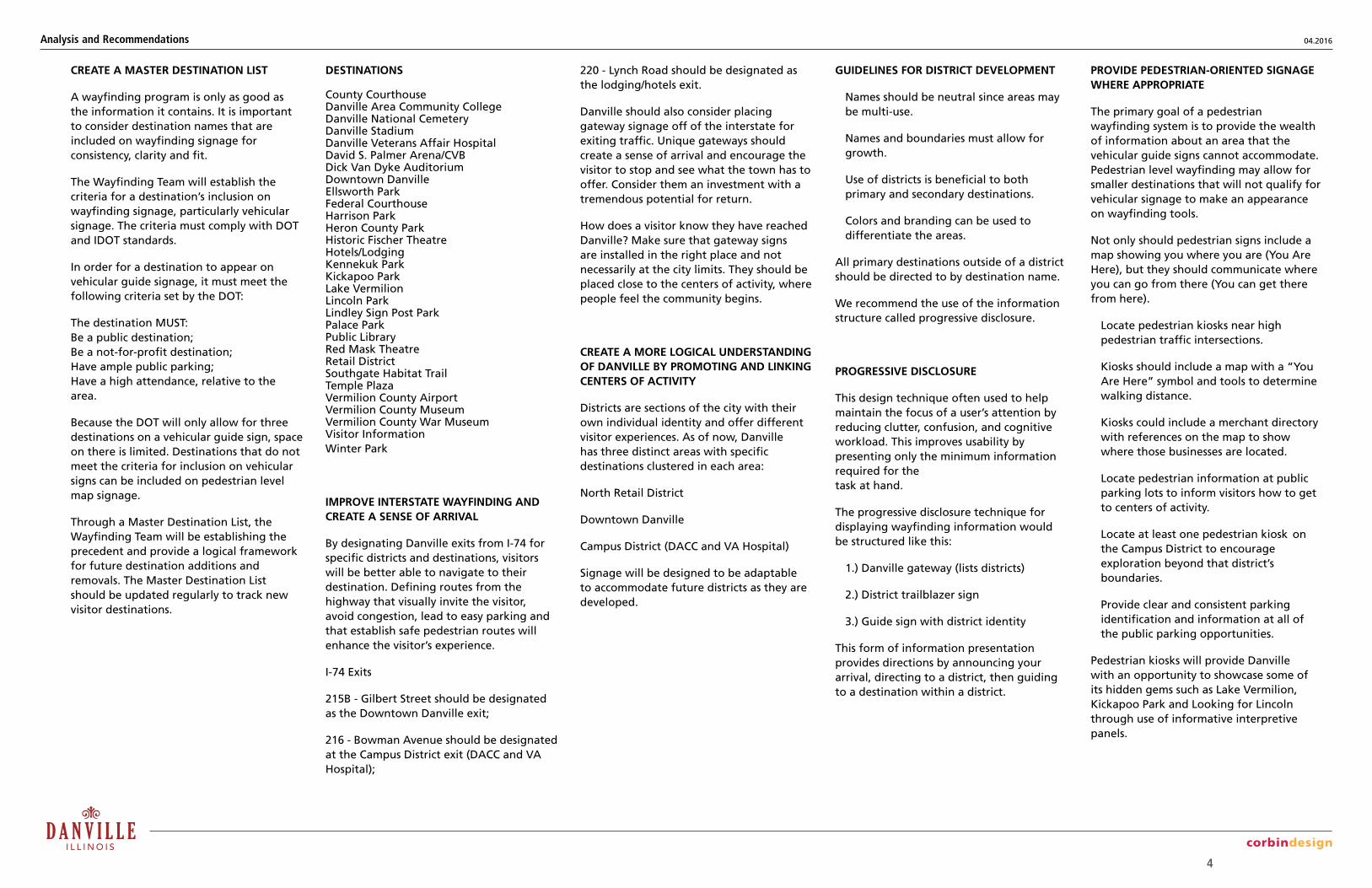
CREATE A MASTER DESTINATION LIST
A wayfinding program is only as good as the information it contains. It is important to consider destination names that are included on wayfinding signage for consistency, clarity and fit.
The Wayfinding Team will establish the criteria for a destination’s inclusion on wayfinding signage, particularly vehicular signage. The criteria must comply with DOT and IDOT standards.
In order for a destination to appear on vehicular guide signage, it must meet the following criteria set by the DOT:
The destination MUST: Be a public destination; Be a not-for-profit destination; Have ample public parking; Have a high attendance, relative to the area.
Because the DOT will only allow for three destinations on a vehicular guide sign, space on there is limited. Destinations that do not meet the criteria for inclusion on vehicular signs can be included on pedestrian level map signage.
Through a Master Destination List, the Wayfinding Team will be establishing the precedent and provide a logical framework for future destination additions and removals. The Master Destination List should be updated regularly to track new visitor destinations.
DESTINATIONS
County CourthouseDanville Area Community CollegeDanville National CemeteryDanville StadiumDanville Veterans Affair HospitalDavid S. Palmer Arena/CVBDick Van Dyke AuditoriumDowntown DanvilleEllsworth ParkFederal CourthouseHarrison ParkHeron County ParkHistoric Fischer TheatreHotels/LodgingKennekuk ParkKickapoo ParkLake VermilionLincoln ParkLindley Sign Post ParkPalace ParkPublic LibraryRed Mask TheatreRetail DistrictSouthgate Habitat TrailTemple PlazaVermilion County AirportVermilion County MuseumVermilion County War MuseumVisitor Information Winter Park
IMPROVE INTERSTATE WAYFINDING AND CREATE A SENSE OF ARRIVAL
By designating Danville exits from I-74 for specific districts and destinations, visitors will be better able to navigate to their destination. Defining routes from the highway that visually invite the visitor, avoid congestion, lead to easy parking and that establish safe pedestrian routes will enhance the visitor’s experience.
I-74 Exits
215B - Gilbert Street should be designated as the Downtown Danville exit;
216 - Bowman Avenue should be designated at the Campus District exit (DACC and VA Hospital);
220 - Lynch Road should be designated as the lodging/hotels exit.
Danville should also consider placing gateway signage off of the interstate for exiting traffic. Unique gateways should create a sense of arrival and encourage the visitor to stop and see what the town has to offer. Consider them an investment with a tremendous potential for return.
How does a visitor know they have reached Danville? Make sure that gateway signs are installed in the right place and not necessarily at the city limits. They should be placed close to the centers of activity, where people feel the community begins.
CREATE A MORE LOGICAL UNDERSTANDING OF DANVILLE BY PROMOTING AND LINKING CENTERS OF ACTIVITY
Districts are sections of the city with their own individual identity and offer different visitor experiences. As of now, Danville has three distinct areas with specific destinations clustered in each area:
North Retail District
Downtown Danville
Campus District (DACC and VA Hospital)
Signage will be designed to be adaptable to accommodate future districts as they are developed.
GUIDELINES FOR DISTRICT DEVELOPMENT
Names should be neutral since areas may be multi-use.
Names and boundaries must allow for growth.
Use of districts is beneficial to both primary and secondary destinations.
Colors and branding can be used to differentiate the areas.
All primary destinations outside of a district should be directed to by destination name.
We recommend the use of the information structure called progressive disclosure.
PROGRESSIVE DISCLOSURE
This design technique often used to help maintain the focus of a user’s attention by reducing clutter, confusion, and cognitive workload. This improves usability by presenting only the minimum information required for the task at hand.
The progressive disclosure technique for displaying wayfinding information would be structured like this:
1.) Danville gateway (lists districts)
2.) District trailblazer sign
3.) Guide sign with district identity
This form of information presentation provides directions by announcing your arrival, directing to a district, then guiding to a destination within a district.
PROVIDE PEDESTRIAN-ORIENTED SIGNAGE WHERE APPROPRIATE
The primary goal of a pedestrian wayfinding system is to provide the wealth of information about an area that the vehicular guide signs cannot accommodate. Pedestrian level wayfinding may allow for smaller destinations that will not qualify for vehicular signage to make an appearance on wayfinding tools.
Not only should pedestrian signs include a map showing you where you are (You Are Here), but they should communicate where you can go from there (You can get there from here).
Locate pedestrian kiosks near high pedestrian traffic intersections.
Kiosks should include a map with a “You Are Here” symbol and tools to determine walking distance.
Kiosks could include a merchant directory with references on the map to show where those businesses are located.
Locate pedestrian information at public parking lots to inform visitors how to get to centers of activity.
Locate at least one pedestrian kiosk on the Campus District to encourage exploration beyond that district’s boundaries.
Provide clear and consistent parking identification and information at all of the public parking opportunities.
Pedestrian kiosks will provide Danville with an opportunity to showcase some of its hidden gems such as Lake Vermilion, Kickapoo Park and Looking for Lincoln through use of informative interpretive panels.
4
04.2016
Analysis and Recommendations
Analysis and Recommendations

Fabricator is responsible for matching all colors and materials as specified and are required to provide the Owner color and material samples for approval.
CAUTION! CONSISTENT AND ACCURATE COLOR REPRODUCTION IN THIS DOCUMENT CANNOT BE ASSURED DUE TO THE LIMITATIONS OF COLOR COPYING TECHNOLOGY.
The Coated Pantone Matching System® and Matthews Acrylic Polyurethatue are used for specifying signage color matches. (In the absence of actual sign material color chip reference sets, actual specified product color swatches should be referenced for color matching.)
Shown here are approximations of the primary signage background colors and supporting accent colors. Actual color finishes on signage must be matte or low luster (not shiny or glossy) and exclusively a premium acrylic polyurethane.
Signage paints produced by Matthews Paint Company are to be the standard reference.
Vinyl Films from 3M are to be the standard.
Color application varies per sign type. Refer to specific design intent drawings for application details.
---
MP15793 Town & Country Red
---
7Maroon
---
MP04855 Patent Yellow
---
Yellow
---
---
---
6Black 8
---
---
---
Light Blue
12Blue 110 Blue 2 13 Green 111 Green 214Gold 29 Gold 1
---
MP10269 Dark Slate
---
5Dark Grey4
---
MP18074 Sparkle Silver Metallic
---
---
---
---
Pantone®:
Matthews Acrylic Polyurethane Paint:
3M Reflective Print:
1 Metallic Silver 2 White
---
MP07026 Stormy Sky
---
---
---
---
---
MP01603 Wild OIive
---
---
---
---
---
MP12440 Electrum
---
---
---
---
Pantone®:
Matthews Acrylic Polyurethane Paint:
3M Reflective Print:
---
MP11713 Cloister
---
3 Grey
Symbols Artwork
A a B b C c D d E e F f G g H h I i J j K k L l M m N n O o P p Q q R r S s T t U u V v W w X x Y y Z z 1 2 3 4 5 6 7 8 9 0Gloucester MT Extra Condensed- Regular
Aa Bb Cc Dd Ee Ff Gg Hh Ii Jj Kk Ll Mm Nn Oo Pp Qq Rr Ss Tt Uu Vv Ww Xx Yy Zz 1234567890ClearviewHwy 1-W
Aa Bb Cc Dd Ee Ff Gg Hh Ii Jj Kk Ll Mm Nn Oo Pp Qq Rr Ss Tt Uu Vv Ww Xx Yy Zz 1234567890Avenir Roman
Standard Arrow Parking[P]
Typography
Color Palette
Scale
Sign Type Description
Sign Type
Client
109 East Front Suite 304Traverse City, MI 49684
231 947.1236
Date Description
I L L I N O I S
5
04.29.16 PRELIMINARY05.20.16 FINAL
Wayfinding and Signage Plan
Graphic Standards
3/4" = 1'-0"(on an 11 x 17 sheet)

DOWNTOWNDISTRIC T
D A N V I L L E
SHOPPING • D IN ING • ENTER TAINMENT
Temple Plaza3 min walk
Palmer Arena5 min walk
Visitor Information5 min walk
County War Museum7 min walk
D O W N T O W N
RETAILDISTRIC T
D A N V I L L E
SHOPPING • D IN ING • ENTER TAINMENT
CAMPUSDISTRIC T
D A N V I L L E
SHOPPING • D IN ING • ENTER TAINMENT
DOW
NTOW
N
D A N V I L L E
Downtown
CampusDistrict
Hotels
D A N V I L L E
Van DykeAuditorium
D A N V I L L E
Large VehicularGuide
Large VehicularTrailblazer
Vehicular Guide(non-district)
Vehicular Trailblazer(non-district)
DowntownDanville
CampusDistrict
DanvilleStadium
DowntownDanville
VisitorInformation
2 min walk
North and Walnut
VISITOR PARKING2 Hour Regulated Public Parking
Monday - Friday 7AM - 5PM
Lake VermilionCounty Park
Open Sunrise to Sunset
LakeVermilionCountyPark
RETA
IL
D ISTRIC T
DISTRIC T DISTRIC T
CAMP
US
Temple Plaza
F O U N D E D 1 8 2 7
DOWNTOWN RETAIL CAMPUS
F O U N D E D 1 8 2 7
Main Gateway
Robert E. JonesMunicipal Building
17 West Main Street
Secondary GatewayI-1 I-2
Municipal ID(Large)
Municipal ID(Medium)
Municipal ID(Small)
MunicipalGuide
PedestrianGuide
District Banners PedestrianTrailblazer
PedestrianKiosk
(district)
Parking IDP-1
Parking GuideP-2
G-1 G-2 G-3 G-4
K-1cCampus
K-1bRetail
DISTRIC T
DOWNTOWN
D A N V I L L E
Temple Plaza
Van DykeAuditorium
Palmer Arena
Temple Plaza
Van DykeAuditorium
Palmer Arena
DISTRIC T
DOWNTOWN
D A N V I L L E
Van DykeAuditorium
Vehicular Guide(Downtown)
VehicularTrailblazer
(Downtown)
DISTRIC T
RETAIL
D A N V I L L E
Winter Park
LakeVermilion
Downtown
DISTRIC T
RETAIL
D A N V I L L E
D A N V I L L E
DISTRIC T
CAMPUS
CommunityCollege
VA MedicalCenter
Downtown
D A N V I L L E
DISTRIC T
CAMPUS
Van DykeAuditorium
Van DykeAuditorium
G-3a
G-3b Retail
G-3c Campus
G-4b Retail
G-4c Campus
G-4a
I-4 I-5 I-6I-3G-5 G-5a K-1a
Scale
Sign Type Description
Sign Type
Client
109 East Front Suite 304Traverse City, MI 49684
231 947.1236
Date Description
I L L I N O I S
6
04.29.16 PRELIMINARY05.20.16 FINAL
Wayfinding and Signage Plan
Sign Type Array
1/4" = 1'-0"(on an 11 x 17 sheet)

F O U N D E D 1 8 2 7
DOWNTOWN RETAIL CAMPUS
Back View
Front View
Masked and sprayed graphics.
Custom stone base. Owner toreview and approve stone.
Side View
Fabricated aluminum cabinet withinternal structure as required.
Custom curved top
Custom curved bottom
Dark grey towrap return edge 1" return
OPTIONAL: Masked and painted background colors with White reflective "Danville" and district names. District icons to be digitally printed 3M UV Cured Inks onto 3M High Intensity Prismatic Sheeting Series 3930, protected with a 3M™ Acrylic Overlay Film.
Supplier:Sherine Industries Ltd.1-800-665-0566www.sherineindustries.com
7'-6"
6'-6"
5'-8 1/2"
1'-10"
1'-0"
1"
2'-10"Gateway signs inform visitors when they are entering Danville and that the city has three distinct districts. This sign type is different from official municipal markers, which would be placed at the legal municipal boundary. Gateways should be located at intuitive locations where there is a high density of local destinations. Locations are usually not in the right-of-way and could include ad-ditional landscaping. Reflective graphics should be used if external light fixtures are not available. These signs are gener-ally single-sided because the backs are usually not visible.
I-1 Main Gateway
3/4" = 1'-0"(on an 11 x 17 sheet)
Scale
Sign Type Description
Sign Type
Client
109 East Front Suite 304Traverse City, MI 49684
231 947.1236
Date Description
I L L I N O I S
7
04.29.16 PRELIMINARY05.20.16 FINAL
Wayfinding and Signage Plan

F O U N D E D 1 8 2 7
Front View Side ViewBack View
Aluminum panel with backside and return edges painted Grey
3" square aluminumpole painted Metallic Silver
Full face digitally printed 3M UV Cured Inks onto 3M High Intensity Prismatic Sheeting Series 3930, protected with a 3M™ Acrylic Overlay Film.
Supplier:Sherine Industries Ltd.1-800-665-0566www.sherineindustries.com
Install post with Breakaway Bolts. Breakaway to conform with city and IDOT guidelines.
Concrete pad flush with grade wheninstalled in sidewalk. Surface to have appearance grade finish. Depth and reinforcement of footing to be engineered by fabricator.
OPTIONAL: Pad to extend at least 2" above grade when install in grass or unimproved ground.
Whatley decorative baseD20S painted Metallic Siver
Supplier:Whatley/Valmont Composite Structures, Inc.877-959-7678www.whatley.com
10'-6"
3'-2 1/2"
3'-7"
Secondary Gateway signs inform visitors when they are entering Danville. These signs are located in areas that either do not have enough traffic to justify or space to install a Main Gateway. These can be installed in the right-of-way. Depending on the road speed the sign may be used with or without the decora-tive base.
I-2 Secondary Gateway
3/4" = 1'-0"(on an 11 x 17 sheet)
Scale
Sign Type Description
Sign Type
Client
109 East Front Suite 304Traverse City, MI 49684
231 947.1236
Date Description
I L L I N O I S
8
04.29.16 PRELIMINARY05.20.16 FINAL
Wayfinding and Signage Plan

DowntownDanville
CampusDistrict
DanvilleStadium
Front View Back View
Full face digitally printed 3M UV Cured Inks onto 3M High Intensity Prismatic Sheeting Series 3930, protected with a 3M™ Acrylic Overlay Film.
Supplier:Sherine Industries Ltd.1-800-665-0566www.sherineindustries.com
Sign Type Description:This sign type directs vehicular traffic to primary campus destinations, visitor parking and campus exits. These signs are placed along major campus roads where greater visibility is needed because of high amountsof vehicular traffic. The signs uses full face reflective vinyl copy and background.All aluminum post and panels fabrication. Center ribbon to display LCC name to be printed direct on the aluminum using outdoor inks and coatings. The blank panels to be painted to match the reflective blue.
Aluminum panels to meet or exceedIDOT breakaway requirements.
Galvanized steel post and breakaway base to conform with city and IDOT guidelines.
5'-10"
8'-4"
7'-0"
6'-9"
15'-4"
According to the MUTCD, this vehicular guide should be used on roads with speeds above 25 mph. More commonly is it used on roads with speeds greater than 35 mph. Because of the size of the panels and cost of the break-away components, this sign costs more than other guide signs. No decorative base or graphics on the back are included because drivers only see this sign type for a brief time and usually pedestrians are not near the higher speed roads.
G-1 Large Vehicular Guide
1/2" = 1'-0"(on an 11 x 17 sheet)
Scale
Sign Type Description
Sign Type
Client
109 East Front Suite 304Traverse City, MI 49684
231 947.1236
Date Description
I L L I N O I S
9
04.29.16 PRELIMINARY05.20.16 FINAL
Wayfinding and Signage Plan

D A N V I L L E
DowntownDanville
Front View Back View Side View
Sign Type Description:This sign type directs vehicular traffic to primary campus destinations, visitor parking and campus exits. These signs are placed along major campus roads where greater visibility is needed because of high amountsof vehicular traffic. The signs uses full face reflective vinyl copy and background.All aluminum post and panels fabrication. Center ribbon to display LCC name to be printed direct on the aluminum using outdoor inks and coatings. The blank panels to be painted to match the reflective blue.
DA N V I L L EF O U N D E D 1 8 2 7
Full face digitally printed 3M UV Cured Inks onto 3M High Intensity Prismatic Sheeting Series 3930, protected with a 3M™ Acrylic Overlay Film.
Supplier:Sherine Industries Ltd.1-800-665-0566www.sherineindustries.com
Aluminum panel with backside and return edges painted Grey
Surface applied vinylgraphics
Horizontal panel support
Exposed brackets
Separate header panel
Separate footer panel
3" square aluminumpole painted Metallic Silver
Install post with Breakaway Bolts. Breakaway to conform with city and IDOT guidelines.
Concrete pad flush with grade wheninstalled in sidewalk. Surface to have appearance grade finish. Depth and reinforcement of footing to be engineered by fabricator.
OPTIONAL: Pad to extend at least 2" above grade when install in grass or unimproved ground.
13'-2"
10"
4'-6"
1'-6"
3'-10"
7 1/4" 1'-10"
Cut-out for draining
According to the MUTCD, this vehicular Trailblazer should be used on roads with speeds above 25 mph. More commonly is it used on roads with speeds greater than 35 mph. This sign is referred to as a "Trailblazer" because it is used to identify a single route to a remote desti-nation. No decorative base was included because drivers only see this sign type for a brief time. The graphics are included to be consistent with other sign types that share this same overall design.
G-2 Large Vehicular Trailblazer
1/2" = 1'-0"(on an 11 x 17 sheet)
Scale
Sign Type Description
Sign Type
Client
109 East Front Suite 304Traverse City, MI 49684
231 947.1236
Date Description
I L L I N O I S
10
04.29.16 PRELIMINARY05.20.16 FINAL
Wayfinding and Signage Plan

D A N V I L L E
Downtown
CampusDistrict
Hotels
Front View Back View Side View
Sign Type Description:This sign type directs vehicular traffic to primary campus destinations, visitor parking and campus exits. These signs are placed along major campus roads where greater visibility is needed because of high amountsof vehicular traffic. The signs uses full face reflective vinyl copy and background.All aluminum post and panels fabrication. Center ribbon to display LCC name to be printed direct on the aluminum using outdoor inks and coatings. The blank panels to be painted to match the reflective blue.
DA N V I L L EF O U N D E D 1 8 2 7
Full face digitally printed 3M UV Cured Inks onto 3M High Intensity Prismatic Sheeting Series 3930, protected with a 3M™ Acrylic Overlay Film.
Supplier:Sherine Industries Ltd.1-800-665-0566www.sherineindustries.com
Aluminum panel with backside and return edges painted Grey
Surface applied vinylgraphics
Horizontal panel support
Exposed brackets
Separate header panel
Separate footer panel
3" square aluminumpole painted Metallic Silver
Install post with Breakaway Bolts. Breakaway to conform with city and IDOT guidelines.
Concrete pad flush with grade wheninstalled in sidewalk. Surface to have appearance grade finish. Depth and reinforcement of footing to be engineered by fabricator.
OPTIONAL: Pad to extend at least 2" above grade when install in grass or unimproved ground.
Whatley decorative baseD20S painted Metallic Siver
Supplier:Whatley/Valmont Composite Structures, Inc.877-959-7678www.whatley.com
Cut-out for draining
13'-2"
10"
4'-6"
1'-6"
3'-10"
7 1/4" 1'-10"
According to the MUTCD, this vehicular guide should be used on roads with speeds of 25 mph or below. More com-monly is it used on roads with speeds up to 35 mph. This sign type is used to direct visitors while they are outside of the districts.
G-3 Vehicular Guide, Non-district
1/2" = 1'-0"(on an 11 x 17 sheet)
Scale
Sign Type Description
Sign Type
Client
109 East Front Suite 304Traverse City, MI 49684
231 947.1236
Date Description
I L L I N O I S
11
04.29.16 PRELIMINARY05.20.16 FINAL
Wayfinding and Signage Plan

Front View
Sign TypeG-3a
Sign TypeG-3b
Sign TypeG-3c
Back View Side View
Sign Type Description:This sign type directs vehicular traffic to primary campus destinations, visitor parking and campus exits. These signs are placed along major campus roads where greater visibility is needed because of high amountsof vehicular traffic. The signs uses full face reflective vinyl copy and background.All aluminum post and panels fabrication. Center ribbon to display LCC name to be printed direct on the aluminum using outdoor inks and coatings. The blank panels to be painted to match the reflective blue.
DA N V I L L EF O U N D E D 1 8 2 7
Full face digitally printed 3M UV Cured Inks onto 3M High Intensity Prismatic Sheeting Series 3930, protected with a 3M™ Acrylic Overlay Film.
Supplier:Sherine Industries Ltd.1-800-665-0566www.sherineindustries.com
Aluminum panel with backside and return edges painted Grey
Surface applied vinylgraphics
Horizontal panel support
Exposed brackets
Cut-out for draining
Separate header panel
Separate footer panel
3" square aluminumpole painted Metallic Silver
Install post with Breakaway Bolts. Breakaway to conform with city and IDOT guidelines.
Concrete pad flush with grade wheninstalled in sidewalk. Surface to have appearance grade finish. Depth and reinforcement of footing to be engineered by fabricator.
OPTIONAL: Pad to extend at least 2" above grade when install in grass or unimproved ground.
Whatley decorative baseD20S painted Metallic Siver
Supplier:Whatley/Valmont Composite Structures, Inc.877-959-7678www.whatley.com
DISTRIC T
DOWNTOWN
D A N V I L L E
Temple Plaza
Van DykeAuditorium
Palmer Arena
Temple Plaza
Van DykeAuditorium
Palmer Arena
DISTRIC T
DOWNTOWN
D A N V I L L E
Temple Plaza
Van DykeAuditorium
Palmer Arena
Temple Plaza
Van DykeAuditorium
Palmer Arena
DISTRIC T
RETAIL
D A N V I L L E
Winter Park
LakeVermilion
Downtown
D A N V I L L E
DISTRIC T
CAMPUS
CommunityCollege
VA MedicalCenter
Downtown
13'-2"
10"
4'-6"
2'-8"
3'-10"
7 1/4" 1'-10"
According to the MUTCD, this vehicular guide should be used on roads with speeds of 25 mph or below. More com-monly is it used on roads with speeds up to 35 mph. This sign type is used to direct visitors while they are within a district. Each district has a unique identity that includes the district name, color and icon. These signs are designed to fit in the right-of-way. The decorative base covers the break-away base.
G-3a, G-3b, and G-3c Vehicular Guide, District Identification
1/2" = 1'-0"(on an 11 x 17 sheet)
Scale
Sign Type Description
Sign Type
Client
109 East Front Suite 304Traverse City, MI 49684
231 947.1236
Date Description
I L L I N O I S
12
04.29.16 PRELIMINARY05.20.16 FINAL
Wayfinding and Signage Plan
D A N V I L L E
DowntownDanville
Front View Back View Side View
Sign Type Description:This sign type directs vehicular traffic to primary campus destinations, visitor parking and campus exits. These signs are placed along major campus roads where greater visibility is needed because of high amountsof vehicular traffic. The signs uses full face reflective vinyl copy and background.All aluminum post and panels fabrication. Center ribbon to display LCC name to be printed direct on the aluminum using outdoor inks and coatings. The blank panels to be painted to match the reflective blue.
Full face digitally printed 3M UV Cured Inks onto 3M High Intensity Prismatic Sheeting Series 3930, protected with a 3M™ Acrylic Overlay Film.
Supplier:Sherine Industries Ltd.1-800-665-0566www.sherineindustries.com
Aluminum panel with backside and return edges painted Grey
Horizontal panel support
Exposed brackets
Separate header panel
Separate footer panel
3" square aluminumpole painted Metallic Silver
Install post with Breakaway Bolts. Breakaway to conform with city and IDOT guidelines.
Concrete pad flush with grade wheninstalled in sidewalk. Surface to have appearance grade finish. Depth and reinforcement of footing to be engineered by fabricator.
OPTIONAL: Pad to extend at least 2" above grade when install in grass or unimproved ground.
Whatley decorative baseD20S painted Metallic Siver
Supplier:Whatley/Valmont Composite Structures, Inc.877-959-7678www.whatley.com
Cut-out for draining
11'-0"
10"
2'-2"
1'-6"
3'-10"
7 1/4" 1'-10"
According to the MUTCD, this vehicular Trailblazer should be used on roads with speeds of 25 mph or below. More com-monly is it used on roads with speeds up to 35 mph. This sign type is used to direct visitors while they are outside of the districts. This sign is referred to as a "Trailblazer" because it is used to identify a single route to a remote des-tination. These signs are designed to fit in the right-of-way. The decorative base covers the break-away base.
G-4 Vehicular Trailblazer, Non-district
1/2" = 1'-0"(on an 11 x 17 sheet)
Scale
Sign Type Description
Sign Type
Client
109 East Front Suite 304Traverse City, MI 49684
231 947.1236
Date Description
I L L I N O I S
13
04.29.16 PRELIMINARY05.20.16 FINAL
Wayfinding and Signage Plan

Front View Back View Side View
Sign Type Description:This sign type directs vehicular traffic to primary campus destinations, visitor parking and campus exits. These signs are placed along major campus roads where greater visibility is needed because of high amountsof vehicular traffic. The signs uses full face reflective vinyl copy and background.All aluminum post and panels fabrication. Center ribbon to display LCC name to be printed direct on the aluminum using outdoor inks and coatings. The blank panels to be painted to match the reflective blue.
Full face digitally printed 3M UV Cured Inks onto 3M High Intensity Prismatic Sheeting Series 3930, protected with a 3M™ Acrylic Overlay Film.
Supplier:Sherine Industries Ltd.1-800-665-0566www.sherineindustries.com
Aluminum panel with backside and return edges painted Grey
Horizontal panel support
Exposed brackets
Separate header panel
Separate footer panel
3" square aluminumpole painted Metallic Silver
Install post with Breakaway Bolts. Breakaway to conform with city and IDOT guidelines.
Concrete pad flush with grade wheninstalled in sidewalk. Surface to have appearance grade finish. Depth and reinforcement of footing to be engineered by fabricator.
OPTIONAL: Pad to extend at least 2" above grade when install in grass or unimproved ground.
Whatley decorative baseD20S painted Metallic Siver
Supplier:Whatley/Valmont Composite Structures, Inc.877-959-7678www.whatley.com
Cut-out for draining
DISTRIC T
DOWNTOWN
D A N V I L L E
DowntownDanville
Sign TypeG-4a
Sign TypeG-4b
Sign TypeG-4c
DISTRIC T
DOWNTOWN
D A N V I L L E
DISTRIC T
RETAIL
D A N V I L L E
D A N V I L L E
DISTRIC T
CAMPUS
Retail District DowntownDanville
CampusDistrict
11'-0"
10"
2'-2"
2'-8"
3'-10"
7 1/4" 1'-10"
According to the MUTCD, this vehicular Trailblazer should be used on roads with speeds of 25 mph or below. More com-monly is it used on roads with speeds up to 35 mph. This sign type is used to direct visitors while they are within a district. This sign is referred to as a "Trailblazer" because it is used to identify a single route to a remote destination. Each dis-trict has a unique identity that includes the district name, color and icon. The decorative base covers the break-away base. These signs are designed to fit in the right-of-way. The decorative base covers the break-away base.
G-4a, G-4b and G-4c Vehicular Trailblazer, District Identification
1/2" = 1'-0"(on an 11 x 17 sheet)
Scale
Sign Type Description
Sign Type
Client
109 East Front Suite 304Traverse City, MI 49684
231 947.1236
Date Description
I L L I N O I S
14
04.29.16 PRELIMINARY05.20.16 FINAL
Wayfinding and Signage Plan

Front View Back View Side View
Doiuble-sided Aluminum panel with painted back sides and return edges
"Band-it" universal channel clampstrapped to post with stainless steel straps
Supplier:BAND-IT - IDEX, INC.A Unit of Idex Corporation303-320-4555www.band-it-idex.com
"Band-it" aluminum channel extrusionbonded and welded to message panel
Painted background colors with surface applied graphics
2'-0"
4'-1 1/2"
This sign type is designed to be used by pedestrians. The size of the messages has been adjusted to be large enough to be visible for walkers on the sidewalks and small enough to be less visible to drivers. The distance to destinations in minutes is listed under the destination. The messages are non-reflective, so vehicle headlights do not illuminate the signs at night. The signs can be attached to existing poles.
G-5 Pedestrian Guide
3/4" = 1'-0"(on an 11 x 17 sheet)
Scale
Sign Type Description
Sign Type
Client
109 East Front Suite 304Traverse City, MI 49684
231 947.1236
Date Description
I L L I N O I S
15
04.29.16 PRELIMINARY05.20.16 FINAL
Wayfinding and Signage Plan

Front View Back View
Aluminum panel with painted back side and return edges
"Band-it" universal channel clampwith stainless steel straps
Supplier:BAND-IT - IDEX, INC.A Unit of Idex Corporation303-320-4555www.band-it-idex.com
Painted background colors with surface applied graphics
2'-2"
1'-3"This sign type is designed to be used by pedestrians. The size of the messages has been adjusted to be large enough to be visible for walkers on the sidewalks and small enough to be less visible to drivers. This sign is referred to as a "Trailblazer" because it is used to identify a single route. The distance to the destination in minutes is listed under the destination. The messages are non-reflective, so vehicle headlights do not illuminate the signs at night. The signs can be attached to existing poles.
G-5a Pedestrian Trailblazer
3/4" = 1'-0"(on an 11 x 17 sheet)
Scale
Sign Type Description
Sign Type
Client
109 East Front Suite 304Traverse City, MI 49684
231 947.1236
Date Description
I L L I N O I S
16
04.29.16 PRELIMINARY05.20.16 FINAL
Wayfinding and Signage Plan

Front View
Sign TypeK-1a
Sign TypeK-1b
Sign TypeK-1c
Side ViewBack View
Sign Type Description:This sign type directs vehicular traffic to primary campus destinations, visitor parking and campus exits. These signs are placed along major campus roads where greater visibility is needed because of high amountsof vehicular traffic. The signs uses full face reflective vinyl copy and background.All aluminum post and panels fabrication. Center ribbon to display LCC name to be printed direct on the aluminum using outdoor inks and coatings. The blank panels to be painted to match the reflective blue.
Bolted to threaded rods in footing with with leveling nuts
Whatley decorative baseD20S painted Metallic Siver
Supplier:Whatley/Valmont Composite Structures, Inc.877-959-7678www.whatley.com
DOWNTOWNDISTRIC T
D A N V I L L E
SHOPPING • D IN ING • ENTER TAINMENT
DOWNTOWNDISTRIC T
D A N V I L L E
Concrete pad flush with grade wheninstalled in sidewalk. Surface to have appearance grade finish. Depth and reinforcement of footing to be engineered by fabricator.
OPTIONAL: Pad to extend at least 2" above grade when install in grass or unimproved ground.
3" square aluminumpost painted Metallic Silver
OPTIONAL
CHANGEABLE
INFORMATION
PANEL
ARTWORK
PROVIDED BY
OTHERS
FINAL ARTWORK
TO BE PROVIDED
BY OTHERSCAMPUSDISTRIC T
D A N V I L L E
SHOPPING • D IN ING • ENTER TAINMENT
FINAL ARTWORK
TO BE PROVIDED
BY OTHERS
DOWNTOWNDISTRIC T
D A N V I L L E
SHOPPING • D IN ING • ENTER TAINMENT
FINAL ARTWORK
TO BE PROVIDED
BY OTHERS
RETAILDISTRIC T
D A N V I L L E
SHOPPING • D IN ING • ENTER TAINMENT
FINAL ARTWORK
TO BE PROVIDED
BY OTHERS
Dimensional district icon
Custom aluminum cabinet withpainted background colorsand masked and sprayed graphics
Removeable message panel. Attached with stainless steelhex-head screws. Final artwork to be provided by others.
Graphics processes:1. Digitally printed vinyl mounted to PVC substrate withUV laminate (approx 1 year life)
2. Direct to surface digital printing on painted aluminumpanel with clear-coat (approx 3 year life)
3. High pressure laminate panel (10 year warranty) Supplier: iZone Imaging 2526 Charter Oak Drive, Suite 100 Temple, TX 76502 888.464.9663 www.izoneimaging.com
This sign type is located at areas where there are high concentrations of pedes-trians. They are usually located on the sidewalk near intersection cross-walks. One side is designated for wayfinding and has a changeable map panel and optional merchant directory.Options for second panel mounted to the back side:1. Additional local wayfinding map2. Regional wayfinding map3. Interpretive panel4. Promotion or advertising panel5. Trail or historic map
K-1a, K-1b and K-1c Pedestrian District Kiosk
3/4" = 1'-0"(on an 11 x 17 sheet)
Scale
Sign Type Description
Sign Type
Client
109 East Front Suite 304Traverse City, MI 49684
231 947.1236
Date Description
I L L I N O I S
17
04.29.16 PRELIMINARY05.20.16 FINAL
Wayfinding and Signage Plan

Front View Additional Layouts
Side View
Back View
DISTRIC T
CAMP
US
Sewn Bracket sleeve
Banner Arm Supplier:Kalamazoo Banner Workswww.kalamazoobanner.com
Stainless Steel Strap Supplier:www.band-it-idex.com
KBW "Bannerflex Airow"premium fiberglass banner rod.
Grommet
Double-sided vinyl banner
1'-6"
7'-0"
8'-6" minimumoverhead clearance
Banners should be installed in the tran-sitional areas within district boundaries. Banners can be installed on existing light poles with the pole owners permis-sion. They should be used in groups of six or more.
District Identification Banners
1/2" = 1'-0"(on an 11 x 17 sheet)
Scale
Sign Type Description
Sign Type
Client
109 East Front Suite 304Traverse City, MI 49684
231 947.1236
Date Description
I L L I N O I S
18
04.29.16 PRELIMINARY05.20.16 FINAL
Wayfinding and Signage Plan

North and Walnut
VISITOR PARKING2 Hour Regulated Public Parking
Monday - Friday 7AM - 5PM
North and Walnut
VISITOR PARKING2 Hour Regulated Public Parking
Monday - Friday 7AM - 5PM
Front View
Plan View
Back View
Aluminum panel for parking "P"
3" "Signcomp" series 3 post and panel sign systemwith custom curved top and bottom
3" square aluminumpost painted Metallic Silver
Direct bury installation
Full face digitally printed 3M UV Cured Inks onto 3M High Intensity Prismatic Sheeting Series 3930, protected with a 3M™ Acrylic Overlay Film.
Supplier:Sherine Industries Ltd.1-800-665-0566www.sherineindustries.com
7'-6"
4'-5"
4'-3"
3'-8"
This sign type should replace the existing parking lot identification signs. These signs should be installed perpendicu-lar to the road. The current signs are parallel.
P-1 Parking Identification
3/4" = 1'-0"(on an 11 x 17 sheet)
Scale
Sign Type Description
Sign Type
Client
109 East Front Suite 304Traverse City, MI 49684
231 947.1236
Date Description
I L L I N O I S
19
04.29.16 PRELIMINARY05.20.16 FINAL
Wayfinding and Signage Plan

Front View Back View
Existing pole
Full face digitally printed 3M UV Cured Inks onto 3M High Intensity Prismatic Sheeting Series 3930, protected with a 3M™ Acrylic Overlay Film.
Supplier:Sherine Industries Ltd.1-800-665-0566www.sherineindustries.com
Aluminum panel with painted back side and return edges
"Band-it" universal channel clampand stainless steel straps
Supplier:BAND-IT - IDEX, INC.A Unit of Idex Corporation303-320-4555www.band-it-idex.com
2'-0"
1'-4"
This sign type should replace the existing parking guide signs. These signs can be attached to existing poles.
P-2 Parking Guide
3/4" = 1'-0"(on an 11 x 17 sheet)
Scale
Sign Type Description
Sign Type
Client
109 East Front Suite 304Traverse City, MI 49684
231 947.1236
Date Description
I L L I N O I S
20
04.29.16 PRELIMINARY05.20.16 FINAL
Wayfinding and Signage Plan

LakeVermilionCountyPark
Front View Back View
Aluminum panel with backside and return edges painted Grey
3" square aluminumpost painted Metallic Silver
Direct bury installation
Full face digitally printed 3M UV Cured Inks onto 3M High Intensity Prismatic Sheeting Series 3930, protected with a 3M™ Acrylic Overlay Film.
Supplier:Sherine Industries Ltd.1-800-665-0566www.sherineindustries.com
2'-6"
3'-7 1/2"
7'-0" Minimum overhead clearance
This sign type should be used to direct visitors to tertiary destinations that do not require the larger, more costly vehicu-lar guides. They should be used where road speeds are below 30 mph.
I-3 Municipal Guide
3/4" = 1'-0"(on an 11 x 17 sheet)
Scale
Sign Type Description
Sign Type
Client
109 East Front Suite 304Traverse City, MI 49684
231 947.1236
Date Description
I L L I N O I S
21
04.29.16 PRELIMINARY05.20.16 FINAL
Wayfinding and Signage Plan

Dedicatory NameBuilding Name
Building Address
Dedicatory NameBuilding Name
Building Address
Front View
Plan View
Back View
3" square aluminumpost painted Metallic Silver
Direct bury installation
Painted background colors with surface applied graphics
3" "Signcomp" series 3 post and panel sign systemwith custom curved top and bottom
6'-3"
4'-0"
5'-1 1/2"
4'-6 1/4"
This sign type should be used to identify municipal facilities. The current layout has a message line for a dedicatory name. The layout can be modified to ac-comodate custom layouts. Double-sided signs should be installed perpendicular to the road. A single-sided version should be used if the back is not visible.
I-4 Municipal Identification, Large
3/4" = 1'-0"(on an 11 x 17 sheet)
Scale
Sign Type Description
Sign Type
Client
109 East Front Suite 304Traverse City, MI 49684
231 947.1236
Date Description
I L L I N O I S
22
04.29.16 PRELIMINARY05.20.16 FINAL
Wayfinding and Signage Plan

DestinationName
Hours of Operation
Front View
Plan View
Back View
DestinationName
Hours of Operation
3" square aluminumpost painted Metallic Silver
Direct bury installation
Painted background colors with surface applied graphics
3" "Signcomp" series 3 post and panel sign systemwith custom curved top and bottom
6'-0"
3'-9"
4'-2 1/2"
3'-7"
This sign type should be used to identify municipal parks. The current layout has a message line for the hours of operation. The layout can be modified to accomo-date custom layouts. Double-sided signs should be installed perpendicular to the road. A single-sided version should be used if the back is not visible.
I-5 Municipal Identification, Madium
3/4" = 1'-0"(on an 11 x 17 sheet)
Scale
Sign Type Description
Sign Type
Client
109 East Front Suite 304Traverse City, MI 49684
231 947.1236
Date Description
I L L I N O I S
23
04.29.16 PRELIMINARY05.20.16 FINAL
Wayfinding and Signage Plan

Destination Destination
Front View
Plan View
Back View
3" square aluminumpost painted Metallic Silver
Direct bury installation
Painted background colors with surface applied graphics
3" "Signcomp" series 3 post and panel sign systemwith custom curved top and bottom
4'-10"
2'-7"
4'-0"
3'-4 1/2"
This sign type should be used to identify small municipal destinations. The layout can be modified to accomodate custom layouts. Double-sided signs should be installed perpendicular to the road. A single-sided version should be used if the back is not visible.
I-6 Municipal Identification, Small
3/4" = 1'-0"(on an 11 x 17 sheet)
Scale
Sign Type Description
Sign Type
Client
109 East Front Suite 304Traverse City, MI 49684
231 947.1236
Date Description
I L L I N O I S
24
04.29.16 PRELIMINARY05.20.16 FINAL
Wayfinding and Signage Plan

DowntownDanv i l l e
Fo rest G l enPreserve1 1.5 M I LES 1 .7 M I LES
EX IT 215A EXIT 215 B
Existing Eastbound exit sign
Proposed change to Attractions Exit information panel
Existing Westbound exit sign
Replacement IDOT Attractions Sign
3/4" = 1'-0"(on an 11 x 17 sheet)
Scale
Sign Type Description
Sign Type
Client
109 East Front Suite 304Traverse City, MI 49684
231 947.1236
Date Description
I L L I N O I S
25
04.29.16 PRELIMINARY05.20.16 FINAL
Wayfinding and Signage Plan

I L L I N O I S
0102
0304a
04b05a
03a
03b05
04
06
11
13
13a
13b
13c
10
07
08
12
09
16
16b
16a
1414a
15 17
17a
15b
17b
16c
15c
15a
14b
Campus DistrictBanners
Retail DistrictBanners
Downtown DistrictBanners
CampusDistrict
RetailDistrict
1
2
15
19
20
6
34
13
21
22
23
24
V. A. Medical CenterDanville Area College
Exit 216
Gilbert StExit 215B
DowntownDanville
SouthgateHabitat Trail
Harrison Park
SEE INSET PLAN
Kennekuk CoveCounty Park
Vermilion CountyAirport DNV
Support RouteSecondary RoutePrimary Route
Sign LocationsGateway Sign
#
Temple Plaza
Danville National CemeteryDanville Veterans AffairsDanville Area Community College
Danville Stadium
Hotels/Lodging
Historic Fischer Theatre
Public Library
2
Dick Van Dyke AuditoriumDavid S Palmer Arena/CVB
Vermilion County War MuseumVermilion County MuseumLake VermilionEllsworth ParkWinter ParkRed Mask TheatreLincoln ParkVisitor InformationSouthgate Habitat TrailVermilion County Airport DNVHarrison ParkKickapoo Park
1
2
3
4
5
7
8
9
10
11
12
13
14
15
16
17
18
19
20
21
22
Kennekuk Park23
Heron County Park24
Federal CourthouseLindley Sign Post Forest
25
26
Palace Park27
County Courthouse28
6
Destinations
26
Wayfinding and Signage Plan
26
04.2016

I L L I N O I S
8
17
16
189
10
11
25
26
28
2712
14
5
P1
P4
P2P2
P3
7
DowntownDanville
Support RouteSecondary Route
Public Parking
Primary RouteSign Locations#
P#
Temple Plaza
Danville National CemeteryDanville Veterans AffairsDanville Area Community College
Analysis and RecommendationsAnalysis and RecommendationsAnalysis and RecommendationsAnalysis and RecommendationsAnalysis and RecommendationsAnalysis and RecommendationsAnalysis and RecommendationsAnalysis and RecommendationsAnalysis and RecommendationsAnalysis and RecommendationsAnalysis and RecommendationsAnalysis and RecommendationsAnalysis and Recommendations
Danville Stadium
Hotels/Lodging
Historic Fischer Theatre
Public Library
2
Dick Van Dyke AuditoriumDavid S Palmer Arena/CVB
Vermilion County War MuseumVermilion County MuseumLake VermilionEllsworth ParkWinter ParkRed Mask TheatreLincoln ParkVisitor InformationSouthgate Habitat TrailVermilion County Airport DNVHarrison ParkKickapoo Park
1
2
3
4
5
7
8
9
10
11
12
13
14
15
16
17
18
19
20
21
22
Kennekuk Park23
Heron County Park24
Federal CourthouseLindley Sign Post Forest
25
26
Palace Park27
County Courthouse28
6
Destinations
18
22
19
20
21
23
25 24
31
32
33
3430
35
36
38
37
39
40
26-29 areKiosk locations
26
29
29a
27
28
18a
18b
29b
27
Wayfinding and Signage Plan
27
04.2016

I L L I N O I S28
04.2016Wayfinding and Signage Plan
DAN0001 | Danville Wayfinding Program 5/5/2016
G-1 Large Vehicular Guide01
444
DACCDowntown DanvilleVA Medical Center
Sign Message DistrictNon-District
DirectionSoutheast
Street NameLynch Rd
Cross StreetMain St
G-1 Large Vehicular Guide02
66
Southgate Habitat TrailHotels/Lodging
Sign Message DistrictNon-District
DirectionWest
Street NameE Main Street
Cross StreetLynch Road
I-2 Secondary Gateway03
[see design intent drawing for layout]
Sign Message DistrictNon-District
DirectionEast
Street NameE Main Street
Cross StreetN Daisy Ln
Page 1© Copyright 2016 Corbin Design | Version 3.1 [ ] - Notes within brackets are not to be printed. They representsymbols, graphical elements or special notes.
DAN0001 | Danville Wayfinding Program 5/5/2016
K-1c Kiosk (Campus)03a
Location on College Campus to bedetermined.
Danville core team to contact collegerepresentatives to find final location.
Sign Message DistrictCampus
K-1c Kiosk (Campus)03b
Location on VA Campus to be determined.
Danville core team to contact VArepresentatives to find appropriate location.
Sign Message DistrictCampus
G-1 Large Vehicular Guide04
888
Downtown DanvilleRetail DistrictVisitor Information [i]
Sign Message DistrictNon-District
DirectionEast
Street NameE Main Street
Cross StreetBowman Ave
G-4c Vehicular Trailblazer (Campus)04a
4 National Cemetery
Sign Message DistrictCampus
DirectionEast
Street NameMain St
Cross StreetNebraska St
Page 2© Copyright 2016 Corbin Design | Version 3.1 [ ] - Notes within brackets are not to be printed. They representsymbols, graphical elements or special notes.

I L L I N O I S29
04.2016Wayfinding and Signage Plan
DAN0001 | Danville Wayfinding Program 5/5/2016
G-4c Vehicular Trailblazer (Campus)04b
6 National Cemetery
Sign Message DistrictCampus
DirectionWest
Street NameMain St
Cross StreetNebraska St
G-1 Large Vehicular Guide05
446
Downtown DanvilleRetail DistrictCampus District
Sign Message DistrictNon-District
DirectionSouth
Street NameBowman Ave
Cross StreetMain StLocate new freestanding sign between utility and
parking lot light poles shown in the second photo.
Notes
G-4c Vehicular Trailblazer (Campus)05a
8 Hotels/Lodging
Sign Message DistrictCampus
DirectionWest
Street NameMain St
Cross StreetNicklas Ave
Page 3© Copyright 2016 Corbin Design | Version 3.1 [ ] - Notes within brackets are not to be printed. They representsymbols, graphical elements or special notes.
DAN0001 | Danville Wayfinding Program 5/5/2016
G-2 Large Vehicular Trailblazer06
8 Campus District
Hotels/Lodging
Sign Message DistrictNon-District
DirectionWest
Street NameE Main Street
Cross StreetBowman AveCustom layout for 2 messages required
Notes
I-7 I-74 Attraction Information07
[see design intent drawing for layout]
Sign Message DistrictNon-District
DirectionWest
Street NameI-74
Cross StreetExit 215B
I-7 I-74 Attraction Information08
[see design intent drawing for layout]
Sign Message DistrictNon-District
DirectionEast
Street NameI-74
Cross StreetExit 215B
Page 4© Copyright 2016 Corbin Design | Version 3.1 [ ] - Notes within brackets are not to be printed. They representsymbols, graphical elements or special notes.

I L L I N O I S30
04.2016Wayfinding and Signage Plan
DAN0001 | Danville Wayfinding Program 5/5/2016
I-1 Gateway (Monument)09
[see design intent drawing for layout]
Sign Message DistrictNon-District
DirectionSouth
Street NameGilbert Street
Cross StreetBridges St
Replace existing sign
Notes
G-1 Large Vehicular Guide10
688
Danville StadiumDowntown DanvilleRetail District
Sign Message DistrictNon-District
DirectionSouth
Street NameGilbert Street
Cross Street4th Street
G-2 Large Vehicular Trailblazer11
4 Danville Stadium
Sign Message DistrictNon-District
DirectionNorth
Street NameGilbert Street
Cross Street4th Street
Page 5© Copyright 2016 Corbin Design | Version 3.1 [ ] - Notes within brackets are not to be printed. They representsymbols, graphical elements or special notes.
DAN0001 | Danville Wayfinding Program 5/5/2016
G-3 Vehicular Guide (Non-district)12
666
Downtown DanvilleRetail DistrictVisitor Information [i]
Sign Message DistrictNon-District
DirectionEast
Street Name4th Street
Cross StreetGilbert Ave
I-2 Secondary Gateway13
[see design intent drawing for layout]
Sign Message DistrictNon-District
DirectionWest
Street NameW Main Street
Cross StreetAve E
Replace existing sign
Notes
G-2 Large Vehicular Trailblazer13a
4 DowntownDanville3.5 Miles
Sign Message DistrictNon-District
DirectionNorth
Street NameCounty Road 1300
Cross StreetRoute 150
Page 6© Copyright 2016 Corbin Design | Version 3.1 [ ] - Notes within brackets are not to be printed. They representsymbols, graphical elements or special notes.

I L L I N O I S31
04.2016Wayfinding and Signage Plan
DAN0001 | Danville Wayfinding Program 5/5/2016
G-4 Vehicular Trailblazer (Non-district)13b
6 DowntownDanville 5.25 Miles
Sign Message DistrictNon-District
DirectionWest
Street NameKickapoo Park Rd
Cross StreetCounty Rd 1300
Location to be determined.
No decorative base cover at this location.
Notes
G-4 Vehicular Trailblazer (Non-district)13c
6 DowntownDanville8 Miles
Sign Message DistrictNon-District
DirectionWest
Street NameKennekuk entrance drive
Cross StreetCounty Rd 1300Location to be determined.
No decorative base cover at this location.
Notes
G-1 Large Vehicular Guide14
468
Lake VermilionWinter ParkRetail District
Sign Message DistrictNon-District
DirectionSouth
Street NameVermilion St
Cross StreetWinter Ave
Page 7© Copyright 2016 Corbin Design | Version 3.1 [ ] - Notes within brackets are not to be printed. They representsymbols, graphical elements or special notes.
DAN0001 | Danville Wayfinding Program 5/5/2016
G-3 Vehicular Guide (Non-district)14a
466
Retail DistrictDowntownCampus District
Sign Message DistrictNon-District
DirectionWest
Street NameWinter Ave
Cross StreetVermilion St
G-4 Vehicular Trailblazer (Non-district)14b
4 Harrison Park
Sign Message DistrictNon-District
DirectionSouth
Street NameN Logan Ave
Cross StreetVoorhees St
G-1 Large Vehicular Guide15
688
Lake VermilionCampus DistrictDowntown
Sign Message DistrictNon-District
DirectionNorth
Street NameVermilion St
Cross StreetWinter Ave
Page 8© Copyright 2016 Corbin Design | Version 3.1 [ ] - Notes within brackets are not to be printed. They representsymbols, graphical elements or special notes.

I L L I N O I S32
04.2016Wayfinding and Signage Plan
DAN0001 | Danville Wayfinding Program 5/5/2016
I-1 Gateway (Monument)16
[see design intent drawing for layout]
Sign Message DirectionNorth
Street NameVermilion St
Cross StreetPoland RdReplace existing sign
Notes
G-3c Vehicular Guide (Campus)16a
46
Heron County ParkVermilion County Airport
Sign Message DistrictRetail
DirectionSouth
Street NameVermilion St
Cross StreetNewell Rd
G-3c Vehicular Guide (Campus)16b
46
Vermilion County AirportHeron County Park
Sign Message DistrictRetail
DirectionNorth
Street NameVermilion St
Cross StreetNewell RdLocation to be determined.
Notes
Page 10© Copyright 2016 Corbin Design | Version 3.1 [ ] - Notes within brackets are not to be printed. They representsymbols, graphical elements or special notes.
DAN0001 | Danville Wayfinding Program 5/5/2016
G-4 Vehicular Trailblazer (Non-district)15a
6 Lake Vermilion
Sign Message DistrictNon-District
DirectionEast
Street NameWinter Ave
Cross StreetDenmark Rd
G-4b Vehicular Trailblazer (Retail)15b
6 VermilionCounty Airport
Sign Message DistrictRetail
DirectionSouth
Street NameVermilion St
Cross StreetPoland Rd
Replace existing sign
Notes
G-4b Vehicular Trailblazer (Retail)15c
4 VermilionCounty Airport
Sign Message DistrictRetail
DirectionNorth
Street NameVermilion St
Cross StreetPoland Rd
Replace existing sign
Notes
Page 9© Copyright 2016 Corbin Design | Version 3.1 [ ] - Notes within brackets are not to be printed. They representsymbols, graphical elements or special notes.
DAN0001 | Danville Wayfinding Program 5/18/2016
I-1 Gateway (Monument)16
[see design intent drawing for layout]
Sign Message DirectionNorth
Street NameVermilion St
Cross StreetPoland RdReplace existing sign
Notes
G-3b Vehicular Guide (Retail)16a
46
Heron County ParkVermilion County Airport
Sign Message DistrictRetail
DirectionSouth
Street NameVermilion St
Cross StreetNewell Rd
G-3b Vehicular Guide (Retail)16b
46
Vermilion County AirportHeron County Park
Sign Message DistrictRetail
DirectionNorth
Street NameVermilion St
Cross StreetNewell RdLocation to be determined.
Notes
Page 10© Copyright 2016 Corbin Design | Version 3.1 [ ] - Notes within brackets are not to be printed. They representsymbols, graphical elements or special notes.

I L L I N O I S33
04.2016Wayfinding and Signage Plan
DAN0001 | Danville Wayfinding Program 5/5/2016
G-4 Vehicular Trailblazer (Non-district)17b
4 VermilionCounty Airport
Sign Message DistrictNon-District
DirectionWest
Street NamePoland Rd
Cross StreetBowman Ave
Location to be determined.
Notes
G-2 Large Vehicular Trailblazer18
6 Ellsworth Park
Sign Message DistrictNon-District
DirectionEast
Street NameE Main Street
Cross StreetAve B
G-4 Vehicular Trailblazer (Non-district)18a
8 Ellsworth Park
Sign Message DistrictNon-District
DirectionSouth
Street NameAve B
Cross StreetWarrington Ave
Page 12© Copyright 2016 Corbin Design | Version 3.1 [ ] - Notes within brackets are not to be printed. They representsymbols, graphical elements or special notes.
DAN0001 | Danville Wayfinding Program 5/5/2016
G-2 Large Vehicular Trailblazer16c
6 Vermilion County Airport
Sign Message DistrictNon-District
DirectionWest
Street NameNewell Rd
Cross StreetN 1800 E RdLocation to be determined.
Notes
G-3 Vehicular Guide (Non-district)17
468
DowntownRetail DistrictLake Vermilion
Sign Message DistrictNon-District
DirectionEast
Street NameWinter Ave
Cross StreetVermilion St
G-4b Vehicular Trailblazer (Retail)17a
Welcome toRetail District
Sign Message DistrictRetail
DirectionSouth
Street NameVermilion St
Cross StreetNewell Ave
Page 11© Copyright 2016 Corbin Design | Version 3.1 [ ] - Notes within brackets are not to be printed. They representsymbols, graphical elements or special notes.

I L L I N O I S34
04.2016Wayfinding and Signage Plan
DAN0001 | Danville Wayfinding Program 5/5/2016
G-3a Vehicular Guide (Downtown)21
468
Danville StadiumRetail DistrictEllsworth Park
Sign Message DistrictDowntown
DirectionEast
Street NameE Main Street
Cross StreetGilbert Ave
G-1 Large Vehicular Guide22
666
Downtown DanvillePalmer ArenaRetail District
Sign Message DistrictNon-District
DirectionSouth
Street NameGilbert Street
Cross StreetMain St
Remove existing "Business District" sign
Notes
G-3a Vehicular Guide (Downtown)23
448
Retail DistrictTemple PlazaCampus District
Sign Message DistrictDowntown
DirectionWest
Street NameE Main Street
Cross StreetVermilion St
Page 14© Copyright 2016 Corbin Design | Version 3.1 [ ] - Notes within brackets are not to be printed. They representsymbols, graphical elements or special notes.
DAN0001 | Danville Wayfinding Program 5/5/2016
G-4 Vehicular Trailblazer (Non-district)18b
6 Ellsworth Park
Sign Message DistrictNon-District
DirectionSouth
Street NameAve B
Cross StreetOakwood Ave
G-3a Vehicular Guide (Downtown)19
448
Campus DistrictDowntownDanville Stadium
Sign Message DistrictDowntown
DirectionNorth
Street NameGilbert Street
Cross StreetMain St
G-3a Vehicular Guide (Downtown)20
488
Retail DistrictCampus DistrictDowntown
Sign Message DistrictDowntown
DirectionWest
Street NameE Main Street
Cross StreetGilbert Ave
Page 13© Copyright 2016 Corbin Design | Version 3.1 [ ] - Notes within brackets are not to be printed. They representsymbols, graphical elements or special notes.

I L L I N O I S35
04.2016Wayfinding and Signage Plan
DAN0001 | Danville Wayfinding Program 5/5/2016
K-1a Kiosk (Downtown)27
[see design intent drawing for layout]
Sign Message DistrictDowntown
DirectionNorth and South
Street NameE Main Street
Cross StreetNorth St
Map artwork provided by others
Photos show different views of the same location.
Is it possible to relocate the planters?
Notes
Page 16© Copyright 2016 Corbin Design | Version 3.1 [ ] - Notes within brackets are not to be printed. They representsymbols, graphical elements or special notes.
DAN0001 | Danville Wayfinding Program 5/5/2016
G-3a Vehicular Guide (Downtown)24
668
Retail DistrictTemple PlazaVisitor Information [i]
Sign Message DistrictDowntown
DirectionEast
Street NameE Main Street
Cross StreetVermilion St
G-3a Vehicular Guide (Downtown)25
466
Campus DistrictPalmer ArenaVisitor Information [i]
Sign Message DistrictDowntown
DirectionNorth
Street NameVermilion St
Cross StreetMain St
K-1a Kiosk (Downtown)26
[see design intent drawing for layout]
Sign Message DistrictDowntown
DirectionNorth and South
Street NameVermilion St
Cross StreetMain St
Map artwork provided by others
Notes
Page 15© Copyright 2016 Corbin Design | Version 3.1 [ ] - Notes within brackets are not to be printed. They representsymbols, graphical elements or special notes.

I L L I N O I S36
04.2016Wayfinding and Signage Plan
DAN0001 | Danville Wayfinding Program 5/5/2016
G-4a Vehicular Trailblazer (Downtown)29a
4 Visitor Information [i]
Sign Message DistrictDowntown
DirectionEast
Street NameE Main Street
Cross StreetWalnut St.
G-4a Vehicular Trailblazer (Downtown)29b
6 Visitor Information [i]
Sign Message DistrictDowntown
DirectionWest
Street NameE Main Street
Cross StreetWalnut St
G-3 Vehicular Guide (Non-district)30
666
Harrison ParkLincoln ParkLake Vermilion
Sign Message DistrictNon-District
DirectionEast
Street NameFairchild St
Cross StreetLogan Ave
Page 18© Copyright 2016 Corbin Design | Version 3.1 [ ] - Notes within brackets are not to be printed. They representsymbols, graphical elements or special notes.
DAN0001 | Danville Wayfinding Program 5/5/2016
K-1a Kiosk (Downtown)28
[see design intent drawing for layout]
Sign Message DistrictDowntown
DirectionNorth and South
Street NameE Main Street
Cross StreetHarrison St
Map artwork provided by others
Photos show different views of the same location.
Notes
K-1a Kiosk (Downtown)29
[see design intent drawing for layout]
Sign Message DistrictDowntown
DirectionNorth and South
Street NameWalnut St
Cross StreetMain St
Map artwork provided by others
Notes
Page 17© Copyright 2016 Corbin Design | Version 3.1 [ ] - Notes within brackets are not to be printed. They representsymbols, graphical elements or special notes.

I L L I N O I S37
04.2016Wayfinding and Signage Plan
DAN0001 | Danville Wayfinding Program 5/5/2016
G-3 Vehicular Guide (Non-district)34
488
County MuseumHarrison ParkLincoln Park
Sign Message DistrictNon-District
DirectionEast
Street NameFairchild St
Cross StreetGilbert Ave
G-3 Vehicular Guide (Non-district)35
466
Lincoln ParkRetail DistrictVan Dyke Auditorium
Sign Message DistrictNon-District
DirectionSouth
Street NameGilbert Street
Cross StreetFairchild St
Page 20© Copyright 2016 Corbin Design | Version 3.1 [ ] - Notes within brackets are not to be printed. They representsymbols, graphical elements or special notes.
DAN0001 | Danville Wayfinding Program 5/5/2016
G-3 Vehicular Guide (Non-district)31
688
Van Dyke AuditoriumLake VermilionRetail District
Sign Message DistrictNon-District
DirectionSouth
Street NameVermilion St
Cross StreetFairchild St
G-3 Vehicular Guide (Non-district)32
488
Van Dyke AuditoriumDowntownPalmer Arena
Sign Message DistrictNon-District
DirectionNorth
Street NameVermilion St
Cross StreetFairchild St
G-3 Vehicular Guide (Non-district)33
468
Retail DistrictDowntownVan Dyke Auditorium
Sign Message DistrictNon-District
DirectionWest
Street NameFairchild St
Cross StreetVermilion St
Page 19© Copyright 2016 Corbin Design | Version 3.1 [ ] - Notes within brackets are not to be printed. They representsymbols, graphical elements or special notes.

I L L I N O I S38
04.2016Wayfinding and Signage Plan
DAN0001 | Danville Wayfinding Program 5/5/2016
G-5 Pedestrian Guide37
8
8
8
8
8
8
8
8
[north face]County Courthouse4 min walkPalmer Arena6 min walkTemple Plaza1 min walkVisitor Information [i]6 min walk
[south face]County War Museum3 min walkFischer Theatre1 min walkLindley Sign Post Park1 min walkPublic Library4 min walk
Sign Message DistrictDowntown
DirectionNorth and South
Street NameVermilion St
Cross StreetFountain Place
Mount two panels to light post
Notes
Page 22© Copyright 2016 Corbin Design | Version 3.1 [ ] - Notes within brackets are not to be printed. They representsymbols, graphical elements or special notes.
DAN0001 | Danville Wayfinding Program 5/5/2016
G-5 Pedestrian Guide36
4
8
8
8
6
8
8
8
[north face]Lindley Sign Post Parkacross the streetCounty Courthouse5 min walkPalace Park1 min walkTemple Plaza2 min walk
[south face]Lindley Sign Post Parkacross the streetCounty War Museum2 min walkFederal Courthouse1 min walkPublic Library2 min walk
Sign Message DistrictDowntown
DirectionNorth and South
Street NameVermilion St
Cross StreetHarrison St
Mount two panels to light post
Notes
Page 21© Copyright 2016 Corbin Design | Version 3.1 [ ] - Notes within brackets are not to be printed. They representsymbols, graphical elements or special notes.

I L L I N O I S39
04.2016Wayfinding and Signage Plan
DAN0001 | Danville Wayfinding Program 5/5/2016
G-5 Pedestrian Guide38
6
8
8
8
8
8
8
8
[north face]Kresge Parkacross the streetCounty Courthouse2 min walkPalmer Arena3 min walkVisitor Information [i]3 min walk
[south face]County War Museum5 min walkLindley Sign Post Park4 min walkPublic Library6 min walkTemple Plaza1 min walk
Sign Message DistrictDowntown
DirectionNorth and South
Street NameVermilion St
Cross StreetNorth St
Relocate hanging flower pot
Mount two panels to light post
Notes
Page 23© Copyright 2016 Corbin Design | Version 3.1 [ ] - Notes within brackets are not to be printed. They representsymbols, graphical elements or special notes.
DAN0001 | Danville Wayfinding Program 5/5/2016
G-5 Pedestrian Guide39
6
6
8
8
8
8
[north face]Palmer Arena2 min walkVisitor Information [i]2 min walk
[south face]County War Museum6 min walkLindley Sign Post Park5 min walkPublic Library7 min walkTemple Plaza3 min walk
Sign Message DistrictDowntown
DirectionNorth and South
Street NameVermilion St
Cross StreetMain St
Mount two panels to light post
Notes
G-6 Pedestrian Trailblazer40
4 Visitor Information [i]next to arena
Sign Message DistrictDowntown
DirectionEast
Street NameMain St
Cross StreetWalnut St
Page 24© Copyright 2016 Corbin Design | Version 3.1 [ ] - Notes within brackets are not to be printed. They representsymbols, graphical elements or special notes.

Phase 1
Location Sign Number Type
01 G-1
02 G-1
04 G-1
04a G-4c
04b G-4c
05 G-1
05a G-4c
06 G-2
07 I-7
08 I-7
14 G-1
15 G-1
15a G-4
17a G-4b
19 G-3a
20 G-3a
21 G-3a
22 G-1
23 G-3a
24 G-3a
25 G-3a
29a G-4a
29b G-4a
31 G-3
32 G-3
33 G-3
34 G-3
35 G-3
Phase 4
Location Sign Number Type
03 I-2
09 I-1
13 I-2
16 I-1
Phase 3
Location Sign Number Type
10 G-1
11 G-2
12 G-3
14a G-3
14b G-4
15b G-4b
15c G-4b
16a G-3b
16b G-3b
16c G-2
17 G-3
17b G-4
18 G-2
18a G-4
18b G-4
30 G-3
Phase 2
Location Sign Number Type
03a K-1c
03b K-1c
26 K-1a
27 K-1a
28 K-1a
29 K-1a
36 G-5
37 G-5
38 G-5
39 G-5
40 G-6
Banners
Phase 5
Location Sign Number Type
13a G-2
13b G-4
13c G-4
Scale
Sign Type Description
Sign Type
Client
109 East Front Suite 304Traverse City, MI 49684
231 947.1236
Date Description
I L L I N O I S
40
04.29.16 PRELIMINARY05.20.16 FINAL
Phasing Implementation Plan

Danville Area Transportation Study FY 2017 UPWP- Adopted June 9, 2016 Page 1
Danville Area Transportation Study Metropolitan Planning Organization
Fiscal Year 2017
Unified Planning Work Program (UPWP)
July 1, 2016 through June 30, 2017
Adopted June 9, 2016
Danville Area Transportation Study
1155 E. Voorhees Street, Suite A
Danville, Illinois 61832
Phone: (217)431-3453 Fax: (217) 431-3444
www.dats-il.com

Danville Area Transportation Study FY 2017 UPWP- Adopted June 9, 2016 Page 2
UNIFIED PLANNING WORK PROGRAM
(UPWP)
OF THE
DANVILLE AREA
TRANSPORTATION STUDY
(DATS)
FOR
Fiscal Year 2017
PREPARED FOR: Danville Area Transportation Study (DATS)
IN COOPERATION WITH: Illinois Department of Transportation
Federal Highway Administration
Federal Transit Administration
PREPARED BY: Jaclyn Vinson, MPO Director
Danville Area Transportation Study
1155 E. Voorhees Street, Suite A
Danville, Illinois 61832
Phone: (217) 431- 2873
Email: [email protected]

Danville Area Transportation Study FY 2017 UPWP- Adopted June 9, 2016 Page 3
Table of Contents
Glossary………………………………………………………………….………………..pg. 04
I. Introduction………………………………………………..…....……………pg. 06
a. MPO Overview
i. DATS Urbanized Area
ii. DATS Planning Area
iii. DATS Organizational Structure
iv. DATS Staff Structure
v. DATS Funding
II. Issues and Requirements………………………………………………..…pg. 09
a. UPWP Overview
b. Planning Factors & Federal Initiatives
c. Public Participation
d. Funding Sources
III. Work Program Tasks………………………………………………………...pg.12
a. Task 1.0 Program Administration and Management
b. Task 2.0- Long Range Planning
c. Task 3.0- Transportation Improvement Plan
d. Task 4.0- Multi-Modal Planning
e. Task 5.0- Land Use Integration
f. Task 6.0- Data Collection and Analysis
g. Task 7.0- Public Participation
h. Task 8.0- Special Studies
IV. Funding Tables………………………………………………………….……pg. 19
Appendix A. MPO Planning Area

Danville Area Transportation Study FY 2017 UPWP- Adopted June 9, 2016 Page 4
Glossary
ADA Americans with Disabilities Act. This federal legislation mandated
significant changes in transportation, building codes and hiring
policies to prevent discrimination against people with disabilities.
Capacity The number of people or amount of goods that can be served by a
transportation facility or program. It is most often used to describe
the number of vehicles served by a roadway.
DATS Danville Area Transportation Study
DMT Danville Mass Transit
FHWA Federal Highway Administration
FTA Federal Transit Administration
IDOT Illinois Department of Transportation
ITS Intelligent Transportation Systems. A wide range of advanced
technology that improve the safety and efficiency of existing
transportation facilities or services. Common examples of ITS
include central dispatch of road emergency assistance or freeway
traffic maps shown on television or the Internet to warn motorists of
crashes.
Intermodal Multiple modes of transportation working together in an efficient,
integrated system.
LOS Level of Service. Quantitative measure of congestion.
LRTP Long Range Transportation Plan
MPO Metropolitan Planning Organization. Agency designated by the
governor to administer the federally required transportation
planning in a metropolitan area. A MPO must be in place in every
Danville Area Transportation Study FY 2017 UPWP- Adopted June 9, 2016 Page 5
urbanized area with a population over 50,000. The function of the
MPO is to provide “A continuing, coordinated, and comprehensive
transportation planning process in urbanized areas.”
STP Surface Transportation Program. The primary federal funding
program resulting from ISTEA, TEA-21, SAFETEA-LU, and
MAP-21 that provides money for a wide range of transportation
projects.
TIP Transportation Improvement Program. Federally required
document produced by the MPO that identifies all federally funded
projects for the current four-year period. The TIP is developed
every year. In order for any federally or state-funded project to
proceed, it must be included in the TIP and the Statewide
Transportation Improvement Program.
MAP-21 MAP-21, the Moving Ahead for Progress in the 21st Century Act
(P.L. 112-141), was signed into law by President Obama on July 6,
2012. Funding surface transportation programs at over $105 billion
for fiscal years (FY) 2013 and 2014, MAP-21 is the first long-term
highway authorization enacted since 2005.
MAP-21 creates a streamlined and performance-based surface
transportation program and builds on many of the highway, transit,
bike, and pedestrian programs and policies established in 1991.
UPWP Unified Planning Work Program. A federally required annual report
describing the agency’s transportation work program and budget,
detailing the various state and federal funding sources that will be
used. It represents the state fiscal year and is developed in the first
quarter of the calendar year for the ensuing fiscal year.
VMT Vehicle Miles Traveled. Refers to the number of miles traveled on
roadways by a vehicle for a specific time period.

Danville Area Transportation Study FY 2017 UPWP- Adopted June 9, 2016 Page 6
I. INTRODUCTION
MPO Overview
Established through federal legislation, Metropolitan Planning Organizations (MPOs)
exist throughout the United States in all urbanized areas of more than 50,000 people
and have the authority to prioritize, plan, and program transportation projects in the
urbanized area (UA) for federal funding.
The Danville Area Transportation Study (DATS) MPO is the federally-designated
transportation planning agency for parts of Vermilion County. Serving as a regional
partnership among the Federal Highway Administration (FHWA), U.S. Department of
Transportation (USDOT), Illinois Department of Transportation (IDOT), Federal Transit
Administration, local elected leadership, local planning and public works directors, the
business community, and citizens across the planning area, the MPO leads in the
development of the region’s Long Range Transportation Plan and short-range
Transportation Improvement Program.
Members of the DATS include the municipalities of Georgetown, Westville, Belgium,
Catlin, Tilton, and Danville, the townships of Danville, Catlin, Newell, and Georgetown,
Vermilion County, and the Illinois Department of Transportation.
The MPO is responsible for the following aspects of the transportation process:
1) To design and set goals and objectives of the planning process and the Long
Range Transportation Plan;
2) To establish performance measures for the Urbanized Area;
3) To review and advise on proposed changes in transportation planning concepts;
4) To serve as a representative between governmental units in the Urbanized Area;
and
5) To obtain optimum cooperation of all governmental units in providing information
and in implementing various elements of the transportation plan.
MPO planning activities are funded by grants from the Federal Highway Administration
(FHWA), the Illinois Department of Transportation, and by local governments through
regional match requirements. In general, 80 percent of MPO expenses are covered by
federal grants. The MPO’s Unified Planning Work Program (UPWP) is adopted
annually in cooperation with our public transit agency- Danville Mass Transit (DMT),
local governments, the Illinois Department of Transportation, and the Federal Highway
Administration, and serves as the organization’s annual budget and work program. The

Danville Area Transportation Study FY 2017 UPWP- Adopted June 9, 2016 Page 7
efforts of the MPO ensure that local and regional agencies maintain eligibility for federal
transportation funding.
Planning Area
The Danville Area Transportation Study is one of fourteen MPOs in the state of Illinois
that serve as the lead transportation planning and programming agencies for
metropolitan areas. The MPOs Urbanized Area serves approximately 30.5 square
miles and contains a population of 50,551 throughout Vermilion County. A map of the
MPO planning area is provided in Appendix A.
Municipalities within the Urbanized Area include Georgetown, Westville, Belgium, Tilton,
Catlin, and Danville. The population shown is provided by the 2012 American
Community Survey.
Figure 1.1 Population Distributions
Municipality Population
Belgium 404
Catlin 2,040
Danville 33,027
Georgetown 3,474
Tilton 2,724
Westville 3,202
Unincorporated 5,680
Total 50,551
DATS Organizational Structure
DATS operates under the principal direction of two committees- the Policy Committee
and the Technical Committee. In its organizational structure, the Technical Committee
acts as a working body under the direction of the Policy Committee. DATS maintains
an Advisory Committee with representatives of agencies that are affected by the
transportation decision-making process.

Danville Area Transportation Study FY 2017 UPWP- Adopted June 9, 2016 Page 8
DATS Policy Committee
The DATS Policy Committee consists of local elected and appointed officials of
those agencies that have a primary interest in transportation. Each member is
expected to reflect the official position of his or her constituent agency and/or the
public interests they represent. The members include:
1. Vermilion County Board Chairman
2. Mayor, City of Danville
3. Mayor, of Villages at large
4. Illinois Department of Transportation- District #5 Representative
5. Township Supervisor
The Policy committee assumes the decision-making authority for DATS and
establishes policies that guide and form the transportation planning process. The
committee has a variety of responsibilities, which range from approving the annual
TIP to establishing the boundary of the study area.
DATS Technical Committee
The DATS Technical Committee consists of staff from DATS participating agencies.
Technical members perform analyses and make recommendations concerning
transportation issues to the Policy Committee for their approval. The actual technical
work is performed by DATS staff and the DATS Technical Committee member
organizations.
DATS Technical Committee membership is composed of representatives of the
following agencies:
1. Vermilion County (2 Voting Members)
2. City of Danville (2 Voting Members, with priority given to Danville Mass
Transit)
3. Villages (1 Voting Member)
4. Townships (1 Voting Member)
5. CRIS Rural Transit District (1 Voting Member)
6. Vermilion County Regional Airport (1Voting Member)
7. Illinois Department of Transportation, District 5 (1 Voting Member)

Danville Area Transportation Study FY 2017 UPWP- Adopted June 9, 2016 Page 9
DATS Staff Structure
The professional time and services for transportation planning in this cooperative effort
is provided through a composite approach. It consists of DATS staff housed in the
Engineering and Urban Services Department at the City of Danville, as well as
additional assistance from IDOT. The day-to-day operations of the agency are
performed by DATS staff, with technical expertise in transportation planning, geographic
information systems, and other related areas.
DATS staff collects, analyzes and evaluates various groups of data to determine the
transportation system requirements of the urbanized area in conjunction with member
agencies. The data collected by staff throughout the Metropolitan Planning Area is
information necessary to operate the DATS office. Staff also prepares materials for use
at Technical and Policy Committee meetings. The professional staff members
participate in all DATS meetings and provide expertise as needed. In addition, they
represent the agency at other meetings of regional importance.
DATS Funding
DATS is funded by 80% federal transportation planning funds from FHWA and FTA
through Fixing America’s Surface Transportation Act or the “FAST Act”. The funds
require a local match of 20%, which is supplied by the State Metro Planning Funds and
the City of Danville. To ensure that all funds are well managed and that the planning
activities are completed in accordance with Federal and State guidelines, IDOT has
entered into an agreement with the MPO and the agencies represented by the MPO to
help coordinate the planning process.
II. ISSUES AND REQUIREMENTS
UPWP Overview
The purpose of the Unified Planning Work Program (UPWP) is to provide the Danville
Urbanized Area with a work allocation plan that promotes a transportation planning
process that is cooperative, comprehensive and continuing as required under the
Federal Aid Highway Act of 1962. Development of the work program is the joint
responsibility of the Metropolitan Planning Organization (MPO), the Illinois Department
of Transportation (IDOT), and other agencies authorized to carry out transportation
planning and implementation activities.
This UPWP for the Danville Area Transportation Study documents the transportation
planning activities and related tasks to be accomplished during federal fiscal year (FY)
2017. The goal of the MPO is to ensure a continuing, cooperative, and comprehensive

Danville Area Transportation Study FY 2017 UPWP- Adopted June 9, 2016 Page 10
(“3-C”) approach for transportation planning for the metropolitan area, both short and
long-range, with proper coordination among:
City and county governments, transit operators, and regional agencies;
State agencies including the Illinois Department of Transportation; and
Federal agencies including the Federal Highway Administration
(FHWA) and Federal Transit Administration (FTA) of the United States
Department of Transportation (U.S. DOT), the U.S. Department of
Housing and Urban Development, and the U.S. Environmental
Protection Agency.
Planning Factors & Federal Initiatives
Fixing America’s Surface Transportation Act (FAST Act), the federal transportation
legislation passed by U.S. Congress and signed by the President in 2015, defines
specific planning factors to be considered when developing transportation plans and
programs in a metropolitan area. Current legislation calls for MPOs to conduct planning
that:
Supports the economic vitality of the metropolitan area, especially by
enabling global competitiveness, productivity, and efficiency.
Increases the safety of the transportation system for motorized and
non-motorized users
Increases the security of the transportation system for motorized and
non-motorized users
Increases the accessibility and mobility options available to people and
for freight
Protects and enhances the environment, promotes energy
conservation, and improves quality of life, promotes consistency
between transportation improvements and state and local planned
growth and economic development patterns
Enhances the integration and connectivity of the transportation system,
across and between modes, people and freight.
Promotes efficient system management and operation
Emphasizes the preservation of the existing transportation system
In addition to the planning factors required by the FAST Act, the MPO considered other
federal initiatives relevant to the metropolitan planning process in the development of
this UPWP.
Public Participation

Danville Area Transportation Study FY 2017 UPWP- Adopted June 9, 2016 Page 11
Federal legislation requires MPOs to include provisions in the planning process to
ensure the involvement of the public in the development of transportation plans and
programs including a Long-Range Transportation Plan that includes at least a 20-year
horizon, a short-term Transportation Improvement Program, and an annual Unified
Planning Work Program. The Danville Area Transportation Study’s Public Participation
Plan (P3) requires that members of the public are given at least thirty (30) days to review
and comment on the draft work program prior to adoption. Following that review period,
public hearings will be held prior to the adoption of the work program. The MPO will use
local newspapers to notify the public of the seven day review period as well as dates,
times, and locations of the public hearings. Copies of the draft UPWP will be posted at
the MPO’s website at www.dats-il.com and in public libraries across the county.
More information on the public involvement process is provided by the MPO’s P3
available on the MPO’s website at http://www.dats-il.com/for-public-review.html and at
the MPO’s Office. The P3 serves to inform local residents, businesses, and officials of
the MPO’s regional planning efforts and obtain meaningful input into the transportation
planning process.
Funding Sources for Planning Activities
The UPWP primarily describes planning activities to be undertaken in the metropolitan
planning region utilizing federal funding including FHWA Section 112 (PL), FHWA
Statewide Planning and Research (SPR), and FTA Section 5303 grants. All work,
including MPO staff time and consultant studies, listed in the UPWP are funded by one
or more of the following funding sources.
FHWA Section 112 grant funds (also known as “PL” funds)
Federal planning funds can be used for up to 80 percent of a project, with a required 20
percent match typically provided by local governments.
FTA Section 5303 grant funds
Section 5303 funds are federal funds designated for transit planning and research
activities. Up to 80 percent federal funds can be used for a project. The remaining 20
percent match is typically divided between state and local government.

Danville Area Transportation Study FY 2017 UPWP- Adopted June 9, 2016 Page 12
III. WORK PROGRAM TASKS
MPO planning activities are developed to ensure the region maintains a certified
transportation planning process. As such, each planning activity identified in the UPWP
is integrated into the region’s Long Range Transportation Plan, subsequently leading to
implementation by way of the Transportation Improvement Program. This section
provides detailed information, outlined by general tasks, for each work element that the
MPO will undertake in Fiscal Year 2017.

Danville Area Transportation Study FY 2017 UPWP- Adopted June 9, 2016 Page 13
Task 1.0 Program Administration/Management
Purpose
Administer the MPO and its work program in a manner that:
Maintains the region’s eligibility to receive federal transportation capital
and operating assistance; and
Provides a continuous, cooperative, and comprehensive transportation
planning process throughout the multi-municipality region.
FY 2016 Accomplishments
This is a continuing work activity.
FY 2017 Activities
Manage the implementation of tasks within the FY 2017 UPWP.
Prepare and review request for proposals, contracts, invoices, maintain
membership lists, prepare meeting agendas, and record meeting
minutes.
Monitor best practices for transportation planning through industry
associations such as the National Academies Transportation Research
Board (TRB), the American Planning Association (APA), the
Association of MPOs (AMPO), the American Public Transportation
Association (APTA), the American Association of State Highway and
Transportation Officials (AASHTO), among others.
Participate in meetings, workshops and conferences in order to stay
current on innovative planning techniques.
Work with IDOT and MPO members to make the necessary changes in
the planning process as a result of FAST Act rule-making and
guidance
Prepare the Fiscal Year 2018 Unified Planning Work Program
Prepare the Federally Obligated Projects of FY 2016 Report
End Products
An ongoing transportation planning program through the execution of
the tasks outlined in the work program
Regular Technical and Policy committee meetings
Regional meetings on transportation-related issues
FY 2017 Unified Planning Work Program

Danville Area Transportation Study FY 2017 UPWP- Adopted June 9, 2016 Page 14
Task 2.0 Long Range Plan
Purpose
Maintain a long range plan for the region’s transportation needs that is: 1) technically
based on the latest available data on land use, demographics, and travel patterns; 2)
based on regional goals, and 3) financially based on predictable, reliable funding
sources
FY 2016 Accomplishments
Continued implementation and maintenance of the 2040 Long Range
Transportation Plan
Continued community visioning efforts and data accumulation to guide
the development of the 2040 Long Range Transportation Plan.
2040 Long Range Transportation Plan document preparation, writing
and approval
o Existing Conditions and Trend analysis
o Future population and employment projects
o Public involvement, presentations, focus group meetings, etc.
o GIS mapping and other visual aid preparation
o LRTP drafting
FY 2017 Activities
Continue work on and implement the 2040 Long Range Transportation
Plan
End Products
Performance Measures Defined and Incorporated

Danville Area Transportation Study FY 2017 UPWP- Adopted June 9, 2016 Page 15
Task 3.0 Transportation Improvement Plan
Purpose
Maintain a regional program that prioritizes and schedules transportation projects
consistent with adopted short- and long-range plans.
FY 2016 Accomplishments
Managed the FYs 2016-2019 TIP through formal amendments and
administrative adjustments
Published Annual Listing of Federally Obligated Projects for FY 2015
FY 2017 Activities
Adopt and maintain a financially feasible TIP. TIP projects and
programs will be consistent with the MPO’s 2040 Long Range
Transportation Plan.
Report on the status of TIP projects on a regular basis to IDOT and
MPO membership and coordinate with IDOT and project sponsors
regarding project schedules and funding expenditures
Amend the FY17-FY20 TIP as needed by the DATS members
End Products
Maintenance of the Transportation Improvement Program
Annual listing of Federally Obligated Projects
Task 4.0 Multi-Modal Planning
Purpose
Provide increased emphasis on issues related to alternate modes and regional inter-
modal connectivity including:
Local bus and regional transit services,
Pedestrian and bicyclist facilities/network,
Commercial freight movers, and
Connections between modes of travel/transport
FY 2016 Accomplishments
Danville Pedestrian Access Plan (ADA Compliance Sidewalk Survey)
Continued accumulation of ADA Compliance data
Updated the Regional Bicycle Plan
FY 2017 Activities
Work to implement the goals of the Regional Bicycle Plan
Continue to accumulate ADA Compliance data
Create an ADA Transition Plan for the City of Danville
Help create an ADA Transition Plan for Vermilion County

Danville Area Transportation Study FY 2017 UPWP- Adopted June 9, 2016 Page 16
Task 5.0 Land Use Integration
Purpose
To undertake various regional, corridor, and sub-area planning studies within the region
in consultation with the state, local governments, and transit operators in an effort to
integrate land use planning with the MPO’s transportation planning process to ensure
the successful implementation of the MPO’s Long Range Transportation Plan.
FY 2016 Accomplishments
Coordinated with local comprehensive plans
FY 2017 Activities
Continue support for the integration of transportation, urban design,
and land use planning through work with regional partners
Task 6.0 Data Collection and Analysis
Purpose
Create, update and maintain transportation planning databases and inventories and to
monitor developments in the region for impacts on the transportation system. When
appropriate, data will be integrated into GIS for use in the transportation planning
process.
FY 2016 Accomplishments
Conducted traffic counts on specific corridors
Analyzed traffic accident data from the Illinois Department of
Transportation
FY 2017 Activities
Activities that may be undertaken include: traffic counts, travel time
studies, functional classification, bicycle/pedestrian facilities inventory,
land use data, crash data, transit ridership (passenger trips,
passengers per mile, passengers per hour, and passengers per route),
transit performance, GIS data, etc.
Continue to work with local city/county staff to refine data for
local/regional use
Continue to collect traffic count data for planning and project design
Collect socioeconomic data for planning and project design
End Products
Data on daily traffic, peak hour volume, vehicle miles traveled, and
accidents
Data on population, land use, and socio-economic data
Maps and inventories of transportation system components
Updated data from IDOT
Data for the MPO’s performance measures

Danville Area Transportation Study FY 2017 UPWP- Adopted June 9, 2016 Page 17
Task 7.0 Public Participation
Purpose
Provide opportunities for meaningful public input on transportation planning by following
the guidelines of the adopted Public Participation Plan and continuing to seek new
methods of outreach.
FY 2016 Accomplishments
Maintained MPO website and communication tools
Began to update the MPO’s Public Participation Plan
Created the opportunity for youth to participate in the planning process
by working with School District 118’s AP Human Geography class at
Danville High School.
FY 2017 Activities
Update the MPO’s Public Participation Plan
Maintain contact list of citizens who ask to be notified about plans,
programs, and projects. The list will include citizens who contact the
MPO to express interest in particular topics or general involvement,
which are contact through the MPO’s outreach efforts such as
speaking engagements to civic clubs and interest groups.
Continue working with School District 118
Continue to place ads and public notices with media, including outlets
that serve minority citizens and other transportation-disadvantaged
groups, to publicize the development and adoption of MPO products.
Continue the evaluation and improvement of the MPO’s public
involvement techniques
End Products
Maintain comprehensive website on regional transportation planning
activities
Input for MPO sponsored projects

Danville Area Transportation Study FY 2017 UPWP- Adopted June 9, 2016 Page 18
Task 8.0 Special Studies
Purpose
A continuing emphasis of the Unified Planning Work Program will be to provide
continued technical support to all DATS member agencies in carrying out detailed
transportation studies. DATS frequently serves as an added resource to the various
municipalities, the county, transit providers, townships and the Illinois Department of
Transportation (IDOT) by conducting and/or participating in a wide range of various
planning and technical projects referred to as Special Studies. Projects range from
administration of ongoing major studies and support of local evaluations.
The submitted special study for fiscal year 2017 is the Bowman Avenue Corridor Study.
This project has requested the use of $100,000 PL dollars to have a consultant-led
study.
Name of Project Bowman Avenue Corridor Study
Objective/Task Description What is the purpose and scope of work for the task?
Identify issues and opportunities along the Bowman Avenue corridor from I-74 to the northern
limits of the MPA. Identify corridor improvements that improve the transportation network to
support economic growth to existing developed and under developed areas and future growth
areas. Determine high risk safety issues along the corridor and recommend appropriate
mitigation. Evaluate east-west connections and needed improvements. Determine potential for
Illinois Route 1 traffic congestion relief and evaluate the impact on residential and commercial
areas along Route 1 from I-74 to West Newell. Make access recommendations to maximize
roadway capacity while limiting roadway footprint. Accommodate all modes of transportation in
the study, specifically; rail, freight, bus, pedestrian, air.
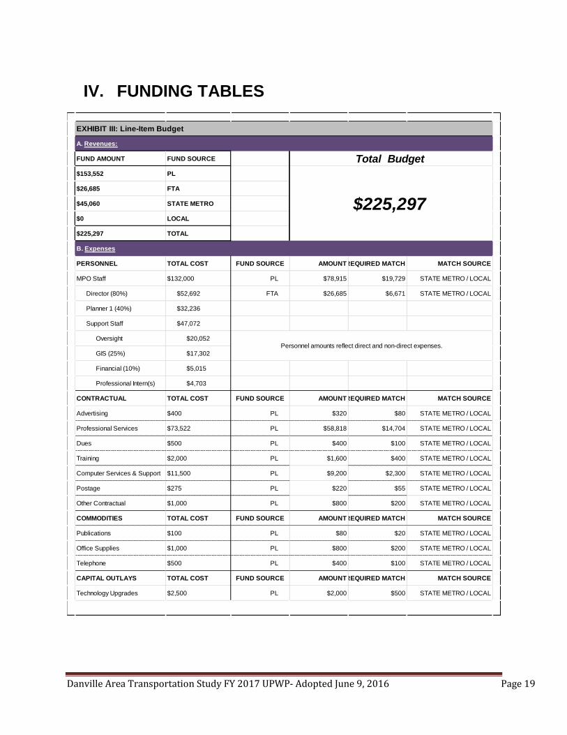
Danville Area Transportation Study FY 2017 UPWP- Adopted June 9, 2016 Page 19
IV. FUNDING TABLES
A. Revenues:
FUND AMOUNT FUND SOURCE
$153,552 PL
$26,685 FTA
$45,060 STATE METRO
$0 LOCAL
$225,297 TOTAL
B. Expenses
PERSONNEL TOTAL COST FUND SOURCE AMOUNTREQUIRED MATCH MATCH SOURCE
MPO Staff $132,000 PL $78,915 $19,729 STATE METRO / LOCAL
Director (80%) $52,692 FTA $26,685 $6,671 STATE METRO / LOCAL
Planner 1 (40%) $32,236
Support Staff $47,072
Oversight $20,052
GIS (25%) $17,302
Financial (10%) $5,015
Professional Intern(s) $4,703
CONTRACTUAL TOTAL COST FUND SOURCE AMOUNTREQUIRED MATCH MATCH SOURCE
Advertising $400 PL $320 $80 STATE METRO / LOCAL
Professional Services $73,522 PL $58,818 $14,704 STATE METRO / LOCAL
Dues $500 PL $400 $100 STATE METRO / LOCAL
Training $2,000 PL $1,600 $400 STATE METRO / LOCAL
Computer Services & Support $11,500 PL $9,200 $2,300 STATE METRO / LOCAL
Postage $275 PL $220 $55 STATE METRO / LOCAL
Other Contractual $1,000 PL $800 $200 STATE METRO / LOCAL
COMMODITIES TOTAL COST FUND SOURCE AMOUNTREQUIRED MATCH MATCH SOURCE
Publications $100 PL $80 $20 STATE METRO / LOCAL
Office Supplies $1,000 PL $800 $200 STATE METRO / LOCAL
Telephone $500 PL $400 $100 STATE METRO / LOCAL
CAPITAL OUTLAYS TOTAL COST FUND SOURCE AMOUNTREQUIRED MATCH MATCH SOURCE
Technology Upgrades $2,500 PL $2,000 $500 STATE METRO / LOCAL
EXHIBIT III: Line-Item Budget
Total Budget
$225,297
Personnel amounts reflect direct and non-direct expenses.

Danville Area Transportation Study FY 2017 UPWP- Adopted June 9, 2016 Page 20

Danville Area Transportation Study FY 2017 UPWP- Adopted June 9, 2016 Page 21
Appendix A. DATS Planning Area

Danville Area Transportation Study FY 2017 UPWP- Adopted June 9, 2016 Page 22

Approved June 9, 2016
1
Transportation Improvement Program Fiscal Years 2017 – 2020
Approved on June 9, 2016
Prepared For: Danville Area Transportation Study the, Metropolitan Planning Organization of the, Danville Urbanized Area In Cooperation With:
Illinois Department of Transportation (IDOT) Federal Highway Administration (FHWA) Federal Transit Administration (FTA) Prepared By: Jaclyn Vinson, MPO Director 1155 E Voorhees St, Suite A Danville, IL 61832 Phone: (217) 431-2873 Email: [email protected] Web: www.dats-il.com
D a n v i l l e U r b a n i z e d A r e a , V e r m i l i o n C o u n t y , I l l i n o i s
D a n v i l l e A r e a T r a n s p o r t a t i o n S t u d y , M e t r o p o l i t a n P l a n n i n g O r g a n i z a t i o n

Approved June 9, 2016
2
LIST OF ACRONYMS HBP Highway Bridge Program
CFR Code of Federal Regulations
FHWA Federal Highway Administration
FTA Federal Transit Administration
FY Fiscal Year
HES Hazard Elimination Safety Fund
IDOT Illinois Department of Transportation
INB Innovative Bridge
IM Interstate Maintenance Fund
L Local
Major BR Illinois Major Bridge Program
MAP-21 Moving Ahead for Progress in the 21st Century Act
MFT Motor Fuel Tax Fund
MPO Metropolitan Planning Organization
NHS National Highway System
PPR Project Priority Review
ROW Right-of-Way
RR-S Railroad Safety
S State
State Only State
STE Enhancement
STIP State Transportation Improvement Program
STP-R Surface Transportation Program – Rural
STP-U Surface Transportation Program – Urban
TAR Truck Access
TBP Township Bridge
TIP Transportation Improvement Program

Approved June 9, 2016
3
Administration
Jaclyn Vinson Director Liila Bagby Adam Aull Lisa Robinson
Planner I GIS Coordinator
Administrative Assistant
Policy Committee Technical Committee Advisory Committee
Illinois Department of Transportation, District 5 Representative
Illinois Department of Transportation, District 5 (1 Voting Member)
Illinois Department of Transportation, District 5 Local Roads
Vermilion County, County Board Chairman Vermilion County (2 Voting Members) Illinois Department of Transportation, Office of Planning and Programming
City of Danville, Mayor City of Danville (2 Voting Members) Federal Highway Administration
Townships, Danville Township Supervisor CRIS Rural Transit District (1 Voting Member) Federal Transit Administration
Villages, Village of Westville Mayor Vermilion Regional Airport (1 Voting Member) Vermilion Advantage
Villages -Tilton, Catlin, Belgium, Westville, or City of Georgetown (1 Voting Member) Danville Sanitary District
Townships-Newell, Blount, Danville, Catlin, Georgetown (1 Voting Member) Westville Sanitary District
Ameren Illinois
AT&T
Aqua Illinois Water Company

Approved June 9, 2016
4
INTRODUCTION
The Fiscal Years 2017-2020 Transportation Improvement Program (TIP) is a product of the on-going transportation planning process for the Danville Area Transportation Study (DATS). It was prepared by the administration of the MPO, with assistance from the DATS Technical Committee, for the DATS Policy Committee. The projects contained in the TIP are derived from the Long Range Transportation Plan, previous TIP documents and current and future needs of the urbanized area. The purpose of the TIP is the documentation of proposed projects spanning a period of four fiscal years in order to secure project funding. Any local project that solicits federal or state monies must be included in the annual TIP in order to be considered for such funding. Agencies who request Surface Transportation Urban (STU) funding for their projects must complete and submit a justification sheet to the MPO administration. The administration shall score submitted projects based upon criteria and scoring system specified in the justification sheet, which define how well the project fulfills the goals and objective of the Long Range Transportation Plan. The results are to then be presented to the Technical Committee to be used for an informed decision process in programming projects. Projects are subject to the financial abilities of federal, state and/or local agencies’ funding sources. When approved and endorsed by the DATS Policy Committee (the Metropolitan Planning Organization for the Danville area), these bodies certify that the requirements of 23 CFR, Section 450.308 are met. The existing transportation system within the Danville Area Transportation Study planning boundaries is being operated and maintained with the revenue sources that are provided through federal, state and local jurisdictions. The FY 2017-2020 Transportation Improvement Program is financially constrained, meaning that all funding estimates are based on anticipated state, federal, and local budget constraints.
PROJECT CATEGORIES AND PRIORITIZATION OF PROJECTS
The FY 2016-2019 TIP is developed to meet the guidelines of the Federal Highway Administration and the Federal Transit Administration under the Fixing America’s Surface Transportation(FAST Act). As specified in those guidelines, projects for the following categories are included: Interstate – This category includes improvements to the Interstate Highway System, which are funded through Interstate 4R funds for
reconstruction, rehabilitation, resurfacing and restoration. Operating and Capital Assistance Projects – This category consists of transit projects funded through Chapters 5307, 5309, 5310, 5311, 5316
and 5317. All transit projects in the Danville area are included in this category.

Approved June 9, 2016
5
Major or Area Service Highway Extensions – This category consists of those street projects within the urbanized area that are extensions of major rural roads into the urbanized area. Federal-Aid Surface Transportation Program Rural [STP-R] funds are used for projects in this category.
Urban Systems Projects – This category includes improvements to collector and arterial streets that are Federal-aid Highways. Federal-Aid Surface Transportation Program (STP) funds are used for projects in this category.
The continuing, comprehensive, and cooperative (3C) transportation planning process required by federal regulations requires inclusion in the TIP of those projects that will receive federal-aid funding from one or more of the federal transportation programs. These programs include: Interstate, Federal-Aid Surface Transportation Program Rural (STP-R) and Urban (STP-U) funds, Highway Bridge Replacement and Rehabilitation (BRRP), Federal-Aid Hazard Elimination Safety (HES) and Federal Transit Administration (FTA). Those projects, of IDOT and local jurisdictions, that are not regionally significant in nature, such as small resurfacing projects or minor railroad crossing improvements, may not be individually identified in the TIP even though the projects receive federal-aid funding. Many times the smaller projects are grouped together in similar categories (i.e. resurfacing). The costs shown in this document are estimates of expected costs based on current information available about the projects. Any significant changes to the cost of a project need to be reported to the DATS Technical and Policy Committees. This document sets priorities in two ways. The report differentiates between projects to be constructed or receive funding in the first fiscal year (FY 2017 Annual Element) and those to be constructed during the following three fiscal years (FY 2018-2020). The amount of time required for preliminary engineering and right-of-way acquisition, the availability of funds and community needs will determine whether a project will be in the Annual Element or the latter portion. Also included is an area for illustrative projects that do not have any identified funding source. These projects may be moved to one of the program years once funding is secured. Preliminary activities on some projects have been underway for some time. However, construction has not begun because these preliminary activities may not yet have been completed. Unforeseen difficulties in these activities could delay a project for a year or more. Thus a project may be included in the Annual Element for two years or more. Projects are prioritized at minimum on an annual basis to reflect changing needs and circumstances.

Approved June 9, 2016
6
TIP ANNUAL ELEMENT
In accordance with 23 CFR 450.220(c), the Metropolitan Planning section of the Federal Register of October 28, 1993, the participating members of the Danville Area Transportation Study agree that the State may propose federal-aid projects funded from the Highway Safety Improvement Program. They also may propose projects funded with Interstate, NHS, STP-R, STP-U, HES and BRRP monies, to be included in the statewide program of projects with these projects being drawn from the annual element of the TIP. All federally funded projects that significantly alter the functional capacity or capability of a facility will be included in the TIP Annual Element. All STP projects, regardless of work type, will be included in the TIP Annual Element. Some projects of similar work types will continue to be combined in the TIP Annual Element as categories of improvements such as engineering, intermittent resurfacing, etc. The Illinois Department of Transportation will continue to provide the Danville Area Transportation Study with the Department’s entire annual and multi-year highway program regardless of funding source and work type. The Illinois Department of Transportation will notify the Danville Area Transportation Study of all projects proposed for State letting regardless of funding source and work type, including projects not shown in the TIP Annual Element. The Danville area TIP will be utilized to develop the State’s Transportation Improvement Program (STIP). Highway and transit projects eligible for grouping will be summarized by year, funding source and type of work. The Danville area TIP will be incorporated by reference to the STIP. The STIP will be submitted for FHWA and FTA approval with appropriate documentation of public involvement.

Approved June 9, 2016
7
TIP SELECTION PROCESS
In accordance with FAST Act regulations, the four-year TIP is financially constrained. In other words, all projects in the second, third, and fourth year annual elements have reasonably guaranteed funding sources. Project implementation priority is given to the first annual element. However, circumstances may present themselves which necessitate the movement of a latter annual element project forward to the first year. When this occurs, such a move will take place by action of the Technical and Policy Committees. The Technical and Policy Committees shall also approve any project subject to amendment. The Danville Area Transportation Study receives an allocation of funds each year through formulas determined by the FHWA, FTA and the Illinois Department of Transportation, administered by the Illinois Department of Transportation. The Surface Transportation Program (STP) funds are funds for the Danville urbanized area. Consensus among the jurisdictions through action of the Policy Committee determines the best use of these funds.
PUBLIC INVOLVEMENT EFFORTS
Since its inception in early 2003, DATS has been actively committed to involving the public in the planning process. Whenever a regular meeting, public hearing or informational meeting is held, consideration is given to all comments or suggestions. In some instances, responses to resident input are prepared in writing and distributed to interested parties. For major transportation system developments that require formal Environmental Assessment (EA) or Environmental Impact Statement (EIS), comments received by the public at a public hearing or by letter are responded to directly in the final report. The MPO embraces an active role in identifying public participants. The administration presently maintains a mailing list, which includes active members of DATS committees and persons who have requested to be notified of meetings and events. The public is informed about DATS public meetings via announcements that are sent out to all individuals on the mailing list at least one (1) week prior to the scheduled event. Meeting announcements are also published onto the Internet via the DATS website, www.dats-il.com All interested parties are encouraged to join and participate at all DATS meetings. To facilitate public involvement in the development of a document or project, copies of all documents discussed at the DATS meetings are made available for public inspection at the MPO office prior to each meeting and are given to individuals upon request. News releases are

Approved June 9, 2016
8
distributed periodically to announce the availability of a DATS report or to provide background on planning activities. Final copies of all DATS documents are made available to the public via the DATS website and the MPO office. In addition to the formal public involvement process mentioned above, DATS relies on many informal techniques. This is especially important when considering that area residents often bring transportation planning issues and problems to the attention of their elected officials. For these reasons, DATS staff members often attend meetings of other governmental agencies. Informal public participation occurs when an interested citizen contacts the DATS office to discuss an issue in which they are interested, or when a citizen or business requests transportation or planning data. In developing the FY 2017-2020 TIP, the administration complied with the guidelines set forth in the Danville Area Transportation Study Public Participation Plan, adopted in April 2015.
REPORT FORMAT
Local projects may be identified by the DATS numbering system. This system lists the primary funding source, the anticipated year of construction and a second number referencing the project within this report (XX-YR-##). Local projects begin with the following initials:
City of Danville - DA City of Georgetown - GE Village of Tilton - TI Village of Catlin - CA Village of Belgium - BE Village of Westville - WE Danville Mass Transit - DMT CRIS Rural Transit District - CRIS Danville Township - DT Newell Township - NT Catlin Township - CT Vermilion County - VC Vermilion Regional Airport - VRA

Approved June 9, 2016
9
BEGINNING END
DA-17-01 Fairchild/JacksonDHS Shared Use Path and
Intersection ImprovementsSection/Jackson English MFT/ITEP 600.00 0.00 1,200.00 720.00 2,520.00
DA-17-02 VARIOUS ANNUAL MAINTENANCE MFT/LOCAL 1,000.00 0.00 0.00 0.00 1,000.00
1,000.00 0.00 0.00 0.00 1,000.00
FU N D TY PEA gency C ost
( in 1,0 0 0 's)
Part ner A gency
C ost
( in 1,0 0 0 's)
St at e C ost
Share
( in 1,0 0 0 's)
Federal C ost
Share ( in
1,0 0 0 's)
TOTAL (In 1,000's)
Fiscal Year 2017 Annual Element
PR OJEC T
N U M B ERPR OJEC T R OU TE
D ESC R IPT ION OF PR OPOSED
IM PR OV EM EN T
LOC A TION TOTA L
PR OJEC T
C OST ( in
1,0 0 0 's)
N OTES
CITY OF DANVILLE
BEGINNING END
DMT-17-01 OPERATING ASSISTANCE 5307 0.00 0.00 671.00 671.00 1342.00
DMT-17-02 TWO (2) 35' BUSES 5307 0.00 0.00 185.00 739.00 924.00
DMT-17-03 GARAGE RENOVATIONS 5307 0.00 0.00 50.00 200.00 250.00
0.00 0.00 906.00 1,610.00 2516.00
Federal C ost
Share ( in
1,0 0 0 's)
A gency C ost
( in 1,0 0 0 's)
Part ner A gency
C ost
( in 1,0 0 0 's)
TOTAL (In 1,000's)
PR OJEC T
N U M B ERPR OJEC T R OU TE
D ESC R IPT ION OF PR OPOSED
IM PR OV EM EN T
LOC A TION
FU N D TY PE
St at e C ost
Share
( in 1,0 0 0 's)
DANVILLE MASS TRANSIT
Fiscal Year 2017 Annual Element
N OTES
TOTA L
PR OJEC T
C OST ( in
1,0 0 0 's)
BEGINNING END
VC-17-01 TR274 CARROLL TWSP BRIDGE REPLACEMENT HBP/TBP 32.60 32.60 260.80 326.00 652.00 09-03138-00-BR
VC-17-02 COUNTY ROADS ANNUAL CO RESURFACING MFT 200.00 0.00 0.00 0.00 200.00
VC-17-03 COUNTY ROADS ANNUAL CO SEAL COAT MFT 400.00 0.00 0.00 0.00 400.00 17-00000-00-GM
VC-17-04 TOWNSHIP ROADS ANNUAL TWP SEAL COAT MFT 0.00 1,800.00 0.00 0.00 1,800.00 17-XX000-00-GM
VC-17-05 FAS 1511/CH20 WEST NEWELL RDFULL DEPTH PAVEMENT
RECLAMATION
DENMARK
RDIL RTE 1 MFT/STU 700.00 0.00 0.00 700.00 1,400.00 13-00203-00-RS
1,332.60 1,832.60 260.80 1,026.00 4,452.00
VARIOUS
VARIOUS
FU N D TY PEA gency C ost
( in 1,0 0 0 's)
Federal C ost
Share ( in
1,0 0 0 's)
VARIOUS
VERMILION COUNTY
TOTAL (In 1,000's)
Fiscal Year 2017 Annual Element
PR OJEC T
N U M B ERPR OJEC T R OU TE
D ESC R IPT ION OF PR OPOSED
IM PR OV EM EN TN OTES
Part ner A gency
C ost
( in 1,0 0 0 's)
St at e C ost
Share
( in 1,0 0 0 's)
LOC A TION
SN092-3174
TOTA L
PR OJEC T
C OST ( in
1,0 0 0 's)

Approved June 9, 2016
10
BEGINNING END
VRA-17-01 REHABILITATE TAXIWAY A AND A1
REHABILITATE THE INTERSECTION
OF TAXIWAY A AND A1 AS WELL
AS TAXIWAY A BETWEEN
RUNWAY 16/34 AND THE
TAXIWAY A AND A1
INTERSECTION
13.00 0.00 13.00 234.00 260.00
CONTINUE REHABILITATION OF
ROADWAYS AND TAXIWAYS ON THE
AIRPORT.
13.00 0.00 13.00 234.00 260.00
TOTA L
PR OJEC T
C OST ( in
1,0 0 0 's)
N OTES
VERMILION REGIONAL AIRPORT
LOC A TION
FU N D TY PEA gency C ost
( in 1,0 0 0 's)
Part ner A gency
C ost
( in 1,0 0 0 's)
St at e C ost
Share
( in 1,0 0 0 's)
Federal C ost
Share ( in
1,0 0 0 's)
TOTAL (In 1,000's)
Fiscal Year 2017 Annual Element
PR OJEC T
N U M B ERPR OJEC T R OU TE
D ESC R IPT ION OF PR OPOSED
IM PR OV EM EN T
BEGINNING END
CRIS-17-01 (3) 15 PASSENGER BUS 5310 0.00 0.00 0.00 190.00 190.00
CRIS-17-02 OPERATING ASSISTANCE 5311 0.00 0.00 0.00 168.00 168.00
CRIS-17-03 OPERATING ASSISTANCE DOAP 0.00 0.00 900.00 0.00 900.00
CRIS-17-04 PLANNING GRANT DTIF 0.00 0.00 125.00 0.00 125.00
0.00 0.00 1,025.00 358.00 1,383.00
2017
TOTA L
PR OJEC T
C OST ( in
1,0 0 0 's)
FU N D TY PEA gency C ost
( in 1,0 0 0 's)
St at e C ost
Share
( in 1,0 0 0 's)
Federal C ost
Share ( in
1,0 0 0 's)
N OTES
CRIS RURAL MASS TRANSIT DISTRICT
2017
PR OJEC T
N U M B ERPR OJEC T R OU TE
D ESC R IPT ION OF PR OPOSED
IM PR OV EM EN T
LOC A TIONPart ner A gency
C ost
( in 1,0 0 0 's)
TOTAL (In 1,000's)
2017
2017
Fiscal Year 2017 Annual Element
BEGINNING END
VCCD-17-01 Kickapoo Rail Trail Trail Construction- AC Oakw ood Ave Kickapoo Park ITEP/IDNR 117.74 0.00 652.00 2,201.00 2,970.74 CR-95-340-13 (ACSTE-00D5(108))
117.74 0.00 652.00 2,201.00 2,970.74
St at e C ost
Share
( in 1,0 0 0 's)
Federal C ost
Share ( in
1,0 0 0 's)
TOTA L
PR OJEC T
C OST ( in
1,0 0 0 's)
N OTES
VERMILION COUNTY CONSERVATION DISTRICT
TOTAL (In 1,000's)
Fiscal Year 2017Annual Element
PR OJEC T
N U M B ERPR OJEC T R OU TE
D ESC R IPT ION OF PR OPOSED
IM PR OV EM EN T
LOC A TION
FU N D TY PEA gency C ost
( in 1,0 0 0 's)
Part ner A gency
C ost
( in 1,0 0 0 's)
Approved June 9, 2016
11
BEGINNING END
DA-18-01Voorhees Street over Stoney
CreekMajor Bridge Replacement MBR 223.00 0.00 0.00 1,116.65 1,339.65 08-00330-02-PV
DA-18-02 VARIOUS ANNUAL MAINTENANCE MFT/LOCAL 1,000.00 0.00 0.00 0.00 1,000.00
1,000.00 0.00 0.00 0.00 1,000.00
FU N D TY PE
Federal C ost
Share ( in
1,0 0 0 's)
TOTA L
PR OJEC T
C OST ( in
1,0 0 0 's)
A gency C ost
( in 1,0 0 0 's)
St at e C ost
Share
( in 1,0 0 0 's)
Fiscal Year 2018 Annual Element
PR OJEC T
N U M B ERPR OJEC T R OU TE
D ESC R IPT ION OF PR OPOSED
IM PR OV EM EN T
LOC A TIONPart ner A gency
C ost
( in 1,0 0 0 's)
N OTES
CITY OF DANVILLE
TOTAL (In 1,000's)
BEGINNING END
DMT-18-01 OPERATING ASSISTANCE 5307 0.00 0.00 750.00 750.00 1,500.00
0.00 0.00 750.00 750.00 1,500.00
A gency C ost
( in 1,0 0 0 's)
TOTAL (In 1,000's)
LOC A TION
FU N D TY PE
TOTA L
PR OJEC T
C OST ( in
1,0 0 0 's)
N OTES
Fiscal Year 2018 Annual Element
DANVILLE MASS TRANSIT
St at e C ost
Share
( in 1,0 0 0 's)
Federal C ost
Share ( in
1,0 0 0 's)
Part ner A gency
C ost
( in 1,0 0 0 's)
PR OJEC T
N U M B ERPR OJEC T R OU TE
D ESC R IPT ION OF PR OPOSED
IM PR OV EM EN T
BEGINNING END
VC-18-01 TR194 BLNT TWSP BRIDGE REPLACEMENT HBP/TBP 0.00 25.00 25.00 200.00 250.00 13-01132-00-BR
VC-18-02 TR62 BUTLER TWSP BRIDGE REPLACEMENT HBP/TBP 0.00 25.00 25.00 200.00 250.00 13-02149-00-BR
VC-18-03 TR 261 OAKWOOD TWSP BRIDGE REPLACEMENT HBP/TBP 0.00 45.00 45.00 360.00 450.00 15-14141-00-BR
VC-18-04 COUNTY ROADS ANNUAL Co. RESURFACING MFT 200.00 0.00 0.00 0.00 200.00
VC-18-05 COUNTY ROADS ANNUAL Co. SEAL COAT MFT 400.00 0.00 0.00 0.00 400.00 18-00000-00-GM
VC-18-06 TOWNSHIP ROADS ANNUAL TWSP SEAL COAT MFT 0.00 1,800.00 0.00 0.00 1,800.00 18-XX000-00-GM
600.00 1,895.00 95.00 760.00 3,350.00
TOTA L
PR OJEC T
C OST ( in
1,0 0 0 's)
FU N D TY PEA gency C ost
( in 1,0 0 0 's)
Part ner A gency
C ost
( in 1,0 0 0 's)
Federal C ost
Share ( in
1,0 0 0 's)
PR OJEC T
N U M B ERN OTES
VERMILION COUNTY
TOTAL (In 1,000's)
SN092-3145
SN092-3069
VARIOUS
VARIOUS
PR OJEC T R OU TE
SN 092-3170
Fiscal Year 2018 Annual Element
LOC A TION
VARIOUS
St at e C ost
Share
( in 1,0 0 0 's)
D ESC R IPT ION OF PR OPOSED
IM PR OV EM EN T

Approved June 9, 2016
12
BEGINNING END
CRIS-18-01 (3) 15 PASSENGER BUS 5310 0.00 0.00 0.00 190.00 190.00
CRIS-18-02 OPERATING ASSISTANCE 5311 0.00 0.00 0.00 174.00 174.00
CRIS-18-03 OPERATING ASSISTANCE DOAP 0.00 0.00 990.00 990.00
0.00 0.00 990.00 364.00 1,354.00
TOTA L
PR OJEC T
C OST ( in
1,0 0 0 's)
Federal C ost
Share ( in
1,0 0 0 's)
St at e C ost
Share
( in 1,0 0 0 's)
Part ner A gency
C ost
( in 1,0 0 0 's)
TOTAL (In 1,000's)
PR OJEC T R OU TED ESC R IPT ION OF PR OPOSED
IM PR OV EM EN T
LOC A TION
FU N D TY PEA gency C ost
( in 1,0 0 0 's)
Fiscal Year 2018 Annual Element
PR OJEC T
N U M B ERN OTES
CRIS RURAL MASS TRANSIT DISTRICT
BEGINNING END
VRA-18-01APRON REHABILITATION
PHASE 1
REHABILITATE A PORTION OF THE
AIRCRAFT PARKING APRON66.00 0.00 66.00 1,188.00 1,320.00
66.00 0.00 66.00 1,188.00 1,320.00
St at e C ost
Share
( in 1,0 0 0 's)
Fiscal Year 2018 Annual Element
VERMILION REGIONAL AIRPORT
PR OJEC T R OU TED ESC R IPT ION OF PR OPOSED
IM PR OV EM EN T
A gency C ost
( in 1,0 0 0 's)
LOC A TION
Federal C ost
Share ( in
1,0 0 0 's)
TOTA L
PR OJEC T
C OST ( in
1,0 0 0 's)
N OTES
Part ner A gency
C ost
( in 1,0 0 0 's)
TOTAL (In 1,000's)
FU N D TY PEPR OJEC T
N U M B ER

Approved June 9, 2016
13
BEGINNING END
DA-19-01 DENMARK ROADNORTHWEST PUMP STATION
REPLACEMENT
WINTER/LO
GANCITY LIMITS
MFT,STU,
LOCAL4,500.00 0.00 0.00 0.00 4,500.00 16-00352-00-PV
DA-19-02 VARIOUS ANNUAL MAINTENANCE MFT/LOCAL 1,000.00 0.00 0.00 0.00 1,000.00
5,500.00 0.00 0.00 0.00 5,500.00
Fiscal Year 2019 Annual Element
PR OJEC T
N U M B ERPR OJEC T R OU TE
D ESC R IPT ION OF PR OPOSED
IM PR OV EM EN T
LOC A TION
CITY OF DANVILLE
TOTA L
PR OJEC T
C OST ( in
1,0 0 0 's)
Part ner A gency
C ost
( in 1,0 0 0 's)
St at e C ost
Share
( in 1,0 0 0 's)
Federal C ost
Share ( in
1,0 0 0 's)
TOTAL (In 1,000's)
N OTESFU N D
TY PE
A gency C ost
( in 1,0 0 0 's)
DMT-19-01 OPERATING ASSISTANCE 5307 0.00 0.00 750 750 1500
DMT-19-02 TWO (2) 35' BUSES 5307 0.00 0.00 196 784 980
DMT-19-03 ONE (1) SUPER-MEDIUM BUS 5310 0.00 0.00 27.00 88.00 115.00
0.00 0.00 973.00 1,622.00 2,595.00
Fiscal Year 2019 Annual Element
TOTAL (In 1,000's)
DANVILLE MASS TRANSIT
BEGINNING END
VC-19-01 COUNTY ROADS ANNUAL Co. RESURFACING MFT 200.00 0.00 0.00 0.00 200.00
VC-19-02 COUNTY ROADS ANNUAL Co. SEAL COAT MFT 400.00 0.00 0.00 0.00 400.00 19-00000-00-GM
VC-19-03 TOWNSHIP ROADS ANNUAL TWSP SEAL COAT MFT 0.00 1,800.00 0.00 0.00 1,800.00 19-XX000-00-GM
VC-19-04 TR 42A MIDDLEFORK TWSP BRIDGE REPLACEMENT HBP/TBP 0.00 22.50 22.50 180.00 225.00 13-12151-00-BR
VC-19-05 TR325 DANVILLE TWSP BRIDGE REPLACEMENT HBP/TBP 0.00 27.50 27.50 220.00 275.00 09-05144-00-BR
VC-19-06 TR 222 CATLIN TWP BRIDGE REPLACEMENT HBP/TBP 0.00 25.00 25.00 200.00 250.00 07-04132-00-BR
600.00 1,875.00 75.00 600.00 3,150.00
VARIOUS
Fiscal Year 2019 Annual Element
Federal C ost
Share ( in
1,0 0 0 's)
TOTA L
PR OJEC T
C OST ( in
1,0 0 0 's)
A gency C ost
( in 1,0 0 0 's)
LOC A TIONSt at e C ost
Share
( in 1,0 0 0 's)
VARIOUS
SN 092-0112
FU N D
TY PE
D ESC R IPT ION OF PR OPOSED
IM PR OV EM EN T
Part ner A gency
C ost
( in 1,0 0 0 's)
VARIOUS
N OTES
VERMILION COUNTY
SN 092-3271
PR OJEC T
N U M B ERPR OJEC T R OU TE
TOTAL (In 1,000's)
SN 092-3153

Approved June 9, 2016
14
BEGINNING END
CRIS-19-01 (3) 15 PASSENGER BUS 5310 0.00 0.00 0.00 190.00 190.00
CRIS-19-02 OPERATING ASSISTANCE 5311 0.00 0.00 0.00 174.00 174.00
CRIS-19-03 OPERATING ASSISTANCE DOAP 0.00 0.00 1,089.00 0.00 1,089.00
0.00 0.00 1,089.00 364.00 1,453.00
LOC A TIONSt at e C ost
Share
( in 1,0 0 0 's)
FU N D
TY PE
A gency C ost
( in 1,0 0 0 's)
Part ner A gency
C ost
( in 1,0 0 0 's)
PR OJEC T R OU TE
TOTA L
PR OJEC T
C OST ( in
1,0 0 0 's)
Federal C ost
Share ( in
1,0 0 0 's)
PR OJEC T
N U M B ER
D ESC R IPT ION OF PR OPOSED
IM PR OV EM EN T
CRIS RURAL MASS TRANSIT DISTRICT
Fiscal Year 2019 Annual Element
N OTES
TOTAL (In 1,000's)
BEGINNING END
VRA-19-01APRON REHABILITATION
PHASE 2
REHABILITATE A PORTION OF THE
AIRCRAFT PARKING APRON45.00 0.00 45.00 810.00 900.00
45.00 0.00 45.00 810.00 900.00
N OTES
Fiscal Year 2019 Annual Element
PR OJEC T
N U M B ERPR OJEC T R OU TE
D ESC R IPT ION OF PR OPOSED
IM PR OV EM EN T
St at e C ost
Share
( in 1,0 0 0 's)
Federal C ost
Share ( in
1,0 0 0 's)
TOTA L
PR OJEC T
C OST ( in
1,0 0 0 's)
LOC A TION
FU N D
TY PE
A gency C ost
( in 1,0 0 0 's)
TOTAL (In 1,000's)
VERMILION REGIONAL AIRPORT
Part ner A gency
C ost
( in 1,0 0 0 's)

Approved June 9, 2016
15
BEGINNING END
DA-20-01 VARIOUS ANNUAL MAINTENANCE MFT/LOCAL 1,000.00 0.00 0.00 0.00 1,000.00
1,000.00 0.00 0.00 0.00 1,000.00
FU N D TY PE
St at e C ost
Share
( in 1,0 0 0 's)
D ESC R IPT ION OF PR OPOSED
IM PR OV EM EN T
Part ner A gency
C ost
( in 1,0 0 0 's)
CITY OF DANVILLE
Federal C ost
Share ( in
1,0 0 0 's)
A gency C ost
( in 1,0 0 0 's)
Fiscal Year 2020 Annual Element
TOTAL (In 1,000's)
N OTESPR OJEC T
N U M B ERPR OJEC T R OU TE
TOTA L
PR OJEC T
C OST ( in
1,0 0 0 's)
LOC A TION
BEGINNING END
VC-20-01 TR 54 BRIDGE REPLACEMENT HBP/TBP 5.00 5.00 40.00 200.00 250.00 16-09129-00-BR
VC-20-02 COUNTY ROADS ANNUAL COUNTY RESURFACING M FT 200.00 0.00 0.00 0.00 200.00
VC-20-03 COUNTY ROADS ANNUAL COUNTY SEAL COAT MFT 400.00 0.00 0.00 0.00 400.00 20-00000-00-GM
VC-20-04 TOWNSHIP ROADS ANNUAL TOWNSHIP SEAL COAT MFT 0.00 1,800.00 0.00 0.00 1,800.00 20-XX000-00-GM
605.00 1,805.00 40.00 200.00 2,650.00
VERMILION COUNTY
TOTAL (In 1,000's)
SN 092-3062
VARIOUS
VARIOUS
LOC A TION
FU N D TY PEPR OJEC T R OU TE
TOTA L
PR OJEC T
C OST ( in
1,0 0 0 's)
N OTESD ESC R IPT ION OF PR OPOSED
IM PR OV EM EN T
VARIOUS
A gency C ost
( in 1,0 0 0 's)
Part ner A gency
C ost
( in 1,0 0 0 's)
Federal C ost
Share ( in
1,0 0 0 's)
St at e C ost
Share
( in 1,0 0 0 's)
Fiscal Year 2020 Annual Element
PR OJEC T
N U M B ER
BEGINNING END
CRIS-20-01 (3) 15 PASSENGER BUS 5310 0.00 0.00 0.00 190.00 190.00
CRIS-20-02 OPERATING ASSISTANCE 5311 0.00 0.00 0.00 174.00 174.00
CRIS-20-03 OPERATING ASSISTANCE DOAP 0.00 0.00 1,200.00 0.00 1,200.00
0.00 0.00 1,200.00 364.00 1,564.00
PR OJEC T R OU TEPR OJEC T
N U M B ER
TOTAL (In 1,000's)
CRIS RURAL MASS TRANSIT DISTRICT
TOTA L
PR OJEC T
C OST ( in
1,0 0 0 's)
N OTESD ESC R IPT ION OF PR OPOSED
IM PR OV EM EN T
LOC A TION
FU N D TY PEA gency C ost
( in 1,0 0 0 's)
Part ner A gency
C ost
( in 1,0 0 0 's)
St at e C ost
Share
( in 1,0 0 0 's)
Federal C ost
Share ( in
1,0 0 0 's)
Fiscal Year 2020 Annual Element

Approved June 9, 2016
16

Approved June 9, 2016
17