Embed Size (px)
Citation preview

Page 1 of 17
2019 Island County Conservation Futures Fund
Pearson Shoreline Acquisition
Sponsor: Whidbey Camano Land Trust
Contact: Ryan Elting
Address: 765 Wonn Rd C-201
Greenbank, WA 98253
Phone: 360-222-3310
Fax: 360-222-3510
E-mail: [email protected]
Project Budget Summary:
Total Land Value $2,000,000
Total Costs of Services (staff time, appraisal, survey, Phase
1 Environmental Assessment, trail signs, interpretive signs,
fencing, invasive species removal, etc.)
$98,000
Total Project Cost $2,098,000
CFF Amount Requested in 2019 $210,000
Parcel Numbers:
R42931-135-0080; R42931-071-0470; R42806-485-0240; R42931-142-0940; R32936-020-5200; R42806-472-0570 (tidelands)
Landowner Names:
Estate of William Pearson
Landowner Contact Information: (Please use Land Trust project manager as contact point.)
Primary Contact: Ryan Elting, Conservation Director
Mailing Address: 765 Wonn Road C-201, Greenbank, WA 98253
Phone: (360) 222-3310
E-mail [email protected]

Page 2 of 17
Project Description:
The Pearson Shoreline property, along Possession Sound south of Clinton, consists of 54 acres
of undeveloped forested uplands and private tidelands spanning more than one-half mile
(2,820 feet) along the shoreline.
In 2016, the Board of Island County Commissioners approved the County Parks Department to
partner with the Whidbey Camano Land Trust to pursue grant funds to protect fish and wildlife
habitat and create permanent public beach use, in an underserved area of Whidbey Island.
conserve the Pearson Shoreline property, and secure public beach access. Three years later, all
grant funding for the purchase of the property has been secured except for the 10% local match
required by the State grant. This proposal will fulfill this local funding requirement and allow
acquisition of the property.
The Land Trust will own and manage the property and the County will hold a conservation
easement that ensures permanent public access to this site for activities including birding,
nature-viewing, picnicking, beachcombing and kayaking, as well as precluding any future
development on this unstable bluff property. The site is also well situated on the Cascadia
Marine Trail, a Washington Water Trail and designated National Recreation Trail, and would
provide a needed stopover point for kayakers and other non-motorized boaters. The property’s
picturesque beach, abundant eelgrass beds, juvenile salmon and forage fish habitat, mature
coastal forest, and two seasonal streams contribute to the high environmental quality of the
property and its attractiveness to recreationists.
The Land Trust will bring Salmon Recovery funds (already secured) and the local Conservation
Futures Funds (this request), to purchase the underlying land interest, and the state $750,000
Aquatic Lands Enhancement Account grant (already secured) and the $985,000 federal National
Coastal Conservation and Wetland grant (already secured) will be used by the County to fund
the purchase of the conservation easement that will ensure permanent public access to the
property’s long expanse of shoreline.
Page 3 of 17
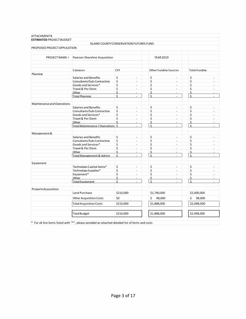
ATTACHMENT B ESTIMATED PROJECT BUDGET
ISLAND COUNTY CONSERVATION FUTURES FUND
PROPOSED PROJECT APPLICATION
PROJECT NAME = Pearson Shoreline Acquisition YEAR 2019
Category CFF Other Funding Sources Total Funding Planning Salaries and Benefits $ - $ - $ - Consultants/Sub-Contracting $ - $ - $ - Goods and Services* $ - $ - $ - Travel & Per Diem $ - $ - $ - Other $ - $ - $ - Total Planning $ - $ - $ -
Maintenance and Operations Salaries and Benefits $ - $ - $ - Consultants/Sub-Contracting $ - $ - $ - Goods and Services* $ - $ - $ - Travel & Per Diem $ - $ - $ - Other $ - $ - $ - Total Maintenance / Operations $ - $ - $ - Management &
Administration
Salaries and Benefits $ - $ - $ - Consultants/Sub-Contracting $ - $ - $ - Goods and Services* $ - $ - $ - Travel & Per Diem $ - $ - $ - Other $ - $ - $ - Total Management & Admin $ - $ - $ - Equipment Technology Capital Items* $ - $ - $ - Technology Supplies* $ - $ - $ - Equipment* $ - $ - $ - Other $ - $ - $ - Total Equipment $ - $ - $ - Property Acquisition Land Purchase $210,000 $1,790,000 $2,000,000
Other Acquisition Costs $0 $ 98,000 $ 98,000
Total Acquisition Costs $210,000 $1,888,000 $2,098,000
Total Budget $210,000 $1,888,000 $2,098,000
* For all line items listed with "*", please provided an attached detailed list of items and costs
Page 4 of 17
Project Narrative:
A. Conservation Values & Resources:
1. Rarity of resources or habitats protected:
a. Significance of resources protected:
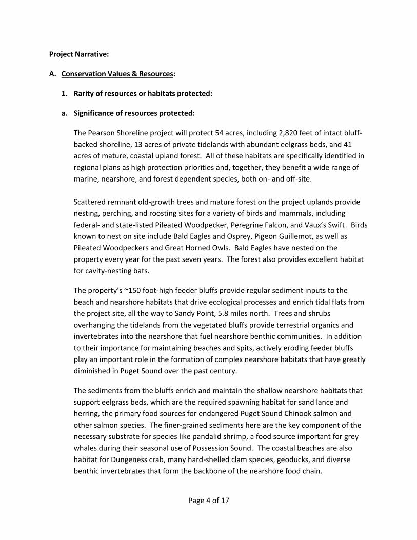
The Pearson Shoreline project will protect 54 acres, including 2,820 feet of intact bluff-
backed shoreline, 13 acres of private tidelands with abundant eelgrass beds, and 41
acres of mature, coastal upland forest. All of these habitats are specifically identified in
regional plans as high protection priorities and, together, they benefit a wide range of
marine, nearshore, and forest dependent species, both on- and off-site.
Scattered remnant old-growth trees and mature forest on the project uplands provide
nesting, perching, and roosting sites for a variety of birds and mammals, including
federal- and state-listed Pileated Woodpecker, Peregrine Falcon, and Vaux’s Swift. Birds
known to nest on site include Bald Eagles and Osprey, Pigeon Guillemot, as well as
Pileated Woodpeckers and Great Horned Owls. Bald Eagles have nested on the
property every year for the past seven years. The forest also provides excellent habitat
for cavity-nesting bats.
The property’s ~150 foot-high feeder bluffs provide regular sediment inputs to the
beach and nearshore habitats that drive ecological processes and enrich tidal flats from
the project site, all the way to Sandy Point, 5.8 miles north. Trees and shrubs
overhanging the tidelands from the vegetated bluffs provide terrestrial organics and
invertebrates into the nearshore that fuel nearshore benthic communities. In addition
to their importance for maintaining beaches and spits, actively eroding feeder bluffs
play an important role in the formation of complex nearshore habitats that have greatly
diminished in Puget Sound over the past century.
The sediments from the bluffs enrich and maintain the shallow nearshore habitats that
support eelgrass beds, which are the required spawning habitat for sand lance and
herring, the primary food sources for endangered Puget Sound Chinook salmon and
other salmon species. The finer-grained sediments here are the key component of the
necessary substrate for species like pandalid shrimp, a food source important for grey
whales during their seasonal use of Possession Sound. The coastal beaches are also
habitat for Dungeness crab, many hard-shelled clam species, geoducks, and diverse
benthic invertebrates that form the backbone of the nearshore food chain.

Page 5 of 17
The Pearson tidelands are identified in the Island County Multi-Species Salmon Recovery
Plan as a high protection priority for juvenile salmon habitat and a very high protection
priority for forage fish habitat. The project will protect one of the largest stretches of
intact coastal habitats under single ownership on southeast Whidbey Island. Other
regional, state, and local plans that reference the site’s resources are listed in Exhibit B.
The full ecological value of the Pearson property extends well beyond the project
boundaries. The property spans 2,820 feet of Possession Sound shoreline and is directly
across from the mouth of the Snohomish River, one of the most productive salmon
rivers in Puget Sound. Salmon fry exiting the Snohomish River rely heavily on the
shallow habitats on the west side of Possession Sound as refuge, and substantial use by
foraging juvenile Puget Sound Chinook is documented here. The property is also located
about one-half mile north of the mouth of Glendale Creek, one of only three salmon-
spawning streams on Whidbey Island. Precluding development on the property’s
uplands will maintain the natural functioning of its feeder bluffs that nourish the healthy
nearshore habitats that juvenile Chinook and other salmon species depend on.
The healthy, functioning nearshore and upland habitats described above, require
minimal restoration, making it highly suitable for conservation.
b. Rarity of resources or habitats protected:
The Pearson property’s 2,820 feet of un-armored natural shoreline is one of only a
handful of similar beach ownerships of such length in Island County. The eelgrass beds
on the project site are a nationally-declining nearshore habitat type that is highly
important for a large variety of marine species. On Whidbey Island, and across Puget
Sound, nearshore wetlands have been heavily impacted by bluff-top development. The
project abuts Possession Sound, an ecologically critical stretch of the Whidbey Basin
coastline, and one of the most important migratory shorebird and waterfowl areas on
the West Coast. Puget Sound wetlands provide essential habitat for millions of
migratory birds, and over five million birds migrate, overwinter, or reside along this
particular stretch of Puget Sound shoreline, including many shorebirds, waterfowl, and
raptors.
B. Appropriate Public Use and Enjoyment:
The Pearson property will provide access to low-impact recreation including hiking,
beachcombing, fishing, and nature-viewing, along more than one-half mile of beach and nearly
Page 6 of 17
a mile of trails through a mature coastal forest. The site is well suited for public access with an
existing gravel road that leads to the beach. Such a road could never be built under current
County codes, but its presence provides a unique opportunity to get residents and visitors to
the beach. The road will be maintained as a pedestrian trail, and an existing pull-out off the
paved county road will be enlarged and improved to accommodate visitor parking. With the
trail and cleared pull-off area already in place, minimal further disturbance will be necessary to
prepare the property for public use, and the passive recreational uses proposed for the site are
compatible with protecting its resources, while offering the public an opportunity to quietly
enjoy them.
The property features a wide grassy area next to the beach that would be suitable as a new
stopover and potential campsite for non-motorized boaters along the Cascadia Marine Trail, a
Washington Water Trail and designated National Recreation Trail that stretches from south
Puget Sound up to British Columbia. With the exception of Possession Point State Park, there
are no other marine trail campsites on south Whidbey Island. Having a potential new stopover
site on this side of Possession Sound will make this portion of the Marine Trail more accessible
to non-motorized boaters of all levels.
C. Plan Consistency and Partnerships:
Protection of the Pearson Shoreline project is consistent with the following local and regional
plans, as well as the local, state, and national plans listed in Exhibit B.
1. Island County Comprehensive Plan (ICCP):
Protection of the Pearson Shoreline property, with its significant beach access, fish and
wildlife habitat, wetlands, feeder bluffs, and low-impact recreational opportunities will
further several goals of the Island County Comprehensive Plan. These goals include:
a) Natural Resources Element:
Goal 3: Protect wetlands from a net loss in functions.
Goal 4: Protect Fish and Wildlife Habitat Conservation Areas.
Goal 6: Protect the public health, safety and welfare from threats resulting from
incompatible development being sited on or near steep and/or unstable
slopes.
Goal 8: Protect aquifer recharge areas from contamination and ensure long-term
recharge potential.

Page 7 of 17
Goal 10: Conserve a variety of natural lands, in both public and private ownership, for
the enjoyment and economic benefit of current and future residents of Island
County.
Goal 11: Prioritize the protection of natural lands that coincide with other valuable
resources, including ecological, historical, agricultural, recreational, and
cultural lands.
b) Parks and Recreation Element:
Goal 2: Provide low-impact/passive outdoor recreation opportunities throughout the
County. Specifically, the Plan states that “new parks and/or habitat
conservation areas are needed around Clinton to address nature trail needs.”
Goal 3: Increase public access to the County’s beaches and shoreline areas, creating
recreation opportunities that respect the ecological integrity of the shoreline
ecosystem.
Goal 4: Acquire lands that conserve priority habitat and natural resources, preserve
open space, improve beach access, maintain island character, and improve
and expand passive outdoor recreational opportunities for public enjoyment.
Goal 8: Foster partnerships and county-wide collaboration among park and habitat
providers to improve the provision of habitat conservation and recreation
services.
2. WRIA 6 Multi-species Salmon Recovery Plan (May 2005):
The Pearson project will help implement Island County’s Multi-species Salmon Recovery
Plan, by protecting high priority nearshore habitat. The stretch of shoreline that
encompasses the Pearson property is identified as a very high protection priority for forage
fish, including sand lance and herring, which use the site's eelgrass beds for spawning
habitat. The property is also identified as a high protection priority for juvenile salmon,
which find shelter and forage in the eelgrass beds, and feed on terrestrial insect rain that is
deposited from riparian vegetation growing along the undeveloped shoreline.
3. Washington State Puget Sound Partnership (PSP) – 2014/2015 Action Agenda:
The Protection and Restoration of habitat is one of three region-wide strategic initiatives
identified by the Puget Sound Partnership's Action Agenda. The Pearson property is a
critical addition to protection efforts on southeast Whidbey Island, given the small amount
of intact habitat and protected lands along this stretch of shoreline.

Page 8 of 17
The Puget Sound Partnership's Action Agenda also identifies improving public access to
Puget Sound as another of its three strategic initiatives. With 10 acres of tidelands and more
than one-half mile of beach with a scenic upland trail, the Pearson property would add
significantly to public beach access on south Whidbey Island and Puget Sound.
4. Documented support for this project by planning partners, other organizations, and
citizens:
There is a long history on Whidbey Island of trying to protect the Pearson property from
development, and community support for the project is expected to be very strong.
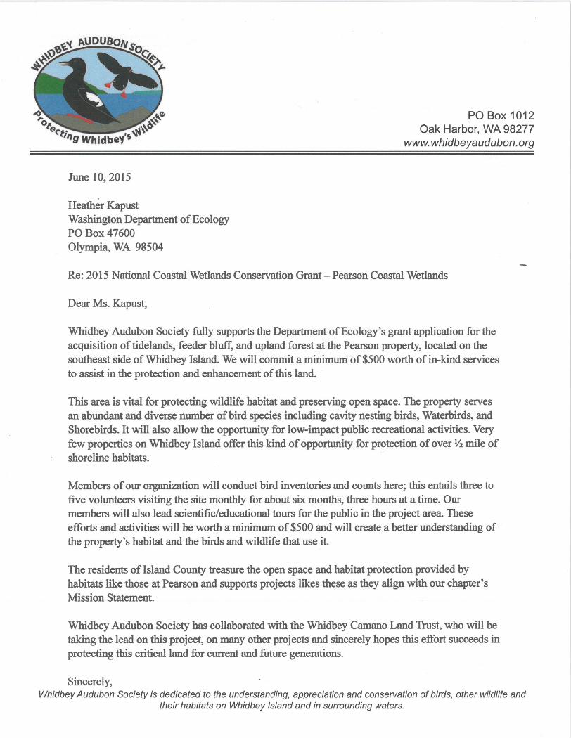
Organizations such as the Washington Water Trails Association and Whidbey Audubon
Society are thrilled at the possibility of adding one-half mile of public beach access and
protecting critical fish and wildlife habitat on south Whidbey Island.
The Pearson Shoreline acquisition project has documented support from:
- Washington Recreation and Conservation Office (RCO)
- Washington Salmon Recovery Funding Board (SRFB)
- U.S. Fish & Wildlife Service
- Washington Water Trails Association
- Whidbey Audubon Society
- Washington Department of Natural Resources
- Washington Veterans Conservation Corps
- Private citizens, mostly Clinton residents
D. Potential for Loss:
1. Immediacy and magnitude of potential loss of areas identified as having long-term rural
significance or land suitable for conservation.
In June 2017, the longtime landowner, Bill Pearson, declined an appraised fair market offer
to purchase the property by the Land Trust. The following May, Mr. Pearson passed away.
His executor in now preparing to market the property, for the first time in anyone’s living
memory, for sale as part of the process of settling the estate. The appraisal of the property,
including consulting with the Planning Department, indicated that the property can be
Page 9 of 17
developed into eight bluff-top homesites. This would represent the loss of a highly valuable
beach access opportunity and have a direct, negative impact on bluff stability and
associated nearshore habitats. Development of the uplands would degrade the quality of
Bald Eagle nesting habitat, and the productive eelgrass beds that support forage fish
spawning, salmon, shellfish and migratory birds. Acquiring the Pearson property is the most
cost-effective way to maintain functioning habitats on-site and coastal wetland habitats
along the rest of this drift cell. Protection of the property will also allow restoration of
impacted areas, including invasive plant and creosote removal. In addition, building on
feeder bluffs next to a county road often has a huge financial impact to Island County and
its taxpaying citizens when bluffs fail.
2. Immediacy of acquisition timing: opportunity with landowner and leveraged funding.
This very moment is our last and best opportunity to protect this amazing piece of Whidbey
Island shoreline before it is sold and developed. The commitment of 10 percent local match
through CFF is all that is necessary to allow the use the of the $1.9 million of federal and
state funding already secured.
E. Assessment of Stewardship Viability:
1. Stewardship needs are identified and adequately addressed with an appropriate
management plan or application includes funding request for management plan:
The Whidbey Camano Land Trust develops management plans for all of its fee-owned lands
to address long-term stewardship and public access needs. Funding for developing this plan
is available through the State grants. In addition, funding for immediate stewardship needs,
including invasive species removal, fencing, and signage, are covered by the federal and
state grant funding for the project.
To ensure appropriate and compatible public access, the Land Trust will need to install
fencing on certain sections of the road leading to the beach, and fence-off and
decommission several old roads. To this end, the WA Veterans Conservation Corps has
committed to assisting with invasive species removal, installing native plantings, and
reclaiming roads and trails that are not intended for public use.
The Land Trust also recruits volunteer land stewards for every property we own, who
maintain weekly scheduled visits to the property and carry out specific tasks.

Page 10 of 17
Lastly, the WA Department of Natural Resources has committed to removing two stockpiles
of creosote treated telephone poles on the Property uplands.
2. Potential risks and liabilities to protect long-term conservation values and resources are
identified and adequately addressed:
As stated above, certain measures will need to be taken to direct public access to the
desired, appropriate locations, which includes a future parking area, the existing road/trail
to the shoreline, and the shoreline beach area. Beyond public access, invasive plant control
is needed to deal with noxious weeds, particularly along the road to the beach, and the
landing area at the base of the road by the beach. Funding is available for this effort in the
short-term, and long-term control will be part of the Land Trust’s on-going maintenance.
3. Identifies long-term costs of maintenance and capital improvements (if any) and are
adequately addressed:
Capital improvements will be limited to a small parking area off of Humphrey Road, and the
Land Trust will seek funds for its design and construction. As use increase, we will also
provide a sani-can for visitors.
Funds from the State grants are sufficient to cover invasive species removal that will
supplement the efforts committed by the WA Veterans Conservation Corps.
F. Financial Strategies:
1. Acquisition cost efficiencies and financial strategy (including matching contributions) to
leverage use of funds:
The State grant requires local match in the amount of 10 percent of the total project cost,
for which the Land Trust is hereby requesting $210,000 from the Conservation Futures
Fund.
For its part, the Land Trust will bring Salmon Recovery funds (already secured) to purchase
the underlying land interest, and the state and federal grants will be used by the County to
acquire the conservation easement to ensure permanent public access.
Page 11 of 17
2. Strategy for managing future costs, liability and risk issues (for example, acquisition of
minimum controlling interest).
The Land Trust has not identified any notable risks or liabilities related to protecting the
long-term conservation values and resources of the property. The Land Trust will be
responsible for the long-term management and maintenance of the site, and has a
Stewardship Reserve Fund, Legal Defense Fund, and legal defense insurance, all of which
help ensure the Land Trust’s ability to manage the site in perpetuity.
In addition, the Land Trust has a robust volunteer program that currently engages more
than 150 volunteers per year who contribute more than 3,500 hours stewarding Land Trust
properties. Several volunteers have expressed interest in adopting the Pearson property as
volunteer Site Stewards if the site is successfully protected.
To prevent bluff-top development that would destabilize the bluff and endanger the
property’s habitats, and to allow public access through the property and along the beach,
fee-simple ownership is the minimal controlling interest feasible. The partnership helps
achieve the goals and metrics of the County’s Comprehensive Plan, and by partnering with
the Land Trust the County only needs to hold a conservation easement interest in the
property.

Page 12 of 17
Exhibit A: Pearson Shoreline Project Photos

Page 13 of 17

Page 14 of 17
View of the beach from the trail on the Pearson Shoreline uplands.
The Pearson Shoreline property features 2,820 feet of intact feeder bluff, beach, and tidelands with eelgrass beds.

Page 15 of 17
The Pearson property will provide beach and trail access for a variety of low-impact recreational uses.
There are two seasonal streams and several wetlands on the property that contribute to the site’s high environmental quality.
Page 16 of 17
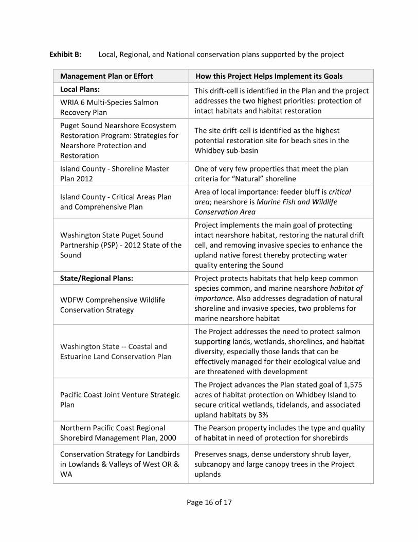
Exhibit B: Local, Regional, and National conservation plans supported by the project
Management Plan or Effort How this Project Helps Implement its Goals
Local Plans: This drift-cell is identified in the Plan and the project addresses the two highest priorities: protection of intact habitats and habitat restoration
WRIA 6 Multi-Species Salmon Recovery Plan
Puget Sound Nearshore Ecosystem Restoration Program: Strategies for Nearshore Protection and Restoration
The site drift-cell is identified as the highest potential restoration site for beach sites in the Whidbey sub-basin
Island County - Shoreline Master Plan 2012
One of very few properties that meet the plan criteria for “Natural” shoreline
Island County - Critical Areas Plan and Comprehensive Plan
Area of local importance: feeder bluff is critical area; nearshore is Marine Fish and Wildlife Conservation Area
Washington State Puget Sound Partnership (PSP) - 2012 State of the Sound
Project implements the main goal of protecting intact nearshore habitat, restoring the natural drift cell, and removing invasive species to enhance the upland native forest thereby protecting water quality entering the Sound
State/Regional Plans: Project protects habitats that help keep common species common, and marine nearshore habitat of importance. Also addresses degradation of natural shoreline and invasive species, two problems for marine nearshore habitat
WDFW Comprehensive Wildlife Conservation Strategy
Washington State -- Coastal and Estuarine Land Conservation Plan
The Project addresses the need to protect salmon supporting lands, wetlands, shorelines, and habitat diversity, especially those lands that can be effectively managed for their ecological value and are threatened with development
Pacific Coast Joint Venture Strategic Plan
The Project advances the Plan stated goal of 1,575 acres of habitat protection on Whidbey Island to secure critical wetlands, tidelands, and associated upland habitats by 3%
Northern Pacific Coast Regional Shorebird Management Plan, 2000
The Pearson property includes the type and quality of habitat in need of protection for shorebirds
Conservation Strategy for Landbirds in Lowlands & Valleys of West OR & WA
Preserves snags, dense understory shrub layer, subcanopy and large canopy trees in the Project uplands
Page 17 of 17
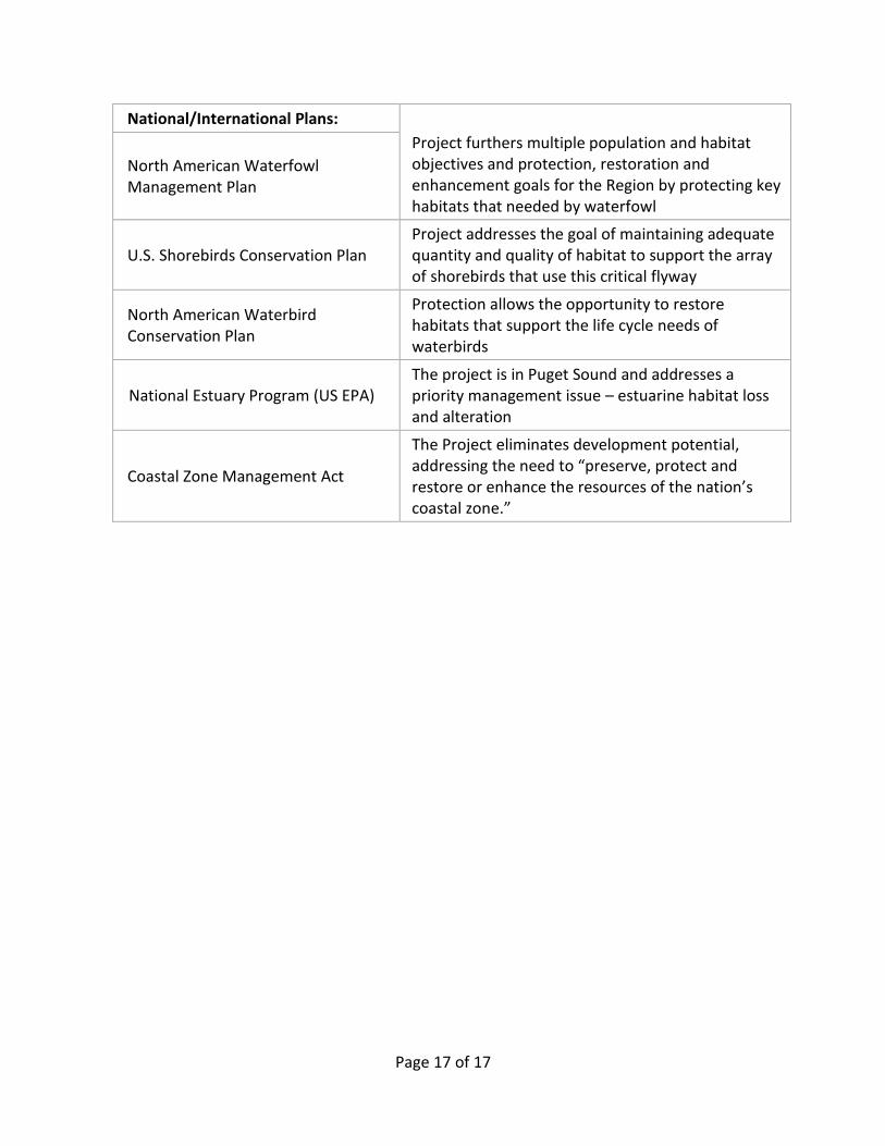
National/International Plans:
Project furthers multiple population and habitat objectives and protection, restoration and enhancement goals for the Region by protecting key habitats that needed by waterfowl
North American Waterfowl Management Plan
U.S. Shorebirds Conservation Plan Project addresses the goal of maintaining adequate quantity and quality of habitat to support the array of shorebirds that use this critical flyway
North American Waterbird Conservation Plan
Protection allows the opportunity to restore habitats that support the life cycle needs of waterbirds
National Estuary Program (US EPA) The project is in Puget Sound and addresses a priority management issue – estuarine habitat loss and alteration
Coastal Zone Management Act
The Project eliminates development potential, addressing the need to “preserve, protect and restore or enhance the resources of the nation’s coastal zone.”


Island County Salmon Recovery Technical and Citizens Committee
P.O. Box 5000, Coupeville, WA 98239
June 22, 2018
Suzanna Stoike, PSAR Program Manager Puget Sound Partnership 326 East D St., Tacoma, WA 98501 RE: Letter of Support for Pearson Shoreline Acquisition
Dear Suzanna & PSAR Large Cap Team Members,
As the appointed citizen’s advisory board for the WRIA 6 Island lead entity, the Salmon Recovery Technical and Citizens Committee (SRTCC) approves the Whidbey Camano Land Trust applying for Large Cap Puget Sound Acquisition & Restoration (PSAR) funding for 18-1832 Pearson Shoreline Acquisition project.
This project will result in the acquisition and protection of a 52-acre property including2,820 feet of feeder bluff, 10-acres of tidelands, and 39-acres of upland with two streams that cascade down the forested bluffs to the shoreline below. This property offers nearshore benefits to out- and in-migrating salmon that rely on the nearshore for their survival through the following habitats: eelgrass, feeder bluffs and upland forest and wetlands. The Pearson Shoreline Acquisition project advances priority restoration efforts called for in WRIA 6 Salmon Recovery Plan.
Thank you for your consideration of this proposal. Please let me know if you need more information.
Sincerely,
Todd Zackey, Co-Chair Salmon Recovery Technical and Citizen Committee WRIA 6 Lead Entity Island County