Embed Size (px)
Citation preview

2020 CensusLocal Update of Census Addresses
Operation (LUCA)Promotion
Atlanta Regional Office Managing Census Operations in:AL, FL, GA, LA, MS, NC, SC

Agenda 2020 Census Overview What is LUCA? LUCA Confidentiality and Security Statewide LUCA Participation in 2010 Other Census Geography Programs (GSS, BAS, PSAP) LUCA Participation Media Options (GUPS, Digital, Paper)
Preparing For The 120 Day Review Period
2

Why allocate your limited resources to Census programs?
Political Power: Census is constitutionally mandated for re‐apportionment of
Congress. Census results are used for Redistricting at national, state, and
local levels. Informed Planning: Federal, tribal, state and local use governments use Census data
in their community planning and regional development. Businesses and non‐profits use Census statistics in their
organizational decisions (e.g., where to locate, size of market, etc.)
Money/Economic Impact: $400 Billion/year is distributed using Census numbers ($4
Trillion over the decade).
3

2020 Census Design
44

Address List Maintenance 2010 ‐ 2020
On‐going Maintenance and Update
US Postal Service’s Delivery Sequence File (DSF)Updates from tribal, state, and local government address lists and commercial address listsContinuous identification of stability and change
Address Canvassing
Nationwide In‐Office Address CanvassingIn‐Field Address CanvassingAnnual In‐Field data collection, checks, and tests
LUCA
Opportunity to review and update the Census Bureau’s address list for the 2020 Census
5

What is the Local Update of Census Addresses Operation
(LUCA)? Authorized by the Census Address List Improvement Act of 1994 (Public Law 103‐430).
2020 Decennial Census voluntary geographic partnership operation.
The one and only opportunity for tribal, state, and local governments to review and update the Census Bureau’s Address List for residential addresses and group quarters.
6

Before we count people, we need an accurate list of the living quarters where we need to count them.
LUCA improves the Census Bureau’s Address List.
Local Governments are almost always the best source of address data (GIS, E911, Property Tax Assessors, and/or Utility Services, etc...).
The accuracy and completeness of the address list is critical to the success of the Census.
An accurate Address List leads to an accurate Population Count.
Why LUCA Is A Critical Component For An Accurate 2020 Census
7

What’s New for LUCA 2020 Includes ungeocoded address records for state and county participants.
Includes residential structure coordinates, if available.
Allows participants to submit residential structure coordinates, if available.
Allows participants to submit non‐city style addresses with corresponding map spots.
Requires residential multi‐unit structure identifiers (Apt 1, Unit A2, Lot 17, #3001, etc.)
8

Confidentiality and Security The information provided to/from LUCA is covered under Title 13 of the United States Code which: Requires the Census Bureau maintain the confidentiality of all information it collects.
Requires the Census Bureau to ensure confidential treatment of census‐related information, including individual addresses and map structure points.
Requires that all LUCA liaisons, LUCA reviewers, and anyone with access to Title 13 materials abide by the Confidentiality and Security Guidelines.
Requires certification of return or destruction of Title 13 data after LUCA ends.
9

Counties in SC = 46
# in LUCA2010 = 44
96% of SC counties participated in LUCA
for 2010.

Cities in SC = 268(does not include
CDPs)
# in LUCA2010 = 142
53% of SC cities participated in LUCA
for 2010.

For all areas in white, there was no local review of the
Census address list for the 2010 Census.

Geographic Support System (GSS) Program
Integrated program of improved address coverage, continual spatial and feature updates, and enhanced quality assessment and measurement.
Supports and maintains the geographic and cartographic infrastructure necessary for the Census Bureau’s data collection, processing, tabulation, and dissemination programs for the United States and Puerto Rico.
Provides for continual updates throughout the decade to support current surveys and the 2020 Census.
13

14

The State of South Carolinaprovided address point data for the entire state.

Boundary and Annexation Survey (BAS)
If the Census place boundary (blue) is not corrected to aligned with the accurate locally‐sourced place boundary (red) and parcels (black), housing units may be misallocated.
Annual BAS Schedule:December/January – program information sent to
participantsJanuary 1 – Date that Annexations must be legally in
effect March 1 – submission deadline for Population
Estimates program and ACSMay 31 – submission deadline for changes to be
included in subsequent BAS materialsand in the 2020 LUCA materials.
16

2020 Participant Statistical Areas Program (PSAP)
An opportunity for designated representatives to review and update statistical geographies for 2020 Census data tabulation.
• Coordinating agencies can review, identify, propose changes, and delineate new census tracts, block groups, census designated places (CDPs), and census county divisions (CCDs).
• 2 Phases: • Delineation (120‐day review)• Verification (90‐day review)
17

2020 Participant Statistical Areas Program (PSAP) “Plan”New for 2020
GOAL: Clean, Consistent Statistical Geography Nationwide
Census Bureau intends to create a 2020 statistical areas “plan” for both the standard and tribal statistical geographies, which our partners can review and update.
Lessens burden on our partners.
Ensures that ALL statistical geographies are reviewed/updated consistently.
More extensive review than just criteria thresholds.
Partners can update the 2020 “plan” OR update from 2010 statistical geography base.
18

2020 Participant Statistical Areas Program (PSAP)
Participation Options & Schedule
Tentative Schedule:• Program Invitation – July 2017• Materials Available – December 2018• PSAP Verification – December 2019
19
Standard Statistical Geographies:
Tribal Statistical Geographies: GUPS
Paper Maps
or
GUPS Geographic Update Partnership Software

LUCA Timeline January 2017: Advance notification for LUCA mailed. April 2017: LUCA promotional trainings begin. July 2017: Invitation letter and registration forms mailed. We
recommend registering before the end of August. October 2017: Technical training workshops begin. February 2018: Participation materials mailed to registered
participants (120 day clock begins upon receipt). This is the time technical staff needs to be available. We recommend that you plan now to ensure adequate budget and resource availability during this time period.
August 2019: Feedback materials sent to participants and the 30 day appeals process begins.
April 1, 2020: Census Day.
20
Preparing For LUCA 120 Day Review Period
Participate in the 2017 Boundary and Annexation Survey (BAS) to ensure your jurisdiction’s boundaries are accurate and up to date prior to LUCA.
Develop your address review strategy and determine team of reviewers – Estimates are between 16 to 672 hours to complete the address review and submit updates.
Coordinate your partnership with overlapping and neighboring county, city, and state governments.
Determine, assemble, and prepare your local address sources. Determine the format for your LUCA materials. Geocode your local address list using the on‐line Census Geocoder. Access the Census Address Block Count List for your jurisdiction online
and compare these counts to your local sources.
21

Takes individual addresses or a file of addresses and obtains approximate coordinates and census Geography.
Increase the maximum number of records from 1,000 to 10,000. Provides an alternate
path for largergovernments to submit addressesto be geocoded when you have an address listthat is not geocoded(not linked to pointsor parcels or any particular location.)
24 hour turnaround on the results.
22
Early Tools For LUCA PartnersUpdated Census Geocoder Tool
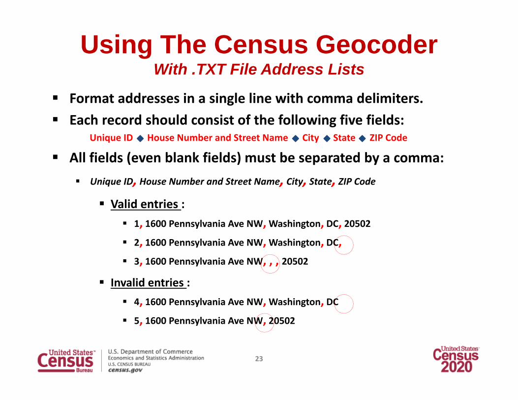
Using The Census GeocoderWith .TXT File Address Lists
Format addresses in a single line with comma delimiters. Each record should consist of the following five fields:
Unique ID House Number and Street Name City State ZIP Code
All fields (even blank fields) must be separated by a comma: Unique ID, House Number and Street Name, City, State, ZIP Code
Valid entries : 1, 1600 Pennsylvania Ave NW, Washington, DC, 20502 2, 1600 Pennsylvania Ave NW, Washington, DC, 3, 1600 Pennsylvania Ave NW, , , 20502
Invalid entries : 4, 1600 Pennsylvania Ave NW, Washington, DC 5, 1600 Pennsylvania Ave NW, 20502
23

Batch Census Geocoder Output File
TractB
lock
Batch File Address
ID Match
TIGER/Line ID**Matching Address
MatchType Lat/Lon*
ST CO
24
*Our latitude and longitude coordinate system is NAD83.**TIGER/Line ID is dependent upon which benchmark you choose.
(We recommend using Public_AR_ACS2016 Benchmark with Current_ACS2016 vintage.)

Census Geocoder Helpful Hints Apartments, suites, lot numbers, rooms, etc., are geocoded by the basic street address, regardless of the individual unit identifier.
When setting up your address list, it is good practice to use headers to help organize and structure your address formatting – particularly when uploading a spreadsheet based format (.CSV, .XLS, or .XLSX formats).
Headers count as the first record. It takes time to geocode 10,000 addresses – be patient.
25

Early Address Block Count List Providing an early address block count list for partners in January 2017 (includes count of residential addresses and group quarters by block).
Address Block Count lists can be linked/joined to 2016 TIGER/Line shape files.
More Early Tools For LUCA Partners
26

Accessing Your Count List
27
1. Finds your counts HERE!
2. Choose your AIA or state.
3. Choose your entity type.
4. Select your entity.

Linking Address Block Count Data
28
Early Address Block Count Lists can be linked/joined to 2016 TIGER/Line Shapefiles for overlay and analysis.
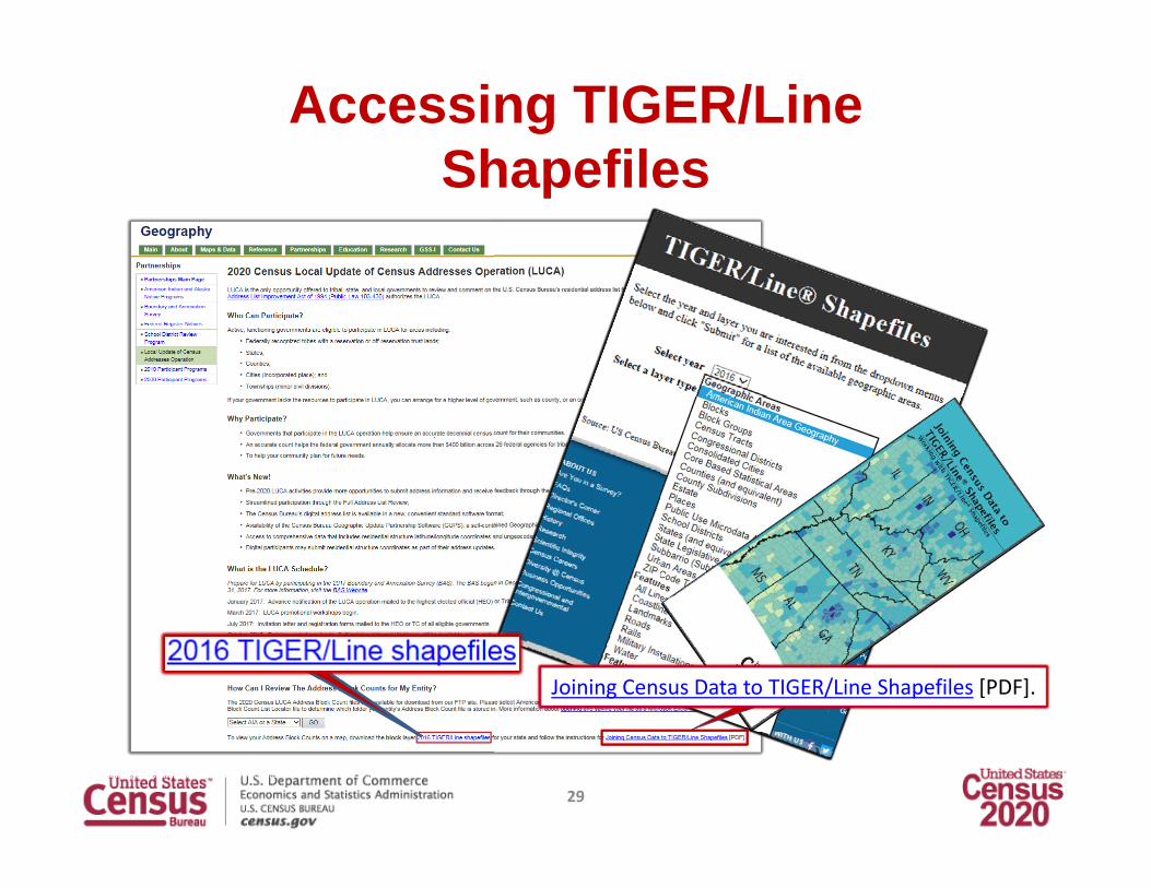
Accessing TIGER/Line Shapefiles
29
Joining Census Data to TIGER/Line Shapefiles [PDF].

Preparation – Address List Formats Paper Available to governments with 6,000 or fewer addresses. Legal size (8.5” x 14”) – 6 addresses per page. Two sorts:
Street Name/House Number. Census Tract number/Block number/Street Name/House Number.
Separate ‘Add Page’ Digital Available to all governments. Excel (.xlsx) or Comma Delimited Text (.csv) format. No separate ‘Add Page’.
30

Address List LayoutLUCA 2010 – 26 Fields LUCA 2020 – 24 FieldsEntity IDLine #MAFIDActionStateCountyTractBlockGQ FlagHouse NumberStreet Name Prefix QualifierStreet Name Prefix DirectionStreet Name Prefix TypeStreet NameStreet Name Suffix TypeStreet Name Suffix DirectionStreet Name Suffix QualifierLocation Description or GQ NameApartment/Unit NumberZIP CodeNoncity‐Style Mailing AddressNoncity‐Style ZIP CodeStructure PointLatitudeLongitudeCity‐Style Flag
Line #MAFIDActionEntity IDStateCountyTractBlockGEO IDGQ FlagHouse NumberStreet NameApartment/Unit #ZIP CodeGQ NameFacility NameLocation DescriptionNoncity‐Style Mailing AddressNoncity‐Style ZIP CodeMapspot IDAddress UseLatitudeLongitudeCity‐Style Flag
}
31

Paper ‐ Address List
DISCLOSURE PROHIBITED BY TITLE 13, U.S.C.NO TITLE 13 DATA DISPLAYED
32

Paper – Address List Add Page
33

Map Media types
Electronic Map Media Maps are provided as TIGER partnership shapefiles
Paper Map Media Large format paper map(s) (36” X 42”) along with a DVD of
small format (8.5” X 14”) block maps in Adobe PDF format
34

Geographic Update Partnership Software (GUPS)
Customized Geographic Information System (GIS) software for participation in the 2020 LUCA operation.
Designed to be usable for participants with no GIS experience, but may also be the best choice for GIS users.
Allows for both simple and complicated reviews and edits. Allows participants to add external geospatial data
(shapefiles, geodatabases, and imagery) for comparison and update purposes.
Quality Check/Validation Tool within GUPS assures LUCA edits are valid before submission file(s) are created.
No internet connection required.
35

GUPS Hardware and Software Requirements
36

Geographic Update Partnership Software (GUPS)
37

Geographic Update Partnership Software (GUPS)
38

Prioritizing Your ReviewWhen a complete review is not possible, focus your review on these areas:
Group quarters – College dorms, nursing homes, correctional facilities, etc. Areas of new construction. E‐911 conversion areas. Single/multifamily home conversions. Warehouses converted to residential. New mobile homes. Apartment buildings with irregular/missing numbering schemes. Annexed land. Areas along governmental boundaries. Blocks with the greatest count differences between the Census Bureau’s
address block count and your address block count. State and county reviewers should also focus on the ungeocoded list.
39

http://www.census.gov/geo/partnerships/luca.html(check this website for updates)
40

2020 Census LUCA
Questions?
Toll free LUCA Helpline: (844) 344‐0169
Email: [email protected]
Website: https://www.census.gov/geo/partnerships/luca.html
Atlanta Regional Office Geography Department: (404) 331‐1339
41