Embed Size (px)
Citation preview
THE EXCAVATION OF A ROMANCEMETERY AT 21–33 NEWARKE
STREET, LEICESTERMichael Derrick
with contributions from:Jennifer Browning, Simon Chapman, Nicholas Cooper, Harriet Jacklin,
Angela Monckton and Deborah Sawday
Archaeological excavation by University of Leicester Archaeological Services inadvance of the redevelopment of 21–33 Newarke Street, Leicester, revealedsignificant extra-mural Roman deposits. Early activity comprised agriculturalplot lay-outs, the alignment of which supports the proposal that NewarkeStreet follows the line of the Roman road from Leicester to Medbourne(Gartree Road). During the fourth century, the site was part of an extensiveinhumation cemetery and 30 burials were excavated. Two contemporarystructures are likely to represent mausolea. Two late seventeenth–earlyeighteenth-century brick-kilns were also located. The finds and archive are heldby Leicester City Museums (Accession Nos. A5.2002 and A23.2002).
INTRODUCTION
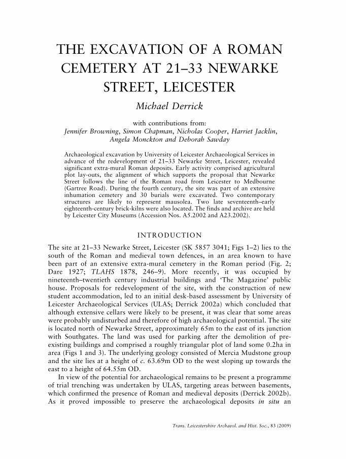
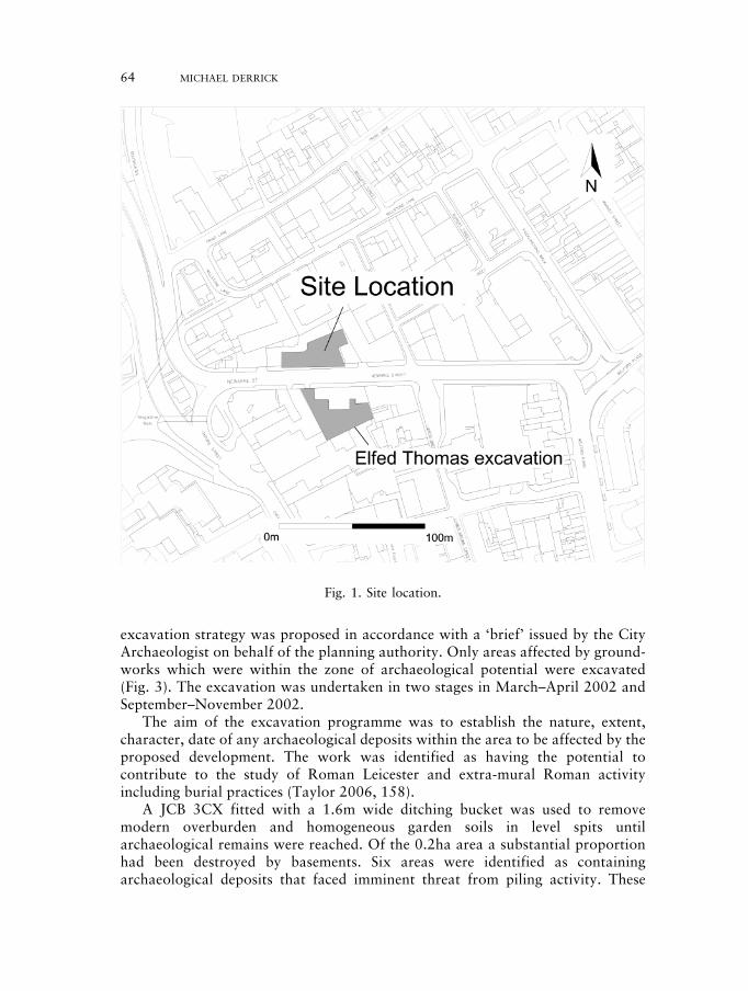
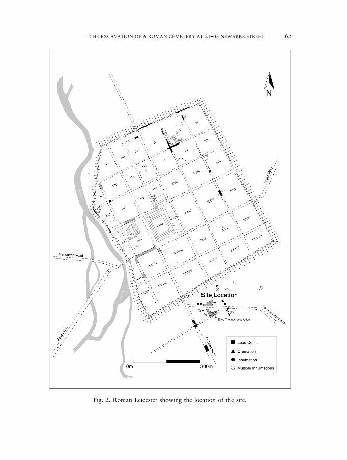
The site at 21–33 Newarke Street, Leicester (SK 5857 3041; Figs 1–2) lies to thesouth of the Roman and medieval town defences, in an area known to havebeen part of an extensive extra-mural cemetery in the Roman period (Fig. 2;Dare 1927; TLAHS 1878, 246–9). More recently, it was occupied bynineteenth–twentieth century industrial buildings and ‘The Magazine’ publichouse. Proposals for redevelopment of the site, with the construction of newstudent accommodation, led to an initial desk-based assessment by University ofLeicester Archaeological Services (ULAS; Derrick 2002a) which concluded thatalthough extensive cellars were likely to be present, it was clear that some areaswere probably undisturbed and therefore of high archaeological potential. The siteis located north of Newarke Street, approximately 65m to the east of its junctionwith Southgates. The land was used for parking after the demolition of pre-existing buildings and comprised a roughly triangular plot of land some 0.2ha inarea (Figs 1 and 3). The underlying geology consisted of Mercia Mudstone groupand the site lies at a height of c. 63.69m OD to the west sloping up towards theeast to a height of 64.55m OD.
In view of the potential for archaeological remains to be present a programmeof trial trenching was undertaken by ULAS, targeting areas between basements,which confirmed the presence of Roman and medieval deposits (Derrick 2002b).As it proved impossible to preserve the archaeological deposits in situ an
Trans. Leicestershire Archaeol. and Hist. Soc., 83 (2009)
230487 02c-063-102 18/10/09 10:16 Page 63
excavation strategy was proposed in accordance with a ‘brief’ issued by the CityArchaeologist on behalf of the planning authority. Only areas affected by ground-works which were within the zone of archaeological potential were excavated(Fig. 3). The excavation was undertaken in two stages in March–April 2002 andSeptember–November 2002.
The aim of the excavation programme was to establish the nature, extent,character, date of any archaeological deposits within the area to be affected by theproposed development. The work was identified as having the potential tocontribute to the study of Roman Leicester and extra-mural Roman activityincluding burial practices (Taylor 2006, 158).
A JCB 3CX fitted with a 1.6m wide ditching bucket was used to removemodern overburden and homogeneous garden soils in level spits untilarchaeological remains were reached. Of the 0.2ha area a substantial proportionhad been destroyed by basements. Six areas were identified as containingarchaeological deposits that faced imminent threat from piling activity. These
64 MICHAEL DERRICK
Fig. 1. Site location.
230487 02c-063-102 18/10/09 10:16 Page 64
THE EXCAVATION OF A ROMAN CEMETERY AT 21–33 NEWARKE STREET 65
Fig. 2. Roman Leicester showing the location of the site.
230487 02c-063-102 18/10/09 10:16 Page 65
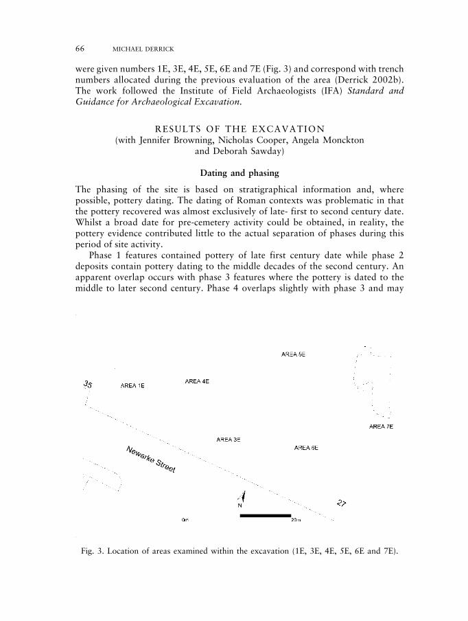
were given numbers 1E, 3E, 4E, 5E, 6E and 7E (Fig. 3) and correspond with trenchnumbers allocated during the previous evaluation of the area (Derrick 2002b).The work followed the Institute of Field Archaeologists (IFA) Standard andGuidance for Archaeological Excavation.
RESULTS OF THE EXCAVATION(with Jennifer Browning, Nicholas Cooper, Angela Monckton
and Deborah Sawday)
Dating and phasing
The phasing of the site is based on stratigraphical information and, wherepossible, pottery dating. The dating of Roman contexts was problematic in thatthe pottery recovered was almost exclusively of late- first to second century date.Whilst a broad date for pre-cemetery activity could be obtained, in reality, thepottery evidence contributed little to the actual separation of phases during thisperiod of site activity.
Phase 1 features contained pottery of late first century date while phase 2deposits contain pottery dating to the middle decades of the second century. Anapparent overlap occurs with phase 3 features where the pottery is dated to themiddle to later second century. Phase 4 overlaps slightly with phase 3 and may
66 MICHAEL DERRICK
Fig. 3. Location of areas examined within the excavation (1E, 3E, 4E, 5E, 6E and 7E).
230487 02c-063-102 18/10/09 10:16 Page 66
THE EXCAVATION OF A ROMAN CEMETERY AT 21–33 NEWARKE STREET 67
extend into a later phase as third- to fourth-century pottery was recovered fromthese contexts. Phase 5 represents the period of cemetery activity and is dated tothe fourth century due to its association with the adjacent Elfed Thomas Building,Newarke Street cemetery (Cooper 1996), although the graves of phase 5 containedthird-century pottery which was assumed to be residual. Phase 6 appeared to bepost-Roman in date and contained a small assemblage of fourth-century pottery.Phase 7 contained pottery of a medieval date while phase 8 represents post-medieval activity.
Contexts in square brackets denote cut numbers, e.g. [232], while those inround brackets denote fills or spreads, e.g. (709).
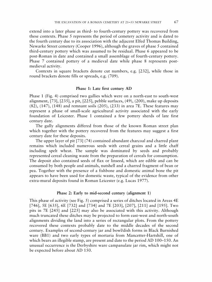
Phase 1: Late first century AD
Phase 1 (Fig. 4) comprised two gullies which were on a north-east to south-westalignment, [73], [235], a pit, [225], pebble surfaces, (49), (200), make up deposits(82), (147), (148) and remnant soils (205), (233) in area 7E. These features mayrepresent a phase of small-scale agricultural activity associated with the earlyfoundation of Leicester. Phase 1 contained a few pottery sherds of late firstcentury date.
The gully alignments differed from those of the known Roman street planwhich together with the pottery recovered from the features may suggest a firstcentury date for these deposits.
The upper layer of pit [73] (74) contained abundant charcoal and charred plantremains which included numerous seeds with cereal grains and a little chaffincluding spelt wheat. The sample was dominated by seeds and probablyrepresented cereal cleaning waste from the preparation of cereals for consumption.The deposit also contained seeds of flax or linseed, which are edible and can beconsumed by both people and animals, nutshell and a charred fragment of bean orpea. Together with the presence of a fishbone and domestic animal bone the pitappears to have been used for domestic waste, typical of the evidence from otherextra-mural deposits found in Roman Leicester (e.g. Lucas 1977).
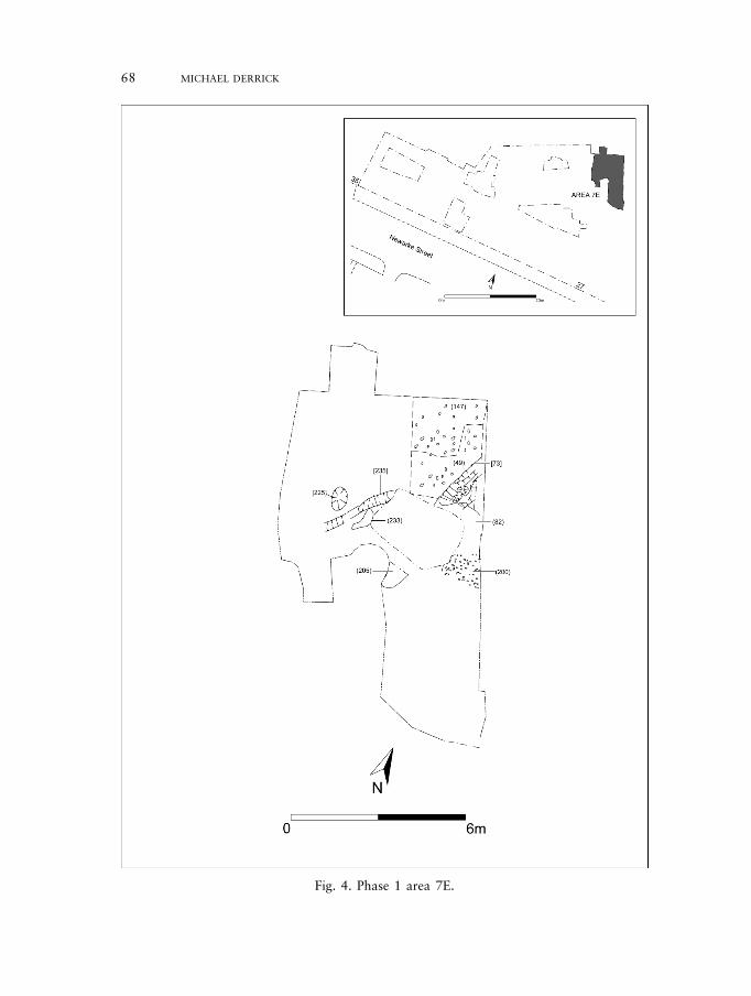
Phase 2: Early to mid-second century (alignment 1)
This phase of activity (see Fig. 5) comprised a series of ditches located in Areas 4E[746], 5E [635], 6E [732] and [734] and 7E [203], [207], [211] and [195]. Twopits in 7E [245] and [225] may also be associated with this activity. Althoughmuch truncated these ditches may be projected to form east-west and north-southalignments dividing the land into a series of rectangular plots. From the potteryrecovered these contexts probably date to the middle decades of the secondcentury. Examples of second-century jar and bowl/dish forms in Black Burnishedware (BB1) and two early types of mortaria from Mancetter-Hartshill, one ofwhich bears an illegible stamp, are present and date to the period AD 100–150. Anunusual occurrence is the Derbyshire ware campanulate jar rim, which might notbe expected before about AD 150.
230487 02c-063-102 18/10/09 10:16 Page 67
68 MICHAEL DERRICK
Fig. 4. Phase 1 area 7E.
230487 02c-063-102 18/10/09 10:16 Page 68
THE EXCAVATION OF A ROMAN CEMETERY AT 21–33 NEWARKE STREET 69
The alignment of the ditches is at variance with that of the Roman town streetplan during this period. Furthermore, they appear to be aligned upon, orperpendicular to, Newarke Street, which it has been postulated was the finalsection of the Via Devana (Gartree Road) joining the Tripontium Road just to thesouth of the south gate (Cooper 1996; see Fig. 2). The ditches contained potterydating to the late first and early second century and are likely to reflect anagricultural period of land management, drainage and boundary demarcation.Similar rectilinear roadside plots were laid out adjacent to the Fosse Way, on thewest side of Leicester as inferred from the excavations at Great Holme Street in1975 (Lucas 1977).
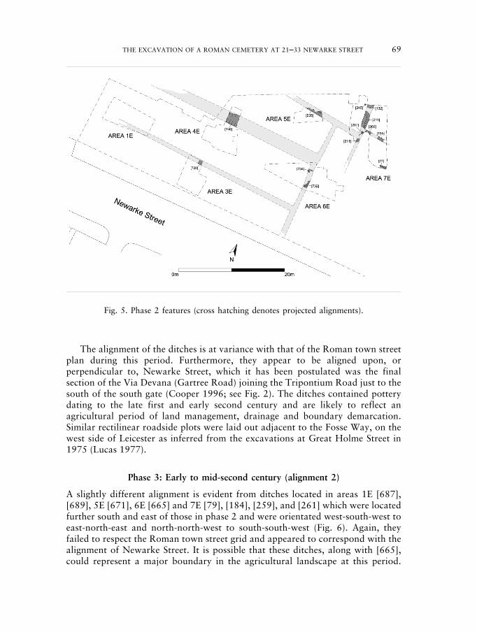
Phase 3: Early to mid-second century (alignment 2)
A slightly different alignment is evident from ditches located in areas 1E [687],[689], 5E [671], 6E [665] and 7E [79], [184], [259], and [261] which were locatedfurther south and east of those in phase 2 and were orientated west-south-west toeast-north-east and north-north-west to south-south-west (Fig. 6). Again, theyfailed to respect the Roman town street grid and appeared to correspond with thealignment of Newarke Street. It is possible that these ditches, along with [665],could represent a major boundary in the agricultural landscape at this period.
Fig. 5. Phase 2 features (cross hatching denotes projected alignments).
230487 02c-063-102 18/10/09 10:16 Page 69
Pottery from this phase (203 sherds) dates to the middle or later decades of thesecond century and shows little difference in content to the phase 2 groups.
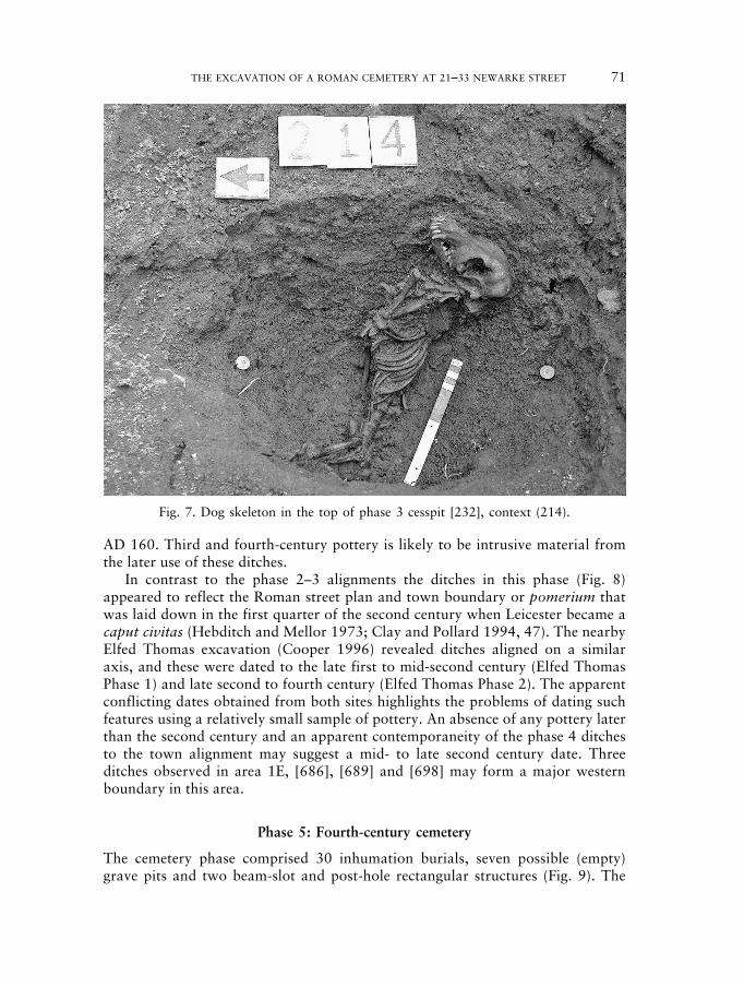
A cess pit was located in Area 7E. The pit was oval in plan, straight-sided andhad a curved base [232]. A sample from the fill contained a few charred cerealgrains and seeds but also contained mineralised seeds of opium poppy. Seedsbecome mineralised by impregnation with calcium phosphate minerals fromsewage in cesspits. Opium poppy has been found in Roman contexts at CausewayLane (Monckton 1999) and in a cesspit pre-dating the cemetery at the nearbyElfed Thomas site (Monckton 1996). It is recorded at other Roman sites inEngland (Greig 1991) and was used as a medicine and for food flavouring. Otherremains in the pit included a few mineralised grass and organic fragments ofsimilar appearance to remains from cesspits seen from other sites in Leicester. Theupper fill (214) contained the remains of an articulated dog skeleton; a relativelysmall male animal represented by most anatomical parts except phalanges andcaudal vertebrae (tail) (Fig. 7).
Phase 4: Mid to late-second century (alignment 3)
A re-alignment of boundaries took place during this phase indicated by ditches inareas 1E [686], [696], [698] and 7E [104], [117], [152], [207], [213], [241], [242],[247]. This phase contains second century pottery similar to that from phases 2and 3 but also includes part of Samian Form 31, which should date from at least
70 MICHAEL DERRICK
Fig. 6. Phase 3 features (cross hatching denotes projected alignments).
230487 02c-063-102 18/10/09 10:16 Page 70
THE EXCAVATION OF A ROMAN CEMETERY AT 21–33 NEWARKE STREET 71
AD 160. Third and fourth-century pottery is likely to be intrusive material fromthe later use of these ditches.
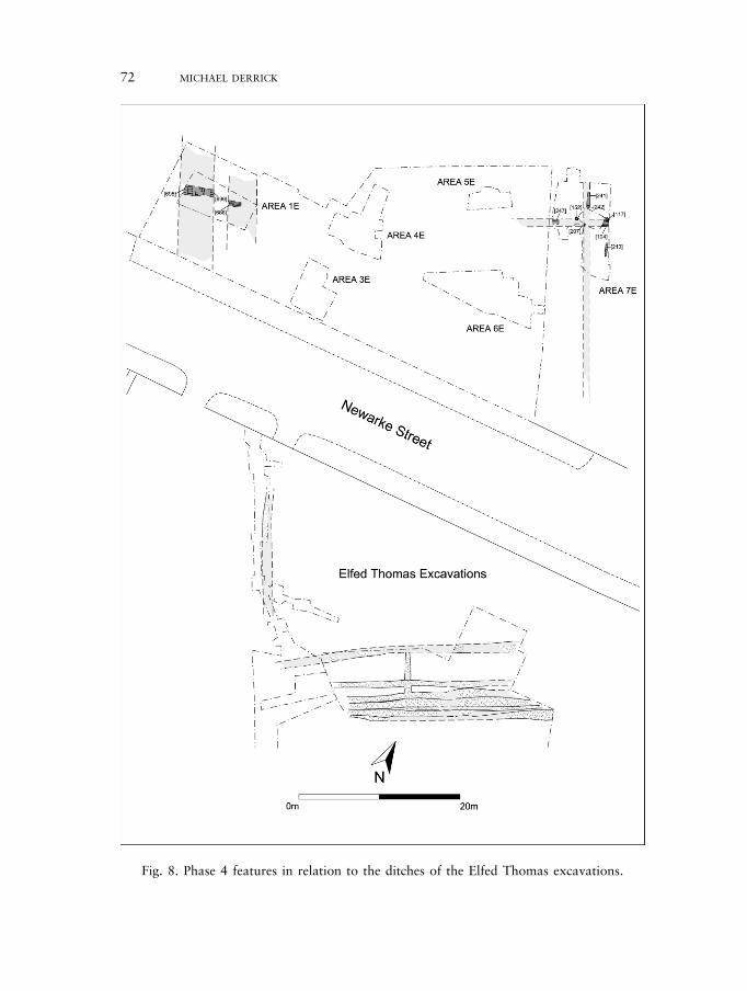
In contrast to the phase 2–3 alignments the ditches in this phase (Fig. 8)appeared to reflect the Roman street plan and town boundary or pomerium thatwas laid down in the first quarter of the second century when Leicester became acaput civitas (Hebditch and Mellor 1973; Clay and Pollard 1994, 47). The nearbyElfed Thomas excavation (Cooper 1996) revealed ditches aligned on a similaraxis, and these were dated to the late first to mid-second century (Elfed ThomasPhase 1) and late second to fourth century (Elfed Thomas Phase 2). The apparentconflicting dates obtained from both sites highlights the problems of dating suchfeatures using a relatively small sample of pottery. An absence of any pottery laterthan the second century and an apparent contemporaneity of the phase 4 ditchesto the town alignment may suggest a mid- to late second century date. Threeditches observed in area 1E, [686], [689] and [698] may form a major westernboundary in this area.
Phase 5: Fourth-century cemetery
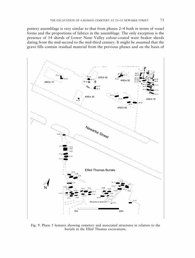
The cemetery phase comprised 30 inhumation burials, seven possible (empty)grave pits and two beam-slot and post-hole rectangular structures (Fig. 9). The
Fig. 7. Dog skeleton in the top of phase 3 cesspit [232], context (214).
230487 02c-063-102 18/10/09 10:16 Page 71
72 MICHAEL DERRICK
Fig. 8. Phase 4 features in relation to the ditches of the Elfed Thomas excavations.
230487 02c-063-102 18/10/09 10:16 Page 72
THE EXCAVATION OF A ROMAN CEMETERY AT 21–33 NEWARKE STREET 73
pottery assemblage is very similar to that from phases 2–4 both in terms of vesselforms and the proportions of fabrics in the assemblage. The only exception is thepresence of 14 sherds of Lower Nene Valley colour-coated ware beaker sherdsdating from the mid-second to the mid-third century. It might be assumed that thegrave fills contain residual material from the previous phases and on the basis of
Fig. 9. Phase 5 features showing cemetery and associated structures in relation to theburials in the Elfed Thomas excavations.
230487 02c-063-102 18/10/09 10:16 Page 73
the evidence from the Elfed Thomas site a fourth century date for the cemetery andassociated features is suggested.
Cemetery layoutThe burials were orientated approximately west-east with the head at the west endand the body laid out in a supine position. The characteristics of the graves werevery similar to those observed at the nearby Elfed Thomas site where a Christiantradition was suggested, based upon date, orientation, presence of stone lining,absence of grave goods and lack of grave intersection (Cooper 1996). Previousfinds of lead coffins with plaster or lime packing in Newarke Street lends furthersupport for a possible Christian cemetery. However, the late Roman west-eastburials reported from Clarence Street, Leicester have been interpreted asrepresenting a wider trend in burial treatment unrelated to religion (Gardner2005, 76).
Unlike the Elfed Thomas excavations there seems to be very little in the way ofcorresponding boundary ditches demarcating space within the cemetery. Theinhumations cut earlier ditches in areas 1E, 5E, 6E and 7E. However, the graveswere equally spaced and there appeared to be discernible rows similar to thoseobserved at the Elfed Thomas excavation. There are four instances of intersectionwithin this part of the cemetery (SK7 cutting SK8, SK18 cutting SK 21, SK23cutting SK 17 and SK29 cutting SK30) and almost all burials with the exception ofSK17 conformed to a west-east alignment. Although the site was greatly truncatedby Victorian cellaring it would appear that the burials were more denselyconcentrated towards the eastern corner of the site, in area 7E.
Grave pitsAll grave pits were straight sided and had relatively flat bases. The overlyingplough soil, which survived to depths of 1.5m, appears to have preserved theoriginal ground level and very little truncation seems to have occurred across thesite.
Stone liningsSix graves were stone-lined (SK10, SK12, SK14, SK18, SK19, SK22), and one, SK6, was buried within a Swithland slate cist (see Figs 10 and 12). The stone liningswere mainly discontinuous although SK18 and SK22 exhibited full lining. Thelinings comprised granite, Dane Hills sandstone and occasionally Swithland slateand fragments of tile. In addition to the stone lining present in SK19, there appearsto have been an attempt to partially cover or pack the body using re-usedSwithland slate; this slate was laid flat across the body and was also evidentunderneath the burial (Fig. 11). Some of the Dane Hills sandstone present in thisburial also showed signs of re-use evident from mortar adhering to the stone.Twenty-two of the burials excavated at Elfed Thomas, Newarke Street providedevidence for stone lining (Cooper 1996), while the excavations at Great HolmeStreet produced two burials with evidence for partial stone lining (J. Lucas pers.comm.). Evidence for stone-lined graves or packing has been reported at several
74 MICHAEL DERRICK
230487 02c-063-102 18/10/09 10:16 Page 74
THE EXCAVATION OF A ROMAN CEMETERY AT 21–33 NEWARKE STREET 75
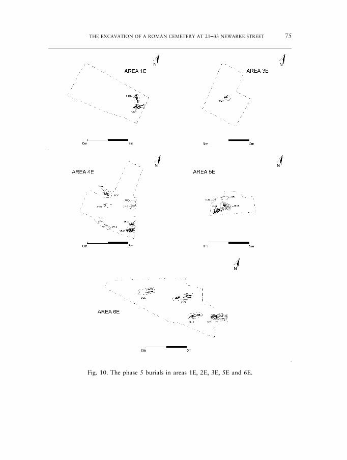
Fig. 10. The phase 5 burials in areas 1E, 2E, 3E, 5E and 6E.
230487 02c-063-102 18/10/09 10:16 Page 75
76 MICHAEL DERRICK
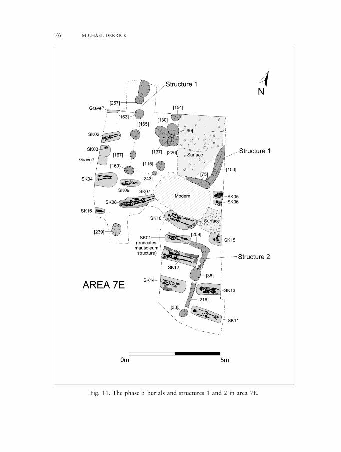
Fig. 11. The phase 5 burials and structures 1 and 2 in area 7E.
230487 02c-063-102 18/10/09 10:16 Page 76

THE EXCAVATION OF A ROMAN CEMETERY AT 21–33 NEWARKE STREET 77
Roman cemeteries in England such as Lankhills, Winchester where linings of flintand tile were observed (Clarke 1979, 355–6) and at Bath Gate, Cirencester where27 of the 453 graves contained evidence for stone packing, while most hadcontinuous linings (Viner and Leach 1982, 95). The late Roman burials atClarence Street, Leicester (Gardner 2005) did not have any with stone lining.
Crummy and Crossan (1993, 101–2) have suggested that stone linings mayhave been used as markers to ‘prevent future disturbance of the coffin/corpse, orto facilitate its location for the insertion nearby of a related burial’. Although thismay be the case for SK10 and SK19 the remaining lined burials would not havebeen visible from the surface and may have served as a crude form of cist. Theslate cist in SK19 contained an infant burial and was formed using three slates,two of which were laid on edge and the third covering the burial. A parallel maybe seen at Great Casterton, Rutland where ‘rough cists of local limestone’(Grainger and Mahany n.d.) were observed.
The pottery retrieved from the grave fills provided a third-century terminuspost quem for the burials. It is likely that the burials date broadly to the latter halfof the fourth century, which was the case with those found at the nearby ElfedThomas site (Cooper 1996). Further evidence for a fourth century date may beevident from the use of stone and tile packing which Clarke (1979, 335) haspostulated may be a fourth-century burial rite.
CoffinsThe presence of nails recovered from around the edge of burials SK2, 4, 11, 13,15, 18, 19, 20, 22, 23, 24, 26, 29 and 30 may suggest the presence of woodencoffins. The fact that nails were not recovered from all the graves may reflectdiffering excavation methods or, as at Great Holme Street, the use of wooden pegsin the construction of the coffin (Lucas 1977).
Fig. 12. Burial SK12, located within structure 1, showing stone packing.
230487 02c-063-102 18/10/09 10:16 Page 77
Corpse orientation and positionAll heads with the exception of SK17 were placed to the west of the grave.MacDonald has suggested that west-east orientated burial was adopted in the fourthcentury in response to the popular sun cult Sol Invictus (1979, 425–6). Other sitessuch as Butt Road, Colchester display a rapid adoption of west-east burials at thisperiod where it has been suggested to represent the widespread adoption ofChristianity (Crummy and Crossan 1993). The bodies were laid in a supine andextended position and the arms were either extended or flexed across the pelvis.
Burial chronology and datingDating the burials is problematic in that there were no deliberately-placed findsthat are datable. As mentioned earlier, the graves contained sherds of potterydating to the third century, therefore providing a terminus post quem date for theburial phase. The graves themselves were stratigraphically later than the ditchphases and therefore provide a post second century date. A large quarry pittruncates the graves in area 4E and contains pottery dating to the fourth centurysuggesting that the area had gone out of use as a cemetery shortly after this period.By using the dating evidence suggested for the adjacent Elfed Thomas excavationsand taking into account the dating of similar burial layout and practice at sitessuch as Colchester and Lankhills, Winchester it seems probable that the gravesdate to the fourth century.
Grave offeringsOnly two burials exhibited traits that could be classed as ‘grave offerings’. GraveSK21 contained a supine burial, with head to the west and arms flexed across thepelvis. The grave was similar to many of the other burials, although an animaltooth had been placed in both hands and two horn cores had been laid close to thehead. Offerings of this kind may indicate a pagan origin and could be viewed as anattempt to ‘hedge ones bets’ in the afterlife in respect of pagan and Christianbeliefs. An indication that this sort of practice was tolerated can be found in canon41 of the Council of Elvira, held in Spain in AD 305 which permitted paganshrines to remain in Christian households, in order to avoid confrontation (Watts1993, 194). The horn cores and teeth could also represent the remains of a ritualmeal or feasting, associated with Roman funerary practices.
Skeleton 6 was buried within a slate cist comprising re-used building material.Underneath the capping slate was a folded strip of lead that appeared to have beenplaced prior to the closing of the cist. While it is possible that this lead could havebeen residual and associated with the slate used in the cist’s construction, itremains possible that it was deliberately deposited as a charm of some kind.
A bone hair pin (Crummy 1983, type 2) was recovered from the fill of burialSK9 and may have been associated with the corpse prior to burial. The skeletonwas of indeterminate sex, although it may be possible to infer female gender fromthe presence of the hairpin.
The pottery recovered from the graves was second to third century in date andthere was no evidence that it represented ritual deposition and it would appear to
78 MICHAEL DERRICK
230487 02c-063-102 18/10/09 10:16 Page 78
THE EXCAVATION OF A ROMAN CEMETERY AT 21–33 NEWARKE STREET 79
be residual. The ferrous finds within the graves can be interpreted as nailsassociated with coffin construction.
Funerary structuresTwo structures, which were probably contemporary with the cemetery phase,were located in area 7E (Fig. 9). The structure to the north (structure 1) compriseda post-hole and beam slot construction. A line of post-holes, [257], [163], [165],[167] and [169], aligned approximately north-south cuts through phase 3 ditchdeposits, with [169] perhaps forming a south-west corner post. The south-eastcorner however comprised two beam slots, [75] and [100]. The area enclosedcontained a series of post-holes, [90], [130], [137] and [226], that may indicateinternal features or another phase of construction. Within the structure was agravel area that contained pottery of a late first to early second century datealthough its association with the structure is equivocal. The area enclosed was freeof burial activity and the post-holes and beam slots were similarly free oftruncation which would suggest an earlier foundation or contemporaneity withthe burials which seem to have respected the structure.
Structure 2 was revealed to the south and consisted of two shallow, almostflat-bottomed slots, running at right angles to each other, [209] and [216]. A post-hole, [30], may form a continuation of the line of [216]. These enclosed twoburials (SK12 and SK14), and respected a row of burials comprising SK11, 10, 13and 15. Burial SK1 truncated slot [209] and may represent a later phase ofinternment after the structure fell into disuse.
A possible hearth may have been associated with structure 2 [38]. It was bowl-shaped with a rounded base and sides of 45 degrees with an upper fill formed froma concentrated layer of scorched small and medium rounded pebbles below afragment of redeposited burnt clay which had been burnt in situ. A deposit ofhighly fired vitrified stone fragments overlay the top of the feature (33). A samplefrom the upper deposit (11) contained charcoal, a few wheat grains and severalweed seeds. Bean or pea and hazel nutshell were also present. These remainscompare with the scatter of domestic waste found in many features in the townand are insufficient to suggest cereal related activity here.
Both structures could be interpreted as mausolea. Structure 1 is similar to thetemple-mausoleum found during excavation at 165 Great Dover Street,Southwark, London which was similar in plan to many Romano-Celtic templesfrom north-western Europe (Mackinder 2001, 9–10). The structure at DoverStreet had associated masonry walls whereas structure 1 did not. The external andinternal post-holes evident in structure 1, however, may indicate a post-builtstructure with an inner and outer wall similar to the Dover Street mausoleum. Noassociated features were found within the area enclosed by the foundations, as wasthe case at Dover Street (ibid).
A possible mausoleum structure was located at Butt Road, Colchesteralthough the evidence was not conclusive and the interpretation of the structureremains tentative (Crummy et al. 1993). A possible comparable feature tostructure 2 was also located on the Elfed Thomas site. This comprised
230487 02c-063-102 18/10/09 10:16 Page 79
fragmented sections of gullies which appeared to enclose a series of five burialsand could be re-interpreted as a mausoleum structure although the originalphasing did suggest that this was a pre-cemetery feature (Cooper 1996, 5, fig. 3and 13, fig. 7).
As there are no burials within structure 1, however, it is possible, if thecemetery included Christian burials, that it was an early church. Possible churcheshave been interpreted for structures at Silchester, Richborough and Icklingham(Morris 1983, 12–14).
Inferred earlier burialsThe evidence for pre-Christian burial practice on site was scant. There is apossibility that burial SK21 may reflect earlier pagan practice while the north-south alignment of SK17 may also suggest an earlier practice. Evidence for paganburial practice was found on the nearby site of York Road (Gossip 1998) whereburials aligned north-south and wearing hobnailed shoes were revealed. Oneburial appeared to have been included in the backfill of a ditch, which can becompared with the partially articulated bones found in ditch [696]. Human bonewas also found within ditches at Bonners Lane, Mill Lane and Causeway Lane,perhaps suggesting early Roman funerary activity (Wakely 1999; Finn 2002, 94;Baxter 2004).
Fragments of unidentified burnt bone may be evidence for disturbedcremation burials. Cremations are known in the Newarke Street area (Dare1927; Cooper 1996, fig. 10), while elsewhere four urned cremations were locatedat Grange Lane, Leicester (Thomas 2006) and cremated bone was recovered fromthe excavations at Mill Lane, Leicester (Finn 2002, 94). Fragments of glass wererecovered from Roman contexts in area 7E. These fragments appear to be part ofthick flat-bottomed vessels and are often associated with cremation burial.
THE HUMAN REMAINS: HARRIET JACKLIN AND SIMON CHAPMAN
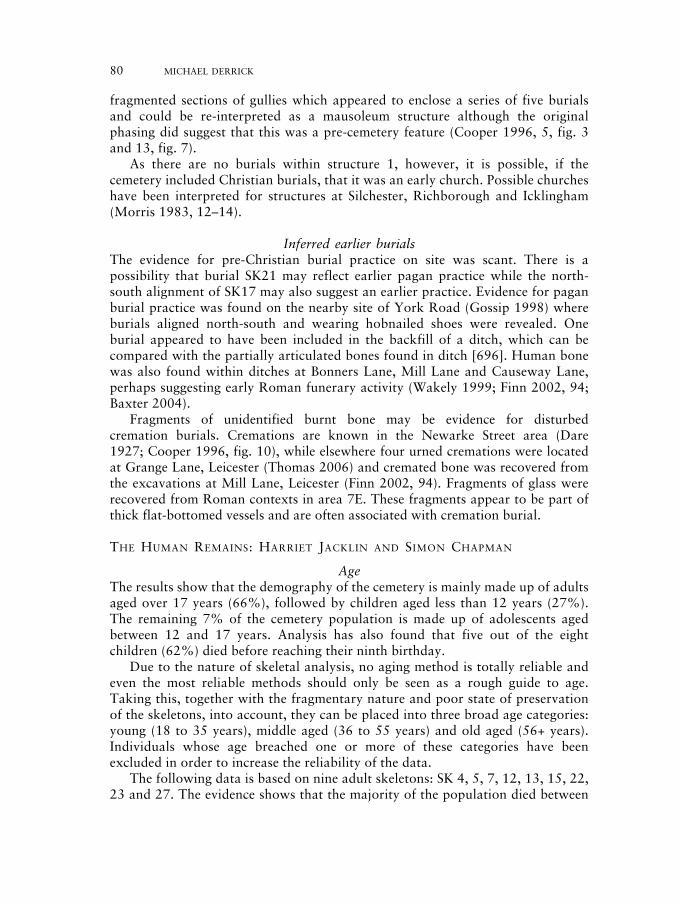
AgeThe results show that the demography of the cemetery is mainly made up of adultsaged over 17 years (66%), followed by children aged less than 12 years (27%).The remaining 7% of the cemetery population is made up of adolescents agedbetween 12 and 17 years. Analysis has also found that five out of the eightchildren (62%) died before reaching their ninth birthday.
Due to the nature of skeletal analysis, no aging method is totally reliable andeven the most reliable methods should only be seen as a rough guide to age.Taking this, together with the fragmentary nature and poor state of preservationof the skeletons, into account, they can be placed into three broad age categories:young (18 to 35 years), middle aged (36 to 55 years) and old aged (56+ years).Individuals whose age breached one or more of these categories have beenexcluded in order to increase the reliability of the data.
The following data is based on nine adult skeletons: SK 4, 5, 7, 12, 13, 15, 22,23 and 27. The evidence shows that the majority of the population died between
80 MICHAEL DERRICK
230487 02c-063-102 18/10/09 10:16 Page 80
THE EXCAVATION OF A ROMAN CEMETERY AT 21–33 NEWARKE STREET 81
18 and 35 years of age (45%), with 33% surviving until middle age (26 to 55years) and only 22% of the population living beyond the age of 56.
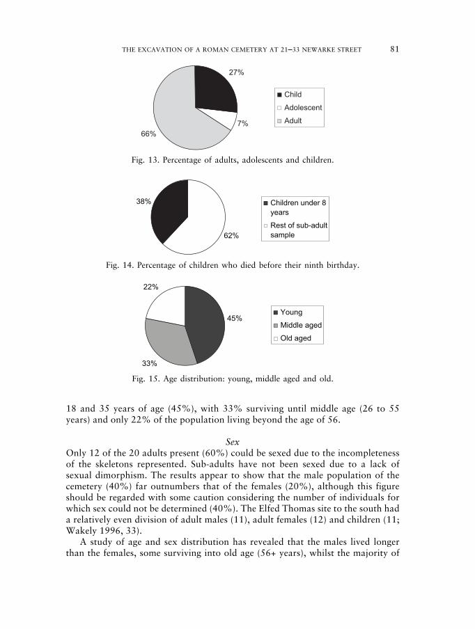
SexOnly 12 of the 20 adults present (60%) could be sexed due to the incompletenessof the skeletons represented. Sub-adults have not been sexed due to a lack ofsexual dimorphism. The results appear to show that the male population of thecemetery (40%) far outnumbers that of the females (20%), although this figureshould be regarded with some caution considering the number of individuals forwhich sex could not be determined (40%). The Elfed Thomas site to the south hada relatively even division of adult males (11), adult females (12) and children (11;Wakely 1996, 33).
A study of age and sex distribution has revealed that the males lived longerthan the females, some surviving into old age (56+ years), whilst the majority of
27%
7%66%
Child
Adolescent
Adult
Fig. 13. Percentage of adults, adolescents and children.
62%
38% Children under 8years
Rest of sub-adultsample
Fig. 14. Percentage of children who died before their ninth birthday.
45%
33%
22%
Young
Middle aged
Old aged
Fig. 15. Age distribution: young, middle aged and old.
230487 02c-063-102 18/10/09 10:16 Page 81
females died between the ages of 17 and 35. Similar results were found by Wakely(1996, 33) at the Elfed Thomas, Newarke Street site.
The predominance of females dying in the younger age group suggests a highmortality, which may be associated with pregnancy and childbirth, leaving moreof the male population to survive into old age.
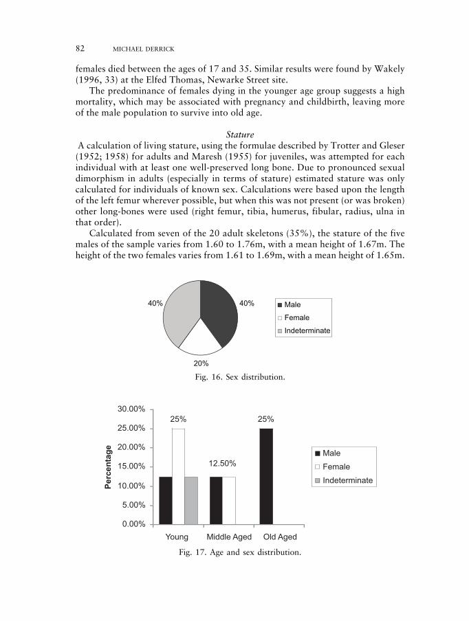
StatureA calculation of living stature, using the formulae described by Trotter and Gleser(1952; 1958) for adults and Maresh (1955) for juveniles, was attempted for eachindividual with at least one well-preserved long bone. Due to pronounced sexualdimorphism in adults (especially in terms of stature) estimated stature was onlycalculated for individuals of known sex. Calculations were based upon the lengthof the left femur wherever possible, but when this was not present (or was broken)other long-bones were used (right femur, tibia, humerus, fibular, radius, ulna inthat order).
Calculated from seven of the 20 adult skeletons (35%), the stature of the fivemales of the sample varies from 1.60 to 1.76m, with a mean height of 1.67m. Theheight of the two females varies from 1.61 to 1.69m, with a mean height of 1.65m.
82 MICHAEL DERRICK
40%
20%
40% Male
Female
Indeterminate
25%25%
12.50%
0.00%
5.00%
10.00%
15.00%
20.00%
25.00%
30.00%
Young Middle Aged Old Aged
Percentage
Male
Female
Indeterminate
Fig. 17. Age and sex distribution.
Fig. 16. Sex distribution.
230487 02c-063-102 18/10/09 10:16 Page 82
THE EXCAVATION OF A ROMAN CEMETERY AT 21–33 NEWARKE STREET 83
The mean male adult statures observed in the Newarke Street population arebroadly comparable to other Roman groups. The stature for the females is slightlyhigher, although this figure should be regarded with some caution due to it beingbased on only two skeletons. This reflects ‘normal’ developmental growth patternsassociated with adequate nutritional conditions for the period.
In the juveniles, however, it was apparent that linear growth (which dictatesstature) often lagged behind biological age. In other words, several of the juveniles(SKs 1, 2 & 9) were slightly under-sized for their age. This may have been due toinadequate childhood nutrition or even disease.
Robusticity indexUnfortunately, due to the fragmentary nature of the long bones, no analysis of therobusticity of the individuals was possible. SK 7’s left femur has been found to be8mm smaller than the right, which may indicate some kind of trauma or injury,although no evidence of this is present on the long bones.
Platymeria and Platycnemia indexPlatymeria indices below 85 (Brothwell 1981) are regarded as platymeric(flattening of the thigh bone). Only seven skeletons provided both left and rightmeasurements, four of which showed platymeric anteposterior flattening of theupper femoral shaft (13.3%).
SK 4 shows platymeric flattening of the right femur, SK 13 shows platymericflattening of both shafts, SK 17 exhibits platymeric flattening of the left shaft ofthe femur and SK 19 shows platymeric flattening of the right shaft.
Platycnemia indices below 62 (Brothwell 1981) are regarded as platycnemic(ante posterior flattening of the tibia). SK 4 shows abnormal flattening of both leftand right tibia.
The reasons for this flattening are poorly understood but may be related to theeffect of the muscles on the bone during movements, i.e. the abnormal flatteningof SK 4 could be due to occupation or nutritional factors.
Post-cranial non-metric traitsNon-metric traits are minor anatomical variations in the bone, which varybetween individuals, representing genetic variability and can indicate genetic
Site Mean male stature Mean female stature
Newarke Street 1.67m 1.65m*Oxford St, Leicester (Chapman 1999) 1.72m 1.61mHaymarket, Leicester (Chapman 1997) 1.69m –Elfed Thomas, Leicester (Wakely 1996) 1.71m 1.59mCirencester (Wells 1982) 1.69m 1.58mPoundbury (Farwell and Molleson 1993) 1.66m 1.61mModern (from 1981 Population Census) 1.73m 1.61m
* Based on only two female statures.
Table 1. Mean adult statures observed at other Roman sites.
230487 02c-063-102 18/10/09 10:16 Page 83
relationships. Mostly occurring after adolescence, non-metric traits are recordedas either present or absent. Very few traits were witnessed on the material andtherefore no further conclusions were drawn.
Trait Affected skeleton
Atlas posterior bridge 15, 21Atlas lateral bridge 5, 15, 21Septal apeture (humerus) 10Os trigonum (talus) 7Anterior calcaneal facetabsent 12, 16double 3, 4, 7, 8, 17
Table 2. Post-cranial non-metric traits.
PathologyMost human disease and trauma only affects the soft tissues of the victim, rarelycausing death, and consequently is very rarely preserved in archaeologicalspecimens, there are certain conditions that leave an indelible mark on the humanskeleton. Diseases infecting the skeleton will usually initiate an osteoblastic (bonegrowth) or an osteoclastic (bone resorption) reaction within living bone cells;similar reactions are commonly observed also as a result of mechanical stress andtrauma.
The following pathological conditions were observed:
Degenerative disease/arthropathies
Degenerative joint disease (arthropathy) is the most commonly observed skeletaldisease in both modern and archaeological material. Most such conditions arise asa result of normal prolonged use of the joints over a long lifespan. However,repetitive occupational use of a particular joint may lead to early onset. Traumaticdamage to a joint may also lead to early onset arthropathies. Unsurprisingly,degenerative arthropathy was mostly present in the older members of the NewarkeStreet population. Only SK 13, a female aged between 20–30 years, was theexception to this rule with arthritic lesions on her rib ends.
The joint disease observed can be classified according to several types:
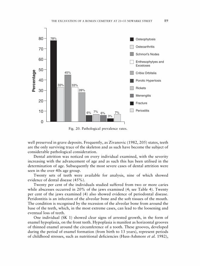
OSTEOPHYTOSIS: SKS 7, 12, 13, 21, 22, 26 & 27Osteophytosis is a condition where growths of new bone (Osteophytes) arisearound the margins of joints and may vary in size according to severity. Thiscondition is extremely common in all skeletal populations, becoming morecommon with the advancement of age. Most individuals over the age of 50 yearswill show some sign of osteophytosis.
Based on nine adult skeletons with sufficient bones present for osteophytosis tobe diagnosed, 78% were affected.
84 MICHAEL DERRICK
230487 02c-063-102 18/10/09 10:16 Page 84
THE EXCAVATION OF A ROMAN CEMETERY AT 21–33 NEWARKE STREET 85
OSTEOARTHRITIS: SKS 15, 21 & 22Osteoarthritis is primarily caused by the wear and tear of joints throughcontinuous use due to occupation or advanced age and arises as a result of the lossof joint cartilage, eventually leading to friction between the articulating bones.Unlike in osteophytosis, the condition is erosive (rather than proliferative) andaffects the joint’s articular surface rather than its margins and may be seen assurface pitting of the joint surface in its early stages. SK 21; a male aged over 45years is severely affected by osteoarthritis.
Based on nine adult skeletons with sufficient bones present for osteoarthritis tobe diagnosed, 33% were affected.
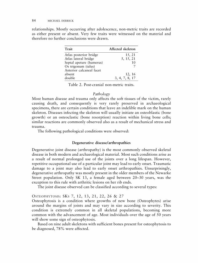
SCHMORL’S NODES: SKS 12, 22, 23, 26 & 27A Schmorl’s node is a crater like depression occurring either on the anterior orposterior surface, mostly toward the dorsal side, of vertebral bodies. These arecaused by herniation or prolapse of inter-vertebral disk tissue, forming ectopicdeposits of nucleus pulpous material in the neighbouring vertebral bodies. Theseare most common in the lumbar and lower thoracic regions of the human spine(Resnick and Niwayama 1978). It has been suggested (Schmorl and Junghanns1971) that trauma and or strenuous activity, especially in adolescence, andmetabolic and degenerative disorders may contribute to the formation of theselesions. SK 26, a male aged between 30 and 40 years, is severely affected bySchmorl’s nodes.
Based on 12 adult vertebrae complete enough to show any signs of thedisorder, 45% were affected by Schmorl’s nodes.
ENTHESOPHYTES AND EXOSTOSES: SKS 4, 12 & 21Enthesophytes and exostoses are similar to osteophytes in appearance and arise atthe site of a tendon insertion or enthesis. They arise from repeated trauma to
Fig. 18. Vertebra of SK 21 exhibiting osteoarthritic lipping and a Schmorl’s node.
230487 02c-063-102 18/10/09 10:16 Page 85
tendons through repeated muscular exertion. Other osteophytes like growths maybe simply ossified haematomas (bleeds) more correctly known as exostoses,arising from damage to muscle through strain or injury. Both of these bonygrowths are frequently used in the identification and interpretation ofoccupational stress and injury (Dutour 1986).
Based on nine adult skeletons with sufficient bones present for the condition tobe diagnosed, 33% were affected by Enthesophytes and Exostoses. Enthesophyteswere identified on the left femur and tibia of SK 4 and on both patellae of SK 12.Both of these cases were probably merely a result of continuous and strenuous useof the legs. Enthesophytes also affected both clavicles of SK 21, a male over 45years.
METABOLIC DISEASE
Metabolic diseases are often used as indicators of ‘stress’ during the life of theindividual, since they represent an individual’s adaptive response to stressesinflicted upon the body during its developmental years. Stresses may take the formof vitamin or mineral deficiencies such as iron (causing anemia), calcium (maycause osteoporosis), vitamin C (causing scurvy), vitamin D (causing rickets) etc.However, skeletons displaying such conditions should not be regarded as ‘victims’of these conditions, since the bone response to the deficiency is a survivalmechanism, not a failure. The true ‘victims’ of metabolic disorders are those thatbecame so physiologically stressed that they died before the bone changes could beimplemented.
CRIBRA ORBITALIA: SKS 1, 6, 17, 18 & 28Cribra orbitalia is a common condition in many ancient populations, manifestingitself as a pitting on the bone within the orbits (eye sockets). The condition is oftenassociated with a similar pitting of the parietal bones of the skull known as porotichyperostosis.
Based on 18 craniums complete enough to observe the condition, 28% wereaffected by cribra orbitalia.
POROTIC HYPERTOSIS: SK 18It is believed that the main cause of cribra orbitalia and porotic hypertosis is anutritional deficiency, in particular of chronic iron-deficiency anaemia. Anaemiaitself is caused by a reduction (in number and/or quality) of blood haemoglobin,which in turn leads to hypoplasia (increase) of bone marrow in an attempt toproduce more red blood cells. That the condition is caused by iron deficiency isclear, but it is often difficult to determine the cause of the iron deficiency itselfsince this may arise as a result of a large blood-loss, parasitic infection, nutritionaldeficiency, disease etc. Hypoplasia of bone marrow has a two-fold affect on bone;firstly it causes a destruction of the outer table of compact bone through thedevelopment of porotic lesions (in the orbits and on the cranial vault), andsecondly an expansion of the middle layer of bone or diploe (Stuart-Macadam1991, 101). The osteological manifestation of this condition is predominant in
86 MICHAEL DERRICK
230487 02c-063-102 18/10/09 10:16 Page 86
THE EXCAVATION OF A ROMAN CEMETERY AT 21–33 NEWARKE STREET 87
juveniles, probably due to the increased nutritional demands associated withchildhood growth and development. When observed in older adults it is more thanlikely that the lesions reflect a period of childhood anaemia. Indeed the severity ofthe porotic lesions can be seen to lessen with the advancing age of the person, i.e.gradually healing over time (Nathan and Haas 1966).
Based on 18 crania complete enough to observe the condition, 6% wereaffected by porotic hypertosis.
RICKETS: SK 23Rickets is partially caused by a lack of vitamin D, which leads to softening of thebones. This causes a bowed appearance in the legs and in some cases the arms dueto the pressure exerted on them by standing up and crawling as an infant.Aufderheide and Rodriguez-Martin (1998) explain that the exact cause of thiscondition is still unknown, but it is generally believed that it is a reaction to stresscaused by disease or a deficiency of vitamin D in the diet.
Based on 15 femurs complete enough to observe the condition, 7% wereaffected by rickets.
Infectious disease
MENINGITIS: SK 28Signs of meningitis are visible in the cranial vault of SK 28, an infant aged betweenfive and seven years. Diagnosis is based on recent research by Cox and Mays(2000, 149), who suggest that there are consistent changes on the endocranialsurface of the skull, which may be consistent with meningitis or inflammation ofthe meninges.
Based on 18 skeletal remains, which have sufficient bones present to concludethe presence or absence of the disease, 6% were affected by possible meningitis.
FRACTURE/TRAUMA
Fractures in human bone material can be of two varieties; either healed, the resultof minor accidental injury, or unhealed, as a result of far more serious and fatalinjuries. Once a fracture has been sustained, if the individual survives the trauma,the cells of the bones endosteum and periosteum react in such a way as to repairthe break. They do this through the secretion of new bone tissue and enzymeswhich promote the deposition of salts and combine with coagulated tissue fluids,creating a fibrous wrapping around the break. Collagen fibres then fortify thefibrous wrapping and the broken bones begin to reunite. This so called ‘periostealreaction’ or ‘callus’ is easily recognised in pathological samples by its coarsegranular appearance.
FRACTURE: SK 14Only one fracture was identified in the human remains from Newarke Street,affecting the left femur of SK 14. The femur was badly affected by the break
230487 02c-063-102 18/10/09 10:16 Page 87
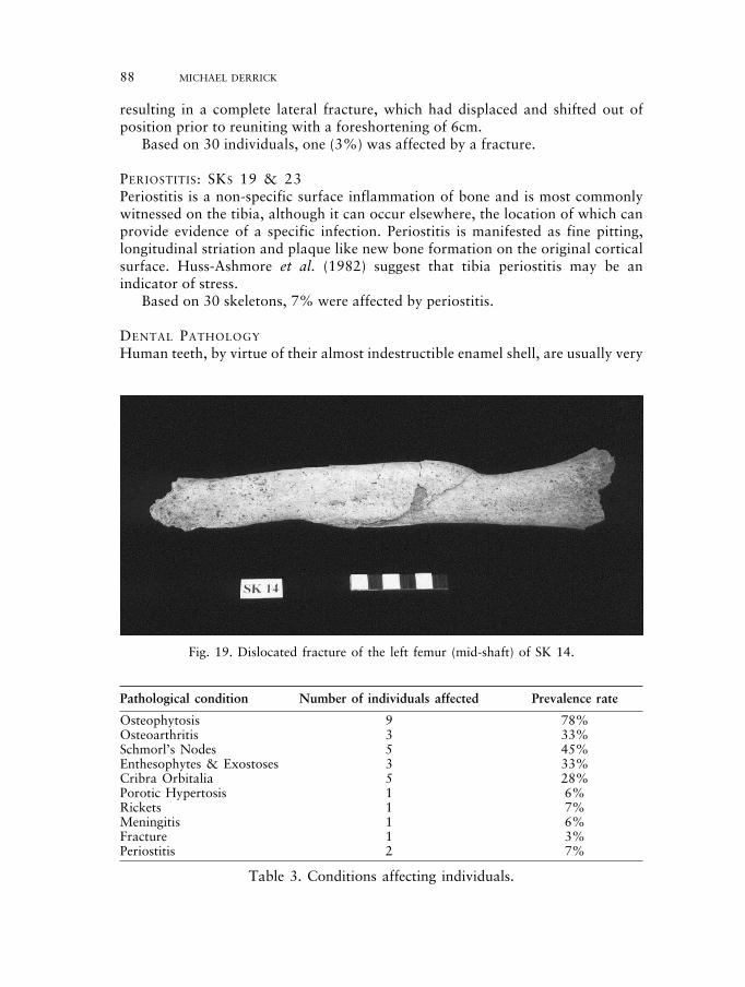
resulting in a complete lateral fracture, which had displaced and shifted out ofposition prior to reuniting with a foreshortening of 6cm.
Based on 30 individuals, one (3%) was affected by a fracture.
PERIOSTITIS: SKS 19 & 23Periostitis is a non-specific surface inflammation of bone and is most commonlywitnessed on the tibia, although it can occur elsewhere, the location of which canprovide evidence of a specific infection. Periostitis is manifested as fine pitting,longitudinal striation and plaque like new bone formation on the original corticalsurface. Huss-Ashmore et al. (1982) suggest that tibia periostitis may be anindicator of stress.
Based on 30 skeletons, 7% were affected by periostitis.
DENTAL PATHOLOGY
Human teeth, by virtue of their almost indestructible enamel shell, are usually very
88 MICHAEL DERRICK
Fig. 19. Dislocated fracture of the left femur (mid-shaft) of SK 14.
Pathological condition Number of individuals affected Prevalence rate
Osteophytosis 9 78%Osteoarthritis 3 33%Schmorl’s Nodes 5 45%Enthesophytes & Exostoses 3 33%Cribra Orbitalia 5 28%Porotic Hypertosis 1 6%Rickets 1 7%Meningitis 1 6%Fracture 1 3%Periostitis 2 7%
Table 3. Conditions affecting individuals.
230487 02c-063-102 18/10/09 10:17 Page 88
THE EXCAVATION OF A ROMAN CEMETERY AT 21–33 NEWARKE STREET 89
well preserved in grave deposits. Frequently, as Zivanovic (1982, 205) states, teethare the only surviving trace of the skeleton and as such have become the subject ofconsiderable pathological consideration.
Dental attrition was noticed on every individual examined, with the severityincreasing with the advancement of age and as such this has been utilised in thedetermination of age. Subsequently the most severe cases of dental attrition wereseen in the over 40s age group.
Twenty sets of teeth were available for analysis, nine of which showedevidence of dental disease (45%).
Twenty per cent of the individuals studied suffered from two or more carieswhile abscesses occurred in 20% of the jaws examined (4; see Table 4). Twentyper cent of the jaws examined (4) also showed evidence of periodontal disease.Peridontitis is an infection of the alveolar bone and the soft tissues of the mouth.The condition is recognised by the recession of the alveolar bone from around thebase of the teeth, which, in the most extreme cases, can lead to the loosening andeventual loss of teeth.
One individual (SK 1) showed clear signs of arrested growth, in the form ofenamel hypoplasia, on the front teeth. Hypoplasia is manifest as horizontal groovesof thinned enamel around the circumference of a tooth. These grooves, developedduring the period of enamel formation (from birth to 13 years), represent periodsof childhood stresses, such as nutritional deficiencies (Huss-Ashmore et al. 1982),
0
10
20
30
40
50
60
70
80 78%
33%
45%
33%
28%
6% 6%3%
7% 7%
Per
cen
tag
eOsteophytosis
Osteoarthritis
Schmorl’s Nodes
Enthesophytyes andExostoses
Cribia Orbitalia
Porotic Hypertosis
Rickets
Menengitis
Fracture
Periostitis
Fig. 20. Pathological prevalence rates.
230487 02c-063-102 18/10/09 10:17 Page 89
vitamin D deficiency, hyperparathyroidism and exantematous fevers (Lukacs 1989,267), during which times tooth enamel cannot develop fully. In this case thepresence of hypoplasia supports the findings of under developed bone lengths andcribra orbitalia, indicating that the individual was nutritionally stressed duringchildhood, perhaps eventually resulting in its death at the age of 10 to 11 years.
SK 21 (a male over 45 years of age) is of particular interest, when consideringdental health, as he suffered from severe dental disease; four carious lesions andfour abscesses. The high number of affected teeth may be due to poor dentalhygiene, diet and the individual’s age; dental pathology had more time to developthan in other younger individuals.
Summary of skeletal and dental analysisAlthough the fragmentary survival and the poor condition of the skeletons buriedat Newarke Street has meant that the detailed analysis of demography andpathological conditions is somewhat limited, subsequent analysis has revealed thatthe individuals buried here belonged to a community who experienced times ofnutritional stress and led physically demanding lives. These individuals were ofaverage height and build for the period and the males often showed a high level ofmuscular development indicating that they engaged in physical activity and werestrong.
Analysis shows that the majority of the males lived longer than the females,whose mortality was greatest between 18 to 35 years, which is commonly referred
90 MICHAEL DERRICK
Skeleton No. Prevalence No. of Prevalence Enamel Periodontalof caries rate of no. of abscesses rate of no. of hypoplasia disease
teeth affected teeth affected
1 3 9% 1 3% Yes No2 0 0 0 0 No No5 0 0 1 3% No No6 0 0 0 0 No No7 2 6% 0 0 No Yes8 0 0 0 0 No No9 0 0 0 0 No No10 0 0 1 3% No No11 0 0 0 0 No No12 0 0 0 0 No Yes13 0 0 0 0 No Yes15 0 0 0 0 No No17 0 0 0 0 No No18 0 0 0 0 No No21 4 12.5% 4 12.5% No No22 0 0 0 0 No No23 2 6% 0 0 No No26 0 0 0 0 No Yes27 0 0 0 0 No No28 0 0 0 0 No No
Table 4. Results of dental analysis.
230487 02c-063-102 18/10/09 10:17 Page 90
THE EXCAVATION OF A ROMAN CEMETERY AT 21–33 NEWARKE STREET 91
to as the childbearing years. Whilst reproduction is an important considerationregarding female mortality, Wakely (1996, 49) suggests that women may alsohave been deprived of certain resources such as the best food, which may haveundermined their health and made them more susceptible to disease and earlymortality.
Diet has been recognised as an important factor regarding the health of theindividuals, evident by the variety of metabolic diseases caused by vitamindeficiencies: Cribra orbitalia, porotic hypertosis and rickets. It is therefore clearthat those buried here may have lacked nutrients essential for growth and health.These findings are further supported by evidence of enamel hypoplasia andarrested development amongst the adolescents in the sample.
The results show that the Newarke Street individuals must also have eaten arelatively hard and coarse diet, which caused substantial wear to their teeth. Theirdental health was also below modern standards with a number of individualssuffering from severe tooth decay and dental abscesses.
Proportionally, more of the males in the community lived into and beyondmiddle age, and as expected suffered from more of the conditions associated withgetting older. The older males in the sample showed signs of osteoarthritis, relatedto age and a high level of wear and tear on one or more joints and spine. The spinewas also often subject to the pathological condition known as Schmorl’s nodes,which is indicative of strenuous activity and trauma.
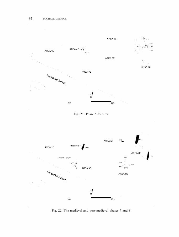
Phase 6: Fourth-century post-cemetery activity
This phase consists of a series of layers and pits which overlay the phase 5 gravesin area 7E (Fig. 21). The layers (47), (50), (65) and (70) consisted of dumps ofhousehold rubbish which contained pottery dating to the late first to early secondcentury. The absence of later pottery may reflect the relatively low sherd numbersrecovered from the site. Two pits [102], [104] overlay graves SK5 and 6 andcontained late first to early second century and third- to fourth-century potterysherds respectively and probably indicate small scale habitation of thesurrounding area. Pit [741] may have been a quarry and had truncated two graves;third- and fourth-century pottery was present in its lower fills suggesting a fourthcentury date for this encroachment into the cemetery.
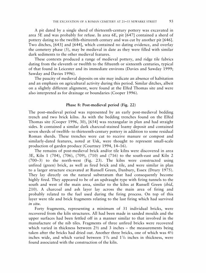
Phase 7: Medieval period (Fig. 22)
Archaeological deposits from the medieval period were few in all areas. Twoditches, [24] and [54], containing medieval pottery in area 7E were aligned north-south. The ditches enclosed a strip of land perpendicular to Newarke Street andwere probably utilised for boundary and drainage purposes. A flat-bottomed ditch[739] in area 4E contained pottery dating to the late medieval period and wasaligned on a similar north-south axis. The alignments of these medieval featuresreflect the medieval line of Newarke Street, or Hangman’s Lane as it was knownduring this period.
230487 02c-063-102 18/10/09 10:17 Page 91
92 MICHAEL DERRICK
Fig. 21. Phase 6 features.
Fig. 22. The medieval and post-medieval phases 7 and 8.
230487 02c-063-102 18/10/09 10:17 Page 92
THE EXCAVATION OF A ROMAN CEMETERY AT 21–33 NEWARKE STREET 93
A pit dated by a single sherd of thirteenth-century pottery was excavated inarea 5E and was probably for refuse. In area 6E, pit [647] contained a sherd ofpottery dating to the twelfth–thirteenth century and was cut by another pit [646].Two ditches, [643] and [644], which contained no dating evidence, and overlaythe cemetery phase (5), may be medieval in date as they were filled with similardark sediments to the other medieval features.
These contexts produced a range of medieval pottery, and ridge tile fabricsdating from the eleventh or twelfth to the fifteenth or sixteenth centuries, typicalof that found in Leicester and its immediate environs (Davies and Sawday 1999;Sawday and Davies 1996).
The paucity of medieval deposits on site may indicate an absence of habitationand an emphasis on agricultural activity during this period. Similar ditches, albeiton a slightly different alignment, were found at the Elfed Thomas site and werealso interpreted as for drainage or boundaries (Cooper 1996).
Phase 8: Post-medieval period (Fig. 22)
The post–medieval period was represented by an early post-medieval beddingtrench and two brick kilns. As with the bedding trenches found on the ElfedThomas site (Cooper 1996, 30), [654] was rectangular in plan and had straightsides. It contained a similar dark charcoal-stained loamy deposit and containedseven sherds of twelfth- to thirteenth-century pottery in addition to some residualRoman sherds. These trenches were cut to receive manure or compost andsimilarly-dated features, noted at Usk, were thought to represent small-scaleproduction of garden produce (Courtney 1994, 14–16).
The remains of post-medieval brick and/or tile kilns were discovered in area3E, Kiln 1 (704), (706), (709), (710) and (716) to the south-east and Kiln 2(700–3) to the north-west (Fig. 23). The kilns were constructed usingunfired (green) brick, as well as fired brick and tile, and were similar in planto a larger structure excavated at Runsell Green, Danbury, Essex (Drury 1975).They lay directly on the natural substratum that had consequently becomehighly fired. They appeared to be of an updraught type with firing tunnels to thesouth and west of the main area, similar to the kilns at Runsell Green (ibid,210). A charcoal and ash layer lay across the main area of firing andprobably related to the fuel used during the firing process. On top of thislayer were tile and brick fragments relating to the last firing which had survivedin situ.
Forty fragments, representing a minimum of 31 individual bricks, wererecovered from the kiln structures. All had been made in sanded moulds and theupper surfaces had been fettled off in a manner similar to that involved in themanufacture of the nib tiles. Fragments of three unfired bricks were recoveredwhich varied in thickness between 2½ and 3 inches – the measurements beingtaken after the bricks had dried out. Another three bricks, one of which was 4½inches wide, and which varied between 15/8 and 17/8 inches in thickness, werefound associated with the construction of the kiln.
230487 02c-063-102 18/10/09 10:17 Page 93
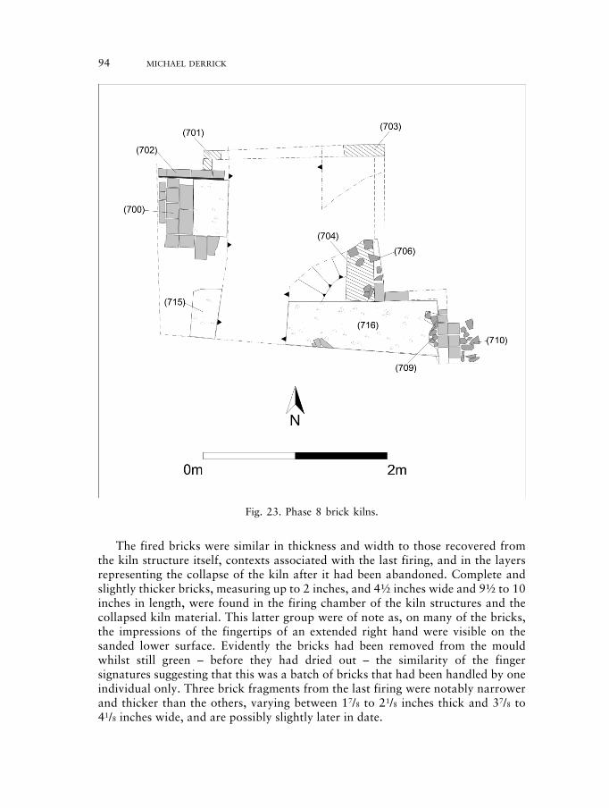
The fired bricks were similar in thickness and width to those recovered fromthe kiln structure itself, contexts associated with the last firing, and in the layersrepresenting the collapse of the kiln after it had been abandoned. Complete andslightly thicker bricks, measuring up to 2 inches, and 4½ inches wide and 9½ to 10inches in length, were found in the firing chamber of the kiln structures and thecollapsed kiln material. This latter group were of note as, on many of the bricks,the impressions of the fingertips of an extended right hand were visible on thesanded lower surface. Evidently the bricks had been removed from the mouldwhilst still green – before they had dried out – the similarity of the fingersignatures suggesting that this was a batch of bricks that had been handled by oneindividual only. Three brick fragments from the last firing were notably narrowerand thicker than the others, varying between 17/8 to 21/8 inches thick and 37/8 to41/8 inches wide, and are possibly slightly later in date.
94 MICHAEL DERRICK
Fig. 23. Phase 8 brick kilns.
230487 02c-063-102 18/10/09 10:17 Page 94
THE EXCAVATION OF A ROMAN CEMETERY AT 21–33 NEWARKE STREET 95
Many of the fragments were overfired, fragmented and some were completelyvitrified. Bands of reduction may have been the result of stacking in the kiln, orsecondary use in the kiln structure. Some of the bricks had the remains of othersadhering to them while two from the firing chamber and kiln structure had clayadhering to their undersides, possibly used in place of mortar. Only the square fluetile showed evidence of mortar.
Forty-four fragments of moulded nib tile were recovered, mostly from contextsassociated with the kiln structure, the last firing of the kilns, and theirabandonment. All the tiles had been made in sanded moulds and consequently hadfive sanded surfaces, whilst the remaining upper surface had been fettled off.Unfortunately, no complete examples were found, and the length of the tiles is notknown. The thickness varied between 10 and 20mm, the majority measuringbetween 14 and 18mm, whilst two tiles were between 165 and 166mm wide. Athird tile had an estimated width of 170mm. A few nibs survived, and the tilesevidently lacked peg holes. The nib is on the smooth side, and the sanded sidewould have appeared uppermost on the roof, a characteristic shared with most nibtiles in the region (Allin 1981) and elsewhere (Moorhouse 1988, 36). A sample of29 fragments of tile was recovered from the base of the firing chamber in kiln 2.Measuring approximately 7 inches square by 1 inch thick, the tile had evidentlybeen rolled out on a sanded surface and then cut into shape, unlike the mouldednib tile.
A thin deposit of lime lay across the floor of the kilns and within the firingtunnel and may indicate that lime burning had taken place as well as brickproduction. Evidence for brick firing and lime burning was encountered at RunsellGreen where large quantities of chalk and lime were encountered (Drury 1975,211). The kilns at Runsell Green may have had walls above ground to a height of2m but it is not possible to say if there was a permanent roof or whether atemporary cover of wasters or turf was used (op. cit.).
Evidence for the production of bricks within the immediate area comes in theform of cartographic and standing building evidence. Stukeley’s map of 1722mentions ‘brick kilns where antiently was a Roman pottery’ in the area, whileRoberts’ map of 1741 shows brick kilns and possibly a hovel (drying shed) at thenorth-eastern end of Hangman’s Lane (Newarke Street).
The earliest brick-built standing buildings in Leicestershire appeared in the latefifteenth–early sixteenth century and were high-status constructions such as KirbyMuxloe castle, Bradgate House, Groby Manor and Abbot Penny’s wall, LeicesterAbbey (McWhirr 1997). In the sixteenth century, brick became a popular buildingmaterial among the gentry and continued well into the early seventeenth centuryas seen at Quenby Hall. The earliest small-scale building using brick started in thelate seventeenth century when timber-framed buildings in the south of the countywere part brick. The earliest brick building in the city is the east front of the GreatHall of Leicester Castle of c. 1695 whilst the earliest securely dated brick buildingsare the Great Meeting House (1708) and a building in Highcross Street (1712). Arefurbished building in Churchgate revealed a date of 1717 (McWhirr 1997, 53;N. Finn pers. comm.)
230487 02c-063-102 18/10/09 10:17 Page 95
A probable date for the brick/tile kilns would seem to range from between thelate seventeenth century and 1722 (Stukeley’s map). The dimensions of the brickare similar to those in use at this period and the earliest brick buildings seem to beappearing in the city at this time.
DISCUSSION
Despite considerable disturbance from cellarage the excavation at Newarke Streethas contributed to the increased understanding of the extra-mural activitiesassociated with the Roman, medieval and post-medieval town (e.g. Cooper 1996;Finn 2004; Gardner 2005). Although there is some evidence for prehistoricactivity in the area from flint material (including a rolled flint flake of Palaeolithicdate) the main evidence is for Roman and post-medieval occupation.
The earliest phase (1) comprises a series of gullies, a pit, pebble surface andremnant soils which appear to represent first century agricultural activity. Phases2 and 3 indicate early second century land management and boundary divisionoccurring outside the Roman town. Although only located in limited areas due tocellar disturbance a series of ditches containing late first to early second-centurypottery do appear to run parallel and perpendicular to Newarke Street (Figs 5 and6). The fact that the orientation of the ditches appears to be reflected in thealignment of Newarke Street may support the suggestion that it had a Romanorigin (Cooper 1996) representing the final stretch of the Via Devana beforejoining the road to the southern gate. The final phase of agricultural managementprior to the cemetery (Fig. 8, phase 4) comprises a series of ditches which have acorresponding alignment to those observed at the Elfed Thomas site. Potteryrecovered from these ditches dates them to the middle to late second centurywhich would place them together with the phase 2 ditches from the Elfed Thomassite (Cooper 1996, 9–12). The date-range is broadly contemporary with theestablishment of the town defences and, as suggested by Cooper, it may have beenthe case that abandonment of the agricultural activity and the silting/deliberatebackfilling of the ditches indicates a depopulation of the newly created suburbanareas with contraction of settlement into the town. This hypothesis has also beensuggested for other extra mural sites to the north and east of the defences (Buckleyand Lucas 1987, 50; Finn 1993, 93). The ceramic evidence may also point to ashift in land use, as there is a distinct lack of third-century material arising in theassemblages. This absence of material, which was also encountered within phases1 to 3 at Causeway Lane (Clark 1999) and the early groups from the ElfedThomas cemetery (Marsden 1996), could be attributed to the construction ofearthen defences at the end of the second century. This construction may havealtered the function and status of the extra-mural area rendering it unoccupiedand no longer used for rubbish disposal.
The cemetery phase (Fig. 9, phase 5) contained 30 burials, which almostexclusively exhibit an east/west burial orientation, the exception being burialSK17 which was aligned north/south and SK21 which contained possible ritually-placed burial goods. A proportion of the graves were stone-lined while some
96 MICHAEL DERRICK
230487 02c-063-102 18/10/09 10:17 Page 96
THE EXCAVATION OF A ROMAN CEMETERY AT 21–33 NEWARKE STREET 97
appear to have been buried in coffins, as attested by the presence of nails withinthe burial fill, and one was interred within a slate cist. Seven other possible gravepits were observed which contained no trace of a body. The pottery assemblagerecovered from the grave fills is similar in date and character to that from phases1–3. As it was not possible to date the burials from the finds a combination ofstratigraphic position, burial rites and an association with the Elfed Thomas site,where some of the burials were associated with coins, has been attempted whichsuggests a fourth century date. Despite modern disturbance, taken together withthe Elfed Thomas excavations, 68 late Roman burials have been examinedenabling comparisons to be made with other cemeteries around Leicesterincluding the 91 burials located during the Clarence Street excavations (Gardner2005). Newarke Street and Clarence Street both show a predominance of east-west orientated burials although Clarence Street does not include any stone-linedgraves. Following the criteria used by Watts (1991) there is some evidence that theNewarke Street burials follow a Christian tradition (Cooper 1996, 27; Mattingly2006, 343). However some of the criteria put forward by Watts are open tochallenge and it is possible that a prevailing fashion of burial rite was beingadopted which had evolved through the fourth century which need notconclusively denote Christian burial (Gardner 2005, 76).
Two possible mausolea structures were present, one of which (structure 1)resembles a temple-mausoleum uncovered at 165 Great Dover Street, Southwark,London (Mackinder 2001) while the other (Structure 2) is similar to a structureexcavated at the Elfed Thomas site (Cooper 1996, 7, fig. 3, features 6.2, 7.1 and6.6). Structures 1 and 2 provided little in the way of clear ceramic dating evidence.Structure 1 comprised a post-hole and beam slot arrangement which respectedgraves to the east and south but which was devoid of any burials. The absence ofburials within the structure perhaps suggests that the mausoleum interpretation isopen to question and if the burials are Christian it is possible that this mayrepresent a church (Morris 1983, 12). In contrast, structure 2 contained burialsSK12 and 14 within its bounds and respected several burials to its north-west andnorth-east suggesting a contemporaneous date with these graves. Structure 2 alsocut through grave SK1 suggesting an earlier burial phase within the cemetery. Itwould appear that these structures were from the latest phase of burial within thecemetery possibly during the later fourth century.
The cemetery appears to have fallen into disuse some time in the fourth centurywhereupon limited pitting activity appears to have taken place. The potteryrecovered from this activity (phase 6) contains residual earlier material and somestratified fourth-century sherds. Little of the material dates to after c. AD 200 andappears to represent the redeposition of earlier deposits.
Medieval activity (phase 7) is extremely sparse and comprises ditches whichrun perpendicular to Newarke Street forming strips of land running north/southwhich contain pottery of a twelfth to thirteenth century date. Pits containingpottery of a similar date and a flat-based ditch containing late medieval potterysuggest that this extra-mural area was used for agriculture and was very sparselysettled during this period.
230487 02c-063-102 18/10/09 10:17 Page 97
A bedding trench of a type previously recorded at the Elfed Thomas LawSchool site was excavated and was found to contain early post-medieval potterythus suggesting horticultural activity at this time. Two post-medieval brick kilnspossibly dating to the late seventeenth or early eighteenth century were discoveredalong the Newarke Street frontage. Such brick kilns are shown on Stukeley’s mapof 1722 and Roberts’ map of 1741 and provide more evidence for thedevelopment of the city of Leicester.
In conclusion, this work has increased our knowledge of extra-muralagricultural and cemetery activity in the Newarke Street area where similar trendsin burial rite such as position of body, alignment and stone-lined graves wereobserved on the Elfed Thomas site. These burials were comparable in date withothers from Leicester at Clarence Street, Great Holme Street and HaymarketTowers and suggest a broad contemporaneity of burial rite, perhaps consistentwith Roman Christian practice at this time, although as Gardener has pointed outwe can see as many significant differences in the burial practices as there aresimilarities (Gardner 2005, 76). While the Newarke Street and Great Holme Streetcemeteries contained stone-lined graves these were absent at Clarence Street. Incontrast the burials at Haymarket Towers contained more grave goods anddisplayed a range of orientations. These differences may reflect factors other thanreligious belief and provide tantalising glimpses of variation within the civitascapital of Ratae Corieltavorum.
ACKNOWLEDGEMENTS
I would like to thank Hallam Contracts and Sowden Group Ltd for funding theproject and for their co-operation during this stage of archaeological works.Special thanks go to Kevin Hill for his on-site co-ordination of building works.Richard Clark, Leicester City Archaeologist monitored the work on behalf of theplanning authority. The following specialists have contributed to this paper:Jennifer Browning (animal bone), Simon Chapman (human bone), NicholasCooper (Roman pottery and other finds), Harriet Jacklin (human bone), AngelaMonckton (charred plant remains) and Deborah Sawday (post-Roman pottery,post-medieval brick and tile). Maggie Cox of Museum of London ArchaeologicalServices kindly provided information on the mausolea from Great Dover Street,Southwark. Thanks also go to Matt Beamish, Vicki Score and Martin Shore forpreparing the author’s original illustrations for publication. The archaeologicalexcavation was carried out by Sophie Clarke, Simon Chapman, Michael Derrick,Meredith Collins, Jon Coward, Tony Gnanaratnam, Wayne Jarvis and MartinShore. The project manager was Richard Buckley.
Michael Derrick is a former Senior Supervisor with University of LeicesterArchaeological Services.
The report was edited by Lynden Cooper and Patrick Clay of ULAS.
98 MICHAEL DERRICK
230487 02c-063-102 18/10/09 10:17 Page 98
THE EXCAVATION OF A ROMAN CEMETERY AT 21–33 NEWARKE STREET 99
BIBLIOGRAPHY
Allin, C. E., 1981 ‘The Ridge Tile’, in J. E. Mellor and T. Pearce (eds) 52–70.Aufderheide, A.C. The Cambridge Encyclopedia of Human Palaeopathology,and Rodriguez-Martin, Cambridge, Cambridge University Press.C., 1998Baxter, I., 2004 ‘Human Remains’, in N. Finn (eds) 2004, 131.Brothwell, D., 1981 Digging up Bones, London, British Museum Press.Buckley, R. J. and Leicester Town Defences, Leicester, Leicestershire Museums ArtLucas, J. N., 1987 Galleries and Records Service.Chapman, S. J., 1997 Osteology Report on the Human Remains Excavated From a
Roman Cemetery at the Haymarket Towers Development Site,Humberstone Gate, Leicester, Unpublished ULAS Report 97/29.
Chapman, S. J., 1999 ‘Osteology Report on the Human Remains’, in J. Gossip (ed.)Excavations at the Republic Car Park, Oxford St, Leicester,Unpublished ULAS Report 99/112, 84–97.
Clark, R., 1999 ‘The Roman Pottery’, in A. Connor and R. Buckley (eds) 1999,95–164.
Clarke, G., 1979 The Roman Cemetery at Lankhills, Winchester Studies 3, Pre-Roman and Roman Winchester, Part II, Oxford, Clarendon.
Clay, P. and Iron Age and Roman Occupation in the West Bridge Area,Pollard, R., 1994 Leicester. Excavations 1962–1971, Leicester, Leicestershire
Museums Art Galleries and Records Service.Connor, A. and Roman and Medieval Occupation in Causeway Lane, Leicester,Buckley, R., 1999 Leicester, Leicester Archaeology Monograph 5.Cooper, L., 1996 ‘A Roman Cemetery in Newarke Street, Leicester Newarke Street,
Leicester’, Transactions of the Leicestershire Archaeological andHistorical Society 70, 170–90.
Courtney, P. and Y., ‘A Siege Examined: The Civil War Archaeology of Leicester’,1992 Post-Medieval Archaeology 26, 47–89.Courtney, P., 1994 Report on the Excavations at Usk 1965–1976: Medieval and
Later Usk, Cardiff, University of Wales Press.Cox, M. and Mays, Human Osteology in Archaeology and Forensic Science, London,S., 2000 Greenwich Medical Media Limited.Crummy, N., 1983 The Roman Small Finds from excavations in Colchester 1971–9,
Colchester Archaeological Report 9, Colchester ArchaeologicalTrust.
Crummy, N. and ‘Excavations at Butt Road 1976–9, 1986 and 1988’, in N.Crossan, C., 1993 Crummy et al. (eds) 1993, 4–163.Crummy, N., Excavations of Roman and Later Cemeteries, Churches andCrummy, P. and Monastic Sites in Colchester, 1971–88, Colchester ArchaeologicalCrossan, C., 1993 report 9, Colchester Archaeological Trust.Dare, M. P., 1927–8 ‘The cemeteries of Roman Leicester’, Transactions of the
Leicestershire Archaeological and Historical Society 15,34–57.
Davies, S. and ‘The Post Roman Pottery and Tile’, in A. Connor and R. BuckleySawday, D., 1999 (eds) 165–213.
230487 02c-063-102 18/10/09 10:17 Page 99
Derrick, M., 2002a An Archaeological Desk Based Assessment for Proposed StudentAccommodation at Newarke Street, Castle Ward Leicester (SK5857 304), ULAS Report 2002-012.
Derrick, M., 2002b An Archaeological Evaluation of Land at 29–33 Newarke Street,Leicester (SK 5857 0415), ULAS Report 2002–058.
Drury, P. J., 1975 ‘Post-Medieval Brick and Tile Kilns at Runsell Green, Danbury,Essex’, Post-Medieval Archaeology 9, 203–12.
Dutour, O., 1986 Enthesopathies (lesions of muscular insertions) as indicators ofthe activities of Neolithic Saharan populations’, American Journalof Physical Anthropology 71, 221–4.
Farwell, D. E. and Poundbury. Vol 2. The Cemeteries, Dorset Natural History andMolleson, T., 1993 Archaeology Society Monograph Series no. 11.Finn, N., 1993 ‘An archaeological evaluation at 71–95, Sanvey Gate, Leicester
(SK 5826 0502)’, Transactions of the Leicestershire Archaeo-logical and Historical Society 67, 93–4.
Finn, N., 2002 ‘Mill Lane, SK 583 042’, Transactions of the LeicestershireArchaeological and Historical Society 78, 94–7.
Finn, N., 2004 The origins of a Leicester suburb. Roman, Anglo-Saxon, medievaland post-medieval occupation on Bonners Lane, Oxford, BritishArchaeological Reports British Series 372.
Gardner, R., 2005 ‘A Roman Cemetery in Clarence Street, Leicester’, Transactions ofthe Leicestershire Archaeological and Historical Society 79,27–90.
Gossip, J., 1998 ‘York Road/Oxford Street (SK 585 039)’, Transactions of theLeicestershire Archaeological and Historical Society 72, 159–60.
Grainger, C. and Roman and Anglo Saxon Burials and a Roman Kiln, Excavated atMahany, C., no date Great Casterton in 1966, Unpublished archive report,
Leicestershire Museums.Greig, J., 1991 ‘The British Isles’, in W. van Zeist, K. Wasylikowa and K-E. Behre
(eds) Progress in Old World Palaeoethnobotany, Rotterdam,Balkema, 299–334.
Hebditch, M. and ‘The Forum and Basilica of Roman Leicester’, Britannia 4, 1–83.Mellor, J., 1973Huss-Ashmore, R., ‘Nutritional Inference from Palaeopathology’, in M. B. SchifferGoodman, A. H. and (ed.), Advances in archaeological method and theory, vol. 5, NewArmelagos, G. J., 1982 York, Academic Press, 395–474.Lucas, J. N., 1977 ‘Great Holme Street, Leicester’, in A. D. McWhirr (ed.)
‘Archaeology in Leicestershire and Rutland 1976’, Transactionsof the Leicestershire Archaeological and Historical Society 52(1976–7), 86–7 (82–103).
Lukacs, J. R., 1989 ‘Dental Palaopathology: Methods for reconstructing dietarypatterns’, in M. Y. Iscan and K. A. R. Kennedy (eds)Reconstruction of life from the skeleton, New York, Alan R. LissInc.
MacDonald, J. L., 1979 ‘Religion’, in G. Clarke (ed.) 1979, 404–33.Mackinder, A., 2001 A Romano-British Cemetery on Watling Street. Excavations at
165 Great Dover Street, Southwark, London, MoLASArchaeology Studies Series 4.
100 MICHAEL DERRICK
230487 02c-063-102 18/10/09 10:17 Page 100
THE EXCAVATION OF A ROMAN CEMETERY AT 21–33 NEWARKE STREET 101
McWhirr, A., Romano-British Cemeteries at Cirencester, CirencesterViner, L. and Excavations vol. 2, Cirencester, Cirencester ExcavationWells, C., 1982 Committee.McWhirr, A., 1997 ‘Brickmaking in Leicestershire before 1710’, Transactions of
the Leicestershire Archaeological and Historical Society 71,37–59.
Maresh, M., 1955 ‘Linear growth of long-bones of extremities from infancy throughadolescence’, American Journal of diseases of childhood 89,725–42.
Marsden, P., 1996 ‘The Roman Pottery: other wares’, in L. Cooper (ed.) 1996,53–61.
Mattingly, D., 2006 An Imperial Possession. Britain in the Roman Empire, London,Allen Lane.
Monckton, A., 1996 ‘Charred and mineralised plant remains’, in L. Cooper (ed.) 1996,74–7.
Monckton, A., 1999 ‘The plant remains’, in A. Connor and R. Buckley (eds) 1999,346–62.
Moorhouse, S., 1988 ‘Documentary Evidence for Medieval Ceramic Roofing Materialsand its Archaeological Implications: Some Thoughts’, MedievalCeramics 12, 33–55.
Morris, R., 1983 The Church in British Archaeology, London, Council for BritishArchaeology Research Report 47.
Nathan, H. and Haas, Cribra orbitalia, a bone condition of the orbit of unknownN., 1966 ‘nature’, Israel Journal of Medical Science 2, 171–91.Resnick, D. and ‘Intervertebral disk herniations: Cartilaginous (Schmorl’s) nodes’,Niwayama, G., 1978 Radiology 126, 57–65.Sawday, D. and ‘The Post Roman Pottery and Ridge Tile’, in L. Cooper (ed.) ,Davies, S., 1996 1996 61–4.Schmorl, G. and The human spine in health and disease, 2nd American edition,Junghanns, H., 1971 New York and London, Grune & Stratton.Stewart-Macadam, P., ‘Anemia in Roman Britain: Poundbury camp’, in H. Bush and M.1991 Zvelebil (eds), Health in Past Societies; Biocultural interpretations
of human skeletal remains in archaeological contexts, BritishArchaeological Reports (International Series) 567, 101–13.
Taylor, J., 2006 ‘The Roman period’, in N. J. Cooper (ed.) The Archaeology of theEast Midlands. An Archaeological Resource Assessment andResearch Agenda, Leicester, Leicester Archaeology Monograph13, 137–60.
Thomas, J., 2006 ‘Grange Lane (SK 586 038)’, Transactions of the LeicestershireArchaeological and Historical Society 80, 217.
Trotter, M. and ‘Estimation of stature from long bones of American whites andGleser, G. C., 1952 Negroes’, American Journal of Physical Anthropology 10,
463–514.Viner, L. and Leach, ‘Bath Gate Cemetery, 1969–76’, in A. McWhirr et al. (eds) 1982,R., 1982 69–109.Wakely, J., 1996 ‘Skeletal Analysis’, in L. Cooper (ed.) 1996, 33–51.Wakely, J., 1999 ‘The human bone’, in A. Connor and R. Buckley (eds) 1999, 365.
230487 02c-063-102 18/10/09 10:17 Page 101

Watts, D., 1991 Christians and pagans in Roman Britain, London and New York,Routledge.
Watts, D., 1993 ‘An Assessment of the Evidence for Christianity at the Butt RoadSite’ in N. Crummy et al., 1993, 192–202.
Wells, K., 1982 ‘The Human Burials’, in A. McWhirr et al. (eds) 1982, 135–207.Zivanovic, S., 1982 Ancient Diseases: The Elements of Palaeopathology (Translated
by Lovett F. Edwards), London, Methenuen & Co.
102 MICHAEL DERRICK
230487 02c-063-102 18/10/09 10:17 Page 102