Embed Size (px)
Citation preview
293THIS IS NOT A PAID ADVERTISEMENT
Wanamaker Building 100 Penn Square East Philadelphia, PA 19107-3390 ATTN: CENAP-OP-R
Public Notice Public Notice No. Date CENAP-OP-R-2015-0293
Application No. File No.
In Reply Refer to: REGULATORY BRANCH
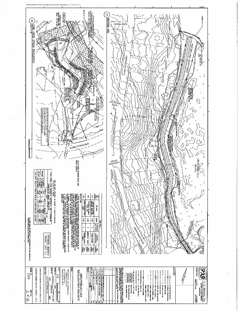
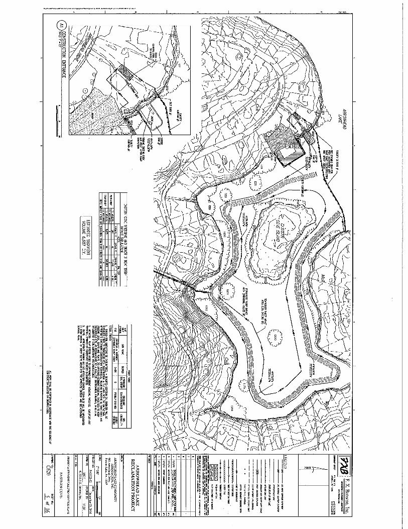
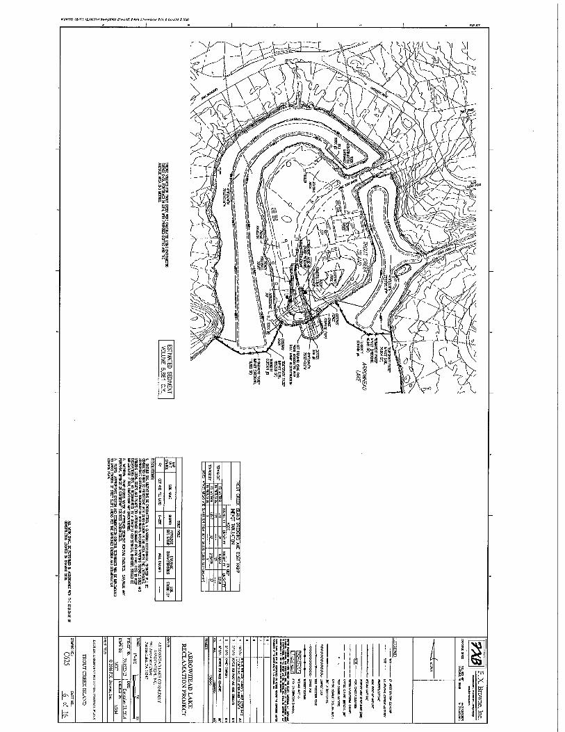
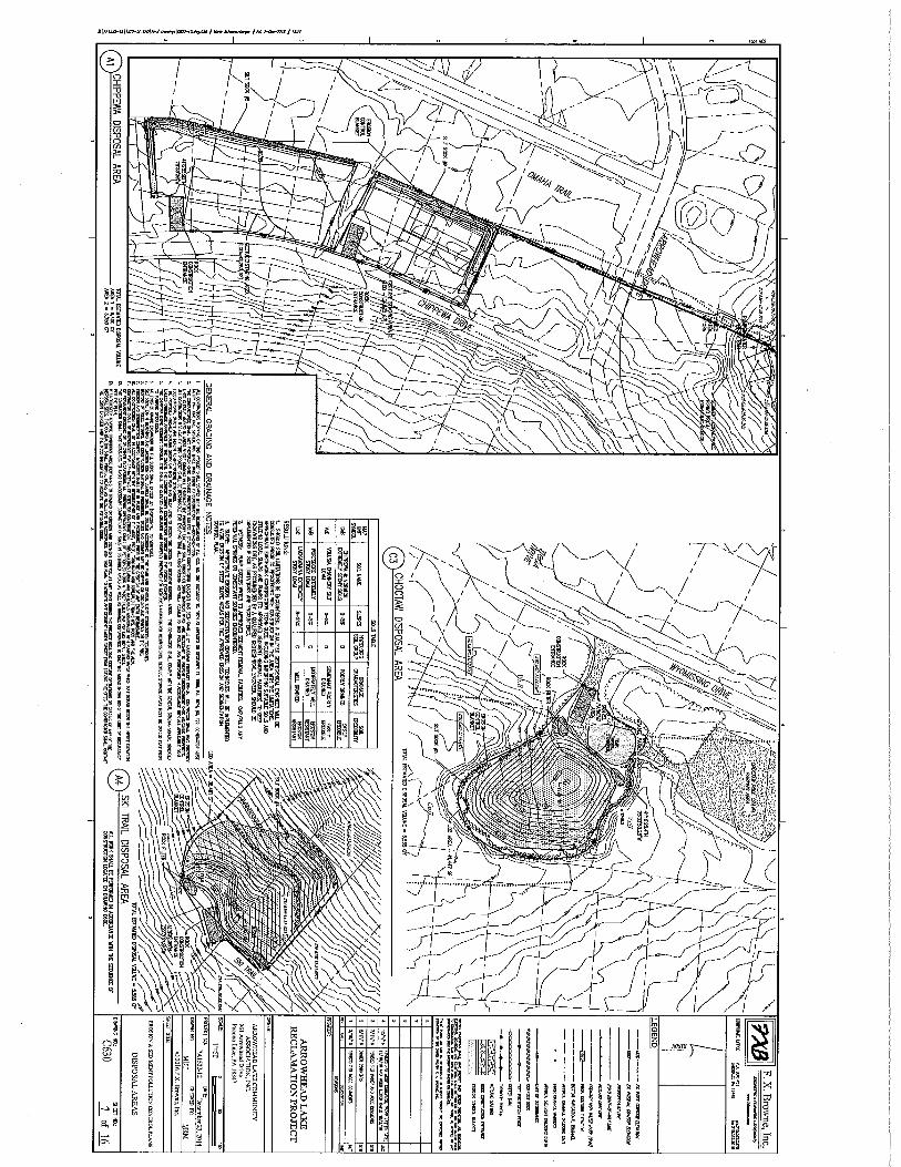
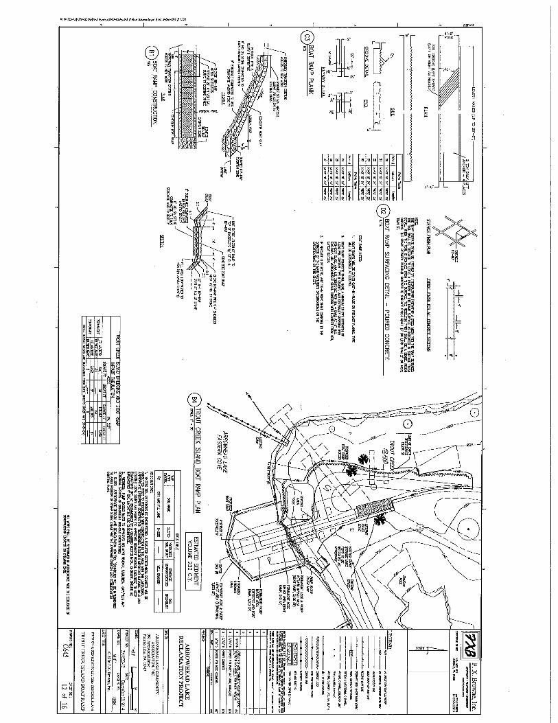
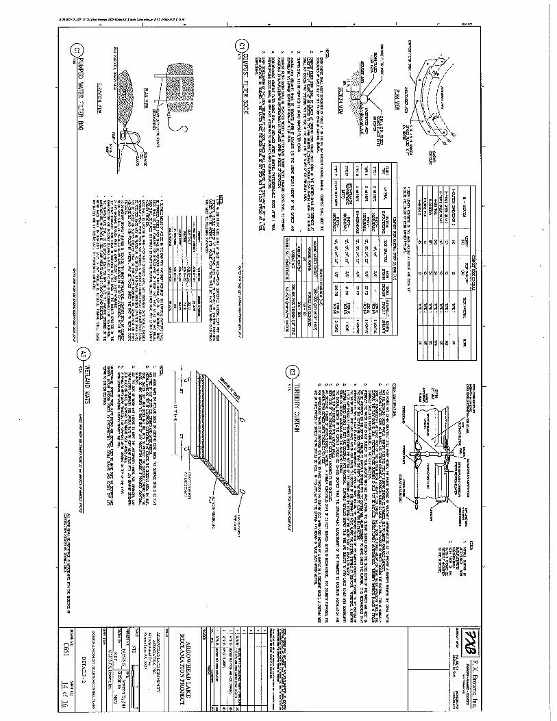
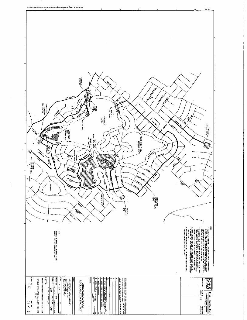
This District has received an application for a Department of the Army permit pursuant to Section 404 of the Clean Water Act (33 U.S.C. 1344). The purpose of this notice is to solicit comments and recommendations from the public concerning issuance of a Department of the Army permit for the work described below. APPLICANT: Arrowhead Lake Community Association, Incorporated 961 Arrowhead Drive Pocono Lake, Pennsylvania 18347 AGENT: F. X. Browne, Incorporated 1101 South Broad Street Lansdale, Pennsylvania 19446 WATERWAY: Trout Creek, Lewis Creek, and Arrowhead Lake LOCATION: The project is located within Arrowhead Lake and its tributaries within the Arrowhead Lake Residential Community in multiple locations in Coolbaugh and Tobyhanna Townships, Monroe County, Pennsylvania. Attachment 1 contains a plan set for the project. ACTIVITY: The applicant proposes to complete a two-phased project over a two year period. The project will involve maintenance dredging, both hydraulic and mechanical. Hydraulic dredging will be performed using a cutterhead suction dredge which vacuumes up silt and sediment and pumps the material through floating pipes. The material is deposited through the pipes into geotubes at the upland dewatering location. These dewatering areas are approved upland areas. Silt and sediment will be dewatered within the geotubes with 95% of solids remaining within the tubes. The geotubes will be surrounded an impervious curbing and water will be filtered from the curbing through a bag filter and pumped back to the lake. Mechanical dreging will be accomplished using backhoes, bulldozers and loaders and will involve redeposition of material when pushing and removing material. This material will be hauled to the approved upland disposal sites. Also included in the project is a stream bank stabilization project, a boardwalk across wetlands and open water to access uplands, the re-construction of 3 existing boat ramps, a pier and gazebo, and a new boat docking facility. Total area of work for the project is 31.6 acres which will include 6.72 acres of hydraulic dredging, 8.41 acres of dewatering which includes temporary coffer dams to facilitate mechanical dredging, 1.06 acres of temporary impact for mechanical dredging of open water areas, 0.02 acre of permanent
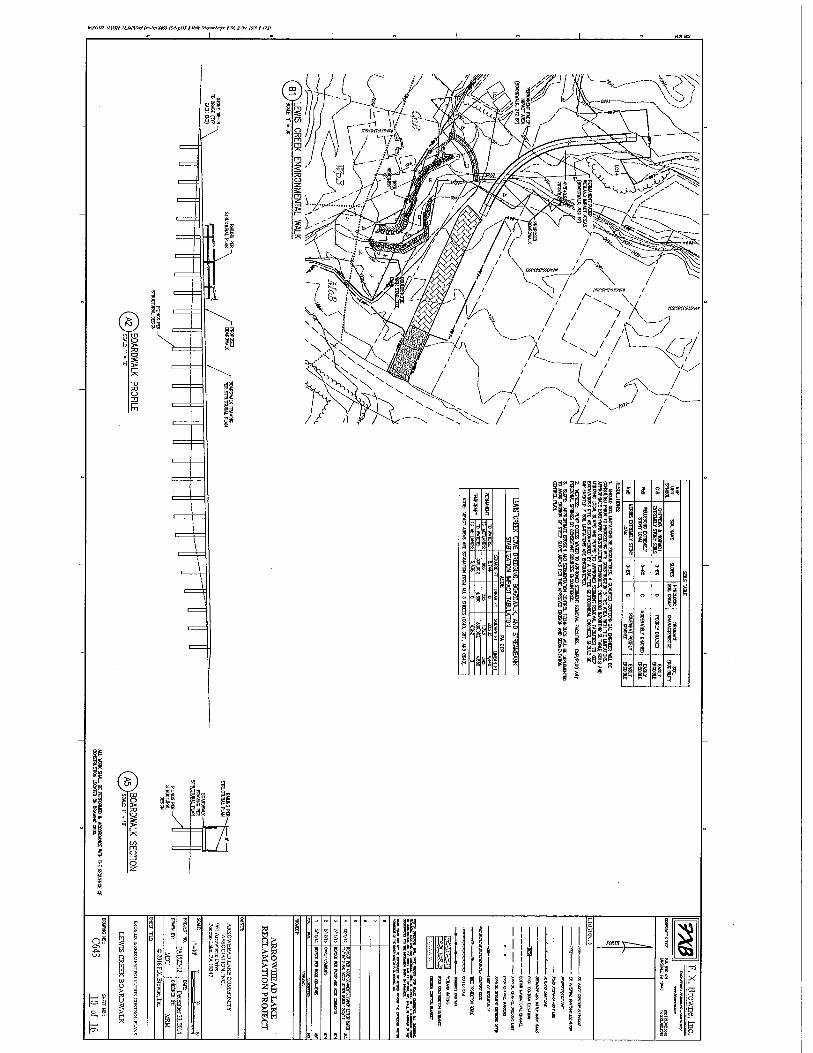
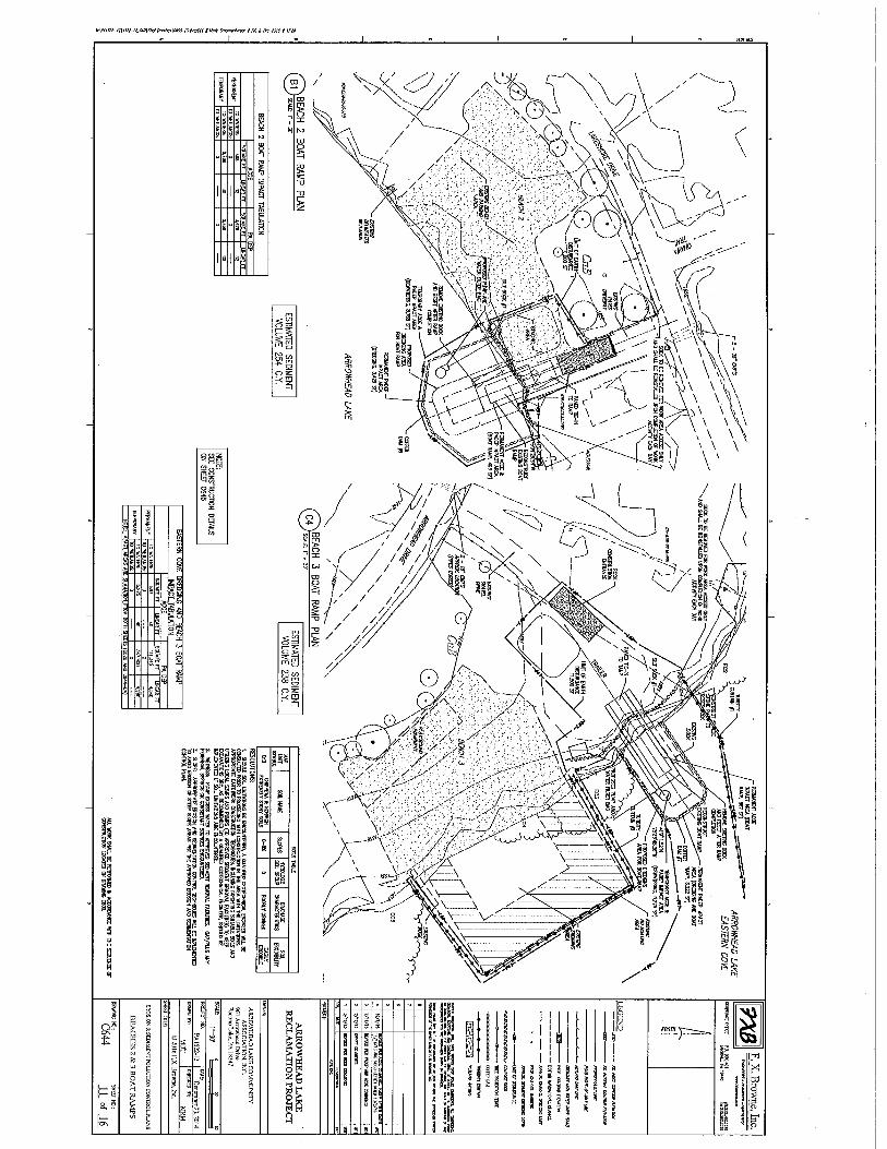
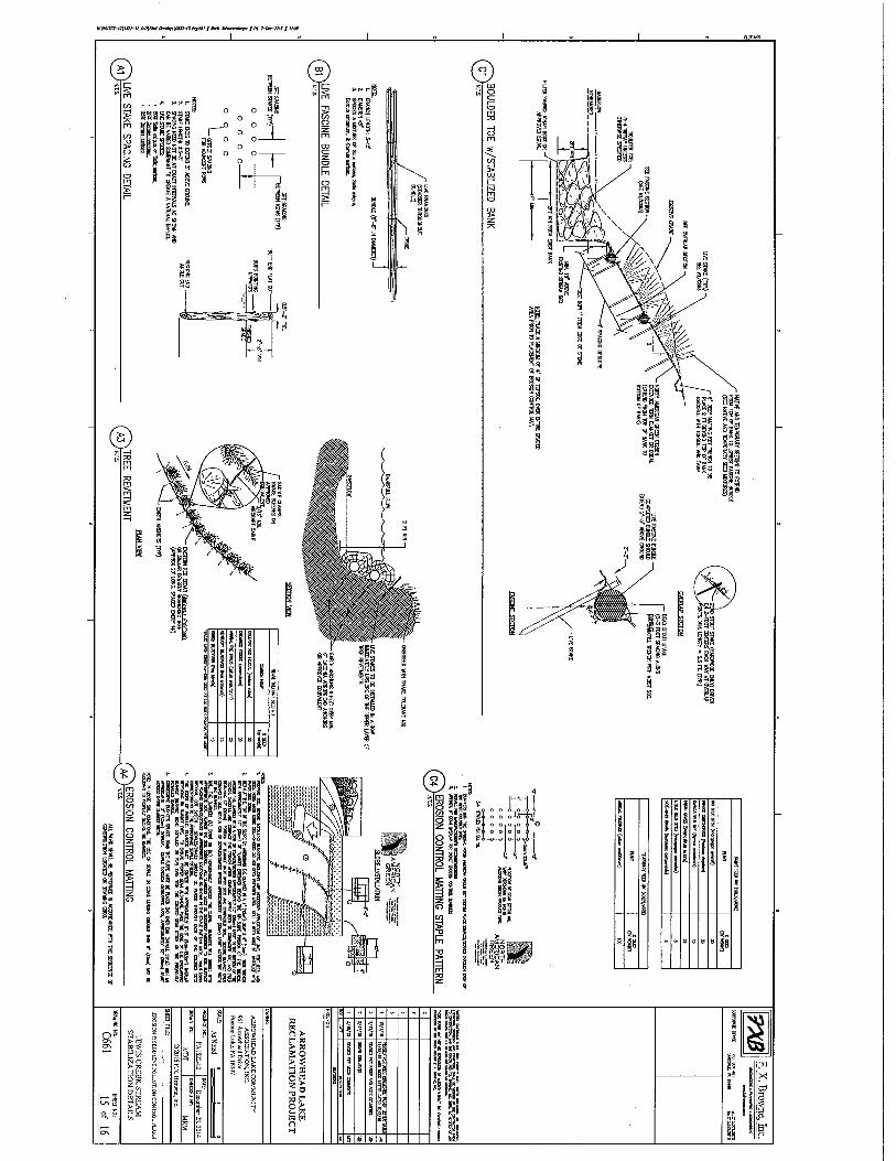
- 2 - removal of wetlands and 0.001 acre of stream fill for streambank stabilization, and 0.04 acre of permanent fill and 0.5 acre of temporary dewatering and dredging for the replacement of the boat ramps, the remaining portion of the work area described above will be in uplands. Phase 1 will include the hydraulic dredging of Eastern Cove and Trout Creek Island navigational channels. This activity is not a federally regulated activity under Section 404 of the Clean Water Act as it will not involve the discharge of dredged and/or fill material into waters of the United States. It is included here as part of the overall project. The Eastern Cove navigation channel will be approximately 15' wide, 4' deep and 4000' long and will cover approximately 1.38 acres of hydraulic dredging. The Trout Creek navigational channel will be approximately 75' wide, ranging from 3' to 5' deep and 3100' long and will cover approximately 5.34 acres of hydraulic dredging. Material dredged through the suction method will be piped through floating pipes to Geotubes located in uplands and will not involve the discharge of any dredged material into the lake or adjacent wetlands. Return water to the lake will be a federally regulated discharge of dredged material. Dewatered material will be spread on-site in the approved upland area shown on the attached plans. Phase 2 will include drawing down the lake to dewater the Lewis Creek Cove navigational channel in order to facilitate the mechanical dredging of the navigational channel. The Lewis Creek Cove navigational channel will be approximately 10' to 15' wide, 4' deep and approximately 2500' long along the east side of the cove and 600' of the west side of the cove. The area of temporary dewatering to perform the mechanical dredging is 8.41 acres. The area of temporary impact to open waters for the navigational channel is 1.06 acres. Dredged material will be trucked to the approved upland disposal site shown on the attached plans. The total proposed volume of dredge material is approximately 17,000 cubic yards, consisting of plant material and sediments from the inflow at the creeks. All navigation channels will be marked using standard navigational buoys, each will have a concrete weight approximatetly 12 inches in diameter. There will be 74 buoys in all. The buoy anchors would impacts 0.02 acre of the waterway bottom. These structures are not a federally regulated activity under Section 404 of the Clean Water Act (CWA). A fish enhancement area consisting of 8 fish habitat structures constructed of stumps, logs and branches 1000 s.f. in size will also be placed at the Lewis Dredging area to provide cover for fish, to enhance spawning and to enhance habitat for juvinile fish creating shelter from predators. The placement of these structures is not a federally regulated activity under Section 404 of the CWA. The applicant is proposing a Lewis Creek Stream stabilization project which will include 0.001 acre of permanent fill for stabilization of the creek banks placed below the ordinary high water mark (OWHM) of the stream and 0.02 acre of permanent fill in wetlands along the stream banks to stabilize the channel. Streambank stabilization will be accomplished using stone below the OHWM and stone and soil fill along the banks stabilized using matting, live stakes and vegetative plantings. Phase 2 will also include the re-construction of the existing boat ramps at Beach #2, Beach #3 and Trout Creek Island. The area of permanent fill for the installation of the concrete boat ramps
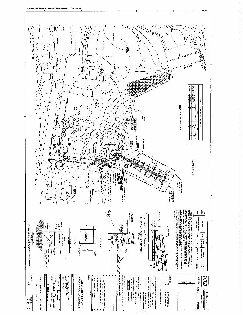
- 3 - is 0.04 acre below the OHWM. There will be 0.5 acre of temporary dewatering, fill for coffer dams and mechanical dredging below the OHWM. Areas around the boat ramps will be mechanically dredged using an excavator which would not be a federally regulated activity under Section 404 of the CWA. Phase 2 will also include the construction of a 160' long boardwalk over emergent wetlands and open water, and a pier and gazebo at the clubhouse which will extend 72' out into the lake. These structures will not invlove the discharge of dredged and/or fill material. All posts will be driven into the ground and will not involve concrete footers. The posts will be placed at a distance of 10 feet apart and will not have the effect of fill to the lake bottom. The boardwalk, pier and gazebo will be constructed 18 inches above the ground/water surfaces and will not shade out vegetation or impede the growth of vegetation beneath them and the structures are not federally regulated under Section 404 of the CWA. The new boat docking facility located at Beach #2 would be floating structure, and no fill will be associated with the facility. It will be teathered to steel pilings in uplands, as such would not be a federally regulated activity under Section 404 of the CWA. PURPOSE: The stated purpose of the project is to increase accessibility of the lake for boating, to improve the boat launch/rental facilities and increase the recreation value of the residential community. A preliminary review of this application indicates that the proposed work would not affect listed species or their critical habitat pursuant to Section 7 of the Endangered Species Act as amended. As the evaluation of this application continues, additional information may become available which could modify this preliminary determination. The decision whether to issue a permit will be based on an evaluation of the activity's probable impact including its cumulative impacts on the public interest. The decision will reflect the national concern for both protection and utilization of important resources. The benefits which reasonably may be expected to accrue from the work must be balanced against its reasonably foreseeable detriments. All factors which may be relevant to the work will be considered including the cumulative effects thereof; among those are conservation, economics, aesthetics, general environmental concerns, wetlands, cultural values, fish and wildlife values, flood hazards, flood plain values, land use, navigation, shore erosion and accretion, recreation, water supply and conservation, water quality, energy needs, safety, food and fiber production, mineral needs and welfare of the people. A Department of the Army permit will be granted unless the District Engineer determines that it would be contrary to the public interest. The Corps of Engineers is soliciting comments from the public; Federal, State, and local agencies and officials; Indian Tribes; and other interested parties in order to consider and evaluate the impacts of this proposed activity. Any comments received will be considered by the Corps of Engineers to determine whether to issue, modify, condition or deny a permit for this proposal. To make this decision, comments are used to assess impacts on endangered species, historic properties, water quality, general environmental effects, and the other public interest factors listed above. Comments are used in the preparation of an Environmental Assessment and/or an Environmental Impact Statement pursuant to the National Environmental Policy Act.
- 4 - Comments are also used to determine the need for a public hearing and to determine the overall public interest of the proposed activity. Comments on the proposed work should be submitted, in writing, within 30 days to the District Engineer, U.S. Army Corps of Engineers, Philadelphia District, Wanamaker Building, 100 Penn Square East, Philadelphia, Pennsylvania 19107-3390. Review of the National Register of Historic Places indicates that no registered properties or properties listed as eligible for inclusion therein are located within the permit area of the work. Avoidance, Minimization, Alternatives: The applicant has stated that they have avoided and minimized impacts to wetlands and aquatic vegetation by designing the navigational channels farthest from the banks of the lake while still providing the desired access within the lake and by constructing new boat ramps within the foot print of the existing boat ramps. All construction access areas are within existing access points to the lake and beach areas. Where necessary, temporary wood matting would be used over wetlands for construction access. The applicant states there are no preferred alternatives as the purpose of the reclamation project is to restore historical access to the lake. The boat ramps are located in the original footprints and the walkway and pier/gazebo are in the only locations available for their purpose. Compensatory mitigation is not proposed for this project for the following reasons: 1. The proposed wetland impact is deminimus and limited to a single water dependent activity . This was accomplished after careful consideration during the design phase. 2. The project is referred to as a reclamation project, assuming that the goal is to 'restore' the habitat from previous years when the coves were open, accessible and unimpeded . 3. Although a long term increase of lake depth is expected, sediment is also expected to re-accumulate and aquatic plant growth will return over time, especially if maintenance dredging is not proposed. 4. Previous recreational activities will return to the project area, which has long been hindered by excess sediment buildup and lack of access. 5. Since the dredging activity is not anticipated to exceed a 4 ft. depth, the lake bottom will still be relatively shallow and nutrient rich for a resurgence of plants over time, although there may be some long term changes until the plant communities totally recover. Any aquatic plant loss is most likely a temporary loss. 6. Since there will be extensive, non-dredged portions of the lake, the overall impact of the dredging activity to the entire lake ecosystem should be minimized because non-dredged areas can serve as refuge and also provide the seed source needed for aquatic plant re-establishment. 7. The project has been intentionally designed to minimize impacts to both wetland and aquatic resource habitats.
- 5 - 8. There is deminimus placement of fill material proposed in jurisdictional areas for boat ramps and stream stabilization. In accordance with Section 401 of the Clean Water Act, a Water Quality Certificate is necessary from the State government in which the work is located. The Pennsylvania Department of Environmental Protection is currently reviewing the application file E45-592. Any comments concerning the work described above which relate to Water Quality considerations should be sent to this office with a copy to the State. The evaluation of the impact of the work described above on the public interest will include application of the guidelines promulgated by the Administrator, U.S. Environmental Protection Agency, under authority of Section 404(b) of the Clean Water Act. Any person may request, in writing, to the District Engineer, within the comment period specified in this notice, that a public hearing be held to consider this application. Requests for a public hearing shall state in writing, with particularity, the reasons for holding a public hearing. Additional information concerning this permit application may be obtained by calling Elaine J. Moyer at 570-842-1044, via email at [email protected], or writing this office at the above address. Edward E. Bonner Chief, Regulatory Branch