Embed Size (px)
Citation preview

3.0 PROJECT DESCRIPTION
City of Berkeley 651 Addison Street Mixed-Use Project August 2008 Draft Environmental Impact Report
3.0-1
The 651 Addison Street Mixed-Use Project is a proposed mixed-use development that would involve construction of a 5-story housing project with 2,600 square feet (SF) of street-level commercial near the foot of University Avenue across from the new Amtrak station. The project would consist of 94 residential units, two retail spaces, and a 102-space parking garage with 28 bicycle spaces. The project would also construct all necessary infrastructure to connect to existing City services.
3.1 PROJECT LOCATION, OWNERSHIP, AND CURRENT USE
The proposed 651 Addison Street (also 2020 Third Street) Mixed-Use Project (project) is located within the West Berkeley Area Plan in the City of Berkeley, Alameda County. Regional access is provided by Interstate 580 (I-580) and Interstate 80 (I-80), which are located approximately two-tenths of a mile west of the site. Figure 3.0-1 depicts the regional location of the project site. The project site is located on the northwest corner of the intersection of Addison and Third Streets (Figure 3.0-2). The project site consists of one parcel (Assessor’s Parcel No. 056-1954-009) under single ownership (Aquatic Park Enterprises, LLC) that encompasses approximately 36,400 square feet (0.84 acres). The site is generally rectangular (with a notch at the northwest corner of the site) north-south along Third Street and east-west along Addison Street. The site is flat and paved with a concrete pad.
The site has historically been used as a manufacturing facility, and more recently was used as a work, storage, commercial, and light-manufacturing facility. The project site previously included the one-story, 19,400 square foot Drayage building, which was demolished in June 2007 (Figure 3.0-3). The Drayage building was constructed in 1935 and was declared unsafe by the Berkeley Fire Department and Building Department in 2005, which later lead to eviction and demolition of the building.
The area surrounding the project site includes a variety of different land uses from manufacturing including the Truitt White lumber company on Second Street to boutique retailers along Fourth Street (Figure 3.0-4). The project study area has experienced much redevelopment within the last decade, including a renovated train stop and transit hub, streetscape improvements, housing developments, live/work facilities, pedestrian/bicycle transportation improvements, new office building, and reinvestment in stores located along University Avenue, San Pablo Avenue, Fourth Street, and additional surrounding streets. Additionally, two of the City’s largest open spaces are located within close proximity to the project site. These include the Berkeley Aquatic Park and the Berkeley Waterfront and Marina.
3.2 SURROUNDING PROJECTS
There are four major projects that were approved recently in the general vicinity of the project site that may contribute to overall cumulative impacts. Cumulative impact criteria are determined by each resource topic area. Additional projects in the vicinity that were not included for the discussion of cumulative impacts are listed in Table 4.0-2. One additional project that is not yet approved includes amendments that would allow for automobile sales in West Berkeley. These projects include the following:
• 700 University Avenue – 173 one- and two-bedroom residential units and commercial/ retail on an approximately two-acre site
• Read Building at 2039 4th Street – mixed-use development with 7,747 SF general office space, 8,540 SF retail, one 2,962 SF residential dwelling unit in single two- to three-story tiered building (49-foot maximum height) with garden courtyard

3.0 PROJECT DESCRIPTION
651 Addison Street Mixed-Use Project City of Berkeley Draft Environmental Impact Report August 2008
3.0-2
• 1885 University Avenue/1950 Martin Luther King Jr Way – 148 one- and two-bedroom residential units and commercial/retail on an approximately one-acre site
• West Berkeley Bowl – 920 Heinz Avenue – grocery retail and distribution center
• West Berkeley Auto Sales – Zoning Ordinance, General Plan, and West Berkeley Plan amendments to allow automobile sales in West Berkeley
All the pending, proposed, and approved projects occurring within the City of Berkeley are depicted in Figure 3.0-5. Table 4.0-1 provides further details of these projects and projects located in the project vicinity of the West Berkeley Area.

S o l a n oC o u n t yS o l a n oC o u n t y
M a r i nC o u n t yM a r i nC o u n t y
A l a m e d aC o u n t yA l a m e d aC o u n t y
S o n o m aC o u n t yS o n o m aC o u n t y
C o n t r a C o s t aC o u n t yC o n t r a C o s t aC o u n t y
S a n M a t e oC o u n t yS a n M a t e oC o u n t y
N a p aC o u n t yN a p aC o u n t y
S a n t a C l a r aC o u n t yS a n t a C l a r aC o u n t y
S a n F r a n c i s c oC o u n t yS a n F r a n c i s c oC o u n t y
S a c r a m e n t oC o u n t yS a c r a m e n t oC o u n t y
Napa River
Carquinez Strait Sacramento RiverSherman Lake
Kent LakeBroad Slough
Calaveras Reservoir
Nicasio Reservoir
San Antonio Reservoir
San Pablo ReservoirBriones Reservoir
Montezuma Slough
Lake Chabot
San Andreas Lake
Upper San Leandro Reservoir
Alpine Lake
Laguna Lake
New York Slough
Lower Crystal Springs Reservoir
Upper Crystal Springs Reservoir
San Jose
Concord
AntiochSan Rafael--Novato
Santa Rosa
Vallejo
Fairfield
VacavilleNapa
Petaluma
Livermore
SonomaSonoma
Half Moon BayHalf Moon Bay
Fairfield SouthwestFairfield Southwest
YountvilleYountville
§̈¦880
§̈¦280
§̈¦580
§̈¦680
§̈¦80
§̈¦780
§̈¦380
§̈¦505
§̈¦980
§̈¦280
§̈¦80
£¤101
£¤1
£¤101Golden Gate National Rec AreaGolden Gate National Rec Area Mount Diablo State ParkMount Diablo State Park
Mount Tamalpais State ParkMount Tamalpais State Park
Source: ESRI; CaSIL
T:\_G
IS\AL
AMED
A_CO
UNTY
\MXD
S\BE
RKEL
EY\R
EGIO
NAL.M
XD - 8
/21/2
007 @
5:58
:48 PM
´4 0 4
MILES
ProjectLocation
Figure 3.0-1Regional Vicinity Map
San FranciscoOakland
Berkeley
P a c i f i c Oc e a n


Addison St
James Kenney Rec Center ParkJames Kenney Rec Center Park
5TH
4TH
6TH
2ND 7TH
ADDISON
BOLIVAR
HEARST
FRONTAGE
UNIVERSITY
BANCROFT
ALLSTONEASTSHORE
UNIVERSITY OVERPASS
UNION PACIFIC RAILROAD
CHANNING
HEARST
DELAWARE
FRONTAGE
Eastshore State ParkEastshore State Park
Berkeley Aquatic ParkBerkeley Aquatic Park
Figure 3.0-2Source: GlobeXplorer 2005, PMC 2007
T:\_G
IS\AL
AMED
A_CO
UNTY
\MXD
S\BE
RKEL
EY\A
DDISO
N_ST\
PROJ
ECTLO
CATIO
N2.M
XD - 8
/22/2
007 @
3:46
:07 PM
´200 0 200
FEET Project Location Map
!"c$
Project LocationParcels


NOTES:1 Elevations are based on
City of Berkeley datum.2 Utility locations as shown are
based on a combination of surface structure observations, utility company markings and utility company and City of Berkeley maps. Due to inherent uncertainties in mapping underground utility facilities, these locations cannot be guaranteed. Locations should be verified prior to construction.
Figure 3.0-3Existing Project Site
T:\_
CS\
Wor
k\Be
rkel
ey_6
51 A
dd
ison
St_
27-0
098\
fi gur
es
Source: Moran Engineering; December 2005
FEET
160 32


HARRISON
GILMAN
CAMELIA
PAGE
JONES
CEDAR
VIRGINIA
DELAWARE
HEARST
UNIVERSITY
ADDISON
ALLSTON WAY
BANCROFT WAY
CHANNING WAY
DWIGHT WAY
PARKER
CARLETON
PARDEE
GRAYSON
HEINZ
POTTER ASHBYMURRAY
FOLGER
ANTHONY
SAN
PA
BLO
NIN
TH
TENTH
FIFTH
EIGH
TH
SEVEN
TH
SIXTH
FOU
RTH
SECO
ND
SAN
PA
BLO
S & P
Rig
ht 0
f Way
S & P
Rig
ht 0
f Way
Manufacturing
Mixed- Manufacturing
Mixed Use/ Light Industrial
Mixed Use/ Residential
General Commercial
Residential
Outdoor Recreation Subzone
PROJECT LOCATION
Source: City of Berkeley Planning Department; July,1998
T:\_
CS\
Wor
k\Be
rkel
ey_6
51 A
dd
ison
St_
27-0
098\
fi gur
es
Figure 3.0-4West Berkeley Plan Land Use Districts


#*!(!(
!(
!(
Cesar Chavez State ParkCesar Chavez State Park
San Pablo ParkSan Pablo Park
Berkeley Aquatic ParkBerkeley Aquatic Park
University ParkUniversity Park
James Kenney Rec Center ParkJames Kenney Rec Center Park
EastshoreState ParkEastshoreState Park
!"c$San
FranciscoBay
651 Addison St
UCBerkeley
UCBerkeley
Codornices Ck
Eastshore State ParkEastshore State Park
Berke ley Aquatic ParkBerke ley Aquatic Park
2039 4th St
920 Heinz Ave
700 University Ave
1950 Martin Luther King Dr
7TH
9TH
4TH
10TH
5TH
6TH
3RD2ND
PARKER
GRANT
BLAKE
DERBY
CHANNING
ALLSTON
SAN PABLO
VINE
VIRGINIA
OREGON
DELAWARE
MC GEE
SACRAMENTO
ADDISON
DWIGHT
MILVIA
8TH
HASTE
FULTON
FRONTAGE
DANA
PAGE
JONES
KING
ADA
OXFORD
EUCLID
ELLIS
CURTIS
ROSE
BOLIVAR
CAMELIA
TELE
GRAP
H
WALNUT
ASHBY
DURANT
67TH
KAINS
HARMON
HEARST
HEINZ
BONAR
RUSSELL
BONITA
PRINCE
WARD
ELLSWORTH
STUART
FAIRVIEW
CEDAR
STANNAGE
CALIFORNIA
FOLGER
HARRISON
66TH
MATHEWS
JOSEPHINE
SATHER
GRAYSON
NEILS
ON
CENTER
CHESTNUT
MC KINLEY
JULIA
BROWNING
WOOLSEY
ESSEX
CARLETON
SPAULDING
ALCATRAZ, OA
WEST
ROOSEVELT
FRANCISCO
HILGARD
RIDGE
ADEL
INE
ORDW
AY
EDITH
TYLER
PARK
SCENIC
LE CONTE
67TH, EM
SANT
A FE
HARPER
CORNELL
PERA
LTA
66TH, OA
HOPKINS
BYRON
UNIVERSITY
BUENA
FRANKLIN
ARCH
BAY
TALBOT
JEFFERSON
BURNETT
BERKELEY
PARDEE
MABEL
HASKELL
WHEELER
VALLEY
MURRAY
ALCATRAZ
ACTO
NCARRISON
EMERSON
BUCHANAN
HOLLY
OTIS
WEBSTER
EDWARDS
JAYNES
DOHR
EVELYN
SPINNAKER
ANTHONY
SPRUCE
SEAWALL
CUTTER
BANCROFTKITTREDGE
TEVL
IN
MARTIN LUTHER KING J
67TH, OAAL
BINA
HENRY
63RD, OANORTH, OA
TREMONT
POTTER
SHATTUCK, OA
HOWE
BELVEDERE
65TH, OA
IDAHO
LINCOLN
SHATTUCK
STANTON
SHASTASOUTH HALL
BREAKWATER
HILL
LORINA
DEAKIN
LEROY
DOVER
SHORT
HAVILA
ND
CHAUCER
GILMAN
BARROWS
NEWBURY
MASONIC
HAWTHORNE
FLORENCE
WHITNEY, OA
BATAAN
MACFARLANE
DOWLING
TOMLEE
CHILT
ON
WALKER
POE
CYPRESS
ACROFT
BERRYMAN
SPRING
ASHBY
LEROY
MC GEE
GILMAN
ADDISON
WESTSAN PABLO
66TH, OA
MC GEE
POTTER
BANCROFT
WEST
DANA
LEROY
ADEL
INE
RUSSELL
SACRAMENTO
RUSSELL
BANCROFT
ACTON
66TH, OA
WEST
ARCH
FRONTAGE
LINCOLN
WOOLSEY
BONITA
WALNUT
HENRY
BYRON
HEARST
ACTON
FULTON
HEARST
UNIVERSITY
MARTIN LUTHER KING J
CEDAR
MILVIA
DOHRSTANTON
PARK
BERKELEY
OXFORD
9TH
DEAKIN
ACTON
SHATTUCK
MABELUNIVERSITY
VIRGINIA
ADEL
INE
CALIFORNIA
STUART
SEAWALL
66TH, OA
ROSE
ARCHHOPKINS
VIRGINIA
KAINS
ADDISON
SHATTUCK
WARD
PAGE
DWIGHT
RUSSELL
LINCOLN
CEDAR
BERK
ELEY
ROSE
CURTIS
CARLETON
ACTON
STUART
CALIFORNIA
HENRY
DWIGHT
FULT
ON
ASHBY
PRINCE
EDITH
FRANCISCO
SPRUCE
CORNELL
CEDAR
ACTON
8TH
Source: City of Berkeley 2007, PMC 2007
T:\_G
IS\AL
AMED
A_CO
UNTY
\MXD
S\BE
RKEL
EY\A
DDISO
N_ST\
SURR
ONDI
NG PR
OJEC
TS.MX
D - 9
/17/
2007
@ 2:
48:40
PM
´1,000 0 1,000
FEET
#* Current Project
!( Surrounding ProjectsWest Berkeley Auto SalesCity of Berkeley
Figure 3.0-5Surrounding Projects
West Berkeley Auto Sales


3.0 PROJECT DESCRIPTION
City of Berkeley 651 Addison Street Mixed-Use Project August 2008 Draft Environmental Impact Report
3.0-13
3.3 PROJECT OBJECTIVES
The following objectives have been identified for the proposed project:
• To generally implement the concepts of the West Berkeley Area Plan with the development of the proposed project;
• To develop an economically feasible project;
• To construct some form of commercial, residential, or mixed-use project that is consistent with the Avenue Commercial land designation in the Berkeley General Plan.
3.4 PROJECT CHARACTERISTICS
The proposed project would consist of the development of an approximately 36,400 square foot lot (0.84 acre) with a 5-story building consisting of four levels of housing over ground-level parking and street retail. The project would include a café with outdoor seating, another commercial space, and 94 units of residential housing. A breakdown of square footage for each use is provided in Table 3.0-1.
TABLE 3.0-1 PROPOSED 651 ADDISON LAND USES
Development Classification Lots, Units, and/or Spaces Square Feet Percentage of
Total Units
Two-Bedroom 23 units 23,237 24.5%
One-Bedroom 56 units 39,652 59.5%
Studio 15 units 9,336 16.0%
Misc. (floors, corridors, stairs, etc.) - 15,927 -
Total Residential (floors 1-4) 94 units 88,152 100%
Ground-Level Commercial 2 retail spaces 2,600 -
Ground-Level Parking 102 car spaces 27,269 -
Misc. (lobby, corridors, utilities, etc.) 28 bike spaces 3,330 -
Total Ground Level - 33,199 -
Other Misc. (mechanical, etc.) - 1,581 -
Total Structural Area - 122,932 -
Gross Floor Area* - 92,470 -
Useable Open Space** - 14,319 -
Total Lot Area - 36,400 - *Gross Floor Area excludes parking area, per Berkeley Zoning Ordinance Title 23F **Defined by City of Berkeley as open to the sky and common space; includes courtyard and roof deck areas
Defined Building Envelopes
The building envelope is the portion of a lot in which all graded and/or impermeable surfaces must occur and defines where structural setbacks occur. The building itself would constitute 95 percent of the impervious surface, including the parking garage, driveways, patios, and

3.0 PROJECT DESCRIPTION
651 Addison Street Mixed-Use Project City of Berkeley Draft Environmental Impact Report August 2008
3.0-14
impervious decking. The total building footprint would be 33,199 square feet (see Figures 3.0-6 through 3.0-10). The average building height would be 60 feet with a maximum height of 63 feet, for a total of five stories. The landscaping and open space is designed for a range of public and private uses. Public open space uses include courtyard and landscaped roof deck areas. Private open space uses include residential patios and balconies. Residential patios would face the courtyard area and balconies would be west-facing. The sidewalk would include street-level landscaping and seasonal shade trees. The applicant shall implement the Aquatic Park Connection Streetscape Improvement Project’s sidewalk and stormwater drainage improvements. The residential lobby, courtyard, and roof would integrate landscaping, benches, and art to include common places for neighbors in which to interact.
Residential and Commercial
The project proposes the development of 94 residential units as follows: two-bedroom, one-bedroom, and studio. Seventy of these units are considered base units of housing. Twenty percent of the base units, or 14 units, would be sold at a price that is affordable to an appropriate-sized household whose income is no more than 80 percent of the area median income reported for the Oakland PMSA for households of that size.1 Commercial space would include 2,600 square feet of ground-floor retail, including the following possible uses: café, restaurant, and other small-scale neighborhood-serving retail. The mixed-use development would occur on a 36,400 square foot lot, resulting in a gross floor area of approximately 92,470 square feet (with density bonus) at a Floor Area Ratio (FAR) of 2.54.
LAND USE
The proposed project is located in the West Berkeley Area of the Berkeley General Plan. The site is designated by the General Plan as Avenue Commercial (AC) and zoned as West Berkeley Commercial (C-W), with MU-LI and MU-R (Mixed-Use Industrial and Mixed-Use Residential) nearby. The General Plan designation of Avenue Commercial allows for a range of uses characterized by pedestrian-oriented commercial developments and multi-family residential structures. Further discussion and details on land use and the project’s consistency with applicable General Plan policies are provided in Section 4.1, Land Use, Population, and Housing, of this EIR.
The General Plan Land Use map designates lands to the south and east of the project site as manufacturing and manufacturing mixed-use. To the west of the project site are manufacturing uses, the Aquatic Park, and a recreational trail. North of the project site are manufacturing, commercial uses, and the University Avenue viaduct.
CONSTRUCTION PHASING
Construction of the project is proposed to begin in September 2009 and be complete near the beginning of 2011. The proposed project would not be phased. Development of the proposed project would require excavation of the upper seven feet below ground surface to be replaced with engineered fill.
1 PMSA (primary metropolitan statistical area) as defined by the U.S. Census Bureau is a geographic entity defined by the Federal OMB for use by federal statistical agencies.

3.0 PROJECT DESCRIPTION
City of Berkeley 651 Addison Street Mixed-Use Project August 2008 Draft Environmental Impact Report
3.0-15
WATER
Water service for the proposed project would be served by East Bay Municipal Utility District’s (EBMUD) existing water supply, distribution system, and treatment facilities. The water treatment facilities that serve the project site and area include the EBMUD Orinda Water Treatment Plant. Further discussion and details regarding water are provided in Section 4.10, Public Services and Utilities, of this EIR.
WASTEWATER
The City of Berkeley provides wastewater collection and transmission from properties located within its boundaries to EBMUD for treatment. The EBMUD’s Main Wastewater Treatment Plant, located in Oakland near the entrance to the San Francisco-Oakland Bay Bridge, services the project area. Wastewater infrastructure currently servicing the project area consists of a 16-inch sewer main on Addison Street. Further discussion and details regarding wastewater are provided in Section 4.10, Public Services and Utilities, of this EIR.
STORM DRAINAGE
The project site drains to the southwest. Runoff from the proposed project is to be collected by the existing storm drains on Addison Street. Further discussion and details are provided in Section 4.8, Hydrology and Water Quality, of this EIR.
ELECTRICITY/NATURAL GAS/TELEPHONE
The proposed project would utilize existing electricity, gas, and telephone lines that serve the surrounding project area. These lines are located along Addison Street. Electricity and gas would be provided by Pacific Gas & Electric Company (PG&E) and telephone service by AT&T. The project proposes to connect to electric, gas, and telephone lines during the construction of the project. Additionally, this project would be part of the Aquatic Park Connection Streetscape Improvement Project, which would include plans for undergrounding the utility line along Addison Street. The environmental impacts of the Streetscape Improvement Project are analyzed in the Aquatic Park Connection Streetscape Improvement Project Initial Study (City of Berkeley, 2006). Therefore, the environmental effects of undergrounding the utility lines are not analyzed in this document. Further discussion and details regarding electricity, natural gas, and telephone are provided in Section 4.10, Public Services and Utilities, of this EIR.
OTHER SERVICES
Fire protection in the City of Berkeley is provided by Berkeley Fire Department. The City of Berkeley Police Department provides law enforcement services within the City limits. Further discussion regarding fire and law enforcement services is provided in Section 4.10, Public Services and Utilities, of this EIR.

Figure 3.0-6Parking Garage First Floor
T:\_
CS\
Wor
k\Be
rkel
ey_6
51 A
dd
ison
St_
27-0
098\
fi gur
es
Source: Baum Thornley Architects; October 2007
FEET
150 30

Figure 3.0-7Second Floor Plan
T:\_
CS\
Wor
k\Be
rkel
ey_6
51 A
dd
ison
St_
27-0
098\
fi gur
es
Source: Baum Thornley Architects; October 2007
FEET
150 30

Figure 3.0-8Proposed Grading Site Plan
T:\_
CS\
Wor
k\Be
rkel
ey_6
51 A
dd
ison
St_
27-0
098\
fi gur
es
Source: Baum Thornley Architects; October 2007
FEET
80 16

FEET
150 30 Figure 3.0-9Street Elevations
South Elevation
East Elevation
T:\_
CS\
Wor
k\Be
rkel
ey_6
51 A
dd
ison
St_
27-0
098\
fi gur
es
Source: Baum Thornley Architects; October 2007

3.0 PROJECT DESCRIPTION
651 Addison Street Mixed-Use Project City of Berkeley Draft Environmental Impact Report August 2008
3.0-20
This page intentionally left blank.
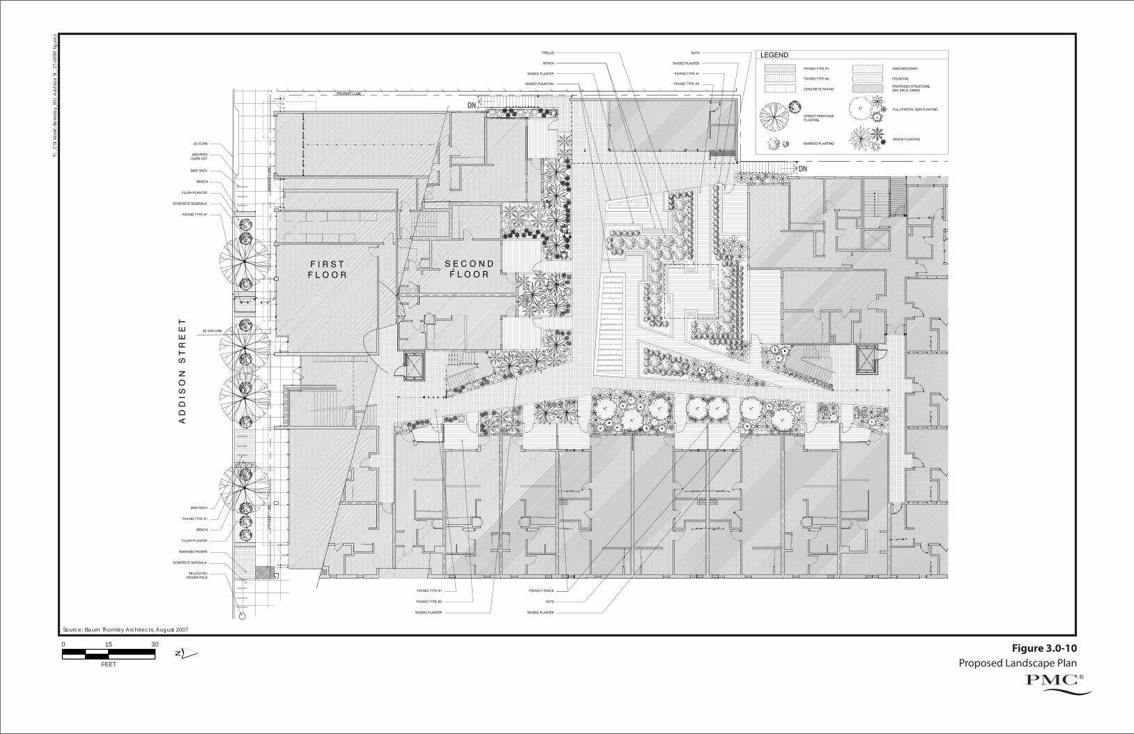
Figure 3.0-10Proposed Landscape Plan
T:\_
CS\
Wor
k\Be
rkel
ey_6
51 A
dd
ison
St_
27-0
098\
fi gur
es
Source: Baum Thornley Architects; August 2007
FEET
150 30


3.0 PROJECT DESCRIPTION
City of Berkeley 651 Addison Street Mixed-Use Project August 2008 Draft Environmental Impact Report
3.0-23
3.5 REGULATORY REQUIREMENTS, PERMITS, AND APPROVALS
This EIR may be used for the following direct and indirect actions regarding the proposed project:
CITY OF BERKELEY
Actions that would be required from the Berkeley City Council, Design Review Commission, Berkeley Zoning Adjustment Board, and/or City staff may include, but are not limited to, the following:
1) Use Permit for a mixed-use building greater than 20,000 square feet per City of Berkeley Municipal Code (BMC) Section 23E.64.030;
2) Use Permit for height of mechanical room over the height limit per City of Berkeley
Municipal Code (BMC) Section 23E.04.020;
3) Use Permit for new construction over 5,000 square feet per BMC Section 23.64.050.B.1;
4) Variance to allow height of 5 stories to accommodate placement of density bonus units per State Density Bonus Law (Zoning Ordinance Section 23C.12.050 and California Government Code Section 65915);
5) Use Permit for a full-service restaurant per BMC Section 23E.64.030;
6) Use Permit to allow the incidental sales of beer and wine sales within a quick or full-
service restaurant per BMC Section 23E.64.030 and 23E.16.040;
7) Use Permit for sidewalk seating with benches and planters per BMC Section 23E.24.010;
8) Building and Grading Permits;
9) Encroachment Permit for undergrounding the utility lines per BMC Section 16.24.050; and
10) Encroachment Permit for public improvements including stormwater and sewer per BMC Section 17.16.030.
OTHER GOVERNMENTAL AGENCY APPROVALS
Additional subsequent approvals and other permits that may be required from local, regional, state, and federal agencies for which the EIR may be used are identified below.
California Regional Water Quality Control Board (RWQCB)
CWA Section 402 regulates construction-related stormwater discharges to surface waters through the National Pollution Discharge Elimination System (NPDES) program. The NPDES General Permit for Storm Water Discharges Associated with Construction Activity (Construction Activity General Permit, #CA-S029831) requires the applicant to file a public notice of intent to discharge stormwater and to prepare and implement a stormwater pollution prevention plan (SWPPP).

3.0 PROJECT DESCRIPTION
651 Addison Street Mixed-Use Project City of Berkeley Draft Environmental Impact Report August 2008
3.0-24
In addition, the City of Berkeley is a co-permittee under the NPDES Municipal Stormwater Permit (Municipal Stormwater Permit No. CAS0029831), operating under the Alameda Countywide Clean Water Program for 2003. This permit requires that discharges of pollutants from areas of new development be reduced to the maximum extent practicable. Compliance with this standard requires that control measures be incorporated into the design of new development to reduce pollution discharges in site runoff over the life of the project. Each permittee shall include conditions of approval in permits for applicable projects, as defined in Provision C.3.c, to ensure that stormwater pollutant discharges are reduced by incorporation of treatment measures and other appropriate source control and site design measures, and increases in runoff flows are managed in accordance with Provision C.3.f, to the maximum extent practicable.
3.0 PROJECT DESCRIPTION
City of Berkeley 651 Addison Street Mixed-Use Project August 2008 Draft Environmental Impact Report
3.0-25
REFERENCES
Aquatic Park Enterprises, LLC. 2007. Final Application Materials. Prepared for the City of Berkeley. Revised October 2, 2007.
City of Berkeley. 2002. Berkeley General Plan. Adopted April 23, 2002.
City of Berkeley. 1992. West Berkeley Area Plan. Adopted December 14, 1993.
City of Berkeley. 2006. City of Environmental Initial Study for the Aquatic Park Connection Streetscape Improvement Project. October 30, 2006.
City of Berkeley. 1999. City of Berkeley Zoning Ordinance. Adopted March 9, 1999.
U.S. Census Bureau. 2007. American Community Survey Office. Page last modified September 17, 2007. http://www.census.gov/acs/www/UseData/geo.htm [Website accessed December 17, 2007].


![final p roject [bar rendering]](https://img.pdfslide.net/doc/110x75/568163ef550346895dd568c2/final-p-roject-bar-rendering.jpg)