Embed Size (px)
Citation preview
Alameda County Impact Analysis
Agricultural and Forestry Resources
Sand Hill Wind Project Draft Environmental Impact Report 3.2‐1 November 2013
ICF 00151.13
3.2 Agricultural and Forestry Resources This section describes the regulatory and environmental setting for agricultural and forestry resources in the project area. It also describes impacts on agricultural and forestry resources that would result from implementation of the Initial and Full Repower.
3.2.1 Existing Conditions
Regulatory Setting
Federal
No federal plans or policies related to agricultural or forestry resources apply to either the Initial or Full Repower phase of the proposed project.
State
Farmland Mapping and Monitoring Program
California established the Farmland Mapping and Monitoring Program (FMMP) in 1982 to continue the Important Farmland Inventory efforts begun by the Natural Resources Conservation Service (NRCS) in 1975. The FMMP is a non‐regulatory program intended to aid in assessing the location, quality, and quantity of agricultural lands and conversion of such lands over time. The FMMP provides consistent and impartial data for the analysis of agricultural land uses and land use changes in California. Under the FMMP, the first Important Farmland Maps were produced in 1984, covering 38 of the state’s 58 counties; current maps, released every 2 years, cover almost 98 percent of the state’s privately held land (California Department of Conservation 2007). The FMMP rates agricultural land according to soil quality and irrigation status within the designations discussed below. Environmental Setting, below, discusses the FMMP designations within the project vicinity.
Prime Farmland
The FMMP defines prime farmland as land with the best combination of physical and chemical characteristics for producing food, feed, fiber, forage, oilseed, and other agricultural crops with minimum inputs of fuel, fertilizer, pesticides, and labor, and without intolerable soil erosion.
Unique Farmland
Unique farmland, as defined by the FMMP, is land other than prime farmland that is used for the production of specific high‐value food and fiber crops such as, citrus, tree nuts, olives, cranberries, fruits, and vegetables.
Farmland of Statewide Importance
Farmland of statewide importance is land of statewide or local importance that has been identified by state or local agencies for agricultural use.
Alameda County Impact Analysis
Agricultural and Forestry Resources
Sand Hill Wind Project Draft Environmental Impact Report 3.2‐2 November 2013
ICF 00151.13
Farmland of Local Importance
Farmland of local importance is land identified as important to the local agricultural economy by each county’s board of supervisors and a local advisory committee. The Alameda County Board of Supervisors has determined that no farmland of local importance is present in Alameda County (California Department of Conservation 2011b).
Grazing Land
The FMMP defines grazing land as land on which the existing vegetation is suited to the grazing of livestock.
Urban and Built‐Up Land
Urban and built‐up land is defined as land occupied by structures, including residential, industrial, commercial, and other developed uses, with a building density of at least one unit per 1.5 acres, or approximately six structures per 10‐acre parcel.
Williamson Act
The California Land Conservation Act of 1965, commonly referred to as the Williamson Act, is a state policy administered at the local government level. The Williamson Act is intended to preserve agricultural and open space lands through contracts with private landowners. By entering into a Williamson Act contract, the landowner foregoes the possibility of converting agricultural land to nonagricultural use for a rolling period of 10 years in return for lower property taxes. Local governments receive an annual subvention of forgone property tax revenues from the state via the Open Space Subvention Act of 1971.
Of California’s 58 counties, 53 have adopted the Williamson Act program, including Alameda County. The Environmental Setting section below describes the location of Williamson Act lands within the project area.
Local
The project area falls under the jurisdiction of Alameda County’s General Plan and ECAP, which contain the following pertinent agriculture‐related goals, objectives, and policies. In addition, Alameda County’s Right‐to‐Farm Ordinance (Alameda County Administrative Code Chapter 6.28) relates to agricultural lands in the project area.
Alameda County General Plan
The Conservation Element (1994) of the Alameda County General Plan contains the following goals and objectives relevant to the Initial and Full Repower.
Goal: To protect and maintain soils in Alameda County in such a manner to be beneficial to agricultural and open uses.
Goal: To protect agriculture and agricultural lands.
Objective 1: To preserve agricultural lands.
Objective 2: To promote sound land use management on agricultural lands.
Objective 4: To support a purpose of multiple use of agricultural and grazing lands as a means of preserving economic and environmental values of the land.
Alameda County Impact Analysis
Agricultural and Forestry Resources
Sand Hill Wind Project Draft Environmental Impact Report 3.2‐3 November 2013
ICF 00151.13
Alameda County East County Area Plan
Alameda County’s ECAP guides development in the easternmost portion of the county, encompassing the area eastward from the Pleasanton/Dublin ridgeline to the San Joaquin County line and south from the Contra Costa County line to the Santa Clara County line. In November 2000, Alameda County voters approved the Save Agriculture and Open Space Lands Initiative (Measure D), amending the Alameda County General Plan and in particular the ECAP. Measure D was intended to preserve and enhance agriculture and agricultural lands and to protect the natural qualities, the wildlife habitats, the watersheds, and the open space of Alameda County from excessive, badly located, and harmful development.
The ECAP contains the following goals and policies applicable to the Initial and Full Repower. The policy marked with an asterisk (*) represents a policy modified by Measure D.
Goal: To maximize long‐term productivity of East County's agricultural resources.
Policy 71: The County shall conserve prime soils (Class I and Class II, as defined by the USDA Soil Conservation Service Land Capability Classification) and Farmland of Statewide Importance and Unique Farmland (as defined by the California Department of Conservation Farmland Mapping and Monitoring Program) outside the Urban Growth Boundary.
Policy 73: The County shall require buffers between those areas designated for agricultural use and new nonagricultural uses within agricultural areas or abutting parcels. The size, configuration and design of buffers shall be determined based on the characteristics of the project site and the intensity of the adjacent agricultural uses, and if applicable, the anticipated timing of future urbanization of adjacent agricultural land where such agricultural land is included in a phased growth plan. The buffer shall be located on the parcel for which a permit is sought and shall provide for the protection of the maximum amount of arable, pasture, and grazing land feasible.
Policy 74: The County shall require that, where conflicts between a new use and existing use are anticipated, the burden of mitigating the conflicts be the responsibility of the new use.
Policy 75: The County shall enforce the provisions of the Alameda County Right‐to‐Farm Ordinance on all lands within and adjacent to agricultural areas.
Policy 85: The County shall utilize provisions of the Williamson Act and other appropriate economic incentives to support agricultural uses.
*Policy 86: The County shall not approve cancellation of Williamson Act contracts within or outside the County Urban Growth Boundary except where findings can be made in accordance with state law, and the cancellation is consistent with the Initiative. In no case shall contracts outside the Urban Growth Boundary be canceled for purposes inconsistent with agricultural or public facility uses. Prior to canceling any contract inside the County Urban Growth Boundary, the Board of Supervisors shall specifically find that there is insufficient non‐contract land available within the Boundary to satisfy state‐mandated housing requirements. In making this finding, the County shall consider land that can be made available through reuse and rezoning of non‐contract land.
Policy 98: The County shall require Site Development Review for all proposed buildings, except accessory uses related to agricultural production (see definition in Table 1 [of the ECAP]), in the "A‐100" (Agriculture ‐ 100‐acre minimum parcel size), "A‐160" (Agriculture ‐ 160‐acre minimum parcel size), or "A‐320" (Agriculture ‐ 320‐acre minimum parcel size) Districts.
Policy 169: The County shall allow for continued operation, new development, redevelopment, and expansion of existing and planned windfarm facilities within the limits of environmental constraints.
Alameda County Impact Analysis
Agricultural and Forestry Resources
Sand Hill Wind Project Draft Environmental Impact Report 3.2‐4 November 2013
ICF 00151.13
Policy 170: The County shall protect nearby existing uses from potential traffic, noise, dust, visual, and other impacts generated by the construction and operation of windfarm facilities.
Policy 173: The County shall discourage the development of uses and structures that are not compatible with wind energy operations within the Wind Resource Area (as shown on Figure 4 [of the ECAP]).
Alameda County Right‐to‐Farm Ordinance
Alameda County has a Right‐to‐Farm Ordinance, Chapter 6.28 of the Administrative Code. The Right‐to‐Farm Ordinance alerts prospective property owners that lands within 2,000 feet include agricultural properties and informs them of lawful and properly conducted agricultural and related activities. The ordinance is intended to promote public health, safety, and welfare and to support and encourage continued agricultural operations in Alameda County. The ordinance provides recourse for both parties in the event of a dispute regarding any inconvenience or discomforts from agricultural operations and protects such operations from nuisance lawsuits.
Alameda County Zoning Ordinance
The project area is zoned Agricultural District (A District) under the Alameda County Zoning Ordinance. The Zoning Ordinance allows for agricultural and other non‐urban uses. Within the A District, privately owned wind‐electric generators are conditionally permitted uses subject to approval by the EBZA.
Environmental Setting
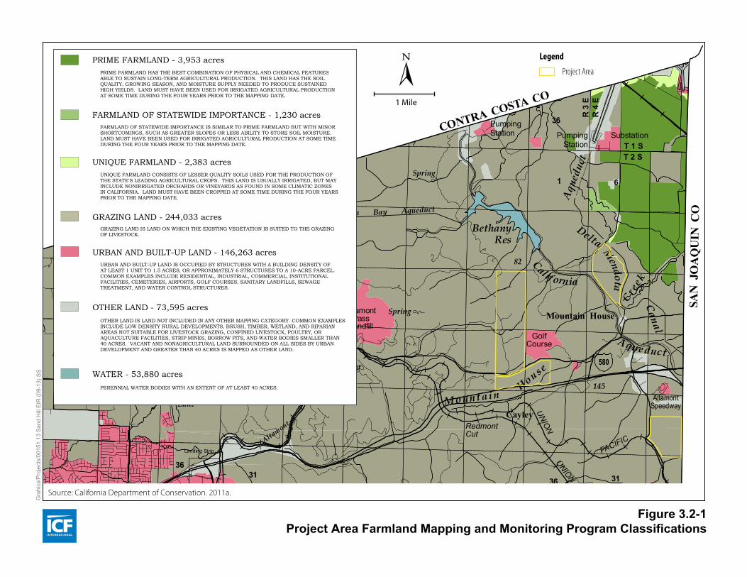
Project Area Farmland Mapping and Monitoring Program Classifications
The FMMP designates the majority of unincorporated Alameda County land as grazing land, defined as “land on which the existing vegetation is suited to the grazing of livestock” (California Department of Conservation 2011a). According to the most recent mapping, the county has approximately 3,953 acres of prime farmland, 1,230 acres of farmland of statewide importance, 2,383 acres of unique farmland, 244,033 acres of grazing land, 146,263 acres of urban and built up land, and 75,595 acres of other land (California Department of Conservation 2011a). The FMMP identifies the land within the project parcels as grazing land (California Department of Conservation 2011a). Figure 3.2‐1 shows FMMP designations for project area lands.
In addition to mapping agricultural lands, the FMMP tracks the amount of land converted from agricultural to nonagricultural use. Between 2008 and 2010, the most recent years available, Alameda County experienced a net loss of 342 acres of agricultural land (California Department of Conservation 2011b). Of those 342 acres converted to nonagricultural use, 219 acres were designated as grazing land (California Department of Conservation 2011b).
Project Area Soils
Soils in the project area consist mainly of Altamont clay, Linne clay loam, and Rincon clay loam. The soils in the Altamont and Linne series are well drained, typically found in the rolling to steeper terrain, and are used primarily for dry‐farmed grain, grain hay, pasture, and range (United States Department of Agriculture 1966). Soils in the Rincon series are found primarily on nearly level valley floors and fans east of Livermore and north of Mountain House; they are mainly used for irrigated pasture, alfalfa, row crops, dry‐farmed grain, and grain hay (United States Department of Agriculture 1966).
BethanyRes
Aqu
educ
t
Delta
Calif ornia
Mendota
Canal
Creek
House
South Bay Aqueduct
Spring
Cre
ekBr
ushy
Spring
Spr
Aque duct
Mount ainFrickLake
Altamont
Cr
Patterson
Spr
Run
Spring
Spring
Spring
Spring
Spring
Springs
Springs
Spring
Se co
Arroyo
South
Bay
Aqueduct
Arroyo
Mocho
HetchHetchy
AqueductMudSprings
Corral
Hollow
MendenhalSpring
Creek
TunnelCreek
SweetSprings
Arroyo
Valle
Arroyo
Mocho
Spring
Spring
MudSprings
ShaferCr
TroutCreek
SouthFork
Cr
Valpe Coffey Mill Gl
Gulch
Fairchild
GlSmith
Gulch
SpringCa lla han
Spring
Spring
SycamoreSpring
Spring
Spring
Spring
Spr
Spring
Spr
Falls
Spring
Sinbad
Cree k
Spring
Spring
Spring
Springs
Spring
Spring
Spring
Springs
Spring
Spring
Lake
DryCreek
San An to
nio Res
ervoir
Williams
Gulch
San
C r e e k
An tonio
LaCosta
C r e e k
Bear
Gulch
Creek
Whitlock
C r e e k
Indian
Aqueduct
Creek
Alameda
Aqueduct
Leyden
Creek
Creek
Joe
Indi
an
CreekWelch
CalaverasReservoir
C r e e k
C r e e k
S c o t t
Toroges
Creek
Sher
don
Cr
Pirate
Creek
South
Fork
App erson
HetchHetchy
Aqueduct
Cre
ek
Vallecitos
Laguna
de
Arroyo
PositasLas
Arroyo
Cree
k
Tassa
jara
Arroyo
Valle
Cr
Cottonwood
Creek
Cayetamo
Gold
Cr
CreekLaurel
Cro
wC
reek
Creek
Cul l
Cree
k
Norris
Cr
UpperSan Leandro Res
Bol inas
Creek
Leandro
San
Creek
KaiserBuck
horn
Cr
LakeChabot
SanLeandro
Creek
San Leandro Tunnel
LakeMerritt
ClaremontCr
Cr
Strawberry
BerkeleyYacht Harbor
Outer H
arbo
r
MiddleHarbor
Inner HarborEstuary
SA
N
FR
AN
CI
SC
O
BA
Y
Palomares
Cre ek
SA
LT
EV
AP
OR
AT
OR
S
Alamed a Creek
E V A P O R A T O R S
S A L T
Slo ugh
New
ark
Plummer Cr
Mud SloughCoyote Creek
Slou
gh
Mow
ry
Creek
Mission
San Leandro Bay
Del
Valle QuarryLakes
LakeElizabeth
UN
ION
PAC
IFIC
PACIFIC
OAKLAND BAY
BRIDGE
61
13
24
80
580
80
12324
580
TUBE
13
580
13
BART
UNION
PACIFIC
PACIFIC
UNION
185
OaklandInternational
Airport
61
BART
880
880
580
580
880
92
PACIFIC
PACIFIC
BARTUNION
UNION
238880
880
84
BART
680
680
PACIFIC
UNION
UN
ION
PACIFIC
238
SAN MATEOBRIDGE
DUMBARTON
BRIDGE
PACIFIC
84
84
UNIO
N
680
84
680580
PACIFIC
UNION
580
580
84
PACIFIC
UNION
UNION
Livermore Airport
UNION
PACIFIC
HaywardExecutive Airport
Landing Strip
Landing Strip
1 6
36
T 1 ST 2 S
R 3
ER
4 E
61
36
T 2 ST 3 S
31
61
36 31
T 3 ST 4 S
61
3631
T 4 ST 5 S
6
R 3
ER
4 E
1
3136
R 2
ER
3 E
61
3136
R 2
ER
1 E
6
3136
R 2
WR
1 W
T 4 ST 5 S
31
61
36
P O T E R O D E L O S C E R R I T O S
3136
1 6
3136
1 6
V A L L E D E S A N J O S E( S U N O L A N D B E R N A L )
31
T 3 ST 4 S
R 1
WR
2 W
A R R O Y O D E L A A L A M E D A
3136
6
R 2
ER
3 E
S A N T A R I T AL O S P O S I T A S
R 2
ER
1 E
3136
6
CANADA DE LOSVAQUEROS
~
R 2
WR
1 W
T 2 ST 3 S
31
6
R 2
WR
1 W
1
6
R 2
WR
3 W
16
3136
T 1 ST 2 S
S A N R A M O NS A N L O R E N Z O
( C A S T R O)
S A N A N TO N I O(V. AND D. PERALTA)
S A N A N TO N I O(A. M. PERALTA)
S A N A N TO N I O(Y. PERALTA)
S A N L E A N D R O
S A N L O R E N Z O(SOTO)
A G U A C A L I E N T E
R 1
ER
1 W
MT
DIA
BL
O M
ER
IDIA
N
LO
S
PO
SI
TA
S
(AMADOR)
PumpingStation Pumping
StationSubstation
AltamontPass
LandfillMountain House
RedmontCut
Cayley
AltamontSpeedway
MidwaySubsta
PattersonPass
Tesla
Co rr a lHo l l o w
CedarMtn
DevilsPit
DevilsHole
SugarloafButte
Mt Wallace
C r a n e
R i d g e
Mitchell
Ravine
Ce d a r M
t n Ri d g e
Lang Canyon
CanyonEy lar
Rid
ge
Man
Canyon
Tarraville
V a l p eLookout
Point
RoseFlat
HamiltonFlat
ShaferFlat
R i d g e
Beartrap
Ridge
Camp OhloneRegional Park
OakRidge
R i d g e
Wa u h a b
Ri d g e
Ro c k yDEL VALLE
REG IONAL PARK
U.S.Vet er ansHospi ta l
L I V E R M O R E
V A L L E Y
Ulmar
Livermore
Trevarno
EastPleasanton
Hosp
LawrenceLivermoreNational
Laboratory
GolfCourse
Golf Course
AltamontPass
Altamont
VascoRoad
Landfill
BrushyPeak
Ca
ny
on
Co
l l i er
Golf Course
Canyon
Doolan
Hosp
Camp ParksRegional ParkCAMP
PARKS
CountyFairgrounds
KomandorskiVillage
Shadow CliffsRegional Rec Area
Pleasanton
Dublin
San R
amon V
al ley
A m a d o rVa l l e y
Canyon
Martin
H o l l i s
Can yonCanyo
n
Eden
Donlan PtC a n y o n
Su
no
l
D u b l i n
Can
Can
HeadD
evan
ey
Can
Cook
Ridge
Main
GolfCourse
GolfCourse
Kilkare Woods
Wa l p e r t
Ri d g e
TolmanPeak
Ri d
ge
Canyon
Stonybrook
Farwell
Dresser
Niles JunctionNiles
Pl e
as
an
t on
Ri d
ge
SunolN i l e s
Ca n y onScotts Corner
Vallecitos Valley
GolfCourse
Su
no
l
Va
l l ey
GravelPits
GolfCourse
Va l l e yL a C o s t a
MissionPass
Morrison Can
MaguirePeaks
SUNOL REGIONAL WILDERNESS
MISSION SAN JOSEDE GUADALUPE
MissionPeak
A p p e r s o n R i d g e
MonumentPeak
Mt Allison
Mission San Jose
Hidden Val
Irvington
Warm Springs
CurtnerDrawbridge
Durham RoadLandfill
Substation
MowryLanding
Newark
FREMONT
Centerville
JarvisLanding
DumbartonPoint
SAN
FRAN
CISCO BAY NATIONAL W
ILDLIFE REFUGE
CalaverasPoint
Coyote HillsRegional Park
TurkIsland
Coyote
Hills
Union City
Pabrico
Baumberg
Carpenter
GARIN
REGIONAL PARK
HaywardMt Eden
RussellCity
Johnson Landing
Hayward Landing
Roberts Landing
C.S.U. Hayward
ChabotCollege
San Leandro
San Lorenzo
Ashland Castro ValleyHospGolf Course
GolfCourse
Mulford Landing
MulfordGardens
San Leandro Va lley
ANTHONY CHABOT REGIONAL PARK
GolfCourse
GolfCourse
San Leandro Hi l ls
Grass
Valley
ZooKnowland Park
and Arboretum
Riley
Ridge
Bay FarmIsland
Coliseum
RamagePeak
LAS TRAMPASREG WILDERNESS Ridge
Rocky
Can
Redwood
MerrittCollege
MillsCollege
HolyNamesCollege
REDWOOD
REGIONAL PARK
Joaquin MillerPark
Alameda
Robert W CrownMemorial Beach
AlamedaNaval
AirStation(closed)
OaklandNaval
SupplyCenter
Oaklan
d
Army T
ermina
l
LaneyCollege
Piedmont
OAKLANDGovernmentIsland
Hosp
Hosp
EmeryvilleRobert Sibley
Regional Preserve
Univ of CaliforniaBERKELEY
Hosp
FlemingPoint
Berkeley Pier
Albany
Be r k e l e y
H i l l s
The Knife
GolfCourse
Cem
GolfCourse
GolfCourse
GolfCourse
201
140
320
420
72
396
256
456
289
434
89
361
205
767
515
419
233764
982
810
966
956
927
1120
701
861
746
227
358
384
385
373
209
519 82
145
477
656
514
209
CONTRA COSTA CO
CONTRA
CONTRA COSTA CO
COSTACO
SAN
JO
AQ
UIN
CO
SANTA CLARA CO
STANISL
AUS CO
SAN JOAQUIN COSAN MATEO CO
CLARA CO
SANTA
SAN MATEO CO
SAN FRANCISCO CO
-121°30'0"
-121°30'0"
-121°37'30"
-121°37'30"
-121°45'0"
-121°45'0"
-121°52'30"
-121°52'30"
-122°0'0"
-122°0'0"
-122°7'30"
-122°7'30"
-122°15'0"
-122°15'0"
-122°22'30"
-122°22'30"
37°52'30"
37°52'30"
37°45'0"
37°45'0"
37°37'30"
37°37'30"
37°30'0"
37°30'0"
ALAMEDA COUNTY IMPORTANT FARMLAND 2010 CALIFORNIA DEPARTMENT OF CONSERVATION
DIVISION OF LAND RESOURCE PROTECTION
FARMLAND MAPPING AND MONITORING PROGRAM
STATE OF CALIFORNIAEdmund G. Brown Jr., GovernorTHE NATURAL RESOURCES AGENCYJohn Laird, SecretaryDEPARTMENT OF CONSERVATIONDerek Chernow, Acting Director
160
4010
1 mile
The minimum land usemapping unit is 10 acres,except Water , which ismapped to a minimum of40 acres.
1 square mile = 640 acres.
SOLANO
CONTRA COSTA
ALAMEDASAN
MATEO
SANTA CLARA
SANTACRUZ
OTHER LAND - 73,595 acresOTHER LAND IS LAND NOT INCLUDED IN ANY OTHER MAPPING CATEGORY. COMMON EXAMPLESINCLUDE LOW DENSITY RURAL DEVELOPMENTS, BRUSH, TIMBER, WETLAND, AND RIPARIANAREAS NOT SUITABLE FOR LIVESTOCK GRAZING, CONFINED LIVESTOCK, POULTRY, ORAQUACULTURE FACILITIES, STRIP MINES, BORROW PITS, AND WATER BODIES SMALLER THAN40 ACRES. VACANT AND NONAGRICULTURAL LAND SURROUNDED ON ALL SIDES BY URBANDEVELOPMENT AND GREATER THAN 40 ACRES IS MAPPED AS OTHER LAND.
URBAN AND BUILT-UP LAND - 146,263 acresURBAN AND BUILT-UP LAND IS OCCUPIED BY STRUCTURES WITH A BUILDING DENSITY OFAT LEAST 1 UNIT TO 1.5 ACRES, OR APPROXIMATELY 6 STRUCTURES TO A 10-ACRE PARCEL.COMMON EXAMPLES INCLUDE RESIDENTIAL, INDUSTRIAL, COMMERCIAL, INSTITUTIONALFACILITIES, CEMETERIES, AIRPORTS, GOLF COURSES, SANITARY LANDFILLS, SEWAGETREATMENT, AND WATER CONTROL STRUCTURES.
WATER - 53,880 acresPERENNIAL WATER BODIES WITH AN EXTENT OF AT LEAST 40 ACRES.
GRAZING LAND - 244,033 acresGRAZING LAND IS LAND ON WHICH THE EXISTING VEGETATION IS SUITED TO THE GRAZINGOF LIVESTOCK.
PRIME FARMLAND - 3,953 acresPRIME FARMLAND HAS THE BEST COMBINATION OF PHYSICAL AND CHEMICAL FEATURESABLE TO SUSTAIN LONG-TERM AGRICULTURAL PRODUCTION. THIS LAND HAS THE SOILQUALITY, GROWING SEASON, AND MOISTURE SUPPLY NEEDED TO PRODUCE SUSTAINEDHIGH YIELDS. LAND MUST HAVE BEEN USED FOR IRRIGATED AGRICULTURAL PRODUCTIONAT SOME TIME DURING THE FOUR YEARS PRIOR TO THE MAPPING DATE.
FARMLAND OF STATEWIDE IMPORTANCE - 1,230 acresFARMLAND OF STATEWIDE IMPORTANCE IS SIMILAR TO PRIME FARMLAND BUT WITH MINORSHORTCOMINGS, SUCH AS GREATER SLOPES OR LESS ABILITY TO STORE SOIL MOISTURE.LAND MUST HAVE BEEN USED FOR IRRIGATED AGRICULTURAL PRODUCTION AT SOME TIMEDURING THE FOUR YEARS PRIOR TO THE MAPPING DATE.
UNIQUE FARMLAND - 2,383 acresUNIQUE FARMLAND CONSISTS OF LESSER QUALITY SOILS USED FOR THE PRODUCTION OFTHE STATE'S LEADING AGRICULTURAL CROPS. THIS LAND IS USUALLY IRRIGATED, BUT MAYINCLUDE NONIRRIGATED ORCHARDS OR VINEYARDS AS FOUND IN SOME CLIMATIC ZONESIN CALIFORNIA. LAND MUST HAVE BEEN CROPPED AT SOME TIME DURING THE FOUR YEARSPRIOR TO THE MAPPING DATE.
SCALE: 1:100,0001 inch represents approximately 1.6 miles
0 1 2 3 4 5 6 7 8 9 10 11Kilometers
0 1 2 3 4 5 6Miles
Important Farmland Maps are compiled by the Farmland Mapping and Monitoring Program (FMMP) pursuant toSection 65570 of the California Government Code. To create the maps, FMMP combines current land use informationwith U.S. Department of Agriculture-Natural Resources Conservation Service (NRCS) soil survey data. Soil unitsqualifying for Prime Farmland and Farmland of Statewide Importance are determined by the NRCS. Changes to soilprofiles subsequent to publication of NRCS soil surveys are not reflected on this map. This map was developed usingNRCS digital soil data (SSURGO) and may contain individual soil units as small as one acre.
Farmland Mapping and Monitoring Program 801 K Street, MS 18-01 Sacramento, CA 95814 Phone: (916) 324-0859 e-mail: [email protected] © California Department of Conservation, Division of Land Resource Protection, 2011.
Map published April 2011.
Additional data is available at www.conservation.ca.gov/dlrp/fmmp, including detail on the program, full sizePDF maps, map categories, statistics, field summaries, and GIS data for download. Contact the:
The Department of Conservation makes no warranties as to the suitability of this product for any particular purpose.
This map should be used within the limits of its purpose - as a current inventory of agricultural land resources.This map does not necessarily reflect general plan or zoning designations, city limit lines, changing economic or marketconditions, or other factors which may be taken into consideration when land use policies are determined. This map isnot designed for parcel-specific planning purposes due to its scale and the ten-acre minimum land use mapping unit.Classification of important farmland and urban areas on this map is based on best available data. The information hasbeen delineated as accurately as possible at 1:24,000-scale, but no claim to meet 1:24,000 National Map AccuracyStandards is made due to variations in the quality of source data.
Land use status is determined using current and historic aerial imagery, supplemental GIS data, and field verification.Imagery sources may include public domain datasets, web-based information, and commercially purchased data,depending on data availability. Supplemental data on land management status is obtained from federal, state, andlocal governments. Map reviewers at the local level contribute valuable information with their comments and suggestions.Please refer to FMMP field analyst reports for each county to obtain specific citations.
Cultural base information for the Important Farmland Maps was derived from public domain data sets, based upondesign of the U.S. Geological Survey, with updates generated by digitizing over current imagery.
Total County Area - 525,337Mapped Area- 525,337
1 Mile
Source: California Department of Conservation. 2011a.
Gra
hics
/Pro
ject
s/00
151.
13 S
and
Hill
EIR
(09-
13) S
S
Figure 3.2-1Project Area Farmland Mapping and Monitoring Program Classifications
Project Area
Legend
Alameda County Impact Analysis
Agricultural and Forestry Resources
Sand Hill Wind Project Draft Environmental Impact Report 3.2‐5 November 2013
ICF 00151.13
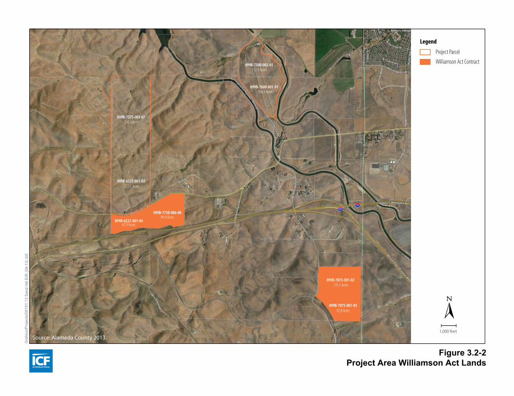
Williamson Act Lands
As of 2009, the most recent enrollment data available for Alameda County, a total of 135,031 acres of Williamson Act lands were located throughout Alameda County (California Department of Conservation 2011b). Of these, 132,539 acres were classified as prime and 2,493 acres were classified as non‐prime lands (California Department of Conservation 2011b). Williamson Act lands in the project area are classified as non‐prime Williamson Act Lands, defined as “land which is enrolled under California Land Conservation Act contract and does not meet any of the criteria for classification as Prime Agricultural Land” (California Department of Conservation 2012). The state defines non‐prime land as open space land of statewide significance under the Williamson Act, and notes that most such land is used for grazing or non‐irrigated crops, but may include “other open space uses which are compatible with agriculture and consistent with local general plans” (California Department of Conservation 2012). Several of the project parcels are under Williamson Act contract, and utility‐scale wind energy turbines and projects, such as those that were developed in the 1980s and 1990s and that are expected to continue to be maintained and/or built in the APWRA, have been determined to be compatible uses by both the County and the California Department of Conservation. Three of the seven parcels scheduled for the Initial Repower phase are under Williamson Act contract (Alameda County 2013). The eighth parcel, part of the Full Repower but not the Initial Repower, is also under Williamson Act contract (Alameda County 2013). Figure 3.2‐2 shows Williamson Act lands in the project area.
Project Area Agriculture and Forest Resources
Eastern Alameda County is largely rural, with open space, agriculture, and wind farms being the predominant uses. Forest resources are not present within or near the project parcels. The approximately 1,000‐acre project area is currently in agricultural use as cattle grazing land as well as existing wind farm operations. Grazing takes place concurrently with wind turbine operations, and the wind farms’ internal maintenance access roads provide landowners with additional access to portions of their properties. Wind farm operators lease rights from property owners to use portions of the land for turbines, ancillary electric power lines, access roads, substations, and maintenance facilities. Because wind energy facilities occupy a small area of the total leased acreage, the remainder of the land continues to be used for agricultural production.
3.2.2 Environmental Impacts This section describes the impact analysis relating to agricultural resources for both the Initial Repower and the Full Repower. It describes the methods used to determine the impacts of the Sand Hill Wind Project, lists the thresholds used to conclude whether an impact would be significant and, if applicable, provides measures to mitigate (reduce, avoid or compensate for) any impacts determined to be significant.
Methods for Analysis This section of the EIR addresses potential impacts of the Initial Repower and subsequent Full Repower on agricultural and forest resources. In general, impacts on agricultural or forest resources may occur during the decommissioning of existing wind facilities, or during construction, operation and maintenance of the proposed wind facilities; all of these situations are considered in the evaluation of potential impacts on agricultural and forest resources. The analysis of agricultural and forest resources impacts was conducted using a review of the most
Alameda County Impact Analysis
Agricultural and Forestry Resources
Sand Hill Wind Project Draft Environmental Impact Report 3.2‐6 November 2013
ICF 00151.13
current (2010) FMMP information for Alameda County, including the Important Farmlands Map and farmland conversion tables; NRCS soils data; and Alameda County’s parcel‐specific Williamson Act information.
Determination of Significance Based on Appendix G of the State CEQA Guidelines, a proposed project would normally be required to determine if it would have any of the following potential significant effects.
Convert prime farmland, unique farmland, or farmland of statewide importance (Farmland), as shown on the maps prepared pursuant to the FMMP of the California Resources Agency, to nonagricultural use.
Conflict with existing zoning for agricultural use or conflict with a Williamson Act contract.
Conflict with existing zoning for, or cause rezoning of forest land (as defined in PRC Section 12220[g]), timberland (as defined by PRC Section 4526), or timberland zoned Timberland Production (as defined by Government Code Section 51104[g]).
Result in the loss of forest land or conversion of forest land to non‐forest use.
Involve other changes in the existing environment that, due to their location or nature, could result in conversion of Farmland to nonagricultural use or conversion of forest land to non‐forest use.
Impacts and Mitigation Measures
Impact AG‐1: Convert prime farmland, unique farmland, or farmland of statewide importance (Farmland), as shown on the maps prepared pursuant to the FMMP of the California Resources Agency, to nonagricultural use (no impact)
Based on the current data available from the FMMP, no prime farmland, unique farmland, or farmland of statewide importance (Farmland) is present within the project area (California Department of Conservation 2011a). The project area is composed entirely of lands classified as grazing land (California Department of Conservation 2011a). Therefore, because no important farmland exists within the project boundary, neither project decommissioning, construction, nor operation and maintenance activities associated with the Initial Repower would convert any Farmland, as defined by the FMMP, to nonagricultural use. There would be no impact. No mitigation is required.
Impact AG‐2: Conflict with existing zoning for agricultural use or conflict with a Williamson Act contract (no impact)
Chapter 17.06.040 of the Alameda County Code of Ordinances indicates that privately‐owned wind facilities are a conditionally permitted use on non‐prime farmland within the A District (Alameda County 2011). No prime farmland is present within or near the project area and all of the project area Williamson Act lands are classified as non‐prime Williamson Act lands. The Initial Repower would therefore be considered a conditionally permitted use in accordance with the Alameda County Zoning Ordinance. Further, the Initial Repower would not result in any substantial change to the existing agricultural use on either contracted or non‐contracted lands in or near the project area, nor result in the cancellation or non‐renewal of Williamson Act contracts on parcels under lease for the Sand Hill Wind Project. The Initial Repower would therefore have no impact on existing agricultural zoning or Williamson Act contracts. No mitigation is required.
Source: Alameda County 2013.
099B-6325-001-0467.9 Acres
222.5 Acres
310.6 Acres
115.1 Acres
99.4 Acres
104.9 Acres
099B-7750-006-00
099B-7875-001-02
099B-7600-001-01
099B-6325-001-03
099B-7375-001-07
Williamson Act Contract
Project Parcel
Legend
Gra
hics
/Pro
ject
s/00
151.
13 S
and
Hill
EIR
(09-
13) S
S
Figure 3.2-2Project Area Williamson Act Lands
1,000 feet
92.8 Acres
112.9 Acres099B-7500-003-01
099B-7875-001-03
Alameda County Impact Analysis
Agricultural and Forestry Resources
Sand Hill Wind Project Draft Environmental Impact Report 3.2‐7 November 2013
ICF 00151.13
Impact AG‐3: Conflict with existing zoning for, or cause rezoning of forest land, timberland, or timberland zoned Timberland Production (no impact)
No land zoned as forest land or timberland is located within or in the immediate vicinity of the project area. Accordingly, the Initial Repower would not conflict with existing zoning, or cause rezoning, of forest land or timberland. There would be no impact. No mitigation is required.
Impact AG‐4: Result in the loss of forest land or conversion of forest land to non‐forest use (no impact)
No forest lands exist in the project area; consequently, the Initial Repower would not cause the loss or conversion of forest land to non‐forest use. There would be no impact. No mitigation is required.
Impact AG‐5: Involve other changes in the existing environment that, due to their location or nature, could result in conversion of Farmland to nonagricultural use or conversion of forest land to non‐forest use (less‐than‐significant impact on farmland conversion; no impact on forest land)
The project area, as noted above, does not occupy lands designated as Farmland, as defined by the FMMP. However, as the project area is currently in agricultural use as well as the wind power generation use, designated as grazing land, zoned for agriculture and protected by the provisions of Measure D, it is considered farmland in the traditional sense.
Existing wind farm facilities in the project area occupy a total of approximately 47.2 acres. Of these, approximately 0.7 acre of wind turbine foundations would be decommissioned and removed during the Initial Repower. When built, the Initial Repower facilities are expected to occupy 11.9 acres for the next 30 years. Decommissioning of 0.7 acre of existing wind turbines and their replacement with 11.9 acres of shrouded turbines and associated facilities would represent a net loss, for 30 years, of approximately 11.2 acres of agricultural land.
Existing agricultural activities within and in the vicinity of the project area would not be restricted in any way beyond current limitations. Continued operation of the wind power facilities also precludes the conversion of these agricultural lands to other nonagricultural uses. As discussed above, the Initial Repower would not result in the conversion of any Farmland to nonagricultural uses. Because the Initial Repower would result in a temporary (30 year) net loss of approximately 11.2 acres of agricultural land, but no change in Farmland, this would be a less‐than‐significant impact. No mitigation is required.
Full Repower
Decommissioning, construction, and operation and maintenance activities associated with the Full Repower phase of the remaining wind turbines are expected to be the same as those for the Initial Repower, but on a substantially larger or more intensive scale. The acreage devoted to wind farm facilities for the Full Repower would be substantially greater than that of the Initial Repower. Using the same per‐turbine footprint assumptions for the Full Repower as for the Initial Repower (0.03 acre/turbine), the maximum anticipated number of new turbines (300) under the Full Repower would be expected to occupy a total of 9 acres. In addition, the Full Repower is expected to involve the construction of a new O&M building. Construction of the O&M building is expected to disturb up to 5 acres of land to accommodate the building, parking and storage space, a 25‐foot
Alameda County Impact Analysis
Agricultural and Forestry Resources
Sand Hill Wind Project Draft Environmental Impact Report 3.2‐8 November 2013
ICF 00151.13
gravel surfaced access road, and gated access. As with the other facilities, the O&M building would likely remain in place for the 30‐year anticipated useful life of the project. Impacts on agricultural resources are therefore expected to be similar to those identified for the Initial Repower.
Impact AG‐1[F]: Convert prime farmland, unique farmland, or farmland of statewide importance (Farmland), as shown on the maps prepared pursuant to the FMMP of the California Resources Agency, to nonagricultural use (no impact)
No Farmland is present within the project area. The project parcels are composed entirely of lands classified as grazing land (California Department of Conservation 2011a). Therefore, because no Farmland exists within the project parcels, decommissioning, construction, and operation and maintenance activities associated with the Full Repower would not convert any Farmland, as defined by the FMMP, to nonagricultural use and there would be no impact on Farmland conversion.
Impact AG‐2[F]: Conflict with existing zoning for agricultural use or conflict with a Williamson Act contract (no impact)
Because the proposed wind facilities are a conditionally permitted use on non‐prime farmland within Alameda County’s A District, and no prime farmland is present within or near the project area, the Full Repower would be considered a conditionally permitted use. The Full Repower is not expected to result in any substantial change to the existing agricultural use on either contracted or non‐contracted lands in or near the project area, nor result in the cancellation or non‐renewal of Williamson Act contracts on parcels under lease for the Initial and Full Repower phases. There would be no impact on existing agricultural zoning or Williamson Act contracts.
Impact AG‐3[F]: Conflict with existing zoning for, or cause rezoning of forest land, timberland, or timberland zoned Timberland Production (no impact)
No forest land, or land zoned as forest land or timberland, is located within or in the immediate vicinity of the project area. The Full Repower would therefore not conflict with existing zoning, or cause rezoning, of forest land or timberland. There would be no impact on forest land or timberland.
Impact AG‐4[F]: Result in the loss of forest land or conversion of forest land to non‐forest use (no impact)
No forest land, or land zoned as forest land or timberland, is located within or in the immediate vicinity of the project area. The Full Repower would therefore not result in the loss or conversion of any forest land to non‐forest use. There would be no impact on forest land.
Impact AG‐5[F]: Involve other changes in the existing environment that, due to their location or nature, could result in conversion of Farmland to nonagricultural use or conversion of forest land to non‐forest use (less‐than‐significant impact on farmland conversion; no impact on forest land)
Although the project area lands are not classified as Farmland under the FMMP, they are considered agricultural lands in the traditional sense. Under the Full Repower, approximately 3 acres of existing 1980s–1990s‐era wind turbines would be decommissioned and replaced with 9 acres of shrouded turbines, as well as 5 acres of new O&M facilities and associated roadway improvements. The Full Repower is therefore expected to result in a net loss, for 30 years, of approximately 11 acres of agricultural land in addition to the 11.2 acres for the Initial Repower. Existing agricultural activities
Alameda County Impact Analysis
Agricultural and Forestry Resources
Sand Hill Wind Project Draft Environmental Impact Report 3.2‐9 November 2013
ICF 00151.13
would not be restricted beyond current limitations and operation of the wind power facilities precludes the conversion of these agricultural lands to other nonagricultural uses. For the same reasons as discussed above, the Full Repower would not result in the conversion of any Farmland to nonagricultural uses. This would therefore be a less‐than‐significant impact. No mitigation is required.
Additionally, as discussed above, there is no forest land, or land zoned as forest land or timberland, within or in the immediate vicinity of the project area. The Full Repower would therefore not result in the conversion of any forest land to non‐forest use. There would be no impact on forest land.
3.2.3 References Cited
Printed References Alameda County. 1994. Conservation Element of the Alameda County General Plan. Amended May 5,
1994.
———. 2011. Alameda County Uniform Rules and Procedures Governing Agricultural Preserves and Williamson Act Contracts. Available: <http://www.acgov.org/cda/planning/generalplans/williamson_act.htm>. Accessed: November 1, 2012.
———. 2013. Alameda County Assessor Parcel Maps Parcel Viewer. Available: <http://www.acgov.org/assessor/maps2.htm>. Accessed: August 15, 2013.
California Department of Conservation. 2010. The California Land Conservation (Williamson) Act 2010 Status Report. Available: <http://www.conservation.ca.gov/dlrp/lca/stats_reports/Documents/2010%20Williamson%20Act%20Status%20Report.pdf>. Accessed: August 15, 2013.
———. 2007. Division of Land Resource Protection. Farmland Mapping and Monitoring Program ‐ Program Background. Available: <http://www.conservation.ca.gov/dlrp/fmmp/overview/Pages/background.aspx>. Accessed: July 24, 2013.
———. 2011a. Division of Land Resource Protection. Alameda County Important Farmland 2010. Map published April 2011. Available: <ftp://ftp.consrv.ca.gov/pub/dlrp/FMMP/pdf/2010/ala10.pdf>. Accessed: August 15, 2013.
———. 2011b. Division of Land Resource Protection. California Farmland Conversion Report 2006 – 2008. Available: <http://www.conservation.ca.gov/dlrp/fmmp/pubs/2006‐2008/Documents/FCR_0608_final.pdf>. Accessed: July 29, 2013.
United States Department of Agriculture. 1966. Soil Conservation Service, University of California Agricultural Experiment Station. Soil Survey, Alameda Area, California. Available: <http://soildatamart.nrcs.usda.gov/manuscripts/CA609/0/alameda.pdf>. Accessed: July 24, 2013.