Embed Size (px)
Citation preview

Environmental Checklist and Analysis – Biological Resources
July 2015 3-25 Line 114, Line 114-1, and Line SP4Z Pipeline Decommissioning Project MND
3.4 BIOLOGICAL RESOURCES 1
BIOLOGICAL RESOURCES - Would the Project:
Potentially Significant
Impact
Less Than Significant
with Mitigation
Less Than Significant
Impact
No Impact
a) Have a substantial adverse effect, either directly or through habitat modifications, on any species identified as a candidate, sensitive, or special status species in local or regional plans, policies, or regulations, or by the California Department of Fish and Wildlife or U.S. Fish and Wildlife Service?
b) Have a substantial adverse effect on any riparian habitat or other sensitive natural community identified in local or regional plans, policies, regulations, or by the California Department of Fish and Wildlife or U.S. Fish and Wildlife Service?
c) Have a substantial adverse effect on federally protected wetlands as defined by Section 404 of the Clean Water Act (including, but not limited to, marsh, vernal pool, coastal, etc.) through direct removal, filling, hydrological interruption, or other means?
d) Interfere substantially with the movement of any native resident or migratory fish or wildlife species or with established native resident or migratory wildlife corridors, or impede the use of native wildlife nursery sites?
e) Conflict with any local policies or ordinances protecting biological resources, such as a tree preservation policy or ordinance?
f) Conflict with the provisions of an adopted Habitat Conservation Plan, Natural Community Conservation Plan, or other approved local, regional, or State habitat conservation plan?
3.4.1 Environmental Setting 2
3.4.1.1 Regional Setting 3
The area where the three submarine pipelines cross under the San Joaquin River is 4
located within the Delta subsection of the Great Valley Ecological Region of California at 5
the confluence of the Sacramento and San Joaquin Rivers. Except for the levees 6
present on the San Joaquin and Sacramento Rivers, the subsection is a nearly level 7
plain at just about sea level. 8

Environmental Checklist and Analysis – Biological Resources
Line 114, Line 114-1, and Line SP4Z 3-26 July 2015 Pipeline Decommissioning Project MND
3.4.1.2 Site-Specific Setting 1
Habitat Types 2
A preliminary site visit was conducted by Padre Associates on January 15, 2015. The 3
Project occurs within the lower reach of the San Joaquin River immediately upstream 4
from the Antioch (Senator John A. Nejedly) Bridge on SR 160 approximately 7.7 miles 5
upstream from its confluence with the Sacramento River. The Project area is comprised 6
of five habitat types, annual grassland, disturbed land, emergent wetland (marsh), open 7
water, and ruderal land. Table 3.4-1 shows the total area of each habitat type within the 8
Project area. Table 3.4-2 provides a list of wildlife species observed in January 2015 9
within the Project area. Table 3.4-3 is a compiled list of special-status species that have 10
been reported within approximately 5 miles of the Project site. Most of the Project is 11
within open water, but terrestrial segments occur along the south and north landings of 12
the pipeline, as shown in Figures 3.4-1A and 3.4-1B. 13
Table 3.4-1. Habitat Types and Acreage Within the Total Project Area
Cover Type Cover Type Code Area
(Square Feet) Acreage
Emergent Wetland (Marsh) EMW 7,744 0.18
Ruderal RD 10,839 0.25
Annual Grassland AG 12.096 0.28
Disturbed Land DS 20,582 0.47
Open Water OW 374,106 8.58
Table 3.4-2 Wildlife Species Observed at the Project Site
Family/Common Name Scientific Name Protected
Status1
Source2
BIRDS
Ducks, Geese, and Swans (Anatidae)
Greater White-fronted Goose Anser albifrons M --
Snow Goose Chen caerulescens M --
Canada Goose Branta canadensis M 2
Mallard Anas platyrhynchos M 2
New World Quail (Odontophoridae)
California Quail Callipepla californica M --
Phalacrocoracidae (Cormorants)
Double-crested cormorant Phalacrocorax auritus M,FGWL --
Bitterns, Herons, and Allies (Ardeidae)
M
Snowy Egret Egretta thula M --
Great Egret Ardea alba -- --
Great Blue Heron Ardea herodias M 1
Green Heron Butorides striatus M
New World Vultures (Cathartidae)

Environmental Checklist and Analysis – Biological Resources
July 2015 3-27 Line 114, Line 114-1, and Line SP4Z Pipeline Decommissioning Project MND
Table 3.4-2 Wildlife Species Observed at the Project Site
Family/Common Name Scientific Name Protected
Status1
Source2
Turkey Vulture Cathartes aura M 2
Hawks, Kites, Eagles (Accipitridae)
Red-tailed Hawk Buteo jamaicensis M 1,2
Rails, Gallinules, and Coots (Rallidae)
American Coot Fulica americana M 2
Lapwings and Plovers (Charadriidae)
Killdeer Charadrius vociferus M 1,2
Stilts and Avocets (Recurvirostridae)
Black-necked Stilt Himantopus mexicanus M --
Sandpipers, Phalaropes, and Allies (Scolopacidae)
Greater Yellowlegs Tringa melanoleuca M --
Pigeons and Doves (Columbidae)
Mourning Dove Zenaida macroura M 2
Tyrant Flycatchers (Tyrannidae)
Black Phoebe Sayornis nigricans M 2
Western Kingbird Tyrannus verticalis M 2
Jays and Crows (Corvidae)
American Crow Corvus brachyrhynchos M 2
Swallows (Hirundinidae)
Cliff Swallow Petrochelidon pyrrhonota M --
Cave Swallow Petrochelidon fulva M --
Mockingbirds and Thrashers (Mimidae)
Northern Mockingbird Mimus polyglottos M 2
Starlings (Sturnidae)
European Starling Sturnus vulgaris -- 2
Emberizids (Emberizidae)
Song Sparrow Melospiza melodia M --
White-crowned Sparrow Zonotrichia leucophrys M 2
Golden-crowned Sparrow
Zonotrichia atricapilla M 2
Blackbirds (Icteridae)
Red-winged Blackbird Agelaius phoeniceus M 2
Western Meadowlark Sturnella neglecta M 1,2
Brewer’s Blackbird Euphagus cyanocephalus M 1,2
Fringilline and Cardueline Finches and Allies (Fringillidae)
House Finch Haemorhous mexicanus M 1,2
Lesser Goldfinch Spinus psaltria M 2
Protected Status1
M = Migratory Bird Treaty Act (MBTA) CSC = California Species of Special Concern
FE = Federally Endangered FP = California Fully Protected Species
FT = Federally Threatened BCC = USFWS Birds of Conservation Concern
SE = California State Endangered WL = CDFW Watch List
ST = California State Threatened
Note: Surveys were conducted during January.

Environmental Checklist and Analysis – Biological Resources
Line 114, Line 114-1, and Line SP4Z 3-28 July 2015 Pipeline Decommissioning Project MND
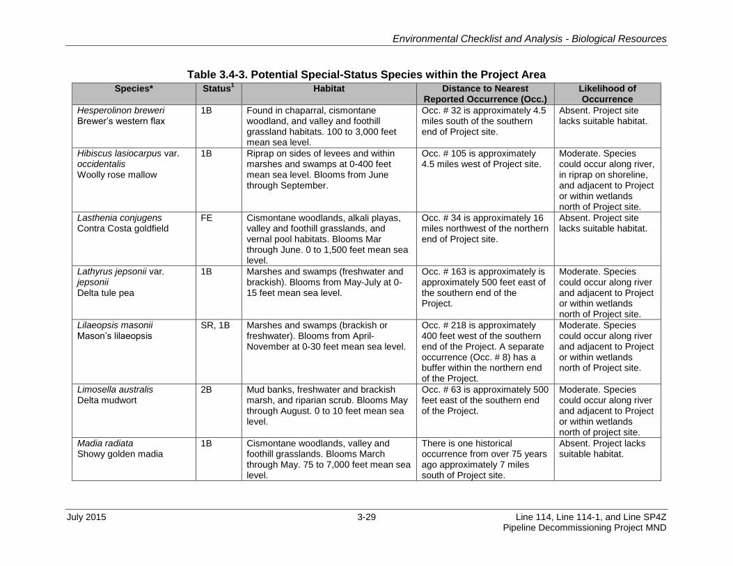
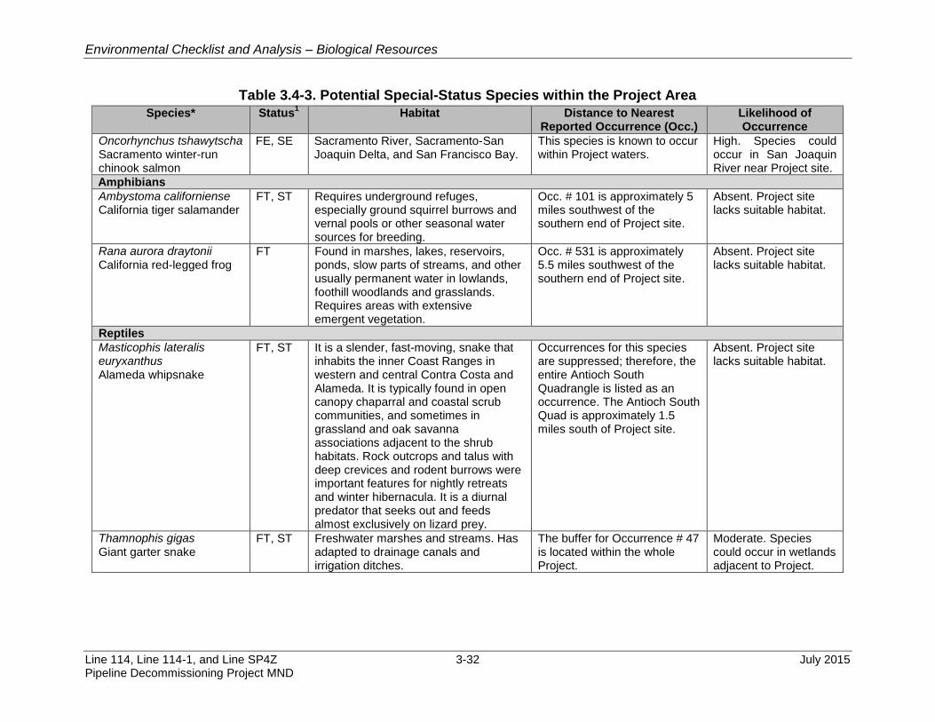
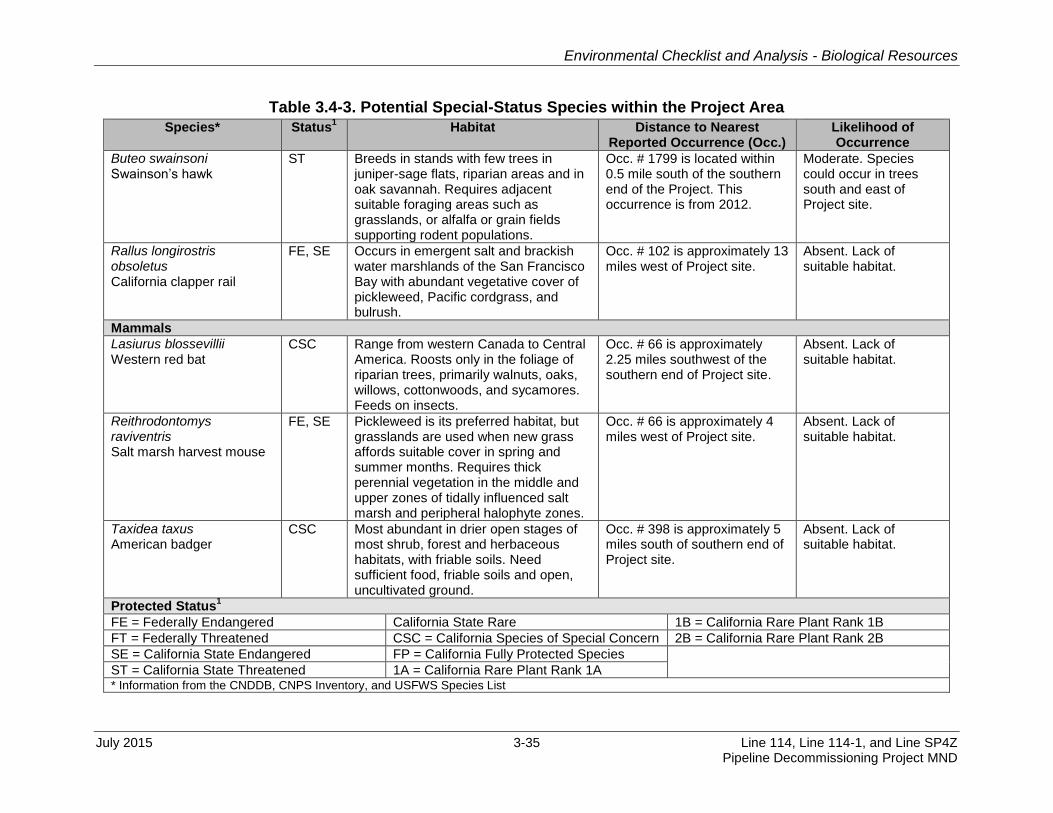
Table 3.4-3. Potential Special-Status Species within the Project Area
Species* Status1 Habitat Distance to Nearest
Reported Occurrence (Occ.) Likelihood of Occurrence
Plants
Blepharizonia plumosa Big tarplant
1B Valley and foothill grassland. Blooms from July to October at 100 to 1,650 feet mean sea level.
Occ. # 56 is approximately 5 miles southwest of southern end of Project site.
Absent. Project site lacks suitable habitat.
California macrophylla Round-leaved filaree
1B Cismontane woodland, valley/foothill grassland. 50 to 4,000 feet mean sea level.
Occ. # 95 is approximately 6 miles southwest of southern end of Project site.
Absent. Project site lacks suitable habitat.
Cicuta maculata var. bolanderi Bolander’s water hemlock
2B Freshwater or brackish marshes and swamps. 0 to 600 feet mean sea level.
Occ. # 15 is approximately 1 mile southeast of the southern end of Project site.
Moderate. Species could occur along river and adjacent to Project or within wetlands north of Project site.
Chloropyron molle ssp. molle Soft bird’s-beak
FE Found in coastal salt marshes and swamps. 0 to 10 feet mean sea level.
The buffer of Occ. # 18 from 1993 is located near the northern end of Project site.
Moderate. Species could occur within wetlands north of Project site.
Cryptantha hooveri Hoover’s cryptantha
1A Valley and foothill grassland in coarse sand. 3 to 500 feet mean sea level.
Occ. # 4 was reported approximately 2 miles southwest of southern end of Project site.
Absent. Project site lacks suitable habitat.
Eriogonum nudum var. psychicola Antioch Dunes buckwheat
1B Found in inland dune habitat (Antioch Dunes). 0 to 60 feet mean sea level.
Occ. # 1 is approximately 2.8 miles west of Project site.
Absent. Project site lacks suitable habitat.
Eriogonum truncatum Mt. Diablo buckwheat
1B Found in chaparral, valley grassland, and coastal scrub communities in Contra Costa County. 900 to 1,800 feet mean sea level.
There is one historical occurrence (Occ. # 4) from more than 100 years ago located approximate 2.5 miles southeast of the southern end of Project site.
Absent. Project site lacks suitable habitat.
Erysimum capitatum ssp. angustatum Contra Costa wallflower
FE, SE Found in inland dune habitat. 10 to 60 feet mean sea level.
Occ. # 4 is approximately 4 miles west of Project site.
Absent. Project lacks suitable habitat.
Eschscholzia rhombipetala Diamond-petaled California poppy
1B Found in valley and foothill grassland habitat (alkaline clay). 0 to 3,000 feet mean sea level.
There is one historical occurrence from over 100 years ago approximately 5 miles from Project site.
Absent. Project site lacks suitable habitat.
Environmental Checklist and Analysis - Biological Resources
July 2015 3-29 Line 114, Line 114-1, and Line SP4Z Pipeline Decommissioning Project MND
Table 3.4-3. Potential Special-Status Species within the Project Area
Species* Status1 Habitat Distance to Nearest
Reported Occurrence (Occ.) Likelihood of Occurrence
Hesperolinon breweri Brewer’s western flax
1B Found in chaparral, cismontane woodland, and valley and foothill grassland habitats. 100 to 3,000 feet mean sea level.
Occ. # 32 is approximately 4.5 miles south of the southern end of Project site.
Absent. Project site lacks suitable habitat.
Hibiscus lasiocarpus var. occidentalis Woolly rose mallow
1B Riprap on sides of levees and within marshes and swamps at 0-400 feet mean sea level. Blooms from June through September.
Occ. # 105 is approximately 4.5 miles west of Project site.
Moderate. Species could occur along river, in riprap on shoreline, and adjacent to Project or within wetlands north of Project site.
Lasthenia conjugens Contra Costa goldfield
FE Cismontane woodlands, alkali playas, valley and foothill grasslands, and vernal pool habitats. Blooms Mar through June. 0 to 1,500 feet mean sea level.
Occ. # 34 is approximately 16 miles northwest of the northern end of Project site.
Absent. Project site lacks suitable habitat.
Lathyrus jepsonii var. jepsonii Delta tule pea
1B Marshes and swamps (freshwater and brackish). Blooms from May-July at 0-15 feet mean sea level.
Occ. # 163 is approximately is approximately 500 feet east of the southern end of the Project.
Moderate. Species could occur along river and adjacent to Project or within wetlands north of Project site.
Lilaeopsis masonii Mason’s lilaeopsis
SR, 1B Marshes and swamps (brackish or freshwater). Blooms from April-November at 0-30 feet mean sea level.
Occ. # 218 is approximately 400 feet west of the southern end of the Project. A separate occurrence (Occ. # 8) has a buffer within the northern end of the Project.
Moderate. Species could occur along river and adjacent to Project or within wetlands north of Project site.
Limosella australis Delta mudwort
2B Mud banks, freshwater and brackish marsh, and riparian scrub. Blooms May through August. 0 to 10 feet mean sea level.
Occ. # 63 is approximately 500 feet east of the southern end of the Project.
Moderate. Species could occur along river and adjacent to Project or within wetlands north of project site.
Madia radiata Showy golden madia
1B Cismontane woodlands, valley and foothill grasslands. Blooms March through May. 75 to 7,000 feet mean sea level.
There is one historical occurrence from over 75 years ago approximately 7 miles south of Project site.
Absent. Project lacks suitable habitat.

Environmental Checklist and Analysis – Biological Resources
Line 114, Line 114-1, and Line SP4Z 3-30 July 2015 Pipeline Decommissioning Project MND
Table 3.4-3. Potential Special-Status Species within the Project Area
Species* Status1 Habitat Distance to Nearest
Reported Occurrence (Occ.) Likelihood of Occurrence
Oenothera deltoids ssp. howellii Antioch Dunes evening-primrose
FE, SE, 1B
Riverine sand dunes. Blooms March through September. 0 to 100 feet mean sea level.
Occ. # 10 is less than 1 mile west of the southern end of Project site.
Absent. Project site and lacks suitable habitat.
Scutellaria lateriflora Side-flowering skullcap
2B Mesic meadows and seeps and freshwater marshes. Blooms July through September. 0 to 1,500 feet mean sea level.
Occ. # 14 is approximately 15 miles northeast of the northern end of Project site.
Absent. Project site lacks suitable habitat.
Symphyotrichum lentum Suisun Marsh aster
1B Marshes and swamps (brackish and freshwater). Blooms from May-November at 0-10 feet mean sea level.
Occ. # 168 is approximately 400 feet west of the southern end of the Project. A separate occurrence (Occ. # 34) has a buffer within the northern end of Project site.
Moderate. Species could occur along river and adjacent to Project or within wetlands north of project site.
Invertebrates
Apodemia mormo langei Lange’s metalmark
butterfly
FE The species is currently found only at the Antioch Dunes in Contra Costa County. It has a very close relationship with naked stemmed buckwheat (Eriogonum nudum) on which its eggs are deposited. The buckwheat is also an important nectar source for adults.
The whole Antioch north quadrangle, which is approximately 500 feet to the west, is listed as Occ. # 1.
Absent. Project site lacks suitable habitat.
Desmocerus californicus dimorphus
Valley elderberry longhorn beetle
FT Occurrences of the Valley elderberry longhorn beetle are primarily in the vicinity of moist valley oak woodlands associated with riparian corridors in the lower Sacramento River and upper San Joaquin River drainages (U.S. Fish and Wildlife Service 1984). Elderberry plants are obligate hosts for the Valley elderberry longhorn beetle, providing a source of food and broodwood.
Occ. # 158 is approximately 22 miles southeast of the southern end of Project site.
Absent. Project site lacks suitable habitat.
Fish
Archoplites interruptus Sacramento perch
CSC Most often found in warm reservoirs and ponds. Capable of surviving high temperatures, high salinities, high
Occurrence # 3 is within the waters located adjacent to Project site.
High. Species could occur in San Joaquin River near Project site.

Environmental Checklist and Analysis - Biological Resources
July 2015 3-31 Line 114, Line 114-1, and Line SP4Z Pipeline Decommissioning Project MND
Table 3.4-3. Potential Special-Status Species within the Project Area
Species* Status1 Habitat Distance to Nearest
Reported Occurrence (Occ.) Likelihood of Occurrence
turbidity, and low water clarity. Often found in clear water among beds of aquatic vegetation, they achieve greater numbers.
Pogonichthys macrolepidotus Sacramento splittail
CSC Occurs in lakes and rivers of the Central Valley and is capable of tolerating moderate levels of salinity. Commonly occur in brackish waters of Suisun Bay, Suisun Marsh and the Sacramento-San Joaquin Delta.
This species is known to occur within Project waters.
High. Species could occur in San Joaquin River near Project site.
Acipenser medirostris Green sturgeon
FT Anadromous fish species. Juveniles have been collected in the San Francisco Bay up to the lower reaches of the Sacramento and San Joaquin rivers. Spawning locations and seasons of this species are not known.
This species is known to occur within Project waters.
High. Species could occur in San Joaquin River near Project site.
Hypomesus transpacificus Delta smelt
FT, SE Endemic to the upper Sacramento/San Joaquin Delta, it mainly inhabits the freshwater-saltwater mixing zone of the estuary, except during its spawning season, when in moves into freshwater during the early spring months from March until May.
This species is known to occur within Project waters.
High. Species could occur in San Joaquin River near Project site.
Spirinchus thaleichthys Longfin smelt
FC, ST Endemic to Sacramento/San Joaquin Delta. Feed on zooplankton. Tolerate a wide range of salinity conditions, and are most abundant in Suisun and San Pablo Bays, but are also found in south San Francisco Bay and the open ocean.
This species is known to occur within Project waters.
High. Species could occur in San Joaquin River near Project site.
Oncorhynchus mykiss Central Valley steelhead
FT Sacramento and San Joaquin River systems, Sacramento-San Joaquin Delta, and San Francisco Bay.
This species is known to occur within Project waters.
High. Species could occur in San Joaquin River near Project site.
Oncorhynchus tshawytscha CV spring-run chinook salmon
FT, ST Sacramento River, Sacramento-San Joaquin Delta, and San Francisco Bay.
This species is known to occur within Project waters.
High. Species could occur in San Joaquin River near Project site
Environmental Checklist and Analysis – Biological Resources
Line 114, Line 114-1, and Line SP4Z 3-32 July 2015 Pipeline Decommissioning Project MND
Table 3.4-3. Potential Special-Status Species within the Project Area
Species* Status1 Habitat Distance to Nearest
Reported Occurrence (Occ.) Likelihood of Occurrence
Oncorhynchus tshawytscha Sacramento winter-run chinook salmon
FE, SE Sacramento River, Sacramento-San Joaquin Delta, and San Francisco Bay.
This species is known to occur within Project waters.
High. Species could occur in San Joaquin River near Project site.
Amphibians
Ambystoma californiense California tiger salamander
FT, ST Requires underground refuges, especially ground squirrel burrows and vernal pools or other seasonal water sources for breeding.
Occ. # 101 is approximately 5 miles southwest of the southern end of Project site.
Absent. Project site lacks suitable habitat.
Rana aurora draytonii California red-legged frog
FT Found in marshes, lakes, reservoirs, ponds, slow parts of streams, and other usually permanent water in lowlands, foothill woodlands and grasslands. Requires areas with extensive emergent vegetation.
Occ. # 531 is approximately 5.5 miles southwest of the southern end of Project site.
Absent. Project site lacks suitable habitat.
Reptiles
Masticophis lateralis euryxanthus Alameda whipsnake
FT, ST It is a slender, fast-moving, snake that inhabits the inner Coast Ranges in western and central Contra Costa and Alameda. It is typically found in open canopy chaparral and coastal scrub communities, and sometimes in grassland and oak savanna associations adjacent to the shrub habitats. Rock outcrops and talus with deep crevices and rodent burrows were important features for nightly retreats and winter hibernacula. It is a diurnal predator that seeks out and feeds almost exclusively on lizard prey.
Occurrences for this species are suppressed; therefore, the entire Antioch South Quadrangle is listed as an occurrence. The Antioch South Quad is approximately 1.5 miles south of Project site.
Absent. Project site lacks suitable habitat.
Thamnophis gigas Giant garter snake
FT, ST Freshwater marshes and streams. Has adapted to drainage canals and irrigation ditches.
The buffer for Occurrence # 47 is located within the whole Project.
Moderate. Species could occur in wetlands adjacent to Project.

Environmental Checklist and Analysis - Biological Resources
July 2015 3-33 Line 114, Line 114-1, and Line SP4Z Pipeline Decommissioning Project MND
Table 3.4-3. Potential Special-Status Species within the Project Area
Species* Status1 Habitat Distance to Nearest
Reported Occurrence (Occ.) Likelihood of Occurrence
Anninella pulchra pulchra Silvery legless lizard
CSC Occur in the Coast Range from Contra Costa County to Mexico. Common in coastal dune, valley-foothill, chaparral, and coastal scrub habitats. Found in loose soil and leaf litter.
Occurrence # 56 is located within a mile of Project site.
Absent. Project Site lacks suitable habitat.
Emys marmorata Western pond turtle
CSC Ponds, marshes, rivers, streams and irrigation ditches with aquatic vegetation. Needs basking sites and suitable upland habitat (sandy banks or grassy open fields) for egg laying.
Occ. # 135 is approximately 3.5 miles west of Project site.
Moderate. Species could occur in river and in adjacent wetlands and uplands.
Birds
Melospiza melodia mailliardi Song sparrow (“Modesto” population)
CSC Found in freshwater marshes dominated by tules and cattails and willow thickets with source of running water and semi-open canopy. Abundant in Delta and Butte Sink.
Occ. # 36 is approximately 5 miles northwest of the northern end of Project site.
Low. Species could occur in wetlands outside of Project site.
Melospiza melodia maxillaris Suisun song sparrow
CSC Found in emergent marshes, ponds, and ditches dominated by bulrushes, cattails, and other emergent wetland plants.
Occ. # 29 is approximately 3.75 miles northwest of the northern end of Project site.
Low. Species could occur in wetlands outside of Project site.
Geothlypis trichas sinuosa Saltmarsh common yellowthroat
CSC It is a small insectivorous warbler that gleans on insects on or near the ground from low herbaceous vegetation, bushes, and small trees. It breeds in fresh and brackish water marshes near the Bay between March and August in an area from Tomales Bay on the north, Carquinez Strait on the east, and Santa Cruz County on the south. After the breeding season, the species will move into saltwater marshes.
Occ. # 7 is approximately 3.75 miles northwest of the northern end of Project site.
Low. Species could occur in wetlands outside of Project site.
Lanius ludovicianus Loggerhead shrike
CSC Prefers open habitats with scattered shrubs, trees, posts, fences, utility lines, or other perches. Searches for prey (small birds, mammals, amphibians,
Occ. # 3 is approximately 3.75 miles southeast of the southern end of Project site.
Low. Species could occur in wetlands outside of Project site.

Environmental Checklist and Analysis – Biological Resources
Line 114, Line 114-1, and Line SP4Z 3-34 July 2015 Pipeline Decommissioning Project MND
Table 3.4-3. Potential Special-Status Species within the Project Area
Species* Status1 Habitat Distance to Nearest
Reported Occurrence (Occ.) Likelihood of Occurrence
reptiles, fish, carrion, etc.) from a perch at least 2 feet above ground.
Laterallus jamaicensis coturniculus California black rail
ST It is resident in brackish and saltmarsh habitats in the Bay-Delta area. It has been documented in Mallard Island Marsh and Port Chicago Marsh, in marsh areas along the south side of Suisun Bay, Peyton Slough, Hill Slough, and Grey Goose in Suisun Bay.
Occ. # 109 is approximately 1.75 miles southeast of the southern end of Project site.
Moderate. Species could occur in wetlands adjacent to Project.
Elanus leucurus White-tailed kite
FP Rolling foothills/valley margins with scattered oaks and river bottomlands or marshes next to deciduous woodland. Found in open grasslands, meadows, or marshes for foraging close to isolated, dense-topped trees for nesting and perching.
Occ. # 17 is approximately 5 miles west of Project site.
Low. Species could occur in wetlands outside of Project site.
Circus cyaneus Northern harrier
CSC Frequents meadows, grasslands, open rangelands, desert sinks, fresh and saltwater emergent wetlands; seldom found in wooded areas. Nests on ground near marsh edge or grassland. Preys on Feeds mostly on voles and other small mammals, birds, frogs, small reptiles, crustaceans, insects, and, rarely on fish.
There are no breeding occurrences of this species within 15 miles of Project site.
Low. Species could occur in wetlands outside of Project site.
Agelaius tricolor Tricolored blackbird
SE Nesting colony requires open water, protected nesting substrate and foraging area with insect prey within a few km of the colony.
Occ. # 106 is approximately 10 miles northwest of the northern end of Project site.
Low. Species could occur in wetlands outside of Project site.
Athene cunicularia
Burrowing owl CSC Uses burrow sites in open, dry annual
or perennial grasslands, deserts and scrublands characterized by low-growing vegetation.
Occ. # 947 is approximately 1.25 miles south of the southern end of Project site.
Low. Species could occur in burrows along levee, but no burrows were observed nor were burrowing owls seen.
Environmental Checklist and Analysis - Biological Resources
July 2015 3-35 Line 114, Line 114-1, and Line SP4Z Pipeline Decommissioning Project MND
Table 3.4-3. Potential Special-Status Species within the Project Area
Species* Status1 Habitat Distance to Nearest
Reported Occurrence (Occ.) Likelihood of Occurrence
Buteo swainsoni Swainson’s hawk
ST Breeds in stands with few trees in juniper-sage flats, riparian areas and in oak savannah. Requires adjacent suitable foraging areas such as grasslands, or alfalfa or grain fields supporting rodent populations.
Occ. # 1799 is located within 0.5 mile south of the southern end of the Project. This occurrence is from 2012.
Moderate. Species could occur in trees south and east of Project site.
Rallus longirostris obsoletus California clapper rail
FE, SE Occurs in emergent salt and brackish water marshlands of the San Francisco Bay with abundant vegetative cover of pickleweed, Pacific cordgrass, and bulrush.
Occ. # 102 is approximately 13 miles west of Project site.
Absent. Lack of suitable habitat.
Mammals
Lasiurus blossevillii Western red bat
CSC Range from western Canada to Central America. Roosts only in the foliage of riparian trees, primarily walnuts, oaks, willows, cottonwoods, and sycamores. Feeds on insects.
Occ. # 66 is approximately 2.25 miles southwest of the southern end of Project site.
Absent. Lack of suitable habitat.
Reithrodontomys raviventris Salt marsh harvest mouse
FE, SE Pickleweed is its preferred habitat, but grasslands are used when new grass affords suitable cover in spring and summer months. Requires thick perennial vegetation in the middle and upper zones of tidally influenced salt marsh and peripheral halophyte zones.
Occ. # 66 is approximately 4 miles west of Project site.
Absent. Lack of suitable habitat.
Taxidea taxus American badger
CSC Most abundant in drier open stages of most shrub, forest and herbaceous habitats, with friable soils. Need sufficient food, friable soils and open, uncultivated ground.
Occ. # 398 is approximately 5 miles south of southern end of Project site.
Absent. Lack of suitable habitat.
Protected Status1
FE = Federally Endangered California State Rare 1B = California Rare Plant Rank 1B
FT = Federally Threatened CSC = California Species of Special Concern 2B = California Rare Plant Rank 2B
SE = California State Endangered FP = California Fully Protected Species
ST = California State Threatened 1A = California Rare Plant Rank 1A * Information from the CNDDB, CNPS Inventory, and USFWS Species List

Environmental Checklist and Analysis - Biological Resources
Line 114, Line 114-1, and Line SP4Z 3-36 July 2015 Pipeline Decommissioning Project MND
Figure 3.4-1A. Habitat Types North Landing

Environmental Checklist and Analysis - Biological Resources
July 2015 3-37 Line 114, Line 114-1, and Line SP4Z Pipeline Decommissioning Project MND
Figure 3.4-1B. Habitat Types South Landing

Environmental Checklist and Analysis - Biological Resources
Line 114, Line 114-1, and Line SP4Z 3-38 July 2015 Pipeline Decommissioning Project MND
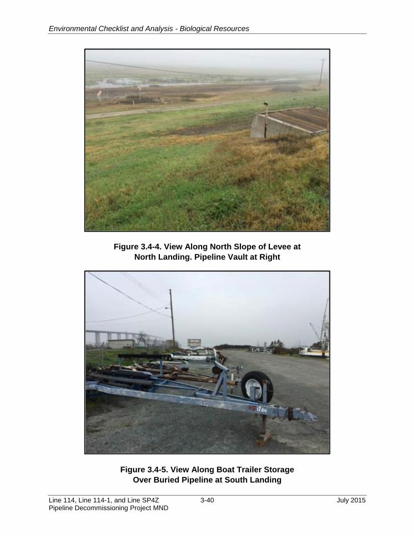
Emergent Wetland Marsh 1
The shallow water portions of the Project site along the shoreline are considered 2
emergent wetland/marsh, and support hardstem bulrush (Schoenoplectus acutus) and 3
water hyacinth (Eichhornia crassipes). The marsh extends approximately 25 to 40 feet 4
riverward from the levees and along the entire width of both the North Landing and 5
South Landing Foreshores (See Figures 3.4-1A, 3.4-1B, 3.4-2 and 3.4-3). This 6
community accounted for approximately 0.18 acre within the total Project area and may 7
be considered waters of the U.S. and/or waters of the State pursuant to Sections 404 8
and 401 of the Federal Clean Water Act (CWA). 9
Ruderal 10
This community occurs in disturbed terrestrial areas along the pipeline alignment. Within 11
the riprap, along the north landing levee slopes and terraces, and along the pipeline 12
alignment within the marina at the south landing amid the boat trailer storage area. This 13
community accounted for approximately 0.25 acre. See Table 3.4-3 and Figures 3.4-1A 14
and 3.4-1B. 15
Annual Grassland 16
This habitat type is found along the levee slopes and is dominated by non-native grass. 17
Species identified included Bermuda grass (Cynodon dactylon), wild oat (Avena fatua), 18
Mediterranean barley (Hordeum marinum ssp. gussoneanum), clover (Trifolium sp.), 19
vetch (Vicia sp.), horseweed (Conyza canadensis), and filaree (Erodium cicutarium) 20
(Figure 3.4-4 and Figure 3.4-5). This community accounted for approximately 0.28 acre. 21
See Table 3.4-3 and Figures 3.4-1A and 3.4-1B. 22
Disturbed Land 23
This habitat type includes areas covered in gravel or other developed structures like 24
roads and buildings. Vegetation, if it exists, is very sparse and generally composed of 25
hardy weedy species. This community accounted for approximately 0.47 acre. See 26
Table 3.4-3 and Figures 3.4-1A and 3.4-1B. 27
Open Water 28
The San Joaquin River is categorized as a “navigable water of the U.S.” under Section 29
10 of the Federal Rivers and Harbors Act of 1899, a “water of the U.S.” pursuant to 30
Section 404 of the CWA, and a water of the State. Water depths vary from less than 4 31
feet near the shoreline to approximately 40 feet in the river channel. Currents are strong 32
through the Project area. 33

Environmental Checklist and Analysis - Biological Resources
July 2015 3-39 Line 114, Line 114-1, and Line SP4Z Pipeline Decommissioning Project MND
Figure 3.4-2. View of North Landing Foreshore
Figure 3.4-3. View of South Landing Foreshore
Environmental Checklist and Analysis - Biological Resources
Line 114, Line 114-1, and Line SP4Z 3-40 July 2015 Pipeline Decommissioning Project MND
Figure 3.4-4. View Along North Slope of Levee at
North Landing. Pipeline Vault at Right
Figure 3.4-5. View Along Boat Trailer Storage
Over Buried Pipeline at South Landing

Environmental Checklist and Analysis - Biological Resources
July 2015 3-41 Line 114, Line 114-1, and Line SP4Z Pipeline Decommissioning Project MND
Special-Status Species 1
A list of special-status species that have been reported within approximately 5 miles of 2
the Project site was compiled based on a species list obtained from the U.S. Fish and 3
Wildlife Service (USFWS) website, a query of the California Natural Diversity Database 4
(CNDDB), and a query of the California Native Plant Society (CNPS) database 5
California Rare Plant Ranking System (CRPR) (Table 3.4-3) (Figure 3.4-6). Table 3.4-3 6
provides a likelihood of occurrence analysis based on the species range, habitat 7
requirements, and timing of inhabitation. Certain species, such as those associated with 8
vernal pool habitats, were eliminated from these analyses due to the absence of vernal 9
pools within the Project site. As a result, the species described below are limited to 10
those listed species that have a potential to occur on the Project site. Additional 11
information regarding those species with the potential to occur within the Project site is 12
discussed in Appendix D (Biological Reconnaissance Survey). 13
Plants 14
Special-status plants that have a moderate potential to occur within the Project site 15
include: Bolander’s water hemlock (Cicuta maculata var. bolanderi), which has been 16
reported within 1 mile of the site; soft bird’s-beak (Chloropyron molle ssp. molle), which 17
was reported at the northern end of the site; woolly rose mallow (Hibiscus lasiocarpus 18
var. occidentalis), which was reported in riprap habitat within 5 miles of the site; and 19
Delta tule pea (Lathyrus jepsonii var. jepsonii), Mason’s lilaeopsis (Lilaeopsis masonii), 20
Delta mudwort (Limosella australis), and Suisun Marsh aster (Symphyotrichum lentum), 21
which were reported within 500 feet of the site (Table 3.4-3). 22
Fish 23
Special status fish species that have the potential to occur within the San Joaquin River 24
at the Project site include: Sacramento perch (Archoplites interruptus), green sturgeon 25
(Acipenser medirostris), Delta smelt (Hypomesus transpacificus), longfin smelt 26
(Spirinchus thaleichthys), Sacramento splittail (Pogonichthys macrolepidotus), Central 27
Valley steelhead (Oncorhynchus mykiss), Central Valley spring-run Chinook salmon 28
(Oncorhynchus tshawytscha), and Sacramento winter-run Chinook salmon 29
(Oncorhynchus tshawytscha). 30
Reptiles 31
Special-status reptile species that have a moderate potential to occur within the Project 32
site include the giant garter snake (GGS)(Thamnophis gigas), which has two reported 33
occurrences within 0.3 mile and 1.5 miles of the Project site, and western pond turtle 34
(Emys marmorata), which has been reported within 3.5 miles of the site. 35

Environmental Checklist and Analysis - Biological Resources
Line 114, Line 114-1, and Line SP4Z 3-42 July 2015 Pipeline Decommissioning Project MND
Figure 3.4-6. Special-Status Species Occurrences

Environmental Checklist and Analysis - Biological Resources
July 2015 3-43 Line 114, Line 114-1, and Line SP4Z Pipeline Decommissioning Project MND
Birds 1
Special-status bird species that have a moderate potential to occur near the Project site 2
include California black rail (Laterallus jamaicensis), which has been reported within 3
1.75 miles of the site, and Swainson’s hawk (Buteo swainsoni), which was reported 4
within 0.5 mile of the site. California black rail nesting was reported in 1981 in an area 5
approximately 1.5 miles southeast of the south landing. On the north landing in 6
Sacramento County, the closest occurrence was in 2005 approximately 3.75 miles 7
west-northwest of the Project site. Extensive wetlands and potential black rail habitat 8
occur north of the north landing levee. Along the south landing, a Swainson’s hawk nest 9
site was reported 0.25 mile south of the Project site in 2012. On the north landing in 10
Sacramento County, the closest occurrence was in 2012 approximately 2.75 miles east 11
of the Project site. 12
3.4.2 Regulatory Setting 13
3.4.2.1 Federal and State 14
Federal and State laws and regulations pertaining to this issue area and relevant to the 15
Project are identified in Table 3.4-4. 16
Table 3.4-4. Laws, Regulations, and Policies (Biological Resources)
U.S. Endangered Species Act (FESA) (7 USC 136, 16 USC 1531 et seq.)
The FESA, which is administered in California by the U.S. Fish and Wildlife Service (USFWS) and National Marine Fisheries Service (NMFS), provides protection to species listed as threatened or endangered, or proposed for listing as threatened or endangered. Section 9 prohibits the “take” of any member of a listed species.
Take is defined as “...to harass, harm, pursue, hunt, shoot, wound, kill, trap, capture, or collect, or to attempt to engage in any such conduct.”
Harass is “an intentional or negligent act or omission that creates the likelihood of injury to a listed species by annoying it to such an extent as to significantly disrupt normal behavior patterns that include, but are not limited to, breeding, feeding, or sheltering.”
Harm is defined as “...significant habitat modification or degradation that results in death or injury to listed species by significantly impairing behavioral patterns such as breeding, feeding, or sheltering.”
When applicants are proposing projects with a Federal nexus that “may affect” a Federally listed or proposed species, the Federal agency is required to consult with the USFWS or NMFS, as appropriate, under Section 7, which provides that each Federal agency must ensure that any actions authorized, funded, or carried out by the agency are not likely to jeopardize the continued existence of any endangered or threatened species or result in the destruction or adverse modification of areas determined to be critical habitat.
U.S. Magnuson-Stevens Fishery Conservation and
The MSA is the primary law governing marine fisheries management in U.S. Federal waters. The MSA was first enacted in 1976 and amended in 1996. Amendments to the 1996 MSA require the identification of Essential Fish Habitat (EFH) for federally managed species and the implementation of measures to conserve and enhance this habitat. Any project requiring Federal authorization,

Environmental Checklist and Analysis - Biological Resources
Line 114, Line 114-1, and Line SP4Z 3-44 July 2015 Pipeline Decommissioning Project MND
Table 3.4-4. Laws, Regulations, and Policies (Biological Resources)
Management Act (MSA) (16 USC 1801 et seq.)
such as a USACE permit, is required to complete and submit an EFH Assessment with the application and either show that no significant impacts to the essential habitat of managed species are expected or identify mitigations to reduce those impacts. Under the MSA, Congress defined EFH as “those waters and substrate necessary to fish for spawning, breeding, feeding, or growth to maturity” (16 USC 1802(10)). The EFH provisions of the MSA offer resource managers a means to heighten consideration of fish habitat in resource management. Pursuant to section 305(b)(2), Federal agencies shall consult with the NMFS regarding any action they authorize, fund, or undertake that might adversely affect EFH.
U.S. Migratory Bird Treaty Act (MBTA) (16 USC 703-712)
The MBTA was enacted to ensure the protection of shared migratory bird resources. The MBTA prohibits the take, possession, import, export, transport, selling, purchase, barter, or offering for sale, purchase, or barter, of any migratory bird, their eggs, parts, and nests, except as authorized under a valid permit. The responsibilities of Federal agencies to protect migratory birds are set forth in Executive Order 13186. The USFWS is the lead agency for migratory birds. The USFWS issues permits for takes of migratory birds for activities such as scientific research, education, and depredation control, but does not issue permits for incidental take of migratory birds.
U.S. Other The Bald and Golden Eagle Protection Act makes it illegal to import, export, take (including molest or disturb), sell, purchase or barter any bald eagle or golden eagle or parts thereof.
Clean Water Act (33 USC 1251 et seq.) and Rivers and Harbors Act (33 USC 401) (see Section 3.9, Hydrology and Water Quality).
Executive Order 13112 requires Federal agencies to use authorities to prevent introduction of invasive species, respond to and control invasions in a cost-effective and environmentally sound manner, and provide for restoration of native species and habitat conditions in invaded ecosystems.
Executive Order 13158 requires Federal agencies to identify actions that affect natural or cultural resources within a Marine Protected Area (MPA) and, in taking such actions, to avoid harm to the natural and cultural resources that are protected by a MPA.
CA California Endangered Species Act (CESA) (Fish & Game Code, § 2050 et seq.)
The CESA provides for the protection of rare, threatened, and endangered plants and animals, as recognized by the California Department of Fish and Wildlife (CDFW), and prohibits the taking of such species without its authorization. Furthermore, the CESA provides protection for those species that are designated as candidates for threatened or endangered listings. Under the CESA, the CDFW has the responsibility for maintaining a list of threatened species and endangered species (Fish & Game Code, § 2070). The CDFW also maintains a list of candidate species, which are species that the CDFW has formally noticed as under review for addition to the threatened or endangered species lists. The CDFW also maintains lists of Species of Special Concern that serve as watch lists. Pursuant to the requirements of the CESA, an agency reviewing a proposed project within its jurisdiction must determine whether any State-listed endangered or threatened species may be present in the project site and determine whether the proposed project will have a potentially significant impact on such species. In addition, the CDFW encourages informal consultation on any proposed project that may affect a candidate species. The CESA also requires a permit to take a State-listed species through incidental or otherwise lawful activities (§ 2081, subd. (b)).
CA Lake and Streambed
The CDFW regulates activities that would interfere with the natural flow of, or substantially alter, the channel, bed, or bank of a lake, river, or stream. These

Environmental Checklist and Analysis - Biological Resources
July 2015 3-45 Line 114, Line 114-1, and Line SP4Z Pipeline Decommissioning Project MND
Table 3.4-4. Laws, Regulations, and Policies (Biological Resources)
Alteration Program (Fish & Game Code, §§ 1600-1616)
regulations require notification of the CDFW for lake or stream alteration activities. If, after notification is complete, the CDFW determines that the activity may substantially adversely affect an existing fish and wildlife resource, the CDFW has authority to issue a Streambed Alteration Agreement.
CA Other relevant California Fish and Game Code sections
The California Native Plant Protection Act (Fish & G. Code, § 1900 et seq.) is intended to preserve, protect, and enhance endangered or rare native plants in California. This Act includes provisions that prohibit the taking of listed rare or endangered plants from the wild and a salvage requirement for landowners. The Act directs the CDFW to establish criteria for determining what native plants are rare or endangered. Under section 1901, a species is endangered when its prospects for survival and reproduction are in immediate jeopardy from one or more causes. A species is rare when, although not threatened with immediate extinction, it is in such small numbers throughout its range that it may become endangered.
The California Species Preservation Act (Fish & Game Code, §§ 900-903) provides for the protection and enhancement of the amphibians, birds, fish, mammals, and reptiles of California.
Fish and Game Code sections 3503 & 3503.5 prohibit the taking and possession of native birds’ nests and eggs from all forms of needless take. These regulations also provide that it is unlawful to take, possess, or destroy any birds in the orders Falconiformes or Strigiformes (birds-of-prey) or to take, possess, or destroy the nests or eggs of any such bird except as otherwise provided by this Code or any regulation adopted pursuant thereto.
Fish and Game Code sections 3511 (birds), 4700 (mammals), 5050 (reptiles and amphibians), and 5515 (fish) designate certain species as “fully protected.” Fully protected species, or parts thereof, may not be taken or possessed at any time without permission by the CDFW.
Fish and Game Code section 3513 does not include statutory or regulatory mechanism for obtaining an incidental take permit for the loss of non-game, migratory birds.
3.4.2.2 Local 1
Local laws and regulations pertaining to this issue area and relevant to the Project are 2
identified in Table 3.4-5. 3
Table 3.4-5. Local Laws, Regulations, and Policies (Biological Resources)
Conservation Element Of Contra Costa County General Plan 2005-2020
Goal 8-E To protect rare, threatened and endangered species of fish, wildlife and plants, significant plant communities, and other resources which stand out as unique because of their scarcity, scientific value, aesthetic quality or cultural significance. Attempt to achieve a significant net increase in wetland values and functions within the County over the life of the General Plan. The definition of rare, threatened and endangered includes those definitions provided by the Federal Endangered Species Act, the California Endangered Species Act, the California Native Plant Protection Act, and the California Environmental Quality Act.
Goal 8-F To encourage the preservation and restoration of the natural characteristics of the San Francisco Bay/Delta estuary and adjacent lands, and recognize the role of Bay vegetation and water area in maintaining favorable climate, are and water quality, fisheries and

Environmental Checklist and Analysis - Biological Resources
Line 114, Line 114-1, and Line SP4Z 3-46 July 2015 Pipeline Decommissioning Project MND
Table 3.4-5. Local Laws, Regulations, and Policies (Biological Resources)
migratory waterfowl.
Policy 8-6 Significant trees, natural vegetation, and wildlife populations generally shall be preserved.
Policy 8-7 Important wildlife habitats which would be disturbed by major development shall be preserved, and corridors for wildlife migration between undeveloped lands shall be retained.
Policy 8-13 The critical ecological and scenic characteristics of rangelands, woodlands, and wildlands shall be recognized and protected.
Policy 8-15 Existing vegetation, both native and non-native, and wildlife habitat areas shall be retained in the major open space areas sufficient for the maintenance of a healthy balance of wildlife populations.
Policy 8-17 The ecological value of wetland areas, especially the salt marshes and tidelands of the bay and delta, shall be recognized. Existing wetlands in the County shall be identified and regulated. Restoration of degraded wetland areas shall be encouraged and supported whenever possible.
Policy 8-24 The County shall strive to identify and conserve remaining upland habitat areas which are adjacent to wetlands and are critical to the survival and nesting of wetland species.
Policy 8-25 The County shall protect marshes, wetlands, and riparian corridors from the effects of potential industrial spills.
City of Oakley 2020 General Plan
Goal 6.3 Encourage preservation of important ecological and biological resources.
Policy 6.3.5 Encourage preservation and enhancement of Delta wetlands, significant trees, natural vegetation, and wildlife populations.
Policy 6.3.6 Encourage preservation of portions of important wildlife habitats that would be disturbed by major development, particularly adjacent to the Delta
Sacramento County General Plan Delta Protection Policies
DP-25 Preserve and protect the natural resources of the Delta. Promote protection of remnants of riparian and aquatic habitat. Encourage compatibility between agricultural practices, recreational uses and wildlife habitat. Partner with Sacramento Regional County Sanitation District and other partners to promote and encourage the use of recycled water for agricultural, habitat and water conservation purposes where feasible.
DP-26 Encourage farmers to implement management practices to maximize habitat values for migratory birds and other wildlife. Appropriate incentives, such as the purchase of conservation easements from willing sellers or other actions, should be encouraged.
DP-27 Lands managed primarily for wildlife habitat should be managed to maximize ecological values. Appropriate programs, such as "Coordinated Resource Management and Planning" (Public Resources Code Section 9408(c)) should ensure full participation by local government and property owner representatives.
DP-28 Support the non-native invasive species control measures being implemented by the California Department of Fish and Game, the California Department of Boating and Waterways, the California Emergency Management Agency, the California Department of Food and Agriculture, the State Water Resources Control Board, the Central Valley and San Francisco Bay Regional Water Quality Control Boards, and the Agricultural Commissioners for the five Delta Counties (Yolo, Solano, Sacramento, San Joaquin, and Contra Costa), which include controlling the arrival of new species into the Delta.
DP-29 Preserve and protect the viability of agricultural areas by including an adequate financial mechanism in any planned conversion of agricultural lands to wildlife habitat for conservation purposes. The financial mechanism shall specifically offset the loss of local government and special district revenues necessary to support public services and infrastructure.
DP-30 Support the implementation of appropriate buffers, management plans and/or good

Environmental Checklist and Analysis - Biological Resources
July 2015 3-47 Line 114, Line 114-1, and Line SP4Z Pipeline Decommissioning Project MND
Table 3.4-5. Local Laws, Regulations, and Policies (Biological Resources)
neighbor policies (e.g., safe harbor agreements) that among other things, limit liability for incidental take associated with adjacent agricultural and recreational activities within lands converted to wildlife habitat to avoid or minimize negative effects on the ongoing agricultural and recreational operations adjacent to the converted lands.
DP-31 Incorporate, to the maximum extent feasible, suitable and appropriate wildlife protection, restoration and enhancement on publicly-owned land as part of a Delta-wide plan for habitat management.
DP-32 Promote ecological, recreational and agricultural tourism in order to preserve the cultural values and economic vitality that reflect the history, natural heritage and human resources of the Delta including the establishment of National Heritage Area designations.
DP-33 Protect and restore ecosystems and adaptively manage them to minimize impacts from climate change and other threats and support their ability to adapt in the face of stress.
DP-34 Support the design, construction, and management of any flooding program to provide seasonal wildlife and aquatic habitat on agricultural lands, duck club lands and additional seasonal and tidal wetlands, shall incorporate "best management practices" to minimize vectors including mosquito breeding opportunities, and shall be coordinated with the local vector control districts. (Each of the four vector control districts in the Delta provides specific wetland/mosquito management criteria to landowners within their district.)
Sacramento County General Plan Conservation Element
Habitat Mitigation Policies
CO-58 Ensure no net loss of wetlands, riparian woodlands, and oak woodlands.
CO-59 Ensure mitigation occurs for any loss of or modification to the following types of acreage and habitat function:
vernal pools,
wetlands,
riparian,
native vegetative habitat, and
special status species habitat.
CO-60 Mitigation should be directed to lands identified on the Open Space Vision Diagram and associated component maps (please refer to the Open Space Element).
CO-61 Mitigation should be consistent with County-adopted habitat conservation plans.
CO-62 Permanently protect land required as mitigation.
CO-63 Vernal pools, wetlands, and streams within identified preserves shall not be drained, excavated, or filled for the purpose of converting the land to another use. If fill or modification is required for Drainage Master Plans, stormwater quality or levee maintenance, creation or restoration of an equal amount must occur within the boundaries of the preserve to achieve no net loss consistent with policy CO-58.
CO-64 Consistent with overall land use policies, the County shall support and facilitate the creation and biological enhancement of large natural preserves or wildlife refuges by other government entities or by private individuals or organizations.
CO-65 Create a network of preserves linked by wildlife corridors of sufficient size to facilitate the movement of species.
CO-66 Mitigation sites shall have a monitoring and management program including an adaptive management component including an established funding mechanism. The programs shall be consistent with Habitat Conservation Plans that have been adopted or are in draft format.
CO-67 Preserves and conservation areas should have an established funding mechanism, and where needed, an acquisition strategy for its operation and management in perpetuity. This includes existing preserves such as the American River Parkway, Dry Creek

Environmental Checklist and Analysis - Biological Resources
Line 114, Line 114-1, and Line SP4Z 3-48 July 2015 Pipeline Decommissioning Project MND
Table 3.4-5. Local Laws, Regulations, and Policies (Biological Resources)
Parkway, Cosumnes River Preserve and other plans in progress for riparian areas like Laguna Creek.
CO-68 Preserves shall be planned and managed to the extent feasible so as to avoid conflicts with adjacent agricultural activities (Please also refer to the Agricultural Element).
CO-69 Avoid, to the extent possible, the placement of new major infrastructure through preserves unless located along disturbed areas, such as existing roadways.
Habitat Protection and Project Review Policies
CO-70 Community Plans, Specific Plans, Master Plans and development projects shall:
Include the location, extent, proximity and diversity of existing natural habitats and special status species in order to determine potential impacts, necessary mitigation and opportunities for preservation and restoration.
Be reviewed for the potential to identify non-development areas and establish preserves, mitigation banks and restore natural habitats, including those for special status species, considering effects on vernal pools, groundwater, flooding, and proposed fill or removal of wetland habitat.
Be reviewed for applicability of protection zones identified in this Element, including the Floodplain Protection Zone, Stream Corridor Ordinance, Cosumnes River Protection Combining Zone and the Laguna Creek Combining Zone.
CO-71 Development design shall help protect natural resources by:
Minimizing total built development in the floodplain, while designing areas of less frequent use that can support inundation to be permitted in the floodplain,
Ensuring development adjacent to stream corridors and vernal pools provide, where physically reasonable, a public street paralleling at least one side of the corridor with vertical curbs, gutters, foot path, street lighting, and post and cable barriers to prevent vehicular entry.
Projects adjacent to rivers and streams shall integrate amenities, such as trail connectivity, that will serve as benefits to the community and ecological function.
Siting of wetlands near residential and commercial areas should consider appropriate measures to minimize potential for mosquito habitation.
Development adjacent to steam corridors and vernal pools shall be designed in such a manner as to prevent unauthorized vehicular entry into protected areas.
CO-72 If land within river and stream watersheds in existing agricultural areas is developed for non-agricultural purposes, the County should actively pursue easement dedication for recreation trails within such development as a condition of approval.
CO-73 Secure easement or fee title to open space lands within stream corridors as a condition of development approval.
CO-74 Evaluate feasible on-site alternatives early on in the planning process and prior to the environmental review process that reduce impacts on wetland and riparian habitat and provide effective on-site preservation in terms of minimum management requirements, effective size, and evaluation criteria.
Protection of Special Status Species Habitat Policies
CO-75 Maintain viable populations of special status species through the protection of habitat in preserves and linked with natural wildlife corridors.
CO-76 Habitat conservation plans shall be adopted by the County to provide a comprehensive strategy to protect and aid in the recovery of special status species.
CO-77 Development of open space acquisition programs within natural areas shall consider whether the area is occupied by special status species.
CO-78 Plans for urban development and flood control shall incorporate habitat corridors linking habitat sites for special status species. (Please also refer to the Open Space Element for related policies.)
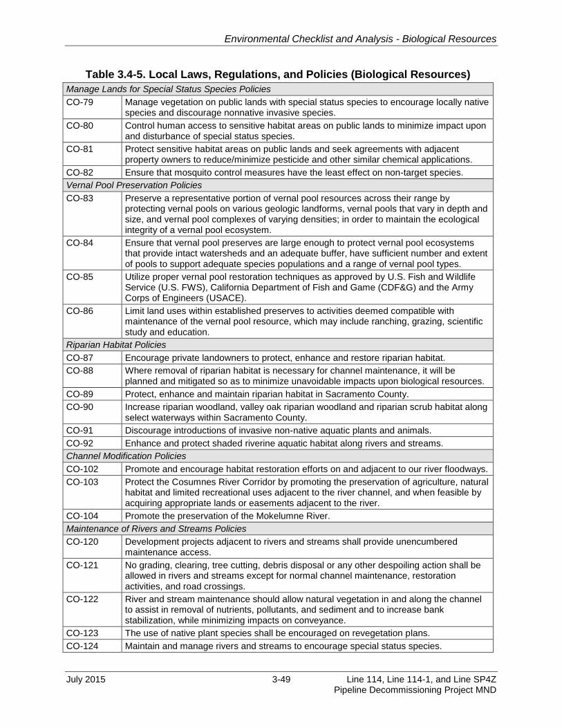
Environmental Checklist and Analysis - Biological Resources
July 2015 3-49 Line 114, Line 114-1, and Line SP4Z Pipeline Decommissioning Project MND
Table 3.4-5. Local Laws, Regulations, and Policies (Biological Resources)
Manage Lands for Special Status Species Policies
CO-79 Manage vegetation on public lands with special status species to encourage locally native species and discourage nonnative invasive species.
CO-80 Control human access to sensitive habitat areas on public lands to minimize impact upon and disturbance of special status species.
CO-81 Protect sensitive habitat areas on public lands and seek agreements with adjacent property owners to reduce/minimize pesticide and other similar chemical applications.
CO-82 Ensure that mosquito control measures have the least effect on non-target species.
Vernal Pool Preservation Policies
CO-83 Preserve a representative portion of vernal pool resources across their range by protecting vernal pools on various geologic landforms, vernal pools that vary in depth and size, and vernal pool complexes of varying densities; in order to maintain the ecological integrity of a vernal pool ecosystem.
CO-84 Ensure that vernal pool preserves are large enough to protect vernal pool ecosystems that provide intact watersheds and an adequate buffer, have sufficient number and extent of pools to support adequate species populations and a range of vernal pool types.
CO-85 Utilize proper vernal pool restoration techniques as approved by U.S. Fish and Wildlife Service (U.S. FWS), California Department of Fish and Game (CDF&G) and the Army Corps of Engineers (USACE).
CO-86 Limit land uses within established preserves to activities deemed compatible with maintenance of the vernal pool resource, which may include ranching, grazing, scientific study and education.
Riparian Habitat Policies
CO-87 Encourage private landowners to protect, enhance and restore riparian habitat.
CO-88 Where removal of riparian habitat is necessary for channel maintenance, it will be planned and mitigated so as to minimize unavoidable impacts upon biological resources.
CO-89 Protect, enhance and maintain riparian habitat in Sacramento County.
CO-90 Increase riparian woodland, valley oak riparian woodland and riparian scrub habitat along select waterways within Sacramento County.
CO-91 Discourage introductions of invasive non-native aquatic plants and animals.
CO-92 Enhance and protect shaded riverine aquatic habitat along rivers and streams.
Channel Modification Policies
CO-102 Promote and encourage habitat restoration efforts on and adjacent to our river floodways.
CO-103 Protect the Cosumnes River Corridor by promoting the preservation of agriculture, natural habitat and limited recreational uses adjacent to the river channel, and when feasible by acquiring appropriate lands or easements adjacent to the river.
CO-104 Promote the preservation of the Mokelumne River.
Maintenance of Rivers and Streams Policies
CO-120 Development projects adjacent to rivers and streams shall provide unencumbered maintenance access.
CO-121 No grading, clearing, tree cutting, debris disposal or any other despoiling action shall be allowed in rivers and streams except for normal channel maintenance, restoration activities, and road crossings.
CO-122 River and stream maintenance should allow natural vegetation in and along the channel to assist in removal of nutrients, pollutants, and sediment and to increase bank stabilization, while minimizing impacts on conveyance.
CO-123 The use of native plant species shall be encouraged on revegetation plans.
CO-124 Maintain and manage rivers and streams to encourage special status species.

Environmental Checklist and Analysis - Biological Resources
Line 114, Line 114-1, and Line SP4Z 3-50 July 2015 Pipeline Decommissioning Project MND
Table 3.4-5. Local Laws, Regulations, and Policies (Biological Resources)
Fisheries Policies
CO-126 Prohibit obstruction or underground diversion of natural waterways.
CO-127 Protect, preserve, and restore migratory routes for anadromous species.
CO-128 Require screens on diversion pumps or similar bypass apparatus to reduce fish mortality.
CO-129 Require screening on all public water diversion facilities.
CO-130 Protect, enhance and restore riparian, in-channel and shaded riverine aquatic habitat for:
Spawning and rearing of fish species, including native and recreational non-native, non-invasive species, where they currently spawn;
Potential areas where natural spawning could be sustainable; and
Supporting other aquatic species.
3.4.3 Impact Analysis 1
a) Have a substantial adverse effect, either directly or through habitat 2 modifications, on any species identified as a candidate, sensitive, or special-3 status species in local or regional plans, policies, or regulations, or by the 4 California Department of Fish and Wildlife or U.S. Fish and Wildlife Service? 5
Less than Significant with Mitigation. Although no special-status species were 6
observed during project site visits surveys in the area, several special-status plant and 7
wildlife species are known to occur, or have the potential to occur, on or near the 8
Project site. 9
Worker awareness would play an important role in successfully implementing 10
protections and avoiding impact to special-status species and sensitive habitat during 11
the Project. In addition, a qualified environmental monitor(s) would be present during 12
construction activities. MM BIO-1: Worker Environmental Awareness Program and 13
MM BIO-2: Biological Compliance Monitoring Program, would reduce impacts to 14
special-status species and habitats within the Project area, and reduce potential 15
impacts to water quality from resuspension of riverbed sediments, including 16
methylmercury, to a less than significant level. 17
MM BIO-1: Worker Environmental Awareness Program (WEAP). A California 18 State Lands Commission (CSLC)-approved biologist shall conduct pre-19 construction WEAP training for work crew members prior to any construction 20 activities and periodic training if new crew members report to the Project. 21 Training materials shall be submitted to CSLC staff for approval 3 weeks prior 22 to commencement of Project activities. The WEAP shall include a discussion 23 of the potential presence of special-status species and habitats within the 24 Project area, and protection measures to ensure species are not impacted by 25 Project activities. Interpretation shall be provided for non-English speakers. 26
MM BIO-2: Biological Compliance Monitoring Program. Prior to the 27 commencement of offshore activities, Pacific Gas and Electric (PG&E) shall 28

Environmental Checklist and Analysis - Biological Resources
July 2015 3-51 Line 114, Line 114-1, and Line SP4Z Pipeline Decommissioning Project MND
submit a Project-specific Biological Compliance Monitoring Program to 1 California State Lands Commission (CSLC) staff for review and approval 60 2 days prior to decommissioning activities. The Program shall indicate the 3 appropriate number of CSLC-approved biologists to conduct monitoring for 4 each phase of the Project. At a minimum, the monitor(s) shall: 5
Monitor the work area for special-status species prior to daily construction. 6
If western pond turtle and giant garter snake are present and require 7
removal to avoid harm, the California Department of Fish and Wildlife 8
(CDFW) and/or the U.S. Fish and Wildlife Service (USFWS) shall be 9
notified and a qualified wildlife biologist shall be employed to trap 10
individuals in accordance with methods approved by the CDFW/USFWS. 11
A relocation site shall be identified by the wildlife biologist, in consultation 12
with the CDFW/USFWS, and the individual shall be relocated. 13
Record all work activities on a daily basis. 14
Ensure Project compliance with all agency conditions and mitigation 15
measures that could potentially affect biological resources. 16
If necessary, issue stop work orders, and ensure, in conjunction with the 17
decommissioning contractor staff and PG&E staff, that non-compliance 18
remedies are fully implemented. 19
Conduct daily water quality monitoring. 20
Prepare a final monitoring report for submittal to CSLC staff within 30 days 21
of Project completion. 22
Terrestrial Project activities are confined to the northern levee crown and landward side 23
slope at the north landing, which is in non-native grassland/ruderal vegetative habitat. 24
Equipment staging would be along the existing Sherman Island East Levee Road and 25
toe road, which are also previously disturbed areas within non-native cover. On the 26
south landing, a small area (27 square feet) where the existing pipeline crossing sign 27
exists would be impacted. Most of the habitat is non-native grassland and ruderal 28
vegetation. These habitats generally do not provide suitable habitat for special-status 29
plant species and none was observed during winter surveys. However, to ensure that 30
impacts to special-status plants would not occur during construction, the following MM 31
to complete preconstruction surveys prior to work would further avoid potential impacts 32
to special-status plants. 33
MM BIO-3: Preconstruction Surveys for Special-Status Plant Species. Prior to 34 Project initiation, a qualified botanist shall survey the Project site to identify 35 special-status plants. The surveys would be conducted during the appropriate 36 blooming period. If a special-status plant or stand is found, it shall be flagged, 37 and the California Department of Fish and Wildlife (CDFW) and/or the U.S. 38 Fish and Wildlife Service (USFWS), and California State Lands Commission 39 (CSLC) staff shall be notified. If impacts cannot be avoided by isolating the 40

Environmental Checklist and Analysis - Biological Resources
Line 114, Line 114-1, and Line SP4Z 3-52 July 2015 Pipeline Decommissioning Project MND
plant from the work area by temporary fencing or other means, with 1 concurrence of the resource agencies, a qualified botanist shall be consulted 2 to identify an appropriate location for relocating the plants, or for temporarily 3 holding them for future restoration of the site, or to collect seeds or cuttings 4 for use during restoration. A copy of the preconstruction survey shall be 5 submitted to CDFW, USFWS, and CSLC staffs prior to Project initiation. 6
If special-status plants are observed during Project surveys, Pacific Gas and 7
Electric shall submit California Natural Diversity Database (CNDDB) forms to 8
the CDFW Biogeographic Data Branch ([email protected]) with all pre-9
construction survey data within five working days of the sighting and shall 10
provide CDFW’s Bay Delta Region with copies of the CNDDB forms and 11
survey maps. 12
The Project would result in the disturbance of riverbed habitat during pipeline removal. 13
The total area impacted is approximately 0.97 acre (based on a 3,519-foot-long by 14
12-foot-wide by 5.5-foot-deep impact area). The total volume of sediments expected to 15
be affected is approximately 8,602 cy. Construction activities within the San Joaquin 16
River, which provides spawning and foraging habitat and migration corridors for several 17
special-status fish species, could degrade water quality, remove cover, and otherwise 18
cause harm to special-status species. However, over the 60-day Project duration, the 19
average daily impact footprint is estimated to be approximately 0.016 acre. 20
Impacts to water quality due to disturbance of sediments would be brief and temporary. 21
The sandy sediments that characterize the channel bottom within the Project area are 22
expected to rapidly settle to the bottom, and would not be expected to add substantially 23
to the natural water column turbidity or decrease dissolved oxygen levels. Finer 24
sediments could be expected to move down current for some distance. The addition of 25
these sediments to the relatively high natural suspended sediment load within the San 26
Joaquin River is not considered significant and would not be expected to result in 27
exceeding the water quality objective for turbidity. Near-bottom water currents would be 28
expected to rapidly disperse suspended material further reducing long-term water 29
column turbidity from the proposed activities. 30
Specific potential impacts to special-status fish species include the following: 31
Delta smelt: Direct contact with excavation equipment and temporary 32
degradation of habitat. 33
Steelhead: Short-term interference with migration, temporary degradation of 34
water quality, temporary loss or degradation of habitat and temporary 35
interference with foraging or food resources. 36
Chinook salmon: Short-term interference with migration, temporary degradation 37
of water quality for both adults and juveniles and the additional potential impacts 38

Environmental Checklist and Analysis - Biological Resources
July 2015 3-53 Line 114, Line 114-1, and Line SP4Z Pipeline Decommissioning Project MND
of interference with foraging or food resources, and direct contact with equipment 1
and operations. 2
Green sturgeon: Short-term interference with migration, temporary degradation of 3
water quality, temporary loss or degradation of habitat and temporary 4
interference with foraging or food resources. 5
Longfin smelt: Short-term interference with migration, temporary degradation of 6
water quality, temporary loss or degradation of habitat and interference with 7
foraging or food resources. 8
Sacramento splittail: Temporary degradation of water quality, and interference 9
with foraging or food resources. 10
Sacramento perch: Temporary degradation of water quality, and interference with 11
foraging or food resources. 12
Protective measures such as the use of a silt curtain would not be effective in 13
minimizing turbidity impacts due to the flow rate and strong current associated with the 14
San Joaquin River at the crossing location and the highly variable natural sediment load 15
occurring as baseline in the river. Additionally, use of a silt curtain would not be feasible 16
for the Project due to the location of work activities within the ship channel, as the 17
marine spread must be readily able to move to accommodate ship traffic through the 18
work area. MM BIO-2, MM BIO-4: In-Water Work Windows and Protections, and MM 19
WQ-1: Surface Water Protection would avoid or reduce impacts to special-status fish 20
species to a less than significant level. 21
MM BIO-4: In-Water Work Windows and Protections. The Project shall conduct 22 in-water construction activities within the aquatic work windows established 23 by the National Marine Fisheries Service, U.S. Fish and Wildlife Service, and 24 California Department of Fish and Wildlife for delta smelt, southern distinct 25 population segment (DPS) of green sturgeon, California Central Valley DPS 26 of steelhead trout, Central Valley fall-run, late fall-run, spring-run, and 27 Sacramento River winter-run Chinook salmon evolutionary significant units. 28 To avoid impacts to critical life stages of these species, all in-water Project 29 construction shall occur between August 1 and October 31 unless an 30 extension is granted from the agencies listed above. In addition, no activities 31 that would entrain or impinge fish shall be used. 32
Western pond turtle and giant garter snake may be present in the shoreline work area 33 and could be struck by equipment or unearthed during excavations. MM BIO-2, MM 34 BIO-5: Preconstruction Surveys for Western Pond Turtle and Giant Garter Snake, 35 and MM BIO-6: Temporary Exclusion Fencing would reduce potential impacts to 36 these special-status reptiles resulting from Project construction. 37

Environmental Checklist and Analysis - Biological Resources
Line 114, Line 114-1, and Line SP4Z 3-54 July 2015 Pipeline Decommissioning Project MND
MM BIO-5: Preconstruction Surveys for Western Pond Turtle and Giant Garter 1 Snake. A pre-construction survey for western pond turtle and giant garter 2 snake shall be conducted within 24 hours prior to construction to ensure that 3 individuals are not present in the work area. A copy of the survey report shall 4 be submitted to the U.S. Fish and Wildlife Service (USFWS), the California 5 Department of Fish and Wildlife, and California State Lands Commission 6 staffs prior to Project initiation. The Project area shall be re-inspected if a 7 lapse in construction activity of 2 weeks or greater has occurred. Project 8 activities occurring in potential giant garter snake habitat shall be conducted 9 within the giant garter snake active period of May 1 - October 1. If terrestrial 10 construction is to take place between October 2 and April 30, the USFWS 11 Sacramento Office shall be contacted to see if additional surveys are required 12 to minimize take. 13
MM BIO-6: Temporary Exclusion Fencing. The construction area shall be 14 delineated with high visibility temporary fencing at least 4 feet in height to 15 prevent encroachment of construction personnel and equipment onto any 16 sensitive areas between the north shoulder of the lower levee road and the 17 grassland and wetland areas north of the road during Project work activities. 18 Such fencing shall be erected to assure no disturbance of wetland habitat that 19 could provide habitat for special-status plants and wildlife. The fencing shall 20 be inspected and maintained daily until completion of the proposed action. 21 The fencing shall be removed only when all construction equipment is 22 removed from the site. Actions within the Project area shall be limited to 23 authorized vehicle and equipment operation on existing roads. No Project 24 activities shall occur outside the delineated Project construction area. 25
Although Project activities would occur late in the breeding season for Swainson’s hawk 26 (beginning August 1), noise and motion associated with work activities in the vicinity of 27 Swainson’s hawk nesting areas could disrupt breeding activities. The following MM 28 would reduce impacts to nesting Swainson’s hawk resulting from Project construction. 29
MM BIO-7: Preconstruction Surveys for Swainson’s Hawk. For work that begins 30 between March 1 and September 15, a qualified biologist with expertise in 31 Swainson’s hawk, shall conduct surveys of potential nesting habitat within 32 0.5 mile of any earth-moving activities prior to initiation of such activities. 33 Surveys shall be conducted during the recommended survey periods for 34 Swainson’s hawk in accordance with the Recommended Timing and 35 Methodology for Swainson’s Hawk Nesting Surveys in California’s Central 36 Valley (Swainson’s Hawk Technical Advisory Committee 2000). The 37 proposed survey methodology shall be submitted to the California 38 Department of Fish and Wildlife (CDFW) for review and approval, with a copy 39 to California State Lands Commission (CSLC) staff, a minimum of 15 days 40 prior to the proposed start of survey activities. 41

Environmental Checklist and Analysis - Biological Resources
July 2015 3-55 Line 114, Line 114-1, and Line SP4Z Pipeline Decommissioning Project MND
If nesting Swainson’s hawks are observed, all Project-related activities with 1 the potential to cause nest abandonment or forced fledging of young within a 2 minimum of 0.5 mile of nesting hawks shall be avoided between March 1 and 3 September 15. Pacific Gas and Electric shall be required to obtain a 4 California Endangered Species Act permit from the CDFW if Project activities 5 with the potential to cause disturbance to nesting Swainson’s hawks are 6 proposed to be conducted within the 0.5 mile buffer. A copy of the survey 7 report shall be submitted to the CDFW and CSLC staffs prior to Project 8 initiation. 9
If construction work begins after September 15 and ends before March 1 10 (outside of the breeding season), impacts to the Swainson’s hawk would be 11 avoided. Surveys would not be required for work conducted during this part of 12 the year. 13
Noise from construction activities could disrupt California black rail that may nest in 14
nearby wetlands. In addition, equipment used in the excavation of the pipelines within 15
the terrestrial areas of the Project could destroy nests or otherwise disturb nesting birds. 16
The following MMs would reduce the disturbance to California black rail or nesting birds 17
to a less than significant level. 18
MM BIO-8: Preconstruction Survey for California Black Rail. If work is scheduled 19 to occur during California black rail breeding season (February 1 through 20 August 15), a qualified biologist shall conduct a breeding season survey to 21 identify nesting locations of California black rail. Surveys shall be conducted 22 between February 1 and August 1 in accordance with accepted protocols. A 23 copy of the survey report shall be submitted to the California Department of 24 Fish and Wildlife (CDFW) and California State Lands Commission staffs prior 25 to Project initiation. 26
If active nests are observed, work within 250 feet of any nest location shall 27 not occur until August 15, unless a variance is approved by the CDFW and a 28 biological monitor is present and has the authority to stop work if nesting rails 29 are disturbed by construction activities. 30
If construction occurs between August 15 and February 1, a preconstruction 31 survey would not be required. 32
MM BIO-9: Preconstruction Survey and Minimization Measures for Nesting 33 Birds. The following measures shall be implemented prior to and during 34 construction activities to reduce Project-related impacts to active bird nests 35 and to reduce the potential for construction activities to interrupt breeding and 36 rearing behaviors of birds: 37
A preconstruction survey shall be conducted to determine the presence of 38
nesting birds if ground clearing or construction activities are initiated 39

Environmental Checklist and Analysis - Biological Resources
Line 114, Line 114-1, and Line SP4Z 3-56 July 2015 Pipeline Decommissioning Project MND
during the breeding season (February 1 through September 15). The 1
Project site and potential nesting areas within 500 feet of the site shall be 2
surveyed 14 to 30 days prior to the initiation of construction. Surveys shall 3
be performed by a qualified biologist or ornithologist to verify the presence 4
or absence of nesting birds. A copy of the survey report shall be submitted 5
to the California Department of Fish and Wildlife (CDFW) and California 6
State Lands Commission staffs prior to Project initiation. 7
Construction shall not occur within a 500 foot buffer surrounding nests of 8
raptors or a 250 foot buffer surrounding nests of migratory birds. 9
If construction within these buffer areas is required, or if nests must be 10
removed to allow continuation of construction, then approval must be 11
obtained from the CDFW. 12
If construction activities begin after September 15 and end before 13
February 1, impacts to nesting and breeding birds would be avoided, and 14
surveys would not be required. 15
b) Have a substantial adverse effect on any riparian habitat or other sensitive 16 natural community identified in local or regional plans, policies, regulations, or by 17 the California Department of Fish and Wildlife or U.S. Fish and Wildlife Service? 18
Less than Significant with Mitigation. The river bank in the south landing Project area 19
is narrow, covered in rock riprap, and the only riparian cover is blackberry thicket on the 20
south bank, which would be temporarily impacted by the removal of the warning sign. 21
The levee on the north landing is vegetated in non-native grassland/ruderal plants. The 22
sign removal would not result in significant ground-disturbing activities. 23
The foreshore of both landings that are vegetated in brackish water wetland plants 24
(emergent wetland-marsh) would be not be disturbed by the Project. In addition to 25
wetlands, the San Joaquin River in the Project area supports a sensitive aquatic 26
community. The open water of the river is designated as critical habitat for delta smelt 27
by the USFWS and supports species regulated by NMFS and CDFW, including 28
salmonids, Sacramento splittail, western pond turtle, and giant garter snake. Potential 29
impacts to the aquatic community are identified and MMs for those impacts are 30
recommended above. 31
Implementation of MM BIO-4 and MM BIO-5 would reduce impacts to sensitive natural 32
communities. In addition, MM WQ-1 would further reduce potential impacts to sensitive 33
wetland areas. 34
c) Have a substantial adverse effect on federally protected wetlands as defined by 35
Section 404 of the Clean Water Act (including, but not limited to, marsh, vernal 36

Environmental Checklist and Analysis - Biological Resources
July 2015 3-57 Line 114, Line 114-1, and Line SP4Z Pipeline Decommissioning Project MND
pool, coast, etc.) through direct removal, filling hydrological interruption, or other 1
means? 2
Less than Significant with Mitigation. Activities associated with pipeline 3
decommissioning and removal would create temporary, localized disturbances in upland 4
areas and within the San Joaquin River. Based on the preliminary site visit, the only 5
wetlands identified within the Project area are located along the foreshore of the north 6
and south landings. Approximately 0.16 acre of wetland is located at the north landing 7
and 0.02 acre of wetland is located at the south landing (for a total of 0.18 acre). The 8
cutting and pulling of the submerged pipelines would occur riverward of the wetlands; 9
therefore, it is anticipated that they would not be directly impacted by Project activities. 10
However, the disruption of bottom sediments may temporarily increase water turbidity 11
near the wetland areas. 12
In addition, a section of the San Joaquin River bottom approximately 12 feet wide by 13
3,519 feet (0.97 acre) would be impacted by the pipeline removal. Because the area is 14
under the jurisdiction of the USACE under Section 404 of the CWA and Section 10 of 15
the Rivers and Harbors Act of 1899, permits would be required. The proposed Project is 16
likely eligible for Nationwide Permit (NWP) 12, Utility Line Activities. Prior to 17
construction, the USACE would be contacted, the appropriate permit would be obtained, 18
and the permit requirements would be implemented. As impacts to wetlands and waters 19
of the U.S. would be temporary, the Project would result in no adverse impacts and no 20
net loss of wetlands or waters of the U.S. 21
The Project would be required to adhere to standard industry best management 22
practices (BMPs) during all decommissioning and removal activities. In addition, the 23
implementation of MM WQ-1 would protect the river, its tributaries, and wetlands from 24
fuels, oils, sediments, and other harmful materials and reduce potential impacts to 25
wetlands and waters of the U.S./State to less than significant. 26
d) Interfere substantially with the movement of any native resident or migratory 27 fish or wildlife species or with established native resident or migratory wildlife 28 corridors, or impede the use of native wildlife nursery sites? 29
Less than Significant with Mitigation. The work area in the San Joaquin River is 30
within critical habitat for delta smelt. Potential impacts to delta smelt and other special-31
status fish species that inhabit or migrate in the San Joaquin River in or near the Project 32
area would be minimized by scheduling activities in the river during the in-water work 33
window. Potential impacts to special-status fish species are discussed above. 34
Implementation of MM BIO-4 would reduce impacts to less than significant. 35
e) Conflict with any local policies or ordinances protecting biological resources, 36 such as a tree preservation policy or ordinance? 37
Environmental Checklist and Analysis - Biological Resources
Line 114, Line 114-1, and Line SP4Z 3-58 July 2015 Pipeline Decommissioning Project MND
Less than Significant Impact. The Project does not conflict with any local policies or 1
ordinances protecting biological resources and no trees would be removed as a result of 2
the Project. All other Sacramento County, Contra Costa County, and City policies 3
protecting biological resources would be followed (refer to Table 3.4-5). 4
f) Conflict with provisions of an adopted Habitat Conservation Plan, Natural 5 Community Conservation Plan, or other approved local, regional, of State habitat 6 conservation plan? 7
No Impact. The upland portion of the south landing may be within the Urban 8
Development Area of the planning area for the East Contra Costa County Habitat 9
Conservation Plan/Natural Community Conservation Plan (ECCC HCP/NCCP); 10
however, the requirements of the ECCC HCP/NCCP are generally applicable to 11
development projects that affect open space and wildlife habitat with the planning area. 12
No significant ground-disturbing activities or land use change would occur on the Contra 13
Costa County side of the Project. In addition, the San Joaquin River is outside of the 14
planning area. Therefore, no conflict is anticipated. 15
3.4.4 Mitigation Summary 16
Implementation of the following mitigation measures would reduce the potential for 17
Project-related impacts to biological resources to less than significant. 18
MM BIO-1: Worker Environmental Awareness Program. 19
MM BIO-2: Biological Compliance Monitoring Program. 20
MM BIO-3: Preconstruction Surveys for Special-Status Plant Species. 21
MM BIO-4: In-Water Work Windows and Protections. 22
MM BIO-5: Preconstruction Surveys for Western Pond Turtle and Giant Garter 23
Snake. 24
MM BIO-6: Temporary Exclusion Fencing. 25
MM BIO-7: Preconstruction Survey for Swainson’s Hawk. 26
MM BIO-8: Preconstruction Survey for California Black Rail. 27
MM BIO-9: Preconstruction Survey and Minimization Measures for Nesting Birds. 28
MM WQ-1: Surface Water Protection. 29